PARKS AND WILDLIFE COMMISSION
OF THE NORTHERN TERRITORY
www.dtc.nt.gov.au
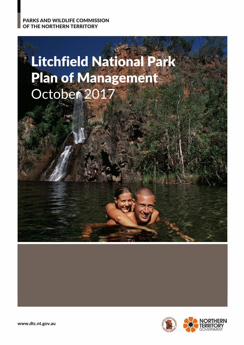
Litchfield National Park
Plan of Management
October 2017
Litchfield National Park Plan of Management
Page i
Intent of this Plan
This is the second Plan of Management prepared for Litchfield National Park. It has been prepared in
accordance with section 18 of the Territory Parks and Wildlife Conservation Act.
The first plan came into operation in 1992. The 1992 plan will be replaced by this plan when it comes into operation. This plan will remain in force until it is revoked by another plan prepared under the Territory
Parks and Wildlife Conservation Act. Any development in the park, or any other “act” for the purposes of
the Native Title Act, done in the park, will comply with the requirements of the Native Title Act.
Management actions stated in this plan have been given a priority rating of Low, Medium or High.
Implementation of these actions is subject to change.
This plan complies with Northern Territory and Commonwealth legislation and Parks and Wildlife Commission policies. Supplementary information is provided on Commission policies and related
documents under www.dtc.nt.gov.au. This plan focuses specifically on the values of this park.
Published by the Parks and Wildlife Commission of the Northern Territory.
ISBN 978-1-921937-35-4
Acknowledgements:
This plan was made possible through the efforts and interests of many individuals and organisations including the Litchfield National Park Stakeholder Reference Group. Consultation with interested groups within the wider community also occurred and valuable contributions were given by various key stakeholder groups including members from the tourism industry, neighbours to the park and recreational
groups.
Front cover photo Tjanera Falls (Sandy Creek): Courtesy of Tourism NT
Litchfield National Park Plan of Management
Page ii
Executive Summary
The Park and its Values
Litchfield National Park is renowned for spectacular waterfalls, safe swimming and opportunities to experience the rugged landscapes of the Top End. The park is located 120 km south of Darwin, covers about 145 600 ha and received about 330 000 visitors in 2015. It is one of the most highly visited parks
in the Northern Territory and a key driver of tourism in the Top End and Batchelor area.
It is a popular destination for Darwin residents, interstate and international visitors. Its close proximity to Darwin and the range of activities (swimming, walking, camping, four-wheel driving, extended bushwalking, fishing, nature appreciation) and different standards of facilities (highly developed to
natural) provide significant recreation and tourism opportunities for visitors.
Visitor experiences were enhanced through the implementation of the Litchfield National Park Visitor Experience Development Plan which was released with funding in early 2015. These works included a redesign of the Buley Rockhole site, enhanced facilities at Tolmer Falls, enhanced facilities and increased camping at Florence Falls, a redesign of the Tjaynera Falls campground and new boardwalks and
amenities at the Termite Mounds site.
In April 2015, the Northern Territory Government announced it would complete the sealing of the Litchfield Park Road and construct an all-weather bridge over the Lower Finniss River. These works are due for completion in 2018 and are likely to have a significant impact on key sites and the flow of visitors
through the park.
The park is recognised as a premier conservation reserve for its high biodiversity and large number of species of conservation value. It protects biodiversity of regional and national significance, in a region that is developing rapidly. This high species diversity is due to the variety of habitats including sandstone plateaus, monsoon rainforests and swamps, Melaleuca woodlands and lowlands and alluvial plains. Water movement is an important factor in the shaping and maintaining of these ecosystems. The park contains water-dependent ecosystems, which are of regional significance as important wildlife habitats, including
monsoon forests, riparian and floodplain habitats.
The core values of Litchfield National Park include its biodiversity, cultural and visitor values. These attributes are under threat from the impacts of Gamba grass (Andropogon gaynus). This aggressive weed has infested about 17% of the park leading to destructive, uncontrollable wildfires which impact on visitor safety and biodiversity values. Management of Gamba grass is essential to ensure the long term safety of
visitors and the integrity of (natural values of) the park.
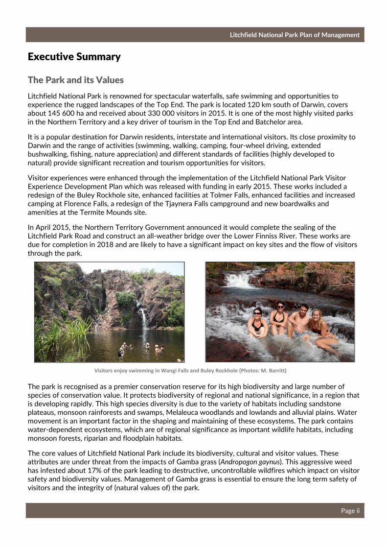
Visitors enjoy swimming in Wangi Falls and Buley Rockhole (Photos: M. Barritt)

Litchfield National Park Plan of Management
Page iii
Fun in Florence Falls plunge pool
(Photo: Tourism NT)
Litchfield National Park has significant cultural value. The area is significant to the local Aboriginal people, who have an important connection to the land. Sites of cultural significance of ritual, mythological and spiritual importance to the Aboriginal people and that underpin their connection to country and cultural obligations include several registered sacred sites and a variety of art sites dating back several thousands
of years.
The park contains historical values of regional significance that illustrate the development of the Top End pastoral and mining industries which had a profound effect on the culture and lifestyles of local Aboriginal people. Two sites within the park are registered on the NT Heritage Register. The sites are Blyth Homestead which was part of an operating pastoral station and Bamboo Creek tin mine which operated sporadically between 1906 and 1955. The park also contains the wreckage of a number of World War II
Spitfires.
The park is used for many purposes by a wide range of stakeholders including the Aboriginal stakeholders, tourism industry and local community. It is important for the Parks and Wildlife Commission
to work closely with these stakeholders and to support the varied uses of the park.
Key Management Directions
This is the second Plan of Management prepared for the park. It sets management objectives and
proposes measures to guide management and development over the life of the plan.
The park will continue to be developed as a major national park offering recreational experiences for the spirited and adventurous visitor as well as for families. The major attraction of the park will continue to be the opportunity to swim and relax in spectacular, natural plunge pools and waterholes in close proximity to Darwin. New recreation sites and activities will be opened and promoted, providing visitors with new and exciting experiences, assisting in dispersing visitors and protecting the natural values. The park will continue to offer a range of visitor sites with different standards of
access and facilities.
The plan proposes to manage the key issues of poor circulation and over-crowding through improvements to existing sites and new developments. Some issues have been addressed through the implementation of the Visitor Experience Development Plan in 2015-16. This Visitor Experience Development Plan considered the immediate recreational needs of visitors, including measures necessary to cater to increasing visitor numbers while continuing to
deliver a high quality visitor experience.
A new Visitor Experience Development Plan will be prepared by 2020 guided by development proposals outlined in this plan. New developments and experiences
proposed include:
• New four-wheel drive tracks;
• New half day and overnight walks;
• One or two new mountain bike / cycle tracks;
Litchfield National Park Plan of Management
Page iv
• Potential new visitor sites at Horse Paddock Creek, the Eastern Escarpment and the East Reynolds;
• Indigenous tours;
• Adventure activities, such as ziplining; and
• Nature based luxury accommodation.
Specific visitor sites in the park will be monitored to assess potential impacts from the sealing of the Litchfield Park Road and bridge over the Lower Finniss River. These findings will be considered in the preparation of the new Visitor Experience Development Plan. The Parks and Wildlife Commission will also investigate the carrying capacity of key sites and the park as a whole and options to best deal with
over-crowding into the future.
The Parks and Wildlife Commission will focus on threats to the park’s landscapes and biodiversity by implementing the Litchfield National Park Integrated Conservation Strategy. The Integrated Conservation Strategy defines key values and sets out key management interventions to protect these values and
manage threats to them.
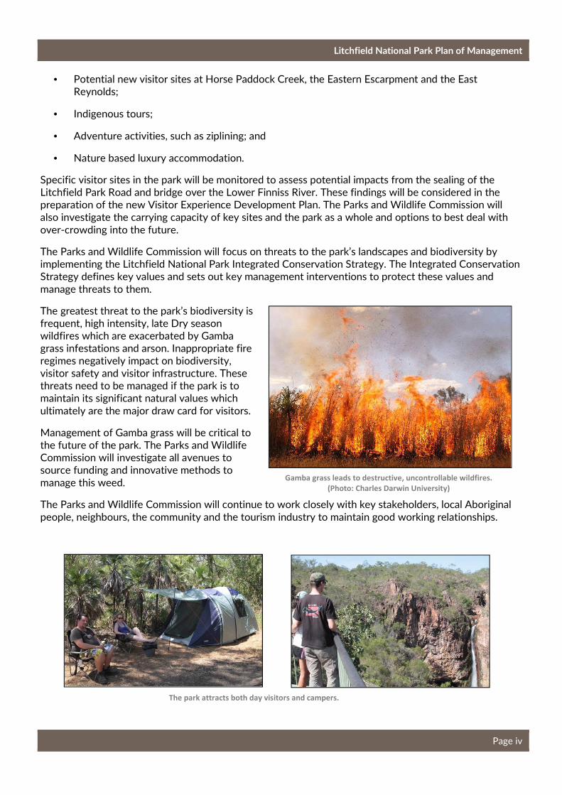
The greatest threat to the park’s biodiversity is frequent, high intensity, late Dry season wildfires which are exacerbated by Gamba grass infestations and arson. Inappropriate fire regimes negatively impact on biodiversity, visitor safety and visitor infrastructure. These threats need to be managed if the park is to maintain its significant natural values which
ultimately are the major draw card for visitors.
Management of Gamba grass will be critical to the future of the park. The Parks and Wildlife Commission will investigate all avenues to source funding and innovative methods to
manage this weed.
The Parks and Wildlife Commission will continue to work closely with key stakeholders, local Aboriginal
people, neighbours, the community and the tourism industry to maintain good working relationships.
Gamba grass leads to destructive, uncontrollable wildfires.
(Photo: Charles Darwin University)
The park attracts both day visitors and campers.
Litchfield National Park Plan of Management
Page v
Table of Contents
Executive Summary .................................................................................................................................................................... ii
The Park and its Values ............................................................................................................................................... ii
Key Management Directions ..................................................................................................................................... ii
Table of Contents ........................................................................................................................................................................ v
1. Introduction .............................................................................................................................................................................. 1
1.1 History of the Park ................................................................................................................................................... 1
1.2 A Vision for the future of Litchfield National Park ............................................................................................... 3
1.3 The Relative Importance of the Park ..................................................................................................... 3
2. Managing for Visitors ............................................................................................................................................................ 4
2.1 Visitor trends, use and activities ........................................................................................................................ 4
2.2 Economic Value of Tourism ................................................................................................................................. 5
2.3 Existing Visitor Activities and Facilities ........................................................................................................... 6
Visitor Experience Development Plan.............................................................................................................. 6
Potential Commercial Opportunities ................................................................................................................ 7
2.4 Future Considerations ............................................................................................................................................ 7
2.5 Proposed New Park Developments ............................................................................................................... 30
2.6 Visitor Safety .......................................................................................................................................................... 32
2.7 Visitor Access ......................................................................................................................................................... 33
2.8 Visitor Information, Interpretation and Monitoring ................................................................................. 34
2.9 Waste Management ............................................................................................................................................. 35
3. Managing Natural Values ................................................................................................................................................. 36
3.1 Water Resources ................................................................................................................................................... 37
3.2 Flora ........................................................................................................................................................................... 37
3.3 Fauna ......................................................................................................................................................................... 38
3.4 Managing Threatening Processes ................................................................................................................... 40
4. Managing Cultural Values ..................................................................................................................................... 45
5. Park Administration ............................................................................................................................................................ 47
5.1 General Administration ....................................................................................................................................... 47
5.2 Community and Stakeholder Engagement .................................................................................................. 48
5.3 Development Proposals and Commercial Operations ............................................................................ 49
6. References ............................................................................................................................................................................. 50
Litchfield National Park Plan of Management
Page 1
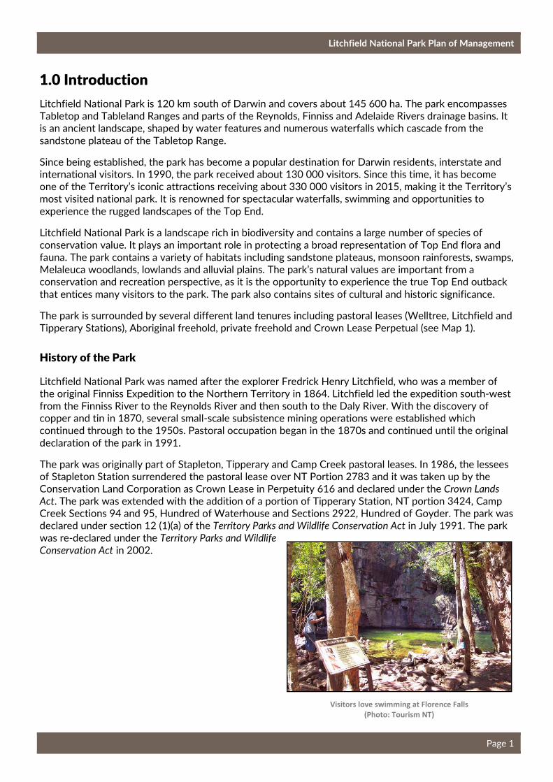
1.0 Introduction
Litchfield National Park is 120 km south of Darwin and covers about 145 600 ha. The park encompasses Tabletop and Tableland Ranges and parts of the Reynolds, Finniss and Adelaide Rivers drainage basins. It is an ancient landscape, shaped by water features and numerous waterfalls which cascade from the
sandstone plateau of the Tabletop Range.
Since being established, the park has become a popular destination for Darwin residents, interstate and international visitors. In 1990, the park received about 130 000 visitors. Since this time, it has become one of the Territory’s iconic attractions receiving about 330 000 visitors in 2015, making it the Territory’s most visited national park. It is renowned for spectacular waterfalls, swimming and opportunities to
experience the rugged landscapes of the Top End.
Litchfield National Park is a landscape rich in biodiversity and contains a large number of species of conservation value. It plays an important role in protecting a broad representation of Top End flora and fauna. The park contains a variety of habitats including sandstone plateaus, monsoon rainforests, swamps, Melaleuca woodlands, lowlands and alluvial plains. The park’s natural values are important from a conservation and recreation perspective, as it is the opportunity to experience the true Top End outback
that entices many visitors to the park. The park also contains sites of cultural and historic significance.
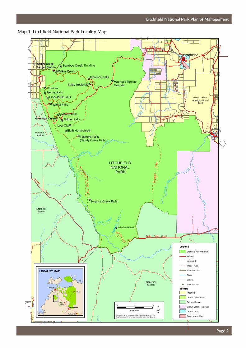
The park is surrounded by several different land tenures including pastoral leases (Welltree, Litchfield and
Tipperary Stations), Aboriginal freehold, private freehold and Crown Lease Perpetual (see Map 1).
History of the Park
Litchfield National Park was named after the explorer Fredrick Henry Litchfield, who was a member of the original Finniss Expedition to the Northern Territory in 1864. Litchfield led the expedition south-west from the Finniss River to the Reynolds River and then south to the Daly River. With the discovery of copper and tin in 1870, several small-scale subsistence mining operations were established which continued through to the 1950s. Pastoral occupation began in the 1870s and continued until the original
declaration of the park in 1991.
The park was originally part of Stapleton, Tipperary and Camp Creek pastoral leases. In 1986, the lessees of Stapleton Station surrendered the pastoral lease over NT Portion 2783 and it was taken up by the Conservation Land Corporation as Crown Lease in Perpetuity 616 and declared under the Crown Lands
Act. The park was extended with the addition of a portion of Tipperary Station, NT portion 3424, Camp Creek Sections 94 and 95, Hundred of Waterhouse and Sections 2922, Hundred of Goyder. The park was declared under section 12 (1)(a) of the Territory Parks and Wildlife Conservation Act in July 1991. The park was re-declared under the Territory Parks and Wildlife
Conservation Act in 2002.
Visitors love swimming at Florence Falls
(Photo: Tourism NT)
Litchfield National Park Plan of Management
Page 2
Cr e
ek
Skewes
Road
Daly River Road
Trac
kS
tap
leto
n
Bat chelor
Roa
d
Milton Road
Stuart
Highw
ay
Greenant Creek
Re
ynolds
Rive r
Walker Creek Ranger Station
Lost City
Wangi Falls
Walker Creek
Tjenya Falls
Florence Falls
Buley Rockhole
Blyth Homestead
Bine-Jeruk Falls
Tolmer Falls
Surprise Creek Falls
Bamboo Creek Tin Mine
Tjaynera Falls (Sandy Creek Falls)
Tjaetaba Falls
Magnetic Termite Mounds
LITCHFIELD NATIONAL
PARK
Batchelor
!(
!(
!(
!(
!(
DARWIN
KATHERINE
Mataranka
Jabiru
PineCreek
LOCALITY MAP
So
uth
Fin
niss
Riv
er
Finn
iss
Riv
er
Bra
nch
´Horizontal Datum: Geocentric Datum of Australia (GDA) 1994Map Projection: Universal Transverse Mercator, MGA Zone 52
Finniss River Aboriginal Land
Trust
TipperaryStation
Litchfield Station
Welltree Station
Cascades
Tableland Creek
Tabl
elan
dC
ree
k
Sandy C re
ek
Litc
hfie
ld
Park Road
Reynolds R
i ver4 w
dT
rack A
del
aid
e
River
West Bra
nch
Adela id
e
River
Rey
nolds River East
Branch
0 105
Kilometres
Tableland
Cr eek Track
TenureFreehold
Pastoral Lease
Crown Lease Perpetual
Crown Lease Term
Crown Land
Government Use
Legend
Sealed
Unsealed
Track (4wd)
River
Creek
Park Feature
Litchfield National Park
Tabletop Tack
Map 1: Litchfield National Park Locality Map
Litchfield National Park Plan of Management
Page 3
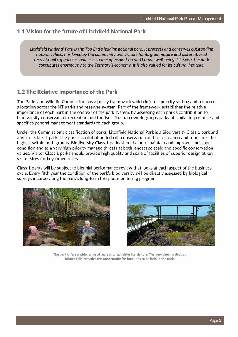
1.1 Vision for the future of Litchfield National Park
1.2 The Relative Importance of the Park
The Parks and Wildlife Commission has a policy framework which informs priority setting and resource allocation across the NT parks and reserves system. Part of the framework establishes the relative importance of each park in the context of the park system, by assessing each park’s contribution to biodiversity conservation, recreation and tourism. The framework groups parks of similar importance and
specifies general management standards to each group.
Under the Commission’s classification of parks, Litchfield National Park is a Biodiversity Class 1 park and a Visitor Class 1 park. The park’s contribution to both conservation and to recreation and tourism is the highest within both groups. Biodiversity Class 1 parks should aim to maintain and improve landscape condition and as a very high priority manage threats at both landscape scale and specific conservation values. Visitor Class 1 parks should provide high quality and scale of facilities of superior design at key
visitor sites for key experiences.
Class 1 parks will be subject to biennial performance review that looks at each aspect of the business cycle. Every fifth year the condition of the park’s biodiversity will be directly assessed by biological
surveys incorporating the park’s long-term fire-plot monitoring program.
The park offers a wide range of recreation activities for visitors. The new viewing deck at
Tolmer Falls provides the opportunity for functions to be held in the park.
Litchfield National Park is the Top End’s leading national park. It protects and conserves outstanding
natural values. It is loved by the community and visitors for its great nature and culture-based
recreational experiences and as a source of inspiration and human well-being. Likewise, the park
contributes enormously to the Territory’s economy. It is also valued for its cultural heritage.

Litchfield National Park Plan of Management
Page 4
Photography is a popular activity in the park (Photo: courtesy of Tourism NT)
2. Managing for Visitors
2.1 Visitor trends, use and activities
Tourism is a major contributor to the Northern Territory economy. The Tourism Vision 2020: Northern
Territory’s Strategy for Growth was developed to grow the visitor economy on the Northern Territory. The
strategy recognises that NT parks and reserves are a central driver of the Territory’s tourism industry.
The Northern Territory has a higher reliance on tourism than any other state or territory apart from Tasmania (Tourism NT, 2015). Tourism Vision 2020 recognises the important role of national parks and the important part visitors can play in national parks. The strategy states, ‘Increased visitation and use of national parks delivers regional economic benefits, as well as increased visitor awareness and an
understanding of park values, ultimately contributing to long term conservation efforts’.
Visitor numbers to Litchfield National Park have been steadily increasing. The park is renowned for picturesque waterfalls, scenic Top End landscapes and swimming, all in close proximity to Darwin. The park provides a wide variety of visitor experiences ranging from swimming and walking to remote, four-wheel driving. The park has the highest satisfaction of any Territory experience and it is one of the Territory’s most popular parks. On average, 70% of visitors are from interstate, 18% are international
visitors and 12% are from the Northern Territory.
Tourism Vision 2020 explains that 61% of inbound visitors to Australia selected nature-based activities as the primary purpose for their visit. National research shows that visitors to the NT are more likely to participate in nature-based tourism activities than visitors to other states in Australia. The three main reasons people visit the park is to swim, view waterfalls / waterholes and sightseeing. The range of activities available in the park and undertaken by visitors is provided in Table 1. The top three activities
undertaken by local, interstate and international visitors are swimming, short walks and photography.

Litchfield National Park Plan of Management
Page 5
Table 1: Activities provided in the park and percentage of visitors undertaking the activities.
Activity Local (%) Interstate (%) International (%) Total (%)
Swimming 89 78 84 82
Short walk (< 2 hours) 51 76 73 71
Photography 42 66 68 62
Picnicking / Barbecuing 42 37 47 41
Driving / touring 27 48 38 41
Wildlife viewing 25 40 51 41
Camping 34 36 43 38
Bird watching 18 32 22 26
Medium walks (2-4 hours) 12 20 15 17
Four-wheel driving 17 20 10 16
Guided commercial tour 4 9 12 9
Long walks (>4 hours) 4 3 3 3
Overnight hike 3 1 2 2
Mountain biking 2 1 1 1
(Source: 2009 Visitor Survey Report, Litchfield National Park.)
2.2 Economic Value of Tourism
In 2015, total visitors (holiday, visiting friends and business) to the Greater Darwin tourism region, which encompasses Darwin, Palmerston, Batchelor, Mary River National Park and Litchfield National Park, was 766 000 (Tourism NT, 2016). Key attractions for visitors are natural and cultural values and the proximity of the park to Darwin. It is probable that visitor numbers to the park will continue to grow over the life of the plan. The plan needs to consider developing the park to cater for this potential increase while
ensuring a positive experience for visitors.
The park is significant to the Top End tourism industry and is a key driver of tourism activities in the Batchelor area. The tourism industry in the area provides commercial tours, accommodation, meals and general provisions. Commercial accommodation available near the park and in Batchelor includes a motel, caravan parks, cabins and camping. During the peak season, 27.5% of visitors stay overnight while during
the shoulder season 24.5% of visitors stay overnight in the park (Visitor Surveys July 2013).
The Territory’s park visitors are from all stages of life and include youth, families and older couples. They come from overseas, interstate and from the local area. While they have different holiday and recreational preferences, by and large today’s park visitors want rich experiences in nature and seek connections on a personal level. Visitors are not content just to “look”, they want to DO. The challenge is
making sure what they can DO in the Territory is unique from experiences anywhere else.
The Territory’s competitive strength as a holiday destination is in providing visitor experiences that deliver a unique blend of nature and culture. The majority of domestic and international leisure visitors
come to the Territory for these core experiences.
The Tourism Vision 2020 (Tourism NT, 2013) identifies that in order to increase market growth, there needs to be a focus on developing new visitor experiences; either repackaging existing products or

Litchfield National Park Plan of Management
Page 6
introducing new experiences. New recreation sites and activities identified in the park need to enhance
the visitor experience, be sustainable and alleviate pressure on the existing key visitor sites.
2.3 Existing Visitor Activities and Facilities
The key sites in the park, including Wangi Falls, Florence Falls and Buley Rockhole, will continue to be key attractions for visitors. These sites are often at capacity or over-crowded during the peak season. It is important that the park offers alternative sites to encourage visitors to disperse, to maintain visitor
experiences and reduce over-crowding. The plan proposes four ways to address this:
1. upgrade existing visitor sites to cater for increased visitor numbers;
2. improve awareness and promotion of alternative sites in the park;
3. improve flow of visitors through the park, and
4. investigate options for new recreation sites to cater for current and future demands.
Visitor Experience Development Plan
The Commission recognises the need to maintain the quality of existing experiences and attract government and private investment for new nature-based opportunities at our most popular parks. As a result, the Parks and Wildlife Commission will prepare Visitor Experience Development Plans for the
highest priority parks.
Visitor Experience Development Plans were released for Litchfield National Park and Casuarina Coastal Reserve in early 2015. The Visitor Experience Development Plan for Litchfield National Park considered the immediate needs of visitors, including measures to ensure that the park can cater to increasing visitor numbers while continuing to achieve and deliver a high quality visitor experience. The Northern Territory Government funded the implementation of this plan, with works commencing in 2015-16. The key works
included:
• expanding the Florence Falls 2WD and 4WD campground, a new ablution block, new toilet block, sealing the road between the two campgrounds, a new coach parking area, a new path from the
4WD campground to the plunge pool and stairs into the plunge pool;
• the redesign of the Buley Rockholes site included removing the car park and creating a new day-use
area with picnic facilities, removing the campground and replacing with a sealed car park;
• redesigning the Tjaynera Falls campground to provide additional campsites and a new toilet block;
• upgrading the Termite Mounds site with a new boardwalk around a cathedral termite mound,
upgrading the existing boardwalk and a new toilet block to replace the existing one; and
• enhancing the Tolmer Falls site with a new picnic / functions area with landscape views, a new toilet
block, new half day walk and a new privately operated campground site.
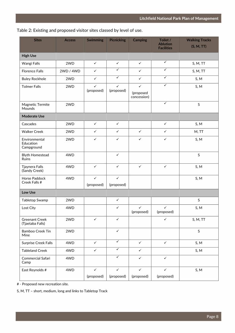
Table 2 provides a summary of visitor sites and proposed new sites categorised by their level of use. There are a number of sites in all three categories from low to moderate to high levels of use. This range of sites provides opportunities for different types of visitors to experience and enjoy the park. Tables 3 to 21 summarise the existing visitor sites in the park and identifies the purpose of the site, existing facilities,
issues, opportunities and proposed future directions.
A new Visitor Experience Development Plan will be prepared for the park in the next five years. In developing the new plan, consideration will be given to the level of use of existing facilities and new opportunities to ensure a positive visitor experience. The ‘Future Directions’ section of Tables 3 to 21 and the Proposed New Park Developments in section 2.5 will be used to inform the new Visitor Experience
Litchfield National Park Plan of Management
Page 7
Development Plan. Other recreation experiences that will be considered include more swimming and
bush camping opportunities and new half or full day walks.
Potential Commercial Opportunities
In 2014, the Parks and Wildlife Commission made an open call for expressions of interest, Growing Investment Opportunities in Parks. The purpose was to increase tourism investment in Northern Territory parks and reserves, to encourage new and exciting visitor experiences and to attract greater visitor numbers across the estate. Interest was expressed for several tourism opportunities in the park. If these
ventures are realised they will enhance the experiences offered to visitors.
Private operators can offer experiences for visitors which are not offered by the Parks and Wildlife Commission (see also section 5.3). The Parks and Wildlife Commission aims to promote new and existing tourism opportunities in parks and reserves across the Northern Territory. Operators can approach the
Parks and Wildlife Commission to develop new commercial opportunities.
Opportunities exist for private operators to manage new and existing campgrounds within the park. Private management of these campgrounds can enhance the visitor experience and reduce anti-social behaviour through a more regular presence in problem areas. It can also enable the Parks and Wildlife
Commission to better focus effort on key conservation and visitor outcomes.
2.4 Future Considerations
As visitor numbers to the park continues to increase, many of the key visitor sites will reach their carrying capacity. Sites will become over-crowded to the point where the visitor experience and the natural environment will be negatively impacted. In the years leading to this point, the Parks and Wildlife Commission will investigate options to best deal with this situation. Options considered may include opening new recreation sites within the park, limiting entry numbers to sites and running shuttle buses to
specific sites.
Management Actions
• Develop a new Visitor Experience Development Plan by 2020. (High)
• Promote and facilitate commercial management of key campgrounds. (High)
• Promote the lesser known and used sites in the park to assist in dispersing visitors including working with the tourism industry. (High)
Management Actions
• Determine the carrying capacity of key sites and the park as a whole and investigate options to
best deal with this situation. (High)
Litchfield National Park Plan of Management
Page 8
Table 2: Existing and proposed visitor sites classed by level of use.
Sites Access Swimming Picnicking Camping Toilet / Ablution Facilities
Walking Tracks
(S, M, TT)
High Use
Wangi Falls 2WD � � � � S, M, TT
Florence Falls 2WD / 4WD � � � � S, M, TT
Buley Rockhole 2WD � � � � S, M
Tolmer Falls 2WD � (proposed)
� (proposed)
�
(proposed concession)
� S, M
Magnetic Termite Mounds
2WD � S
Moderate Use
Cascades 2WD � � � S, M
Walker Creek 2WD � � � � M, TT
Environmental Education Campground
2WD � � � � S, M
Blyth Homestead Ruins
4WD � S
Tjaynera Falls (Sandy Creek)
4WD � � � � S, M
Horse Paddock Creek Falls #
4WD �
(proposed)
�
(proposed)
S, M
Low Use
Tabletop Swamp 2WD � S
Lost City 4WD � � (proposed)
� (proposed)
S, M
Greenant Creek (Tjaetaba Falls)
2WD � � � S, M, TT
Bamboo Creek Tin Mine
2WD � S
Surprise Creek Falls 4WD � � � � S, M
Tableland Creek 4WD � � � S, M
Commercial Safari Camp
4WD � � �
East Reynolds # 4WD �
(proposed)
�
(proposed)
�
(proposed)
�
(proposed)
S, M
# - Proposed new recreation site.
S, M, TT – short, medium, long and links to Tabletop Track

Litchfield National Park Plan of Management
Page 9
LITCHFIELD NATIONAL
PARK
Batchelor
So
uth
Fin
niss
Riv
er
Finn
iss
Riv
er
Bra
nch
´Horizontal Datum: Geocentric Datum of Australia (GDA) 1994Map Projection: Universal Transverse Mercator, MGA Zone 52
Walker Creek RangerStation
Stapl
eto
nT
rack
Reynolds R
i ver4w
dTra
ck
Daly River Road
Litc
hfie
ld
Park Road
Batche
lorRoad
Stuart
Highw
ay
Sandy C re
e k
Re
ynolds
River
Tabl
elan
dC
ree
k
Reynolds
River East
Bran
ch
Skewes Road
Tjaetaba
Tjenya Falls
Swimming is only permitted within designated swimming areas dueto the presence of Saltwater Crocodiles.
Wangi Falls
Tjaynera Falls (Sandy Creek)
Commercial Safari Camp
Surprise Creek Falls
Greenant Creek
Bamboo CreekTin Mine
Walker Creek
Cascades
Florence Falls
Buley Rockhole
Education Campground
Magnetic TermiteMounds
Lost City
Blyth Homestead
Tableland Creek
Tabletop Tack
LegendLitchfield NationalPark
Camping
Wood BBQ
Toilets
Historical
Picnic Facilities
Walking Track
Lookout
Information
Telephone
Ranger Station
Visitor Facilities
Kiosk
Swimming
Caravan
4wd
Gas BBQ
Art sales
Emergency Call Device
Disabled Access
Road
Drainage
Cadastre
4WD Track
TabletopTrack
Tolmer Falls
Tableland
Cr eek Track
0 105
Kilometres
Map 2: Existing Recreation Facilities and Activities

Litchfield National Park Plan of Management
Page 10
Table 3 - Wangi Falls
Purpose/ Level of Service
Wangi Falls is one of the most popular sites in the park. It encompasses a spectacular twin waterfall
with large plunge pool providing the opportunity for safe swimming, nature appreciation, picnicking and
walks. It is a major site providing high standards of access, facilities and information for large numbers of
visitors.
Visitor Experience Provided
Typical Visit: Visitors are provided with comfort and convenience in a popular /iconic site. Intensity of Use: High. Received over 210 000 visitors in 2015. Many stay in the main visitor area for less than two hours.
Levels of Service: Very high level of service.
Access Standards
Vehicle Access: High standard sealed road. Disabled Access: Barrier free access to key features and
facilities of the main visitor node. Tracks and Paths: Highly accessible and high standard tracks. The Wangi
Falls Walk from the viewing platform up across the escarpment is of moderate standard with some narrow
and rocky sections. Car Parking: Sealed car and bus parking catering for 52 car parks and 25 spaces for
coaches, caravans and long vehicles.
Standard of Information
Orientation: Directional signs on arterial roads. Detailed site information supported on the website.
Comprehensive site orientation and information. Interpretation and Information: A comprehensive
interpretation geared to large numbers of visitors, with diverse needs and usage patterns.
Activities Activities encouraged include: swimming; sightseeing; picnicking; short walks; photography; camping;
nature and culture appreciation and relaxation. The presence of many other visitors is an expected part of
the park experience. The Wangi Falls Centre includes a café.
Visitor Facilities Standards
Seats, Tables and Shelter: Seating, tables and
shelters provided.
Toilets: Two toilet blocks with flushing toilets
and wash basin facilities are provided. One
toilet block is located in the day-use area and
the other is located in the campground.
BBQs and Fireplaces: Gas BBQs are provided in the day-
use area and the campground. A communal fireplace is
provided in the campground. Firewood is collected by
visitors along the Litchfield Park Road for the communal
fireplace. Food Services: The Wangi Falls Centre includes a
café. Camping: Provision for 34 camping sites and three of
these sites are tent only. No powered sites are provided. Camping fees apply for all forms of camping. Consideration
will be given to the Wangi Falls Centre managing the
booking of camp sites. The use of generators is not
permitted in the park.
Ranger Presence
Visitor Safety and Risk Mitigation: Significant hazards and hidden threats
communicated on site and in pre-visit
information. Standard swimming safety
equipment and signs installed on site. Risk
mitigation and on-site compliance to
minimise exposure to hazards. A public
telephone is provided. Glass containers are
not permitted within 10 m of designated
swimming areas.
Open Space Management: Mowing of day-use and
camping areas for aesthetic appeal. Slashing of sides of
access road for visitor safety (fire).
Management Facilities: No management facilities are
located at this site.
Issues and Opportunities
• Swimming in the plunge pool is closed over the Wet season when water levels become too high leading to
hazardous conditions and the potential for saltwater crocodiles to enter the pool. The pool is not opened
again until the water levels have dropped and the pool has been thoroughly surveyed for crocodiles. A
crocodile fence was installed in 2014 to reduce the likelihood of crocodiles entering the plunge pool.
• Issues arise from visitors climbing and jumping from rock faces surrounding the falls and can result in
serious injuries and negative experiences for other visitors.
• The main car park area was expanded in 2009 to accommodate an additional 12 long vehicles and 26 cars.
This expansion was to cater for the large numbers of visitors in the peak visitor season.
• The Wangi Falls Centre opened in June 2013. Consideration will be given to the booking of campsites
through the Centre. The Wangi Falls Centre may assist in spreading the visitors across the site however it
is recognised that the Centre is likely to attract more visitors to the site and potentially increase the length
of stay of visitors at the site.
• Opportunity to improve the use and the flow of the Tabletop Track through visitors registering at the
Wangi Falls Centre. A secure car parking compound could be constructed at this site to enable a place for
visitors who are walking the Tabletop Track or cycling the overnight mountain bike loop (see section 2.3)
to safely leave their vehicles.
• Interpretive and orientation information located in the interpretive shelter is adequate.
• The campground was extended in 2009 and is already at capacity during the peak visitor season. There is
Litchfield National Park Plan of Management
Page 11
potential to re-design the campground to accommodate more campsites. A re-design should also provide
a number of spaces for over-sized vehicles. The campground could also be improved through the sealing
of the road through the site.
• There is an opportunity to work with tour companies to stagger the arrival of tour groups to Wangi Falls,
Florence Falls and Buley Rockhole.
• Free WiFi has been installed at Wangi Falls and is only available for set hours.
• Scenic helicopter flights run by a private operator will begin operation from the Wangi Falls area in early
2017.
Future Directions
• Proposed Development – Re-design the campground to accommodate more spaces and identify a few
camp sites which will accommodate larger caravans, campervans and mobile homes. Seal the road through
the campground and install a new ablution block. (High)
• Proposed Direction – Realise the potential for commercial management of the Wangi Falls campground
including bookings, campground management and cleaning. (High)
• Movement of Visitors – Work with the tourism industry and tour companies to develop a system of
staggering the arrival of visitors to the key visitor sites, particularly in relation to cruise ship visitors. Work
with the tourism industry to more widely promote the lesser used sites in the park. (High)
• Visitor Safety – Continue to implement the Crocodile Management Plan and the Emergency Response
Procedure Manual. (High)
• Visitor Safety – Review the swimming and water safety guidelines for the plunge pool to ensure it is
opened at the appropriate water levels. (High)
• Proposed Development – Investigate the potential for a secure car parking compound for visitors using
the Tabletop Track. (Medium)
• Proposed Development – Through the Wangi Falls Centre encourage the site as the starting point for
visitors wishing to walk the whole of the Tabletop Track. (Medium)
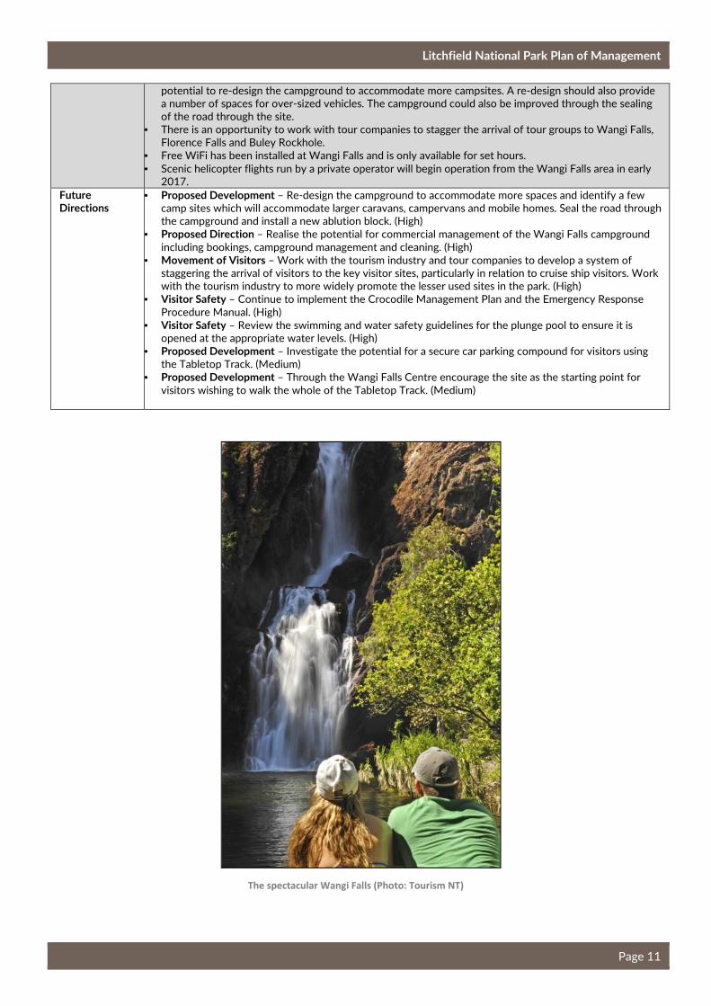
The spectacular Wangi Falls (Photo: Tourism NT)
Litchfield National Park Plan of Management
Page 12
Table 4 - Florence Falls
Purpose/ Level of Service
Florence Falls is a spectacular twin waterfall surrounded by attractive monsoon rainforest. The site is
managed as a major site providing high standards of access, facilities and information for a relatively
large number of visitors.
Visitor Experience Provided
Typical Visit: Park visitors are provided with passive and active recreation opportunities. Visitors who are
prepared to walk are provided with the opportunity to swim in a natural bush setting. Intensity of Use: High. Over 244 000 visitors in 2015. Many stay in the main visitor area for less than two hours. Levels of Service: Moderate level of service.
Access Standards
Vehicle Access: High standard sealed road. Disabled Access: Disabled access to the viewing platform. No
disabled access to the plunge pool. Tracks and Paths: Disabled access to viewing platform. From the
viewing platform the walk leads to a steep staircase to the plunge pool at the base of the falls. Shady Creek
Walk from main pool to car park is an easy walk. A formalised walking track extends from Florence Falls to
Buley Rockhole. Car Parking: Sealed car and bus parking.
Standard of Information
Orientation: Directional signs on arterial roads. Detailed site information supported on the website.
Comprehensive site orientation and information. Interpretation and Information: A range of interpretation
signs are provided to cater to large numbers of visitors.
Activities Activities encouraged include; swimming; sightseeing; picnicking; short walks; photography; camping;
nature appreciation and relaxation. The presence of other users is an expected part of the park experience.
Visitor Facilities Standards
Seats, Tables and Shelter: Picnic
platforms provided at the Florence
picnic area. No seating provided at
plunge pool. Seating provided at
viewing platform.
Toilets: Flushing toilets are located
in the car park and at the two-wheel
drive and four-wheel drive
campgrounds.
BBQs and Fireplaces: BBQs provided at day-use area. At the two-
wheel drive and four-wheel drive camping areas there are wood
BBQs. Visitors are asked to collect firewood along the Litchfield
Park Road within the park. Food Services: Mobile food and drinks
van. Camping: Works associated with the Visitor Experience
Development Plan, will see an increase in camping sites from 14 to
25 in the two-wheel drive campground and an increase from 5 to
25 sites in the four-wheel drive campground. No powered sites are
provided. Camping fees apply. There is currently no booking system
for the campgrounds however there is potential for a booking
system to be implemented over the life of the Plan.
Ranger Presence Visitor Safety and Risk Mitigation: Hazards communicated on site and
in pre-visit information. Risk
mitigation and on-site compliance
to minimise exposure to hazards.
Glass containers are not permitted
within 10 m of designated
swimming areas.
Open Space Management: Slashing for infrastructure, safety (fire),
visitor access, open space and aesthetic appeal.
Management Facilities: No management facilities are located at this
visitor site.
Issues and Opportunities
• This site was upgraded as part of the Visitor Experience Development Plan. Upgrades included re-
designing the day-use car parking area, expanding the two-wheel drive and four-wheel drive
campgrounds (including a new ablution block and toilet block) and a staircase into the plunge pool. The
path from the four-wheel drive campground to the plunge pool is also being upgraded as part of these
works.
• In peak visitor season the rocks located beside the main plunge pool can become over-crowded. Entry
into the plunge pool at these times can be difficult.
• Issue with visitors jumping from the escarpment and / or the top of the waterfall. This presents a serious
danger to visitors.
• A concrete walking track was constructed in 2012 from Florence Falls along the creek to Buley Rockhole.
This track ensures a safer and easier walk and reduces the impact on the environment.
• A helipad will be constructed in 2017 to enable Careflight to make emergency evacuations.
Future Directions
• Proposed Direction – Encourage commercial management of the campgrounds including bookings,
campground management and cleaning. (High)
• Promotion – Promote the walk from Buley Rockhole to Florence Falls to assist in dispersing visitors from
the key visitor sites. (High)
Litchfield National Park Plan of Management
Page 13
Table 5 - Buley Rockhole
Purpose/ Level of Service
Buley Rockhole is a very popular site with locals and visitors. The site provides the opportunity to enjoy
swimming in a series of rockholes. Buley Rockhole is a major site providing a high standard of access,
facilities and information for a relatively large number of visitors. The site is at capacity.
Visitor Experience Provided
Typical Visit: Park visitors seeking to swim with minimal walking required to the site. Intensity of Use: High.
About 244 400 visitors in 2015. Many spread along the creek and rockholes. Tourists tend to stay for a
short time while regular park visitors may stay for several hours. Levels of Service: High level of service.
Access Standards
Vehicle Access: High standard sealed road. Disabled Access: No disabled access is provided. Tracks and Paths: Highly accessible with a moderate standard of tracks. The track that runs parallel to the creek is
rocky and basic. Car Parking: Sealed car park and unsealed tour operator parking.
Standard of Information
Orientation: Directional signs on arterial roads. Detailed site information supported on the website.
Comprehensive site orientation. Sign located in the car park advises visitors that if the car park is full then
so are the rockholes. Interpretation and Information: Interpretation is provided at the start of the walk.
Activities Activities encouraged include swimming, informal picnicking, short walks, sightseeing, photography, nature
appreciation and relaxation.
Visitor Facilities Standards
Seats, Tables and Shelter: None currently as
visitors picnic directly on the rocks surrounding the
creek. Through with the Visitor Experience
Development Plan a new day-use area was created
in the existing car park. Tables, chairs and shade
shelters provided. Toilets: A new toilet block was
installed in 2014.
BBQs and Fireplaces: BBQs are provided in the day-
use area.
Food Services: None.
Camping: None.
Ranger Presence Visitor Safety and Risk Mitigation: Hazards and
hidden threats communicated on-site and in pre-
visit information. Risk mitigation and on-site
compliance to minimise exposure to hazards. Glass
containers are not permitted within 10 m of the of
designated swimming areas.
Open Space Management: Slashing for infrastructure,
safety (fire), visitor access, open space and aesthetic
appeal. Management Facilities: None.
Issues and Opportunities
• This site was upgraded as part of the Visitor Experience Development Plan. The upgrades included
removing the existing car park and creating a new day-use area with picnic facilities in its place. The
campground was removed and turned into a sealed car park.
• Visitor over-crowding of Buley Rockhole is a major problem during the peak visitor season.
• Interpretative and orientation information located at the start of the walk is quite dated. There is scope to
upgrade this area.
• Anti-social behaviour was previously an issue at this site however the removal of the campground has
been anti-social behaviour decrease.
• Some visitors jump from inappropriate locations presenting a danger to themselves and those swimming
in the pools below.
Future Directions
• Movement of visitors - Work with the tourism industry and tour companies to develop a system of
staggering the arrival of visitors to the key visitor sites. Work with the tourism industry to more widely
promote the lesser used sites in the park. (High)
• Direction – Continue to work with NT Police in managing the anti-social behaviour that can occur at this
site. (Ongoing)
Litchfield National Park Plan of Management
Page 14
Table 6 - Tolmer Falls
Purpose/ Level of Service
Tolmer Falls is a spectacular waterfall which includes a cave at the base of the falls, sheltering a colony of
the near threatened Orange Leaf-nosed Bat. This site provides a high standard of access, facilities and
information for a large number of visitors. Visitors are able to view the spectacular falls from a distance
without impacting the fauna living near the falls.
Visitor Experience Provided
Typical Visit: Tourists and park visitors seeking a view of the waterfall and a short easy walk. Intensity of Use: High. About 100 000 visitors in 2015. Most visitors stay for a short amount of time. Levels of Service: Very high level of service.
Access Standards
Vehicle Access: High standard sealed road. Disabled Access: Disabled access is provided from the car park
to the Tolmer Falls lookout, picnic area, functions deck and toilet block. Tracks and Paths: High standard of
access to the viewing platform. Alternative track back to car park is of moderate standard with some rocky
sections. Path to functions deck. Car Parking: Sealed car and bus parking.
Standard of Information
Orientation: Directional signs on arterial roads. This walk is described on the Park ‘Short Walks’ Fact Sheet.
Interpretation and Information: A range of interpretation panels are provided at the lookout and in the
interpretation shelter near the car park. Geared to large numbers of people.
Activities Activities encouraged include; sightseeing; short walks; photography and nature appreciation. The presence
of many other users is an expected part of the Park experience.
Visitor Facilities Standards
Seats, Tables and Shelter: Seating is provided at the
interpretation shelter and along both walks to viewing
platform. No seats are provided at the viewing platform.
A picnic area with seating and shelters and a functions
deck was constructed as part of the works associated
with the Visitor Experience Development Plan. Toilets: A new toilet block was constructed as part of the Visitor
Experience Development Plan works.
BBQs and Fireplaces: None.
Food Services: None.
Camping: There is currently no camping at this
site. A low-key camping area, to be managed by
a private operator, will be developed as part of
the Visitor Experience Development Plan.
Ranger Presence Visitor Safety and Risk Mitigation: Hazards and hidden
threats communicated on-site and in pre-visit
information. Risk mitigation and on-site compliance to
minimise exposure to hazards. Glass containers are not
permitted within 10 m of designated swimming areas.
Open Space Management: Slashing for
infrastructure, safety (fire), visitor access, open
space and aesthetic appeal when required.
Management Facilities: None.
Issues and Opportunities
• The site was upgraded as part of the Visitor Experience Development Plan and included a new picnic
area, functions deck with landscape views, a new toilet block, upgrades to the existing viewing platform
and development of a low-key camping area that could potentially be managed by a private operator. The
works may also include a half day walk to the Lost City.
• The site could accommodate higher visitor numbers without impacting on the experiences. The site has
the potential to be developed as a visitor hub and alleviate pressure on some of the other sites.
• The site has the potential to develop a ‘wow’ feature such as a glass walkway out over the edge of the
existing viewing platform or a swing bridge. This ‘wow’ feature would attract visitors to the site and help
alleviate pressure on the primary visitor sites. This ‘wow’ feature could be developed by a private
operator.
• A tour operator has in the past held a permit to take a limited number of visitors swimming in a rockhole
above Tolmer Falls. This site is difficult to access and only physically fit visitors with a competent tour
guide should enter. This is a unique adventure experience only available to a limited number of visitors.
Future Directions
• Future Proposed Development - The site is to be developed as a visitor hub including development of a
‘wow’ feature such as a swing bridge or glass walkway out over the edge of the escarpment. This ‘wow’
feature could be developed and run by a private operator. (High)
• Commercial Operator - Promote the continued use of swimming in the rockhole above the Falls for tour
groups to increase the diversity of experiences available in the park. (High)
Litchfield National Park Plan of Management
Page 15
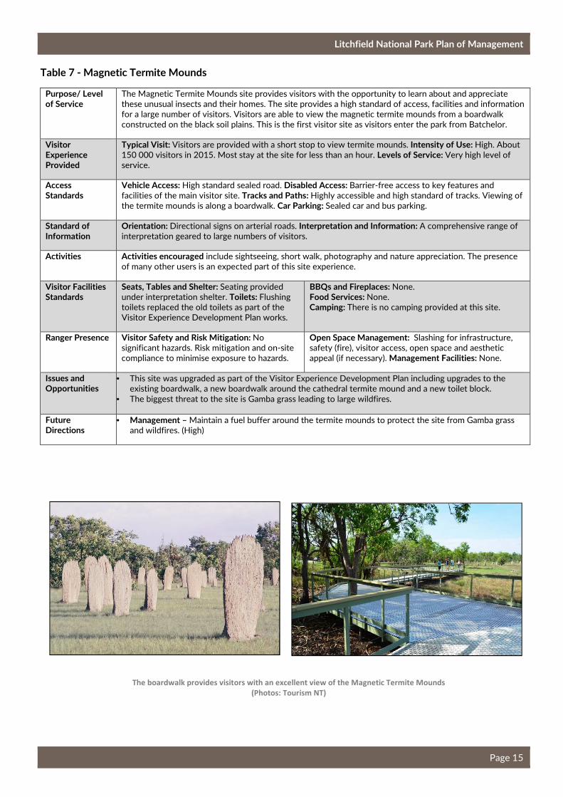
Table 7 - Magnetic Termite Mounds
Purpose/ Level of Service
The Magnetic Termite Mounds site provides visitors with the opportunity to learn about and appreciate
these unusual insects and their homes. The site provides a high standard of access, facilities and information
for a large number of visitors. Visitors are able to view the magnetic termite mounds from a boardwalk
constructed on the black soil plains. This is the first visitor site as visitors enter the park from Batchelor.
Visitor Experience Provided
Typical Visit: Visitors are provided with a short stop to view termite mounds. Intensity of Use: High. About
150 000 visitors in 2015. Most stay at the site for less than an hour. Levels of Service: Very high level of
service.
Access Standards
Vehicle Access: High standard sealed road. Disabled Access: Barrier-free access to key features and
facilities of the main visitor site. Tracks and Paths: Highly accessible and high standard of tracks. Viewing of
the termite mounds is along a boardwalk. Car Parking: Sealed car and bus parking.
Standard of Information
Orientation: Directional signs on arterial roads. Interpretation and Information: A comprehensive range of
interpretation geared to large numbers of visitors.
Activities Activities encouraged include sightseeing, short walk, photography and nature appreciation. The presence
of many other users is an expected part of this site experience.
Visitor Facilities Standards
Seats, Tables and Shelter: Seating provided
under interpretation shelter. Toilets: Flushing
toilets replaced the old toilets as part of the
Visitor Experience Development Plan works.
BBQs and Fireplaces: None.
Food Services: None.
Camping: There is no camping provided at this site.
Ranger Presence Visitor Safety and Risk Mitigation: No
significant hazards. Risk mitigation and on-site
compliance to minimise exposure to hazards.
Open Space Management: Slashing for infrastructure,
safety (fire), visitor access, open space and aesthetic
appeal (if necessary). Management Facilities: None.
Issues and Opportunities
• This site was upgraded as part of the Visitor Experience Development Plan including upgrades to the
existing boardwalk, a new boardwalk around the cathedral termite mound and a new toilet block.
• The biggest threat to the site is Gamba grass leading to large wildfires.
Future Directions
• Management – Maintain a fuel buffer around the termite mounds to protect the site from Gamba grass
and wildfires. (High)
The boardwalk provides visitors with an excellent view of the Magnetic Termite Mounds
(Photos: Tourism NT)
Litchfield National Park Plan of Management
Page 16
Table 8 - Tabletop Swamp
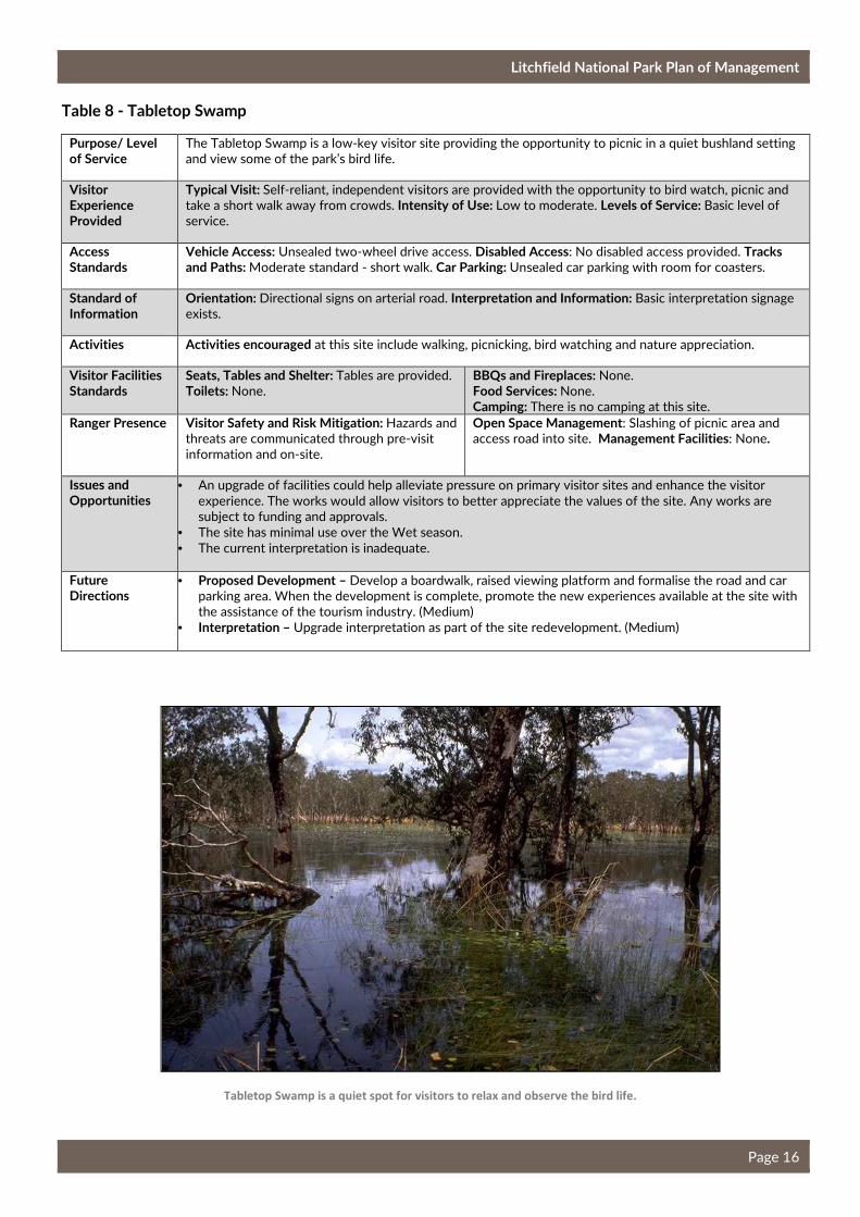
Purpose/ Level of Service
The Tabletop Swamp is a low-key visitor site providing the opportunity to picnic in a quiet bushland setting
and view some of the park’s bird life.
Visitor Experience Provided
Typical Visit: Self-reliant, independent visitors are provided with the opportunity to bird watch, picnic and
take a short walk away from crowds. Intensity of Use: Low to moderate. Levels of Service: Basic level of
service.
Access Standards
Vehicle Access: Unsealed two-wheel drive access. Disabled Access: No disabled access provided. Tracks and Paths: Moderate standard - short walk. Car Parking: Unsealed car parking with room for coasters.
Standard of Information
Orientation: Directional signs on arterial road. Interpretation and Information: Basic interpretation signage
exists.
Activities Activities encouraged at this site include walking, picnicking, bird watching and nature appreciation.
Visitor Facilities Standards
Seats, Tables and Shelter: Tables are provided. Toilets: None.
BBQs and Fireplaces: None.
Food Services: None.
Camping: There is no camping at this site.
Ranger Presence Visitor Safety and Risk Mitigation: Hazards and
threats are communicated through pre-visit
information and on-site.
Open Space Management: Slashing of picnic area and
access road into site. Management Facilities: None.
Issues and Opportunities
• An upgrade of facilities could help alleviate pressure on primary visitor sites and enhance the visitor
experience. The works would allow visitors to better appreciate the values of the site. Any works are
subject to funding and approvals.
• The site has minimal use over the Wet season.
• The current interpretation is inadequate.
Future Directions
• Proposed Development – Develop a boardwalk, raised viewing platform and formalise the road and car
parking area. When the development is complete, promote the new experiences available at the site with
the assistance of the tourism industry. (Medium)
• Interpretation – Upgrade interpretation as part of the site redevelopment. (Medium)
Tabletop Swamp is a quiet spot for visitors to relax and observe the bird life.
Litchfield National Park Plan of Management
Page 17
Table 9 - Lost City
Purpose/ Level of Service
The Lost City is a low key site and is managed to provide visitors with a four-wheel drive bush experience to
lost city formations. The site includes a short walk through the lost city.
Visitor Experience Provided
Typical Visit: Self-reliant, independent and experienced visitors who seek solitude and a sense of
remoteness. Intensity of Use: Low. About 20 000 visitors in 2015. Levels of Service: Basic level of service.
Access Standards
Vehicle Access: Four-wheel drive access only. The site is closed during the Wet season. Disabled Access: No disabled access is provided. Tracks and Paths: Moderate standard of walking track. Car Parking: Car
parking area provided at start of walking track.
Standard of Information
Orientation: Directional signs on arterial roads. Interpretation and Information: Basic interpretation signage
exists.
Activities Activities encouraged include: sightseeing; picnicking; short walks; photography; nature appreciation and
relaxation.
Visitor Facilities Standards
Seats, Tables and Shelter: Picnic tables are
provided.
Toilets: None.
BBQs and Fireplaces: One BBQ is provided.
Food Services: None.
Camping: There is no camping at this site.
Ranger Presence Visitor Safety and Risk Mitigation: Hazards are
communicated on-site and through pre-visit
information.
Open Space Management: Slashing around car park
area, day-use area and the access track into site.
Management Facilities: None.
Issues and Opportunities
• This site provides a different experience than most others offered in the park. During the peak visitor
season, many of the campgrounds across the park are full. A campground could be developed at this site
to assist in dispersing visitors and provide additional camping sites.
• The site provides the opportunity to educate visitors on the geological significance of the area.
• There are no toilet facilities at the site and this has a negative impact on the visitor experience and can
lead to environmental issues.
• A half day walk is being constructed between the Lost City site and Tolmer Falls under the Visitor
Experience Development Plan.
Future Directions
• Proposed Development – Install a toilet block to improve the visitor experience and protect the
environment. (Medium)
• Proposed Development – Develop a bush camping area to assist in dispersing visitors. (Medium)
• Interpretation – Upgrade the interpretation at the site. (High)
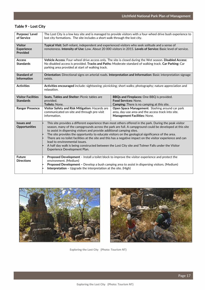
Exploring the Lost City (Photo: Tourism NT)
Exploring the Lost City (Photo: Tourism NT)
Litchfield National Park Plan of Management
Page 18
Table 10 - Greenant Creek / Tjaetaba Falls
Purpose/ Level of Service
Greenant Creek / Tjaetaba Falls is a low-key visitor site providing a walk through a monsoon rainforest
habitat, beside a picturesque watercourse, to the lookout at the top of Tjaetaba Falls. This site provides an
alternative visitor site to assist in reducing over-crowding at other key locations.
Visitor Experience
Typical Visit: Visitors are provided with a short or longer walk through rainforest to a waterfall. Intensity of Use: Low to moderate visitor numbers. Levels of Service: Moderate level of service.
Access Standards
Vehicle Access: High standard sealed road. Disabled Access: No disabled access provided. Tracks and Paths: Moderate standard of tracks. Car Parking: Unsealed car parking area.
Standard of Information
Orientation: Directional signs on arterial roads. Interpretation and Information: Interpretation signs are
present on site.
Activities Activities encouraged include: sightseeing; picnicking; short walks; photography; nature appreciation and
relaxation. Swimming is not permitted below Tjaetaba Falls as the pool and area downstream of the falls is
an Aboriginal sacred site. Visitors are able to cool down in the pool at the top of the falls.
Visitor Facilities Standards
Seats, Tables and Shelter: Picnic tables
provided.
Toilets: Self composting toilets are provided.
BBQs and Fireplaces: Woodfire BBQs are provided.
Food Services: None.
Camping: There is no camping at this site.
Ranger Presence Visitor Safety and Risk Mitigation: The area
has been identified as potentially containing
scrub typhus which is carried by ticks. Visitors
are warned through on-site information. Glass
containers are not permitted within 10 m of
designated swimming areas.
Open Space Management: Slashing for infrastructure,
safety (fire), visitor access, open space and aesthetic
appeal if necessary. Management Facilities: None.
Issues and Opportunities
• The rock pool at the top of Tjaetaba Falls is small and cannot cater to large numbers of visitors.
Development at this site will be restricted to upgrading existing facilities rather than expanding the site.
Future Directions
• Site Future - Maintain this site as a low key site to ensure visitors are provided with opportunities to
avoid the more crowded sites.
• Proposed Development – Upgrade the car park, walking tracks and toilet block to provide a higher
standard of facilities. (Low)
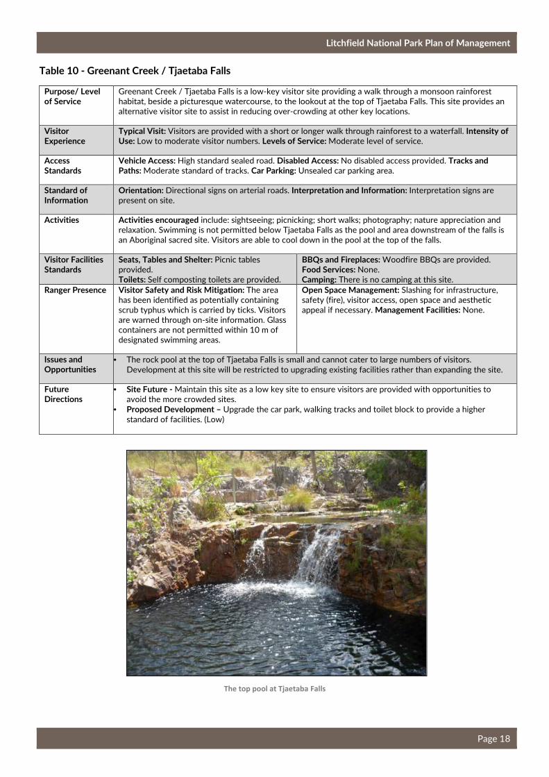
The top pool at Tjaetaba Falls
Litchfield National Park Plan of Management
Page 19
Table 11 - Cascades
Purpose/ Level of Service
Cascades provides a high standard of access, facilities and information for a moderate number of visitors.
This site was developed in 2010 as an alternative recreation opportunity away from the crowds. Visitors
can walk or picnic beside the picturesque Cascade Creek or swim in the many rock pools. The Cascades can
be reached either via a walk that follows the creek up to the Cascades or a longer walk that provides views
out across the escarpment before arriving at the Cascades.
Visitor Experience Provided
Typical Visit: Self-reliant and experienced visitors who seek swimming and picnicking opportunities away
from crowds. Intensity of Use: Moderate. Levels of Service: Moderate level of service.
Access Standards
Vehicle Access: High standard sealed road. Disabled Access: Disabled access from the car park to one of
the viewing platforms. No disabled access to the top of the escarpment. Tracks and Paths: Moderate
standard of tracks. The lower viewing platforms may receive higher numbers of visitors than the top
lookout. Car Parking: Sealed car and long vehicle parking.
Standard of Information
Orientation: Directional signs on arterial roads. Detailed site information supported on the Parks and
Wildlife Commission website. Interpretation and Information: Basic interpretation is provided at the
beginning of the walking track.
Activities Activities encouraged include: sightseeing; picnicking; short and medium walks; swimming; photography;
nature appreciation and relaxation. The presence of some other users is an expected part of the park
experience.
Visitor Facilities Standards
Seats, Tables and Shelter: Seating, tables, chairs,
interpretation shelter and viewing platforms
provided. Two seats provided at the top of the
escarpment. Toilets: A self-composting toilet is
provided.
BBQs and Fireplaces: None.
Food Services: None.
Camping: There is no camping at this site.
Ranger Presence Visitor Safety and Risk Mitigation: Hazards and
hidden threats communicated on-site and in pre-
visit information. Glass containers are not
permitted within 10 m of designated swimming
areas.
Open Space Management: Slashing for
infrastructure, safety (fire), visitor access, open space
and aesthetic appeal if necessary. Management Facilities: None.
Issues and Opportunities
• The site includes Wet and Dry season access to the rock pools at the top of the escarpment. The
footbridge at the base of the creek is removed at the start of the Wet season signifying the closing of the
Dry season section of walk.
• The site may be closed for limited times during the Wet season when flash flooding occurs.
Future Directions
• Car Park – Expand the car park with an additional 20 car parks. (High)
• Proposed Development – Install seating on the banks at the top the creek to enhance the visitor
experience. (High)
• Future Direction - Monitor the level of use of the site to determine if the walking track needs hardening.
• Future Direction – Upon completion of the sealing of the Litchfield Park Road, assess the impacts on the
site. Carry out a site assessment to determine how impacts can be mitigated. (Medium)
Litchfield National Park Plan of Management
Page 20
Table 12 - Walker Creek
Purpose/ Level of Service
Walker Creek provides a low-key location for swimming, picnicking and camping along a picturesque
watercourse. Visitors are able to walk in and camp along the creek at private camping sites. This type of
experience is not offered elsewhere in the park and is very popular with visitors. Camping is only available
in the Dry season.
Visitor Experience Provided
Typical Visit: Independent, experienced park visitors willing to sacrifice comfort in order to avoid high use
areas and retain outback experience. Intensity of Use: Low. About 25 000 visitors in 2015. Levels of Service: Moderate level of service.
Access Standards
Vehicle Access: High, sealed two-wheel drive road. Disabled Access: No disabled access. Tracks and Paths: Moderate standard of tracks. Car Parking: Sealed car parking area.
Standard of Information
Orientation: Directional signs on arterial roads. Interpretation and Education: Interpretation is provided on
site.
Activities Activities encouraged include: swimming; sightseeing; picnicking; short walks; photography; nature
appreciation; camping and relaxation.
Visitor Facilities Standards
Seats, Tables and Shelter: Tables are provided.
Toilets: Self composting toilets are provided in
the car park and between the day-use area and
campsite number 4 and campsite number 7 and
8.
BBQs and Fireplaces: Woodfire BBQs are provided in the
day-use and camping areas.
Food Services: None.
Camping: Eight walk-in camp sites are provided. The site
is also a major camp site for Tabletop Track.
Ranger Presence Visitor Safety and Risk Mitigation: Hazards
communicated on-site and in pre-visit
information. Glass containers are not permitted
within 10 m of designated swimming areas.
Open Space Management: Slashing for infrastructure,
safety (fire), visitor access, open space and aesthetic
appeal (as required). Management Facilities: The Walker
Creek Ranger station is located near to this visitor site.
The ranger station includes an office, residences, bore
and workshop.
Issues and Opportunities
• This is the second site visitors discover as they enter the park from the north. The sealing of the
remaining sections of the Litchfield Park Road is likely to have a significant impact on this site and affect
the flow of visitors through the park.
• Issues arise with visitors from the Tabletop Track using these camping sites without paying. This leaves
limited sites available for those visitors specifically wanting to camp at Walker Creek.
• Toilet facilities are limited for those campers staying in campsites 1, 2, 3 and 4. Campers are advised to
make their own bush toilets which can become unpleasant during peak season.
Future Directions
• Future Direction – Upon completion of the sealing of the Litchfield Park Road, assess the impacts on the
site. Carry out a site assessment to determine how impacts can be mitigated. (Medium)
• Site Future – Maintain this site as a low key visitor site to ensure this unique experience is still offered
within the park. (Ongoing)
• Proposed Development – Upgrade the furniture and harden the walking track through the site. (Medium)
Litchfield National Park Plan of Management
Page 21
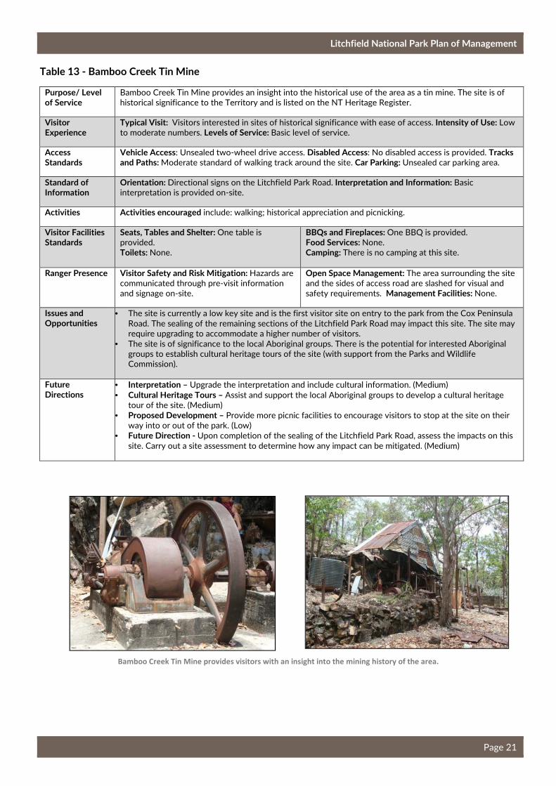
Table 13 - Bamboo Creek Tin Mine
Purpose/ Level of Service
Bamboo Creek Tin Mine provides an insight into the historical use of the area as a tin mine. The site is of
historical significance to the Territory and is listed on the NT Heritage Register.
Visitor Experience
Typical Visit: Visitors interested in sites of historical significance with ease of access. Intensity of Use: Low
to moderate numbers. Levels of Service: Basic level of service.
Access Standards
Vehicle Access: Unsealed two-wheel drive access. Disabled Access: No disabled access is provided. Tracks and Paths: Moderate standard of walking track around the site. Car Parking: Unsealed car parking area.
Standard of Information
Orientation: Directional signs on the Litchfield Park Road. Interpretation and Information: Basic
interpretation is provided on-site.
Activities Activities encouraged include: walking; historical appreciation and picnicking.
Visitor Facilities Standards
Seats, Tables and Shelter: One table is
provided.
Toilets: None.
BBQs and Fireplaces: One BBQ is provided.
Food Services: None.
Camping: There is no camping at this site.
Ranger Presence Visitor Safety and Risk Mitigation: Hazards are
communicated through pre-visit information
and signage on-site.
Open Space Management: The area surrounding the site
and the sides of access road are slashed for visual and
safety requirements. Management Facilities: None.
Issues and Opportunities
• The site is currently a low key site and is the first visitor site on entry to the park from the Cox Peninsula
Road. The sealing of the remaining sections of the Litchfield Park Road may impact this site. The site may
require upgrading to accommodate a higher number of visitors.
• The site is of significance to the local Aboriginal groups. There is the potential for interested Aboriginal
groups to establish cultural heritage tours of the site (with support from the Parks and Wildlife
Commission).
Future Directions
• Interpretation – Upgrade the interpretation and include cultural information. (Medium)
• Cultural Heritage Tours – Assist and support the local Aboriginal groups to develop a cultural heritage
tour of the site. (Medium)
• Proposed Development – Provide more picnic facilities to encourage visitors to stop at the site on their
way into or out of the park. (Low)
• Future Direction - Upon completion of the sealing of the Litchfield Park Road, assess the impacts on this
site. Carry out a site assessment to determine how any impact can be mitigated. (Medium)
Bamboo Creek Tin Mine provides visitors with an insight into the mining history of the area.
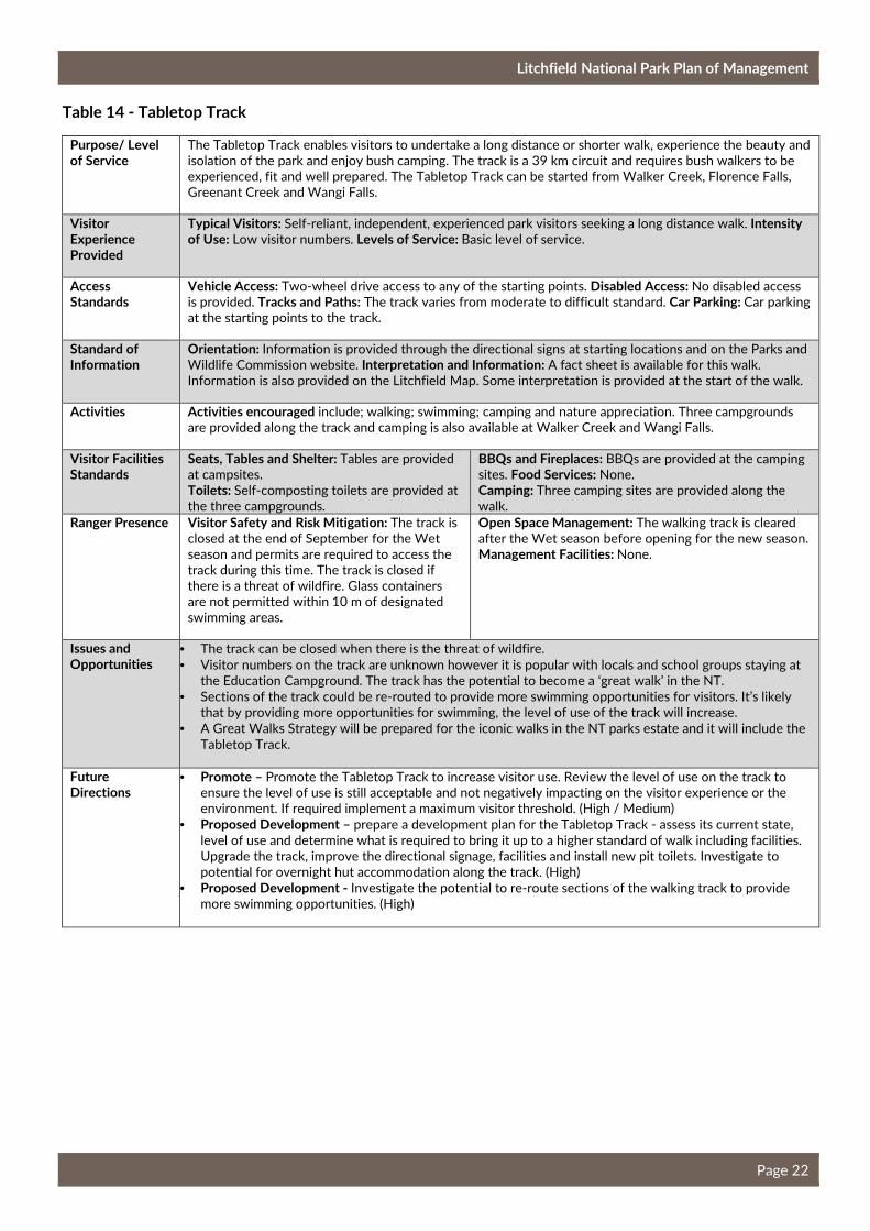
Litchfield National Park Plan of Management
Page 22
Table 14 - Tabletop Track
Purpose/ Level of Service
The Tabletop Track enables visitors to undertake a long distance or shorter walk, experience the beauty and
isolation of the park and enjoy bush camping. The track is a 39 km circuit and requires bush walkers to be
experienced, fit and well prepared. The Tabletop Track can be started from Walker Creek, Florence Falls,
Greenant Creek and Wangi Falls.
Visitor Experience Provided
Typical Visitors: Self-reliant, independent, experienced park visitors seeking a long distance walk. Intensity of Use: Low visitor numbers. Levels of Service: Basic level of service.
Access Standards
Vehicle Access: Two-wheel drive access to any of the starting points. Disabled Access: No disabled access
is provided. Tracks and Paths: The track varies from moderate to difficult standard. Car Parking: Car parking
at the starting points to the track.
Standard of Information
Orientation: Information is provided through the directional signs at starting locations and on the Parks and
Wildlife Commission website. Interpretation and Information: A fact sheet is available for this walk.
Information is also provided on the Litchfield Map. Some interpretation is provided at the start of the walk.
Activities Activities encouraged include; walking; swimming; camping and nature appreciation. Three campgrounds
are provided along the track and camping is also available at Walker Creek and Wangi Falls.
Visitor Facilities Standards
Seats, Tables and Shelter: Tables are provided
at campsites.
Toilets: Self-composting toilets are provided at
the three campgrounds.
BBQs and Fireplaces: BBQs are provided at the camping
sites. Food Services: None.
Camping: Three camping sites are provided along the
walk.
Ranger Presence Visitor Safety and Risk Mitigation: The track is
closed at the end of September for the Wet
season and permits are required to access the
track during this time. The track is closed if
there is a threat of wildfire. Glass containers
are not permitted within 10 m of designated
swimming areas.
Open Space Management: The walking track is cleared
after the Wet season before opening for the new season.
Management Facilities: None.
Issues and Opportunities
• The track can be closed when there is the threat of wildfire.
• Visitor numbers on the track are unknown however it is popular with locals and school groups staying at
the Education Campground. The track has the potential to become a ‘great walk’ in the NT.
• Sections of the track could be re-routed to provide more swimming opportunities for visitors. It’s likely
that by providing more opportunities for swimming, the level of use of the track will increase.
• A Great Walks Strategy will be prepared for the iconic walks in the NT parks estate and it will include the
Tabletop Track.
Future Directions
• Promote – Promote the Tabletop Track to increase visitor use. Review the level of use on the track to
ensure the level of use is still acceptable and not negatively impacting on the visitor experience or the
environment. If required implement a maximum visitor threshold. (High / Medium)
• Proposed Development – prepare a development plan for the Tabletop Track - assess its current state,
level of use and determine what is required to bring it up to a higher standard of walk including facilities.
Upgrade the track, improve the directional signage, facilities and install new pit toilets. Investigate to
potential for overnight hut accommodation along the track. (High)
• Proposed Development - Investigate the potential to re-route sections of the walking track to provide
more swimming opportunities. (High)
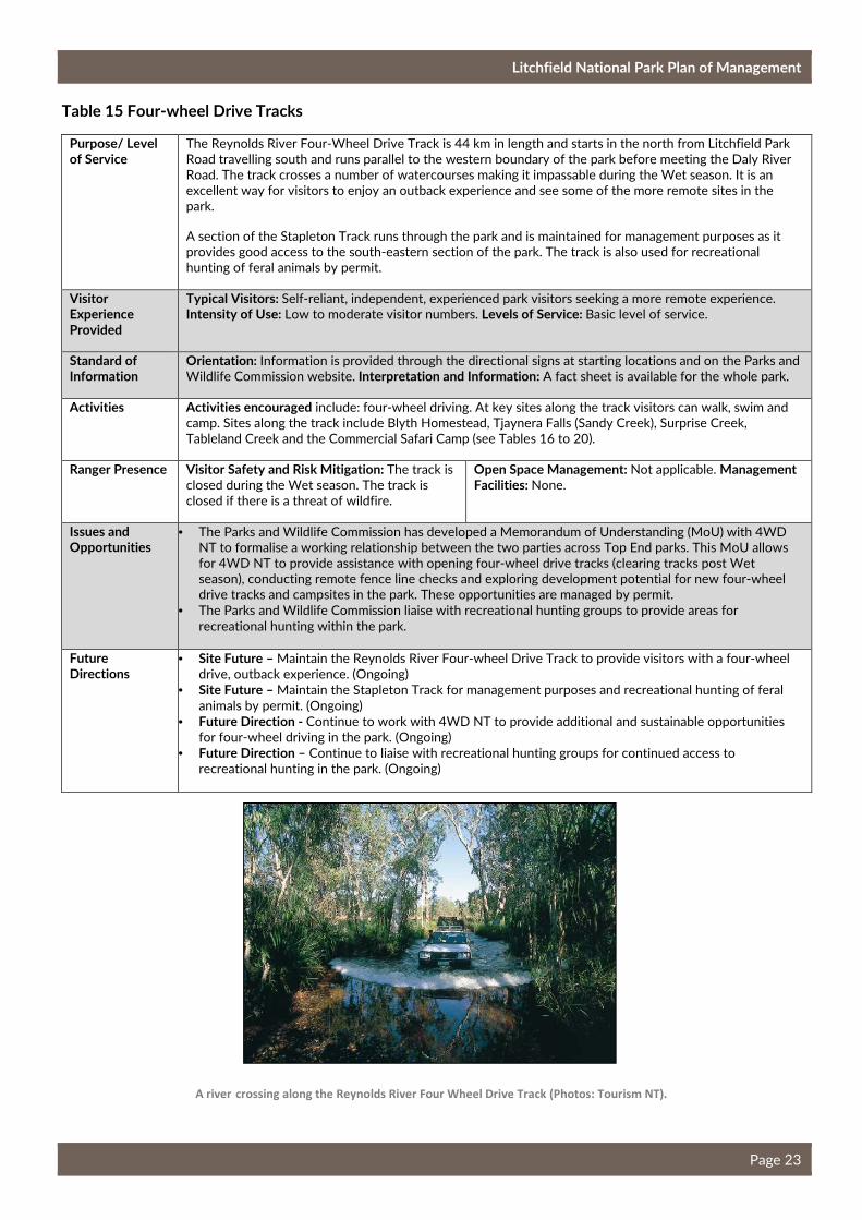
Litchfield National Park Plan of Management
Page 23
Table 15 Four-wheel Drive Tracks
Purpose/ Level of Service
The Reynolds River Four-Wheel Drive Track is 44 km in length and starts in the north from Litchfield Park
Road travelling south and runs parallel to the western boundary of the park before meeting the Daly River
Road. The track crosses a number of watercourses making it impassable during the Wet season. It is an
excellent way for visitors to enjoy an outback experience and see some of the more remote sites in the
park.
A section of the Stapleton Track runs through the park and is maintained for management purposes as it
provides good access to the south-eastern section of the park. The track is also used for recreational
hunting of feral animals by permit.
Visitor Experience Provided
Typical Visitors: Self-reliant, independent, experienced park visitors seeking a more remote experience. Intensity of Use: Low to moderate visitor numbers. Levels of Service: Basic level of service.
Standard of Information
Orientation: Information is provided through the directional signs at starting locations and on the Parks and
Wildlife Commission website. Interpretation and Information: A fact sheet is available for the whole park.
Activities Activities encouraged include: four-wheel driving. At key sites along the track visitors can walk, swim and
camp. Sites along the track include Blyth Homestead, Tjaynera Falls (Sandy Creek), Surprise Creek,
Tableland Creek and the Commercial Safari Camp (see Tables 16 to 20).
Ranger Presence Visitor Safety and Risk Mitigation: The track is
closed during the Wet season. The track is
closed if there is a threat of wildfire.
Open Space Management: Not applicable. Management Facilities: None.
Issues and Opportunities
• The Parks and Wildlife Commission has developed a Memorandum of Understanding (MoU) with 4WD
NT to formalise a working relationship between the two parties across Top End parks. This MoU allows
for 4WD NT to provide assistance with opening four-wheel drive tracks (clearing tracks post Wet
season), conducting remote fence line checks and exploring development potential for new four-wheel
drive tracks and campsites in the park. These opportunities are managed by permit.
• The Parks and Wildlife Commission liaise with recreational hunting groups to provide areas for
recreational hunting within the park.
Future Directions
• Site Future – Maintain the Reynolds River Four-wheel Drive Track to provide visitors with a four-wheel
drive, outback experience. (Ongoing)
• Site Future – Maintain the Stapleton Track for management purposes and recreational hunting of feral
animals by permit. (Ongoing)
• Future Direction - Continue to work with 4WD NT to provide additional and sustainable opportunities
for four-wheel driving in the park. (Ongoing)
• Future Direction – Continue to liaise with recreational hunting groups for continued access to
recreational hunting in the park. (Ongoing)
A river crossing along the Reynolds River Four Wheel Drive Track (Photos: Tourism NT).

Litchfield National Park Plan of Management
Page 24
Table 16 - Blyth Homestead (Ruins)
Purpose/ Level of Service
The site provides the opportunity to learn some history of the park, when it was an operating cattle station.
The site is of heritage significance to the Territory and is listed on the NT Heritage Register. The site
receives low visitor numbers.
Visitor Experience Provided
Typical Visit: Self-reliant park visitors are provided with an opportunity to visit a historical site. Intensity of Use: Low number of visitors. Levels of Service: Basic level of service.
Access Standards
Vehicle Access: Access to site is currently four-wheel drive and is only open during the Dry season.
Disabled Access: None. Tracks and Paths: Easy walking around the ruins. Car Parking: Unsealed and not
formalised car parking area.
Standard of Information
Orientation: Directional signage is located at the start and end of the Reynolds River Four-Wheel Drive
Track. Interpretation and Information: On-site interpretation is provided.
Activities Activities encouraged include four-wheel driving and historical appreciation.
Visitor Facilities Standards
Seats, Tables and Shelter: Tables and seats
are provided.
Toilets: None.
BBQs and Fireplaces: None.
Food Services: None.
Camping: None.
Ranger Presence Visitor Safety and Risk Mitigation: Hazards
are communicated through pre-visit
information.
Open Space Management: The site is slashed before
opening at the beginning of the Dry season. Management Facilities: None.
Issues and Opportunities
• The site has the potential to accommodate guided historical and cultural tours to enhance the visitor
experience.
Future Directions
• Proposed Development – Support development of guided historical and cultural tours of the site. If a
guided tour is established assess the need for a toilet block. (Low)
Blyth Homestead is listed on the NT Heritage Register
(Photos: on the left Tourism NT, on the right Heritage Division, Department of Tourism and Culture).
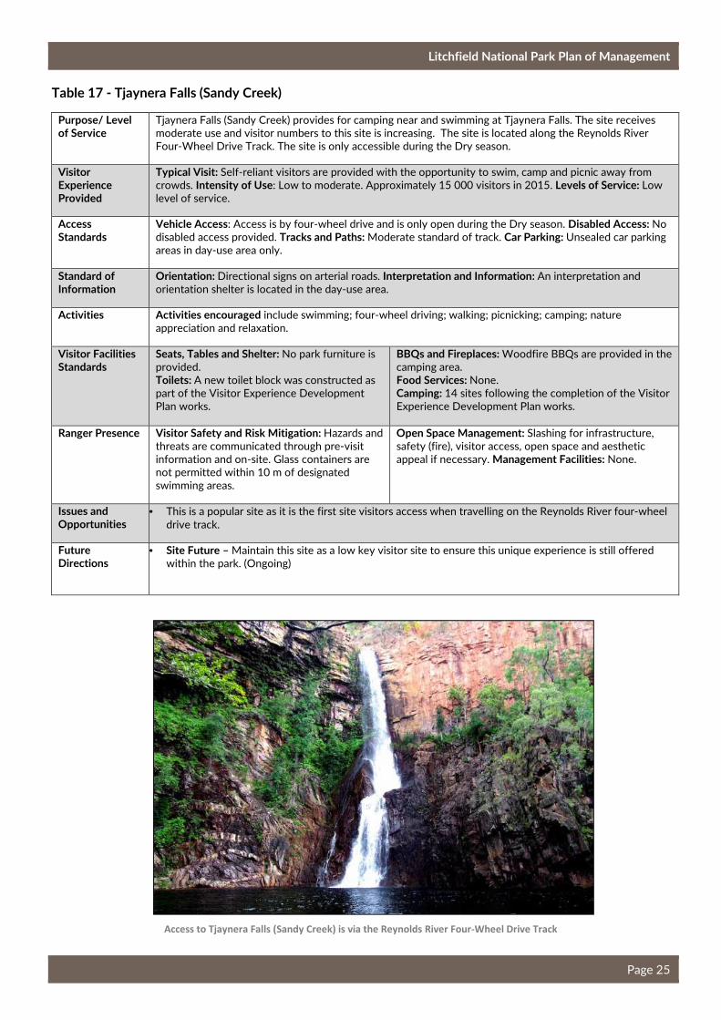
Litchfield National Park Plan of Management
Page 25
Table 17 - Tjaynera Falls (Sandy Creek)
Purpose/ Level of Service
Tjaynera Falls (Sandy Creek) provides for camping near and swimming at Tjaynera Falls. The site receives
moderate use and visitor numbers to this site is increasing. The site is located along the Reynolds River
Four-Wheel Drive Track. The site is only accessible during the Dry season.
Visitor Experience Provided
Typical Visit: Self-reliant visitors are provided with the opportunity to swim, camp and picnic away from
crowds. Intensity of Use: Low to moderate. Approximately 15 000 visitors in 2015. Levels of Service: Low
level of service.
Access Standards
Vehicle Access: Access is by four-wheel drive and is only open during the Dry season. Disabled Access: No
disabled access provided. Tracks and Paths: Moderate standard of track. Car Parking: Unsealed car parking
areas in day-use area only.
Standard of Information
Orientation: Directional signs on arterial roads. Interpretation and Information: An interpretation and
orientation shelter is located in the day-use area.
Activities Activities encouraged include swimming; four-wheel driving; walking; picnicking; camping; nature
appreciation and relaxation.
Visitor Facilities Standards
Seats, Tables and Shelter: No park furniture is
provided.
Toilets: A new toilet block was constructed as
part of the Visitor Experience Development
Plan works.
BBQs and Fireplaces: Woodfire BBQs are provided in the
camping area.
Food Services: None.
Camping: 14 sites following the completion of the Visitor
Experience Development Plan works.
Ranger Presence Visitor Safety and Risk Mitigation: Hazards and
threats are communicated through pre-visit
information and on-site. Glass containers are
not permitted within 10 m of designated
swimming areas.
Open Space Management: Slashing for infrastructure,
safety (fire), visitor access, open space and aesthetic
appeal if necessary. Management Facilities: None.
Issues and Opportunities
• This is a popular site as it is the first site visitors access when travelling on the Reynolds River four-wheel
drive track.
Future Directions
• Site Future – Maintain this site as a low key visitor site to ensure this unique experience is still offered
within the park. (Ongoing)
Access to Tjaynera Falls (Sandy Creek) is via the Reynolds River Four-Wheel Drive Track
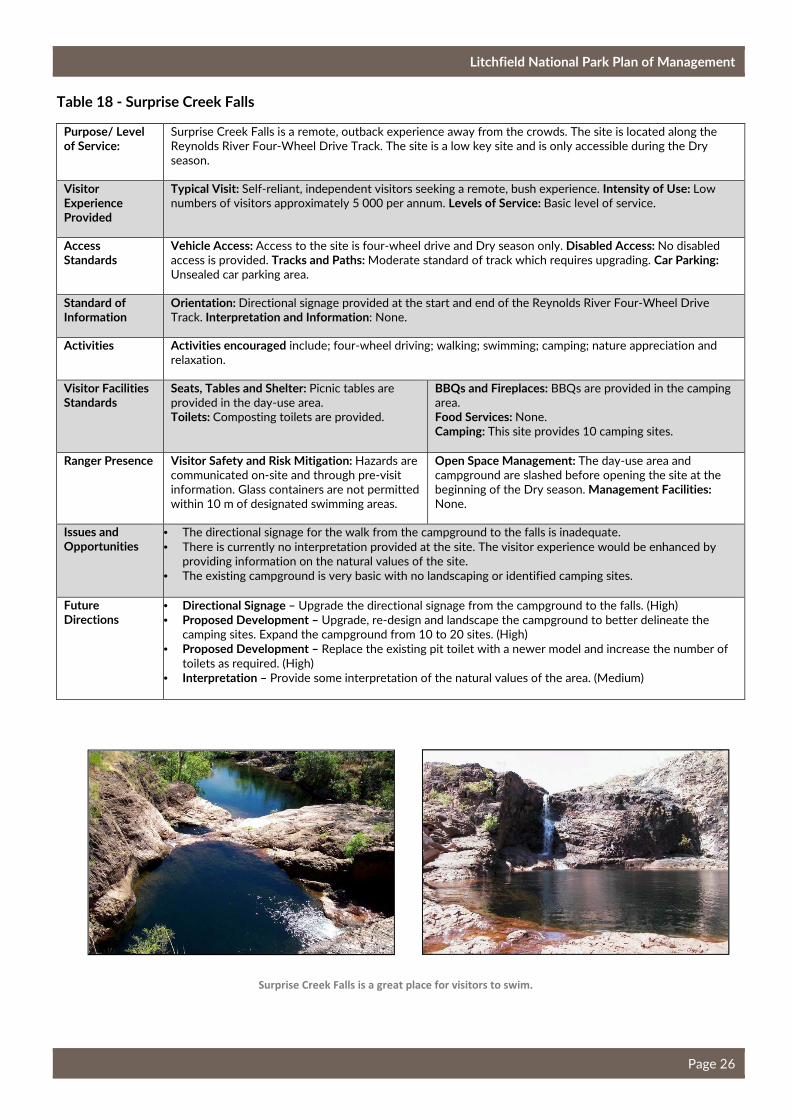
Litchfield National Park Plan of Management
Page 26
Table 18 - Surprise Creek Falls
Purpose/ Level of Service:
Surprise Creek Falls is a remote, outback experience away from the crowds. The site is located along the
Reynolds River Four-Wheel Drive Track. The site is a low key site and is only accessible during the Dry
season.
Visitor Experience Provided
Typical Visit: Self-reliant, independent visitors seeking a remote, bush experience. Intensity of Use: Low
numbers of visitors approximately 5 000 per annum. Levels of Service: Basic level of service.
Access Standards
Vehicle Access: Access to the site is four-wheel drive and Dry season only. Disabled Access: No disabled
access is provided. Tracks and Paths: Moderate standard of track which requires upgrading. Car Parking: Unsealed car parking area.
Standard of Information
Orientation: Directional signage provided at the start and end of the Reynolds River Four-Wheel Drive
Track. Interpretation and Information: None.
Activities Activities encouraged include; four-wheel driving; walking; swimming; camping; nature appreciation and
relaxation.
Visitor Facilities Standards
Seats, Tables and Shelter: Picnic tables are
provided in the day-use area.
Toilets: Composting toilets are provided.
BBQs and Fireplaces: BBQs are provided in the camping
area.
Food Services: None.
Camping: This site provides 10 camping sites.
Ranger Presence Visitor Safety and Risk Mitigation: Hazards are
communicated on-site and through pre-visit
information. Glass containers are not permitted
within 10 m of designated swimming areas.
Open Space Management: The day-use area and
campground are slashed before opening the site at the
beginning of the Dry season. Management Facilities: None.
Issues and Opportunities
• The directional signage for the walk from the campground to the falls is inadequate.
• There is currently no interpretation provided at the site. The visitor experience would be enhanced by
providing information on the natural values of the site.
• The existing campground is very basic with no landscaping or identified camping sites.
Future Directions
• Directional Signage – Upgrade the directional signage from the campground to the falls. (High)
• Proposed Development – Upgrade, re-design and landscape the campground to better delineate the
camping sites. Expand the campground from 10 to 20 sites. (High)
• Proposed Development – Replace the existing pit toilet with a newer model and increase the number of
toilets as required. (High)
• Interpretation – Provide some interpretation of the natural values of the area. (Medium)
Surprise Creek Falls is a great place for visitors to swim.
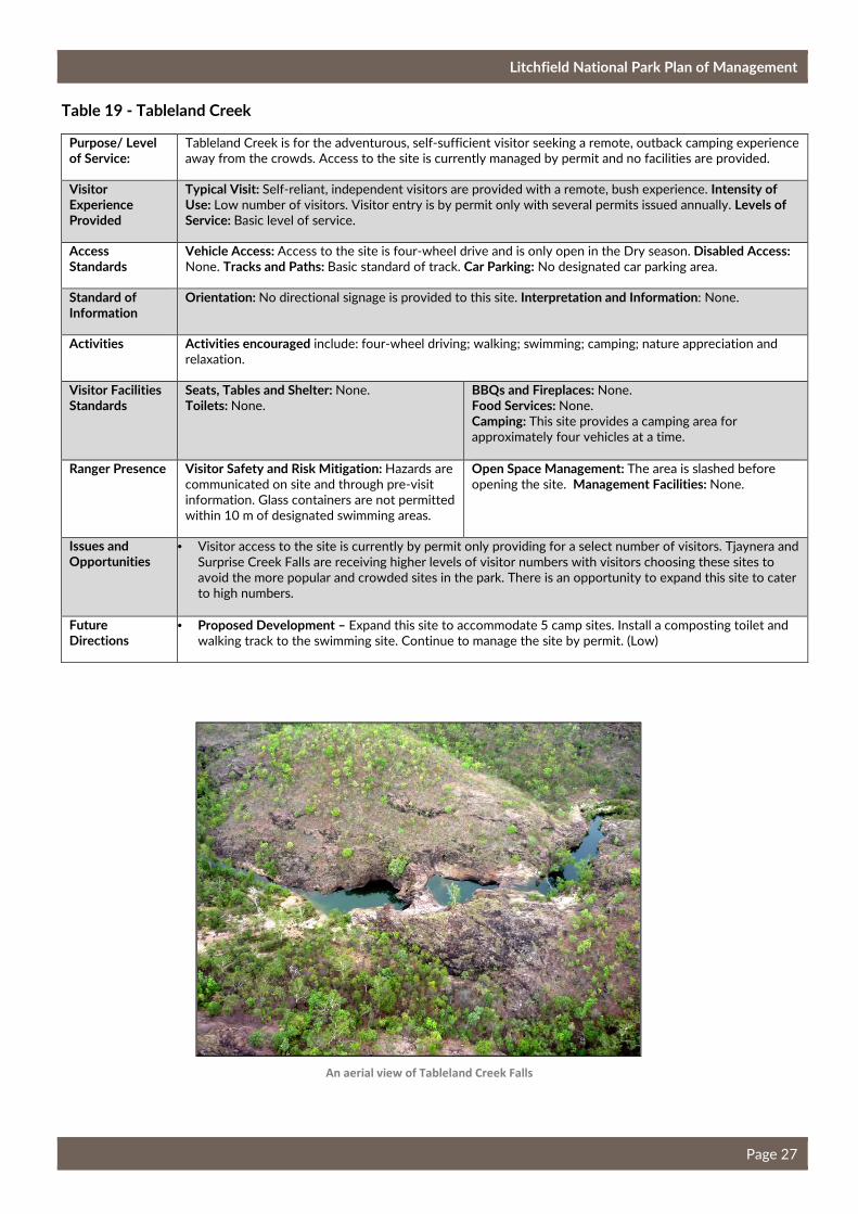
Litchfield National Park Plan of Management
Page 27
Table 19 - Tableland Creek
Purpose/ Level of Service:
Tableland Creek is for the adventurous, self-sufficient visitor seeking a remote, outback camping experience
away from the crowds. Access to the site is currently managed by permit and no facilities are provided.
Visitor Experience Provided
Typical Visit: Self-reliant, independent visitors are provided with a remote, bush experience. Intensity of Use: Low number of visitors. Visitor entry is by permit only with several permits issued annually. Levels of Service: Basic level of service.
Access Standards
Vehicle Access: Access to the site is four-wheel drive and is only open in the Dry season. Disabled Access: None. Tracks and Paths: Basic standard of track. Car Parking: No designated car parking area.
Standard of Information
Orientation: No directional signage is provided to this site. Interpretation and Information: None.
Activities Activities encouraged include: four-wheel driving; walking; swimming; camping; nature appreciation and
relaxation.
Visitor Facilities Standards
Seats, Tables and Shelter: None.
Toilets: None. BBQs and Fireplaces: None.
Food Services: None.
Camping: This site provides a camping area for
approximately four vehicles at a time.
Ranger Presence Visitor Safety and Risk Mitigation: Hazards are
communicated on site and through pre-visit
information. Glass containers are not permitted
within 10 m of designated swimming areas.
Open Space Management: The area is slashed before
opening the site. Management Facilities: None.
Issues and Opportunities
• Visitor access to the site is currently by permit only providing for a select number of visitors. Tjaynera and
Surprise Creek Falls are receiving higher levels of visitor numbers with visitors choosing these sites to
avoid the more popular and crowded sites in the park. There is an opportunity to expand this site to cater
to high numbers.
Future Directions
• Proposed Development – Expand this site to accommodate 5 camp sites. Install a composting toilet and
walking track to the swimming site. Continue to manage the site by permit. (Low)
An aerial view of Tableland Creek Falls
Litchfield National Park Plan of Management
Page 28
Table 20 - Commercial Safari Camp
Purpose/ Level of Service:
The Commercial Safari Camp provides an exclusive experience for clients of the concessionaire. Visitors
have the opportunity to spend multiple days exploring the less visited sites in the park.
Visitor Experience Provided
Typical Visit: Tour groups managed through a concession. Intensity of Use: Low visitor numbers. Group
sizes are limited to a maximum of 24 visitors. For each group there is a maximum stay of two nights. Levels of Service: Basic level of service.
Access Standards
Vehicle Access: Access is only permitted when accompanied by the concessionaire. The track is four-wheel
drive and is only open in the Dry season. Entry is through a locked gate. Disabled Access: None. Tracks and Paths: None. Car Parking: Parking is provided for the four-wheel drive bus.
Standard of Information
Orientation: Information is provided through the tour organiser. Interpretation and Information: None.
Activities Activities encouraged at this site include camping, relaxing and nature appreciation.
Visitor Facilities Standards
Seats, Tables and Shelter: Tables and seats are
provided as part of the tour.
Toilets: Composting toilets and camp showers
are provided.
BBQs and Fireplaces: Cooking facilities are provided as
part of the tour.
Food Services: Food services are provided as part of the
tour.
Camping: Tents are provided by the tour organiser.
Ranger Presence Visitor Safety and Risk Mitigation: Public
access is not permitted - access is only
provided with the concessionaire.
Open Space Management: None. Management Facilities: None.
Issues and Opportunities
• This experience is not offered elsewhere in the park.
• The current commercial concession will expire in May 2017 providing the opportunity to review the
future use of the site. Consideration will be given to other opportunities to best use this site and may
include a camp ground for multiple tour operators.
Future Directions
• Site Future – Review the future of the site to determine the best use of the area. (High).
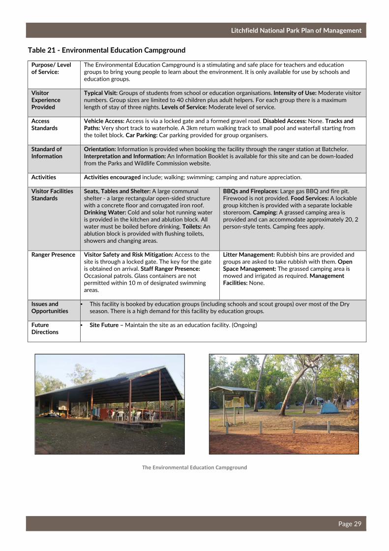
Litchfield National Park Plan of Management
Page 29
Table 21 - Environmental Education Campground
Purpose/ Level of Service:
The Environmental Education Campground is a stimulating and safe place for teachers and education
groups to bring young people to learn about the environment. It is only available for use by schools and
education groups.
Visitor Experience Provided
Typical Visit: Groups of students from school or education organisations. Intensity of Use: Moderate visitor
numbers. Group sizes are limited to 40 children plus adult helpers. For each group there is a maximum
length of stay of three nights. Levels of Service: Moderate level of service.
Access Standards
Vehicle Access: Access is via a locked gate and a formed gravel road. Disabled Access: None. Tracks and Paths: Very short track to waterhole. A 3km return walking track to small pool and waterfall starting from
the toilet block. Car Parking: Car parking provided for group organisers.
Standard of Information
Orientation: Information is provided when booking the facility through the ranger station at Batchelor.
Interpretation and Information: An Information Booklet is available for this site and can be down-loaded
from the Parks and Wildlife Commission website.
Activities Activities encouraged include; walking; swimming; camping and nature appreciation.
Visitor Facilities Standards
Seats, Tables and Shelter: A large communal
shelter - a large rectangular open-sided structure
with a concrete floor and corrugated iron roof.
Drinking Water: Cold and solar hot running water
is provided in the kitchen and ablution block. All
water must be boiled before drinking. Toilets: An
ablution block is provided with flushing toilets,
showers and changing areas.
BBQs and Fireplaces: Large gas BBQ and fire pit.
Firewood is not provided. Food Services: A lockable
group kitchen is provided with a separate lockable
storeroom. Camping: A grassed camping area is
provided and can accommodate approximately 20, 2
person-style tents. Camping fees apply.
Ranger Presence Visitor Safety and Risk Mitigation: Access to the
site is through a locked gate. The key for the gate
is obtained on arrival. Staff Ranger Presence: Occasional patrols. Glass containers are not
permitted within 10 m of designated swimming
areas.
Litter Management: Rubbish bins are provided and
groups are asked to take rubbish with them. Open Space Management: The grassed camping area is
mowed and irrigated as required. Management Facilities: None.
Issues and Opportunities
• This facility is booked by education groups (including schools and scout groups) over most of the Dry
season. There is a high demand for this facility by education groups.
Future Directions
• Site Future – Maintain the site as an education facility. (Ongoing)
The Environmental Education Campground
Litchfield National Park Plan of Management
Page 30
2.5 Proposed New Park Developments
Potential New Four-wheel Drive Tracks
Four-wheel driving is a popular recreation activity in the park. There is potential for new four-wheel drive tracks to be developed that could include access to new camping, swimming and walking experiences. The Parks and Wildlife Commission will explore this potential with the assistance of 4WD NT (see also
Table 15).
New Walking Tracks
Bushwalking is a key visitor activity and statistics show that 38% of tourists bushwalk in the Litchfield,
Kakadu National Park and Arnhem tourism region (Tourism NT 2013).
The park has the potential to offer new half day loop walks. A key requirement when determining the
alignment of any new walking track will be to provide visitors with swimming opportunities.
Recreational Fishing
Recreational fishing is a popular activity in the Top End and fishing occurs in many of the rivers, creeks and culverts in the park. Discussions with the Amateur Fishermen’s Association of the Northern Territory
(AFANT) highlighted the need to give more recognition to this activity.
Fishing is permitted in creeks, rivers and culverts within the park with the exception of the creek below Wangi Falls (as it is a sacred site) and in all designated swimming areas. Visitors fishing in the road culverts along Litchfield Park Road should be careful of vehicles travelling along this road and should ensure their vehicle is parked well off the road. Visitors fishing in the park should be aware that saltwater
crocodiles occur in the park and visitors should use all necessary precautions when near the water.
Cycle / Mountain Bike Tracks
For many years, cycling and mountain bike enthusiasts and clubs have been using the service tracks and old four-wheel drive tracks within the park for mountain bike riding. The landscape of the park provides the perfect setting for off-road cycling and mountain bike tracks with rugged surfaces, spectacular scenery and little or no sand. The park’s close proximity to Darwin has led to mountain bike clubs using
the park for weekend events.
The Parks and Wildlife Commission will provide a dedicated cycle / mountain bike track and promote this recreation activity. Mountain bike groups were consulted on the feasibility of developing a mountain bike track in the park and supported the proposal. The Master Plan Mountain Biking in the Northern Territory (Tourism NT, 2016) identifies the potential for the development of a distinctive, world class adventure
ride in the park.
It is proposed to develop one mountain bike track initially with the assistance of local mountain bike groups. The track will be promoted widely as a new experience. Information on the cycling / mountain bike track will be prepared providing visitors with the necessary information to undertake the track safely and to gain the most enjoyment. The track will be developed using sustainable trail standards and will be monitored for environmental impacts including spread of weeds, erosion and fire management. If this
track is found to be well used, consideration will be given to developing more tracks.
Potential New Visitor Sites
A number of undeveloped areas of the park have potential to be developed as visitor sites to provide new and possibly different experiences and alleviate pressure on key visitor sites. Three areas have high potential include Horse Paddock Creek Falls, the Eastern Escarpment and the East Reynolds. All three
sites could offer low key walking, swimming and camping.
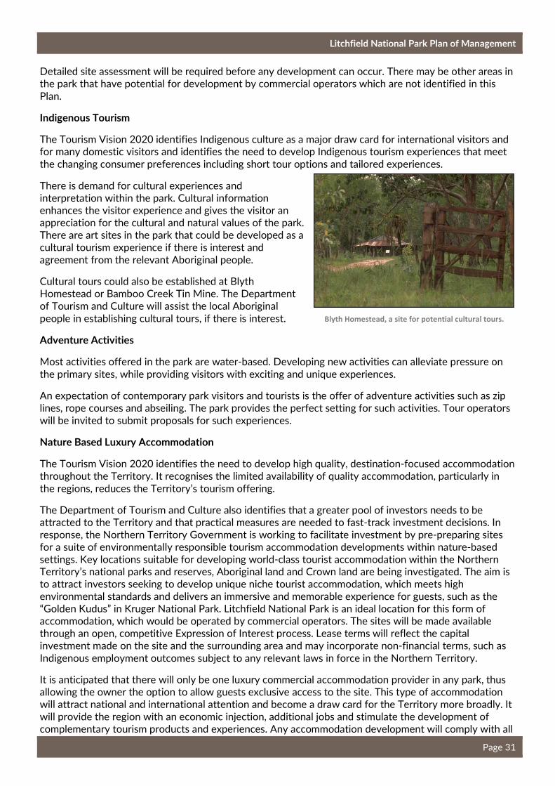
Litchfield National Park Plan of Management
Page 31
Detailed site assessment will be required before any development can occur. There may be other areas in the park that have potential for development by commercial operators which are not identified in this
Plan.
Indigenous Tourism
The Tourism Vision 2020 identifies Indigenous culture as a major draw card for international visitors and for many domestic visitors and identifies the need to develop Indigenous tourism experiences that meet
the changing consumer preferences including short tour options and tailored experiences.
There is demand for cultural experiences and interpretation within the park. Cultural information enhances the visitor experience and gives the visitor an appreciation for the cultural and natural values of the park. There are art sites in the park that could be developed as a cultural tourism experience if there is interest and
agreement from the relevant Aboriginal people.
Cultural tours could also be established at Blyth Homestead or Bamboo Creek Tin Mine. The Department of Tourism and Culture will assist the local Aboriginal
people in establishing cultural tours, if there is interest.
Adventure Activities
Most activities offered in the park are water-based. Developing new activities can alleviate pressure on
the primary sites, while providing visitors with exciting and unique experiences.
An expectation of contemporary park visitors and tourists is the offer of adventure activities such as zip lines, rope courses and abseiling. The park provides the perfect setting for such activities. Tour operators
will be invited to submit proposals for such experiences.
Nature Based Luxury Accommodation
The Tourism Vision 2020 identifies the need to develop high quality, destination-focused accommodation throughout the Territory. It recognises the limited availability of quality accommodation, particularly in
the regions, reduces the Territory’s tourism offering.
The Department of Tourism and Culture also identifies that a greater pool of investors needs to be attracted to the Territory and that practical measures are needed to fast-track investment decisions. In response, the Northern Territory Government is working to facilitate investment by pre-preparing sites for a suite of environmentally responsible tourism accommodation developments within nature-based settings. Key locations suitable for developing world-class tourist accommodation within the Northern Territory’s national parks and reserves, Aboriginal land and Crown land are being investigated. The aim is to attract investors seeking to develop unique niche tourist accommodation, which meets high environmental standards and delivers an immersive and memorable experience for guests, such as the “Golden Kudus” in Kruger National Park. Litchfield National Park is an ideal location for this form of accommodation, which would be operated by commercial operators. The sites will be made available through an open, competitive Expression of Interest process. Lease terms will reflect the capital investment made on the site and the surrounding area and may incorporate non-financial terms, such as
Indigenous employment outcomes subject to any relevant laws in force in the Northern Territory.
It is anticipated that there will only be one luxury commercial accommodation provider in any park, thus allowing the owner the option to allow guests exclusive access to the site. This type of accommodation will attract national and international attention and become a draw card for the Territory more broadly. It will provide the region with an economic injection, additional jobs and stimulate the development of complementary tourism products and experiences. Any accommodation development will comply with all
Blyth Homestead, a site for potential cultural tours.
Litchfield National Park Plan of Management
Page 32
requirements as outlined in section 5.3 and be consistent with the Parks and Wildlife Commission’s
Commercial Tourism Development Policy.
2.6 Visitor Safety
Visitor safety is paramount in the management of the park, however visitor accidents occur and when they do it is important that the situation is handled quickly and effectively. The Parks and Wildlife Commission has an overarching visitor incident system that provides a basis on which to respond to emergencies. Annual risk management assessments are undertaken and specific risk mitigation activities are captured within operational action plans. All incidents are reported centrally and the Parks and Wildlife Commission has a range of Work, Health and Safety hazard reduction guidelines to which the park adheres. The effective implementation of this system requires sufficient resources and trained,
competent staff.
Formal helicopter landing sites have been developed at the turnoff to Wangi Falls and Florence Falls and emergency landing sites are located at Tolmer Falls and Walker Creek. Batchelor airstrip is also used, if
required.
Saltwater crocodiles occur in waterways in Litchfield National Park and, as such, swimming is only permitted within the designated swimming areas. Wangi Falls, Sandy Creek, Surprise Creek, Walker Creek and the lower section of Cascades are surveyed for crocodiles and saltwater crocodiles are removed before being opened to the public. Visitors are warned of the presence of crocodiles through pre-visit information and on-park signage. A Crocodile Management Plan applies across the park and is reviewed
periodically.
Management Actions
• Explore the potential for new four-wheel drive tracks in the park with assistance from 4WD NT. (Medium)
• Develop two half day loop walks and potentially an overnight walk. (Medium)
• Support recreational fishing in the creeks, rivers and culverts in the park. Promote a safety message in relation to the presence of saltwater crocodiles in the park and the dangers associated with fishing in road culverts. (High)
• Develop a mountain bike track with the assistance of local mountain bike groups. Develop information on the track to enhance visitor safety and enjoyment. If the initial mountain bike track is well used, develop more tracks, as appropriate. Develop the track using sustainable track standards and work with mountain bike groups to ensure the alignment meets the needs of mountain bike users and complies with national track standards. Work with the tourism industry to promote mountain biking as a new visitor experience in the park. Monitor use and environmental impacts of the track including weed management and erosion. (Ongoing)
• Undertake a detailed site assessment of Horse Paddock Creek, the Eastern Escarpment and the East Reynolds to determine their recreational potential. (High)
• Work with the local Aboriginal people to encourage Aboriginal cultural tours in the park. (High)
• The Parks and Wildlife Commission will work with the tourism industry groups to develop and facilitate adventure activities (while ensuring park values are protected). (High)
• Facilitate private investment in nature based accommodation in the park. The development of this type of accommodation will comply with relevant policies and be assessed commensurate with the scale of the potential impact consistent with Northern Territory and Commonwealth legislation. (High)

Litchfield National Park Plan of Management
Page 33
Saltwater crocodiles are known to occur in the plunge pool at Wangi Falls. As an added precaution, a fence across Wangi Creek was erected as a barrier to reduce the likelihood of saltwater crocodiles entering the plunge pool during the Dry season. Wangi Falls plunge pool will continue to be closed to swimming during the
Wet season.
Directional and safety signage is an important element to ensure visitors have a safe and relaxing visit. The Parks and Wildlife Commission will continue to review and improve the directional signage within the park. Visitor information that shapes visitor expectations and behaviour will assist in reducing incidents of injury
to visitors.
The Greenant Creek area potentially harbours scrub typhus, a disease caused by the bacteria Orientia
tsutsugamushi. Scrub typhus can be prevented by applying an insect repellent (containing DEET), wearing enclosed footwear (e.g. sneakers) and long trousers are preferable if bushwalking. Visitors are warned
through on-site information.
Over the years, sites such as Wangi Falls, Buley Rockhole and Florence Falls have increased in popularity amongst visitors and Territorians. During peak season these sites become over-crowded and anti-social behaviour from some visitors is occurring more frequently. This behaviour is largely attributed to the consumption of excessive amounts of alcohol. This poor behaviour can include abusive language and in some instances can lead to violence leaving many visitors feeling unsafe and negatively impacting on their
experience.
To improve visitor safety and enjoyment, glass is now banned within 10 m of all designated swimming areas in the park. Ranger staff also carry out joint patrols with NT Police over long-weekends. These joint
patrols have seen a reduction in anti-social behavior and the return of families back to the park.
2.7 Visitor Access
There are four access routes into the park. The main entry is via Batchelor Road, a two-wheel drive sealed road, from Batchelor which joins Litchfield Park Road. The second entry is via the Cox Peninsula Road which joins Litchfield Park Road in the north western corner of the park. A section of the Litchfield Park Road is currently unsealed and the existing bridge crossing the lower Finniss River goes under water during the Wet season, effectively limiting this entry to Dry season access only. These roads are public
roads maintained by the Department of Infrastructure, Planning and Logistics.
Rangers removing a saltwater crocodile from Wangi Falls
Management Actions
• Parks and Wildlife Commission staff must be familiar with the Work, Health and Safety systems and be trained and prepared to implement them at any time. (High)
• Park and Wildlife Commission staff will work closely with NT Police, Fire and Emergency Services and Bushfires NT and during safety incidents when required. (High)
• Implement the Crocodile Management Plan and review periodically. (High)
• Review and upgrade directional signage to ensure visitors are able to easily locate park facilities. (Ongoing)
• Enforce the glass ban within 10m of all designated swimming areas. (High)
• Continue to work with NT Police to protect visitors from anti-social behaviour. (Ongoing)
Litchfield National Park Plan of Management
Page 34
In April 2015, the Territory Government announced it would complete the sealing of the Litchfield Park Road and construct an all-weather bridge over the Lower Finniss River. These works are due to be completed in 2018. These works will impact the flow of visitors through the park and may lead to more
pressure to open swimming sites early after the Wet season.
The third entry to the park is via the Reynolds River Four-Wheel Drive Track. This is an unsealed four-wheel drive access track that is closed during the Wet season. The fourth entry is via Marindja Road,
which is an unsealed road from Channel Point that is closed in the Wet season.
Access into the park along the Litchfield Park Road from Batchelor can be restricted due to flash flooding in the Wet season. The Parks and Wildlife Commission advises the public of the closure of the Reynolds River Four-Wheel Drive Track and specific site closures via media releases and the Parks and Wildlife Commission website. Road Closures are managed in conjunction with the Department of Infrastructure,
Planning and Logistics and are communicated to the public through the Road Report.
Buley Rockhole, Florence Falls and Cascades can be periodically closed during the Wet season during flash floods. The Lost City site is also closed during the Wet season once the road becomes water logged. Other sites accessed via the Reynolds River Four-Wheel Drive Track including Blyth Homestead, Tjaynera Falls (Sandy Creek) and Surprise Creek Falls are closed over the Wet season until the Reynolds River
Four-Wheel Drive Track re-opens.
Air access can include fixed-wing air tours operating out of Batchelor and Darwin. Informal emergency helicopter landing sites are located at Wangi Falls, Tolmer Falls, Florence Falls and Walker Creek.
Helicopter tours will be permitted as provided by Parks and Wildlife Commission policy.
2.8 Visitor Information, Interpretation and Monitoring
Interpretation in the park can enhance visitor enjoyment and provides an avenue for learning and appreciation of the natural and cultural values of the park. It is essential to provide up to date and interesting information. The park currently provides three forms of interpretation, interpretive signage throughout the park, ranger-guided walks and talks and Park Fact Sheets. Information is also provided by
the tourism industry and tour groups.
There are two orientation shelters at the eastern and western entries to the park. The western orientation shelter is small and provides limited information. The sealing of the Litchfield Park Road is likely to lead to more visitors entering the park from the west. The western orientation shelter may need
to be upgraded to better inform visitors of the opportunities the park offers.
Pre-visit information helps visitors to plan their trip. Pre-visit information can be obtained from the Parks and Wildlife Commission offices, webpage and Facebook site, and at the Darwin and Batchelor Visitor Information Centres, through Tourism Top End. Electronic / digital mediums offer new and exciting ways
to deliver interpretation.
Management Actions
• Conduct a visitor flow modelling project to understand the impacts on the park from the sealing of the Litchfield Park Road, enabling measures to be implemented to mitigate impacts. (High)
• Continue to work with the Department of Infrastructure, Planning and Logistics and advise the public of road closures. (Ongoing)
Litchfield National Park Plan of Management
Page 35
Visitor Monitoring
A number of traffic counters in the park collect visitor figures for select visitor sites. The Parks and Wildlife Commission will continue to maintain accurate visits data from traffic counters in the park and will carry out visitor surveys to ascertain visitor satisfaction, profile and use of the park about every three
years.
2.9 Waste Management
In late 2014, following consultation with key tourism stakeholders, all rubbish bins were removed from the park. This has been a positive move for the park and it has promoted visitors to recycle, re-use and
remove their own rubbish from the park.
Management Actions
• Ensure interpretive material provided is accurate and informative. (High)
• Upgrade the western orientation shelter to provide more detailed information on the park. (Medium)
• Parks and Wildlife Commission staff will work closely with the Batchelor Visitor Information Centre to ensure material provided to the Centre is up to date. (Ongoing)
• Continue to collect visits data from traffic counters and carry out visitor surveys in accordance with the Parks and Wildlife Visitor Monitoring Program. (High)
Litchfield National Park Plan of Management
Page 36
3. Managing Natural Values
The park protects a broad representation of Top End flora and fauna in a region that is developing rapidly. The high species diversity in the park is due to the variety of habitats including sandstone plateaus, undisturbed remnant rainforests, upland swamps and black soil plains. The park’s central sandstone plateau supports rich woodland flora communities dominated by Darwin woolybutt (Eucalyptus miniata), Darwin stringybark (Eucalyptus tetrodonta), grevillea (Grevillea pteridifolia), banksia (Banksia dentata) and a wide variety of other woodland species. The park includes numerous patches of monsoon rainforest located in deep, narrow gorges that were created over thousands of years by the force of waterfalls
cutting into the escarpment walls.
Litchfield National Park lies across three bioregions including Darwin Coastal, Pine Creek and Daly Basin. The Darwin Coastal bioregion is characterised by flat, low-lying country, drained by several large rivers. The vegetation communities include eucalypt forest and woodlands with tussock and hummock grass understory. The Pine Creek bioregion is characterised by mainly hilly to rugged ridges and undulating plains with eucalypt woodlands and patches of monsoon forest. The Daly Basin bioregion is characterised by gently undulating plains with scattered low plateau remnants and some rocky hills and gorges along its western edge. The dominant vegetation is Darwin woolybutt and stringybark open forests (DEWHA,
2008).
Integrated Conservation Strategy
An integrated conservation strategy summarises the park’s key values and outlines how these values will be protected and maintained by managing the threats. Values are defined as the most important things to look after and could include plants, animals, specific sites, cultural sites or areas. Within each value it is
recognised that there may be many nested values.
The Litchfield National Park Integrated Conservation Strategy was developed in 2014-15 and sets out well defined objectives and measurable targets for the most important values and threats to the park and gives clear understanding as to the conservation success of the park. The strategy involves regular
monitoring, evaluation of results and adjustment of actions so that management is adaptive and optimal.
The Integrated Conservation Strategy identifies the greatest threat to the natural values is frequent, high intensity, late Dry season wildfires which are highly influenced by Gamba grass, mission grass and arson.
Key management actions and monitoring programs relate to mitigating these threats (see Section 3.4).
The Strategy was developed with assistance from the Department of Environment and Natural Resources. Specialist advice was also sought from Bushfires NT and Charles Darwin University. The strategy focusses on five key values (four natural values and one visitor / cultural value), however the values of the park are interconnected and by managing these values, the nested values are also managed. Selecting the most important values for the park provides a focus for planning, actions and monitoring.
The four key natural values include:
1. Sandstone Plateaus: some of the most ecological valuable vegetation communities in the park including the Table Top open forest, Table Top woodland, sandstone woodlands, Table Top spring
communities, dry heathland and callitris stands.
Conservation Targets: <30% of the habitat is burnt per year and >20% of this habitat remains unburnt
over 5 years.
2. Monsoon rainforest and swamps: these include monsoonal forest, riparian forest, upland swamps,
sedge communities and wet heathlands. These communities are generally fire intolerant.
Conservation Targets: <10% of this habitat is burnt per year and >80% of this habitat remains unburnt
over 10 years.

Litchfield National Park Plan of Management
Page 37
3. Melaleuca woodlands: fire intolerant vegetation communities including melaleuca woodlands and
drainage woodlands.
Conservation Targets: <65% of this habitat is burnt per year and >30% of this habitat remains unburnt
over 3 years.
4. Lowland woodland and alluvial plains: vegetation communities comprising a significant proportion of
the park supporting relatively fire intolerant species.
Conservation Targets: <65% of this habitat is burnt per year and >30% of this habitat remains unburnt
over 3 years.
Note: Conservation Targets were determined in 2014 and may change upon review of the Integrated
Conservation Strategy in 2020.
The basis of threat management will be through the development and implementation of Annual Action Plans as directed by the Integrated Conservation Strategy. Monitoring and reporting of performance will
occur every two years.
3.1 Water Resources
The park contains water-dependent ecosystems of regional significance as important wildlife habitats including monsoon forests, riparian and floodplain habitats. Water movement is an important factor in
shaping and maintaining these ecosystems.
There are numerous springs located on the Tabletop plateau which provide a continuous source of water for locations such as Buley Rockhole, Florence Falls, Tolmer Falls, Wangi Falls and Tjaetaba Falls. It is important to protect these springs from any developments that may
impact the flow or lead to pollution of the waterways.
3.2 Flora
There are 974 native plant species recorded in the park including one species of cycad (Cycas armstrongii),
listed as vulnerable on the NT Threatened Species List.
The park contains representative samples of eight Northern Territory vegetation types and contains the sole representative sample of Northern Territory Vegetation Type No. 48, fan palm (Livistona humilis) tall
open-shrubland with sorghum grassland understory (NRETAS, 2009).
The numerous springs in the Tabletop landform provide
continuous water for many sites
Management Actions
• Implement the Litchfield National Park Integrated Conservation Strategy and review it every five
years. (High)
Management Actions
• Ensure any proposed developments on the Tabletop do not impact on the flow of springs or lead
to pollution of waterways. (Ongoing)
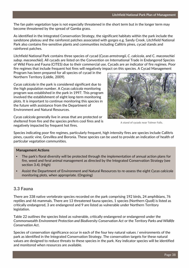
Litchfield National Park Plan of Management
Page 38
The fan palm vegetation type is not especially threatened in the short term but in the longer term may
become threatened by the spread of Gamba grass.
As identified in the Integrated Conservation Strategy, the significant habitats within the park include the sandstone plateau and the rainforest patches associated with gorges e.g. Sandy Creek. Litchfield National Park also contains fire-sensitive plants and communities including Callitris pines, cycad stands and
rainforest patches.
Litchfield National Park contains three species of cycad (Cycas armstrongii, C. calcicola, and C. maconochiei
subsp. maconochiei). All cycads are listed on the Convention on International Trade in Endangered Species of Wild Flora and Fauna (CITES) due to their commercial use. Cycads are an indicator of fire regimes. Poor fire regimes that include frequent hot fires will negatively impact on this species. A Cycad Management Program has been prepared for all species of cycad in the
Northern Territory (Liddle, 2009).
Cycas calcicola in the park is considered significant due to the high population number. A Cycas calcicola monitoring program was established in the park in 1997. This program involved the establishment of eight long-term monitoring plots. It is important to continue monitoring this species in the future with assistance from the Department of
Environment and Natural Resources.
Cycas calcicola generally live in areas that are protected or sheltered from fire and the species prefers cool fires and is
negatively impacted by frequent hot fires.
Species indicating poor fire regimes, particularly frequent, high intensity fires are species include Callitris pines, caustic vine, Grevillea and Boronia. These species can be used to provide an indication of health of
particular vegetation communities.
3.3 Fauna
There are 338 native vertebrate species recorded on the park comprising 192 birds, 24 amphibians, 76 reptiles and 46 mammals. There are 13 threatened fauna species, 1 species (Northern Quoll) is listed as critically endangered, 3 are endangered and 9 are listed as vulnerable under Northern Territory
legislation.
Table 22 outlines the species listed as vulnerable, critically endangered or endangered under the Commonwealth Environment Protection and Biodiversity Conservation Act or the Territory Parks and Wildlife
Conservation Act.
Species of conservation significance occur in each of the four key natural values / environments of the park as identified in the Integrated Conservation Strategy. The conservation targets for these natural values are designed to reduce threats to these species in the park. Key indicator species will be identified
and monitored when resources are available.
A stand of cycads near Tolmer Falls.
Management Actions
• The park’s floral diversity will be protected through the implementation of annual action plans for fire, weed and feral animal management as directed by the Integrated Conservation Strategy (see section 3.4). (High)
• Assist the Department of Environment and Natural Resources to re-assess the eight Cycas calcicola monitoring plots, when appropriate. (Ongoing)
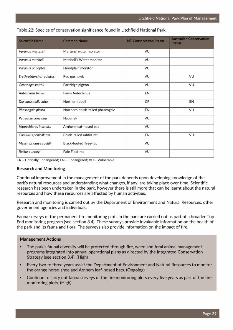
Litchfield National Park Plan of Management
Page 39
Table 22: Species of conservation significance found in Litchfield National Park.
Scientific Name Common Name NT Conservation Status Australian Conservation Status
Varanus mertensi Mertens’ water monitor VU
Varanus mitchelli Mitchell’s Water monitor VU
Varanus panoptes Floodplain monitor VU
Erythrotriorchis radiatus Red goshawk VU VU
Geophaps smithii Partridge pigeon VU VU
Antechinus bellus Fawn Antechinus EN
Dasyurus hallucatus Northern quoll CR EN
Phascogale pirata Northern brush-tailed phascogale EN VU
Petrogale concinna Nabarlek VU
Hipposideros inornata Arnhem leaf-nosed bat VU
Conilurus penicillatus Brush-tailed rabbit-rat EN VU
Mesembriomys gouldii Black-footed Tree-rat VU
Rattus tunneyi Pale Field-rat VU
CR – Critically Endangered; EN – Endangered; VU – Vulnerable.
Research and Monitoring
Continual improvement in the management of the park depends upon developing knowledge of the park’s natural resources and understanding what changes, if any, are taking place over time. Scientific research has been undertaken in the park, however there is still more that can be learnt about the natural
resources and how these resources are affected by human activities.
Research and monitoring is carried out by the Department of Environment and Natural Resources, other
government agencies and individuals.
Fauna surveys of the permanent fire monitoring plots in the park are carried out as part of a broader Top End monitoring program (see section 3.4). These surveys provide invaluable information on the health of
the park and its fauna and flora. The surveys also provide information on the impact of fire.
Management Actions
• The park’s faunal diversity will be protected through fire, weed and feral animal management programs integrated into annual operational plans as directed by the Integrated Conservation Strategy (see section 3.4). (High)
• Every two to three years assist the Department of Environment and Natural Resources to monitor the orange horse-shoe and Arnhem leaf-nosed bats. (Ongoing)
• Continue to carry out fauna surveys of the fire monitoring plots every five years as part of the fire monitoring plots. (High)
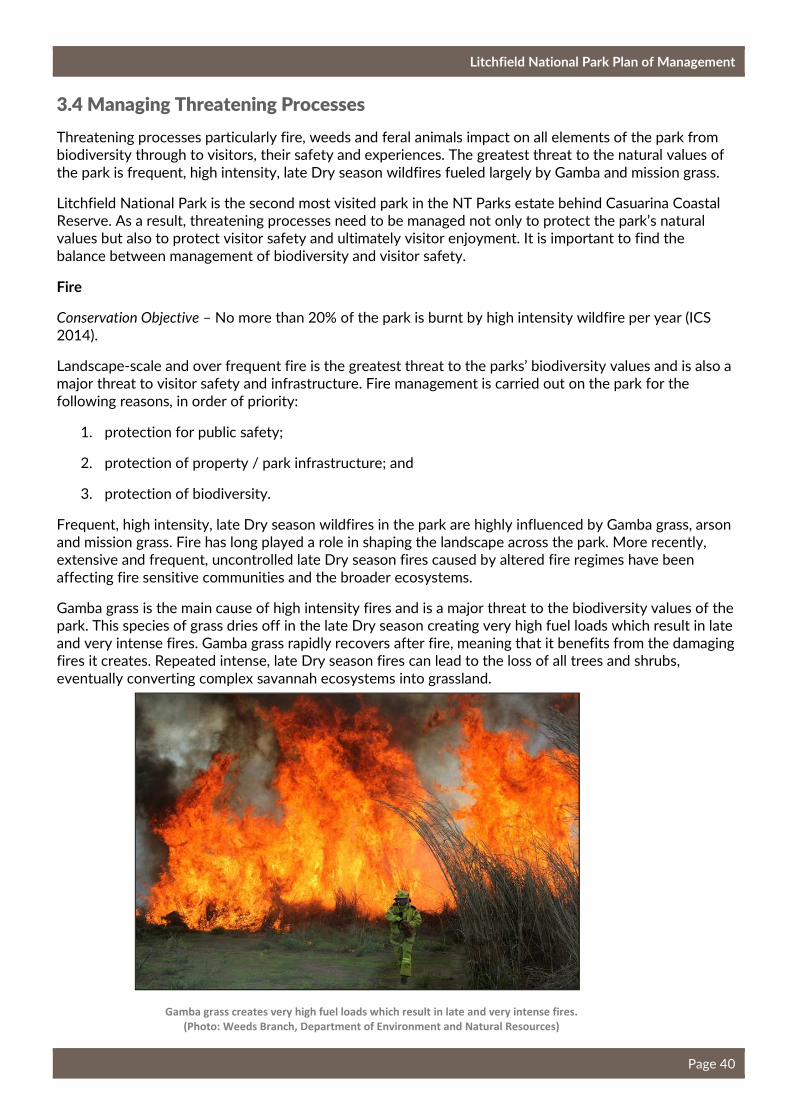
Litchfield National Park Plan of Management
Page 40
3.4 Managing Threatening Processes
Threatening processes particularly fire, weeds and feral animals impact on all elements of the park from biodiversity through to visitors, their safety and experiences. The greatest threat to the natural values of
the park is frequent, high intensity, late Dry season wildfires fueled largely by Gamba and mission grass.
Litchfield National Park is the second most visited park in the NT Parks estate behind Casuarina Coastal Reserve. As a result, threatening processes need to be managed not only to protect the park’s natural values but also to protect visitor safety and ultimately visitor enjoyment. It is important to find the
balance between management of biodiversity and visitor safety.
Fire
Conservation Objective – No more than 20% of the park is burnt by high intensity wildfire per year (ICS
2014).
Landscape-scale and over frequent fire is the greatest threat to the parks’ biodiversity values and is also a major threat to visitor safety and infrastructure. Fire management is carried out on the park for the
following reasons, in order of priority:
1. protection for public safety;
2. protection of property / park infrastructure; and
3. protection of biodiversity.
Frequent, high intensity, late Dry season wildfires in the park are highly influenced by Gamba grass, arson and mission grass. Fire has long played a role in shaping the landscape across the park. More recently, extensive and frequent, uncontrolled late Dry season fires caused by altered fire regimes have been
affecting fire sensitive communities and the broader ecosystems.
Gamba grass is the main cause of high intensity fires and is a major threat to the biodiversity values of the park. This species of grass dries off in the late Dry season creating very high fuel loads which result in late and very intense fires. Gamba grass rapidly recovers after fire, meaning that it benefits from the damaging fires it creates. Repeated intense, late Dry season fires can lead to the loss of all trees and shrubs,
eventually converting complex savannah ecosystems into grassland.
Gamba grass creates very high fuel loads which result in late and very intense fires.
(Photo: Weeds Branch, Department of Environment and Natural Resources)
Litchfield National Park Plan of Management
Page 41
These late Dry season fires can also impact visitor enjoyment and safety. Key visitor sites in the park have been closed to visitors, as a result of late, intense, Dry season fires. The continued expansion of Gamba grass and the resulting wildfires fuelled by this weed threaten long-term visitor safety and the integrity of
the park.
In 2013 about 90% of the park was burnt, of this 45% was burnt early Dry season and 45% late Dry season. In July 2013 arsonists deliberately lit several fires along Litchfield Park Road, contributing to 20% of the early Dry season burn total. Then in August 2013, fires were lit along Litchfield Park Road and the Reynolds River Four-Wheel Drive Track on days of catastrophic fire conditions. The fires continued to burn for three to four weeks resulting in 45% of the park being burnt. Ultimately, these acts of arson
were responsible for all the late Dry season fires and half the total park burn for 2013.
In 2014, 88% of the park was burnt with 22% burnt in the early Dry season and over 65% burnt in the late Dry season. In 2015 fire management was greatly improved with about 43% of the park burning.
Over 30% of these burns were in the early Dry season and only 10% was in the late Dry season.
Fire history of recent years indicates that too much of the park is being burnt and too frequently. Frequent, intense fires lead to a reduction in biodiversity as many species are unable to cope with
frequent hot fires. If current trends continue it is likely that much of the park’s biodiversity will be lost.
Rangers currently burn at the end of the Wet season and early Dry season to provide a mosaic burn, to reduce fuel loads to protect key assets, significant habitats, infrastructure and protect park boundaries. Not all the identified areas that need burning, are able to be burnt in the early part of the year, when fires
are cool. This leaves large tracts of land unprotected from wildfire.
Litchfield National Park is part of a Top End Park fire monitoring program. This program is run by the Department of Environment and Natural Resources and Charles Darwin University. The monitoring program within Litchfield National Park comprises monitoring plots located across a variety of landform and vegetation types / habitat conditions within the park. The monitoring program comprises two elements, annual satellite-based mapping of fire events and on-ground survey assessment of changes in flora and fauna. These surveys provide essential information on how fire is affecting the park and
whether the biodiversity of the park is improving, staying the same or declining.
The Parks and Wildlife Commission will work to achieve targets prescribed by the Integrated Conservation Strategy by implementing a strategic, adaptive approach to fire management particularly
through a focus on:
1. pre-fire season planning and discussions with neighbouring properties and important stakeholders
(e.g. Bushfires NT);
2. implementing burnt buffers along road and track corridors, natural features such as watercourses and floodplain margins and boundary situations which historically have been the source of
unwanted ignitions;
3. wherever practicable, implementing patchy prescribed management fires of low scorch height (i.e.
low severity); and
4. end-of-year assessment and review.
Increased emphasis will be given to implementing the management program in the cooler Dry season period (generally before August) with the intention of reducing the proportion of the park burnt by late
season wildfires to be significantly less than that burnt through the prescribed burning program.
Sandstone plateau and its associated springs, monsoon rainforest, cycad and Cypress pine groves is the key habitat which requires protection from hot, frequent wildfires. The Parks and Wildlife Commission will prepare annual fire action plans prior to the fire season which will be informed by the Integrated
Litchfield National Park Plan of Management
Page 42
Conservation Strategy. These annual action plans will be prepared with assistance and advice of Bushfires
NT.
The park is also part of the Australian SuperSite Network established by the Terrestrial Ecosystem Research Network (TERN 2015). The SuperSite network seeks to understand how ecosystems will respond to future environmental change by setting up a nationally consistent network of multidisciplinary and intensive ecosystem observatories. The Litchfield Savanna SuperSite represents high rainfall savanna, the dominant ecosystem across northern Australia. This site will help scientists understand the dynamics of the kinds and numbers of plant species in an area and their distribution and relationships by linking
field observations with infrastructure measuring of the exchanges of carbon, water and energy.
Weeds
Weeds represent a major threat to the biodiversity values of the park and if left unmanaged have the potential to significantly alter the structure of the ecosystems. Eradication of species over large areas is generally not feasible. Management is therefore focused on eradication and control in select areas and of
priority species.
The Parks and Wildlife Commission has a responsibility under the Weeds Management Act to control the spread of declared weeds and, in some cases eradicate them from parks and reserves. There are currently 61 weeds species listed for the park. The three weed species of most significant threat to the biodiversity
values of the park are:
1. Gamba grass (Andropogon gayanus);
2. Mission grass (Pennisetum polystachion.); and
3. Mimosa (Mimosa pigra).
Gamba grass is highly invasive with the ability to alter and damage savanna landscapes. Gamba grass is classed as a Class B/C weed under the Weeds Management Act and within the park requires containment of existing infestations, while eradicating any smaller and / or new infestations. Gamba grass is also listed as a Key Threatening Process under the Commonwealth’s Environment Protection and Biodiversity
Conservation Act and the national Threat Abatement Plan to reduce the impacts on northern Australia’s
biodiversity by the five listed grasses (Commonwealth of Australia, 2012).
Gamba grass fires are about eight times more intense that those fuelled by native grasses. Later in the Dry season, when Gamba grass is more fully cured, fire intensities are almost 25 times as high as those
recorded in adjacent native grass savannas.
Management Actions
• Implement the Integrated Conservation Strategy and annual fire action plan. Implement a strategic early Dry season fire management program focussing on public safety, protection of infrastructure and biodiversity assets. (High)
• Assist the relevant agencies with the Top End fire monitoring program. (High)
• The Parks and Wildlife Commission will investigate ways to involve the local Aboriginal groups in control burning and fire management on the park. (Medium)
• Undertake annual fire scar mapping. (Ongoing)
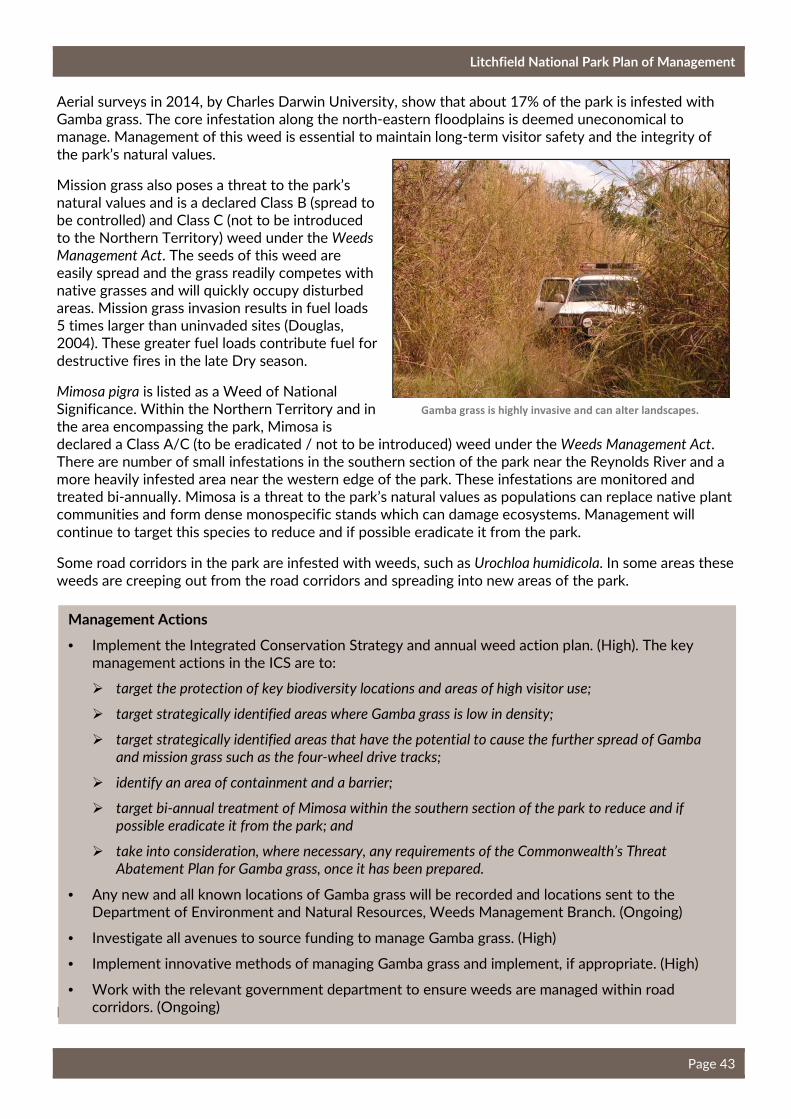
Litchfield National Park Plan of Management
Page 43
Aerial surveys in 2014, by Charles Darwin University, show that about 17% of the park is infested with Gamba grass. The core infestation along the north-eastern floodplains is deemed uneconomical to manage. Management of this weed is essential to maintain long-term visitor safety and the integrity of
the park’s natural values.
Mission grass also poses a threat to the park’s natural values and is a declared Class B (spread to be controlled) and Class C (not to be introduced to the Northern Territory) weed under the Weeds
Management Act. The seeds of this weed are easily spread and the grass readily competes with native grasses and will quickly occupy disturbed areas. Mission grass invasion results in fuel loads 5 times larger than uninvaded sites (Douglas, 2004). These greater fuel loads contribute fuel for
destructive fires in the late Dry season.
Mimosa pigra is listed as a Weed of National Significance. Within the Northern Territory and in the area encompassing the park, Mimosa is declared a Class A/C (to be eradicated / not to be introduced) weed under the Weeds Management Act. There are number of small infestations in the southern section of the park near the Reynolds River and a more heavily infested area near the western edge of the park. These infestations are monitored and treated bi-annually. Mimosa is a threat to the park’s natural values as populations can replace native plant communities and form dense monospecific stands which can damage ecosystems. Management will
continue to target this species to reduce and if possible eradicate it from the park.
Some road corridors in the park are infested with weeds, such as Urochloa humidicola. In some areas these
weeds are creeping out from the road corridors and spreading into new areas of the park.
Feral Animals
Gamba grass is highly invasive and can alter landscapes.
Management Actions
• Implement the Integrated Conservation Strategy and annual weed action plan. (High). The key management actions in the ICS are to:
� target the protection of key biodiversity locations and areas of high visitor use;
� target strategically identified areas where Gamba grass is low in density;
� target strategically identified areas that have the potential to cause the further spread of Gamba
and mission grass such as the four-wheel drive tracks;
� identify an area of containment and a barrier;
� target bi-annual treatment of Mimosa within the southern section of the park to reduce and if
possible eradicate it from the park; and
� take into consideration, where necessary, any requirements of the Commonwealth’s Threat
Abatement Plan for Gamba grass, once it has been prepared.
• Any new and all known locations of Gamba grass will be recorded and locations sent to the Department of Environment and Natural Resources, Weeds Management Branch. (Ongoing)
• Investigate all avenues to source funding to manage Gamba grass. (High)
• Implement innovative methods of managing Gamba grass and implement, if appropriate. (High)
• Work with the relevant government department to ensure weeds are managed within road corridors. (Ongoing)

Litchfield National Park Plan of Management
Page 44
Feral animals can have a major impact on the natural values of a park. They can cause erosion of fragile soils, spread weeds and exotic diseases and compete with native animals for food and habitat. Eleven exotic animal species have been recorded within the park including cane toads, cats, house mouse, Asian
house gecko, black rat, horse, pig, sambar deer, cattle and two species of buffalo.
The key species with the greatest impact on the park’s fauna include cats, cane toads, buffalo and pigs. The complete eradication of all feral animals in the park is not feasible as there are no effective means of
controlling species such as cats and cane toads.
Feral animals in the park are managed through a contract agreement. A contractor is employed twice a year to muster cattle from the park and cull horses, pigs and buffalos. The culled animals are collected and used for pet meat. Neighbours to the park and the public are notified prior to the muster and cull
occurring.
Recreational hunting organisations also assist park management with feral animal control in the more
remote areas of the park.
Opportunistic culling also occurs down the Reynolds River Four-Wheel Drive Track when it is closed to the public. To ensure visitor safety, some sections of the park may need to be closed when a muster or
cull is occurring.
Management Actions
• Continue to employ a contractor to muster cattle and cull pigs, horses and buffalos. (Ongoing)
• Continue to engage recreational hunting organisations to assist with feral animal control. (High)
• The entry of pets will be consistent with the Parks and Wildlife Commission’s Pets in Parks Policy. (Ongoing)
• Work with neighbours to maintain boundary fences. (Ongoing)
Litchfield National Park Plan of Management
Page 45
4. Managing Cultural Values
Aboriginal Cultural Values
Traditional hunting is still carried out in select areas of the park with the Aboriginal people mainly hunting fish and turtles. Current impacts of traditional hunting and gathering on the park’s natural values are low. The Territory Parks and Wildlife Conservation Act provides for Aboriginals who have traditionally used an area of land or water, to continue to use that area in accordance with Aboriginal tradition for hunting,
food gathering and for ceremonial and religious purposes.
There are many sacred sites, art sites, archaeological sites and sites of significance throughout the park. Many of the most popular recreation sites in the park are sacred sites or are in the vicinity of sacred sites. The management and protection of Aboriginal sites is guided by the Aboriginal Areas Protection Authority and the Northern Territory Aboriginal Sacred Sites Act. Destruction, damage, disturbance and entry to any site is an offence under the Act. Protection of sacred sites in relation to development is regulated by the use of Authority Certificates issued by the Aboriginal Areas Protection Authority. Prior to the issue of an Authority Certificate, the Aboriginal Areas Protection Authority is required to consult with custodians of sacred sites to provide an opportunity for them to say who enters their sacred sites and what can happen on their sacred sites. Illegal entry, works on or use of a sacred site is an offence
under the Northern Territory Aboriginal Sacred Sites Act.
There is a significant burial ground located in the north-western section of the park. This site is managed
by the local Aboriginal people.
Litchfield National Park is significant to the local Aboriginal people, who have an important connection with the land. The Parks and Wildlife Commission acknowledges that cultural knowledge belongs to the Aboriginal people associated with the country and will not use, or permit to be used, such knowledge
without prior consent.
The Heritage Act provides protection for archaeological places and objects in the Territory. Archaeological places and objects are not necessarily sacred sites and can include art sites, artefact scatters, quarries and scarred trees. The Act also provides protection for and conservation of declared heritage places and objects, including buildings, ruins, and old yards, as well as geological features, fossils and habitats. Sacred
objects are also protected under the Heritage Act.
European Historical Values
The historical values of the park provide an insight into the development of the Top End pastoral and mining industries, which had a profound effect on the culture and lifestyles of local Aboriginal people. Two sites in the park registered on the NT Heritage Register include Blyth Homestead and Bamboo Creek
Tin Mine.
Blyth Homestead
Blyth Homestead was built in 1929 by the Sargent family to function as an outstation on Stapleton Station. The site includes a homestead, a scatter of corrugated iron, sandstone blocks and other metal objects and a set of stockyards. Blyth Homestead is of heritage significance due to its architectural and social significance. Blyth Homestead is one of the few remaining examples of this type of building which
was formerly common on Northern Territory Pastoral leases.
The site contains tangible and well-preserved remnants of pastoral and mining activities carried out during this time. Due to its isolated location, the Sargent family had to be self-sufficient in order to survive. Their farming activities were supplemented by alluvial and reef tin mining to the east of the
homestead.
Litchfield National Park Plan of Management
Page 46
Bamboo Creek Tin Mine
Bamboo Creek Tin Mine is of historic significance as it provides an insight into the small-scale mining activities that occurred in the area. Tin was discovered in the area in 1906 and was mined sporadically until 1955. The site contains remnants of the equipment used for ore extraction, processing and
transportation of tin.
Both heritage sites may require restoration works over the life of this Plan. Clearances will be sought
under the Heritage Act for works on places and objects protected under that legislation.
World War II
The wreckage of a RAAF Spitfire A58-2 was found near the eastern boundary of the park in 2016. This Spitfire is believed to have crashed on 30 June 1943, when the pilot, Colin R. Duncan was forced to eject from the plane due to engine troubles during an attack (Grant, 1995). The wreckage is highly fragmented
due largely to the force of impact.
There is no visitor access to the wreckage due to its remoteness and the rough and inaccessible terrain. There may be potential for this wreckage to be relocated and used as an interpretive display by the
relevant heritage authority. There are potentially two other Spitfire wrecks in the park.
Management Actions
• Traditional hunting and gathering of animals, plants and natural materials from the park for traditional purposes will extend only to the Aboriginals who have traditionally used the area in accordance with Aboriginal tradition. If hunting or gathering activities are perceived to negatively impact on the park’s natural values or visitor experience, the Parks and Wildlife Commission will review harvesting practices with the local Aboriginal people. (Ongoing)
• Prepare and implement an annual Cultural Heritage Action Plan including a cultural heritage database for the park, documenting all known cultural heritage sites and their management. (Medium)
• The management and protection of sacred sites will be assured through the Aboriginal Areas Protection Authority and the expressed wishes of the local Aboriginal people. Authority Certificates will be sought for any works proposed. (Ongoing)
• The Parks and Wildlife Commission will manage the burial site in accordance with the wishes of the local Aboriginal people and the requirements of the Aboriginal Areas Protection Authority. (Ongoing)
• The Parks and Wildlife Commission will work with Aboriginal groups to gather information for the interpretation of sites within the park, where appropriate. (Ongoing)
• Indigenous ecological knowledge and skills will be integrated into park management programs where possible and recorded appropriately. (Ongoing)
• Management of the historical sites and any conservation of the sites will be consistent with the Heritage Act. (Ongoing)
• Any proposals for work affecting archaeological sites or objects will be consistent with the requirements of the Heritage Act. Expert advice will be sought from the relevant NT government authority. Sacred sites clearance process will also apply to works that may impact archaeological
sites. (Ongoing)
Litchfield National Park Plan of Management
Page 47
5. Park Administration
5.1 General Administration
The Parks and Wildlife Commission of the Northern Territory is responsible for the daily management of Litchfield National Park. Overall management of the park is guided by a legislative and policy framework. For proper management of the park, and the safety of persons (and enjoyment) and property, it is
essential that by-laws and regulations are properly enforced.
Funding for the management of the park, including administrative, staffing, infrastructure and services, is sourced through the Northern Territory Government. Works programs are subject to Territory-wide government priorities. Park managers ensure effective allocation of funding across park management and programs. Park and agency-wide priorities, performance indicators, monitoring, evaluation and reporting
are integrated into a management cycle.
Management of the park is carried out by staff based in the Batchelor Parks and Wildlife office and the
Walker Creek Ranger Station. These rangers also manage a number of smaller parks in the area.
Work and Business Opportunities
The Parks and Wildlife Commission can provide for work and business opportunities for the local community and local Aboriginal people. Contract services and business opportunities include campground management, cleaning park’s facilities, general repairs and maintenance of infrastructure, walking track maintenance, fencing, construction and weed and feral animal control. Contracting out of services and new businesses in the park which enhance the visitor experience or assist in park management will be
encouraged.
Volunteers
Litchfield National Park can benefit enormously from volunteers. Volunteers can make a major contribution to park management and assist in making park resources go further. Programs could include assisting with education and interpretation, weed management, maintenance of four-wheel drive and
mountain bike tracks and campground hosts.
Mining
Exploration, mining and extractive activities can have significant impacts on the natural and cultural values of the park. Mining or exploration companies can apply to the Northern Territory Government for permission to explore for minerals within Litchfield National Park. Reserved Land (No. 1229) has been granted over sections of NT Portion 2783 including Wangi, Florence and Tolmer Falls and Blyth
Homestead.
A granted exploration licence extends across most of the park and there is an application for an exploration licence over a smaller area in the southern section of the park. Mining is permitted within the
park in accordance with legislation.
Management Actions
• Enforce provisions of the Territory Parks and Wildlife Conservation Act, including its by-laws and regulations and other legislation where appropriate. (Ongoing)
• Continue to offer contracts and concession opportunities as required, for the management and maintenance of park assets. Local Aboriginal groups will be encouraged to take up commercial opportunities including campfire talks, campground maintenance, cultural tours or other viable
enterprises. (Ongoing)
Litchfield National Park Plan of Management
Page 48
5.2 Community and Stakeholder Engagement
Many stakeholders of the park have a keen interest in how it is managed and the future direction for the park. The key stakeholders for Litchfield National Park include the Aboriginal groups, the tourism industry
and the community.
A Stakeholder Reference Group was established in May 2010 to enable key stakeholders to provide advice on the preparation of a draft Plan of Management. The Stakeholder Reference Group comprised representatives from local Aboriginal groups, a representative from Tourism NT, Tourism Top End, the Batchelor Tourism Development Group, tour operators, the Northern Land Council and the Parks and Wildlife Commission. The Stakeholder Reference Group met regularly and their input was essential in the
development of this Plan.
Aboriginal Involvement
The Parks and Wildlife Commission recognises Aboriginal people as important stakeholders. Whist there are currently no active native title claims over the park there may however be existing native title rights and interests over all or part of the park. The Parks and Wildlife Commission will comply with relevant laws including the Native Title Act (Cth) and the Northern Territory Aboriginal Sacred Sites Act (NT), where
applicable.
Tourism Industry Engagement
As Litchfield National Park is one of the most highly visited parks in the Northern Territory it is essential that tourism needs are considered in the management and future development of the park. Tourism input was sought during the preparation of this plan and engagement with the tourism industry will continue including with the review and update of the park’s Visitor Experience Development Plan and the visitor
flow modelling project.
Community Involvement
The town of Batchelor is at the entry to Litchfield National Park. The park is an important source of revenue for the town through the provision of accommodation, food, fuel and general supplies. Park rangers work closely with the Batchelor community and the Batchelor Visitor Information Centre. The Parks and Wildlife Commission will continue to maintain good relationships with the community in
Batchelor.
The size and shape of the park reinforces the need for good working relationships with neighbours to ensure the conservation effort is not isolated from the broader landscape. The Parks and Wildlife
Commission will continue to maintain good working relationships with the neighbours.
Litchfield National Park received about 330 000 visitors in 2015 and previous surveys indicate that around 20% of these visitors are Territorians. Many of these Territorians are Darwin locals and they feel a strong sense of ownership to Litchfield National Park. Developments or proposed changes in the park can generate significant public interest and it is important to ensure good communication with the
community.
• Actively encourage the community and recreation groups to become involved in programs in the
park. (Ongoing)

Litchfield National Park Plan of Management
Page 49
5.3 Development Proposals and Commercial Operations
Proposals to develop commercial accommodation or other commercial infrastructure within or adjacent to the park may arise during the life of this plan. Such developments may present significant opportunities
for business partnerships and result in benefits for visitors, local economies and expanded park services.
The Parks and Wildlife Commission has a Commercial Tourism Development Policy that provides a clear over-arching process to facilitate the development of privately developed and operated tourism infrastructure in Territory parks and reserves. Any major proposals or new works will be required to comply with this policy and be assessed commensurate with the scale of potential impact consistent with
Northern Territory and Commonwealth legislation.
Concessions provide services that are appropriately offered by private enterprise. Concessions can be an important tool for managing visitors and better use of staff resources. Well managed concessions can make the park more accessible and more enjoyable to a greater number of people and benefit the tourist
industry.
Permits are issued to businesses that provide appropriate services, assist management or will enhance the visitor experience within the park. There are currently three approved concession operators for Litchfield National Park. It is essential that commercial activities undertaken in the park are of a high standard and are compatible with the park’s character and values. All concessionary operations are required to operate
in accordance with the Act, the by-laws and where relevant, the Parks and Wildlife Commission policy.
Management Actions
• All commercial operations within the park are required to operate under a concession lease or license agreement in accordance with the Act, the by-laws and where relevant the Parks and Wildlife Commission Commercial Tourism Development Policy. (Ongoing)
• Ensure that the type and number of operations does not compromise the character and / or visitor experience in the park. (Ongoing)
• The potential impacts of any proposed activity or development will be considered and assessed commensurate with the scale of potential impact, consistent with Northern Territory and
Commonwealth legislation. (Ongoing)
Management Actions
• Regularly liaise with neighbours and key stakeholders to facilitate cooperative management for the control of fire, stray stock and feral animals, weeds, soil conservation, fences, aspects of Aboriginal interest, visitor access and tourism development. (Ongoing)
• Regularly liaise with the tourism industry to ensure a clear line of communication and a good working relationship. (Ongoing)
Litchfield National Park Plan of Management
Page 50
6. References
Commonwealth of Australia (2012). Threat abatement plan to reduce the impacts on northern Australia’s
biodiversity by the five listed grasses. Department of Sustainability, Environment, Water, Population and
Communities.
Department of the Chief Minister (DCM) (2009). Northern Territory Climate Change Policy 2009. Published
by the Northern Territory Government.
Department of Environment, Water, Heritage and the Arts (DEWHA), (2008). Rangelands 2008 – Taking
the Pulse. Australian Collaborative Rangeland information System: Reporting Change in the Rangelands.
Douglas, M. M, Setterfield S.A, Rossiter N., Barratt J., Hutley L.B. (2004). Effects of mission grass
(Pennisetum polystachion (L) Schult) invasion on fuel loads and nitrogen availability in a northern Australia
tropical savanna. Weed management: balancing people, planet, profit. 14th Australian Weeds Conference.
Wagga Wagga, New South Wales.
Grant, J. (1995). Spitfires Over Darwin 1943: No. 1 Fighter Wing. Melbourne Victoria,RJ, Moore.
Griffiths AD, Woinarski J.C.Z, Armstrong ID, Cowie ID, Dunlop CR & Horner PG, (1997). Biological Study
of Litchfield National Park. Technical Report No. 62. Parks and Wildlife Commission of the Northern
Territory.
Liddle, D.T (2009) Management Program for Cycads in the Northern Territory of Australia 2009-2014.
Department of Natural Resources, Environment, the Arts and Sport, Darwin.
NRETAS (2009). Park Profile for Litchfield National Park. Unpublished data, Northern Territory
Government.
NRETAS (2009). Visitor Survey Results for Litchfield National Park July 2009. Unpublished data. Northern
Territory Government.
Parks and Wildlife Service (2010). Visitor figures for Litchfield National Park. Unpublished information from
the Parks Visits Database.
Parks and Wildlife Commission of the Northern Territory (2012). Litchfield National Park - Peak Season
Visitor Satisfaction Survey Results, July 2012. Unpublished information from the Parks Visits Database.
Tourism Northern Territory (2010). Litchfield National Park Strategic Planning Presentation. Unpublished.
Tourism Northern Territory. (2013). Tourism Vision 2020: Northern Territory’s Strategy for Growth.
Northern Territory Government.
Tourism Northern Territory (2010). Tourism Research Australia’s National and International Visitor Surveys.
Tourism Northern Territory (2015). Economic Contribution of Tourism to the Northern Territory 2013-14. Estimates gathered from the report State Tourism Satellite Accounts 2013-14: produced by Tourism Research Australia (TRA), Australian National Accounts: National Income, Expenditure and Product, Dec
2014 and Labour Force, Australia, Mar 2015: produced by Australian Bureau of Statistics (ABS).
Tourism Northern Territory (2016). Master Plan Mountain Biking in the Northern Territory.
Recommended