2008 NORTHEASTERN NATURALIST !5(4):54I-556
Landscape Position Influences the Distribution of GarlicMustard, an Invasive Species
Kevin Burls '" ' and Charles McClaugherty'
Abstract - We investigated the distribulion and abundance of Alliaria peiiolata, aninvasive biennial, with respect lo historical land use, and examined environmentalconditions to look for correlations with distribution patterns. Sixty currently forestedplots in Cuyahoga Valley National Park. OH were chosen based on 1959 land use; ag-ricultural (open) versus forested. Plots were analyzed for Garlic Mustard distribution,abundance, invasion area, and incursion distance. Garlic Mustard distribution did notvary with historical land use, but did vary significantly with distance from rivers andwith elevation. Polygon area: peri meter values were also correlated with invasion.These results differ from studies done with Garlic Mustard in New England wherehistorical land use appeared to be a larger factor in distribution. These results sug-gest the importance of landscape corridors in biological invasions and can be used toidentify areas with greater potential for invasive species in this region.
Introduction
Invasive species are considered the second greatest threat to biodiver-sity today (Wilson 2002). These species have the ability to displace nativespecies through competition or disease, and can often cause changes in thecommunity structure and degrade the environmental health of the landscape(Mack and D'Antonio 1998, McCarthy 1997, Williamson 1996). Currently,5-25% of the vascular species in the United States today are considered in-vasive (Vitousek et al. 1996). Over $130 billion per year is spetit to controlthe spread and impacts of these species (Evans 2003). Research regardinginvasive species wilt not only increase general knowledge regarding theseplants' biology and ecology, but can also allow land managers to increase theefficiency of their control programs and may ultimately mitigate the extentof the damage done by aggressive nonnative invading plants. The manage-ttient applications of this research are extremely useful and are of greatimportance to the discipline of conservation biology (Coblentz 1990).
While all communities are more or less able to be invaded by exotic plants(Williamson 1996), landscape disturbances often play a major role in bio-logical invasions ( Inderjit 2005, Nuzzo 1999). The extent of human presencehas been proven to be a major contributor to biological invasions, possiblydue to humans artificially increasing propagule abundance (Williamson1996). Some recent work has explored the influence of long-term historicalland use on the spread and distribution of invasive plants (Lundgren et al.
'Mount Union College, 1972 Clark Avenue. Alliance. OH 44601.-Currentaddress - 200 Talus Way #423. Reno, NV 89503. 'Corresponding author [email protected].
542 Norlheaswm Nalto-alisl Vol. 15. No. 4
2004; Kristina Stinson, Harvard Forest, Petersham, MA, pers. comm.),building on substantial research supporting the influence of historical landuses on stand-scale and large-scale (e.g., landscape) species composition aswell as abiotic conditions (Foster 1992. Guggenberger et al. 1994, Hall et al.2002, Motzkin et al. 2002, Verheyen et al. 1999). Most ofthis work has beendone in the New England area, a region with soils developed on boulderytill, though some research on historical land use has been done in Wisconsinand in Europe (Guggenberger et al. 1994, White and Mladenoff 1994).
Alliaria petiolata (Bieb.) Cavera and Grande (Garlic Mustard) is aninvasive Eurasian herbaceous plant, first recorded in Long Island, NYin 1868 (Nuzzo 1993). It can limit the biodiversity of a forest understorythrough competition and also demonstrates allelopathy, disrupting my-corrhizal associations (Roberts and Anderson 2001, Stinson et al. 2006.Wolfe and Klironomos 2005). Byers and Quinn (1998) demonstratedthat Garlic Mustard populations display phenotypic plasticity in biomassallocation and flowering phenology between habitats, which allows forsuccessful establishment in a variety of light, moisture, and soil conditions.Habitat variation also influenced the survivorship and seed germinationof populations. Sites in their study were strongly distinguished by differ-ences in pH, calcium content, nitrogen content, and percent organic matter,among other factors. Historical human activity has also been shown to in-fluence similar soil nutrients; at least some of the differences may be dueto fertilization of agricultural fields (Koerner et al. 1997. Verheyen et al.1999). These results lead to the hypothesis that lasting abiotic differencesresulting from historical agriculture will cause the differential distributionand survival of Garlic Mustard.
This study investigates the distribution of Garlic Mustard in the CuyahogaValley National Park with relation to 1959 land use. The objectives ofthisinvestigation were to determine I) if historical land use has influenced thecurrent distribution or abundance of Garlic Mustard in the Cuyahoga Val-ley National Park and 2) if selected environmental variables can be used toexplain any trends discovered.
Materials and Methods
Species descriptionGarlic Mustard behaves strictly as a biennial in the United States with
a first-year rosette and a second-year flowering and fruiting plant (Nuzzo2000). Seeds are produced in siliques on the tops of the stems and average350 seeds per plant, though extremely stout plants can produce up to 7000seeds (Nuzzo 1999). Seeds usually germinate into rosettes in mid-spring;second-year plants usually bolt in mid-spring and are fully grown withinapproximately one month (Anderson et al. 1996). In northeastern Ohio,mature seeds dehisce from the siliques around late July. Seed dehiscence

2008 K. Burls and C. McClaugherty 543
is quickly followed by senescence, and seed rain is normally limited towithin 1-2 meters of the mother plant. (Anderson et al. 1996, Nuzzo2000). Garlic Mustard has been present in Ohio since at least 1927, andspecimens were recorded in proximity to Cuyahoga Valley National Parkin 1959 (# 13724 and 63474, The Ohio State University Herbarium).
Site descriptionThe Cuyahoga Valley National Park is located in northeastern Ohio
(41°17'N, 8I°34'W) in Cuyahoga and Summit counties and is approxi-mately 135.95 kml The dominant soil series are Ellsworth silt and loam(3.20 km-), rough broken land (1.55 km'), and Glenford silt and loam (0.77km-). The Park stretches from Bedford, OH to Akron, OH. The majority ofthe area is deciduous hardwoods, with dominant communities being Quer-cus spp. {oa.k)/Carya spp. (hickory), Acer spp. (maple)/oak, and maple/Plantanus occidentalis L. (Sycamore) (based on National Park ServiceGIS data). The river valley was the site of the Ohio and Erie Canal, cre-ated in 1827 and abandoned in 1913. Previous to 1974, the area consistedof a matrix of privately owned farms and forest patches, some owned bythe Cleveland Metropolitan Park District. In 1974, the area was designatedby the national governmetit as a national recreation area (Cockrell 1992,ODNR 2006). The area was established as a National Park in 2000 (Cross2002) and includes several metropolitan parks and two ski resorts. Sectionsof private land are also embedded within the Park. The Cuyahoga Rivervalley itself consists mainly of alfisols on glacial till with shale and sand-stone bedrock between 480-205 million years old (Cockrell 1992, NRCS2007). The average annual temperature is 9.78 °C, and the area receivesan average of 98.30 cm of rain each year (for comparison, Worcester, MA,near the region studied by Lundgren et al. [2004], has an average tempera-ture of 8.4 °C and has an annual precipitation of 124.59 cm; NOAA 2005).This area presents an opportunity to examine the influences of historicalland use on the distribution of an invasive plant in a culturally heteroge-neous landscape with more fertile soils and different climatic conditionsthan most other areas previously studied.
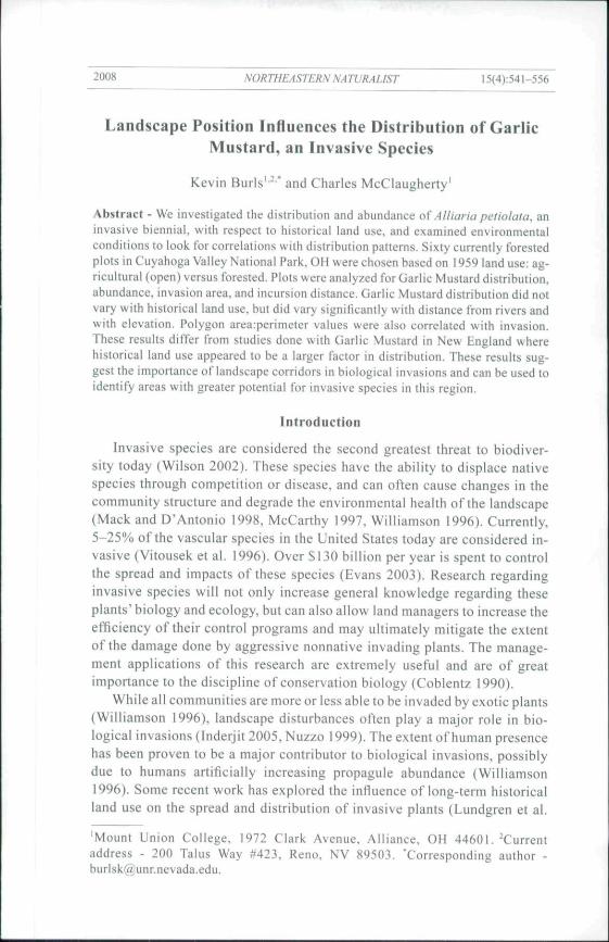
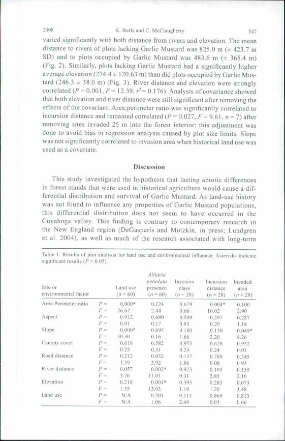
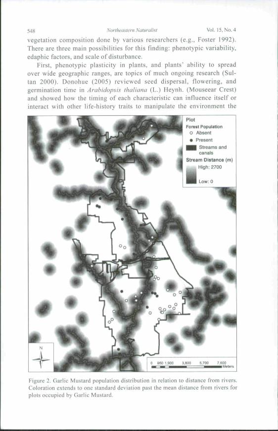
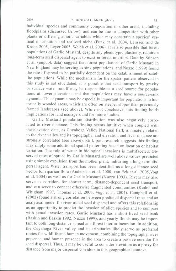
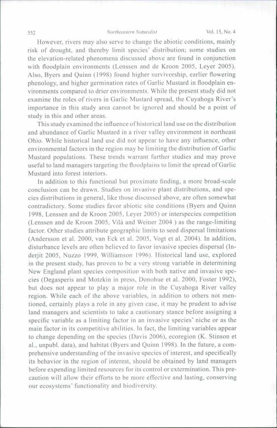
For this study, we chose the year 1959 as a reference point for histori-cal land use in the Cuyahoga River valley region. The National Park GISstaff had already created detailed 1959 land-use maps of the Park, allow-ing for accurate delineation of currently forested areas into areas thatwere either open or forested fifty years ago. This date corresponds wellto post-peak agriculture use and the subsequent abandonment of familandand reestablishment of forest cover in Ohio as described by Simpson et al.(1994). These trends are seen in the Cuyahoga River valley; in 1959, thearea currently designated as national park had 38.84 knr of agriculturalland and 77.88 km^ of forested land; today the area has only 8.44 km^ ofagriculture and maintained open areas and 95.70 km- of forest (Figs, la.
544 Northi'asíern Niituraiist Vol, 15, No. 4
Ib). During this time, there was a net increase in urban and other landuses of 12.58 km". As most remaining agriculture was abandoned whenthe Park was commissioned in 1974. there has been adequate time forforest regrowth (other than in select patches used for educational and rec-reational purposes). This reversal of land-use trends is roughly equivalentto that which occurred in 1830 as described in studies conducted in theMassachusetts area (Foster 1992, Hall et al. 2002).
Experimental methodsHistorical and present land use in the Cuyahoga Valley National Park
was determined using files provided by the National Park staff. Using
1959 LandCovar^ ^ ^ 1 Forail Land
Agriculture
m Urban u Buil Up Lmd
Figtire la. Land cover ofCuyahoga Valley National Park in 1959.

2008 K, Burl:, and C, McClaugherty 545
ArcMap 9.1, polygons were created and divided into two categories basedon their 1959 status: agricultural (open) or wooded. All polygons are cur-rently forested. Each polygon extended at least 150 m along a trail edgeand at least 50 m into the forest interior to establish a buffer from otherland-use categories or mapping inaccuracies. Study polygons, thirty ineach category, were then randomly selected, each at least I km from itsnearest neighbor. Study plots inside the polygons, each 2500 m- in area,were selected along the trails present through the polygon using the cen-troid function on ArcMap and satellite photographs ofthe area. Plots wererectangular in shape, extending 100 m long along the trail edge and 25 minto the forest. Trails, which are ix-r\asi\c ihroughout the Park, were used
Figure lb. Land ct)ver of (_'Liy;tlioga Valley National Park in 2002.
546 Northeastern Naturalist Vol. 15. No. 4
as plot boundaries in order to eliminate them as a variable during analysis.Roads and pathways are well-known corridors for invasion (Lundgren etal. 2004, Parendes and Jones 2000), so all sites are at a high risk of moderninvasion. Thus, there is no way to test for the effects of agriculture on his-torical Garlic Mustard invasion. The current study examines only whetherabiotic or biotic changes in areas that were historically agricultural havecreated conditions that facilitate invasion and establishment.
Plots were surveyed on foot, and any Garlic Mustard found was divid-ed into edge populations, located between the trail edge and the outertreeline, or forest populations, extending into the forest past theouter treeline. Population boundaries inside study plots were delineatedas zones without individual plants for 15 m, which is appropriate giventhe normally short dispersal distance of Garlic Mustard (Anderson et al.1996, Nuzzo 2000). Maximum incursion of the population into the forestand maximum length along the plot were recorded. Visual measurementsof the abundance of the population were made as the percent of the popu-lation's maximum area covered by Garlic Mustard in the followingclasses: <1.0%, 1.0-3.0%, 3.1-5.0%, 5.1-15.0%, 15.1-25.0%, 25 .1 -50.0%, 50.1-75.0%, or >75.0%. Percent canopy cover was measured atthe center of each plot at 5-m intervals from the trail edge using a convexspherical densiometer, and qualitative assessments of canopy composi-tion, stand structure, topography, soil moisture, and cotnmon understoryvegetation were recorded. Major disturbances such as power lines, roads,etc., were avoided by requiring a minimum of a 25-m forested buffer tothe rear of each plot. Slope and aspect were determined from a digital ele-vation map using ArcMap. and plot distances from rivers and roads weredetermined using GIS layers created by the National Park.
Chi-square analyses were performed on population presence or ab-sence with respect to land use. Edge and forest environments were verysimilar and were therefore merged prior to the analysis of environmentaland plot data. ANOVA tests were run on population invasion class, incur-sion distance, and invasion area with respect to land use and with respectto the study polygon area:perimeter ratio, aspect, slope, canopy cover,distance from roads, distance from rivers, and elevation. All analyseswere done using SYSTAT 9.
Results
The results of all y^ analyses and ANOVAs are listed below in Table 1.Land use was not correlated to Garlic Mustard presence, invasion class,invasion area, or incursion distance. Mean polygon arcaiperimeter ratiodiffered between agricultural and forest land uses ( 30.35 and 59.91, respec-tively). The average slope in degrees also differed between agricultural andforested land use (10.73 and 27.80, respectively). Garlic Mustard presence
2008 K. Burls and C. McClaugherty 547
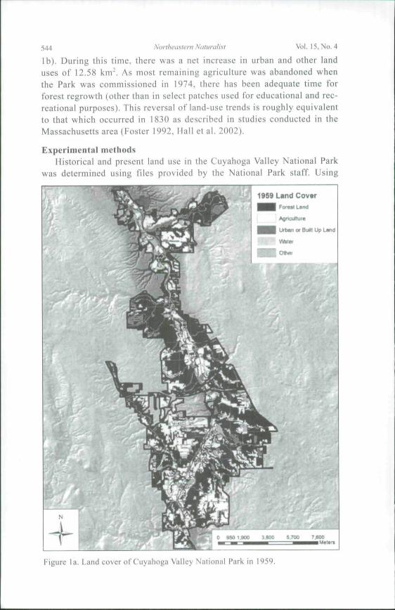
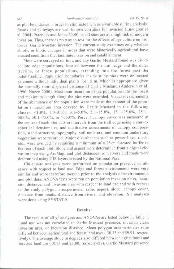
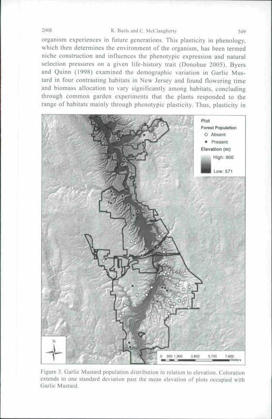
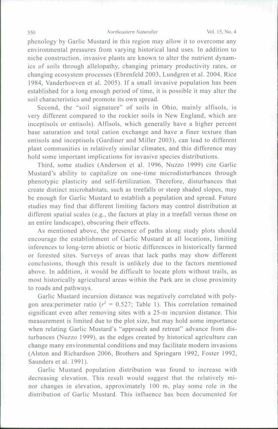
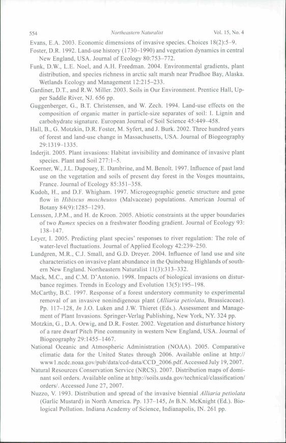
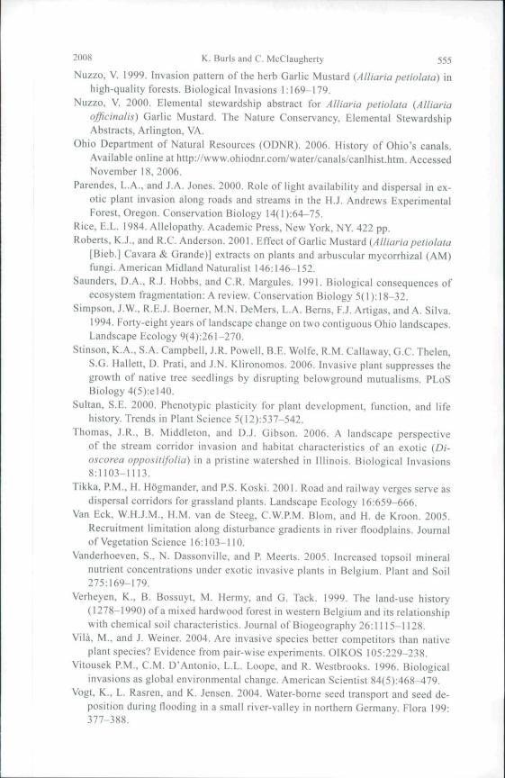
varied significantly with both distance from rivers and elevation. The meandistance to rivers of plots lacking Garlic Mustard was 825.0 m (± 423.7 mSD) and to plots occupied by Garlic Mustard was 483.6 m (± 365.4 m)(Fig. 2). Similarly, plots lacking Garlic Mustard had a significantly higheraverage elevation (274.4 ± 120.63 m) than did plots occupied by Garlic Mus-tard (246.3 ± 38.0 m) (Fig. 3). River distance and elevation were stronglycorrelated {P = 0.001, F = 12.39, H = 0.176). Analysis of covariance showedthat both elevation and river distance were still significant after removing theeffects of the covariant. Area:perimeter ratio was significantly correlated toincursion distance and remained correlated (P ^ 0.027, F - 9.61, n - 7) afterremoving sites invaded 25 m into the forest interior; this adjustment wasdone to avoid bias in regression analysis caused by plot size limits. Slopewas not significantly correlated to invasion area when historical land use wasused as a covariate.
Discussion
This study investigated the hypothesis that lasting abiotic differencesin forest stands that were used in historical agriculture would cause a dif-ferential distribution and survival of Garlic Mustard. As land-use historywas not found to influence any properties of Garlic Mustard populations,this differential distribution does not seem to have occurred in theCuyahoga valley. This finding is contrary to contemporary research inthe New England region (DeGasperis and Motzkin, in press; Lundgrenet al. 2004), as well as much of the research associated with long-term
Table 1. Results of plot analysis for landsignificant results {P <
Site orenvironmental factor
Area:Perimeter ratio
Aspect
Slope
Canopy cover
Road distance
River distance
Elevation
Land use
0.05).
P =F =P^F =P =F =P =F =
P —
F =P =F =P =F =P =F =
Land use{n = 60)
0.000*26.620.9120.010.000*
30.300.6180.250.2121.590.0573.760.2181.55N/AN/A
use and environmenial influence. Asterisks indicate
Alliariapetiolatapresence{n = 60)
0.1242.440.6800.170.695O.!60.5820.310.0523.920.002*
11.010.001*
13.030.3011.06
Invasionelass
{n = 28)
0.6790.660.5490.850.1801.660.9550.240.1371.860.9230.310.3931.100.1132.69
Incursiondistance(/I - 28)
0.004*10.020.5970.290.1502.200.6280.240.7800.080.1032.850.2831.200.8690.03
Invadedarea
(« = 28)
0.1002.900.2871.180.049*4.260.9320.010.3450.930.1592.100.0733.480.8130.06
548 Northeastern Naturalist Vol. 15, Nu. 4
vegetation composition done by various researchers (e.g., Foster 1992).There are three main possibilities for this finding: phenotypic variability,edaphic factors, and scale of disturbance.
First., phenotypic plasticity in plants, and plants' ability to spreadover wide geographic ranges, are topics of much ongoing research (Sul-tan 2000). Donohue (2005) reviewed seed dispersal, flowering, andgermination time in Arabidopsis thaliana (L.) Heynh. (Mouseear Crest)and showed how the timing of each characteristic can influence itself orinteract with other life-history traits to manipulate the environment the
PlotForvtt PopulMlon
O Absent• Present
t^M Streams andcanals
Stream Distance (mHigh; 2700
Figure 2. Garlic Mustard population distribution in relation to distance trom rivers.Coloration extends to one standard deviation past the mean distance from rivers forplots occupied by Garlic Mustard.
2008 K. Burls and C. McClaugherty 549
organism experiences in future generations. This plasticity in phenology,which then determines the environment of the organism, has been termedniche construction and influences the phenotypic expression and naturalselection pressures on a given life-history trait (Donohue 2005). Byersand Quinn (1998) examined the demographic variation in Garlic Mus-tard in four contrasting habitats in New Jersey and found flowering timeand biomass allocation to vary significantly among habitats, concludingthrough common garden experiments that the plants responded to therange of habitats mainly through phenotypic plasticity. Thus, plasticity in
/ (
N
PlotForesr Population
O Absent
• Present
Elevation (m)
High: 900
^ 1 Low: 571
J1l
Figure 3, Uarlic Mtislard population disiribuilon in relation to elevation. Colorationextends to one standard deviation past the mean elevation of plots occupied withGarlic Mustard.
550 Northeastern Naturalist Vol, 15. No, 4
phenology by Garlic Mustard in this region may allow it to overeóme anyenvironmental pressures from varying historical land uses. In addition toniche construction, invasive plants are known to alter the nutrient dynam-ics of soils through allelopathy, changing primary productivity rates, orchanging ecosystem processes (Ehrenfeid 2003, Lundgren et al. 2004, Rice1984. Vanderhoeven et al. 2005). If a small invasive population has beenestablished for a long enough period of time, it is possible it may alter thesoil characteristics and promote its own spread.
Second, the "soil signature" of soils in Ohio, mainly alfisols, isvery different compared to the rockier soils in New England, which areinceptisols or entisols). Alfisols, which generally have a higher percentbase saturation and total cation exchange and have a finer texture thanentisols and inceptisols {Gardiner and Miller 2003), can lead to differentplant communities in relatively similar climates, and this difference mayhold some important implications for invasive species distributions.
Third, some studies (Anderson et al. 1996, Nuzzo 1999) cite GarlicMustard's ability to capitalize on one-time microdlsturbances throughphenotypic plasticity and self-fertilization. Therefore, disturbances thatcreate distinct microhabitats, such as treefalls or steep shaded slopes, maybe enough for Garlic Mustard to establish a population and spread. Futurestudies may find that different limiting factors may control distribution atdifferent spatial scales (e.g., the factors at play in a treefall versus those onan entire landscape), obscuring their effects.
As mentioned above, the presence of paths along study plots shouldencourage the establishment of Garlic Mustard at all locations, limitinginferences to long-term abiotic or biotic differences in historically farmedor forested sites. Surveys of areas that lack paths may show differentconclusions, though this result is unlikely due to the factors mentionedabove. In addition, it would be difficult to locate plots without trails, asmost historically agricultural areas within the Park are in close proximityto roads and pathways.
Garlic Mustard incursion distance was negatively correlated with poly-gon area:perimeter ratio (/̂ = 0.527; Table 1). This correlation remainedsignificant even after removing sites with a 25-m incursion distance. Thismeasurement is limited due to the plot size, but may hold some importancewhen relating Garlic Mustard's "approach and retreat" advance from dis-turbances (Nuzzo 1999), as the edges created by historical agriculture canchange many environmental conditions and may facilitate modern invasions(Alston and Richardson 2006, Brothers and Springarn 1992, Foster 1992,Saunders et al. 1991).
Garlic Mustard population distribution was found to increase withdecreasing elevation. This result would suggest that the relatively mi-nor changes in elevation, approximately 100 m, play some role in thedistribution of Garlic Mustard. This influence has been documented for
2008 K. Burls and C. McClaugherty 551
individual species and community composition in other areas, includingfloodplains (discussed below), and can be due to competition with otherplants or differing abiotic variables which may constrain a species' ver-tical distribution and realized niche (Funk et al. 2004, Lenssen and deKroon 2005, Leyer 2005. Welch et al. 2006). It is also possible that forestpopulations of Garlic Mustard, despite any phenotypic plasticity, require along-term seed dispersal agent to exist in forest interiors. Data by Stinsonet al. (unpubi. data) suggest that forest populations of Garlie Mustard inNew England may be serving as sink populations, and Nuzzo (1999) foundthe rate of spread to be partially dependent on the establishment of satel-lite populations. While the mechanism for the spatial pattern observed inthis study is not elucidated, it is possible that seed transport by gravityor surface water runoff may be responsible as a seed source for popula-tions at lower elevations and that populations may have a source-sinkdynamic. This dynamic may be especially important for populations in his-torically wooded areas, which are often on steeper slopes than previouslyfarmed landscapes (see above). While not conclusive, this finding holdsimplications for land managers and for future studies.
Garlic Mustard population distribution was also negatively corre-lated to river distance. This finding seems intuitive when coupled withthe elevation data, as Cuyahoga Valley National Park is innately relatedto the river valley and its topography, and elevation and river distance arestrongly correlated (see above). Still, past research suggests this fmdingmay imply some additional spatial patterning based on location or habitatvariation. The role of water in biological invasions is multifaceted. Ob-served rates of spread by Garlic Mustard are well above values predictedusing simple expulsion from the mother plant, indicating a long-term dis-persal agent. Water transport has been identified as a long-distance seedvector for riparian flora (Andersson et al. 2000, van Eck et al. 2005,Vogtet al. 2004) as well as for Garlic Mustard (Nuzzo 1993). Rivers may alsoserve as corridors for shorter term, distance-dependent seed transport,and can serve to connect otherwise fragmented communities (Kudoh andWhigham 1997, Thomas et al. 2006, Vogt et al. 2004). Campbell et al.(2002) found a strong correlation between predicted dispersal rates and ananalytical model for river-aided seed dispersal and offers this relationshipas an opportunity to predict the invasion of alien species and to comparewith actual invasion rates. Garlic Mustard has a short-lived seed bank(Baskin and Baskin 1992, Nuzzo 1999), and yearly floods may be impor-tant to both long-distance spread and forest interior incursion. In addition,the Cuyahoga River valley and its tributaries likely serve as preferredroutes for wildlife and human movement, combining the topography, riverpresence, and human presence in the area to create a passive corridor forseed dispersal. Thus, it may be useful to consider elevation as a proxy fordistance from major dispersal corridors in this geographical context.
552 Northeastern Naluratisi Vol. 15, No. 4
However, rivers may also serve to change the abiotic conditions, mainlyrisk of drought, and thereby limit species' distribution; some studies onthe elevation-related phenomena discussed above are found in conjunctionwith floodplain environments (Lenssen and de Kroon 2005, Leyer 2005).Also, Byers and Quinn (1998) found higher survivorship, earlier floweringphenology, and higher germination rates of Garlic Mustard in floodplain en-vironments compared to drier environments. While the present study did notexamine the roles of rivers in Garlic Mustard spread, the Cuyahoga River'simportance in this study area cannot be ignored and should be a point ofstudy in this and other areas.
This study examined the influence of historical land use on the distributionand abundance of Garlic Mustard in a river valley environment in northeastOhio. While historical land use did not appear to have any influence, otherenvironmental factors in the region may be limiting the distribution of GarlicMustard populations. These trends warrant further studies and may proveuseful to land managers targeting the floodplains to limit the spread of GarlicMustard into forest interiors.
In addition to this functional but proximate finding, a more broad-scaleconclusion can be drawn. Studies on invasive plant distributions, and spe-cies distributions in general, like those discussed above, are often somewhatcontradictory. Some studies favor abiotic site conditions (Byers and Quinn1998, Lenssen and de Kroon 2005. Leyer 2005) or interspecies competition(Lenssen and de Kroon 2005. Vila and Weiner 2004 ) as the range-limitingfactor. Other studies attribute geographic limits to seed dispersal limitations(Andersson et al. 2000, van Eck et al. 2005. Vogt et al. 2004). In addition,disturbance levels are often believed to favor invasive species dispersal (In-derjit 2005, Nuzzo 1999, Williamson 1996). Historical land use, exploredin the present study, has proven to be a very strong variable in determiningNew England plant species composition with both native and invasive spe-cies (Degasperis and Motzkin in press. Donohue et al. 2000, Foster 1992),but does not appear to play a major role in the Cuyahoga River valleyregion. While each of the above variables, in addition to others not men-tioned, certainly plays a role in any given case, it tnay be prudent to adviseland managers and scientists to take a cautionary stance before assigning aspecific variable as a limiting factor in an invasive species' niche or as themain factor in its competitive abilities. In fact, the limiting variables appearto change depending on the species (Davis 2006), ecoregion (K. Stinson etal., unpubl. data), and habitat (Byers and Quinn 1998). In the future, a com-prehensive understanding of the invasive species of interest, and specificallyits behavior in the region of interest, should be obtained by land managersbefore expending limited resources for its control or extermination. This pre-caution will allow their efforts to be more effective and lasting, conservingour ecosystems' functionality and biodiversity.

2008 K. Btjris and C. McClaugherty 553
Acknowledgments
The authors would like to thank Anthony Gareau and Laura Eize at CuyahogaValley National Park for the use of GIS layers including past and present land-useinformation, forest boundaries, and known invasive species locations.
Literature Cited
Alston, K.P., and D.M. Richardson. 2006. The roles of habitat features, disturbance,and distance from putative source populations in structuring alien plant invasionsat the urban/wildland interface on the Cape Peninsula, South Africa. BiologicalConservation 132:183-198.
Anderson, R.C.. S.S. Dhillon. and T.M. Kelley. 1996. Aspects of tbe ecology of aninvasive plant, Garlic Mustard {Alliariapetiolata), in central Illinois. RestorationEcology 4(2):181-191.
Andersson, E., C. Nilsson, and M.E. Johansson. 2000. Plant dispersal in boreal riversand its relation to the diversity of riparian flora. Journal of Biogeography 27(5):1095-1106.
Baskin, J.M., and C.C. Baskin. 1992. Seed germination biology of the weedy bien-nial Alltaria petiolata. Natural Areas Journal 12:191-197.
Brothers, T.S., and A. Sprigarn. 1992. Forest fragmentation and alien plant invasionof central Indiana old-growth forests. Conservation Biology 6(l):91-100.
Byers. D.L.. and J.A. Quinn. 1998. Demographic variation in Alliaria petiolata(Brassicaceae) in four contrasting habitats. Journal of the Torrey Botanical So-ciety 125(2):138-149.
Campbell, G.S.. P.G. Blackwcli. and F.I. Woodward. 2002. Can landscape-scalecharacteristics be used to predict plant invasions along rivers? Journal of Bioge-ography 29:535-543,
Coblentz. B.E. 1990. Fxotic organisms: A dilemma for conservation biology. Con-servation Biology 4(3):26l-265.
Cockrell, R. 1992. A green shrouded miracle: The administrative history of CuyahogaValley National Recreation Area, Ohio. National Park Service Midwest RegionalOffice, Omaha, NE. Available online at littp://www.nps.gov/history/history/online_books/Cuyahoga/toc.htm. Accessed June 27, 2007.
Cross, R. 2002. A "stealth" park slips under the radar screen. Chicago Tribune. June9. 2002. Available online at http://www.chicagotribune.com/travel/chi-020609cuyahogaside.l .679541 .story?coll=chi-900siteindex-fea. Accessed June 27, 2007.
Davis, A.S. 2006. When does it make sense lo target the weed seed bank? Weed Sci-ence 54:558-565.
DeGasperis. B.G., and G. Motzkin. In press. Windows of opportunity: Historical andecological controls on Berberis thunhergii invasions. Ecology.
Donobue. K.. 2005. Nicbe construction through phenological plasticity: Life-historydynamics and ecological consequences. New Phytologist 166:83-92.
Donohue. K., D.R. Foster, and G. Motzkin. 2000. Effects of the past and the pres-ent on species distributions: Land-use history and demography of wintergreen.Journal of Ecology 88:303-316.
Ehrenfeld. J.G. 2003. Effects of exotic plant Invasions of soil nutrient cycling pro-cesses. Ecosystems 5:503-523.
554 Northeastern Naturalist Vol. 15. No, 4
Evans, E.A. 2003. Economic dimensions ofinvasive species. Choices 18(2):5-9.Foster. D.R. 1992, Land-use history ( 1730-1990) and vegetation dynamics iti central
New England. USA, Journal of Ecology 80:753-772.Funk, D.W., L.E. Noel, and A.H. Freedman. 2004. Environmental gradients, plant
distribution, and species richness in arctic salt marsh near Prudhoe Bay. Alaska.Wetlands Ecology and Management 12:215-233.
Gardiner. D.T., and R.W. Miller. 2003. Soils in Our Environment, Prentice Hall, Up-per Saddle River, NJ. 656 pp.
Guggenberger, G.. B.T, Christensen, and W. Zech. 1994. Land-use effects on thecomposition of organic matter in particle-size separates of soil: I. Lignin andcarbohydrate signature, European Journal of Soil Science 45:449-458.
Hall, B,. G. Motzkin, D.R. Foster, M. Syfert, and J. Burk. 2002. Three hundred yearsof forest and land-use change in Massachusetts, USA. Journal of Biogeography29:1319-1335.
Inderjit. 2005. Plant invasions: Habitat Invisibility and dominance of invasive plantspecies. Plant and Soil 277:1-5,
Koerner, W., J,L. Dupouey, E, Dambrine, and M. Benoît. 1997. Influence of past landuse on the vegetation and soils of present day forest in the Vosges mountains,France. Journal of Ecology 85:351-358.
Kudoh, H., and D,F. Whigham. 1997. Microgeographic genetic structure and geneflow in Hibiscus moscheutos (Malvaceae) populations. American Journal ofBotany 84(9):1285-1293.
Lenssen. J,P.M., and H. de Kjoon. 2005. Abiotic constraints at the upper boundariesof two Rumex species on a freshwater flooding gradient. Journal of Ecology 93:138-147.
Leyer, 1. 2005. Predicting plant species' responses to river regulation: The role ofwater-level fluctuations. Journal of Applied Ecology 42:239-250.
Lundgren, M.R., C,J. Small, and G.D. Dreyer. 2004. Influence of land use and sitecharacteristics on invasive plant abundance in the Quinebaug Highlands of south-etTi New England, Northeastern Naturalist 11 (3):313-332,
Mack. M.C, and C.M. D'Antonio. 1998. Impacts of biological invasions on distur-bance regimes. Trends in Ecology and Evolution 13(5):195-198.
McCarthy, B.C. 1997. Response of a forest understory community to experimentalremoval of an invasive nonindigenous plant {Alliaria petiolata, Brassicaceae).Pp. 117-128, In J.O. Luken and J.W. Thieret (Eds.). Assessment and Manage-ment of Plant Invasions. Springer-Verlag Publishing, New York, NY, 324 pp.
Motzkin. G., D.A. Orwig, and D.R. Foster. 2002. Vegetation and disturbance historyof a rare dwarf Pitch Pine community in western New England, USA. Journal ofBiogeography 29:1455-1467.
National Oceanic and Atmospheric Administration (NOAA). 2005, Comparativeclimatic data for the United States through 2006. Available online at http://wwwl.ncdc.noaa.gov/pub/data/ccd-data/CCD_2006.pdf. Accessed July 19,2007.
Natural Resources Conservation Service (NRCS). 2007. Distribution maps of domi-nant soil orders. Available online at http://soils.usda.gov/tecbnical/classification/orders/. Accessed June 27, 2007.
Nuzzo, V. 1993. Distribution and spread of the invasive biennial Alltaria petiolata(Garlic Mustard) in Nortb America. Pp, 137-145. In B,N, McKnight (Ed,). Bio-logical Pollution. Indiana Academy of Science, Indianapolis, IN. 261 pp.
2008 K. Burls and C. McClaugherty 555
Nuzzo, V. 1999. Invasion pattern ofthe herb Garlic Mustard {Alliaria petiolata) inhigh-quality forests. Biological Invasions 1:169-179.
Nuzzo, V. 2000, Elemental stewardship abstract for Alliaria petiolata (Alliariaofficinalis) Garlic Mustard. The Nature Conservancy, Elemental StewardshipAbstracts, Arlington, VA,
Ohio Department of Natural Resources (ODNR), 2006. History of Ohio's canals.Available online at http://www.ohiodnr.com/water/canals/canlhist.htm. AccessedNovember 18, 2006.
Parendes, L.A., and J,A. Jones. 2000. Role of light availability and dispersal in ex-otic plant invasion along roads and streams in the H,J, Andrews ExperimentalForest, Oregon. Conservation Biology 14( I ):64-75.
Rice, E.L. 1984. Allelopathy, Academic Press, New York, NY. 422 pp.Roberts. K..I., and R.C, Anderson, 2001, Effect of Garlic Mustard {Alliaria petiolata
[Bieb.] Cavara & Grande)] extracts on plants and arbuscular mycorrhizal (AM)fiingi. American Midland Naturalist 146:146-152,
Saunders, D.A., R.J. Hobbs, and C,R. Margules, 1991, Biological consequences ofecosystem fragmentation: A review. Conservation Biology 5( 1 ):t8-32.
Simpson, J.W., R.E.J, Boemer, M.N. DeMers, L.A. Bertis, F.J. Artigas, and A. Silva.1994. Forty-eight years of landscape change on two contiguous Ohio landscapes.Landscape Ecology 9(4):26l-270,
Stinson, K,A., S.A, Campbell, J.R. Powell, B.E, Wolfe, R.M. Callaway, G.C. Thelen,S.G, Hallett, D. Prati, and J.N. Klironomos. 2006. Invasive plant suppresses thegrowth of native tree seedlings by disrupting belowgroimd mutualisms, PLoSBiology 4(5):el40.
Sultan, S,E. 2000, Phenotypic plasticity for plant development, function, and lifehistory. Trends in Plant Science 5{12):537-542.
Thomas, J.R., B. Middleton, and D,J. Gibson, 2006. A landscape perspectiveof the stream corridor invasion and habitat characteristics of an exotic {Di-oscorea oppositifotia) in a pristine watershed in Illinois. Biological Invasions8:1103-1113.
Tikka, P.M., H. Högmander, and P.S. Koski. 2001. Road atid railway verges serve asdispersal corridors for grassland plants. Landscape Ecology 16:659-666.
Van Eck, W.H.J.M,, H.M. van de Steeg, C.W,P.M. Blom, and H. de Kroon. 2005.Recruitment limitation along disturbance gradients in river floodplains. Journalof Vegetation Science 16:103-110.
Vanderhoeven, S., N. Dassonville, and P. Meerts. 2005, Increased topsoil mineralnutrient concentrations under exotic invasive plants in Belgium. Plant and Soil275:169-179.
Verheyen, K,, B. Bossuyt, M. Hermy, and G. Tack. 1999. The land-use history(1278-1990) of a mixed hardwood forest in western Belgium and its relationshipwith chemical soil characteristics. Journal of Biogeography 26:1115-1128.
Vila, M., and J, Weiner. 2004. Are invasive species better competitors than nativeplant species? Evidence from pair-wise experiments, OIKOS 105:229-238,
Vitousek P.M,, CM. D'Antonio. L.L, Loope, and R. Westbrooks. 1996. Biologicalinvasions as global environmental change, American Scientist 84(5):468-479.
Vogt. K,. L. Rasren, and K. Jensen. 2004. Water-borne seed transport and seed de-position during flooding in a small river-valley in northern Germany. Flora 199:377-388.
I
556 Northeastern Naturalist Vol. 15, No. 4
Welch, B.A., C.B. Davis, and R.J. Gates. 2006. Dominant environmental factorsin wetland plant communities invaded by Phragmites australis in East Harbor,Ohio, USA. Wetlands Ecology and Management 14:511-525.
White, M.A., and D.J. Mladenoff. 1994. Old-growth forest landscape transitionsfrom pre-European settlement to present. Landscape Ecology 9(3):19I-205.
Williamson, M. 1996. Biological Invasions. Chapman and Hall Publishing, London,
UK. 244 pp.Wilson, E.O. 2002. The Future of Life. Knopf (Random House) Publishing. New
York, NY. 229 pp.Wolfe, B.E., and J.N. Klironomos. 2005. Breaking new ground: Soil communities
and exotic plant invasion. BioScience 55(6):477-487.

Recommended