Page | 1
Resource Guide
Humanities and Social Sciences—Geography
The information and resources contained in this guide provide a platform for teachers and educators to consider how to effectively embed important ideas around reconciliation, and Aboriginal and Torres Strait Islander histories, cultures and contributions, within the specific subject/learning area of Humanities and Social Sciences—Geography. Please note that this guide is neither prescriptive nor exhaustive, and that users are encouraged to consult with their local Aboriginal and Torres Strait Islander community, and critically evaluate resources, in engaging with the material contained in the guide.
- Page 2: Background and Introduction to Aboriginal and Torres Strait Islander Geography - Page 3: Timeline of Key Dates in the Contemporary History of Aboriginal and Torres Strait Islander Geography - Page 5: Recently Released Aboriginal and Torres Strait Islander Geographical Resources - Page 14: Aboriginal and Torres Strait Islander Land Councils and Native Title Representative Bodies/Service Providers - Page 16: Aboriginal and Torres Strait Islander Geographers, Land Rights Activists and Ranger Groups - Page 17: Aboriginal and Torres Strait Islander Geography Events and Celebrations - Page 18: Other Online Guides/Reference Materials - Page 20: Reflective Questions for Geography Staff and Students
Please be aware this guide may contain references to names and works of Aboriginal and Torres Strait Islander people that are now deceased. External links may also include names and images of those who are now deceased.

Page | 2
Background and Introduction to Aboriginal and Torres Strait Islander Geography
“For Aboriginal people there is literally no life without the land. The land is where our ancestors came from in the Dreamtime, and it is where we shall return. The land binds our fathers, ourselves and our children together. If we lose our land, we have literally lost our lives and spirits, and no amount of social welfare or compensation can ever make it up to us.”– Galarrwuy Yunupingu, Aboriginal leader, land rights activist and 1978 Australian of the Year. As suggested through Galarrwuy Yunupingu’s quote above, essentially all aspects of Aboriginal and Torres Strait Islander life are geographically underpinned in that they are so intricately and importantly tied to the land, or Country1. That is, for tens of thousands of years, not only has Country physically nourished Aboriginal and Torres Strait Islander peoples through providing natural supplies and sustenance such as native bush tucker/medicine, so too has it served as a fundamental source of cultural and spiritual nourishment. From an Aboriginal and Torres Strait Islander perspective, totems; languages; stories; scientific knowledges; and civic/social customs all come from, and/or are connected to, Country, which is itself often viewed as sentient. People have a reciprocal interrelationship with Country—a responsibility to look after Country so that Country will, in turn, continue to look after one’s self and one’s community. As Environmental Humanities Professor Deborah Bird Rose articulates, “Country in Aboriginal English is not only a common noun but also a proper noun. People talk about country in the same way that they would talk about a person: they speak to country, sing to country, visit country, worry about country, feel sorry for country, and long for country. People say that country knows, hears, smells, takes notice, takes care, is sorry or happy. Country is not a generalised or undifferentiated type of place, such as one might indicate with terms like ‘spending a day in the country’ or ‘going up the country’. Rather, country is a living entity with a yesterday, today and tomorrow, with a consciousness, and a will toward life.”2 The importance of connecting to and caring for Country can therefore be understood, as can the negative impacts of forced dispossession of, or disconnection from, Country, which followed from the colonial declaration of the legal fiction of terra nullius3. Land rights and native title movements have since worked to dispel the notion that Aboriginal and Torres Strait Islander peoples did not have a relationship with Country prior to colonisation, and to reassert the importance of First Nations peoples’ deep connections to, and knowledges about, Country. Indeed, many of these significant knowledges are now being recognised in positive and productive geo-scientific collaborations, as explored in some of the subsequent sections of this guide.
1 Note that, from Aboriginal and Torres Strait Islander perspectives, the term “Country” is generally used to refer to distinct geo-cultural communities, rather than to the whole Australian continent. 2 Reference: Bird Rose, D. (1996): Nourishing terrains: Australian Aboriginal views of landscape and wilderness, Australian Heritage Commission, ACT, pp.7. 3 The term terra nullius means “nobody’s land,” “land belonging to no one,” or “land without owners” and was problematically used to ‘justify’ colonial expansion and deny Aboriginal and Torres Strait Islander peoples’ relationship with, and rights to, their land.

Page | 3
Timeline of Key Dates in the Contemporary History of Aboriginal and Torres Strait Islander Geography
This timeline chronologically lists some of the key dates in the more recent history of Aboriginal and Torres Strait Islander Geography and/or with regard to the relationship between geography and reconciliation more generally.
- 60,000+ years ago: - Aboriginal and Torres Strait Islander communities across Australia have maintained longstanding conventions, conceptualisations and connections pertaining to Country/place and Geography for tens of thousands of years.
- 1963: - Yolgnu leaders presented the Yirrkala bark petitions to the Australian Parliament, protesting against the seizure of more than 300 kilometres of Aboriginal land in Arnhem Land for mining.
1966: - Gurindji Elder Vincent Lingiari led the walk-off from Wave Hill cattle station (the ‘Wave Hill Walk-Off’), protesting against low wages and poor working conditions on traditional lands. - 1971:
- The Gove land rights case, while denying recognition of native title, sets the intellectual framework for recognising land rights.
- 1973:
- Following the seven-year strike at Wave Hill, Prime Minister Gough Whitlam appointed Mr. Justice Woodward to lead the Woodward Royal Commission into Aboriginal Land Rights to determine how best to recognise Aboriginal land rights in the Northern Territory.
- 1976:
- The Australian Parliament passed the Aboriginal Land Rights (Northern Territory) Act 1976 (Cth), leading to the establishment of Land Rights legislation in most Australian states in the 1970s and 1980s.
- 1972:
- The Aboriginal Tent Embassy was pitched outside Parliament House in Canberra, campaigning for the recognition of Aboriginal land rights.
- 1975: - On August 16 over 3,200 square kilometers of land at Wave Hill was transferred by
leasehold title back to the Gurindji people by Prime Minister Whitlam. The iconic photo of Prime Minister Whitlam handing soil to Vincent Lingiari captures this historic moment.
- 1977: - A specialist lobby group on Aboriginal land rights was established in NSW. The non-
statutory group, known as the Aboriginal Land Council, was formed when Aboriginal community members met for three days in Redfern to discuss land rights. This was an important moment for land rights legislation in NSW.

Page | 4
- 1983:
- The Aboriginal Land Rights Act 1983 was passed in NSW. This Act recognises land rights of Aboriginal people and the spiritual, cultural and economic importance of the land to the Aboriginal people.
- 1985: - The Australian government handed Uluru and Kata Tjuta back to its Anangu Traditional
Owners. It became one of the first parks in the world to be managed by a board with a majority of Traditional Owners.
- 1981: - The Pitjantjatjara Land Rights Act 1981 was passed in South Australia, followed by the
Maralinga Tjarutja Land Rights Act in 1984. These Acts allowed land to be vested to Aboriginal communities.
- 1988:
- The Barunga Statement, calling for self-management and land rights for Aboriginal and Torres Strait Islander peoples, was presented to Prime Minister Bob Hawke, who indicated his support for a treaty.
- 1992: - The High Court recognised native title in the landmark Mabo vs Queensland (no. 2) case, busting the myth of terra nullius.
- 1993: - The Australian Parliament passed the Native Title Act.
- 1995: - The Australian Government officially recognised the Aboriginal and Torres Strait Islander flags.
- 2015: - The NAIDOC theme for 2015, We All Stand on Sacred Ground: Learn, Respect & Celebrate, was specifically set as an opportunity to pay respect to Country; to honour those who work tirelessly to preserve lands, seas and cultures; and to share the stories of the many sites of significance or sacred places across Australia.
- 2019: - The Timber Creek compensation case, known officially as the Griffiths case, is the first assessment by the High Court of compensation for extinguishment of native title rights and interests under the Native Title Act 1993 (Cth). The case was hailed by many as the most important Native Title decision since the historic Mabo ruling in 1992.
2020: - The NAIDOC theme for 2020, Always Was, Always Will Be, recognises the thousands of years that Aboriginal and Torres Strait Islander peoples have continued to be connected to, and have continued to care for, Country.

Page | 5
Recently Released Aboriginal and Torres Strait Islander Geographical Resources
Organised below are a number of examples of recently produced or published Aboriginal and Torres Strait Islander geography-related resources that can meaningfully contribute to contemporary classroom learning, and to the field of Geography in Australia as a whole. Curriculum-aligned Film Clips Listed below are a number of film clips which may have been created to be specifically aligned with the Geography curriculum, and/or which are aligned to the Aboriginal and Torres Strait Islander Histories and Cultures cross-curriculum priority more broadly. The film clips capture information, issues and ideas around connecting to, and caring for Country; the relationship between Country, culture and individual/community identity; and the importance of Aboriginal and Torres Strait Islander land rights. ABC Education film clips:
- Bardi Jawi Rangers: caring for country - Dust Echoes - First Australians were also the first farmers - Indigenous perspective on sustainability - Indigenous seasons across northern Australia - Keeping Aboriginal culture alive - Meet Uluru’s Traditional Owners - Noongar people speak about a sense of place - Out and about with Nyul Nyul Rangers - Outback icon spectacular from space - Race against time: preserving Ngan’gi bush lore - Recognising the potential of native vegetables - Respecting the bush harvest - River Kids (Digi book) - Sacred fig tree: lone survivor - Taming the Australian desert - Tasty bush tucker - The challenges of growing bush foods - Visit the Torres Strait - Walking on Aboriginal Land - Welcome to Shelley Beach, Port Lincoln
ABC Behind the News film clips:
- Bush Food - Closing Communities - Land Rights - River Kids - Torres Strait

Page | 6
- Uluru Handback - Wave Hill
Cool Australia film clips:
- Blue Water Empire (based on the Bunya Productions Documentary series)
Benefits for community – Cool Burning
Caring for country – Cool Burning
Historical burning – Cool Burning
How to conduct a cool burn – Cool Burning
Land degradation and the cattle industry – Cool Burning
Restoring country with cool burns – Cool Burning
Traditional knowledge – Cool Burning
Why I care for country – Cool Burning
Working with scientists – Cool Burning Reconciliation Australia short films:
This Land is Mine I Paul Kelly & Kev Carmody (see also the accompanying Paul Kelly & Kev Carmody – “This Land is Mine” Primary and Secondary school curriculum resources on the Narragunnawali platform)
Who We Are: Country/Place (see also the Who We Are: Country/Place Primary and Secondary school curriculum resources on the Narragunnawali platform)
SBS film clips:
Connection to Country (with accompanying Teacher Notes)
Every King Tide Aboriginal and Torres Strait Islander Toponyms (Place Names) The list below includes a number of example resources around Aboriginal and Torres Strait Islander place names.
- ABC— This Place - Australian Museum— Place Names Chart (Online chart) - Geographical Names Board of New South Wales— Commemorative naming (Online fact sheet) - Geographical Names Board of New South Wales— Dual naming – supporting cultural recognition (Online fact sheet) - Harold Koch and Luise Hercus— Aboriginal Placenames: Naming and Re-naming the Australian Landscape (E-book) - Luise Hercus and Jane Simpson— Indigenous Placenames: An Introduction (Online book chapter) - Reconciliation Australia— Let’s Talk… Sacred Ground: Names and Places (Online fact sheet)

Page | 7
- Rob Amery and Georgina Yambo Williams— Re-claiming Through Renaming: The Reinstatement of Kaurna Toponyms in Adelaide and the Adelaide Plains (Online book chapter) - State Library of New South Wales— Weemala (Digital database) - State Library of Queensland— South East Queensland Placenames (Online information guide) - Tasmanian Aboriginal Corporation— pulinga to lutruwita (Tasmania) Place Names Map
You may also consider contacting your local Aboriginal and Torres Strait Islander Land Council or Language and Culture Centre in seeking information and resources around traditional place names. A number of policy documents around Aboriginal and Torres Strait Islander place names, and dual naming, have also been published, including:
- Department of Environment, Climate Change and Water NSW (2009) ‘Use of Aboriginal language in DECCW publications and signage’ in DECCW Aboriginal Languages Policy: Language is our culture – culture is our language, DECCW, pp. 11. https://www.environment.nsw.gov.au/-/media/OEH/Corporate-Site/Documents/Policy-and-law/aboriginal-languages-policy-090600.pdf
- Government of Western Australia/Landgate (2015) ‘Recognition and use of Aboriginal names’ in Policies and Standards for Geographical Naming in Western Australia, pp.7, https://www0.landgate.wa.gov.au/__data/assets/pdf_file/0017/46421/1574-Geographic-names-policies.pdf
- Intergovernmental Committee on Surveying and Mapping (n.d.) Policy guidelines for the recording and use of Aboriginal and Torres Strait Islander Place Names, https://www.icsm.gov.au/sites/default/files/aboriginal_names_0.pdf
- Intergovernmental Committee on Surveying and Mapping/Permanent Committee on Place Names (2016) ‘Aboriginal and Torres Strait Islander Place Names’ and ‘Dual Naming’ in Principles for the Consistent Use of Place Names: includes Principles for the Use of Aboriginal and Torres Strait Islander Place Names and Dual Naming Depiction Principles, pp.9, https://www.icsm.gov.au/sites/default/files/consistent_place_names_principles.pdf
- South Australian Government Department of Premier and Cabinet (2016) ‘Recording and using indigenous place names’ in Geographical names guidelines, https://www.sa.gov.au/topics/planning-and-property/planning-and-land-management/suburb-road-and-place-names/geographical-names-guidelines
- Tasmanian Government Department of Premier and Cabinet (n.d.) Aboriginal Dual Naming Policy: A policy for the naming of Tasmanian geographic features, http://www.dpac.tas.gov.au/__data/assets/pdf_file/0008/189314/Aboriginal_and_Dual_Naming_Policy.pdf

Page | 8
Aboriginal and Torres Strait Islander Maps Linguistic/Geo-cultural Maps The SBS/NITV article, Do you know what Aboriginal land you’re on today?, helps to express why it is important to ensure that, “no matter what you’re doing in Australia today… know that it’s on Aboriginal land… and *what* Aboriginal land.” Listed below are examples of cartographic representations of Aboriginal and Torres Strait Islander linguistic/geo-cultural communities. Note that each map is just one representation of the many other map sources that are available. The maps may indicate only the general location of larger groupings of people, which may include distinct languages within a wider language family, and indeed various dialects of a distinct language. Boundaries are not intended to be exact.
- Australian Institute of Aboriginal and Torres Strait Islander Studies: AIATSIS Map of Indigenous Australia - First Language Australia: Gambay – Languages map (with accompanying Teachers’ Notes) - Our Languages— Language Maps - State Library of Queensland: Indigenous languages map of Queensland
You may also consider contacting your local Aboriginal and Torres Strait Islander Land Council or Language and Culture Centre in seeking information and resources around Aboriginal and Torres Strait Islander linguistic/geo-cultural maps or mapping. Songlines and Star Maps ‘Songlines’ is an English word for Dreaming tracks that trace the journeys of Ancestral spirits as they created the land, animals and laws. Songlines are recorded in songs, stories, dance and art. They carry significant spiritual, ecological, economic and cultural connection to the knowledge, customs, ceremony and Law of many language groups, including travel and trade routes, the location of waterholes and the presence of food. In many cases, songlines on the earth are mirrored by sky songlines which, together, allowed people to navigate the land and seas. Listed below are examples of resources about songlines as geographically significant mapping tools.
- ABC News— Singing the country to life - ABC Radio National/Awaye!— Aboriginal Astronomy and Star Maps - ABC Science— Star maps point to Aboriginal songlines - Australian National University— Songlines of the Western Desert (with accompanying Project Report) - Grant Revell & Jill Milroy— Aboriginal Story Systems: Re-mapping the West, Knowing Country, Sharing Space - Kungkarangkalpa: Seven Sisters Songline - National Film and Sound Archive— The Songlines - National Museum of Australia— Protecting Aboriginal Knowledge (including Map of Dreaming Tracks crossing the northern end of the Canning Stock Route, imposed over Alfred Canning’s own map)

Page | 9
- National Museum of Australia— Songlines: Tracking the Seven Sisters (including digital interactive that explores two different parts of the Seven Sisters songlines: the significant rock art site of Walinynga (Cave Hill), and the dynamic collaborative artwork project that created the tjanpi Seven Sisters Are Flying) - Ray P. Norris & Bill Yidumduma Harney— Songlines and Navigation in Wardaman and Other Aboriginal Cultures - Queensland Rural Medical Education Limited— What are song lines? - Queensland Studies Authority— Torres Strait Islander zugubal (constellations) - SBS— APY elders share sacred songline with the world - SBS— Songlines – What they are and how they guide us across Australia - SBS/NITV— Learn Indigenous Australian creation stories – ‘Songlines on Screen’ multimedia features - Sharing Stories Foundation— Cultural Mapping: The Songlines Project - The Conversation— How ancient Aboriginal star maps have shaped Australia’s highway network
Topographic Art Often, Aboriginal and Torres Strait Islander art has served as a kind of geo-spiritual mapping tool, drawing on culturally significant symbolism to produce a detailed visual study of a geographical area and the Dreaming stories and Songlines tied to that place. Below are links to examples of resources around the topographic of Aboriginal and Torres Strait Islander art.
- National Film and Sound Archive— Dreamings, through Indigenous Art - National Film and Sound Archive— Painting Country - Peter Sutton— Icons of Country: Topographic Representations in Classical Aboriginal Traditions
Aboriginal and Torres Strait Islander Spatial Distribution/Demographics Often of interest to the field of Geography is the distribution of Aboriginal and Torres Strait Islander peoples, and the demographics of Aboriginal and Torres Strait Islander communities, across spaces and places. National-scale data around spatial distribution and demographics in Australia has typically been collected in Census form, which is often represented statistically. It is important to remember that there can be challenges and limitations to Census data quality and the completion rates (particularly in more remote areas) that affect this quality, as well as to recognise that quantitative statistics do not always adequately capture the qualitative complexities that influence, and are influenced by, such data. Nonetheless, listed below are some links to recent data around Aboriginal and Torres Strait Islander spatial distribution/demographics across geographies:
- Australian Bureau of Statistics— Estimates of Aboriginal and Torres Strait Islander Australians, June 2011 - Australian Bureau of Statistics— Estimates and Projections, Aboriginal and Torres Strait Islander Australians, 2001 to 2026

Page | 10
- Australian Bureau of Statistics— Schools, 2016 Summary of Findings (including section focused specifically on Aboriginal and Torres Strait Islander Students data, such as the number of Aboriginal and Torres Strait Islander students, by states and territories) - Australian Human Rights Commission— A statistical overview of Aboriginal and Torres Strait Islander peoples in Australia - Australian Institute of Aboriginal and Torres Strait Islander Studies—Population and distribution
You may also like to search the Australian Bureau of Statistics website to view Community Profiles (tables of detailed Census data for a selected area, including a profile of Aboriginal and Torres Strait Islander Peoples for that area). Remember that the definition/geographical definition of “community” here may not necessarily align with Aboriginal and Torres Strait Islander meanings and mappings of “community”. Aboriginal and Torres Strait Islander Seasonal Calendars The list below includes a number of examples of Aboriginal and Torres Strait Islander seasonal calendars. The traditional ecological and meteorological knowledges captured in these calendars have become well esteemed within ‘Western’ geographical and earth sciences for what they can teach wider society about environmental management and sustainability, and about understanding and approaching contemporary geographical issues such as climate change.
- Banbai calendar (NSW) - D’harawal calendar (NSW) - Gariwerd calendar (VIC) - Gulumoerrgin (Larrakia) seasons calendar (NT) - Jawoyn calendar (NT) - Kunwinjku seasons calendar (NT) - MalakMalak and Matngala plant knowledge calendar (NT) - Maung calendar (NT) - Gooniyandi seasons calendar (WA) - Miriwoong Seasonal Calendar (WA/NT) - Ngadju seasons calendar (WA) - Ngan’gi seasons calendar (NT) - Ngurrungurrudjba (Yellow Water) seasons calendar (NT) - Nyoongar calendar (WA) - Tiwi calendar (NT) - Walabunnba calendar (NT) - Walmajarri seasons calendar (WA) - Wardaman calendar (NT) - Yanyuwa calendar (NT) - Yawuru Seasons (WA)
A number of these individual seasonal calendars are hosted together on the Bureau of Meteorology’s Indigenous Weather Knowledge page, and on the CSIRO’s Indigenous seasons calendars page. You may also consider researching published curriculum resources around

Page | 11
Aboriginal and Torres Strait Islander seasonal calendars, such as ABC Education’s Indigenous seasons across northern Australia resources, Queensland Curriculum and Assessment Authority’s Torres Strait Islander Seasonal Calendar resources, or the Catholic Education Office of Western Australia’s Growing Enriched Cultural Knowledge in Schools (GECKOS) Seasons lesson plans. Welcome to, and Acknowledgement of, Country For geographers working in the field, and for all Australians more generally, an Acknowledgement of Country is a way of showing respect for the Aboriginal or Torres Strait Islander Traditional Owners and Custodians of the land on which working, learning and living is taking place, or a meeting or event is being held. An Acknowledgement of Country is different from a Welcome to Country, which is a formal welcome onto land and can only be conducted by Traditional Owners to welcome visitors to their Country. The acts of being welcomed to and acknowledging Country are a continuation of protocols that have been practiced for thousands of years. For non-Indigenous Australians, Acknowledgement of Country is a symbolic act of reconciliation as it recognises the continuing connection of Aboriginal and Torres Strait Islander peoples to Country. Listed below are a number of protocol documents, and educational resources, around about the importance of Welcome to Country and Acknowledgement of Country processes.
ABC Education— Why is a Welcome to Country important?
ACT Government Community Services— Welcome to Country
Government of South Australia Department of State Development— Preferred Statements of Acknowledgement
Government of South Australia Department of Premier and Cabinet— Welcome to Country
NSW Department of Education & Communities— Welcome to Country and Acknowledgement of Country: Guidelines and Protocols for NSW Public Schools and TAFE NSW Institutes
Northern Territory Government— Protocols for Acknowledgement and Welcome to Country
Queensland Government— Welcome to Country
Queensland Government— What is an Acknowledgement of Traditional Owners and Elders
Queensland Studies Authority— Welcome to Country and Acknowledgement of Country
Reconciliation Australia— Welcome to and Acknowledgement of Country
State Government Victoria Department of Education & Training— Welcome to Country and Acknowledgement of Country: A Guide for Victorian Schools
Tasmanian Government Department of Premier and Cabinet— Acknowledgement and Welcome to Country
Victoria Department of Education & Training— Welcome to Country and Acknowledgement of Country: A Guide for Victorian Schools
Weerianna Street Media— Welcome to Country app
Western Australia Department of Education— Welcome to Country and Acknowledgement of Country protocols
See the Acknowledgement of Country and Welcome to Country RAP Actions on the Narragunnawali platform for more information and ideas.

Page | 12
Aboriginal and Torres Strait Islander Flags Flags are of interest to Geography given their frequent ties to nation-building, and to symbolically representing a people and that group of peoples’ relationship with their country or place. Listed below are a number of useful resources around the Aboriginal Flag and the Torres Strait Islander Flag.
- Australian Government Department of the Prime Minister and Cabinet—Australian Flags - Australian Institute of Aboriginal and Torres Strait Islander Studies— Aboriginal flag - Australian Institute of Aboriginal and Torres Strait Islander Studies— Torres Strait Islander flag - Carroll & Richardson Flagworld Pty Ltd (awarded the sole rights to the manufacture and marketing of the Aboriginal Flag by the Flag’s designer, Harold Thomas, in 1997). - Queensland Health— Guidelines for flying the Aboriginal and Torres Strait Islander flags - Reconciliation Australia— Q and A – Flying the Aboriginal and Torres Strait Islander Flags - SBS— Did You Know? … Facts about the Aboriginal Flag - SBS— Did You Know? … Facts about the Torres Strait Islander Flag - Torres Strait Regional Council (copyright owner of the Torres Strait Islander flag) - Sydney Morning Herald/Patrick Dodson— Aboriginal Flag a Symbol of Reconciliation
See the Aboriginal and Torres Strait Islander Flags RAP Action on the Narragunnawali platform for more information and ideas. Aboriginal and Torres Strait Islander Built Environments As well as appreciating the relationship between Aboriginal and Torres Strait Islander peoples and the natural environment, it is also important to appreciate the relationship between Aboriginal and Torres Strait Islander peoples and the built environment. Listed below is just a small sample of research and media reports, as well as wider reference materials, that may provide relevant insights into traditional Aboriginal and Torres Strait Islander architecture, current-day housing survey data, and collaborative/culturally inclusive town planning projects.
- Angela Pitts/Architecture Australia— dreaming the block - Australian Bureau of Statistics— National Aboriginal and Torres Strait Islander Social Survey, 2014-15: Housing - Australian Government Department of the Prime Minister and Cabinet—Aboriginal and Torres Strait Islander Health Performance Framework 2014 Report (See ‘Housing’ pp. 78-80) - Carroll Go-Sam/Architecture Australia— Indigenous Design Paradigms - Claire Suttles/Focus Media Group— Australia’s First Builders: Aboriginal Architecture Past and Present - Indigenous Architecture and Design Victoria - Elizabeth Grant and Peter Hobbs/Architecture Australia— West Kimberley Regional Prison - Jefa Greenway/Architecture Australia— Reflections on Indigenous Placemaking - Jim Malo/Domain— It’s time to rethink how we design our cities: Indigenous architect

Page | 13
- Louisa Wright/Architecture Australia— Indigenous garden opens in heart of Melbourne - National Shelter— Aboriginal and Torres Strait Islander Housing Round Table Report (2012) - SBS/NITV— Push for buildings celebrating Indigenous identity - Timothy O’Rourke/Architecture Australia— Sharing plans for Aboriginal housing
Virtual Tour Opportunities Culturally responsive virtual tour opportunities can be a meaningful way to engage with Aboriginal and Torres Strait Islander places and perspectives. Sydney Opera House’s Guwanyi Walama: Aboriginal Perspectives of Bennelong Point experience is on example of a virtual tour whereby, through the personal voices of Aboriginal narrators, students are provided with tools to learn about Aboriginal perspectives on, and longstanding relationships with, the Sydney Harbour region. This virtual tour is free for all Australian schools to register for via DART Connections. Consider also opportunities for complementing and further contextualising virtual tours by inviting local Aboriginal and Torres Strait Islander community members into the classroom to share their personal stories and perspectives.
Page | 14
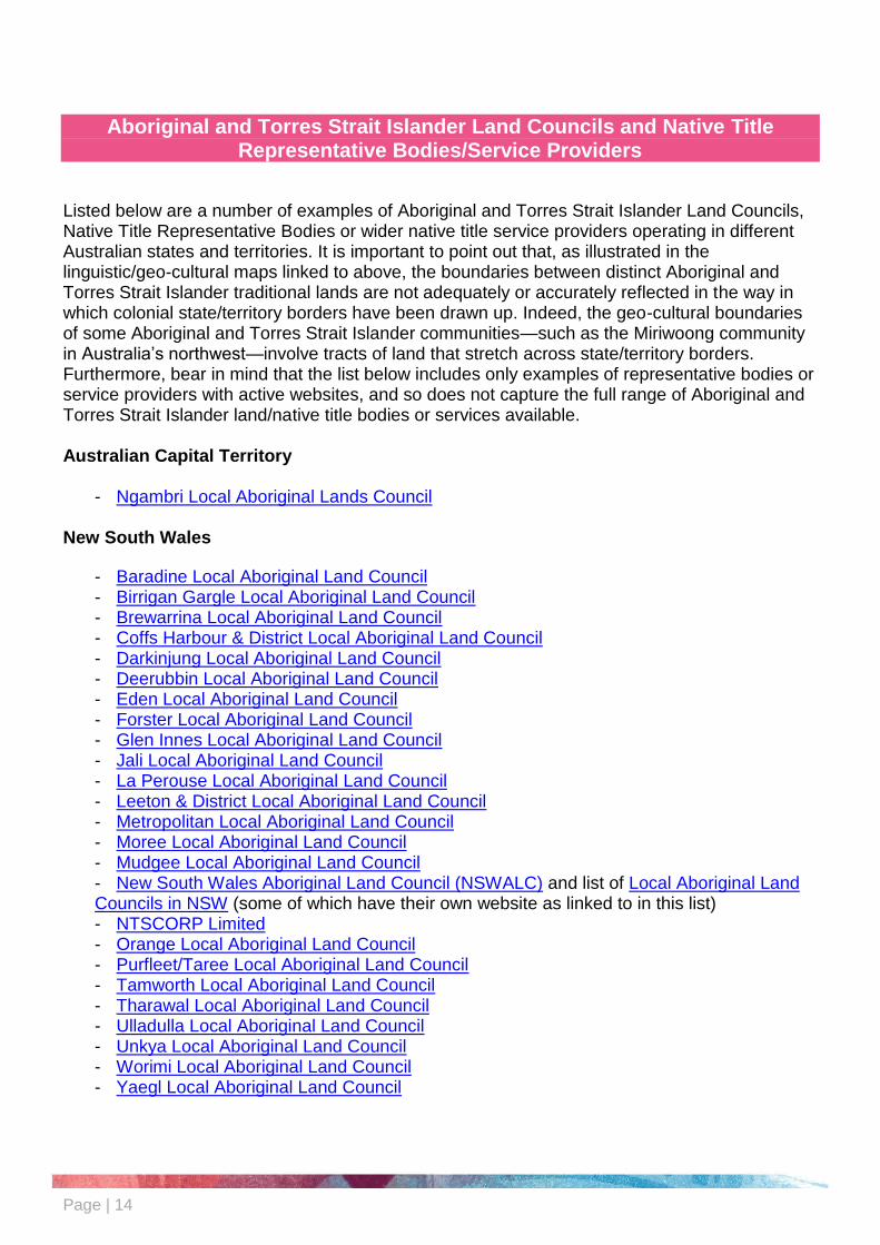
Aboriginal and Torres Strait Islander Land Councils and Native Title Representative Bodies/Service Providers
Listed below are a number of examples of Aboriginal and Torres Strait Islander Land Councils, Native Title Representative Bodies or wider native title service providers operating in different Australian states and territories. It is important to point out that, as illustrated in the linguistic/geo-cultural maps linked to above, the boundaries between distinct Aboriginal and Torres Strait Islander traditional lands are not adequately or accurately reflected in the way in which colonial state/territory borders have been drawn up. Indeed, the geo-cultural boundaries of some Aboriginal and Torres Strait Islander communities—such as the Miriwoong community in Australia’s northwest—involve tracts of land that stretch across state/territory borders. Furthermore, bear in mind that the list below includes only examples of representative bodies or service providers with active websites, and so does not capture the full range of Aboriginal and Torres Strait Islander land/native title bodies or services available. Australian Capital Territory
- Ngambri Local Aboriginal Lands Council New South Wales
- Baradine Local Aboriginal Land Council - Birrigan Gargle Local Aboriginal Land Council - Brewarrina Local Aboriginal Land Council - Coffs Harbour & District Local Aboriginal Land Council - Darkinjung Local Aboriginal Land Council - Deerubbin Local Aboriginal Land Council - Eden Local Aboriginal Land Council - Forster Local Aboriginal Land Council - Glen Innes Local Aboriginal Land Council - Jali Local Aboriginal Land Council - La Perouse Local Aboriginal Land Council - Leeton & District Local Aboriginal Land Council - Metropolitan Local Aboriginal Land Council - Moree Local Aboriginal Land Council - Mudgee Local Aboriginal Land Council - New South Wales Aboriginal Land Council (NSWALC) and list of Local Aboriginal Land Councils in NSW (some of which have their own website as linked to in this list) - NTSCORP Limited - Orange Local Aboriginal Land Council - Purfleet/Taree Local Aboriginal Land Council - Tamworth Local Aboriginal Land Council - Tharawal Local Aboriginal Land Council - Ulladulla Local Aboriginal Land Council - Unkya Local Aboriginal Land Council - Worimi Local Aboriginal Land Council - Yaegl Local Aboriginal Land Council

Page | 15
Northern Territory
- Anindilyakwa Land Council (Groote Eylandt) - Central Land Council - North Australian Indigenous Land and Sea Management Alliance - Northern Land Council - Tiwi Land Council
Queensland
- Cape York Land Council - Carpentaria Land Council Aboriginal Corporation - Central Queensland Land Council Aboriginal Corporation - North Queensland Land Council - Queensland South Native Title Services - Torres Strait Regional Authority
South Australia
- Aboriginal Lands Trust - South Australian Native Title Services
Tasmania
- Aboriginal Land Council of Tasmania - Tasmanian Aboriginal Land and Sea Council
Victoria
- Barengi Gadjin Land Council - Native Title Services Victoria
Western Australia
- Central Desert Native Title Services - Goldfields Land and Sea Council - Kimberley Land Council - South West Aboriginal Land and Sea Council - Yamatji Marlpa Aboriginal Corporation
Some of the abovementioned state and territory bodies/services are also part of the National Native Title Council, and/or illustrated on the national-scale National Native Title Tribunal Map of Representative Aboriginal/Torres Strait Islander Body Areas.

Page | 16
Aboriginal and Torres Strait Islander Geographers
Aboriginal and Torres Strait Islander people who have played, and/or continue to play, a key role in the field of Geography in Australia may not always be explicitly recognised, or referred to, through the title of ‘geographer’. However, in many ways, all Aboriginal and Torres Strait Islander people could be considered geographers given their deep connections to, knowledges of, and/or caring contributions to Country. Acknowledging the shared contributions of Aboriginal and Torres Strait Islander peoples to the subject/learning area of Geography is therefore important. Nevertheless, should you wish to provide opportunities for students and children to explore and acknowledge individuals or more localised groups of Aboriginal and Torres Strait Islander people who have contributed to the subject/learning area of Geography, some avenues for relevant research and classroom learning could include:
- Researching and learning about the contributions of Aboriginal and Torres Strait Islander Geography Academics, such as Professor Marcia Langton AM;
- Researching and learning about the contributions of Aboriginal and Torres Strait Islander land rights activists, such as Vincent Lingiari, Eddie Koiki Mabo, and Galarrwuy Yunupingu AM;
- Researching and learning about the contributions of Aboriginal and Torres Strait Islander ranger groups. The Australian Government’s map of Indigenous Protected Areas and Commonwealth Funded Indigenous Ranger Groups pinpoints a number of Aboriginal and Torres Strait Islander ranger groups active as at February 2020. As well as using the internet to look up the specific webpages of the individual ranger groups mapped, you may be able to find out more about these, and other, ranger groups through your local Aboriginal and Torres Strait Islander Land Council.
- Researching and learning about the contributions of Aboriginal and Torres Strait Islander geography-related reference groups/networks and their members, such as the Seed Indigenous youth climate network.

Page | 17
Aboriginal and Torres Strait Islander Geography Events/Celebrations
- Banksia Foundation Sustainability Awards (including specific Indigenous Leadership for Sustainability Award category)
- Country Needs People Campaign
- Ecological Society of Australia Indigenous Ecological Knowledge Symposium (2014), Indigenous Biocultural Knowledge Symposium (2019), and associated Indigenous Ecology and Land Management Events and Activities
- Northern Territory Government Department of Tourism and Culture Ranger awards
- NAIDOC Awards (including specific Caring for Country Award)
- National Landcare Awards (including specific Indigenous Land Management Award category)
- NT Natural Resource Management Awards (including specific Indigenous NRM Champion Award category)

Page | 18
Other Online Guides/Reference Materials
- Australian Bureau of Statistics (n.d.) Statistical Geography Fact Sheet: Indigenous Structure,
https://www.abs.gov.au/websitedbs/censushome.nsf/home/factsheetsas?opendocument&navpos=450
- Australian Human Rights Commission (2008) Climate change, water and Indigenous knowledge, https://www.humanrights.gov.au/sites/default/files/content/social_justice/nt_report/ntreport08/pdf/Climate_Change_Community_Guide.pdf
- Australian Human Rights Commission (2017) rightsED: Subject Areas: Geography/History, Civics and Citzenship, https://www.humanrights.gov.au/our-work/face-facts-introduction-rightsed
- Australian National University (2009) Guidelines for Indigenous Ecological Knowledge Management (including archiving and repatriation), https://www.nintione.com.au/resources/rao/guidelines-for-indigenous-ecological-knowledge-management-including-archiving-and-repatriation/
- CSIRO (2013) Bibliography on Indigenous Land Management in Australia, http://aiatsis.gov.au/sites/default/files/products/research_outputs/bibliography-on-indigenous-land-management-in-australia.pdf
- CSIRO (2017) Indigenous knowledge and environmental management, https://www.csiro.au/en/Research/Environment/Land-management/Indigenous
- Ecology and Society (2013) Integrating Indigenous Ecological Knowledge and Science in Natural Resource Management: Perspectives from Australia, http://www.ecologyandsociety.org/issues/view.php/feature/50
- National Museum of Australia (2017) On Country, http://www.nma.gov.au/exhibitions/on_country/country
- Ninti One (2011) Aboriginal people, bush foods knowledge and products from central Australia: Ethical guidelines for commercial bush food research, industry and enterprise, http://www.nintione.com.au/resource/NintiOneResearchReport_71_BushFoodGuidelines.pdf
- Parliament of Australia/Davis, M. (1998) Biological Diversity and Indigenous Knowledge, http://www.aph.gov.au/About_Parliament/Parliamentary_Departments/Parliamentary_Library/pubs/rp/RP9798/98rp17
- Queensland Curriculum and Assessment Authority (2007) The History of Aboriginal land rights in Australia (1800s—1980s), https://www.qcaa.qld.edu.au/downloads/approach2/indigenous_res006_0712.pdf
- Reconciliation Australia (2016) Let’s Talk…Land Rights, https://www.reconciliation.org.au/wp-content/uploads/2017/11/1608-Lets-Talk_Land-Rights.pdf

Page | 19
- SBS/NITV (2017) SBS/NITV (2017) Mayi Jilbamun (Food Journey), http://www.sbs.com.au/nitv/feature/mayi-jilbamun
- Scott, G. (2004) A Bibliography of Indigenous Ecological Knowledge in Northern Australia, https://www.cdu.edu.au/centres/ik/pdf/IEK_bibliography.pdf
- South West Aboriginal Land & Sea Council (2013) Kaartdijin Noongar Links to AC Geography F-Year 2, https://www.noongarculture.org.au/wp-content/uploads/2012/06/Geography-F-2-Curriculum-links-to-Kaartdijin-Noongar-Website1.pdf
- South West Aboriginal Land & Sea Council (2013) Kaartdijin Noongar Links to AC Geography Year 3-6, https://www.noongarculture.org.au/wp-content/uploads/2012/06/Geography-3-6-Curriculum-links-to-Kaartdijin-Noongar-Website.pdf
- South West Aboriginal Land & Sea Council (2013) Kaartdijin Noongar Links to AC Geography, Year 7-10, https://www.noongarculture.org.au/wp-content/uploads/2012/06/Geography-7-10-Curriculum-links-to-Kaartdijin-Noongar-Website1.pdf
- Tasmanian Government (2018) The Orb: Living Cultures, https://www.theorb.tas.gov.au/living-cultures
- Watson, H (1987) Singing the Land, Singing the Land, http://singing.indigenousknowledge.org

Page | 20
Reflective Questions for Geography Staff and Students
Do you know the name of the Country on which your school or early learning service is situated, and who its Traditional Owners are? Are you aware of any local sites of significance to these Traditional Owners?
What is the significance of Acknowledgement of Country and Welcome to Country and how are these protocols related to reconciliation?
How have Aboriginal and Torres Strait Islander histories and cultures influenced Australian geography, and what active role do these histories and cultures play today?
Given that Country essentially underpins all aspects of Aboriginal and Torres Strait Islander life, what is the relationship between Aboriginal and Torres Strait Islander geography and other subject/learning areas? That is, how might we think about interdisciplinary Aboriginal and Torres Strait Islander geo-sciences, geo-economics and geo-linguistics, for example? Why is this relationship important to appreciate?
Where appropriate, organise an excursion to a local Aboriginal and Torres Strait Islander Land Council, Native Title service, Ranger Group or other geography-focused community organisation. What learnings and messages did you take away from your excursion? Were there any collaborations occurring between this Aboriginal and Torres Strait Islander organisation and non-Indigenous organisations, and/or can you think of any potential positive avenues for collaboration?
Choose to research an Aboriginal or Torres Strait Islander geographer, land rights activist or ranger. What is the importance of his or her contributions to geography on either a local or (inter)national scale?
How might your school or early learning centre contribute to the celebration of Aboriginal and Torres Strait Islander geography and geographers?
How can embedding Aboriginal and Torres Strait Islander histories and cultures into the study and practice of Geography help to foster reconciliation?
Recommended