
i
Historic City of George Town
Heritage Management Plan
State Government of Penang

ii
Penang island view from space

iii
This Heritage Management Plan for the nominated World Heritage Site, the Historic City of George Town, has been approved and adopted by the State Government of Penang at the State Planning Committee meeting on 12 February 2007 The Plan was supervised by the Committee for the Nomination of Penang as a World Heritage Site under the chairmanship of the Honourable Mr Teng Chang Yeow, State Executive Committee Member for Tourism Development and Environment. The Plan is the result of co-operation and discussion by the representatives of various government agencies, including the State Town & Country Planning Department and the Local Authority, and others including non-government organisations, and individuals who have been involved in the management or research and documentation of the site. Due to time constraints, the authors of this Heritage Management Plan were unable to hold more extensive consultations but it is envisaged that in the course of socialising the plan, further discussions will be held with relevant stakeholders. Some of the content for parts 2 to 4 of the Plan has been drawn from the application dossier for registration of the site. The Plan was prepared and written by: Badan Warisan Heritage Services Sdn Bhd 2 Jalan Stonor 50450 Kuala Lumpur Malaysia © February 2008

iv
CONTENTS Page
1.0 Introduction 1
1.1 What is a Heritage Management Plan 2
1.2 Why is a Heritage Management Plan necessary 2
1.3 Basis for the Heritage Management Plan 2
1.4 Vision and Objectives of the Heritage Management Plan 4
2.0 Summary of the Heritage Management Plan Structure
6
3.0 Description of the Site 8
3.1 Location and Extent 9
3.2 Brief Description of the Site 12
3.3 Architectural Style 23
3.4 Interests and ownership 40
3.5 Legal Status 41
3.6 Protective Measures and Means of Implementing Them 41
3.7 Existing System of Site Management 46
3.8 Implemented Projects and Programmes 49
4.0 Statement of Significance 51
4.1 Statement of Cultural Significance 52
4.2 Key Values 52
4.3 Justification for Nomination 53
5.0 Management Issues and Challenges 54
5.1 Introduction 55
5.2 Intrusive Features/Factors that Threaten Significance 55
5.3 Religious Sites 61
5.4 Infrastructure and Facilities 63
5.5 Urban form, townscape and landscape 64

v
5.6 Site Interpretation 65
5.7 Funding, Resources and Capacity Development 67
5.8 The Harbour Area and the Clan Jetties 68
5.9 The Civic Precinct 69
5.10 The Historical Commercial Centre 70
5.11 Living Heritage – Penang Peranakan 71
5.12 Gazetted Monuments and Archaeology 72
5.13 Tourism and Visitor Management Control 73
5.14 Transportation and Road Systems 75
5.15 Boundaries and settings of the World Heritage Site 78
6.0 Policy Aims and Management Objectives 79
6.1 Introduction 80
6.2 Enhanced Administrative Structure for the Management of the Site
80
6.3 State Heritage Committee 84
6.4 Heritage Department 86
6.5 World Heritage Office 87
6.6 State Heritage Fund 88
6.7 Technical Review Panel 89
7.0 Action Plan, Implementation and Monitoring 94
7.1 Heritage Management Plan 95
7.2 Implementation and Monitoring 95
7.3 Sustainable Cultural Heritage Tourism 96
7.4 Action Plan and Time Frame for Review 97
Appendices 98
Appendix 1
Stovel, Herb: “Approaches to Managing Urban Transformation for Historic Cities” (Macau, 2002)
99
Appendix 2
UNESCO “Cultural Heritage Management and Tourism: Models for Co-operation Among Stakeholders”
101

1
1.0 INTRODUCTION

2
1.1 What is a Heritage Management Plan
1.1.1 A Heritage Management Plan is a document which explains why a place is significant and how to sustain that significance. It starts with describing what is there, why it matters, what is happening to it and the principles by which you will manage it. It then sets more detailed programmes for maintenance, management, access, use or other issues.
1.1.2 This Plan has been produced to provide a protective and developmental framework for the Core Area and Buffer Zone of the Historic City of George Town (The Site). It is intended to guide the future management of the site and will support the nomination of this Site for inscription as a World Heritage Site.
1.1.3 The purpose of this Plan is to administer, manage and protect the Outstanding Universal Values of the Site by developing a co-ordinated and consensual framework for the long-term management and development of the Site.
1.2 Why is a Heritage Management Plan necessary
1.2.1 A Heritage Management Plan is a requirement of the World Heritage Convention, adopted by UNESCO in 1972 and to which the Government of Malaysia is a signatory. The Operational Guidelines issued by the World Heritage Committee strongly recommend that all State Parties have management frameworks and adequate legal protection suitable for long-term conservation of World Heritage Sites. A Heritage Management Plan is an effective way of achieving this.
1.2.2 This Plan forms a core component of the framework. It must be operationalised with a Management System implemented and monitored, to ensure that the state of conservation and heritage values of the site are maintained and enhanced.
1.3 Basis for the Heritage Management Plan 1.3.1 The Heritage Management Plan for the Site is founded on the principles
of sustainable socio-economic development of the local communities living and working in the Site, and for the protection, conservation and presentation of the Site. It is in response to the pressures and complex management issues that face the Site. The Plan represents a framework

3
document for long-term decision-making by those agencies, organisations and individuals responsible for the management of the Site.
1.3.2 The Heritage Management Plan is not intended to be prescriptive or
binding but rather to provide guidance for activities and programmes which may have an impact on the Site. It is intended to complement the Penang Local Plan (currently under preparation) and if required a Special Area Plan as prescribed under the Town and Country Planning Act 172 (1976).
1.3.3 The area of the Site forms only a part of the city and what happens to
the rest of George Town has a direct relationship with the Site and vice versa. The approach adopted in this Heritage Management Plan has to suggest practical measures to protect the Site and improve the experience of visitors whilst catering properly for the needs of those who live and work in the area.
1.3.4 The Heritage Management Plan is intended to help ensure the
conservation of the cultural heritage assets of the Site and must represent the consensual view of the Committees and Managers responsible for the protection, interpretation and promotion of the Site and the enhancement of the character, values and appearance of the Site.
1.3.5 In addition, as the Heritage Management Plan will affect the local
community, it must reflect the interests of all stakeholders – those who are involved in the development and implementation of the Plan as they have the power to enforce decisions and influence the conservation and use of the area, as well as landowners, residents, professional experts, representatives of the local and religious communities, etc.
1.3.6 This Heritage Management Plan has been prepared in broad accordance
with the general procedures and requirements published in 1998 and revised in 2005 by ICCROM, ICOMOS and UNESCO as Management Guidelines for World Cultural Heritage Sites. This Plan also takes into account other documents including the Nara Declaration on Authenticity (1994). The Plan has been developed with reference to current best practices as expressed in the Champasak Heritage Management Plan and the latest generation of recently published WHS Management Plans in the United Kingdom, including the Maritime Mercantile City Liverpool and the Canterbury World Heritage Site Management Plan.
1.3.7 This Plan uses the general model for a Conservation Management Plan by
James Kerr (The Conservation Plan, National Trust NSW, 2001) as well as
4
the model promoted in the 2nd UNITAR Workshop on the Management of World Heritage Sites (2005).
1.4 Vision and Objectives of the Heritage Management Plan
Vision
1.4.1 “To ensure and encourage sustainable heritage development and to provide a protection and development framework in order to maintain the authenticity and integrity of the Site, as exemplified by its Outstanding Universal Values.”
Objectives
1.4.2 The Heritage Management Plan has six main objectives: 1.4.2.1 To define the significance and values of the Site (ref Dossier pp 109 –
123). 1.4.2.2 To summarize the current measures and management structures
which are in operation in the Site (ref Dossier Chapter 5, pp 154 – 200) and to propose new measures to protect and enhance the Site’s special status, heritage values and significance.
1.4.2.3 To propose a framework for the management of the Site and the
buildings and land within it and its community and businesses, so that their essential character is preserved through the identification and promotion of its heritage assets, especially its traditional shophouses (ref Dossier pp 47 – 53), religious buildings (ref Dossier pp 34 – 46) and living cultures (ref Dossier pp 90 – 108), and the development and transfer of the necessary skills to the local community.
1.4.2.4 To increase public awareness of and interest in the Site and promote
its educational and cultural values through development of partnerships and consensus among all those, public and private, who are in anyway stakeholders in the Site.
1.4.2.5 To recommend a programme of works and projects that will enhance
the Site and improve the enjoyment of the Site for all who live, work or spend leisure time in the area by establishing effective operational linkages between the committees and agencies responsible for the management of the Site and all other bodies working in the area through developing appropriate uses of the Site, including traditional religious and cultural festivals and community activities.

5
1.4.2.6 To maximise public and private, national and international, resources for the conservation, protection and promotion of the Site thus ensuring sensitive interventions in the site and prevention of inappropriate development through the establishment of the proposed State Heritage Fund.

6
2.0 SUMMARY OF THE OF HERITAGE MANAGEMENT PLAN STRUCTURE

7
2.1 Summary of the Heritage Management Plan Structure 2.1.1 The following outlines the structure of the Heritage Management Plan
for the Historic City of George Town
Part 1: Introduction This section outlines the nature, purpose and structure of the Plan and the processes behind its development. Part 2: Executive Summary Part 2 presents a brief overview of the main conclusions and recommendations.
Part 3: Description of the Site This section briefly described the location, extent and character of the Site. It also outlines the current management and ownership situation within the Site. Part 4: Statement of Significance This section presents the Statement of Significance, the Nomination Criteria and a summary of the key outstanding universal values.
Part 5: Management Issues and Challenges Part 5 forms the core analytical section of the Plan and seeks to identify and discuss the key opportunities, threats and management issues facing the Site and its environs. The management issues cover a broad range of subjects including the Site and its setting, built heritage conservation, traffic and transportation, tourism impact as well as social, political and cultural issues. It makes recommendations for specific actions considered necessary to counter threats and grasp opportunities for the sustainable regeneration of the Site as well as protecting its Outstanding Universal Values. Part 6: Policy Aims and Management Objectives This section is the heart of the Plan. It presents an agreed vision for the future of the Historic City of George Town as a World Heritage Site, supported by a management framework which seeks to provide guidance on the sustainable regeneration of the Site and its environs in a manner that addresses the challenges and management issues facing the Site.
Part 7: Action Plan, Implementation and Monitoring This final section explores how the Plan will be implemented. It outlines how change can be monitored and proposes a time-frame for the implementation of an Action Plan. Part 8 : Appendices

8
3.0 DESCRIPTION OF THE SITE
9
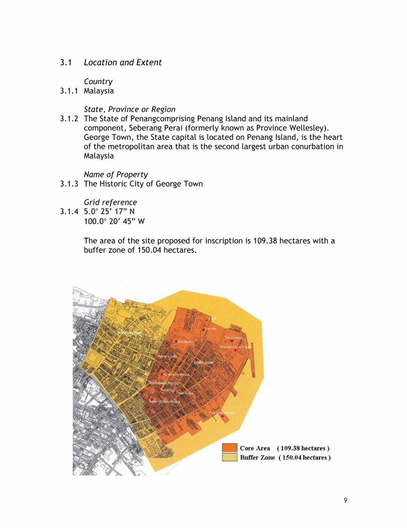
3.1 Location and Extent
Country 3.1.1 Malaysia
State, Province or Region 3.1.2 The State of Penangcomprising Penang Island and its mainland
component, Seberang Perai (formerly known as Province Wellesley). George Town, the State capital is located on Penang Island, is the heart of the metropolitan area that is the second largest urban conurbation in Malaysia
Name of Property
3.1.3 The Historic City of George Town
Grid reference 3.1.4 5.0° 25’ 17” N
100.0° 20’ 45” W The area of the site proposed for inscription is 109.38 hectares with a buffer zone of 150.04 hectares.

10
Map 1: Location Plans showing Penang Island
Map 2: Key Plan – George Town

11
Map 3: Aerial Photograph of the Core Area and Buffer Zone of the Historic City of George Town
12
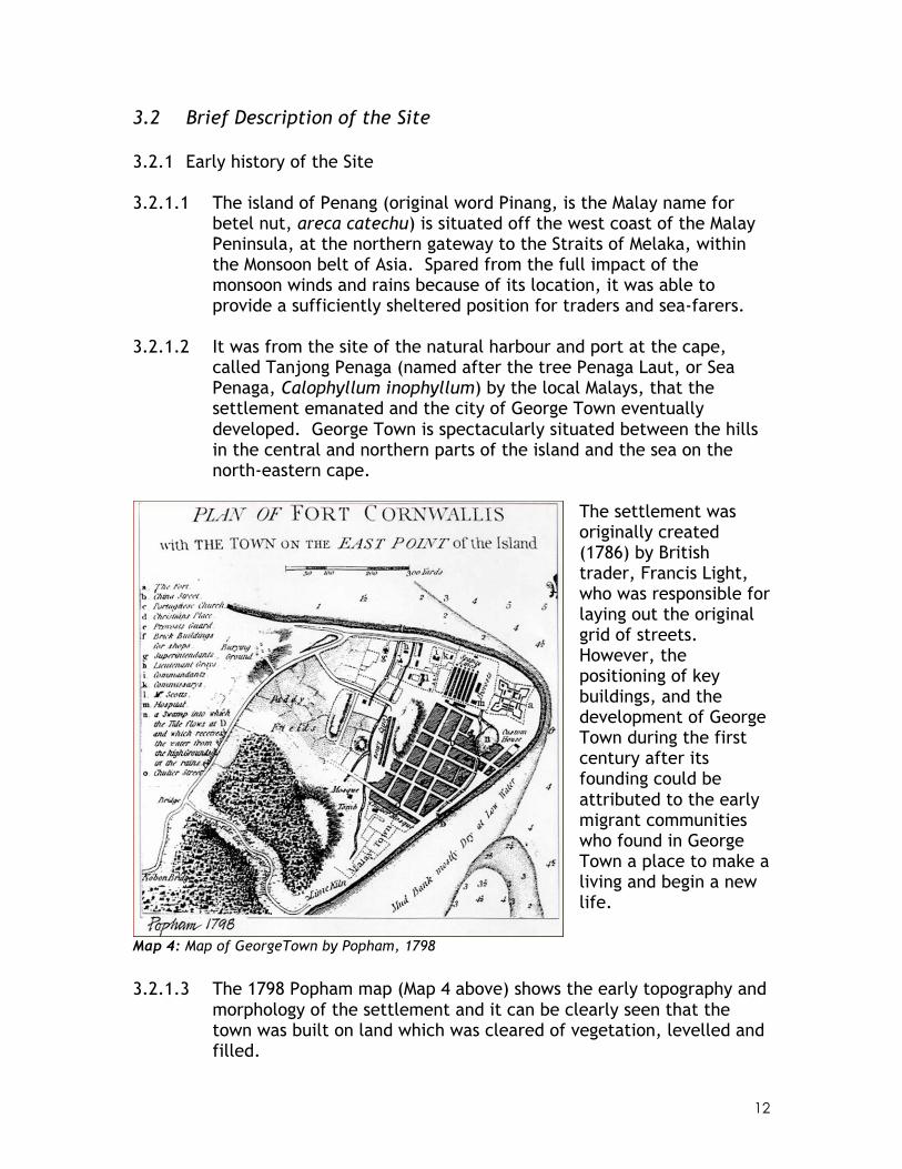
3.2 Brief Description of the Site 3.2.1 Early history of the Site 3.2.1.1 The island of Penang (original word Pinang, is the Malay name for
betel nut, areca catechu) is situated off the west coast of the Malay Peninsula, at the northern gateway to the Straits of Melaka, within the Monsoon belt of Asia. Spared from the full impact of the monsoon winds and rains because of its location, it was able to provide a sufficiently sheltered position for traders and sea-farers.
3.2.1.2 It was from the site of the natural harbour and port at the cape,
called Tanjong Penaga (named after the tree Penaga Laut, or Sea Penaga, Calophyllum inophyllum) by the local Malays, that the settlement emanated and the city of George Town eventually developed. George Town is spectacularly situated between the hills in the central and northern parts of the island and the sea on the north-eastern cape.
The settlement was originally created (1786) by British trader, Francis Light, who was responsible for laying out the original grid of streets. However, the positioning of key buildings, and the development of George Town during the first century after its founding could be attributed to the early migrant communities who found in George Town a place to make a living and begin a new life.
Map 4: Map of GeorgeTown by Popham, 1798
3.2.1.3 The 1798 Popham map (Map 4 above) shows the early topography and morphology of the settlement and it can be clearly seen that the town was built on land which was cleared of vegetation, levelled and filled.

13
3.2.2 Key areas and their character 3.2.2.1 The Historic City of George Town core area covers an area of 109.38
hectares bounded by the Straits of Melaka on the north-eastern cape of Penang Island, Lorong Love (Love Lane) to the North-West and Gat Lebuh Melayu and Jalan Dr Lim Chwee Leong to the South-West corner.
3.2.2.2 There are more than 1700 historic buildings within this Core Zone
aligned on four main streets of Pengkalan Weld (Weld Quay), Lebuh Pantai (Beach Street), Jalan Masjid Kapitan Keling (Pitt Street) and Lorong Love and several perpendicular streets of Jalan Tun Syed Sheh Barakbah, Lebuh Light (Light Street), Lebuh Bishop (Bishop Street), Lebuh Gereja (Church Street), Lebuh Cina (China Street), Lebuh Pasar (Market Street), Lebuh Chulia (Chulia Street), Lebuh Armenian (Armenian Street) and Lebuh Aceh (Acheen Street).
3.2.2.3 The core zone is protected by 150.04 hectares of the Buffer Zone,
not including the sea buffer, bounded by the stretch of sea area around the harbour, Jalan Prangin to the south-west corner and Jalan Transfer to the North-West corner.
3.2.2.4 The site corresponds to the historic inner city of George Town,
encompassing a rich collection of historic buildings of different styles (see Maps 5 & 6).
3.2.2.5 The early settlers formed their own neighbourhoods or quarters.
While the boundaries of these ethnic quarters were not clearly demarcated, they centre on certain streets or intersections where cultural practices and preferences of the different ethnic groups have created an impact on the development of the town.
3.2.2.6 The position of key buildings for the Chinese population followed
closely their traditional and cultural orientation with mountains or hills to the rear of the building for a sense of security and the front facing the sea to allow for openness. The ‘Malay Town’ evolved around the wetlands leading to the Prangin Creek allowing for irrigation of padi fields as well as acting as a route for transportation. The Indian Hindu population settled close to their fellow Tamil speaking Indian Muslim community. The latter of whose mosque was located close to the Acheen Street Mosque of the early Arab and Malay Muslims of the Malay Town. The few Europeans living in town settled close to Fort Cornwallis, the administrative centre, and clustered around the 1818 St. George’s Anglican Church with its north-south orientation rather than the typical east-west orientation of the northern hemisphere.

14
Map 5: Maps of the Historic City of George Town dated 1803 and 1807-08 with outline showing the Core Zone (red) ad the Buffer Zone (Green)
Map 6: Map of the Historic City of George Town dated 1883 with the outline showing the Core
Zone (red) and the Buffer Zone (green)

15
3.2.2.7 The urban pattern of the site is an overlay of buildings set within open spaces and regular row development with vestiges of the urban village. The early buildings were set in large open spaces with ancillary buildings added as the need arose. Among important examples of this building layout are St. George’s Church, the Supreme Court, Kuan Yin Temple, Kapitan Keling Mosque and private mansions on Light Street, most of which were destroyed during World War II and the land subsequently redeveloped. Examples of this legacy can still be found in the elegant mansions set within spacious compounds along Jalan Sultan Ahmad Shah (formerly Northam Road).
Campbell Street in the early 1900s (above) and today (below)

16
3.2.3 The Chinese town 3.2.3.1 The Chinese town is located within the grid of early George Town,
with China Street as the primary axis and King Street as the secondary axis. Although no record of Chinese influence in early town planning exists, an analysis of the Chinese settlement suggests that the Chinese settlers chose to live within the town grid. They were particular in choosing the site based on social economy and feng shui principles. Respective dialect groups built their own associations, kongsi or temples as social centres and kept their regional dialect, customs, cuisine as well as art and architecture.
3.2.3.2 The most important building for the Chinese society is the Kong Hock
Keong (founded c 1800), also known as the Kuan Yin (Goddess of Mercy) temple located at the end of China Street on a slightly elevated site and is seen in the 1798 Popham map. The temple is sited with its back towards the central hills on the island and faces the harbour or sea with the hills of the mainland in the distance across the channel.
3.2.3.3 King Street, which runs perpendicular to China Street, has several
institutional buildings and temples of less importance laid out. During the 19th century there were at least eight clan associations or kongsi on King Street, one on Bishop Street and Guandong and Fujian provinces. Most of these institutions are located to the left of the Kuan Yin temple on the China Street axis demonstrating the superior status of the latter in the Chinese cosmic order. The network of kongsi includes the Cheah Kongsi, two Khoo Kongsi, Lim Kongsi, Tan Kongsi and Yeoh Kongsi, representing the five major Hokkien kongsi. This urban geography of clan temples and houses is a unique feature of the historic settlement of George Town.
Kong Hock Keong, also known as the Kuan Yin (Goddess of Mercy) temple

17
3.2.4 The Indian settlement 3.2.4.1 Next to the Chinese town is the Indian settlement which extends to
the two sections of Chulia Street where the Kapitan Keling Mosque (founded 1801) which is the centre for the Indian Muslim (Chuliah) community, and the Sri Mahamariamman Temple (built 1833) for the Hindus. The latter was built in accordance with the salva agamas with an antechamber, a hall, circumambient dome, surrounding walls and an entrance and a gopuram, which is over 23 feet high. It is from this temple that the celebration of Thaipusam starts every year.
3.2.4.2 Crowned with onion-shaped domes, the Kapitan Keling Mosque is the
largest historic mosque in George Town. The original mosque was a rectangular building with a hipped roof, built on the site by the East India Company, but was enlarged several times. The present mosque with its British Raj style was designed by the German Eurasian architect, Henry Alfred Neubronner in 1910.
3.2.4.3 As development in the town became more intensive, rows of
residential and shophouses were built on available land fronting the street, eventually hiding the earlier buildings and their compounds. Examples of this overlay can be seen in Chulia Street where the early bungalows can be found behind the later shophouses. This building layout was followed by the Chinese kongsi, where the temples were set within an open space surrounded by shophouses. For the kongsi and temples, this arrangement of buildings provided a screen of privacy for members of the clan or society in the early days, to assemble or hold meetings out of view of the police and others.
Kapitan Kling Mosque

18
3.2.5 The Malay town 3.2.5.1 Further south in the Malay town which evolved around the Prangin
River and the southern part of Chulia Street, is the Acheen Malay Mosque which was founded in 1808 by Tengku Syed Hussain, a wealthy Arab merchant prince who became the Sultan of Aceh. Until the 1970s when the Muslim pilgrimage to Mecca was made by ship rather than by airplane, Acheen Street was the centre for the haj travel for pilgrims from North Sumatra, Southern Thailand and the northern states of Peninsula Malaysia.
3.2.5.2 The Acheen Malay Mosque has an octagonal-shaped minaret following
the 16th century Moghul architecture common in old mosques found in Aceh. The mosque together with the tomb of its founder is marked in the 1798 Popham map as a landmark of the Malay township; it was the first Muslim urban parish and the earliest centre of spice traders and Malay entrepreneurs on the island.
Kapitan Kling Mosque

19
3.2.6 The Harbour Area and the Clan Jetties 3.2.6.1 The warehouses and godowns near the waterfront extend from Beach
Street to Weld Quay with two street frontages. The warehouses were located behind the offices that front the main street. The streets extend from the waterfront jetties (ghauts) into the town’s commercial centre. Weld Quay extends from Swettenham Pier to Prangin River, linking ghauts that provided jetties at each end.
3.2.6.2 The Penang harbour in its heyday had a number of piers: Victoria Pier
(1888), Church Street Pier/Railway Jetty (1897) and Swettenham Pier (1904). The Raja Tun Uda Pier (Ferry terminal) was opened only in 1959.
3.2.6.3 During the 1880s, a stretch of seafront was reclaimed and named
after Sir Fredrick Weld, Governor of the Straits Settlements (1885-87). Offices and godowns were built on the new waterfront in the distinctive Anglo-Indian style typified by colonnaded arcades. They housed the offices of European firms that were shipping agents, general importers and tin refiners like Boustead, Behn Meyer, Macalister & Co. and Peterson Simons. During World War II, many of the fine buildings near the harbour were bombed and destroyed, including the Government offices on Beach Street and Downing Street, Victoria and Railway Pier.
View of the harbour area along Weld Quay

20
3.2.6.4 While the Penang harbour continues to be an important waterway, the harbour front activities have changed due to relocation of cargo handling and containerization to the expanded port facilities on the mainland at Butterworth and Prai. The Penang Bridge from the island to the mainland spans 11.5 km. over the southern channel carrying its full capacity of vehicles. However, the ferry remains an important transport link to the mainland, carrying both vehicles and passengers from George Town to Butterworth. Both Swettenham Pier and Church Street Pier continue to be used as passenger cruise terminal and marina respectively.
3.2.6.5 The clan jetties represent a unique form of settlement unlike similar
“water villages” elsewhere as each community from each jetty comprise members of the same clan with the same surname, such as the Lim, Chew, Tan, Lee and Yeoh jetties. Since 1969, the residents have been given special permission to occupy the site in the form of “Temporary Occupation Licence” for each of the premises they occupy. The timber jetty housing, numbering 249 premises, built on stilts on the seashore, spread over an area of approximately 16.8 acres. The houses are arranged in a “fishbone” layout with the jetty built of timber planks serving as the major spine for access and communication. Typically, a temple, housing the deity brought from the clan’s home village in China, is sited at the front or rear of the jetty. Each of the jetty clan communities has set up a system of self-management to look after the security, maintenance of common areas and movement of heavy vehicles.
View of the Clan Jetties with the Ferry Terminal in the background

21
3.2.7 The Civic Precinct 3.2.7.1 Immediately west of Swettenham Pier and south of Fort Cornwallis
were the government offices and administrative buildings. This area was known as the “Government’s Quadrangle” or King Edward Place. King Edward Place ends with the Victoria Memorial Clock Tower, built in 1897 by a prominent Chinese businessman, Cheah Chen Eok, to commemorate Queen Victoria’s diamond jubilee. The tower now stands on a small roundabout that opens to Beach Street on its south, Light Street on its west, Jalan Tun Syed Sheh Barakbah on its north and King Edward Place on its east.
3.2.7.2 A 12-storey government office built by the Public Works Department
replaced the former building destroyed during World War II. A remaining section of the government quadrangle now houses the Syariah Court.
3.2.7.3 Among the other major public buildings are the State Legislative
Assembly building (formerly the Magistrates Court), Municipal Council buildings, the Town Hall and City Hall (at the Esplanade), Supreme Court Building at the end of Light Street, and the Dewan Sri Pinang (Penang’s first auditorium) and Bank Negara (National Bank) which were built in the 1960s. The Esplanade, an open field facing the north beach, and its promenade was George Town’s main social and recreational centre.
The City Hall which lies adjacent to the Esplanade

22
3.2.8 The Historic Commercial Centre 3.2.8.1 The historic commercial centre follows the original grid laid out in
the 18th century, and is framed by Light Street, Beach Street, Chulia Street and Pitt Street, the first two converging at Fort Cornwallis. Covering an area of approximately 18.6 hectares, it is subdivided into 18 rectangular blocks, all of unequal dimensions. It is segmented into banking and trading areas related to port activities.
3.2.8.2 On the northern section of Beach Street are neo-classical style
buildings that house the Standard Chartered Bank, the Algemene Bank Nederland (ABN Bank) and the Hong Kong and Shanghai Corporation (HSBC) which was reconstructed after World War II in a late art deco style.
3.2.8.3 At the turn of the 19th century, the northern section of Beach Street
and its adjacent Bishop Street were the “high streets” where European stores and stores selling exclusive goods were patronized by the European community and Penang elite. A remarkable number of corner coffee shops cater to the office workers reflecting the role of this quarter as a business district.
3.2.8.4 Another distinct segment of this commercial centre is the shopping
area of the Tamil Indians who are mainly Hindu. This area, called “Little Madras” but today is referred to unofficially as “Little India”, is centred at Market Street and adjacent Penang Street.
3.2.8.5 China Street and King Street are respectively the main commercial
street and social centre for the Chinese community within this quarter, as described earlier.
The ABN-Amro Bank (left) and the OCBC Bank (right) on Beach Street which have been
restored

23
3.2.9 Other features 3.2.9.1 Outside the main historic commercial centre are largely residential
quarters of terrace houses and shophouses, interspersed with bungalows.
3.2.9.2 The Prangin Canal forms the southern limit of early 19th century
George Town. The canal was built from the site of the original Prangin River which was filled in the 1880s. It is joined to another drainage canal at Transfer Road which was appropriately named “Boundary ditch” in the 19th century. The two canals thus logically form the southern and western limits respectively of the nomination site for World Heritage.
3.3 Architectural Style 3.3.1 Throughout George Town’s urban history, the myriad cultures which
traded with, and settled on, Penang Island brought building styles from all over the world. These influences stretched from Melaka (with Portuguese and Dutch styles), Junk Ceylon (Phuket), Kedah and Aceh to China, India, Europe, America and the Arab world. The early architecture of the island therefore formed from the amalgam of cultural values, ideas, traditions and memories of the immigrant and indigenous builders adapted to the availability of materials, transport and the need to live comfortably in a tropical climate.
3.3.2 The site chosen by Francis Light for the setting out of the town grid was
mainly swamp land. The indigenous Malay style timber stilt building form was initially used until the land could be properly drained. By the 1790s, easily available timber from the mangroves on the coast, bakau (Rhizophora species) trunks, were used to form solid platforms beneath the soft brick and lime mortar columns and walls of more permanent structures which started to appear.
3.3.3 Originally restricted to one or two low storeys, improved drainage
allowed buildings to increase in height providing better ventilation. Building widths were dictated by the availability of materials and method of transport; early terraced buildings would typically have a frontage of twelve feet between party walls. This was later increased to sixteen to twenty feet depending on the local hardwood beams for walls and roof construction and the wealth and status of the owner. The depth of the buildings was dependant on the size of the land.

24
3.3.4 The importance of keeping interiors cool and well ventilated was addressed by each of the builders in turn who followed the traditions of their home lands. As materials and fashions influenced, the building styles changed, but their form remained a reflection of their uses.
3.3.5 Building materials 3.3.5.1 These included granite and terracotta tiles and later, decorative
cement tiles while the upper stories had floors of local timber planks. Soft burnt clay bricks plaster with lime mortar jointed walls with lime or chunam plaster and wash applied as a breathable skin allowed moisture to rise from the base of the walls and evaporate.
3.3.5.2 Early shutters were simple framed timber boards; later, these took
on the embellishments and traditional carvings of the culture of their builders and users. The openings of tall, door-sized shutters which rose from the floor level were also embellished with decorative carved balustrades. These later evolved in air vent spandrels below shorter shutters in the Traditional Chinese shophouses and carved balustrade panels of the Straits Eclectic shophouses.
3.3.5.3 Open fanlights above the door and shutter openings allowed cooling
breezes to move through the building. Doors were again often carved, the outer door with sections of lattice and open figures and landscapes allowing both ventilation and a secure but private view of the street from within, and the inner, solid pivoted doors which were barred only at night against intruders. In later refiguring of entrances for commercial use, horizontal timber bars, incorporated into a sliding panel across the entrance between the inner solid doors and the outer half doors, were traditionally used by the Cantonese and can still be seen in Cintra Street and Rope Walk.
3.3.5.4 The early timber and brick building used easily available attap (palm
leaf) roofs but after a series of devastating fires, unglazed terracotta roof tiles were introduced possibly as early as 1787. These came in a variety of forms, the rounded ‘pan-tiles’, possibly influenced by the roofs found in what was once Portuguese governed Melaka, the Indian equal shaped ‘v’ shaped tiles, the Chinese wide shallow ‘furrow’ tiles and semi-cylindrical ‘ridge’ tiles used mainly for Chinese temples. Marseilles tiles were introduced in the 1900s and became increasingly popular after World War II.
3.3.6 Ornamentation 3.3.6.1 The multicultural heritage contributed to the eclectic mix of
ornamentation – the carved wood panels and fascia boards of the

25
indigenous Indo-Malay forms; the elaborate mythological and superstitious images of the Chinese, the domes and arches of Moghul India and the neo-classical elements of British architecture of the Georgian and Regency periods.
3.3.7 The Indo-Malay Bungalow 3.3.7.1 Early bungalows took their cue from the building methods of the
indigenous Malays, and were raised on stilts and of timber and attap. With better drainage and the introduction of brick, made and used by Indian convict labour, a building form evolved from the Malay bumbung lima (five ridge roofs) house found mainly on the west coast of the Malay Peninsula. The name describes the form of a rectangular house plan with one main horizontal roof ridge and four descending corner ridges which was adapted by the Arab and Sumatran Muslims living around the Acheen Street Mosque and became the building form used around Argyll Road, Chulia Street and Burmah Road, a form which later influenced the European Anglo-Indian form.
3.3.7.2 Later, timber stilts were replaced with brick columns and walls which
in turn supported timber floors above and allowed cool air to flow up through the gaps in the floor boards. The main walls of the first floor were composed of timber frames with continuous pairs of louvered shutters of door height, with decoratively carved balustrades within the openings. Carved or louvered panels above the shutters allowed for ventilation when the shutters were closed. Above the frame of the shutters was the timber wall plate, supporting the Indian tiled hipped roof. This type of housing can still be found clustered around or close by the older mosques, staggered in their setting to allow airflow in and around the properties as in a rural kampong.
3.3.7.3 This style was adopted by the Jawi Perakanans in the 1850s but here
the first floor was reached by external stairs to one side of the main building, leading to a small platform inspired by the traditional serambi (verandah) of a Malay house, and covered with a large pitched roof with decorative lattice work to the upper parts, to form ‘walls’. The bottom flight of stairs were constructed from masonry decorated with ceramic and cement tiles, a form known as Melaka Stairs, while the upper section was timber with finely carved flat balustrades, bargeboards and fascia boards. Shutters were divided into a lower section ending at balustrade height which was solid while the upper section was louvered and arched fanlights above the shutters allowed for permanent ventilation. The roof was tiled with Indian tiles.

26
Syed Alatas Mansion (Anglo-Indian Bungalow typology)

27

28

29
3.3.8 The Anglo-Indian Bungalow 3.3.8.1 The Anglo-Indian bungalow was first developed in India in the 17th
and 18th centuries. The prime example of this style is Suffolk House, built in the late 1780s, which demonstrates the fusion between the British Palladian Revival during the Georgian and Regency periods and the needs for comfort in an equatorial region.
3.3.8.2 Brick was used for walls and both floors and typically, these
bungalows had a projecting central bay and porch. An example is the Government House (built 1804) at Light Street Convent in the core zone, and the Aloes, one of the original European residences along Northern Road (now Jalan Sultan Ahmad Shah).
3.3.8.3 The Indian Muslim merchants soon adopted this style and a premier
example is the Syed Alatas Mansion on Armenian Street in the core zone. Arched louvre shuttered opening, with turned balustrades and embellished cartwheel fanlights, pierce the brick and lime plastered walls. The floors are expressed by large stringcourse moulding and corners emphasised by pilasters. Decorative fascia boards typical of the Indo-Malay bungalow express the ethnicity of the original owner.
3.3.8.4 The porte-cochere projecting from the central bay of the bungalow
provides both the required emphasis and shelter for carriages or pedestrians below and a further roofed ventilated space above. The tall main door into the building, below the porte-cochere, enters into a central hall flanked by rooms on either side.
3.3.8.5 The front and rear portions of the building open the full width of the
space allowing ventilation into the hall and providing an area to one side of the front door for timber stairs, an arrangement contrary to the principles of feng shui.
3.3.8.6 Three openings on the front façade of the porte cochere follow the
Anglo-Palladian Georgian traditions. The triangular gable end of the porte cochere roof is embellished with mouldings and ornament as in the pediments of British Regency Greek-Revival of Nash at the turn of the 19th century, although using images and forms relevant to the Muslim tradition of ornamentation.
3.3.9 The Shophouse 3.3.9.1 The predominant form of building in George Town is the shophouse.
From its beginnings the ubiquitous terraced shophouse developed it simple early form into ornamented confections for the prosperous elite. The later long airwell shophouse form was thought to be based

30
on the traditional Chinese courtyard house though reduced in width in the urban setting. As a basic element in Chinese architecture, for both practical and semiotic needs, the airwell provided light and ventilation whilst representing the Yin (void), the enclosed building provided shade and shelter which represented the Yang (solid) in feng shui.
3.3.9.2 This form has been found in southern China and subsequent
Portuguese, Dutch and English colonisation brought with it 16th to 19th century European planning principles as can be found in Dutch-Indonesia and Melaka, British Singapore, Malaya and Burma. The eventual shophouse form in this region was reintroduced back to southern China during the early 20th century, especially to Guandong and Fujian provinces.
3.3.9.3 In the interest of economy of land and building materials, the party-
wall shophouse form was built for a multiple of different uses – religious, commercial, residential and mixed commercial and residential. Terraced rows of shophouses were built perpendicular to the roads. Each separate unit was divided by a wall shared with the adjoining neighbours. Twelve to twenty feet in width, the early shophouses were not more than 40 feet deep. However, as they developed, their length increased, often to over 100 feet by the end of the 19th century.
3.3.9.4 A covered walkway for public use, typically five feet in width, was
created by the ground floor being set back from the street edge. Colloquially, this verandah became known as “kaki lima” (five foot way). The first floor façade would then be supported on columns along the street edge with the ground floor party walls ending at the recessed façade, allowing a continual passage below the front portion of the first floor. Building by-laws introduced in 1822 imposed the inclusion of the five-foot way in building forms. A possible further influence of the five foot way was the single storey ‘bamboo house’ of China brought to Southeast Asia from the 17th century.
3.3.9.5 Depending on the function of the shophouse, the ground floor façade
would either be open between the two party walls for commercial use, secured with shutters at night, or a solid brick wall pierced by a tripartite arrangement with a central door opening flanked on either side by window openings, above which would be further ventilation openings. The decoration and patterning of the mouldings around these opening and the dressing of the opening themselves varied according to the culture and traditions of those who built or used the premises. They changed too as influences and fashions restyled the

31
semiotics of the ornamentation into more frivolous decorative features. However, the tripartite rhythm of these elements remained. The upper storey also evolved in form as well as decoration and this became a more marked indication of the period of shophouse design.
3.3.9.6 The earliest brick shophouses of George Town of which a few still
remain in Queen Street and Love Lane were simple in construction. Shorter than their later counterparts, they comprised a single pitched roof with the ridge perpendicular to the party walls. The ground floor façade was usually of brick with a central pair of timber doors flanked by simple rectangular windows with shutters in heavy wooden frames on either side. Very little ornamentation or carving was incorporated. On the first floor façade, the space between the dressed first floor beam and the roof beam was filled by a short timber wall above which solid shutters covered the opening between the wall and the dressed roof beam.
3.3.9.7 Internally the roof beams were often of natural form and the
underside of the tiles exposed as can be seen in houses along Queen Street. There were not gutters and the open street drain and backyard drain were essential elements in handling rainwater flow.
3.3.9.8 The ground floor was one continuous level with the staircase cutting
across the width below the main ridge of the roof. The remaining space would be determined by the cultural and traditional needs of the occupants. A large open section to the rear was partly covered with a tiled roof or first floor terracotta tiled balcony used for cooking. The open back area allowed for the collection of rainwater in either jars or granite reservoirs and used for bathing. Night soil was collected though the back except for those properties which were built back to back with no access thorough a back lane which meant the collection occurred daily though the shophouse.
3.3.9.9 Until the mid 19th century, the population of George Town was
predominantly Indo-Malay. This was reflected in the styles and forms of architecture used. As the Chinese population grew and became more dominant, their influences and cultural requirements were reflected in the architecture of the urban landscape. The early traditional Chinese shophouse was longer than the early shophouse form, often over 100 feet, and this necessitated the introduction of airwells for ventilation and subdued light. Two pitched roofs, to the front and back of an airwell, also required a third smaller roof over the corridor to the side or on either side of the airwell, against the party walls, which allowed passage through the length of the building without getting wet. Rain from the gutterless roofs of the inner

32
airwell would fall to the ground floor which was sunken at this point and usually lined with granite slabs. The water was then channelled through to the front or back external drains and this arrangement helped to cool the building interiors as well as provide a primary reservoir in heavy monsoon rains, helping to avoid external flooding.
3.3.9.10 The tripartite grouping of door and windows remained on the ground
floor but further ventilation requirements necessitated the incorporation of openings above the windows which took on significant cultural forms. The first floor façade became more sophisticated with the short timber wall above the dressed floor beam being replaced with a masonry wall often shaped with three indented panels and frame-like moulding in plaster around each indent. These spaces were also used as vents by inserting Chinese green glazed ceramic ventilation tiles or timber grilles. The shutters became taller and louvered, as in the Indo-Malay bungalows, traditionally stretching between the two party walls with pilasters rising on either side. Above the shutters were sometimes two beams, one that supported a decorative frieze either painted with tales of Chinese mythology or the ceramic cut and paste shard work, “chien nien”, to support the roof battens and terracotta tiled roof. The houses of Seh Tan Court and Cannon Square, built in the 1850s, remain prime examples of this style.
3.3.9.11 By this time, clear elements guided by feng shui began to affect the
physical form of the shophouse. As the land was comparatively flat, the need to place a building with its back on a hill was achieved by raising the floor level by one step progressively through the building, usually in line with the airwell beam furthest to the rear of the building. The overall increased height required a longer staircase and so the position changed from running across the space to running parallel to the party wall and airwell void. The staircase itself rose from within the building and faced the front, thus only the underside was visible upon entering the second space. The party walls dividing the Early Traditional Chinese shophouse were built to rise above the roof tiles dividing the ridge of the row, also serving to prevent fires from spreading between the neighbouring shophouses. The styling of the gable end form differed according to their origins in southern China, often developing beyond the basic shape of the five elements.
3.3.9.12 The form of the Late Traditional Chinese shophouse was an expansion
of the Early Traditional, through height and decoration. Internally the function remained very much the same. The front entrance opening into the ceremonial or ancestral hall used by the male members of the household and their guests were screened from the remaining interior used by the females and children. The kitchen

33
remained to the rear and internal screens of carved timber and lattice work afforded both privacy and through ventilation and derived the overall interior space into smaller units or rooms.
3.3.9.13 The underside of the staircases became embellished with timber-
pattterned mouldings, as did the ceiling panels on the first floor with the ground floor retaining the exposed joists as a ceiling. Large cupboards with glazed door panels, decorated with Chinese cloud motif beadings were inserted into the cool brick walls and exaggerated with heavy lime plaster frames as an indication of prosperity.
3.3.9.14 The Chinese air vents were replaced with cast iron filigree work from
Scotland. The continuous row of wooden louvered shutters was either topped with panels of fixed louvers or glass. The tall pilasters followed the new emphasis on height and became decorated with lime mouldings, broken by a stringcourse to emphasise the first floor and rooflines.
3.3.9.15 As the shophouse became the dominant urban form, urban bungalows
took up elements of their composition. The bungalow at 32 Stewart Lane, set between two rows of shophouses, adopts the Anglo-Indian bungalow form and yet incorporates the full width shuttered front for the upper portion of the porte cochere and the Chinese tripartite entrance form for the ground floor, set back from the main façade thus creating a five foot way. The two first floor openings on either side of the porch are covered by separate pairs of louvre shutters, door height, with Georgian fanlights and arched moulding made from lime plaster, thus creating a Sino-Anglo-Indian bungalow. This new form of eclecticism was also expressed in the first floor façade of the shophouse which took on the appearance of the Anglo-Indian central bay above the porte cochere by replacing the continuous row of shutters with three louvre-shuttered openings and arched fan lights which can be seen along Church Street as well as many properties along Muntri Street and Love Lane.
3.3.10 The Courtyard Mansions 3.3.10.1 At the turn of the 20th century, the fashion for the European
bungalow to be set within extensive gardens outside of the urban centre began to appeal to the wealthy Chinese and Eurasians who toyed with the idea of moving out from their street front shophouses to a life behind gate and walls. Whilst the European bungalow was moderate in terms of decoration, the new Chinese elite continued to indulge in the patronage of British High Victorian and Edwardian ornamental frivolities which were first implanted on shophouse

34
architectural forms. With the introduction of European architects and engineers and later the Western trained local architect, bungalows took on an eclectic style mixing forms and ornamentation from a myriad of influences both existing in Penang and newly imported. Leith Street offers several examples of late 1880s early eclectic bungalows where the traditional Chinese courtyard house still dominates the plan. Built mainly by Hakka millionaires in contrast to the wealthy, predominantly Teochew and Straits Chinese elite who were the main developers of the style in Singapore. In Penang, the Straits Chinese remained in elaborate shophouses and only later evolved the fashion.
3.3.10.2 This early eclecticism should be known as Sino-Anglo-Eclecticism and
Leong Fee’s Mansion and what is now the Cathay Hotel at Leith Street are elegant examples of this cultural mixture and clearly encouraged the eclecticism of Penang. The Cathay Hotel follows the external appearance of a porticoed and balustrated late Victorian, neo-classical baroque mansion with its heavy classical pediments and ornamentation. However, this was merely a façade behind which lies the form of a Chinese courtyard house. Leong Fee’s Mansion avoided the central courtyard and instead brought light into the centre of the building and two smaller courtyards flanking either side of the central hall.
3.3.10.3 Directly opposite these two is a more subtle example built by Cheong
Fatt Tze, also a Hakka Chinese millionaire. Although it is a fine courtyard mansion with both the internal and external appearances true to the Chinese form and style, European influences are seen in the use of Scottish cast iron columns and balustrades and cast iron capitals; and Art Nouveau stained glass in the central bay.
3.3.10.4 The Late Traditional Chinese shophouses inevitable evolved into a
distilled version of Straits eclecticism and whilst the villas favoured more European decoration, the shophouse continued to be embellished with both the traditional shard work, “chien nien”, painted friezes and Europeanised lime mouldings, swags and cartouche, together with ‘egg and dart’ stringcourses and an indulgence for stylised Corinthian or composite columns. New materials were also introduced in the form of highly decorative tiles from Europe and Japan, and used a dado panels along the ground floor facades.
3.3.11 Chinese Kongsi House 3.3.11.1 The Kongsi is one of the most enduring outcomes of Chinese
immigration. They were formed as multi-aid associations to look

35
after the welfare of immigrants from particular Chinese language groups, people originating from the same district or clan or those practising the same trade. The functions of the Kongsi varied but the basic spaces needed were similar: a meeting hall for members to gather and a prayer hall with altars for the worship of ancestors.
3.3.11.2 There is no standard form of Kongsi buildings, the chief determinant
being the financial capacity of the association. The more affluent groups would basically model their Kongsi after the style found in their hometowns, with adjustments to the local site. Among the various groups, the Cantonese built district associations and followed more strictly traditional Cantonese architecture. These buildings are found along King Street, Penang Street, Chulia Street and Muntri Street. Hokkien Chinese immigrants who settled in the area south of Chulia street after the mid-19th century formed a special type of settlement where their kongsi temple was surrounded by shophouses belonging to the same clan. It is an urbanised mono-surname village brought over from China and adapted to the colonial town plan.
3.3.11.3 There are five clans of major surnames in George Town, namely
Cheah, Yeoh, Khoo, Lim and Tan. The Lim and Tan erected Kongsi temples transplanted from southern Fujian (Ming Nan) – typically they be courtyard houses with two halls, two corridors and an air well in the centre. The elaborate curved roof is characterised by a curved ridge ending in a swallow tail and decorated with “chien nien”. The Cheah, Yeoh and Khoo Kongsi, on the other hand, built magnificent Kongsi temples that showed a certain degree of integration with the local context. The double storey clan house is a synthesis of an Anglo-Indo-Malay bungalow and a Ming Nan temple with the prayer pavilion attached to the main hall beautifully adapted from the central porch typical of an Anglo-Indian bungalow.
3.3.12 Chinese Temples 3.3.12.1 According to “Chinese beliefs and culture, the worship of deities and
ancestors are equally important. The houses of worship and ancestral halls are not much different from the ordinary traditional houses in China except in terms of scale, degree of ornamentation and feng shui dimensions. Hence a basic one or two hall building with an internal courtyard or airwell, usually three bays wide, would serve the purpose. The front hall could be the lobby, while the second hall facing the courtyard would be the main hall with an altar or shrine. An alternative layout would be a main hall flanked by two wings with a prayer pavilion sometimes attached to the front hall, a form more common for Hokkien temples.

36
3.3.12.2 The roofs display strong proportions and shapes, always giving visual identify to the built environment. The dominant element at the top is either the curved roof of the temple or the extended gable wall with multi shapes of gable end. There are two basic roof shapes. The first is the half-pitched and half-gable roof, known as Xie Shan, commonly found in the prayer pavilion of Hokkien temples or clan houses such as the Khoo Kongsi. The other is a gable roof with solid walls at two ends, known as Yin Shan, and is the most popular roof form found in Penang, used both in Chinese public buildings as well as residential and commercial buildings.
3.3.13 Architecture of the Government 3.3.13.1 The simplicity of the former Magistrates and Police Courts on Light
Street seemed too Spartan as style for the new government buildings of the 20th century. The Town Hall (built 1880) was extended and refashioned in 1906 following the building of the City Hall (1903) and evolved a more classical form of European styles and ornamentation. The Penang Free School (built 1896 and1906), now the State Museum, shows influences of Flemish Renaissance, revived during High Victorian architecture in England.
3.3.14 The Terraced House 3.3.15 By the turn of the 20th century, following outbreaks of the plague,
cholera, malaria and small pox due largely to massive overcrowding and unsanitary conditions of the urban centre, new building ordinances were introduced matching the more health conscious codes developed in Britain. Back lanes were created to allow access for the night soil collection from outside rather than through the shophouses and a new form of residential building was introduced. The shorter ‘terraced houses’ were similar in footprint to the Victorian terrace of England’s suburbs of the 1890s. The form returned to the Early Shophouse plan often with the staircase across the width, the overall height having been reduced from the Late Chinese Traditional Shophouse, though internally the feng shui elements continued to be present in the form of screens and positions of openings. This change in building size in turn affected the middle-class family structures in particular. Clear examples of the terraced house can be seen along Nagore Road and Katz Street. Set back from the street, their plan included small compounds behind low shanghai plastered walls along the street edge. The indented ground floor façade no longer provided a five foot way for public use, but instead a sheltered loggia for the residents. Thus a pavement was introduced into the language of the street, becoming a common feature of the suburbs changing the urban form and social space once provided by the ubiquitous five foot way.

37
Cheong Fatt Tze Mansion (Courtyard Mansion typology)

38
Khoo Kongsi, one of the most enduring outcomes of Chinese immigration

39
3.3.16 The long Straits Eclectic Shophouse continued to be built for residential use though it would often incorporate the front wall, gate and small compound as well as the required back lane. These shophouses became highly decorated though more often in lime plaster work rather than the shanghai plaster, more popular for terraced houses, mixing traditional Chinese motifs with European.
3.3.17 The choice and mixture of styles used in new buildings and
embellishment of existing ones were directly related to the exposure of the middle and upper classes through education, communication and the wide network for trade. Penang’s landowners readily adopted new architectural forms, uses and technologies. As an example, by the early 1920s, with the popularity of cinema entertainment came the influences of American cinema architecture, the Art Deco Style and its hybrid form, the Shanghai Art Deco.
3.3.18 Characteristic of the Art Deco Style was the emphasis on height and
even if the buildings were only one or two stories, the vertical was emphasised through decorations often culminating in a flag pole as the uppermost point, as can be seen on shophouse facades along Campbell Street. Typically the Late Traditional Chinese and Straits Eclectic shophouses were also tall, thus the style and form were compatible and although in building materials terms vastly different, it did not disturb the existing lines of the older streetscape nor the cultural meaning of the spaces and openings, retaining a comfortable homogenous environment.
3.3.19 Not all new innovations were for Penang’s elite residents. Opposite
the Kapitan Kling Mosque, two mansion blocks were built on Waqf land. The first, built in 1934, provided commercial accommodation at street level and two floors of residential accommodation above. Fashioned in American Arts and Crafts Style with an overhanging terracotta roof, it exposed fair faced brickwork and tall chimneys for the extraction of cooking fumes, necessitated by the layering of accommodation incorporating both European and Moorish elements. This formula was so successful it was used again in a second Waqf block in the late 1930s, and this incorporated elements of the International Style. Built for a Muslim rather than a Chinese population, the cultural form of the interior was more comparable to European buildings of similar use. A third block on Kampong Kolam was developed where the five foot way was raised into layers above the street with housing units inset from the main façade to gain shade, shelter and ventilation, and this was to become the prototype of the 1950s housing blocks.
3.3.20 The International early Modernist Style which began in Europe prior
to Art Deco, began to appear in George Town much later, possibly from trading links with Dutch Indonesia. The introduction of reinforced concrete meant upper storeys could be cantilevered to produce the shelter for the five foot way beneath thus removing the

40
colonnade but it was not until the introduction of air conditioning in the 1940s was this style fully exploited as new technology meant the tropical climate no longer dictated the building form and architects were at liberty to explore new design aesthetic, free from local climatic needs. Nevertheless, cultural elements continued to dictate the placing of buildings and interior arrangements.
3.3.21 After World War II, a Straits Eclectic Style merged with Art Deco, as
Art Deco merged with the International Style, and these hybrid forms opened the way for exploration and freedom of design in new buildings. Together with the influx of European architects who brought with them the more functional style of the modern movement, the Federal Style emerged. This was a local form of modernism and can be seen in such buildings as St Xavier’s School (rebuilt 1951), a three-storey building with deep over hanging Marseilles tile roofs, steel and plate glass windows, open verandah ways on each floor providing access, shelter and ventilation, with none of the decorative embellishments of its former buildings. Typically in George Town, where buildings remained no higher than four or five storeys, new commercial buildings and corner site hotels reflected this Federal Style as in the Merlin Hotel on Union Street, Star Hotel on Carnavon Street and the Sky Hotel on Chulia Street.
3.3.22 One of the first major modernist buildings was the Tunku Syed Putra
Building, formerly the state administrative building, which was rebuilt in 1961 following the original’s destruction during World War II. A raised block above an elongated vertically louvred podium base, it reflected an essence of Olivetti’s offices in Milan (1955) and played with coloured panels below the fenestration, a method employed by Le Corbusier. Although higher then the surrounding international banking, commercial and remaining government buildings, its location within the commercial centre created a focal point.
3.3.23 Following independence in 1957, a demand for buildings of
nationhood encouraged the new generation of Western trained Malaysian architects to the profession. The new architectural language of Modernism was brought into George Town’s inner city and suburbs and George Town’s focus on trading throughout the Western and Eastern world, coupled with an eager appetite for new technology and the wealth to support it, created a townscape rich in architectural forms and styles.
3.4 Interests and ownership 3.4.1 Land within the designated site is approximately 45% publicly owned
which includes public buildings, religious buildings, open spaces, roads and other government or quasi-government owned properties. Privately owned properties account for the remaining 55%. The

41
major owners of privately owned properties within the nomination site are Chinese clan associations (kongsi) and religious institutions including the Muslin Endowment Board (Waqf properties).
3.5 Legal Status 3.5.1 The Site has no legal status. The Core Area and Buffer Zone are
identified as a conservation area under the Municipal Council of Penang Island Structure Plan, governed by the Town and Country Act 1976 and its Amendment Act 1995.
3.6 Protective Measures and Means of Implementing Them 3.6.1 The protective designation also includes therefore to the common
principle of practice that has been undertaken by various official government agencies which have within them operative measures governed by their respective legislations and administrative procedures.
3.6.2 A general statutory framework of laws which have been adopted by
the Municipal Council of Penang are as follows:
1. Antiquities Act (1976), Act 168 which has been super ceded by the National Heritage Act (2005), Act 645
2. Town and Country Planning Act (1976), Act 172 3. Local Government Act (1976), Act 171 4. Street, Drainage and Building Act (1974) 5. Uniform Building By-Laws (1986) 6. Design Guidelines for Conservation Areas in the Inner City
Area of George Town, Penang (1987) which has been super ceded by the Guidelines for Conservation Areas and Heritage Buildings (2007)
7. Policies and Guidelines of the Municipal Council of Penang Island and the Ministry of Housing and Local Government
3.6.3 Background setting to protection 3.6.3.1 The economic stagnation of Penang in 1969 resulted in the
restructuring of the state’s economy and an urban renewal strategy was formulated. Four Comprehensive Development Areas were identified for government action. Three were within the Historic City of George Town – the Kompleks Tun Abdul Razak (KOMTAR) was to be the Penang New Urban Centre with Macallum Street Ghaut and Kedah Road being developed for public housing. With the exception of the Macallum Street Ghaut site, that is, on land reclaimed from the sea, the other sites required clearing of

42
large areas of two storey shophouse streets and relocation of residence and businesses.
3.6.3.2 KOMTAR’s 65-storey, polygonal office tower and four-storey
podium, developed over an eleven year period between 1974-85, was not only the catalyst to the change in Penang’s urban skyscape but also saw a dramatic social challenge to the city population. The introduction of the shopping mall and office complex, commercial retail space became smaller, more expensive, with no storage areas nor living facilities and thus had a fundamental effect on the existing life patterns of the multicultural communities of George Town. The separation of business and residence altered the pattern of living. However, the inner city shophouses with combined usage still continued, with affordable rents and familiar way of life.
3.6.3.3 KOMTAR and similar commercial high rises also created a need for
transportation, either public or private, putting pressure on existing road systems and traditional housing flanking the expanding arterial routes. New developments within the established streets of the inner city were set back from the existing building line in anticipation of road widening and a new urban landscape focussed on car-led urban developments rather than pedestrian-led urban conservation.
3.6.4 Early Protection Measures 3.6.4.1 In the early 1970s, a policy on conservation areas was introduced
by the Central Area Planning Unit (CAPU) of the City Council of George Town. This was the first time a conservation plan for George Town became part of the town plan (referred to as the Interim Zoning Plan 1/73, approved by the State government in 1973 and gazetted in 1974, under the prevailing legislation, the Town Boards enactment.)
3.6.4.2 The intention of the policy on conservation areas was to
“encourage greater sensitivity in renewal or rehabilitation work; this will give scope for greater appreciation of the historical and social environment of the locality.” It was pointed out that “in the absence of appropriate legislation, attempts at conservation have to remain a policy requiring greater awareness and cooperation from the professionals and the general public.”
3.6.4.3 In parallel with the island’s rapid urban change, which focussed on
high residential densities and plot ratio as the only limitation on height, the post KOMTAR period in the mid-1980s saw the emergence of a “bottom-up” public conservation movement. Concern for the gradual loss of Penang’s historic environment and buildings led to a relatively quiet campaign, in 1981, to save College General, the Catholic Seminary on Kelawei road, from

43
demolition and redevelopment. Public expressions were in the form of a signature campaign and letters to the press, which met with unsupportive response from the authorities unaccustomed by such open public opinion.
3.6.4.4 This incident sparked a conscious effort by a small group of
individuals, including government planners, to promote public awareness on the need for heritage conservation. In 1987 the MPPP introduced “Draft Design Guidelines for Conservation Areas for the Inner City of George Town” and identified five heritage zones, later increased to six. The same area was restricted by the mainly controlled rentals of the buildings, which inhibited development more than the guidelines and their enforcement.
3.6.5 The Role of the Rent Control Act 3.6.5.1 The integrity and authenticity of both the tangible and intangible
values of George Town remained intact until 1999 as the Rent Control Act (repealed 1997 and came into force on 1 January 2000) controlled development initiatives in the historic town centre.
3.6.5.2 However, once this law was repealed, there was a short period of
adjustment for the initial few years – traditional tenants moved out because of rising rentals, properties were sold and/or redeveloped, and new businesses took over the place of traditional trades. Nevertheless, existing laws and guidelines for development have ensured that these changes have been managed and the cultural values within the historic town of George Town, especially in the areas around the religious centres of the various communities, have prevailed.
3.6.5.3 The port of George Town on the other hand does not anymore
function as a trading port as it has been transferred to mainland Penang state. These developments present a clear and present danger to the continuity of the trading activities that define the cultural dynamics of the city.
3.6.6 Existing Statutory Designations 3.6.6.1 The State Authority, i.e. the Penang State Executive Council
(EXCO), is responsible for general policy with respect to the planning, development and use of all lands and buildings within the area of every Local Authority in the State. The State Planning Committee (SPC) chaired by the Chief Minister, makes decisions on planning policies relating to the conservation, use and development of land in the State and may give directions to the Local Authority to adopt and implement decisions of the SPC. The Municipal Council of Penang Island (MPPP) is the local planning

44
authority and its statutory functions are provided for in accordance with S.6(1) and S.6(2) of the Town and Country Planning Act (1976).
3.6.6.2 The Town and Country Planning Act (1976) is a law which governs
urban and rural planning mechanisms to provide a comprehensive system of control and guidance throughout Peninsula Malaysia. Subsequent amendments to this Act included several procedures and regulations which indirectly affected the urban heritage conservation. This Act introduces a system of development planning preparation for urban development via a two tier system – the State Structure Plan which provides general policy, and the Local Plan which is a detailed area plan. In addition, there is also provision for a Special Area Plan which outlines detailed projects and programmes.
Acts and Guidelines which provide the existing statutory framework for protection of the
Site

45
3.6.6.3 The gazetting of the State Structure Plan (2007) provides general principles and policies for new development and interventions particularly emphasizing the need for conservation with stringent measures for development control in the Site identified for World Heritage Listing. It incorporates specific policies for the George Town Heritage Preservation Area such as:
SP1 Conservation aspects shall be integrated with comprehensive
development in Heritage Preservation Areas (Inner City of George Town).
SP1S1 Allowing individual building owners in the heritage zone to develop their property based on integrated development concepts. It shall comply with the policies of George Town Inner City Conservation Area Design Guidelines by Penang Island Municipal Council.
SP1S2 Ensure all form of developments or renovation works conform with the guidelines for heritage buildings.
SP1S3 Establishing a more effective road network and transport system in the inner city and also to add values to the usage of heritage buildings by providing walkway in front of the buildings, covering the open drainage, providing seating facilities, rubbish bins, pedestrian crossings and other attractive street furniture.
SP2 Adaptive reuse of heritage buildings in the city centre shall be
encouraged. SP2S1 Encouraging adaptive reuse of the existing heritage buildings
located in and outside the heritage areas through appropriate incentives and financial rebates to encourage the conservation of buildings with heritage values.
[ Note : SP = Specific Policy, S = Step ] 3.6.6.4 The preparation of a Local Plan for Penang island is currently
underway and this will enhance the protection of the Site as it addresses various planning aspects pertaining to the development, redevelopment, improvement, conservation or management practice. In addition, a Special Area Plan if proposed will contain detailed guidelines for implementation and management of the Site.
3.6.7 Development Control Process 3.6.7.1 In Penang, the local planning authority, Penang Island Municipal
Council (MPPP) has well established management systems to control the process of development applications. In considering planning applications, MPPP takes into account the provisions of the Structure Plan and their own Planning and Development Control policies and guidelines.

46
3.6.7.2 Overall, this process involves three stages. Approvals related to land laws consists of Land Subdivision, Conversion and Change of Express Conditions and applications are submitted through the District Land Office and the rules and regulations involved are largely based on the National Land Code. Planning application and permission involves layout approval of mixed development comprising industries, housing and commerce and these applications are made to the Planning Department in the Local Council. In considering the applications, the Local Authority takes into consideration the Structure and Local Plans and in their absence, the main development control mechanism is the Planning and Development Control Policy of MPPP. Finally, all applications for building works require approval from the Local Authority’s Building Department and the main governing legislations are the Street, Building and Drainage Act and Uniform Building By-laws.
3.6.7.3 In addition, since 1987, the Design Guidelines for Conservation
Areas in the Inner City Area of George Town, Penang, has been used by MPPP to control development. Subsequently, the Guidelines for Conservation Areas and Heritage Buildings were approved by the State Planning Committee and gazetted on 23 August 2007.
3.6.7.4 MPPP have identified 1,715 heritage buildings in the Core Area and
another 1,928 heritage buildings in the Buffer Zone and all planning proposals, infill development and redevelopment, for these buildings and sites will be controlled by the Guidelines.
No. Type Core Zone Buffer
Zone Total
1. Category I 57 14 71 2. Category II 1658 1914 3572 3. Infill Development 301 206 507 4. Replacement 262 237 499 TOTAL 2278 2371 4649
3.7 Existing System of Site Management 3.7.1 Penang has created a system of managing the nominated Site. The
State Heritage Conservation Committee, chaired by the Chief Minister, directs and coordinates policies, guidelines and activities relating to the promotion and conservation of cultural heritage. This Steering Committee provides advice to the State Executive Council on matters relating to heritage conservation and the State Town and Country Planning Department serves as the secretariat to this Steering Committee.

47
3.7.2 This Committee can co-opt members from the private sector and NGOs involved in promoting heritage conservation.
3.7.3 Apart from State and local levels of protection, the National Heritage
Act 2005, provides an overarching set of provisions to protect cultural and natural heritage through the office of the Commissioner of Heritage. Under this Act, there is provision for a National Heritage Register and in 2007, the St George’s Church property in Penang has been identified and gazetted as National Heritage on the Register.
3.7.4 Public agencies and private organizations who have a role in the
management of the properties within the Site include:
• State Town and Country Planning Department • Municipal Council of Penang Island (MPPP) and its Planning,
Building, Engineering, Urban Services, Licensing Departments and the Landscape and Heritage Units
• The State Tourism Action Council • The Penang Development Corporation • State Public Works Department • State Drainage and Irrigation Department and other technical
departments (National Electricity Board, Telecoms and other telcos, Waterworks, Fire Department, etc.)
• Federal Department of Museums and Antiquities • Penang State Museum • Penang Port Commission • Penang Port Sdn. Bhd. • Majlis Agama Islam Pulau Pinang (Islamic Religious Council of
Penang) • Chinese Clans (kongsi) and Associations • Hindu Endowment Board • SERI (The Socio-Economic and Environmental Research Institute of
Penang • Penang Heritage Centre • Penang Heritage Trust • Nanyang Folk Culture Group • Badan Warisan Malaysia (The Heritage of Malaysia Trust) • ArtsEd • Various Sports and Recreation organizations • Various Chambers of Commerce • Hoteliers, Travel, Guides and Transport agencies and associations • The Chinese Town Hall

48

49
3.8 Implemented Projects and Programmes 3.8.1 Many projects have been implemented by public agencies related to
the presentation and transmission of cultural heritage in the Site and have contributed to creating greater public awareness and public participation in heritage conservation. These include: • Restoration of Syed Al-Attas Mansion (1994) • Restoration of Fort Cornwallis (2001) • Street Improvement and Upgrading “Little India” Phase 1 (2002) • Street Improvement and Upgrading “Acheen Street and Armenian
Street” (2003) • Street Improvement and Upgrading “Lebuh Pantai” (2003) • Restoration of the Town Hall (2003) • Street Improvement and Upgrading “Gold Bazaar” Phase 1 (2003) • Restoration of No. 116 & 118 Lebuh Acheh (2003) • Interior Refurbishment of the City Hall (2004) • Street Improvement and Upgrading “Upper Penang Road” (2004) • Street Improvement and Upgrading “Little India” Phase 2 (2005) • Street Improvement and Upgrading “Gold Bazaar” Phase 2 (2005) • Restoration of 57 Jalan Macalister (2005) • Car Park Building Lebuh Pantai/ Lebuh Victoria (2007) • Street Improvement and Upgrading “Jalan Penang” (ongoing) • Protestant Cemetery Restoration (1994 and 2007) • Suffolk House Restoration (2000 – 2007)
3.8.2 In addition, programmes, seminars, documentation and research
undertaken by NGOs and professional and educational institutions such as the Penang Heritage Trust, Arts-Ed, the Nanyang Folk Culture Group and Universiti Sains Malaysia aimed at enhancing restoration skills, training and capacity building, urban revitalization, promoting cultural diversity and vibrancy and an appreciation and interpretation of local history and architectural legacy have been undertaken. These include:
• International Conference on Urban Conservation and Planning
(1986) • Seminar on the Nomination of Cultural and Natural Heritage of
Malaysia to the World Heritage List (1998) • UNESCO Conference: The Economics of Heritage (1998) • Listing of George Town as an endangered site on World Monuments
Watch (2000 and 2002) • “The Penang Story – A Celebration of Cultural Diversity” Colloquia
and Conference (2001-2002) • Early View of Penang and Malacca exhibition (2001-2002) • Urban Muslim Community, Culture and Heritage Youth Education • Anak-Anak Kota (Children of the City) (2001 - ongoing) • TUGI – The Urban Governance Initiative – Penang’s Report Card on
Cultural Heritage Conservation

50
• Women in Urban Governance (2001) • The Penang Local Government Consultative Forum (established
2000) • Sustainable Penang Initiative: Vision for Penang’s Cultural
Vibrancy • A Study of Traditional and Endangered Trades of George Town
(2000) • Oral History Workshop (2001) • UNESCO Sub-Regional Workshop for Heritage Education (2006) • The creation of a house-owner’s manual for the Inner City (2006) • Living Heritage Treasures of Penang Programme (2005-2007) • UNESCO Specialist Guide’s Course for World Heritage Sites (2007) • “Living Heritage for our Future” Art Exhibition (2007) • Tanjong Heritage Annual Art Competition for art institutions (2002
– ongoing) • “Kota Kita” newspaper for the Inner City (2005-2006)

51
4.0 STATEMENT OF SIGNIFICANCE

52
4.1 Cultural Significance 4.1.1 Statement of Cultural Significance 4.1.1.1 As a most complete surviving historic island port settlement with a
multi-cultural living heritage originating from the mercantile era of the Straits of Melaka, where the trade route extended from Great Britain and Europe through the Middle East, the Indian sub-continent and the Malay archipelago to China.
4.1.1.2 As a place where the greatest religions and cultures met, so too
have their built forms, both retaining clear identities and allowing a fusion of ideas unified through a predominant respect for scale and continuity. It is this that makes the urban landscape of value, not the buildings per se, remarkable in themselves and worthy of conservation through there may be finer examples elsewhere, but for their juxtaposition.
4.1.1.3 By virtue of its key geographical location in the region, Penang has
always been international in its outlook, nationalist in its spirit and proud of its unique multi-cultural identity. Located at the crossroads of spiritual and material exchange, Penang presents to the world a continuing culture of tolerance, peace and diversity in the region.
4.2 Key Values 4.2.1 Outstanding Universal Values of the nominated site have been
identified in the Nomination Dossier and are embedded in criteria (ii), (iii) and (iv) of the Operational Guidelines (full title) and are expressed as follows:-
(ii) exhibit an important interchange of human values, over a span of time or within a cultural area of the world, on development in architecture or technology, monumental arts, town-planning or landscape design. (iii) bear a unique or at least exceptional testimony to a cultural tradition or to a civilization which is living or which has disappeared. (iv) be an outstanding example of a type of building, architectural or technological ensemble, or landscape which illustrates (a) significant stage(s) in human history.

53
4.3 Justification for Nomination 4.3.1 Criterion (ii)
The description of the defining elements that satisfy this criterion is as follows:- “The Historic Cities of the Straits of Malacca: Melaka and George Town” represent exceptional examples of multi-cultural trading towns in East and Southeast Asia, forged from the mercantile and civilization exchanges of Malay, Chinese, Indian and European cultures.”
4.3.2 Criterion (iii)
The description of the defining elements that satisfy this criterion is as follows:- “The Historic Cities of the Straits of Malacca: Melaka and George Town” are living testimony to the multi-cultural heritage and tradition of Asia, where the greatest religions, and cultures met. The coexistence of distinct faiths – both tangible and intangible – in particular the different religious buildings, is a testament to the religious pluralism of Asia.”
4.3.3 Criterion (iv)
The description of the defining elements that satisfy this criterion is as follows:- “The Historic Cities of the Straits of Malacca: Melaka and George Town” reflect the coming together of cultural elements from elsewhere in the Malay Archipelago and from India and China with those of Europe to create a unique architecture, culture and townscape without parallel anywhere in the East and South East Asia. In particular, a range and exceptional architecture of shophouses and townhouses.

54
5.0 MANAGEMENT ISSUES AND CHALLENGES

55
5.1 Introduction 5.1.1 The city of George Town has the largest existing quantity and
aesthetic variety of traditional shophouses in the Asian region. The continuous existence of these buildings is due to two (2) primary factors namely, the Rent Control Act 1966 and the implementation of the urban renewal scheme of KOMTAR in the early 1970’s.
5.1.2 The Rent Control Act (RCA) was introduced by the Federal
Government of Malaysia in 1966 to address and balance social inequality through the control of rent and protecting the tenants from easy evictions. This enabled poorer citizens to remain in their tenanted properties without fear of eviction by landlords for commercial gains.
5.1.3 The conservation efforts in Penang Island started with the
implementation of the ambitious urban renewal scheme of KOMTAR in the early 1970’s. The demolition of 11 acres comprising largely of traditional shophouses to make way for the construction of the KOMTAR Development in the centre of George Town created awareness amongst the local population about the importance of conserving the built fabric within their city. The intensification of commercial space in a single area, purportedly as an act of urban renewal, was also seen as a way to conserve other historic areas. This combined with the RCA has effectively kept the built fabric of the city intact. However, with the repeal of the RCA in 1997 which came into effect on 1 January 2000, these areas have now come under threat. The World Heritage Site status will help preserve the built fabric of this historic city.
5.1.4 This part of the Heritage Management Plan explores the issues and
challenges faced in the Site and identify areas where the future management of the Site can contribute to the effective protection, enhancement and communication of the Site’s Outstanding Universal Values.
5.2 Intrusive Features/Factors that threaten Significance On the whole, the greatest threats to the retention of significance are related to issues of:-
(a) Development Pressure from Infrastructure and Real Estate projects
(b) Non-Compliance with Conservation Plans, Policies and Guidelines (c) Gentrification and loss of community cohesion

56
5.2.1 Development Pressure from Infrastructure and Real Estate projects 5.2.1.1 The most significant large-scale pressure comes from high-impact
projects, mainly involving infrastructure development, which have been directly planned at Federal Government level such as the Penang Monorail Project - a monorail system that is currently planned to provide a rail-based public transport system to link George Town and its suburbs, with one of the lines ending at the ferry terminal. Another project is the Northern Corridor Economic Region Development (NCERD) programme - a Government initiative which was launched in 2007 to accelerate economic and growth and elevate income levels in the north of Peninsular Malaysia – encompassing the States of Perlis, Kedah, Pulau Pinang and the North of Perak. The focus of the NCERD is on tourism and logistics services, levering the region’s strengths such as Langkawi and Pulau Pinang as the region’s premier tourist destinations.
5.2.1.2 Tourism is one of the key sectors in the Malaysian economy and
the second largest foreign exchange earner in Malaysia after manufacturing. It is a major contributor to the region’s economy generating 9.1 billion in tourist receipts in 2005. It is also one of the largest job contributors employing 132,000 people in the tourism services industry in 2005.
5.2.1.3 Tourist arrivals in Penang was 3 million in 2006, and is forecasted to achieve 17.4 million from 2008 – 2012. With World Heritage Inscription the increase will happen faster. The impact of this growth in numbers will impose great strains on the carrying capacity of the Site.
5.2.1.4 There are also in existence development plans that have been
granted planning permission and building plan approval prior to 2007. Issues arise from these new development projects which have yet to be built but are now not in consonance with the new Guidelines for Conservation Areas and Heritage Buildings approved by the State Planning Committee in August 2007.
5.2.1.5 Only 66.5% of buildings and sites within the proposed World
Heritage Site are considered to have any heritage significance. Several of the sites within the Site are vacant land or sites that are occupied by temporary structures. The opportunities for new construction to maximise their economic development potential are limited by the constraints imposed by these conservation guidelines. Acknowledging these limitations, the Municipal Council has planning incentives such as exemption from providing car parks, waiver of proposed road-widening and back-lane widening line requirements, maintenance grants and exemption from other charges as compensation for the reduction in building floor space.

57
5.2.1.6 World Heritage Inscription brings with it its own set of challenges.
In relation to development and tourism, land prices within the Site will rise due to the high demand for space for related activities.
Recommendations • Increase stakeholders’ awareness and sensitivity towards sustainable
heritage development. • Technical officers in all relevant Government agencies should be
conversant with the guidelines to enable better assessment and enforcement.
• Enforce the Guidelines for Conservation Areas and Heritage Buildings, 2007 for all buildings in the Core Area and Buffer Zone to ensure that the setting or views into or out of the area are protected.
• Identify areas for controlled development that is sustainable and sympathetic to the vision for the Site and its Outstanding Universal Values.
• Understand and manage key issues and vulnerability. • Infrastructure projects should be subjected to Cultural Heritage
Impact Assessments. • A Technical Review Panel should be created immediately to examine
plans that have been submitted to ensure that the designs are compatible with the heritage values of the Site and high standards of design are maintained. It is critical that no compromises are allowed that would jeopardise the status of World Heritage inscription.

58
5.2.2 Non-Compliance with Conservation Plans, Policies and Guidelines 5.2.2.1 Current policies and regulations enabling the conservation of the
built heritage for Penang are contained in a number of sources including the National Heritage Act 2005, Town & Country Planning Act, 1976, Act 172, and the new Guidelines for Conservation Areas and Heritage Buildings, 2007. There is a need for a clear simplified document that the local authorities, developers, and general public can utilise as a clear starting point for conservation of the built heritage.
5.2.2.2 The present building control system requires all building owners to
apply to the Municipal Council for permits to repair buildings and for building plan approval in the case of alterations and additions to an existing building or for the erection of a new building.
5.2.2.3 Guidelines for heritage buildings have to be complied with if the
building is identified as a heritage building. Where a proposed development is on a site that is not designated as a heritage building, the proposed building must comply with design guidelines that control the façade, roof and height of the building. The Guidelines for Conservation Areas and Heritage Buildings, 2007 is applicable for all buildings in the Core Area and Buffer Zone to ensure that the setting or views into or out of the area are protected. The enforcement of these protective guidelines only within the Core Area and Buffer Zone may create resentment within these areas. However, the enforcement of these guidelines throughout George Town may limit development growth.
5.2.2.4 The National Heritage Register launched by the Ministry of Culture
Arts & Heritage in 2007 under the National Heritage Act 2005 (Act 645) has currently a list of 50 items of tangible and intangible heritage on their list. Of the 18 buildings and sites listed in the Register, the St. George’s Church is the only one located in George Town.
5.2.2.5 Listing of buildings is a key aspect of maintaining the built fabric.
The implementation of a heritage registrar as a mechanism for preserving these privately owned properties is necessary.
Recommendations • Educate technical officers in the Government agencies on the
guidelines to enable better enforcement. • Increase stakeholders’ awareness and sensitivity towards sustainable
heritage developments. • Enforce the Guidelines for Conservation Areas and Heritage Buildings,
2007 for all buildings in the Core and Buffer Zone areas to ensure that setting, or views into or out of the area are protected.

59
• Identify areas for controlled development that is sustainable and sympathetic to the vision of the Site and its Outstanding Universal Values.
• Understand and manage key issues and vulnerability. • Create a local Heritage Register that includes privately owned
properties.
5.2.3 Gentrification and loss of community cohesion 5.2.3.1 The Penang Structure Plan 2020 incorporates specific policies for
special areas or places that have economical, environmental or development importance such as the George Town Heritage Preservation Areas. George Town has in total 1,715 heritage buildings within the core area, with another 1,928 heritage buildings located in the Buffer Zone. As a legacy of George Town’s history, these building exhibit a range of architectural styles. Many of the heritage buildings in the Site are privately owned and a large number are poorly maintained as direct result of the RCA and its limitation on economic gain.
5.2.3.2 The lifting of the RCA in 1997 and abolishment in 2000 resulted in
an economic change and gentrification of areas within the Site. The Site currently faces threats in the form of development pressure from local developers to maximise the development potential on private lots for economic gains. Many of these traditional shophouse buildings have undergone change in the traditional use of the building as a ‘shop’ and ‘house’ to accommodate new trades and businesses. This has resulted in possible threats in the form of
i) the gentrification of the WHS due to population demographics, ii) change in character of the Site.
5.2.3.3 The Penang Structure Plan 2020 acknowledges that the adaptive
reuse of these traditional shophouses is essential to George Town’s regeneration and economic growth. These changes in use must be managed and a balance struck to ensure that they do not dilute the Outstanding Universal Values of the Site. The Structure Plan allows individual building owners in the heritage zone to develop their properties based on an integrated development concept that complies with the policies of George Town Inner City Conservation Area Design Guidelines.
5.2.3.4 It is essential for the Municipal Council to identify specific areas
for development within the Core Area and Buffer Zone and create a comprehensive set of guidelines that are site specific which take into account an analysis of the current uses, and an understanding of conflicts and issues, as well as opportunities, in order to manage these development projects and ensure that they are

60
sustainable and sympathetic with the Outstanding Universal Values of the Site. Public awareness that a high quality and distinctive historical site can and will generate income and revitalisation of the site is essential to manage this change.
5.2.3.5 Over the years various non-governmental agencies such as the
Penang Heritage Trust and Arts-Ed have run various awareness and education programmes such as the ‘Penang Story’ in 2002, an oral history workshop and community history colloquiums, and the ‘Anak-anak Kota’ (Children of the City) an on-going Heritage Education programme that uses creative arts initiatives, to raise awareness of the meaning and significance of heritage. These programmes are to be encouraged to create further community impact.
5.2.3.6 Cultural mapping of the Core Area and Buffer Zone are already in
existence. However the information is sparse and need to be enhanced through a data collection process in the form of a comprehensive and systematic socio-cultural mapping exercise, complemented by a desk audit of existing surveys and studies in order for a meaningful commentary and examination of the users/local communities/visitors perceptions of the Site.
5.2.3.7 Generally, such an exercise for the Site would be vital. It would
identify the gaps that exist in the understanding of the cultural values that are core to the nomination. It would usefully reveal the aspirations and expectations of the stakeholders. It would highlight user and demographic patterns, record local and personal histories and establish lines of communication and feedback. With the data in hand, place-embedded and community-based management strategies can then be formulated for inclusion in the Heritage Management Plan, given the multi-faceted nature of the Site.
5.2.3.8 The sentiments of the various communities of Penang and their
leaning towards heritage and history have been succinctly captured in the ‘Penang Story’, one of the first comprehensive cultural mapping exercises to capture Penang’s past through the collation of community stories. Other available documents include the Nanyang Folk Culture Research and Publications, and the Penang Heritage Trust Study of Traditional and Endangered Trades of George Town.
Recommendations • Promote sustainable development that is sympathetic to the
Outstanding Universal Values of the Site • Identify specific areas for development within the Core Area and
Buffer Zone and create a comprehensive set of guidelines or Special

61
Area Plan that are site specific and sympathetic to the Outstanding Universal Values of the Site
• Develop and encourage educational and arts programmes for the Site as a whole
• Carry out comprehensive and systematic socio-cultural mapping exercises on a continuing basis to establish baselines for approvals.
• Create a mechanism to ensure that there is no over-gentrification, especially within areas where unique, historic communities live.
5.3 Religious sites 5.3.1 A large number of properties within the Core Area and Buffer Zone
are owned by the religious sector. These properties include places of worship, buildings in general and plots of land, many of which were bequeathed by its congregation. The concentration of these places of worship in the Site is high with the different religious buildings located within close proximity of each other in a small area. The religious buildings are on the whole still being used for their original purpose and are largely intact.
5.3.2 There is high a degree of authenticity in the architecture and the
religious practices carried out in these places of worship. Conservation awareness amongst the religious community and its congregation is on the rise but many of these places still suffer from the lack of true understanding of the deeper sense of conservation. Several of these buildings such as the Khoo Kongsi clanhouse, the Masjid Kapitan Kling and the Han Jiang Teochew Ancestral Temple have in recent years been restored with varying degrees of success.
5.3.3 Interpretation of these religious sites and the religious practices
carried out is of key importance to give the visitor an overall understanding of the significance of these buildings within the World Heritage context. In places where restoration has been carried out, the respective communities have made efforts to offer various forms of interpretation to make the recipient’s visit more meaningful. Visual tools in the form of interpretative panels have been installed at the Han Jiang Teochew Ancestral Temple and a museum has been created at the Khoo Kongsi clanhouse to complement the restoration effort.
5.3.4 Places of worship within the Site have also over the years faced
different congregational problems due to gentrification. Some like the Acheen Street mosque is faced with a diminishing congregation while others like that of the St George’s Church, the oldest Anglican Church in South-East Asia, have expanded and require additional space for worship. World Heritage status is seen by some quarters as a threat in the drive to increase or cater for an enlarged congregation. Different approaches on how to solve the planning and spatial issues have to be debated. The Municipal Council is the final

62
authority on what should be the most suitable urban design form for a particular site.
5.3.5 There is currently limited legislation governing demolition of religious
buildings for expansion other than approval from the Municipal Council at the planning submission stage. Although renovations for expansion can be permitted, they must be sympathetic with the Outstanding Universal Values of the Site.
5.3.6 Religious communities will need to manage visitors to their sites in
order to prevent disruption of religious services, festivals and processions. These sites will also have to provide public amenities such as toilets, rubbish disposal, etc. Imposition of an entry tax may be a means to regulate visitors and provide a source of income to maintain the sites. Entry may also be limited to non-service hours. Threats to the site should not be seen as dangers but rather challenges to overcome and managed.
Recommendations
• Encourage meaningful interpretation at all heritage sites including their festivals and processions.
• Increase stakeholders’ awareness and sensitivity towards sustainable heritage development
• Enforce the Guidelines for Conservation Areas and Heritage Buildings, 2007 for all buildings in the Core and Buffer Zone areas to ensure that setting, or views into or out of the area are protected.

63
5.4 Infrastructure and facilities 5.4.1 The Site will require additional infrastructure and facilities to support
an increase in the number of tourists. Additional human resources are also required to service the hospitality industry and related infrastructure such as emergencies (and the response time), street cleaning and litter collection services. In addition, the Tourism Police service in Batu Ferringhi can be extended to the Site.
5.4.2 Penang is a major tourist destination for Malaysia and there are
presently 13, 047 hotel/motel/service apartments rooms of varies categories available on the Island. Many of the major hotels in Penang are located within the Core Area and Buffer Zone. Batu Ferringgi where the majority of the beach hotels are located is approximately 30 minutes by car from the Site. The hotels in Penang are often fully booked during the festive seasons and school holidays. Tourist may find it difficult to obtain a room during these peak seasons.
5.4.3 Food is a major attraction and tourism product for Penang. The Core
Area and Buffer Zones are well provided for in terms of food outlets and eateries. Food vendors can be found on every street within the Site.
5.4.4 The nominated Site has never been subjected to earthquakes and
other natural disasters. Penang Island did however experience the effects of the Tsunami in 2004 on its West Coast and in recent years has felt the after shocks of a number of major earthquakes that occurred on the Island of Sumatra.
5.4.5 Several flood mitigation projects have been implemented by the
Drainage and Irrigation Department and the Municipal Council including widening of the drainage outfall at Carnarvon and Leith Streets.
5.4.6 There are currently insufficient public toilets in the Core Area and
Buffer Zone. Most of the public toilets are located in business premises such as restaurants, hotels, shopping complexes, etc. More public toilets should be made available in general public realm. The Ministry of Housing and Local Industry has since 2002 taken serious measures to improve the conditions of public toilets throughout Malaysia through various campaigns and introducing new guidelines. These efforts have met with a measure of success.
Recommendations
• Prepare a new tourism marketing strategy for the Site and complement it with the creation of a World Heritage Brand and Identity.
• Prepare a new visitor management plan.

64
• Prepare emergency response strategy for the Site. • Improve visitor management, access, movement and facilities within
the site and its surrounding area. • Improve and increase provision and conditions of public toilets.
5.5 Urban form, townscape and landscape 5.5.1 The Urban Design Plan for the Inner City Area of George Town aims at
providing the following; • pedestrian friendly environment and civic areas such as plazas,
concourses, covered walkways, landscaped areas, tree planting and street furniture;
• facilities and equipment in public areas for the handicapped and continue to create barrier-free environments;
• residential neighbourhoods that are more conducive for community development and interaction among the residents.
5.5.2 The Municipal Council has since 2001 embarked on a phase-by-phase
Street Improvement and Upgrading programme and various restoration projects.
5.5.3 The street upgrading programmes take into account barrier-free
access and highlight the old historical tram lines. While the overall implementation of these upgrading programmes is applauded, more consultation between the Municipal Council and shopkeepers should be carried out to ensure that the design of the street furniture does not create obstruction to their daily routine. Better co-ordination and monitoring amongst the different Government Agencies is also

65
necessary to ensure that the blind Braille blocks are not obliterated or damaged when subsequent infrastructure repairs are carried out.
5.5.4 For the residents, shoppers and visitors there are very few places to
sit in the Site unless it is within a tenanted premise such as a coffee shop or restaurant.
5.5.5 The quality of streets and public spaces is important. It is
recommended that the Municipal Council carries out an Environmental Audit to form the basis of a management strategy for the Site.
Recommendations • Provide better communication, co-ordination and monitoring amongst
the stakeholders • Carry out a comprehensive Environmental Audit of the city centre • Provide more people places within the public realm. • Make the creation of barrier-free environments a priority. 5.6 Site interpretation 5.6.1 A condition that is unique to George Town and Penang is the ongoing
programme for the training of World Heritage specialist guides certified by UNESCO. Experts from Penang were directly involved in workshops to produce a training handbook for specialist guides, in ‘Training the Trainers’ workshops in several locations in Asia and in the inaugural course for the training of certified guides, which took place in Penang in 2007. This was part of the early preparation for possible inscription. The objectives of the course are to
a) Provide accredited guides the opportunity to strengthen their skills in interpreting heritage sites, with an emphasis on World Heritage Sites.
b) Enhance the educational experience of visitors (both local and international), leading to longer stays and repeat visitation,
c) Contribute to the sustainable safeguarding of UNESCO World Heritage Sites by educating visitors about conservation issues and advocating codes of responsible conduct,
d) Benefit local communities by promoting their role as hosts and active participants in the cultural tourism industry,
e) Improve career prospects for accredited guides. The intention is to offer at least two courses a year to build capacity to meet growing market demands in the near future.
5.6.2 The Penang Heritage Centre has also provided training to the trishaw
peddlers of Penang who operate in the inner city of George Town. This course is aimed at providing the trishaw peddlers with

66
information on the heritage trails and sites and upgrading their skills as informal guides to the tourists in the Site.
5.6.3 There are currently thirteen (13) self guided and guided trails
focusing on distinct features within the WHS. These trails are:
i. Little India Experience & Pinang Peranakan Mansion ii. Heritage Trail & Cheong Fatt Tze Mansion iii. Streets of Harmony & Historical Enclave iv. Historical George Town Trails v. Traditional Trades & Food Trails of George Town vi. Muslim Historical Sites vii. Penang Heritage Trail – Exploring the Streets of George Town viii. Religious Walk ix. Trishaw trails (3 different trails) x. American Express Heritage Trails (2 different trails)
5.6.4 There are no signs or markers along the self-guided walking routes,
making it rather difficult for the visitor to follow the routes with only the help of a leaflet. These walks are popular amongst those that are aware of their existence. One of the limitations is that the leaflets are available only at specific outlets that few in number. There are also no plaques along the route to assist and enhance the visitor’s understanding and experience of the site, with the exception of Upper Penang Road and Beach Street. These walks could be expanded or additional walks could be created to capture other characteristics

67
of the Site such as the ‘Immigrant Story’, ‘Architectural Morphology of the Shophouse’, and ‘Endangered Trades of Georgetown’.
Recommendations • Improve quality of walks through properly signed routes that could be
followed without the necessity for obtaining leaflets. • Install markers to indicate significant sites for easy identification and
enhance the visitors’ experience. • Make self-guided leaflets more widely available • Provide better site interpretation through signage, brochures, etc. • Provide training of certified guides through the Cultural Heritage
Specialist Guide Training & Certification Programme. • Continue to provide training to the trishaw peddlers of Penang who
operate in the inner city of George Town. • Prepare a visitor management plan.
5.7 Funding, Resources and Capacity Development 5.7.1 Generally with only 66.5% of the buildings and sites within the
nominated World Heritage Site are considered to have heritage significance, there are more heritage buildings located in the greater area of George Town than within the Core Area and Buffer Zone.
5.7.2 Most occupied heritage buildings are by and large in good condition
while most of the unoccupied buildings require repair or are at risk of redevelopment. These privately owned buildings are maintained by their owners. The long term conservation and maintenance of these heritage buildings will require considerable commitment and funds from the stakeholders. The lack of available grant schemes from the government and restoration loans from financial institutions coupled with the high construction cost for conservation creates difficulties in engaging the private owners into conserving and maintaining their properties much less buy into the World Heritage Site idea.
5.7.3 Insufficient funding to support conversion of these buildings will make
it difficult to bring back these buildings into use where the gap exists between cost and end value. Understanding that availability of funds is a key issue for the restoration of buildings, a State Heritage Fund (SHF) that is monitored by the State Heritage Committee (SHC) is proposed to be set up at the State level to provide stakeholders grants and loans for restoration projects.
5.7.4 This fund is funded from several sources namely:
1. KeKKWa (Ministry of Culture, Arts and Heritage – Federal level) 2. Ministry of Finance (Federal level) 3. State Secretariat (State level)

68
4. Ministry of Tourism (Federal level) 5. Penang Municipal Council (State level)
The State Heritage Fund will also be utilised for the protection, enforcement and promotion of the Site.
The physical maintenance of these heritage buildings requires specialist technical knowledge and materials. The current lack of available traditional materials and specialist knowledge of traditional construction techniques complicate the work process. Specific research and technical information needs to be made available. Although there are currently data available, this information is not collated. Technical data and resource information must be consolidation and made available to the general public to facilitate easier management and execution of these projects.
Recommendations • Set up a State Heritage Fund to provide funding and loans for
restoration projects as well as protect, enforce and promote the World Heritage Site.
• Create grants schemes and incentives to encourage conservation of private properties by stakeholders.
• Create a data base on technical knowledge and a registry/directory of specialist contractors.
The Harbour Area and the Clan Jetties 5.8.1 The growth of Penang historically from a mercantile trading port is
very much a visible and integral part of George Town’s built fabric. Although the city has long since lost its port, evidence of it rich maritime trading history is instantly recognisable in the elements that has remained such as the godowns, former business premises, and clan jetties. The focal point of this waterfront history is located around the existing Ferry terminal, Fort Cornwallis, the godowns and the clan jetties. As an ensemble, these buildings form tangible evidence of Penang’s mercantile port history. Currently, there is little interpretation of this historic site and the site is also earmarked for development.
5.8.2 The redevelopment of Swettenham Pier is underway. This involves
the replacement of the existing pier and a new pier will be designed to cater to large passenger cruise liners such as the QEII. This development is important for regeneration of the waterfront area which has declined in activities over the past 2 decades as a result of the shifting of port activities to the Butterworth port on the mainland.

69
5.8.3 Existing historic warehouses will be adapted for tourism related uses and public amenities and a new promenade at Church Street Pier are being created to improve public access to this historic waterfront. One of the major concerns is the parking demand for buses and cars to serve the visitors.
5.8.4 The Church Street Pier has not been in use for many years and was
dilapidated to such an extent it was no longer structurally sound. This pier was demolished and it has been replaced by a new pier in 2007 with facilities for a marina next to the pier.
5.8.5 The present ferry terminal is in urgent need of improvement as it is
an important gateway to the proposed World Heritage site. Proposals for it include the development of a monorail station, shops and an overhead pedestrian connection over Weld Quay to Market Street Ghaut.
5.8.6 The Clan Jetties are located at the south-eastern foreshore of the cape, and stretches from the ferry terminal to the outfall of Prangin canal. Future plans for this unique settlement would have to be handled with great sensitivity. It is recommended that a community planning approach that involves the participation of the local community be adopted so that a sustainable future could be secured for the clan jetties. Presently, a community hall and interpretation centre has been constructed at the Chew Jetty. Funds have been allocated for signage at the entry points into the respective jetties and for a pontoon to facilitate tour rides by boat around the jetties. The boat tours will be operated by the residents themselves. It has also been proposed that a pilot project be started to demonstrate sustainable upgrading of the stilt houses.
Recommendations • A Special Area Plan of the Harbour Area and the Clan Jetties is to be
developed to ensure that development does not degrade the site’s historical character and significance.
• Encourage residents to plan and develop economically sustainable projects
• Create a pilot project to benchmark the upgrading of clan jetty houses to include an independent sewerage system, higher standards of heat insulation and reuse of tradition materials.
5.9 The Civic Precinct 5.9.1 The Civic Precinct lies west of the Swettenham pier and south of
the Fort Cornwallis. The cluster of Government and Administrative buildings is centred around the Esplanade which comprises of an open field facing the north beach and its promenade, was George Town’s main social and recreational centre during the British era.

70
Prominent buildings around this site are the Town Hall, City Hall, the State Legislative Assembly Building (formerly the Magistrates Court), Municipal Council buildings, Supreme Court Building at the end of Light Street; Dewan Sri Pinang (Penang’s first Auditorium) and Bank Negara (National Bank Building.
5.9.2 This area today is relatively quiet as not many activities take
place in the area. Currently most of the activities happen at the fringes of the field, with the field itself being under utilised. Location of the existing public amenities in front of the Fort Cornwallis blocks view to the Fort and the design of the amenities itself is unsympathetic to its surroundings. The Fort itself, although restored, has lost its historical setting.
5.9.3 The Esplanade itself has provided little in terms of street furniture
to encourage visitors to sit and enjoy the area. Recommendations
• Encourage sports and recreational activities to take place on and around the Esplanade field
• Reassess the location and design of existing public amenities • Restore the historic setting , especially around the Fort Cornwallis
area • Carry out a comprehensive Environmental Audit for the Esplanade
Area
5.10 The Historical Commercial Centre 5.10.1 Located within the original late 18th century street grid, the area
is framed by Light Street, Beach Street, Chulia Street and Pitt Street and covers an area of 18.6 hectares. Originally this historic commercial centre is segmented into banking and trading areas related to the port activities. Today this business district and its surrounding neighbourhood of the Malay and Chinese quarters remain vibrant. The Indian neighbourhood which has always been centred at Market Street and the adjacent Penang Street within the historic commercial centre also has remained intact.
5.10.2 While these areas remain commercially vibrant, many of these
traditional shophouse buildings have undergone change in the traditional use of the building as a ‘shop’ and ‘house’ to that of purely a businesses premise. This had resulted in the inner city areas of George Town to die down after business hours.
5.10.3 Most of buildings and land around the Acheen Street Mosque has
been bequeath to the Penang Islamic Religious Council. The Acheen Street Mosque in recent years is faced with a diminishing congregation. To encourage an increase in congregation, the

71
Religious Council’s new policy is to rent these premises only to Muslim traders and families. It is seen that this strategy will help retain the Malays population within the Site.
5.10.4 The Municipal Council has planned to relocated the existing
businesses in the existing Campbell Street Wet Market and convert it into an Arts Market.
Recommendation
• Encourage the gentrification only in selected areas of the inner city of George Town to create a sustainable living city
• Create a mechanism to ensure that there is no over-gentrification, especially within areas where unique, historic communities live.
5.11 Living heritage – Penang Peranakan 5.11.1 George Town is a living example of the weaving of various cultures
forged by trade activities of the Malays, Chinese, Indians, Arabs, British, creating a new cultural community with unique multi-cultural, social and built heritage. Thus, it exhibits an important interchange of human values over a period of 200 year within the Asian Region.
5.11.2 George Town is characterized by a unique and distinct urban
structure with architectures that represent the different cultural communities. The said communities have defined traditions, rituals and celebrations, crafts, and food. The interaction among the various communities with the realities of inter-marriages (Chinese immigrant and Malay) resulted in the emergence of the Baba community, (South Indian Muslim men and Malay women) the Jawi Peranakans or Jawi Pekan, (Arabs and local women) Arab Peranakan and (Europeans and locals) Eurasians.
5.11.3 Significantly, the Baba community can only be found in 3 places in
the world, one of which is George Town and Penang. 5.11.4 The intangible living heritages of these communities are under
threat as the Peranakans have over time assimilated themselves with the local population, absorbing much of their culture and practises. This intangible living heritage must be documented to create awareness and pride in the society in order to preserve the unique heritage.
Recommendations

72
• Commission documentation on the unique living heritage of the
Penang Peranakans • Develop awareness programmes for the younger generation to
appreciate the multi-cultural heritage of Penang.
5.12 Gazetted monuments and archaeology 5.12.1 Ancient monuments which were protected under the Antiquities
Act 1976 were under the purview of the Federal Department of Museum and Antiquities are now under the jurisdiction of the Heritage Department under the NHA 2005. Most of these monuments were government properties and are in general, in a good state of repair.
5.12.2 When the Heritage Department was established in 2005, it took
over the responsibility for archaeological investigations from the JMA. Archaeological excavations were carried out during the restoration of Fort Cornwallis in 2001, the restoration of the Kapitan Keling Mosque in 2003, and the redevelopment of the Supreme Court site which is scheduled to be completed in 2008. At present, the Municipal Council does not maintain any archaeological records. The Municipal Council together with the Heritage Department should commission an archaeological data base for Penang which should include the WHS Core and Buffer Zone areas. The archaeological data base would provide:
• A computerised record that is linked to a GIS system to enable
comprehension and manipulation, of all archaeological data in Penang for all buildings and vestiges as well as below-ground archaeology.
• An assessment system which will provide an understanding of the archaeology of Penang and which will identify gaps in our current knowledge and suggest possible areas of research for future archaeological work.
• A strategy that will provide a framework for how the archaeological resources of Penang and the WHS might be managed for the future.
Recommendations:
• Commission an archaeological data base, and carryout data assessment to formulate a strategy for future archaeological work in Penang and the Site.
• Commission the publication of findings of recent excavation works.

73
5.13 Tourism and Visitor Management 5.13.1 Tourism is already of major significance in the Penang economy
and is growing at a pace 10% annually with current tourist numbers for Penang in 2006 reaching 3 million visitors and once listed as a UNESCO World Heritage Site, it is anticipated that the rate of growth will amplify to increase at a rate of 20% yearly. The impact of this growth in numbers will impose great strains on the carrying capacity of the Site.
5.13.2 The increase in visitor arrivals also means that accommodation,
transport, parking, service and guiding capacities will have to be increased. Hospitality schools will have to increase their intake to cater for future demands. Generally, there should be a gearing up in anticipation of Inscription.
5.13.3 The branding of ‘George Town – World Heritage Site’ is the most
essential marketing tool for the city. It is a proven factor that designation as a WHS helps raise the profile of a destination and encourages more visits.
5.13.4 As demonstrated in other UNESCO World Heritage Sites, there is
an opportunity to benefit from visitors without impacting on the significance of the site. To achieve this, a co-ordinated approach to tourism management is required. A proper co-ordinated tourism management plan is essential to promote the Site, enhance the visitors’ experience, and maintain its Outstanding Universal Values.

74
5.13.5 A New Tourism Marketing Strategy and visitor management plan is to be prepared and agreed upon by the Municipal Council and the Ministry of Tourism in consultation with all stakeholders to improve the quality of tourism in George Town. The strategies must provide for sustainable tourism and be capable of being managed effectively for the benefit of all stakeholders.
5.13.6 The proliferation of tourism-oriented commercial outlets should
be controlled and confined to designated areas so that the nature of use, especially in residential areas, does not alter radically and in an indiscriminate fashion. This should relate back to planning controls.
5.13.7 A programme to install historical road plaques with original street
names in 4 languages is to be implemented by 2008. A study to revive the tramway system in George Town has been carried out. If implemented, it will enhance the public transport system and serve as another stand-alone visitor attraction.
5.13.8 The capacity to offer interpretation is seen as a key strength of
the heritage community. Almost every site of consequence that has been restored in the Core Area and Buffer Zone offers detailed interpretation The.g. Cheong Fatt Tze Mansion (guided tours, two museums, archives), Teochew Association (interpretation panels), Khoo Kongsi (museum), Syed Alatas Mansion (Islamic Museum), SunYat Sen’s House (interpretation panels) and the Chew Jetty (interpretation centre) just to name a few.
5.13.9 There are ongoing programmes in the State to offer different
forms and means of meaningful interpretation (signage) and to promote and safeguard intangible values such as arts and heritage, living heritage treasures and food trails, etc.
5.13.10 The idea of Sustainable Tourism must be examined and promoted
in the context of World Heritage and the Site as it relates back to the underlying principle of preparing a management plan to protect the Outstanding Universal Values of the Site. The UNESCO Models for Cooperation for Culture Heritage and Tourism would be a good starting point to bring the process forward.
Recommendations
• Prepare a new tourism marketing strategy for the WHS and complement it with the creation of a World Heritage Brand and Identity.
• Prepare a new visitor management plan. • Improve the quality of tourism products and implement a scheme to
develop the Cultural Industries through institutions of learning and enhancement of the local arts and crafts trades.

75
• Complete the installation of interpretative road plaques which record historic street names in different languages.
• Continue the programmes on interpretation and those that safeguard the intangible culture heritage.
• Control the location of tourism-oriented commercial activities through planning and building use designations.
• Accept and promote Sustainable Tourism as a means to maintain and protect the Site.
5.14 Transportation and Road Systems 5.14.1 Prevailing Situation 5.14.1.1 Presently, the MPPP is in the process of drafting local plans for the
Island of Penang. As part of the process, the authority has appointed private consultants to undertake a traffic study. For purposes of the Heritage Management Plan, issues and recommendations that impinge directly on the Core Area and Buffer Zone are highlighted here.
5.14.2 Classification and Authority 5.14.2.1 The major roads within the Site are classified as Town Roads.
These are supported by a network or grid of local neighbourhood roads. All of them are under the jurisdiction of and are administered and maintained by MPPP.
5.14.3 Census Data and Implications 5.14.3.1 As part of the study, a traffic count was conducted to ascertain
the number of vehicles leaving and entering the City of George Town. The count amounted to 20,000 cupecs/hour, which is high in comparative terms.
5.14.3.2 Several key junctions in the Site were surveyed during peak hour
conditions. These include the Light Street- Beach Street-Weld Quay-Tun Syed Sheh Barakbah Road roundabout, the Beach Street-Chulia Street traffic light junction and the Masjid Kapitan Keling Road- Chulia Street traffic light junction. The observation is that the flow is presently stable.
5.14.4 Traffic Management 5.14.4.1 The study iterated that a good management system for the city
centre was essential to reduce road congestion, accidents and conflicts between pedestrians and vehicular traffic. Due to the narrow width of roads in the City, a comprehensive one-way system has been implemented to raise the capacity of the roads.

76
Traffic lights are coordinated by a computerised system and traffic police are stationed at strategic junctions during peak hours to control flow of vehicles.
5.14.4.2 The local authority has embarked on street upgrading programmes
over the last five years to create barrier-free access for pedestrians. These have been successfully implemented in Upper Penang Road, Beach Street, Mesjid Kapitan Keling Road, Little India, Acheh- Armenian Streets in addition to Campbell Street and the Esplanade which had been carried out earlier. The upgrading of the middle section of Penang Road is in progress should be completed by the middle of 2008. In general, it can be said that there is a formal pedestrian system in place within the Site.
5.14.4.3 Car-parking is a problem within the City and the Site with its
narrow roads. On-street parking adds to the congestion of the roads. There is a system of payment for car-parking which is either by way of meters or by tickets.
5.14.5 Public Transport 5.14.5.1 Within the Site, there are four modes of public transport – bus,
taxi, car/van hire and trishaws. The existing bus services run by seven companies have been complemented by the introduction of a new operator called ‘Rapid Penang’ with a larger inventory of buses. The MPPP free shuttle bus service within the Site has been discontinued, although the route is still maintained. The study indicates a low passenger count in comparison to the number of users of private vehicles. Sustainability of the bus services as a commercial activity is an issue.
5.14.5.2 Transportation by trishaws for short distances within the City and
Site has always been available as a traditional, man-powered system. It continues to be a local convenience although numbers are limited. Their attraction as a tourism resource is outstanding.
5.14.5.3 The public ferry service operated by Penang Port Berhad is the
main sea transport link to Seberang Perai. It continues to be a dominant connector between George Town and Butterworth.
5.14.6 Proposals for New Transportation Systems 5.14.6.1 There are two alternative proposals being discussed that impinge
on the Site. The first is an above ground monorail system that links other urban areas to the City, presently stopping on the fringe of the historic area, with the exception of a line that ends at the ferry terminal, a condition which may not be compatible with the cultural values of the Site. The second is an electric tram system within the City itself, which has a more friendly and

77
compatible scale about it and which has been demonstrated to be viable as an alternative means of transport.
5.14.7 Preliminary Proposals 5.14.7.1 The traffic study has outlined several proposals. Those that
concern the Site include: 1. To take steps to decrease private vehicles entering the City by
imposing higher parking fees, decreasing the number of parking bays and implementing a payment system for vehicles entering the City.
2. To implement a park-and-ride system concept to encourage the
use of public transport into the City. 3. To substitute on-street parking with off-street parking centres. 4. To provide pedestrian corridors in new development projects
that connect up with public transportation nodes like bus stops. 5. To encourage the use of public transport.
5.14.8 Issues not identified in the Traffic Study for MPPP
5.14.8.1 Issues not identified in the study but deemed pertinent to the idea of World Heritage Listing include:-
1. The question of tourist buses, their mobility and size, and the
requirement for parking facilities to cope with the expected increase in tourist arrivals.
2. Streamlining the idea of vehicular entry fees with the entry
fees for visitors to the World Heritage Site. 3. The question of connectivity within the Site and the
reinstatement of a free shuttle bus system. 4. The continued upgrading of streets to create barrier-free
access within the whole Site and beyond. 5. The creation of more car-free zones to enable appreciation of
the Site free from the potential danger posed by moving vehicles competing for space on narrow streets.
5.14.9 Local Plan 5.14.9.1 The local plan process will allow for a continuing dialogue on
traffic impact and other related issues. Recommendations will be

78
examined and stakeholders within the Site will be encouraged to provide views and feedback on how the Site should be treated and developed, physically and economically.
Recommendations
• Reduction in traffic levels within the Site should be a principle aim of the Municipal Council’s transport plan.
• Support the principle of coach drop-off points if suitable sites can be identified.
• Explore alternative means of transport for the site that is compatible with the scale and values of the Site.
5.15 Boundaries and settings of the World Heritage Site 5.15.1 The Core Area of the Historic City of George Town covers an area
of 109.38 hectares. It is bounded by the Straits of Melaka on the north-eastern cape of Penang Island, Lorong Love (Love Lane) to the North-West and Gat Lebuh Melayu and Jalan Dr Lim Chwee Leong to the South-West corner.
5.15.2 The Core Zone is protected by 150.04 hectres of the Buffer Zone,
not including the sea buffer, bounded by the stretch of sea area around the harbour, Jalan Prangin to the south-west corner and Jalan Transfer to the North-West corner.
5.15.3 However, there is an absence of markers or signage which define
the boundary of the Core Zone. Recommendations
• Provide clear markers to give a more visible presence of the boundaries of the Core Zone; this will help foster recognition of Site as well as contribute to the promotion of the concept of World Heritage.
• Monitor that the key elements governing the overall setting and characteristics of the Core Area and Buffer Zone are maintained through enforcement of proper guidelines and legislation.

79
6.0 POLICY, AIMS AND MANAGEMENT OBJECTIVES

80
6.1 Introduction 6.1.1 This section outlines an agreed vision for the future of the Historic
City of George Town as a World Heritage Site, supported by a management framework which seeks to provide guidance on the sustainable regeneration of the Site and its environs in a manner that addresses the challenges and management issues outlined in Part 5.0 of the Heritage Management Plan.
6.1.2 The Vision for the Historic City of George Town is “To ensure and
encourage sustainable heritage development and to provide a protection and development framework in order to maintain the authenticity and integrity of the Site, as exemplified by its Outstanding Universal Values.”
6.1.3 To secure a future for this Site in line with its Vision, the new
framework for the management of the Site and the buildings and land within it, and its communities and economic activities, has been proposed. This management framework will provide the setting for the Historic City of George Town to be an exemplary demonstration of sustainable development and heritage-led regeneration which will forge an identity for the Site as a thriving, historic city of international significance with a distinctive cultural life.
6.1.4 Once the Plan is operationalised into a management system, it
will provide a platform to engage its residents and visitors alike in making the Historic City of George Town an attractive place to live, work, shop and visit. The approach adopted in this Plan suggests practical measures to protect the Site and at the same time, to improve the experience of visitors while catering to the needs of those who live and work in the area.
6.2 Enhanced Administrative Structure for the Management of the
Site 6.2.1 To strengthen the existing system of management in the Site, an
enhanced administrative structure will be established (Chart 1). This will be embedded in existing models of administration, specifically that for ‘InvestPenang’.
6.2.2 The State Heritage Committee (SHC) will be established to act as
a body to monitor the management of the Site and to be responsible for the implementation of the Heritage Management Plan. The SHC super cedes the present State Heritage Conservation Committee and it will be chaired by the Chief Minister which gives the official force to the Heritage Management Plan.

81
6.2.3 There are already well-established statutory processes for the management of the Site by the Local Authority. The existing system of control and guidance is provided for by the Town and Country Planning Act (1976) and the State Structure Plan (gazetted 2007) and the Local Plan (currently being drafted) regulates development planning. It is recommended to have a Special Area Plan for the Site and this Heritage Management Plan will form the basis for this Special Area Plan.
6.2.4 The new administrative structure provided for in this Heritage
Management Plan will see a Heritage Department established (to super cede the present Heritage Unit under the Building Department), on par with other Departments in the Local Authority. The remit of this new Department is the physical management of the site – approving building plans and redevelopment, improving and enforcing the Guidelines for Conservation Areas and Conservation Buildings, and managing the conservation of all heritage buildings within and outside the Core Area and Buffer Zone.
6.2.5 The Heritage Department will also be responsible for inspection
and periodic monitoring of physical development in the Site and it will report to the SHC through its representation as an ex-officio member of the SHC.
6.2.6 Currently, there is no single agency or organisation which has
management responsibility for the non-statutory issues in the Historic City of George Town – areas such as research, education and training, cultural tourism, community liaison, cultural mapping, security, branding and marketing, creating a safe and secure living environment and cultural heritage impact assessments are therefore not addressed holistically. The establishment of a World Heritage Office (WHO) using the model of ‘investPenang’1 will provide a body which has the necessary locus standi within government.
6.2.7 The primary function of the WHO will be to manage and liaise
with the local authorities as well as State and Federal agencies on all matters pertaining to the Site which are currently outside the purview of the statutory system. Essentially, the WHO will ensure unified management and implementation of the Heritage Management Plan, and it will play the role of the de facto site manager.
1 ‘investPenang’ is an established entity of the State Government of Penang under the Companies Act. It is a not-for-profit entity, and its primary focus is to sustain, rejuvenate and further promote the business milieu in the State through investments and development.

82
CHART 1 ADMINISTRATIVE STRUCTURE FOR MANAGEMENT OF WORLD HERITAGE SITE
FEDERAL AUTHORITIES
Ministry of Culture, Arts & Heritage (Secretariat for Culture, UNESCO Commission in Malaysia)
National Heritage Department o World Heritage Site Department
Ministry of Housing & Local Government Federal Town and Country & Planning Department
Ministry of Tourism
Ministry of Higher Education
STATE AUTHORITIES State Executive Council (EXCO)
State Planning Committee State Heritage Committee
State Town & Country Planning Department
LOCAL AUTHORITY MPPP Heritage Dept.
WORLD HERITAGE OFFICE
ENABLING LAWS National Heritage Act 2005 Town & Country Planning Act (1976) Act 172
ENABLING LAWS TCPA
Structure Plan Local Plan Special Area
Plan
ENABLING LAWS TCPA S.6 (1) and S.6 (2)
Local Plan & Action Area Plan Street, Building & Drainage Act Uniform Building By-laws Guidelines for Conservation Areas & Heritage Buildings, approved and adopted by the State Planning Committee (SPC) on 23 August 2007, superseding the Guidelines for Conservation Areas in the Inner City of George Town, 1987 Other non-statutory plans + ?? setting up of World Heritage Office

83
CHART 2 MANAGEMENT SYSTEM FLOW CHART FUNDING
SOURCES
GOVERNMENT
STATE PLANNING COMMITTEE
(SPC)
STATE HERITAGE
STEERING COMMITTEE
(SHSC)
MPPP
HERITAGE DEPT
JPBD
JPBD
FEDERAL
MINISTRIES & AGENCIES*
WORLD HERITAGE FUND Sourced from
Federal Ministries
and Agencies
WORLD
HERITAGE OFFICE
[Corporatised body set up
through Companies Act]
ORGANISATION CHART [see Chart 3]
ORGANISATION CHART [see Chart 4]
STATE HERITAGE
FUND
* Ref Chart 1: The Federal Ministries and Agencies include a) the National Heritage Department of the Ministry of Culture, Arts and Heritage, b) Federal Town and Country Planning Department of the Ministry of Housing and Local Government, c) Ministry of Tourism and d) the Ministry of Higher Education
TECH
REVIEW PANEL

84
6.3 State Heritage Committee 6.3.1 The State Heritage Committee (SHC) which is under the Chair of
the Chief Minister gives the official force to this Management Plan. The area covered by this Management Plan is the designated Core Area and Buffer Zone and will cover other heritage buildings and sites in Penang, as necessary.
6.3.2 The SHC will have representation from State, Federal and Local
levels, as well as independent members including heritage experts and local community leaders. The committee will have a maximum of 15 members comprising the following:
a) Chief Minister of Penang (Chair) b) State Ex-Co Member for Tourism c) State Ex-Co Member for Arts & Culture d) State Secretary e) State Legal Advisor f) Director of Unit Perancangan Ekonomi Negeri (UPEN) g) State Financial Officer h) Council President i) Director of State Planning (JPBD) j) Representative from Jabatan Warisan Negara k) Representative from Badan Warisan Malaysia l) Representative from Penang Heritage Trust m) No more than three individual heritage experts or
representatives of local business and community to be appointed by the Chief Minister
6.3.3 The SHC will have 6 ex-officio as follows:
i) Director of Planning Department, MPPP ii) Director of Building Department, MPPP iii) Director of Heritage Department, MPPP iv) Directors from two other technical departments to be
determined e.g. Engineering, Urban Services v) General Manager of the World Heritage Office
6.3.4 Terms of Reference
The SHC will be formed as the highest level of State Government to act as a body to monitor the implementation of the Heritage Management Plan and act as a forum for the discussion of issues concerning management of the Site. The SHC will meet a minimum of three times a year and undertake the following roles:
a) To safeguard the Site within the framework of sustainable development.

85
b) To liaise with the National Heritage Department to ensure that the heritage values for which the Site has been inscribed are conserved in all authenticity and integrity, according to the international standards outlined in the World Heritage Convention and its Operational Guidelines.
c) To monitor the condition of the Site and agree on appropriate
action to deal with any threats to its well-being and in the process, to develop and agree on such further principles and guidance as might be needed for the protection of the Outstanding Universal Values of the Site.
d) To monitor statutory development plans and government
guidance and encourage the appropriate authorities to keep under review the statutory and other designations, in order to ensure the continued protection of the Site and its setting, and to propose, as necessary, legal regulations, policy documents and codes of practice to give effect to the Plan.
e) To monitor the implementation of the World Heritage Office,
the Management Plan and the setting up of a monitoring programme and the updating of the Plan periodically.
f) To decide on conservation programmes, proposals for display,
interpretation and visitor facilities, proposals for training, education and awareness raising programmes,
g) To appoint the General Manager of the World Heritage Office
of research on social and cultural matters
h) To be responsible for fundraising.
i) To approve all budgets, including those for major conservation, restoration and preservation projects, and other programmes and projects undertaken by the General Manager of the Site Manager.
j) To adjudicate on disputes arising from the implementation of
the Plan.
k) To receive reports from the World Heritage Office on the activities and performance of the Jabatan Warisan, MPPP and the World Heritage Office.
The World Heritage Office will perform the duties of the Secretariat to the SHC.

86
6.4 Heritage Department, MPPP
6.4.1 The Heritage Department, MPPP has its roots in the existing Heritage Unit within the Building Department in MPPP. The existing unit is upgraded into a full department of its own with a Director (Pengarah) and supporting technical and clerical staff (ref. Organisational Chart 3A). The establishment, staffing and funding of this new department will be based on the One Stop Centre model.
6.4.2 The remit of this Department is the physical management of the
Site. This includes approving building plans and redevelopment within the Site, improving and enforcing the building guidelines for the Site, and managing the conservation of all heritage buildings within and outside of the Site for the MPPP and the State of Penang.
6.4.3 To ensure that the policies relating to heritage buildings are
consistent, the Heritage Department is also responsible for approving renovation and redevelopment plans of all heritage buildings in Penang. The Director of the Heritage Department can come from any of the related built environment disciplines but must have knowledge of and experience with heritage management.
6.4.4 Terms of Reference (Ref. Chart 3)
a) To process and monitor the application of plans pertaining to development of buildings and sites located within the Core Area and Buffer Zone of the nominated World Heritage Site
b) To prepare guidelines for conservation of heritage buildings
and sites and to implement these Guidelines
c) To carry out periodic inspect and undertake surveys on all heritage buildings for compliance to Conservation Guidelines and best practice standards
d) To provide recommendations pertaining to the applications for
any planning, renovations, amendments, additions, extensions, reconstruction and change of use, pertaining to heritage aspects on all heritage buildings on Penang island
e) To undertake programmes to raise awareness and educate
public, members of the community, owners and residents on conservation standards and practice

87
6.5 World Heritage Office 6.5.1 The World Heritage Office (WHO) will be set up using the model of
‘investPenang’ which will enable it to function independently while giving it the necessary locus standi within government. The WHO will manage non-statutory matters for the Site.
6.5.2 Its primary function is to manage and liaise with the local
authorities on all matters pertaining to the Site which are currently outside the purview of the current statutory system including branding, promotion, tourism and liaison with State, Federal and International organisations and agencies for betterment of the Site. Bearing in mind that this is a living site, the WHO also liaises with the community that lives and work there. Issues that arise could include matters pertaining to public transportation, security, research, impact studies, site interpretation, public awareness and community liaison.
6.5.3 The WHO is headed by a General Manager who must be
knowledgeable in matters related to the conservation and management of heritage sites.
6.5.4 Terms of Reference
The WHO will ensure unified management of the implementation of the Management Plan within the Site. Its main functions are:
a) To manage agreed-upon programmes of work b) To be responsible for the delivery of programmes of work c) To advise the SHC and any other appropriate policy-making and
decision-making bodies on policy and other issues arising during the implementation of the Plan.
6.5.5 The broad functional areas of the work of the WHO are:
a) To ensure heritage conservation. b) To encourage and facilitate research. c) To educate future generations. d) To develop sustainable cultural tourism and to manage visitor
facilities and visitor services. e) To promote socio-economic development of the local
communities and to manage agreed-upon community programmes and schemes.
f) To encourage community involvement in positive actions to conserve their cultural heritage.
g) To develop proposals and funding packages for major projects. h) To execute agreed-upon and funded projects. i) To supervise monitoring of the Site.

88
j) To prepare budgets and to manage and monitor expenditures within agreed budgets.
k) To prepare and present reports on the implementation of the Plan.
l) To function as the Secretariat of the SHC and to attend meetings related to this function and others when matters relating to the implementation of this Management Plan are under consideration.
6.6 State Heritage Fund 6.6.1 Both the State Government and the MPPP are financially
autonomous. However, the Federal Government has, and will continue, to contribute financial resources to specific heritage conservation projects and other works. However, there is a need to have adequate financial resources for the management of the Site.
6.6.2 To this end, there will be established a State Heritage Fund (SHF)
which will be managed by SHC. Funding for the SHF comes from annual allocations provided from Federal, State and Local sources specifically:
a) the Ministry of Culture, Arts and Heritage (proposed) World
Heritage Fund b) the National Heritage Department’s (proposed) Grant Scheme c) the Ministry of Housing and Local Government d) the Ministry of Tourism and Tourism Malaysia e) the Ministry of Finance by way of (proposed) Financial
Incentives for the promotion of conservation works f) State Government g) Municipal Council of Penang Island (MPPP)
6.6.3 Other possible revenue sources will be entry taxes that are
charged by hotels, restaurants, etc. In addition, funds raised from private, corporate and international organisations can also be added to the SHF.
6.6.4 Fiscal incentives will continue to be offered by MPPP including
fast track processing for planning approval, waivers of road widening and back lane widening lines, car parking incentives and maintenance grants by way of annual assessments and exemption from other charges. The SHC will study recommendations for other fiscal incentives.
6.6.5 The SHF is to be used for programmes and projects related to the
management of the Site by both the World Heritage Office and the Heritage Department.

89
6.6.6 It is proposed that the SHF will enjoy tax-exempt status. 6.7 Technical Review Panel 6.7.1 The Technical Review Panel (TRP), which is to be set by MPPP,
will be entrusted with the task of demonstrating that thoughtful heritage conservation and excellent new design are very compatible concepts in the constructing of the modern Asian city in the 21st century.
6.7.2 The TRP will be chaired by the President of the Council and will
have a maximum of eight members comprised of architects, urban designers, heritage and cultural experts, lawyers and other knowledgeable professionals who have no vested or direct interests in the local property sector.
6.7.3 Terms of Reference
The TRP, which will be convened when there are projects to be reviewed, will meet to assess planning and building designs which have been submitted on sites within the Core Area and Buffer zone based on the following criteria, recommending changes where deemed appropriate and necessary:- a) Technical Excellence b) Innovation c) Use of materials d) Sustainability e) Contribution to community/public space f) Scale g) Eco features h) Compatibility with existing built heritage and intangible
culture i) Contribution to the continuum of the heritage j) Cultural and social impact
6.7.4 Additional duties include the review of existing design and
conservation guidelines and assisting in the articulation of the review criteria in public awareness programmes, where debate of the criteria will be invited.
6.7.5 The Heritage Department will perform the duties of the
Secretariat to the Technical Review Panel.

90
CHART 3: HERITAGE DEPARTMENT (JABATAN WARISAN) RESPONSIBILITY CHART
Planner Advisory
• Development Control • Development
Planning • Policy
Implementation • Landscape Inspection
Architect Technical Assessment Building Plan Assessment Liaison with Maintenance &
Enforcement Department MPPP
Engineer Advisory • Drawing Section • Road & Maintenance • Traffic & Public Amenities • Geo-technical • Mechanical Liaison with
Engineering & Maintenance Department MPPP
Inspection
Jabatan Warisan MPPP
General Administration Liaison with other
technical departments in MPPP
Liaison with the World Heritage Office
Guidelines Create guidelines based
on World Heritage policies
List functions, ToRs, etc

91
CHART 3A : HERITAGE DEPARTMENT (JABATAN WARISAN) PROPOSED ORGANISATION STRUCTURE

92
CHART 4 : WORLD HERITAGE OFFICE (RESPONSIBILITY CHART)
Public Relations Branding & Marketing
– site interpretation / signage /
Liaison with communities – local / Penang / International / neighbourhood / street / Town Hall meetings
Tourism People Promotion Facilities State Tourism Action
Committee (STAC) •
Public Transport Site Circulation Barrier Free Public Parking
Security Police FRU Disaster Rescue
Unit
World Heritage Office • Manages the Non-Statutory
Issues Pertaining to the World Heritage Site
• Is the Secretariat for the World Heritage Action Committee)
Research Social Impact Studies Cultural Impact Studies Traffic Impact Studies Working with USM’s Heritage
Centre / SERI / etc
Education & Training Working with
Heritage NGO’s / IPTAs / PDC
Tourist guides’ training and related industries
Heritage policy with standards and guidelines
UNESCO’s Cultural Heritage Management and Tourism: Models for Co-operation Among Stakeholders
Herb Stovel’s Indicators for the Management of Historic Sites
Periodic Monitoring by UNESCO

93
CHART 4A : WORLD HERITAGE OFFICE (PROPOSED ORGANISATION CHART)
GENERAL MANAGER
DEPUTY GENERAL
MANAGER
EDUCATION & TRAINING SECTION
COMMUNICATIONS & INFORMATION
SECTION (PR)
ADMINISTRATION & FINANCE SECTION
CULTURE SECTION (TOURISM)
RESEARCH SECTION
PROGRAM
CO-ORDINATOR
PR MANAGER
ACCOUNTANT
TOURISM MANAGER
RESEARCH MANAGER
ASSISTANT PROGRAM
CO-ORDINATOR
FACILITATORS
(Part-time)
PR EXECUTIVE
LIASON
OFFICER
LIASON
OFFICERS
TOURISM
EXECUTIVE
TOURISM
EXECUTIVE
RESEARCH ASSISTANT
RESEARCH
ASSISTANTS (Part-time)
ACCOUNTS
CLERK
OFFICE
SUPPORT

94
7 ACTION PLAN, IMPLEMENTATION & MONITORING

95
7.1 Heritage Management Plan 7.1.1 The Management Plan will have major effects on Penang Island as a
whole, not only the nominated World Heritage Site. The success of the Management Plan and the realisation of its full potential for the economic development of the area will depend on how completely it is integrated into Federal, State and Local administration.
7.1.2 For the Plan to be fully effective, there must be:
a) Full and effective backing of the Plan’s objectives and policies at national, state and local levels.
b) Bodies able to make decisions on the implementation of policies at all levels and agencies of government involved in the Site.
c) An effective management structure with adequate staffing and resources to monitor and oversee all aspects of the Plan.
d) Adequate training and capacity development for staff at all levels.
e) An effective programme of education and awareness-raising in the local communities to engage their support for the conservation of the Site.
f) Revised legal protection and regulations, and g) Adequate resources.
7.1.3 It is critical that the implementing body, i.e. the State Government
of Penang, take note that the success of the Plan is equally dependent on the “buy-in” by all stakeholders, especially the private sector, residents, NGOs, etc.
7.2 Implementation and monitoring 7.2.1 It is recommended that following the adoption and endorsement of
the Management Plan, a comprehensive Management System is prepared to guide the manager of the Site in operationalising the administration, implementation, enforcement, monitoring and review of the Plan.
7.2.2 It is also recommended that in order to assess the adequacy of the
management and legal measures which will be put in place to protect the Outstanding Universal Values of the Site, a number of performance indicators are adopted for monitoring management effectiveness. These indicators have been developed by Herb Stovel in his paper “Approaches to Managing Urban Transformation for Historic Cities” (Macau, 2002) (ref Annex 1).

96
7.2.2.1 The Stovel indicators is an assessment method for historic cities to gauge the success and sustainability of their management strategy. It address issues on craft traditions, planning efforts, significant heritage values, integrity of components in relation to operations systems, continuity, community participation in decision-making, self-help strategies for improvement, core criterion in evaluating development options, levels of decision making, promotion of heritage conservation as an instrument of social inclusion, retaining of development profits within the local community, and level of risk preparedness.
7.3 Sustainable Cultural Heritage Tourism 7.3.1 In addition, it is recommended that to promote sustainable cultural
heritage tourism, the UNESCO “Cultural Heritage Management and Tourism: Models for Co-operation Among Stakeholders” are adopted (ref Annex 2).
7.3.2 Four models have been developed and tested for the conservation of
heritage and development of tourism as a local resource. All four models are interrelated.
7.3.2.1 Model 1 addresses fiscal management of heritage conservation,
maintenance and development at the municipal level. 7.3.2.2 Model 2 addresses the involvement and investment by the tourism
industry in the sustainability of the cultural heritage resource base and supporting infrastructure.
7.3.2.3 Model 3 is a model for community education and skills training
leading to employment in the heritage conservation and cultural tourism sectors, with emphasis on opportunities for women and youth.
7.3.2.4 Model 4 addresses consensus building and conflict resolution among
tourism promoters, property developers, local residents and heritage conservationists.
7.3.3 All the models draw upon the Site’s cultural heritage assets and provide
a methodology to formulate strategies and action plans and to implement these strategies to improve benefits for all stakeholders. The models also provide for ongoing cultural tourism impact assessment, monitoring and evaluation and therefore will add to monitoring change in the Site.

97
7.4 Action Plan and Time Frame for Review 7.4.1 On approval of the Heritage Management Plan by the State Planning
Committee, a detailed work programme for its implementation in line with the objectives has to be developed. This process necessitates the involvement of all stakeholders through workshops and Focus Group Discussions.
7.4.2 The next step in the process is to create the mandate to operationalise
the framework in compliance with the requirements of World Heritage Operational Guidelines. A work programme should be drawn up outlining the steps to be taken by all respective parties identified in the framework, with key milestones established for the deliverables assigned to each party. It is critical that priorities be established to ensure that the main features of the plan are in place in preparation for inscription of the Site.
7.4.3 The time frame for the Action Plan, its programmes and projects will be
determined by the State Heritage Committee

98
APPENDICES APPENDIX 1: Summary of paper by Herb Stovel “Approaches to Managing Urban Transformation for Historic Cities” (Macau, 2002) APPENDIX 2: UNESCO “Cultural Heritage Management and Tourism: Models for Co-operation Among Stakeholders”

99
APPENDIX 1 Stovel, Herb: “Approaches to Managing Urban Transformation for Historic Cities” (Macau, 2002) The following is a summary of the key performance indicators proposed by Herb Stovel in the management of a historic city. For the full paper, refer to http://www.macauheritage.net/vision/pdf 1. A well managed historic city will maintain and strengthen its craft traditions.
• Assessment should look at the degree to which traditional craftsmanship and related support systems have been sustained and made available to strengthen maintenance of the existing and a base for contemporary expression.
2. A well managed historic city will ensure contemporary planning efforts which reflect traditional patterns and layouts.
• Assessment should look at the degree to which contemporary planning and design is based on efforts to understand and to meaningfully re-employ existing urban forms, building vestiges and patterns.
3. The attributes of a well managed historic city will authentically reflect its significant heritage values.
• Authenticity: Assessment here looks at the degree to which the attributes (design, material, setting, workmanship, function, traditions) of the historic city may be seen to reflect the significant heritage values of the historic city.
4. A well managed historic city will maintain and strengthen the integrity of its components, its systems and the relationship between them.
• Integrity: Assessment here looks at the degree to which wholeness and intactness of the historic city and its operating systems may be seen to be present.
5. A well managed historic city will maintain and strengthen its sources of continuity.
• Continuity: Assessment here will look at the degree to which continuity of form, layout, living traditions and patterns of use are present in the historic city.
6. A well managed historic city will ensure community participation in decision-making.
• Assessment involves looking at the degree of involvement of the community in defining heritage values and in determining form of appropriate care.

100
7. A well managed historic city will support self-help strategies for its improvement.
• Assessment involves looking at the degree to which planning promotes use of self-help policies and strategies in achieving conservation goals.
8. A well managed historic city will ensure its defined heritage values serve as the key reference in valuating development options.
• Assessment involves looking at the degree to which the values of the historic city serve as a core criterion in evaluating development options.
9. A well managed historic city will have mechanisms in place to strengthen decision-making at local levels.
• Assessment involves looking at the degree to which decision-making has been moved to the local level (and therefore the degree to which local heritage interest has been strengthened and local ownership assured).
10. A well managed historic city will promote heritage conservation as an instrument of social inclusion.
• Assessment involves looking at the degree to which conservation policy and programmes promote social and cultural respect, mutual respect and sustained co-existence.
11. A well managed historic city will optimize retention of programmes and project profits within the local community.
• Assessment involves looking at the degree to which development profits are retained with individuals and institutions within the local community.
12. A well managed historic city will ensure high levels of risk preparedness in its institutions and municipal agencies.
• Assessment involves looking at the degree to which management regimes incorporate policies, strategies and programmes for improving risk preparedness.

101
APPENDIX 2 UNESCO “Cultural Heritage Management and Tourism: Models for Co-operation Among Stakeholders”

102

103

104

105
Recommended


