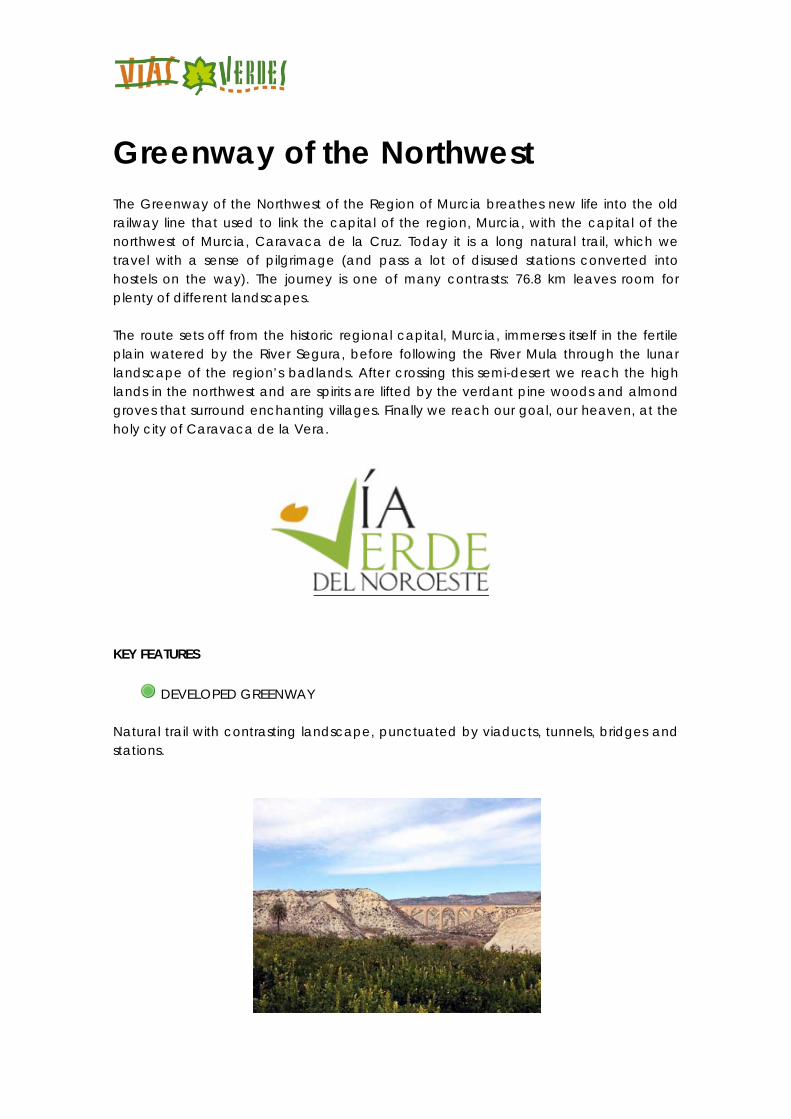
Greenway of the Northwest The Greenway of the Northwest of the Region of Murcia breathes new life into the old railway line that used to link the capital of the region, Murcia, with the capital of the northwest of Murcia, Caravaca de la Cruz. Today it is a long natural trail, which we travel with a sense of pilgrimage (and pass a lot of disused stations converted into hostels on the way). The journey is one of many contrasts: 76.8 km leaves room for plenty of different landscapes. The route sets off from the historic regional capital, Murcia, immerses itself in the fertile plain watered by the River Segura, before following the River Mula through the lunar landscape of the region’s badlands. After crossing this semi-desert we reach the high lands in the northwest and are spirits are lifted by the verdant pine woods and almond groves that surround enchanting villages. Finally we reach our goal, our heaven, at the holy city of Caravaca de la Vera.
KEY FEATURES
DEVELOPED GREENWAY Natural trail with contrasting landscape, punctuated by viaducts, tunnels, bridges and stations.
LOCATION Between Murcia (Espinardo University campus) and Caravaca de la Cruz MURCIA Length: 76´8 km
Users:
(Except for some sections). See details in Accessible Greenways (in Spanish) Type of surface: Mixed (asphalt surface treatment and compacted artificial aggregate), tarmac, compacted gravel and sand. Natural setting: Lunar landscape or badlands and mountain countryside with pine and fruit trees. Mula valley and fertile flood plain of the River Segura. Cultural heritage: Monumental city of Murcia. Towns of Mula, Bullas, Cehegín and Caravaca de la Cruz. El Niño Sanctuary. The Lost City of Begastri and the thermal spa waters of Baños de Mula. Seven railway stations refurbished as hostels. Infrastructure: Greenway. 9 viaducts, 1 metal bridge (over the Segura) and 6 tunnels. How to get there: Murcia: Renfe. Madrid-Murcia line Murcia, Baños de Mula, Mula, El Niño de Mula, Bullas, Cehegín, Caravaca. Bus. Empresa Costa Cálida. Murcia-Caravaca line. Campus de Espinardo, Ribera de Molina, Molina de Segura, Alguazas. Bus. Latbus bus company. Connections: Murcia: 5 km away from the start of the Greenway Maps to use: National Geographic Institute Map. Scale 1:50,000. Sheets 910, 911, 912 and 913 Ministry of Development Official Road Map Further information in Greenways Guide, Volume 1
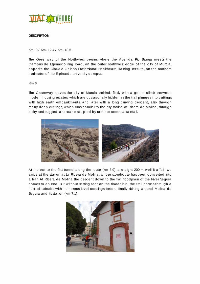
DESCRIPTION Km. 0 / Km. 12,4 / Km. 40,5 The Greenway of the Northwest begins where the Avenida Pío Baroja meets the Campus de Espinardo ring road, on the outer northwest edge of the city of Murcia, opposite the Claudio Galeno Professional Healthcare Training Institute, on the northern perimeter of the Espinardo university campus. Km 0 The Greenway leaves the city of Murcia behind, firstly with a gentle climb between modern housing estates, which are occasionally hidden as the trail plunges into cuttings with high earth embankments, and later with a long curving descent, also through many deep cuttings, which runs parallel to the dry ravine of Ribera de Molina, through a dry and rugged landscape sculpted by rare but torrential rainfall.
At the exit to the first tunnel along the route (km 3.9), a straight 200 m well-lit affair, we arrive at the station at La Ribera de Molina, whose storehouse has been converted into a bar. At Ribera de Molina the descent down to the flat floodplain of the River Segura comes to an end. But without setting foot on the floodplain, the trail passes through a host of suburbs with numerous level crossings before finally skirting around Molina de Segura and its station (km 7.1).
On leaving Molina (km 7.5) we cross the N-344 road on a zebra crossing controlled by a traffic light with pedestrian button. The Greenway, now with a gravel surface, embarks on a long, straight section through the left hand water meadow of the River Segura. This path through the “vegetable garden” of Murcia is flanked by cottages and farmland growing a wide variety of crops. A tight left turn takes us to the River Segura itself, which we cross via an impressive, carefully restored iron bridge (km 9.1). This is one of the most striking vestiges of the old railway. On the far bank (the right hand one) the fertile riverside farmland predominates once again.
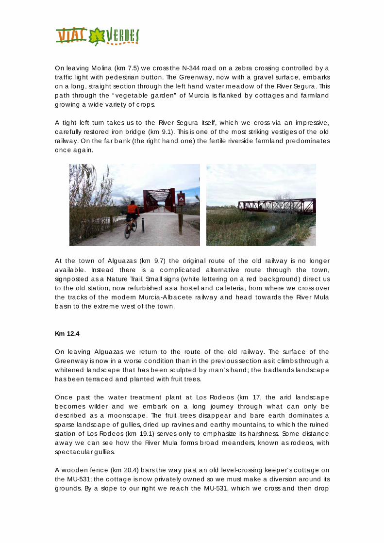
At the town of Alguazas (km 9.7) the original route of the old railway is no longer available. Instead there is a complicated alternative route through the town, signposted as a Nature Trail. Small signs (white lettering on a red background) direct us to the old station, now refurbished as a hostel and cafeteria, from where we cross over the tracks of the modern Murcia-Albacete railway and head towards the River Mula basin to the extreme west of the town. Km 12.4 On leaving Alguazas we return to the route of the old railway. The surface of the Greenway is now in a worse condition than in the previous section as it climbs through a whitened landscape that has been sculpted by man’s hand; the badlands landscape has been terraced and planted with fruit trees. Once past the water treatment plant at Los Rodeos (km 17, the arid landscape becomes wilder and we embark on a long journey through what can only be described as a moonscape. The fruit trees disappear and bare earth dominates a sparse landscape of gullies, dried up ravines and earthy mountains, to which the ruined station of Los Rodeos (km 19.1) serves only to emphasize its harshness. Some distance away we can see how the River Mula forms broad meanders, known as rodeos, with spectacular gullies. A wooden fence (km 20.4) bars the way past an old level-crossing keeper’s cottage on the MU-531; the cottage is now privately owned so we must make a diversion around its grounds. By a slope to our right we reach the MU-531, which we cross and then drop
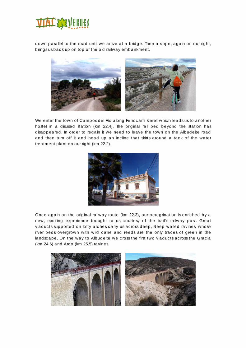
down parallel to the road until we arrive at a bridge. Then a slope, again on our right, brings us back up on top of the old railway embankment.
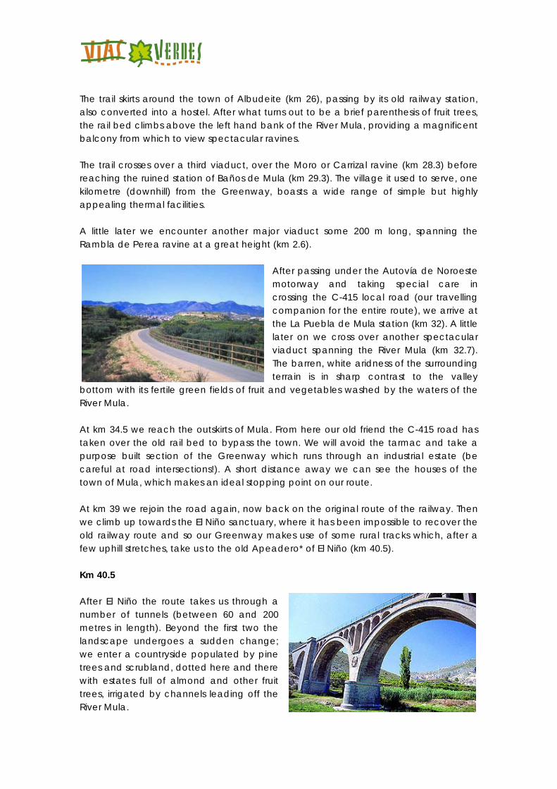
We enter the town of Campos del Río along Ferrocarril street which leads us to another hostel in a disused station (km 22.4). The original rail bed beyond the station has disappeared. In order to regain it we need to leave the town on the Albudeite road and then turn off it and head up an incline that skirts around a tank of the water treatment plant on our right (km 22.2).
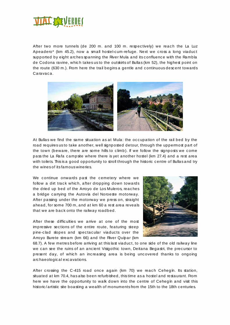
Once again on the original railway route (km 22.3), our peregrination is enriched by a new, exciting experience brought to us courtesy of the trail’s railway past. Great viaducts supported on lofty arches carry us across deep, steep walled ravines, whose river beds overgrown with wild cane and reeds are the only traces of green in the landscape. On the way to Albudeite we cross the first two viaducts across the Gracia (km 24.6) and Arco (km 25.5) ravines.
The trail skirts around the town of Albudeite (km 26), passing by its old railway station, also converted into a hostel. After what turns out to be a brief parenthesis of fruit trees, the rail bed climbs above the left hand bank of the River Mula, providing a magnificent balcony from which to view spectacular ravines. The trail crosses over a third viaduct, over the Moro or Carrizal ravine (km 28.3) before reaching the ruined station of Baños de Mula (km 29.3). The village it used to serve, one kilometre (downhill) from the Greenway, boasts a wide range of simple but highly appealing thermal facilities. A little later we encounter another major viaduct some 200 m long, spanning the Rambla de Perea ravine at a great height (km 2.6).
After passing under the Autovía de Noroeste motorway and taking special care in crossing the C-415 local road (our travelling companion for the entire route), we arrive at the La Puebla de Mula station (km 32). A little later on we cross over another spectacular viaduct spanning the River Mula (km 32.7). The barren, white aridness of the surrounding terrain is in sharp contrast to the valley
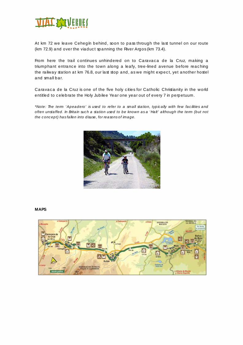
bottom with its fertile green fields of fruit and vegetables washed by the waters of the River Mula. At km 34.5 we reach the outskirts of Mula. From here our old friend the C-415 road has taken over the old rail bed to bypass the town. We will avoid the tarmac and take a purpose built section of the Greenway which runs through an industrial estate (be careful at road intersections!). A short distance away we can see the houses of the town of Mula, which makes an ideal stopping point on our route. At km 39 we rejoin the road again, now back on the original route of the railway. Then we climb up towards the El Niño sanctuary, where it has been impossible to recover the old railway route and so our Greenway makes use of some rural tracks which, after a few uphill stretches, take us to the old Apeadero* of El Niño (km 40.5). Km 40.5 After El Niño the route takes us through a number of tunnels (between 60 and 200 metres in length). Beyond the first two the landscape undergoes a sudden change; we enter a countryside populated by pine trees and scrubland, dotted here and there with estates full of almond and other fruit trees, irrigated by channels leading off the River Mula.
After two more tunnels (de 200 m. and 100 m. respectively) we reach the La Luz Apeadero* (km 45.2), now a small hostel-cum-refuge. Next we cross a long viaduct supported by eight arches spanning the River Mula and its confluence with the Rambla de Codona ravine, which takes us to the outskirts of Bullas (km 52), the highest point on the route (630 m.). From here the trail begins a gentle and continuous descent towards Caravaca.
At Bullas we find the same situation as at Mula: the occupation of the rail bed by the road requires us to take another, well signposted detour, through the uppermost part of the town (beware, there are some hills to climb). If we follow the signposts we come pass the La Rafa campsite where there is yet another hostel (km 27.4) and a rest area with toilets. This is a good opportunity to stroll through the historic centre of Bullas and try the wines of its famous wineries. We continue onwards past the cemetery where we follow a dirt track which, after dropping down towards the dried up bed of the Arroyo de Los Muleros, reaches a bridge carrying the Autovía del Noroeste motorway. After passing under the motorway we press on, straight ahead, for some 700 m, and at km 60 a rest area reveals that we are back onto the railway roadbed. After these difficulties we arrive at one of the most impressive sections of the entire route, featuring steep pine-clad slopes and spectacular viaducts over the Arroyo Burete stream (km 66) and the River Quípar (km 68.7). A few metres before arriving at this last viaduct, to one side of the old railway line we can see the ruins of an ancient Visigothic town, Deitana Begastri, the precursor to present day, of which an increasing area is being uncovered thanks to ongoing archaeological excavations. After crossing the C-415 road once again (km 70) we reach Cehegín. Its station, situated at km 70.4, has also been refurbished, this time as a hostel and restaurant. From here we have the opportunity to walk down into the centre of Cehegín and visit this historic/artistic site boasting a wealth of monuments from the 15th to the 18th centuries.
At km 72 we leave Cehegín behind, soon to pass through the last tunnel on our route (km 72.9) and over the viaduct spanning the River Argos (km 73.4). From here the trail continues unhindered on to Caravaca de la Cruz, making a triumphant entrance into the town along a leafy, tree-lined avenue before reaching the railway station at km 76.8, our last stop and, as we might expect, yet another hostel and small bar. Caravaca de la Cruz is one of the five holy cities for Catholic Christianity in the world entitled to celebrate the Holy Jubilee Year one year out of every 7 in perpetuum. *Note: The term ‘Apeadero’ is used to refer to a small station, typically with few facilities and often unstaffed. In Britain such a station used to be known as a ‘Halt’ although the term (but not the concept) has fallen into disuse, for reasons of image.
MAPS
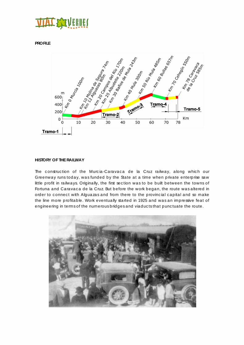
PROFILE
HISTORY OF THE RAILWAY The construction of the Murcia-Caravaca de la Cruz railway, along which our Greenway runs today, was funded by the State at a time when private enterprise saw little profit in railways. Originally, the first section was to be built between the towns of Fortuna and Caravaca de la Cruz. But before the work began, the route was altered in order to connect with Alguazas and from there to the provincial capital and so make the line more profitable. Work eventually started in 1925 and was an impressive feat of engineering in terms of the numerous bridges and viaducts that punctuate the route.
Although work finished in 1931, it was not until two years later, on May 28 to be precise, when the line was opened. From the outset business was less than brisk, and it became ruinous when competition from road transport began to make ever greater inroads. In 1964 the line’s steam locomotives were phased out and faster, more economical and more reliable railcars were introduced. But this failed to improve the situation of a railway that was dying on its feet. So, on April 15, 1971 all services between Alguazas and Caravaca were axed and shortly afterwards the rails and the sleepers were torn up. However, the rails linking Alguazas (where there was also a link with the Chinchilla-Cartagena line) to the Murcia-Zaraiche terminus were saved, and this section remained open until the early nineties for the passage of the occasional goods train. Between 1998 and 2011 two sections of this railway route were developed as Greenway, and some of the stations have been refurbished as hostels, thanks to the efforts of the Ministry of the Environment (Nature Trails Programme) and the Regional Government of Murcia.
INTERESTING DATA 1. Festivals and holidays 2. Accommodation 3. Eco-tourism 4. Managing Authority 5. Town Councils 6. Emergencies 7. Coaches & buses
8. Railway Festivals and holidays Murcia Easter Week after Easter. Spring Festival: Tuesday is the Bando de la Huerta (a day of local dress and processions) and Saturday the Entierro de la Sardina (Burial of the Sardine). September 6 - 15. Fiesta de Moros y Cristianos (a not too serious re-enactment of the battle between Moors and Christians). Molina de Segura January 22. Local festivities in honour of San Vicente. Easter. Third Monday in September. Local festivities in honour of the Virgen de la Consolación. Alguazas Easter. July 12 and 13. Local festivities in honour of San Onofre and San Antonio.
Campos del Río June 24. Local festivities in honour of San Juan Bautista. Albudeite Easter Sunday. Fiesta de Alcaldes de Ramos. Mula Easter. Night of the Drums, Easter Tuesday. September 19 - 25. Local festivities in honour of El Niño. Bullas April 25. Fiesta de San Marcos. April 29. Fiesta de los Agricultores (Farmers’ Festival). October. Local festivities in honour of the Virgen del Rosario. Cehegín January 20. Bonfire of San Sebastián. Easter. September 8 - 14. Local festivities in honour of the Virgen de las Maravillas. Caravaca de la Cruz May 1 - 5. Local festivities in honour of the Santísima Vera Cruz. Moros y Cristianos (a not too serious re-enactment of the battle between Moors and Christians) and Caballos del Vino (Running of the Wine Horses). July 16. Fiestas de la Virgen del Carmen. September 14. Exaltación de la Vera Cruz. Accommodation www.murciaturistica.es Greenway of the North West Hostel Network - Alverdes *Next to the Greenway Torres de Cotillas Albergue de las Torres de Cotillas (hostel) Tel. 868 185 427; www.alverdes.es Alguazas *Hostel at the former Alguazas railway station Tel. 868 185 427; www.alverdes.es
Campos del Río *Hostel at Campos del Río railway station Tel. 868 185 427; www.alverdes.es Albudeite *Hostel at the former Albudeite railway station Tel. 868 185 427; www.alverdes.es Mula * Hostel at the former La Luz railway station Tel. 868 185 427; www.alverdes.es Bullas *Albergue de Bullas La Rafa (hostel) Tel. 868 185 427; www.alverdes.es Cehegín * Hostel at the former Cehegín railway station Tel. 868 185 427; www.alverdes.es Caravaca de la Cruz * Hostel at the former Caravaca de la Cruz railway station Tel. 868 185 427; www.alverdes.es Albergue de las Fuentes del Marqués (hostel) Tel. 868 185 427; www.alverdes.es Hotel El Llano El Llanico, Caravaca de la Cruz, Murcia Tel: 968 73 58 53 Info Tourism Murcia Tourist Office Tel. 968 358 749; [email protected] www.murciaciudad.com Murcia Tourist Office Tel. 968 358 749; [email protected] www.murciaciudad.com Molina de Segura Tel. 968 388 500; www.portal.molinadesegura.es
Mula Tourist Office Tel. 968 637 510; www.mula.es Bullas Tourist Office Tel. 968 652 244; www.bullas.es Cehegín Tourist Office Tel. 968 723 550; www.turismocehegin.es Caravaca de la Cruz Tourist Office Tel. 968 702 424; www.turismocaravaca.org Managing Authority Consorcio de las Vías Verdes de la Región de Murcia. (Consortium of Murcia Region Greenways) Manager: Juan Soria Martínez Tel. 868 185 185; www.viaverdedelnoroeste.com Tel. 608105339: [email protected] www.facebook.es/viaverdedelnoroeste Town Councils Murcia Tel. 968 358 600; www.murcia.es Molina de Segura Tel. 968 388 500; www.portal.molinadesegura.es Alguazas Tel. 968 620 022; www.alguazas.es Campos del Río Tel. 968 650 135; www.camposdelrio.es Albudeite Tel. 968 667 502; www.albudeite.com Mula Tel. 968 637 510; www.mula.es
Bullas Tel. 968 652 031; www.bullas.es Cehegín Tel. 968 740 400; www.cehegin.es Caravaca de la Cruz Tel. 968 702 000; www.caravaca.org Emergencies Tel. 112 TRANSPORTS Coaches & buses Murcia Bus station Tel. 968 292 211 www.estaciondeautobusesdemurcia.com Molina de Segura Bus station Tel. 968 640 108 Mula Bus station Tel. 968 660 713 Cehegín Bus station Tel. 968 743 408 Murcia, Baños de Mula, Mula, El Niño, Bullas, Cehegín y Caravaca de la Cruz: Buses Costa Cálida, Line Caravaca-Murcia. Tel. 968 298 927 Campus de Espinardo. Lines 21 (Murcia-Ceutí), 31 (Murcia-El Raal), 39 (Murcia-Campus Universitario and 41 (Murcia-Torres de Cotillas). Ribera de Molina. Line 79 (Murcia-Molina de Segura). Molina de Segura. Lines 21 (Murcia-Ceutí), 22 (Murcia-Molina), 41 (Murcia-Torres de Cotillas), 42 (Murcia-Blanca) and 79 (Murcia-Molina de Segura). Alguazas. Lines 21 (Murcia-Ceutí) and 41 (Murcia-Torres de Cotillas). Buses Latbus. Tel. 968 299 238/902 250 088 www.latbus.com
Railway RENFE Murcia Railway Station Tel. 902 240 202; www.renfe.es Consult the conditions under which bikes can be carried on trains LINKS www.viaverdedelnorthwest.com Greenway of the Northwest Consortium www.murciaturistica.es Tourism portal for the Region of Murcia www.carm.es Official website of the Autonomous Community of the Region de Murcia MULTIMEDIA https://www.youtube.com/watch?v=GWE2dMRfsFY https://www.youtube.com/watch?v=O5ZS46Mi0G8
Recommended