GCSE GEOGRAPHY A Sample Assessment Materials 5
© WJEC CBAC Ltd.
GCSE GEOGRAPHY A COMPONENT 1 CHANGING PHYSICAL AND HUMAN LANDSCAPES SAMPLE ASSESSMENT MATERIALS 1 hour 30 minutes
Section Question Mark SPaG
A
1 34
2 34 4
B
Either 3 16
Or 4 16
Total 84 4
ADDITIONAL MATERIALS In addition to this paper you will require a calculator and a ruler. INSTRUCTIONS TO CANDIDATES Answer both questions in Section A. Answer one question from Section B. Use black ink or black ball-point pen. Write your name, centre number and candidate number in the spaces at the top of this page. Write your answers in the spaces provided in this booklet. If additional space is required you should use the lined pages at the end of this booklet. The question number(s) should be clearly shown. INFORMATION FOR CANDIDATES The number of marks is given in brackets [ ] at the end of each question or part-question. Your ability to spell, punctuate and use grammar and specialist terms accurately will be assessed in your answer to question 2 (c)(iii).
PMT
GCSE GEOGRAPHY A Sample Assessment Materials 6
© WJEC CBAC Ltd.
SECTION A CORE THEMES
Answer all of the questions in this section.
THEME 1: Landscapes and physical processes
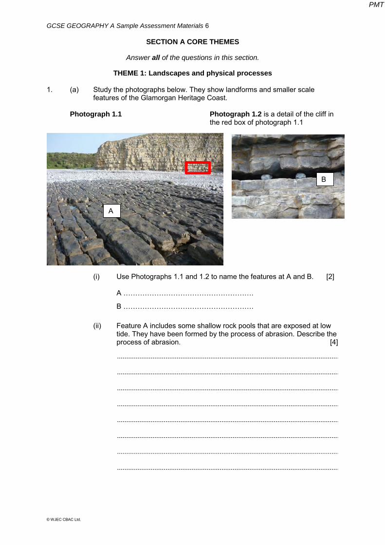
1. (a) Study the photographs below. They show landforms and smaller scale features of the Glamorgan Heritage Coast.
Photograph 1.1 Photograph 1.2 is a detail of the cliff in
the red box of photograph 1.1
(i) Use Photographs 1.1 and 1.2 to name the features at A and B. [2] A ………………………………………………. B ……………………………………………….
(ii) Feature A includes some shallow rock pools that are exposed at low tide. They have been formed by the process of abrasion. Describe the process of abrasion. [4]
A
B
PMT
GCSE GEOGRAPHY A Sample Assessment Materials 7
© WJEC CBAC Ltd.
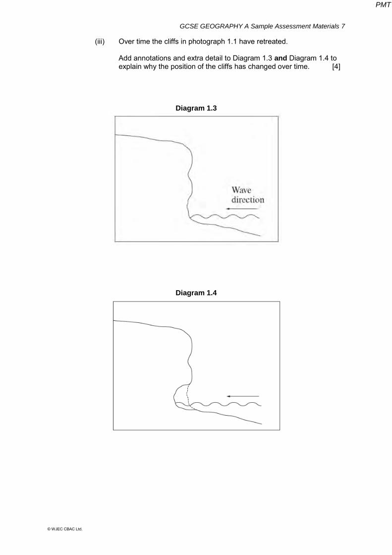
(iii) Over time the cliffs in photograph 1.1 have retreated.
Add annotations and extra detail to Diagram 1.3 and Diagram 1.4 to explain why the position of the cliffs has changed over time. [4]
Diagram 1.3
Diagram 1.4
PMT
GCSE GEOGRAPHY A Sample Assessment Materials 8
© WJEC CBAC Ltd.
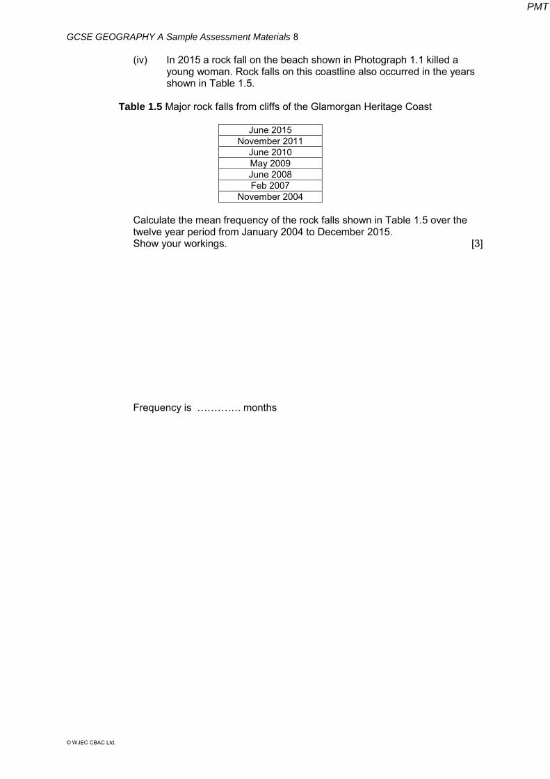
(iv) In 2015 a rock fall on the beach shown in Photograph 1.1 killed a young woman. Rock falls on this coastline also occurred in the years shown in Table 1.5.
Table 1.5 Major rock falls from cliffs of the Glamorgan Heritage Coast
June 2015
November 2011 June 2010 May 2009 June 2008 Feb 2007
November 2004
Calculate the mean frequency of the rock falls shown in Table 1.5 over the twelve year period from January 2004 to December 2015.
Show your workings. [3]
Frequency is …………. months
PMT

GCSE GEOGRAPHY A Sample Assessment Materials 9
© WJEC CBAC Ltd.
BLANK PAGE
PMT
GCSE GEOGRAPHY A Sample Assessment Materials 10
© WJEC CBAC Ltd.
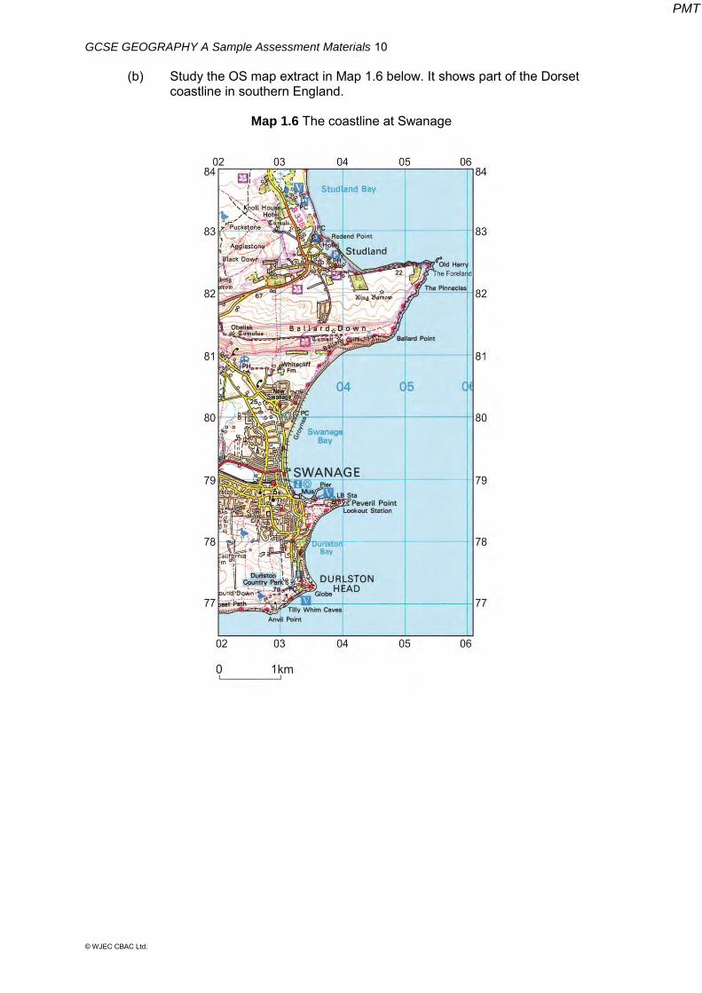
(b) Study the OS map extract in Map 1.6 below. It shows part of the Dorset coastline in southern England.
Map 1.6 The coastline at Swanage
PMT
GCSE GEOGRAPHY A Sample Assessment Materials 11
© WJEC CBAC Ltd.
(i) Use map evidence from Map 1.6 to describe the relief in grid squares 0281, 0381 and 0481. [4]
(ii) Explain why differences in rock type and structure can affect rates of coastal erosion. [6]
................................................................................................................ ................................................................................................................ ................................................................................................................ ................................................................................................................ ................................................................................................................ ................................................................................................................ ................................................................................................................ ................................................................................................................ ................................................................................................................ ................................................................................................................ ................................................................................................................ ................................................................................................................
PMT
GCSE GEOGRAPHY A Sample Assessment Materials 12
© WJEC CBAC Ltd.
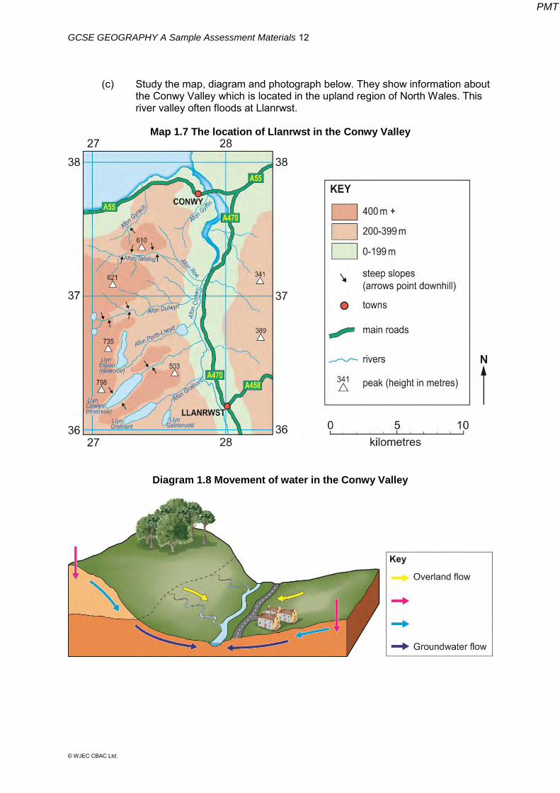
(c) Study the map, diagram and photograph below. They show information about the Conwy Valley which is located in the upland region of North Wales. This river valley often floods at Llanrwst.
Map 1.7 The location of Llanrwst in the Conwy Valley
Diagram 1.8 Movement of water in the Conwy Valley
PMT

GCSE GEOGRAPHY A Sample Assessment Materials 13
© WJEC CBAC Ltd.
Photograph 1.9 The town of Llanrwst in the flooded Conwy Valley
(i) Use Diagram 1.8. State what movement of water is shown by the pink and pale blue arrows using the correct specialist terms. [2]
The pink arrow shows …………………………………. The pale blue arrow shows …………………………… (ii) The hills to the west of the Conwy Valley are impermeable. Suggest
one way that arrows on Diagram 1.8 could be altered to show how the flow of water will be affected. [1]
………………………………………………………………………….. (iii) Make use of Map 1.7, Diagram 1.8 and Photograph 1.9 to decide
whether you agree with the following statement. ‘Physical factors are more likely to cause flooding in Llanwrst than
human factors’. Explain your reasons. [8] ................................................................................................................ ................................................................................................................ ................................................................................................................ ................................................................................................................ ................................................................................................................ ................................................................................................................ ................................................................................................................ ................................................................................................................
PMT
GCSE GEOGRAPHY A Sample Assessment Materials 14
© WJEC CBAC Ltd.
................................................................................................................ ................................................................................................................ ................................................................................................................ ................................................................................................................ ................................................................................................................ ................................................................................................................ ................................................................................................................ ................................................................................................................ ................................................................................................................ ................................................................................................................ ................................................................................................................ ................................................................................................................ ................................................................................................................ ................................................................................................................ ................................................................................................................ ................................................................................................................
End of question 1
PMT
GCSE GEOGRAPHY A Sample Assessment Materials 15
© WJEC CBAC Ltd.
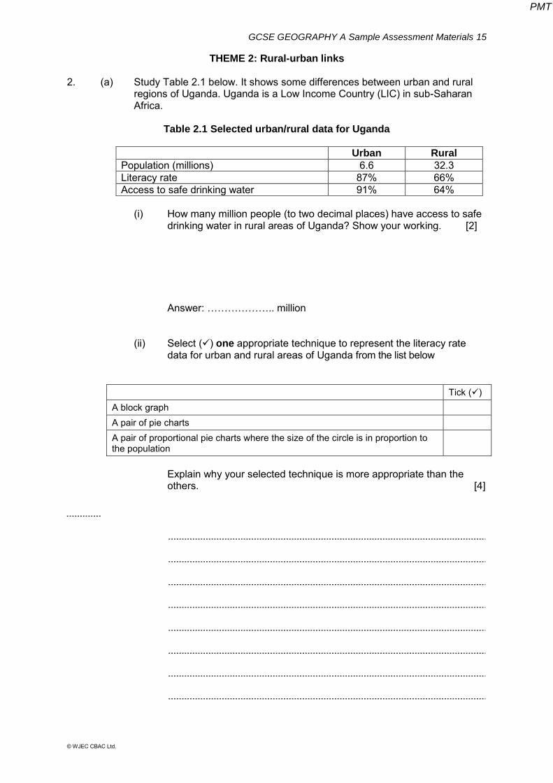
THEME 2: Rural-urban links
2. (a) Study Table 2.1 below. It shows some differences between urban and rural regions of Uganda. Uganda is a Low Income Country (LIC) in sub-Saharan Africa.
Table 2.1 Selected urban/rural data for Uganda
Urban Rural
Population (millions) 6.6 32.3 Literacy rate 87% 66% Access to safe drinking water 91% 64%
(i) How many million people (to two decimal places) have access to safe
drinking water in rural areas of Uganda? Show your working. [2] Answer: ……………….. million
(ii) Select () one appropriate technique to represent the literacy rate data for urban and rural areas of Uganda from the list below
Tick () A block graph A pair of pie charts A pair of proportional pie charts where the size of the circle is in proportion to the population
Explain why your selected technique is more appropriate than the others. [4]
PMT
GCSE GEOGRAPHY A Sample Assessment Materials 16
© WJEC CBAC Ltd.
(iii) In Uganda many people are moving from rural areas to the capital city, Kampala. Migration like this occurs in many Low Income Countries (LICs). Explain why people may feel pushed away from the rural environment and
attracted to move to towns and cities in LICs. [6]
PMT
GCSE GEOGRAPHY A Sample Assessment Materials 17
© WJEC CBAC Ltd.
(b) The migration of people into Ugandan cities has led to the growth of informal settlements or shanty towns.
(i) Describe the location of one shanty town in one global city located in the economically developing world. [4]
Name of city
(ii) Describe one way in which living conditions have improved in a
named shanty town you have studied. [4] Name of shanty town
PMT
GCSE GEOGRAPHY A Sample Assessment Materials 18
© WJEC CBAC Ltd.
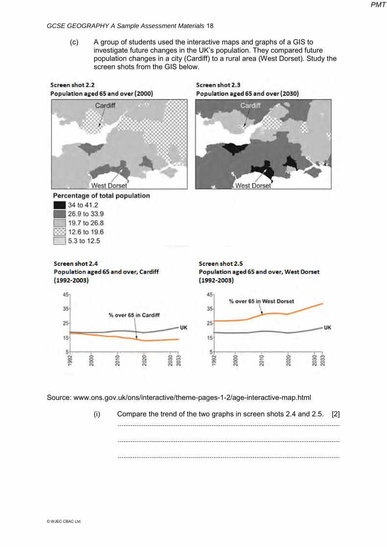
(c) A group of students used the interactive maps and graphs of a GIS to investigate future changes in the UK’s population. They compared future population changes in a city (Cardiff) to a rural area (West Dorset). Study the screen shots from the GIS below.
Source: www.ons.gov.uk/ons/interactive/theme-pages-1-2/age-interactive-map.html (i) Compare the trend of the two graphs in screen shots 2.4 and 2.5. [2]
PMT
GCSE GEOGRAPHY A Sample Assessment Materials 19
© WJEC CBAC Ltd.
(ii) Screen shots 2.2 and 2.3 show that there is a higher proportion of people aged 65 and over in West Dorset than in Cardiff. Give two reasons why rural areas of the UK tend to have more people aged 65 and over. [4]
(iii) The ageing population will create future challenges for individuals and
organisations in the UK. Make use of screen shots 2.2 – 2.5 to help you decide whether these
challenges will be greater in rural or urban areas of the UK. You will need to justify your decision by considering the consequences for rural and urban communities. [8 + 4]
Your ability to spell, punctuate and use grammar and specialist terms
accurately will be assessed in your answer to this question.
PMT
GCSE GEOGRAPHY A Sample Assessment Materials 20
© WJEC CBAC Ltd.
End of question 2
PMT

GCSE GEOGRAPHY A Sample Assessment Materials 21
© WJEC CBAC Ltd.
BLANK PAGE
PMT
GCSE GEOGRAPHY A Sample Assessment Materials 22
© WJEC CBAC Ltd.
SECTION B OPTIONS
Answer one question in this section. Choose either question 3 (Theme 3) OR question 4 (Theme 4)
THEME 3: Tectonic Landscapes and Hazards
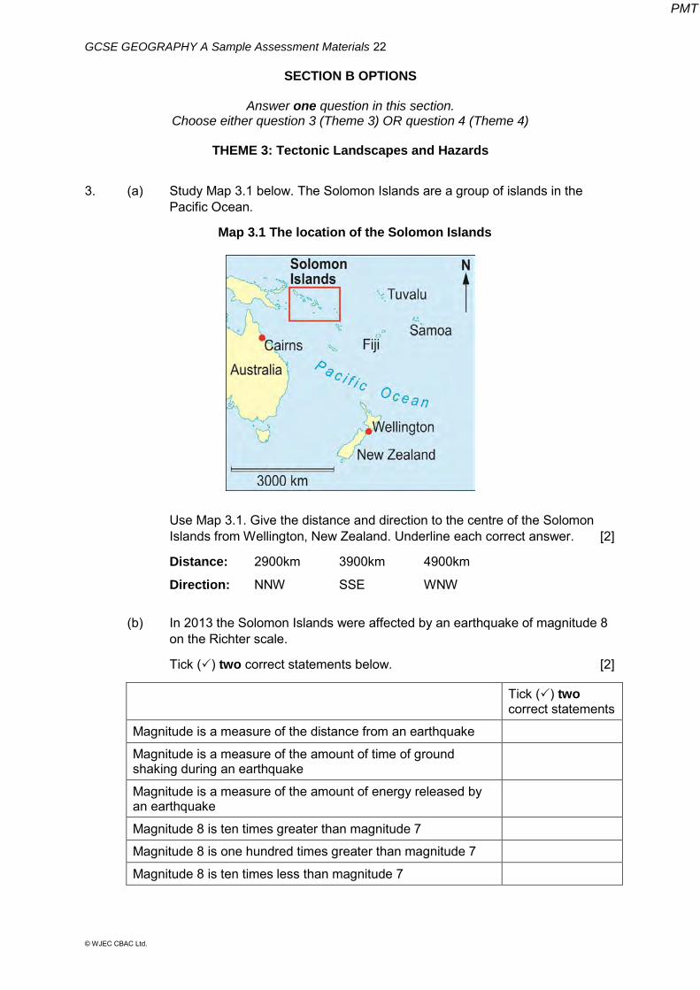
3. (a) Study Map 3.1 below. The Solomon Islands are a group of islands in the Pacific Ocean.
Map 3.1 The location of the Solomon Islands
Use Map 3.1. Give the distance and direction to the centre of the Solomon Islands from Wellington, New Zealand. Underline each correct answer. [2]
Distance: 2900km 3900km 4900km
Direction: NNW SSE WNW
(b) In 2013 the Solomon Islands were affected by an earthquake of magnitude 8
on the Richter scale.
Tick () two correct statements below. [2]
Tick () two correct statements
Magnitude is a measure of the distance from an earthquake
Magnitude is a measure of the amount of time of ground shaking during an earthquake
Magnitude is a measure of the amount of energy released by an earthquake
Magnitude 8 is ten times greater than magnitude 7
Magnitude 8 is one hundred times greater than magnitude 7
Magnitude 8 is ten times less than magnitude 7
PMT
GCSE GEOGRAPHY A Sample Assessment Materials 23
© WJEC CBAC Ltd.
(c) The 2013 earthquake created a tsunami that killed at least 5 people in the Solomon Islands.
Explain why an earthquake sometimes creates a tsunami. [4]
………………………………………………………………………………………..
………………………………………………………………………………………..
………………………………………………………………………………………..
………………………………………………………………………………………..
………………………………………………………………………………………..
………………………………………………………………………………………..
………………………………………………………………………………………..
………………………………………………………………………………………..
(d) Average wealth in the Solomon Islands (measured using GNI) is US$1,600 per person. The 2013 tsunami that struck the Solomon Islands was 0.9 metres high. It flooded some remote villages and a small town. The town's airport was damaged. Aid was sent from New Zealand and Australia.
Make use of the information about the Solomon Islands to decide whether you agree with the following statement. ‘Remote islands are more vulnerable to tectonic hazards than any other location.’ Explain your answer [8]
………………………………………………………………………………………..
………………………………………………………………………………………..
………………………………………………………………………………………..
………………………………………………………………………………………..
………………………………………………………………………………………..
………………………………………………………………………………………..
………………………………………………………………………………………..
………………………………………………………………………………………..
………………………………………………………………………………………..
………………………………………………………………………………………..
………………………………………………………………………………………..
………………………………………………………………………………………..
………………………………………………………………………………………..
………………………………………………………………………………………..
………………………………………………………………………………………..
PMT

GCSE GEOGRAPHY A Sample Assessment Materials 24
© WJEC CBAC Ltd.
………………………………………………………………………………………..
………………………………………………………………………………………..
………………………………………………………………………………………..
………………………………………………………………………………………..
………………………………………………………………………………………..
………………………………………………………………………………………..
………………………………………………………………………………………..
………………………………………………………………………………………..
………………………………………………………………………………………..
End of Question 3
PMT
GCSE GEOGRAPHY A Sample Assessment Materials 25
© WJEC CBAC Ltd.
BLANK PAGE
PMT
GCSE GEOGRAPHY A Sample Assessment Materials 26
© WJEC CBAC Ltd.
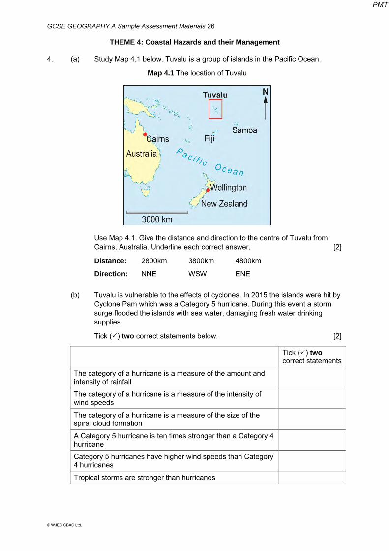
THEME 4: Coastal Hazards and their Management 4. (a) Study Map 4.1 below. Tuvalu is a group of islands in the Pacific Ocean.
Map 4.1 The location of Tuvalu
Use Map 4.1. Give the distance and direction to the centre of Tuvalu from Cairns, Australia. Underline each correct answer. [2]
Distance: 2800km 3800km 4800km
Direction: NNE WSW ENE
(b) Tuvalu is vulnerable to the effects of cyclones. In 2015 the islands were hit by
Cyclone Pam which was a Category 5 hurricane. During this event a storm surge flooded the islands with sea water, damaging fresh water drinking supplies.
Tick () two correct statements below. [2]
Tick () two correct statements
The category of a hurricane is a measure of the amount and intensity of rainfall
The category of a hurricane is a measure of the intensity of wind speeds
The category of a hurricane is a measure of the size of the spiral cloud formation
A Category 5 hurricane is ten times stronger than a Category 4 hurricane
Category 5 hurricanes have higher wind speeds than Category 4 hurricanes
Tropical storms are stronger than hurricanes
PMT
GCSE GEOGRAPHY A Sample Assessment Materials 27
© WJEC CBAC Ltd.
(c) Explain why hurricanes create a storm surge. [4]
………………………………………………………………………………………..
………………………………………………………………………………………..
………………………………………………………………………………………..
………………………………………………………………………………………..
………………………………………………………………………………………..
………………………………………………………………………………………..
………………………………………………………………………………………..
………………………………………………………………………………………..
(d) Average wealth in Tuvalu (measured using GNI) is US$5,840 per person.
The highest point anywhere in Tuvalu is only 4.6 metres above sea level. The islands are vulnerable to coastal flooding during hurricanes such as Cyclone Pam. After Cyclone Pam aid was sent from Australia and New Zealand.
Climate change also threatens the islands. It is estimated that a sea level rise of between 20 and 40 centimetres would make it impossible for people to continue to live on Tuvalu.
Make use of the information about Tuvalu to decide whether you agree with the following statement. ‘Remote islands are more vulnerable to coastal hazards than any other location.’ Explain your answer. [8] ………………………………………………………………………………………..
………………………………………………………………………………………..
………………………………………………………………………………………..
………………………………………………………………………………………..
………………………………………………………………………………………..
………………………………………………………………………………………..
………………………………………………………………………………………..
………………………………………………………………………………………..
………………………………………………………………………………………..
………………………………………………………………………………………..
………………………………………………………………………………………..
………………………………………………………………………………………..
………………………………………………………………………………………..
………………………………………………………………………………………..
PMT
GCSE GEOGRAPHY A Sample Assessment Materials 28
© WJEC CBAC Ltd.
………………………………………………………………………………………..
………………………………………………………………………………………..
………………………………………………………………………………………..
………………………………………………………………………………………..
………………………………………………………………………………………..
………………………………………………………………………………………..
………………………………………………………………………………………..
………………………………………………………………………………………..
………………………………………………………………………………………..
………………………………………………………………………………………..
End of Question 4
PMT
Recommended