Empirical Models for Canadian Unconformity-Associated Uranium Deposits
Jefferson, C. W. [1], Thomas, D. [2], Quirt, D. [3], Mwenifumbo, C. J. [1], and Brisbin, D. [2]
_________________________ 1. Geological Survey of Canada, Ottawa 2. Cameco Corporation, Saskatoon, SK 3. AREVA Resources Canada Inc., Saskatoon, SK
ABSTRACT
This review of the geology and geochemical-geophysical attributes of the unconformity-associated uranium (U) deposit type is based mainly on deposits in the Athabasca Basin. Pods, veins, and semi-massive replacements of uraninite (var. pitchblende) are located close to unconformities between late Paleo- to Mesoproterozoic conglomeratic sandstone and metamorphosed basement. The Athabasca and Thelon basin strata are up to 1.5 km thick, overall flat-lying, apparently unmetamorphosed but pervasively altered, mainly fluvial, red to pale tan quartzose sandstone, lesser conglomerate and mudstone. The underlying red hematitic clay-altered regolith grades down through chloritic-illitic and chloritic altered rock to fresh basement gneiss. The highly metamorphosed interleaved Archean to Paleoproterozoic granitoid and supracrustal basement gneiss includes graphitic metapelite that preferentially hosts reactivated shear zones and deposits. A broad variety of deposit shapes, sizes and compositions ranges from polymetallic lenses at and above the unconformity, with variable Ni, Co, As, Pb and traces of Au, Pt, Cu, REEs and Fe, to near-monometallic and generally basement-hosted veins that in some cases are now recognized as ‘blind’ with few direct clues for exploration. Key geochemical/mineralogical anomalies for exploration include: illite, sudoïte, dravite, silicification, quartz dissolution, and >3 ppm U, as well as pathfinders such as B, Pb and Pb isotopes, Ni, Co, Cu and As in sandstone and till. Geophysical anomalies include low or high resistivity in sandstone related to clay alteration or silicification, respectively, high conductivity in basement graphitic metapelite gneiss, gravity lows related to quartz dissolution, and seismically detected offsets of the basal unconformity. Geological targets, based on integrated geophysics, multiparameter drill hole logging and lineament analysis of multiple media, include intersecting faults with specific geometries, favourable basement lithology and marked facies changes in the basal Athabasca Group.
INTRODUCTION
This synopsis is based on unconformity-associated uranium (U) deposits that have been discovered only in two Paleo- to Mesoproterozoic intracratonic basins of the northwestern Canadian Shield (Figure 1): Athabasca (Figure 2) and Thelon. This report is condensed and partly updated from Jefferson et al. (2007b, c) who tabulate the grade, tonnage and world context of this deposit type, with details provided by Gandhi (2007). As of December 2006, average U grades of these deposits are ~ 2% in Athabasca Basin, 0.4% in Thelon Basin, 0.32% in Kombolgie Basin of Australia, and 0.17% in Beaverlodge district. These compare to 0.03% U in the world’s largest single U resource at Olympic Dam in Australia, 0.04% to 0.1% in sandstone-hosted deposits, and about 0.2% in volcanic-hosted deposits. The McArthur River and Cigar Lake deposits in the Athabasca Basin are exceptional resources with 192,085 and 131,386 contained tonnes U at grades of 22.28 and 15.02 % U respectively.
This review is simplified to the following topics. Cited studies provide technical detail for exploration. ‘THE 1970s
AND 1980s MODEL’ summarizes four basic components and includes advances such as morphology and architecture; ore mineralogy and composition; alteration mineralogy, geochemistry and zonation; new exploration technologies; and unresolved issues of that time. ‘GEOLOGICAL ADVANCES SINCE 1990’ notes that little change has been seen in the core model, but that important aspects have been clarified. These include empirical age constraints, unconformities, U rich basement complexes, favourable basement supracrustal belts and rock types, reactivated faults, and distinction of end-member sub-types (i.e. egress (several variants) and ingress (under-explored basement-hosted monomineralic deposits). ‘GEOCHEMICAL ADVANCES, THEIR GEOLOGICAL EXPRESSIONS AND GEOPHYSICAL PROPERTIES’ reviews new knowledge about the quartz-dominated, U-depleted cover strata, regional and district-scale alteration products (quartz, kaolinite vs dickite, illite, chlorite, dravite, fluorapatite, aluminum phosphate-sulphate minerals), and deposit-scale alteration (illite-kaolinite-chlorite) with respect to the end-member deposit types. The UPDATED MODEL is summarized.
Ore Deposits and Exploration Technology_____________________________________________________________________________________
Paper 51
___________________________________________________________________________
In "Proceedings of Exploration 07: Fifth Decennial International Conference on Mineral Exploration" edited by B. Milkereit, 2007, p. 741-769
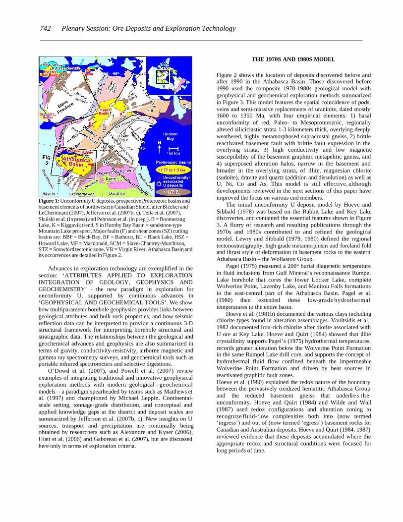
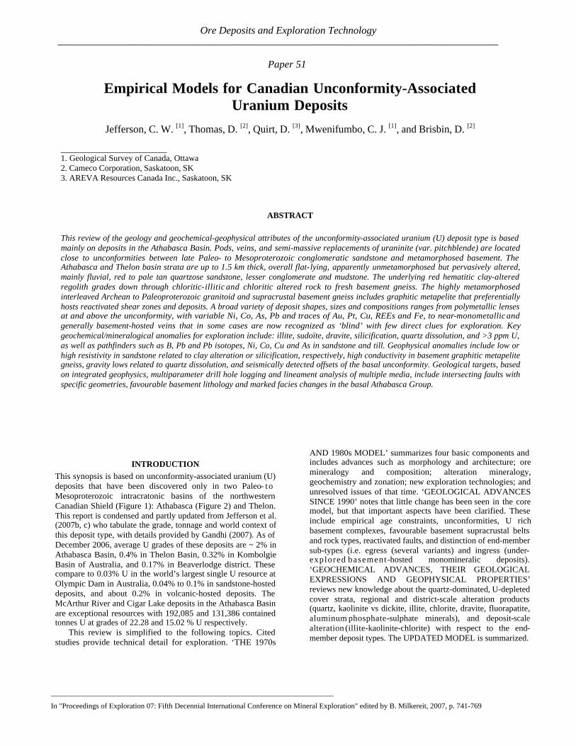
Figure 1: Unconformity U deposits, prospective Proterozoic basins and basement elements of northwestern Canadian Shield, after Bleeker and LeCheminant (2007), Jefferson et al. (2007b, c), Tella et al. (2007), Skulski et al. (in press) and Pehrsson et al. (in prep.). B = Boomerang Lake, K = Kiggavik trend, S in Hornby Bay Basin = sandstone-type Mountain Lake prospect. Major faults (F) and shear zones (SZ) cutting basins are: BBF = Black Bay, BF = Bathurst, BL = Black Lake, HSZ = Howard Lake, MF = Macdonald, SCM = Slave-Chantrey-Murchison, STZ = Snowbird tectonic zone, VR = Virgin River. Athabasca Basin and its occurrences are detailed in Figure 2.
Advances in exploration technology are exemplified in the section: ‘ATTRIBUTES APPLIED TO EXPLORATION INTEGRATION OF GEOLOGY, GEOPHYSICS AND GEOCHEMISTRY’ - the new paradigm in exploration for unconformity U, supported by continuous advances in ‘GEOPHYSICAL AND GEOCHEMICAL TOOLS’. We show how multiparameter borehole geophysics provides links between geological attributes and bulk rock properties, and how seismic reflection data can be interpreted to provide a continuous 3-D structural framework for interpreting borehole structural and stratigraphic data. The relationships between the geological and geochemical advances and geophysics are also summarized in terms of gravity, conductivity-resistivity, airborne magnetic and gamma ray spectrometry surveys, and geochemical tools such as portable infrared spectrometers and selective digestions.
O’Dowd et al. (2007), and Powell et al. (2007) review examples of integrating traditional and innovative geophysical exploration methods with modern geological – geochemical models – a paradigm spearheaded by teams such as Matthews et al. (1997) and championed by Michael Leppin. Continental-scale setting, tonnage-grade distribution, and conceptual and applied knowledge gaps at the district and deposit scales are summarized by Jefferson et al. (2007b, c). New insights on U sources, transport and precipitation are continually being obtained by researchers such as Alexandre and Kyser (2006), Hiatt et al. (2006) and Gaboreau et al. (2007), but are discussed here only in terms of exploration criteria.
THE 1970S AND 1980S MODEL
Figure 2 shows the location of deposits discovered before and after 1990 in the Athabasca Basin. Those discovered before 1990 used the composite 1970-1980s geological model with geophysical and geochemical exploration methods summarized in Figure 3. This model features the spatial coincidence of pods, veins and semi-massive replacements of uraninite, dated mostly 1600 to 1350 Ma, with four empirical elements: 1) basal unconformity of red, Paleo- to Mesoproterozoic, regionally altered siliciclastic strata 1-3 kilometers thick, overlying deeply weathered, highly metamorphosed supracrustal gneiss, 2) brittle reactivated basement fault with brittle fault expression in the overlying strata, 3) high conductivity and low magnetic susceptibility of the basement graphitic metapelitic gneiss, and 4) superposed alteration halos, narrow in the basement and broader in the overlying strata, of illite, magnesian chlorite (sudoïte), dravite and quartz (addition and dissolution) as well as U, Ni, Co and As. This model is still effective, although developments reviewed in the next sections of this paper have improved the focus on various end members.
The initial unconformity U deposit model by Hoeve and Sibbald (1978) was based on the Rabbit Lake and Key Lake discoveries, and contained the essential features shown in Figure 3. A flurry of research and resulting publications through the 1970s and 1980s contributed to and refined the geological model. Lewry and Sibbald (1979, 1980) defined the regional tectonostratigraphy, high grade metamorphism and foreland fold and thrust style of deformation in basement rocks to the eastern Athabasca Basin – the Wollaston Group.
Pagel (1975) measured a 200° burial diagenetic temperature in fluid inclusions from Gulf Mineral’s reconnaissance Rumpel Lake borehole that cores the lower Locker Lake, complete Wolverine Point, Lazenby Lake, and Manitou Falls formations in the east-central part of the Athabasca Basin. Pagel et al. (1980) then extended these low-grade hydrothermal temperatures to the entire basin.
Hoeve et al. (1981b) documented the various clays including chlorite types found in alteration assemblages. Voultsidis et al., 1982 documented iron-rich chlorite after biotite associated with U ore at Key Lake. Hoeve and Quirt (1984) showed that illite crystallinity supports Pagel’s (1975) hydrothermal temperatures, records greater alteration below the Wolverine Point Formation in the same Rumpel Lake drill core, and supports the concept of hydrothermal fluid flow confined beneath the impermeable Wolverine Point Formation and driven by heat sources in reactivated graphitic fault zones. Hoeve et al. (1980) explained the redox nature of the boundary between the pervasively oxidized hematitic Athabasca Group and the reduced basement gneiss that underlies the unconformity. Hoeve and Quirt (1984) and Wilde and Wall (1987) used redox configurations and alteration zoning to recognize fluid-flow complexities both into (now termed ‘ingress’) and out of (now termed ‘egress’) basement rocks for Canadian and Australian deposits. Hoeve and Quirt (1984, 1987) reviewed evidence that these deposits accumulated where the appropriate redox and structural conditions were focused for long periods of time.
742 Plenary Session: Ore Deposits and Exploration Technology _________________________________________________________________________________________
Figure 2: Geological setting and unconformity-associated U occurrences of the Athabasca Basin region of northwestern Canada (Figure 1). Heavy dashed lines are selected major reactivated fault zones. Basement geology is after Portella and Annesley (2000a), Thomas et al. (2002), Card (2006), and Card et al. (2003, 2007a, b). Athabasca Basin geology is after Ramaekers et al. (2007).
Figure 3: Empirical geological model and exploration methods (not to scale) for unconformity-related U deposits of the 1970 to 1990 period (after Hoeve and Sibbald, 1978, Hoeve et al., 1980, Sibbald et al., 1976 and modified from an anonymous figure sent to the writers for identification). The geological model framed the development and application of geochemical (right column; note pathfinder trace elements) and geophysical (left column) methods. Numbers indicate roughly decreasing order of effectiveness of each method in those years in terms of generating immediate drill targets. All of these methods remain useful, some being more reconnaissance in nature. Other traditional and still important geological methods not shown here include lineament analysis, structural geology in drill core and spatial mapping of basement geological units
743Jefferson, C.W., et al. Empirical models for Canadian unconformity-associated uranium deposits __________________________________________________________________________________________
Knipping (1974) and Dahlkamp (1978) among others introduced the concept of supergene processes related to pre-Athabasca Group release of U by weathering of basement rocks, transport of U by surface and ground waters, and U deposition within basement rocks under reducing conditions. Thomas (1983) among others recognized the importance of U rich basement source rocks and discussed mechanisms for release and transport of U. Macdonald (1985) documented the intense paleo-weathering signature of the basal unconformity. Hoeve and Quirt (1984) described the alteration suite of illite-chlorite-hydrothermal hematite that is spatially related to ore and overprints the paleo-weathering alteration of the basement.
Potential causes of U deposition include reduction by organic matter, graphite in metapelite gneiss or ancient hydrocarbons, electrolytic processes, and Eh – pH changes with iron as an electron acceptor. Many workers such as Pagel and Jaffrezic (1977), Leventhal et al. (1987) and Wilde et al. (1989) have focused their attention on the close spatial association with uraninite of unusual tarry organic matter, commonly termed pyrobitumen or thucholite. Pyrobitumen had long been recognized in the Beaverlodge camp (Beck, 1969). Essentially all of the pyrobitumen coats or invades fractured uraninite (Wilson et al., 2007). This late paragenesis with respect to the macroscopic uraninite in the Athabasca and Beaverlodge deposits is consistent with its resemblance to oxidized and degraded Cretaceous oil, although some of it may have been derived from the Douglas Formation oil shale during the late Meso- to Neoproterozoic (Wilson et al., 2007). Much research is underway to test the hypothesis that the pyrobitumen was formed inorganically and is genetically important for ore formation (e.g. McCready et al., 1999; Alexandre and Kyser, 2006; Sangely et al., al., 2007).
Hoeve and Sibbald (1978) proposed that graphitic metapelitic gneiss was the source of reductants to precipitate uraninite. The hypothesis that pyrobitumen was formed inorganically pursues the concept that this graphite was the source of carbon that was hydrogenated during hydrothermal ore formation. Tilsley (1978) and Tilsley (in Page et al., 1979) took a different approach by considering graphitic conductors as the cause of primary concentration of U at the anodes of spontaneous electrochemical cells. Hoeve and Quirt (1984) emphasized the heat-conducting attributes of the graphitic conductors that could have driven hydrothermal fluid flow. Geophysical attributes of these rocks are reviewed below under ‘Graphitic metapelite basement gneiss’.
Structural geological advances in those years were key to locating ore. Ruhrmann (1987) recognized the importance of reactivated faults in the Gaertner deposit at Key Lake. At the Carswell Structure, a complex impact structure had to be unraveled to identify an overturned unconformity with its associated alteration framework (Laine et al., 1985).
Everhart and Wright (1953), and Beck (1969) in the Beaverlodge camp, and Ruzicka (1989, 1996a) in the Athabasca camp emphasized the metallurgical differences between U ore end members that are monometallic (or ‘simple’: essentially uraninite and coffinite) vs polymetallic (or ‘complex’: having anomalous concentrations of sulfide and arsenide minerals with significant amounts of Ni, Co, Cu, Pb, Zn and Mo).
In the late 1970’s and early 1980’s new geochemical and mineralogical applications were developed in tandem with the new geological and mineralogical concepts. The new methods
included soil and till geochemistry (Coker and Dunn, 1983), biogeochemistry (Dunn, 1983); and lithogeochemistry – clay mineralogy (e.g. Sopuck et al., 1983; Hoeve and Quirt, 1984; Ibrahim and Wu, 1985; Maurice et al., 1985; Clark, 1987; Earle and Sopuck, 1989; Percival, 1989; Quirt, 1985, 1989). Dyck (1969) and Scott (1983 measured and contoured radon gas emission as an expression of radioactive decay related to underlying U ore deposits. This technique has been used with mixed results on reconnaissance to detailed scales and is still in practice. Traditional lake-sediment sampling highlighted the locations of Key Lake (1500 ppm, Maurice et al., 1985) and McArthur River (>10 ppm, Wasyliuk, 2006) against the regional background of 1-2 ppm. The application of geochemical tools to the discoveries at Key Lake was described by Tan (1980).
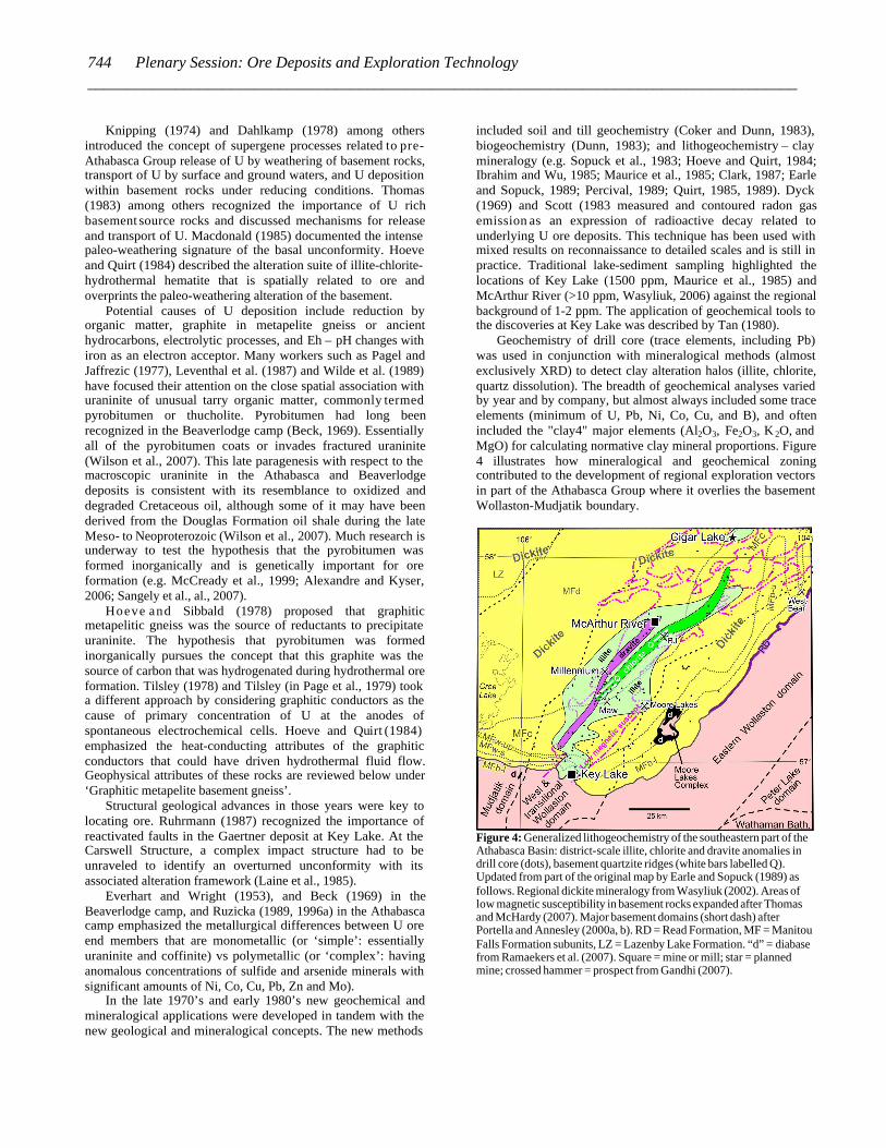
Geochemistry of drill core (trace elements, including Pb) was used in conjunction with mineralogical methods (almost exclusively XRD) to detect clay alteration halos (illite, chlorite, quartz dissolution). The breadth of geochemical analyses varied by year and by company, but almost always included some trace elements (minimum of U, Pb, Ni, Co, Cu, and B), and often included the "clay4" major elements (Al2O3, Fe2O3, K 2O, and MgO) for calculating normative clay mineral proportions. Figure 4 illustrates how mineralogical and geochemical zoning contributed to the development of regional exploration vectors in part of the Athabasca Group where it overlies the basement Wollaston-Mudjatik boundary.
Figure 4: Generalized lithogeochemistry of the southeastern part of the Athabasca Basin: district-scale illite, chlorite and dravite anomalies in drill core (dots), basement quartzite ridges (white bars labelled Q). Updated from part of the original map by Earle and Sopuck (1989) as follows. Regional dickite mineralogy from Wasyliuk (2002). Areas of low magnetic susceptibility in basement rocks expanded after Thomas and McHardy (2007). Major basement domains (short dash) after Portella and Annesley (2000a, b). RD = Read Formation, MF = Manitou Falls Formation subunits, LZ = Lazenby Lake Formation. “d” = diabase from Ramaekers et al. (2007). Square = mine or mill; star = planned mine; crossed hammer = prospect from Gandhi (2007).
744 Plenary Session: Ore Deposits and Exploration Technology _________________________________________________________________________________________
In the 1980s most of the classic ‘vein type’ U deposits of the Beaverlodge camp (Tremblay, 1972; Smith, 1986; Ruzicka, 1996b) had a previously noted spatial relationship to the unconformity beneath the Martin Group (Robinson, 1955, p. 73-74). Smith (1986) and Mazimhaka and Hendry (1989), and others working in the camp suggested a genetic relationship to the unconformity, although although this correlation was not generally accepted in the literature, and Gandhi (1983) had documented the unique episyenite nature and younger apparent age of the Gunnar deposit in this same camp.
Some basement-hosted U occurrences around the temporally correlative Baker Lake Basin were also suggested to be unconformity related (Miller, 1980). In the same decades, two deposits of this type were identified in Thelon Basin: Kiggavik in 1977 (Fuchs and Hilger, 1989) and Boomerang Lake in 1983 (Davidson and Gandhi, 1989). The Thelon Basin was further recognized as stratigraphically and metallogenically correlative with the Athabasca Basin (Miller and LeCheminant, 1985; Gandhi, 1989).
Initial exploration in the Athabasca and similar basins focused on surface radioactivity associated with near-surface deposits located around their margins. In the Athabasca Basin this exploration included the rim and the uplifted basement pillar of the Carswell meteorite impact structure. Initial discoveries were made at Rabbit Lake, Key Lake and Cluff Lake. Detailed follow-up exploration focused on airborne and ground electromagnetic methods based on recognition of an association between basal graphitic metapelite units of then Wollaston Group, cross-cutting faults and U at Key Lake (e.g. Ray et al., 1976; Matthews et al. 1997). These methods remain the most
effective to identify the location, depth and characteristics of basement conductors.
GEOLOGICAL ADVANCES SINCE 1990
Introduction
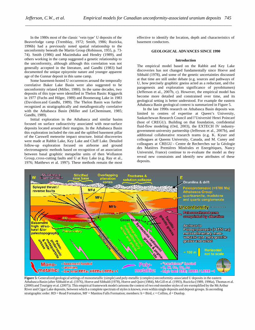
The empirical model based on the Rabbit and Key Lake discoveries has not changed fundamentally since Hoeve and Sibbald (1978), and some of the genetic uncertainties discussed at that time are still under debate (e.g. sources and pathways of U, how precisely graphitic gneiss acted as a reductant, and the paragenesis and exploration significance of pyrobitumen) (Jefferson et al., 2007b, c). However, the empirical model has become more detailed and constrained over time, and its geological setting is better understood. For example the eastern Athabasca Basin geological context is summarized in Figure 5.
In the late 1990s research on Athabasca Basin deposits was limited to centres of expertise at Queen’s University, Saskatchewan Research Council and l’Université Henri Poincaré (host of CREGU). Building on that foundation, confidential fluid-flow modeling (Ord, 2003), the EXTECH IV industry-government-university partnership (Jefferson et al., 2007b), and additional collaborative research teams (e.g. K. Kyser and colleagues at Queens University, Canada, and M. Cuney and colleagues at CREGU - Centre de Recherches sur la Géologie des Matières Premières Minérales et Energétiques, Nancy Université, France) continue to re-evaluate the model as they reveal new constraints and identify new attributes of these deposits.
Figure 5: Generalized geological settings of monometallic (simple) and poly-metallic (complex) unconformity-associated U deposits in the eastern Athabasca Basin (after Sibbald et al. (1976), Hoeve and Sibbald (1978), Hoeve and Quirt (1984), McGill et al. (1993), Ruzicka (1989, 1996a), Thomas et al. (2000) and Tourigny et al. (2007)). This empirical framework model cartoons the context of two end-member styles of ore exemplified by the McArthur River and Cigar Lake deposits, between which a complete spectrum of styles is known, even within single deposits and deposit groups. In ascending stratigraphic order: RD = Read Formation, MF = Manitou Falls Formation; members: b = Bird, c = Collins, d = Dunlop.
745Jefferson, C.W., et al. Empirical models for Canadian unconformity-associated uranium deposits __________________________________________________________________________________________
The U exploration industry strongly supports such research and has now discriminated a spectrum of end member types of U deposits, all spatially associated with the basal unconformity of the Proterozoic Basins. The geological context of the eastern Athabasca Basin is summarized in the idealized cross-section of Figure 5. The unconformity is presented as a series of paleotopographic highs and valleys. In the centre of the figure the McArthur River deposit is situated along a reverse offset of the unconformity with ore both in the basement and silicified conglomeratic sandstone. A hanging wall silicified zone extends laterally into stratigraphy and is transected by upward splays of the P2 fault, along which subsequent clay alteration has propagated.
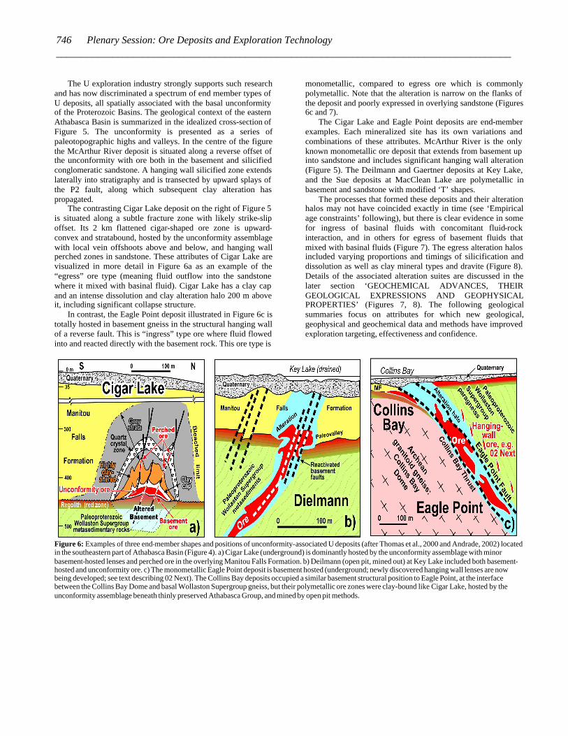
The contrasting Cigar Lake deposit on the right of Figure 5 is situated along a subtle fracture zone with likely strike-slip offset. Its 2 km flattened cigar-shaped ore zone is upward-convex and stratabound, hosted by the unconformity assemblage with local vein offshoots above and below, and hanging wall perched zones in sandstone. These attributes of Cigar Lake are visualized in more detail in Figure 6a as an example of the “egress” ore type (meaning fluid outflow into the sandstone where it mixed with basinal fluid). Cigar Lake has a clay cap and an intense dissolution and clay alteration halo 200 m above it, including significant collapse structure.
In contrast, the Eagle Point deposit illustrated in Figure 6c is totally hosted in basement gneiss in the structural hanging wall of a reverse fault. This is “ingress” type ore where fluid flowed into and reacted directly with the basement rock. This ore type is
monometallic, compared to egress ore which is commonly polymetallic. Note that the alteration is narrow on the flanks of the deposit and poorly expressed in overlying sandstone (Figures 6c and 7).
The Cigar Lake and Eagle Point deposits are end-member examples. Each mineralized site has its own variations and combinations of these attributes. McArthur River is the only known monometallic ore deposit that extends from basement up into sandstone and includes significant hanging wall alteration (Figure 5). The Deilmann and Gaertner deposits at Key Lake, and the Sue deposits at MacClean Lake are polymetallic in basement and sandstone with modified ‘T’ shapes.
The processes that formed these deposits and their alteration halos may not have coincided exactly in time (see ‘Empirical age constraints’ following), but there is clear evidence in some for ingress of basinal fluids with concomitant fluid-rock interaction, and in others for egress of basement fluids that mixed with basinal fluids (Figure 7). The egress alteration halos included varying proportions and timings of silicification and dissolution as well as clay mineral types and dravite (Figure 8). Details of the associated alteration suites are discussed in the later section ‘GEOCHEMICAL ADVANCES, THEIR GEOLOGICAL EXPRESSIONS AND GEOPHYSICAL PROPERTIES’ (Figures 7, 8). The following geological summaries focus on attributes for which new geological, geophysical and geochemical data and methods have improved exploration targeting, effectiveness and confidence.
Figure 6: Examples of three end-member shapes and positions of unconformity-associated U deposits (after Thomas et al., 2000 and Andrade, 2002) located in the southeastern part of Athabasca Basin (Figure 4). a) Cigar Lake (underground) is dominantly hosted by the unconformity assemblage with minor basement-hosted lenses and perched ore in the overlying Manitou Falls Formation. b) Deilmann (open pit, mined out) at Key Lake included both basement-hosted and unconformity ore. c) The monometallic Eagle Point deposit is basement hosted (underground; newly discovered hanging wall lenses are now being developed; see text describing 02 Next). The Collins Bay deposits occupied a similar basement structural position to Eagle Point, at the interface between the Collins Bay Dome and basal Wollaston Supergroup gneiss, but their polymetallic ore zones were clay-bound like Cigar Lake, hosted by the unconformity assemblage beneath thinly preserved Athabasca Group, and mined by open pit methods.
746 Plenary Session: Ore Deposits and Exploration Technology _________________________________________________________________________________________
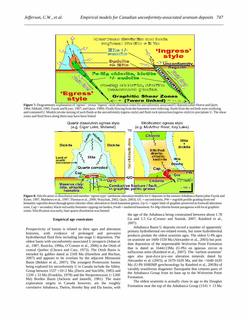
Figure 7: Diagrammatic explanation of ‘egress’- versus ‘ingress’-style alteration zones for unconformity associated U deposits (after Hoeve and Quirt, 1984; Sibbald, 1985; Fayek and Kyser, 1997; and Quirt, 1989). Fluids flowing from the basement were reducing; fluids from the red beds were oxidizing and contained U. Models invoke mixing of such fluids at the unconformity (egress-style) and fluid-rock interaction (ingress-style) to precipitate U. The shear zones and fluid flows along them may have been linked
Figure 8: Silicification vs dissolution end-member ‘egress-type’ sandstone alteration models for U deposits in the eastern Athabasca Basin (after Fayek and Kyser, 1997, Matthews et al., 1997; Thomas et al., 2000; Wasyliuk, 2002; Quirt, 2003). UC = unconformity, PW = regolith profile grading from red hematitic saprolite down through green chloritic-illitic alteration to fresh basement gneiss, Up-G = upper limit of graphite preserved in footwall alteration zone, Cap = secondary black-red earthy hematite capping ore bodies, Fresh = unaltered basement: Fe-Mg-chlorite biotite paragneiss with local graphitic zones. Silicification was early; later quartz dissolution was limited
Empirical age constraints
Prospectivity of basins is related to their ages and alteration histories, with evidence of prolonged and pervasive hydrothermal fluid flow including late stage U deposition. The oldest basin with unconformity-associated U prospects (Johan et al., 1987; Ruzicka, 1996a, O’Connor et al., 2006) is the Otish of central Quebec (Chown and Caty, 1973). The Otish Basin is intruded by gabbro dated at 2169 Ma (Hamilton and Buchan, 2007) and appears to be overlain by the adjacent Mistassini Basin (Bekker et al., 2007). The youngest Proterozoic basins being explored for unconformity U in Canada include the Sibley Group between 1537 +10/-2 Ma, (Davis and Sutcliffe, 1985) and 1339 ± 33 Ma (Franklin, 1978) and the Neoproterozoic (<1200 Ma) Borden Basin (Jackson and Iannelli, 1981). The main exploration targets in Canada however, are the roughly correlative Athabasca, Thelon, Hornby Bay and Elu basins, with
the age of the Athabasca being constrained between about 1.78 Ga and 1.5 Ga (Creaser and Stasiuk, 2007, Rainbird et al., 2007).
Athabasca Basin U deposits record a number of apparently primary hydrothermal ore-related events, but some hydrothermal products predate the oldest uraninite ages. The oldest U-Pb ages on uraninite are 1600-1550 Ma (Alexandre et al., 2003) but post-date deposition of the impermeable Wolverine Point Formation that is dated as 1644±13Ma (U-Pb) on igneous zircon in tuffaceous units (Rainbird et al., 2007). The ‘earliest uraninite’ ages also post-date pre-ore alteration minerals dated by Alexandre et al. (2003), at 1670-1620 Ma, and the ~1640-1620 Ma (U-Pb SHRIMP geochronology by Rainbird et al., 2003b) of variably uraniferous diagenetic fluorapatite that cements parts of the Athabasca Group from its base up to the Wolverine Point Formation.
The oldest uraninite is actually close in age to the Douglas Formation near the top of the Athabasca Group (1541 " 13 Ma
747Jefferson, C.W., et al. Empirical models for Canadian unconformity-associated uranium deposits __________________________________________________________________________________________
by Re-Os isochron, Creaser and Stasiuk, 2007). Ages of 1521 +/- 8 Ma on McArthur River (McGill et al., 1993), 1486 to 1519 Ma on the McArthur River and Sue C deposits (Fayek et al., 2002b) and 1461 ± 47 Ma on the Cigar Lake deposit (Fayek et al., 2002a) are also the ‘oldest’ uraninite dated on these deposits. These deposits and their host rocks were overprinted by further alteration and U remobilization events at approximately 1350 Ma, 1176 Ma, 900 Ma and 300 Ma (Hoeve and Quirt, 1984; Cumming and Krstic, 1992; McGill et al., 1993; Kyser et al., 2000; Fayek et al., 2002a).
The key impact of this geochronology is that the ore forming event(s) took place, possibly at different times in different places, from 50 to more than 100 Ma after the basins were deposited, thus exploration must target aspects of the basins (e.g. structural reactivation and hydrothermal alteration features) that are temporally linked to the ore. Although many dates have been published as listed above, some geochronological data are among the most closely guarded exploration secrets in the industry, and many unknowns remain. These are among the most difficult data to acquire with accuracy and precision.
Unconformities
The first-order favourable attribute is the unconformity at the base of a relatively flat-lying and intracontinental, un-metamorphosed, late Paleoproterozoic to Mesoproterozoic, fluvial, conglomeratic sandstone, diagenetic red-bed sequence. Prospective Proterozoic basins in Canada and Australia are typically underlain by extensive red hematitic and kaolinitic paleo-regoliths (e.g. Fraser et al., 1970; Cecile, 1973; Macdonald, 1980, 1985; Miller et al., 1989; Ramaekers, 1990; Gall, 1994). Variable thicknesses of regolith grade down through green chloritic-illitic altered rock into fresh basement (Hoeve and Quirt, 1984; Kyser et al., 2000). The regolith is interpreted as a result of regional paleoweathering (Tremblay, 1982; Gall and Donaldson, 2006) that has been overprinted by diagenetic bleaching and additional hematite alteration (e.g. Macdonald, 1985).
The unconformity is now mappable in 3D by careful integration of seismic reflection images with drill hole structural and lithologic data (White et al., 2007) both regionally (Hajnal et al., 2007) and in detail (Gyorfi et al., 2007). It is also a zone of high lateral permeability and porosity that enhanced fluid flow and alteration to produce anomalies in illite (K), chlorite (Fe and Mg) and U (Mwenifumbo et al., 2004, 2007). The concept of deposits in the Beaverlodge camp being of the unconformity type is now more clearly supported by many geologists who worked there, based on the spatial association of most of those deposits with the unconformity beneath the Martin Formation, reactivated faults and favourable basement lithology (Trueman, 2005, 2006)
U-rich basement complexes
Basement domains with U-enriched granite and pegmatite generated during regional high-grade metamorphism and anatexis of metasedimentary rocks are favourable sources (e.g.,
Thomas, 1983, Annesley et al., 1997; Madore et al., 2000; Cuney et al., 2003; Freiberger and Cuney, 2003; Hecht and Cuney, 2003). Abundant U-bearing minerals in such domains include uraninite that forms numerous small prospects in pegmatite (Thomas, 1983; Anonymous, 2005), monazite (Hecht and Cuney, 2000), zircon and apatite. The radiogenic domains, also rich in K, Th and rare earth elements (REE), may have selectively contributed U to the deposits through a variety of mechanisms, and their radiogenic heat may have driven mineralizing hydrothermal fluids.
Favourable basement supracrustal belts
In the eastern part of the Athabasca Basin, most mines and prospects are located along the transition between the western Wollaston and eastern Mudjatik basement domains (Figure 2; Thomas, 1983; Annesley et al., 2005) with high proportions of pelitic, quartzose and arkosic paragneiss that are isoclinally folded and interleaved with Archean orthogneiss and intruded by abundant pegmatite. Similar favourable basement attributes beneath the southwestern Athabasca Basin are documented by Rippert et al. (2000), Brouand et al., (2003), Wheatley and Cutts, (2006), Card et al. (2007b), Kupsch and Catuneanu (2007), and Pană et al. (2007). The favourable supracrustal belts are characterized by aeromagnetic lows that can be integrated with other data including EM conductors and structural lineaments to generate predictive basement geology maps (e.g. Card, 2006; Thomas and Wood, 2007).
Graphitic metapelite basement gneiss
Graphitic basement units are the source of most significant conductors in the Athabasca Basin, and are key empirical locators for U deposits in the Athabasca, Thelon and Kombolgie basins (Dahlkamp, 1993; Thomas et al., 2000). According to Powell (pers. comm., 2007): 1) people have generally believed that better conductors were better U targets historically; 2) there is a correlation between conductor strength (conductance) and deposit size and grade; and 3) EM bright spots tend to correlate with known U occurrences.
Underlying the eastern Athabasca Basin, Lewry and Sibbald (1979) showed that graphitic gneiss units are stratigraphically low in the metasedimentary Wollaston Supergroup of the western Wollaston and eastern Mudjatik basement domains (Figures 2, 4). The protolith of the graphitic metapelitic gneiss appears to unconformably overlie Archean granitoid gneiss and form the basal interface (Thomas, 1983) of the Wollaston Supergroup that involves a primary depositional east-west facies change from quartzitic, through garnetiferous silicate-facies iron formation, to weakly sulphidic graphitic metapelite (Tran, 2001; Yeo and Delaney, 2007). The metapelite constitutes a structurally weak zone that focused deformation, including a major D1 décollement, and was structurally repeated during folding and thrusting (Tran, 2001; Thomas et al., 2005b). Similar graphitic units underlie deposits in the Maybelle River (Wheatley and Cutts, 2006; Kupsch and Catuneanu, 2007) and Shea Creek (Rippert et al., 2000) areas of the western Athabasca
748 Plenary Session: Ore Deposits and Exploration Technology _________________________________________________________________________________________

Basin where they are components of supracrustal belts in the Taltson magmatic zone (Card et al., 2007b; Brouand et al., 2003). These supracrustal components and the associated 1985 to 1968 Ma Taltson granitoid intrusive suite are traced easterly and northeasterly under the southwestern Athabasca Basin as far as the Snowbird tectonic zone (Figure 1) where they are truncated by the Virgin River shear zone (Figure 2) (Stern et al, 2003; Card, 2006; Card et al., 2007b).
Graphitic metapelite is present under the western Thelon Basin where it is part of the Paleoproterozoic Amer Group (Hadlari et al., 2004; Skulski et al., in press) and associated with the Boomerang Lake prospect (Davidson and Gandhi, 1989). It is absent beneath the eastern part of the Thelon Basin along the Kiggavik Trend (Figure 1) where the deposits are focused on mafic units in the Archean Woodburn Group at structural intersections characterized by chorite-illite alteration and gravity lows (Fuchs and Hilger, 1989).
Reactivated faults
Faults in the Athabasca Basin constitute a number of arrays with different attributes, such as dextral or sinistral, extensional or transpressional and ductile or brittle, within which subsidiary splays may be invisible at the district scale but critical at the deposit scale. Case examples include: Ruhrmann (1987) for the Gaertner ore body at Key Lake, McGill et al. (1993) for the McArthur River area, Baudemont and Federowich (1996) for the Dominique-Peter deposit, Baudemont and Pacquet (1996) for the McClean Lake area, Rippert et al., (2000) and Lorilleux et al. (2002) for Shea Creek, Thomas (2005a) for McArthur River mine, Thomas (2005b) for the Eagle Point mine, Harvey and Bethune (2007) for the Deilmann ore body at Key Lake, and Tourigny et al. (2007) for the Sue C mine.
In these deposits, a number of originally ductile regional faults underwent repeated brittle reactivation. Their vertical offsets are limited to tens of metres, but these were essential for focusing ore fluids. The largest reactivated faults in the Athabasca Basin (Figure 2) offset the unconformity by hundreds of metres, but remain small compared to primary ductile offsets of basement units in the order of tens of kilometres along thrust and strike-slip faults. The P2 reverse fault for example offsets the unconformity by 20 to 40 m and at times was extensional (Bernier, 2004) but is located along a deep listric ductile fault zone related to folds and thrusts of the Hudsonian orogeny (Hajnal et al., 2007). In the Sue open pit mines at McClean Lake, Beaudemont and Federowich (1996), Baudemont and Paquet (1997) and Tourigny et al. (2007) have shown that the south-raking geometry of elongate ore lenses and pods, together with structural elements in the enclosing shear zone, can predict the overall south-raking geometry of the deposits. They suggested that en-echelon arrays of uraninite veins at Sue C Pit represent hybrid extensional-shear fractures.
Reactivated fault arrays are spatially linked with changes in stratigraphic thickness, sedimentary facies and paleocurrent directions in the Athabasca Group (Ramaekers and Catuneanu, 2004; Ramaekers et al., 2007; Yeo et al., 2007b). Faults were hinge lines during some 200 million years of alternating sedimentation and erosion. Transfers of strain between fault
arrays may have been a cause of basin development. Changes in basin polarity and fault valve activity would have influenced fluid flow, possibly regionally up-dip toward basin margins (Hiatt and Kyser, 2007), down dip along paleo-channel conglomerate units (Long, 2007; Collier and Yeo, 2001), and/or vertically along faults as part of convection systems that were driven by local deep heat sources such as the graphite-bearing deep fault zones themselves (Hoeve and Quirt, 1984) and caused basement alteration and ore deposition.
Basement uplifts beneath the Athabasca Group (‘quartzite ridges’) range from 10s to 100s of metres, some associated with paleo-talus deposits, and some being within 100 m of the present surface. Their origin as pre- vs post-Athabasca Group is still in debate. Structural pop-ups developed in part by back-thrusts associated with reverse faults (Figure 10) created at least some of the basement highs and valleys before, during and/or after deposition of the Athabasca Group (Bernier, 2004; Gyorfi et al., 2007, Harvey and Bethune, 2007; Long, 2007; Yeo et al., 2007b). Basement topography would have strongly influenced hydrothermal fluid flow during and after its development and is therefore an empirical exploration guide. These structures have been intersected by anomalously short drill holes, are imaged by seismic reflection, and produce local gravity anomalies.
Distinction of end-member subtypes
Alteration assemblages described below under
‘GEOCHEMICAL ADVANCES, THEIR GEOLOGICAL EXPRESIOONS AND GEOPHYSICAL PROPERTIES’ a r e organized into two broad geological types classified as ‘egress’ and ‘ingress’ (Figure 7) (Fayek and Kyser, 1997). The egress and ingress alteration products are spatially related to ore and are part of the geological models for polymetallic versus monometallic deposits, but not all alteration is temporally related to ore deposition as explained above in ‘Empirical age constraints’.
Sandstone-hosted polymetallic subtype
Polymetallic ore is found in unconformity-associated U deposits that are hosted by the unconformity assemblage, by basement rocks immediately below and connected to the unconformity and/or perched in the sandstone. Until recently perched uraninite bodies were considered as vectors to ore rather than being targets in their own right, but the discovery of the Kianna prospect in the Shea Creek area (UEX, 2005) has changed that perception. Egress-type alteration halos are developed mainly in the Athabasca Group strata above polymetallic deposits as well as above the McArthur River monometallic deposit that also transects the unconformity. Details on egress and ingress alteration are provided below in ‘UPDATED MODELS – INTEGRATION OF ALTERATION WITH GEOLOGY AND GEOPHYSICS AT DEPOSIT SCALES.’
Basement-hosted monometallic subtype
Of all of the subtypes, the relatively blind, basement-hosted deposit subtype has recently emerged as a premier target
749Jefferson, C.W., et al. Empirical models for Canadian unconformity-associated uranium deposits __________________________________________________________________________________________
because of its monomineralic nature, competent host rock, and new potential as an under explored target. The tendency of monometallic deposits to be basement hosted in ‘ingress’ settings (Figure 7) (except for the unique McArthur River deposit) had been recognized by Ruzicka (1989) and the linkage to the ingress setting was first clearly stated by Thomas et al. (2000). Early discoveries of this subtype include Rabbit Lake (1968), Cluff Lake OP and Claude (1970-71), Eagle Point (1980), and Sue C-D-E (1989-91) – all exposed or near surface. However, the potential to find major ‘blind’ ingress monometallic deposits displaying little or no egress alteration component had not been realized.
Blind basement-hosted potential was identified geologically by AREVA Resources Canada Inc with the 1997 discovery of P-Patch northeast of Key Lake (Wheatley, 2005, 2006; and Brisbin and Wheatley, 2006) but this style was not widely recognized as a valuable exploration target until the Millennium deposit was delineated by Cameco in 2000 (Roy et al., 2005; Robertson, 2006; Halaburda and Roy, 2006; and Roy and Halaburda, 2006). Basement-hosted monometallic deposits are not just the disconnected roots of a ‘T’ shaped Key Lake type egress deposit (Figure 6b) because the Deilmann and Gaertner deposits are polymetallic to depth, albeit different in detail from their unconformity ore assemblages. Neither is McArthur River a good analogue because, although monometallic, it extends into the unconformity area, has a significant overlying alteration plume, as well as major clay alteration. Ingress deposits are a discrete end-member type developed by the interaction of basement rocks with ingressing fluids in systems separate from those which generated egress or hybrid deposits. The exploration strategies used to discover basement-hosted deposits are exemplified by the Eagle Point, Millennium and P-patch case-histories.
At Eagle Point (Eldorado Resources Ltd., 1987), the potential for additional resources of this type has been demonstrated in the hanging wall of an existing deep, monometallic basement-hosted system (Figure 6c) (Renaud, 2006). Significant intersecting conjugate and overprinting fault systems generated networks of extensional sites such as Riedel shears (Rhys, 2002; Thomas, 2005a, b) in structural repetitions of graphitic metapelite basement gneiss above the Collins Bay dome at Eagle Point.
This deposit sub-type has significant implications for exploration. Some explorationists and researchers are convinced that the deep basement-hosted monometallic subtype has potential for discovery outside the current basin margin (Cuney, 2006). Important factors to consider include how deep the original basement ore systems could have been, versus calculations of the amount of basement that has been eroded with distance from the prospective basin (Harper et al., 2005). The Kiggavik trend is one example of basement-hosted deposits that are preserved (along with the deeper portions of the regolith) up to 15 km away from outcrops of preserved Thelon Formation. Drilling practices have changed within the Athabasca Basin as well – no longer do geologists always stop the drill once ‘fresh’ basement has been reached – depending on local geological knowledge they may continue through ‘fresh’ but prospective basement rocks until a significant marker has been reached. Property-scale lithostratigraphy and structure are mapped in 3-D: predictive zones of graphitic metapelite, meta-
arkose, amphibolite and meta-quartzite markers, and structurally disturbed zones favourable for passage of mineralizing fluids.
GEOCHEMICAL ADVANCES, THEIR GEOLOGICAL EXPRESSIONS AND GEOPHYSICAL PROPERTIES
This section reviews advances in geochemistry that parallel the above geological advances and are measurable by new and established geophysical methods. The scope is broadened to include information and ideas on Canadian basins other than the Athabasca, as an aid to exploration where local deposits are either not yet discovered or their alteration systems are not understood in regional context. The geochemical compositions translate directly to and from measurable mineralogy. Multiparameter borehole geophysics in the Athabasca Basin provides a means of quantitatively calibrating the geophysical expressions of these compositional differences in bulk rock units that airborne and ground geophysics can measure. However permafrost conditions complicate drilling in more northerly basins so that borehole logging is very limited. Petrophysics is another important source of such data especially in permafrost terranes, but must be placed in context. Samples recoverable from core may not necessarily represent what remote methods will detect in the bulk rock units.
Quartz-dominated, U-depleted cover strata
The conglomeratic sandstone sequences that overlie the regolith and host parts of the polymetallic U deposits are thoroughly oxidized terrestrial red bed sequences with very long and complex diagenetic and hydrothermal alteration histories (Macdonald, 1980; Hoeve and Quirt, 1984; Ramaekers, 1990; Kyser et al., 2000). The preserved detrital framework in the Athabasca Basin is typically more than 95% quartz with less than 3% clay matrix, mainly dickite (Wasyliuk, 2002). In contrast, variable primary feldspar and lithic fragments are preserved in quartz- and phosphate-cemented portions of the Thelon Formation (Kyser et al., 2000) whose coarser grained units have been described as lithic arkose and subarkose (Cecile, 1973; Miller, 1983; Rainbird et al., 2003a). Much of the Hornby Bay Group is feldspathic (Kerans et al., 1981).
Nevertheless, the sedimentary fills of all three basins are depleted in U (<1 ppm) with local residual Th anomalies, such as indicated by airborne gamma ray surveys (e.g. Carson et al., 2002b, Campbell et al., 2007; Mwenifumbo and Bernius, 2007) and regional to local geochemical surveys (Maurice et al., 1985; Quirt, 1985; Wallis et al., 1985; Percival, 1989; Andrade, 2002). The primary stratigraphy of these sandstone units is overall translucent to geophysical methods, and provides an extremely low background against which subtle anomalies are detectable. Primary differences in clay abundance for the upper Manitou Falls Formation and the Wolverine Point Formation are possibly detectable by seismic reflection (see White et al., 2007).
The Wolverine Point Formation is, in contrast, distinctly conductive, with locally preserved saline formation waters. It also has high background radioactivity, with extensive uraniferous phosphate cemented zones. The Wolverine Point
750 Plenary Session: Ore Deposits and Exploration Technology _________________________________________________________________________________________
Formation, as a conductor and an aquitard, hinders detection geophysically and geochemically of underlying conductive graphitic units, mineralization and alteration.
Regional- and district-scale alteration
In addition to pre-Athabasca Group paleo-weathering and retrograde metamorphic alteration of basement gneiss below the unconformity, two types of regional-scale alteration have been recognized: basinwide pre-ore diagenetic sandstone alteration, and egress-type but subbasin-scale alteration halos that outline trends and clusters of U deposits, representing broad zones where basement fluids mixed with basinal fluids. A complex and long-lived diagenetic sequence differs overall between the Athabasca, Thelon and Kombolgie basins (Kyser et al., 2000; updated in Jefferson et al., 2007b, c), and is independent of detailed stratigraphy in each basin. Differences in alteration systems of the Thelon Basin and the Athabasca Basin are being documented as part of ongoing studies to determine local prospectivity guides in these basins (e.g. Renac et al., 2002; Wasyliuk (2002). The nature of each type of mineral alteration is described below.
Quartz
One of the earliest-recognizable regional diagenetic events in the Athabasca Basin is a pre-ore quartz overgrowth (Q1 event) that encompasses weak to locally intense early diagenetic quartz overgrowths on hematite-dusted detrital quartz grains. This is informally termed ‘tombstone’ where drill core has a polished appearance due to a high proportion of cement in Athabasca Group strata above or proximal to basement quartzite highs in the McArthur River area and to the southwest, in the Millennium area. The tombstone silicification of the Athabasca Group preserves some of the early detrital kaolinitic clay mineralogy, detrital to early diagenetic hematite, and the early regional diagenetic dickite (Wasyliuk, 2002). Even some primary microbial laminae defined by very finely crystalline hematite are preserved by silicification (Yeo et al., 2007a) very close to the McArthur River deposit. Pervasive silicification is crudely stratabound in the McArthur River, Millennium and Virgin River areas where it can be calibrated by borehole geophysics (Figure 9) and traced by AMT (Craven et al., 2007) as resistive zones.
Quartz dissolution (post Q1; overlapping Q2) is a major alteration effect above many egress-style deposits such as the Cigar Lake deposit that resulted in significant volume reduction and collapse of the Athabasca Group strata. It is superimposed in places on both Q1 and Q2 at McArthur River. Late silicification fronts, comprising drusy disseminated to fracture- filling quartz (Q2) are also a component of large alteration systems of quartz-dissolution, for example at Cigar Lake (Andrade 2002) and in the McArthur River area (McGill et al. 1993). Drusy quartz crystals filling voids are developed mainly at the periphery of alteration systems, and are interpreted to be related to quartz dissolution immediately above the deposit (Percival, 1989; Hoeve and Quirt 1984). Later drusy quartz (Q3) was also described locally within the previous quartz-dissolution zones (Thomas et al., 2000; Andrade, 2002).
Relatively conductive gaps in the stratabound resistivity anomalies are interpreted as zones of structural disturbance and dissolution related to uraninite zones in the McArthur River, Millennium and Virgin River areas (e.g. Leppin and Goldak, 2005; Powell et al., 2005; O’Dowd et al., 2007; Powell et al., 2007). Quartz dissolution zones are also targeted as resistivity lows in the Cigar Lake area where they have been one of the guides to new discoveries (O’Dowd et al., 2007).
Kaolinite vs Dickite
The original mixed clay matrix of the Athabasca Basin was shown by Hoeve and Quirt (1984) to have been dominantly kaolinitic with small amounts of montmorillonite and chlorite (Wolverine Point Formation) and a low-Mg-Fe i l l i te (nomenclature after Nickel and Nichols, 1991). Regional diagenesis converted the primary clay minerals to a mixture dominated by dickite, a higher crystallinity polymorph of kaolinite, with minor amounts of illite and chlorite (Quirt and Wasyliuk, 1997; Earle et al., 1999; Quirt, 2001; and Wasyliuk, 2002). The dominant clay mineral in the Thelon and Kombolgie basins is illite (Kyser et al., 2000; Renac et al., 2002). Applying the calculations of Hoeve and Quirt (1984) to these basins suggests that sufficient K was present in detrital feldspar and mica to support complete conversion of detrital kaolinite to illite during their diagenesis, unlike most of the Athabasca Group.
Illite
Variations in the proportion of kaolinite (now dickite) in the regional background of the Athabasca Basin were noted by Earle and Sopuck (1989) in the southeast where a large illite anomaly forms a corridor 10-20 km wide from Key Lake to Cigar Lake (Figure 4). Earle et al. (1999) described the illitic alteration at Key Lake in more detail. The axis of this regional illite anomaly also contains sub-parallel linear zones of anomalous chlorite and dravite. The regional illite anomaly overlies all known U deposits and prospects in the southeastern part of the basin (Figure 4), notably Key Lake, P-Patch (4 km East of Key Lake), McArthur River, BJ (7.5 km SE of McArthur River) and the Millennium prospect. Smaller illite anomalies surround Cigar Lake and deposits in the Midwest – Dawn Lake – McClean Lake – Rabbit Lake area. A similar illite corridor is present in the Shea Creek area of the western Athabasca Basin (Rippert et al., 2000).
Basement rock compositions and structures likely influenced the alteration mineralogy of the overlying sandstone. The above-described regional illite anomaly overlies a 5-20 km wide aeromagnetic low, where underlying Wollaston Supergroup gneiss includes abundant metaquartzite and metapelite units. The illite anomaly is expressed as local K anomalies in ground spectral (K-U-Th) gamma ray surveys (e.g. Shives et al., 2000), but is not evident in regional airborne gamma ray data (Carson et al., 2002b).
A distinction has also been made between two illite types (cis and trans which replace the previous illite nomenclature); introduced by Laverret et al. (2006) and Kister et al. (2006). The illite related to regional diagenesis is platy (illite trans) whereas that related to more intense hydrothermal alteration in the mineralized zones is hairy (illite cis). Three D modeling in GOCAD© of clay alteration distribution and mass balance
751Jefferson, C.W., et al. Empirical models for Canadian unconformity-associated uranium deposits __________________________________________________________________________________________

calculations have also shown that K must have been added from basement rocks to generate the hairy illite, along with Mg for the sudoïte (see Chlorite following) and B for the dravite (Kister et al., 2005, 2006).
Chlorite
Chlorite alteration is more local near many deposits in the eastern Athabasca Basin, and is possibly associated spatially with quartzite ridges (Figure 4), although not all known basement ridges are overlain by this alteration. Chlorite has been described extensively for the Kombolgie Basin of Australia (Wilde and Wall, 1987; Wilde et al., 1989; Lida, 1993; Polito et al., 2004; Beaufort et al., 2005). In the Athabasca Basin sudoite, an Al-Mg-rich di, trioctahedral chlorite, is present in alteration of both sandstone and basement at a number of deposits, including Cigar Lake (Percival and Kodama, 1989) and McArthur River (Wasyliuk, 2002). Up to five types of chlorite have been documented in the basement (Quirt, 1997; Quirt and Wasyliuk, 1997) – the challenge in using chlorite as an exploration pathfinder is to distinguish between ore-related alteration, that associated with retrograde metamorphism and paleo-weathering, and perhaps other types of barren hydrothermal alteration systems. Local chlorite anomalies in other Proterozoic basins would be worthy of further investigation.
Dravite (magnesiofoitite)
The dravite or magnesiofoitite in the Athabasca Basin (Wasyliuk, 2002, 2005) is clay-sized tourmaline: blue-green and concentrated along fractures and disseminated in altered zones. It overprints illite, chlorite and kaolinite, and records overgrowth by late hydrothermal boron metasomatism. Boron anomalies are part of the overlying geochemical halo of the McArthur River P2 deposit (McGill et al., 1993) as well as other deposits from Key Lake to Cigar Lake.
Fluorapatite
Phosphate minerals preserve a rich record of regional to local, low- to high-temperature saline fluid diagenesis: precipitation, destruction and re-precipitation of phosphate as xenotime, apatite, and Ca-Sr-LREE-Al-phosphate minerals (AP) plus or minus sulphur (APS). Diagenetic xenotime typically forms euhedral overgrowths of 1-10 microns on detrital zircon, lacks U in the Athabasca Basin, and is overgrown by quartz and fluorapatite (Rainbird et al., 2003b). This xenotime is significantly post-dated by hydrothermal uraniferous xenotime described by Quirt et al. (1991) for the Maw Zone (MacDougall, 1990). Diagenetic, variably uraniferous, patchy to stratabound fluorapatite cement was dated at ~1640-1620 Ma by U-Pb SHRIMP geochronology from the Wolverine Point to basal Fair Point formations (Rainbird et al., 2003b). This age is within error of the depositional age of the Wolverine Point Formation (1644+/- 13 Ma; Rainbird et al., 2007). Fluorapatite in the Thelon Basin has a similar paragenesis, locally forming patchy pinkish red cement with ~20 to 500 ppm U (Miller, 1983), spatially associated with fracture and breccia zones from the bottom to top of the Thelon Formation, and yielding a single age population in recent SHRIMP analyses (Jefferson et al., 2007a).
Fluorapatite zones are prominent ‘false’ anomalies in high-resolution airborne gamma ray surveys of the Thelon and Athabasca basins.
Aluminum phosphate sulphate (APS) minerals
Pseudocubic APS minerals, recognized in trace to minor amounts throughout the Athabasca Group, are interpreted as mid- to late-diagenetic to early hydrothermal. Kotzer and Kyser (1995) estimated an age of 1500-1250 Ma for goyazite intergrown with illite and dravite. Crandallite, in the same family as goyazite, has been interpreted as the youngest phosphate generation, intermixed with late-formed kaolinite (Hoeve and Quirt, 1984, Wilson, 1985).
The APS minerals have been shown to be the host of a third district-scale alteration effect that is subtly evident as thorium (Th) anomalies in airborne radiometric, borehole geophysical, stratigraphic geochemical and mineralogical data. These Th anomalies correlate directly with increased detrital grain size in the Manitou Falls Formation, but U and K appear to be systematically depleted with respect to Th and other elements irrespective of grain size (Figure 9). These correlations, strong in conglomerate and pebbly sandstone beds of the Manitou Falls Formation, but inconsistent in similar textured units of the underlying Read Formation in the eastern part of the Basin, are subtle in the western part of the Athabasca Basin at Shea Creek (Mwenifumbo et al., 2000). Th anomalies in coarse grained beds are evident in all drill logs in transects across exploration sites and away from deposits (Mwenifumbo and Bernius 2007, Yeo et al., 2007b). Th is also anomalous in regional airborne spectral gamma-ray data that can represent such Th anomalies as one phase in ternary K-U-Th plots (Carson et al., 2002b). These Th anomalies coincide with the outcrop distribution of the Bird and lower Collins members of Manitou Falls Formation (Campbell et al., 2007). Similar anomalies are evident in the eastern Thelon Formation (corroborated by ground spectrometer readings) and Hornby Bay Formation. Detailed correlation of Th anomalies in drill core (Figure 9) indicates aluminum phosphate (AP) (no sulphur) as the host minerals (Mwenifumbo and Bernius, 2007).
The APS minerals referred to as ‘crandallite group’ by Mwenifumbo and Bernius (2007) were specifically identified as florencite. They form abundant 3-6 micron grains intimately intergrown with illite, dickite, anatase and hematite, and are most abundant in the lower Manitou Falls Formation that crops out in an eastward convex band around the eastern rim of the Athabasca Basin. They contain elevated Th, form clusters resembling detrital grains and are matrix to hematite-rich pebbly laminae with relatively abundant detrital zircon and rare xenotime. This assemblage is interpreted as an alteration product of detrital heavy minerals during moderately high-temperature (150-170º C) diagenesis that post-dated Q1 quartz overgrowths. In the Thelon, Hornby Bay and Elu basins, APS minerals are described as concentrated at the base of the sedimentary succession and in the regolith (Gall and Donaldson, 2006). These APS minerals are also pseudocubic but slightly larger than the Athabasca APS minerals, and here too appear to post-date uraniferous fluorapatite.
Evidence of pre-existing unstable detrital minerals in the Athabasca Basin and their relationships to U-depleted, Th-rich aluminum phosphate +/- sulphate (APS) minerals is analysed in
752 Plenary Session: Ore Deposits and Exploration Technology _________________________________________________________________________________________
detail by Gaboreau et al. (2007). Although discussions have been focused on genetic issues such as sources and pathways of U, work by Gaboreau et al. (2007) indicates that differences in APS compositions proximal versus distal to ore deposits may be useful empirical guides to ore. The P/S ratio records redox conditions during formation of the APS: high P/S ratios correspond to paleo-reducing conditions, theoretically proximal to a paleo-ore-forming environment. APS in barren sandstone also have elevated Sr whereas those proximal to ore contain elevated LREE. Practical tests are underway regarding the utility of APS geochemistry as a standard exploration technology.
UPDATED MODELS - INTEGRATION OF ALTERATION WITH GEOLOGY AND GEOPHYSICS
AT DEPOSIT SCALES
Deposit-scale alteration mineralogy and geochemistry
Alteration mineralogy and geochemistry of unconformity deposits and their host rocks are among the most important exploration criteria in the Athabasca and Thelon basins of Canada, and the Kombolgie Formation of Australia. The parageneses of deposits in these basins have been compared by Hoeve and Quirt (1984), Miller and LeCheminant (1985), Kotzer and Kyser (1995), Kyser et al. (2000) and Cuney et al. (2003). Early work on alteration mineralogy in the Athabasca Basin is exemplified by Hoeve et al. (1981a, b), and Hoeve and Quirt (1984). Wasyliuk (2002) set the modern template for exploration using short wave infrared (SWIR) analysis of clay mineralogy by the field-based PIMA© technology (see ‘Mineralogical and geochemical tools’).
Geophysics and key elemental geochemistry can be used to evaluate alteration targets in the Athabasca and other basins. Even where targets are located at more than 500m depth, key alteration signatures can be detected within the quartz-dominated and U-depleted (<1 ppm) sandstone units of these basins by integration of changes in resistivity, density, U and K content. These measurements can possibly also discriminate silicification, quartz dissolution, addition of >2.5 U and the addition of K that converted dickite to illite (e.g. Clark, 1987, Thomas et al., 2000 and Percival, 1989). To evaluate various prospects in different basins their specific alteration systems must first be defined. Analysis and comparison of mineral and fluid paragenesis of each host basin are critical to establish whether the basin is prospective as a whole, and if so what exploration parameters are useful to explore local prospects.
That said, alteration types in the Athabasca Basin are organized into two broad geometric shapes interpreted as ‘egress’ and ‘ingress’ (Figure7). The following details on egress and ingress alteration systems are based mainly on Hoeve and Quirt (1984), Sibbald (1985), Fayek and Kyser (1997) and Quirt (1989).
Egress-style illite-kaolinite-chlorite alteration
Most published descriptions and related exploration strategies deal with the egress forms of alteration that range between two distinct end-member types (Figure 8): i) quartz dissolution +
illite and ii) silicified (Q1 +Q2) + later illite-kaolinite-chlorite + dravite. Strata overlying most egress deposits in the Athabasca Basin typically experienced dissolution of quartz as well as zircon, with volume losses locally exceeding 90% (Percival, 1989). In contrast, alteration in the McArthur River to Millennium corridor is dominantly represented by the early-silicification end-member with local, intense, pre-ore quartz dissolution and little apparent volume loss (Matthews et al. 1997). Around the Deilmann ore body at Key Lake, silicification is minor, but late kaolinite and dravite (tourmaline) are superimposed on earlier illite alteration. Intense egress-type clay alteration zones surrounding deposits such as Cigar Lake also constitute natural geological barriers to U migration in ground waters (Percival et al., 1993) and are important geotechnical factors in mining and ore processing (Andrade, 2002).
In further detail, zones of inferred egress-type fluid mixing are characterized by host-rock alteration halos that contain illite, kaolinite, dravite, chlorite, euhedral quartz, and locally, Ni-Co-As-Cu sulfide minerals (Hoeve and Quirt, 1984; Wallis et al., 1985; Kotzer and Kyser, 1995). Whereas the latter described the chlorite as Mg-chlorite (=clinochlore), at most deposits the chlorite is a less common Al-Mg variety termed sudoïte (Hoeve and Quirt, 1984; Percival and Kodama, 1989). More than one variety of chlorite is commonly present in this deposit type (Quirt, 1989, 2003; Quirt and Wasyliuk, 1997; Wasyliuk, 2005, 2006).
Deposit-specific alteration halos are up to 400 m wide at the basal unconformity, thousands of metres in strike length, and extend several hundred metres above major deposits (e.g. Thomas et al., 2000 for McArthur River; Kister et al., 2003 for Shea Creek; and Bruneton, 1993 for Cigar Lake). This alteration typically envelops the main ore-controlling structures, forming plume-shaped or flattened elongate bell-shaped halos that taper gradually upward from the base of the sandstone and narrow sharply downward into the basement. Illite-dominated haloes typically have K2O/Al2O3 ratios > 0.18 and MgO/Al2O3 ratios < 0.15; kaolinite-dominated haloes have K2O/Al2O3 a n d MgO/Al2O3 ratios < 0.04; and chlorite-rich haloes have MgO/Al2O3 ratios > 0.125 and K2O/Al2O3 ratios < ~0.04 (Sopuck et al., 1983). Compared to background ratios of 0.1-0.16 K2O/Al2O3 in the Athabasca Group (Ibrahim and Wu, 1985), Percival (1989) measured K2O/Al2O3 ratios >0.27 for most of the alteration zone at Cigar Lake (n=150).
A thin bleached and white clay (illite) replacement zone at the top of the paleo-weathering profile is interpreted as diagenetic-hydrothermal alteration superimposed on the lateritic-weathered, red-green profile developed on the basement rocks (Macdonald, 1980). Below, and within egress-type deposits, this bleached white to pale green zone overprints (‘breaches’) the normal colour and mineralogy of the paleo-weathering profile. Bleached white to pale green alteration also locally overprints very fine-grained early diagenetic hematite in red to pink mudstone beds and intraclasts of the Read Formation (termed ‘hematite removal’). Sandstone and conglomerate beds within the alteration zones are bleached to very pale pinkish, greenish or white. Mass balance calculations of Kister et al. (2006) on Shea Creek have shown that hematite was leached out of those bleached zones by reduced hydrothermal fluid.
753Jefferson, C.W., et al. Empirical models for Canadian unconformity-associated uranium deposits __________________________________________________________________________________________

Ingress-style chlorite-sudoïte-illite alteration
Ingress-style alteration is expressed by similar geochemical and mineralogical products to those of the egress type. However these are inverted, developed by fluid-rock interaction in basement gneiss rather than sandstone, and are of limited value for surface exploration. Understanding such alteration is important for detailed development drilling and underground exploration.
Minor and/or patchy host-rock alteration is evident in the sandstone above basement-hosted deposits with ingress-type alteration zoning (Wheatley, 2006). Such deposits are essentially “blind” exploration targets, except by geophysical methods, although broader, relatively subtle and patchy geochemical and mineralogical halos above them may provide clues to their existence. These deposits are mono-mineralic uraninite and have very narrow, inverted alteration halos along the sides of the basement structure. At Eagle Point, for example, the alteration grades from illite +/- sudoïte on the inside, through sudoïte +/- illite, to Fe-Mg chlorite +/- sudoïte on the outside against fresh basement rock (Figure 7; Quirt 2003). At the alteration - ore interface a brick red hematite zone is irregular and thinner than which caps deposits at the unconformity, and resembles a ‘basement-hosted roll-front’.
Targeting these metallurgically attractive deposits requires exploration geologists to understand the geometry of fault and fold systems in the basement, in search of the most likely settings for deposits, for example, in the hanging or footwall of reverse faults. Some alteration zones have both ingress and egress characteristics such as those at the important McArthur River deposit. This suggests complex hydrothermal systems that involved both processes very close to one another in space and time. A good understanding of the basement geology and structural features is required especially to explore for basement-hosted deposits, as follows.
Examples of success by integration
The new discoveries (Figure 2) exemplify success based on multidisciplinary integration of well established traditional methods, such as investigating basement conductors and thorough knowledge of basement stratigraphy, with new structural knowledge and advancements in geophysics, a paradigm spearheaded by teams such as Matthews et al. (1997) and championed by Michael Leppin, with successes exemplified by O’Dowd et al. (2007) and Powell et al. (2007). Eagle Point was discovered in 1980 and produced before 1990. Exploration at McArthur River began in 1980, the discovery hole was drilled in 1988 and production began in 1999. In both cases re-analysis and blending of legacy data with new development data have enhanced reserves by identifying basement stratigraphic and structural geological sites favourable for ore. The Shea Creek trend in the western Athabasca Basin south of Cluff Lake includes significant discoveries in 1992 and 2005 (Gandhi, 2007; Jefferson et al., 2007b, c), a result of continued multidisciplinary geology, geochemistry, mineralogy and geophysics over decades of exploration by COGEMA (now AREVA Resources Canada Ltd.) and joint-venture partners. The
discovery of significant super-high-grade sandstone hosted U in the Kianna prospect well above the unconformity (together with high-grade intersections at the unconformity and in the basement) (UEX, 2005) adds another potentially economic end member to the spectrum.
The new 02 North Extension (02 Next) drill target at Eagle Point was generated by integrating multidisciplinary information such as: sheared antiformal structures identified by previous drilling, conductive fault traces, positions of existing mined out ore bodies, magnetic trend lines that map basement structure, and EM conductivity anomalies (Thomas, 2005b; Powell et al., 2006; O’Dowd et al., 2007).
McArthur River’s more than 20-year exploration history involved thorough documentation of basement lithology, structure, geochemistry, mineralogy and their various geophysical expressions (McGill et al., 1993, Jefferson et al., 2002; Thomas, 2005a; Craven et al., 2007; Gyorfi et al., 2007). A 6-unit basement ‘metamorphic stratigraphy’ has been mapped in plan and section: quartzite, meta-arkose and feldspathic quartzite, cordierite-bearing pelitic gneiss, biotite pelitic gneiss, calc-silicate gneiss, and foliated granite and pegmatite. Pelitic gneiss includes graphitic zones in the footwall to the P2 fault. Extensive detailed structural fabric analysis has generated statistical knowledge of foliations, faults and fractures, with predominant sets parallel and in two conjugates to the P2 fault. These have been synthesized by Cameco in multiple plans and sections. McGill et al. (1993) indicated the importance of structures intersecting the main P2 fault, and Thomas (2005a) documented how the 20-year knowledge base is being used to understand and predict favourable structural-lithologic sites for ore generation and abrupt ore cut offs. Gyorfi et al. (2007) showed how such predictive structures can be mapped by integrating pseudo-3D seismic methods with such data (Figure 10).
ATTRIBUTES APPLIED TO EXPLORATION
Geophysical and geochemical tools are now part of a
continuum of integrated exploration methods. The modern status of geophysical tools is reviewed through explicit case examples such as Nimeck and Koch (2006), O’Dowd et al. (2005, 2007) and Powell et al. (2005, 2006, 2007). The present paper selectively summarizes the use of some geophysical methods that in the year 2000 were not in wide use but have since become more popular through demonstration by EXTECH IV, improved analytical software, better understanding of their linkages to geochemistry and geology, and the rise in exploration activity.
Multiparameter borehole geophysics
Multiparameter borehole geophysics provides quantitative bulk rock property characteristics that help to design and calibrate the various other applied geophysical methods such as electromagnetics, magnetotellurics and seismic. Figure 9 illustrates selected data sets from two drill holes in the McArthur River area. MAC-218 directly intersects part of the P2 North deposit, whereas RL-88 intersects a basement structural high
754 Plenary Session: Ore Deposits and Exploration Technology _________________________________________________________________________________________
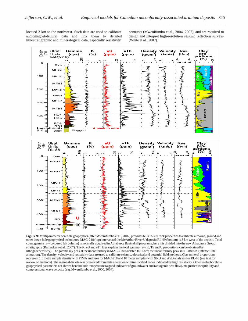
located 3 km to the northwest. Such data are used to calibrate audiomagnetotelluric data and link them to detailed lithostratigraphic and mineralogical data, especially resistivity
contrasts (Mwenifumbo et al., 2004, 2007), and are required to design and interpret high-resolution seismic reflection surveys (White et al., 2007).
Figure 9: Multiparameter borehole geophysics (after Mwenifumbo et al., 2007) provides bulk in-situ rock properties to calibrate airborne, ground and other down-hole geophysical techniques. MAC-218 (top) intersected the McArthur River U deposit; RL-99 (bottom) is 3 km west of the deposit. Total count gamma ray (coloured left column) is normally acquired in Athabasca Basin drill programs; here it is divided into the new Athabasca Group stratigraphy (Ramaekers et al., 2007). The K, eU and eTh logs explain the total gamma-ray (K, Th and U proportions can be obtained by lithogeochemistry). The gamma ray peak at the unconformity in MAC-218 is related to U-ore; the unconformity peak in RL-88 is K (intense illite alteration). The density, velocity and resistivity data are used to calibrate seismic, electrical and potential field methods. Clay mineral proportions represent 1.5 metre sample density with PIMA analyses for MAC-218 and 10 meter samples with XRD and ASD analyses for RL-88 (see text for review of methods). The regional dickite was preserved from illite alteration within silicified zones indicated by high resistivity. Other useful borehole geophysical parameters not shown here include temperature (a good indicator of groundwater and radiogenic heat flow), magnetic susceptibility and compressional wave velocity (e.g. Mwenifumbo et al., 2000, 2004).
755Jefferson, C.W., et al. Empirical models for Canadian unconformity-associated uranium deposits __________________________________________________________________________________________

Seismic reflection
Seismic reflection is relatively new to uranium exploration, although much knowledge about the overall depth and shape of the Athabasca and Thelon basins has come from regional seismic studies (e.g. Hobson and MacAulay, 1969; Overton, 1977; Suryam, 1981, 1984). Modern seismic reflection techniques can provide a continuous structural interpretation in 2D and 3D (White et al., 2007), from near surface to a few kilometres below the unconformity (Györfi et al., 2007) or deep in the crust to Moho (Hajnal et al., 2007). This is generally achieved by varying source frequency, shot and geophone spacing and data processing, calibrated with the aid of rock properties from borehole geophysics (Mwenifumbo et al., 2004).
Complete structural sections can be interpreted using local and generic structural analogues to determine fundamental exploration parameters such as the location and irregularities in the unconformity, and shallow to deep faults. Figure 10 illustrates the linkage between structure interpreted from dense high-resolution seismic reflection data and the increased recognition of fault intersections as ore foci. This interpretation was the result of laborious processing to screen out anthropomorphic noise. Iterative integration with available drill-hole data was required to generate a realistic interpretation consistent with all data.
Seismic reflection has helped extrapolate structure from drillhole and other data sets. Seismic reflection also holds promise for discriminating units with percentage differences in clay content (White et al., 2007). Direct detection of ore bodies with downhole seismic data is undergoing experimentation (O’Dowd et al., 2005; Powell et al., 2005).
Gravity
Ground and airborne gravity can detect alteration zones as negative gravity anomalies (dissolution zones) or positive anomalies (silicified zones), but direct detection of ore deposits is a challenge due to their small dimensions that limit the magnitude of gravity anomalies (Thomas and Wood, 2007). Gravity also provides insights into the geological framework for exploration on both regional and district scales. Airborne gravity mapping through thick cover strata can reveal linear features that coincide with lineaments on aeromagnetic maps and may be interpreted as small basement fault offsets (e,g, Turner Valley survey reported by Argyle et al., 2000). Gravity is best used in conjunction with multiple other data sets that can help to resolve ambiguities related to factors such as overburden thickness, and bulk densities and dips of deep basement units.
Conductivity – resistivity
Electromagnetic methods, while remaining essential for tracing basement conductors, now also detect ore-related alteration features. High-resolution airborne electromagnetic surveys in Australia have detected shallow but hidden low-resistivity
alteration zones and crudely mapped fault offsets of the unconformity (Bisset, 2003). Improved audiomagnetotelluric methods in the McArthur River area of Athabasca Basin have detected deep conductors and shallow alteration zones (Tuncer et al., 2006; Craven et al., 2007). Highly altered, clay-rich, quartz-corroded quartzarenite in the Athabasca Group has relatively low resistivity, whereas quartz-rich silicified zones are characterized by high resistivity.
Powell et al. (2005) have shown that low resistivity also maps zones of high porosity related to quartz dissolution and fracturing in the Virgin River exploration area (Centennial prospect, Figure 2). O’Dowd et al. (2007) review the multiple methods used to understand resistivity anomalies at Eagle Point’s 02 Next discovery, reminding us that measured conductor traces are plotted up-dip (on the top-basement plane) and therefore can be off-set from the positions of the predicted blind ore deposits. They also document complex changes in resistivity related to alteration, including local transformation of graphitic gneiss units from conductors to resistors as a result of silicification. This case study highlights the importance of borehole geophysics and determination of petrophysical properties on drill core to help establish variations in rock properties on a case-by-case basis.
Figure 10: Two-way-travel time (TWT) contour map of the basal unconformity to the Athabasca Group in the McArthur River mine area, derived from detailed seismic reflection data acquired along the pseudo-3D array and regional lines 12 and 14 (Gyorfi, 2007; Gyorfi et al., 2007). Warm colours represent greater depth (‘Low’ side of P2 fault); greens through blues are shallower (‘High’ side of P2 fault). Interpreted P2 fault array is shown in red, extrapolated from defined drill intersections by means of seismic two-way travel times (TWT). HWR = Hanging wall reverse faults; FF = footwall fault array shown as irregular black, purple, red and green lines that range from highly oblique through sub-parallel to the P2 fault array. Main ore pods (approximate positions shown by yellow ovals) coincide with the intersections of footwall faults and the P2 fault. ‘?’ indicates a site where oblique faults intersect the P2 fault but an ore pod is not yet discovered.
756 Plenary Session: Ore Deposits and Exploration Technology _________________________________________________________________________________________
Aeromagnetic maps
Airborne magnetic surveys provide the means to map basement geology from the margins of these Proterozoic basins to their centres (e.g. Pilkington, 1989) with the aid of magnetic susceptibility and related data from outcrop and drill core that intersects the basement. Thomas and McHardy (2007) provide a modern review of this technology and demonstrate its application to the eastern Athabasca Basin. They point out first-order exploration targets such as faults and favourable basement lithologic units as mapped by magnetic gradients between Archean gneiss domes and the Wollaston Supergroup, previously exemplified by Gregory (1983), Kornick (1983) and Baudemont and Paquet, 1996). Card’s (2006) remote predictive map of the basement between the Snowbird Tectonic Zone and the Alberta border exemplifies linkages between multiple sources of lineament data, base-of-drillhole lithology and aeromagnetic data that are standard for unpublished property-scale geological basement maps by industry.
A new collaboration by Saskatchewan Industry and Resources (SIR) and the Geological Survey of Canada is quantitatively predicting basement geology in a GIS compilation. Aeromagnetic data were enhanced by draping to a surface 300 m above the base of the basin. The basin model is a composite based on reconnaissance seismic reflection data (Hobson and MacAulay, 1969) calibrated by unconformity depths from SIR drill-hole data archives. The aeromagnetic data were microlevelled and upward continued (Pilkington and Roest, 1992) by using a Taylor series expansion of the magnetic field from a mathematical surface to enhance signal information before draping. This enhanced aeromagnetic image facilitates extrapolation of basement geology from basin-margin outcrops to deeply buried areas.
Airborne gamma ray spectrometry
Airborne gamma ray spectrometry directly measures U, K and Th at the earth’s surface. Interpretation of results from such surveys requires knowledge of the overburden, such as paleo-ice-flow directions and till stratigraphy (e.g. Campbell, 2007). Campbell et al. (2007) provided calibration data that document relationships between gamma ray and surficial geochemical data, a quantitative basis for the use of ground (Shives et al., 2000) and airborne gamma ray multiparameter geophysical surveys (e.g. Richardson, 1983; Campbell et al., 2007) in geochemical prospecting and lithologic mapping. The extensive illite alteration corridor in sandstone between McArthur River and Key Lake (Figure 4) does not correlate with K in published reconnaissance gamma ray data (Carson et al., 2002a, b), although detailed ground gamma ray spectrometry by Shives et al. (2000) suggests that K does correlate with illite alteration in the McArthur River area.
In the Athabasca Basin, the bedrock is generally the basement gneiss or the Athabasca Group sandstone with their varying degrees of alteration. Transport of gneissic material onto the edges of the basin from the northeast (prevailing ice flow) may be the cause of some anomalous linear spectrometric features (Campbell et al., 2007). Also, Athabasca Group
material has been transported onto the gneissic basement and Paleozoic strata to the southwest, hence anomalies found there tend to represent an up-ice source within the Athabasca Basin. This does not rule out the possibility of anomalies derived from outlying basement-hosted U deposits, above which Athabasca Group cover has been totally eroded. New radiometric surveys on the south side of the Athabasca Basin (Buckle et al., 2007) demonstrate the immediate detection of basement bedrock signatures at the basin margin, despite the heavy component of glacially transported material from the Athabasca Basin.
Interpretation of radiometric anomalies is undergoing more analysis through geochemical calibration and detailed correlation with Quaternary geology, but some questions are still unsolved. Solutions require more detailed Quaternary geology, complete high-resolution radiometric data sets covering the entire basin and surrounds, and integration with other data sets such as airborne and satellite hyperspectral surveys. Some air and ground radiometric anomalies are recognized as U-rich fluorapatite zones such as the Wolverine Point Formation of the Athabasca Basin, and fluorapatite breccias and patches in the Thelon Basin (Miller, 1983; Miller et al., 1989; Rainbird et al., 2003b; Renac et al., 2002). These U-enriched strata are not U deposits in their own right but provide clues to U mobility in the Athabasca, Thelon and Otish basins.
Mineralogical and geochemical tools
Early mineralogical and geochemical techniques, and recent advances are reviewed above and exemplified by Wasyliuk (2002, 2005, 2006), Quirt and Wasyliuk (2006), Kister et al., (2006) (with GOCAD 3D modeling of the alteration distribution at Shea Creek and McArthur River), Laverret et al. (2006), Gaboreau et al. (2007) and Mwenifumbo et al. (2007). One of the key attributes in drill core has been and remains the mineralogy of the clay, including chlorite, in the sandstone matrix and in altered basement rock (clay mineral proportions of illite, kaolin and chlorite, plus dravite). In the early years this was determined for exploration mainly, and in a direct manner by XRD, with accessory research by microprobe to refine the compositional data. In addition clay mineral proportion information was derived indirectly through use of geochemical normative clay mineral calculations (e.g. software algorithm of Quirt (1995)).
Clay mineral proportions and distinction of dickite from kaolinite and sudoïte from other chlorite species are now also rapidly and effectively obtained at relatively low cost in the field by portable shortwave infrared (SWIR) spectrometers that provide their own light source (PIMA II by Integrated Spectronics Ltd.) or use either artificial or natural light (TerraSpec and FieldSpec Pro by Analytical Spectral Devices). Also today, a combination of methods is used (SWIR, XRD, norms, EMP, SEM). Systematic core sampling is essential, and is typically spaced at 3 to 5 m intervals for SWIR spectrometric analyses and at wider intervals for the other methods.
Calibrated software algorithms for semi-quantitative analyses (Earle et al., 1999) enhance the usefulness of the SWIR analyses. Spectrometric methods have potential to be fully quantitative, given calibration of the spectral absorption band
757Jefferson, C.W., et al. Empirical models for Canadian unconformity-associated uranium deposits __________________________________________________________________________________________
locations and shapes with appropriate mineral standards, and the use of artificial mixtures to develop best-fit algorithms (Zhang et al., 2001; Percival et al., 2002). SWIR spectrometry is particularly useful in distinguishing between the kaolinite-group polytypes of kaolinite and dickite (Wasyliuk, 2002).
Normative calculations based on lithogeochemical data further refine the mineralogical identifications. XRD is still required to provide illite crystallinity and illite compositional [Al/(Fe+Mg)] data, and SEM is used obtain illite morphology information (Quirt and Wasyliuk, 2006). Exploration in Australia relies more on SWIR spectroscopy because the larger variations between background diagenetic clay mineral features and those of the diagenetic-hydrothermal clay minerals allow the method to provide more clay mineral parameter information. Libraries of spectrometric signatures for various rock and alteration types are now being generated with the ultimate goal of using these data to calibrate and interpret hyperspectral airborne and satellite imagery (P. Budkewitsch and J. Peter, pers. comm., December 2005).
Most historical geochemical exploration tools were designed to detect host rock alteration pipes that sub-crop beneath the glacial overburden. The most common method used in the past has been composite chip sandstone boulder geochemistry (Earle et al., 1990; Earle, 2001). However, other methods that have been used include top-bedrock geochemistry, conventional till and soil geochemistry, lake sediment and lake water surveys, biogeochemistry, and ‘soil’ gas surveys: radium (Ra), radon (Rn) and helium (He) in soil and water samples. Recently, new geochemical tools have been put into use, including soil geochemistry using selective digestion techniques, soil gas hydrocarbons; CO2/O2 soil gas surveys, isotopes, and selective extractions. Pb isotope ratios may fingerprint radiogenic lead derived from buried ore deposits in contrast with background lead isotopes in cover media, as well as providing more understanding of basin and deposit formation and alteration (Holk et al., 2003).
Mobile ion surveys using selective extraction techniques (e.g. enzyme leach, MMI, SGH) of specific soil horizons hold great promise for direct detection of ore through hundreds of metres of rock and Quaternary cover in the Athabasca Basin (Wasyliuk, 2006). These methods rely on precise sampling and very weak leach methods to extract elements of interest from the minerals in the sample and place them into solution (e.g., Hamilton et al., 2004a, b). These extractions can emphasize trace metals and lead isotopes that are pathfinders to ore. Leach digestions such as ammonium acetate pH 7, enzyme leach, MMI, and weak HCl, are tested for effectiveness in the local exploration environment, then systematically employed. Research is ongoing concerning suitable sample depth(s), soil horizon(s) and soil size fractions. Pathfinder elements and specific sample media and depths must be determined by experiment for each deposit type and set of local conditions (e.g. Gale et al., 2004).
Improved laboratory analytical tools have made it possible to dissect samples more precisely and in greater detail. Evaluation of Pb isotope systematics for exploration in the Athabasca Basin is increasing now that ICP-MS geochemical data are the norm. Fluid inclusion studies used to be generalized and destructive. It is now possible to analyse single inclusions both by destructive (crush leach analysis) and in-situ non-
destructive methods, such as the Raman microprobe, laser ablation anlysis of individual inclusions and microthermometry (Derome et al., 2003a, b; Cuney, 2006), and synchrotron X-ray analysis and imaging (McCready et al., 2005, 2007; Cuney, 2006). These techniques have applications to trace elements, hydrocarbons, salinity species and isotopic study. For example fluid inclusion studies by Derome et al. (2003a, 2005) indicate that T and P close to the unconformity decreased from the “earlier peak diagenetic” 160-220°C and 1 to 1.25 kbar respectively from Rabbit Lake and Carswell deposits to the mineralization stage of 140-160°C, 0.6 kbar. They also documented mixing of two different but apparently contemporaneous brines.
The fluid inclusion results support inferences above that the peak hydrothermal alteration minerals were formed at different times and possibly with different vectors than the fluid that deposited the uraninite. These results also reinforce the potential for deep basement hosted deposits within and outside of Proterozoic basins (Cuney, 2006), and are reminders of the potential for U precipitation at other redox boundaries such as the first intrabasinal redox boundary (Oklo, Gabon; Cuney, 2006) and the Mountain River deposit in the Hornby Bay Basin, Canada (Bell, 1996). Was the base of the Wolverine Point Formation once a redox boundary? Is the base of the Douglas Formation a suitable candidate?
ACKNOWLEDGMENTS
Much of this paper is taken from Jefferson et al. (2007b, c) and based on products of the EXTECH IV Athabasca Uranium Multidisciplinary Study - a three-year da ta-acquisition partnership from April 2000 to March 2003, coordinated by the Geological Survey of Canada (GSC), Saskatchewan and Alberta geological Surveys, Cameco Corporation and AREVA Resources of Canada Inc. This initiative was stimulated by planning meetings involving Saskatchewan Industry and Resources, Cameco, AREVA and JCU. Industry leadership included research partnerships through NSERC with the universities of Alberta, Laurentian and Saskatchewan. Team leaders, mentors and facilitators include co-authors of the cited papers from the EXTECH IV volume, as well as Suraj Ahuja, Nick Andrade, Irvine Annesley, Michel Cuney, Mark Fenton, Quentin Gall, Wayne Goodfellow, Mike Gunning, Evelyn Inglis, Pierre Keating, Ingrid Kjarsgaard, Brian McGill, Sally Pehrsson, Trevor Perkins, Brian Powell and Charles Roy. Paul Nicholls pointed out Tilsley’s thoughts on electrochemical cells.
Two recent workshops provided extensive practical case histories with explicit information about specific deposits in the Athabasca Basin that have added to the public knowledge base: the Saskatchewan Geological Society Short Course on Athabasca Uranium, Saskatoon, SK, November 28, 2005 and the CIM Field Conference on Uranium: Athabasca Deposits & Analogues, Saskatoon, SK, September 13-14 2006. The latter included field trips that shared exploration information to an unprecedented degree, highlighting a new era in exploration teamwork between experienced major U companies and numerous emerging junior U companies.
758 Plenary Session: Ore Deposits and Exploration Technology _________________________________________________________________________________________

A comprehensive review by Tom Lane and incisive comments by Michel Cuney, Franz Dahlkamp and Gary Yeo on short notice substantially improved the manuscript. Thanks to Sue Davis for drafting assistance, Beth Hillary for support on many fronts, and Tom Lane for his invitation and persistent encouragement. This paper is a contribution to the Uranium Resources of Canada Project, Secure Canadian Energy Supply Program of the Geological Survey of Canada.
REFERENCES
Alexandre, P., Kyser, K. and Polito, P., 2003, Geochronology of the Paleoproterozoic basement-hosted unconformity-type uranium deposits in northern Saskatchewan, Canada, in Cuney, M., ed., Uranium Geochemistry 2003, International Conference, April 13-16 2003, Proceedings: Unité Mixte de Recherche CNRS 7566 G2R, Université Henri Poincaré, Nancy, France, 37-40.
Alexandre, P. and Kyser, T. K., 2006, Geochemistry of Uraniferous Bitumen in the Southwest Athabasca Basin, Saskatchewan, Canada: Economic Geology, 101, 1605-1612.
Andrade, N., 2002, Geology of the Cigar Lake uranium deposit, in Andrade, N., Breton, G., Jefferson, C.W., Thomas, D.J., Tourigny, G., Wilson, S., and Yeo, G.M., eds., Field Trip A1, The Eastern Athabasca Basin and its Uranium Deposits: Geological Association of Canada – Mineralogical Association of Canada, Annual Meeting, Field Trip Guidebook A1, 53-72.
Annesley, I.R., Madore, C., Shi, R. and Krogh, T.E., 1997, U-Pb geochronology and thermotectonic events in the Wollaston Lake area, Wollaston Domain: A summary 1994-1996, in Summary of Investigations 1997, Saskatchewan Geological Survey, Saskatchewan Energy and Mines, Miscellaneous Report 97-4, 162-173.
Annesley, I.R., Madore, C. and Portella, P., 2005, Geology and thermotectonic evolution of the western margin of the Trans-Hudson Orogen: evidence from the eastern sub-Athabasca basement, Saskatchewan, Canadian Journal of Earth Sciences, 42, 573-597.
Anonymous, 2005, SMDI Database; Saskatchewan Industry and Resources.
Argyle, M., Ferguson, S., Sander, L., and Sander, S., 2000, AIRGrav results: a comparison of airborne gravity data with GSC test site data: The Leading Edge, October, 2000, 19, 1134-1138.
Baudemont D. and Federowich, J., 1996, Structural control of uranium mineralization at the Dominique-Peter deposit, Saskatchewan, Canada: Economic Geology, 91, 855-874.
Baudemont, D. and Pacquet, A., 1996, The Sue D and E uranium deposits, northern Saskatchewan: Evidence for structurally controlled fluid circulation in the Athabasca Basin, in Ashton, K.E., and Harper, C.T., eds., MinExpo’96 Symposium–Advances in Saskatchewan Geology and Mineral Exploration: Saskatchewan Geological Society, Special Publication No. 14, 85-94.
Beaufort, D., Patrier, P., Laverret E., Bruneton, P., and Mondy, J., 2005, Clay alteration associated with Proterozoic unconformity-type deposits in the East Alligator Rivers Uranium Field, Northern Territory, Australia, Economic Geology, 100, 515-536.
Beck, L. S., 1969, Uranium deposits of the Athabasca region, Saskatchewan: Department of Mineral Resources, Geological Sciences Branch, Precambrian Geology Division, Province of Saskatchewan, Report No. 126, 140 p., with maps 126A, 126B, 126C and 126D.
Bekker, A., Rainbird, R.H., and Karhu, J.H., 2007, Linking the Mistassini and Otish Basins with the Paleoproterozoic evolution of the Superior Craton (abstract), in GAC-MAC Program with Abstracts, v. 32: Geological Association of Canada, Annual Meeting, Yellowknife, May 23-25, 2007, p. 7.
Bell, R.T., 1996, Sandstone Uranium, in Eckstrand, O.R., Sinclair, W.D., and Thorpe, R.I., eds., Geology of Canadian mineral deposit types: Geological Survey of Canada, Geology of Canada (8), 212-219. (also Geological Society of America, The Geology of North America, v. P-1.)
Belyk, C., 2006, Geology of the Eagle Point uranium deposit, in Field Trip 1 (Cigar Lake, McClean Lake, Sue, and Eagle Point deposits), Field Trip Guidebooks, CIM Field Conference, Uranium: Athabasca Deposits & Analogues, Saskatoon, SK, September 13-14, 2006, 104-117.
Bernier, S., 2004, Stratigraphy of the Late Paleoproterozoic Manitou Falls Formation, in the vicinity of the McArthur River Uranium Deposit, Athabasca Basin, Saskatchewan, Canada, unpublished M.Sc. thesis: Laurentian University, 184 p.
Bisset, A., 2003, Detecting unconformity related alteration using Tempest – an example from Arnhem Land, Australia, in Cuney, M., ed., Uranium Geochemistry 2003, International Conference, April 13-16 2003, Proceedings: Unité Mixte de Recherche CNRS 7566 G2R, Université Henri Poincaré, Nancy, France, 75-78.
Bleeker, W. and LeCheminant, A.N., 2007, The “Dessert Lake” red-bed basin: a newly recognized Proterozoic basin (outlier) overlying the southern extension of the Slave and Bear provinces, in GAC-MAC Program with Abstracts, v. 32: Geological Association of Canada, Annual Meeting, Yellowknife, May 23-25, 2007, p. 8.
Brisbin, D. and Wheatley, K., 2006, The Key Lake and nearby uranium deposits, in Field Trip 2 (McArthur River, Key Lake, Millennium, and Moore Lake deposits), Field Trip Guidebooks, CIM Field Conference, Uranium: Athabasca Deposits & Analogues, Saskatoon, SK, September 13-14, 2006, 70-85.
Brouand, M., Cuney, M. and Deloule, E., 2003, Eastern extension of the Taltson orogenic belt and eastern provenance of Athabasca sandstone: IMS 1270 ion microprobe U/Pb dating of zircon from concealed basement plutonic rocks and from overlying sandstone (Canada), in Cuney, M., ed., Uranium Geochemistry 2003, International Conference, April 13-16 2003, Proceedings: Unité Mixte de Recherche CNRS 7566 G2R, Université Henri Poincaré, Nancy, France, p. 91-94.
Bruneton, P., 1993, Geological environment of the Cigar Lake uranium deposit. Canadian Journal of Earth Sciences, 30, 653-673.
Buckle, J.L., Carson, J.M., Coyle, M.., Ford, K.L., Delaney, G., and Slimmon, W., 2007, Geophysical series – Cree Lake, Saskatchewan 100 colour maps (10 open files, 10 sheets each). Geological Survey of Canada, Open Files 5398 to 5407 (also Saskatchewan Industry and Resources (SIR), Open Files 2007-1 to 2007-10). Release date: June 5, 2007
Campbell, J.E., 2007, Quaternary geology of the eastern Athabasca Basin, Saskatchewan, in Jefferson, C.W. and Delaney, G., eds., EXTECH IV: Geology and Uranium EXploration TECHnology of the Proterozoic Athabasca Basin, Saskatchewan and Alberta: Bulletin 588: Geological Survey of Canada (also Special
759Jefferson, C.W., et al. Empirical models for Canadian unconformity-associated uranium deposits __________________________________________________________________________________________
Publication 18: Saskatchewan Geological Society, Special Publication 4: Geological Association of Canada, Mineral Deposits Division), 211-228.
Campbell, J.E., Klassen, R.A., and Shives, R.B.K., 2007, Integrated field investigations of airborne radiometric data and drift composition, Nuclear Energy Agency–International Atomic Energy Agency Athabasca test area, Saskatchewan, in Jefferson, C.W. and Delaney, G., eds., EXTECH IV: Geology and Uranium EXploration TECHnology of the Proterozoic Athabasca Basin, Saskatchewan and Alberta: Bulletin 588: Geological Survey of Canada (also Special Publication 18: Saskatchewan Geological Society, Special Publication 4: Geological Association of Canada, Mineral Deposits Division), 533-554.
Card, C.D., 2006, Remote predictive map for the basement to the western Athabasca Basin: Saskatchewan Industry and Resources, Open File 2006-45, preliminary geological map, scale 1:500 000.
Card, C.D., Campbell, J.E. and Slimmon, W.L., 2003, Basement Lithologic Framework and Structural Features of the Western Athabasca Basin, in Summary of Investigations 2003, Volume 2: Saskatchewan Geological Survey, Sask. Industry Resources, Misc. Rep. 2003-4.2, CD-ROM, Paper D-3, 17 p.
Card, C.D., Pană, D., Portella, P., Thomas, D.J., and Annesley, I.R., 2007a, Basement rocks to the Athabasca Basin, Saskatchewan and Alberta, in Jefferson, C.W. and Delaney, G., eds., EXTECH IV: Geology and Uranium EXploration TECHnology of the Proterozoic Athabasca Basin, Saskatchewan and Alberta: Bulletin 588: Geological Survey of Canada (also Special Publication 18: Saskatchewan Geological Society, Special Publication 4: Geological Association of Canada, Mineral Deposits Division), 69-88.
Card, C.D., Pană, D., Stern, R.A., and Rayner, N., 2007b, New insights into the geological history of the basement rocks to the southwestern Athabasca Basin, Saskatchewan and Alberta, in Jefferson, C.W. and Delaney, G., eds., EXTECH IV: Geology and Uranium EXploration TECHnology of the Proterozoic Athabasca Basin, Saskatchewan and Alberta: Bulletin 588: Geological Survey of Canada (also Special Publication 18: Saskatchewan Geological Society, Special Publication 4: Geological Association of Canada, Mineral Deposits Division), 119-134
Carson, J.M., Holman, P.B., Ford, K.L., Grant, J.A. and Shives, R.B.K., 2002a, Airborne gamma ray spectrometry compilation series, Lake Athabasca, Alberta-Saskatchewan. Geological Survey of Canada, Open File 4252, scale 1:1,000,000, March 1, 2002. 8 sheets.
Carson, J.M., Holman, P.B., Ford, K.L., Grant, J.A. and Shives, R.B.K., 2002b, Airborne gamma ray spectrometry compilation series, Wollaston Lake, Saskatchewan. Geological Survey of Canada, Open File 4253, scale 1:1,000,000, March 1, 2002. 8 sheets.
Cecile, M.P., 1973, Lithofacies analysis of the Proterozoic Thelon Formation, Northwest Territories (including computer analysis of field data), unpublished M.Sc. Thesis: Carleton University, 119 p.
Chown, E.H. and Caty, J.L., 1973, Stratigraphy, petrography and paleocurrent analysis of the Aphebian clastic formations of the Mistassini–Otish basin, in Young, G.M., ed., Huronian Stratigraphy and Sedimentation: Geological Association of Canada, Special Publication 12, p. 49–71.
Clark, L., 1987, Near surface lithogeochemical halo as an aid to discovery of deeply buried unconformity-type uranium deposits, Journal of Geochemical Exploration, 28(1-3), 71-84.
Collier, B. and Yeo, G.M., 2001, Stratigraphy of the Paleoproterozoic Manitou Falls B Member at the Deilmann Pit, Key Lake, Saskatchewan, in Summary of Investigations, 2001, Volume 2: Saskatchewan Geological Survey, Saskatchewan Energy and Mines, Report 2001-4.2, 297-305.
Coker, W.B. and Dunn, C.E., 1983, Lake water and lake sediment geochemistry, NEA/IAEA Athabasca Test Area, in Cameron, E.M., ed., Uranium Exploration in Athabasca Basin, Saskatchewan, Canada: Geological Survey of Canada, Paper 82-11, 117-125.
Craven, J.A., McNeice, G., Powell, B., Koch, R., Annesley, I.R., Wood, G., Mwenifumbo, C.J., Unsworth, M.J., and Xiao, W., 2007, Audio-magnetotelluric studies at the McArthur River mining camp and Shea Creek area, northern Saskatchewan, in Jefferson, C.W. and Delaney, G., eds., EXTECH IV: Geology and Uranium EXploration TECHnology of the Proterozoic Athabasca Basin, Saskatchewan and Alberta: Bulletin 588: Geological Survey of Canada (also Special Publication 18: Saskatchewan Geological Society, Special Publication 4: Geological Association of Canada, Mineral Deposits Division), 413-424.
Creaser, R.A. and Stasiuk, L.D., 2007, Depositional age of the Douglas Formation, northern Saskatchewan, determined by Re-Os geochronology, in Jefferson, C.W. and Delaney, G., eds., EXTECH IV: Geology and Uranium EXploration TECHnology of the Proterozoic Athabasca Basin, Saskatchewan and Alberta: Bulletin 588: Geological Survey of Canada (also Special Publication 18: Saskatchewan Geological Society, Special Publication 4: Geological Association of Canada, Mineral Deposits Division), 341-346.
Cumming, G.L. and Krstic, D., 1992, The age of unconformity-associated uranium mineralization in the Athabasca Basin, northern Saskatchewan. Canadian Journal of Earth Sciences, 29, 1623-1639.
Cuney, M., 2006, Implications of fluid inclusion studies for exploration of unconformity-related uranium deposits, in Abstracts Volume, Quirt, D. ed., CIM Field Conference, Uranium: Athabasca Deposits & Analogues, Saskatoon, SK, September 13-14 2006, 45-46.
Cuney, M., Brouand, M., Cathelineau, M., Derome, D., Freiberger, R., Hecht, L., Kister, P., Lobaev, V., Lorilleux, G., Peiffert, C. and Bastoul, A.M., 2003, What parameters control the high grade – large tonnage of the Proterozoic unconformity related uranium deposits?, in Cuney, M., ed., Uranium Geochemistry 2003, International Conference, April 13-16 2003, Proceedings: Unité Mixte de Recherche CNRS 7566 G2R, Université Henri Poincaré, Nancy, France, 123-126.
Dahlkamp, F.J., 1978, Geological appraisal of the Key Lake U-Ni deposits, northern Saskatchewan, Economic Geology, 73, 1430-1449.
Dahlkamp, F.J., 1993, Uranium Ore Deposits, Springer-Verlag, Berlin, 460 p.
Davidson, G.I. and Gandhi, S.S., 1989, Unconformity-related U-Au mineralization in the middle Proterozoic Thelon sandstone, Boomerang Lake Prospect, Northwest Territories, Canada: Economic Geology, 84(1), 143-157.
Davis, D.W., and Sutcliffe, R.H., 1985, U–Pb ages from the Nipigon Plate and Northern Lake Superior’ Geological Society of America Bulletin, 96, 1572–1579.
Derome, D., Cathelineau, M., Cuney M., and Fabre. C., 2003a, Reconstitution of the P, T, X properties of paleo-fluids in the
760 Plenary Session: Ore Deposits and Exploration Technology _________________________________________________________________________________________
McArthur River unconformity-type uranium deposit (Saskatchewan, Canada) , in Cuney, M., ed., Uranium Geochemistry 2003, International Conference, April 13-16 2003, Proceedings: Unité Mixte de Recherche CNRS 7566 G2R, Université Henri Poincaré, Nancy, France, 141-144.
Derome, D., Cuney M., Cathelineau, M., Dubessy, J. and Bruneton, P., 2003b, A detailed fluid inclusion study in silicified breccias from the Kombolgie sandstones (Northern Territory, Australia): application to the genesis of Middle-Proterozoic unconformity-type uranium deposits. Journal of Geochemical Exploration, 80, 259-275.
Derome, D., Cathelineau, M., Cuney M., Fabre. C., and L’Homme T., 2005, Evidences of brine mixings in the McArthur River unconformity-type uranium deposit (Saskatchewan, Canada), Implications on genetic models, Economic Geology, 100 (8), 1529-1545.
Dunn, C.E., 1983, Uranium biogeochemistry of the NEA/IAEA Athabasca Test Area, in Cameron, E.M., ed., Uranium Explorat ion in Athabasca Basin, Saskatchewan, Canada: Geological Survey of Canada, Paper 82-11, 127-132.
Dyck, W., 1969, Development of uranium exploration methods using radon: Geological Survey of Canada, Paper 69-46, 26p.
Earle, S., 2001, Application of composite glacial boulder geochemistry to exploration for unconformity-type uranium deposits in the Athabasca Basin, Saskatchewan, Canada; in M.B. McClenaghan, P.T. Bobrowsky, G.E.M. Hall, and S.J. Cooke , eds., Drift prospecting in glaciated terrain, Geological Society Special Publication 185, 225-235.
Earle, S. and Sopuck, V., 1989, Regional lithogeochemistry of the eastern part of the Athabasca Basin uranium province, Saskatchewan, in Muller-Kahle, E., ed., Uranium resources and geology of North America: International Atomic Energy Agency, TECDOC-500, 263-269.
Earle, S., McGill, B, and Murphy, J, 1990, Glacial boulder lithogeochemistry: an effective new exploration technique in the Athabasca Basin, Saskatchewan, in, L.S. Beck and C.T. Harper (eds), Modern Exploration Techniques, Saskatchewan Geological Society, Special Publication 10, 94-114.
Earle, S., Wheatley, K. and Wasyliuk, K., 1999, Application of reflectance spectroscopy to assessment of alteration mineralogy in the Key Lake area, in Ashton, K.E., and Harper, C.T., eds., MinExpo’96 Symposium–Advances in Saskatchewan Geology and Mineral Exploration: Saskatchewan Geological Society, Special Publication No. 14, 109-123.
Eldorado Resources Ltd., 1987, The Eagle Point uranium deposits, northern Saskatchewan, in Economic minerals of Saskatchewan, Gilboy, C.F. and Vigrass, L.W., eds., Saskatchewan Geological Society, Special Publication Number 8, 78-98.
Everhart, D.L. and Wright, R., 1953, The geologic character of pitchblende veins: Economic Geology, 48, 77-96.
Fayek, M. and Kyser, K.K., 1997, Characterization of multiple fluid events and rare-earth-element mobility associated with formation of unconformity-type uranium deposits in the Athabasca Basin, Saskatchewan, The Canadian Mineralogist, 35, 627-658.
Fayek, M., Harrison, T.M., Ewing, R.C., Grove, M. and Coath, C.D., 2002a, O and Pb isotope analyses of uranium minerals by ion microprobe and U-Pb ages from the Cigar Lake deposit, Chemical Geology, 185, 205-225.
Fayek, M., Kyser, T.K. and Riciputi, L.R., 2002b, U and Pb isotope analysis of uranium minerals by ion microprobe and the geochronology of the McArthur River and Sue Zone uranium deposits, Saskatchewan, Canada: The Canadian Mineralogist, 40, 1553-1569.
Franklin, J.M., 1978, The Sibley Group, Ontario, in Wanless, R.K. and Loveridge, W.D., eds., Rubidium–strontium isotopic age studies, report 2: Geological Survey of Canada Paper 77-14, p. 31–34.
Fraser, J.A., Donaldson, J.A., Fahrig, W.F. and Tremblay, L.P., 1970, Helikian basins and geosynclines of the northwestern Canadian Shield, in Baer, A.J., Basins and Geosynclines of the Canadian Shield: Geological Survey of Canada, Paper 70-40, 213-238.
Freiberger, R. and Cuney, M., 2003, New evidence for extensive fluid circulation within the basement in relation to unconformity type uranium deposits genesis in the Athabasca Basin, Saskatchewan, Canada, in Cuney, M., ed., Uranium Geochemistry 2003, International Conference, April 13-16 2003, Proceedings: Unité Mixte de Recherche CNRS 7566 G2R, Université Henri Poincaré, Nancy, France, 151-154.
Fuchs, H. and Hilger, W., 1989, Kiggavik (Lone Gull): an unconformity related uranium deposit in the Thelon Basin, Northwest Territories, Canada, in Uranium Resources and Geology of North America, Proceedings of a Technical Committee Meeting, Saskatoon, 1-3 September, 1987: International Atomic Energy Agency, TECDOC-500, Vienna, 429-454.
Gaboreau, S., Cuney, M., Quirt, D., Beaufort, D., Patrier, D., and Mathieu, R., 2007, Significance of aluminum phosphate-sulphate minerals associated with U unconformity-type deposits: The Athabasca Basin, Canada: American Mineralogist, 92, 267-280.
Gale, G.H., Pawliw, P. and Hill, G.T., 2004, Enzyme LeachSM and Terrasol LeachSM studies of soils at the MacLellan Au-Ag deposit, Lynn Lake, Manitoba (NTS 64C15), in Report of Activities 2004: Manitoba Industry, Economic Development and Mines, Manitoba Geological Survey, 92–103.
Gall, Q., 1994, The Proterozoic Thelon paleosol, N.W.T., Canada, Precambrian Research, 68, 115-137.
Gall, Q., and Donaldson, J.A., 2006, Diagenetic fluorapatite and aluminum phosphate-sulphate in the Paleoproterozoic Thelon Formation and Hornby Bay Group, northwestern Canadian Shield, Canadian Journal of Earth Sciences, 43, 617-628.
Gandhi, S.S., 1983, Age and origin of pitchblende from the Gunnar deposit, Saskatchewan, in Current Research, Part B, Geological Survey of Canada Paper 83-1B, 291-297.
Gandhi, S.S., 1989, Geology and uranium potential of the Thelon Basin and adjacent basement in comparison with the Athabasca Basin region, in Uranium Resources and Geology of North America: International Atomic Energy Agency, Tech. Doc. 500, 411-428.
Gandhi, S.S., 2007, Significant unconformity-associated uranium deposits of the Athabasca Basin, Saskatchewan and Alberta, and selected related deposits of Canada and the world: Geological Survey of Canada, Open File 5005: Saskatchewan Industry Resources, Open File 2007- 11, CD-ROM.
Gregory, A.F., 1983, Interpretive geological mapping as an aid to exploration in the NEA/IAEA Athabasca Test Area, in Uranium Exploration in Athabasca Basin, Saskatchewan, Canada, (ed.) E.M. Cameron: Geological Survey of Canada, Paper 82-11, 171-178 and 1:100,000-scale maps.
Györfi, I., 2007, Seismic constraints on the geological evolution of the McArthur River region in view of the tectonics of the eastern
761Jefferson, C.W., et al. Empirical models for Canadian unconformity-associated uranium deposits __________________________________________________________________________________________

Athabasca Basin, northern Saskatchewan, unpublished Ph.D. thesis, Department of Geological Sciences, University of Saskatchewan, Saskatoon, 230 p.
Györfi, I., Hajnal, Z., White, D.J., Takács, E., Reilkoff, B., Annesley, I.R., Powell, B., and Koch, R., 2007, High-resolution seismic survey from the McArthur River region: contributions to mapping the complex P2 uranium ore zone, Athabasca Basin, Saskatchewan, in Jefferson, C.W. and Delaney, G., eds., EXTECH IV: Geology and Uranium EXploration TECHnology of the Proterozoic Athabasca Basin, Saskatchewan and Alberta: Bulletin 588: Geological Survey of Canada (also Special Publication 18: Saskatchewan Geological Society, Special Publication 4: Geological Association of Canada, Mineral Deposits Division), 397-412.
Hadlari, T., Rainbird, R., and Pehrsson, S.J., 2004, Geology, Schultz Lake, Nunavut: Geological Survey of Canada, Open File 1839, geological map, 1 sheet, scale 1:250,000.
Hajnal, Z., Takács, E., White, D.J., Györfi, I., Powell, B., and Koch, R., 2007, Regional seismic signature of the basement and crust beneath the McArthur River mine district, Athabasca Basin, Saskatchewan, in Jefferson, C.W. and Delaney, G., eds., EXTECH IV: Geology and Uranium EXploration TECHnology of the Proterozoic Athabasca Basin, Saskatchewan and Alberta: Bulletin 588: Geological Survey of Canada (also Special Publication 18: Saskatchewan Geological Society, Special Publication 4: Geological Association of Canada, Mineral Deposits Division), 389-396.
Halaburda, J. and Roy, C., 2006, Millennium deposit, in Field Trip 2 (McArthur River, Key Lake, Millennium, and Moore Lake deposits), Field Trip Guidebooks, CIM Field Conference, Uranium: Athabasca Deposits & Analogues, Saskatoon, SK, September 13-14, 2006, 52-64.
Hamilton, S.M., Cameron, E.M., McClenaghan, M.B. and Hall, G.E.M., 2004a, Redox, pH and SP variation over mineralization in thick glacial overburden, Part I: methodologies and field investigation at the Marsh Zone gold property: Geochemistry: Exploration, Environment, Analysis, 4 (1), 33–44.
Hamilton, S.M., Cameron, E.M., McClenaghan, M.B. and Hall, G.E.M., 2004b, Redox, pH and SP variation over mineralization in thick glacial overburden, Part II: field investigation at Cross Lake VMS property: Geochemistry: Exploration, Environment, Analysis, 4 (1), 45–58.
Hamilton, M.A., and Buchan, K.L., 2007, U-Pb baddeleyite age for Otish Gabbro: Implications for correlation of Proterozoic sedimentary sequences and magmatic events in the eastern Superior Province (abstract), in GAC-MAC Program with Abstracts, v. 32: Geological Association of Canada, Annual Meeting, Yellowknife, May 23-25, 2007, p. 35.
Harper, C.T., Ebel, C., Yeo, G., Card, C., and Nelson, C., 2005, Wollaston Lake Project: Geology of the Wollaston Supergroup in the Rabbabou Bay–Wellbelove Bay area, northeast Wollaston Lake, Saskatchewan (parts of NTS 64L-6, -7, -10, and -11), in Summary of Investigations 2005, Volume 2: Saskatchewan Geological Survey, Saskatchewan Industry Resources, Miscellaneous Report 2005-4.2, CD-ROM, Paper A-6, 25p.
Harvey, S.E. and Bethune, K.M., 2007, Context of the Deilmann orebody, Key Lake mine, Saskatchewan, in Jefferson, C.W. and Delaney, G., eds., EXTECH IV: Geology and Uranium EXploration TECHnology of the Proterozoic Athabasca Basin, Saskatchewan and Alberta: Bulletin 588: Geological Survey of Canada (also Special Publication 18: Saskatchewan Geological
Society, Special Publication 4: Geological Association of Canada, Mineral Deposits Division), p. 249-266.
Hecht L. and Cuney M., 2000, Hydrothermal alteration of monazite in the Precambrian basement of the Athabasca Basin: implications for the genesis of unconformity related deposits. Mineralium Deposita (35), 791-795.
Hecht L. and Cuney M., 2003, Tracing the sources of unconformity-type uranium deposits, in Cuney, M., ed., Uranium Geochemistry 2003, International Conference, April 13-16 2003, Proceedings: Unité Mixte de Recherche CNRS 7566 G2R, Université Henri Poincaré, Nancy, France, 177-180.
Hiatt, Eric E., Kyser, T.K. Fayek, M., Polito, P., Holk, G.J., Riciputi, L.R., 2006, Early quartz cements and evolution of paleohydraulic properties of basal sandstones in three Paleoproterozoic continental basins: evidence from in situ δ18O analysis of quartz cements: Chemical Geology, 238 (1-2), 19-37.
Hiatt, E.E. and Kyser, T.K., 2007, Sequence stratigraphy, hydrostratigraphy, and mineralizing fluid flow in the Proterozoic Manitou Falls Formation, eastern Athabasca Basin, Saskatchewan, in Jefferson, C.W. and Delaney, G., eds., EXTECH IV: Geology and Uranium EXploration TECHnology of the Proterozoic Athabasca Basin, Saskatchewan and Alberta: Bulletin 588: Geological Survey of Canada (also Special Publication 18: Saskatchewan Geological Society, Special Publication 4: Geological Association of Canada, Mineral Deposits Division), 489-506.
Hobson, G. D., and MacAulay, H. A., 1969, A seismic reconnaissance survey of the Athabasca Formation, Alberta and Saskatchewan (Part of 74) (A co-operative venture with the Saskatchewan Department of Mineral Resources): Geological Survey of Canada, Paper 69-18, 23 p.
Hoeve, J. and Quirt, D.H., 1984, Mineralization and host rock alteration in relation to clay mineral diagenesis and evolution of the Middle-Proterozoic, Athabasca Basin, northern Saskatchewan, Canada: Saskatchewan Research Council, SRC Technical Report 187, 187 p.
Hoeve, J. and Quirt, D.H., 1987, A stationary redox front as a critical factor in the formation of high-grade, unconformity-type uranium ores in the Athabasca Basin, Saskatchewan, Canada: Bulletin de Minéralogie, 110, 157-171.
Hoeve, J. and Sibbald, T., 1978, On the genesis of Rabbit Lake and other unconformity-type uranium deposits in northern Saskatchewan, Canada: Economic Geology, 73, 1450-1473.
Hoeve, J., Sibbald, T.I.I., Ramaekers, P. and Lewry, J.F., 1980, Athabasca Basin unconformity-type uranium deposits: a special class of sandstone-type deposits?, in Ferguson, J., and Goleby, A.B., eds.,Uranium in the Pine Creek Geosyncline: International Atomic Energy Agency, Vienna, 575-594.
Hoeve, J., Sibbald, T.I.I., Ramaekers, P. and Lewry, J.F., 1980, Athabasca Basin unconformity-type uranium deposits: a special class of sandstone-type deposits?, in Ferguson, J. and Goleby, A.B., eds., Uranium in the Pine Creek Geosyncline: International Atomic Energy Agency, Vienna, 575-594.
Hoeve, J., Rawsthorn, K. and Quirt, D., 1981a, Uranium metallogenetic studies: Collins Bay B Zone, II. Clay mineralogy, in Summary of Investigations 1981: Saskatchewan Geological Survey, Miscellaneous Report 81-4, 73-75.
Hoeve, J., Rawsthorn, K. and Quirt, D., 1981b, Uranium metallogenetic studies: clay mineral stratigraphy and diagenesis in the Athabasca
762 Plenary Session: Ore Deposits and Exploration Technology _________________________________________________________________________________________
Group, in Summary of Investigations 1981, Saskatchewan Geological Survey, Miscellaneous Report 81-4, 76-89.
Holk G.J., Kyser T.K., Chipley D.; Hiatt E.E., and Marlatt J., 2003, Mobile Pb-isotopes in Proterozoic sedimentary basins as guides for exploration of uranium deposits, Journal of Geochemical Exploration: Elsevier, 80(2), 297-320
Ibrahim, H.J. and Wu, H.F., 1985, Geochemical and mineralogical alteration at the Midwest uranium-nickel deposits, in Sibbald, T.I. and Petruk, W., eds., Geology of Uranium Deposits: Canadian Institute of Mining and Metallurgy Special Volume 32, 73-84.
Jackson, G.D. and Iannelli, T.R., 1981, Rift-related cyclic sedimentation in the Neohelikian Borden Basin, northern Baffin Island, in Campbell, F.H.A., ed., Proterozoic Basins of Canada: Geological Survey of Canada, Paper 81-10, 269-302.
Jefferson, C.W., McGill, B.D., Thomas, D.J., Marlatt, J.M., McHardy, S., Drever, G.L. and Sopuck, V.J., 2002, Chapter 5, McArthur River Mine, in Andrade, N., Breton, G., Jefferson, C.W., Thomas, D.J., Tourigny, G., Wilson, S., and Yeo, G.M., eds., Field Trip A1, The Eastern Athabasca Basin and its Uranium Deposits: Geological Association of Canada – Mineralogical Association of Canada, Annual Meeting, Field Trip Guidebook A1, 73-88.
Jefferson, C.W., Skulski, T., Davis, W., Costello, K., Hunter, R., and Rainbird, R., 2007a, Thelon Basin, Nunavut: tectonics, sedimentation, diagenesis and comparisons with Athabasca Basin, Power Point presentation: Nunavut Mining Symposium, Iqaluit, April 19, 2007, http://www.nunavutminingsymposium.ca/ presentations/.
Jefferson, C.W., Thomas, D.J., Gandhi, S.S., Ramaekers, P., Delaney, G., Brisbin, D., Cutts, C., Portella, P., and Olson, R.A., 2007b, Unconformity-associated uranium deposits of the Athabasca Basin, Saskatchewan and Alberta, in Jefferson, C.W. and Delaney, G., eds., EXTECH IV: Geology and Uranium EXploration TECHnology of the Proterozoic Athabasca Basin, Saskatchewan and Alberta: Bulletin 588: Geological Survey of Canada (also Special Publication 18: Saskatchewan Geological Society, Special Publication 4: Geological Association of Canada, Mineral Deposits Division), 23-68.
Jefferson, C.W., Thomas, D.J., Gandhi, S.S., Ramaekers, P., Delaney, G., Brisbin, D., Cutts, C., Quirt, D., Portella, P., and Olson, R.A., 2007c, Unconformity-associated uranium deposits of the Athabasca Basin, Saskatchewan and Alberta, in Goodfellow, W., ed., Mineral Deposits of Canada: A Synthesis of Major Deposit-Types, District Metallogeny, the Evolution of Geological Provinces, and Exploration Methods: Geological Association of Canada, Mineral Deposits Division, Special Publication No. 5, 273-305.
Johan, Z., Picot, P., and Ruhlmann, F., 1987, The ore mineralogy of the Otish Mountains uranium deposit, Quebec: Skippenite, Bi,Se,Te, and Watkinsonite, Cu,PbBi4(Se,S)8, two new mineral species: Canadian Mineralogist, 25, 625-638.
Kerans, C., Ross, G.M., Donaldson, J.A. and Geldsetzer, H.J., 1981, Tectonism and depositional history of the Helikian Hornby Bay and Dismal Lakes Groups, District of Mackenzie, in Campbell, F.H.A., ed., Proterozoic Basins of Canada: Geological Survey of Canada, Paper 81-10, 157-182.
Kister, P., Laverret, E., Cuney, M., Vieillard, P. and Quirt, D., 2003, 3D distribution of alteration minerals associated with unconformity-type mineralization: Anne Zone, Shea Creek deposit (Saskatchewan, Canada), in Cuney, M., ed., Uranium Geochemistry 2003, International Conference, April 13-16 2003,
Proceedings: Unité Mixte de Recherche CNRS 7566 G2R, Université Henri Poincaré, Nancy, France, 197-200.
Kister, P., Vieillard, P., Quirt, D., Cuney, M., and Laverret, E., 2005, Thermodynamic constraints on the mineralogical and fluid composition in a Proterozoic clastic sedimentary basin: the Athabasca Basin (Saskatchewan, Canada), European Journal of Mineralogy, 17, 325-342.
Kister, P., Laverret, E., Quirt, D., Cuney, M., Patrier P., Beaufort, D., and Bruneton P., 2006, Mineralogy and geochemistry of the host-rock alterations associated to the Shea Creek unconformity-type uranium deposits (Saskatchewan, Canada), Part 2. Spatial distribution of the Athabasca Group sandstone matrix minerals. Clays and Clay Minerals, 54, 295-313.
Knipping, H.D., 1974, The concepts of supergene versus hypogene emplacement of uranium at Rabbit Lake, Saskatchewan, Canada, in Formation of Uranium Deposits, International Atomic Energy Agency, Vienna, p. 531-548.
Kornik, L.J., 1983, Vertical magnetic gradiometer survey and interpretation, NEA/IAEA Athabasca Test Area, in Uranium Exploration in Athabasca Basin, Saskatchewan, Canada, (ed.) E.M. Cameron, Geological Survey of Canada, Paper 82-11, 147-150 and 1:100,000-scale maps.
Kotzer, T. and Kyser, T.K., 1995, Fluid history of the Athabasca Basin and its relation to diagenesis, uranium mineralization and paleohydrology, Chemical Geology, 120, 45-89.
Kupsch, B.G. and Catuneanu, O., 2007, Alteration features and geochemical signatures of the Maybelle River uranium zone, Athabasca Basin, Alberta, in Jefferson, C.W. and Delaney, G., eds., EXTECH IV: Geology and Uranium EXploration TECHnology of the Proterozoic Athabasca Basin, Saskatchewan and Alberta: Bulletin 588: Geological Survey of Canada (also Special Publication 18: Saskatchewan Geological Society, Special Publication 4: Geological Association of Canada, Mineral Deposits Division), 347-362.
Kyser, K., Hiatt, E., Renac, C., Durocher, K., Holk, G., and Deckart, K., 2000, Chapter 10: Diagenetic fluids in Paleo- a n d Mesoproterozoic sedimentary basins and their implications for long protracted fluid histories, in Kyser, K., ed., Fluids and Basin Evolution: Mineralogical Association of Canada, Short Course Series Volume 28, Calgary 2000 (Series Editor Robert Raeside), 225-262.
Lainé, R., Alonso, D. and Svab, M. (eds.), 1985, The Carswell Structure uranium deposits, Saskatchewan: Geological Association of Canada Special Paper 29, 230 p.
Laverret, E., Patrier, P., Beaufort, D., Kister, P.H., Quirt, D., Bruneton, P., and Clauer, N. 2006. Mineralogy and geochemistry of host-rock alterations associated with the Shea Creek unconformity-type uranium deposits (Saskatchewan, Canada). Part 1: spatial variation of illite properties. Clays and Clay Minerals, 54, 275-294.
Leppin, M. and Goldak, D., 2005, Mapping deep sandstone alteration and basement conductors utilizing transient audio magnetotellurics: Exploration for uranium in the Virgin River Area, oral presentation, Saskatchewan Open House, Saskatoon, November 29, 2005.
Leventhal, J.S., Grauch R., Threlkeld, C., Lichte, F. and Harper, C., 1987, Unusual organic matter associated with uranium from the Claude deposit, Cluff lake, Canada: Economic Geology, 82, 1169-1176.
763Jefferson, C.W., et al. Empirical models for Canadian unconformity-associated uranium deposits __________________________________________________________________________________________
Lewry, J.F. and Sibbald, T.I.I., 1979, A review of pre-Athabasca basement geology in northern Saskatchewan, in Parslow, G.R., ed., Uranium Exploration Techniques: Saskatchewan Geological Society, Special Publication No. 4, 19-58.
Lewry, J.F. and Sibbald, T.I.I., 1980, Thermotectonic evolution of the Churchill Province in northern Saskatchewan: Tectonophysics, 68, 45-82.
Lida, Y., 1993, Alteration and ore-forming processes of unconformity related uranium deposits, Resource Geology, 15, 299-308.
Long, D.G.F., 2007, Topographic influences on the sedimentology of the Read and Manitou Falls formations, eastern Athabasca Basin, Saskatchewan, in Jefferson, C.W. and Delaney, G., eds., EXTECH IV: Geology and Uranium EXploration TECHnology of the Proterozoic Athabasca Basin, Saskatchewan and Alberta: Bulletin 588: Geological Survey of Canada (also Special Publication 18: Saskatchewan Geological Society, Special Publication 4: Geological Association of Canada, Mineral Deposits Division), 367-280.
Lorilleux, G., Jebrak, M., Cuney, M., and Baudemont, D., 2002, Polyphased hydrothermal breccias associated with unconformity uranium mineralization (Northern Saskatchewan, Canada), Journal of Structural Geology (24), 323-338.
Macdonald, C., 1980, Mineralogy and geochemistry of a Precambrian regolith in the Athabasca Basin, M.Sc. Thesis, University of Saskatchewan, 151 p.
Macdonald, C., 1985, Mineralogy and geochemistry of the sub-Athabasca regolith near Wollaston Lake, in Sibbald, T.I. and Petruk, W., eds., Geology of Uranium Deposits: Canadian Institute of Mining and Metallurgy Special Volume 32, 155-158.
Macdougall, D.G., 1990, Rare earth mineralization in the Athabasca Group – Maw Zone, in Summary of Investigations 1990: Saskatchewan Geological Survey, Saskatchewan Energy and Mines, Miscellaneous Report 90-4, 103-105.
Madore, C., Annesley, I. and Wheatley, K., 2000, Petrogenesis, age, and uranium fertility of peraluminous leucogranites and pegmatites of the McClean Lake / Sue and Key Lake / P-Patch deposit areas, Saskatchewan, extended abstract in GeoCanada: the Millennium Geoscience Summit: Joint meeting of the Canadian Geophysical Union, Canadian Society of Exploration Geophysicists, Canadian Society of Petroleum Geologists, Canadian Well Logging Society, Geological Association of Canada, and the Mineralogical Association of Canada, May 29-June 2, 2000, Calgary, Alberta, Canada (also known as GAC-MAC Program with Abstracts, v. 25), 1041.PDF, 4 p.
Matthews, R., Koch, R., Leppin, M., Powell, B. and Sopuck, V., 1997, Advances in integrated exploration for unconformity uranium deposits in western Canada, in Gubins, A.G., ed., Geophysics and Geochemistry at the Millennium, Proceedings of Exploration ’97, Fourth Decennial International Conference on Mineral Exploration, September 15-18, 1997: Prospectors and Developers Association of Canada, Toronto, Sept. 1997, 993-1002.
Maurice, Y.T., Dyck, W. and Strnad, J.G., 1985, Secondary dispersion around the uranium-nickel deposit at Key Lake, northern Saskatchewan, in Sibbald, T.I. and Petruk, W., eds., Geology of Uranium Deposits: Canadian Institute of Mining and Metallurgy Special Volume 32, 38-47.
Mazimhaka, P. and Hendry, H., 1989, Uranium deposits in the Beaverlodge area, northern Saskatchewan: their relationship to the Martin Group (Proterozoic) and the underlying basement, in Uranium resources and geology of North America, Proceedings of
a Technical Committee Meeting, Saskatoon, 1-3 September, 1987: International Atomic Energy Agency, TECDOC-500, Vienna, 297-315.
McCready, A.J., Annesley, I.R., Parnell, J. and Richardson, L.C., 1999, Uranium-bearing Carbonaceous Matter, McArthur River Uranium Deposit, Saskatchewan, in Summary of Investigations: Saskatchewan Geological Survey, 110-120.
McCready, A. J., Annesley, I. R., Cuney, M., Cavell, R. G., Derome, D., Rickers, K., Webb, M. A., 2005, Trace element geochemistry of fluid inclusions in the Athabasca Basin: implications and constraints on the metallogenesis of world-class uranium deposits, Jahresbericht / Hamburger Synchrotronstrahlungslabor HASYLAB am Deutschen Elektronen-Synchrotron DESY = Annual report, HASYLAB, 1117-1118.
McCready, A. J., Annesley, I. R., and Cavell, R. G., 2007, The inorganic geochemistry of ‘organics’: a possible new geochemical vector to mineralization? (abstract), in GAC-MAC Program with Abstracts, v. 32: Geological Association of Canada, Annual Meeting, Yellowknife, May 23-25, 2007, 55-56.
McGill, B., Marlatt, J., Matthews, R., Sopuck, V., Homeniuk, L. and Hubregtse, J., 1993, The P2 North uranium deposit Saskatchewan, Canada: Exploration Mining Geology, 2(4), 321-331.
Miller, A. R., 1980, Uranium geology of the eastern Baker Lake Basin, District of Keewatin, Northwest Territories: Geological Survey of Canada Bulletin 330, 63 p.
Miller, A.R., 1983, A progress report: uranium-phosphorous association in the Helikian Thelon Formation and sub-Thelon saprolite, central District of Keewatin: Geological Survey of Canada, Paper 83-1A, 449-456.
Miller, A. R. and LeCheminant, A.N., 1985, Geology and uranium metallogeny of Proterozoic supracrustal successions, central District of Keewatin, N.W.T. with comparisons to northern Saskatchewan, in Sibbald, T.I. and Petruk, W., eds., Geology of Uranium Deposits: Canadian Institute of Mining and Metallurgy Special Volume 32, 167-185.
Miller, A.R., Cumming, G.L. and Krstic, D., 1989, U-Pb, Pb-Pb, and K-Ar isotopic study and petrography of uraniferous phosphate-bearing rocks in the Thelon Formation, Dubawnt Group, Northwest Territories, Canada: Canadian Journal of Earth Sciences, 26, 867-880.
Mwenifumbo, C.J., Pflug, K.A., Elliott, B.E., Jefferson, C.W., Koch, R., Robbins, J., and Matthews, R., 2000, Multiparameter borehole geophysical logging at the Shea Creek and McArthur River Projects: Parameters for exploration, stratigraphy and high-resolution seismic studies, in Summary of Investigations 2000, Volume 2: Saskatchewan Geological Survey, Sask. Energy Mines, Misc. Rep. 2000-4.2, 110-122.
Mwenifumbo, C.J., Elliott, B.E., Jefferson, C.W., Bernius, G. R., and Pflug, K.A., 2004, Physical rock properties from the Athabasca Group: designing geophysical exploration models for unconformity-associated uranium deposits: Journal of Applied Geophysics, 55, 117-135.
Mwenifumbo, C.J. and Bernius, G.R., 2007, Crandallite-group minerals: host of thorium enrichment in the eastern Athabasca Basin, Saskatchewan, in Jefferson, C.W. and Delaney, G., eds., EXTECH IV: Geology and Uranium EXploration TECHnology of the Proterozoic Athabasca Basin, Saskatchewan and Alberta: Bulletin 588: Geological Survey of Canada (also Special Publication 18: Saskatchewan Geological Society, Special
764 Plenary Session: Ore Deposits and Exploration Technology _________________________________________________________________________________________
Publication 4: Geological Association of Canada, Mineral Deposits Division), 521-532.
Mwenifumbo, C.J., Percival, J.B., Bernius, G.R., Elliott, B., Jefferson, C.W., Wasyliuk, K., and Drever, G., 2007, Comparison of geophysical, mineralogical, and stratigraphic attributes in drillholes MAC-218 and RL-88, McArthur River uranium camp, Athabasca Basin, Saskatchewan, in Jefferson, C.W. and Delaney, G., eds., EXTECH IV: Geology and Uranium EXploration TECHnology of the Proterozoic Athabasca Basin, Saskatchewan and Alberta: Bulletin 588: Geological Survey of Canada (also Special Publication 18: Saskatchewan Geological Society, Special Publication 4: Geological Association of Canada, Mineral Deposits Division), 507-520.
Nickel, E.H. and Nichols, M.C., 1991, Mineral reference manual: Van Nostrand Reinhold, New York, 250 p.
Nimeck, G. and Koch, R., 2006, Case history with integrated methods at Shea Creek, western Athabasca, in Abstracts Volume, Quirt, D. ed., CIM Field Conference, Uranium: Athabasca Deposits & Analogues, Saskatoon, SK, September 13-14 2006, p. 35.
O’Connor, T., Zaluski, G., Kyser, K., and Polito, P., 2006, Otish-Mistassini Basin, in Abstracts Volume, Quirt, D. ed., CIM Field Conference, Uranium: Athabasca Deposits & Analogues, Saskatoon, SK, September 13-14 2006, 126-132.
O’Dowd, C., Wood, G., Cosma, C., Perkins, T., and Powell, B., 2005, Borehole seismic techniques at McArthur River Mine: A case study, in Short Course on Athabasca Uranium: Saskatchewan Geological Society, book of power point presentations, November 28, 2005.
O’Dowd, C., Bingham, D., Powell, B., Brisbin, D., and Koch, R., 2007, Mine Site Geophysical Applications in the Athabasca Basin, in Exploration 07 Proceedings Fifth Decennial Conference on Geophysics and Geochemistry of Minerals, ed. B. Milkereit.
Ord, A. (abstract), 2003, The Athabasca and Witwatersrand mineralizing systems, in Cuney, M., ed., Uranium Geochemistry 2003, International Conference, April 13-16 2003, Proceedings: Unité Mixte de Recherche CNRS 7566 G2R, Université Henri Poincaré, Nancy, France, p. 271.
Overton, A., 1977, Seismic determination of basement depths, in Report of Activities Part C: Geological Survey of Canada, Paper 77-1C, 19-25.
Page, L. R., Tilsley, J. E., and Bowie, S. H. U., 1979, Theoretical and Practical Aspects of Uranium Geology, Philosophical Transactions of the Royal Society of London. Series A, Mathematical and Physical Sciences, 291 (1381), 447-452.
Pagel, M., 1975, Détermination des conditions physico-chimiques de la silicification diagénétique des grès Athabasca (Canada) au moyen des inclusions fluides: Académie des Sciences (Paris) Comptes Rendus, Série D., v. 280, 2301-2304.
Pagel M. and Jaffrezic, H., 1977, Analyses chimiques des saumures des inclusions du quartz et de la dolomite du gisement d'uranium de Rabbit Lake (Canada). Aspect méthodologique et importance génétique: Comptes Rendus de l'Académie des Sciences (Paris), 284, 113-116.
Pagel, M., Poty, B. and Sheppard, S.M.F., 1980, Contributions to some Saskatchewan uranium deposits mainly from fluid inclusion and isotopic data, in Ferguson, S. and Goleby, A., eds., Uranium in the Pine Creek Geosyncline: IAEA, Vienna, 639-654.
Pană, D., Creaser, R.A., Muehlenbachs, K., and Wheatley, K., 2007, Basement geology in the Alberta portion of the Athabasca Basin:
context for the Maybelle River area, in Jefferson, C.W. and Delaney, G., eds., EXTECH IV: Geology and Uranium EXploration TECHnology of the Proterozoic Athabasca Basin, Saskatchewan and Alberta: Bulletin 588: Geological Survey of Canada (also Special Publication 18: Saskatchewan Geological Society, Special Publication 4: Geological Association of Canada, Mineral Deposits Division), 135-154.
Pehrsson, S.J., Currie, M., Berman, R., Paul D., Davis, W.J., Chorlton, L., Ashton, K., and Card C., in preparation, Bedrock geology compilation and regional synthesis of the southern Rae Domain and parts of the Hearne Domain, western Churchill Province, Canada: Geological Survey of Canada, Open File, scale 1:550 000.
Percival, J.B., 1989, Clay mineralogy, geochemistry and partitioning of uranium within the alteration halo of the Cigar Lake uranium deposit, Saskatchewan, Canada, unpublished Ph.D. Thesis: Carleton University, Ottawa, 343 p.
Percival, J.B. and Kodama, H., 1989, Sudoite from Cigar Lake, Saskatchewan: Canadian Mineralogist, 27, 633-641.
Percival, J.B., Bell, K. and Torrance, J.K., 1993, Clay mineralogy and isotope geochemistry of the alteration halo at the Cigar Lake uranium deposit: Canadian Journal of Earth Sciences, 30, 689-704.
Percival, J.B., Wasyliuk, K., Reif, T., Bernier, S., Drever, G., and Perkins, C.T., 2002, Mineralogical Aspects of Three Drill Cores along the McArthur River Transect using a Portable Infrared Spectrometer, in Summary of Investigations, 2002, Volume 2: Saskatchewan Geological Survey, Saskatchewan Industry and Resources, Miscellaneous Report 2002-4.2, Paper D-14, 15 p. CD-ROM.
Pilkington, M., 1989, Variable-depth magnetization mapping: Application to the Athabasca Basin, northern Alberta and Saskatchewan, Canada : Geophysics, 54 , no.9, 1164-1173.
Pilkington, M., and Roest, W., 1992, Draping aeromagnetic data in areas of rugged topography: Journal of Applied Geophysics, 29, 135-142
Polito, P.A., Kyser, K., Marlatt, J., Alexandre, P., Bajwah, Z. and Drever, G., 2004, Significance of the alteration assemblages for the origin and evolution of the Proterozoic Nabarlek unconformity-related uranium deposit, Northern Territory, Australia,Economic Geology, 99, 113-139.
Portella, P. and Annesley, I.R., 2000a, Paleoproterozoic tectonic evolution of the eastern sub-Athabasca basement, northern Saskatchewan: Integrated magnetic, gravity, and geological data, extended abstract in GeoCanada: the Millennium Geoscience Summit: Joint meeting of the Canadian Geophysical Union, Canadian Society of Exploration Geophysicists, Canadian Society of Petroleum Geologists, Canadian Well Logging Society, Geological Association of Canada, and the Mineralogical Association of Canada, May 29-June 2, 2000, Calgary, Alberta, Canada (also known as GAC-MAC Program with Abstracts, v. 25), 647.PDF, 4 p.
Portella, P. and Annesley, I.R., 2000b, Paleoproterozoic thermotectonic evolution of the eastern sub-Athabasca basement, northern Saskatchewan: Integrated geophysical and geological data, in Summary of Investigations 2000, Volume 2: Saskatchewan Geological Survey, Saskatchewan Energy and Mines, Miscellaneous Report 2000-4.2, 191-200.
Powell, B., Leppin, M., Wood, G., O’Dowd, C. and Brisbin, D., 2005, Recent innovative applications of geophysics to new uranium
765Jefferson, C.W., et al. Empirical models for Canadian unconformity-associated uranium deposits __________________________________________________________________________________________
discoveries in the Athabasca Basin (extended synopsis), in Symposium on uranium production and raw materials for the Nuclear Fuel Cycle - supply and demand, economics, the environment and energy security, Vienna, Austria, 20-24 June, 2005: International Atomic Energy Agency, IAEA-CN-128, p. 112-114.
Powell, B., Leppin, M., Wood, G., O’Dowd, C. and Brisbin, D., 2006, Case history with integrated methods, Eastern Athabasca: geophysics applied to new uranium discoveries in the Athabasca Basin, in Abstracts Volume, Quirt, D. ed., CIM Field Conference, Uranium: Athabasca Deposits & Analogues, Saskatoon, SK, September 13-14 2006, p 38.
Powell, B., Wood, G., and Bzdel, L., 2007, Advances in geophysical exploration for uranium deposits in the Athabasca Basin, in Exploration 07 Proceedings Fifth Decennial Conference on Geophysics and Geochemistry of Minerals, ed. B. Milkereit
Quirt, D.H., 1985, Lithogeochemistry of the Athabasca Group: Summary of sandstone data, in Summary of Investigations 1985: Saskatchewan Geological Survey, Saskatchewan Energy and Mines, Miscellaneous Report 85-4, p. 128-132.
Quirt, D.H., 1989, Host-rock alteration at Eagle Point South: Saskatchewan Research Council, Publication No. R-855-1-E-89, 95 p.
Quirt, D.H., 1995, Norm calculation procedure for sandstone clay minerals, Saskatchewan Research Council, Publication No. R-1230-28-E-95, 14 p. plus Appendices.
Quirt, D.H., 1997, Chloritization below the Dawn Lake uranium deposit (11A Zone), northern Saskatchewan, Geological Association of Canada - Mineralogical Association of Canada, joint annual meeting, Ottawa.
Quirt, D. and Wasyliuk, K., 1997, Kaolinite, dickite, and other clay minerals in the Athabasca Group, Canada, and the Kombolgie Formation, Australia, 11th International Clay Conference, Ottawa.
Quirt, D.H., 2001, Kaolinite and Dickite in the Athabasca Sandstone, Northern Saskatchewan, Canada. Saskatchewan Research Council, Publication No. 10400-16D01, 27 p.
Quirt, D.Q., 2003, Athabasca unconformity-type uranium deposits: one deposit type with many variations, in Cuney, M., ed., Uranium Geochemistry 2003, International Conference, April 13-16 2003, Proceedings: Unité Mixte de Recherche CNRS 7566 G2R, Université Henri Poincaré, Nancy, France, 309-312.
Quirt, D., Kotzer, T., and Kyser, T.K., 1991, Tourmaline, phosphate minerals, zircon and pitchblende in the Athabasca Group: Maw Zone and McArthur River areas, in Summary of Investigations 1991: Saskatchewan Geological Survey, Saskatchewan Energy and Mines, Report 91-4, 181-191.
Quirt, D.H. and Wasyliuk, K., 1997, Kaolinite, dickite, and other clay minerals in the Athabasca Group, Canada, and the Kombolgie Formation, Australia, in Program with Abstracts, 11th International Clay Conference, Ottawa, Ontario, Canada, June, 1997, A61.
Quirt, D. and Wasyliuk, K., 2006, Mineralogical methods for U exploration in the Athabasca Basin, in Abstracts Volume, 2006 CIM Field Conference (Uranium: Athabasca Deposits & Analogues), Saskatoon, SK, September 13-14 2006, 41-44.
Rainbird, R.H., Hadlari, T., Aspler, L.B., Donaldson, J.A., LeCheminant, A.N. and Peterson, T. D., 2003a, Sequence stratigraphy and evolution of the Paleoproterozoic
intracontinental Baker Lake and Thelon basins, western Churchill Province, Nunavut, Canada, Precambrian Research, 125 (1-2), 21-53.
Rainbird, R.H., Rayner, N. and Stern, R.A., 2003b, SHRIMP U-Pb geochronology of apatite cements and zircon-bearing tuff clasts in sandstones from the Athabasca Group, Athabasca Basin, northern Saskatchewan and Alberta: Saskatchewan Geological Survey, Open House 2003 Abstract Volume, 6.
Rainbird, R.H., Stern, R.A., Rayner, N., and Jefferson, C.W., 2007, Age, provenance, and regional correlation of the Athabasca Group, Saskatchewan and Alberta, constrained by igneous and detrital zircon geochronology, in Jefferson, C.W. and Delaney, G., eds., EXTECH IV: Geology and Uranium EXploration TECHnology of the Proterozoic Athabasca Basin, Saskatchewan and Alberta: Bulletin 588: Geological Survey of Canada (also Special Publication 18: Saskatchewan Geological Society, Special Publication 4: Geological Association of Canada, Mineral Deposits Division), 193-210.
Ramaekers, P., 1990, Geology of the Athabasca Group (Helikian) in northern Saskatchewan. Saskatchewan Energy and Mines, Saskatchewan Geological Survey Report 195, 49 p.
Ramaekers, P. and Catuneanu, O., 2004, Development and sequences of the Athabasca Basin, Early Proterozoic, Saskatchewan and Alberta, Canada, in Eriksson, P.G., Altermann, W., Nelson, D.R., Mueller, W.U., and Catuneanu, O., eds., The Precambrian Earth: Tempos and Events: Elsevier, Amsterdam, 705-723.
Ramaekers, P., Jefferson, C.W., Yeo, G.M., Collier, B., Long, D.G.F., Drever, G., McHardy, S., Jiricka, D., Cutts, C., Wheatley, K., Catuneanu, O., Bernier, S., Kupsch, B., and Post, R., 2007, Revised geological map and stratigraphy of the Athabasca Group, Saskatchewan and Alberta, in Jefferson, C.W. and Delaney, G., eds., EXTECH IV: Geology and Uranium EXploration TECHnology of the Proterozoic Athabasca Basin, Saskatchewan and Alberta: Bulletin 588: Geological Survey of Canada (also Special Publication 18: Saskatchewan Geological Society, Special Publication 4: Geological Association of Canada, Mineral Deposits Division), 155-192.
Ray, G.E., 1976, Project 5: Foster Lake (NW) – Geikie River (SW) area; Reconnaissance geological mapping of 74A-13, 14 and 74H-3, 4, in Summary of Investigations: Saskatchewan Department of Mineral Resources, 18-23
Renac, C., Kyser, T.K., Durocher, K., Drever, G. and O’Connor, T., 2002, Comparison of diagenetic fluids in the Proterozoic Thelon and Athabasca basins, Canada: implications for protracted fluid histories in stable intracratonic basins: Canadian Journal of Earth Sciences, 39, 113-132.
Renaud, A.D., 2006, Unconformity and basement-hosted uranium deposits at the Rabbit Lake Operation, Collins Bay, Saskatchewan, in Abstracts Volume, Quirt, D. ed., CIM Field Conference, Uranium: Athabasca Deposits & Analogues, Saskatoon, SK, September 13-14 2006, 65-67.
Rhys, D.A., 2002, Geological report on the Hidden Bay property, Wollaston Lake area, northern Saskatchewan: technical report prepared for Panterra Geoservices Inc., delivered April 18, 2002 to UEX Corporation, Vancouver, B.C.: publicly filed May 28, 2002 by UEX as a 7770K PDF classified as ‘other’ on the System for Electronic Document Analysis and Retrieval (SEDAR), a filing system developed for the Canadian Securities Administrators at www.sedar.com, 89 p.
Richardson, K.A., 1983, Airborne gamma-ray spectrometric survey of the NEA/IAEA Athabasca Test Area, in Uranium Exploration in
766 Plenary Session: Ore Deposits and Exploration Technology _________________________________________________________________________________________
Athabasca Basin, Saskatchewan, Canada, (ed.) E.M. Cameron, Geological Survey of Canada, Paper 82-11, 1-14.
Rippert, J.C., Koning, E., Robbins, J., Koch, R. and Baudemont, D., 2000, The Shea Creek Uranium Project, West Athabasca Basin, Saskatchewan, Canada, in Abstract Volume: Geological Association of Canada – Mineralogical Association of Canada, joint annual meeting, Calgary, p. 65.
Robertson, R., 2006, Millennium: Cameco’s newest uranium discovery, The Northern Miner, 91(51), 1 and 14.
Robinson, S.C., 1955, Mineralogy of uranium deposits, Goldfields, Saskatchewan: Geological Survey of Canada, Bulletin 31, 128 p.
Roy, C., Halaburda, J., Thomas, D., Hirsekorn, D., 2005, Millennium Deposit - Basement-hosted Derivative of the Unconformity Uranium Model, in Uranium Geology & Deposits, in Symposium on Uranium Production and Raw Materials for Nuclear Fuel Cycle - Supply and Demand, Economics, the Environment and Energy Security (IAEA-CN-128): Extended Synopses: International Atomic Energy Agency Conference (International Symposium), IAEA in co-operation with OECD/NEA, WNA, NEI and UN-ECE, International Atomic Energy Agency, CN-128, 42-45.
Roy, C. and Halaburda, J., 2006, The Millennium uranium deposit, in Abstracts Volume, Quirt, D. ed., CIM Field Conference, Uranium: Athabasca Deposits & Analogues, Saskatoon, SK, September 13-14 2006, 117-118.
Ruhrmann, G., 1987, The Gaertner uranium orebody at Key Lake (northern Saskatchewan, Canada) after three years of mining: an update of the geology, in Gilboy, C.F. and Vigrass, L.W., eds., Economic minerals of Saskatchewan: Saskatchewan Geological Society, Special Publication 8, 120-137.
Ruzicka, V.R., 1989, Monometallic and polymetallic deposits associated with the sub-Athabasca unconformity in Saskatchewan, in Current Research: Geological Survey of Canada, Paper 89-1C, 67-79.
Ruzicka, V.R., 1996a, 7. Unconformity-associated uranium, in Eckstrand, O.R., Sinclair, W.D., and Thorpe, R.I., eds., Geology of Canadian mineral deposit types: Geological Survey of Canada, Geology of Canada (8), 197-210. (also Geological Society of America, The Geology of North America, v. P-1).
Ruzicka, V.R., 1996b, 13.1. Veins in Shear Zones, in Vein Uranium, in Eckstrand, O.R., Sinclair, W.D., and Thorpe, R.I., eds., Geology of Canadian mineral deposit types: Geological Survey of Canada, Geology of Canada (8), 278-283. (also Geological Society of America, The Geology of North America, v. P-1).
Sangely, L., Chaussidon, M., Michels, R., Brouand, M., Cuney, M., Huault V., and Landais P., 2007, Micrometer scale carbon isotopic study of bitumen associated with Athabasca uranium deposits: Constraints on the genetic relationship with petroleum source-rocks and the abiogenic origin hypothesis, Earth and Planetary Science Letters (258) 378-396.
Scott, F., 1983, Midwest Lake uranium discovery, in Cameron, E.M., ed., Uranium Exploration in Athabasca Basin, Saskatchewan, Canada Geological Survey of Canada, Paper 82-11, 41-50.
Shives, R.B.K., Wasyliuk, K., and Zaluski, G., 2000, Detection of K-enrichment, illite chimneys using ground gamma ray spectrometry, McArthur River area, northern Saskatchewan, in Summary of Investigations 2000, Volume 2: Saskatchewan Geological Survey, Sask. Energy Mines, Misc. Rep. 2000-4.2, 160-169.
Sibbald, T.I.I., 1985, Geology and genesis of the Athabasca Basin uranium deposits, in Summary of Investigations 1985: Saskatchewan Geological Survey, Saskatchewan Energy and Mines, Miscellaneous Report 84-4, 133-156.
Sibbald, T.I.I., Munday, R.J.C. and Lewry, J.F., 1976, The geological setting of uranium mineralization in northern Saskatchewan, in Dunn, C.E., Uranium in Saskatchewan: Saskatchewan Geological Society, Special Publication 3, 51-98.
Skulski, T., Paul, D., Buckle, J., Sandeman, H., Berman, R., Pehrsson, S., Rainbird, R, Davis, W., Kerswill, J., and Sanborn-Barrie, M., in press, Bedrock geology and regional synthesis of the north-central Rae domain, western Churchill Province, Nunavut, Canada: Geological Survey of Canada, Open File 5577, 1:550,000 scale.
Smith, E. E. N., 1986: Geology of the Beaverlodge Operation Eldorado Nuclear Limited SA, in Evans, E.L., ed., Uranium Deposits of Canada: Canadian Institute of Mining and Metallurgy, Special Volume 33, 95-119.
Sopuck, V.J., de Carle, E.M. and Cooper, B., 1983, The application of lithogeochemistry in the search for unconformity-type uranium deposits, northern Saskatchewan, Canada, in Parslow, G.R., ed., Geochemical Exploration 1982, Special Issue: Journal of Geochemical Exploration (19), 77-99.
Stern, R A, Card, C D, Pan|, D, Rayner, N, 2003, SHRIMP U-Pb ages of granitoid basement rocks of the southwestern part of the Athabasca Basin, Saskatchewan and Alberta: Geological Survey of Canada, Current Research, no. 2003-F3, 2003, 20 pages.
Suryam, J.V., 1981, 1:50,000 scale preliminary geophysical map, Saskatchewan Energy and Mines.
Suryam, J.V., 1984, Seismic Investigations on the Perimeter of the Athabasca Basin in Northern Saskatchewan (Wollaston Lake-Black Lake Areas), Report No. 216B: Saskatchewan Energy and Mines, 38 p. and 2 maps.
Tan, B.H., 1980, Prospektion und Exploration der Uranvorkommen am Key Lake in Saskatchewan, Kanada (Prospection and exploration of the U occurrences at Key Lake in Saskatchewan, Canada): Techn Univ Berlin, unpublished Ph.D. thesis, 112 p. (in German).
Tella, S., Paul, D., Berman, R.G., Davis, W.J., Peterson, T.D., Pehrsson, S.J., and Kerswill, J.A., 2007, Geology, Bedrock Geology compilation and Regional Synthesis of parts of Hearne Domain, western Churchill Province, Nunavut – Manitoba: Geological Survey of Canada, Open File 5441, scale 1:550 000, 3 sheets.
Thomas, D.J., 1983, Distribution, geological controls and genesis of uraniferous pegmatites in the Cree Lake zone of northern Saskatchewan, unpublished M.Sc. thesis: University of Regina, 213 p + 6 map appendices.
Thomas, D.J., Matthews, R.B. and Sopuck, V., 2000, Athabasca Basin (Canada) unconformity – type uranium deposits: Exploration model, current mine developments and exploration directions, in Cluer, J.K., Price, J.G., Struhsacker, E.M., Hardyman, R.F., and Morris, C.L., eds., Geology and Ore Deposits 2000: The Great Basin and Beyond: Geological Society of Nevada Symposium Proceedings, Reno, Nevada, May 15-18 2000, Volume 1, 103-126.
Thomas, D.J., Jefferson, C.W., Yeo, G.M, Card, C., and. Sopuck, V.J., 2002, I. Introduction, in Andrade, N., Breton, G., Jefferson, C.W., Thomas, D.J., Tourigny, G., Wilson, S., and Yeo, G.M., eds., Field Trip A1, The Eastern Athabasca Basin and its Uranium Deposits: Geological Association of Canada – Mineralogical
767Jefferson, C.W., et al. Empirical models for Canadian unconformity-associated uranium deposits __________________________________________________________________________________________
Association of Canada, Annual Meeting, Field Trip Guidebook A1, 1-22.
Thomas, D., 2005a, McArthur River Deposit: Zone 2 ore body: Insights into structural controls along the P2 fault, in Short Course on Athabasca Uranium: Saskatchewan Geological Society, book of power point presentations, November 28, 2005.
Thomas, D., 2005b, Eagle Point uranium deposit: its structural footprint at a property, deposit and stope scale, in Short Course on Athabasca Uranium: Saskatchewan Geological Society, book of power point presentations, November 28, 2005.
Thomas, M.D. and McHardy, S., 2007, Magnetic insights into basement geology in the area of McArthur River uranium deposit, Athabasca Basin, Saskatchewan, in Jefferson, C.W. and Delaney, G., eds., EXTECH IV: Geology and Uranium EXploration TECHnology of the Proterozoic Athabasca Basin, Saskatchewan and Alberta: Bulletin 588: Geological Survey of Canada (also Special Publication 18: Saskatchewan Geological Society, Special Publication 4: Geological Association of Canada, Mineral Deposits Division), 425-440.
Thomas, M.D. and Wood, G., 2007:, Geological significance of gravity anomalies in the area of McArthur River uranium deposit, Athabasca Basin, Saskatchewan, in Jefferson, C.W. and Delaney, G., eds., EXTECH IV: Geology and Uranium EXploration TECHnology of the Proterozoic Athabasca Basin, Saskatchewan and Alberta: Bulletin 588: Geological Survey of Canada (also Special Publication 18: Saskatchewan Geological Society, Special Publication 4: Geological Association of Canada, Mineral Deposits Division), 441-464.
Tilsley, J.E., 1978, The role of electrochemical cells in formation of paleosurface-related vein-type uranium deposits, paper presented at the American Association of Petroleum Geologists, 63rd Annual Meeting, Oklahoma City, Oklahoma, April 11, 1978 (unpublished manuscript, 46 p.)
Tourigny, G., Quirt, D.H., Wilson, N., Wilson, S., Breton, G., and Portella, P., 2007, Basement geology of the Sue C uranium deposit, McClean Lake area, Saskatchewan, in Jefferson, C.W. and Delaney, G., eds., EXTECH IV: Geology and Uranium EXploration TECHnology of the Proterozoic Athabasca Basin, Saskatchewan and Alberta: Bulletin 588: Geological Survey of Canada (also Special Publication 18: Saskatchewan Geological Society, Special Publication 4: Geological Association of Canada, Mineral Deposits Division), 229-248.
Tran, H.T., 2001, Tectonic Evolution of the Paleoproterozoic Wollaston Group in the Cree Lake Zone, northern Saskatchewan, Canada, PhD thesis, University of Regina, 458p.
Tremblay, L.P., 1972, Geology of the Beaverlodge Mining Area, Saskatchewan: Geological Survey of Canada, Memoir 367, 265 p.
Tremblay, L.P., 1982, Geology of the uranium deposits related to the sub-Athabasca unconformity, Saskatchewan: Geological Survey of Canada, Paper 81-20, 56 p.
Trueman, E.A.G., 2005, Beaverlodge uranium district, in Short Course on Athabasca Uranium: Saskatchewan Geological Society, book of power point presentations, November 28, 2005.
Trueman, E.A.G., 2006, The Beaverlodge uranium district, in Abstracts Volume, Quirt, D. ed., CIM Field Conference, Uranium: Athabasca Deposits & Analogues, Saskatoon, SK, September 13-14 2006, 119-121.
Tuncer, V., Unsworth, M., Siripunvaraporn, W. and Craven, J., 2006, Exploration for unconformity type uranium deposits with audio-
magnetotelluric data: a case study from the McArthur River Mine, Saskatchewan (Canada), Geophysics, 71 (6), B201-B209.
UEX, 2005, UEX Reports Multiple High-grade Intersections of Sandstone and Basement-hosted Uranium Mineralization in 63B Area at Shea Creek: Wed Sep 14, 2005 News release on UEX w e b s i t e : http://www.uex-corporation.com/s/NewsReleases.asp?ReportID= 117361&_Type=News-Releases&_Title=UEX-Reports-Multiple-High-grade-Intersections-of-Sandstone-and-Basement-hos…
Voultsidis, V., von Pechmann, E., Classen, D., 1982, Petrography, mineralogy and genesis of the U-Ni deposits, Key Lake, Saskatchewan, Canada, in Amstutz, G.C., El Goresy, A., Frenzel, G., Kluth, C, Moh, G., Wauschkuhn, A. & Zimmermann, R.A. ed., Ore genesis - the state of the art: Springer Verlag, Berlin, 469-490.
Wallis, R.H., Saracoglu, N., Brummer, J.J. and Golightly, J.P., 1985, Geology of the McClean uranium deposits, in Sibbald, T.I. and Petruk, W., eds., Geology of Uranium Deposits: Canadian Institute of Mining and Metallurgy Special Volume 32, 101-131.
Wasyliuk, K., 2002, Petrogenesis of the kaolinite-group minerals in the eastern Athabasca Basin of northern Saskatchewan: Applications to uranium mineralization, M. Sc. Thesis: University of Saskatchewan, Saskatoon, Saskatchewan, 140 p.
Wasyliuk, K., 2005, Clay distribution patterns and alteration in the Athabasca Basin, northern Saskatchewan, in Short Course on Athabasca Uranium: Saskatchewan Geological Society, book of power point presentations, November 28, 2005.
Wasyliuk, K., 2006, Geochemical methods in the Athabasca Basin: Past, Present and Future, in CD-ROM of Power Point Presentations, CIM Field Conference, Uranium: Athabasca Deposits & Analogues, Saskatoon, SK, September 13-14 2006.
Wheatley, K., 2005, Uranium geology and exploration history of the Key Lake and McClean Lake areas, in Short Course on Athabasca Uranium: Saskatchewan Geological Society, book of power point presentations, November 28, 2005.
Wheatley, K., 2006, Geology of the Key Lake deposits, in Abstracts Volume, Quirt, D. ed., CIM Field Conference, Uranium: Athabasca Deposits & Analogues, Saskatoon, SK, September 13-142006, 95-107.
Wheatley, K. and Cutts, C., 2006, Overview of the Maybelle River uranium mineralization, Alberta, Canada, in Uranium production and raw materials for the Nuclear Fuel Cycle - supply and demand, economics, the environment and energy security: International Atomic Energy Agency, Symposium Proceedings, Vienna, Austria, 20-24 June, 2005, STI/PUG/1259 on companion CD to printed volume, 12 p.
White, D.J., Hajnal, Z., Roberts, B., Györfi, I., Reilkoff, B., Bellefleur, G., Mueller, C., Woelz, S., Mwenifumbo, C.J., Takács, E., Schmitt, D.R., Brisbin, D., Jefferson, C.W., Koch, R., Powell, B., and Annesley, I.R., 2007, Seismic methods for uranium exploration: an overview of EXTECH IV seismic studies at the McArthur River mining camp, Athabasca Basin, Saskatchewan, in Jefferson, C.W. and Delaney, G., eds., EXTECH IV: Geology and Uranium EXploration TECHnology of the Proterozoic Athabasca Basin, Saskatchewan and Alberta: Bulletin 588: Geological Survey of Canada (also Special Publication 18: Saskatchewan Geological Society, Special Publication 4: Geological Association of Canada, Mineral Deposits Division), 363-388.
768 Plenary Session: Ore Deposits and Exploration Technology _________________________________________________________________________________________
Wilde, A. R. and Wall, V. J., 1987, Geology of the Nabarlek uranium deposit, Northern Territory, Australia: Economic Geology 82 (5), 1152-1168
Wilde, A.R.O., Mernach, T.P., Bloom, M.S. and Hoffman, C.F., 1989, Fluid inclusion evidence on the origin of some Australian unconformity-associated uranium deposits: Economic Geology 84, 1627-1642.
Wilson, J.A., 1985, Geology of the Athabasca Group in Alberta: Geological Survey Department, Alberta Research Council, Bulletin No. 49, 78 p.
Wilson, N.S.F., Stasiuk, L.D., and Fowler, M.G., 2007, Origin of organic matter in the Proterozoic Athabasca Basin of Saskatchewan and Alberta, and significance to unconformity-associated uranium deposits, in Jefferson, C.W. and Delaney, G., eds., EXTECH IV: Geology and Uranium EXploration TECHnology of the Proterozoic Athabasca Basin, Saskatchewan and Alberta: Bulletin 588: Geological Survey of Canada (also Special Publication 18: Saskatchewan Geological Society, Special Publication 4: Geological Association of Canada, Mineral Deposits Division), 325-340.
Yeo, G.M. and Delaney, G., 2007, The Wollaston Supergroup, stratigraphy and metallogeny of a Paleoproterozoic Wilson cycle in the Trans-Hudson Orogen, Saskatchewan, in Jefferson, C.W. and Delaney, G., eds., EXTECH IV: Geology and Uranium EXploration TECHnology of the Proterozoic Athabasca Basin, Saskatchewan and Alberta: Bulletin 588: Geological Survey of
Canada (also Special Publication 18: Saskatchewan Geological Society, Special Publication 4: Geological Association of Canada, Mineral Deposits Division), 89-118.
Yeo, G.M., Percival, J.B., Jefferson, C.W., Ickert, R., and Hunt, P., 2007a, Environmental significance of oncoids and crypto-microbial laminates from the Late Paleoproterozoic Athabasca Group, Saskatchewan and Alberta, in Jefferson, C.W. and Delaney, G., eds., EXTECH IV: Geology and Uranium EXploration TECHnology of the Proterozoic Athabasca Basin, Saskatchewan and Alberta: Bulletin 588: Geological Survey of Canada (also Special Publication 18: Saskatchewan Geological Society, Special Publication 4: Geological Association of Canada, Mineral Deposits Division), 315-324.
Yeo, G.M., Jefferson, C.W., and Ramaekers, P., 2007b, Comparison of lower Athabasca Group stratigraphy among depositional systems, Saskatchewan and Alberta, in Jefferson, C.W. and Delaney, G., eds., EXTECH IV: Geology and Uranium EXploration TECHnology of the Proterozoic Athabasca Basin, Saskatchewan and Alberta: Bulletin 588: Geological Survey of Canada (also Special Publication 18: Saskatchewan Geological Society, Special Publication 4: Geological Association of Canada, Mineral Deposits Division), 465-488.
Zhang, G., Wasyliuk, K. and Pan, Y., 2001, The characterization and quantitative analysis of clay minerals in the Athabasca Basin, Saskatchewan: application of short-wave infrared reflectance spectroscopy, Canadian Mineralogist, 39, 1347-1363.
769Jefferson, C.W., et al. Empirical models for Canadian unconformity-associated uranium deposits __________________________________________________________________________________________
Recommended