1
CEMETERIES OF MCNAIRY COUNTY, TENNESSEE
COMPLIED BY NANCY WARDLOW KENNEDY
This has been a ‘when I can find time to work on it,’ project for about four years now. I am sure manyerrors are in this book because of several factors:
1. Much of this information was given to me verbally.2. Cemetery names are remembered differently by different people. Example: A little cemetery in my
neighborhood of my youth was called Chenault. There is only one Chenault buried there -Naricusus Richards Chenault. It is actually the Richards Cemetery, the family of John Richards.
3. Since this project took so long, some of the data was lost and a file on the computer was distortedwhich was never fully regained.
The project needed to be finished, errors and all. Hopefully this will be a work in progress and people arewelcome to add comments or additions.
Thanks to Albert Brown and Harold Cox for their cemetery transcriptions which was referred to manytimes.
I wish to thank the many, many people that helped with this project. The numerous people I talked with forinformation and those wonderful people from the county and the internet that contacted me with information andmade this a delightful project.
Thanks to Helen King and Dorothy Smith clerks in the McNairy County Records Room for their help inthis project over the years and also Nancy McClain for going with me to visit many cemeteries and Pat JonesBlanton for listening to me all the time.
December 22, 2006Nancy Wardlow Kennedy
1358 Hwy 142, Selmer, TN [email protected]
Remember friendsAs you are now, so once was I,As I am now, so you must be,
Prepare for death and follow me.
John Russell’s monument, Ingram cemetery
MAPS PAGE 2
CEMETERIES PAGE 5
UNMARKED GRAVES PAGE 42

2
MAP ONE - NORTHWEST MCNAIRY COUNTY
ONE OF FOUR
3
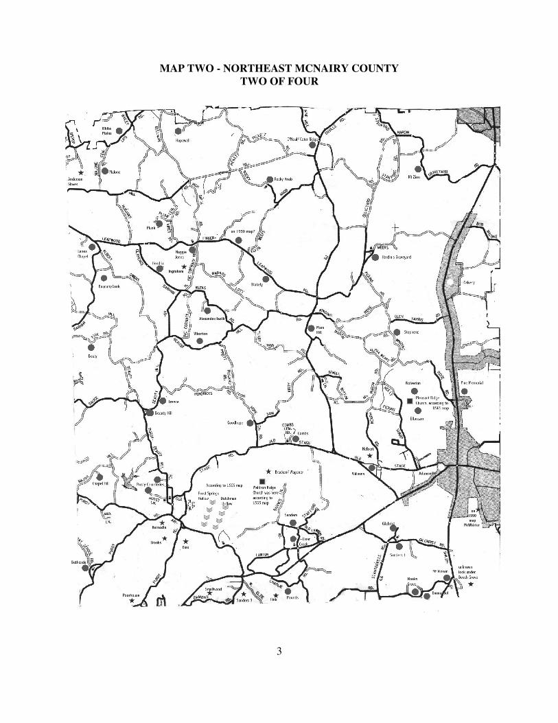
MAP TWO - NORTHEAST MCNAIRY COUNTY
TWO OF FOUR

4
MAP THREE - SOUTHWEST MCNAIRY COUNT
THREE OF FOUR

5
MAP FOUR - SOUTHEAST MCNAIRY COUNTY
FOUR OF FOUR

6
Interesting stories about single graves or unknown graves:
The Duke and Prince families came from Virginia to old Camden in 1834. Old Camden was located onthe Nashville to Memphis Stage Road, which is the vicinity of Rosecreek today. Edmond Duke and ElizabethPrice, a young couple, probably related, married before 1850. Elizabeth died young and, as she had requested, shewas buried on the hill so she could see her friends as they travel the road.
John Doles, at rest now, on that lofty place, one of the highest in western McNairy County, with shade trees,and people passing by. Should you ever visit the grave of John Doles, just west of the entrance to Big Hill PondState Park on Hwy 57 West, I think you will discover that his last wish was granted: “Bury me on that high hillyonder, so I can course the bees in the next life.” ( Roger Howell)
Albert Wolfe, about 85 years in 2002 lived on New Bethel Road west of Selmer. This is where he grew up. His father, Will, just let his hogs run free and once they got almost to Falcon and he went to look for them. There inthe woods he saw a sandstone sticking out of the ground and it said, ‘my brother.’ Will thought it was someonepassing through.
In south-western McNairy County, off the Felix Taylor Road about a mile, is one tombstone that says MaryKirk. She and her husband were walking one day and she saw the spot and said, ‘this is where I want to be buried.’When she died her husband buried her there, but he remarried and his second wife did not bury him beside her. Preston King thinks her dates were 1856-1898. About 100 yards before the intersection of Steadman Road and Sulphur Springs, on the right is 3 or 4graves parallel and right beside Steadman Road. This at one time was the old Boatman place but I have not foundanyone who knows who is buried there. Johnny Carlin says when he bought the place he planted buttercups on thegraves. The stone, or sandrocks were lost many years ago. There used to be a house there and Rayburn Carlin saidhe thought a child fell off the porch and died, but does not know if they buried it there. There was a dipping vatacross the road made of concrete where the cows, horses, dogs could walk down in and the up the other side. Thiswas pushed down when the road was made wider.
West of the intersection of Steadman Road and Sulphur Springs Road, in the hills is one single grave. Oraltradition says a man was passing through and died and they buried him there.
Wilma Woods tells me that Ariel and Mary (Polly) Hopkins built a home three miles south of old PleasantSite Church. He died in 1857 and Mary died after 1880, and according to family history are buried on a hillside notfar away. This could on their farm on it could be an unmarked grave at Spring Hill cemetery.
On a lone grave just off Beauty Hill Rd. Family passing through, stayed the night - wife got sick and died,they buried her and man and son went on.
There is a grave on what we call Michael Hill on Hwy 142. Behind the Gary Sander’s place. No otherinformation available.
This cemetery has not been found: Recorded in McNairy County Deed Book U, page 53: W J Null,administrator of John Null transferred 196 acres to the heirs of H. L. Lassiter, except for one acre to be used as aburial ground. Either this burial ground has been lost or it is the Mathis Cemetery. Information from BarbaraDavies.
Just off Hwy 57 on what is now Unity Road, a small graveyard that has been forgotten for many yearsconsisted of five to six graves of people that were killed in a storm. Louise Jones Teague told me when she was alittle girl they lived near this cemetery at the Shelton place.
It has been passed down through oral history that after the War Between the States, there was a make-shifthospital on what was then the Old Stantonville Rd in (now) Selmer. This site would be just above Walmart and wasalmost straight from Shiloh. It was also passed down the dead soldiers were buried in the fields west of MaxedonAuto Shop, closer to Hwy 45.
Off the Bethel Purdy Road, between Bethel Springs and Purdy is at least one unmarked grave. This is onprivate property and the owner stated he quit showing where the grave was because several time the grave was duginto. He stated how many graves were there originally is unknown to him but he was told when he purchased theplace that our first sheriff Henry Wilson was buried there.
In 2009, I found a little cemetery with three graves off Friendship road. After years of searching I finallyfound Mary E McCullar Ferguson. One day, a relative of a friend emailed and said he knew of an unknowncemetery and that Mary Ferguson was buried there. I checked and found Mary E Ferguson and two children buriedoff Friendship road on the old Horton place. A Horton descendant now owns the place and says oral history has it

7
that the house burned. It is unknown if Mary and the children died in the fire or not. I also know another Hortonthat used to live close to this site, and swore she had a ghost looking for a child? Mary died Jan 23, 1872. Nomarkers now for the children.
Adamsville Cemetery is located in the Town of Adamsville, on Main Street, about 3 blocks west the only red lightnear the First Baptist Church on Main St. If you are coming from Selmer it is on the left as you enter town.
Adams Chapel African American Cemetery is located between Ramer and Guys on Dickey Road. From Selmertake Hwy 45 South to the red light at the junction of Hwy 45 and 57 at Eastview. Turn right on Hwy 57 W and gothrough Ramer. Immediately after crossing the railroad turn left on Chewalla Road, go about 1 ½ miles and turn lefton Capooth Rd. About 2 ½ miles Capooth Road will intersect with Dickey Rd. The Church and Cemetery is about½ mile on the right on Dickey Road. It is a new cemetery beside the Adams Chapel Church and is maintained bythe members.
Alexander Cemetery or sometimes called Leath Cemetery - Take Hwy 45 N to Finger. Turn right on Hwy199/Finger Leapwood Rd. Go past the railroad and go about 5-6 miles and turn right on N McCormack Rd (just pastMaggie Jones Church and cemetery). Go about 2 miles to an intersections, go to the left on Weeks Rd about a mileand turn right on Hollins Lane. The cemetery is at the end of Hollins Lane. I have never been to this cemetery - notsure if it is easy to find. According to John Talbott, the cemetery is located on the old Alexander H. Ingrahamplantation. It has five marked graves and several unmarked. Albertine, wife of A. H. Ingraham 1821-1856;Catherine, wife of John A. Alexander, Oct 15, 1828 - Dec 23, 1903; John A. Alexander, Feb 15, 1821 - April 10,1893; Julius, son of J. B. and N. E. Leath 1894-1897; Jane Alexander, Feb 14, 1860 - Dec 9, 1892.
Anderson Slave Cemetery - according to John Talbott, “ is located on the old William T Anderson plantation” Thetwo graves belong to two of W. T. Anderson’s slaves, who died in a cabin fire. One was W. H. A. Anderson, theother is unknown. Both are marked with sandstones.” John also told me they were 8-10 unmarked graves. TakeHwy 45 N to Finger. Turn right on Hwy 199/Finger Leapwood Rd, go across the railroad and take the first road tothe left, Center Hill Rd. Almost immediately turn left on Sweet Lips Rd. Go a little over a mile to Bishop Lane. Goanother mile and turn right on Hillard Gann Rd. At the end of the road is the little cemetery. It is hard to find. Theway the crow flies about one mile north was where the Anderson family was buried.
Barnhill Family Cemetery is located in downtown Guys. Take Hwy 45 S toward the Mississippi State line. Just asyou enter into Guys City limits turn right on Guys Chewalla Rd, on top the hill. Just before you get to the railroadtracks turn left on S Gin Road, past the old Rinehart Gin. Just before you cross the tracks the cemetery is to the left. All known graves in this cemetery are Barnhill, except for Henry R Sharp, Oct 21, 1809 - Apr 25, 1875. Thiscemetery is unkept and hard to find.
Barnhill (Luke) Family Cemetery is north of the Guys Chewalla Rd, past Olive Hill Church.Take Hwy 45 S toward the Mississippi State line. Just after you enter Guys City limits turn right on Guys ChewallaRd on top of hill. Go pass the railroad 2-4 miles. You will pass Olive Hill Church and cemetery on the left, goabout ½ to 1 mile and there are some little field roads to the right. The cemetery is north of the road about a mile andwould be hard to find without help. It used to have a fence around it and has just a few graves. Luke Barnhill was ablack man and in 1920 is listed as Luther Barnhill, unmarried with three relatives living with him. I have beenunable to find anyone to take me to this cemetery since there are very few that know about it. There is also a white cemetery located very close to this cemetery, but it is unknown who is buried in this cemetery.
Baucum Cemetery - is located west of Leapwood about 3 miles on Leapwood Finger Rd. If you are in Adamsvilletake directions for Mars Hill Cemetery. Go north of Mars hill Cemetery about one mile and turn left on Hwy 199 orLeapwood Finger Road. Go about 3 miles and cemetery is off in the fields on the right side. All graves in thiscemetery are unknown.
Baucum or Beard, Cook Cemetery, is located just off Albert Owens Road near Finger. The cemetery is not listed

8
on a current map - so it is probably hard to find. John Talbott says a person would need help. From Selmer takeHwy 45 N to Finger, turn right on Hwy 199 (Finger Leapwood Rd). Go past the railroad and go about 2-3 miles. Turn right on Ed Barham Rd. Go about 1 mile. The cemetery is on the left. It is sorta in the triangle between EdBarham Rd, Plunk Rd and Albert Owens Rd. Dick White says buried in cemetery is Cook, Beard and Barham families. I hear different opinions about where this cemetery is. John Talbott and Albert Brown say off AlbertOwens Rd. Albert Brown says north of Albert Owns Rd. Dick White says off Ed Barham Rd. It is said that RobertNash dug the graves up the Cook Cemetery and re-buried in Hendrix Cemetery, which is parallel across the fields. Gary O’Neal says this is the Beard/Cook Cemetery and the Baucum Cemetery is on the Finger Leapwood Rd, justpast Maggie Jones Church. I have note, can’t remember the source that says Robert Nash was dug up and re-buriedin the Hendrix Cemetery. Maybe someone can come up with the real Baucum cemetery.
Beaty is a little family cemetery of William Beaty, John and Elizabeth Beaty and other relatives. It may be difficultto find because of the network of roads to get there. From Selmer, take Hwy 45 N to Bethel Springs. Turn right onBethel Purdy Road, go less than a mile and turn left on Wright St which will be Otis Plunk Road when you get out ofcity limits. Go about three miles where the road will fork and keep to the left on Ed Barham Rd. Go about 1 ½miles to cross roads and turn right on Bob Kirk Rd. The cemetery is about 1 mile on the right and well kept. KirbySchool was located near by. The road years ago was called Purdy Denmark Road.
Beauty Hill Cemetery has a half dozen ways to get there. One way is to take Hwy 45 N to Bethel Springs, turnright at Bethel Purdy Rd, go about 2/4 mile and turn left on Widsom St, take the first road to the right, which is RoseHill road. Go 2-3 miles where it dead ends into Limon Gauge Rd. Turn right here and go about 2 miles whereseveral roads come together. Another way is to take Hwy 64 E from Selmer, to the Airport Rd, about 4-5 miles. Turn left on Airport Rd and go about 3 miles, turn left on Purdy Beauty Hill Rd and go about 3 miles. The cemeteryis on your right is behind Beauty Hill Church in the Y of two roads meeting. About ½ mile from Beauty Hill on the
right side of the road is the Treece Cemetery.
Beech Grove Historical Church - I found this site recorded on a USGS map on the computer. It is the sameneighborhood that of an old cemetery long ago destroyed. Mr Orlan Watson, about 90 years old, told me on Hwy22 between West Shiloh and Adamsville in the Gilchrist Community was an old cemetery when he was a young mannear the gravel pit. It had many graves. Larry Watson, a distant cousin of Mr Watson, had also told me about thecemetery. He stated when the Hwy 22 was made the road crew was told to leave the cemetery but one of theforemen and several men went one night and dozed it down. If the cemetery belonged to the church is unknown. Ijust know they were in the same vicinity.
Bethel Springs Cemetery is located in the town of Bethel Springs, one block to the west of Main street, locatedbeside the Bethel Springs Presbyterian Church. This Church is one of the oldest continuing congregations inMcNairy Co. The building is old and very picturesque. The cemetery is old and the older markers are in bad shape,probably many have crumbled during the years. There are many unmarked graves.
Bethel Springs African American Cemetery is located on Wright Street in Bethel Springs (east of the railroad) was transcribed by Henry H. Sanders, Jr in 2003. He says the condition of the cemetery is poor and has about 40unmarked graves. This cemetery was started after the old cemetery was abandoned. The CME Methodist Church was started in west Bethel Springs but as families located to the east side of the railroad, the Church moved to theeast side and was re-organized in 1902. Also nearby is the New Bethel Methodist church formed in 1943. Some ofthe family names are Baldridge, Floyd, Sanders, Smith. T C Williams says some of the unmarked graves are: AdaMoore (maybe 1925), — Martindale the g g mother of Otis Floyd, George Ervin, Nannie Ervin (maybe Erwin orIrvin). Nannie has a tin marker, unreadable, Tom Roland, King Moore.
Bethel Springs Old Black Cemetery has almost been lost to time and elements. Years ago a CME Church waslocated on the west side of Bethel Springs near the cemetery. (Top off hill - just off Parkway St) Due to the fact thatmembers of this congregation slowly moved to the east side of town, the church was relocated east of the railroadand a new cemetery was started nearby. The known graves in this cemetery are, George & Betty Williams, FlossieMosley, Will Mosely, Bob Rowsey, Hattie Rowsey, Hattie Warren, Emment Warren, — Perkins, Charlie Cole,

9
Monroe Cole, Dick Pettis, Monroe Pettis, Clifford Williams, Ella Williams, Net Moten, Carline Moten, BettyPettigrew, Logan Floyd, Jim Wiley, Molly Wiley. (List supplied by T C Williams) Some of these people weremembers of the CME Methodist Church in the 1800's. Some nearly 40 more unknown graves according to T CWilliams. Several veterans are buried here. During the Civil War, Confederate soldiers dug a trench on a hill thatover looked Bethel Springs. The Union army moved in and took over. The Union Army stayed in Bethel Springsuntil the war was over. Several black soldiers died and was buried in this cemetery. There have not been any recentgraves in this cemetery. It is ‘growed up’ and most of the stones are broken. This is not a large cemetery now, butin times past it could have been quite large but ‘lost in time’ because of insufficient markers and settlement of thecommunity over a period of 100 years. This cemetery is located in Bethel Springs at the top of the hill on Parkway(to the left).
Bethesda is between Selmer and Old Purdy. Was first called Old Jopling Cemetery, the name changed afterBethesda Church was built there. The Church grew out of a brush arbor in the spring of 1893 at a little place calledCedar Grove about a mile from where the church now stands. In the fall, they organized a church and named itBethesda and built a small church at the intersection of two roads. In 1915, they secured more land which includedthe old Jopling Graveyard. Jopling was started as a family graveyard, the first known person buried there was babyMary Jopling in 1845. In Selmer, just south of the railroad is a street called N Railroad, turn east here. (If you aregoing south it is immediately after the railroad, turn left - if you are going north it is just before the railroad, turnright.). Follow this road around a sharp curve and go about ½ mile. Turn left on Bethesda Purdy Rd. It is about 3miles and you will see the old Church and cemetery. A few years ago, vandals pulled the John Jopling headstoneacross the woods and left it there. The family had a new one erected. About 1998 someone called and told me theoriginal Jopling monument was in the woods behind Twin Springs.
Bias Cemetery, near Purdy, probably a family cemetery, is a lost cemetery. Charles Brooks said when he wasyoung there were quite a few graves there. Charles died in 2006 and I had not located anyone that knows of thiscemetery until I talked with Ruby West. Ruby stated she remembered this cemetery because this is where hergranddaddy Smallwood lived but she says she does not remember going close or who was buried there. Ruby’s greatgrandmother Smallwood was a Bias before she married. Charles said is was almost at Purdy on Purdy Road about½ to 3/4 mile from the intersection of Purdy Rd and Airport Rd, to the east in the woods, maybe up to a mile.
Bickins Cemetery - see Floyd Cemetery
Bivins Cemetery - see Floyd Cemetery
Blakely, also known as Good Springs - This was a hard cemetery to find. Albert Brown said it was west ofLeapwood. Only one grave is documented: Celia Bell Cochran, born Feb 22, 1869 and died Oct 17, 1877. Foundin the D H Lott old family Bible: Good Springs: History of early settlers in McNairy County were Captain Robison,W S Wisdom, Bill Anderson, John Ingram, Jack Kerby, Johnson Walsh, Higgins, Ned Gatlin, Moore Robison, BigBill Robbins, Little Bill Robbins, Cooden Farith, Tom Farith, Bill Dires, George Waters, Tom Robbins, JoeRobbins, Ben Black Sharp, Ben Curtis, Major Smith, Frank Miller and Joe Johnson. John Robbins was laid to restin the Good Springs Cemetery in 1826 and in 1828 John Henry Burton. These two men were in the RevolutionaryWar. Captain Robison was laid to rest in the Sweet Lips Cemetery. According to Gary O’Neal, Charles ? Barham,born ca 1770's and died ca 1830's, right after settling in McNairy County is buried here along with his wife. Thomas and Margaret Blakely Barham may also be buried here. The Good Springs Cemetery/Blakely Cemetery islocated on the Finger Leapwood Rd (Hwy 199) approximately 1 and ½ miles west of Leapwood. (To get toLeapwood, see Mars Hill Cemetery.) This cemetery is shown on the 1990 map.
Brackin Cemetery, also called Wagoner, is north of the Lawton community. Take Hwy 64 from either Adamsvilleor Selmer to Old Lawton Rd (on the north side of Hwy 64) at the Lawton community. About where Old LawtonRoad begins to be a secondary road is Barnes Lane on the right. This is also a secondary road and may even be justa field or logging road, the cemetery is probably a little over a mile. The Robert Wagoner family is buried here. Only two graves are documented: John H. Brackin, born May 20, 1811 and died May 15, 1862; Martha S Brackin,born April 27, 1810 and died Sept 7, 1887. The USGS Maps shows Waldron Ridge Church served this area.

10
Breastworks - see Motley
Brooks Cemetery (1), south of Stantonville, see Thacker Cemetery for directions.
Brooks Cemetery (2) , almost at Purdy on Purdy Rd. about ½ to 3/4 mile from the intersection of Purdy Rd andAirport Rd. One can take several streets off of Poplar Ave in Selmer and will run into Purdy Rd several miles. Ifyou get to Airport Road, you have gone too far. It is on the left about ½ to 3/4 mile south of the intersection ofPurdy Rd and Airport Rd. The only headstone left is James Brooks, May 16, 1788-April 20, 1854. When AlbertBrown listed the cemetaries he showed 3 more marked graves: J P Smith, Infant Crowder (of G. H.) and Felix T., Oct 30, 1861 - Feb 11, 1880. There are 4-5 unmarked graves, probably the Brooks family. Jane Brooks, wife ofJames may be buried here also, since she is not listed in any cemetery book. She died between 1860 - 1870. JamesBrooks was the first man to build a brick house in Purdy.
Browder Cemetery has long been gone. On Hwy 142 ( take Hwy 45 south in Selmer, turn right in front ofWalmart) about 1.5 miles to the intersection of Hwy 142 and Brooks Rd. This used to be the old Stantonville Rd,that ran about .5 mile north of present Hwy 142. At one time Alyce Ladd says there was two tombstones Richardand Mary Browder. (Not sure still there now.) It is unknown to me if there were other graves there. Oxford Schoolwas back west about 1.5 miles, close to where the Baptist Church is on High School Rd. When Bobby Mask boughtthe farm from Whitten, it was called the Frank Browder Cemetery. Will Hockaday’s heirs state the graves werepushed into a gully or ditch. It is unknown if only Frank and wife Mary buried there or if there were more - OrlanWatson tells me there are about ½ dozen graves here.
Browder #2: Mr Watson, an old man in his nineties, came by office in December 2006 with information onthe Browder cemetery or should I say Browder cemeteries. As a young married man Mr Watson lived in the areathat now between Hwy 45 S in Selmer and Stantonville on Hwy 142. Before Hwy 142 was built the OldStantonville Road wound around the hills (mostly) north of the new highway about 1/4 to ½ mile. He told methere was three small cemeteries on the Old Stantonville Rd all in about 1 -2 mile’s distance. One was located offwhat is now High School Rd ( on Hwy 142, 1 mile from Walmart, turn left, and the cemetery was east of theFellowship Church. Years ago, when Mr Watson was a young man, he stumbled upon this cemetery while hunting. Maybe a dozen graves with self made monuments. He thinks some of the Howell family may be buried here sincethey owned much of the property in this area.
Browder #3, was close to the old Browder School and is behind what is today (2006) the Eddy Martinplace, originally a Hockaday place. He thinks this little cemetery might have been called Rock Springs and probablythe Browder family is buried here. This little cemetery was later fenced in as a hog pen and all the graves destroyed. List of people buried in Browder Cemetery, Hwy 142, Selmer, Tenn, behind what is now Jack ---- who operatesHockday Brooms: 1. Richard Browder: Born 1801, died 1885. Marker missing2. Mary Ann, wife of Richard: Born Aug 23, 1800, died Nov 20, 1874. Marker broken.3. Andrew Jackson Browder: Son of Richard and Mary Ann. Born ca 18314. Beam (Helbert) - wife of Franklin Browder. Died 1909. No marker5. John Browder, son of Andrew Jackson & Phoebe Caroline (Helbert) Browder, no markerThis may be everyone who is buried in the Browder Family Cemetery. There are some sand rocks which may markothers, perhaps slaves. (I am sorry I failed to write down who gave me this information.)
Mr Watson may be an old man, but his mind is still pretty sharp, so all we have his memory on thesecemeteries. In this description from Mr Watson, the school is called Browder. I have also heard Oxford schoolmentioned in the same vicinity. Don’t know if the two schools were at different times or the same school.
Brush Creek Cemetery is listed in Harold Cox’s Death Abstracts, but I have not been able to located it. The onelisted in this book is Martha Brock (her mother was a Faulkner.) Brush Creek Cemetery may be the Faulkner FamilyCemetery.
Buena Vista Cemetery and Church is located northwest of Bethel Springs. The church was started in 1857 andthe present structure was built around 1890. The oldest known grave is Ethel M Gust who died July 16, 1847. According to David Agnew, there are approximately 278 marked graves (in 1984). There are several unmarked

11
graves or those marked with sandstones. Bethel Springs is a ‘ no light town’ so you have to watch for the streetsigns. As you enter Bethel Springs from Selmer on Hwy 45 N turn left on Buena Vista Road. The Church andcemetery are about several miles on the left. If you’re on the 45 By Pass turn west on Buena Vista Rd and it is about3 miles at the intersection of Buena Vista Rd and Tull Rd.
Caffey Cemetery - See New Hope Cemetery
Calvary Church and Cemetery, also called Mud Creek, is located on Hwy 22 N in Adamsville on the right. From the red light on Main street about 4-6 miles.
Canady location unknown, read somewhere it was about 8-10 graves.
Carr, Coleman and Nethery Cemetery are all located together. They are located on Sulphur Springs Road about1-2 miles north of Hwy 57. There are two ways to find these cemeteries. (1) Take Hwy 57 through Ramer until youget to Sulphur Springs Road. Turn right on Sulphur Springs road and go 1-2 miles. Carr and Coleman will be on theright and Nethery will be on the left. (2) From Selmer take Hwy 64 West, turn left on Sulphur Springs Road. Goseveral miles, past the Sulphur Springs Church and then 3-4 miles. Nethery is on the right and Carr and Colemanwill be on the left. (If you come to Hwy 57 you’ve gone too far, turn around and go back about 1-2 miles.) Thecemeteries are hard to find. There may be an old field road where Coleman and Carr are. About 20 years ago, theNethery Cemetery was located on a dirt road that is no longer in use but may be visible. Good luck. Carr is a smallfamily cemetery.
Carter is located at Michie. Take Hwy 45 S from Selmer about 5 miles to the red light at Eastview. Turn left and go to Michie, several miles. Turn right at the cross roads of Hwy 57 and 22. Turn down the road beside Greer EggFarm (not in business any more) it will be about 1/4 mile on the right. I have wondered how this cemetery got itsname. There was once a Carter School here and as often was in the early days probably a church schoolcombination. The cemetery has been referred to as Carter Schoolhouse Cemetery.
Cave Springs Cemetery is located now in Chester County. At one time it was part of McNairy County. It may beon Hwy 225. See directions for Davidson Cemetery in Chester Co. Cave Springs is 2-3 miles north of DavidsonCemetery.
Center Ridge Church and Cemetery is just barely in McNairy County. Harold Cox says this cemetery is less than100 years old with the earliest grave being 1921. There are a dozen roads that will get you to this Cemetery. I neverbeen there, so I don’t the best way. Will tell you a couple of ways. (1) From Bethel Springs (Hwy 45 By Pass) , turnright at Buena Vista Road, go about 2-3 miles. The road will fork, keep the to left on Rowsey School Road, goabout 3-4 miles. Turn right on Center Ridge Road. In a short distance the Church and Cemetery will be on the right. (2) From Selmer, take Hwy 64 W about six miles, turn right at the Rosecreek Fire Station on Curtis Hill ChurchRoad. Go 2-3 miles and you will have to turn one way or the other on Rowsey School Rd, turn left. About a mileturn right on Center Ridge Rd. In a short distance the Church and Cemetery will be on the right.
Center Hill : See O’Neal Cemetery. At different times or by different folks it is called either name.
Chambers - There are four Chambers family and community cemeteries. One is near Acton by Chambers Creek.This is where a John Chambers settled and the name of the cemetery is now called White House cemetery. JohnChambers born ca 1814 is the first known grave at this cemetery. This cemetery was cleaned about 1998 and hasonly 15 markers standing and many, many unmarked graves.
Two other cemeteries are in the old Chambers community, north of what is now Hwy 22 and south ofShiloh, just barely in McNairy County and not too far, the way the crow flies, from White House Cemetery.
One, just off Hwy 22 is called Chambers Creek. The other cemetery is called Chambers Family cemeteryand just off Dillon road. The way the crow flies, there is possibly a mile between them. Both cemeteries are offHwy 22 just before it enters Hardin County.
The Chamber’s Creek Cemetery is a community graveyard with about 60 marked graves. Sam Chambers,

12
1804-1844, is buried here. In the Chambers family cemetery, there are only 20 marked graves, all Chambers and Ross. A J Chambers,
born 1818, is buried here.The fourth cemetery is Chamber’s Chapel, a black cemetery located in the McNairy community. There are
several graves in this cemetery.
Chambers Family Cemetery is close to Pebble Hill community. Take Hwy 45 S from Selmer, turn left at the lightat Walmart on Hwy 142, Go to the crossroads at Stantonville and turn right on the Michie Pebble Hill Rd. Goseveral miles, and enjoy the scenery as you go. You will see a sign that says Pebble Hill Church. Turn left onHarrison Rd. Go about 2 miles, the cemetery is on the right. If you get to Joe Dillon Rd you have gone about 1/4mile too far.
Chambers Chapel African American Cemetery located in the McNairy community. At one time there was achurch and school combined here. It was destroyed by a tornado in 1943. Take Hwy 45 N through Bethel Springsand turn right on McNairy Rd. Go across the railroad and immediately turn right. Go a short distance and theChambers Chapel road will go the left. The cemetery is on this road, on the right, on a little hill. It is a well keptcemetery and according to T. C. Williams it may not can be seen from the road but will be fairly easy to find. Thiscemetery was transcribed by Mozella Baldridge in 2003.
Chambers Creek is almost in Hardin County, just north of Michie. From Selmer, take Hwy 45 S to Hwy 57. Turnleft on Hwy 57 and go about 9 miles to Hwy 22. Turn right on Hwy 22, go about 1 ½ miles. Turn right on Chambers Cemetery Lane.
Chenault Cemetery - see Richards Cemetery
Chapel Hill cemetery is located east of Bethel Springs. From Selmer, on old Hwy 45 going through Bethel Springsturn right on Bethel Purdy Rd. Go 2-3 miles and turn left on Major Hill Rd. About a mile, turn right on Chapel HillLane. The cemetery is at the dead end. Years ago, even as late as 1916, the Old Stage Road went from Purdy toBethel Springs and Old Chapel Hill and School was located about half way between. There was a New Chapel Hill alittle closer to Purdy. The cemetery was located closer to the Old Chapel Hill Church. That road has beenabandoned years since and it would take an expert to probably trace the road from Bethel to Purdy. If you want tohear some good ghost stories, check with the people that live nearby.Mr. Orlan Watson, ca at least 90 years old came to my office December 2006 and told me this information. Justbefore the Chapel Hill cemetery was a small cemetery (on the same side of the road) with about a dozen graves. In1964 the man grading the roads just went off the road and dozed all the graves down. Mr. Watson was the RoadCommissioner at that time and he stated he got in a lot of trouble for that incident and the man operating the roadgrader never gave an explanation as to whey he did it.
Clear Creek for the older cemetery - see Old Clear Creek Cemetery
Clear Creek Baptist Church and Cemetery is located in the Lawton community just off Hwy 64 between Selmerand Adamsville. See Old Clear Creek for brief history of the Church. The Church moved to the Lawton communityin 1927 on land given by Dr H C Sanders. Ed Wagoner was the first person to be interred in our cemetery in 1949says Mary Nell Browning and Ira Tidwell was the second in 1950. From either direction on Hwy 64, turn north onCrabtree Road and in short distance you will see the Church on the right.
Coats Family Cemetery is located north east of Moore’s School House off of Hwy 64 W, on what is now JohnMoore Rd on the old John T Moore farm. This farm is still in the John Moore family. Four known graves of theCoats family.
Cobb Cemetery is north of Stantonville, just outside city limits, on Gilchrist Stantonville Rd. Take Hwy 45 fromSelmer, turn left at the light at Walmart on Hwy 142. Go to the crossroads at Stantonville and turn left on GilchristStantonville Rd. Go around a deep curve and city limits will end in less than ½ mile. The cemetery is about two

13
hundred yards north of the Clear Creek bridge on the right side (or east side) of the road. Fairly close to road. Information from Bill Wagoner. Little is known about this cemetery. Albert Brown lists only one grave, first nameunknown
Coleman Cemetery - Carr , Coleman and Nethery Cemetery are all located together. They are located on SulphurSprings Road about 1-2 miles north of Hwy 57. See instructions for Carr Good luck. Charles Stuck, Jr visited theColeman graveyard in 1974. A Mr. Will Steadman gave him a grand tour and stated he remembered as a child therewas about two dozen graves, all of them very old. He was told this was an ‘outlaw graveyard’ and that irregularburials took place. He heard that Robert Murrell, the famous outlaw, roamed these woods and may have hidden outhere from time to time. Only two stones remain: Calvin Coleman 1815-1872 and Jane Coleman 1828-1897. Mr.Steadman said this could be referred to as an old community cemetery, maybe as the Old Otterville Cemetery. Depending on the time, the surrounding community was once called Neathery and once called Ottersville. AlbertBrown list two people in Coleman, Calvin and Jane Coleman.
Coln Cemetery is located in the southeastern part of McNairy County, almost at the Mississippi line. Take Hwy 22S out of Michie. Turn right on John George Loop. The cemetery is on the right about 1/4 mile. Fort FamilyCemetery is about 1/4 mile further. Coln family is mostly buried here.
Combs cemetery is also called Union Grove.
Concord is a family cemetery with Hookers and Millsaps graves. I have not determined the relationship, if any, ofthe Hookers and Millsaps. Take Hwy 45 S toward the Mississippi State line. Just after you enter Guys City limitsturn right on Guys Chewalla Rd, on top of the hill. Go across the railroad. It is about a mile pass the railroad in thewoods on left. It is hard to see because you have to look back through a clearing in the trees. It is near the oldFinely James home place. Daddy always meant to take me but we just never got around to it. Hooker is one of myfamily lines.
Confederate Cemetery
Cook Cemetery is also called Baucum/Beard Cemetery. .
Curtis Hill Church and Cemetery sorta north of the Rosecreek Community. From Selmer, take Hwy 64 Westabout 7 miles, turn right on Curtis Hill Church Rd at the Rosecreek Fire Station. The Church and Cemetery are 1-2miles on the right.
Davidson Cemetery is just over in Chester County but was part of McNairy County until the 1880's. It is a familycemetery on Hwy 225. From Selmer, take Hwy 64 W, about 9-10 miles, almost to the Hardeman County line. Turnright on Woodville Rd. or called Hwy 225. About one mile the road will intersect with the Carl Whitten Road, takea right here (you are still on Woodville Rd or Hwy 225). About 2 miles and you will cross over into Chester Countystay on Hwy 225 about 5-6 miles. Davidson Cemetery is on the right. Another way is go north of Bethel Springs onHwy 45N, turn west at Refuge Road. When Refuge intersects with Hwy 225 turn right and Davidson will be closeon the right. Hwy 225 is called Woodville Road in McNairy County, I am not sure of the name in Chester County. Cave Springs Cemetery is on this same road a few miles on the left.
Deming Cemetery - is a family cemetery located near the Cypress Church of Christ. This little cemetery wasdocumented in 1969 by Faye Tennyson Davidson and Margueritte Halcomb Boyd. The condition of this grave site isunknown and may be hard to find. To find Cypress Church of Christ, take Hwy 45 S from Selmer to the junction ofHwy 45 & Hwy 57 at Eastview. Turn right (west) on Hwy 57, go through Ramer 3-4 miles and going up a small hillyou will see a sign on the left that says Cypress Rd. Turn on this road. The Church is about 3 miles on the right. The known buried there are: Mary L. Deming, May 25, 1808 - Nov 21, 1891; Dames W Deming, Dec 11 1823 - Oct28, 1902; Mary C Deming, Nov 15, 180 - Feb 19, 1905; John W Deming, Feb 22 1865 - Feb 27, 1950; Lou LDeming, Nov 9, 1864 - Mar 11, 1934; Oliver Lewis, 1868-1906; Eliza Deming Lewis, May 14, 1870 - 1917. Takenfrom Harold Cox’s Cemetery Records.

14
Dunn Cemetery is located in the northern part of the county. Have not been able to locate it enough to givedirections. It is on the USGS maps. It is probably known to as another name.
Dunaway Cemetery on Steadman Road, west of Selmer, is also called the Thompson Cemetery. At Selmer takethe 45 Bypass West, turn left on new Bethel Road, go several miles to a fork in the road, keep to the left which isSteadman road. About 1-2 miles on the right in the cow pasture is the cemetery. Be careful - you may not can runfaster than a bull. This cemetery is located on the old Dunaway place. Albert Wolfe says he thinks John D. Forsytheis buried here. One of the cemeteries called Dunaway, was behind the old home place of James Dunaway built byhis father in 1880.
Dunaway Cemetery - see also Hicks Cemetery
Eastview Cemetery - This is the is a new cemetery behind the Eastview Baptist Church on Hwy 45 South inEastview. The Eastview Church was organized in 1982 with 16 charter members. The Church is rustic andcharming setting in a grove of trees on the right. The new cemetery is behind the building
Ebenezar is located north of Adamsville and close by is Wolverton Cemetery. It has also been called the FarrisCemetery or the McFall Cemetery. Take Hwy 22 North (or called N Maple St) at the red light in Adamsville. Goabout 1 ½ mile and turn left on Winding Ridge Rd. Go about 2-3 miles and on the left will be a small gravel roadwith a gate. (Glenn Gohr says if you see the Fox Hunter’s building on Winding Ridge Rd you have gone too far,turn around and go back.) It is about a mile down the small road to Wolverton Cemetery which is on the left andonly has a few markers. About ½ mile on down the road is Ebenezer Cemetery on the right where the little roaddead ends. Glenn Gohr says there are about 30 graves in Ebenezer Cemetery which include members of theWilliams, McFall and Farris families. At one time there was a church by the name of Old Ebenezer. According tothe 1916 map the surrounding area was Pleasant Ridge Church and Union Grove Church.
Emmanuel Tabernacle is a new cemetery, started about 1990 located on the Tommy Sanders Road betweenStantonville and Adamsville. From either town, take Hwy 117 (or called Shiloh Adamsville Rd.) The TommySanders Road is just about half way. Turn west on Tommy Sanders Road and the Church will be about one mile onthe left. From Adamsville, Hwy 117 is south at the red light. From Stantonville, take Hwy 142, almost to the HardinCounty line, Hwy 117 is at the West Shiloh community and turns north.
Erwin Family Cemetery. On Hwy 142 just west of Stantonville City Limits. From Selmer, take Hwy 45 S. Turnleft in front of Walmart on Hwy 142. About 5 miles. Start look after you pass the sign that says Mt Zion CemeteryRoad on the left, the Erwin Cemetery is a short distance behind a private residence. This Cemetery has not beendocumented in any Cemetery Book.
Estes Cemetery is now in Chester County but once was in McNairy County. Take Hwy 45 North into ChesterCounty, about 1-2 miles and turn left on Montezuma Road. The cemetery is immediately on the right. Across Hwy45 is the Estes Church of Christ and the new cemetery is behind the building. The new cemetery is not consideredpart of McNairy County heritage.
Eureka Cemetery is located in the Southwest part of the county, almost on the Hardeman County line. Take Hwy57 W from Ramer and turn right on the Vernie Kirk road (on top of the hill) . If you get to the Hardeman Countyline, turn around and go back, you went too far. The cemetery is on the right just about 3 - 4 miles and is visiblefrom the road.
Falcon Cemetery is located across the road from the Falcon Baptist Church. The Falcon church was organized in1910 in the Falcon schoolhouse. John Brooks gave the land for a new church. When the cemetery was started,Falcon was a thriving little town under the hill on the railroad. Those people are all gone and those that rememberthem are gone. All that’s left are those on the hill. From Selmer take Hwy 45 S, after you pass all the little fast food

15
places, Falcon Road will be on the hill on the right. Turn. About ½ mile the road will fork, keep to the left and soonyou will see the Church and cemetery. (When going down Hwy 45 S, if you get to Walmart - you’ve gone to far -turn back.)
Farris Cemetery was once located off Stafford Bottom Road, on a ridge. There were approximately 15 graves thatwas bull-dozed away when clearing the land. This road was once called the Farris Stafford Rd. It is unknown who isburied in this cemetery. Information by Jai Templeton. Not shown on map.
Faulkner Cemetery is located in the southwest part of the county, between Guys and Chewalla, on the old FaulknerRoad just before you go into Mississippi. Take Hwy 45 S toward Mississippi. Just as you get into Guys City Limits,turn right on Guys Chewalla Road on top of the hill. Go past the railroad and turn on Gay Thompson Road. Keepto the right at the fork ( Trantham Road goes to the left.) The cemetery is on the right on private property just beforeyou go into Mississippi.
Fellowship Church Cemetery is a new cemetery. It is located on High School Rd in Selmer. The easiest way to findthis church and cemetery is go Highway 45 S from Selmer to Walmart. Turn left in front of Walmart and go onemile. High School Road will be on the left. The Church and cemetery are about ½ mile on the right.
Finger Cemetery is located in ‘downtown’ Finger next to the Finger Baptist Church. Easy to find. Take Hwy 45 Nto Finger, turn right on Hwy 199/Finger Leapwood Rd. About 2 miles you will see the Church and cemetery on theleft. John Talbott says “ The Finger Cemetery began with the burial of Andrew J. Maness in October of 1913 onJames R. McIntyre’s farm. Before the burial, Zanie Brown and Harmon Hodges had to clear blackberry bushesaway in order to dig the grave. Shortly after the burial, James Robert and Fannie McIntyre deeded half an acre forthe use of a graveyard, on Jan 5, 1914. In 1921, just three weeks before his death, James R. McIntyre deeded anaddition to the cemetery.
Fink Cemetery. This cemetery is just south of Hwy 64 at the Lawton Community. It is located on Charlie Poundsroad, just south of Hwy 64 East at Lawton. Take Hwy 64 from Selmer or Adamsville and watch for Charlie Poundsroad on the south side. It is about ½ mile on the right and is off in the woods and probably hard to find. Poundscemetery is closer to the road.
Floyd Cemetery is a cemetery between McNairy and Finger. From Selmer, take Hwy 45 N through Bethel Springs. About 10-12 miles turn right on Smith Rd. If you get to Finger city limits, you have gone to far, turn and go back. Go less than a mile and turn left on Ward Lane. Floyd Cemetery is at the end of this lane. John Talbott says thecemetery is unkept with about 40 graves. Sometimes this cemetery was also called Bivens or Bickins.
Forgotten Cemetery (my name for this cemetery) was located about a mile east of Falcon behind what was theHenry Watson home place. Larry Watson says maybe 30 graves. Henry Watson and his son Johnny Watson livedside by side and it was thought the old cemetery was behind only the Henry Watson house. However in the 1980's aman came from Alabama and stated he wanted to see his brother’s grave and he walked to a spot behind Johnny’shouse, making the cemetery larger than they had realized. Larry Watson states when he was a child remembered seea couple of monuments across the road. So the size of this forgotten cemetery could be large. Mrs Annie Westbooks,born 1917, states she walked by this cemetery as a child going to school and it was large (at least in a child’s eyes)and the markers went down to the road. One day she passed by and they had started building a house there and sheasked her daddy why a house was built in the cemetery. I asked Miss Annie if this was a black cemetery or whitecemetery and she stated it must have been a white cemetery since her parents never told her anyone buried there. Johnny Watson called and told me about the cemetery but he died before I could get by to see it. He stated thetombstones were already gone by the time he moved there. I called many people about this cemetery, a few knewabout it but never saw the tomb stones and some that lived in the neighborhood didn’t know anything about it. Several stories were told why the monuments were missing: (1) Someone pushed the monuments into a gully (2)someone loaded the monuments and carried them away. The ground was cultivated for many years and about 2000part of the soil was taken and placed in the gully where Burger King now stands. It is my opinion this cemetery hadits beginning before Falcon Cemetery was started in 1885. This area in the early days was close to what was called

16
Oxford Creek. John Henderson was buried on his land which was behind Walmart about ½ mile south of thiscemetery. Some families living in and around this area were Forsythe, Ray, Browder, Alexander and Basinger. Remember an area was usually about a three mile circle. It is sad that nothing has ever been recorded about thiscemetery and those who died are forgotten
Fort Cemetery - is a very small family cemetery close to Coln Cemetery in the southeastern part of the county. Some have called this the Mason Cemetery. Take Hwy 22 S from Michie toward the Mississippi State line. Turnright on John George Loop. Coln Cemetery is about 1/4 mile on the right and Fort Cemetery is about 1/4 a milemore. There are about six graves in this cemetery. It is documented in Albert Brown’s Cemetery Book as MasonCemetery. Pat Jones and Barbara Guess documented this cemetery:
unknown Oct 3, 1865 - no death date unknown Oct 25, 1815 - Oct 27, 1869Elias M. Fort Jan 25, 1843 - Aug 2, 1866 Lucy A. Fort Oct 25, 1815 - Oct 27, 1869Francis Mason 1791 - Oct 24, 1860 Thomas Mason April 24, 1818 - Oct 3, 1865Francis Price Aug 20, 1836 - Feb 1, 1862 Mary G. Winn — 22, 1809 - Mar 29, 1867It is odd that all these people died in the 1860's.
Friendship Church and Cemetery is located between Ramer and Selmer on Friendship Road. Nancy McClaintells that on September 2, 1907 a group of people decided to build a church at the Old Friendship Graveyard. Thisbuilding was to serve as a meeting house for all denominations and be used for a school if needed. The land wasdonated by John Reynolds. Two ways to get there. (1) Go to Ramer on Hwy 57 W. Go across the railroad tracksand turn right on Friendship Road. Friendship Church and Cemetery are on the left about 3 miles north of Ramer onFriendship Rd. (2) In Selmer take the Bypass West. Turn left on New Bethel Road. Always keep to the right atany fork until you come to Friendship Rd which forks to the left. The Church cemetery is about 4 miles on the right.The first known Church documented here was in 1907 according to the Friendship Church minutes, said they ‘built achurch at the Old Friendship Cemetery.’
Gilchrist Cemetery is about 500 yards down the road and across from Mt Sharon Church in the old Gilchristcommunity east of Adamsville. From Selmer take Hwy 64 toward Adamsville, about 8-10 miles and turn right onGilchrist Stantonville Rd. From Adamsville take Hwy 64 toward Selmer a short distance out of city limits and turnleft on Gilchrist Stantonville Rd. On Gilchrist Stantonville Rd go to the crossroads and turn left on Mt Sharon Rd. The church is immediately on the right and the cemetery is a little further on the left.
Gilmer - or Gilmore, in the early days they said Gilmer. Albert Brown calls this the Singleton Cemetery, but I thinkit should be called the Gilmer cemetery. Two young men are Singleton, the two older ones are William andSusannah Gilmer or Gilmore. The branch that runs right behind this cemetery is called Gilmore Creek. This graveyard is what was the 1st district in 1850.
The four stones say: Willaim Gilmer born in NC July 1, 1785 Susannah, wife of William Gilmer born NC,died in Tenn, Aug 3, 1871. (This could be Aug 8.) In 1870, they are living with their son John. Two Singletonchildren of Redden and Margaret Singleton. William C born June 5, 1853, died Jan 22, 1854. Charles L, born Nov28, 1859, died Sept 26, 1865. There were possibly 12-15 graves marked with sand rocks.
William Gilmore will’s was proven in McNairy Court 1874. He names his two daughters:Margaret wife of Reddin Singleton and Sarah Elizabeth, wife of John Ramer. Although one of the Singleton childrendied in 1865, I have not found Redding and Margaret in McNairy county after 1850. They are not in HardemanCounty in 1860, but she is still living when her father died. Ethel Lowrance, who was raised in this neck of thewoods, says it was probably a little community cemetery. She doesn’t remember anyone telling her that a Churchwas there at any time. Albert Wolfe was familiar with this cemetery and he said a Gooch descendant told him thefirst wife of Thomas Gooch was buried here. Later Thomas moved over toward Mosses Creek and he is buried inGooch Cemetery.
To get to this cemetery - At Selmer take the 45 Bypass West, turn left on new Bethel Road, go several milesto a fork in the road, keep to the left which is Steadman road. About two miles on the right side. It’s not hard to find- if you know where to look. Today, May 24, 2002, There is a spot to pull off the side of the road and the old fieldsare gown up with trees about 5-6 feet tall. There is a sign that says “no dumping.” Go in a northwesterly directionup a small rise about 100 feet. If you get to Sulphur Springs Road, you have gone too far. Turn and go back and it is

17
1.2 miles on the left.
Gooch Cemetery - See Mosses Creek
Good Hope Church and Cemetery is northeast of Old Purdy. From Selmer, take Hwy 64 East several miles,almost to Adamsville City limits. Turn left on Leapwood Enville Road (or called Hwy 224). About 3 miles this roadwill fork, bear to the left on Old Stage Road for 2-3 more miles. Turn right on Good Hope Church Road and theChurch and cemetery will be on the left about ½ mile. There are shorter routes from Selmer, but several roadchanges. If you have a map you can choose a closer way.
Good Springs Cemetery - see Blakely Cemetery
Gravel Hill is an old cemetery in the Gravel Hill Community. Gravel Hill used to be a thriving little community inthe southern part of McNairy County. When they built Hwy 45 it just died out, all that remains is the two Churchesthat shared the cemetery. (Note: August 2006 the Primitive Baptist Church does not have a congregation. It makesfor a sad tingle in the heart. This Church was a big powerful Church for about 150 years, but as the Primitive Baptistdenomination diminished, so did this church.)
The Concord Primitive Baptist Church was started in 1832 by the Gooches and Teagues from Mosses Creekon land given by Ezekiel Springer. The community cemetery was probably started after the Primitive BaptistChurch. The first known grave was 1851. In 1867 a group of people left the Primitive Baptist and built a church afew hundred feet away on an acre of land given by J M Huggins.
In the old part there are a lot of vacant spots alluding to the fact there are 30-40 unmarked graves. Two unmarked graves are Josiah Jordan Dec 1838- July 3, 1912 and his first wife Cyrene C Huggins Jordan April 3, 1839-Jan 3, 1896 (or in the Huggins Cemetery) . Some say Josiah is buried next to his second wife Rosa Springer but Ido not know that for a fact.
From Selmer, take Hwy 45 S about 5-6 miles. Turn right on Gravel Hill Road. About 1-2 miles you willgo around a slow curve and will see the old Primitive Baptist Church on the left. The cemetery is on both sides ofthe road. To go on to Huggins cemetery from here, go past Gravel Hill Missionary Baptist Church (south) about 1/4mile, turn left on a small road and Huggins cemetery is just a short distance.
Griswell Cemetery is located just south of Finger. Take Hwy 45 N to Finger. Turn right on Hwy 199/FingerLeapwood Rd. Go across the railroad and go about 1 ½ - 2 miles. Turn right on Payne Rd. According to JohnTalbott “the Griswell Cemetery was located on the old Dan C. Griswell farm. Two graves have standard tombstonesand twenty have sandstone markers. Most of these graves are probably the Griswell family. Those marked areMatilda G. Plunk, wife of J. A. Plunk Aug 1827 - March 11, 1852 and Sarah Phillips wife of Isaac Phillips, Feb 10,1803-April 10, 1863. Others are Daniel C. Griswell, Aug 1865- 1938; E. R. Griswell father of Daniel, born 1821and died before 1900; Margaret S. Griswell, wife of E. R., born 1833 and died after 1900; Daniel Harwood Barham,Nov 11, 1811 - 1860; Mary Penina Shelton Barham 1816-1873. It is also thought that J. A. Plunk and Isaac Phillipsare buried in Griswell Cemetery.” Gary O’Neal says Daniel Harwood Barham is buried here. He was born 11-11-1811 and died ca 1860. He got too hot working in his brick kennel and died at about age 49.
Guys Cemetery is located in the old part of Guys City Limits. This cemetery has been called the Sharp Cemeteryand the Houston Cemetery. The first grave was George Houston, age six in 1878, the son of Robert & Irene MichieHouston. Take Hwy 45 South toward the Mississippi line. Just as you enter into Guys city limits turn right on GuysChewalla Road, on top of the hill. When I was a kid we called this Smith Hill because there was a Smith Store there. Turn left at the community center on Farmville Road. The cemetery is almost immediate. On top the hill in theshade of a large tree.
Haltom’s Chapel Cemetery is located in Chester County. Was originally in McNairy County.
Hamm Cemetery is a cemetery that no one knows exactly who is buried there. That it’s name is Hamm has justbeen passed down from generation to generation and very few know of this cemetery. I never remember my motheror grandparents tell of this cemetery when I was a child. I’ve been by there hundreds of times and never saw a

18
cemetery, apparently the only markers were sandstones. Some people think John and Phoebe Hamm could be buriedin this cemetery. It was a small cemetery.
It is also speculated that the children of William and Rachael Huggins Hamm are buried in this cemeteryand maybe other relatives. They lost five children (young adults) between 1849 and 1852. Those thought buriedthere are: Thomas Hamm, April 17, 1851 and maybe his wife Martha Atkins who died before 1860; Phillip Hamm,May 11, 1851; Manerva Hamm, July 28, 1851; Jasper Hamm, Sept 10 1849; and Carroll Anderson Hamm 1852. William and Rachel moved to Arkansas before 1860, a place thinly populated and disease had not conquered.
The cemetery is located about a mile from the Gravel Hill Cemetery on the New Hope Rd.It is on private property, in a wooded area. Take Hwy 57 E at Eastview and turn right on New Hope Road. It isjust before New Hope Road and Mayflower Road intersects.
Hardin’s Graveyard Church and Cemetery is located in the Leapwood community in the northeastern part of thecounty. The markers were destroyed many years ago and there is no records showing those buried there. The nameof the Church is Solitude Freewill Baptist Church. Take Hwy 64 E to Adamsville. Just before you get to Adamsvillecity limits, turn left on Hwy 224/Leapwood Enville Rd. About 2-3 miles there will be a fork in the road, keep to theright. Go 4-5 miles and turn right on Hardin Graveyard Rd, go about 3 miles and turn right on Finley Rd. Thechurch is at the triangle of Hardin Graveyard Rd. Finely Rd and Meeks Rd. The Church is on one side and thecemetery is on the other. From Finger, turn off Hwy 45 N at the Finger Leapwood Rd (or Hwy 199, go about 15miles to where the road insects with the Leapwood Enville Rd (or Hwy 224). Go across Hwy 224 and the road namechanges to Hardins Graveyard Rd. Go about 2 miles and you will see the cemetery.
Head Family Cemetery is located in the southwest part of the county. Take Hwy 57 West out of Ramer . Turnright on Dan Head Road. The cemetery is just off the Hwy. According to Harold Cox there are only four graveshere, and only one has a marker.
Helbert Cemetery is north of the Hickory Flats community, in the woods and hard to find. Bill Wagoner says it is agood size cemetery. From Adamsville, take Old Stage Rd (by First Baptist Church)about 2 miles to Puron Road . The cemetery is somewhere in the corner of Old Stage Rd and Puron Rd.
Henderson Albert Brown says south of Hively Rd in Selmer. We don’t have a road by that name any more. Thelone monument of Captain John Henderson, Penn Militia Rev War, born Nov 30, 1756 and died Feb 20, 1840 islocated behind Walmart. It is thought this was just a single monument but there maybe others in unmarked graves.
Hendrix is located southeast of Finger. Take Hwy 45 N to Finger. Turn right on Hwy 199/Finger Leapwood Rd. Go across the railroad and immediately turn right, still on Finger Leapwood Rd. Go about 5 miles and turn right onClarence Barham Rd. A little over a mile, the graveyard is on the left.
Hester Family Albert Brown says this cemetery is on Salem Road near Bethel Springs, but it is not documented.
Hicks Cemetery. According to Winifred Browder, this cemetery may also be called the Dunaway Cemetery orWallace. It is located on the Warren Floyd Rd, west of Selmer. Take Hwy 64 W out of Selmer about three milesand turn left on Sulphur Springs Rd. About ½ mile this road will fork and you keep to the right which is Hines GinRd (in past times it was called Hunter’s Store Rd). Go 2-3 miles and turn left on Warren Floyd Rd. Just a shortdistance and the cemetery is on the right. William Pinkey Dunaway is buried in this cemetery. One of thecemeteries called Dunaway, was behind the old home place of James Dunaway built by his father in 1880.
Hopewell Cemetery is in the northern part of the county, just barely in McNairy County. In 1940 the name of thecommunity was called Poplar Springs. Take Hwy 45 N to Finger. Turn right on Hwy 199/ Finger Leapwood Rd. Go across the railroad and immediately turn right, still on Finger Leapwood Rd. About ½ mile, turn left on CenterHill Rd. Go 5-6 miles and turn left on Bullman Rd. Go about 2 miles and turn right on Hopewell Church Rd. About 1 mile will be a little lane to the right called Hopewell Church Lane. The cemetery is here.

19
Houston Family Cemetery is an old cemetery and it is thought Revolutionary War soldier Archibald Houston wasburied there in 1836. A marker was put there for Houston. Take Hwy 45 to the Junction of 45 and 57 at Eastview. Turn right on 57 and go about 1 mile to Houston Cemetery Road. The cemetery is about 3 miles on the left in afenced in area.
Huggins is an old family cemetery at Gravel Hill. From Selmer take Hwy 45 S until you get to the red light atEastview. Turn left on Hwy 57. Go about 2 miles, turn left on Tom Baker. About 3/4 mile is a little road to the left. The cemetery is down this little lane not too far from the main road. For another way, see instructions on how to getto Gravel Hill cemetery. If you have ancestors buried in Huggins cemetery, you probably have some buried atGravel Hill. In the summer of 1994, a confederate monument was put in Huggins Cemetery for James MonroeHuggins. Huggins was a private in Newsom’s Tennessee Calvary of the Confederate Army.
Hughes Cemetery has six unmarked graves. Jerry Boatman told me about it. At one time the graves had flint stonesfor markers but someone came in one day and got them all. The Cemetery is on Locke Rd, in western McNairyCounty. From Selmer, take Hwy 64 W. Go 3-4 miles and turn left on Sulphur’s Springs Rd. Go several miles, youwill pass the Sulphur Spring Church on the left and the next road on the right will be Lock road, turn here. Thecemetery is is about 1.5 miles on the left, about 300 yards from the road behind an old house. James L. W. Boatman(1830-1909) owned this land years ago and it is owned today be a descendant, Jerry Boatman. After old James’ firstwife died he married Levicie C. Hughes in 1872, the daughter of Charles and Lucinda Hughes. The Hughes livedtwo doors away from the Boatmans. It is possible it is Levicie Hugh Boatman’s family buried here. It is alsopossible that she is buried here because she died before 1880 and is not documented.
Hunter Cemetery, also called Knight Cemetery. The old Hunter’s community was formely Knight communitybecause Knights lived there before the Hunters did. Take Hwy 64 West from Selmer 3-4 miles. Turn left atSulphur’s Springs Road. About ½ mile the road will fork, bear to the right on Hines Gin Road. The cemetery isabout 4 miles on the left beside the Hunter Church. According to Harold Cox, there are several unmarked graves
Hurst Cemetery was once a part of McNairy County but is now in Chester Co. From Selmer, take Hwy 64 W,about 9-10 miles, almost to the Hardeman County line. Turn right on Woodville Rd. or called Hwy 225. About onemile the road will intersect with the Carl Whitten Road, take a right here (you are still on Woodville Rd or Hwy 225). About 2 miles and you will cross over into Chester County stay on Hwy 225 about 2-3 miles, turn left in frontof Little Hatchie Church and Cemetery. It is less than a mile to Hurst Cemetery.
Indian Creek Cemetery is in the southwest part of the county north of Chewalla. It is located by Little IndianCreek. The best way is go to on Hwy 57 West to Ramer. Just after you cross the railroad tracks turn left onChewalla Road. Go several miles, almost to Chewalla, and turn left on Indian Creek Cemetery Road. The cemeteryis on both sides of the road. Barbara Coke Laffoon tells me that she has one ancestors buried here in unmarkedgrave. Louis Caste Austin is buried toward the edge of the cemetery. His wife Sarah Mask Austin Graham isburied somewhere in the Oak Grove Cemetery.
Ingle Cemetery. There are two Ingle cemeteries. (1) One is located in McNairy County and (2) one is just over inChester County but at one time was part of McNairy County. Ironically, when you look at a map, the two are almostparallel, north and south, with about 3 miles between.
Ingle Cemetery (1) From Selmer, take Hwy 64 West about 6-7 miles, turn right on Mt. Gilead Road. Go about amile. The cemetery is just off the road on the right about 250 yards. Harold Cox says this cemetery has not beencleaned in many years. There are about 75 unmarked graves. Harold Cox documented this cemetery years ago.Charlotte Holloway gives additional W M Rogers, COA 6th Tenn Cav - no dates; Lt Thomas Rogers, Co C Tenn Cav- no dates; A R Russom, COA 6th Tenn Cav - no dates. She states that the Mary J Thompson buried there is the wifeof William Thompson. There are no markers for Ingle documented, so they must be in unmarked graves. (Cox hasrecorded Adams and Mary Soals Ingle in both Ingle cemeteries. I called Cox and he said it was known which, ifeither, Ingle cemetery they are buried in.)

20
Ingle Cemetery (2) in Chester Co: from Selmer, Take Hwy 64 W, about 9-10 miles, almost to the HardemanCounty line. Turn right on Woodville Rd. or called Hwy 225. About one mile the road will intersect with the CarlWhitten Road, take a right here (you are still on Woodville Rd or Hwy 225). About 2 miles and you will cross overinto Chester County stay on Hwy 225 about 2-3 miles Ingle is on the right near Little Hatchie Church on the left. This cemetery was once in McNairy County before Chester County was formed. All recorded graves are of the Inglefamily. There are several unknown graves.
Ingraham Cemetery is another cemetery that has almost been lost to time. John Ingraham built a house south ofwhere the Ingraham cemetery is located. The house had two large rooms downstairs with a hall between, theupstairs was the same. It was painted red and became known as the Red House. Take hwy 45 N to Finger. Turnright on Hwy 199/Finger Leapwood Rd. Go past the railroad and go about 5-6 miles and turn right on NMcCormack Rd (just past Maggie Jones Church and cemetery.) The cemetery is on the right about ½ mile. It isfenced and neatly kept, behind a barn on private property. John Talbott says, “ it was located on the old John SIngraham plantation. The family cemetery includes four of the Ingrahams and five or six of their faithful slaves. John S Ingraham, died Aug 28, 1855, age about 65; Rebecca Ingraham died Feb 16, 1830, age about 40; twoinfants.”
Ingram Cemetery is located close to Eureka Cemetery on the Vernie Kirk Rd. Take Hwy 57 W from Ramer and goalmost to the Hardeman County line. Turn right on Vernie Kirk road, the cemetery is about 2-3 miles on the right. Ihave never been to this cemetery so don’t know if it is visible from the road. Harold Cox says there are dozens ofunmarked graves. Only five markers are standing.
Jackson Cemetery. Albert Brown says this is in the McNairy Community - he has documented about 20 graves.Location unknown.
Jeanes Cemetery - see Prather -Jeans Cemetery
Johnson Family Cemetery is close to Pebble Hill. Take Hwy 45 S from Selmer, turn left at the light at Walmarton Hwy 142, Go to the crossroads in the town of Stantonville and turn right on Michie Pebble Hill Road. Go about5 miles, as you are winding up a hill, on the right side one of the prettiest scenes of McNairy County. While goingup this slow hill will be road going off downhill to the right called Ed McClead Rd. Turn here, the cemetery is at thebottom of the hill on the right, behind some barns. Has a fence and well kept. The Johnson family is buried herealong with some babies of the Cherry family. This cemetery is not documented in any Cemetery Book. Alyce Laddsays those buried here are James A. Johnson ---- 12, 1804 - May 30, 1887 and his wife Elizabeth Ward Johnson Jan25, 1813 - Dec 7, 1866. There are three grandchildren of James and Elizabeth, by the name of Cherry. Theirdaughter married Noel Cherry.
Jones Family Cemetery is located in Finger. Take Hwy 45 N to Finger, turn right on Hwy 199/Finger LeapwoodRd, and go about 1 ½ miles to Mockingbird Rd. The cemetery is located somewhere in the general area of the end ofthis road. Will probably have to have help to find. It may be hard to find. I have never been there. John Talbottsays, “Located on the old Jacob Jones farm. Mr Jones was an early settler in northern McNairy County. Gravesinclude Jacob Jones, born in Virginia in 1798 and Agnes Jones. Both graves are marked with metal objects.
Jopling - See Bethesda
Kerby Cemetery - is located in Finger near the Chester Co. line on land owned by Westvaco. Take Hwy 45 N toFinger and turn right on Hwy 199/Finger Leapwood Rd. Almost to the railroad is a street called Droke Rd, turn lefthere, about ½ mile the road will fork, keep to the right on Young Rd. The cemetery is immediately on the right, up ahill, hard to see. The graves are unmarked and sunken. This cemetery was never recorded and those buried here areunknown. According to John Talbott, “There are numerous unmarked graves including: Frances Kerby, born 1788;Nancy Sparks Kerby. Francis Kerby was the father of Hugh Kerby (Kirby), the first white child born in McNairyCounty.”

21
Kernodle Cemetery’s name has been passed down for at least 70 years. It could be the one located in Purdy,behind David Thacker’s shop. I talked to David and his sister Marie Henry about this cemetery. Marie said sheremembered it as a child, maybe in the 1930's. It was located on her father’s farm. By that time the cemetery hadgrown up and was in a wooded area. She thinks there was about 12-15 graves. Some had marble slabs and othershad sand rocks. A few had a cedar tree planted at the head of the grave. Her father had the trees cut and over theyears the land corroded making a ravine and the cemetery can no longer be found. Marie looked for it a few yearsago. She thinks maybe the marble slabs were stolen years ago. If this is the Kernodle Cemetery is could be veryold. Ruby Gann West also lived in this neighborhood when she was twelve years old in 1936. She stated it hadmany graves and the ground was covered with vines which was often on cemeteries. She said they went through thecemetery to the spring to wash in the summer time and she remembered an old stump that always had a blue bird’snest. In 1850 there is a Bedford Kernodle age 31 and his family; Simpson Kernodle age 41 and his family are bothliving in Purdy. Bedford is not listed again, so apparently they moved or died. Simpson stays and in 1880 is list as72 living with his daughter Mary that married Dr. Asa Bell. Simpson Kernodle is listed as dying in 1883 and buriedin Purdy cemetery. So this leaves some doubt as to if it is the Kernodle Cemetery. One can take dozen ways toPurdy, David’s shop is located on Bethel Purdy Rd just before you get to the Purdy Beauty Hill Rd that lead to theoriginal town.
King Cemetery has long been destroyed. Gloria Howell states the old King Cemetery was located on what is nowthe Rose Creek Rd. The cemetery was located near the turnoff to the Mt Pleasant Cemetery. Someone built agrocery store on the King Cemetery property and destroyed all the tombstones so there is nothing to mark the spotwhere Henry and Hannah Cook King were laid to rest. But their presence is still felt as they are the ancestors ofmost of the Kings in McNairy County. He was listed in the 1870 census as 93 and she was 85 years old. They diedbefore 1880.
Kirk Cemetery is located in the southwest part of the county. Take Hwy 57 W out of Ramer, almost to theHardeman County line. On the right side of the Hwy will be a little road called Kirk Cemetery Lane. The cemeteryis located at the end of this little road. Harold Cox says “ There are probably 100 unidentified graves here, markedwith sandrocks and funeral home markers that can no longer be read. According to Robert Lee, Polly Berryman Kirkage 108 and wife of Allen Kirk is buried here in an unmarked grave. The spot is now surrounded by pines owned byWest Vaco but at one time this was a nice little community with a Church and School.
Kirkman and Sweat Cemetery are very close together. Kirkman is also called the Simpson Cemetery and the
Wolfe Cemetery. They are off the road about ½ mile and probably hard to find. From the map it is sorta south ofthe Ervin Hester Road and sorta east of the Sulphur Springs Road. Take Hwy 64 West from Selmer 3-4 miles, turnleft on Sulphur Spring’s Road about 2 miles, just past where the Ervin Hester Road intersects. Kirkman Cemetery isa short distance south of the Sweat Cemetery, atop a hill and the woods just east of Sulphur Springs’s Rd. AlbertWolfe told me his family cleaned this cemetery in 2001. Albert said Clark Simpson and his children are buried here. Jim and Dora Graham Simpson. Harold Cox documented this cemetery and shows 11 graves. Unmarked accordingto Cox are: Charles Monroe Wolfe Mar 23, 1826-June 16, 1891 and his wife, Savory Julian Wolfe, Sept 15, 1831-Dec 4, ca 1874; John H Wolfe 1860-1890, son of Richard and Mary Eliza Wolfe. Five unmarked graves in a rowbeside John. There are several graves marked only with sandrocks and many graves with no markings at all. CodyBlue Miller also states the following with no birth or death dates: Baby Autrey, William Refus Kirkman, GeorgePowell, Rachel Powell, Clark Simpson, Jake Wolfe, Doris G Simpson, James A Simpson; Zach Powell who died1930, Mary Richards 1845-1890, Rebecca Julian Schults 1797-1908, Irvin Wolfe 1857-1860.
Knight Cemetery is also known as Hunter’s Cemetery.
Lake Hill Memorial Garden is located on Hwy 45 S in Bethel Springs . It is a perpetual care cemetery with all flatmarkers.
Lane Family Cemetery. Albert Brown says it is near Finger. Haven’t found anymore information.
Lanes Chapel is located in the northern part of the county between Finger and Leapwood. Take Hwy 45 to Finger.

22
Turn right on Hwy 199/Finger Leapwood Rd. Go across the railroad and immediately turn right, still on FingerLeapwood Rd . Lanes Chapel will be about three miles on the right. This is a new cemetery. Started about 1960 orso.
Laughlin Cemetery: See Ingle Cemetery
Leath: See Alexander Cemetery. Gary O’Neal says it is probably more of an Alexander family cemetery.
Lebanon Church and Cemetery is located just north of Michie. The Church was organized in 1905 but thecemetery was not started for many years, about 1947. From Selmer, take Hwy 45 S to Hwy 57. Turn left on Hwy 57and go about 9 miles to Hwy 22. Turn right on Hwy 22, go about 1 ½ miles. Turn right on Chambers Store Road. The Church and Cemetery are about 1/4 mile on the left.
Liberty Church and cemetery is located north of Bethel Springs. From Selmer, take Hwy 45 N to Bethel, turn righton Bethel Purdy Rd, about a mile turn left on Wright Street, (this name will change to Otis Plunk Road outside citylimits). Go 2-3 miles and turn right on Forty Forks Rd. The Church will be about a mile on the right. Rose Hillcemetery is also located nearby.
Liberty Church and Cemetery is southeast of Michie. Bessie Lambert says ‘no one now living can remember whenthe Church at Liberty commenced. When I can first remember, I was born in 1903, the Church was meeting in theone room school house which stood at the North end of the cemetery.’ Liberty is one of those places that has adozen ways to get there because of the numerous roads in the area. The best way from Selmer is to take Hwy 45 S toHwy 57. Turn left on Hwy 57. Go about 6-7 miles and turn right on Michie Pebble Hill Rd. Go a short distance,over a mile to Hwy 22. Turn right on Hwy 22, Turn left on Matrose Carrolls Road. Go about 2 miles to acrossroads. Go straight across Hamburg Rd. The road is now called N. Liberty Rd. Go about 1 ½ miles to RushingRd. Liberty Cemetery will be on the right.
Lilly Cemetery - I have not been able to locate. Marjorie Foster tells of this cemetery in Reflections. Thomas HLilly, born 1813 and died 1876, was buried in Lilly Cemetery as were some of his Plunk grandchildren. In 1870Thomas H Lilly lived in the 11th district. Marjorie says she saw her ancestor’s tombstone when she was a child. Thefarm were the cemetery was located, was sold to Westvaco and they crushed the tombstone with a bulldozer. Theyreplace the stone with a flat rock but put the wrong dates.
Little Hatchie Church and Cemetery is located now in Chester County but during the first 60 years was a part ofMcNairy County. Many of our early settlers are buried here. From Selmer, take Hwy 64 W, about 9-10 miles,almost to the Hardeman County line. Turn right on Woodville Rd. or called Hwy 225. About one mile the road willintersect with the Carl Whitten Road, take a right here (you are still on Woodville Rd or Hwy 225). About 2 milesand you will cross over into Chester County stay on Hwy 225 about 2-3 miles Little Hatchie Church and Cemeteryare on the left.
Littlejohn Family is a small family cemetery located on private property and a person would need some help inlocating this cemetery. Take Hwy 45 S from Selmer to the red light at Eastview and turn left on Hwy 57. Go a littleover a mile and turn left on Woodland Circle. The cemetery is in someone’s back yard. One grave is for CharlieLittlejohn who was killed at Shiloh, a young man who never married or had any children. Also buried here is Silasand maybe Frank Littlejohn and five unknown graves. Information from Minnie Bell Littlejohn.
Lock Family Cemetery is located in the middle of nowhere - or at least that’s what I thought when I went there.McNairy County doesn’t have many high hills, but this hill is pretty steep when you try to climb through all theunderbrush and etc. There is no road, or even a path from the main road. It is thought that only the Daniel Lockfamily is buried here. (Daniel Lock and his first wife and several small children.) From Selmer, take Hwy 64 W. Go 3-4 miles and turn left on Sulphur’s Springs Rd. Go several miles, you will pass the Sulphur Spring Church onthe left and the next road on the right will be Lock road, turn here. The cemetery is about 2 miles down this road onthe right and on a hill. It may be hard to find because it is not visible from the road. After Daniel’s first wife died,

23
he remarried Edie Maxedon. Edie and Daniel Lock’s daughter and son-in-law operated the famous Gooch Hotel inSelmer.
Lorraine Church and Cemetery. The church found in 1927 was first called Fair Haven Baptist Church. O L Meeksgave an acre of land in 1929, provided the church be named Lorraine, after his daughter. He also stipulated therewas not to be a cemetery on the land and if the clause was broken the land would revert back to the Meeks family. According to Keith Driskell, the people wanted somewhere to be laid to rest. In 1948 they purchased a spot of landbehind the church for $15 from George Dickey for the purpose of laying their loved ones to rest. Take Hwy 45 Sfrom Selmer and go within a few hundred yards to the Mississippi line. Turn left on Sticine Road, go about 2-3miles and turn right on Melvin Qualls Road. The Church and cemetery are on the left. .
Lowrance Cemetery and Mt. Pleasant Cemetery are on the same road and very close to reach other. It is alsoknown as the Hardin Cemetery. Take Hwy 64 West from Selmer 4-5 miles, turn left on Rose Creek Rd. Go 2-3miles and turn right on the Mt Pleasant Rd. Mt. Pleasant Cemetery is first. Turn left at a cattle guard and Lowranceis about 1/4 mile. According to Harold Cox there are many unidentified graves here, most of which are marked withsandrocks and concrete blocks.
Maggie Jones Church and Cemetery, sometimes called New Church, is located southeast of Finger. New Churchwas organized in the late 1800's and changed its name to Maggie Jones Church in 1915, named after the daughter ofPastor Jones who served the congregation. Take Hwy 45 N to Finger. Turn right on Hwy 199/Finger LeapwoodRd. Go across the railroad and immediately turn right, still on Finger Leapwood Rd. Go 5-6 miles and you will seethe Church on the left and the cemetery on the right.
Maline Cemetery - no information
Malone Cemetery is in the northern part of the county, east of Finger. Take Hwy 45 N to Finger. Turn right onHwy 199/ Finger Leapwood Rd, go across the railroad and immediately turn right, still on Finger Leapwood Rd. About a 1/4 of a mile turn left on Center Hill Rd. Go about 2 miles, or a little more, and turn left on MaloneCemetery Rd. The cemetery is about 1 mile on the right a good distance from the road. John Talbott says thiscemetery is very hard to find and anyone looking for this cemetery would need a guide. There are about 50-60graves here.
Mars Hill Church and Cemetery is between Adamsville and the Leapwood community. The cemetery wasprobably started long before the church. Maybe 40 years. The cemetery is very large and the first grave was about1858. Take Hwy 64 to Adamsville. Just before you get to Adamsville city limits, turn left on Hwy 224/LeapwoodEnville Rd. About 2-3 miles there will be a fork in the road, keep to the right. Go about 4 miles and you will seeMars Hill Church and cemetery on the left.
Mason Cemetery - see Fort Cemetery
Mathis Cemetery is located in the extreme southwest part of McNairy County. It is almost in Hardeman County,about ½ mile east of the Hatchie River and ½ miles south of the railroad. Probably the best way to get there wouldbe to take Hwy 57 West from Ramer and go into Hardeman County. Just over in Hardeman County is a communitycalled Pocahontas. (Really it is a Poke and Plum Town. You poke your head out the window and you plum donemissed it.) In the big curve at Pocahontas turn to the left on Wolf Pen Road back into McNairy County. CrossHatchie River. About 1-2 miles into McNairy County there will be a sign on the left hand side with a road going tothe cemetery. Harold Cox says “there are many unidentified graves most of which are marked with concrete blocks,sandrocks, etc.” The slaves were buried in one section that is now grown up. New Hope Church, about a miletoward Chewalla, serves this community. See also Null Cemetery.
Mathis Cemetery II the name of this cemetery may not be Mathis, but since it has been on Mathis property that iswhat we will call it. It is fairly close to the existing Mathis Cemetery and is in the woods or a field. This oldCemetery is located behind the old Frank Mathis home on Mathis Lane. The property belonged to Troy Eugene

24
Mathis when I first knew about the cemetery and he has since died. It is believed to be on Mark Mathis' propertywhich was at one time deeded to Stanford Mathis. It is probably about 5 miles East of Pocahontas, Tennessee nearthe railroad tracks and the Hatchie. In the 1940's there were about 20 large tombstones in this cemetery which,except for two headstones, have unfortunately, been destroyed. Marks still standing: Febe N Tedford, Mar 24,1826 - Feb 10, 1852, wife of J. J. Tedford. Malissa E Stewart, 1849 - Apr 18, 1873, age 23 y 7 m 23 d, wife of J.W. Stewart. Info from Louise Frazer. See also Null Cemetery.
McAlpin Cemetery is located north west of Ramer. Take Hwy 57 into Ramer, go across the railroad tracks andimmediately turn right on Friendship Road. At the forks take the left on Blankenship Road. The cemetery is about3/4 mile on the left on a hill. There are several marked graves in this cemetery which include Blankenship, Fortune,Henderson, McAlpin and Young. Harold Cox listed two that have no markers, both were wives of James ClintonMcAlpin: (1): Angie Wilmeth McAlpin 1856-1883 , daughter of James W. & Falby Marie Shelton Wilmeth and wifeof James Clinton McAlpin. (2) Elizabeth Betty Morris McAlpin, ca Oct 1852 - June 15, 1923, daughter of Hezekiahand Harriet Morris McAlpin.
McCalip’s Chapel, is located in the western part of McNairy County about 1-2 miles east of Hardeman Countyline. If you are in Selmer, take Hwy 64 West toward Memphis, go 5-6 miles and turn left on Rose Creek Rd Godown this road several miles. McCalips Church and Cemetery will be on the left. If you get to the cross roads onHines Gin Road, you have gone too far about ½ mile. You can get to this cemetery another way: take Hwy 57 inRamer, until you get to the Vernie Kirk Road, almost at the Hardeman County line, turn right on Vernie Kirk Rd. Go down this road for several miles until you come to the Hines gin Road Cross Roads, go past this crossroads about½ mile. Cemetery is on right. This was first a family cemetery. The Alexander McCalip’s family erected a churchthere and it became known as McCalip’s Chapel Cemetery. Alexander and his second wife moved to the area about1878 and erected a log cabin, that cabin was still standing in 1995. Some call it the Tennyson Cemetery.
McCullar Cemetery on Bassham Road in South Selmer. Take Hwy 45 S and approximately 1 mile from the light atHwy 45 and 64 Junction, turn left on Bassham Rd. There are three graves at this cemetery: David McCullar,Margaret McCullar and one more. Frances McCullar informed me the first McCullar in McNairy County owned avast amount of land when he died. The land was divided among his heirs and each one had a nice farm. Several ofthe McCullar’s buried their family at their homeplace. Not shown on map
McCullar Cemetery #2 is behind the First Presbyterian Church on Poplar Ave (Hwy 64 East) in Selmer. John TomMcCullar and his wife. 4 or 5 graves. This cemetery was documented in the Albert Brown book. Not shown onthe map.
McCrary Cemetery is a family cemetery with only 6 graves of Boyette and McCrary. This is the extremesouthwest part of the county. Take Hwy 57 W out of Ramer and go almost to the Hardeman County line. Turn right
on the Vernie Kirk Rd. It is about a mile off Hwy 57 on the left side of the road in the pine trees. There is no road.
McIntyre is a small family Cemetery near Moore’s School House Cemetery in the Rosecreek Community. FromSelmer, take Hwy 64 W about 6 miles, turn right on Moore’s School House Road. About a mile, you will passMoore’s School House Church and Cemetery on the right. McIntire Cemetery is a short distance away on the right.
McKenzie is located north of Stantonville. The best way from Selmer is Hwy 64 East toward Adamsville. Afteryou pass the sign that says Airport on the left, (about 1 mile) turn right on Charlie Pounds Rd. Go 2-3 miles and turnleft on E Elzie Pounds Rd. Go about 2 miles and turn right on McKenzie Land. The cemetery is on left. Thecemetery has been cleaned recently and in very good shape. A visiting genealogist says not listed in the CemeteryBook is several children: 1 infant wicker, 11 infants by the name McKenzie, 1 McKenzie child, 1 infant Younger, 1infant Melton, 1 infant Burnes, 2 infants Kendrick, 2 infant Steel. Also a stone that says ‘sister,’ one that says ‘M M’one that says ‘D D M’ one that says ‘M.B. McKenzie’ one that says ‘A C McKenzie’, one that says ‘ M. E. M.’Buried here is Pearl McKenzie July 1898-June 30, 1909, daughter of Alexander and Mary F McKenzie; Alexander SMcKenzie (d Jan 4, 1864) Andrew Jackson Cole d Apr 6, 1889; Elizabeth McKenzie Cole Dec 11, 1834-Jan 21,1917. McKenzie Cemetery is the final resting place for the McKenzies, Kendricks, Mays, Dancers, Wagoners,

25
Steeles and descendants of G B and D A McKenzie. According to deed records, the tract was purchased andconveyed in November 1911 to D A McKenzie (1808-1878) and his heirs.
McQuinn Cemetery is located in the southwest part of the county. Take Hwy 57 West out of Ramer. Turn left onWhite Oak Cemetery Road. At the end of this road is McQuinn Cemetery. Harold Cox does not have any nameslisted for this cemetery. White Oak Cemetery is about half way down this road on the right.
McWhirter was located in Adamville on the Old Shiloh Rd. It was shown on the 1990 map but it is thought thatmost of this cemetery has been destroyed or lost to time. Albert Brown listed five graves in this cemetery:Amanda McWhirter (Feb 7, 1831 - Jun 1, 1869), C A McWhirter (Jul 21, 1815 - Feb 11, 189–); Hanna McWhirter(Apr 12, 1785 - Jan 3 1851); Priscilla McWhirter (Apr 25, 1818 - Aug 21 1868); Rrobert McWhiter (Aug 2, 1783 -July 8, 1854).
Meeks Cemetery could be called the Chambers Cemetery also. This cemetery is not documented in any cemeterybook. It was documented by Pat Jones and Barbara Guess several years ago. Part of the original Samuel Chambersclan is buried here. John Chambers Mar 8, 1801-Aug 29, 1863 and wife Rebecca Houston Chambers born Apr 3,1790 - unknown. It is thought that John and Rebecca are the ones that originally purchased the land on which thetown of Purdy was later situated.
Rosy Jane daughter of J. C (John) and R (Rebecca) born July 10, 1826 died Oct 15, 1827.The two daughters of John and Rebecca Chambers, both married Meeks. Lucretia married O. L. Meeks
and they are buried here. Synthia Lucrecia wife of O. L. Meeks born Jan 19, 1832 died Dec 29, 1853 - the foot ofher grave says R J C and C L M. Orville Meeks 1822-1901.(Orville was in Tennessee State Legislature before theWar Between The States).
Louvinia married W. C. Meeks. Louvinia wife of W. C. Meeks born Jan 27, 183– died Nov 5, 18- . Thereis no marked grave for W. C. Meeks and he is not listed in the cemetery book - so he may be buried here in anunmarked grave.
John Meeks is buried here , born 1788, departed this life Mar 4, 1876, member of the Primitive Baptistchurch. John is the father of Orville L. Meeks, Wiley C. Meeks and Martha Gibson and others. Elizabeth, John’swife is listed in the 1870 census as 75 years old. She is probably buried here also. There is a tombstone that saysMary E, March 24, 1879, a loving wife, a Mother dear, a faithful friend buried here. This could be Elizabeth wife ofJohn Meeks.
George L.(or T) Meeks Aug 15, 1860 - Jan 7, 1899 (son of O. L. and Lucrecia) Cula Baxter Meeks Apr 22,1860 - June 6, 1896, I have not determined who this is. Jennie Pluvurna infant daughter of W. C. and W. C. and R.L. Meeks. Florence daughter of J. H. and M. C. Gipson Aug 13, 1858 - Nov 27, 1879. John T. Gipson Apr 8,1854-Mar 21, 1891. Otha P. son of John T and Bell Phillips Dec 5, 188 - Jan 11, 19—,
To get to the Meeks Cemetery, take Hwy 45 S from Selmer - go though Eastview, almost the MississippiState Line. Just before you see the sign that says Old Hwy 45 - there is a road that turns to the right called FarmvilleRoad. There is a storage unit where you turn off. Go about 1 mile or less and on the right is Avery Lane. Just pastthis somewhere in those woods on the right is the Meeks Cemetery. Nancy McClain says years ago, it had a fence. Most of the genealogy data, family connections, etc was taken from Marcus J. Wright’s History of McNairy Countyand Reflections.
Meeks Grove Church Cemetery is located south of Adamsville just off Hwy 117. On Hwy 64 in Adamsville turnon Shiloh Adamsville Rd.(or Hwy 22 S) Go 3-4 miles and turn on Tommy Sanders Rd. The Church and cemeteryare 2 miles on the right.
Michie Church of God of Prophecy is not a very old cemetery, maybe 40 years old. It is located on Hwy 57 inMichie City limits, just past Michie School and across the road. From Selmer, take Hwy 45 S to the red light atEastview. Turn left on Hwy 57 and go about 6-7 miles. You will see Michie School on the left and the church andcemetery are just a short distance on the right.
Michie Primitive Baptist Church Cemetery is located in downtown Michie. The church, Providence PrimitiveBaptist Church was organized in late 1890's in Hardin County and moved to Michie in 1904. The cemetery is not

26
that old. From Selmer, take Hwy 45 S to the red light at Eastview. Go left on Hwy 57, for about 6-7 miles and turnright on Michie Pebble Hill Rd. This road will dead end at Hwy 22. Go right on Hwy 22 and in a short distance youwill see the church and cemetery on the left.
Mile Marker: On the old stage road from Bethel Springs to Pocahontas, now in the Byrdlock community there isone stone. It reads “Thomas, son of J. R. & L. Morgan was murdered 1863 about 24 years old.” From Reflections,two articles about Fielding Hurst, says Hurst was responsible for the death of six men. Hurst captured these men andused their bodies as mile markers between Pocahontas and Purdy. He actually placed the heads on miles markersand buried the bodies. Thomas Morgan, was gut shot and left by the side of the road. The nearby Locke familyerected a shelter over the dying man, they took care of him as best they could and informed his family fromAlabama. They did not move him into their home for fear of angering Colonel Fielding Hurst. His family arrivedtoo late to see their son alive but erected the marker. Oral tradition says that when Hurst died, some of Morgan’sfamily came back and vandalized his grave. Nothing is recorded about what happened to the bodies of the othersoldier on the march. Fielding Hurst was a legend, to some a good legend, to some a bad. During his lifetime, therewas no middle ground with Hurst, one either liked or hated him. The same was with Hurst, he would go to greatlengths to protect his own, but woe to those he didn’t like.
Milledgeville is located in Milledgville city limits. Milledgeville is situated in three counties: McNairy, Chester andHardin. Not shown on the map.
Mitchell Cemetery is located on the Feddie Davis Road and Harold Cox says there are no markers. From Selmer,take Hwy 45 S, a little over a mile past Walmart turn right on Feddie Davis Road. The Cemetery is past UnityChurch Road on the left. I have never been to this cemetery - so exact location is unknown. No one has been able tofind this cemetery in years.
Montezuma Cemetery is now in Chester County. In the early days of McNairy County, Montezuma was a thrivingcommunity. When Chester County formed in the 1880's we lost Montezuma. Much of our heritage lies in thisgraveyard. Take Hwy 45 N into Chester County, about 1-2 miles turn left on Montezuma Road (Estes Church ofChrist will be on the right side of Hwy 45. ) The community of Montezuma is about 2 miles.
Moore School House Church and Cemetery at Rosecreek. According to Harold Cox this is a very old cemeterywith many unmarked graves and many marked only with uncarved rocks. It is said the cemetery began across theholler on the next hillside and from some reason many of the bodies were moved to the present location. I wonderabout the graves that were not moved ???? To get there from Selmer, Take Hwy 64 W about 6 miles. Turn right onMoore’s School House Road. The Church and Cemetery about a mile. Dempsy Moore donated the land for a burialground.
Morgan is not a cemetery but one lone grave in the western part of the county. See Mile Marker.
Morphis Cemetery is located in the southwest part of the county. According to Harold Cox, there are about tenunmarked graves, only one is identified. Take Hwy 57 West from Ramer, turn right at Poca Lodge. Kirk Cemeteryis at the end of this road and Morphis Cemetery is about ½ mile north of Kirk Cemetery .
Mosses Creek or Moss Creek or Gooch cemetery is the southwest part of the county. Almost on the HardemanCounty line. Take Hwy 57 West from Ramer and go almost to the Hardeman County line. Turn right on VernieKirk Rd. Turn right on a gravel road called Mullins Rd, the cemetery is on the left. There are more than 100unidentified graves. It is neatly kept.
Motley also called Breast Works is just a small family grave yard, the nicely kept graves are located in a smallfenced area atop the hill just north the Baptist church in Bethel Springs.See Breast Works. Not shown on map.
Mt Carmel Cemetery, located south of Finger is a big graveyard. Matthew and Ester Ward pitched a tent on the hill

27
that is now Mount Carmel Cemetery in November 1825 where he set out his orchards. Four of the Ward childrenare buried in this cemetery. According to John Talbott the cemetery has about 560 graves but about 200 of thesegraves is unmarked. From Selmer, Take Hwy 45 N to Finger. Turn right on Finger Leapwood Rd, go through townand across the railroad. Approximately one mile from the railroad is a road called Mt Carmel on the right. Turn onthe road and the cemetery is about halfway down this road on the right. To the west down a little slope was the slavecemetery.
Mt Gilead Church and Cemetery. Mt Gilead Church was organized in 1895 with 15 members. From Selmer, takeHwy 64 West about 6-7 miles. Turn right on Mt. Gilead Rd. Go about 2 miles and turn left on Rowsey SchoolRoad. The Church and cemetery will be about one mile on the left
Mt. Olive is a African American cemetery. Except for a few graves recorded by family members many graves areunknown because markers were the handwritten funeral home markers that perish quickly. I was there in 1992 andit was in bad shape but still findable. I was there in 2003 and could not get into the cemetery because the thicket oftrees made entry impossible without an ax to clear a path. The cemetery was unkept and many of the markers werefuneral home markers and the ink has faded with time. The ones that I know are buried there are the Adolf Rinehartfamily, Adolph and Louvine Rinehart, Andy and Hattie Burkett. It is on private property. From Selmer take Hwy45, about 1 mile past the Hwy 57 junction, to Allen McCoy road. Go about 3/4 mile, take a field road to the right. Itis quite some distance in the woods, northwest of where the field road ends. Originally the road from Gravel Hill toRamer went close by here. It may be hard to find. The cemetery is about ½ to 1 mile in the woods, depending onthe way you walk. There was an old Church there but it is probably fallen down by now. On the USGS maps thiscemetery is called Damron Cemetery.
Mt. Olivette is also called Carroll Cemetery. This cemetery is not Tulu - it is Mt Olivette. When Albert Browndid the listing he called it Tulu because of the Baptist Church, but the cemetery is called Mt Olivette.On the 1916map shows a community called Tulu which is now a part of Michie and approximately 1 ½ miles, the way the crowflies, was Mt Olivette Church - this church was in existence during War between the States. The Tulu Church wasorganized in 1910 and later became First Baptist Church of Michie. The Mt Olivette Church ceased to be,somewhere along the way. (The two churches were close but never in the same place.) It is southeast of Michie andanother one of those places that have a dozen ways to get there. The best from Selmer is to take Hwy 45 S to Hwy57. Turn left on Hwy 57 and go through Michie (almost to Hardin Co line) to Hwy 22. Turn right on Hwy 22. After about ½ mile and turn right (still on Hwy 22). Immediately to the left is Tulu Road. The Cemetery is about 2miles on the right. The cemetery was vandalized a few years ago and most of the tombstones broken. LaquitaThomson documented this cemetery again July 2003. She states there are about 60 graves, with about 10 withunmarked stones or sand rocks. The main names in this cemetery are Atkins, Britton, Carroll, Castleberry,Childers, Strickland, along with others. Laquita’s papers show that W P Carroll, Henry Carroll, David Carroll,Martha Smith Carroll were born in Rockingham County, NC. The Atkin’s family (some of which are buried in thiscemetery) were also from Rockingham, along with the Wardlow family. It is a possibility they came together.
Mt Pleasant and Lowrance Cemetery are on the same road and a short distance apart. Mt Pleasant Church wasprobably one of the first churches organized in the county, but the no documentation has been found as to the date. We do know it was in existence in 1843. This was taken from the Clear Creek Baptist Church Minutes transcribedby Nancy Wardlow Kennedy “Clear Creek Church, June 24th 1843: The Church met together Saturday before the 4th
Lord’s Day in June and after Divine Service proceeded to business.......... Also received a letter from MountPleasant Church requesting help in case of a difficulty with them. The Church granted her request and appointedBrethren Benjamin Sanders, Rebecca Sanders and Stanford L. Sanders, Senr to go and assist them.” By 1853, thechurch became a Methodist ME South. The first church was located close to Old Camden and was called the MtPleasant Camp Meeting Grounds. In 1901 the church was moved next to the Mt Pleasant Graveyard. When I wasthere about 1995, the old Mt Pleasant Church building was still standing, but in 2003 it was gone. Harold Cox saysthis is one of the oldest cemeteries in the area, is well kept and still in use. There are numerous unidentified graveshere, some with sandrock or block markers and some with none at all. Take Hwy 64 West from Selmer 4-5 miles,turn left on Rose Creek Rd. Go 2-3 miles and turn right on the Mt Pleasant Rd (this road is hard to find, it isunmarked and looks more like a field road. Mt. Pleasant Cemetery is first

28
Mt Vernon Church Cemetery is located just off Hwy 57 West between Eastview and Ramer. Turn off Hwy 57 Wto the left on Mt Vernon road. The Church and cemetery can be seen from the Hwy. This is an old cemetery and theChurch is the second oldest continuing congregation in the county. Nancy McClain, says about 1961 there were alot of graves marked only with sandstones. Later it was cleaned up and sandstones thrown away.
Mt Vinson Church Cemetery is located south of Adamsville just off Hwy 117. On Hwy 64 in Adamsville turn onShiloh Adamsville Rd.(or Hwy 22 S) Go 3-4 miles and turn on Tommy Sanders Rd. The Church and cemetery areimmediately on the right. According to the USGS map, this area was the site of a church called Beech Grove church.
Mt Zion Church and Cemetery at McNairy. Rachel Hooper tells the Mt Zion Church was organized about 1859. The well kept cemetery is right beside the church. Take Hwy 45 N from Selmer and go through Bethel Springs. Turn right at McNairy Rd, go across the railroad and immediately turn left on Lit Wilson Rd. The Church andcemetery are close by.
Mt. Zion African American Cemetery is located in Selmer on Purdy Road near Mr. Zion Church. This is an oldcemetery and very well kept. The best way to find is to take Hwy 64 E (or Poplar Ave) in Selmer to Oak Grove Rdon the left (Hospital is on right). Oak Grove Road will merge into Purdy Rd and just outside city limits is Mt Zionchurch on the left and the cemetery beside it. Prospect and Old Prospect is about ½ mile further.
Mt Zion, on Hwy 142 just west of Stantonville City Limits. The Mt Zion Church and school was started after agrant from the State of Tennessee approved a grant of ten acres to the little community. It was situated on the MtZion Road, close to the Purdy Corinth Road and the cemetery was on the same grounds. In 1932, while cleaning thechurch yards, the church burnt while burning leaves. It was never rebuilt. A story is told of a Civil War Soldier whomade it to the Mt Zion community before he died. He is buried in the cemetery. (Probably the battle of Shiloh.) From Selmer, take Hwy 45 S. Turn left in front of Walmart on Hwy 142. About 5 miles. Turn left on Mt ZionLane. Cemetery is just off the Highway but you can’t see from road. If you go to Stantonville City limits sign - youhave gone too far. Turn around and go back.
Mt. Zion near Milledgeville. The best way is to take Hwy 22 N at Adamsville and go almost to Milledgeville citylimits, turn right on Hardin Graveyard Rd. Go about three miles. It is on the left. The state of Tennessee granted theMethodist Espiscopal Church at Mt Zion approximately ten acres of land for a church and cemetery on December 1,1854. It was signed by Andrew Johnson, Governor of the State of Tennessee.
Mud Creek - see Calvary Cemetery
Murry Family Cemetery is probably the oldest cemetery in the county. The first grave in this cemetery was 1823and was the brother, wife and inlaws of A. V. Murray and has never been documented. John Y. Murry, the son ofA. V. Murry, states he was born within a half a mile from the first courthouse which was located on the A. V. Murrayland. Earl Dwight Jeffries, a descendant of John Y. Murry stated in Reflections the cemetery is inaccessible. Thereis an old cemetery with unknown graves about a mile from the first courthouse site. This little cemetery is on privateproperty and inaccessible. Putting facts together I have come to the conclusion this little cemetery is the MurryFamily Cemetery, however my conclusions have not been proved.
This information was taken from a letter printed in the Ripley Mississippi Sentinel, dated May 30, 1907. John Y Murray, after 73 years away, comes back to McNairy County to visit his mother’s grave: ‘The firstcourthouse in the county was located within a half a mile of where I was born and about the first graveyard in thecounty was located on my father’s land, and the first burial there was of Miles Murry, my father’s oldest brother onAugust 24, 1823, and by his side are the graves of my grandparents, to wit: William and Rachel Anderson Murry,Thomas and Polly McAlpin, and next to my grandmother McAlpin’s grave I found the last resting place of my owndear mother, Sallie McAlpin Murry, who died July 24, 1832, when I was three years, two months and 18 days old.” Dr John Murray’s life, which beginning was McNairy County, resulted in 16 descendants were physicians and onedescendant was William Faulkner. (Note: The first court-house was a log house on the A.V. Murray farm 4 milessouth west of Purdy.)

29
Nethery Cemetary - Carr , Coleman and Nethery Cemetery are all located together. They are located on SulphurSprings Road about 1-2 miles north of Hwy 57. Years ago there was a church called Otterville near these threecemeteries. There are two way to find these cemeteries. (1) Take Hwy 57 through Ramer until you get to SulphurSprings Road. Turn right on Sulphur Springer road and go 1-2 miles. Carr and Coleman will be on the right andNethery will be on the left. (2) From Selmer take Hwy 64 West, turn left on Sulphur Springs Road. Go severalmiles , past the Sulphur Springs Church and then 3-4 miles. Nethery is on the right and Carr and Coleman will be onthe left. (If you come to Hwy 57 you’ve gone too far, turn around and go back about 1-2 miles.) Nethery may belocated on a dirt road, I have never been there. Mr Charles A Stuck visited Nethery Cemetery about April 2002. Hesaid the cemetery was in better condition than when he visited in 1974 and a sign had been erected. Mr WillSteadman told Stuck in 1974 several homesteads north of the cemetery at one time belonged to the Neathery clan.
New Church - see Maggie Jones Cemetery
New Hope Church and Cemetery. The cemetery was started in the Caffey community before the church wasorganized, which happened many times. It was probably called Caffey because it was referred to Caffey cemetery formany years. R W Caffey gave the land for the Church in 1901.From Selmer - take Hwy 45 S to Hwy 57. Turn lefton Hwy 57 and go 1-2 miles and turn right on Hack Bridge Rd. About ½ mile the road will fork, keep to the left. This is called the New Hope Road. Go several miles to where the road intersects with Sticine Road and you will seeNew Hope Church. Cemetery is behind.
New Salem Church and Cemetery is just northwest of Bethel Springs. Take Hwy 45 N from Bethel Springs, turnleft on new Salem Road. About 1/4 mile on the right is the church and on the left is the cemetery. Harold Cox saysthere are several unmarked graves here.
Newell Family Cemetery Albert Brown says this cemetery is north of Leapwood but it is not documented.
Null Cemetery - not sure this cemetery is in McNairy County, but it probably is since it was recorded in McNairyCounty. Barbara Davies tells me “McNairy County Deed book U, page 53, date 1882, a W J Null, administrator ofJohn Null transferred 1966 acres to the heirs of H L Lassister, except for one acres to be used as a burial ground NW4th of Section 9, Township and Range 5E, NE 4, section 8, on the east bank of the Hatchie River. We believe thatJohn Null and several of his children and maybe some neighbors are buried in this cemetery.” No other informationis available. There is only 3 conclusions I can come up with: (1) This is what is know known as the Mathis orMathis II cemetery, since is in the lower left corner of McNairy County, not too far from Hatchie River (2) Thecemetery is in Hardin County (3) The cemetery has been lost to nature. I tend to think it is one of the MathisCemetery since John Null, age 73, was living in this area in1880. See Mathis Cemetery.
O’Neal Cemetery is located north of the Leapwood community, almost at the Chester County line. Also called
Center Hill. Take Hwy 64 to Adamsville. Just before you get to Adamsville city limits, turn left on Hwy224/Leapwood Enville Rd. About 2-3 miles there will be a fork in the road, keep to the right. Go 8 miles, after youpass Center Hill Rd on the left, the cemetery will be about 1/4 mile on the left. Roy O’Neal tells us that thecemetery is an ancient landmark of the northeast corner of McNairy County overlooking the headwaters of WhiteOak creek. Fredrick Sewell and son-in-law Hardin O’Neal came to McNairy County early. Frederick died in 1858 atthe age of 80 and was buried in the family cemetery of his daughter Mary and Hardin O’Neal. His wife Elizabethwas buried here four years later. When the water form White Oak Creek began to rise Hardin O’Neal moved thegraves to higher ground about 1861. The new location became a community cemetery. Some families buried hereare Sewell, O’Neal, Bishop, Canaday, Lott, Rankin, Massengill, Hardin, Young and Weeks. Nearly 300 people areburied here, 62 with no identity. Among those who rest in these hallowed grounds are two pre-civil war slaves thatonce belonged to Fredrick Sewell. They chose to remain with the family after the war. Ned and Unity Sewell.
Oak Hill Cemetery is located in Selmer City Limits on Hwy 45 North, on the left. This cemetery was vandalized in2005, damaging many graves.
Oak Grove, sometimes called the Reeves Cemetery, is the southwest part of the county south of Chewalla and

30
almost in Mississippi. Take Hwy 57 to Ramer. Turn left just across the railroad tracks on Chewalla Rd. Go severalmiles, through the little community of Chewalla, across the railroad tracks. Turn right on Turner Road, go ½ to 1mile and turn left on Reed School House Rd. (Road used to be called Oak Grove Rd.) It is 1 ½ to 2 miles on theleft, just before you go into Mississippi. Don’t know if there is a marker showing the Mississippi line. Harold Coxsays “there are several unmarked grave, some marked with sandstone, concrete blocks, etc.”One unmarked grave isSarah Sellie Mask Graham, first husband was Louis Caste Austin.)
Old Clear Creek is north of Stantonville on Dennis Barber Rd. The history of Clear Creek Church would fill manypages. There were two churches in the little Clear Creek Community and apparently both churches and thecommunity used the cemetery. As early as 1932 there was a Clear Creek Baptist Church and there was about thesame time the Clear Creek Church of Christ. The Baptist Church moved by stages for almost 100 years until itsettled at Lawton in 1927. The Church of Christ stayed near the Cemetery until it moved to Stantonville after 1900. From Selmer, take Hwy 45 S to the light at Walmart, turn left on Hwy 142. Go about 10-12 miles. Turn left on MtVinson Road and then immediately turn right on Dennis Barber Rd. The cemetery is immediately on the left.
Old Friendship Cemetery is just over in Chester County, not over 1/4 mile. However it was once a part ofMcNairy County. Take Hwy 45 N, just as you go into Chester county, take the first road to the left, I think the nameis Friendship Road. The cemetery is immediately on the left. There once was the Old Friendship Baptist Churchhere. Don’t know if it in existence now.
Old White Oak Cemetery - see directions under Barnhill Family Cemetery. The name White Oak Cemeterysurfaced for the this cemetery in 2009 by descendants of Margaret Robertson. The name was given by Helen Mier,who is in her eighties in 2009 and a granddaughter of Margaret. A marker has been placed for Margaret A.McBlancett Robertson born June 5, 1859 and died Feb 22, 1905. According to Willie Jarnigan, another descendant,there are several unmarked graves in this little cemetery. This may be a Robertson family cemetery or a communitycemetery. There is a White Oak Cemetery, not too far away - the way the crow flies.
Olive Hill Cemetery. Take Hwy 45 S toward the Mississippi State line. Just after you enter Guys City limits turnright on Guys Chewalla Rd on top of hill. Go pass the railroad 2-4 miles. The cemetery is in front of Olive Hill
Baptist Church on the left of the road. It was originally the Tate Family cemetery, with the James Tate family buriedthere. Maria Tate was the first one buried there, May 5, 1856, in just east of the homestead, in a grove of trees. (Theoriginal Tate house, built pre-civil war is still standing. Although it has been remodeled and enlarged several timesthe original house is still in there.) The Tate family buried their slaves a short distance from the house. See TateAfrican American Cemetery. Changed to Olive Hill when the Church was established about 1920. The communitywas named after Jess Olive and because it was on a hill. It has been told that Van Doren once camped on thishillside for backup after the Battle of Corinth, during the War Between the States. On the 1916 map as TateCemetery.
Palestine Cemetery is located in southwestern Chester County and I do not have directions. Harold Cox states itwas at one time part of Hardeman County but he included it in his Cemetery book because many of our early settlersare buried there. There are many unmarked graves.
Pebble Hill Church and Cemetery. The Church was organized in early 1900 and is still active. The cemetery wasstarted in 1899 and the first person laid to rest there was a small child Colbert Jordan. Take Hwy 45 S fromSelmer, turn left at the light at Walmart on Hwy 142, Go to the crossroads at Stantonville and turn right on theMichie Pebble Hill Rd. Go several miles, and enjoy the scenery as you go. You will see a sign that says Pebble HillChurch. Turn left on Harrison Rd. The cemetery is on both sides of the road.
Peter Moore Cemetery is a family cemetery just off what is now the Albert Robinson Road between Stantonvilleand Pebble Hill, close to Owl Creek. “Hidden on Owl Creek near Pebble Hill is the graves of the Peter Moorefamily. Descendants of Peter and Sarah Moore purchased and erected tombstones to mark the graves in the summerof 1994. The graves date back to the 1860 period. Peter and Sarah were born in Virginia, he in 1790 and she in

31
1793. They had two sons, Baily born 1818 and John born 1820. The family was in McNairy County by 1850. They settled in the fork of Owl Creek on the hump of Jolly Martin ridge. Peter Moore owned 887 acres of OwlCreek bottom land. Peter and his wife some of his slaves are the ones known to be buried here. There are 5-6 graves. Take Hwy 45 S at Selmer, turn left in front of Walmart, go to the middle of Stantonville, and turn right on MichiePebble Hill Rd. Go about 4-5 miles and turn right on Albert Robinson Road about 3/4 of a mile. This is on privateproperty and one would have to get permission. Peter died in the mid 1860's and his death date was recorded inNarcissa Black’s diary.
Pettis Cemetery - unknown. Albert Brown says in City of Bethel
Pine Hill Memorial Garden is located on the left of Hwy 22 in Adamsville, about 2-3 miles from the red light onMain St.
Pleasant Grove - In Eastview City limits. Just south of Selmer on Hwy 45 S on the right. In 1859 Thomas Prather,Jr. gave five acres of land for a school and five acres for a church and cemetery. The Church and school disbandedabout 1940 according to Ray Prather. Years ago there was also a Methodist Church South at Pleasant Grove. Thechurch & cemetery was on the road that went from Falcon to Gravel Hill. Harold Cox says there are severalunidentified graves, some marked with rocks that bear no inscriptions. My ancestors Turner and Ann Wesson movedfrom this area to Chewalla in the 1850's. They were brought back here for burial amongst their kin.
Pleasant Site Church and Cemetery - Take Hwy 45 out of Selmer to the light at Walmart. Turn left on Hwy 142. Go 4-5 miles and turn right on Pleasant Site Rd. Go about 2 - 2 ½ miles and the road will fork, bear to the left andthe Church cemetery will be about 1/2 mile on the left. The land for the Church and Cemetery was given by J J Hornor David Horn. The church history states J J Horn and the deed says David Horn.
Plunk Cemetery is located in the northern part of the county, southeast from Finger. Take Hwy 45 N to Finger. Turn right on Hwy 199/Finger Leapwood Rd. Go across the railroad and immediately turn right, still on FingerLeapwood Rd. Go 5-6 miles and turn right on Vires Rd. About a mile turn left on Plunk Cemetery Rd. Thecemetery is at the end of this road in a wooded area. Maggie Jones cemetery is close by on the Finger Leapwood Rd. According to Marjorie Foster, there was a church located about 3/4 a mile northwest of the Plunk Cemetery and wasnamed Annies Chapel for Anna Gage Plunk, who picked up an ax and led the way for a church to be built.
Polk Albert Brown says this is south of Adamsville. Have not found the location. Brown lists four graves in thiscemetery: Lucinda Jones (Apr 21, 1791-July 25, 1840); R P Jones (Jan 21, 1815 - Apr 9, 1841); Arophis McWherter(July 23, 1842 - Sept 10, 1842); Euphma Jones McWherter Jan 2, 1820 - Jan 5 1846).
Poor Farm /Poor House Cemetery. On 1916 map as County Farm. Take Poplar Avenue in Selmer, turn in front ofthe hospital on Oakgrove Rd, at Purdy Road turn right. Is is about 1.3 mile on the left. There was an old housestanding where the poor house was located and the graveyard was just north of the house on a small slope. About1970 the cemetery was dozed, all headstones buried and made a pasture. Charles Brooks says there were a lot ofstones there when he was young. There may have been several locations for the poor house and where the poorhouse there was usually a cemetery nearby to serve their own.
Pounds is located south of Lawton near Fink Cemetery. See directions for Fink. In good condition..
Prather Cemetery is also called Jeanes & Prather Cemetery. It is about 3/4 mile west of Hwy 45 in the woods. Take Hwy 45 South from Selmer. Turn right at Pleasant Grove Cemetery on Feddie Davis Road. Go about a mile. Park your car and start walking south. Good luck. This cemetery will almost be impossible to find without helpfrom someone knowing where it is. According to Harold Cox there are only three markers remaining and a dozenmore visible graves, some of which are marked with sandstones. It has always been thought this was a largegraveyard at one time. John Hill son of James Hill, a young man may be buried here. Someone told me a fewsoldiers, wounded at Shiloh and making their way home died close by and were buried here. One may have been aHill. Some that are buried here are: The wife of Josiah Jeans is buried here, Elizabeth Prather Dec 13, 1813 - Jan 17,

32
1878. The daughter of Josiah Jeans and Elizabeth Prather, Rachel Avaline Jeans Carter 1838-before 1869 isbelieved to be buried here. Thomas (1784- Feb 17, 1860) and Rachel (1785- Apr 16, 1850) Prather.
Prospect African American Cemetery is an old cemetery located in Selmer on Purdy Road on the left. (Seedirections to Mt. Zion African American Cemetery). Because of limited space, Prospect Annex was started acrossthe road. The Annexed Cemetery was established on land purchased from Sam and Pet McPeters of Falcon. Bothcemeteries have many unmarked graves. Sometimes these cemeteries are called Prospect and Old Prospect.
Prospect Cemetery. Prospect Church was organized in 1845. The land for the church and cemetery was given byDave Redding, who along with several members of his family is buried close to where the old church stood. Landfor burial of salves was to be the hillside on the south side of the cemetery. The church ‘died’ when dissension roseamong the membership and some moved across the road and started the Union Grove Church. According to JudyHammons the church was dead in the 1920's but was reorganized I 1936 and had services for an unknown length oftime. The building was torn down in 1960. - Take Hwy 45 out of Selmer to the light at Walmart. Turn left on Hwy142. Go 4-5 miles and turn right on Pleasant Site Rd. Union Grove Methodist Church is on the right and ProspectCemetery is on the left. In the early 1900's there was a Prospect Church here. Apparently it just died away. Some ofthe members started the Union Grove Church which later became a Methodist Church. June 1, 1906, McNairyCounty Independent: A plea for Prospect Graveyard in this beautiful old “silent city.” Need to rebuild our church forSunday School for our young people and occasional preaching. Entire community needs a church.
Purdy Cemetery is two cemeteries, about 1/4 mile apart the way the crow flies. This has been a mystery tous that study history of McNairy County. I have listed a lot of my thoughts which seems like ramblings because it ishard to organize them. It is hard to remember the Old Cemetery and the New Cemetery when both were called bothnames. I wish we would call them Purdy Wright Cemetery and Purdy Wisdom Cemetery.
Albert Brown called the one on the hill the Old Cemetery and the one by the road the New Cemetery. Theroads ‘Purdy Beauty Hill Rd’ and ‘Hurst Lane’ were not roads when these cemeteries were established. Theentrance to both cemeteries was probably the Old Stage Road. Some people refer to these cemeteries as Old Purdy
Cemetery and New Purdy Cemetery. Why, I don’t know. They are both old. I have been to both and each one hasearly graves of pioneers that were here in the beginning of McNairy County, or soon thereafter.
In searching, I have found that both cemeteries at one time or the other has been called the “oldcemetery.” In 1924, a newspaper article called the one on the hill “the old cemetery.” In 1942, a newspaperarticle called the one down by the main road “the old cemetery.”
Marcus J. Wright’s History of McNairy County published in 1881, both cemeteries are called ‘the oldcemetery”. Dew Wisdom’s article on Benjamin Wright says he is buried in the ‘Old’ cemetery and he is buried inthe cemetery on the hill. Marcus Wright stated that Juliana Cross was the first gave in the ‘Old” Cemetery she isburied by the main road.
I have come to the conclusion the cemeteries were never named and both were called the Purdy Cemeterybut I have often wondered why a place would have two cemeteries by the same name.
An article in the McNairy County Independent, Nov 21, 1924 states “On Sunday, November 16, 1924........the writer accompanied by J. B. Smallwood of Purdy, ended his way across the hill and through the valley to the spotknown as the old Purdy cemetery, a burying ground laid out a long time before the Civil War. It has been longabandoned as a burying place for the white people, another one having been laid out just on the northern limits of thetown. This old one is on the hill west of the old Walker spring, and on the south side of Old Stage Road.”
Through much research on this subject I disagree with the above statement, because they are both old
cemeteries. Benjamin Wright was buried in one cemetery nearby to where he lived. He built the first cabin in thetown of Purdy near where his monument stands. Wright is buried in (what we call) the Old Purdy Cemetery. Theearly map shows that William S. Wisdom owned a lot at the corner of the old stage road, just west of town and closeto (what we call) the New Purdy Cemetery. After looking at the list and noting the relationships, I tend to think theyboth started more or less as family cemeteries. The Old Cemetery was predominately Harwell and Wright and theNew was predominately Wisdom in early times before 1850.
Although, I find it strange that William S Wisdom is buried in the “New Cemetery” in 1871, but his secondwife, Celia Shull Wisdom was buried in the “Old Cemetery” in 1877.

33
The first grave in the Old Cemetery is of Delia Steadman died Oct 20, 1820. Other early graves were: JAE V Harwell died Sept 22, 1824; William Steadman died Jan 22, 1832; Margaret Steadman died Sept 10, 1833; RevWilliam Roark Dec 1, 1838 and L W J Harwell Sept 8, 1838. (Albert Brown Cemetery Book states Delia Steadmanwas the first.) Two of the earliest graves are in the Harwell family. Two of the unmarked graves belong to theparents of J. R. Adams. Martha Harwell, widow, later married Benjamin Wright. White people were still beingburied in this cemetery in the 1889's and 1890's.
The oldest grave in the New Cemetery is Mary Wisdom died Mar 12, 1838 - that is only 18 years andcontrary to the statement made in the newspaper and quoted above. Note: Marcus J Wright’s history of McNairyCounty states that Julina Cross was the first person to be buried in the “Old’ Purdy Cemetery, she is buried in whatwe call the ‘New’ cemetery. (Julina Cross, Aug 15, 1838) Other early graves were Richard F Crump July 25, 1842;Mary L Crump Aug 5, 1843; Martha Cross Sept 11, 1844; Harriet Ozment Jan 1, 1845; Reed Wisdom Jan 25, 1845.
In counting the early graves in both cemeteries, I find:Cemetery on the Hill Cemetery By the Road
1820's Two None1830's Two Two1840's Three Five1850's Seven Nine The Old Cemetery has recent graves and both races are buried there, I’m not sure if any black people are
buried in the New Cemetery. The New cemetery is smaller and has been cleaned in recent years. The Old cemeteryis large, scattered on the hill and is very much in need of repair. We started cleaning the Old Cemetery about 2003. There are many unmarked graves in the Old cemetery. In looking at old maps, the Old Stage Road from Purdy toBethel Springs went between them.
Recently (May 2002) Nancy McClain and I walked the old cemetery (on the hill, the one I would call theWright cemetery) with the chiggars and ticks. We found one unreadable grave died Oct 5, 1843. We found analmost torn down fence on the southern side with two unmarked graves. Apparently the Headstones were stolenbecause anyone going to the trouble to place a fence there would place headstones. It was elevated with a smallbrick wall around the bottom. On the south was concrete steps to walk into fence. On the south side were at leastseven graves with sand stone markers. Close to the Benjamin Wright stone was eight graves marked with sand stonesand three toward the front. Amazingly we found 7 marked with sandstones on the far north side. All the space inbetween probably at one time or another had graves.
We tried to walk the old stage road between the two cemeteries but stopped because of the swampy, andmaybe snakey land. On the south side of the New Cemetery (the cemetery by the road, which I would call theWisdom cemetery) we found quite a few wild strawberries. If one counted the cedar tress, there are at least 27unmarked graves in this cemetery, and probably more. Some we could barely see a part of the stone under the treeCedar trees, known for longevity, represented eternal life, so many people planted cedar trees at the head of theirloved one’s grave, especially if they couldn’t afford a tombstone. In the old Purdy Cemetery is a circle of cedartree that have been cut to about a 2 foot high stump. It is unknown who is buried in this area.
An article written in the McNairy Independent, 1942 called “The Old Purdy Cemetery”says the one downby the road is the ‘Old Cemetery’. “ Few people are aware of the fact that located near Purdy is probably the oldestcemetery in McNairy County. It is located about a mile from the present site of the old Dormitory and about 600yards from the main road in a grove of large pine and cedar trees. There is another cemetery about a mile west ofOld Purdy. (Not hardly that far) The dates when this cemetery and the one near Purdy was used most frequentlywas at a time when Purdy was the county seat”
Some names in this article buried in what we call the New Cemetery but has not been documented are: PeterL., son of P. S. and L. M. Wisdom 1860-1881; wife of Dr Asa Bell 1851-1887. Dr Asa Bell born 1843, unable toascertain date of death on account of the condition of the marker. Wife of Elijah McLaughin 1792-1870; James F.McKinney, Jr 1871-1872; Elijah C. Hurst 1828-1866. A monument was erected in 1904 in memory of the Lewterfamily.
I guess Purdy having two cemeteries so close and by the same name will always remain a mystery.Purdy is a hard place for me to find, because there is no straight way there, and all the roads seems to look
alike to me. To me the easiest way, although the longest way, is to take Hwy 64 from Selmer going east. From theintersection of Hwy 45 and Hwy 64 in Selmer, it is about 5 miles to Airport Rd. Turn left on Airport Road and goabout 3 miles. Turn right on Gann Road. Almost immediately, turn to the left on Purdy Beauty Hill Rd. You are

34
now in downtown Purdy. 120 years ago it was a beautiful, picturesque town. Today there are two stores, onechurch, two cemeteries and a few houses. Both cemeteries are almost immediate on the left.
1. For the Old Purdy Cemetery, the one I would call the Wright Purdy Cemetery (still on Purdy Beauty HillRd) turn left on Hurst Lane and wind around, always keeping to the right, until it dead ends. It is a secondary roadmost of the way. The cemetery is in the woods.
2. For the New Purdy Cemetery, the one I would call Wisdom Purdy Cemetery (still on Purdy Beauty HillRoad) go about 3/4 a mile and a little road turns to the left to the cemetery. Just before you come to the road, on theright, is the historical Fielding Hurst Home, now vacant and built in pre-civil war days.
The two cemeteries were renamed and direction signs put up in 2012. The one on the Purdy Beauty HillRoad has been named Purdy Wisdom Cemetery, since this is where Wm S. Wisdom is buried. The one on HurstLane has been named Purdy Wright Cemetery, since this is where Benjamin Wright is buried.
Ramer Cemetery is located in the town of Ramer. Turn right beside the railroad on Ramer Selmer Road. It is onthe left. The African American part of the cemetery is to on side and is often called Wade Cemetery.
Reeves Cemetery - see Oakgrove
Refuge, a very old cemetery, is located in the northern part of McNairy County. It was and still is a thickly settledcommunity. In 1851 a meeting house was started and they named it Refuge, a place of shelter. Refuge also had aschool and a public graveyard. It has been told that black slaves were the first to be buried in the cemetery. TakeHwy 45 N from Bethel Springs, turn right on New Salem Road. About a mile you will have to turn, take a right, thisis Refuge Road. Go 2-3 miles and Refuge Cemetery will be on the right This cemetery has both races buried here. The African American section is to the east side.
Richard and Chenault Cemetery is located on Hwy 45 S in Eastview City limits. We always called this theChenault Cemetery but it is actually the Richards Cemetery. Buried here are John and Mary Ann Springer Richard and some of their descendants, including daughter Narcissa Chenault. This was originally on the John Richard farm. An interesting note: Monene Teague, now deceased, said John Richard was a German. Had German books. Johnhad at least two daughters Nancy and Naricissus. Narcissus married Bob Chenault and when she died her daughterburned the books. Bob Chenault is buried at Mt Vernon. To find this cemetery on Hwy 45 S, go about 1 ½ mile pastthe Hwy 45 and Hwy 57 intersection. The cemetery is just past Brushy Bridge on the left in a field. It looks like anoasis of trees in the middle of the field. The owners of the land have respectfully plowed around the site and left thedead to rest in peace.
Richardson Family Cemetery is located on S Gin Road in Guys near the Mississippi line. Take Hwy 45 S towardthe Mississippi State line. Just as you enter into Guys City limits turn right on Guys Chewalla Rd, on top the hill. Just before you get to the railroad tracks turn left on S Gin Road, past the old Rinehart Gin. This cemetery waslocated on the old W F Richardson homeplace. William Fluke Richardson was born 1818 and died 1889. A list ofthose buried in this cemetery can be found on usgenweb/tn/mcnairy/cemeteries/richardson.
Robinson Cemetery is northwest of Ramer. Take Hwy 57 West through Ramer. Turn right on Hubb GilchristRoad. Cemetery in on the left about half way down this road. It has not been documented.
Rocky Knob Cemetery is located in the northern part of the county. I have always wondered why there was eversuch a community, or road or cemetery ever called Rocky Knob, but it is a bunch of little hills and a lot of rocks. You can go through Bethel Springs or Adamsville to get to this cemetery. Through Bethel Springs: Take Hwy 45 Nto Finger. Turn right on Hwy 199/Finger Leapwood Rd. Go across the railroad and turn immediately to the right,still on Finger Leapwood Rd. About ½ mile turn to the left on Center Hill Rd. Go about 6-8 miles and turn right onRocky Knob Rd. The cemetery is a little over a mile on the left. Through Adamsville: Take Hwy 64 to Adamsville. Just before you get to Adamsville city limits, turn left on Hwy 224/Leapwood Enville Rd. About 2-3 miles therewill be a fork in the road, keep to the right. Go 6-8 miles and turn left on Robison Rd. Go about 1 mile and turnleft on Rocky Knob Rd.( Robinson Rd is a small loop, so if you go to the second end the directions will be reverse.) After about 1 ½ mile the road will fork, keep to the right, staying on Rocky Knob Rd, the cemetery is about a mile on

35
the right.
Rose Hill Cemetery. From Selmer, take Hwy 45 N to Bethel, turn right on Bethel Purdy Rd, about a mile turn lefton Wright Street, (this name will change to Otis Plunk Road outside city limits). Go about 2 miles and turn right onLimon Gauge Rd. It is about 2 mile on the left.
Sandhill Cemetery is located in what used to be a little community called Sandhill. Take Hwy 45 S from Selmer toHwy 57. Turn left on hwy 57 and go about 3 ½ miles. Turn left on Jackson road. It is about 2 - 2 ½ miles. A littleover half way, you will come to a crossroads, just go straight across. From Reflections: “For every community orsmall town people call home in the county today, there was probably another one that had a church, a store, a school,but not more - such was Sandhill. It was an area about two miles south of Pleasant Site. It’s name came from thehills and sandy soil. It boasted of many black families: the Damrons - J D, P T, Mattie, Top and Jeff; M C Tate,John Brown, Dave and Caliph Armstrong; A Chappell, Luke Hodge, Will Ray, Dola Surratt, Henry Calicutt andmany more. Some owned land like Jeff Damron and some share cropped. The blacks and the whites associatedwith each other. Orlon Watson related how he and his brother moved Ted and Nancy Damron from Flatwoods backto Sandhill. They played with Ted’s children. The black’s visited white churches and sat in the back. White’svisited black church and sat in the back. It was a mark of respect one for the other. The community was heldtogether by the church and school. The school probably closed in the 1950's but the church remained active forseveral years. Homecoming were observed until the church burned in the 1980's. The cemetery is all that remains ofthe community.”
Sanders Cemeteries: There are four cemeteries commemorating the Sanders family (Gilchrist, Old Lawton, on theSebring property and behind the post office at Michie.) There are probably many unmarked graves in these fourcemeteries. Someone told me that in this cemetery “there were two doctors, two teachers, two teachers, twopreachers and two ‘d---- fools.” The Sanders family that settled in western Mcnairy County are mostly buried at MtPleasant and surrounding cemeteries.
Sanders Family Cemetery: (Not sure which Sanders Cemetery this deed refers to. Lindsay Sanders is buried inthe first one shown below.) Deed dated September 22, 1901 from R W and Kate Luttrell to L P Sanders, etal.We R W Luttrell and wife Kate Luttrell of County of McNairy, State of Tennessee, in consideration of the sum ofthree dollars, paid by L P Sanders, etal, ....granted, bargained and sold unto the descendants of Lindsey Sanders andhis wife Martha Ann Sanders. The Lindsey Sanders heirs referred too, lived on the Shunpike Road .5 miles east ofPurdy and did in 1865 own that certain lot or plat of land described as follows: Beginning at a stone marked X about132 feet from the said Lindsey Sanders old home, runs north from the NW corner of the house also about 34 feetnorth of the Shunpike Road, runs in a northerly direction 245 feet to a stone marked X, thence on right angle in awesterly direction 105 feet to the place of beginning.. To have and to hold the said premises a burial groundexclusively forever......The deed to the above tract of land includes a right away from the house of the LindseySanders old homestead to the graveyard. Witness our hands this the 22nd day of September, 1901. Signed R. W.Luttrell, Mrs Kate Luttrell.
Sanders Family Cemetery is located in the Lawton Community about half way between Adamsville and SelmerJust off Hwy 64. From Adamsville turn on Old Lawton Rd, the cemetery is about 1 ½ miles on the right. FromSelmer turn on Crabtree Rd. Go straight through the crossroad to where the road runs into the Old Lawton Rd. Thecemetery is on the left of Old Lawton Rd. Albert Brown has twenty graves documented in this cemetery, mostlySanders. Bill Wagoner says, Sanders Cemetery, the final resting place of Capper, Rob, Dr James L Sanders andsister, Della, has had a face lift, thanks to David Smith, Will Tom Sanders and others. Dirt has been placed andplaces filled, along with some headstones at unmarked graves.
Sanders Family Cemetery #1 Albert Brown has eleven graves documented in this cemetery, mostly Sanders. Thiscemetery is located in the Gilchrist community. In the early days of McNairy County the Sander’s clan owned a lotof land between what is from up above Lawton and Stantonville. This Sander’s family makes up the Sanders Family

36
Cemetery, Sanders No 1 and Sander’s No 3. Between these two cemeteries is about 40 known graves and probablymany unknown.
Sanders Family Cemetery #2 at Michie. If this Sander’s family is connected to the Lawton Sander’s family it isunknown. From Selmer, take Hwy 45 S to the intersection of Hwy 45 and 57. Turn left at the red light on Hwy 57. Go several miles to Michie. On Hwy 22 S turn left beside the Post Office. About 1/4 mile in a curve , take first roadto right. Albert Brown has nine graves documented in this cemetery, mostly Sanders.
Sanders Family Cemetery #3 is located south of Lawton on West Elzie Pounds Rd. On the Phil Sebring property. Albert Brown has eight graves documented in this cemetery, mostly Sanders.The Hezekiah Sanders that is buried here is not the first one that came to McNairy county according to BillWagoner. The burial of the first Hezekiah is unknown.
Shaw - Albert Brown says this cemetery is located southeast of Michie on Liberty Church Rd.Brown documents one burial: Marie Shaw 1917 - 1985.
Simpson Cemetery, is also called Kirkman or Wolfe Cemetery. See Kirkman.
Singleton Cemetery see Gilmer
Smallwood Cemetery is a forgotten cemetery that was located on Rock Springs Rd, now known as Emmons Rd.
The family cemetery was the old home place of Church B and Sarah Smallwood. Two other unknown graves arehere - an old man who died in a house fire and a baby. The monuments of Church and Sarah Smallwood weremoved to Prospect Cemetery on Hwy 142 when a family built a house too near this little cemetery. Church BSmallwood born 1805 and died 1880. Sarah Smallwood born 1807 and died 1879. This cemetery was documentedby Albert Brown in the 1980's.
Smith Family Cemetery in north McNairy County - almost in Chester Co. Elizabeth Garner Smith was the first oneburied here in 1886. Take Hwy 45 N. several miles north of Bethel. Turn left on Masseyville McNairy Rd, go abouta mile and the road will fork, keep to the right, this is Miliam Rd. The cemetery is on the left about a mile. (Youwill go through a small section of Chester county and then back into McNairy Co - don’t know if there are signs tothis effect.)
Smith Cemetery is just off of Hwy 117, almost in Hardin County. Albert Brown lists this cemetery as Smith #2. Itis sometimes called the Smith Templeton Cemetery, but Brown does not list anyone by the name of Templeton. It isa small cemetery with about 15 known graves. Condition of this cemetery and how easy it is to find is unknown. The cemetery is located almost ½ mile behind West Shiloh church on Hwy 117. Look at directions for West Shiloh.
Spring Hill Cemetery is where I got lost and lost all sense of direction. I kept going around and around. It is westof Pleasant Site and north of Gravel Hill. Take Hwy 45 out of Selmer to the light at Walmart. Turn left on Hwy142. Go 4-5 miles and turn right on Pleasant Site Rd. Go about 2 - 2 ½ miles and the road will fork, bear to theright and the cemetery will be about 1 mile on the right. All that is left in the Spring Hill community is the cemetery. Once there was a church and school. The old cemetery and well kept. Some graves are in the woods.
St Rest Cemetery African American cemetery is located off Hwy 45 S close to the Mississippi State line. TakeHwy 45 S from Selmer and go within a few hundred yards to the Mississippi line. Turn left on Sticine Road, thecemetery is on the left about 1 mile. The Church and cemetery was located on what was once called the CorinthPurdy Rd. About 1950 the Church moved to Hwy 45. The cmetery is well kept and has about 75-80 unmarkedgraves.
Stantonville Cemetery is in Stantonville City limits on Hwy 142. From Selmer, take Hwy 45 to the light atWalmart, turn left here on 142. After you reach Stantonville City limits you will see the cemetery on the left. A nicewell kept cemetery.

37
Stephens is also called Winding Ridge, is located north of Adamsville. Take Hwy 22 N at Adamsville, about 2-3miles turn left on Winding Ridge Rd. The cemetery is on the right about 3 miles.
Stovall Cemetery would be impossible to find. Harold Cox found it several years ago, but there were no headstones, only sunken plots or sand rocks to mark maybe 10-15 graves. George Prior and Elizabeth Shull Stovallmoved to McNairy County early and settled in the 2nd district. Since they both died in McNairy County and no gravehas been located - it is very probable that they are buried here along with other members of their family and in-lawsor neighbors. From Selmer, take Hwy 64 W. Go 3-4 miles and turn left on Sulphur’s Springs Rd. Go several miles,you will pass the Sulphur Spring Church on the left and the next road on the right will be Lock road, go about ½ mileand turn at the first road on the right, Nelson Store Rd. About half way down this road, to the right ‘out in themiddle of no where’ is the Stovall Cemetery.
Subbifield Family
Sulphur Springs is located on Sulphur Springs Road beside the Church. This community was named SulphurSprings because sulphur was in the spring water. The spring went under the old cemetery and years ago whengraves were dug, they had problems keeping water out. Take Hwy 64 West in Selmer, 3-4 miles, turn left on SulphurSprings Road. Go several miles down this road, the cemetery and Church are on the left. This is a well keptcemetery and still in use. Harold Cox says there are many unidentified graves, some marked with block or
sandstones and some are not marked.
Sweat Cemetery and Kirkman Cemetery are very close together. They are off the road about ½ mile andprobably hard to find. From the map it is sorta south of the Ervin Hester Road and sorta east of the Sulphur SpringsRoad. Take Hwy 64 West from Selmer 3-4 miles, turn left on Sulphur Spring’s Road about 2 miles, just past where the Ervin Hester Road intersects. Good luck. Harold Cox says the last known burial here was in the 1920's. Thereare at least ten unmarked graves. In 1984 when he documented the graves there was a fence around it. Albert Wolfesays Allen Sweat, Terrell and Louisa Sweat are buried here. He also states that Pugh Cannon, father of Louisa,Revolutionary War soldier may be buried here.
Tate Cemetery - see Olive Hill
Tate African American Cemetery - for directions to this cemetery see Olive Hill Church. The cemetery is acrossthe road from the Olive Hill Cemetery. Not directly across. It is behind the old Austin house, under the hill. Aneffort was made recently to clean this cemetery. This is a very old cemetery dating back to pre-civil war day. TheJames Tate family and his children buried their slaves here. The Tate family came to McNairy County before 1840from Georgia and brought their slaves with them. The Tate family cemetery was to the east and the slave cemeteryto the north of the home place. The cemetery was used until a few years ago when Adams Chapel started a new,more accessible cemetery. It is unknown how many are buried in this old cemetery. Known buried here are HermanCampbell, Diana Ramer, Clyde Campbell, Uther Campell, Leonard Kirk and Leonard Kirk Jr.
Thacker Hill Cemetery is southeast of Stantonville, near the Hardin County line and near Brooks Cemetery onprivate property owned by a Mr. Blankenship. This was once a little community called Thacker Hill. The best wayto go from Selmer is to take Hwy 45 S to the light in front of Walmart, turn left on Hwy 142. Go completely throughStantonville into Hardin County where it dead ends into Hwy 22. Turn right at the first road, I think called Pratt Rd. When you get to McNairy County it is called Lawrence Sowell Rd. Stay on this road, maybe a couple of miles, untilit goes into the Joe Dillon Rd. Turn right on Joe Dillon Rd and almost immediately you will come to a big curve. Take the little gravel road, called Goodman Lane. The cemeteries are past Mr. Blankenship’s house and it would beappropriate to ask permission. Graves with headstones are: Dewey Thacker, Elbert Thacker, John M Thacker 1885-1919, R. H. Thacker 1901-1901, Ruby Thacker, Rushia Thacker, Minty Orabell Thacker 1888-1906, Nancy AnnThacker, Mary Thacker 1852-1923, Elizabeth Runnels Ledbetter 1801-1885, Nancy Susan Runnels 1783-1860. This list was provided to me by a nice man and sadly I forgot his name to give him the credit.
Thompson Cemetery - I don’t know why this is called the Thompson cemetery. Only Ephraim Thompson and his

38
wife are buried here and they did not live in this community. I think it should be called the McAlpin or DunawayCemetery. See Dunaway Cemetery
Treece- look at instructions for Beauty Hill Cemetery. About 1/4 mile from Beauty Hill Cemetery on the right. Afamily cemetery, very clean and well kept and 5 marked graves and several unmarked.
Tulu Cemetery - See Mt. Olivette
Turner Family Cemetery is located in the southwest part of the county about a mile west of Chewalla. Two waysto get there. (1) Take Hwy 45 S towards the Mississippi State Line Just inside Guys City limits is a road called GuysChewalla Road. Turn right here. (You are going west) Go several miles until you get to the community of Chewalla. After you cross the Chewalla road the name of the road will change to Butler Chapel Road. Pass the fire station onthe left and go about 1 mile. Immediately pass the railroad tracks is a little road called Turner Road, turn left here. The cemetery is on the left just after turn. (2) Go to Ramer on Hwy 57, turn left just across the railroad tracks onChewalla Road. Go several miles and turn right on Butler Chapel Road. Pass the fire station on the left and goabout 1 mile. Immediately pass the railroad tracks is a little road called Turner Road, turn left here. The cemeteryis on the left just after turn. Turner Cemetery is on the old Lum and Martha Turner farm, a beautiful place for acemetery. Mostly Turner and Dickerson family buried here.
Towner Cemetery - do not know where this cemetery is located, if located in McNairy County it is probably knowby another name. It is mentioned in Harold Cox Death Abstracts
Union Grove / Combs is located between Adamsville and Purdy. At the western Adamsville city limits on Hwy 64,turn on Leapwood Enville Rd, also called Hwy 224. Go about 2-3 miles and the road will fork, keep to the left onOld Stage Rd. Go about 1 ½ miles and turn right on Combs Cemetery Rd. The cemetery is a short distance on theright. Pleasant Ridge Church was close by. In the summer of 2006 the old church was still standing.
Union Grove Church and Cemetery Take Hwy 45 out of Selmer to the light at Walmart. Turn left on Hwy 142. Go 4-5 miles and turn right on Pleasant Site Rd. Union Grove Methodist Church and Cemetery is on the right andProspect Cemetery is on the left. This cemetery is new, started in 1983 and the first person buried here was OscarWhitaker in 1983. Prospect Cemetery, an old cemetery, is located just across the road.
Wade African American Cemetery is a part of the Ramer Cemetery. The African American part of the cemeteryis on one side and there are about 40 unmarked graves.
Wagoner Cemetery - See Brackin. USGS Mapping Info Center shows there was a Waldron Ridge Church locatedin this area years ago.
Wallace Cemetery Albert Brown says this cemetery is west of Selmer and has eight marked graves. Four by thename of Dunaway and four by the name of Wallace. See Hicks Cemetery.
Wardlow Cemetery - is a family cemetery located closed to Michie. From Selmer, take Hwy 45 S to Hwy 57 andturn left. Go until you come to Michie city limits. About ½ mile on the left is Charlie Burns Rd, turn left here. Thecemetery is about 3 miles on the left, just off the road on an open field. The cemetery is usually unkept. Occasionally someone cleans it. Buried here is some of the family of John and Nancy Horn Wardlow. This
cemetery is not documented in Albert Brown’s Cemetery Book.
Warren Cemetery has 14 marked graves, 11 of these belong to the Warren family. The other three are Foster,Mathis and Murray. There are a few more graves marked with sandrocks. This small cemetery is fenced and direneed of cleaning. The first burials in this cemetery was two infants and older children. Three of them were childrenof H A and J F Warren. The old patriarch James Warren born 1810 is buried here also. This cemetery has also beenreferred to as Ashbank. In the early days of our county, there was a church nearby called Ashbank, apparently allinformation on this church has been lost except for a few references in history. How the church got this name is

39
unknown and when it ceased to be a church is also unknown. Albert Wolfe tells a little story, a true story, called‘The Lie.’ Wolfe says, ‘Bill Sweat, Isaiah Sweat and several other men went to Purdy one trade day which was thefirst Monday of the month. That night when they started back home they decided they need more whiskey, so theysent Isaiah Sweat and another man back to Purdy to get a gallon. The others came toward Selmer, past the PoorHouse, to the old Warren Cemetery. There was a church nearby and preaching was going on that night. Bill Sweatwent in to listen to the preach and the preacher was preaching out of the book of Isaiah. The preacher said ‘What didIsaiah say?’ Two or three times he asked the same question, ‘What did Isaiah say?” Bill Sweat listened at long as hecould and finally got up and said, ‘He said he was going to get a gallon of whiskey but that was a darn lie.’ It took$75 to keep Bill Sweat out of jail that night.” To find this cemetery, go east from Selmer on Hwy 64E, turn left on Ammons Rd. This is a short road and just before it intersects with Purdy road the fenced cemetery is on the right,behind a trailer on private property.
West Shiloh Church and Cemetery is almost at the Hardin County line. The exact date the church was organizedis unknown, but it is thought about 1907. The Church had a rocky beginning and finally ‘settled’ in 1916 andbecame a strong, active church. All records before 1919 were burnt. The cemetery was started in the 1930's. FromSelmer, take Hwy 45 S to the light at Walmart, turn left on Hwy 142. Go about 12-13 miles. Turn left on Hwy 22 (itmay be called Hwy 117), immediately you will see the Church on the left.
Wharton is north of Purdy and southwest of Leapwood. The scenery through here is very pleasant. The cemetery islocated in a pasture, with a large herd of cattle, about ½ mile from the road and on a small hill that reminds me of anIndian Mound. I ask the neighbor if it ever was an Indian Mound and he didn’t know. There is a fence around thebase of the hill to keep the cows out. When Nancy and I went there, one black, white faced cow kept looking at usand I prayed “Lord, I hope that is not a bull.” Only two stones remain One for John Wharton and wife Josie and onefor W. K Brown and wife Sarah. John Wharton Jan 23, 1853 - Apr 11, 1898 and Wife Josie 1850 - July 3, 1893. W. K. Brown Sept 20, 1840 - Oct 23, 1920; Sarah A, Aug 8, 1853 - Dec 1, 1927. I have not figured out theconnection between the Brown and Wharton families. We counted the unmarked graves and there were about 20-23. Arvis Weeks told me, during civil war a army unit hung 2 black men and one white man and all three are buried here.There are several ways to get to Wharton Cemetery. One way is to take Hwy 45 N to Bethel Springs, turn right atBethel Purdy Rd, go about 2/4 mile and turn left on Widsom St, take the first road to the right, which is Rose Hillroad. Go 2-3 miles where it dead ends into Limon Gauge Rd. Turn right here and go about 2 miles where severalroads come together at Beauty Hill Church. Another way is to take Hwy 64 E from Selmer, to the Airport Rd, about4-5 miles. Turn left on Airport Rd and go about 3 miles, turn left on Purdy Beauty Hill Rd, go through thecommunity of Purdy. When you get to the Beauty Hill Church, keep to the right, and the road name changes toBeauty Hill Rd. It is still quite a distance, but always bear to the right. You will pass the intersections (on the left)Albert Owens Rd, Clarence Barham Rd and McCormack Rd. After you pass McCormack Rd, it is about a mile, in apasture, on a hill to the left. Across the road is a white house and farm equipment. There is a sign that says notrespassing, so you may need to get permission.
White House Cemetery - was cleaned up a few years ago by descendants of those buried there and neighbors. It hasonly 13 tombstones and approximately 100 unmarked graves. Those with markers are: M W & Mary Knight has ahome-made marker, hand carved. George North 1880-1918. Dave North 1836-1921. Tall monument is JohnChambers and his son Henry Clay Chambers who died in the War Between the states. John Chamber’s wife SalinaFarris Chambers Caffey and other close relatives may be buried here or in New Hope Cemetery in an unmarkedgrave. There are recent burials in this cemetery. This cemetery is located southwest of Michie. To me, with somany little roads, it is easier to go to Michie first. Take Hwy 45 S to the red light at Eastview, turn left and go toMichie, several miles, until you get to Michie Pebble Hill Road, turn right here (Michie School will be on the left)Go a short distance to where the road comes to Hwy 22 S. Turn right here. Go about 3 miles and turn right on WillColn Road. About a mile, this road makes a sharp curve (if you go straight you are on Will Coln Lane and it deadends). Go about another mile, past Coln lane and the cemetery is on the left. John Chambers lived in this area. Hishouse was painted white to distinguish him from a kinsman and contemporary of the same name. Thus the cemeterywas also called white house. This cemetery is located almost at the state line, north a few miles are also twocemeteries by the name of Chambers. Not sure of the connection.

40
White Oak Cemetery is located west of Ramer. Take Hwy 57 West from Ramer. Turn left on White OakCemetery Road beside Antioch Church of Christ. The cemetery is about halfway down this road on the left. At theend of this road is a little cemetery called McQuinn Cemetery with no marked graves. This cemetery was also calledCypress Cemetery. James Washington Wilmeth purchased several acres of land near where Antioch Church ofChrist is now located, and set aside eleven acres for White Oak School and four acres for White Oak Cemetery. Theschool was for the community and the Cemetery was originally for family but soon became a community cemetery. James is buried there with a large sand rock marking his grave
White Oak Baptist Church and Graveyard is still a mystery. It is probably known to us today by another name. A deed was recorded on April 7, 1873 in McNairy County and is included here in part, ‘I W. C. Johnson and theundersigned of this deed have this day gifted and do hereby trancefure and convey to Simon Morris & F. C. Robertson Deatens (Deacons) in the old Bapts denomination and their success in office forever. I herebyacknowledge a certain tract of land in McNairy County, State of Tennessee, District No 12 on the water of WhiteOak Creek containing estimation three acres (3 1/8) bounded as ....................including the graveyard and churchhouse known by the name of White Oak and intended solely for the use and purpose of a graveyard and the use ofthe Old Bapts church now constituted and occupying said meeting house known as White Oak Church ..........no otherdenomination will be permitted to use said church house without legal permitance.’ Signed by W. C. Johnson andMaria Johnson, his wife made her mark. Witness by J. D. Shelton and H M Ross. (Note by NKennedy - In 1880there is W. C. Johnson and his wife Mariah living in the 12th civil district, household 26 . He is age 55. In household 11 is J. D. Shelton age 30. From the names of his neighbors this district would be what is now the Chester coline, near Leapwood. Neighbors were Larue, Harvill or Harwell, Sewell and Bishop to name a few.)
White Plains is in the northern part of the McNairy County, almost at the Chester County line. Take Hwy 45 N tofinger, turn right on Hwy 199/Finger Leapwood Rd, go across the railroad and take the first road to the left, calledCenter Hill Rd, almost immediately turn to the left on Sweet Lips road. It is about 3-4 miles and you will weavebetween McNairy and Chester Co. After you pass Malone Cemetery road on the right, the cemetery will be about1/4 on the left. According to John Talbott, the White Plains cemetery is where W. S. Wisdom buried his father andalso several of the Anderson family are buried here.
Wilbanks Cemetery. New, between Chewalla and Wolf Pen Rd. Just off Wolfe Pen road on Essary Springs Rd, leftabout 2 miles. One grave, J L Wilbanks
Wilds Cemetery is between Pebble Hill Church and Lebanon Church, just past Dammons Lane on the left. (SeePebble Hill) This was a small cemetery and no monuments. See unmarked graves list for those buried here.
Williams Cemetery at Eastview. Harold Cox states he couldn’t find this cemetery and has not recorded it. It islocated on Hwy 57 West in Eastview just as you go down the hill on the right. There are probably not many markerson the graves this area was cut for timber a few years ago.
Williams Cemetery at Hickory Flats near Adamsville. Just outside Adamsville city limits on the west side, acrossfrom the High School is the Leapwood Enville Rd (or Hwy 224). Turn on this road, can only turn north. About onemile, just before the Leapwood Enville Road intersects with Old Stage Road the cemetery if on the right. Threemarked graves is in this cemetery. Condition is unknown.
Williams Cemetery near Sulphur Springs- had some notes on this cemetery that I lost.
Winding Ridge Cemetery - see Stephens. Hardin Beauty Church was at the fork of Winding Ridge Road andWeeks Rd.
Wolfe Cemetery is also called Kirkman or Simpson Cemetery. See Kirkman
Wolverton - is located north of Adamsville and close by is Ebenezer Cemetery. Take Hwy 22 North (or called NMaple St) at the red light in Adamsville. Go about 1 ½ mile and turn left on Winding Ridge Rd. Go about 2-3

41
miles and on the left will be a small gravel road with a gate. (Glenn Gohr says if you see the Fox Hunter’s buildingon Winding Ridge Rd you have gone too far, turn around and go back.) It is about a mile down the small road toWolverton Cemetery is on the left and only has a few markers. About ½ mile on down the road is EbenezerCemetery on the right where to little road dead ends. Glen says if is muddy you need to walk. He also says there areabout 30 graves in Ebenezer Cemetery which include members of the Williams, McFall and Farris families. Some ofthose buried are James Wolverton 1797-1878 and his wife Agatha William Wolverton 1802-1874, John ThomasWolverton 1843-1881 and wife Elizabeth Barran Wolverton 1857-1913, William Barran 1821-1898, Jessie Moore1831-1896 and wife Ann Wolverton Moore. According to the 1916 map the surrounding area was Pleasant RidgeChurch and Union Grove Church
Woodville Cemetery is located just over in Chester County and was a part of McNairy County until the early 1880's. From Selmer, Take Hwy 64 W, about 9-10 miles, almost to the Hardeman County line. Turnright on Woodville Rd. About one mile the road will intersect with the Carl Whitten Road, take a right here (you arestill on Woodville Road). About 2 miles and you will cross over into Chester County. It is just across the line on theleft. Harold Cox says there are many unmarked graves in this cemetery. This cemetery dates back to the 1830's somany forefathers are resting here.
Wooten Cemetery - Located in the southwest part of McNairy County. Just off of Big Hill Pond State Park, but youcannot go through the park. Take Hwy 57 W until you come to Pocahontas, in Hardeman County. Turn left at theroad in the sharp curve, always bear to the left, go back into McNairy County until you find Howell Road on the left.Or you go to Ramer on Hwy 57, turn left just across the railroad tracks on Chewalla Road. Go several miles andturn right on Butler Chapel Road . It is several miles and the road will change to Wolf Pen Rd. Turn north on JohnHowell, the cemetery is just below Big Hill Pond Park. My latest map does not show the John Howell roadconnecting to the Wolf Pan Rd, so the cemetery may be inaccessible. Harold Cox says “there are many unidentifiedgraves, most of which are marked with sandrocks, etc.”
Wren Family Cemetery is located in downtown Chewalla. Take Hwy 57 West to Ramer, just across the railroadturn left on Chewalla Road. Go several miles until you get to the crossroads of Chewalla. Rd and Guys ChewallaRd. The cemetery here at the crossroads in a small fenced in area to the right behind a private dwelling.
Wright Cemetery. West of Chewalla on Butler Chapel Road. Not sure which side of road. See instructions forTurner Cemetery.
Young Cemetery - is located on what is now in 2006, the Pete Jones’ farm south of Chewalla, almost at theMississippi state line. Take Hwy 57 to Ramer. Turn left just across the railroad tracks on Chewalla Rd. Goseveral miles, through the little community of Chewalla, across the railroad tracks. Pete lives on the left onWenasoga Rd. Information courtesy of Ed Harrell.The ones with tombstones:1. Noah A.. Morphis died May 24, 1936 52 years 5 months 20 days. Buried by McPeters Funeral Home,
Corinth.2. Mrs Elizabeth (Betty) Young Morphis. Born ca 1852 died ca 1938 was married to a Stovall before
marrying Noah Morphis3. Calvin Young (Masonic Emblem on marker) Nov 4, 1827, Dec 7, 19134. Samantha Young April 11, 1829, Aug 29, 1902, maiden name Blankenship

42
Recommended