TRANSIT DESIGN GUIDELINES
18. TRANSIT-ORIENTED DEVELOPMENT (TOD) GUIDELINES – 193
18. TRANSIT-ORIENTED DEVELOPMENT (TOD) GUIDELINES
Experience in other parts of Southern California and the country has shown that concentrating development near transit, often called Transit-Oriented Development (TOD) or Transit Villages, is an effective way to shift more trips from automobiles to transit. TODs can serve as a catalyst for economic development and community improvements which focus on the new access provided by the transit service.
This synergy between land use and transportation is a goal of the “livable communities,” “sustainable communities,” or “smart growth” philosophies. Smart growth can take the form of TODs in which a compact mix of uses may be provided within pleasant walkable environments focused on transit stations. The Federal Transit Administration (FTA) recognizes the potential positive impacts of the establishment of transit-supportive land uses around transit facilities and evaluates projects based on their ability to generate ridership and economic development through land use changes.
The main purpose of this section is to provide general guidelines for Omnitrans and its member cities to use in planning for and evaluating development adjacent to transit. The guidelines will also assist the FTA in assessing transit supportive uses and policies as part of its overall rating process.
In planning transit, the urban design approach is to identify how the existing urban fabric along the transit corridors and at
stations can be transformed to a more transit supportive environment that also supports local goals for development and revitalization. Transit Supportive/TOD guidelines are the subject of this section. Topics discussed in this section include:
• TOD Definition and Characteristics; • Support for Transit Villages at the Federal, State, and
Regional Levels; • Principles and Benefits of TODs; • Examples of TODs in Western United States; • General TOD Guidelines; • Strategies for General TOD Implementation (TBD); and • TOD Implementation Measures (TBD).
18.1 TOD Definition and Characteristics TOD refers to a compact, mixed-use, pedestrian-oriented neighborhood or district surrounding a transit station. TODs often feature a variety of residential types combined with retail, employment centers, public areas and other services. TODs typically have a radius of one-quarter to one-half mile (which represents pedestrian scale distances) with a rail or bus station as the center (Figure 18-1). The center of the TOD is surrounded by relatively high-intensity development, with intensity of development gradually reducing outwards to be compatible with non-transit-oriented uses (Figure 18-2). A TOD area is convenient for employees and residents to travel to the transit station by foot, bicycle, transit, and accommodates vehicles.

TRANSIT DESIGN GUIDELINES
18. TRANSIT-ORIENTED DEVELOPMENT (TOD) GUIDELINES – 194
Figure 18-1: Basic TOD Diagram
Figure 18-2: Higher intensity/density development adjacent to the Fontana Transit Center
Transit-oriented developments are often called Transit Villages. Figure 18-3 illustrates the building blocks of the TOD Concept.
Typical characteristics of a TOD within ¼ to ½ mile of a station include the following:
An attractive, functional and accessible transit station with pedestrian and transit amenities as the focus for the TOD area, as shown in Figure 18-4;
An appropriate mix of uses such as office and other employment, retail, entertainment, residential, office, and recreational facilities that foster transit usage, walking to the station, and opportunities for people to work, shop, live and play in the area, illustrated in Figures 18-5 through 18-7;
Inviting public and civic spaces near stations;
Building entrances oriented toward the street with parking behind buildings or underground (Figure 18-8);
Well-designed and managed parking such as public parking structures, shared parking between uses, appropriate parking requirements, and bike parking facilities to reduce the land devoted to parking;
Pedestrian connections such as sidewalks, pedestrian paths, and private paseos leading to the station and between uses (Figure 18-9);
A bicycle network consisting of bike paths or designated bike lanes, connecting the transit station with other transit stops, the surrounding area, and citywide network (Figures 18-10);

TRANSIT DESIGN GUIDELINES
18. TRANSIT-ORIENTED DEVELOPMENT (TOD) GUIDELINES – 195
Figure 18-3: TOD Concept

TRANSIT DESIGN GUIDELINES
18. TRANSIT-ORIENTED DEVELOPMENT (TOD) GUIDELINES – 196
Source: Conceptual vision prepared for Omnitrans by Cooper Carry for San Bernardino Transit Center and Transit Oriented Downtown, 2010
Figure 18-4: Transit village around a multi-modal transit center
Source: Conceptual vision prepared for Omnitrans by Cooper Carry for San Bernardino Transit Center and Transit Oriented Downtown, 2010
Figure 18-5: Mixed-use development around an active civic space

TRANSIT DESIGN GUIDELINES
18. TRANSIT-ORIENTED DEVELOPMENT (TOD) GUIDELINES – 197
Figure 18-6: Mixed-use development with inviting public spaces which connect to a transit station in Fruitvale, CA
Figure 18-7: Retail and restaurants located on ground floors with residential above in this mixed-use development in San
Diego, CA
Figure 18-8: Examples of building entrances oriented toward the street with parking behind buildings or underground. Example shown in photo - Downtown Redlands, CA (left) and San Francisco, CA (right)

TRANSIT DESIGN GUIDELINES
18. TRANSIT-ORIENTED DEVELOPMENT (TOD) GUIDELINES – 198
Figure 18-9: A mixed-use project with varying building heights and entrances along landscaped pedestrian pathways and textured paving of parking areas, Rancho Cucamonga, CA
Figure 18-10: Pacific Electric Trail in Fontana, CA with ample pedestrian & bicycle amenities
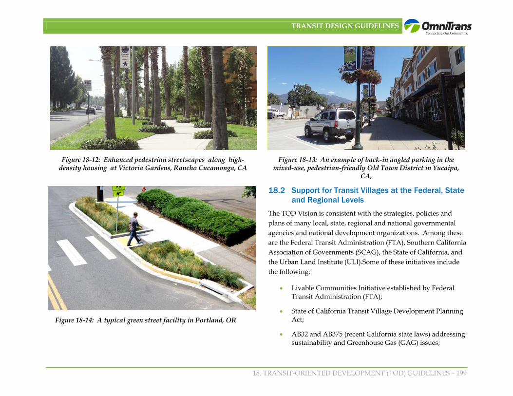
An interconnected network of streets where walkways, landscaping, and pedestrian/bicycle amenities receive priority (Figure 18-11);
Pedestrian-friendly streets with features such as the following:
o Adequate sidewalk widths for at least two or more people to walk side by side (Figures 18-11 & 18-12);
o Street trees at the curb in parkways or tree wells, in combination with drought-tolerant landscape and water retention and filtration areas;
o A row of parked cars on the street to provide a buffer between the pedestrians and moving traffic (Figure 18-13);
o Traffic calming by providing curb nubs to reduce pedestrian crossing distances (Figures 18-14);
o Pedestrian-oriented signage; and
o Pedestrian scale lighting.
Figure 18-11: A pedestrian-friendly environment with adequate sidewalk widths and street trees in tree wells
TRANSIT DESIGN GUIDELINES
18. TRANSIT-ORIENTED DEVELOPMENT (TOD) GUIDELINES – 199
Figure 18-12: Enhanced pedestrian streetscapes along high-density housing at Victoria Gardens, Rancho Cucamonga, CA
Figure 18-13: An example of back-in angled parking in the mixed-use, pedestrian-friendly Old Town District in Yucaipa,
CA,
Figure 18-14: A typical green street facility in Portland, OR
18.2 Support for Transit Villages at the Federal, State and Regional Levels
The TOD Vision is consistent with the strategies, policies and plans of many local, state, regional and national governmental agencies and national development organizations. Among these are the Federal Transit Administration (FTA), Southern California Association of Governments (SCAG), the State of California, and the Urban Land Institute (ULI).Some of these initiatives include the following:
• Livable Communities Initiative established by Federal Transit Administration (FTA);
• State of California Transit Village Development Planning Act;
• AB32 and AB375 (recent California state laws) addressing sustainability and Greenhouse Gas (GAG) issues;
TRANSIT DESIGN GUIDELINES
18. TRANSIT-ORIENTED DEVELOPMENT (TOD) GUIDELINES – 200
• Southern California Association of Governments Compass Blueprint Program; and
• Southern California Association of Governments 2012-2035 Regional Transportation Plan and Sustainable Communities Strategy.
18.2.1 FTA
In 1994, the FTA established the Livable Communities Initiative, which works to strengthen the integration of transit and community planning and encourages land use policies that support the use of transit. This might mean improving pedestrian flow into and out of transit stations or building transit-supportive uses such as childcare centers to make it easier for parents to drop off and pick up their children while going to and from work. The FTA gives priority for funding in its New Starts and Small Starts programs for transit projects with transit-supportive land use policies and implementation measures. Local city governments play a major role in its General Plan and other city plans, zoning, standards and programs by providing transit-supportive land uses plans, and implementation mechanisms. Recently passed MAP 21 legislation continues to encourage land use transportation integration.
18.2.2 State of California Transit Village Planning Act
The Transit Village Development Planning Act of 1994 of California’s Planning, Zoning and Development Laws and amended in 2011 provides financial and other incentives for communities that develop Transit Village Plans around transit stations so that local land use plans and regional transit can be mutually supporting. One of the key incentives is that at least a 25% density bonus may be granted with performance standards.
Definition of transit village:
(a) A neighborhood centered around a transit station that is planned and designed so that residents, workers, shoppers, and others find it convenient and attractive to patronize transit.
(b) A mix of housing types, including apartments, within not more than a quarter mile of the exterior boundary of the parcel on which the transit station is located.
(c) Other land uses, including a retail district oriented to the transit station and civic uses, including day care centers and libraries.
(d) Pedestrian and bicycle access to the transit station, with attractively designed and landscaped pathways.
(e) A transit system that should encourage and facilitate intermodal service, and access by modes other than single occupant vehicles.
(f) Demonstrable public benefits beyond the increase in transit usage, including any five of the following:
(1) Relief of traffic congestion.
(2) Improved air quality.
(3) Increased transit revenue yields.
(4) Increased stock of affordable housing
(5) Redevelopment of depressed and marginal inner-city neighborhoods.

TRANSIT DESIGN GUIDELINES
18. TRANSIT-ORIENTED DEVELOPMENT (TOD) GUIDELINES – 201
(6) Live-travel options for transit-needy groups.
(7) Promotion of infill development and preservation of natural resources.
(8) Promotion of a safe, attractive, pedestrian-friendly environment around transit stations.
(9) Reduction of the need for additional travel by providing for the sale of goods and services at transit stations.
(10) Promotion of job opportunities.
(11) Improved cost-effectiveness through the use of the existing infrastructure.
(12) Increased sales and property tax revenue.
(13) Reduction in energy consumption.
(g) Sites where a density bonus of at least 25 percent may be granted pursuant to specified performance standards.
Source: California Government Code § 65460.2
18.2.3 AB 32 and SB 375
The AB 32 and SB 375 are recent California state laws that prompt California regions to work together to reduce greenhouse gas (GHG) emissions. These laws would achieve this objective by requiring integration of planning processes for transportation, land-use, and housing. The integrated plans emerging from these laws will lead to more efficient communities that provide residents with mobility alternatives and more convenient job and housing options. These laws offer local governments regulatory
and other incentives to encourage more compact and sustainable development and transportation alternatives.
SB 375 includes specific incentives for more sustainable development. In order to motivate more sustainable development, SB 375 reduces costs and barriers associated with building compact TODs by streamlining and exempting from California Environmental Quality Act (CEQA) categories of development that meet specific criteria, especially streamlining for transit priority projects (TPPs), which include the following:
• Contain at least 50 percent residential use (any commercial use must have a floor area ratio of not less than 0.75);
• Provide a minimum net density of at least 20 dwelling units per acre; and
• Be within one-half mile of a major transit stop or high-quality transit corridor.
For more detail on implementation of the Sustainable Communities Strategy see Public Resources Code Section 21155.
18.2.4 Southern California Association of Governments (SCAG)
On the more regional level, SCAG’s growth strategy is driven by four key principles: mobility, livability, prosperity, and sustainability. The Compass Blueprint 2% Strategy are guidelines for how and where the growth vision can be implemented with modest changes to current land use and transportation on 2% of the land area of the region. It proposes strategies to encourage transportation investment and land use decisions that are mutually supportive such as, transit-oriented development, infill development, mixed land uses, walkable communities, and locating new housing near existing jobs. At the core of the Compass Blueprint are Demonstration Projects that are

TRANSIT DESIGN GUIDELINES
18. TRANSIT-ORIENTED DEVELOPMENT (TOD) GUIDELINES – 202
partnerships of SCAG and local governments to apply SCAG’s principles to local plans such as transit-oriented development. SCAG recently updated its Regional Transportation Plan (RTP). The focus of this plan is to improve the balance between land use and transportation systems, and to provide a policy framework on how to do so. The 2012 RTP includes both the Regional Transportation Plan and a Sustainable Communities Strategy.
18.2.5 Urban Land Institute (ULI)
First published in 2003, The ULI’s Ten Principles for Successful Development around Transit was written to direct successful development around transit. These include:
• Creating a flexible, realistic vision and focusing on implementation;
• Forming public/ private partnerships to develop strategies and implement change;
• Planning for development when planning transit stations;
• Determining the optimum number of parking spaces to support transit and surrounding development;
• Turning transit stations into a great place that attracts the community and businesses;
• Getting the right mix of retail development;
• Including a variety of mixed-use projects along a transit line;
• Encouraging assortment of price points; and
• Engaging the corporate community in locational decisions.
18.3 Principles and Benefits of TODs The San Bernardino Valley is estimated to experience considerable growth by the year 2035. Concentrating growth in walkable districts near transit stations rather than scattered throughout the valley will assist in improving air quality by reducing automobile trips and their carbon emissions, promoting economic development clusters, increasing housing choices, assisting in the affordability of housing by reducing the need for multiple cars in a family, reducing city costs for extending and maintaining expansive infrastructure, providing health benefits for workers and residents through walking & biking, and addressing a growing demand for convenient infill urban housing and neighborhoods. Table 18-1 lists some of the principles and benefits of TODs. These walkable transit district principles and benefits are appealing to changing demographics and growing preferences for a more convenient community life. The benefits are categorized as environmental, economic, and social.

TRANSIT DESIGN GUIDELINES
18. TRANSIT-ORIENTED DEVELOPMENT (TOD) GUIDELINES – 203
Table 18-1: TOD Principles and Benefits
TOD Principles TODs occupy land within ¼ mile to ½ mile radius around a rail or bus station, or within 125 to 500 acres. Typically, TOD areas are composed of three elements: • TOD area with platforms, and transit and passenger amenities, • core area within a five-minute walk of the station or about a 1/4 mile of the station, and the most intense employment, residential, and
retail uses as well as convenience commercial for passengers, and • a neighboring ring within a ten-minute walk of station or from about ¼ to ½ mile of the station including a 10-minute walk of the
station and containing residential, commercial and other uses. A TOD must be a walkable, pedestrian-oriented area with amenities such as street trees, benches, crosswalks, decorative paving, and public art. Direct pedestrian connections between different land uses should be provided. TODs have walking connectivity to the regional transit system and bicycle/trail and shuttle links to the area outside the ½-mile area provide extended connectivity. Plans, policies and zoning provisions relating to the intensity and mix of uses; pedestrian based building setbacks; and providing incentives such as density bonuses, floor area ratio increases, reduction of parking requirements, etc. play a significant role in facilitating a TOD, by making the area transit and pedestrian orientated.
Benefits Economic • Catalyst for economic development: TODs can act as a catalyst for nearby properties to invest in development and take advantage of
the higher land use density, customer base and walkable TOD community. • Redevelopment: TODs can be used to redevelop vacant or underutilized properties and declining auto oriented neighborhoods. • Increased property value: TODs can be used to revitalize the area within ¼ mile of the station. • Decrease infrastructure costs: TODs help reduce infrastructure costs due to compact and infill development that can use existing
capacity and does not use as much capacity as auto based development. • Revenue for transit systems: Increased ridership leads to additional revenues for transit service. • Reduced household spending: By reducing auto, parking and travel costs, TODs contribute to an expansion of household net income
and community spending. Households that use transit and reduce the need for one car can save up to $9,000 per year. Environmental • Increased transit ridership and decreased congestion: By decreasing driving, TODs result in reduced congestion. • Improved air quality and energy consumption: Decreased auto trips lead to lower emissions which results in improved air quality. • Conservation of land and open space: TODs are compact developments, and therefore, consume less land than lower-intensity, auto-
oriented development.

TRANSIT DESIGN GUIDELINES
18. TRANSIT-ORIENTED DEVELOPMENT (TOD) GUIDELINES – 204
TOD Principles Social • Increased housing and employment choices: TODs provide a diversity of housing and employment types in conveniently close
proximity to the transit station. • Greater mobility choices: By creating activity nodes linked by transit, TODs increase mobility options in congested areas. Young
people, the elderly, those without cars or not wanting to drive also have mobility options. • Health benefits: By providing more opportunities for walking and bicycling, TODs offer health benefits. • Enhanced sense of community: Bringing more people and businesses closer in a pedestrian environment create an activity hub, TODs
enhance community engagement and activity. • Enhanced public safety. By creating more active pedestrian places used throughout the day and night provides “eyes on the street”,
that helps TODs increase safety. • Quality of life – by reducing the driving time for long automobile commutes, people can recapture this wasted time or other activities. Sources: Statewide Transit-Oriented Development Study; Gruen Associates/HDR.

TRANSIT DESIGN GUIDELINES
18. TRANSIT-ORIENTED DEVELOPMENT (TOD) GUIDELINES – 205
18.4 Examples of TODs in Western United States Below are more details on a few examples of recent Transit-Oriented Developments.
• Mission Meridian Village, South Pasadena - The South Pasadena Metro Gold Line was designed to include a town square with pedestrian amenities and artwork. The Mission Meridian Village, adjacent to the Metro Gold Line in South Pasadena transformed an older retail and residential area to include 67 condominiums, 5,000 square feet of retail space, two levels of subterranean parking containing 280 parking spaces, and a bicycle store and
storage facility. It is located within two minutes of the Metro Gold Line Mission station and is designed in styles in keeping with the surrounding neighborhood, see Figure 18-15. As a TOD, Mission Meridian Village has been a success. In 2006, it won both the AIA Honor Award for Multifamily Residential developments and Congress for New Urbanism Charter Award. This development and the station have stimulated other pedestrian-friendly compatible developments in the area. (Source: Gruen Associates and www.challc.com).
Figure 18-15: Mission Meridian Village, South Pasadena, CA
TRANSIT DESIGN GUIDELINES
18. TRANSIT-ORIENTED DEVELOPMENT (TOD) GUIDELINES – 206
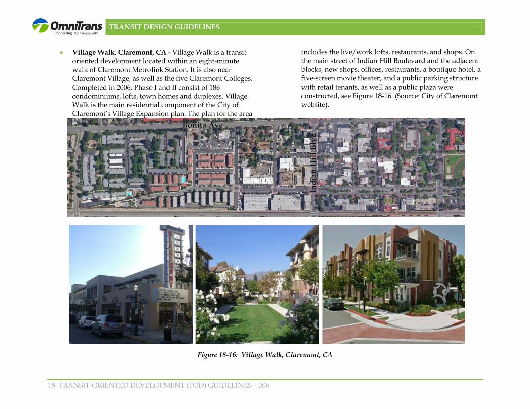
• Village Walk, Claremont, CA - Village Walk is a transit-oriented development located within an eight-minute walk of Claremont Metrolink Station. It is also near Claremont Village, as well as the five Claremont Colleges. Completed in 2006, Phase I and II consist of 186 condominiums, lofts, town homes and duplexes. Village Walk is the main residential component of the City of Claremont’s Village Expansion plan. The plan for the area
includes the live/work lofts, restaurants, and shops. On the main street of Indian Hill Boulevard and the adjacent blocks, new shops, offices, restaurants, a boutique hotel, a five-screen movie theater, and a public parking structure with retail tenants, as well as a public plaza were constructed, see Figure 18-16. (Source: City of Claremont website).
Figure 18-16: Village Walk, Claremont, CA
TRANSIT DESIGN GUIDELINES
18. TRANSIT-ORIENTED DEVELOPMENT (TOD) GUIDELINES – 207
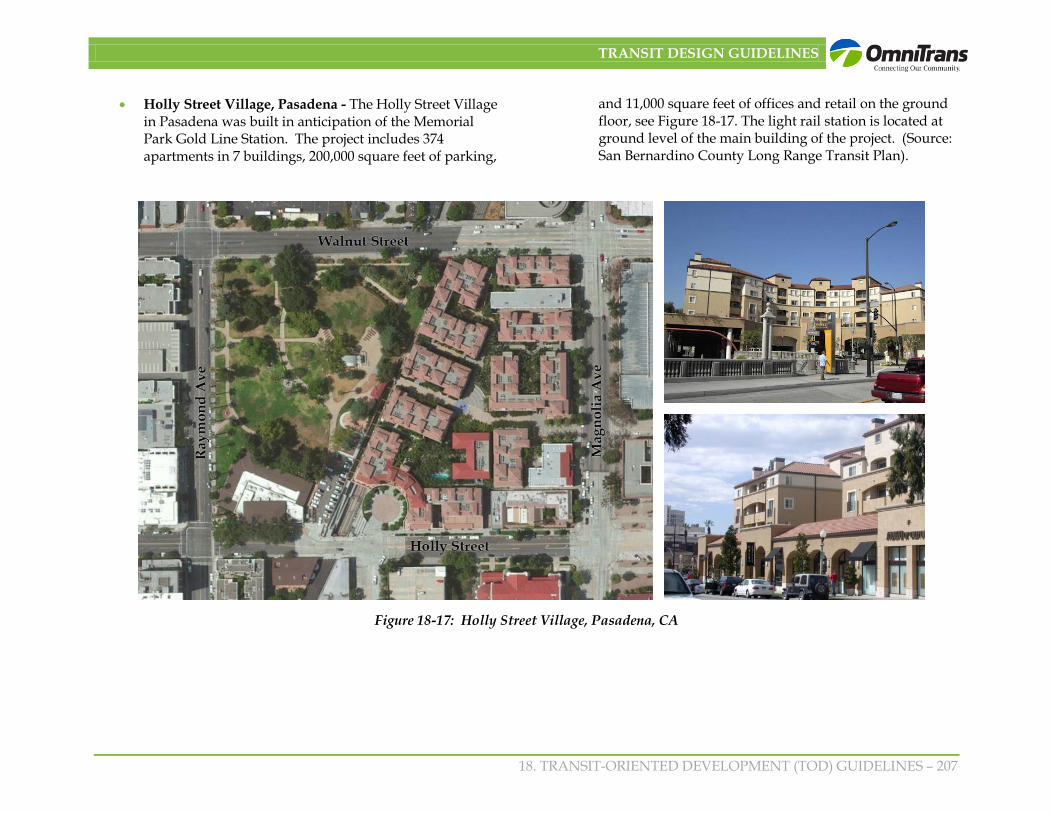
• Holly Street Village, Pasadena - The Holly Street Village in Pasadena was built in anticipation of the Memorial Park Gold Line Station. The project includes 374 apartments in 7 buildings, 200,000 square feet of parking,
and 11,000 square feet of offices and retail on the ground floor, see Figure 18-17. The light rail station is located at ground level of the main building of the project. (Source: San Bernardino County Long Range Transit Plan).
Figure 18-17: Holly Street Village, Pasadena, CA

TRANSIT DESIGN GUIDELINES
18. TRANSIT-ORIENTED DEVELOPMENT (TOD) GUIDELINES – 208
• Grossmont Trolley Center, La Mesa - Completed in 2010 in the City of La Mesa, the Grossmont Trolley Station Transit-Oriented Development consists of two levels of structured parking on both sides of Grossmont Center Drive, 527 one- and two-bedroom apartments on three and four-levels above the parking, and 3,000 square feet of commercial. The TOD is constructed on a seven and one-half acre site adjacent to the existing Grossmont Trolley Station and replaces 600 surface parking spaces. The Grossmont Trolley Station had only a steep staircase connecting the trolley station to the Grossmont Center with its active uses at the
top of the bluff (Figure 18-18). Two elevators were constructed to improve access to the bluff as well as additional transit and pedestrian amenities. A bus court drop-off and pick-up encircles the development and provides access to the replacement parking. The award-winning Fairfield Residential Development follows design standards and guidelines prepared by the City of La Mesa with assistance from Gruen Associates. A portion of the apartments are available to very low- and moderate-income households. (Source: Gruen Associates, City of La Mesa)
Figure 18-18: Grossmont Trolley Center, La Mesa, CA

TRANSIT DESIGN GUIDELINES
18. TRANSIT-ORIENTED DEVELOPMENT (TOD) GUIDELINES – 209
Fruitvale Transit Village, Oakland - Fruitvale Transit Village is a mixed-use development adjacent to the Fruitvale Bay Area Rapid Transit (BART) District station in Oakland. Fruitvale Village was conceptualized as a need to revitalize the existing neighborhood businesses and a plan to better integrate businesses into transit station development. It includes approximately 40,000 square ft.
of retail and restaurant space, approximately 114,000 square ft. of office space including a senior center, a health clinic and a library, and 47 units of mixed income housing. These uses are connected through a pedestrian plaza to the Fruitvale BART station. Phase I was completed in 2004. Phase II, divided into three parts, calls for 450 additional units (Figure 18-19). (Source: The Unity Council).
Figure 18-19: Fruitvale Transit Village, Oakland, CA

TRANSIT DESIGN GUIDELINES
18. TRANSIT-ORIENTED DEVELOPMENT (TOD) GUIDELINES – 210
• Del Mar Station, Pasadena CA - Completed in 2007 in Pasadena on the Metro Gold Line, Del Mar Station is an intense, mixed-use development based on the concept of historic transit plazas of Europe. The four- to seven-story
buildings, organized around a 1-acre plaza and the train station, have 347 apartment units and 11,000 square feet of retail use, Figure 18-20. (Source: The New Transit Town, Best Practices in Transit-Oriented Development).
Figure 18-20: Del Mar Station, Pasadena, CA

TRANSIT DESIGN GUIDELINES
18. TRANSIT-ORIENTED DEVELOPMENT (TOD) GUIDELINES – 211
• Orenco Station, Hillsboro, OR – Located in Portland’s growing high-tech corridor, Orenco Station is situated immediately south of the Intel Ronler Acres plant, a manufacturing and Research and Development facility that employs 16,000 people. In 1999, the National Association of Home Builders named Orenco Station “America’s Community of the Year”. Started in 1997 on an old nursery site, it is a 1,100 acre new town with a 52-acre village center with mixed-use shops, services and residential. It has a range of housing types and prices (rental units, live-work units, loft units above retail, single family) that includes over 4,300 residential units as well as 200,000 square feet retail uses and 800,000 square feet of office uses, Figure 18-21. There is a pedestrian access to the MAX light rail station that extends from the town center. The town center has four-story residential with ground floor retail along the main street. Currently, the walk from the Orenco Station to the town center takes approximately seven minutes and there is little development and no retail space along the way. (Source: Planetizen)
• The Pearl District, Portland, OR – Much has been made of the success of Portland's Pearl District and it is not unwarranted. Since the first residential units were built in 1994 more than 3,500 lofts, condos and apartments have sprung up in the 85-block area, with many more on the drawing board. The area was transformed from an older commercial/industrial area. The Pearl District's zoning emphasizes multi-use structures with street-level food, service and retail shops, as well as residential and office uses, see Figure 18-22. The Portland Streetcar, which runs north and south through the Pearl District every 13 minutes, makes connections with light rail (MAX) as well as the bus transit mall. There is also a strong emphasis on public spaces and parks. Agreements with the City of Portland and property developers have allowed the creation of several parks such as Jamison Square and Tanner Springs Park and also provided tax abatement. Part of the reason that the Pearl District has been so successful is the great diversity of the area. In 2008, rents and property prices increased drastically, pricing-out average Portland residents as well as independent retailers. However, this may change with recent housing market adjustments. (Source: www.tndwest.com)
Figure 18-21: Orenco Station, Hillsboro, OR
TRANSIT DESIGN GUIDELINES
18. TRANSIT-ORIENTED DEVELOPMENT (TOD) GUIDELINES – 212
Figure 18-22: The Pearl District, Portland, OR
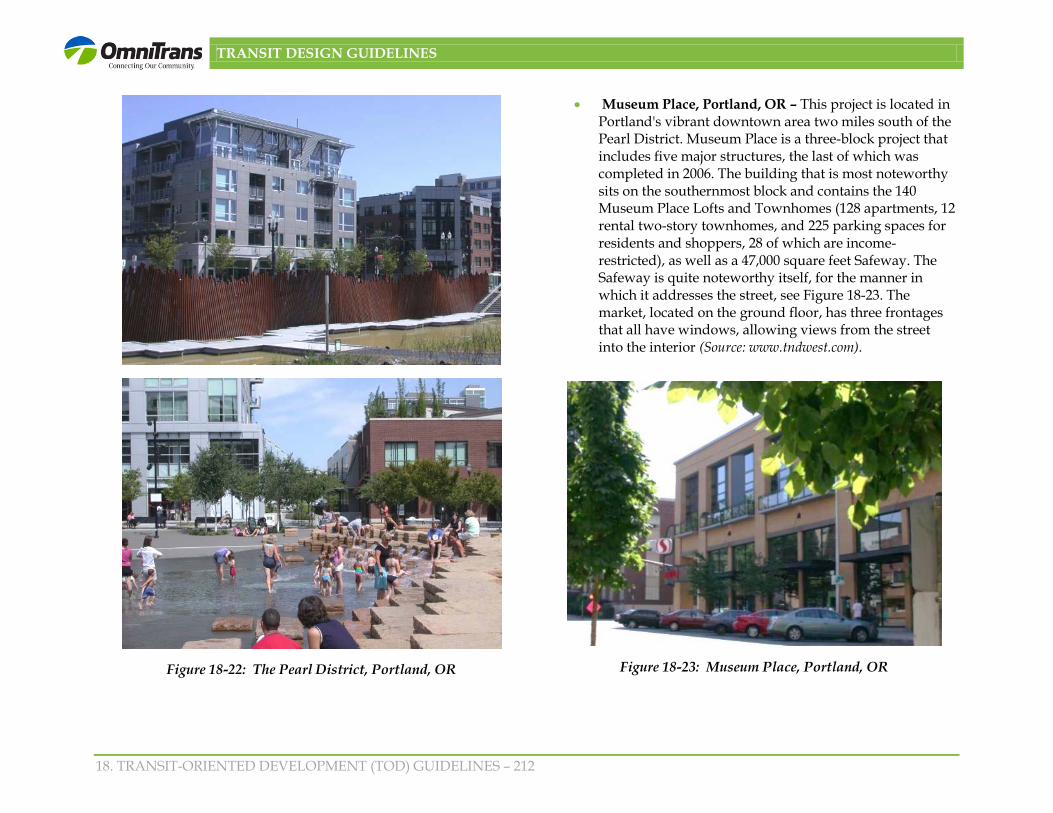
• Museum Place, Portland, OR – This project is located in Portland's vibrant downtown area two miles south of the Pearl District. Museum Place is a three-block project that includes five major structures, the last of which was completed in 2006. The building that is most noteworthy sits on the southernmost block and contains the 140 Museum Place Lofts and Townhomes (128 apartments, 12 rental two-story townhomes, and 225 parking spaces for residents and shoppers, 28 of which are income-restricted), as well as a 47,000 square feet Safeway. The Safeway is quite noteworthy itself, for the manner in which it addresses the street, see Figure 18-23. The market, located on the ground floor, has three frontages that all have windows, allowing views from the street into the interior (Source: www.tndwest.com).
Figure 18-23: Museum Place, Portland, OR

TRANSIT DESIGN GUIDELINES
18. TRANSIT-ORIENTED DEVELOPMENT (TOD) GUIDELINES – 213
Figure 18-24: Downtown Brea
• The Stuart at Sierra Madre Villa Station, East Pasadena, CA – The 1999 East Pasadena Specific Plan encouraged TOD uses around the then proposed Gold Line light rail station at Sierra Madre Villa and provided development guidelines. The Stuart, located adjacent to the final stop of the Metro Gold Line on 7.5 acres of property, and completed in 2006, is the first phase of the TOD. Part of this 188-unit complex is the former Stuart Pharmaceutical plant and office building that was designed by architect Edward Durell Stone in 1958 and is listed in the U.S.
National Register of Historic Places. The Stuart features a direct pathway to the Sierra Madre Gold Line station and park-and-ride, and preserves portion of the Stuart Pharmaceutical (Figure 18-24). The second phase of the project (still under review) will include an additional 322 units. (Source: Gruen Associates and Pasadena Star News)
• Downtown Brea, CA – With the decline of old Downtown Brea, the City of Brea hosted a design charrette in 1989 to bring new life into downtown, Figure 18-25. What resulted from the charrette was a new downtown mixed-use district. Built from scratch, the pedestrian-friendly 60 acre entertainment/retail district consists of movie theaters, restaurants, and retail as well as a mixture of housing options with live-work apartments and townhomes (Source: www.epa.gov).
Figure 18-25: The Stuart at Sierra Madre Villa Station, East Pasadena, CA

TRANSIT DESIGN GUIDELINES
18. TRANSIT-ORIENTED DEVELOPMENT (TOD) GUIDELINES – 214
Figure 18-26: Mandela Gateway, Oakland, CA
• Mandela Gateway, Oakland, CA – Mandela Gateway is a HOPE VI project located at the West Oakland Station on BART. Hope VI is a program run by the U.S. Department of Housing and Urban Development, which was created to help transform public housing and help give residents positive incentives for self-sufficiency as well as comprehensive community services. This project consists of 116 attached rental units and 14 townhomes, as well as 20,000 square feet of retail space, an outdoor playground for children, community facilities for local residents, and town squares at both corners of the gateway. The homes are accessed from a gated interior courtyard, except for 18 of the units which have entrances on 8th Street, providing connectivity with the neighborhood, see Figure 18-26). (Source: www.bridgehousing.com and www.tndwest.com)
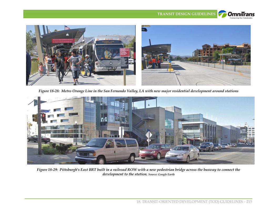
• BRT – Transit-Oriented Development – Although Bus Rapid Transit is relatively new in the United States there are several notable development examples. The Cleveland Healthline, a dedicated lane BRT project, has resulted in renovation of the entire Euclid Avenue and more than $5 billion worth projects are underway or constructed along five miles of Euclid Avenue 1
. The Metro Orange Line in the San Fernando Valley, Los Angeles, an exclusive lane BRT is being to stimulate major residential projects development around the Canoga Station in Warner Center. Pittsburgh’s East BRT, built within a railroad ROW has been a catalyst for new development, see Figures 18-27 through 18-29.
Figure 18-27: Cleveland’s Euclid Corridor BRT has paved the way to economic development: Source: Google Earth
1 http://www:columbusunderground.com/forums/topic/cleveland-euclid
TRANSIT DESIGN GUIDELINES
18. TRANSIT-ORIENTED DEVELOPMENT (TOD) GUIDELINES – 215
Figure 18-28: Metro Orange Line in the San Fernando Valley, LA with new major residential development around stations
Figure 18-29: Pittsburgh's East BRT built in a railroad ROW with a new pedestrian bridge across the busway to connect the development to the station. Source: Google Earth

TRANSIT DESIGN GUIDELINES
18. TRANSIT-ORIENTED DEVELOPMENT (TOD) GUIDELINES – 216
18.5 General TOD Guidelines General TOD guidelines would apply to all TODs and should be considered flexible depending on the uses and unique conditions in a specific area. Many of the guidelines may already be a part of a city’s general plan and zoning. The general TOD guidelines aim to ensure development which is supportive of transit, walkable, aesthetically pleasing, attentive to detail, human-scale and sensitive to existing and surrounding development. The general TOD guidelines are organized as follows:
• A Mixture of Land Uses and Compact Development;
• Prototypical Building Types;
• A Pedestrian/Bicycle-Friendly Environment and Facilities;
• Well-designed Parking and Access;
• Architectural Design Character and Massing;
• Outdoor Open Space Network
• Building Entries and Service Access
• Building and Site Access
• Signage; and
• Sustainable Development.
18.5.1 A Mixture of Land Uses and Compact Development
• Transit supportive uses: Transit supportive land uses that generate high-pedestrian activity support multiple trips, foster 24/7 environment and increase transit ridership should be provided in each station area. These
include uses such as movie theaters, restaurants and outdoor cafes, bookstores, floral shops, newsstands, childcare, offices, high-density residential and other retail, employment and institutional uses that cater to the needs of residents, employees and transit stop users, as shown in Figures 18-30 and 18-31.
Figure 18-30: A mix of transit supportive uses, Portland Downtown
Figure 18-31: Nicolette Mall an example of a walkable urban center in the Twin Cities. Source: Google.com.

TRANSIT DESIGN GUIDELINES
18. TRANSIT-ORIENTED DEVELOPMENT (TOD) GUIDELINES – 217
• Economic development and job creation: Employment intensive businesses that benefit from being within walking distance of transit should be identified and promoted.
Over time support the conversion of heavy-industrial uses within a TOD to more employment intensive uses, mixed use and other transit supportive uses. Relocation of these heavy-industrial uses, storage uses, and automobile oriented uses to other parts of the city should be addressed.
• Mix of uses: A mixture of land uses, appropriate for a TOD and supporting facilities, is encouraged to foster walking within the development to the transit stations and to the surrounding land uses. These may include uses such as residential, retail, restaurant, offices, entertainment uses, hotel, public facilities, open spaces and other employment uses (Figure 18-32). There is no one size fits all for TODs.
Figure 18-32: A former industrial building in San Diego has been converted and expanded into a mixed-use destination.
The mixture of land uses may vary depending on existing conditions in the station area and the major development concept/theme envisioned for an area. For example, some TODs may emphasize employment and regional retail with higher-density housing, such as in a downtown area and some TODs may be more neighborhood-oriented with moderate density housing and neighborhood retail and restaurants focused on a pedestrian gathering space.
• Compact Development: Compact development with a mix of uses places more people in walking distance of the station and fosters walking between uses minimizing some auto trips. To generate transit ridership and reduce automobile dependency, highest residential densities and floor area ratios permitted in the City should be allowed within ½ mile of a transit station. In a downtown area this may mean multi-story buildings. In a more suburban location, this may mean townhomes near the stations and small lot single-family homes further from the station. To encourage property owners, developers and city decision makers to support compact development and provide a customer base for commercial uses, minimum densities should be required, as well as incentives for achieving maximum preferred densities.
o Cities should include minimum and desired densities and floor area ratios. In areas without strong economic conditions, projects may comply with minimum densities and floor area ratios by providing to the City a phased development plan that shows how increased density could be achieved such as later converting surface parking into more intensive uses.
o Incentives per state law may be provided such as the 25% increase beyond the City’s highest density, if public benefits are provided and other incentives are

TRANSIT DESIGN GUIDELINES
18. TRANSIT-ORIENTED DEVELOPMENT (TOD) GUIDELINES – 218
provided such as reduced parking, streamlined processing and streamlined CEQA.
18.5.2 Prototypical Building Types
The ½ mile TOD area occupies over 500 acres, providing infill and new development opportunities for many types of uses and building types interspersed with viable existing uses. Development within the TOD are may take the form of separate uses such as duplexes, bungalow cottages, 4- to 6-plexes, townhomes, multifamily housing, offices and retail shopping areas and also new prototypical development such as mixed-use development which combines residential with one or more of the following uses: offices, retail, entertainment, restaurants, community facilities or similar non-residential uses. Mixed-use projects may be arranged vertically (typically ground-floor retail or restaurant with residential above) or horizontally (typically commercial uses on a portion of the property lined by pedestrian connections to residential uses such as part of a unified development).
Although other uses may also be found, as mentioned previously., the following Figure 18-33 illustrates a range of building types typically found in TODs.
• Middle-density housing including duplexes, bungalow cottages, 4- to 6-plexes, townhomes and garden courtyard apartments typically varying from 14 to 24 units/dwelling units/acre;
• Higher-density housing including courtyard apartments or condominiums, and other multi-family residential varying from 20 to 60 units/acre and above;
• Live-work units typically including one- to two-story residential over ground level office and parking;
• Mixed use which means the combination of commercial development combined with residential development either in a vertical configuration (residential over ground level retail/restaurants) or horizontal configuration (residential and commercial development adjoin each other in the same development);
• Retail/restaurant uses clustered in a main street configuration or in a town center with a highly walkable environment;
• Entertainment and hospitality uses such as auditoriums, theater, cinemas, bowling alley, skating rinks, comedy clubs, music clubs, and hotels;
• Employment intensive offices such as professional, government, knowledge based, research and development, and call centers;
• Employment intensive manufacturing and production such as small high-value products assembly, clothing, etc.;
• Cultural or institutional facilities such as artist and crafts studios, galleries, libraries, museums, churches;
• Healthcare facilities; and
• Recreational facilities including parks, community gathering facilities, and sports fields.

TRANSIT DESIGN GUIDELINES
18. TRANSIT-ORIENTED DEVELOPMENT (TOD) GUIDELINES – 219
Figure 18-33: Residential/Mixed-Use Building Types

TRANSIT DESIGN GUIDELINES
18. TRANSIT-ORIENTED DEVELOPMENT (TOD) GUIDELINES – 220
18.5.3 A Pedestrian/Bicycle-Friendly Environment and Facilities
• Continuous pedestrian and bicycle network leading to the transit station: A major component of any TOD is the creation of connections and linkages from the TOD neighborhood to the transit station. Within the ½-mile TOD area, a plan for and implementation of a continuous, attractive landscaped pedestrian network should be provided linking the mix of land uses to the transit station. A bicycle network consisting of multi-purpose paths for pedestrian and bicycles, bike paths or designated bike lanes should also be included within three miles of transit station.
• Adequate sidewalk width: Adequate sidewalk width should be provided to accommodate pedestrians in street rights-of-way. Devices such as curb nubs or “bump outs” and sidewalk easements on private property are methods to provide adequate sidewalk width in constrained right-of-way condition. Sidewalks and parkways 12’ to 15’ are desirable as they are wide enough for street trees at the curbs, pedestrian amenities, and width for at least two people pass each other and street trees and amenities. Sidewalks or curb parkway width on arterials should not be less than 10’.
• Public and private streetscape improvements: Along each of the streets in a TOD streetscape enhancements should be included to make the area more walkable. These enhancements include landscaping of sidewalk areas along the curb, street furniture, special paving, gateway improvements, pedestrian lighting, pedestrian signage, seating, local bus stops, landscaped medians, water features, decorative crosswalks, and other amenities.
• Safety for pedestrians and bicyclists: Transit stations design should be integrated with the surrounding urban fabric by providing adequate pedestrian amenities, public open space, and well lit interconnected walkways and bike paths. More pedestrian and bicycle activity should be provided to encorage more eyes on the station area to enhance a sense of safety for all users. Safe and secure facilities, such as restrooms and bike racks, should not be isolated and located far from the station entry.
• Buffer: Pedestrian pathways and sidewalks should be buffered from moving traffic by providing street trees along the curbside or a row of parked cars on the street.
• Outdoor dining: Outdoor dining may occur on a portion of the paved sidewalk or in adjacent private area, as shown in Figure 18-34.
Figure 18-34: Outdoor dining adjacent to a comfortable pedestrian environment
TRANSIT DESIGN GUIDELINES
18. TRANSIT-ORIENTED DEVELOPMENT (TOD) GUIDELINES – 221
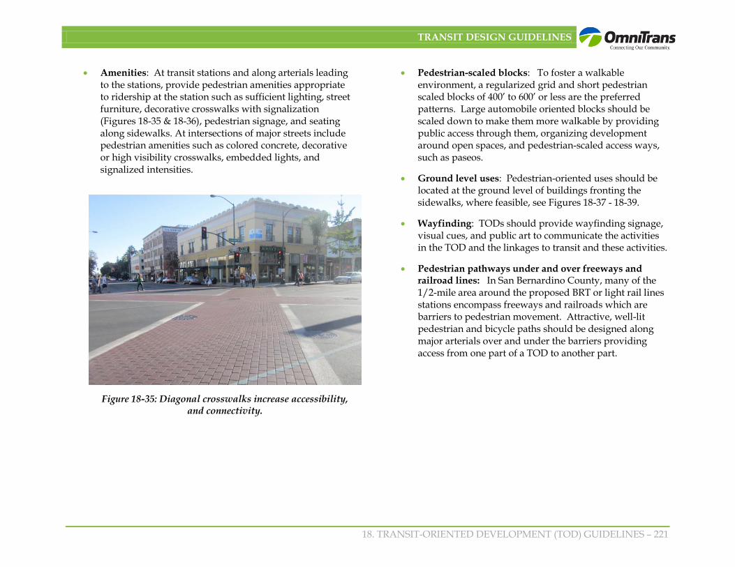
• Amenities: At transit stations and along arterials leading to the stations, provide pedestrian amenities appropriate to ridership at the station such as sufficient lighting, street furniture, decorative crosswalks with signalization (Figures 18-35 & 18-36), pedestrian signage, and seating along sidewalks. At intersections of major streets include pedestrian amenities such as colored concrete, decorative or high visibility crosswalks, embedded lights, and signalized intensities.
• Pedestrian-scaled blocks: To foster a walkable environment, a regularized grid and short pedestrian scaled blocks of 400’ to 600’ or less are the preferred patterns. Large automobile oriented blocks should be scaled down to make them more walkable by providing public access through them, organizing development around open spaces, and pedestrian-scaled access ways, such as paseos.
• Ground level uses: Pedestrian-oriented uses should be located at the ground level of buildings fronting the sidewalks, where feasible, see Figures 18-37 - 18-39.
• Wayfinding: TODs should provide wayfinding signage, visual cues, and public art to communicate the activities in the TOD and the linkages to transit and these activities.
• Pedestrian pathways under and over freeways and railroad lines: In San Bernardino County, many of the 1/2-mile area around the proposed BRT or light rail lines stations encompass freeways and railroads which are barriers to pedestrian movement. Attractive, well-lit pedestrian and bicycle paths should be designed along major arterials over and under the barriers providing access from one part of a TOD to another part.
Figure 18-35: Diagonal crosswalks increase accessibility, and connectivity.

TRANSIT DESIGN GUIDELINES
18. TRANSIT-ORIENTED DEVELOPMENT (TOD) GUIDELINES – 222
Figure 18-36: Decorative crosswalks create pedestrian awareness and caution drivers entering a pedestrian area.

TRANSIT DESIGN GUIDELINES
18. TRANSIT-ORIENTED DEVELOPMENT (TOD) GUIDELINES – 223
18.5.4 Well-designed Parking and Access
• Amount of parking: As transit is available in walking distance of uses within a TOD, the amount of on-site parking required for development should be less than for other areas of the city. Each City should consider reduced parking standards in TOD areas. In addition to a reduction in required parking, City standards may include provisions for shared parking, unbundled parking, in-lieu parking fees, provisions for transit passes or other mechanisms.
• Location of parking: To emphasize the pedestrian realm, on-site parking is discouraged adjacent to the sidewalk along major streets but instead should be located underground or at the rear of the parcels with convenient pedestrian access to non-residential and residential uses. On-street parking, where appropriate, is encouraged to
buffer pedestrians along the sidewalk, as well as shared parking access/structures, see Figure 18-40.
Figure 18-40: Public parking located at the rear of the parcels with convenient pedestrian access and parking.
Figure 18-37: Wide sidewalks with ample space for pedestrians in Downtown
Culver City
Figure 18-38: Streetscape enhancements such as landscaping of sidewalk areas,
landscaped medians and other amenities.
Figure 18-39: Bus shelter in Santa Monica with amenities such as sufficient lighting
and seating.

TRANSIT DESIGN GUIDELINES
18. TRANSIT-ORIENTED DEVELOPMENT (TOD) GUIDELINES – 224
Screening of parking: Existing or new parking spaces in lots which face a street should be screened from view from the street by a hedge or a low masonry wall and vines. Parking garages should be designed with generous landscaping and canopy trees surrounding them.
Parking access: When available, access to parking should be from side streets and from alleys. To minimize traffic congestion and breaks in the pedestrian realm multiple parking access points along major streets are discouraged. Joint use or combined driveways are encouraged. The width of driveway area cuts should be minimized, see Figure 18-41.
Figure 18-41: Guidelines for Parking Design in a TOD

TRANSIT DESIGN GUIDELINES
18. TRANSIT-ORIENTED DEVELOPMENT (TOD) GUIDELINES – 225
• Parking garage design: The design of parking structures should be compatible with the design of the main building. Wrapping an above ground parking structure with residential units, retail, or office is encouraged to screen parking from public view. An above-grade parking structure should not have sloping floors visible from adjacent streets.
• Safety and security: Safety and security of the people using the facility are of paramount importance. Therefore, parking structures design should consider open, glass stairwells and glass-backed elevators and should eliminate potential hiding places. Energy efficient lighting should be provided to improve safety. A balance between daylighting, interior lighting and exterior control should be addressed to provide adequate lighting. Lights should be vandal resistant and easy to maintain. Security devices such as video, audio and emergency buttons that call into the booth or local police station should also be provided.
• Parking structures located away from street frontage: Above ground parking structures should not front on major streets unless there is no feasible alternative. If parking structures are located on a major street, the ground floor should be devoted to pedestrian-friendly retail, service and restaurant uses with visual interest.
• Interconnected parking: Where possible, link the new parking with that of adjacent development to facilitate vehicular and pedestrian movements, especially when streets are congested.
• Shared use of parking: Shared parking with a management plan should be included in a new TOD to minimize traffic congestion and parking demand.
• Drop-off and valet: Spaces for drop-off, kiss-and-ride, and valet parking should be provided in major projects.
• Street Layouts: To provide dispersed access to transit from TOD uses and a more walkable pedestrian environment a grid network of local through streets with sidewalks is preferred over a system of superblocks and cul-de-sacs.
• Street width: In order to slow traffic and make wider pedestrian linkages consider a modification in the lane widths of streets and an increase in pedestrian sidewalk widths, where appropriate.
• Safety devices: To make an area safer for pedestrians include devices such as “Z” crossings of major streets, median refuge areas for pedestrians, beeping crosswalk signals (Figure 18-42), countdown timers, and embedded flashing devices in crosswalks at non-signalized intersections.
Figure 18-42: High visibility crosswalks provide pedestrians
safety

TRANSIT DESIGN GUIDELINES
18. TRANSIT-ORIENTED DEVELOPMENT (TOD) GUIDELINES – 226
• Bike lane streets, bike boulevards, and amenities: Plan for an integrated bike network within the TOD and connections to the County bike network. This may include bike lane streets with bike lanes on either side of travel lanes, two-way buffered bike lanes, or bike boulevards, sharrows, bike boxes at intersections, and bike storage, and repair at major activity centers.
• Traffic Calming: To channel traffic to the arterial streets and minimize impacts on the community, traffic calming techniques such as curb extensions, chokers, speed bumps, and raised crosswalks should be used, Figure 18-43.
Figure 18-43: A curb extension (nub) is a traffic calming technique used to slow the speed of traffic
18.5.5 Architectural Design Character and Massing
• Tailor designs to reflect uniqueness of an area: TODs should vary in design character based on the land use and urban design theme envisioned unique characteristics of a specific geographic location and sensitive existing features and context.
• Visual interest at street level: The form of buildings and architectural details should be designed to create visual interest for pedestrians at the street level using techniques such as staggering the frontage of the building, recessing doors and windows, providing varied display windows, providing awnings and canopies for weather protection and shade, and visually extending interior spaces outside through paving and glazing. In addition, clear glass rather than dark tinted glass or reflective glass should be incorporated along ground level frontages to increase a buildings visual and physical interaction with those on the sidewalk and create a safer and more vibrant pedestrian environment, see Figure 18-44.
Figure 18-44: Clear glass display windows, awnings, and architectural articulation at the street level

TRANSIT DESIGN GUIDELINES
18. TRANSIT-ORIENTED DEVELOPMENT (TOD) GUIDELINES – 227
• Articulated building facades and massing: To create visual interest and to avoid large bulky façades and blank walls, buildings massing should be articulated in form using techniques such as some stepping back of upper floors, stepped terraces, changes in plane, recessed windows, bay windows, balconies, trellises, which create shadow lines, varied roof lines and changes in color (Figure 18-45).
Figure 18-45: Buildings and architectural details with visual interest for pedestrians at street level
• Equal design treatment on facades: Buildings should be designed to be attractive in all directions. Where the rear or sides of the building are visible from streets and alleys these facades should receive equal design treatment to the main façade.
• Building location to emphasize each street as an urban space: Building placement and design should consider its relationship to the street:
o One of the most important elements in creating vital economic development and walkable TODs is to implement “build to-line standards” or a “building frontage line” along streets to establish a continuous “street wall” adjacent to the pedestrian realm. Buildings would be located close to the building frontage line with its building entries facing the sidewalks. Setbacks from the street wall should be limited to courtyards, outdoor dining spaces, and public plazas. Parking should not be located between the pedestrian realm and building façade but should be in the rear of buildings or underground, see Figure 18-46.
Figure 18-46: Building design which fits into the pedestrian environment
o Uses on the ground level and outdoor activities should be selected to activate the street.

TRANSIT DESIGN GUIDELINES
18. TRANSIT-ORIENTED DEVELOPMENT (TOD) GUIDELINES – 228
• Building heights: Building heights should vary within the TOD with taller structures near the station, along wider streets and as focal points.
• Ground floor uses and design: The ground floor is typically the lowest level within a building that is accessible from and within 3’ above or 2’ below grade. In areas designated for mixed-use, ground floor retail, restaurants, and other pedestrian-friendly uses are preferable at the ground floor along the pedestrian realm. The pedestrian realm is generally a 12’-30’ area located between the face of the curb of a street and the face of the building. It includes parkways, sidewalks, and any landscaped areas, and can include public or private areas. However, recognizing that there may not be a market for the entire ground floor of multiple blocks for the uses, residential use on the ground floor may be permitted with the following guidelines:
o Residential located on the ground floor of facing the pedestrian realm should be designed with articulated facades, including features such as awnings, elevated steps, stoops and entrances, recessed windows, patios, windows treated for privacy and pedestrian interest and landscaping.
o The more public areas of the residential units, such as lobbies, exercise rooms, living rooms, or dining areas, should face the street while more private areas, such as bedrooms, should be located in the rear or upper floors.
o Pedestrian-oriented commercial uses should be concentrated near major streets (Figure 18-47).
• Variety in building facades and urban forum: Building forum and facades should vary from building to building and from project to project to create interest along the street and a vibrant area.
• Materials and colors: Materials and colors should be selected to unify the building appearance and fit into the pedestrian realm context. For example, avoid chain link fences, imitation rock/stone veneer and extensive use of wood siding, heavily textured stucco walls, adobe, or slump stone masonry.
• Contemporary, pedestrian-friendly design: Buildings shall be designed to be visually attractive and fit with the vision of a pedestrian-friendly, vibrant streetscape. For example, contemporary glass storefronts inserted into an older building if sensitive to the building key
Figure 18-47: A mixed use project in a San Diego neighborhood with a coffee shop, corner plaza and a
human-scale pedestrian-friendly environment.

TRANSIT DESIGN GUIDELINES
18. TRANSIT-ORIENTED DEVELOPMENT (TOD) GUIDELINES – 229
architectural features are encouraged subject to the unique character envisioned by each community for each TOD.
• Building shaped at corners: A building should reflect the corner of an important pedestrian intersection or a focal point by using a variety of techniques such as strong vertical mass or a tower at the corner, a diagonal setback at the intersection, a corner plaza at the intersection, and/or a recessed building entrance at the corner.
• Lighting: Lighting is encouraged to accent facades at night and provide security and wayfinding for public and private open spaces. Avoid lighting that interferes with residential uses.
• Awnings: Awnings are encouraged for sun protection for a distinctive identify and for visual interest along the pedestrian center. Awnings should be mounted so as to respect the architecture and character of a building and its function. Awnings should project over doors and windows and not blank walls. Open ended awnings are preferred over closed in awnings. Creative steel, canvas, and glass awnings with signage incorporated are encouraged.
• Energy efficient designs: Buildings design and site planning shall consider passive solar and ventilation techniques, as well as specification of “green” materials.
18.5.6 Outdoor Open Space Network
• A network of open spaces: In addition to the pedestrian network along sidewalks, well-proportioned outdoor open spaces such as landscaped sidewalks, paseos, plazas, terraces, courtyards, gardens, and decks should be
incorporated into TODs and connected together, where possible, forming an open space network, Figure 18-48.
Figure 18-48: Well defined courtyards and quiet areas for day and night time use
TRANSIT DESIGN GUIDELINES
18. TRANSIT-ORIENTED DEVELOPMENT (TOD) GUIDELINES – 230
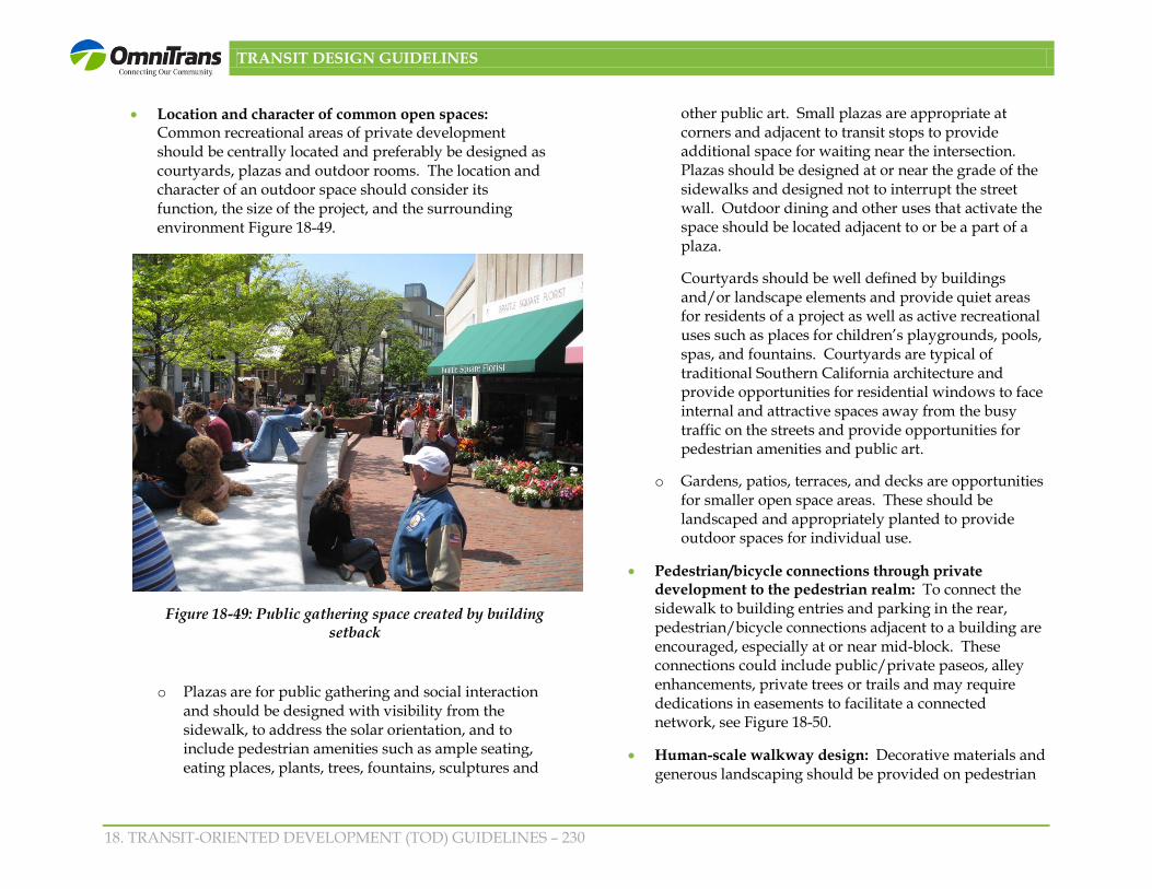
• Location and character of common open spaces: Common recreational areas of private development should be centrally located and preferably be designed as courtyards, plazas and outdoor rooms. The location and character of an outdoor space should consider its function, the size of the project, and the surrounding environment Figure 18-49.
o Plazas are for public gathering and social interaction and should be designed with visibility from the sidewalk, to address the solar orientation, and to include pedestrian amenities such as ample seating, eating places, plants, trees, fountains, sculptures and
other public art. Small plazas are appropriate at corners and adjacent to transit stops to provide additional space for waiting near the intersection. Plazas should be designed at or near the grade of the sidewalks and designed not to interrupt the street wall. Outdoor dining and other uses that activate the space should be located adjacent to or be a part of a plaza.
Courtyards should be well defined by buildings and/or landscape elements and provide quiet areas for residents of a project as well as active recreational uses such as places for children’s playgrounds, pools, spas, and fountains. Courtyards are typical of traditional Southern California architecture and provide opportunities for residential windows to face internal and attractive spaces away from the busy traffic on the streets and provide opportunities for pedestrian amenities and public art.
o Gardens, patios, terraces, and decks are opportunities for smaller open space areas. These should be landscaped and appropriately planted to provide outdoor spaces for individual use.
• Pedestrian/bicycle connections through private development to the pedestrian realm: To connect the sidewalk to building entries and parking in the rear, pedestrian/bicycle connections adjacent to a building are encouraged, especially at or near mid-block. These connections could include public/private paseos, alley enhancements, private trees or trails and may require dedications in easements to facilitate a connected network, see Figure 18-50.
• Human-scale walkway design: Decorative materials and generous landscaping should be provided on pedestrian
Figure 18-49: Public gathering space created by building setback

TRANSIT DESIGN GUIDELINES
18. TRANSIT-ORIENTED DEVELOPMENT (TOD) GUIDELINES – 231
walkways through and adjacent to new projects which are complimentary or of the same design as the treatment of the pedestrian realm.
• Special features: To encourage social interaction, activate a public space and provide a unique identity for an area, special features such as public art and water elements are encouraged, see Figure 18-51. Water could introduce a sense of relaxation and mask traffic noise.
• Lighting: Lighting should be used to guide pedestrians through an open space, to eliminate hidden areas, and to accent special features without interfering with the adjacent residential uses.
Figure 18-51: Special features such as water elements activate a public space
18.5.7 Building Entries and Service Access
• Building entries oriented to street frontage: To promote active pedestrian-friendly streets each individual tenant or business establishment and residential lobbies should be oriented to and be accessible from the major street frontage and directly from the public sidewalk. This will also ensure safety of pedestrians by encouraging “eyes on the street.”
• Entries emphasized: Sidewalk pedestrian entries to shops and residential lobbies should be prominently highlighted with features such as two-story height entries, unique awnings, overhangs, trellises or other distinctive features. Shop and major building entries may be recessed to create a gracious entry provided that the recess enhances the street wall or a plaza along the street frontage.
Figure 18-50: Encourage pedestrian connections through buildings to the pedestrian realm
TRANSIT DESIGN GUIDELINES
18. TRANSIT-ORIENTED DEVELOPMENT (TOD) GUIDELINES – 232
• Service areas concealed: Where possible, service areas should be located at the rear of the building unless these areas can be concealed within the interior of the building design. Loading docks, service/storage areas and mechanical equipment should be screened from public streets and neighborhoods.
18.5.8 Compatibility with Surrounding Development and Between Uses on the Site
• Privacy between land uses: The building and site designs should address privacy between residential units and other non-residential uses on the site and on adjacent properties. Some of the considerations to include in City guidelines to address TODs adjacent to a single-family zone include:
o Transitioning building height from the maximum permitted building height to a lower height, when directly adjacent to the single-family zone. However, the height would not need to match the single-family height or transition at all when a single-family adjacent zone is at higher elevation than the TOD development.
o To provide privacy for adjacent single-family, windows in mixed-use projects directly facing single-family zones within 15’ of the property line, should be designed either translucent, louvered, offset from existing single-family windows, located at least 5’ above the floor of each level or another solution achieving this intent.
o Mixed-use projects should be designed to minimize motor vehicle circulation through local single-family neighborhood streets.
o Guest parking areas should be located and designed to be convenient in order to minimize parking in residential neighborhoods
o Facades and garages that face existing single-family should be designed to be comparable with the setbacks and scale of the existing development.
• Private development to complement the public realm: The design of the structures and landscaping should complement the street pedestrian realm with plazas, pocket parks, public gathering spaces and street furniture.
• Public spaces distinguished from private spaces: The design should provide visual and physical cues that demark the public space from the private space.
• Passageways for light and air: To integrate new buildings with the surrounding area they are encouraged to provide passageways that allow for light and air to adjacent buildings and that connect to the pedestrian realm (Figure 18-52).
• Noise mitigation adjacent to arterials: Noise insulation techniques such as double pane or laminated glass should be used in residential units adjacent to heavily traveled corridors.
18.5.9 Building and Site Access
• Access from side streets and alleys: Vehicular access should be provided from the side streets, adjacent alleys, and parallel streets. Traffic calming techniques should be provided to minimize intrusion of traffic into adjacent neighborhoods.

TRANSIT DESIGN GUIDELINES
18. TRANSIT-ORIENTED DEVELOPMENT (TOD) GUIDELINES – 233
Figure 18-52: Passageways provide opportunities for light and air.
• Pedestrian amenities at street crossings: Pedestrian crossings at arterials should include items such as curb extensions at intersections, decorative crosswalk paving, shortened turning radii for cars, complementary plant materials and pedestrian lighting, public art and bus shelters (Figure 18-53).
Figure 18-53: Curb extension and crosswalk paving at street crossings add to a pedestrian-friendly environment.

TRANSIT DESIGN GUIDELINES
18. TRANSIT-ORIENTED DEVELOPMENT (TOD) GUIDELINES – 234
18.5.10 Signage
Clear distinctive signage: Signage should be pedestrian-oriented, distinctive, clear, and uniformly and consistently applied (Figure 18-54). For mixed-use projects, signage may operate at several scales: identification of individual stores, restaurants, entertainment centers and offices; identification of a group of such businesses and identification of residential units.
Figure 18-54: Project signage should be distinctive and clear
18.5.11 Sustainable Development
Constructing transit and creating transit-oriented developments supports economic and environmental sustainability as discussed previously under benefits of TOD. In designing TOD projects, sustainable features should be incorporated. The following are some sustainable guidelines to consider:
• Buildings should be designed utilizing passive daylight strategies including building shaping, building overhangs and louvers and other shading devices, spectrally-sensitive glazing, photo voltaic panels, appropriate placed landscaping for shading effects, light color and reflective roofing, and solar massing strategies to reduce solar gain.
• Use healthy, long lasting, local and recycled materials.
• Plan for water conservation, storage, and reuse by including features such as low flow appliances and fixtures, reuse of grey water for landscaping and permeable surfaces, drought-tolerant plants, bioswales, rain gardens, storm water retention ponds, outdoor recreational spaces, tree canopies, and green roofs.
• Emphasize connectivity to the transit stations, complete streets, and reduced parking to minimize amount of paved surfaces and walkability
• Consider alternative energy sources such as wind power and efficient HVAC systems, natural ventilation, and other energy producing equipment
Recommended