, . f.
1 1
•
City of San Diego Land Guidance System
Transit-Oriented Development Design Guidelines
Prepared by Caltlzorpc Associates
for tlze Ci!y of San Diego
Approved by tlze City COll1lcil August 4, 1992
.. MAYOR
Maureen O'Connor
COUNCIL District 1 Abbe Wolfsheimer
District 2 Ron Roberts District 3 John Hartley
District 4 George Stevens District 5 Tom Behr
District 6 Valerie Stallings District 7 Judy McCarty
District 8 Bob Filner
CITY ATIORNEY John M. Witt
CITY MANAGER Jack McGrory
PLANNING COMMISSION Karl 20Bell, Chariman
Ralph Pesqueira Edward Reynolds.
Scott Bernet Lynn Benn
Chris Calkins Vema Quinn
ENGINEERING & DEVELOPMENT DEPARTMENT M. Victor Rollinger, Director
William Schempers, Jr., Assistant Director
CITY PLANNING DEPARTMENT Severo Esquivel, Acting Director
George Arimes, Assistant Director Michael J. Stepner, City Architect Linda Johnson, Principal Planner Nancy Schwarz, Project Planner
LAND GUIDANCE SUBCOMMITTEE Stephen H. Silverman; Chair
Tess Nelson, Vice-Chair
Approved by The City Council August 4, 1992 . .Resolution No. R-280480
~
. .
-
-
PLANNING DEPARTMENT
OFFICE OF THE CITY ARCHITECT
533-4500
o Prinhd on rI~c:~c1~d pap~r
THE CITY OF
SAN DIEGO. 525 "B" STREET. SUITE 2002 • SAN DIEGO. CALIFORNIA 92101 - 4411
October, 1992
A Transit-Oriented Development (TOO) is a compact land use pattern with housing, public parks and plazas, jobs, and services located along key points on the transit system. The strategic application of the TOD principles will greatly help us in our efforts as a community to reduce automobile dependence, improve air quality, and create pedestrianoriented, interactive neighborhoods.
The guidelines are the result of an eighteen month long effort under the City's Land Guidance Program. In addition to the work of Calthorpe Associates, key players included the Land Guidance Subcommittee (a broad-based Citizens Advisory Committee), City staff, and other public agency staff. The TOD Guidelines and a companion City Council Policy (600-39) were approved by the City Council on August 4, 1992.
Now that the guidelines are approved, they are being incorporated into basic City policies and regulations. The TOD perspective is being brought to the Street Design Manual update, the Zoning Code update, the Progress Guide and General Plan, community plan updates, demonstration projects, and the Regional Growth Management Strategy.
The TOO concept provides the community with an approach to create a desirable and more efficient urban form while addressing the issues of traffic congestion, air quality, neighborhood character, and growth management. The guidelines support the substantial public investment in tra!,sit systems and result in regional, environmental, and fiscal benefits over the long term.
I hope that you find these guidelines to be interesting and useful.
Micha ner, FAIA, AICP City Architect
-
-
-
-City of San Di~o lAnd Guidance System • Transit-Oriented Deve1op",.mt Design Guidelines
Table of Contents
Introduction
Land Guidance System Transit-Oriented Development Concept Transit-Oriented Developments Defined How To Use These Guidelines
Design Guidelines
1. Definitions and Guiding Principles
Guideline IA: TRANSIT-ORIENTED DEVELOPMENT (TOD) Guideline 18: RELA TIONSHIP TO TRANSIT AND CIRCULATION Guideline IC: URBAN TOD Guideline 10: NEIGHBORHOOD TOO Guideline IE: REVITALIZING, URBANIZING AND NEW GROWTH AREAS Guideline IF: CORE COMMERCIAL AREA Guideline IG: TOO RESIDENTIAL AREAS Guideline IH: PUBLIC USES Guideline II: MIXED-USE Guideline IJ: STREET AND CIRCULATION SYSTEM Guideline lK: GENERAL DESIGN CRITERIA Guideline IL: SECONDARY AREAS Guideline 1M: OTHER USES Guideline IN: COORDINATED PLANNING Guideline 10: PHASING
2. TODs 011 Redevelopable and Urballizillg Sites
Guideline 2A: LOCATION AND PROXIMITY TO TRANSIT SERVICE Guideline 2B: SITE BOUNDARY DEFINITION Guideline 2C: INTEGRATION OF EXISTING ON-SITE USES Guideline 20: MIX OF USES Guideline 2E: RETROFIT OF EXISTING STREETS FOR PEDESTRIAN, BICYCLE
& AUTO CONNEC1]ONS Guideline 2F: PROXIMITY OF COMPETING RETAIL
1
1
1
4
6
7
7
7 8
10 11 12 14 15 16 17 18 19 20 21 22 23
24
24 25 27 29
30 31
Calthorpt" Associatt"s • August 1992 • pagt" i
City of San Diego Land Guidanc~ System • Transit-Oriented Development qesign Guidelines
3. TODs in New Growth Areas
Guideline 3A: LOCATION AND PROXIMITY TO TRANSIT SERVICE Guideline 3B: SITE BOUNDARY DEFINITION Guideline 3C: SITE SIZE AND PHYSICAL CHARACTERISTICS Guideline 3D: DISTRIBUTION OF TODS Guideline 3E: MIX OF USES
4. . Core Commercial Areas
Guideline 4A: Guideline 4B: Guideline 4C: Guideline 4D: Guideline 4E: Guideline 4F: Guideline 4G:
CORE COMMERCIAL AREAS OFFICE INTENSITIES CORE COMMERCIAL CONFIGURATION COMMERCIAL BUILDING SETBACKS COMMERCIAL. BUILDING FACADES COMMERCIAL BUILDING ENTRIES UPPER STORY USES IN CORE COMMERCIAL AREAS
5. TOD Residential Areas
Guideline SA: RESIDENTIAL MIX Guideline 5B: RESIDENTIAL DENSITIES Guideline 5C: ANCILLARY UNITS Guideline 50: RESIDENTIAL BUILDING SETBACKS Guideline 5E: RESIDENTIAL BUILDING FACADES Guideline SF: RESIDENTIAL BUILDING ENTRIES Guideline 5G: RESIDENTIAL GARAGES
6. Secondary Areas
Guideline 6A: TYPE AND PROXIMITY OF USES Guideline 6B: RESIDENTIAL DENSITIES IN SECONDARY AREAS Guideline 6C: BIKEWAYS IN SECONDARY AREAS Guideline 6D: PUBLIC AMENITIES IN SECONDARY AREAS
7. Open Space, Parks, and Public Uses
Guideline 7 A: LOCATION OF PARKS AND PLAZAS Guideline 7B: PARK AND PLAZA DESIGN Guideline 7C: PARK AND PLAZA LANDSCAPING Guideline 70: OPEN SPACE RESOURCE PROTECTION Guideline 7E: COMMUNITY BUILDINGS Guideline 7F: SCHOOLS AND COMMUNITY PARKS Guideline 7G: DA YCARE
32
32 33 34 34 35
36
36 38 39 40 41 42 43
44
44 45 46 47 48 48 49
50
50 51 51 52
53
53 54 55 56 57 58 59
CaJrlrorpe Associates • August 1992 • page ii
-
-
City of San Diego lAnd Guidance System • T",nsit-Oriented Detlelop~t Design Guidelines
8. Street and Circulation System
Guideline 8A: Guideline 8B: Guideline 8C: Guideline 80: Guideline 8E: Guideline 8F: Guideline 8G: Guideline 8H: Guideline 81: Guideline 8J:
ARTERIAL STREETS AND THOROUGHFARES STREET DIMENSIONS CONNECTOR STREETS COMMERCIAL STREETS LOCAL STREETS ALLEYS STREET VISTAS STREET TREES ON-STREET PARKING INTERSECTION DESIGN
9. Pedestrian aHd Bicycle System
Guideline 9A: PEDESTRIAN ROUTES Guideline 9B: CONNECTIONS TO THE CORE AREA AND THE TRANSIT STOP Guideline 9C: ARTERIAL CROSSINGS AND PEDESTRIAN BRIDGES Guideline 9D: SIDEW ALKS Guideline 9E: BIKEW A YS Guideline 9F: BIKE PARKING
10. Transit Stops
Guideline lOA: SITE RELA nONSHIP TO TRANSIT STOP Guideline lOB: TRANSIT STOP FACILmES Guideline lOC: STREET CROSSINGS TO TRANSIT STOPS Guideline 10D: PARK AND RIDE LOTS
11. Parking Requirements aHd Configuration
Guideline llA: PARKING STANDARDS Guideline lIB: JOINT USE PARKING Guideline 11C: PARKING CONFIGURA nON Guideline lID: ON-STREET PARKING REQUIREMENTS Guideline lIE: PARKING MITIGA nON MEASURES Guideline llF: SIZE OF SURFACE PARKING LOTS Guideline IlG: SURFACE PARKING REDEVELOPMENT Guideline llH: RETAIL IN STRUCTURED PARKING LOTS Guideline 111: PARKING LOT LANDSCAPING
Incentives and Implelnentation Strategies
Long-Range Planning Environmental Review and Permit Processing Zoning and City Standards Public Services and Infrastructure
60
60 61 62 63 63 64 65 66 67 68
69
69 70 71 72
73 74
75
75 76 77 78
79
79 81 82 83 83 84 85 86 86
87
87
88
89 90
Ca/tlwrpe Associales • AugllSl 1992 • page iii
-
-
-
City 0/ 51m Di~o Lmd Guidance Systnn • Transit-Orimt~d pnle/opmenl Design Guid~lin~s
Introduction
Land Guidance System
The Land Gui'dance Section was established in September 1989 as a part of the City of San Diego's Mobility Program. The aim of the Land Guidance Section is to reduce transportation demand through new and revised land development policies. Since its inception, the Section has undertaken a number of studies characterizing the status of traffic congestion and land development patterns in the city. The group has also assessed the effectiveness of adopted policies and standards as to whether they support or hinder transportation demand management goals.
In May 1991, the Planning Department and the Engineering and Development Department contracted with Cal thorpe Associates to prepare Design Guidelines, Incentives and Implementation Strategies aimed at redirecting urban growth to patterns which encourage non-automobile travel, yet protect the city's quality of life. This package, along with a number of accompanying policies and programs, constitutes the Land Guidance System for the City of San Diego.
Transit-Oriented Develop7nent Concept
Guiding Principles
San Diego, along with a number of other growing metropolitan regions throughout the country, is increasingly faced with a crisis of many dimensions: mounting traffic congestion, diminishing affordable housing, receding open space, threatened wildlife, urban sprawl, air pollution and socially isolated communities. Reliance upon typical patterns of low density urban development will perpetuate these problems. The goal of the Land Guidance System is to establish policies and standards which seek to address these problems by redirecting urban growth to patterns which reduce automobile dependence and support alternative modes of transportation, while minimizing impacts on existing community character. The Design Guidelines for Transit Oriented Development (TODs) represent strategies to accommodate projected growth within San Diego, maintain the city's present quality of life, and allow for continued economic vitality. Consistent with these concerns, these Design Guidelines are based on the following guiding principles:
•
• • •
•
• • •
Maximize the use of existing urbanized areas accessible to transit through infrastructuresensitive infill and redevelopment.
Reduce consumption of non-urban areas by designing the urban area efficiently.
Employ land use strategies to reinforce transit.
Reduce the number of auto trips and regionaJ'vehicle miles traveled by creating opportunities to walk and bike.
Protect the natural environment and community character by reducing the need for roadway expansions.
Reduce air pollutant emissions and conserve limited energy resources.
Provide a diversity of housing types.
Foster a more vital, interactive and secure community.
Calthorpe Associalt's • August 1992 • page 1
City of SI/n Di~o Lmd GuidI/nee System • Tnmsit-Orie1!ted Development Design Guidelines
TODs link transit and land use
The Transit-Oriented Development (fOD) concept is simple: moderate and high density housing, along with complementing public uses, jobs, retail and services, are concentrated in mixed-use developments located at strategic points along the regional transit system. Low density housing and other auto-oriented uses surround these TOOs in "Secondary Areas." The location, design, configuration, and mix of uses in a TOO provides an alternative to traditional development by emphasizing a pedestrian-oriented environment and reinforcing the use of public transportation.
This linkage between land use and transit is designed to result in an efficient pattern of development that supports the transit system and makes Significant progress in reducing sprawl, traffic congestion, and air pollution. The TOO's mixed-use clustering of land uses within a pedestrian-friendly area connected to transit, provides for growth with minimum environmental and social costs.
TODs aren't just a transit strateg1j; a walkable environment is ketJ to reducing congestion
TODs represent a land use strategy which seeks to strike a balance between resolving today's critical transportation issues and allowing freedom of movement and choice of travel mode. Although' focused on reinforcing transit, the mixed-use and walkable neighborhoods developed under these guidelines would equally support carpools, bus, trolley, biking, walking, and. more efficient auto use. Given historic development trends and projections for the future, each of these travel modes will play an important role in solving the city's increasing traffic congestion problems.
A "willkilble" environment is perhilps the key ilspect of TOOs. The alternatives to drive-alone auto USE'
depend on creating comfortable pedestrian environments at the origin and destination of each trip as aL incentive to walking, biking, carpooling, or riding transit. No one likes to arrive at work without a car if they cannot walk comfortably from transit to their destination or run a mid-day errand. TOOs seek to bring many destinations within walking distance and allow trips to be combined. Placing local retail, parks, day care, civic services, and the transit stop at the center of a TOO reinforces the opportunity to walk or bike for many errands, as well as combine a trip to transit with other stops. Streets lined by trees and building entries that connect transit stops with local destinations also help to make the TOO environment "pedestrianfriendly."
Similarly, it has been shown that a higher percent of people are likely to use transit if they Ciln walk to the station, rather than get in their cars to drive to a "park ilnd ride" lot. Initiill sampling in Siln Diego and experiences in other communities have found that people living or working within 3 to 5 blocks of high frequency bus or trolley service utilize the transit system more than any other group.1 The TOO design guidelines provide strategies for locating high density employment-oriented development adjilcent to trolley stops and moderate density residential-oriented neighborhoods along local bus lines. Park-and-ride lots will continue to be a part of the San Diego transit system, but will not be located within TOOs. Transit utilization in TOOs will increase over time as the mix of uses reaches build-out, as a transit corridor develops, and as residents and employees see the convenience of transit service. Simultaneously, the type of transit service coming to TOOs can mature. It may start \\'ith local bus service, add express bus service as ridership grows, and finally provide trolley connections.
SANDAG, 1985 On DO.1rd Survey and s.:lmple review of 1991 TD~1 survey of employers by K.T. An,dytics, Inc. 1991
Caltharpe Associalcs • Aususl 1992 • pasc 2
-
-
City of San Diego Lmd Guidance System • Transit-qrimted Developmrnt Design Guidelines
From a traffic engineering standpoint, walkable places can affect the average household "mode split, " or the percentage of trips taken on foot, bike, bus, trolley, carpool, or by auto. For example, in European communities, auto use is generally between 35% and 48% of all trips; transit trips comprise on1y 5% to 20% of trips; and pedestrian trips are between 30% to 50% of total trips. Clearly, transit is supported in areas with healthy pedestrian environments. In comparison, the U.S. mode split is 82% via aJ.lto, 11% walking, and 3% by public transil2 If we increased walking trips to a modest 20% (only half of Europe's mode split), we could potentially double transit ridership. In order to achieve these goals, we must provide amenities for pedestrians in a manner that works with American lifestyles. The TOO design guidelines provide a flexible approach to making these changes, without eliminating the car.
TODs can reduce auto trip generation and congestion on major roads
The TOO concept recognizes that the majority of trips will continue to be in cars, and thus focuses on reducing congestion on arterials and thoroughfares. Standard suburban development patterns presently force all local shopping, recreation and school trips, as well as work trips, onto th~ arterial street system. This pattern leads to the congestion neighborhood groups are typically most concerned about. Even without transit, the TOO street system reduces traffic congestion on major streets. The TOO street system still allows convenient access to major roads, but provides an alternative street network for local trips. An interconnected system of local streets, internal to the TOO, reduces congestion on main roads by providing local streets to local destinations. Streets are lined by trees and buildings in which cars are moving at a slower pace than on arterials and collectors. These streets need to be designed to minimize the potential for drivers to use neighborhood streets as through traffic short cuts. Arterials are seen as edges, providing for through traffic and access. On a regional scale, development focused around transit and providing local street networks that avoid arterial streets, should lead to a reduced need for costly road construction in the future.
TODs help solve affordability issues
TOOs not only promote alternates to auto use, but are also a formula to provide affordable communities. Communities that are affordable to the environment because they require efficient use of land, help to preserve open space, and reduce air pollution; affordable for the diverse households moving to San Diego because a variety of housing types, at various costs and densities are encouraged in convenient locations; affordable to limited income households because the mix and configuration of uses allow reduced auto dependence and therefore lower auto-related expenses; affordable to businesses seeking to relocate because their workforce can be freed of the gridlock and high housingcosts typical in other California metropolitan regions; and affordable to the public taxpayer because TOO infrastructure is efficient, streets are safe, and public amenities are well-used.
TODs work in Redevelopable, Urbanizing and New Growth Areas
TODs are an opportunity to promote efficient development patterns, both in the existing urbanized fabric of the city and in growth areas. Efficient development patterns provide a number of benefits, including minimizing urban sprawl, reducing vehicle miles traveled, improving air quality, and enhancing the social aspect of neighborhoods. TOO concepts can be applied in existing developed areas that have the potential to be "revitalized" with a mix of transit-supportable uses (Redevelopable Sites); small to moderate sized undeveloped parcels within the urbanizing portions of the city that could be "infilled" with new TOO uses (Urbanizing Sites); and area~ that are scheduled for urban expansion (New Growth Areas). In each of these
2 "Urb.m Travel Behavior as the Outcome of Public Policy." John Pucher, APA Journal, Autumn 1988.
CaltllOrpe Associates • Allgllst 1992 • page 3
City of San Diego Land Guidance System • Tran!it-Oriented Development Design Guidelines
settings, TOO plans can respond carefully to sensitive environmental resources and to the context and character of existing adjacent neighborhoods.
Transit-Oriented Developments Defined
. Transit-Oriented Developments are mixed-use neighborhoods, up to 160 acres in size, which are developed .around a transit stop and core commercial area. The entire TOO site must be within an average 2,000 foot walking distance of a transit stop. Secondary Areas of lower density housing, schools, parks, and commercial and employment uses surround TOOs for up to one mile.
Retail and office uses in the commercial core of the TOO wiI] vary depending on its location, purpose, and market demand. For example, some TODs may focus on shopping centers with both employment centers and supporting retail and services; commercial core areas in other TODs will be made up of existing commercial shopping streets or a typical neighborhood shopping center with a standard grocery/drug store anchor; and finally, the smallest TODs wiII focus on a convenience center. Additional TOO uses will also vary based on their location. TODs with high frequency transit service are most appropriate for intensive employment and housing uses; TODs with less frequent transit service will have lower density residential and neighborhood uses. The residential densities and building intensities specified by these guidelines are designed to allow a service-oriented transit system that runs at frequent head ways to important destinations in the region.
Proximity to Transit
Proximity to transit is a key factor in determining the suitability of a site for higher density, mixed-us! developments. Convenient transit service is necessary to reduce traffic congestion during commute hours; added benefit can be gained by capturing local trips on-site before they reach arterial streets. A fundamental purpose of the TOD concept is to create a land use pattern which will ultimately support transit. In order for TODs to successfully reduce auto travel throughout San Diego, they must be located within easy walking distance of, or within convenient feeder bus connections to dedicated tramit lines. Studies by regional transit agencies throughout the country have shown that the greatest pedestrian "capture rate" for public transit occurs when transit stops are within a 10 minute walking distance from home or office, have frequent head ways, and are close to a dedicated transit right-of-way. On-board surveys by SANDAG are finding that 80 percent of trolley riders live or work within a 10 minute walking distance3. It is also important that destinations on either end of the trip are pedestrian-oriented and mixed-use. TODs should be designed to be easily accessed by individuals with disabilities.
The City of San Diego is fortunate to have an established transit system that is well-used with opportunities for growth. The transit system has three broad levels of service: the "Trunk Line Network" consisting of trolley or high speed limited stop bus service, the "High Frequency Bus Corridors" which connect neighborhoods with major destinations in San Diego, and the "Feeder Bus Network" made up of local bus lines that connect with the trunk lil1"e network or bus corridors that run through residential neighborhoods. TODs must be located on a segment of the Trunk Line Network, along High Frequency Bus Corridors, or on a segment of the Feeder Bus Line Network within 10 minutes transit travel time from the Trunk Line Network or Bus Corridors. These locations offer the greatest opportunity for creating mixed-use destinations that reflect the signifi.cant investment necessary to construct the transit system and generate the greatest number of transit-bound trips. Immediate transit service is not essential to successfully
3 SANDAG 1991 On Bonrd Surveys
Calthorpe Associates • Altgltst 1992 • page 4
.-.---.-~- •. ----.
-,
,-
-
City of San Di~o Lmd Guidance Systmr • T,.,msit-Orient~d Dev~lopmrnt D~ign Guiddin~s
implementing these ideas, because a system of interconnected streets will be effective at reducing traffic congestion on surrounding arterials and highways.
Urban and Neighborhood TODs
Two types of TOO's may be developed: "Urban TOOs" and "Neighborhood TOOs." Urban TOOs are located on the Trunk Line Network at light rail stops or at express bus stops. Because they are adjacent to the major spine of the regional tran~it system, these TaOs may have a higher percentage of job-generating uses and may be developed at higher commercial intensities and residential densities. Neighborhood TOOs are located on high frequency bus routes or along feeder bus lines within 10 minutes travel time from light rail stops or bus transfer stations. These TaOs should place a greater emphasis on residential uses and localserving shopping.
Secondary Areas
TaOs may be surrounded by more auto-oriented, low density areas called "Secondary Areas." These Secondary Areas can take advantage of the services within a TOO through an interconnected street system with easy access to the transit stop by foot, bike or car. Secondary Areas will be primarily comprised of standard single-family neighborhoods. These areas may also provide uses that serve TOO residents, such as public schools and community parks. Along major arterials, commercial and employment uses may be located in Secondary Areas to provide additional transit ridership and support TOO core commercial area businesses. Because they are entirely within one mile of the transit stop, Secondary Areas are ideal for bicycle travel to the TaOs.
Non-TOO Areas
Some of the urban design concepts addressed in these guidelines would be suitable for projects throughout the city that are striving for greater pedestrian orientation and a reduction in automobile dependence. Please refer to the Implementation Chapter and the associated Council Policy for the long range strategy for incorporating TOO design elements into city-wide policies and regulations.
Functional Settings
Three types of settings ha\'e been identified which broadly characterize the physical pattern of development throughout the city: Rede\'elopable Sites, Urbanizing Sites, and New Growth Areas. These three functional settings represent the range of conditions where TaOs could be located. The characteristics of these settings are summarized below:
Redevelopable Sites: A majority of San Diego is ur"anized and fully built-out. As land values increase over time, older neighborhoods may gradually transition to new uses and economically underutilized areas may redevelop to more intensive uses. rODs may be able to take advantage of this change to reinforce the transit system with land uses that provide riders and provide incenti\'es to creating pedestrian-oriented environments. Existing on-site uses that are economically viable can serve as the starting point for TaOs and in some cases will represent the nucleus for future economic revitalization. Intensification and redevelopment must, however, be balanced with a strong sensitivity to protecting existing neighborhoods and a recognition that additional development is not appropriate in every setting.
Calthorpc Associatcs • August 1992 • page 5
City of San Diego LAnd Guidance System • Transit-Oriented Development Design Guidelilles
Urbanizing Sites: This category represents undeveloped parcels of land that have been "skipped over" in the process of growth and are surrounded by existing development. In many cases these parcels do not have
. an established street system on-site, but are connected to surrounding neighborhoods or adjacent to existing commercial developments. These sites are often l2~ge enough to develop all or a major portion of a TOO; the existing surrounding neighborhoods will then function as its Secondary Area. Many of these sites are still vacant because they have on-site canyons, floodplains and steep slopes. The extent and character of future TOO development will be largely Shaped by these features.
New Growth Areas: There are a number of large undeveloped sites within the Planned Urbanizing and Future Urbanizing Areas with planned or potentially viable transit service. These sites should be developed as one or more TODs, with associated Secondary Areas, under the guidance of these Design Guidelines. While New Growth Areas are the easiest to develop with transit- and pedestrian-oriented patterns, they are generally located at the edge of urban development and may ultimately spread the size of the city. Future planning processes will determine how and where TOD designations will be applied. Furthermore, in many cases, transit service to these sites is only at preliminary planning stages and TODs may be required to function for some time without full transit service. Corridor plans, which identify long-term opportunities for TODs along future transit corridors, should be prepared where transit lines pass through New Growth Areas to ensure that the TOD concept is applied in a manner that respects environmental constraints, works with topography, and functions in the interim without strong transit service.
How To Use These Guidelines
The Design Guidelines address a broad range of issues related to site selection, land use patterns, stree' configuration and design details. The following "decision tree" illustrates how these guidelines should be used, depending on the type of site under consideration:
Design Guidelines Sections
1.2.4-11
Design Guidelin~.,. Sections
1. 3. 4 - 11
Transit-Oriented Development Design Guidelines
Decision Tree
Existing or Pia nned Feed er Bus Line I
High Frequency Bus Corridor
Desisn GUidelines Scction..c;
I. 2.4 - 11
Design Guidelines Design Guidelines Section..c; Sections
1. 3. 4 - 11 1. 6. 8
Colt harpe Associates • AUSU5! 1992 • pase 6
-
. -
-
City of Slrn Diego LAnd GujdRnce Syst~ • Trtlnsit-Oriented Dewlopment Design Gujde1i~es
Design Guidelines
1. TOD Definitions and Guiding Principles
Guideline 1A:
TRANSIT-QRlENTED DEVELOPMENT (TOO) A Transit-Oriented Development (TOO) is a mixed-use community
within a typical 2,000 feet walking distance of a transit stop and core commercial area. The design, configuration, and mix of uses emphasize a pedestrian-oriented environment and reinforce the use of public transportation, without ignoring the role of the automobile. TODs mix residential, retail, office, open space, and public uses within
. comfortable walking distance, making it convenient for residents and employees to travel by transit, bicycle or foot, as well as by car.
Discussion:
TODs can be developed throughout San Diego on undeveloped sites in urbanizing areas, sites with the potential for redevelopment or reuse, and in new urban growth areas. Their uses and configuration must relate to existing surrounding neighborhoods .
TOO sites must be located on or near existing or planned segments of the trunk transit line network or feeder bus line netvvork, yet adequate auto accessibility is also important. The TOO design guidelines establish standards for site selection and development to er.sure that TOOs succeed in providing a mix of uses, a variety of housing types, and a physical environment that is conducive to pedestrian and transit travel.
The size of a TOO and its average 2,000 feet walking distance from the transit stop must be determined on a case-by-case basis. 2,000 feet is intended to represent a "comfortable walking distance" (±10 minutes) for a majority of people. In some locations, comfortable walking distance is aHected by topography, climate, intervening arterials or freeways, and other physical features. Therefore, the size of a TOO will be greater or lesser depending on surrr unding features.
I yc;tj Ocation:
TODs offer GIl alternative to traditional developmellt patterns by providi'!g housing and employment opportunities for the increasingly diverse popUlation of San Diego, and physical environments that· facilitate pedestrian (md transit access. Developing a network of TODs throughout the City will also serve to strcllgthell tile ovcrall performance of the regiollal transit system.
Cal/llOrpe Associates • August 1992 • page 7
Guideline 1B:
RELATIONSHIP TO TRANSIT AND CIRCULA nON
City of Siln Diego LAnd Guidllnce $ystem • Trllnsit-Orimted Development Design Guidelines
The TOO site must be located on: 1) an existing or designated trunk transit line network; 2) on a high-frequency bus corridor; or 3) on a feeder bus line network within 10 minutes transit travel time from a stop on the trunk line network. Where transit may not occur for a period of time, the,land use and street patterns within a TOO must function effectively in the interim and guide the timing and location of future transit lines.
Discussion:
The trunk line network represents the San Diego region's express transit . system. It consists of either light rail "trolley" lines or high speed
limited stop bus service, with at least a 15 minute frequency of service. TOOs on the trunk line network will be located either at light rail or express bus stops.
High frequency bus corridors consist of routes that pass through residential neighborhoods t6 connect with major destinations (such as existing routes along Park Boulevard and University Avenue). These corridors typically provide 6 to 10 minute headways with bus stops located every 2 to 4 blocks.
The feeder bus line network is a system of timed transfer local bus routes which link to the trunk line network. Transit stops on the feeder bus line network that serve as links to the trunk line, should be within 10 minutes transit travel time (approximately 2 to 3 miles), from a trunk line network stop, with buses running at least a 15 minute frequency of service. In some circumstances, a feeder bus line can be provided by a private transit system that meets the level of service criteria of the feeder bus line network.
The TOO program recognizes than even with an ambitious 40% non-auto mode split, 60% of all tdps will continue to be via autos. The land use patterns in TOOs, as well as their internal street systems, must plan for on-going auto use. Adequate auto access from arterials and freeways, as well as frequent transit service, will also be an important locational consideration for the more intensive, employment-oriented TOOs. Similarly, not all transit stops will be TOOs; some stops will be developed as park-and-ride lots or will be located at low-intensity industrial uses.
In many locations transit service is planned, but will not be implemented until well after development occurs. San Diego has the opportunity to guide transit planning by providing the densities necessary to support transit initially. In early years, express bus service can serve plannee trolley lines and establish ridership clientele. Land use patterns
Call/lOrpe Associates • August 1992 • page 8
-
-
-
City of San Diego LAnd Guida.nee Systnn • Transit-Orirnted Det1elopmrnt Design Guidelines
should guide transit service planning, rather than expecting transit to come to an area that must be retrofit to meet' transit-supportable densities.
Justification:
A fundamental purpose of TODs is to create a land use pattern which will support transit. Studies by SANDAG and other transit agencies have shown that the greatest pedestrian "capture rate" for public transit occurs when transit stops are within a 10 minute walking distance from home or office, have frequent headways, and are close to a dedicated transit right-of-way. It is also important that the destinations are pedestrian-oriented and offer a mix of land uses;
Trunk Line Secondary Area
5<-cond01:}" ArcJ
Othor
Secondary Area
CaltllOrpc Associates • August 1992 • page 9
Guideline IC:
URBANTOD
City of San Diego lAnd Guidance System • Transit-Oriented Droelopment Design Guidelines
Urban TODs are located on the trunk line network, at light rail or at bus stops, and may be developed at high commercial intensities and residential densities.
PiSOlssion:
Special site development guidelines are recommended for T~Os that are highly accessible by transit to permit higher density residential development and to encourage a higher percentage of job-generating uses_ Where Urban TODs are located in existing developed neighborhoods, it may be appropriate to apply the densities and mix of uses recommended for Neighborhood TOOs. Urban TOOs are typically sited approximately 1 mile apart to meet trolley station spacing guidelines, although they could be sited closer together in certain circumstances. Examples of potential Urban TOO include sites within the Mission Valley and University communities.
I usti fication:
Each TOD may assume a different character and mix of llses depending on its location within the region and the surrollnding land lIses. Urban TODs are sllitable for job-generating and high intensity uses, such as -offices, large-scale shopping centers, and high density hal/sing, becalls. they allow direct access from any location within the transit system without requiring passengers to transfer between modes. Similarly, the intensity of development along the trunk line network shollld reflect the significant investment necessary to construct the transit system and should generate the greatest nllmber of transi t-bollnd trips.
Calthorpe Associates • August 1992 • page 10
--
-
Guideline 10:
NEIGHBORHOOD TOO
City of San Diego Lanjl Guidance System • Transit-Orimttd Det1tlopment DtSign Guidelints
Neighborhood TOOs are located on the feeder bus line network within 10 minutes transit travel time (no more than 3 miles) from a light rail stop or express bus stop, or along high frequency bus lines that pass through residential neighborhoods. They should place an emphasis on residential uses and local-serving shopping.
Djscussion:
Land use proportions and density standards for Neighborhood TOOs encourage sites which are served by local feeder buses or along high frequency bus lines, but are not located along the trunk transit line network. Neighborhood TOOs should have a residential and localserving shopping focus. Neighborhood TOOs will typically cluster around a bus stop. Where bus stops are frequent, TOOs can be sited close together and form a "corridor" of higher density, mixed-use nodes. Potential Neighborhood TOO sites include parts of Clairemont, Pacific Beach and Mid-City.
Justification:
Neighborhood TODs can help provide affordable cOlnlnllnitie<; because they include a variety of housing types to meets the needs of an increasingly diverse population of the city in a land lise pattern that minimizes the need for multiple car households. If properly designed, Neighborhood TODs can meet local needs for public facilities and parks, respect the character and quality of existing neighborhoods, and limit inter-community traffic through residential areas.
Calthorpc Associatcs • August 1992 • pagc 11
Guideline IE:
REOEVELOPABLE, URBANIZING ANO NEW GROWTH AREAS
Redevelopable Site
Urbanizing Site
New Growth Area
City of San Diego. LAnd Gwdanc~ System • Transit-Orient~d DetI~lopment Design Guidelines
TOOs may be developed on Redevelopable and Urbanizing Sites and in New Growth Areas. Redevelopable sites are developed areas of the city that could be revitalized with new uses and transit service. Urbanizing sites are vacant sites surrounded by existing urban development. New Growth Areas are larger, undeveloped properties on periphery of the city. Community plans, specific plans, and plans for transit corridors should identify appropriate sites in each of these settings for TOOs and transit service.
Discussion:
Three types of settings have been identified which broadly characterize the physical pattern of development throughout the city: Redevelopable Sites, Urbanizing Sites, and New Growth Areas. These three functional settings represent the range of conditions where TODs could be located. The characteristics of these settings are summarized below:
Redevelopable Sites: A majority of San Diego is urbanized and fully built-out. As land values increase over time, older neighborhoods may gradually transition to new uses and economically underutilized areas may redevelop to more intensive uses. TODs may be able to take advantage of this change to reinforce the transit system with land uses that provide riders and provide incentives to creating pedestrianoriented environmen ts. Existing on-site uses that are economically viable can serve as the starting point for TODs and in some cases wiII represent the nucleus for future economic revitalization. Intensification and redevelopment must, however, be balanced with a strong sensitivity to protecting existing neighborhoods and a recognition that additional development is not appropriate in every setting.
Urbanizing Sites: This category represents undeveloped parcels of land that have been "skipped over" in the process of growth and are surrounded by existing development. In many cases these parcels do not have an established street system on-site, but are connected to surrounding neighborhoods or adjacent to existing commercial developments. These sites are often large enough to develop all or a major portion of a TOO; the existing surrounding neighborhoods \vill then function as its Secondary Area.
New Growth Areas: There are still a few undeveloped sites within the Planned Urbanizing and Future Urbanizing Areas with planned or potentially viable transit service. These sites should be developed as
. one o~ more TODs, with associated Secondary Areas. While Nev.,: Growth Areas are the easiest to develop with transit- and pedestrian-
Caltlrorpe Associates . • AJlgllsl 1992 • pase 12
-
-..
-
City of SlIn Diego LAnd Guidllnee System • TTllnsit-Oricnted Deoelopment Design Guidelines
oriented patterns, they are generally located at the edge of urban development and may ultimately spread the size of the city. Furthermore, in many cases, transit service to these sites is only at preliminary planning stages and TODs may be required to function for some time without full transit service. Corridor plans should be prepared along transit lines that pass through New Growth Areas to ensure that the TOO concept is applied in a manner that respects environmental constraints, works with topography, and functions in the interim without strong transit service.
Iustification:
TODs are an opportunity to promote efficient development patterns, both in the existing urbanized fabric of the city and in growth areas. Efficient development patterns provide a number of benefits, including minimizing urban sprawl, reducing vehicle miles traveled, improving air quality, and enhancing the social aspect of neighborhoods.
Caltlwrpe Associates • August 1992 • page 13
Guideline IF:
CORE COMMERCIAL AREAS
City of SlIn Diego Lmd Guidllnee System • Trllnsit-Oriented Droelopment Design Guidelines
Each TOO must have a mixed-use core commercial area located adjacent to the transit stop and surrounded by TOO residential neighborhoods. At a minimum, the core area should provide convenience retail and civic sites. Larger core areas may also include major supermarkets, professional offices, restaurants, service commercial, entertainment uses, comparison retail, and employment-intensive office and light industrial uses.
Discussjon:
The size and location of core commercial areas reflect the anticipated market demand, proximity to transit and phasing considerations. Optional upper floor office and residential uses in the core commercial area increase the mixed-use, round-the-clock nature of the core area. Employment-generating uses, such as stand-alone office uses and employee-intensive light industrial uses may be located adjacent to or amongst the retail component of the core commercial area. The transit stop and core commercial area should be complemented with a "village green" or public plaza which can serve as a focal point for community activities. Secure and convenient bicycle parking facilities should be provided to encourage bicycle access.
Justification:
A commercial core at the cellter of each TOD is essential becallse it permits most residents and employees to walk or ride bicycles to obtain basic goods alld services. This is partiwlarly advalltageolls for those withollt cars and illdividuals with mobility limitations. Those who still choose to drive to shop will have to go fewer miles and can avoid using arterial streets for local trips. Core commercial areas also provide a mixed-lise destination that makes trallsit lise attractive. People are more prolle to lise trallsi t to get to work if the trallsi t stop is combined with retail and service opportllnities.
Cal/harpe Associates • August 1992 • page 14
-
-
City of San Diego Land Guidance System • Transit-Oriented Development Design Guidelilles
Guideline IG:
TOO RESIDENTIAL AREAS
Housing Mix Alternatives (18 Dwelling Units/Acre Minimum Average Net Density) .
t::::.:.:l 26OU/AC 50'1\, ClJ 16OU/AC 0'11. r:::::J 10 OUt AC SO'II.
E:Z2 26DUjAC 20'1\, £'Z!J 16OU/AC SO'l\, CJ 10OU/AC SO'l\,
m::l 26 OU/ AC 37"'-IZJ 16DU/AC 37"'-o IODUjAC 26":.
These diagrams iUustrate housing combinations where an average net density of IS dwelling units per acre are achieved. The diagrams are meant to clarify planning principles only and do not represent actual plans.
TOO residential areas include housing that is within a convenient walking distance (average 2,000 feet) from core commercial areas and transit stops. Average minimum densities should vary between 18 and 2S du/net residential acre, depending on proximity to transit, relationship to surrounding existing neighborhoods, and location within the urban area. TOO residential density requirements should be met with a.mix of small lot single-family, townhomes and apartments.
Discussion:
TOO residential areas should extend from the core commercial area and transit stop over an area that is an average 2,000 feet in radius, representing a 10 minute walking distance. Net densities are roughly 20% higher than gross densities, once streets and other infrastructure improvements are accounted for. The minimum average density requirements are intended to set a baseline density standard for aU TaOs; higher average density standards may be adopted by individual community plans to respond to locational differences within the city. community plans, TOO development plans, specific plans and/or zoning studies will clarify how the minimum average density standards are applied to individual sites.
TOO residential areas should contain a variety of housing types and ownership patterns, ranging from small lot single-family homes with carriage units to apartment buildings. For example, a Neighborhood TOO residential area may be a mix of small lot single-family lots with carriage homes (13 dulac), townhouses (25 du/acre) and apartments (45 du/acre) combined to meet the density requirements. The same strategy of mixing residential product types can be used in Urban TOOs.
I usn fie" tinn:
TOD residential areas provide a higher concentration of hOl/seholds ill close proximity to transit service and core commercial areas thaI! typical suburball land use patterns. MinimulIl densities of at least 12 du/net acre are necessary to support local bus service; higher densities are Ilecessary for adequate light rail alld express bus service. 4 To this e.nd, the TOD Concept encourages walking and biking, reduces reliallce on the autolllobile, supports transit service, and creates distinct, identifiable neighborhoods.
4 wPllbTic Transpurtatio/l alld Lalld Usc p(J/icy." PlislIkarn.' and Zlipan. 1977
Ca/tl/orpc Associates • Aliglist 1992 • pose 15
Guideline IH:
PUBLIC USES
.City of San Diego Land Guidance System • Transit-Oriented Development Design Guidelines
Public uses are required in each TOO to serve residents and workers in the TODs and neighboring areas._ Parks, plazas, and public services may be used in any combination to fulfill this requirement Small public parks and plazas must be provided at a minimum within TaOs to meet local population needs. Roadways and park-and-ride facilities are not applicable towards fulfilling the public use requirement
Discussion:
Each TOO must contain open space areas available to the public and facilities which serve the needs of the surrounding community. Varying sizes and types of TOOs will require or justify inclusion of civic buildings and public facilities. Appropriate public facilities include daycare, libraries, community buildings, police and fire stations, post offices, and governmental services. Public buildings should be placed in central locations, as highly visible focal points, or adjacent to public parks and plazas. Civic uses such as an urban plaza, community center, post office, and library, are best located in the core area in conjunction with retail businesses and offices. Recreation-oriented uses, such as parks, recreation facilities, and community buildings, as well as large parks and schools, should be centrally located with easy access from TOO and Secondary Area residences and the core area. Schools should be placed at the perimeter of TOOs and their Secondary Area.
IustificCltiQn:
The structure of a TOO is built arollnd accessible and convenient pllblic facilities and spaces. A strong sense of community, participation, identity, and conviviality is important to Sllpport the sense of safety and comfort within a TOO. Public uses in TaOs serve this role by providing meeting places, recreation opportunities and lunchtime picnic spots essential to tile vitality of TaOs. Kensington Park is a good example of a well-used park that is centrally located in a neighborhood, has good visibility from ale street, and benefits by being next to a public library.
Calt/wrpc Associates • August 1992 • page 16
-
-
Guideline 11:
MIXED-USE
Vertical Mixture of Land Uses
Horizontal Mixture of Land Uses (within Walking Distance)
City of San Di~o Land GuidQnc~ SysUm • TrQnsit-Orimt~d Dtt1doprnnlt Design Guidelines
All TODs must have a mix of uses arranged horizontally within their boundaries. Vertical mixed-use buildings are also permitted, but are considered a bonus in addition to the basic horizontal mixed-use requiremenL
Djscussion:
Horizontal mixed-use refers to the "plan view" arrangement of land uses within the TODs. Rather than requiring each building to have two or more uses, the area within the TOO must have residential, retail, public, and possibly office uses.
Vertical mixed-use refers to a building type that provides two or more uses, such as ground floor retail, with residential or office above. This is strongly encouraged in TODs, but is not required.
Iuc;tificatjQn:
If a neighborhood or employment area has local destinations within convenient walking distance, residents and employees are more likely to walk or bicycle. Fllrthermore, if local destinations are accessible to drivers withollt requiring use of the arterial street system, congestion can be reduced.
Vertical mixed-use buildings do contribute to a healthy pedestrian environment, but are milch more difftCIIlt to implement dlle to common real estate practices that encourage sillgle-llse bllildings. For this reason, the TOD concept does not rely on vertical mixed-lise to create pedestrian-oriented places.
Calthorpe Associates • August 1992 • page 17
City of San Diego umd Guidanu System • Transit-Orimt~d Dt:rl~lopmrht Design ~uid~1in~s
Guideline 1J:
STREET AND CIRCULATION SYSTEM
, " ,'i (") ',: J JL j'----.; r, " :t-.. :=-~~.-:-- -.-,,-.. ,-.-'>-.--::=!J:;
DiKour.god
The TOO street system should be clear, formalized, and inter-connected, converging to transit stops, core commercial areas, schools and parks. Cul-de-sac and "dead end" streets should be avoided or connected by pedestrian passages and/or bicycle paths. Multiple and parallel routes between the core commercial area, the TOp, and surrounding Secondary Areas must be provided so that local trips are not forced onto arterial streets.
Djscussion:
The street pattern should be simple, memorable and direct, and avoid circuitous routes. Streets should converge near common destinations, such as transit stops, core commercial areas, schools and parks. They should allow autos, bikes, and pedestrians to travel on small local streets to any location in the TOO and to the Secondary Area. Street connections should be designed to keep through community trips on arterial streets and local trips within TOOs. The TOO street system should focus streets into the core commercial area, yet minimize the number of light rail at-grade crossings. At no time should an arterial street be the only route to and from an area of the TOO.
Where there is steep topography or other sensitive resources, it may bl necessary to curve streets and create some cul-de-sacs. Pedestrian and bicycle paths should be provided to allow residents within the TOO to walk to destinations within the TOO and overall, the principles of multiple and interconnected streets should be adhered to,
Iu<;tificatiQo:
Clear, formalized, and illter-connected street systems make common destinatiolls 'l.0:;ibie, alld provide the shortest and most direct path for pedestrians alld bicyclists. With an inter-connected street system, any single street will be less likely to be overbllrdened by excessive traffic, thus reducillg the need for CIII-de-sacs. A street pattenz which is cirCllitOIlS and complex will discourage pedestrians; a street system with landmarks alld a simple form will be memorable and familiar.
Calthorpe Associates • August 1992 • page 18
-
-
-
Guideline 1K:
GENERAL DESIGN CRITERIA
City of SlIn Dkgo lAnd Guidllnee System • Trllnsit-Orimted Dtt7tlopment D~ign Guidelinn
TODs should create pedestrian-oriented environments. In general, buildings should address the street and sidewalk with entries, features and activities, to enliven streets and to create safe, pleasant walking environments. Building intensities and densities should exceed minimum requirements to promote more active commercial centers, to support transit, and to encourage development that addresses the streeL Variation is encouraged.
Discussjon:
With ~e possible exception of anchor retail stores, primary building entrances should be physically and visually oriented toward streets, parks and plazas, and not to the interior of blocks or to parking lots or garages. Secondary building entrances oriented toward parking lots are permitted. Where existing viable uses are separated from the street by large parking lots, infill is encouraged at the street. In addition, new internal streets may be constructed closer to existing entries, thus creating a "main street" pedestrian setting.
Highest commercial intensities and residential densities should occur in the TOOs. Core commercial areas should be intensive enough to provide a "main street" shopping spine. Furthermore,. multi-storied buildings and structured parking are strongly encouraged near transit stops to better utilize the lands adjacent to the transit line and to provide additional transit ridership. As San Diego continues to grow, land economics may make future intensification desirable. Commercial area development plans should include long-term strategies for additional stories and buildings, as well as structured parking. Residential infill should also be possible by permitting some ancillary dweJlings in single family residential areas.
Iu~tificatiQn:
Buildings must be of a sufficient intensity and density to create safe and active streets enhanced by a sense of enclosure and visual interest, and to support transit. Orienting buildings to public streets will encourage walking by providing easy pedestrian connections, by bringing activities and visually interesting features closer to the street, and by providing safety through watchful eyes and activity day and night. Moderateto-high intensities and densities also support frequent and convenient transit service; and retail centers can provide a greater variety of goods and services if more residents and employees are within close. proximity.
Cal/hvrpe Associates • August 1992 • page 19
Guideline 11:
SECONDARY AREAS
City of San Di~o LAnd Guidanu Systml • Transit-Oriented Droelopmen,t Design Guidelines
Each TOO will have a Secondary Area a'djacent to it which includes lands no further than one mile from the proposed transit stop. The Secondary Area street network must provide multiple direct street and bicycle connections to the transit stop and core area without use of an arterial. Secondary Areas may have lower density single family housing, public schools, community parks, less intensive employmentgenerating' uses, and park and ride lots. Competing retail uses are not allowed in the Secondary Area.
DjsOlssjon:
The Secondary Area provides for uses which are not appropriate in TODs because they are more auto-oriented. These areas will, however, provide market support for TOD businesses because Secondary Area residents and workers will shop in the TOD core commercial area and generate riders for the transit system. Employment-generating uses should be located across the street from the TOO transit stop.
Commercial uses which are very similar in nature and market appeal to those located in the TOD's neighborhood-serving core commercial area are not allowed in Secondary Area because they diminish the ability of the TOO to establish a viable retail center. Similarly, very low intensity industrial and warehousing uses 'which are highly auto dependent and do not have a sufficient number of employees to contribute to the pedestrian activity of the TOD are not appropriate for Secondary Areas.
IustificatjQo:
Single-family residential developmellt is and will COlltinl/e to be all important land use within the city, Tlzese areas typically have too low a density to be adeqllately serviced by transit. By maximizing street connections to TODs and making it cO/lvellient for residents to bike to tlze transit stop, transit utilization in single-family areas may i/lcrease, This is important both in new growth areas and in existing neighborhoods where streets may /leed to be retrofit. Providing mllltiple interior street connections between TODs and Secondary Areas ~il1 keep mallY auto trips off arterials, Locating pllblic schools in Secondary Areas will provide a service for the TOD witholll IIsing valllable transit-accessible land,
Caltlrorpe Associates • August 1992 • page 20
._----------------- ,-----------.-~.-,-.... ,.
- Guideline 1M:
OTHER USES
-
-
City 0/ SIIn DieJo LAnd Gui41mu System • T,."nsjt-Oriml~4 Deod",ment D~jgn Guidelines
Uses which rely extensively upon autos or trucks for their business are not appropriate uses for TOOs or Secondary Areas. Rural residential, industrial uses, and travel commercial complexes should be located outside of TOOs or Secondary Areas.
Discussion:
Many uses typically allowed in commercial areas rely predominantly upon auto travel to generate business patrons. These uses, such as auto dealers, freestanding car washes, mini-storage facilities, highway commercial uses, and motels (not including destination resorts), should not be permitted in TODs or Secondary Areas.
Similarly, low employment-generating industrial uses should not be permitted in TOPs or Secondary Areas. They are not compatible with nearby residential uses and generate few employees to support core commercial areas. Low employment-generating industrial uses are appropriate where existing industrial activities occur and where major freeway noise impacts are anticipated.
Justificatjon:
In order for more frequent transit to be economically viable, lises 1Iear transit stops must have a minimum residential densities and commercial uses must create a high level of pedestrian activity. Land near the transit stop should reinforce transit use by sllpporting higher density, pedestrian-oriented uses a1ld development patterns. Uses which are primarily allto-oriented are not appropriate for TODs and are better located near major highways.
CaltJwrpe Associates • August 1992 • page 21
Guideline IN:
COORDINATED PLANNING
City of San Di~o Land Cuidanc~ SyS/mI • Transil-Orinl/~d D.nI~lopmml Design Cuide1in~s
Regardless of the number of property owners, the application for development of a TOO, or a portion of a TOO, must include a coordinated plan for the entire TOO site. This plan should be consistent with the design guidelines, coordinate development across property lines, and provide strategies for financing construction of public improvements.
Djsrussjon:
While TOO sites in New Growth Areas will often be owned by a single entity, many other sites will consist of numerous parcels under multiple ownerships. To ensure that the TOO area is planned in a coordinated manner, a single TOO plan should be submitted. Property owners may jointly prepare a single TOO development plan or work cooperatively with the City to prepare a TOO specific plan.
Financing plans prepared as part of TOO development plans should distribute the costs of public infrastructure and improvements, as well as compensate landowners whose properties help satisfy the TOO public use requirement, through the use of assessment districts, landscape maintenance districts, and/or homeowners associations.
Justification:
TODs represent a departllre from traditional single parcel development and require coordinated planning and implementation of public improvements sllch as streets, pedestrian paths, bikeways, and plazas.
Cal/horpe Associates • Ausust 1992 • page 22
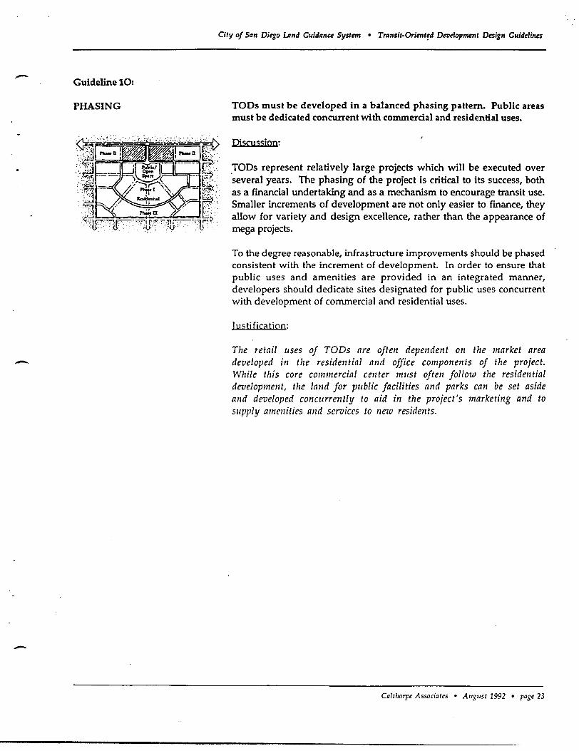
- Guideline 10:
PHASING
-
-
City of San Di~o umd Guidance Syslml • Tran5it-Orimt~d Detldopment Design Guidelines
TOOs must be developed in a balanced phasing pattern. Public areas must be dedicated concurrent with commercial and residential uses.
Pi scu ssjon:
.TOOs represent relatively large projects which will be executed over several years. The phasing of the project is critical to its success, both as a financial undertaking and as a mechanism to encourage transit use. Smaller increments of development are not only easier to finance, they allow for variety and design excellence, rather than the appearance of mega projects.
To the degree reasonable, infrastructure improvements should be phased consistent with the increment of development. In order to ensure that public uses and amenities are provided in an integrated manner, developers should dedicate sites designated for public uses concurrent with development of commercial and residential uses.
Iuc;tjficatjoo:
The retail uses of TODs are often dependent on the market area developed in the residential and office components of the project. While this core commercial center mllst often follow the residential development, the land for pllblic facilities and parks can be set aside a11d developed c011C11rrently to aid in the project's marketing and to s/lpply ame11ities and seroiccs to new residents.
CaltllOrpe Associates • AUSlist 1992 • page 23
City of San Di~o lAnd Guidance System • Trlmsi!-Orienled Droe1opment Design Guidelines
2. Redevelopable and Urbanizing Sites
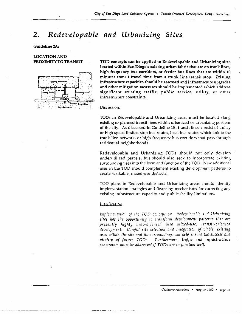
Guideline 2A:
LOCATION AND PROXIMITY TO TRANSIT
j ........ : r: : .
TOO concepts can be applied to Redevelopable and Urbanizing sites located within San Diego's existing urban fabric that are on trunk lines, high frequency bus corridors, or feeder bus lines that are within 10 minutes t~ansit travel time from a trunk line transit stop. Existing infrastructure capacities should be assessed and infrastructure upgrades and other mitigation measures should be implemented which address significant existing traffic, public service, utility, or other infrastructure constraints.
Pjscus<;jon:
TOPs in Redevelopable and Urbanizing areas must be located along existing or planned transit lines within urbanized or urbanizing portions of the city. As discussed in Guideline IB, transit lines consist of trolley or high speed limited stop bus routes, local bus routes which link to the trunk line network, or high frequency bus corridors that pass through residential neighborhoods.
Redevelopable and Urbanizing TOPs should not only develop underutilized parcels, but should also seek to incorporate existing surrounding uses into the form and function of the TOP. New additional uses in the TOP should complement existing development patterns to create walkable, mixed-use districts.
TOP plans in Redevelopable and Urbanizing areas should identify implementation strategies and financing mechanisms for correcting any existing infrastructure capacity and public facility limitations.
Itl <;ti fica tioo:
Implementation of the TOD concept all Rl'devclopable and Urbanizing sites has the opportllnity to transform de-velopment patterns that are presently highly alita-oriented into mixed-Ilse, transit-oriellted development. Careflll site selectioll and illtegration of viable, existillg IIses within the site and its sllrrollndillgs call help ensllre the slIccess and vitality of flltllre TODs. Fllrthermore, traffic and illjrastrtlctllre constraints 111115/ be addressed zf TODs are to jllnction well.
Calilrorpe Associates • August 1992 • page 24
-
-,
-
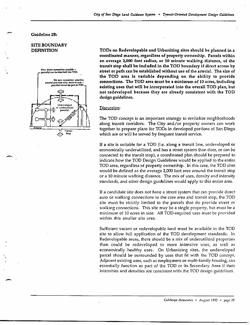
Guideline 2B:
SITE BOUNDARY DEFINITION
Now direct connection pouIblo -parcolCs) con be .boo,bod into TOO.
City of San Diego LAnd Guidllnee System • T~IInsit-Orimted DtTlelopment Design GUidelines
TODs on Redevelopable and Urbanizing sites should be planned in a coordinated manner, regardless of property ownership. Parcels within an average 2,000 foot radius, or 10 minute walking distance, of the transit stop shall be included in the TOD boundary if direct access by street or path can be established without use of the arterial. The size of the TOD area is variable depending on the ability to provide connections. The TOD area must be a minimum of 10 acres, including existing uses that will be incorporated into the overall TOO plan, but not redeveloped because they are already consistent with the TOO design guidelines.
Discussion:
The TOO concept is an important strategy to revitalize neighborhoods along transit corridors. The City and/or property owners can work together to prepare plans for TODs in developed portions of San Diego which are or will be served by frequent transit service.
If a site is suitable for a TOO (i.e. along a transit line, undeveloped or economically underutilized, and has a street system than does, or can be connected to the transit stop), a coordinated plan should be prepared to indicate how the TOO Design Guidelines would be applied to the entire TOO area, regardless of property ownership. In this case, the TOO sites would be defined as the average 2,000 foot area around the transit stop or a 10 minute walking distance. The mix of uses, density and intensity standards, and other design guidelines would apply to this entire area.
If a candidate site does not have a street system that can provide direct auto or walking connections to the core area and transit stop, the TOO site must be strictly limited to the parcels that do provide street or walking connections. This site may be a single property, but must be a minimum of 10 acres in size. All TOO-required uses must be provided within this smaller site area.
Sufficient vacant or redevelopable land must be available in the TOO site to allow full application of the TOO development standards. In Redevelopable areas, there should be a mix of underutilized properties than could be redeveloped to more intensive uses, as we)) as economically healthy uses. On Urbanizing sites, the undeveloped parcel should be surrounded by uses that fit with the TOO concept. Adjacent existing uses, such as employment or multi-family housing, can essentially function as part of the TOO or its Secondary Area if their, intensities and densities are consistent with the TOO design guidelines.
Calthorpe Associates • August 1992 • page 25
City of SIIn Diego Lind Guidllnce System • Trllnsit-Oriented Development Design Guidelines
Justification:
TODs on Redevelopable and Urbanizing. s~tes have the advantage of being located adjacent to existing development and in areas already served by public infrastructure. Given the importance of this strategy, the City should take the lead to encourage preparation of coordinated plans that go beyond the interests of a single property owner and consider the health and vitality of neighborhoods. A lO-acre site can function as a TOD, but will have less overall benefit to the transit system and neighborhood environment. At less than 10' acres, however, the development cannot function effectively as a TOD.
TODs in Redevelopable and Urbanizing areas may be developed on smaller sites than TODs in New Growth Areas because large sites are generally not available in developed portions of the city and because these TODs will generally be enhanCing existing effective transit service, rather than developing new transit lines and new patterns of transit ridership.
Ca/thorpe Associates • August 1992 • page 26
.- Guideline 2C:
-
--
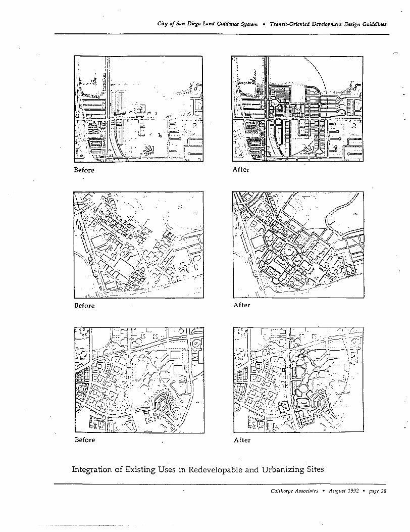
INTEGRA nON OF EXISTING ON-SITE USES
City of San Ditgo Land Guidanc~ Syst~ • Transit-Orirnt~d Devdopment D~ign Guid~lin~s
Existing on-site uses on Redevelopable and Urbanizing sites should complement the mix of uses and the pedestrian and transit orientation of the TOO. Uses which are complementary; and economically and physically viable, should be incorporated into the TOO development plan. If necessary, improvements should be made to make these uses more compatible with TOO concepts. Existing low-intensity and autooriented uses that relate poorly to pedestrians should be redeveloped to be consistent with the TOO's compact, pedestrian-oriented character.
Di"cussion:
In many cases, existing uses will have economic potential to continue operation within the context of a designated TOD site. The condition, density and intensity of these existing uses must be compatible or be made compatible with pedestrian and transit travel. Uses which rely solely on auto trips, such as gas stations, car washes, storage facilities, motels, or low-intensity industrial uses, are not likely to contribute to pedestrian activity in the TOD and should be discouraged and/or placed in structures with other pedestrian-oriented uses.
TOD site plans should integrate existing uses by respecting their ongoing operations, basic access requirements, and, if appropriate, existing building massing and architecture. For example, the Palm Avenue Trolley Station in Nestor could potentially redevelop as a TOD. Careful planning would be necessary to integrate existing viable uses into a pedestrian-oriented master plan. Site improvements may be required to make these properties more consistent with TOD requirements. Infill buildings may be needed to meet density and intensity requirements and to better address streets. Safe, direct and pleasant pedestrian connections should be provided to surrounding areas. Site landscaping and building frontage treatments may also be needed to enhance streets and mitigate areas where streetside conditions, such as parking, blank walls and service entries, are unavoidable. If these guidelines cannot be- met initially, plans for implementing necessary improvements over time must be submitted with the TOO project application.
Iu<;tifjcatiQn:
TOO development allows Jor inJili and redevelopment oj sites that may !lave been skipped over in the process oj urban growth; this type oj "rellse" is all illlportflllt strategy Jor minimizing urban sprawl. Many existing lIses ciln serve as a starting point Jor TOOs and may provide the lluclellS Jor JlItlire economic revitalization.
Ca/tho']', Associates • AIIS"st 1992 • page 27
City of 54zn Diego lAnd Guidance Systml • Transit-Oriented Development Design Guidelines
Before After
Defore After
Defore After
Integration of Existing Uses in Redevelopable and Urbanizing Sites
ColtharpI' Associates • Allgllst 1992 • l'a,I;<,28
-
-
-
Guideline 20:
MIX OF USES
Existing Residential
"
Existing Rosidential
Vacant ' Poltntial Transit Route
Existing lhsidential
Complimrnt existing ruidrnli.ll art.1S ""'ilh new commuci.al .lind public usn.
Existing Residential
ro!ential Tn,nsit Route
Existing Residential
~ -:l \'"C.-:-1 ShOrr'ns 0 'I
C~"It"f' ~
~ E~isting
r====; f=.==R=,e=,,=J,='"=t,=,I==;t
Comp:imrnt existing commr[ci.al centers with higher densit), housing.
City of 54n Diego LAnd Cuida'lce SySlem • Transil-Oriented Deve10pmml Design Guidelines
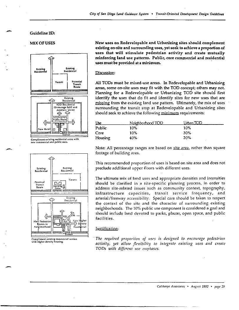
New uses on Redevelopable and Urbanizing sites should complement existing on-site and surrounding uses, yet seek to achieve a proportion of uses that will stimulate pedestrian activity and create mutually reinforcing land use patterns. Public, core commercial and residential uses must be provided at a minimum. .
Discussion:
All TODs must be mixed-use areas. In Redevelopable and Urbanizing areas, some on-site uses may fit with the TOO concept; others may not. Planning for a Redevelopable or Urbanizing TOD site should first identify the uses that do fit and identify sites for new uses that are missing from the existing land use pattern. Ultimately, the mix of uses surrounding the transit stop at Redevelopable and Urbanizing sites should seek to achieve the following minimum requirements:
Public Core Housing
Neighborhood TOO 10% 10% 40%
VrbnnmO 10% 30% 20%
Note: All percentage ranges are based on site area. rather than square footage of building area.
This recommended proportion of uses is based on site area and does not preclude additional upper floors with different uses.
The ultimate mix of land uses and appropriate densities and intensities should be clarified in a site-specific planning process, in order to address site-related issues such as community context, topography, infrastructure capacities, transit service frequency, and arterial/free\",'ayaccessibility. Special care should be taken to respect the context of the site and the character of surrounding existing neighborhoods. The 10% public use component is considered a goal and should include land devoted to parks, plazas, open space, and public facilities.
Justificiltion:
'The required proportioll of uses is desiglled to encol/rage pedestrian activity, yet allow flexibility to integrate existillg IIses and create TODs with different lise emphnses,
CaltllOrpe- Associate-s • Augllst 1992 • page- 29
Guideline 2E:
RETROFIT OF EXISTING STREETS FOR PEDESTRIAN, BICYCLE AND AUTO CONNECI10NS
" Transit ~ Stop
City of San Diego LAnd G!lidance System • Transit-Oriented Detldopment Design Guidelines
Existing on-site pedestrian, bike, parking, and auto circulation systems should be redesigned to encourage pedestrian/bike access between uses, and public spaces in TOOs and Secondary Areas.
Discussion:
On sites that will be retrofit or redeveloped into TODs, existing roadways and pedestrian networks may need to be redesigned to facilitate pedestrian access between buildings and transit, regardless of parcelization patterns. Connections to the core and transit, and between the TOD and surrounding areas are especially critical. Improvements should be made to open walking paths between uses, to protect important vistas, to connect with existing trail systems, and to slow auto traffic. Handicapped access strategies should be incorporated into all street and pathway retrofits. In Carmel Valley and other autooriented suburban areas, pedestrian access could be improved by opening key cul-de-sacs to foot and bicycle traffic. In areas domina ted by "superblocks" new internal streets could be built to provide pedestrianfriendly connections to workplaces and other destinations.
Justification:
Every effort should be made to encourage and facilitate pedestrian access at sites that are redeveloped into TODs. In some cases this may require redesigning streets and pedestrian systems. Connections between TODs and surrounding areas are vital to providing all of the advantages that a walkable, mixed-use and transit-oriented developmen t can provide.
Caltlwrpe Associates • August 1992 • page 30
-
-
-
Guideline 2F
PROXIMIlY OF COMPImNG RETAIL
City of Siln Ditgo lAnd Guidllnce Systmr • Transit-Oriented Def1dopment Design Guidelines
As much as possible, new neighborhood and convenience retail centers should be incorporated into TO Os and the extent of competing existing "strip commercial" areas should be limited. New competing retail uses outside of TOOs should be strictly limited within 1 mile of the TOO core commercial area.
Piscussjon:
In order (or the core commercial area of a TOO to attract major anchor tenants and be economically viable, new competing retail centers must be limited through zoning amendments within the TOO's market area. This provides an incentive (or development of TOOs in Redevelopable and Urbanizing areas and is a key guideline to enable linear areas to function as TOOs. Strip commercial uses that extend beyond a 10 minute walking distance of a transit stop should be limited so that businesses that fit into the TOO can capitalize upon their location and proximity to transit.
Iustificiltion:
TODs depend on retail IIses for a focus and pedestrian destination. Competing centers in locations which do not Sllpport transit or pedestrian-oriented neighborhoods can diminish the opportllnity to build transit-oriented mixed-lise centers. San Diego's present system of strip commercial areas, particularly along blls ralites sllch as El Cajon Boulevard, shollld be examined to determine whether the location of these commercial IIses may be working in conflict with the goals to promote transit usage, encourage walking or biking for some daily trips, and building a network of streets that allow allto users to travel to local shopping trips all local streets.
Ca/tllOrpe Associates • A IISIiSt 1992 • page 31
City of San Diego. LAnd Guidanu System • Transit-Oriented Detle10pmmt Design Guidelines
3. New Growth Areas
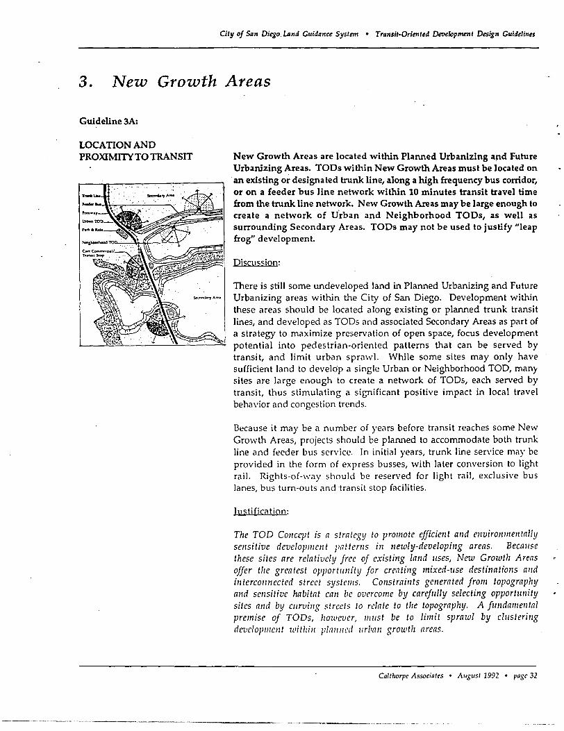
Guideline 3A:
LOCATION AND PROXIMITY TO TRANSIT New Growth Areas are located within Planned Urbanizing a~d Future
Urbanizing Areas. TOOs within New Growth Areas must be located on an existing or designated trunk line, along a high frequency bus corridor, or on a feeder bus line network within 10 minutes transit travel time from the trunk line network. New Growth Areas may be large enough to create a network of V·rban and Neighborhood TOOs, as well as surrounding Secondary Areas. TOOs may not be used to justify "leap frog" development.
Djscus<;jon:
There is still some undeveloped land in Planned Urbanizing and Future Urbanizing areas within the City of San Diego. Development within these areas should be located along existing or planned trunk transit lines, and developed as TODs and associated Secondary Areas as part of a strategy to maximize preservation of open space, focus development potential into pedestrian-oriented patterns that can be served by transit, and limit urban sprawl. While some sites may only have sufficient land to develop a single Urban or Neighborhood TOD, man)' sites are large enough to create a netw'ork of TODs, each served by transit, thus stimulating a significant positive impact in local travel behavior and congestion trends.
Because it may be a number of years before transit reaches some New Growth Areas, projects should be planned to accommodate both trunk line and feeder bus service. In initial years, trunk line service may be provided in the form of express busses, with later conversion to light rail. Rights-of-way should be reserved for light rail, exclusive bus lanes, bus turn-outs and transit stop facilities.
Justification:
The TOD COIlCept is a strategy to promote efficiellt alld environmentally sensitive development Fatterns in newly-developing areas. Becallse these sites are relatively free of existing lalld IIses, New Growth Areas offer tile greatest opportllnity for creatillg mixed-lise dcstinatiollS and interCOllllected strect systcms. COllstraints generated from topography alld sellsitive habitat call be overcome by careflllly selecting opportunity sites alld by ClIrvillg streets to relate to tIle topography. A flllldamelltal premisc of TODs, howevcr, mllst be to limit sprawl by clllsterillg developlllcnt witllill plalllled IIrban growth areas.
CaItllOrpe Associates • AlIgllst 1992 • page 32
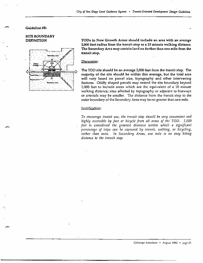
-
-
-
Guideline 3B:
SITE BOUNDARY DEFINITION
r:-;-'-.. '-.. '7L .r ,"" '. . '.' . : '. '.' . '. . ' .. s..-I..,. ...... .
I: '. ". '., :'" ......... .':.' • '200011."
. Awn ..
• . .' Socondaty .......
City of San Di~o lAnd Guidance System • Transit-Oriented Development Design Guidelines
TODs in New Growth Areas should include an area with an average 2,000 foot radius from the transit stop or a 10 minute walking distance. The Secondary Area may contain land no further than one mile from the transit stop.
Piscussion:
The TOO site should be an average 2,000 feet from the transit stop. The majority of the site should be within this average, but the total area will vary based on parcel size, topography and other intervening features. Oddly shaped parcels may extend the site boundary beyond 2,000 feet to include areas which are the equivalent of a 10 minute walking distance; sites affected by topography or adjacent to freeways or arterials may be smaller. The distance from the transit stop to the outer boundary of the Secondary Area may be no greater than one mile.
Iustification:
To encourage transit lise, the trallsit slop shollid be very convenient and highly accessible by foot or bicycle from all areas of the' TOD. 2,000 feet is considered the greatest distance within which a significant percentage of trips can be captllred by transit, walking, or bicycling, rather than allto. In Secondary Areas, one mile is an easy biking distance to the transit stop.
CaTtharpe Associates • AI/gust 1992 • p~ge 33
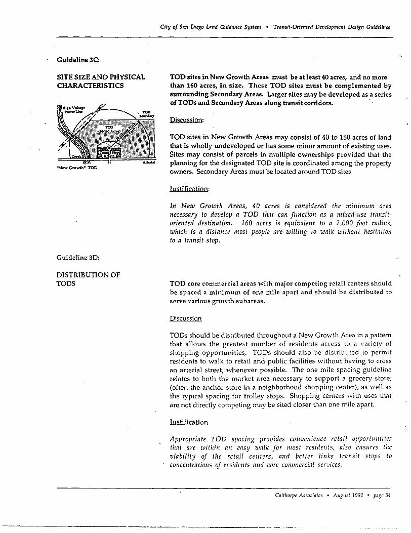
Guideline 3C:
SITE SIZE AND PHYSICAL CHARAcrERISTICS
"New Growth" TOO
Guideline 3D:
DISTRIBUTION OF TODS
City of SQn Diego umd Guidance System • Transit-Oriented Development Design Guidelines
TOO sites in New Growth Areas must be at least 40 acres, and no more than 160 acres, in size. These TOO sites must be complemented by surrounding Secondary Areas. Larger sites may be developed as a series of TODs and Secondary Areas along transit corridors. .
Discussion:
TOD sites in New Growth Areas may consist of 40 to 160 acres of land that is wholly undeveloped or has some minor amount of existing uses. Sites may consist of parcels in multiple ownerships provided that the planning for the designated TOO site is coordinated among the property owners. Secondary Areas must be located around TOO sites.
Justification:
Tn New Growth Areas, 40 acres is considered the minimllm lirea necessary to develop a TOD that can fllnction as a mixed-llse transitoriented destination. 160 acres is equivalent to a 2,000 foot radills, which is a distance most people are willing to walk withollt hesitation to a transit stop.
TOO core commercial areas with major competing retail centers should be spaced a minimum of one mile apart and should be distributed to serve various growth subareas.
pj<:'clI<:.<:ion
TODs should be distributed throughout a New Growth Area in a pattem that allows the greatest number of residents access to a variety of shopping opportunities. TODs should also be distributed to permit residents to walk to retail and public facilities \'·;ithout having to cross an arterial street, whenever possible. The one mile spacing guideline relates to both the market area necessary to support a grocery store; (often the anchor store in a neighborhood shopping center), as well as the typical spacing for trolley stops. Shopping centers with uses that are not directly competing may be sited closer than one mile apart.
Iu<:.ti fica tion
Appropriate TOD spacillg provides cOllveniellce retail opportlillities that arc witizill all easy walk for most residellts, also ellSllres tize viability of tile reta,il centers, and better lillks trallsit stops to COllcelltratiollS of residellts alld core commercial sCTvices.
Calthorpe Associates • AI/SI/st 1992 • pase 34
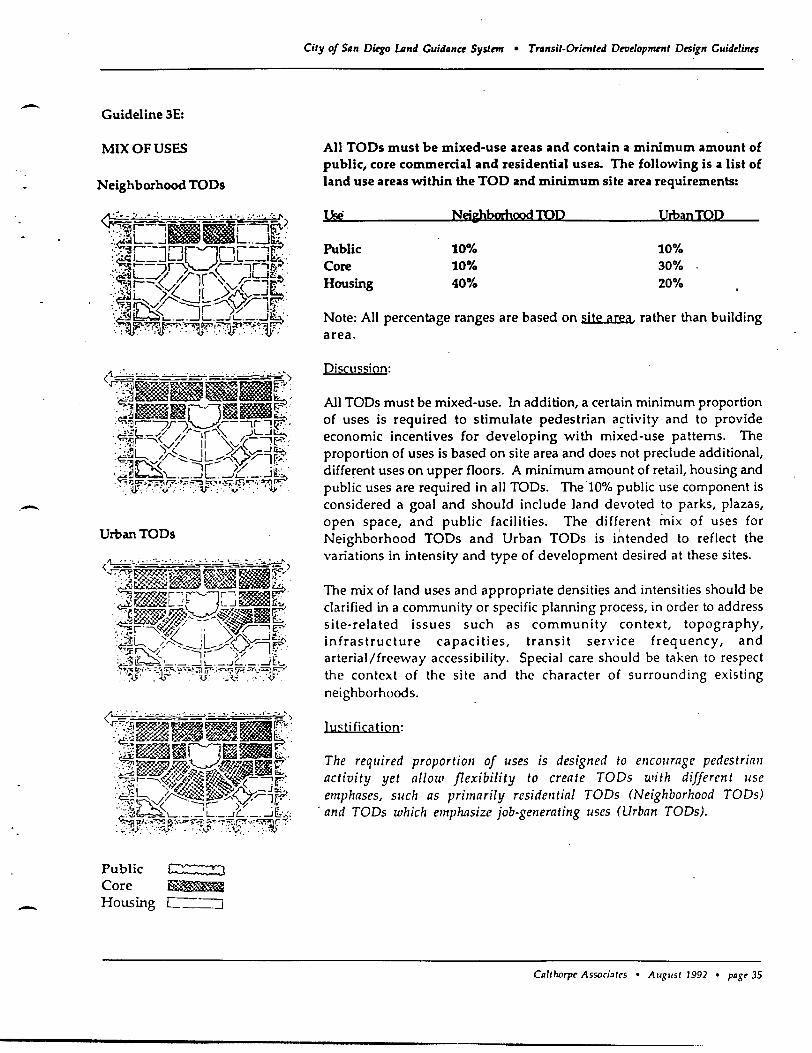
- Guideline 3E:
MIX OF USES
Neighborhood TODs
.-UrbanTODs
Public ~:8
Core ~ - Housing C----=::J
City of Siln D~o LAnd Guidllnce Systnn • Trtlnsit-Orient~d Drodopmrnt Design Guiddin~s
All TODs must be mixed-use areas and contain a minimum amount of public, core commercial and residential uses. The following is a list of land use areas within the TOO and minimum site area requirements:
Use Nej&hbmbood TOP thbanTOD
Public 10% 10% Core 10% 30% Housing 40% 20%
Note: All percentage ranges are based on site area, rather than building area.
Discussion:
All TODs must be mixed-use. In addition, a certain minimum proportion of uses is required to stimulate pedestrian a~tivity and to provide economic incentives for developing with mixed-use patterns. The proportion of uses is based on site area and does not preclude additional, different uses on upper floors. A minimum amount of retail, housing and public uses are required in all TODs. The 10% public use component is considered a goal and should include land devoted to parks, plazas, open space, and public facilities. The different mix of uses for Neighborhood TODs and Urban TODs is intended to reflect the variations in intensity and type of development desired at these sites.
The mix of land uses and appropriate densities and intensities should be clarified in a community or specific planning process, in order to address site-related issues such as community context, topography, infrastructure capacities, transit service frequency, and arterial/freeway accessibility. Special care should be taken to respect the context of the site and the character of surrounding existing neighborhoods.
Iuqi ficatioo:
The required proportion of uses is designed to encourage pedestrian activity yet allow flexibility to create TOOs with different lise emphases, sllch as primarily residelltial TOOs (Neighborhood TOOs)
. and TOOs which emphasize job-generating uses (Urban TOOs).
Cillthorpl' Associates • August 1992 • past.' 35
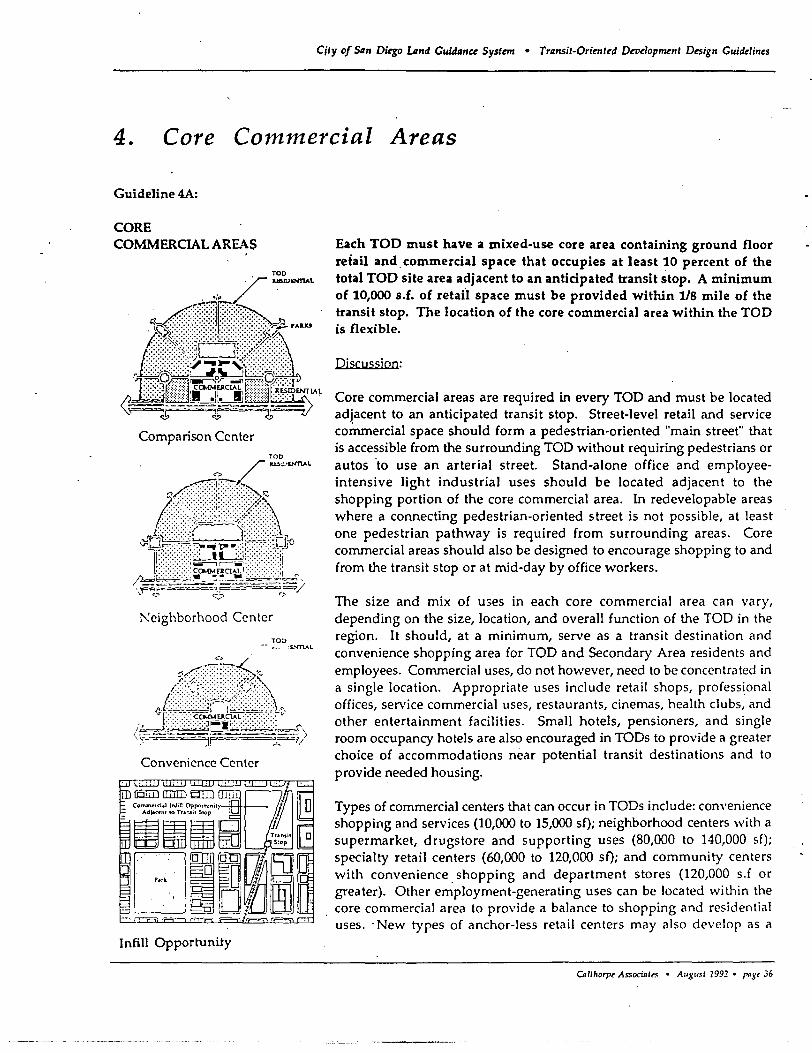
City of Siln Dkgo LAnd GWdllnc~ System • Trllnsit-Orirnt~d Dewlopment D~ign Clliddin~s
4. Core Commercial Areas
Guideline 4A:
CORE COMMERCIAL AREAS
, /~oNT1A~
\-'--, i-- ';=-~1~-
Comparison Center TOO
, ,( ""1:.,."."..L .."
~:::::::-:,
... t:..,... ~ ";-'
!'eighborhood Center
Convenience Center
Infill Opportunity
Each TOO must have a mixed-use core area containing ground floor retail and. commercial space that occupies at least 10 percent of the total TOO site area adjacent to an anticipated transit stop. A minimum of 10,000 s.f. of retail space must be provided within l/S mile of the transit stop. The location of the core commercial area within the TOO is flexible.
Discussion:
Core commercial areas are required in every TOD and must be located adjacent to an anticipated transit stop. Street-level retail and service cOlnmercial space should form a pedestrian-oriented "main street" that is accessible from the surrounding TOD without requiring pedestrians or autos 'to use an arterial street. Stand-alone office and employeeintensive light industrial uses should be located adjacent to the shopping portion of the core commercial area. In redevelopable areas where a connecting pedestrian-oriented street is not possible, at least one pedestrian pathway is required from surrounding areas. Core commercial areas should also be designed to encourage shopping to and from the transit stop or at mid-day by office workers .
The size and mix of u:;es in each core commercial area can vary, depending on the size, location, and overall function of the TOD in the region. It should, at a minimum, serve as a transit destination and convenience shopping area for TOD and Secondary Area residents and employees. Commercial uses, do not however, need to be concentrated in a single location. Appropriate uses include retail shops, professional offices, service commercial uses, restaurants, cinemas, health clubs, and other entertainment facilities. Small hotels, pensioners, and single room occupancy hotels are also encouraged in TODs to provide a greater choice of accommodations near potential transit destinations and to provide needed housing.
Types of commercial centers that can occur in TODs include: convenience shopping and services (10,000 to 15,000 sf); neighborhood centers with a supermarket, drugstore and supporting uses (80,000 to 140,000 sf); specialty retail centers (60,000 to 120,000 sf); and community centers with convenience, shopping and department stores (120,000 s.f or greater). Other employment-generating uses can be located within the core commercial area to provide a balance to shopping and residential uses. -New types of anchor-less retail centers may also develop as a
CAlthorpt Associalt> • Augusl 1992 • ras,36
--
-
-
· City of San Diego Land Guidance System • Transit-Oriented DeTJelopment Design Guidelines
result of new markets produced by the configuration of TOOs, workers in the TOO, and transit accessibility.
Justification:
Mixed-use core commercial areas are the primary link between transit and land use. A TOD must have sufficient retail and commercial space to form a ugJn1. shopping center and provide opportunities for residents and employees to run errands, during lunch-time or to and from work. Without shopping opportunities within convenient walking distance, residents and workers will use their cars for more trips and will lose an incentive to use transit. Core commercial areas must vary in size and character to respond to market considerations.
Calthorpt Associa't'S • Augus, 1992 • pnst 37
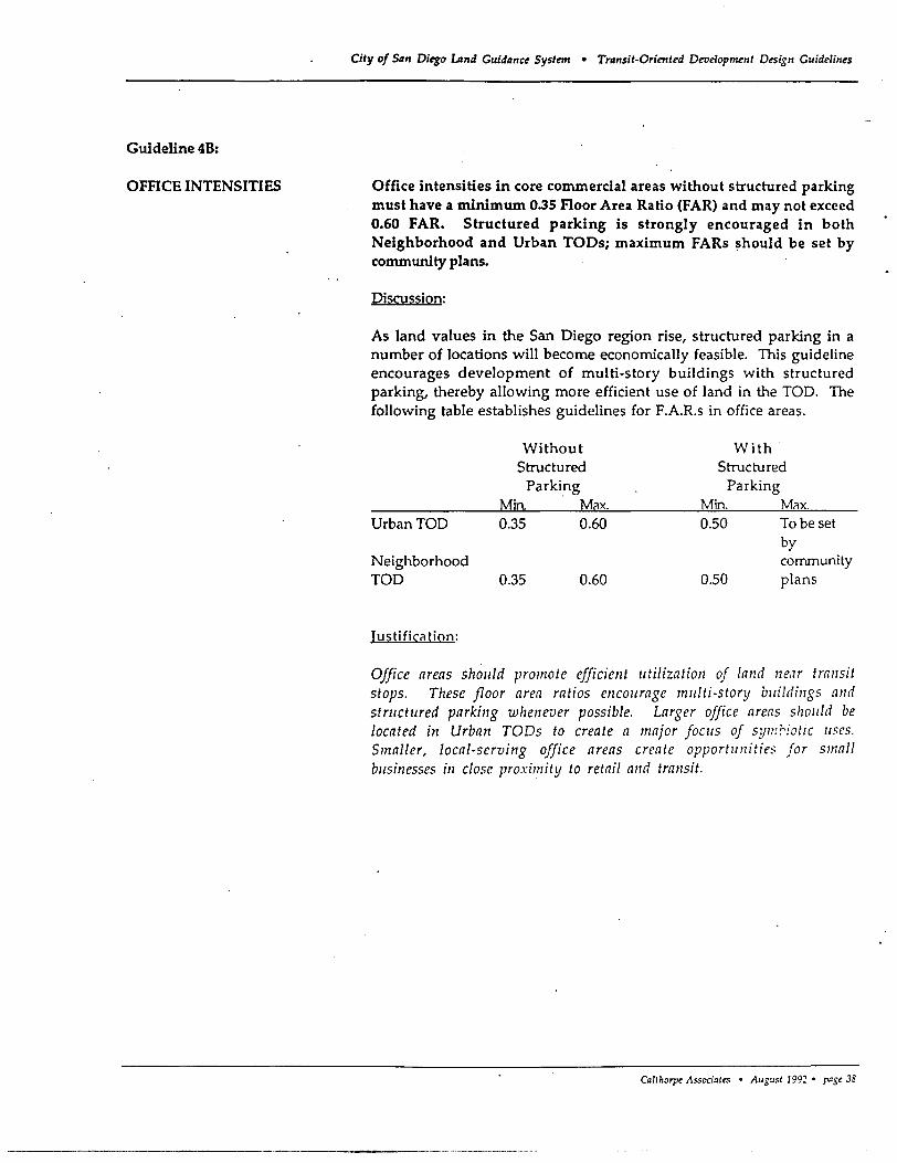
Guideline 48:
OFFICE INTENSITIES
City of San Diego Lind Guidanu System • Transit-Oriented Droe1oprrtnll Design Guidelines
Office intensities in core commercial areas without structured parking must have a minimum 0.35 Floor Area Ratio (FAR) and may not exceed 0.60 FAR. Structured parking is strongly encouraged in both Neighborhood and Urban TODs; maximum FARs should be set by community plans.
Discussion:
As land values in the San Diego region rise, structured parking in a number of locations will become economically feasible. This guideline encourages development of multi-story buildings with structured parking, thereby allowing more efficient use of land in the TOO. The following table establishes guidelines for F.A.R.s in office areas.
Urban TOO
Neighborhood TOO
Justification:
Without Structured
Parking Min Max. 0.35 0.60
0.35 0.60
With· Structured
Parking Min. Max. 0.50 To be set
by community
0.50 plans
Office areas should promote efficient utilization of land near transit stops. These floor area ratios encourage multi-story buildings and stntctured parking whenever possible. Larger office areas should be located in Urban TOOs to create a major foCllS of symhotic uses. Smaller, local-serving office areas create opportllnities for small businesses in close proximity to retail and transit.
Callhorpe Associales • AuguSI 1992· p"g' 3~
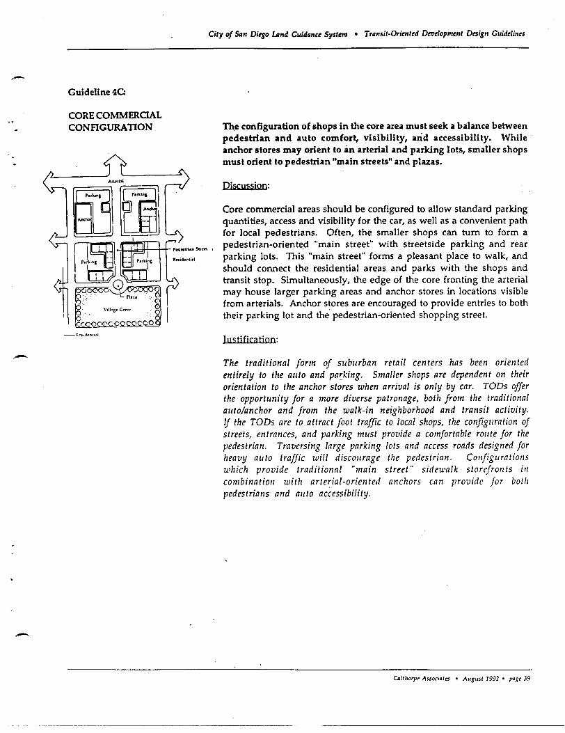
-
-
Guideline 4C:
CORE COMMERCIAL CONFIGURATION
City of 54n Diego umd Guidllnce System • Trllnsit-Oriented Deoelopment Design Guidelines
-me configuration of shops in the core area must seek a balance between pedestrian and auto comfort, visibility, and accessibility. While' anchor stores may orient to an arterial and parking lots, smaller shops must orient to pedestrian "main streets" and plazas.
Piscussion:
Core commercial areas should be configured to allow standard parking quantities, access and visibility for the car, as well as a convenient path for local pedestrians. Often, the smaller shops can tum to form a pedestrian-oriente.d "main street" with streetside parking and rear parking lots. This "main street" forms a pleasant place to walk, and should connect the residential areas and parks with the shops and transit stop. Simultaneously, the edge of the core fronting the arterial may house larger parking areas and anchor stores in locations visible (rom arterials. Anchor stores are encouraged to provide entries to both their parking lot and the pedestrian-oriented shopping street.
Justj fica tion:
The traditional form of suburban retail centers has been oriented entirely to the auto and pa~king. Smaller shops are dependent on their orientation to the anchor stores when arrival is only by car. TODs offer the opportunity for a more diverse patronage, both from the traditional auto/anchor and from the walk-in neighborhood and transit activity. If the TODs are to attract foot traffic to local shops, the configuration of streets, entrances, and parking must provide a comfortable route for the pedestrian. Traversing large parking lots and access roads designed for heavy auto traffic will discourage the pedestrian. Configurations which provide traditional "main street" sidewalk storefron ts ill combination with arterial-oriented anchors can provide for both pedestrians and auto accessibility.
OIUhorpt Associ.,,,, • Augusl 1992 • pogt 39
Guideline 4D:
COMMERCIAL BUILDING SETBACKS
City of San Diego umd Guidanu System • Transit-Orirnted Develupment Design Guidelines
Building setbacks from public streets should be minimized. Setbacks should reflect the desired character of the area and bring buildings close to the sidewalk.
Discussion:
Buildings in core commercial areas should be encouraged to build to the sidewalk edge whenever possible. Anchor tenants in Urban Growth areas, such as supermarkets, should not be strictly held to this requirement because more auto trips are expected to serve heavy load shopping and lenders often require visible surface parking. The Ralphs store in the Uptown District in Hillcrest is a good example of a compromise. In this case, only a small amount of parking is visible from the street; most of it is underground. Parking areas and parking garages should be recessed or placed to the rear of buildings. Larger setbacks of up to 20 feet should be permitted for, office buildings and streetside outdoor cafes and patios in core commercial areas.
Justification:
The street and sidewalk is the main pedestrian activity cellter. Minimal setbacks bring buildings close to the street and the pedestrians. This defined and close edge enlivens commercial areas by encouraging window shopping and streetside activity. This can be seen ill Hillcrest, La Jolla, Mission Boulevard and other areas of San Diego,
CaUhorpt Associates • August 1992 • p,1gt 40
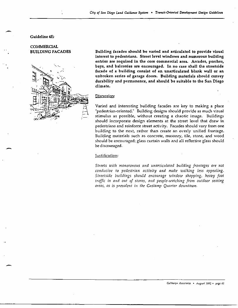
-
-
-
Guideline 4E:
COMMEROAL BUILDING FACADES
City of SlIn DitgO LAnd Guidan« Systmr • Trllnsit-Oriented Deuelopment Design Guidelines
Building facades should be varied and articulated to provide visual interest to pedestrians. Street level windows and numerous building entries are required in the core commercial area. Arcades, porches, bays, and balconies are encouraged. In no case shall the streetside facade of a building consist of an unarticulated blank wall or an unbroken series of garage doors. Building materials should convey durability and permanence, and should be suitable to the San Diego climate.
Discussion:
Varied and interesting building facades are key to making a place "pedestrian-oriented." Building designs should provide as much visual stimulus as pOSSible, without creating a chaotic image. Buildings should incorporate design elements at the street level that draw in pedestrians and reinforce street activity. Facades should vary from one building to the next, rather than create an overly unified frontage. Building materials such as concrete, masonry, tile, stone, and wood should be encouraged; glass curtain walls and all reflective glass should be discouraged.
Iuc;tificatiQn:
Streets with monotonous and 1l1larticlllated building frontages are not conducive to pedestrian activity and make walking less appealing. Streetside vlIildings should encollrage window shopping, heavy foot traffic ill alld out of stores, and people-watching from olltdoor seating areas, as is prevalent ill the Gaslamp Quarter dowlltowll.
Callhorpe Associates • Augu5t 1992 • p.gt 41
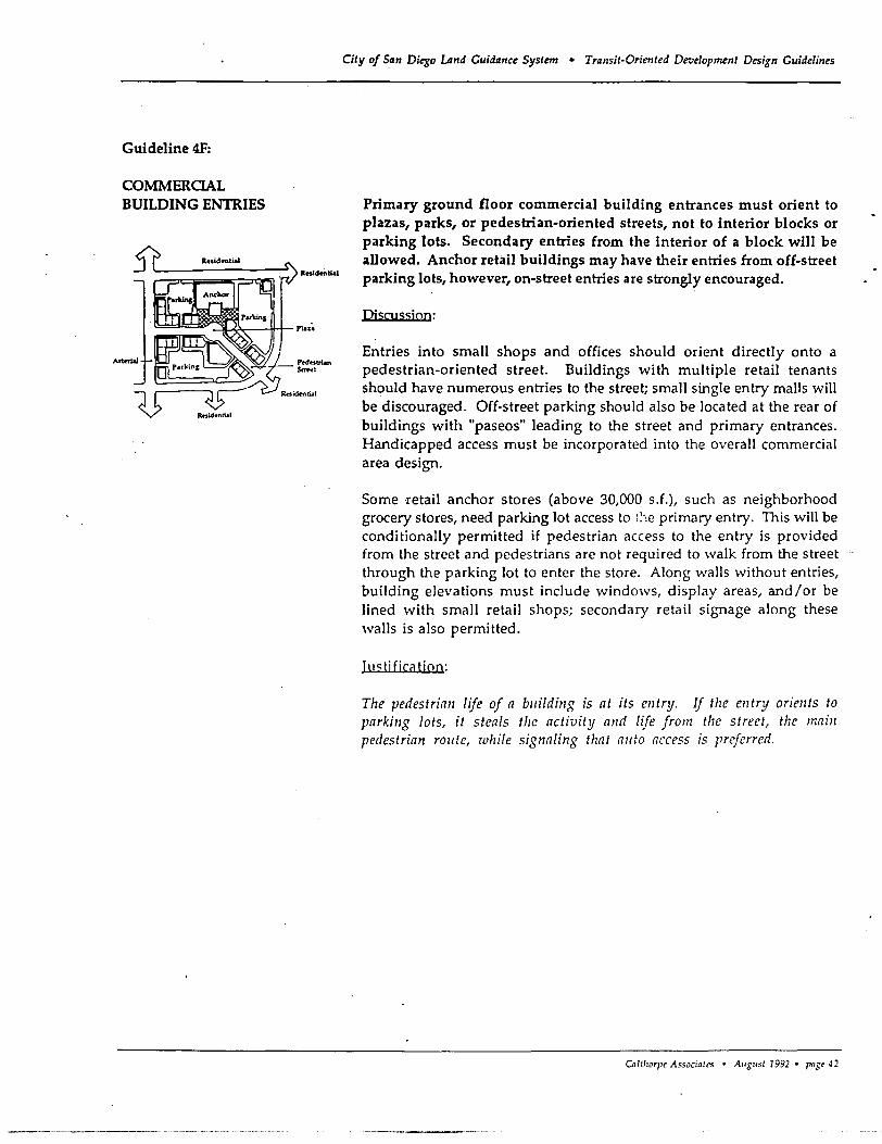
Guideline 4F:
COMMERCIAL BUILDING ENTRIES
City of San Diego LAnd Cuidance System • Transit-Oriented Development Design Cuidelines
Primary ground floor commercial building entrances must orient to plazas, parks, or pedestrian-oriented streets, not to interior blocks or parking lots. Secondary entries from the interior of a block will be allowed. Anchor retail buildings may have their entries from off-street parking lots, however, on-street entries are strongly encouraged.
Discussjon:
Entries into small shops and offices should orient directly onto a pedestrian-oriented street. Buildings with multiple retail tenants should have numerous entries to the street; small single entry malls will be discouraged. Off-street parking should also be located at the rear of buildings with "paseos" leading to the street and primary entrances. Handicapped access must be incorporated into the overall commercial area design.
Some retail anchor stores (above 30,000 s.f.), such as neighborhood grocery stores, need parking lot access to ;;-:e primary entry. This will be conditionally permitted if pedestrian access to the entry is provided from the street and pedestrians are not required to walk from the street through the parking lot to enter the store. Along walls without entries, building elevations must include windows, display areas, and/or be lined with small retail shops; secondary retail signage along these walls is also permitted.
Itlc:;ti ficatiQn:
The pedestrian life of a bllilding is at its entry. If the entry orients to parking lots, it steals the activity and life from the street, the main pedestrian rOllte, while signaling that allto access is preferred.
Ca/lhorpe A"-Socialcs • A"S"sl 1992 • paS' ~2
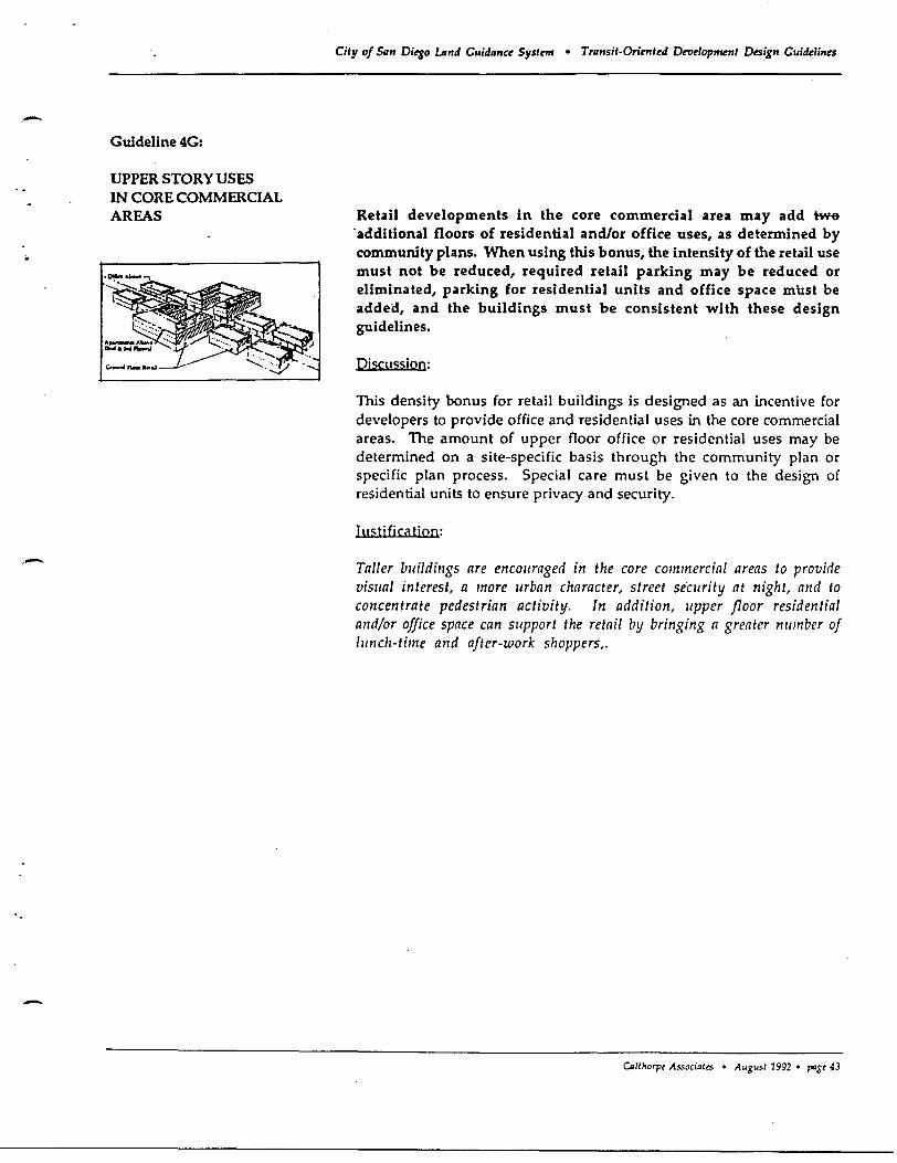
-
Guideline 4G:
UPPER STORY USES IN CORE COMMERCIAL AREAS
City of 5.IIn Diego lAnd Guidllnu Systrm • Trllnsit-Orinrted Development Design Guidelines
Retail developments in the core commercial area may add tw6
. additional floors of residential and/or office uses, as determined by community pla~s. When using this bonus, the intensity of the retail use must not be reduced, required retail parking may be reduced or eliminated, parking for residential units and office space must be added, and the buildings must be consistent with these design guidelines.
Piscussion:
This density bonus for retail buildings is designed as an incentive for developers to provide office and residential uses in the core commercial areas. The amount of upper floor office or residential uses may be determined on a site-specific basis through the community plan or specific plan process. Special care must be given to the design of residential units to ensure privacy and security.
ItI"tjfication:
Taller bllildings are encollraged in the core commercial areas to provide visllal interest, a more urban character, street security at night, and to concentrate pedestrian activity. In addition, IIpper floor residential and/or office space can support the retail by bringing a greater nllmber of llinch-time and after-work shoppers,.
CDlthorpt As.<ociattS • August 1992 • pogt 43
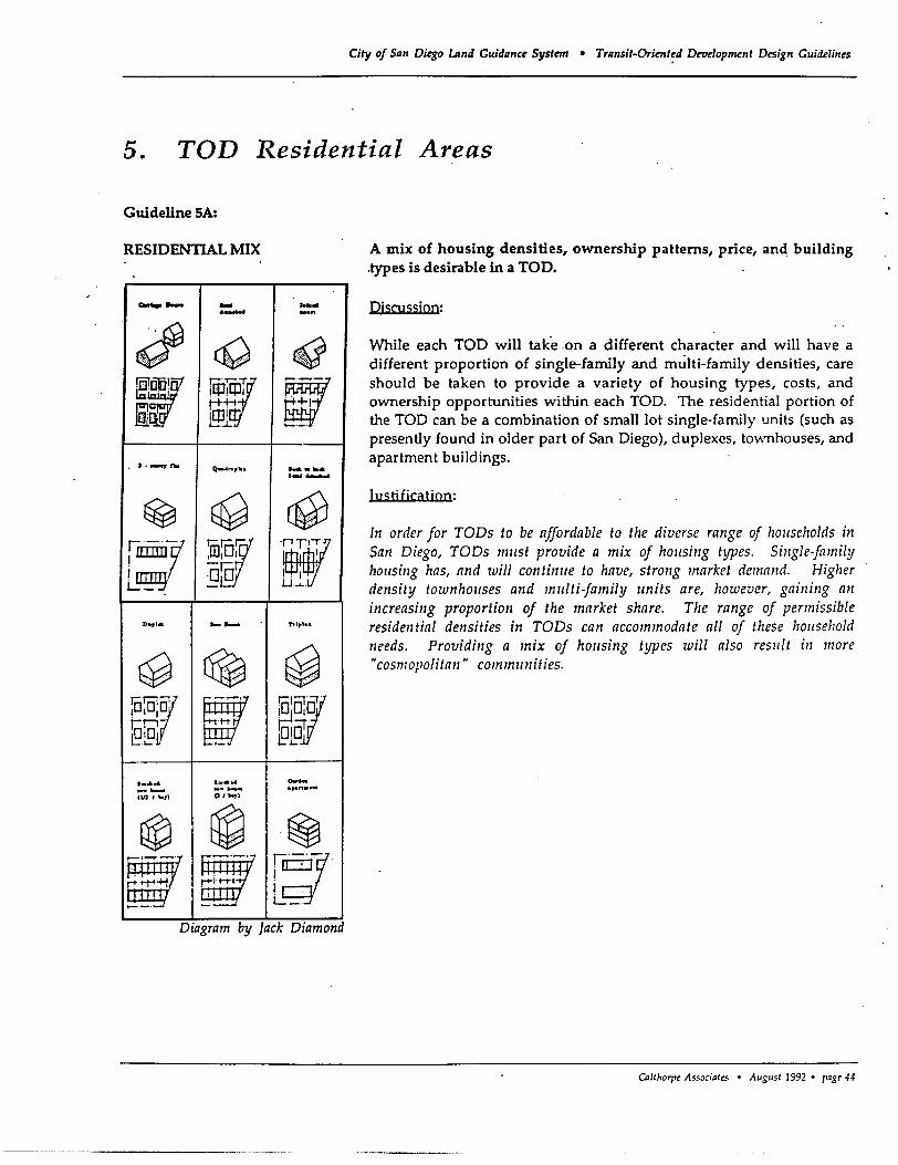
City of San Di~o umd Guidance Syslnn • Transil-Orienl~d Drodopmenl Design Guidelines
5. TOD Residential Areas
Guideline SA:
RESIDENTIAL MIX
-- - ...... ....... -"
" cO (.j ~, ~f mr iQJ,[jJ1
j-H-' @ ilD' '-.J.: ~.-.
~ J • .-.:r'" 0_4 ... , ... ....-~ ,-'-
~ ~ ~ . ::
~:Y @[W !nT, lIIIII1 I I lOTI , . , L..:_ c U .........
De,'. -- !'rIp'"
~ ~ ~ ...
'5'0', ~ !oJV I I I
~IT roB . .t-t
t ...... e: .Lo .
........ I ..... ...... _ ..... ....... .,.n ... un, _,) Cl/~)
~ ~ ~ rl1 ~ffir ~~ I ..
i....:_.
Dzagram by Jack DIamond
A mix of housing densities, ownership patterns, price, and building .types is desirable in a TOO.
QjsOlssjon:
While each TOO will take .on a different character and will have a different proportion of single-family and multi-family densities, care should be taken to provide a variety of housing types, costs, and ownership opportunities within each TOO. The residential portion of the TOO can be a combination of small lot single-family units (such as presently found in older part of San Diego), duplexes, townhouses, and apartment buildings.
Justificatjon:
In order for TODs to be affordable to the diverse range of households ill San Diego, TODs mllst provide a mix of hOllsing types. Single-family hOllsing has, and will continlle to have, strong market demand. Higher density townhollses and mlliti-family units are, however, gailling all increasillg proportion of the market share. The range of permissible residwtial densities in TODs can accommodate all of these hOllse}zold needs. Providillg a mix of hOllsing types will also reslllt ill more H cosmopolitall" commlillities .
CA/thorpe A~5aciQtcs • August 1992 • ragt 44
- Guideline 5B:
RESIDENTIAL DENSITIES
-
-
City of San Di~o lAnd Guidanee System • Transit-Oriented DeT1elopment Design Guidelines
Residential densities within Neighborhood TODs must be a minimum of 12 units per net acre and a minimum average of at least 18 units per net acre. Residential densities within Urban TODs'must be a minimum of 18 units per net acre and have a minimum average of at least 25 units per net acre. Maximum densities should be set by community plans.
Discussion:
The range of permissible TOD densities is designed to encourage transit ridership, as well as provide a variety of housing types, as shown in the following table: '
Minimum Minimum Maximum Density Avernge Density
Neighborhood TOD 12du/netac 18 dulac To be determined by
Urban TOO 18 du/netac 25du/ac community plans
Note: Residential densities in TODs will be measured in ~ densities.
Single-family ownership patterns with ancillary units are feasible behveen 12 and 17 units per net acre. Ancillary units will be calculated as 1 unit per lot. For example, a 4,500 s.f. or smaller lots will create densities of 16 units/net acre or greater if developed with an ancillary unit. To",mhouses can be provided between 18 and 29 units per acre. Smaller attached units, with up to five stories, can be provided at higher densities of up to 70 du/net acre. Actual densities should allow TOO development to strike a balance between emphasizing the importance of development around transit stops and blending in with existing surrounding neighborhoods. TypicC\1 C\verC\ge densities in Neighborhood TODs should be behveen 20 and 30 du/net acre and in Urban TOOs between 25 and 45 du/net acre.
ItI<;fi ficC\tiQn:
The required dC1lsity rnllgc offers flexibility to respond to changing market conditions and encol/rage. a mix of hOllsing types. Tile range of permissible residential densities meets tllis requirement at a millimllm alld allows higl/er dellsities wllich provide a variety of hOIlSillg opportullities for the illcreasillgly diverse household composition of tile San Diego regioll.
Calrhorl't Associatrs • August 19:12 • paSt 45
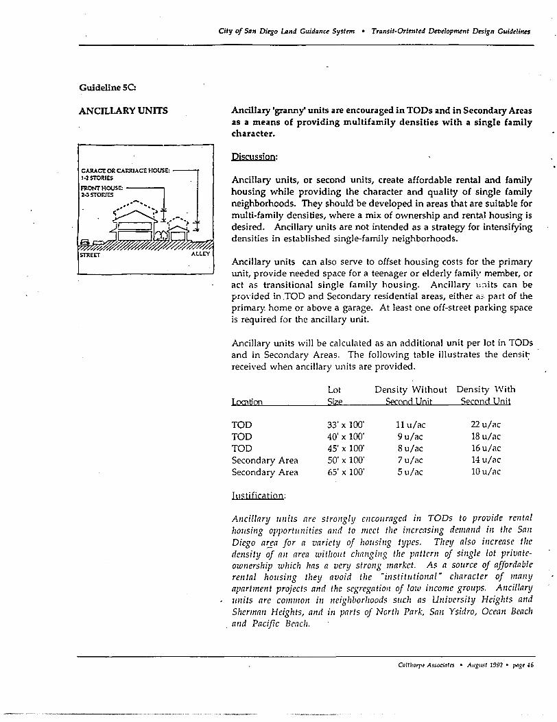
Guideline SC:
ANCILLARY UNITS
CARACE OR CARRIACE HOUSE: 1·2 STORIES
~ONT HOUSE: ---..., 2·3 STORIES
STREf:T
--_ ... _-------
City of San Di~o Land Guidance System • Transit-Oriented Development Design Guidelines
Ancillary 'granny' units are encouraged in TODs and in Secondary Areas as a means of providing multifamily densities with a single family character.
Discussion:
Ancillary units, or second units, create affordable rental and family housing while providing the character and quality of single family neighborhoods. They should be developed in areas that are suitable for multi-family densities, where a mix of ownership and rentaJ housing is desired. Ancillary units are not intended as a strategy for intensifying densities in established single-family neighborhoods.
Ancillary units can also serve to offset housing costs for the primary unit, provide needed space for a teenager or elderly family member, or act as transitional single family housing. Ancillary U:litS can be pro\'ided in TOO and Secondary residential areas, either 3!' part of the primary home or above a garage. At least one off-street parking space is required for the ancillary unit.
Ancillary units will be calculated as an additional unit per lot in TODs and in Secondary Areas. The following table illustrates the densit: received when ancillary units are provided.
Lot Density Without Density With Location Size Second Unit Second Unit
TOO 33' x 100' 11 u/ac 22 u/ac TOO 40' x 100' 9 u/ac 18 u/ac TOO 45' x 100' 8u/ac 16u/ac Secondary Area 50' x 100' 7 u/ac 14 u/ac Secondary Area 65' x 100' 5u/ac 10u/ac
hlc;tifi~atiQn:
Allcillary IIllits are strollgly ellcollraged ill TODs to provide relltal hOllsing opportllllities alld to mcet tIle illcreasillg dcmand ill the Sail Diego ar:ga for a variety of hOIlSillg types. They also increase tile density of all area withollt challgillg the pattern of sillgle lot privateownership which has a very strollg market. As a SOllrce of affordable relltal hOIlSillg they avoid the "institlltional" character of mallY apartmellt projects and the segregatioll of low income grollps. Allcillary IIllits arc common ill neighborhoods sllcll as University Heights and Sherman Heights, and ill parts of North Park, Sail Ysidro, Oceall Beacl!
. and Pacific Benell.
CaltJlDrpt Associates • AlIglI~t 1992 • paSt 46
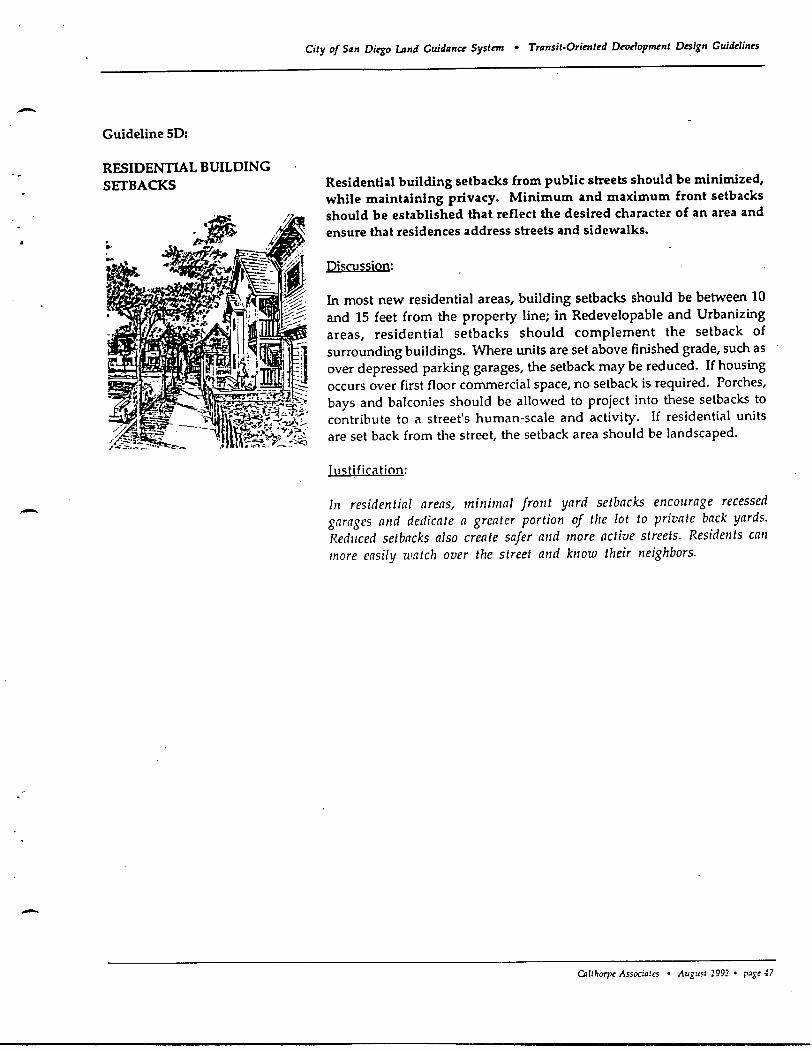
-
-
-
Guideline SO:
RESIDENTIAL BUILDING SETBACKS
City of San Di~o Land Cuidance Systcn • Transit-Oriented Developmrnt Design Cuidelines
Residential building setbacks from public streets should be minimized, while maintaining privacy. Minimum and maximum front setbacks should be established that reflect the desired character of an area and ensure that residences address streets and sidewalks.
Discussion:
In most new residential areas, building setbacks should be between 10 and 15 feet from the property line; in Redevelopable and Urbanizing areas, residential setbacks should complement the setback of surrounding buildings- Where units are set above finished grade, such as over depressed parking garages, the setback may be reduced- If housing occurs over first floor commercial space, no setback is required. Porches, bays and balconies should be allowed to project into these setbacks to contribute to a street's human-scale and activity. If residential units are set back from the street, the setback area should be landscaped.
Iu<;tification:
III residential areas, minimal front yard setbacks encourage recessed garages alld dedicate a greater portion of the lot to private back yards. Redllced setbacks also create safer mId more active streets. Residents call more easily watch over the street alld know their neighbors.
Caltharpt Associates • August 1992 • p~gt ~7
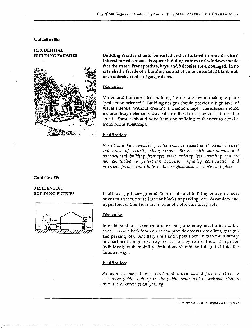
Guideline SE:
RESIDENTIAL BUILDING FACADES
Guideline SF:
RESIDENTIAL BUILDING ENTRIES
--
City of San Ditgo Land Guidanct System • Transit-Orimttd Development Design Guidelines
Building facades should be varied and articulated to provide visual interest to pedestrians. Frequent building entries and windows should face the street. Front porches, bays, and balconies are encouraged. In no case shall a facade of a building consist of an unarticulated blank wall or an unbroken series of garage doors.
Discussion:
Varied and human-scaled building facades are key to making a place "pedestrian-oriented." Building designs should provide a high level of visual interest, without creating a chaotic image. Residences should include design elements that enhance the streetscape and address the street. Facades should vary from one building to the next to avoid a monotonous streetscape.
/ / Justification:
Varied and human-scaled facades enhance pedestrians' visual interest and sense of seCllrity along streets. Streets with monoto12ouS and unarticulated building frontages make walking less appealing and are not conducive to pedestrian activity. Qllality construction and materials further contribute to the neighborhood as a pleasant place.
In all cases, primary ground floor residential building entrances must orient to streets, not to interior blocks or parking lots. Secondary and upper floor entries from the interior of a block are acceptable.
Djc;cuc;c;ion:
In residential areas, the front door and guest entry must orient to the street. Private backdoor entries can provide access from alleys, garages, and parking lots. Ancillary units and upper floor units in multi-family or apartment complexes may be accessed by rear entries. Ramps for individuals with mobility limitations should be integrated into the facade design.
IustificCltion:
As with commercial uses, residential entries SllOUld face tile street to encourage public activity ill the public realm alld to welcome visitors
. from the on-street guest parking.
Cn/lhorpe As.<ocinles • AuguSI 1992 • pase 48
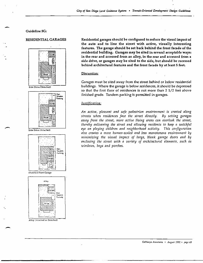
-- Guideline SG:
RESIDENTIAL GARAGES
r·:····,jt:· roK' · .' ~ ~'$.'
' •...... ~
· We · H""", :
". .. .'. L.~~.:;.
Sid~ Orin (Detached)
Side Driv~ (Attached)
Modified Front G.ras~
Alley
c=:: '-~ I···· .. ,~~,,:~,~~ : ... ' :' ·1c:·;:;~<1 :: . . ',~":-,,. i Ort.
~.' .'. .: 4 ~ Tandem
r.\~ ~.i PM""~ I·SS~":· I : .. ~HO~~~] ~ ~! · . . .' . . I . .
. . ...:......:..--.~;.~
Alley (Attached or Det.chedl
City of San Di~go LAnd Guidance SyslmJ • Transil-Orienl~d Dnldopmenl Design Guid~lin~s
Residential garages should be configured to reduce the visual impact of the auto and to line the street with active, visually interesting features. The garage should be set back behind the front facade of the residential building. Garages may be sited in several acceptable ways: in the rear and accessed from an alley, in the rear and accessed from a side drive, or garages may be sited to the side, but should be recessed behind architectural features and the front facade by at least 5 feet.
Discussjon:
Garages must be sited away from the street behind or below residential buildings. Where the garage is below residences, it should be depressed so that the first floor of residences is not more than 2 1/2 feet above finished grade. Tandem parking is pennitted in garages.
Til'; tifica fiQn: ,
An active, pleasant and safe pedestrian environment is created along streets when residences face the street directly. By setting garages away from the street, more active living areas can overlook the street, thereby enlivening the street and allowing residents to keep a watchful eye on playing children and neighborhood activity. This configuration also creates a more human-scaled and less monotonous environment by minimizing the viSllal impact of large, blank garage doors and by enclosing the street with a variety of architectural elements, sllch as windows, bays and porches.
CAlIlrorp~ As.<ocia/t:s • AUE"S/ 1992 • T"'E~ 49
City of San Diegoumd Guidanct: System • Transit-Oriented Development Design Guidelines
6. Secondary Areas
Guideline 6A:
TYPE AND PROXIMITY OF USES Secondary Areas may have lower density housing, public schools, and
community parks. Those parts of Secondary Areas that are in close proximity to the TOO core commercial area may have intensive employment-generating uses and park and ride lots to complement the TOO.
Discussion:
Secondary Areas should contain uses that support the TOO, but do not compete with the retail, professional office, service commercial, and public uses in the TOD's core commercial area. In most cases, Secondary Areas will be primarily comprised of low density single-family neighborhoods. In limited cases, large single-use office or light industrial uses with sufficient employment density to support transit, could be located across the arterial from the TOO core commercial area. Uses such as public schools and community parks, which provide services to TOO residents, should be located close to the TOO.
Employment-generating uses that have intensities which support transit may be allowed within one mile of the TOO core (preferably directly across the street from the core commercial area), if integrated into the transit system. These uses must generate an equal or greater number of persons per acre as generated by residential uses at a density of 7 dwelling units per net acre (+/- 16 residents/acre). For example, a typical office development will generate between 30 and 40 employees/acre, while a standard industrial development only generate 10 to 15 employees per acre and would not be considered as transit-supportive. Although Secondary Area uses across the arterial will produce less pedestrian traffic than adjacent areas, their street system and proximity will provide some non-auto opportunities.
Iuc;ti fica tion:
Secondary Areas provide an important support base for both the core commercial area and the ridership of the bicycle and transit system. They also provide opportllnities for lower density residential development. If properly designed, Secondary Areas call reinforce the viability of the TOO and provide sites for uses that some TOO residents will need. Secondary Areas, however, 11IIIst not alIow competing retail lIses becallse this will significantly detract from tlze TOO's ability to draw transit and retail patrons.
CAlthorpe Associares • Augusr 1992 • ptlgr 50
-
-
Guideline 6B:
RESIDENTIAL DENSITIES IN SECONDARY AREAS
Guideline 6C:
BIKEWAYS IN SECONDARY AREAS
City of Slln Diego Lmd Cuidllnce System • Trllnsit-Orimt~d Drodopment Design Cuiddin~s
The minimum average residential density within Secondary Areas in New Growth areas shall be 7 units per net acre. Ancillary units will be counted as an additional unit per lot.
Discussion:
A variety of low density housing types and densities should be provided in Secondary Areas such that a minimum average density of 7 units per net acre is maintained.
To help meet this minimum average density standard, higher density half-plexes and duplexes could be located on street comers.
Justificatjon:
Secondary Areas provide opportunities for low density hOllsing types that cannot be accommodated in TODs and are essential to ensllring that commllnities are diverse. Secondary Areas also provide hOllsing for the "move lip" market.
The primary roadway system in Secondary Areas must provide strong bicycle connections to the TOO core commercial area and transit stop.
Discu<;sion:
Arterials and selected collector roadways in Secondary Areas must provide safe separated or n~;jrked bicycle lanes allowing quick travel to the transit stop. Secondary Area bicycle paths should connect with the TOO bicycle system.
Justification:
Bicycles are tire most likely mode of travel for Secondary Area .residents who arc apt to lise pllblic trallsit. Strong bicycle connectiolls which follow the shortest possible rOlltes will provide additional encollragemellt for Secondary Area residents to lise transit.
o.1tIIDrpr Associ.l" • Allsusl 1992 • pasr 51
Guideline 6D:
PUBLIC AMENITIES IN SECONDARY AREAS
City of San Diego umd Guidance Systtm • Transit-Oriented Deoelopment Design Guidelines
Day care, neighborhood parks, schools, small convenience stores, and public recreation facilities may be provided to serve Secondary Areas.
Discussion:
Public amenities should be provided in central locations of Secondary Areas. These facilities should be sized to help accommodate the needs of the Secondary Area population.
Justification:
Secondary Areas mllst have sllfficient pllblic recreation amenities and public services. These facilities should be easily accessible to all Secondary Area residents.
OIllhorp( Associates • Ausu~t ]992 • p.7gt 52
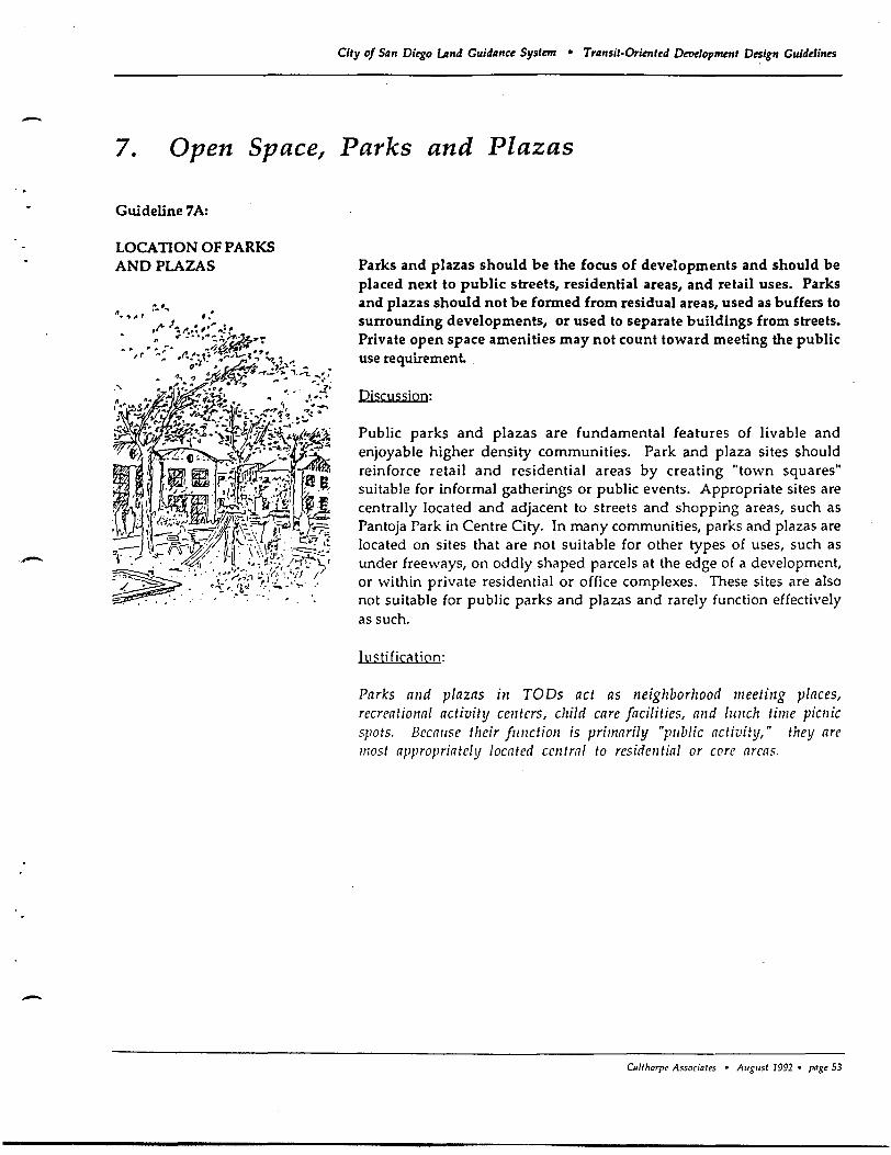
-..
-
-
City of San Diego Land Guidance System • Transit-Oriented DeT1elopment Design Guidelines
7. Open Space, Parks and Plazas
Guideline 7A:
LOCATION OF PARKS AND PLAZAS Parks and plazas should be the focus of developments and should be
placed next to public streets, residential areas, and retail uses. Parks and plazas should not be formed from residual areas, used as buffers to surrounding developments, or used to separate buildings from streets. Private open space amenities may not count toward meeting the public use requirement
Discussion:
Public parks and plazas are fundamental features of livable and enjoyable higher density communities. Park and plaza sites should reinforce retail and residential areas by creating "town squares" suitable for informal gatherings or public events. Appropriate sites are centrally located and adjacent to streets and shopping areas, such as Pantoja Park in Centre City. In many communities, parks and plazas are located on sites that are not suitable for other types of uses, such as under freeways, on oddly shaped parcels at the edge of a development, or within private residential or office complexes. These sites are also not suitable for public parks and plazas and rarely function effectively as such.
III <; tificati on:
Parks alld plazas ill TODs act as neighborhood meeting places, recreational activity centers, child care facilities, alld IUllch time piwic spots. Becallse their fllllctioll is primarily "pllblic activity," they are most appropriately located central to residential or core areas.
u./lhorpc Associalts • A"S"sI 1992 • pagt 53
Guideline 7B:
PARK AND PLAZA DESIGN
City of 51'" Ditgo LAnd Guidlmc~ System • Trlmsit-Orimf~d Detle10pment D~ign Guidelines
Public parks and plazas should be designed for both active and passive uses. They should reflect and reinforce the character of the surrounding area and accommodate the anticipated intensity of use. Private open space amenities may not count towards TOO park acreage requirements.
Discussion;
Various types of parks and plazas can be designed for TODs and Secondary Areas to establish an identity or character for each neighborhood. For example, plazas in commercial core areas may be most appropriately designed with finished hardscape materials such as stone or brick, and include fountains and seating areas; parks in residential areas could be developed with grassy fields, play equipment, and sports facilities. Parks should not be situated on oddly shaped parcels or within private areas.
{ustification:
The design of parks and plazas shol/ld be appropriate to their setting, location, and Ilse. Because parks and plazas will be focal points of TOD ana Secondary Area activity, special consideration should be given t making these pl/blic spaces 110t only fl/nctionally appropriate, bl/t consistent with the c1rnracter and density of the surrounding area. Sensitive integration of public spaces is also critical to public acceptances and commercial success; Seaport Village is an example of sllccessfZlI lise of this technique.
CDlthorp~ Assodates • August 1992 • pagt 54
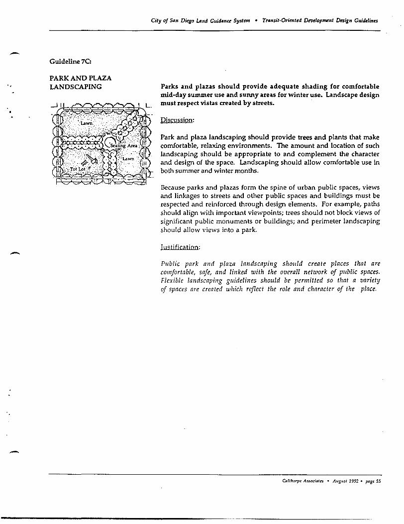
-
-
-
Guideline 7C:
PARK AND PLAZA LANDSCAPING
City of Siln Diego umd Guidllnce System • Trllnsit-Oriented Development Design Guidelines
Parks and plazas should provide adequate shading for comfortable mid-day summer use and sunny areas for winter use. Landscape design must respect vistas created by streets.
Discussion:
Park and plaza landscaping should provide trees and plants that make comfortable, relaxing environments. The amount and location of such landscaping should be appropriate to and complement the character and design of the space. Landscaping should allow comfortable use in both summer and winter months.
Because parks and plazas form the spine of urban public spaces, views and linkages to streets and other public spaces and buildings must be respected and reinforced through design elements. For example, paths should align with important viewpoints; trees should not block views of significant public monuments or buildings; and perimeter landscaping should allow views into a park.
III s ti fica tion:
Pllblic park and plaza landscaping shollld create places that are comfortable, safe, and lillked with the overall network of pllblic spaces. Flexible landscaping gllidelilles should be permitted so that a variety of spaces are created which reflect the role alld character of the place.
u.llhorpt Associ~tts • August 1992 • pagt 55
Guideline 70:
OPEN SPACE RESOURCE PROTECTION
City of San Di~o umd Guidance System • Transit-Oriented Development Design Guidelines
Major creeks, riparian habitat, slopes, and other sensitive environmental features should be conserved as open space amenities and incorporated into the design of TOOs. Fencing and piping of creeks should be avoided and channelization improvements should be minimized.
Discussion:
Open space resources should be incorporated into the design ofTOD and Secondary Areas, in a manner consistent with City standards and CEQA. These resources should be treated as key amenities, rather than as edges to developments. Public access should be permitted, while important natural features and sensitive habitats are preserved. In Mission Valley there is an opportunity to create TODs centered around planned light rail transit stations and oriented to the San Diego River. In New Growth Areas, there is an opportunity for open spaces to shape and enhance neighborhoods, to provide a scenic resource from roads, as well as to serve as wildlife corridors.
Bicycle paths can often be constructed with linear parks, thus serving a dual function of allowing public access to open space and providing non motorized transportation to activity centers aiong the edges of linear parks.
Justification:
Natural featl/res provide visllal relief and a natllral character for the growth area. These areas can also incll/de trails and small picnic areas that serve TOD and Secondary Areas. Sensitive site planning shol/ld be encollraged so that natural habitats are protected and natllral featllres become an integral pllrt of the commllnity.
Olltharpt As.'ociatcs • August 1992 • p.se 56
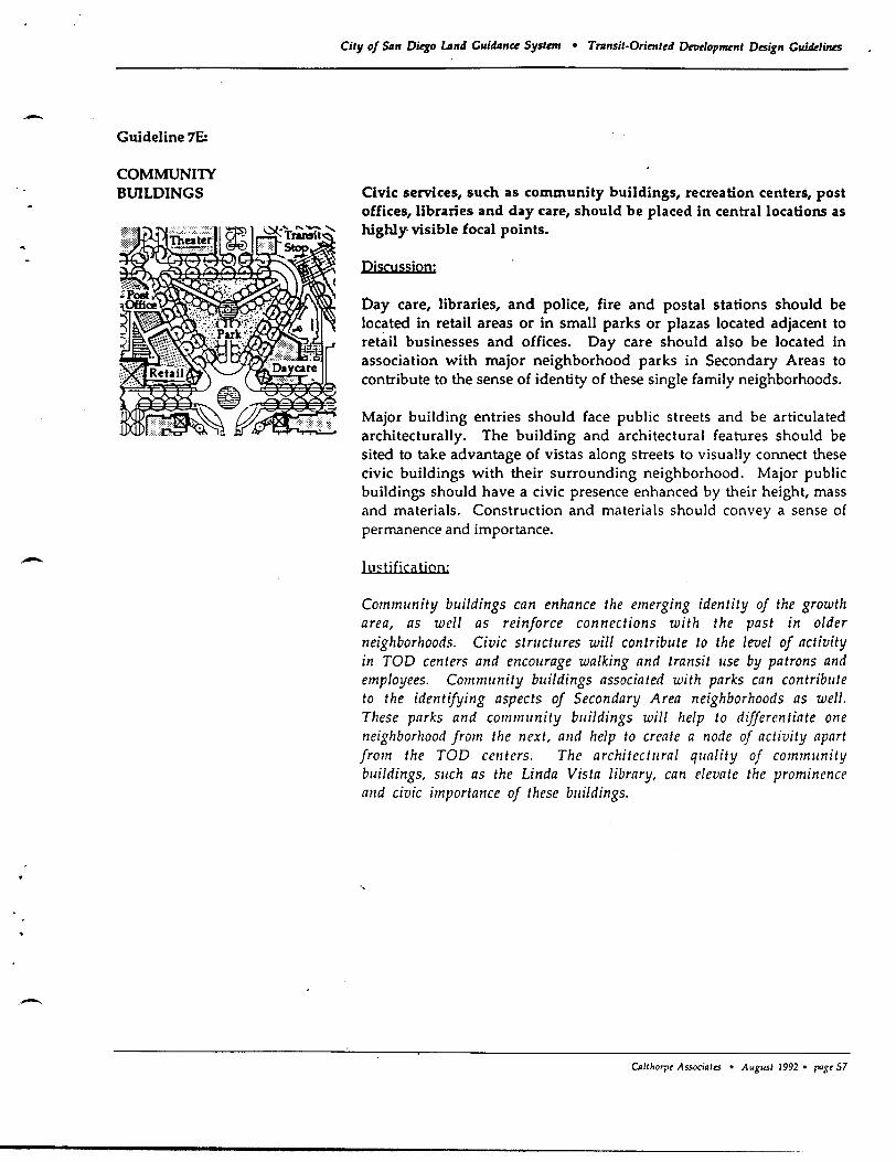
-
-
Guideline 7E:
COMMUNIlY BUILDINGS
City of 511" Di~o LJ",4 Guidil"ce System • TTII"sit-Orimt~4 Dn1dop~"t Desig" Guidelines
Civic: services, such as community buildings, recreation centers, post offices, libraries and day care, should be placed in central locations as highly· visible focal points.
Discussion:
Day care, libraries, and police, fire and postal stations should be located in retail areas or in small parks or plazas located adjacent to retail businesses and offices. Day care should also be located in association with major neighborhood parks in Secondary Areas to contribute to the sense of identity of these single family neighborhoods.
Major building entries should (ace public streets and be articulated architecturally. The building and architectural features should be sited to take advantage of vistas along streets to visually connect these civic buildings with their surrounding neighborhood. Major public buildings should have a civic presence enhanced by their height, mass and materials. Construction and materials should convey a sense of permanence and importance.
Iu<:tjficatjoo;
Community buildings can enhance the emerging identity of the growth area, as well as reinforce connections with the past in older neighborhoods. Civic structures will contribute to the level of activity in TOD centers and encourage walking and transit use by patrons and employees. Community bui/dings associated with parks can contribute to the identifying aspects of Secondary Area neighborhoods as well. These parks and community buildings will help to differentiate one neighborhood from the next, alld help to create a node of activity apart from the TOD centers. The architectural quality of community bui/dings, such as the Linda Vista library, can elevate the prominence alld civic importance of these buildings.
"
CJJlthorpt Associ.ltS • Augusl 1992 • ragr 57
Guideline 7F:
SCHOOLS AND COMMUNIlY PARKS
City of San Diego LAnd Guidance System • Trllnsit-Orimt~d DetI~lopment Design Guide1in~s
If needed, school sites and community parks should be located at the edges of TODs within Secondary Areas. Strong pedestrian and bike links should connect these sites with the commercial and transit core.
Discussion:
While schools and community parks are not necessary uses in the TOO, they may be needed to serve the population of the TOO and the Secondary Area. Schools and community parks should be located within convenient walking distance (1/2 mile) of the TOO, in the Secondary Area. Pedestrian pa ths and bikeways should follow the shortest route to the commercial and transit core.
lusH fica tion:
Land within TOOs should maximize tra1lsit-orie1lted IIses. Schools and community parks may be necessary public facilities for TOO residents, but can be located at the edge of TOOs without detracting from the function of the TOO.
CnltJlOrpe Associ.lts • AuguSI 1992 • pagt 58
- Guideline 7G:
DAY CARE ..
-
City of San Diego LAnd Cuidance System • Transit-Oriented Dttlelopmntt Design Cuidelines
Sites for pre-school day care facilities should be provided in all TOOs and throughout Secondary Areas.
Discussjon:
Day care facilities should be convenient and accessible to both TOD residents and employees. Sites should be located within residential neighborhoods, adjacent to parks, core commercial areas, and oUice buildings. The precise parcel size, and size of the facility should be determined by the developer in conjunction with appropriate local agencies. Day care facilities for school-age should be located at school sites to meet the needs of each school's students.
lu<;tj Oeation:
HOllsehold demographics in the San Diego region are in the process of changing and becoming more diverse. More households are and will be headed by single or double-income parents, creating a strong demand for child care services. A basic objective of the TOD concept is to provide housing opportunities for a variety of household types, and day care facilities are increasingly a necessary daily part of residents' lives. Additionally, many parents now lengthen early morning and evening auto trips by driving to a child care facility before continuing on to work. Locating child care facilities in TODs will not only provide a necessary service, but will allow parents to make the day care trip part of their commute trip, thus reducing vehicle-miles traveled.
OJlthorpe Associ.le> • August 1992 • page 59
City of S,m Diego Land Guidance SystrnJ • Transit-Oriented Droelopment Design Guidelines
8. Street and Circulation System
Guideline SA:
ARTERIAL STREETS AND THOROUGHFARES Arterial streets and thoroughfares should allow efficient conveyance of
through traffic and must not pass through TODs. Portions of Secondary Areas may' be located across an arterial from a TOO.
Discussion:
The regional traffic circulation system is dependent upon an efficient and smooth-flowing network of arterial and thoroughfare streets. Traffic on arterial streets should not be slowed by activity in the TOO. TOO sites should be selected such that arterial and thoroughfare streets are located at the TOO's periphery; not through the center of the TOO.
Arterials may be located between the TOO and the Secondary Area. The lower intensity uses in the Secondary Area Can benefit from proximity to the core commercial area, by permitting workers and bicyclists access to the TOO. Convenient pedestrian and bike crossings should be provided wherever cross-arterial connections are made, consistent with State guidelines contained in the Caltrans Traffic Manual. At these major intersections, it is the City's policy to provide on-demand pedestrian-activated signals. Under- and over-crossings are expensive and generally unused; they are discouraged, unless absolutely necessary in already developed areas.
Iustific<ltion:
In many areas, the main spille of the trallsit system will follow arterial streets and major tllOrolighfares. These fOllr- to six- lane streets are barriers to pedestriall activity and thlls shollld not be the focal point for the TaD. Rather, large traffic carrying streets should be located at the perimeter of a TOO or at the jllllction of two adjacent TODs.
CAlfhorpe AssociQles • AuguSI 1992 • PQge 60
Guideline 80:
COMMEROAL SlREErS
Guideline 8E:
LOCAL SmEETS
-
City of San Diego umd Guidance System • Transit-Oriented Dewlopment Design Guidelines
Commercial streets located in the center of Core Commercial areas should be designed to accommodate pedestrians, slow traffic, provide on-street parking and create a pleasant shopping environment.
Discussjon:
Commercial streets should have two travel lanes and on-street parking in order to create an intimate shopping environment that maintains drive-by visibility to stores. Shops should front onto commercial streets with minimal setbacks. Wider sidewalks, street trees, awnings and arcades should be used to accommodate this active, pedestrian environment. Curbs and landscaping should be configured to allow passage of street cleaning equipment.
lustj fica tion:
Commercial streets can create a pleasant and active commercial spine within Core Commercial areas. Slow traffic and comfortable walking environments will encol/rage walking for many shopping trips, thereby reducing reliance of the al/tomobile and creating an active "main street. "
Local streets should have travel and parking lanes sufficiently narrow to slow traffic and allow trees to form a pleasing canopy over the street, while providing for adequate access for automobiles, and emergency and service vehicles.
Discussion:
Local streets should be designed to serve low volumes of traffic through a pedestrian-oriented environment. Travel and parking lanes should only be wide enough to allow hvo vehicles to slowly pass each other. Emergency and service vehicles would be accommodated by using both travel lanes. Street trees should be provided to enhance the quality of the neighborhood and provide relief from summer heat.
Justification:
Local streets are tile public opcn space in whic1z children often play and arollnd wizich Heiglzbors interact. Velziwlar movclI/cnl sizould be controlled and providcd for within this context.
CDllhorpt Associnlts • AuguSI 1992 • pagt 63
Guideline SF:
ALLEYS
City of San Diego umd Guidance System • Transit-Oriented Derlelopment Design Guidelines
Where possible, alleys should be used to serve residential and commercial developments within TODs, and for lots facing onto parks and collector streets in Secondary Areas.
Discussion:
Alleys are a traditional accessway in San Diego in older neighborhoods such as North Park, Ocean Beach and Hillcrest. Alleys provide relief to the street system and a secondary access to individual parcels. Alley-accessed garages relieve the street side of the house from being
. dominated by garage doors and cramped by curb cuts. Design of alleys should provide sufficient lighting to ensure night-time safety; units facing onto alleys should be provided adequate parking. Where alleys intersect with streets, adequate sight distances and building setbacks should be provided.
IustificCltion:
In areas where walking is to be encollraged, streets lined with garages are undesirable. AlletJs provide an opportunity to pllt the garage to the rcar allowing the more 'social' aspects of the home to front the street. Streets li/led wit1! porches, entries and living spaces are safer because c. this natural sllrveillance. Alleys ill commercial areas place service vehicle access and parking away from the street and sidewalks, affording a 1110re interesting and comfortable streetscape.
Calthorpt Associates • August 1992 • pagt 64
- Guideline 8G:
STREET VISTAS
-
-.
City of San Diego LAnd Guidance System • Trllnsit-Orimted Dewlopment Design Guidelines
Where possible, streets within TODs should frame vistas of the core area, public buildings, parks and natural features.
DjsCussion:
Streets should be designed so they terminate at important buildings and places. This will establish a series of pedestrian "landmarks," to help make the'TOD spatially memorable, and allow pedestrians to feel the context of their community. Straight streets, in particular, allow clear views to landmarks and are encouraged. In areas with steep slopes, the street system should work with the natural topography to accent important landmarks.
Justificatjon:
Visible landmarks help orient pedestrians and make walking routes interesting and memorable. Straight streets make destinations more accessible by making them visible; if a destination is visible, a person is more likely to walk to it.
o.Uhorpt "'ssociat.:s • ,..ugust 1992 • pagt 65
------------------- .-_ .. _._----_._-_.-..
Guideline 8H:
STREET TREES
City of San Di~o Land Guidanc~ Systan • Tran5it-Orimt~d Drodop~nt Design Gujd~/jn~s
Shade trees are required along all streets in New Growth Areas and should be strongly encouraged in Redevelopable and Urbanizing areas. Street trees should be spaced no further than 30 feet on center in planter strips located between curbs and sidewalks. Tree species and planting teclmiques should be selected to create a unified image for the street, provide an effective canopy, avoid sidewalk damage; and minimize water cons:umption.
Discussjon:
Many streets are identified and remembered by their street trees. TOD and Secondary Area streets should be lined with a limited selection of trees to give them a unified and distinct image. Adequate sight distances must be maintained, according to the City's Street Design Manual, in order to ensure safety. Within TODs, trees should be placed in a planter strip between the street and sidewalk. In Secondary Areas that do not have planter strips, the trees should be kept close to the sidewalk to provide shade and should be aligned to visually frame the street." In all cases, trees should be trimmed regularly to accommodate buses and service vehicles. Tree "maintenance should be ensured through the creation of Landscape Maintenance Districts or other means.
IustificCltioo:
Shade for the comfort of the pedestrian is key to creating a viable walking environment. Street trees help redllce heat bllild-llp from large asphalt areas and create a cooler micro-climate. Trees also provide habitat for local birds and help create a beautiflll community.
OJlrhorpt Associales • August J 992 • pagt 66
-Guideline 81:
ON-STREET PARKING
-
City of S4n Di~o LAnd Guidance System • Transit-Oriented Deoelopment Design Guidelines
On-street parking is encouraged on all TOO and Secondary Area streets, except arterials. In Redevelopable and Urbanizing sites, existing streets should be modified, as feasible, to provide on-street parking and landscaping.
Discussion:
Streetside parking is critical to keeping the focus of a community on the street, rather than on the interior- of lots. On-street. parking helps to create street activity, as well as provide functional spaces. It supports orienting building entries to the street by providing convenient access for guests and patrons. Parallel parking should be used most often, however, angled on-street parking is encouraged along shopping streets within core commercial areas, where slow drive-by traffic is desired. To maintain travel speeds and emergency vehicle access, on-street parking should not be permitted on arterials.
On-street parking on local streets can also be compatible with bicycle travel, provided that auto speeds are slow enough (+ / -15 to 20 miles per hour) to allow bikers to travel in the street at the same speed as the cars. However, on selected high-volume connector streets where onstreet parking is to be retained, it is desirable to include sufficient room within the roadway for installation of bike lanes.
J t1" tifica tion:
On-street parking helps to "civilize" the street for pedestrians by creating a bllffer between movillg cars and the sidewalk. The additional parking helps to replace areas devoted to large off-street sllrface parking lots and places the parking near the desired street-side bllilding entries. Oil-street parking tellds to slow tile flow of througll traffic. This helps to develop a pedestrian environment wlzere walking is desired, bllt conflicts with the role of arterial streets 10 move traffic safely and smoothly II/rollgh the commllnity.
CAlI/lOrpt Associates • August 1992 • pagt 67
Guideline 8J:
INTERSECTION DESIGN
City of San Di~o LAnd Guidance Systml • Transit-Oriented Drodopnrenl Design Guidelines
Intersections within TODs and Secondary Areas should be designed to facilitate both pedestrian and vehicular movement. Intersection dimensions should be minimized while providing adequate levels of service.
Discussion:
Since the TOO street is conceived as more than a conduit for cars, street and intersection widths should be kept to a minimum. Intersections should be designed to slow traffic and to reduce pedestrian crossing distances. The practice of prohibiting pedestrian crossings behveen certain comers of intersections to facilitate motor vehicle traffic flow should be discouraged. Unless absolutely necessary for facilitating safety, right and left tum lanes at intersections should be avoided.
Justification:
A street system should balance the needs and viability of the pedestrian, as well as the car. Reduced auto speeds improve pedestrian accessibility and safety, alld can continue to accommodate safe vehiCIIlar movement. Unless absolutely necessary, additional tumill< lanes at intersections should be avoided to minimize pedestrian crossing dimensions.
CnltJ,orpt Associales • Ausus! 1992 • paSt 68
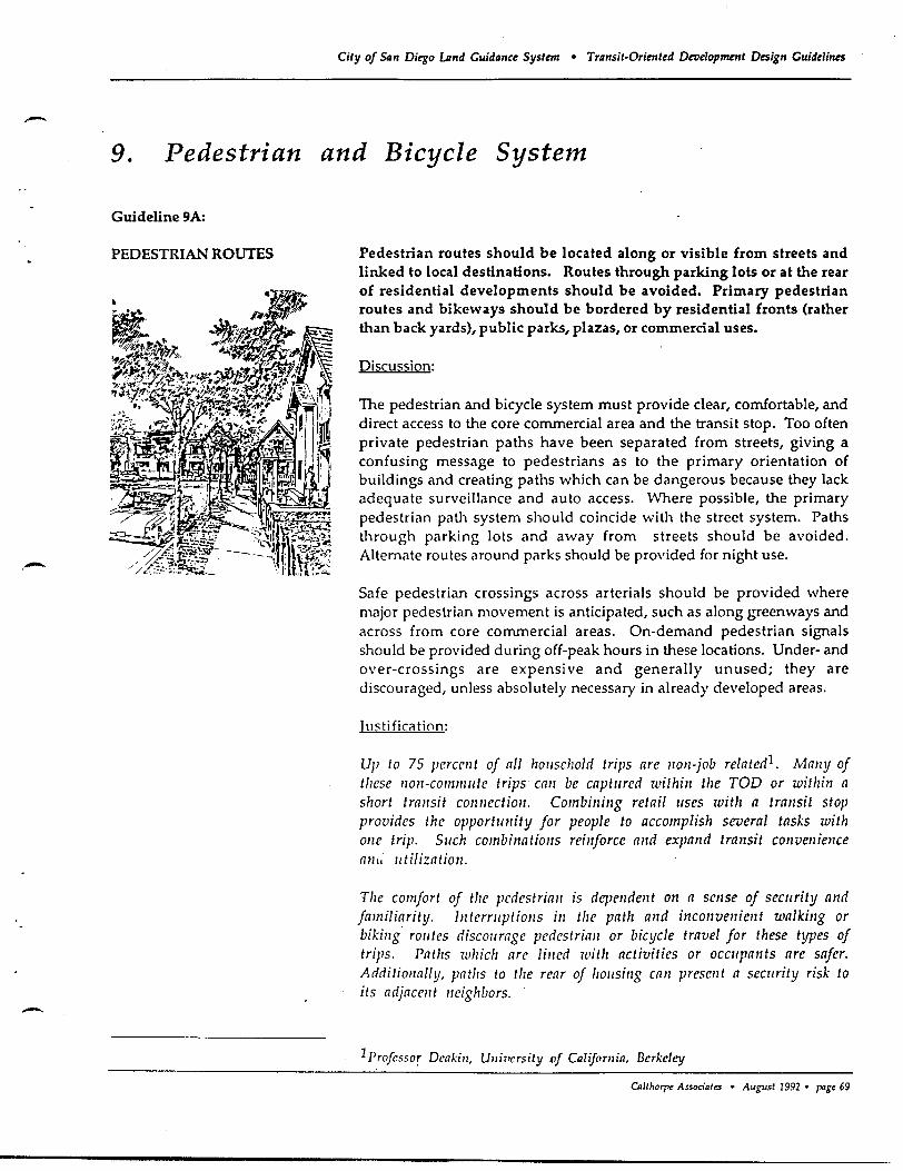
-
-
City of San Di~o LAnd Guidance System • Transit·Oriented Deoeiopment Design Guidelines
9. Pedestrian and Bicycle System
Guideline 9A:
PEDESTRIAN ROUTES Pedestrian routes should be located along or visible from streets and linked to local destinations. Routes through parking lots or at the rear of residential developments should be avoided. Primary pedestrian routes and bikeways should be bordered by residential fronts (rather than back yards), public parks, plazas, or commercial uses.
Discussion:
The pedestrian and bicycle system must provide clear, comfortable, and direct access to the core commercial area and the transit stop. Too often private pedestrian paths have been separated from streets, giving a confusing message to pedestrians as to the primary orientation of buildings and creating paths which can be dangerous because they lack adequate surveillance and auto access. Where possible, the primary pedestrian path system should coincide with the street system. Paths through parking lots and away from streets should be avoided. Alternate routes around parks should be provided for night use.
Safe pedestrian crossings across arterials should be provided where major pedestrian movement is anticipated, such as along greenways and across from core commercial areas. On-demand pedestrian signals should be provided during off-peak hours in these locations. Under- and over-crossings are expensive and generally unused; they are discouraged, unless absolutely necessary in already developed areas.
Illstificiltion:
Up to 75 percent of all household trips are non·job related1. Many of t!lese non-commute trips can be captl/red within the TOD or within a short transit connection. Combining retail I/ses with a transit stop provides the opportunity for people to accomplish several tasks with one trip. SI/ch combinations reinforce and expand transit convenience ant, utilization.
The comfort of the pcdcstrian is dependent on a scnse of seC/lrity and familiarity. Illtcrmptiolls ill the path and inconvenicnt walking or biking routes discourage pedestrian or bicycle travel for these types of trips. Paths wllich are lined with activities or oCC/lpants are safer. Additionally, paths to the rear of housing can present a seCllrity risk to its adjacellt neighbors.
1 Profcssor Dcakin, U7lil'crsity of Calijomia, Berkeley
CQ/lhorp< Associates • August 1992 • 1"'gt 69
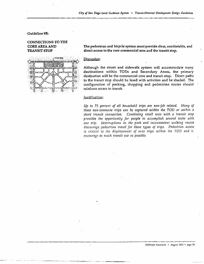
Guideline 9B:
City of San Diego LAnd Guidance System • Transit-Oriented Development Design Guidelines
The pedestrian and bicycle system must provide clear, comfortable, and direct access to the core commercial area and the transit stop.
Discussion:
Although the street and sidewalk system will accommodate many destinations within TODs and Secondary Areas, the primary destination will be the commercial core and transit stop. Direct paths to the transit stop should be lined with activities and be shaded. The configuration of parking, shopping and pedestrian routes should reinforce access to transit.
Iustjfjca tion:
Up to 75 percellt of all household trips are non-job related. Many of these non-commute trips can be captured within the TOD or within a short transit connection. Combining retail uses with a transit stop provides the opportunity for people to accomplish several tasks with one trip. Interruptions in the path and incollvenient walking rOlltes discollrage pedestrian travel for these types of trips. Pedestrian access is critical to the displacement of allto trips within the TOO and t(
encollrage as milch transit lise as possible.
CAlthorpt Associates • August 1992 • pagt 70
----- ----------- ---------- ------- -----------------0-_. ___ --
-
-
. -
Guideline 9C:
ARTERIAL CROSSINGS AND PEDESTRIAN BRIDGES
City of S,m Dkgo umd Gui"n" Systnn • Trtmsit-Orimted Dmelopmntt Design Guidelines
Crosswalks should be provided at all signalized arterial intersections. Undercrossings or bridges designed for pedeshians and bicyclists are discouraged, unless necessary in already developed areas to solve critical access problems.
Discussion:
Crosswalks at Signalized intersections should provide easy and safe pedestrian and bicycle movement across arterials or to difficult to reach transit stops. On-demand signals can be located at strategic intersections, such as where a connection would be made to a transit stop or core commercial area, which could be activated during off-peak commute hours. Underpasses or pedestrian bridges are discouraged because they are expensive and are generally long, circuitous routes that are often unused. However, in some limited cases, where existing development patterns prevent any other convenient street crossings, an under or over pass may be appropriate; direct stairs in addition to handicapped access ramps, could be provided to shorten walking distances.
Justification:
Pedestrialls and bicyclists mllst be permitted to move easily alld safely across arterials if an environment that is /lot reliant 011 the alltomobile is to be created. Illtersections should be designed to provide direct pedestrian and bicycle collllections between core commercial areas, employmellt areas, parks, schools, residential areas and other destina liolls .
Otltltorpe A5Soci~tes • August 1992 • p.1gC 71
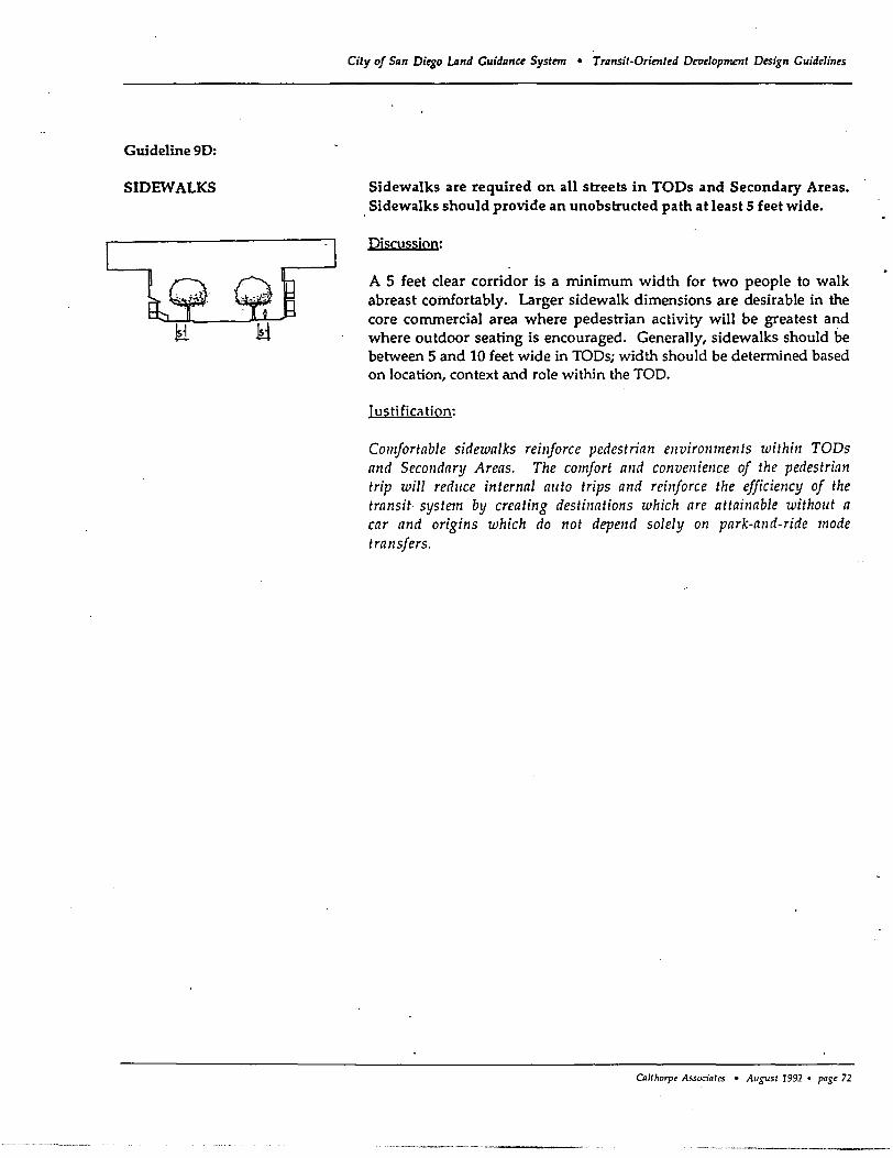
Guideline 9D:
SIDEWALKS
City of San Diego Land Guidance System • Transit-Oriented Deoelopment Design Guidelines
Sidewalks are required on all streets in TODs and Secondary Areas. Sidewalks should provide an unobstructed path at least 5 feet wide.
Discussion:
A 5 feet clear corridor is a minimum width for two people to walk abreast comfortably. Larger sidewalk dimensions are desirable in the core commercial area where pedestrian activity will be greatest a~d where outdoor seating is encouraged. Generally, sidewalks should be between 5 and 10 feet wide in TOOs; width should be determined based on location, context and role within the TOO.
Justification:
Comfortable sidewalks reinforce pedestrian environments within TODs and Secondary Areas. The comfort and convenience of the pedestrian trip will reduce internal auto trips and reinforce the efficiency of the transit system by creating destinations which are attainable withollt a car and origins which do not depend solely on park-and-ride mode transfers.
OlUhorp< Assoa'arcs • August 1991 • pag< 72
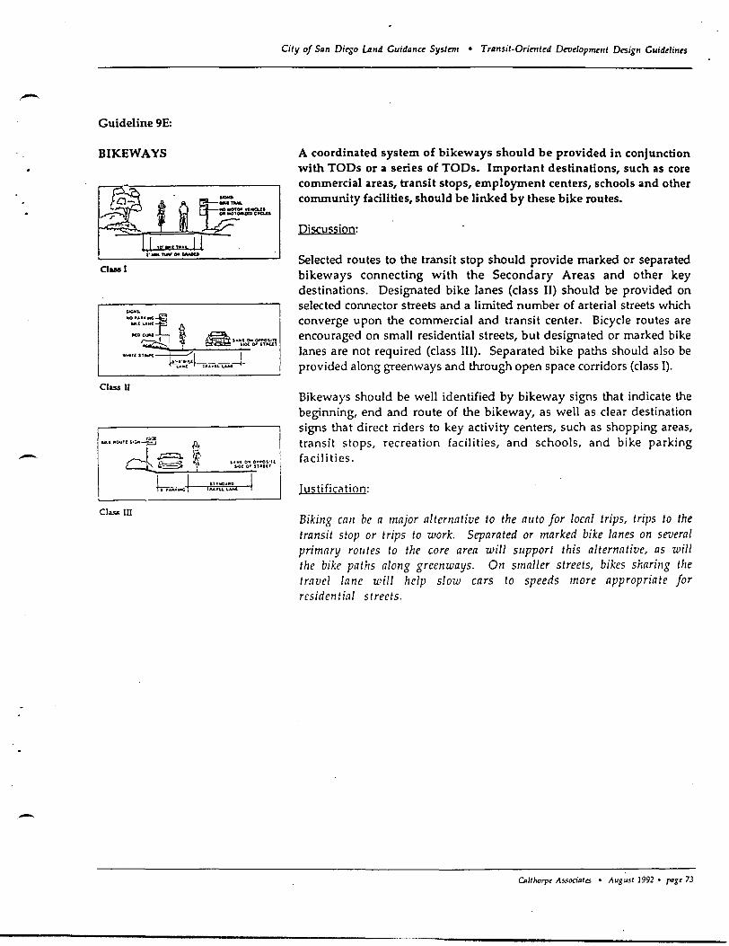
-Guideline 9E:
BIKEWAYS
Oasal
Class n
-Class III
City of San Di~o Land Guidance System • Transil-Orimted Development Design Guide/ines
A coordinated system of bikeways should be provided in conjunction with TODs or a series of TODs. Important destinations, such as core commercial areas, transit stops, employment centers, schools and other community facilities, should be linked by these bike routes.
Discussion:
Selected routes to the transit stop should provide marked or separated bikeways connecting with the Secondary Areas and other key destinations. Designated bike lanes (class II) should be provided on selected connector streets and a limited number of arterial streets which converge upon the commercial and transit center. Bicycle routes are encouraged on small residential streets, but designated or marked bike lanes are not required (class III). Separated bike paths should also be provided along greenways and through open space corridors (class I).
Bikeways should be well identified by bikeway signs that indicate the beginning, end and route of the bikeway, as well as clear destination signs that direct riders to key activity centers, such as shopping areas, transit stops, recreation facilities, and schools, and bike parking facili ties.
Iusti ficil tion:
Biking call be a major alternative to the allto for local trips, trips to the transit stop or trips to work. Separated or marked bike lanes on several primary rallies to the core area will slIpport this alternative, as will the bike paUlS along green ways. On smaller streets, bikes sharing the travel lane will help slow cars to speeds more appropriate for residential streets.
o.llhorpt Associates • August 1992 • 1"'Et 73
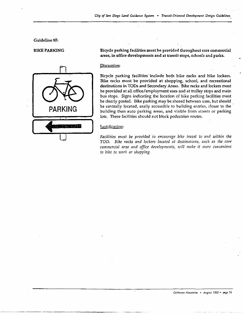
Guideline 9F:
BIKE PARKING
PARKING
.". .' .- .~. "'. ~ .-":. ",,"
City of San Diego Lznd Guidance System • Transit-Oriented D~elopment Design Guidelines.
Bicycle parking facilities must be provided throughout core commercial areas, in office developments and at transit stops, schools and parks.
Discussion:
Bicycle parking facilities' include both bike racks and bike lockers. Bike racks must be provided at shopping, school, and recreational destinations in TODs and Secondary Areas. Bike racks and lockers must be provided at all office/employment uses and at trolley stops and main bus stops. Signs indicating the location of bike parking facilities must be clearly posted. l3ike parking may be shared between uses, but should be centrally located, easily accessible to building entries, closer to the building than auto parking areas, and visible from streets or parking Jots. These facilities should not block pedestrian routes.
Iuc;tific(!tion:
Facilities mllst be provided to encollrage bike travel to and within the TOD. Bike racks and lockers located at destinations, sllch as the core commercial area a/ld office developments, will make it more convenient to bike to work or shopping.
Ca/t/Jorpt Associates • August 1992. pagt 74
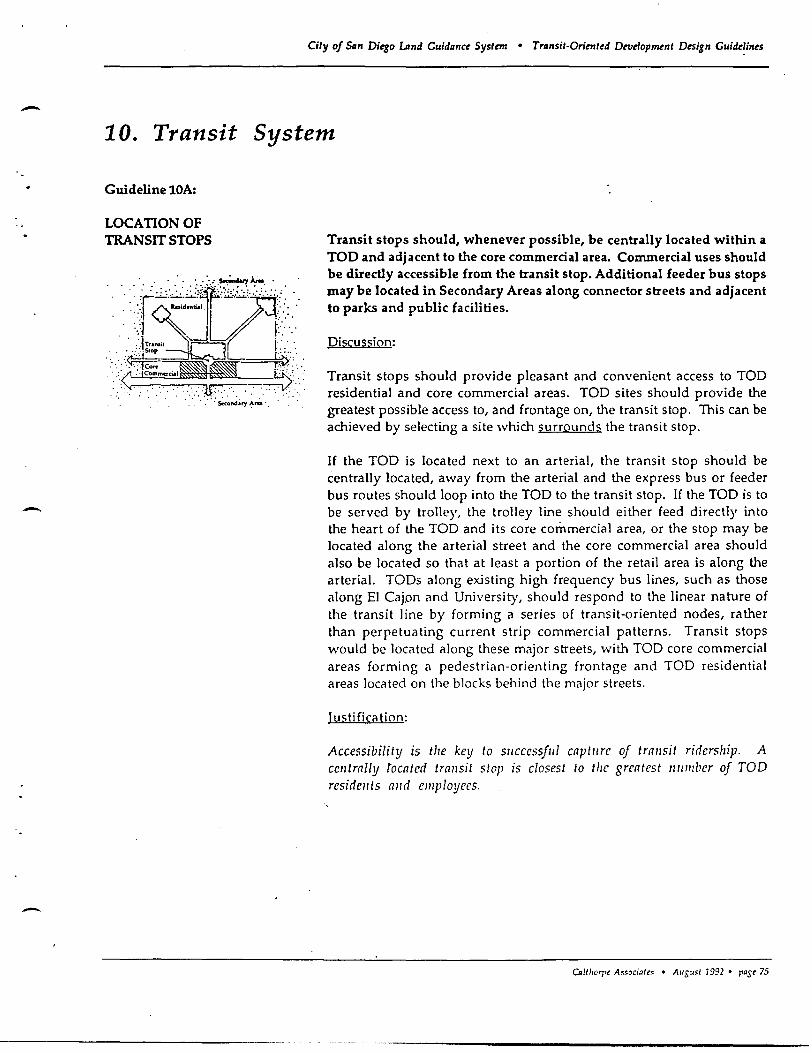
-
-
-
City of San Diego umd Guidllnct System • Trllnsit·Oriented Development Design Gujde~jnes
10. Transit System
Guideline lOA:
LOCATION OF TRANSIT STOPS Transit stops should, whenever possible, be centrally located within a
TOO and adjacent to the core commercial area. Commercial uses should be directly accessible from the transit stop. Additional feeder bus stops may be located in Secondary Areas along connector streets and adjacent to parks and public facilities.
Discussion:
Transit stops should provide pleasant and convenient access to TOO residential and core commercial areas. TOO sites should provide the greatest possible access to, and frontage on, the transit stop. This can be achieved by selecting a site which surrounds the transit stop.
If the TOO is located next to an arterial, the transit stop should be centrally located, away from the arterial and the express bus or feeder bus routes should loop into the TOO to the transit stop. If the TOO is to be served by trolley, the trolley line should either feed directly into the heart of the TOO and its core commercial area, or the stop may be located along the arterial street and the core commercial area should also be located so that at least a portion of the retail area is along the arterial. TODs along existing high frequency bus lines, such as those along EI CaJon and University, should respond to the linear nature of the transit line by forming a series of transit-oriented nodes, rather than perpetuating current strip commercial patterns. Transit stops would be located along these major streets, with TOO core commercial areas forming a pedestrian-orienting frontage and TOO residential areas located on the blocks behind the major streets.
Justi fication:
Accessibility is the key to sllccessful captllre of trallsit ridership. A centrally iocated trallsit stop is closest to the greatest Ill/mba of TOD residellts alld elllployees.
o.1tI.orre Associatrs • August 1992 • pagt 75
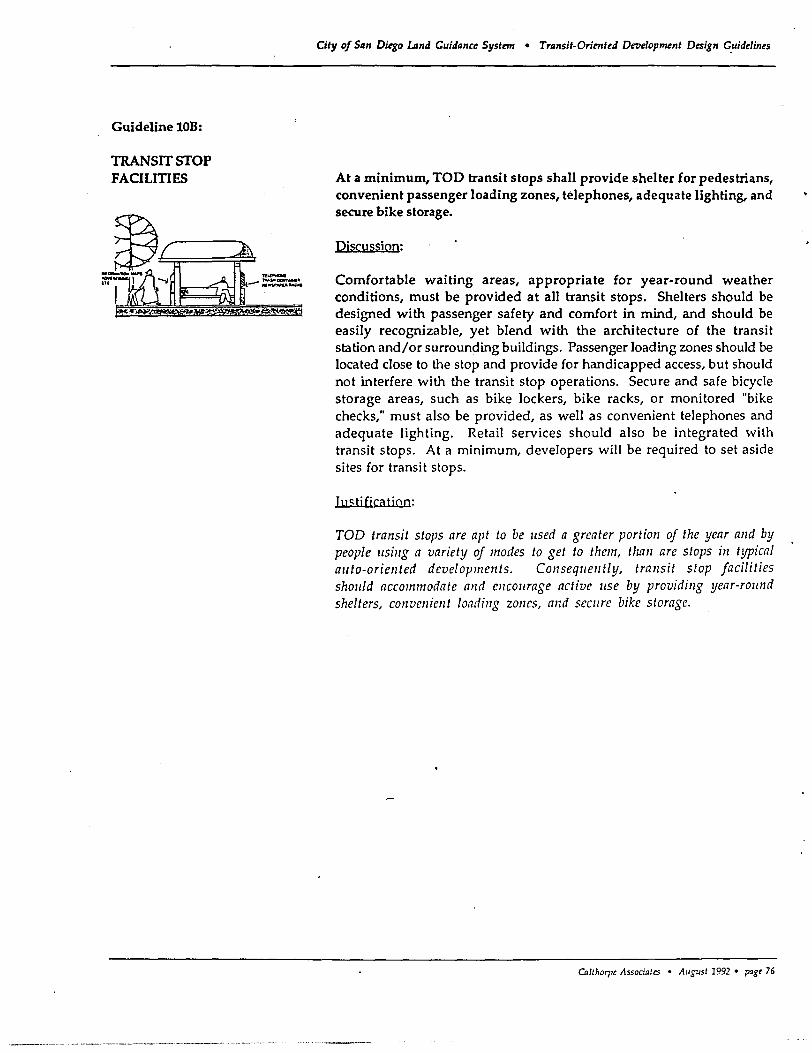
Guideline lOB:
TRANSIT STOP FACILITIES
City of San Dkgo Land Cuidance System • Transit-Oriented Development Design C.uideIines
At a minimum, TOO transit stops shall provide shelter for pedestrians, convenient passenger loading zones, telephones, adequate lighting, and secure bike storage.
Discussion:
Comfortable waiting areas, appropriate for year-round weather conditions, must be provided at all transit stops. Shelters should be designed with passenger safety and comfort in mind, and should be easily recognizable, yet blend with the architecture of the transit station and/or surrounding buildings. Passenger loading zones should be located close to the stop and provide for handicapped access, but should not interfere with the transit stop operations. Secure and safe bicycle storage areas, such as bike lockers, bike racks, or monitored "bike checks," must also be provided, as well as convenient telephones and adequate lighting. Retail services should also be integrated with transit stops. At a minimum, developers will be required to set aside sites for transit stops.
Iuc;tjfjcatjQn:
TOD transit stops are apt to be llsed a greater portion of the year and by people llsillg a variety of modes to get to them, than are stops in typical allto-oriented developments. COllsequently, transit stop facilities should accommodate and encol/rage active use by providing year-round shelters, convenien t loading zones, and seCllre bike storage.
Callhorl't Assoaates • Allgust 1992 • pagt 76
- Guideline 8B:
STREET DIMENSIONS
-
-
City of San Di~o lAnd Guidance Syslm/ • Transit-Orimt~d Dt'tI~lopmnlt D~ign Guidelines
TOO and Secondary Area lane widths, design speeds, and number of travel lanes should be minimized without compromising auto safety, onstreet parking or bike access.
Discussion:
In TODs and Secondary Areas, local and connector streets should be designed or redesigned such that lane widths, design speeds and number of travel lanes are kept to a minimum, without compromising auto safety, in order to provide space for landscaping. bicycle access and onstreet parking. This may require posting signs or providing road humps or other appropriate geometric design features at the entrance to TOD neighborhoods to alert drivers of new street standards.
Iuc;tification:
Slowing auto traffic in the TOD is desired to create a safer, more comfortable pedestrian and bicycling environment. Minimum street dimensions are intended to make streets more intimate in scale while providing for municipal service vehicle access and maintaining auto safety. Smaller street sections will redllce street crossing dimellsions and resllit ill cost savings which call in tllrn be allocated for pedestrian amenities. Slower design speeds will help keep traffic in residential areas moving slowly and safely.
Cnlll.orpt Associntes • August 1992 • page 61
---------------------- ----------------------------
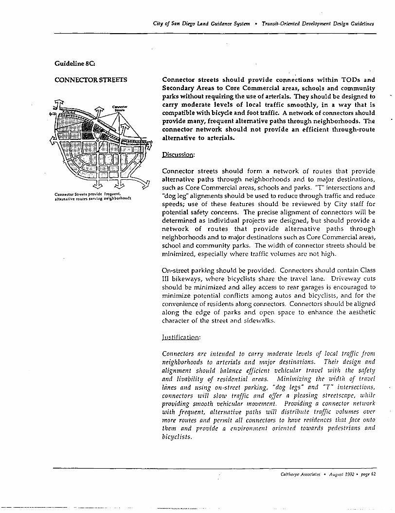
Guideline 8C:
CONNECTOR STREETS
Conn~dor Streets provide frequent, altemalivt routes serving neighborhoods
City of San Dkgo ulnd Guidance System • Transit-Oriented Development Design Guidelines
Connector streets should provide connections within TODs and Secondary Areas to Core Commercial areas, schools and community parks without requiring the use of arterials. They should be designed to carry moderate levels of local traffic smoothly, in a way that is compatible with bicycle and foot traffic. A network of connectors should provide many, frequent alternative paths through neighborhoods. The connector network should not provide an efficient through-route alternative to arterials.
Djscussjon:
Connector streets should form a network of routes that provide alternative paths through neighborhoods and to major destinations, such as Core Commercial areas, schools and parks. 'T" intersections and "dog leg" alignments should be used to reduce through traffic and reduce speeds; use of these features should be reviewed by City staff for potential safety concerns. The precise alignment of connectors will be determined as individual projects are designed, but should provide a network of routes that provide alternative paths through neighborhoods and to major destinations such as Core Commercial areas, school and community parks. The width of connector streets should be minimized, especially where traffic volumes are not high.
On-street parking should be provided. Connectors should contain Class III bikeways, where bicyclists share the travel lane. Driveway cuts should be minimized and alley access to rear garages is encouraged to minimize potential conflicts among autos and bicyclists, and for the convenience of residents along connectors. Connectors shou ld be aligned along the edge of parks and open space to enhance the aesthetic character of the street and sidewalks.
Iu<;tification:
Connectors are intended to carry moderate Ie-vels of local traffic from neighborhoods to arterials and major destinations. Their design and alignment sholiid balance efficient vehicular travel with tlle safety and livability of residential areas. Minimizing the width of travel !tines alld Ilsing on-street parkillg, "dog legs" and "T" intersections, connectors will slow traffic and offer a pleasing streetscape, while providing smooth vehicular movement. Providing a connector network with freqllent, alternative patlls will distribl/te traffic voll/mes over more rOlltes and perlllit all connectors to have residCllces that face onto them and provide a enviro1lment oriented towards pedestrians and bicyclists.
CIlltllOrpt Associates • Allgust 1992 • past 62
,-
-
Guideline tOC:
STREEr CROSSINGS TO TRANSIT STOPS
City of San Dirso Land Guidanu Systnn • Transit·Oriented Dn1elopmDlt Desig.n Guidelines
Streets must be designed to facilitate safe pedestrian crossings to the TOD transit stop.
Discussion:
Transit passengers are likely to make frequent street crossings, some at mid-block, depending on the location and design of the transit stop. Adjacent street design must recognize the need for easy, safe, and fast pedestrian access, by providing sufficient auto and pedestrian visibility distances, stop signs or manually operated traffic signals, handicapped access, and clearly marked pedestrian crossings at signalized intersections.
Iuc;tj fica tion:
Most people will lise transit only if it is fast, safe, and very convenient. Accessibility to transit stops mllst be given high priority ill the design of streets to promote transit ridersllip. Street crossing placement, design and 'markings shollld recogllize tIle need by transit riders for fast and flexible access to the stop.
Oz/tlJOrpe Associates • AI/gust 1992 • page 77
Guideline 100:
PARK AND RIDE LOTS
City of San Di~o Lmd Cuidance System • Trllnsit-Oriented Dellelopment pesign Cuidelines
Park and ride lots are not appropriate for all trunk transit line stops. In Urban TODs, park and ride lots may be provided within structured parking lots located close to the transit stop. Surface parking lots specifically devoted to park and ride should not be provided in TODs. Rather, community-serving surface park and ride lots should be located at the ends of Trunk Line or Feeder Bus Line Networks or in Secondary Areas adjacent to, but outside, the boundaries of TODs.
Discussion:
Park and ride lots are best located adjacent to TOOs or at other transit stops which do not have TOOs. Surface parking lots specifically designed for park and ride, should be located adjacent to TOOs with convenient pedestrian access to the transit stop or at the end of the trunk transit line.
Recognizing the need for parking facilities within Urban TODs to serve both the core commercial area and the transit stop, structured parking lots available to the public may be provided in Urban TOOs. These community parking facilities should primarily serve the TOO and its Secondary Area. The size of the structured parking facility should bp based on projected TOO and Secondary Area needs. These parkinL
structures should be financed and constructed in conjunction with other TOD public improvements.
Iuc;tjficatjoo:
While park and ride lots are extremely important components to bllilding the ridership of the overall transit system, they do not necessarily allgmcllt the Ilses, activities, a1ld densities of a TOD. The 10catio1l alld type of park and ride lots S1101lId be considercd ill terms of the goals and fllnction of the elltire transit system and sholiid not detract from the TOD concepts.
Cn/lhorp< Associates • August 1992 • pagt 78
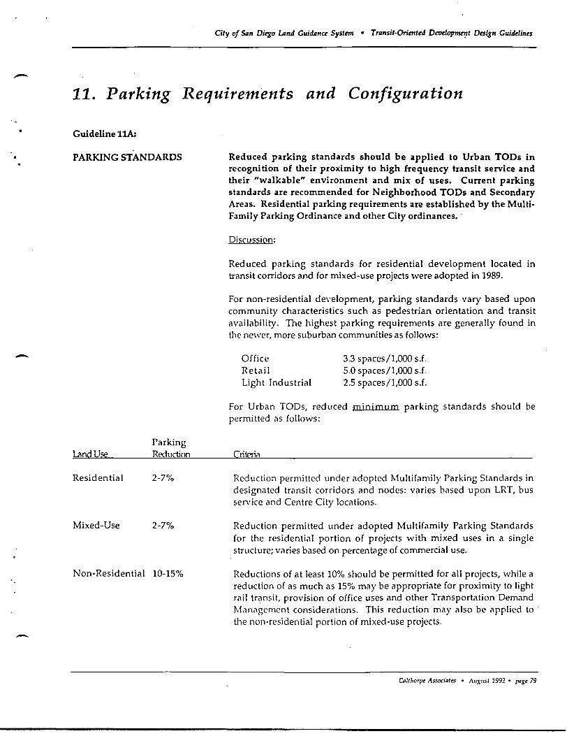
..
-
City of San Diego Land CuiiIanCL Systma • Transit-Orient~d Dewlopmet;tt Design Cuidelin~s
11. Parking Requirements and Configuration
Guideline ItA:
PARKING STANDARDS
Lcmdllie
Residential
Mixed-Use
Parking Reduction
2-7%
2-7%
Non-Residential 10-15%
Reduced parking standards should be applied to Urban TODs in recognition of their proximity to high frequency transit service and their "walkable" environment and mix of uses. Current parking standards are recommended for Neighborhood TODs and Secondary Areas. Residential parking requirements are established by the MultiFamily Parking Ordinance and other City ordinances ..
Discussion:
Reduced parking standards for residential development located in transit corridors and for mixed-use projects were adopted in 1989.
For non-residential development, parking standards vary based upon community characteristics such as pedestrian orientation and transit availability. The highest parking requirements are generally found in the newer, more suburban communities as follows:
Office Retail Light Industrial
3.3 spaces/l,OOO s.f. 5.0 spaces/l,OOO s.f. 2.5 spaces/l,OOO s.f.
For Urban TaOs, reduced minimum parking standards should be permitted as follows:
CrilE'rii'l
Reduction permitted under adopted Multifamily Parking Standards in designated transit corridors and nodes: varies based upon LRT, bus service and Centre City locations.
Reduction permitted under adopted Multifamily Parking Standards for the residential portion of projects with mixed uses in a single structure; varies based on percentage of commercial use.
Reductions of at least 10% should be permitted for all projects, while a reduction of as much as 15% may be appropriate for proximity to light rail transit, provision of office uses and other Transportation Demand Mi'lnagement considerations. This reduction may also be applied to the non-residential portion of mixed-use projects.
CDlthorpt Associates • Ausust 1991 • pagt 79
City of Sim Dit'go LAnd Guidance System • Transit-Oriented Dev!Iopment Design Guidelines
Maximum parking ratios should be established for non-residential uses in Urban TOOs. Based upon further study, parking maximums should be set approximately within the following ranges:
Office Retail Light Industrial
4-5 spaces/l,OOO s.f. 5-6 spaces/l,OOO s.f. 3-4 spaces/l,OOO s.f.
Both minimum and maximum parking standards should be reviewed at least every five years to determine whether further reductions are appropriate.
In preparing and implementing a parking ordinance, the following should be taken into consideration:
1. Communities using parking minimums which differs from the typical suburban requirements described above should be reviewed to determine the appropriate minimum and maximum standards.
2. Consistent with Guideline 9F and with the Multifamily Parking Standards, bike parking standards should be established for nonresidential uses.
3. Parking studies should be conducted as necessary to e\'aluate project that have been granted parking reductions. If recommended by such studies, feasible mitigation measures should be implemented and included as features in future projects.
Iu<;tificatjQn:
Limited rather than ample parking supplies ellcourage commllter lise of transit service.6 Minimum reqllirements help to avoid "spillover" parking ill retail areas or nearby neighborhoods; maximums gllard against overlygenerolls parking sllpplies that discourage trallsit lise and contribute to construction of large surface parking lots. Sample analysis of existing San Diego employers found that the most effective location for implementing redllced parkillg standards was in Urball TODs which are located alollg the trullk trallsit line network.
6 Settillg Parkillg Requiremcllts for Transit-Oricntcd Dcvc10pmCII I, K.l. Anillytics, Inc., for the City of Siln Diego.
OlJ/llOrpe Associates • Augllst 1992 • page 80
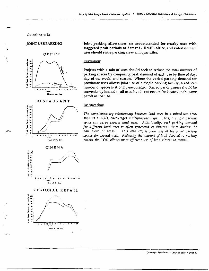
-
-
City of $Qn Diego LAnd Guidllnce System • Trllnsit-Oriented Dwtlopment Design Guidelines
Guideline ltB:
JOINT USE PARKING
c -!1(ll i 90 E ~ E 70 ~ .w :! s..l ~ 40
OFFICE
:. 21' -= 30 I ; ~L~"_"'~"'_"'_"_"'_"_"'_"'_"_'~.'~~~~~_"!~"~ ... ~. __ -+~
7 , I) 1('1 11 U 1 2 .) .. ) t. 7 " 4) 10 ...... Hour ., Ihl' 0 .. ,.
RESTAURANT
~ 1(1)1 - 90 1
~ ~I' ! fA)
~ : I .,:/:' .......... : = 2V I
~ ~IL __ ~ .. ·~·:~· .. _· ______ +-______ __
. ~ un .. 90
E '" ~ 70 .. w ~ s.J ~ 40 ~ )0
:. l'O 'i 10
7 II I) 10 II U 1 1 , .. ) ,. ......... Hour of 'hI Day
CINEMA
~ 4J 10
/ ........... , ".,./ ... " .......... '\ ..... ,.
.. 0 ~ ____ ~ ________ _
7 A " 1\1 11 I! 1 7 ~ 4 S ~ ~ ~ 4J 1."1 II U
""" HOt,lr of th. 0.,.
REGIONAL RETAIL
" ~ 10 11 12 1 2 :\ .. l '" , II " 1('1 ......... Hour 001 th .. 0 .. ,
Joint parking allowances are recommended for nearby uses with staggered peak periods of demand. Retail, office, and entertainment uses should share parking areas and quantities.
Discussion:
Projects with a mix of uses should seek to reduce the total number of parking spaces by comparing peak demand of each use by time of day, day of the week, and season. Where the varied parking demand for proximate uses allows joint use of a single parking facility, a reduced number of spaces is strongly encouraged. Shared parking areas should be conveniently located to all uses, but do not need to be located on the same parcel as the use.
Justificatjon:
The complementary relationship between land uses in a mixed-use area, such as a TOO, encourages mUltipurpose trips. Thus, a single parking space can serve several land uses. Additionally, peak parking demand for different land IIses is often generated at different times during the day, week, or season. This also allows joint llse of the same parking spaces for several IIses. Reducing the amount of lalld devoted to parking within the TOO allows more efficient use of land closest to tra1lsit.
CDlthorp' As..<oaatrs • August 1992 • pag,81
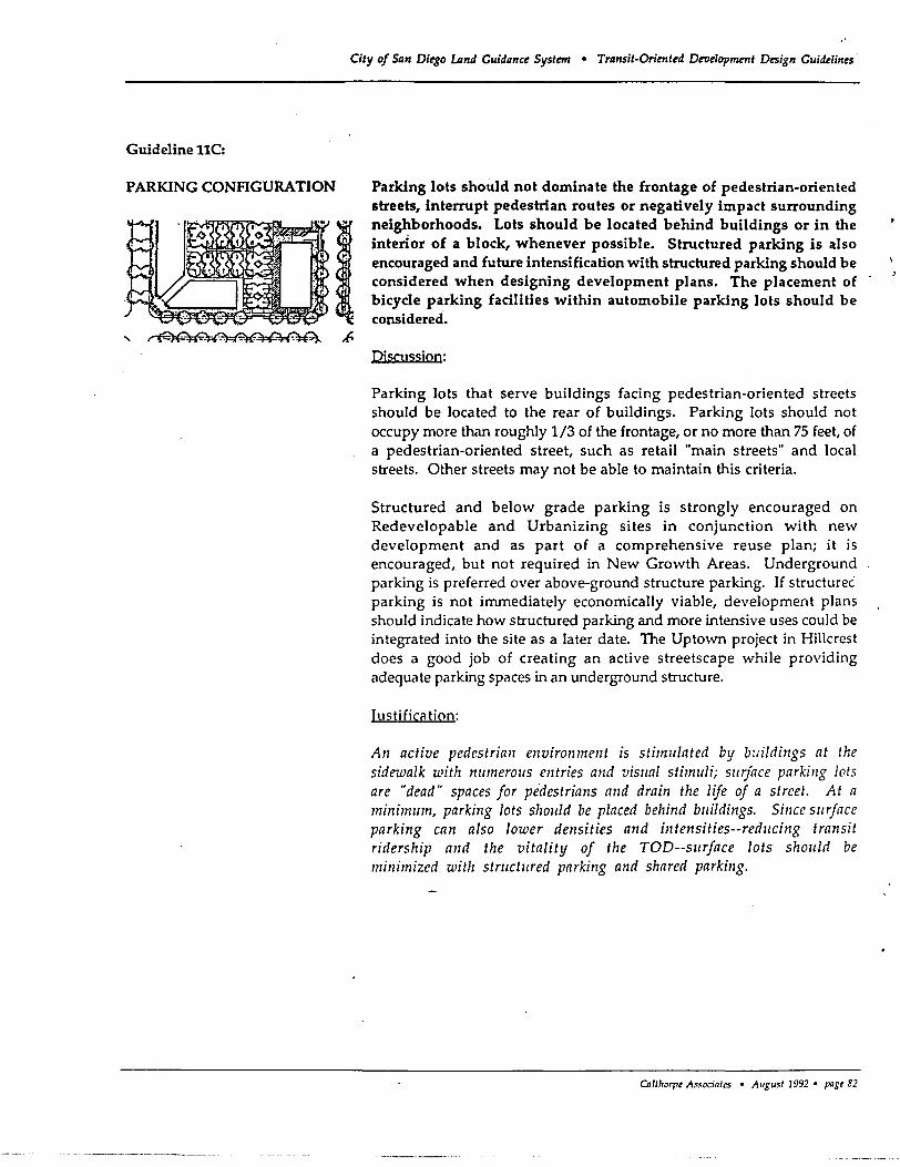
Guideline llC:
PARKING CONFIGURATION
City of San Diego LAnd Guidance System • Transit-Oriented Dtrlelopment Design Guidelines
Parking lots should not dominate the frontage of pedestrian-oriented streets, interrupt pedestrian routes or negatively impact surrounding neighborhoods. Lots should be located behind buildings or in the interior of a block, whenever possible. Structured parking is also encouraged and future intensification with structured parking should be considered when designing development plans. The placement of bicycle parking facilities within automobile parking lots should be considered.
DjsOJssjon:
Parking lots that serve buildings facing pedestrian-oriented streets should be located to the rear of buildings. Parking lots should not occupy more than roughly 1/3 of the frontage, or no more than 7S feet, of a pedestrian-oriented street, such as retail "main streets" and local streets. Other streets may not be able to maintain this criteria.
Structured and below grade parking is strongly encouraged on Redevelopable and Urbanizing sites in conjunction with new development and as part of a comprehensive reuse plan; it is encouraged, but not required in New Growth Areas. Underground parking is preferred over above-ground structure parking. If structurec parking is not immediately economically viable, development plans should indicate how structured parking and more intensive uses could be integrated into the site as a later date. The Uptown project in Hillcrest does a good job of creating an active streetscape while providing adequate parking spaces in an underground structure.
Justification:
An active pedestrian environment is stimlliated by buildings at the sidewalk with nllmerOlls entries and visllal stimuli; sllrface parking lots are "dead" spaces for pedestrians and drain the life of a street. At a minimllm, parking lots shollld be placed behind bllildings. Since sllrface parking can also lower densities and intetlsities--reducing transit ridership and the vitality of the TOD--surface lots should be minimized with structllred parking and shared parking.
OIl1lrorpt Associates • Allgust 1992 • pagt 82
-
I
.-
Guideline 11D:
ON-STREET PARKING REQUIREMENTS
Guideline llE:
PARKING MITIGATION MEASURES
City of San Di~o lAnd Cuidanc~ SystmJ • Transit-Orient~d DnI~lop~nt Design Cuid~lin~s
A portion of any project's parking requirements may be satisfied by onstreet parking.
Discussion:
One space per residential unit when off-street parking is along alleys or the number of on-street parking spaces available on the contiguous street frontage of retail, office, or public use sites, may count against the total required number of parking spaces. To ease parking problems, on-site tandem parking is strongly encouraged.
Iustificiltion:
Utilizing on-street parking spaces to fulfill a portion of the total parking requirement will help redllce the amount of land devoted to parking, while continuing to provide the necessary amount of parking spaces.
\Vhere reduced parking standards are utilized, mitigation measures should be considered to guard against "spill over" parking impacts. Preferential parking zones should be considered in residential neighborhoods and short tenn parking controls may be utilized in core commercial areas.
Discussion:
Where pilrking ratios are significantly reduced to take advantage of proximity to transit, analysis should be made to determine whether adjacent neighborhoods and shopping areas could be negatively affected by spill over parking during peak hours. Residential parking permits should be considered for neighborhoods; meters or short term parking zones should be considered for shopping areas.
I uc;ti nCil tiQnc;:
While the parking guidelines for TODs are intended to not overly restrict parking demand, yet encol/rage carpooling, bicycling and transit lise, in some cases tile maxim 11m parking demand for a pa'rtiClilar area may be excreded. Spillover parking can negatively affect sllrrollnding neighborlloods and discol/rage sllopping in commercial areas. Specific projects shollid be evalllated to determine if mitigation mcasl/rcs wOllld be beneficial.
o.11horpt Associnles • Aususl 1992 • pogt 83
Guideline llF:
SIZE OF SURFACE PARIONG LOTS
City of SIIn Diego LAnd Guidance System • Transit-Oriented Droelopment D(Sign Guidelines
The size of any single surface parking lot shall be limited to 3 acres, unless divided by a street or building.
Discussion:
In no case shall a surface parking lot be larger than 3 acres, unless it is divided into several pieces. Large parking lots can be successfully segmented into smaller units by placing a street through two parking areas or locating a building between parking areas. If a single use will require a surface parking lot in excess of two acres, structured parking should be strongly encouraged.
Justificatjon:
Lnrge parking lots detract from a pedestrian emphasis and dedicate valuable land close to the transit system to non-rider-generating uses. Limiting the size of surface parking lots avoids these problems, while continuing to accommodate the siting needs of anchor retail tenallts.
0l1tl.orpe Associ.tes • August 1992 • pase 84
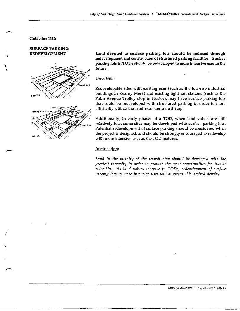
-•
", ~
-
City of Siln Diego lAnd Gaddllnce System • Trllnsit-Orimted Development Design Guidelines
Guideline llG:
SURFACE PARKING REDEVELOPMENT
~ .. ~ ....
~.: .... ~
........... ~. ~.~: ..
.... ~ ~/~.'
~ .. ;:.:~/ <%. <··~;.n'iI Stop . .-:"",« /.':"
BEFORE: <':~'~""'<':- ':: . -', '" ' .......... '-
Land devoted to surface parking lots should be reduced through redevelopment and construction of structured parking facilities. Surface parking lots in TOOs should be redeveloped to more intensive uses in the future.
Discussion:
Redevelopable sites with existing uses (such as the lc;>w-rise industrial buildings in Kearny Mesa) and existing light rail stations (such as the Palm Avenue Trolley stop in Nestor), may have surface parking lots that could be redeveloped with structured parking in order to more efficiently utilize the land near the transit stop.
Additionally, in early phases of a TOD, when land values are still relatively low, some sites may be developed with surface parking lots. Potential redevelopment of surface parking should be considered when the project is designed, and should be strongly encouraged to redevelop with more intensive uses as the TOD matures.
Justification:
Lnnd in the vicinity of the transit stop shollid be developed with the greatest intensity in order to provide the most opportunities for transit ridership. As land values increase in TODs, redevelopmellt of sllrface parking lots to more intensive lIses will augment this desired density.
o./tloorpe Associates • August 1992 • pagt 85
Guideline llH:
RETAIL IN STRUctuRED PARKING LOTS
Cily of San Diego lAnd Guidance Syslml • Transil-Orjrnt~d Deue10pmenl Design Guide1in~s
Retail uses should be encouraged on the first floor of street-side edges of parking structures.
Piscussion:
Parking structures should not be allowed to dominate the street frontage in TODs. Retail uses should be located on the ground floor of parking garages and incorporated into the building's design. Office buildings can also be designed so that the active use portions of the building face the street and wrap around an interior parking structure. Portions of parking structures that do not have first level retail uses must be articulated and otherwise have an appearance similar to the building it serves.
Justification:
The City of San Diego has· been very success fill at preserving the life and activity at the street by requiring ground floor retail in parking structures, This ensures that streets remain interesting and active,
CDllho~ Associates • August 1992 • pagt 86
),
•
-
-
" City of San Ditgo LAnd Guidanc~ Systcn • Transit-Orimt~d Dnlelopmrnt Design Guitkli"~s
Guideline 111:
PARKING LOT LANDSCAPING
~=----~ .. -~ r ~ \.-rr--~~-'::H-- -~ ---rl.:-~---:
All parking lots must have sufficient trees so that within ten years 70 percent of the surface area of the lot is shaded. Additionally, all parking lots should be screened from streets by non-bermed landscape treatments. Views of retail facades must not be blocked.
Discussion:
This guideline is intended to achieve a quality of environment that is comfortable to pedestrians. Trees should be located along walkways; perimeter landscaping should screen views of cars, but not block views of retail facades. Tree canopies should be trimmed to provide shade, but should allow building visibility. Attention should also be given to the use of permeable paving surfaces to reduce surface water runoff.
Justification:
Trees and other landscaping are partiClilarly important for surface parking lots which absorb significant amounts of solar heat alld create uncomfortable places for pedestrians. Lalldscapillg alollg parking lot perimeters should also be provided to soften the visual impact of rows of parked cars alld define the edge of the sidewalk. Landscaping and paving surfaces that allow water to soak into the grollnd can help reduce surface water runoff that pollutes San Diego's streams, bays and ocean waters.
Calthorp~ Associates • August 7992· poge 87
City of San Diego umd Guidance System • Transit-Oriented Droe1op11U7tt Design Guidelines
Incentives & Implementation Strategies
Incentives and other implementation measures are necessary to encourage developers to utilize transitoriented development patterns, as well as provide a supporting basis for long-range land use and transportation planning. These strategies should provide a clear process for implementing the TOD Concept, as well as allow flexibility in interpreting the design guidelines. .
The following recommendations are based on discussions with City staff, the Land Guidance Committee, and participants of the Focus Group sessions. Each category identifies "immediate action items" and "on-going strategies." In all cases, these implementation measures are intended to coincide to the greatest degree possible with existing planning processes and projects already underway by a number of City deparbnents. Additional new implementation mechanisms are also recommended which are necessary to properly bring together the numerous perspectives embodied in the TOO concept.
Long-Range Planning
Immediate Action Items:
• Adopt these TOO Design Guidelines and Implementation Strategies by resolution of th> City Council.
• Adopt a City Council Policy that outlines a phased TOO implementation strategy.
• TOD demonstration projects should be allowed to proceed in advance of comprehensive revisions to existing City codes, standards, and guidelines (including the City's street design manual), provided adequate conditions and monitoring procedures are implemented to minimize City liability.
On-Going Strategies:
• Community plans should be used as "pro-active" tools to designate transit corridors and planning for mixed-use and transit-supportive land uses along existing or planned transit corridors. Community plans should identify appropriate sites for TOOs, Secondary Areas, transit facilities, bicycle routes, pedestrian paths, open space, resource protection, and other non-TOO uses along existing and planned transit corridors. New transit corridors should be planned in conjunction with MTOB staff to ensure that adequate sites are available for TOOs and that densities necessary to support transit can be achieved. Community plan updates should continue to be grouped to allow for comprehensive transportation corridor planning that crosses community plan boundaries. This would apply to both New Growth Areas and Redevelopable and Urbanizing sites.
• As community plans are updated and TOO Opportunity Areas are identified, land use and circulation plans and policies should be amended accordingly. Residential densities, commercial/industrial intensities, and the appropriate mix of uses within TOOs should be clarified. TOOs located in existing developed areas should be designed such that existing residential densities and commercial uses are complemented, without causing significant traffic, infrastructure and public service impacts.
CAJlho'1" Associates • Augu5t 1992 • pagt 88
t
" ~
-
-
•
•
•
City of San Diego LAnd Guidance System • Transit-Oriented Det1elopment Design Guidelines
Planned development permits, redevelopment area plans, and other mechanisms should be used, as appropriate, to implement TOO projects and to ensure that facilities financing and neighborhood character issues are addressed. Individual TOO sites should be encouraged to prepare coordinated plans which provide land use, circulation, infrastructure, and financing plans, as well as traffic studies and environmental review. Proposals may be initiated by either the City, individual property owners, or a group of cooperating property owners. Proposals on TOO sites must demonstrate how the TOO Design Guidelines are applied and adhered to. .
In the course of an update to the General Plan Land Use and Transportation Elements, amendments should be processed to emphasize non-automobile travel opportunities, to identify additional areas where transit-oriented development is desirable, and to reconcile potential conflicts among sensitive resource protection, neighborhood character preservation and transportation corridor expansion goals.
Through the normal course of discretionary project review, the City should encourage proposed projects fully or partially located within 2,000 feet of an existing or planned light rail transit, commuter rail, express bus or transit corridor stop, as identified on Council-approved transit alignment maps, to incorporate elements of the Transit-Oriented Development Design Guidelines into project design.
If existing community plans have not yet been updated with regard to the TOO guidelines, and a property owner desires to construct a project that meets the site selection and development criteria of the TOO guidelines, the City should offer an expedited plan amendment and discretionary permit process, while still ensuring opportunities for full community input.
Environmental Revie'lu and Perlnit Processing
On-Going Strategies:
•
•
The Process Management effort to streamline permit processing should be continued. Planning and evaluating TOO proposals should clearly identify accepted procedures and time limit goals for TOO specific plans, EIRs, tentative maps, and site plan review.
If a specific plan, planned development permit, or other discretionary permit is prepared for an individual TOO site or a series of TODs, a single EIR and traffic study should be required; no subsequent environmental review should be necessary, unless a submitted plan does not conform with the adopted environmental document. State Law (Gov·t. Code Sec. 65450 et seq.) presently allows construction of housing developments that are consistent with the criteria and standards of an adopted specific plan and its EIR to proceed without further environmental review. This should be extended to all uses within the plan area, provided the proposed project is within the range of allowable uses and densities (Le. amount and type of housing, commercial, industrial, and public uses), conforms to other land use and circulation policies, meets the TOO and specific plan design guidelines, and conforms to the requirements of the plan's implementation program. This will require specific plans and their EIR's to provide some flexibility in the range and amount of allowable uses, yet ensure enough clarity in their land use programs to adequately assess potential environmental impacts.
Cnlthorp' As.<oclates • August 1992· Fag,89
•
City of Slln Ditgo Lmd Guidllnce System • Trllnsit-Oriented Development Design Guidelillts
Traffic Level of Service (LOS) and design speeds should be reconciled with the intent of the TOO concept during environmental review, traffic study, and facilities planning for TOO projects_ In all cases, regionally significant roads, such as arterials, thoroughfares, expressways, and freeways, should continue to achieve high levels of service at acceptable travel speeds. Local streets within TOOs should not be held to the same standards; TOO streets should allow reduced speeds and lower levels of service, provided pedestrian and vehicle safety is maintaine~.
Zoning and City Standards
On-Going Strategies:
•
•
•
•
•
•
•
Existing zoning regulations should be amended and new zoning tools created to incorporate the concepts of the TOO guidelines into city wide site development standards. To the extent possible, individual developments within TODs should be permitted to proceed through ministerial, rather than discretionary processes. These standards and processes should be closely coordinated with the current zoning code update process.
Efforts to revise the Street Design Manual should be continued, with emphasis on establishing specific street width and configuration standards that realize the intent of the Design Guidelines. In particular, standards for local streets, new "connector" streets, alleys, sidewalks, street trees, and onstreet parking should be reviewed and amended.
The TOO guidelines should be used to develop more specific zoning regulations to facilitate mixeduse projects. These standards should focus on determining appropriate types of permitted uses, residential densities and commercial intensities, intensity of site use, providing street and pedestrian connections with adjacent parcels, and site buffering.
In accordance with State law, the City has adopted an ordinance to authorize companion units (granny flats) under certain conditions. To date, only a handful of companion units have actually been authorized. The Planning Department should propose amendments to the companion unit ordinance to enable their more widespread use as an affordable housing resource. These amendments could include allowing construction of detached second rental units on existing parcels, provided the single- or multi-family character of the neighborhood is not altered and modifying current vacancy rate restrictions. These amendments should also include the development of standards which would outline the minimum lot size, parking, and transit access requirements for both the ministerial and discretionary approval of such units.
Revise city wide parking standards to be consistent with the TOO Design Guidelines, specifically related to the number of spaces and the configuration and size of parking lots.
Through the standard permit review process, TOO plans should be reviewed to determine whether Residential Permit Parking Zones and time limit parking in commercial areas \vould be necessary.
In conjunction with community p\.an updates and specific plans, review land use designations anc' zoning maps to minimize competing retail and oUice uses outside of TOOs and Secondary Areas, as well as minimizing highly auto-dep,endent uses within the TOO and Secondary Area boundaries.
CoWlOrpe As.<aciules • A"S"sl 1992 • pase 90
;
--,
-
-
City of Siln Ditgo umd Guidllnce System • Trllnsit-Orimted Development Design Guidelines
Public Services and Infrastructure
On-Going Strategies:
• TODs "located in existing developed areas on Redevelopable and Urbanizing Sites must address existing and potential infrastructure and public facility deficiencies_ If necessary, additional parks should be provided and other infrastructure capacity constraints corrected.
• Public facilities and services, such as libraries, parks and recreation centers, should be located in TODs, whenever possible to provide patrons a transit travel option and to strengthen the sense of community in neighborhoods.
• Encourage the Park and Recreation Department to allow TOOs to meet the City's park standards through the use of small and frequent parks and plazas.
• TOO specific plans must include a coordinated infrastructure financing plan which indicates how onand off-site infrastructure and other public improvements shall be financed. Where a specific plan is not prepared, or a proposed project is for only a portion of a TOO, any necessary infrastructure improvements and associated costs must be identified and an appropriate financing method recommended with the planned development permit or individual project application.
• In recognition of the cumulative fiscal benefits resulting from a more efficient urban form, fees (or TOOs should be reduced. The reduction must be linked to a demonstrated reduction in need for facilities to serve TOO developments.
CD/lhorpt Associates • August 1992. paSt 91
Recommended