Embed Size (px)
Citation preview
ZONING ORDINANCE
OF THE
TOWN OF CAMDEN, MAINE
CERTIFIED:
I hereby certify that this Zoning Ordinance is effective on November 4, 1992. This Zoning
Ordinance was enacted at the November 3, 1992 Special Town Meeting and amended at the June
8, 1993 Town Meeting, the November 2, 1993 Special Town Meeting, June 14, 1994 Town
Meeting, June 13, 1995 Town Meeting, November 7, 1995 Special Town Meeting, June 11, 1996
Town Meeting, June 10, 1997 Town Meeting, November 4, 1997 Special Town Meeting, June 9,
1998 Town Meeting, June 8, 1999 Town Meeting, June 13, 2000 Town Meeting, November 7,
2000 Special Town Meeting, November 6, 2001 Special Town Meeting, June 11, 2002 Town
Meeting, June 10, 2003 Town Meeting, November 4, 2003 Special Town Meeting, June 8, 2004
Town Meeting, November 2, 2004 Special Town Meeting, November 8, 2005 Special Town
Meeting, June 13, 2006 Town Meeting, November 7, 2006 Special Town Meeting, June 13, 2007
Town Meeting, November 6, 2007 Special Town Meeting, June 10, 2008 Town Meeting and
November 4, 2008 Special Town Meeting, June 10, 2009 Town Meeting, November 3, 2009
Special Town Meeting, June 8, 2010 Town Meeting, November 2, 2010 Special Town Meeting,
June 12, 2012 Town Meeting and November 6, 2012 Special Town Meeting.
The amendments are effective as of June 15, 1993, November 9, 1993, June 21, 1994, June 20,
1995, November 14, 1995, June 18, 1996, June 17, 1997, and November 11, 1997, June 16,
1998, June 20, 2000, November 14, 2000, November 13, 2001, June 18, 2002, June 17, 2003,
November 11, 2003, June 15, 2004, November 9, 2004, November 15, 2005, June 20, 2006,
November 14, 2006, June 20, 2007, November 13, 2007, June 17, 2008, November 11, 2008
June 17, 2009, November 10, 2009, June 15, 2010, November 3, 2010, June 12, 2012 and
November 6, 2012 are incorporated into the Zoning Ordinance.
______________________________________________________________________________
Martin Cates, Chair Date
Camden Select Board
Signature of Martin Cates attested:
______________________________________________________________________________
Katrina Oakes, Camden Town Clerk Date

This page intentionally left blank
TABLE OF CONTENTS
Page
Article I Title I & II – 1
Article II Purpose I & II – 1
Article III Definitions
Section 1. Meaning of Words III – 1
Section 2. Definitions III – 1 - 20
Appendix 1. Street Level Examples III – 21
Article IV Establishment of Districts
Section 1. Zoning Map IV – 1
Section 2. Zoning Districts IV – 1, 2
Section 3. District Boundaries IV – 2
Article V Administration and Enforcement
Section 1. Administrative Official V – 1
Section 2. Permits Required V – 1, 2
Section 3. Exclusions for Permitting V – 2
Section 4. Certificate of Occupancy V – 2, 3
Section 5. Fee and Time Limits V – 3
Section 6. Penalties V – 4
Section 7. Legal Actions, Consent Agreements & Orders V – 4, 5
Article VI. Nonconformance
Section 1. Purpose VI – 1
Section 2. Nonconforming Lots VI – 1, 2
Section 3. Nonconforming Uses VI – 3
Section 4. Nonconforming Structures VI – 4
Section 5. Transfer of Ownership VI – 5
Section 6. Changes in Nonconformities in Shoreland Areas VI – 5 - 7
Section 7. Nonconforming Ground Coverage VI – 7, 8
Section 8. Unlawful Uses, Structures, or Lots VI – 8
Article VII Zoning Board of Appeals
Section 1. Appointment and Composition VII – 1
Section 2. Procedures VII – 1, 2
Section 3. Powers and Duties VII – 2, 3
Section 4. Special Exception Permits VII – 3 - 8
Section 5. Variances VII – 8 - 11
Section 6. Standards for Request to Exceed Standards Set Forth in
Article VII, Section 3(5) of the Zoning Ordinance
VII – 11
Article VIII. District Regulations
Section 1. Natural Resource Protection District (RP) VIII – 1, 2
Section 2. Rural 1 District (RU-1) VIII – 3 - 6
Section 3. Rural 2 District (RU-2) VIII – 7 - 10
Section 4. Rural Recreation District (RR) VIII – 11 - 14
Section 5. Coastal Residential District (CR) VIII – 15 - 18
Section 6. Village Extension District (VE) VIII – 19 - 24
Section 7. Traditional Village District (V) VIII – 25 - 30
Section 8. Downtown Business District (B-1) VIII – 31 - 34
Section 9. Highway Business District (B-2) VIII – 35 - 38
Section 10. Transitional Business District (B-3) VIII – 39 - 46
Section 11. Neighborhood Service District (B-4) VIII – 47 - 52
Section 12. Harbor Business District (B-H) VIII – 53 - 58
Section 13. River Business District (B-R) VIII – 59 - 62
Section 14. Transitional River Business District (B-TR) VIII – 63 - 66
Section 15. Industrial District (I) VIII – 67 - 70
Section 16. Transitional Harbor Business District (B-TH) VIII – 70 - 76
Article IX. Open Space Zoning
Section 1. Purpose IX – 1
Section 2. Applicability IX – 1
Section 3. General Standards IX – 1 - 6
Section 4. Design Standards IX – 6, 7
Section 5. Common Open Spaces IX – 7, 8
Article X. Performance Standards
Part I. Standards in Overlay Areas X – 1
Section 1. Shoreland Areas X – 1 - 22
Section 2. High Elevation Areas X – 22, 23
Section 3. Historic Areas X – 23
Part II. Performance Standards Generally X – 23
Section 1. Environmental X – 23 - 25
Section 2. Keeping of Animals X – 25
Section 3. Screening and Landscaping X – 26 - 28
Section 4. Off-Street Parking and Loading Standards X – 29 - 37
Section 5. Lots X – 37
Section 6. Fences X – 37
Section 7. Home Occupations X – 37, 38
Section 8. Approval of State Fire Marshall X – 38
Section 9. Mobile Home Parks X – 39 - 45
Section 10. Standards for Older Mobile Homes X – 45 - 48
Article XI. Signs
Section 1. Purpose XI – 1
Section 2. Definitions XI – 1 - 3
Section 3. Permit Required XI – 3
Section 4. Excepted Signs XI – 3, 4
Section 5. Community, Municipal, and Quasi-Municipal Facilities XI – 4
Section 6. Obsolete Signs XI – 4
Section 7. Illuminated Signs XI – 4
Section 8. Flags, Banners and Pennants XI – 4
Section 9. General Prohibitions in All Zones XI – 5
Section 10. Off-Premises Signs XI – 5
Section 11. Specifications XI – 5 - 7
Section 12. Temporary Signs XI – 7
Section 13. Town Directional Signage XI – 7, 8
Article XII. Site Plan Review
Section 1. Purpose and Applicability XII – 1, 2
Section 2. Procedures XII – 2 - 4
Section 3. Site Plan Content XII – 4, 5
Section 4. Supplemental Information XII – 5, 6
Section 5. Waiver of Submission Requirements XII – 6, 7
Section 6. Approval Criteria XII – - 10
Section 7. Expiration of Approval XII – 10
Section 8. Site Plan Review XII – 10
Article XIII. Historic Resources Committee
Section 1. Appointment and Composition XIII – 1
Section 2. Procedures XIII – 1
Section 3. Duties XIII – 1, 2
Article XIV. Regulation of Private Ways
Section 1. Purpose and Applicability XIV – 1
Section 2. Application XIV – 1 - 2
Section 3. Waiver of Submission Requirements XIV – 2 - 3
Section 4. Approval Criteria XIV – 3 - 4
Section 5. Expiration of Approval XIV – 4
Section 6. Recording Plan XIV – 4
Section 7. Appeal XIV – 4
Section 8. Definition of Private Way XIV – 5
Schedule A XIV – 6
Article XV. Amendment and Other Interpretive Provisions
Section 1. Interpretation XV – 1
Section 2. Conflict with Other Ordinances XV – 1
Section 3. Severability XV – 1
Section 4. Amendment XV – 1
Section 5. Repeal XV – 2
Section 6. Availability XV – 2
I & II - 1
Article I Title
This Ordinance shall be known and may be cited as the "Zoning Ordinance of the Town
of Camden, Maine," and will be referred to herein as the Ordinance.
Article II Purpose
This Ordinance, adopted in accordance with the Maine Revised Statutes, is designed to
encourage the most appropriate use of the land throughout the Town; to promote the Town's
Comprehensive Plan; to foster a pattern of development that respects both villages and the rural
landscape while discouraging "sprawl"; to protect existing neighborhoods and encourage
formation of new neighborhoods; to provide for vital business areas; to promote traffic safety; to
provide safety from fire; to provide adequate light and air; to prevent overcrowding of real
estate; to promote a wholesome home environment; to conserve natural resources; and to provide
for adequate public services.
Further, within shoreland areas, this Ordinance is designed to carry out the purposes of
the State Shoreland Zoning Program including to further the maintenance of safe and healthful
conditions; to prevent and control water pollution; to protect fish spawning grounds, aquatic life,
bird and other wildlife habitat; to protect buildings and lands from flooding and accelerated
erosion; to protect archaeological and historic resources; to protect commercial fishing and
maritime industries; to protect freshwater and coastal wetlands; to control building sites,
placement of structures and land uses; to conserve shore cover, and visual as well as actual
points of access to inland and coastal waters; to conserve natural beauty and open space; and to
anticipate and respond to the impacts of development in shoreland areas. (Amended 11/10/09)

I & II - 2
This page intentionally left blank
III - 1
Article III Definitions
Section 1. Meaning of Words
All words not defined herein shall carry their customary and usual meanings. Words used in the
present tense shall include the future. Words used in the singular shall include the plural and
vice versa. The word "lot" shall include "parcel" and "plot." The word "shall" is used to indicate
the mandatory and the word "may" is used to indicate the permissive. The words "occupied" or
"used" shall be considered as though followed by the words "or intended, arranged, or designed
to be used or occupied."
Section 2. Definitions
ABUTTING PROPERTY: Any lot which is physically contiguous with the lot in question
even if only at a point and any lot which is located directly across a public street or way from the
lot in question.
ACCESSORY APARTMENT: A second dwelling unit contained within a single family
detached dwelling or an accessory building on the same lot as a single family detached dwelling
for use as a complete, independent living quarters, with provision for living, sleeping, bathing,
and cooking.
The single family dwelling, including any accessory building, shall:
(1) contain no more than one accessory apartment;
(2) be owner-occupied for the entire time during which the accessory apartment is
occupied;
The accessory apartment shall:
(1) contain a total of less than 600 square feet, gross, of living area; and
(2) be occupied by a person or household for whom the apartment is the primary
residence.
ACCESSORY STRUCTURE: A subordinate structure that is detached from the principal
structure, the use of which is incidental to that of the principal structure.
ACCESSORY USE: A use that is clearly incidental to the principal use, that is subordinate in
area, extent, or purpose to the principal use being served, and that contributes to the comfort,
convenience, or necessity of the principal use, and that is located on the same lot with such
principal building or use. In a residential district, the accessory use shall not be nonresidential in
character. Piers, wharves and bulkheads are included in this definition. (New last sentence -
11/15/05)
III - 2
AGRICULTURE (or FARMING): The production, keeping, or maintenance for sale or lease,
of plants and/or animals, including but not limited to: forages and sod crops; grains and seed
crops; dairy animals and dairy products; poultry and poultry products; livestock; fruits and
vegetables; and ornamental and greenhouse products. Agriculture does not include forest
management and timber harvesting activities. (Amended 11/10/09)
AGRICULTURAL PRODUCTS PROCESSING: The manufacturing, handling, treatment, or
packing of crops, livestock, or dairy products, produced or raised on farms, excluding rendering
plants, fertilizer manufacturing plants, and similar manufacturing operations.
ALTERNATE CODE ENFORCEMENT OFFICER: A Certified Code Enforcement Officer
Appointed by the Camden Board of Selectmen to act in the absence of the appointed Code
Enforcement Officer.
AMUSEMENT PARK: A commercially operated park with a predominance of outdoor games
and activities for entertainment, including motorized rides, water slides, miniature golf, batting
cages, and the like.
AUTO REPAIR GARAGE: A building in which serviceable motor vehicles are maintained,
serviced, or repaired.
BACK SETBACK: See SETBACK, BACK. (New – 11/15/05)
BANNER: Any sign of lightweight fabric or similar material that is permanently mounted to a
pole or a building by a permanent frame at one or more edges. National, state, or municipal
flags, or the official flag of any institution or business, shall not be considered banners.
BAR OR LOUNGE: An establishment or part of an establishment used primarily for the sale or
dispensing of liquor by the drink.
BOAT AND MARINE SALES AND SERVICE: The sale of boats, yachts and accessories
including maintenance, storage, repair or rental. The facility may include removal and launching
facilities, floats and docks, water and electrical hookups and fuel pumps. (New – 11/15/05)
BREAKWATER: A permanent solid structure of rock, concrete, steel or wood (or combination
thereof) extending from the shoreline into the waters for the principal purpose of breaking and
reducing the force of waves. (New - 6/20/06)
BUILDING: Any structure having a roof. Each portion of a building, separated from other
portions by a firewall, shall be considered as a separate building.
BUILDING COVERAGE: The percentage of lot area covered or occupied by principal and
accessory structures, where the building foundation meets the ground, including all floor
overhangs, but excluding roof overhangs and decks. (Amended - 11/14/06)
BUILDING OFFICAL: see Code Enforcement Officer (New 6/12/12)
III - 3
BULKHEAD: A permanent solid structure or wall built along the shore to retain and protect the
upland from wave and sea erosion. (New - 6/20/06)
CAMPING GROUND: A parcel of land used for overnight accommodations for campers
including erection of tents, overnight cabins and parking facilities.
CHURCH: As used in this Ordinance, refers to a place of worship regardless of denomination.
CLEAR CUTTING: Any timber harvesting which over a 10-year period results in an average
residual basal area of trees over 6 inches in diameter measured at 4_ feet above the ground of
less than 30 square feet per acre, unless, after harvesting, the site has a well-distributed stand of
trees at least 5 feet in height that meets the regeneration standards defined under 12 MRSA,
Chapter 805, Section 8869, Subsection 1.
CLINICS FOR ANIMALS: A place for the medical treatment of animals. (new – 11/14/06)
COASTAL WETLAND: All tidal and sub tidal lands; all lands with vegetation present that
is tolerant of salt water and occurs primarily in a salt water or estuarine habitat; and any swamp,
marsh, bog, beach, flat or other contiguous low land which is subject to tidal action during the
highest tide level for the year in which an activity is proposed as identified in tide tables
published by the National Ocean Service. Coastal wetlands may include portions of coastal sand
dunes. (New – 11/15/05)
CODE ENFORCEMENT OFFICER: The official responsible for enforcement of the
Ordinance and for other duties set forth by state statute and other ordinances. The Code
Enforcement Officer (CEO) and Assistant Code Enforcement Officer shall also have all the
duties of a Building Inspector and shall be certified by the state in accordance with Title 30-A,
MRSA S4451. An Assistant Code Enforcement Officer may be appointed to serve at the
direction of the CEO, and in the CEO’s absence shall have all authority of a CEO pursuant to
local ordinances and state statutes. The CEO and the Assistant CEO shall also serve as Building
Official and Assistant Building Official in the enforcement of the MUBEC. (Amended 06/12/12)
COLLEGE: A degree-granting institution of higher (post-secondary) education.
COMMERCIAL OUTDOOR RECREATION: Outdoor recreation activities that are operated
by an entity other than a unit of government and which are available for use for a fee, including
but not limited to standard golf courses, ice skating rinks, tennis courts, cross-country ski trails,
and alpine ski trails and the rental of non-motorized sports equipment, but excluding games and
activities common to amusement parks. Private outdoor recreation facilities serving exclusively
a residential use shall be considered accessory to the residential use.
COMMERCIAL PARKING FACILITY: An outside lot, or any portion of an outside lot,
used for the parking of motor vehicles where that use is a primary use. The term "facility" shall
not include a commercial parking garage. (Amended – 11/13/07)
III - 4
COMMERCIAL PARKING GARAGE: A building used wholly or in part for commercial
parking of vehicles. No parking is permitted above the second story level as measured from
street level.
COMMERCIAL SCHOOL: See SCHOOL, COMMERICAL (New – 11/15/05)
COMMUNITY BUILDING: A private building used by a fraternal, philanthropic or other
civic organization and which may be made available from time to time for community functions.
COMMUNITY LIVING USE: A state-approved, authorized, certified or licensed group home,
or intermediate care facility for eight or fewer mentally handicapped or developmentally disabled
persons.
CONSOLIDATED PIER: A shared pier that meets the standards of Article X, part 1, section
1, (8A).
CORNER LOT: Lot located at the intersection of two streets.
COTTAGE: A dwelling unit designed to be used as a residence during less than six (6) months
out of the year which does not qualify as a dwelling as defined herein.
DAY CARE CENTER (or NURSERY SCHOOL): A facility licensed by the State of Maine
for the care or instruction of more than three (3) preschool aged children, exclusive of children
who may be living in the home which is serving as the day care or nursery school facility.
DAYS: For purposes of computation of the time period for any action or appeal within this
Ordinance, days shall mean consecutive calendar days; provided, however, that in the event that
the last day of any such time period falls on a Saturday, Sunday, or a holiday in which the Town
Office for Camden is closed, then the time period shall be deemed to expire on the next
succeeding calendar day that the Town Offices are open for business.
DRIVE-THROUGH WINDOW: A facility associated with some eating places, banks, and
other service enterprises and designed to enable customers or patrons to remain in their motor
vehicles while passing by an external opening in the structure where they place or receive orders
or transactions. A window designed to receive orders or transactions exclusively from
pedestrians is not included in the term "drive-through window."
DRIVEWAY: A vehicular access from a public or private way to a structure or use on a lot.
Driveways shall be a maximum of twenty (20) feet wide. A driveway may cross front, side and
rear setbacks and may be utilized for parking. A driveway is less than five hundred (500) feet in
length serving two single-family dwellings or one two-family dwelling, or less. (Amended
11/10/09)
DWELLING: A building used as the living quarters for one or more families. The term
"dwelling" shall also include manufactured housing as defined by Title 30-A, MRSA, Section
4358(1), as the same may, from time to time, be amended, and an older mobile home as further
defined in this Zoning Ordinance.
III - 5
DWELLING, ATTACHED: A single family dwelling which has two or more fire separation
walls, or one fire separation wall in the case of a dwelling unit at the end of a group of attached
dwellings; which has no dwelling unit above or below it; and which has no common hallway
with any other dwelling unit.
DWELLING, MULTIFAMILY: One or more buildings used for residential occupancy by
more than two families, each living independently of the other. (Amended - 6/20/06)
DWELLING, SINGLE-FAMILY DETACHED: A building separate from any other building
and that is designed and used exclusively for the living quarters of one family only and not
containing more than one dwelling unit. The term includes manufactured housing and older
mobile homes.
DWELLING, TWO FAMILY: A building used for residential occupancy by two families
living independently of each other.
DWELLING UNIT: A room or group of rooms designed and equipped exclusively for use as
permanent, seasonal, or temporary living quarters for only one person or family at a time, and
containing living, sleeping, toilet and cooking facilities. The term shall include mobile homes
and rental units that contain cooking, sleeping and toilet facilities regardless of the time-period
rented. Recreational vehicles are not residential dwelling units. A dwelling unit may not be
rented for periods of less than seven (7) consecutive days. (Amended 11/10/09)
ELDERLY CONGREGATE HOUSING: A type of multifamily dwelling, including multiple
individual rooms or dwelling units, to be occupied by elderly persons as a residential shared
living environment. Such construction will normally include small individual apartments,
combined with shared community space, shared dining facilities, housekeeping services,
personal care and assistance, transportation assistance, and specialized shared services such as
medical support services and physical therapy.
ESSENTIAL SERVICES: The construction, alteration, or maintenance of the following
facilities, provided they serve primarily the Town of Camden or a neighborhood or structure
within the Town: steam, fuel, gas, communication, transportation, electric power, or water
transmission or distribution lines, towers and related equipment; telephone cables or lines, poles
and related equipment; gas, oil, water, slurry or other similar pipelines; municipal sewage lines,
collection or supply systems; and associated storage tanks. Such systems may include towers,
poles, wires, mains, drains, pipes, conduits, cables, fire alarms and police call boxes, traffic
signals, hydrants and similar accessories, but shall not include buildings which are necessary for
the furnishing of such services. See also Public Utility. Essential services shall not be subject to
the space and bulk standards of this Ordinance.
The Essential Services shall not include a wireless telecommunications facility for which a
permit is necessary in accordance with the Wireless Telecommunications Facility Siting
Ordinance, except that a wireless telecommunications facility shall be deemed to be an Essential
Service in the following limited circumstances:
III - 6
(a) when such facility or a structure which is part of such facility involves co-location as part
of an existing wireless telecommunications facility up issuance of a permit by the Code
Enforcement Officer as set for in Section 4.1 of the Wireless Telecommunications
Facility Siting Ordinance;
(b) location of an antenna in an existing structure, such as (for purposes of illustration) a
church steeple, silo or multi-story building, with no exterior storage of equipment outside
that existing structure.
ESTABLISHED UNIFORM SETBACK RELATIONSHIP: For purposes of the
determination of the front setback in the Traditional Village District (V), the Village Extension
District (VE), the Transitional Business District (B-3), and the Neighborhood Service District
(B-4), the established uniform setback relationship is the established relationship which is
deemed to exist when the distance between the part of the principal building nearest to the street
and the edge of the right-of-way of that adjoining street for the two adjacent lots fronting on the
same street on each side of the subject parcel (the parcel for which the setback is being
determined) is, for each such building, within 5 feet of the average setback distances of the
principal buildings on those 4 lots.
FAMILY: One or more persons occupying a dwelling unit and living as a single housekeeping
unit, as distinguished from a group occupying a boarding home, rooming house, or hotel.
FAST FOOD RESTAURANT and TAKE-OUT FOOD SERVICE: See FOOD SERVICE
FINANCIAL SERVICE: A service listed under U.S. Standard Industrial Classification Codes
60 through 67, inclusive, and including banking, other credit agencies, security and commodity
brokers and service, insurance, real estate and investment offices.
FLAG: Any fabric or bunting containing distinctive colors, patterns, or symbols, used as a
symbol of a government, political subdivision, or other entity.
FLEA MARKET: An outdoor market selling antiques, used household goods, curios, and the
like, at a frequency of more than four days in any six-month period. Flea markets, as
distinguished from yard (or garage) sales, shall be prohibited under this Ordinance.
FLOOR AREA: The surface of a structure on which one walks.
GROSS FLOOR AREA: The floor area of a building, excluding those areas with less
than six feet of headroom.
NET FLOOR AREA: The calculation of the sum of the floor area devoted to the
permitted use on all floors of the building for the purpose of determining a parking
requirement. Other areas, such as those used for utilities, storage, stairs, corridors and
rest rooms, shall not be included in the calculation. (New - 6/20/06)
III - 7
FOOD SERVICE: A place for the serving of prepared food and beverages to the public. For
the purposes of this Ordinance, establishments involved with food service shall be divided into
the following categories:
SIT-DOWN RESTAURANTS: A full service eating facility that meets all the
following criteria:
1. Food and beverages are served at a table for consumption exclusively on the
premises.
2. Plates and utensils are washed on the premises.
3. At least 50% of the seating is within the building.
4. State and town hygiene requirements are met.
A sit-down restaurant does not meet the criteria for a fast food restaurant.
FAST FOOD RESTAURANT: A facility where the food and/or beverages are (1)
primarily intended for immediate consumption, (2) available upon a short waiting time,
(3) served over the counter rather than at a table, and (4) prepackaged or presented in
such a manner that the food and/or beverages can be readily eaten off the premises where
sold. For the purposes of this Ordinance, a fast food restaurant shall not be considered an
accessory use even if subordinate to another use.
TAKE-OUT FOOD SERVICE: The sale of prepared food and/or beverages by an
establishment whose space is devoted principally to the sale of groceries, including
grocery stores, bakeries, wine and cheese stores, and similar establishments that sell food
for use in the home. For the purposes of this Ordinance, such sale of prepared food
and/or beverages shall be considered accessory to the principal use.
FOREST MANAGEMENT ACTIVITIES: Timber management and other forest resource
evaluation activities, pesticide or fertilizer application, management planning activities, timber
stand improvement, pruning, regeneration of forest stands, and other similar or associated
activities, exclusive of timber harvesting and the construction, creation or maintenance of roads.
FOUNDATION: The supporting substructure of a building or other structure, excluding
wooden sills and post supports, but including basements, slabs, frost walls, or other base
consisting of concrete, block, brick or similar material. (New - 6/20/06)
FRONTAGE: The linear distance between the sidelines of a lot, measured along the lot line
that borders upon whatever right-of-way serves as legal access to the lot. For the purposes of
this Ordinance, the following ways shall constitute legal access to a lot along which frontage
shall be measured:
(1) a way accepted by or established as belonging to the Town of Camden, Knox County, or
the State of Maine, provided access is not specifically prohibited;
III - 8
(2) a way, whether dedicated to public ownership or not, as shown on an approved
subdivision plan;
(3) a private or public way which has not been approved by a governmental subdivision but
which has been established in a deed recorded in a registry of deeds or otherwise legally
established by adverse possession or adverse use.
In the case of a lot bordering upon more than one way as defined above, the measurement of
frontage shall include the entire length of the property line along such way or ways. Minimum
street frontage shall mean continuous frontage.
FRONT SETBACK: See SETBACK, FRONT (New – 11/15/05
FUNCTION HALL: A building or a portion of a building used for the purpose of hosting a
function, such as a conference, party, banquet, reception or other social event. (Added 06/17/09)
FUNCTIONALLY WATER-DEPENDENT USES: Those uses that require, for their primary
purpose, location on submerged lands or that require direct access to, or location in, coastal and
inland waters and that cannot be located away from these waters. The uses include, but are not
limited to: commercial and recreational fishing and boating facilities, excluding recreational
boat storage buildings, finfish and shellfish processing, fish storage and retail and wholesale
marketing facilities, waterfront dock and port facilities, shipyards, boat yards, and boat building
facilities, marinas, navigation aides, basins and channels, retaining walls, industrial uses
dependent upon water borne transportation or requiring large volumes of cooling or processing
water and which cannot reasonably be located or operated at an inland site, and uses which
primarily provide general public access to coastal or inland waters. (Amended 11/10/09, 6/15/10)
FUNERAL HOMES: Establishments where the deceased are prepared for burial or cremation,
where the body may be viewed, and where funeral services are sometimes held. (New – 11/15/05)
GAS STATION: An establishment where gasoline and other petroleum products are sold
principally for use in motor vehicles. A gas station may not be considered an accessory use,
except at marinas if the sale of gasoline for use in motor vehicles is incidental and accessory to
the sale of fuel for marine purposes.
GOLF COURSE: A tract of land for playing golf, improved with trees, greens, fairways, and
hazards, and which may include clubhouses and shelters. The term excludes miniature golf
courses.
GREAT POND: Any inland body of water which in a natural state has a surface area in excess
of ten (10) acres, and any inland body of water artificially formed or increased which has a
surface area in excess of thirty (30) acres except for the purposes of this Ordinance, where the
artificially formed or increased inland body of water is completely surrounded by land held by a
single owner. Any pond known as GPA, pursuant to 38 M.R.S.A. Article 4-A, Section 465-A. (New last sentence - 11/2/10)
III - 9
GROUND COVERAGE: The percent of lot area covered or occupied by all structures, parking
lots, and other disturbed surfaces that are non-vegetated.
HAIR SALON: A place where hair is cut and styled. The use may include ancillary services,
such as facials, manicures, pedicures and tanning devices. (New - 6/20/06)
HARBOR LINE: The harbor line for the inner harbor is the line as described on the Official
Zoning Map B of the Town of Camden as adopted by a vote of the electoral body on June 10,
1986. The harbor line for the remainder of the Town's shoreland area is the mean high water
line.
HEALTH SERVICE FACILITY: An out-patient establishment furnishing medical and fitness
services to humans, including the offices of physicians, dentists, and other health practitioners,
clinics, medical laboratories, blood banks, and health clubs.
HEIGHT OF BUILDING OR STRUCTURE: Vertical measurement from a point on the
ground at the average original grade adjoining the foundation to the highest point of the building
or structure, excluding incidental protrusions. In all districts except the Harbor Business District,
the height specified in Article VIII may be increased by four feet if all roof areas of the structure
above 16 feet have a pitch of five in twelve or greater. (Second sentence amended - 6/20/06)
Original grade: the grade of the land that exists prior to the beginning of the proposed
construction; provided, however, that if the grade has been altered in the twelve months prior to
the application for a building permit for the proposed construction, as evidenced by a building
permit or an excavation permit issued pursuant to Article V, Section 2, or Article X, Part II,
Section 1((2)(b), the original grade shall be the grade of the land that existed prior to the
alteration.
Average original grade: except for buildings wholly or partially within the flood plain,
average original grade shall be calculated by taking the original grade elevations every ten feet
along the perimeter of the foundation or proposed foundation, beginning at the lowest point. The
average of all of these elevations shall be the average original grade from which the height of
building is measured.
For buildings or structures wholly or partially within the flood plain, the lowest original
grade for purposes of calculating average original grade shall be the lowest floor level allowed
by the Camden Flood Plain Management Ordinance; except that any building or structure
existing as of June 9, 1992, whose average grade as of that date is lower than the lowest floor
allowed by the Camden Flood Plain Management Ordinance, shall be measured from the average
original grade existing as of that date. The applicant shall have the burden of submitting
sufficient evidence of the average original grade existing as of June 9, 1992. Notwithstanding
the calculation of height set forth above in this paragraph, for nonresidential buildings of one
story, used exclusively for construction, storage or repair of boats or ships on lots abutting the
inner harbor, height of such a building shall be calculated as a vertical measurement exclusively
from the lowest floor for that building allowed by the Camden Flood Plain Management
Ordinance.
III - 10
A plan of the building or structure, prepared by a registered professional (either surveyor,
engineer, or architect) showing elevations in at least ten-foot horizontal increments around the
foundation or the proposed foundation, shall be submitted with any building permit application,
unless the vertical measurement from the lowest original grade adjoining the foundation to the
highest point of the building or structure, excluding incidental protrusions, is less than the
maximum height allowed in the District, or unless the application does not entail a change in the
maximum existing height of the building or structure.
Incidental protrusions shall mean structures attached or fixed to a building or structure
which do not exceed in area five percent of the ground coverage of the building or structure, or
proposed building or structure. Chimneys, antennas, cupolas, towers, or steeples are examples of
the type of structures that are usually considered incidental protrusions.
The term "height of building" shall also mean the height of a structure.
HIGH ELEVATION AREAS: Lands more than 500 feet above mean sea level, subject to the
special performance standards of this Ordinance.
HISTORIC DISTRICT: Lots identified as historic and so identified on the Historic Areas
Overlay Map.
HOME OCCUPATION: An occupation or profession which is accessory to a residential use
and is customarily carried on in a dwelling unit or other structure accessory to a dwelling unit;
carried on by a member of the family residing in the dwelling unit; clearly incidental and
secondary to the use of the dwelling unit for residential purposes; and conforms with the
standards of Article X, Part II, Section 7 of this Ordinance.
HOSPITAL: An institution licensed by the state to provide human in-patient medical or
surgical care for the sick or injured and including related facilities such as laboratories, out-
patient departments, training facilities, central services facilities, and staff offices that are an
integral part of the facility.
HOTEL OR MOTEL: See LODGING
INDIVIDUAL PRIVATE CAMPSITE: An area of land which is not associated with a
campground, but which is developed for repeated camping by only one group not to exceed ten
(10) individuals and which involves site improvements which may include but not be limited to a
gravel pad, parking area, fire place, or tent platform. (Amended 11/10/09)
INN: See LODGING
JUNKYARD: A yard, field, or other area used as a place of storage for the following items,
excluding items which are being stored out of doors for household use within a reasonable period
of time:
III - 11
(1) Three or more unserviceable, discarded, worn-out, or junked motor vehicles as defined
by state law, not including temporary storage, as defined by state law, by an
establishment or place of business engaged primarily in doing auto body repair work for
the purpose of rendering a motor vehicle serviceable;
(2) Discarded, worn-out, or junked plumbing, heating supplies, household appliances, and
furniture;
(3) Discarded, scrap, junked lumber; or
(4) Old or scrap copper, brass, rope, rags, batteries, paper trash, rubber debris, waste and all
scrap iron, steel and other scrap ferrous or non-ferrous material.
LODGING: An overnight accommodation with sleeping arrangements provided for a fee. For
the purposes of this Ordinance, all lodgings shall be divided into the following categories:
HOMESTAY: A use that is accessory and incidental to the primary use of a dwelling as
a residence and that (1) provides one or two furnished bedrooms for rent to guests; (2) is
operated by the family or person residing permanently in the home; (3) employs no
persons who are not residing permanently in the home; (4) exhibits no signs and conducts
no advertising other than being listed with a referral service; (5) provides all parking on-
site; and (6) gives no other exterior display or indication of the activity. A maximum of
one homestay is allowed per multifamily building.
ROOMING HOUSE: A building of residential character in which three, but no more
than ten, furnished rooming house bedrooms are rented to guests usually staying more
than two weeks for the purpose of lodging and/or the taking of meals, and in which the
family or person residing permanently in the home acts as proprietor. The minimum lot
area per room shall be 3,000 square feet.
INN: A type of lodging based in the permanent dwelling of the person or family acting
as proprietor and that accommodates for a fee travelers and other transient guests who are
staying for a limited duration. An inn (1) has ten or fewer sleeping rooms offered for
rent; (2) does not provide full service dining, but may serve breakfast and/or an afternoon
snack to guests only, and (3) may be licensed to host up to eight special functions per
year, including the serving of meals to such gatherings, provided that written notification
is provided to the Code Enforcement Officer and that parking for such functions is
provided on-site or through other off-street arrangements. An inn located on a
nonconforming lot shall be subject to the terms of Article VI, Section 2(2) (c) of this
Ordinance.
HOTEL OR MOTEL: A commercial building or group of buildings built or converted
to accommodate for a fee, travelers and other transient guests, who are staying for a
limited duration, with sleeping rooms (with or without cooking facilities). A hotel or
motel may include restaurant facilities where food is prepared and meals are served only
to its overnight guests.
III - 12
LOT: All contiguous land in parcels in single or joint ownership described on a deed, plot plan,
or similar legal document recorded in the Knox County Registry of Deeds and having frontage.
In the shoreland zone, the area of a lot is the area of land enclosed within the boundary lines of
the lot, minus land below the normal high-water line of a water body or upland edge of a wetland
and areas beneath roads serving more than two lots. (Amended 11/10/09)
LOT COVERAGE: See Ground Coverage.
LOW IMPACT USE: A commercial or other nonresidential use not otherwise allowed in a
zoning district that shares a structure with a dwelling unit and that complies with the standards of
Article VII, Section 4, (9), of this Ordinance, which standards are intended to assure that the use
fits into its surroundings without adverse impact while allowing a reasonable degree of diversity
characteristic of village settings. A low impact use is not required to meet the standards of
Article X, Part II, Section 7.
MANUFACTURED HOUSING: See DWELLING
MANUFACTURING: The processing, fabrication, assembly, or packaging of products or
parts.
MARINA: A business establishment having frontage on navigable water and, as its principal
use, providing for offshore moorings or docking facilities for boats, and which may also provide
accessory services such as boat and related sales, boat repair and construction, indoor and
outdoor storage of boats and marine equipment, bait and tackle shops and marine fuel service
facilities. (Amended 11/10/09)
MARINE RAILWAYS: A parallel set of rails running from a marine related facility to the
water for the purposes of launching, repairing, and retrieving boats and vessels onto land to
which said set of rails is connected.
MINERAL EXPLORATION: Hand sampling, test boring, or other methods of determining
the nature or extent of mineral resources which create minimal disturbance to the land and which
include reasonable measures to restore the land to its original condition.
MINERAL EXTRACTION: Any operation within any twelve (12) month period which
removes more than one hundred (100) cubic yards of soil, topsoil, loam, sand, gravel, clay, rock,
peat, or other like material from its natural location and transports the product removed, away
from the extraction site.
MOBILE HOME PARK: A parcel of land approved by the municipality for the placement of
three (3) or more units of manufactured housing or older mobile homes on mobile home park lots
in accordance with provisions of this Ordinance.
MOTOR HOME SALES: The sale of vehicles with a room behind the driver’s seat, outfitted
as living quarters. (New – 11/15/05)
III - 13
MOTOR VEHICLE SALES: The sale of automobiles, trucks, buses or similar motor-driven
conveyances. (New – 11/15/05)
MUNICIPAL USE: A use of land, structure, or building, owned or controlled by the Town of
Camden or any district, agency, or commission thereof, which serves a public purpose.
MUBEC: “MUBEC” or “this Code” means the Maine Uniform Building and Energy Code
adopted pursuant to 10 M.R.S. § 9271 et seq. (New – 6/12/12)
NEIGHBORHOOD STORE: A retail store that occupies less than 2,000 square feet of total
floor space, of which at least 60% is dedicated to retail sales of groceries and within which no
alcoholic beverages are consumed.
NONCONFORMING LOT: A single lot as described in a recorded deed or instrument which,
at the effective date of adoption or amendment of this Ordinance, does not meet the lot area, lot
area per dwelling unit, or frontage requirements of the District in which it is located. It is
allowed solely because it was in lawful existence at the time this Ordinance or subsequent
amendment took effect.
NONCONFORMING STRUCTURE: A structure that does not meet the setback, ground
coverage, building coverage, view corridor, or height standards of the District in which it is
located. It is allowed solely because it was in lawful existence at the time this Ordinance or
subsequent amendments took effect.
NONCONFORMING USE: A use of premises that is not permitted in the District in which it
is located, but which is allowed to remain solely because it was in lawful existence at the time
this Ordinance or subsequent amendments took effect.
NONINTENSIVE RECREATION: Leisure time activity that can be undertaken without
altering the natural landscape, can be engaged in individually or in small groups, and does not
use motorized vehicles or equipment, as typified by hiking, picnicking, bird watching, bike
riding, and cross-country skiing.
NON-RESIDENTIAL USE: The use of a lot, which fails to meet the definition of
"RESIDENTIAL USE."
NORMAL HIGH WATER MARK OR LINE - INLAND: That line which is apparent from
visible markings, changes in the character of soils due to prolonged action of the water or
changes in vegetation which distinguishes between predominantly aquatic and predominantly
terrestrial land. Areas contiguous with rivers and great ponds that support non-forested wetland
vegetation and hydric soils and that are at the same or lower elevation as the water level of the
river or great pond during the period of normal high-water are considered part of the river or
great pond. (Amended 11/10/09, 6/15/10)
NURSERY SCHOOL: See DAY CARE CENTER (or NURSERY SCHOOL) (New –
11/15/05)
III - 14
NURSING OR CONVALESCENT HOME: A facility in which nursing care and medical
services are performed under the general direction of persons licensed to practice medicine in the
State of Maine for the accommodation of convalescent or other persons who are not in need of
hospital care, but who do require, on a 24-hour basis, nursing care and related medical services.
OLDER MOBILE HOME: A single family manufactured unit which does not meet the
definition of manufactured housing as set forth in Title 30-A, Section 4358, Subsection 1.A of
the MRSA, as the same may from time to time be amended.
OPEN SPACE RESIDENTIAL DEVELOPMENT: A form of housing development which
allows the developer flexibility in subdivision and housing design, including use of single family
detached or attached, two-family, and/or multifamily dwellings, in return for setting aside a
portion of the tract of land as permanent open space, in accordance with the provision of Article
IX, Open Space Zoning, of this Ordinance. All open space residential developments shall be
subject to subdivision regulations and approvals.
OWNERSHIP: Single or joint title to a lot or parcel of land described in a recorded deed or
instrument. For purposes of determining whether a lot or parcel of land contiguous with another
lot has the same ownership, a majority stockholder in a corporation shall be deemed the same
owner as the corporation, each general partner shall be deemed the same owner as a partnership,
and trustees and beneficiaries of a trust shall be deemed the same owners as the trust.
PENNANT: Any lightweight plastic, fabric, or other material, whether or not containing a
message of any kind, suspended from a rope, wire, or string, usually in series, designed to move
in the wind.
PERSONAL SERVICE: A service listed under U.S. Standard Industrial Classification Code
72, and including laundry and cleaning services, photography studios, shoe repair shops, funeral
homes, and similar services to the general public.
PIER: A permanent platform-type structure connected to the shoreline and usually built
perpendicular therefrom over or beyond the normal high-water line or within a wetland,
supported by pilings or cribbing. It is used for the berthing, loading, and unloading of vessels in
coastal areas. (Amended - 6/20/06) (Amended 11/10/09)
PRIME FARM LAND: Land that has not been urbanized, has slopes that are predominantly 8
percent or less, and that has soils identified by the National Cooperative Soils Survey as within
one or more of the following soils classification: Agawam, Buxton, Charlton, Elmwood, Paxton,
Sudbury, Sutton, and Woodbridge.
PRIVATE SCHOOL: See SCHOOL, PRIVATE (New – 11/15/05)
PROFESSIONAL OFFICE: A structure which houses a business or corporate office or the
office of a person or persons who supply a professional service other than a financial service,
health service, or personal service, as defined in this Ordinance. Such professional services
III - 15
include accounting and bookkeeping, advertising and public relations, and radio, television and
movie business offices, engineering, surveying, computer and data processing, photocopying and
blueprinting, law, management and other professional consulting, membership organizations'
offices, personnel supply, real estate, insurance, secretarial, social services, business services,
business offices, and other services clearly similar in nature and purpose to those listed here.
PUBLIC SCHOOL: See SCHOOL, PUBLIC (New – 11/15/05)
PUBLIC UTILITY: Those essential public services, such as, but not limited to, water, sewer,
electricity, telephone, cable, data, gas, and transportation, whether publicly or privately owned,
which are regulated by the Maine Public Utilities Commission, the Maine Department of
Transportation, or Federal Communications Commission. This term also includes buildings,
which are necessary for the furnishing of essential public services. See also Essential Services. (Amended - 6/20/06)
PUBLISHING: The organization, issuance and distribution of information and entertainment
material, either by print or electronic media.
QUASI-PUBLIC FACILITY: A facility for a recognized public purpose, such as an
auditorium, library, park, or museum, which is operated by a non-profit organization or by a
public agency other than the municipality.
RENTAL OF GOODS AND EQUIPMENT: The rental of goods or equipment, including
automobiles, to the general public for personal or household use or to businesses who will be the
users of the goods or equipment.
RESEARCH AND DEVELOPMENT ESTABLISHMENT: An establishment in which are
located facilities for scientific research, investigation, testing, or experimentation, but not
facilities for the manufacture or sale of products, except as incidental to the main purpose of the
establishment.
RESIDENTIAL USE: The use of a lot with one or more dwelling units, community living
uses, elderly congregate housing, nursing and convalescent homes and rooming houses.
Residential use includes home occupations and homestays. In the case of lots with mixed uses
and for the purpose of determining the need to meet the minimum setback requirement for non-
residential uses abutting residential uses, the following applies to the abutting parcels only:
1. Any lot located in the V, VE, CR, RU-1, RU-2 or RP Districts, that contains both
residential and non-residential uses, shall be considered a lot in residential use.
2. Any lot located in the B-3 or B-4 Districts shall be considered a lot in residential
use if more than 50 percent of the floor area of all structures is residential.
3. Any lot located in the I, B-1, B-2, B-H, B-TH, B-TR or B-R Districts shall be
considered a lot in residential use, only if the entire use is residential. (amended – 11/14/06)
RESTAURANT: See FOOD SERVICE
III - 16
RETAIL SALES: The selling of goods or merchandise to the general public for personal or
household consumption or to businesses who will be consumers or end-users of the goods. The
term may include services incidental to the sale of such goods. The term does not include gas
stations or restaurants.
ROOMING OR BOARDING HOUSE: See LODGING.
SCHOOL, COMMERCIAL: A place or institution for teaching and learning, which place or
institution is established for commercial or profit-making purposes, including, by way of
example only, schools for dance, music, riding, gymnastics, photography, driving, or business.
SCHOOL, PRIVATE: An institution for teaching and learning which awards post-secondary
educational degrees or which provides for continuing education or adult education.
SCHOOL, PUBLIC: A place or institution for teaching and learning, which place or institution
teaches courses of study sufficient to qualify attendance there as being in compliance with state
compulsory education requirements. The term public school shall encompass religious and
independent organizations, regardless of their form of ownership, as well as municipal
corporations and school administrative districts, provided that their purpose is to give instruction
pursuant to state compulsory education requirements.
SETBACK, BACK: The distance between the rear line of the lot, extending the full width of
the lot, and the nearest part of any principal or accessory structure on the lot measured from
overhangs or other permanent protrusions. Back or rear setback and back or rear yard are
synonymous.
SETBACK, FRONT: The distance between the line of any frontage extending the width of the
frontage, and the nearest part of any principal or accessory structure on the lot measured from
overhangs or other permanent protrusions. Front setback and front yard are synonymous.
SETBACK, SHORELAND: The nearest horizontal distance from the normal high water line of
a water body or tributary stream, or upland edge of a wetland, to the nearest part of a structure,
road, parking space or other regulated object or area. (Added 11/10/09)
SETBACK, SIDE: The distance between the side property line and the nearest part of any
principal or accessory structure on the lot measured from overhangs or other permanent
protrusions. Any lot line not a back lot line or a front lot line shall be deemed a side lot line.
Side setback and side yard are synonymous.
SHORE FRONTAGE: The length of a lot bordering on a water body or wetland measured in a
straight line between the intersections of the lot lines with the shoreline. (Amended 11/10/09)
SHORELAND AREA OR SHORELAND ZONE: The land area located within two hundred
fifty (250) feet, horizontal distance, of the normal high water line of any great pond, river; within
two hundred fifty (250) feet of the upland edge of a coastal or freshwater wetland, including all
III - 17
areas affected by tidal action; or within seventy-five (75) feet, horizontal distance, of the normal
high water line of a stream. (Amended 11/10/09)
SIDE SETBACK: See SETBACK, SIDE (New – 11/15/05)
SIGN: All definitions pertaining to signs are contained in Article XI of this Ordinance.
SINGLE FAMILY DWELLING: See DWELLING, SINGLE FAMILY (New – 11/15/05)
SIT-DOWN RESTAURANT: See FOOD SERVICE (New – 11/15/05)
SPECIAL EXCEPTION: A use that is generally appropriate within a zoning district but that
has the potential for undue impacts on the public health, safety, and welfare, the natural
environment, or on municipal services in the district. Such uses may be allowed if specific
provision is made for them within the zoning district and if approved by the Zoning Board of
Appeals pursuant to the standards contained in Article VII, Section 4 of this Ordinance.
STREAM: A free-flowing body of water from the outlet of a great pond or the confluence of
two (2) perennial streams as depicted on the most recent edition of a United States Geological
Survey 7.5 minutes series topographic map, or if not available, a 15-minute series topographic
map, to the point where the body of water becomes a river or flows to another water body or
wetland within the shoreland area. (Amended 11/10/09)
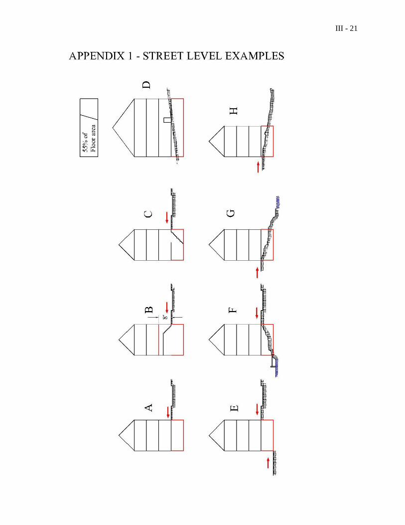
STREET LEVEL: The floor of a building that opens to a pedestrian or vehicular way. When a
floor is not at the level of the pedestrian or vehicular way, then the floor is at street level when it
is less than 8 vertical feet above or below the level of the pedestrian or vehicular way. (Appendix
1, examples A, B, C) Street level also occurs in the following four circumstances:
1) When the grade of the pedestrian or vehicular way slopes along the side of a building, then
street level is the lowest floor that has more than 50% of its floor area above the existing or
finished grade. (Appendix 1, example D)
2) When due to the slope of a site, a building has street level on one side and a lower floor that
opens to a pedestrian or vehicular way on the opposite side, then the building has two street
levels. (Appendix 1, example E)
3) When a building is located in the 100-year floodplain, street level is the lowest floor that is at
least one foot above the 100-year base flood elevation. When due to the slope of the site, a
building also has a street level on the opposite side, as defined above, then the building has
two street levels. (Appendix 1, example F)
4) When a building is not located in a floodplain, or does not open to a pedestrian or vehicular
way, then street level is the lowest floor, excluding the basement that opens directly to the
existing or finished grade. (Appendix 1, examples G, H) (Entire definition revised 6/17/08)
STRUCTURE: Anything built for the support, shelter or enclosure of persons, animals, goods
or property of any kind, together with anything constructed or erected with a fixed location on or
in the ground, or attached to something having a fixed location on or in the ground, excluding
fences, and poles, wiring and other aerial equipment normally associated with service drops as
III - 18
well as guying and guy anchors. The term includes structures temporarily or permanently
located, such as decks, patios and satellite dishes. In areas other than shoreland zones,
driveways, walkways, patios, or other paved surfaces and essential services are not structures. (Amended 11/10/09)
SUSTAINED SLOPE: A sustained slope is the average grade over a horizontal distance of
more than 75 feet. (new – 11/14/06)
TECHNICAL SERVICES: Sales, rental, design, engineering and installation of mechanical,
electrical or electronic equipment and systems, including audio, video, computing or similar
systems.
TEMPORARY STRUCTURE: A structure in place for less than nine months in any 12-month
period. Temporary structures shall be limited by space and bulk standards set forth in the Zoning
Districts.
TEMPORARY STRUCTURE FOR A FUNCTIONALLY WATER-DEPENDENT USE: A
structure in place for less than nine months in any 12-month period for the purpose of marine
boat repair or construction, or for any other use functionally dependent upon harbor, bay, or
shoreline activities. A temporary structure for functionally water-dependent uses shall be subject
to the particular height and ground coverage requirements in Article VIII, Section 12(E)(2).
THEATER: A facility devoted to showing motion pictures, or for dramatic, musical, or other
live performances. (Amended 06/17/09)
TIMBER HARVESTING: The cutting and removal of timber for the primary purpose of
selling or processing forest products. The cutting or removal of trees in the shoreland zone on a
lot that has less than two (2) acres within the shoreland zone shall not be considered timber
harvesting. Such cutting or removal of trees shall be regulated in Article X, Part I, Section 1(14)
Clearing or Removal of Vegetation for Activities Other Than Timber Harvesting. As used in this
Ordinance, timber harvesting is distinct from clear cutting, which is separately defined. (Amended
11/10/09)
TOWN DIRECTIONAL SIGNAGE: A coordinated system of municipal signage to direct
vehicular and pedestrian traffic to public facilities and to shopping and recreational districts
within the Town of Camden. (Added 06/17/09)
TRADESMAN SHOP: The shop of an artist, craftsperson or person in a skilled trade, which
may include retailing of items produced on the premises. (Amended 06/17/09)
TRIBUTARY STREAM: A channel between defined banks created by the action of surface
water, whether intermittent or perennial, and which is characterized by the lack of terrestrial
vegetation or by the presence of a bed, devoid of topsoil, containing waterborne deposits or
exposed soil, parent material or bedrock; and which is connected hydraulically with other water
bodies. This definition does not include rills or gullies forming because of accelerated erosion in
disturbed soils where the natural vegetation cover has been removed by human activity. This
definition does not include the term “stream” as defined elsewhere in this Ordinance, and only
III - 19
applies to that portion of the tributary stream located within the shoreland zone of the receiving
water body or wetland. (New - 11/9/04) (Amended 11/10/09)
TWO FAMILY DWELLING: See DWELLING, TWO FAMILY (New – 11/15/05)
UNIFORM SETBACK RELATIONSHIP: See ESTABLISHED UNIFORM SETBACK
RELATIONSHIP (New – 11/15/05)
UPLAND EDGE OF A WETLAND: The boundary between upland and wetland. For
purposes of a coastal wetland, this boundary is the line formed by the landward limits of the salt
tolerant vegetation and/or the maximum spring tide level, including all areas affected by tidal
action. For purposes of a freshwater wetland, the upland edge is formed where the soils are not
saturated for a duration sufficient to support wetland vegetation; or where the soils support the
growth of wetland vegetation, but such vegetation dominated by woody stems that are six (6)
meters (approximately twenty (20) foot) tall or taller. (Amended 11/10/09)
VARIANCE: A grant of permission by the Zoning Board of Appeals to exceed the space and
bulk standards or performance standards of this Ordinance. Any such grant shall strictly comply
with the standards and procedures of Article VII of this Ordinance. A variance is not authorized
for establishment or expansion of a use otherwise prohibited.
VEGETATION: All live trees, shrubs, and other plants including without limitation, trees both
over and under 4 inches in diameter, measured at 4-½ feet above ground level. (Added 11/10/09)
VOLUME: The amount of space enclosed by roof and fixed, solid, exterior walls as measured
from the exterior faces of the walls and roof. A basement shall be considered volume if it has a
concrete floor and at least seven (7) feet of head room.
WATER BODY: Any great pond, river or stream. (Added 11/10/09)
WETLAND, FORESTED: A freshwater wetland dominated by woody vegetation that is six (6)
meters tall (approximately twenty (20) feet) or taller. (Added 11/10/09)
WETLAND, INLAND OR FRESHWATER: (Amended 11/10/09) Freshwater swamps, marshes,
bogs and similar areas, other than forested wetlands, that are:
1. of 10 or more contiguous acres; or of less than 10 contiguous acres and adjacent to a
surface water body, excluding any river, stream or brook, such that in a natural state, the
combined surface area is in excess of 10 acres; and
2. inundated or saturated by surface saturated by surface or groundwater at a frequency and
for a duration sufficient to support, and that under normal circumstances does support, a
prevalence of wetland vegetation typically adapted for life in saturated soil conditions.
Wetlands usually include swamps, marshes, bogs, and similar areas.
III - 20
Freshwater wetlands may contain small stream channels or inclusions of land that do not
conform to the criteria of this definition.
WHARF: A platform-type structure connected to the shoreline and built parallel therefrom over
the water, supported by piling or cribbing, used for the berthing, loading and unloading of
vessels. (New - 6/20/06)
WHOLESALE TRADE: The sale of goods in quantity, as to retailers for resale. (New – 11/15/05)
WIRELESS TELECOMMUNICATIONS FACILITY: Any structure, antenna, tower, or
other device which provides radio/television transmissions, commercial mobile wireless services,
unlicensed wireless services, cellular phone services, specialized mobile radio communications
(MR), common carrier wireless exchange phone services, and personal communications service
(PAS) or pager services.
YARD (OR GARAGE) SALE: A sale of used household goods, curios, and the like. Yard (or
garage) sales, as distinguished from flea markets, shall be considered to be accessory uses under
this Ordinance and shall not be conducted more frequently than four days in any six-month
period.
III - 21

III - 22
This page intentionally left blank
IV - 1
Article IV Establishment of Districts
Section 1. Zoning Map
A map entitled "Town of Camden Zoning Map" is hereby adopted as part of the Ordinance and
shall be referred to as the Official Zoning Map. The Official Zoning Map (including all overlay
maps referred to in this Ordinance) shall be identified by the signature of the Chairman of the
Board of Selectmen and attested by the signature of the Town Clerk. The Official Zoning Map
shall be located in the office of the Town Code Enforcement Officer, and it shall be the final
authority as to the current zoning status of the land and water areas, building, and other structures
in the Town.
Section 2. Zoning Districts
The Town is divided into the following districts, as shown by the district boundary lines on the
Official Zoning Map:
Natural Resource Protection (RP) District
Rural 1 (RU-1) District
Rural 2 (RU-2) District
Rural Recreation (RR) District
Village Extension (VE) District
Traditional Village (V) District
Coastal Residential (CR) District
Downtown Business (B-1) District
Highway Business (B-2) District
Business Transition (B-3) District
Neighborhood Service (B-4) District
Harbor Business (B-H) District
Transitional Harbor Business (B-TH) District (added 11/11/08)
River Business (B-R) District
Transitional River Business (B-TR) District
Industrial (I) District
IV - 2
In addition, there are established three overlay areas, which, in addition to the standards of the
zoning districts they overlay, are governed by performance standards set forth in Article X, Part
1. The overlay areas address shoreland areas, high elevation areas, and historic areas.
Section 3. District Boundaries
(1) Uncertainty of boundaries
Where uncertainty exists with respect to the boundaries of the various districts as shown on the
Zoning Map, the following rules shall apply:
(a) Boundaries indicated as approximately following the center lines of streets,
highways, or alleys shall be construed to follow such center lines;
(b) Boundaries indicated as approximately following well established lot lines shall
be construed as following such lot lines;
(c) Boundaries indicated as approximately following municipal limits shall be
construed as following municipal limits;
(d) Boundaries indicated as following shorelines shall be construed to follow the
normal high water line, and in the event of natural change in the shoreline shall be
construed as moving with the actual shoreline; boundaries indicated as
approximately following the center line of streams, rivers, canals, lakes, or other
bodies of water shall be construed to follow such center line;
(e) Boundaries indicated as being parallel to or extensions of features indicated in
paragraphs (a) through (d) above shall be so construed. Distances not specifically
indicated on the Official Zoning Map shall be determined by the scale of the map.
Any conflict between the zoning map and description of metes and bounds in a
deed shall be resolved in favor of the description by metes and bounds.
(f) Where physical or cultural features existing in the ground are at variance with
those shown on the Official Zoning Map or in circumstances where the items
covered by paragraphs (a) through (e) above are not clear, the Zoning Board of
Appeals shall interpret the district boundaries.
(2) Division of lots by district boundaries
Where a zoning district boundary line divides a lot or parcel of land of the same ownership of
record at the time such line is established by adoption or amendment of this Ordinance, the
regulations applicable to the less restricted portion of the lot may be extended into the more
restricted portion of the lot, but not more than 50 feet; provided, however, that minimum side
yard and back yard requirements and buffering requirements for nonresidential or multifamily
use abutting a residential use shall be observed.
V - 1
Article V Administration and Enforcement
Section 1. Administrative Official
The Code Enforcement Officer shall enforce this Ordinance, for which purpose he shall
establish reasonable procedures. He shall have all of the duties, responsibilities and powers set
forth in state statute or local ordinance, including but not limited to the power to issue "stop
work" orders, notices of violation of the Ordinance and orders to cease violations, or similar
notices in the execution of his duties and the authority to revoke building permits as a result of
violations of the Zoning Ordinance and/or MUBEC. by the permittee, noncompliance with the
building permit, or other sufficient cause under the Zoning Ordinance and/or MUBEC. He shall
keep all activities within the jurisdiction of this Ordinance under surveillance. He shall examine
all applications for permits or other actions under this Ordinance and within sixty (60) days from
the receipt of such application grant building and/or use permits to those applications acceptable
according to the terms of this Ordinance, or issue a denial in writing with reasons therefore to
those applications which are violations of this Ordinance or do not otherwise conform to the
terms of this Ordinance. The Code Enforcement Officer shall cause to be posted in the Town
Office and on the Town web site a monthly report of building permits within 15 days of the end
of the month. The Code Enforcement Officer shall keep records of his proceedings and such
records shall be made public. He shall institute or cause to be instituted in the name of the Town
any actions that might be appropriate for the enforcement of this Ordinance and for prosecutions
of violations of this Ordinance. He shall report to the Town Manager any changes that might be
needed in the Ordinance and prepare a file for review by the Selectmen and Planning Board for
future action. He shall follow up all building and/or use permits to ascertain compliance with any
conditions or restrictions imposed on the permittee by the Code Enforcement Officer, Planning
Board, or the Zoning Board of Appeals. (Amended 6/12/12)
The action of the Code Enforcement Officer in issuing a "stop work" order, notices of
violations, or similar notices, and the action of the Code Enforcement Officer in revoking
building permits, shall be appealable to the Zoning Board of Appeals by an aggrieved person or
party within fifteen (15) days after the date of receipt of notice of such action by the aggrieved
person or party. All other appeals to the Code Enforcement Officer shall conform with the time
periods set forth in Article V, Section 5 of this Zoning Ordinance. Upon appointment by the
Board of Selectmen, the Alternate Code Enforcement Officer shall have all the duties,
responsibilities and authority of the Code Enforcement Officer.
Section 2. Permits Required
None of the following actions shall be taken until the Code Enforcement Officer has
issued a building and/or use permit certifying that the plans of an intended use of the land or
building are in conformity with this Ordinance. No permit shall be issued for a project that
includes a new driveway, until a driveway/access permit has been issued by the Road
Commissioner and/or the Maine Department of Transportation. Said permit shall be posted on
site in a manner that is visible from a public way within seven working days of issuance. In
V - 2
addition to the actions identified below, this Ordinance applies to any other actions, which do not
require a building or use permit. (Second sentence added - 6/20/06)
(1) Construction, enlargement, alteration, demolition, or moving of any building or structure,
including temporary structures, when the fair and reasonable value of such labor and
materials used exceeds $2,000.00 cumulatively within a 12-month period or work
requiring a permit per section 105 and R105 of MUBEC. Although no permit is required,
if the fair and reasonable value of said labor and materials used is equal to or less than
$2,000.00 cumulatively within a 12-month period or is exempt per section 105 and R105
of MUBEC., said construction, enlargement, alteration, demolition, or moving of any
building or structure must still comply with all the provisions of this Ordinance. (Amended
06/12/12)
(2) New use, including a new commercial use or a change of majority ownership or a
modification that is subject to an ordinance requirement or review criteria for that
commercial use. (Amended 6/15/10)
(3) Change of exterior dimensions and/or illumination of an existing sign.
(4) Extraction of mineral resources.
(5) Excavation or filling of land causing the removal or filling of earth in volumes exceeding
one hundred (100) cubic yards in a period of one (1) year.
(6) The provision, whether by fee simple ownership, lease, or other agreement, of off-street
parking spaces located on a different lot other than the principal building or use in order
to comply with the off-street parking requirements of this Ordinance.
Permits issued under (2) and (6) above are exempt from the posting requirement.
Section 3. Exclusions from Permitting
The following activities are excluded from permitting: Any activities exempted under the
MUBEC.; painting; and landscaping activities not part of projects or developments
requiring site plan review. (Amended 06/12/12)
Section 4. Certificate of Occupancy (Amended 06/12/12)
(1) This Section shall apply to all activities requiring a building permit, including alterations
and renovations to single family and two-family dwellings. This section does not apply to
work exempt from permitting under the MUBEC. and accessory buildings and structures
not for human occupancy. (Amended 06/12/12)
(2) Except as provided in paragraph (1) of this Section, it shall be unlawful to use or occupy
or permit the use or occupancy of any land, building, structure or part thereof which is
created, erected, moved, changed, converted, altered or enlarged, or to change, alter or
V - 3
enlarge the use of any land, building, or structure for which a building permit is required
until a Certificate of Occupancy is issued therefore by the Code Enforcement Officer and
endorsed to the effect that the proposed use of the land, building, or structure conforms
with the requirements of this Ordinance and with applicable state statutes governing
plumbing permits and electrical permits. (Amended 06/12/12)
(3) An applicant shall apply for a Certificate of Occupancy at the same time as applying for a
building permit. After completion of the work permitted by the building permit, the
applicant shall notify the Code Enforcement Officer, who shall issue or deny the
Certificate of Occupancy within fifteen days. The Code Enforcement Officer's failure to
act within fifteen days shall constitute denial of the Certificate of Occupancy. The Code
Enforcement Officer shall issue the Certificate of Occupancy only upon finding that the
building, structure, or site and the use or occupancy thereof comply with the provisions of
this Ordinance and of any building permit issued, and of any site plan or subdivision plan
approved by the Planning Board or Zoning Board of Appeals. The Code Enforcement
Officer shall maintain a public record of all Certificates of Occupancy which are issued. (Amended 06/12/12)
(4) One conditional Certificate of Occupancy, valid for no more than six (6) months from the
date of issuance may be granted by the Code Enforcement Officer based on a showing of
reasonable need by the applicant. Once the project is completed, the CEO shall issue a
Certificate of Occupancy. (Amended 06/12/12)
Section 5. Fee and Time Limits
(1) Application shall be in writing on forms provided by the Code Enforcement Officer and
account for all aspects to which this Ordinance applies. Building permits are valid for six
(6) months for the beginning of construction or use and for two (2) years for the
completion of construction, including finish grading, landscaping, proper backfill, proper
drainage, and all other things to cause the construction, renovation, or change to look
presentable. An extension of time for six months to commence or to complete may be
granted upon application to and approval by the Code Enforcement Officer, upon a
showing by the applicant of reasonable need, unless the zoning ordinance requirements
had been changed after the issuance and receipt of the original permit, in which case the
request for extension may be granted only upon application to and approval by the
Zoning Board of Appeals. A fee schedule for building or use permits shall be established
by the Selectmen annually and the Selectmen shall annually establish a fee for
applications for building and/or use permits that are filed by the applicant after the
commencement of the activity for which the permit is required, such fee to be greater
than the fee for an application that was filed in a timely manner.
(2) Administrative appeals to the Zoning Board of Appeals from an action of the Code
Enforcement Officer in issuing or denying building permits or Certificates of Occupancy
shall be made within sixty (60) days of the date of such action or non-action by the Code
Enforcement Officer. Failure of the Code Enforcement Officer to act upon a request for
V - 4
action, except for an application for a Certificate of Occupancy, or upon an application
for a building permit and/or use permit within sixty (60) days of the date of receipt of
such application by the Code Enforcement Officer shall constitute denial of that request
or application. The Zoning Board of Appeals shall have no authority to decide an appeal
or to accept any appeal which has not been made within such sixty-day (60-day) period. (Amended 06/12/12)
Section 6. Penalties
The monetary penalties for violations of this Ordinance shall be as follows:
(1) The minimum penalty for starting construction or undertaking land use activity without a
required permit shall be $100, and the maximum penalty shall be $2,500 per day.
(2) If a required permit is not displayed within seven (7) days of issuance, it shall become
null and void, and fees are not refundable.
(3) The minimum penalty for any other specific violation shall be $100 and the maximum
penalty shall be $2,500 per day.
In all other respects, assessments of penalties under this Ordinance shall be in accordance
with Title 30-A, Maine Revised Statutes Annotated, Section 4452. Assessment of penalties shall
commence 48 hours after the date of a certified mailing of a notice of violation signed by the
Code Enforcement Officer to the person or party in violation of this Ordinance. Such notice
shall be mailed with return receipt requested to the last known address of the person or party in
violation of this Ordinance. Return of the receipt indicating that the notice was undeliverable as
addressed or otherwise not delivered to the person or party in question shall not in any respect
invalidate enforcement of this Ordinance or any penalties for violations thereof. In addition to
penalties provided herein, the Town may bring an action in the Superior Court or District Court
to enjoin violations of this Ordinance, for collection of penalties, and for such other relief as by
law may be provided.
Section 7. Legal actions, consent agreements and consent orders
When the actions of the Code Enforcement Officer do not result in the correction or abatement of
violations of this Ordinance, the municipal officers (the Select Board), upon notice from the
Code Enforcement Officer, are hereby authorized to institute any and all actions or proceedings,
either legal or equitable, including seeking injunctions concerning violations and the imposition
of fines and penalties pursuant to Title 30-A, Maine Revised Statutes Annotated, §4452, seeking
the relief and monetary penalties set forth in that statute, that may be appropriate or necessary to
enforce the provisions of this Ordinance in the name of the municipality.
The municipal officers, or their authorized agent, are hereby authorized to enter into
administrative consent agreements for the purpose of eliminating violations of this Ordinance
and recovering fines without Court action. Such agreements shall not allow an illegal structure
or use to continue unless the municipal officers are satisfied by the party requesting a consent
agreement , that the following conditions have been met.
V - 5
1. there is no evidence that the landowner or the violator of the Ordinance acted in bad faith;
2. there are no prior violations by the landowner or the violator;
3. the violation did not continue following a municipal order to stop the violation; and
4. the illegal structure or use will not result in a threat or hazard to public health and safety
and will not result in substantial environmental damage.
5. The illegal structure or use does not have a significant adverse effect on the value or
possession of adjoining properties.
The municipal officers shall give notice to all landowners with land abutting a lot for which a
structure or use involves a consent agreement of the Select Board meeting at which the Select
Board considers the request for a consent agreement.
In addition to the authority to seek an administrative consent agreement as set forth above, the
municipal officers are also authorized to enter into administrative consent orders subject to
approval of the Court. The municipal officers shall have the authority to enter into an
administrative consent order on such terms and conditions as the municipal officers deem proper.
Upon enactment, this amendment to the Zoning Ordinance shall be effective immediately.
Upon enactment, this amendment shall also amend the appropriate provisions in Chapter XII of
the Camden Code. (New Section 7 – 6/17/03)

V - 6
This page intentionally left blank
VI - 1
Article VI Nonconformance
Section 1. Purpose
The purpose of this Article is to regulate nonconforming lots, uses, and structures as
defined in this Ordinance such that they can be reasonably developed, maintained or repaired, or
changed to other less nonconforming or to conforming lots, uses, or structures. Definitions of
nonconforming lot, nonconforming structure, nonconforming use, and ownership may be found
in Article III of this Ordinance.
Section 2. Nonconforming Lots (Amended 11/10/09)
(1) Contiguous or Partially Built
(a) If two or more vacant, contiguous lots or parcels, or one or more vacant lots or
parcels contiguous with a lot that has a principal use, are in single or joint
ownership of record, as defined in Article III of this Ordinance, at the time of or
since adoption or amendment of this Ordinance, and if any of these lots do not
individually meet the dimensional requirements of this Ordinance or subsequent
amendments, the lots shall be combined to the extent necessary to meet the
dimensional standards, except:
(i) where the contiguous lots front onto different streets; or
(ii) if the lots were legally and separately created and an approved subdivision
plan of those lots was recorded in the Knox County Registry of Deeds after
September 22, 1971.
This provision shall not apply to 2 or more contiguous lots, at least one of which
is nonconforming, owned by the same person or persons and recorded in the
registry of deeds if the lot was created prior to June 12, 1990 and is served by a
public sewer or can accommodate a subsurface sewage disposal system in
conformance with the State of Maine Subsurface Wastewater Disposal Rules; and (amended 6/15/10)
(iii) each lot contains at least 100 feet of shore frontage and at least 20,000 square
feet of lot area; and
(iv) any lots that do not meet the frontage and lot size requirements of Section
2(1)(a) are reconfigured or recombined so that each new lot contains at least
100 feet of shore frontage and 20,000 square feet of lot area.
(b) A nonconforming lot of record as of the effective date of this Ordinance or
amendment thereto may be built upon provided that such lot is in separate
ownership and not contiguous with any other lot in the same ownership, and that
VI - 2
all provisions of this Ordinance except lot area and frontage can be met. Variance
of other requirements shall be obtained only by action of the Zoning Board of
Appeals.
(c) Any nonconforming lot may be modified as long as it does not create a condition
which leaves the lot's frontage or area below the minimum requirements of this
Ordinance, or so long as the modification does not worsen an existing legally
nonconforming situation.
(2) Lots with Structures
(a) A structure built on a lot prior to enactment of this Ordinance, which lot does not
conform to lot size or lot frontage, may be repaired, maintained or improved, and
may be modified in conformity with Section 4 of this Article. If the proposed
modification of the structure(s) cannot meet the applicable space and bulk
requirements, a variance shall be required from the Zoning Board of Appeals.
(b) If two or more contiguous lots or parcels have the same ownership at the time of
adoption or amendment of this Ordinance, if all or part of the lots do not meet the
applicable space and bulk requirements, and if a principal use exists on each lot,
or if the lots were legally, separately created and an approved subdivision plan for
those lots was recorded in the Knox County Registry of Deeds after September
22, 1971, the nonconforming lots may be conveyed separately or together,
providing all other State law, including the State Minimum Lot Size Law (12
MRSA sections 4807-A through 4807-D) and the State of Maine Subsurface
Wastewater Disposal Rules, and local Ordinance requirements are complied with.
If two or more principal uses or structures existed on a single lot of record on the
effective date of this ordinance, each may be sold on a separate lot provided that
the above referenced law and rules are complied with. When such lots are
divided each lot thus created must be as conforming as possible to the
dimensional requirements of this Ordinance, as determined by the Zoning Board
of Appeals. (Amended – 11/2/10)
(c) An inn located on a lot that is less than two acres in the Traditional Village
District, shall not add sleeping rooms offered for rent beyond those legally
existing as of the date of enactment of this ordinance, nor shall it be used more
intensely with respect to functions, services, or similar activities otherwise
allowed in inns beyond those being routinely and legally offered as of the date of
enactment of this ordinance. (Amended – 11/15/05)
(d) The residential use of a dwelling unit that is discontinued for a period of 24
consecutive months, may not be resumed on a lot that is nonconforming, because
the lot does not meet the lot area per dwelling unit requirement for the District in
which it is located.
VI - 3
Section 3. Nonconforming Uses
(1) Continuance
(a) The use of land, building or structure, lawful at the time of adoption of this
Ordinance, or of subsequent amendments of this Ordinance, may continue
although such use does not conform to the provisions of this Ordinance, except as
provided in paragraph 2, Discontinuance, below.
(2) Discontinuance
(a) A nonconforming use which is discontinued for a period of 24 consecutive months
may not be resumed. The uses of the land, building or structure shall thereafter
conform to the provisions of this Ordinance, except for legally existing space and
bulk nonconformities, which may continue. (Amended – 11/15/05)
(b) In the shoreland zone, a nonconforming use which is discontinued for a period of 12
consecutive months may not be resumed, except that the Zoning Board of Appeals,
for good cause shown by the applicant, may grant up to a one year extension to that
time period. This provision shall not apply to the resumption of a use of a residential
structure provided that the structure has been used or maintained for residential
purposes during the preceding (5) year period. (Added 11/10/09)
(c) Whenever a nonconforming use is changed to a permitted use, such structure and/or
land shall thereafter conform to the provisions of this Ordinance, and the
nonconforming use may not thereafter be resumed.
(3) Expansion of Use
A nonconforming use, including a nonconforming outdoor use of land, shall not be
extended or expanded in building area or building volume, expanse of area of use, or
hours of operation except as defined below. (Amended 11/6/12)
(a) Within the Shoreland Zone, nonconforming residential uses may be expanded within
existing residential structures or within expansions of such structures as allowed in
Section 4. (Added 11/10/09)
(b) In the RP, RR, B-H, B-R, B-TH, & B-TR districts no expansion of a nonconforming
use is allowed. (Added 11/6/12)
(c) In the RU-1, RU-2, B-3, V, VE, and CR districts which are more residential in
character but contain some commercial uses, existing nonconforming uses not in the
shoreland zone, may be expanded by up to 30% in volume and area of use as existed
on November 4, 1992, following Zoning Board of Appeals determination that there
will be no greater physical or visual adverse impact on the subject and adjacent
properties and resources.
VI - 4
In determining there is no greater adverse impact, the decision is to be based on
adverse impacts such as changes to traffic (volume and type), noise, and dust. The
Zoning Board of Appeals may place additional requirements to the project design to
offset current and possible impacts of the nonconforming use and such requirements
will become part of the approval once accepted by the applicant.
As part of the approval of expansion, no additional non-conformity shall be allowed
to be created on the property and all district standards and applicable Site Plan
Review standards must be met. (Added 11/6/12)
(d) In the B-1, B-2, & B-4, districts which are more commercial in character and contain
more business uses, existing nonconforming uses not in the shoreland zone, may be
expanded by up to the extent allowed by the district regulations following Zoning
Board of Appeals determination that there will be no greater adverse physical or visual
impact on the subject and adjacent properties and resources.
In determining there is no greater adverse impact, the decision is to be based on adverse
impacts such as changes to traffic (volume and type), noise, and dust. The Zoning Board
of Appeals may place additional requirements to the project design to offset current and
possible impacts of the nonconforming use and such requirements will become part of the
approval once accepted by the applicant.
As part of the approval of expansion, no additional non-conformity shall be allowed to be
created on the property and all district standards and applicable Site Plan Review
standards must be met. (Added 11/6/12)
(4) Changes in Nonconforming Uses
Upon approval of the Zoning Board of Appeals, a nonconforming use may be changed
such that it is less nonconforming or no more nonconforming than the lawfully existing
situation. In making its determination that the use is less nonconforming or no more
nonconforming than the lawfully existing situation, the Zoning Board of Appeals shall
apply the standards of Article VII, Section 4(3), Standards for Special Exception Permit.
For structures located within a shoreland setback, the Zoning Board of Appeals shall also
apply the standards of Article VI, Section 6, (5). (New last sentence – 11/15/05)
Section 4. Nonconforming Structures
Maintenance, Modification, Replacement and Reconstruction
(1) Except as set forth in (d) of this section, a structure lawfully in existence as of the
effective date of this amendment, that does not meet the height, yard, or setback
restriction of Article VIII, may be repaired, maintained, improved, or replaced, as set
forth in this section. It may be modified and/or accessory structures may be added to the
site without a variance, provided that:
(a) The resulting structure or structures do not exceed the height restrictions of the
district in which the structure or structures are located.
VI - 5
(b) The resulting structure or structures do not exceed the prescribed maximum
ground coverage and maximum building coverage, or, in the case of an existing
structure which does exceed the prescribed maximum ground coverage or
maximum building coverage, the resulting structure or structures do not exceed
the existing ground coverage and the existing building coverage.
(c) There is no increase in the non-conformity, except that a lawfully non-conforming
structure may be expanded in volume and ground floor area by no more than
thirty percent (30%) of the volume and ground floor area of that portion of the
structure that was lawfully non-conforming as of the date of this amendment of
the Ordinance, and provided that the resulting structure or accessory structure is
no closer to the front, side, or rear lot line with respect to which the non-
conformity exists, unless the resulting structure is allowed to be closer in
accordance with the provisions of Article X, Part 1, Section 1 (9) (j) of this
Ordinance.
(d) No structure which is less than the required setback from the normal high water
line of a water body or the upland edge of a wetland shall be expanded further
toward the water body or wetland than the part of the lawfully existing non-
conforming structure closest to the water body or wetland and such structure shall
further conform with the requirements of Article VI, Section 6, if applicable, and
Article X, Part 1, Section 1 (9) (j) of the Ordinance.
(2) Any nonconforming building or structure which is lawfully in existence as of the
effective date of this Ordinance, and which is hereafter damaged or destroyed by fire,
storm, or any other cause which is beyond the control of the owner of that building or
structure, may be repaired, maintained, improved, or replaced within twenty-four (24)
months of said damage or destruction in conformity with the above requirements in this
section.
Section 5. Transfer of Ownership
Ownership of nonconforming lots, structures, and/or uses as defined in this Ordinance may be
transferred without loss of their lawful but nonconforming status.
Section 6. Changes in Nonconforming Structures in Shoreland Areas
Within shoreland setbacks, a nonconforming structure may be modified under the following
circumstances.
(1) Expansion
A nonconforming structure may be added to or expanded after obtaining a permit from
the Code Enforcement Officer if such addition or expansion does not increase the
nonconformity of the structure and is in accordance with subparagraphs (a) and (b)
below.
VI - 6
(a) After January 1, 1989, if any portion of a structure is less than the required setback
from the normal high-water line of a water body or tributary stream or the upland edge of
a wetland, that portion of the structure shall not be expanded, as measured in floor area or
volume, by 30% or more, during the lifetime of the structure, in accordance with Article
VI, Section 4. For structures existing on January 1, 1989, the permitted expansion shall
be based upon existing floor area and volume for the structure on that date. If a
replacement structure conforms with the requirements of Section 6, (3), and is less than
the required setback from a water body, tributary stream or wetland, the replacement
structure may not be expanded if the original structure existing on January 1, 1989 had
been expanded by 30% in floor area and volume since that date.
(b) Whenever a new, enlarged or replacement foundation is constructed under a non-
conforming structure, then the structure and new foundation must be placed such that the
setback requirement is met to the greatest practical extent as determined by the Zoning
Board of Appeals, basing its decision on the criteria specified in subsection (2)
Relocation, below, however, if the completed foundation does not extend beyond the
exterior dimensions of the structure and the foundation does not cause the structure to be
elevated by more than three (3) additional feet, as measured from the uphill side of the
structure (from original ground level to the bottom of the first floor sill), it shall not be
considered to be an expansion of the structure.
(c) Upon satisfaction of all criteria and applicable Zoning Ordinance requirements, the
CEO shall issue the permit two weeks after mailing notices by first class prepaid U.S.
postage to the last known mailing address of all abutters.
(2) Relocation
(a) A nonconforming structure may be relocated within the boundaries of the parcel on
which the structure is located provided that the site of relocation conforms to all setback
requirements to the greatest practical extent as determined by the Zoning Board of
Appeals, and provided that the applicant demonstrates that the present subsurface sewage
disposal system meets the requirements of State law and the State of Maine Subsurface
Wastewater Disposal Rules, or that a new system can be installed in compliance with the
law and said Rules. In no case shall a structure be relocated in a manner that causes the
structure to be more nonconforming.
(b) In determining whether the building relocation meets the setback to the greatest
practical extent, the Zoning Board of Appeals shall consider the size of the lot, the slope
of the land, the potential for soil erosion, the location of other structures on the property
and on adjacent properties, the location of the septic system and other on-site soils
suitable for septic systems, and the type and amount of vegetation to be removed to
accomplish the relocation. When it is necessary to remove vegetation within the water or
wetland setback area in order to relocate a structure, the Zoning Board of Appeals shall
require replanting of native vegetation to compensate for the destroyed vegetation. In
VI - 7
addition, the area from which the relocated structure was removed must be replanted with
vegetation. Replanting shall be required as follows:
(i) Trees removed in order to relocate a structure must be replanted with at least one
native tree, three (3) feet in height, for every tree removed. If more than five trees
are planted, no one species of tree shall make up more than 50% of the number of
trees planted. Replaced trees must be planted no further from the water or wetland
than the trees that were removed.
Other woody and herbaceous vegetation and ground cover that are removed or
destroyed in order to relocate a structure must be re-established. An area at least
the same size as the area where vegetation and/or ground cover was disturbed,
damaged, or removed must be reestablished within the setback area. The
vegetation and/or ground cover must consist of similar native vegetation and/or
ground cover that was disturbed, destroyed or removed.
(ii) Where feasible, when a structure is relocated on a parcel, the original location of
the structure shall be replanted with vegetation which may consist of grasses,
shrubs, trees or a combination thereof.
(3) Reconstruction or Replacement
Any nonconforming structure which is located less than the required setback from a water body,
tributary stream or wetland and which is removed, or damaged or destroyed, regardless of the
cause, by more than 50% of the market value of the structure before such damage, destruction or
removal, may be reconstructed or replaced provided that a permit is obtained within eighteen
(18) months of the date of said damage, destruction, or removal and provided that such
reconstruction or replacement is in compliance with the water body, tributary stream or wetland
setback requirement to the greatest practical extent as determined by the Zoning Board of
Appeals in accordance with the requirements of subsection 2(b) herein. In no case shall a
structure be reconstructed or replaced so as to increase its nonconformity. If the reconstructed or
replacement structure is less than the required setback it shall not be any larger than the original
structure, except as allowed pursuant to Section 6, (1) above, as determined by the non-
conforming floor area and volume of the reconstructed or replaced structure at its new location.
If the total amount of floor area and volume of the original structure can be relocated or
reconstructed beyond the required setback area, no portion of the relocated or reconstructed
structure shall be replaced or constructed at less than the setback requirement for a new structure.
When it is necessary to remove vegetation in order to replace or reconstruct a structure,
vegetation shall be replanted in accordance with Section 6, (2) above.
Any nonconforming structure which is located less than the required setback from a water body,
tributary stream or wetland and which is removed by 50% or less of the market value or
damaged or destroyed by 50% or less of the market value of the structure, excluding normal
maintenance and repair, may be reconstructed in place if a permit is obtained from the code
enforcement officer, within one year of such damage, destruction or removal.
VI - 8
In determining whether the building reconstruction or replacement meets the setback to the
greatest practical extent, the Zoning Board of Appeals shall consider, in addition to the criteria in
paragraph 2 above, the physical condition and type of foundation present, if any.
(4) Changes After Approval
The Code Enforcement Officer may approve minor field changes after approvals are granted by
the Zoning Board of Appeals under this section, provided the change does not expand the
footprint.
(5) Change of Use of a Nonconforming Structure
In addition to the requirements of Article VI, Section 3, (4) the use of a nonconforming structure
may not be changed to another use unless the Zoning Board of Appeals, after receiving a written
application, determines that the new use will have no greater adverse impact on the water body,
tributary stream, or wetland, or on the subject or adjacent properties and resources than the
existing use.
In determining that no greater adverse impact will occur, the Zoning Board of Appeals shall
require written documentation from the applicant, regarding the probable effects on public health
and safety, erosion and sedimentation, water quality, fish and wildlife habitat, vegetative cover,
visual and actual points of public access to waters, natural beauty, flood plain management,
archaeological and historic resources, and commercial fishing and maritime activities, and other
functionally water dependent uses. (Entire section amended 6/20/06)
Section 7. Nonconforming Ground Coverage
Development consisting of structures, parking lots and other non-vegetated surfaces,
which has a nonconforming ground coverage of development may be repaired, maintained,
improved, and buildings and/or accessory structures added to the site and enlarged, without a
variance for ground coverage, and the location of parking lots and other non-vegetated surfaces
within the site may be relocated to other areas within the site or reconfigured, subject to the
condition that the total area of all such structures, parking lots and other non-vegetated surfaces
does not exceed the total area of the nonconforming ground coverage which was in lawful
existence at the time that this Ordinance or subsequent amendment took effect.
Section 8. Unlawful Uses, Structures, or Lots
No provision of this Article VI shall be construed to cause an unlawful use, structure, or
lot which exists unlawfully as of the date of enactment of this Ordinance to be considered lawful
or allowable under the provisions of this Ordinance.
VII - 1
Article VII Zoning Board of Appeals
Section 1. Appointment and Composition
(1) There shall be a Zoning Board of Appeals in accordance with the provisions of 30-A
M.R.S.A. Section 4353, as the same may be amended from time to time.
(2) The Board shall consist of five members serving staggered terms of three years,
appointed by the Board of Selectmen. The Board of Selectmen may also appoint three
(3) alternate members to serve in the absence of regular members. Any alternate
members appointed to the Zoning Board of Appeals shall serve one-year terms. During
the absence of a regular member at any meeting, the Chairman of the Zoning Board of
Appeals shall designate the alternate member who shall serve during the absence of the
absent regular member.
(3) Once a member of the Zoning Board of Appeals has been sworn into office, he or she
shall continue in that office for the remainder of his or her term without having to renew
said oath of office annually.
Section 2. Procedures
(1) The Zoning Board of Appeals shall conduct its meetings in accordance with the
provisions of 30-A M.R.S.A. Section 4353, as the same may be amended from time to
time.
(2) The presence of three voting members of the Zoning Board of Appeals shall constitute a
quorum.
(3) An appeal or any application for action by the Zoning Board of Appeals shall be granted
or a decision of the Code Enforcement Officer can be overruled only upon an affirmative
vote of at least three members of the Zoning Board of Appeals on each finding of fact
and the final disposition. (Amended – 11/15/05)
(4) Before rendering a decision on any appeal, the Zoning Board of Appeals shall conduct a
public hearing, which shall be advertised ten days in advance in a local newspaper and
posted in other places usually used for public notices, at the expense of the appellant.
(5) The Zoning Board of Appeals shall not continue hearings to a future date except for good
cause.
(6) Written notice of the decision of the Board shall be sent to the applicant and the Code
Enforcement Officer within seven days of its decision.
VII - 2
(7) An appeal may be taken from any decision of the Zoning Board of Appeals to the
Superior Court within 45 days after the decision, as provided by 30-A M.R.S.A., Section
4353, as the same may be amended from time to time.
(8) The Zoning Board of Appeals shall keep records of its proceedings and such records shall
be public.
Section 3. Powers and Duties
The Zoning Board of Appeals shall have the following powers and duties:
(1) Administrative Appeals
To affirm, modify or set aside the action of the Code Enforcement Officer in issuing or denying
building or use permits, sign permits, or Certificates of Occupancy when it is alleged that
the action is based on an erroneous interpretation of this Ordinance. (Amended 06/12/12)
(2) Special Exception Permits
To approve, approve with conditions, or disapprove applications for special exception
permits, according to the terms of Section 4 of this Article.
(3) Variances
To approve, approve with conditions, or disapprove variances from the strict enforcement
of the provisions of this Ordinance only as they relate to the space and bulk standards of
the district regulations or a performance standard contained in Article X, according to the
terms of Section 5 of this Article.
(4) Changes in Nonconforming Uses; or Lots, Structures, and Uses in Shoreland Areas
To approve, approve with conditions, or disapprove requests to:
(a) change a nonconforming use such that it is less nonconforming or no more
nonconforming than the lawfully existing situation, as authorized in Article VI,
Section 3;
(b) divide a single lot of record that has two or more principal uses or structures, as
authorized in Article VI, Section 2, (2), (b);
(c) relocate a nonconforming structure that is located within the shoreland setback area,
as authorized in Article VI, Section 6, (2);
(d) reconstruct or replace a nonconforming structure located within the shoreland setback
area, as authorized in Article VI, Section 6, (3)
(5) Standards of Home Occupation
To approve, approve with conditions, or disapprove requests to exceed the specific
standards concerning home occupations concerning the number of employees, traffic
VII - 3
generated, and percentage of floor area set forth in Article X, Part II, Section 7 of the
Zoning Ordinance, in accordance with the Standards of Article VII, Section 6 of this
Zoning Ordinance.
(6) Off-Street Parking
To grant waivers of the off-street parking requirements in the Downtown, River Business,
Transitional River Business, and Harbor Business Districts in accordance with Article X,
Part II, Section 4(2)(c)(4)(iii) and Article X, Part II, Section 2(c)(5).
(7) Stop Work Orders, Revocation of Permits, and Other Similar Notices
To affirm, modify or set aside the action of the Code Enforcement Officer in issuing
"stop work" orders, revocation of permits, notices of violations of this Ordinance, and
other similar actions, when it is alleged that such action is based upon an error of the
Code Enforcement Officer, in concluding that there has been a violation of the Zoning
Ordinance by any person, noncompliance with building permits or other sufficient cause
under the Zoning Ordinance.
(8) To decide an appeal of a site plan decision of the Planning Board concerning errors of
law, according to the terms of Article XII, Section 2(8).
(9) To decide an appeal of a decision of the Code Enforcement Officer or the Planning
Board, as an administrative appeal, from a decision pursuant to the Wireless
Telecommunications Facility Siting Ordinance, when it is alleged that the decision is
based on an erroneous interpretation of that Ordinance. The review of the Zoning Board
of Appeals shall be based exclusively on the record before the Planning Board. An
appeal of a decision of the Code Enforcement Officer shall be de novo (requiring an
evidentiary hearing).
Section 4. Special Exception Permits
(1) Purpose and Applicability
The purpose of this Section is to enable the Zoning Board of Appeals to review certain
proposed uses of the land that have the potential of creating unusual or undue impacts on
surrounding properties, municipal facilities, or the natural environment. A building,
structure, or parcel of land may be used for a special exception use if the use is
specifically listed in the regulations governing the zoning district in which the use is
proposed, and if a special exception permit is approved by the Zoning Board of Appeals.
(2) Application for Special Exception Permit
Application for a special exception permit shall be made to the Code Enforcement
Officer on forms provided for the purposes accompanied by such fee as the Board of
Selectmen shall set on an annual basis for such applications. The applicant shall:
VII - 4
(a) Clearly specify the location of the proposed use, including street address,
Assessor's tax map and lot number, and a location map.
(b) Describe the exact nature of the proposed use.
(c) Submit such other materials as will enable the Zoning Board of Appeals to
determine that the standards for approval of a special exception permit have been
met. The burden of providing the information upon which the Board bases its
findings and of proving conformity with the standards shall be the applicant's.
(3) Standards for a Special Exception Permit
A special exception may be granted by the Zoning Board of Appeals only in the event
that the applicant has established to the satisfaction of the Board that:
(a) Neither the proposed use nor the proposed site upon which the use will be located
is of such a character that the use will have significant adverse impact upon the
value or quiet possession of surrounding properties greater than would normally
occur from such a use in the zoning district. In reaching a determination on this
standard, the Board shall consider:
(i) the size of the proposed use compared with surrounding uses;
(ii) the intensity of the proposed use, including amount and type of traffic to
be generated, hours of operation, expanse of pavement, and similar
measures of intensity of use, compared with surrounding uses;
(iii) the potential generation of noise, dust, odor, vibration, glare, smoke, litter,
and other nuisances;
(iv) unusual physical characteristics of the site, including size of the lot, shape
of the lot, topography, and soils, which tend to aggravate adverse impacts
upon surrounding properties; and
(v) the degree to which landscaping, fencing, and other design elements have
been incorporated to mitigate impacts on surrounding properties.
(b) Municipal facilities serving the proposed use will not be overburdened. In
reaching a determination on this standard the Board shall consider:
(i) the ability of traffic to safely move into and out of the site at the proposed
location;
(ii) the presence of facilities to assure the safety of pedestrians passing by the
site;
VII - 5
(iii) the capacity of the street network to accommodate the proposed use;
(iv) the capacity of public sewerage and water facilities, if they are to be used,
to accommodate the proposed use; and
(v) the capacity of the public storm drainage system, if it is to be used, to
accommodate the proposed use.
(c) The natural characteristics of the site, including topography, drainage, and
relationship to ground and surface waters and flood plains, shall not be such that
the proposed use when placed on the site will cause undue harm to the
environment or to neighboring properties.
(d) Undisclosed Future Uses:
In an application for a special exception requiring renovation or enlargement of an
existing building or new construction, the applicant shall not be required to name
specifically all the uses on the lot if they are not known at the time of renovation,
enlargement or new construction. Instead, the applicant shall state on his
application all the specific uses that are anticipated for the lot. For the area on the
lot for which the use is not then known, the applicant shall designate those areas
as "undisclosed future uses". The applicant must designate on the application at
least one known special exception use. The Zoning Board of Appeals may grant
special exceptions for the known specific uses and the project may proceed to site
review, if required, and a building permit may be issued after site plan review,
with the condition that any required special exceptions for the undisclosed future
uses will be obtained when the uses are determined. The lot shall not be used for
the undisclosed future uses which require a special exception until the required
special exception is obtained.
(e) In considering the foregoing standards the Zoning Board of Appeals shall fully
review these standards even though the applicant may also be subject to site plan
approval.
(4) Additional Standards in Shoreland Areas
For special exception permit applications in shoreland areas, the Board shall additionally
find that the proposed use:
(a) will not result in unreasonable damage to spawning grounds, fish, aquatic life,
bird and other wildlife habitat;
(b) will reasonably conserve shoreland vegetation;
VII - 6
(c) will reasonably conserve visual points of access to waters as viewed from public
facilities;
(d) will reasonably conserve actual points of public access to waters;
(e) will reasonably conserve natural beauty;
(f) will reasonably avoid problems associated with flood plain development or use;
(g) Access from shore shall be developed on soils appropriate for such use and
constructed so as to reasonably control erosion or sedimentation on both subject
and surrounding properties.
(h) The use shall not unreasonably interfere with beach areas.
(i) The facility shall be located so as to minimize adverse effect on marine harvesting
and commercial fishing.
(j) The facility shall be located so as not to interfere with commercial or recreational
boating and moorings.
(5) Conditions of Approval
The Board may attach conditions to its approval of a special exception permit. These
conditions may include, but are not limited to, such requirements as:
(a) street improvements;
(b) access restrictions;
(c) hours of use;
(d) buffering and screening;
(e) utility improvements;
(f) performance guarantees for off-site improvements required as conditions of
approval.
(6) Reapplication
If the Zoning Board of Appeals shall deny a special exception permit, a second request of
a similar nature shall not be brought before the Board within two years from the date of
the first request, unless in the opinion of the majority of the Board, substantial new
evidence can be brought forward, or unless the Board finds that an error of law or
misunderstanding of facts has been made, or unless amendment to the zoning ordinance
VII - 7
has changed the status, circumstances, or conditions of the matter which was brought
before the Board.
(7) Duration of Special Exception Permit
(a) Provided all conditions and standards of approval are met, a special exception
permit shall be a permanent grant of permission and shall "run with the land."
(b) A use granted by special exception may be expanded in area or function only with
the granting of a new special exception by the Zoning Board of Appeals.
(8) Scope of Permit
Any permit or approval granted hereunder is subject to all elements of the final plans and
specifications submitted by the applicant and to all representations, oral or written, made
by or on behalf of the applicant in support of the application or with respect to the nature
and scope of the use, activity or work proposed, and all such permits or approvals shall
include, as an express condition, a written statement to said effect.
(9) Special Criteria for Low Impact Uses
A low impact use, as defined in this Ordinance, shall:
(a) Be located within a building that also includes one or more dwelling units;
(b) Occupy no more than 2,000 square feet of total floor area;
(c) Not cause an existing building, whether or not actually occupied by a dwelling
unit, to be demolished for the purpose of creating a low impact use;
(d) Generate no more than a daily average of 20 vehicular trip ends on week days,
based on a data contained in the latest edition of "Trip Generation," published by
the Institute of Traffic Engineers, or, if the Code Enforcement Officer is unable to
classify the proposed activity into one of the uses listed in this reference work,
based on the written opinion of a professional traffic engineer;
(e) Have no more than one curb cut, which shall have a maximum width of 20 feet;
(f) Require, in addition to the required number of spaces for the dwelling unit(s), no
more than five parking spaces, based on the requirements of Article X, Part II,
Section 4 or, if the type of use cannot be classified as one of the uses listed in
Section 4, based on the average rates per 1,000 square feet of building area for
peak parking spaces occupied as identified in the latest edition of "Parking
Generation," published by the Institute of Transportation Engineers;
VII - 8
(g) Locate any on-site parking to the rear or side of the building, with no such parking
between the building and any street or in the lot's required front yard;
(h) Maintain a vegetated buffer between its on-site parking lot and adjacent properties
in compliance with Article X, Part II, Section 3, Screening and Landscaping.
(i) Not generate hourly sound levels resulting from routine operations in excess of 60
dBA as measured at the property line;
(j) Not be open for business before 7 a.m. or after 8 p.m.;
(k) Comply with the sign regulations of Article XI of this Ordinance relating to
residential districts;
(l) Neither make nor receive shipments in trucks more than 5 times a week;
(m) Store materials or display or sell goods only within a fully enclosed building;
(n) If new construction is involved, achieve a residential appearance, including a roof
pitch of at least six in 12 (or 50 percent) and the use of exterior materials typical
of residences in the area.
Section 5. Variances
(1) Purpose and Applicability
The purpose of a variance is to allow an applicant to exceed a space and bulk standard or
a performance standard under the very limited circumstances set forth in this Section. A
variance is authorized only for the space and bulk standards of the district regulations and
for the performance standards of this Ordinance. A variance shall not be granted to allow
a use or an expansion of a use not otherwise permitted in the district.
(2) Application for Variance
Application for a variance shall be made to the Code Enforcement Officer on forms
provided for that purpose, accompanied by a fee as the Board of Selectmen shall set on
an annual basis for such applications. The application shall clearly state the location of
the property, the relief sought, and the reason(s) for requesting the variance.
(3) Standards
Prior to voting to grant a variance, the Zoning Board of Appeals shall review the
application and find that the following standards have been met:
VII - 9
(a) That a literal interpretation of the requirement of this Ordinance will impose an
undue hardship on the property owner. The term "undue hardship" shall mean
specifically that:
(i) the land in question cannot yield a reasonable return unless a variance is
granted;
(ii) the need for the variance is due to unique circumstances of the property
and not to the general conditions of the neighborhood;
(iii) the hardship is not the result of action taken by the applicant or a prior
owner; and
(iv) the granting of the variance will not alter the essential character of the
locality.
(b) Notwithstanding the requirement set forth in subparagraph (a)(i) above, that the
applicant show that the land in question cannot yield a reasonable return unless a
variance is granted, the Zoning Board of Appeals may grant a variance for
setbacks for single family detached dwellings if it finds that the application meets
the standards contained in subparagraphs (a)(ii) through (a)(iv) and in addition
finds that:
(i) the granting of the variance will not substantially reduce or impair the use
of abutting property;
(ii) the granting of the variance is based upon demonstrated need, not
convenience, and no other feasible alternative is available;
(iii) the dwelling for which the variance is sought is the primary, year-round
residence of the applicant;
(iv) the variance will not exceed 20 percent of the required setback; and
(v) the variance will not cause the area of the dwelling to exceed the
maximum permissible building coverage.
(c) The Board may grant a variance without making a finding of undue hardship to a
property owner for the purpose of making the property accessible to a person with
a disability who is living on the property. Any such variance granted shall be
restricted solely to the installation of equipment or the construction of structures
necessary for access to or egress from the property by the person with the
disability. For the purposes of this paragraph, a disability has the same meaning
as a physical or mental handicap under M.R.S.A. Title 5, Section 4553, namely,
any disability, infirmity, malformation, disfigurement, congenital defect or mental
condition caused by bodily injury, accident, disease, birth defect, environmental
VII - 10
conditions or illness, and includes the physical or mental condition of a person
that constitutes a substantial disability as determined by a physician or, in the case
of mental disability, by a psychiatrist or psychologist, as well as any other health
or sensory impairment that requires special education, vocational rehabilitation, or
related services.
(d) Any variance granted by the Zoning Board of Appeals shall be the minimum
variance from the terms of the Ordinance that will relieve the hardship pleaded.
(4) Variance in Shoreland Areas
Prior to voting to grant a variance within the mandated shoreland area, the Zoning Board
of Appeals shall, in addition, find that the proposed variance:
(a) will not result in unsafe or unhealthful conditions;
(b) will not result in unreasonable erosion or sedimentation;
(c) will not result in water pollution;
(d) will not result in unreasonably damaged spawning grounds, fish, aquatic life, bird
and other wildlife habitat;
(e) will reasonably conserve shoreland vegetation;
(f) will reasonably conserve visual points of access to waters as viewed from public
facilities;
(g) will reasonably conserve actual points of public access to waters;
(h) will reasonably conserve natural beauty; and
(i) will reasonably avoid problems associated with flood plain development and use.
(5) Conditions of Approval
The Zoning Board of Appeals is empowered to impose such conditions on its approval of
a variance as are necessary in its judgment, to protect surrounding property owners or the
Town from adverse impacts resulting from the variance.
(6) Recording of Variance
If the Zoning Board of Appeals grants a variance under this section, a certificate
indicating the name of the current property owner, identifying the property by reference
to the last recorded deed in its chain of title and indicating the fact that a variance,
including any conditions on the variance, has been granted and the date of the granting,
VII - 11
shall be prepared by the applicant in recordable form. This certificate must be recorded
by the applicant at the applicant's expense in the Knox County Registry of Deeds within
90 days of the date of the final written approval of the variance or the variance is void.
The variance is not valid until recorded as provided herein.
(7) Reapplication
If the Zoning Board of Appeals shall deny a variance, a second request of a similar nature
shall not be brought before the Board within two years from the date of the first request,
unless in the opinion of the majority of the Board substantial new evidence can be
brought forward, or unless the Board finds that an error of law or misunderstanding of
facts has been made, or unless amendment has been made to the Zoning Ordinance which
changes the status, circumstances, or conditions of the matter which was appealed.
(8) Duration of Variance
Provided all conditions and standards of approval are met, a variance shall be a
permanent grant of permission and shall "run with the land."
Section 6. Standards for Request to Exceed Standards Set Forth in Article VII, Section
3(5) of the Zoning Ordinance
A request to exceed the standards of a home occupation that concerns the number of employees,
traffic generated, and percentage of floor area shall be granted only in the event that the applicant
has established to the satisfaction of the Zoning Board of Appeals that:
(a) The home occupation is located wholly within structures existing as of March 12,
1985; and,
(b) The standards of Article VII, Section 4(3) Special Exceptions, have been met.

VII - 12
This page intentionally left blank
VIII - 1
Article VIII District Regulations
Section 1. Natural Resource Protection District (RP)
A. Purpose
The purpose of this district is to protect fragile shorelines and other lands of unique
geologic and natural features, especially those that include steep slopes, high elevations,
unstable soils, wetlands, and floodplains, on which development would adversely affect
water quality, disrupt productive habitat and biological ecosystems, or destroy scenic and
natural values. (Amended 11/10/09)
B. Permitted Uses
The following uses are permitted in the Natural Resource Protection District:
The following resource protection uses:
(1) Fire prevention activities
(2) Harvesting of wild crops
(3) Hunting and fishing, in accordance with state and local regulations
(4) Non-intensive recreation not requiring structures
(5) Resource management activities, excluding timber harvesting and land
management roads (Amended 11/10/09)
The following utility uses:
(6) Essential services, but only to serve a permitted use in the Natural Resource
Protection District, except where it is demonstrated that no reasonable alternative
exists
C. Uses Permitted as Special Exceptions
The following uses may be permitted only upon approval as special exceptions in
accordance with the appropriate provisions of this Ordinance:
The following resource production uses:
(1) Agriculture
(2) Timber harvesting and land management roads (Amended 11/10/09)
The following utility uses:
(3) Public utilities
(4) Road construction
VIII - 2
D. Prohibited Uses
Uses not allowed as permitted uses or special exceptions are prohibited within this
district.
E. Standards
(1) The standards of performance of Article X, Parts I and II, shall be observed.
VIII - 3
Section 2. Rural 1 District (RU-1)
A. Purpose
The Rural 1 District includes lands with multiple natural resource constraints; and/or that
are especially important for their recreational, scenic, or other resource-based
opportunities, including farming and woodlands; and/or that are especially important for
long-term protection of water quality. The purpose of this district is to allow a level of
development and activity consistent with the protection of the natural features of these
lands.
B. Permitted Uses
The following uses are permitted in the Rural 1 District:
The following resource protection uses:
(1) Uses listed in Section 1 of this Article, Natural Resource Protection District,
paragraph B
The following resource production uses:
(2) Agriculture
(3) Timber harvesting
The following residential uses:
(4) Single family dwellings
(5) Open space residential developments that meet the standards of Article IX
(6) Cottages
The following municipal and institutional uses:
(7) Family cemeteries, as defined by state law (13 MRSA §1142), covering no more
than one-quarter of an acre of land, a description of which is recorded with the
Town Clerk or with the Knox County Registry of Deeds
The following commercial uses:
(8) Outdoor storage of boats, provided the screening standards of Article X, Part II,
Section 3(5) are met.
(9) Storage within barns or similar accessory structures existing as of the date of
adoption of this Ordinance.

VIII - 4
The following water-dependent uses:
(10) Municipal boat ramps and municipal piers
The following utility uses:
(11) Essential services
(12) Road construction
(13) A wireless telecommunications facility, located in this district east of Camden
Hills State Park, approved by the Code Enforcement Officer or the Planning
Board in accordance with the Wireless Telecommunications Facility Siting
Ordinance of the Town of Camden.
The following accessory activities:
(14) Accessory uses
(15) Home occupations
(16) Homestay
C. Uses Permitted as Special Exceptions
The following uses may be permitted only upon approval as special exceptions in
accordance with the appropriate provisions of this Ordinance:
The following resource production uses:
(1) Extraction of mineral resources
(2) Clear cutting
The following municipal and institutional uses:
(3) Municipal uses
(4) Quasi-public facilities, provided no structures are involved
The following industrial uses:
(5) Agricultural products processing plants, except in shoreland areas
The following utility uses:
(6) Public utilities
D. Prohibited Uses
Uses not allowed as permitted uses or special exceptions are prohibited within this
district.
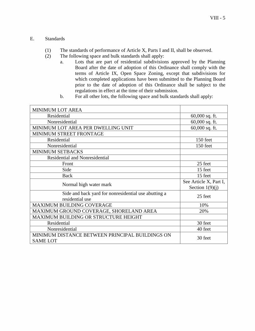
VIII - 5
E. Standards
(1) The standards of performance of Article X, Parts I and II, shall be observed.
(2) The following space and bulk standards shall apply:
a. Lots that are part of residential subdivisions approved by the Planning
Board after the date of adoption of this Ordinance shall comply with the
terms of Article IX, Open Space Zoning, except that subdivisions for
which completed applications have been submitted to the Planning Board
prior to the date of adoption of this Ordinance shall be subject to the
regulations in effect at the time of their submission.
b. For all other lots, the following space and bulk standards shall apply:
MINIMUM LOT AREA
Residential 60,000 sq. ft.
Nonresidential 60,000 sq. ft.
MINIMUM LOT AREA PER DWELLING UNIT 60,000 sq. ft.
MINIMUM STREET FRONTAGE
Residential 150 feet
Nonresidential 150 feet
MINIMUM SETBACKS
Residential and Nonresidential
Front 25 feet
Side 15 feet
Back 15 feet
Normal high water mark See Article X, Part I,
Section 1(9)(j)
Side and back yard for nonresidential use abutting a
residential use 25 feet
MAXIMUM BUILDING COVERAGE 10%
MAXIMUM GROUND COVERAGE, SHORELAND AREA 20%
MAXIMUM BUILDING OR STRUCTURE HEIGHT
Residential 30 feet
Nonresidential 40 feet
MINIMUM DISTANCE BETWEEN PRINCIPAL BUILDINGS ON
SAME LOT 30 feet
VIII - 6
(3) Screening
Nonresidential uses abutting a residential use or a district other than a business or
industrial district shall provide screening in accordance with the standards in
Article X, Part II, Section 3, of this Ordinance.
(4) Shoreland Area
Properties within shoreland areas shall comply with the additional standards set
forth in Article X, Part I, Section 1, of this Ordinance.
(5) High Elevation Areas
Notwithstanding the lists of permitted uses and uses permitted as special
exceptions in this district and the space and bulk standards of this district,
properties located more than 500 feet above mean sea level shall comply with the
standards of Article X, Part I, Section 2, of this Ordinance.
(6) Historic Areas
Properties within historic areas shall comply with the additional standards set
forth in Article X, Part I, Section 3 of this Ordinance.
VIII - 7
Section 3. Rural 2 District (RU-2)
A. Purpose
The Rural 2 District includes lands that are distant from the village area, and/or to which
public water and sewer lines are not expected to be extended within the next ten years,
and/or that have large tracts of land intact, suitable for woodland production, farming,
and unbroken wildlife habitat. The purpose of this district is to allow residential
development that is compatible with the character and traditional use of rural lands,
including extensive areas of field and woodland, and that does not impose an undue
burden on the provision of municipal services.
B. Permitted Uses
The following uses are permitted in the Rural 2 District:
The following resource protection uses:
(1) Uses listed in Section 1 of this Article, Natural Resource Protection District,
paragraph B
The following resource production uses:
(2) Agriculture
(3) Timber harvesting
The following residential uses:
(4) Single family dwellings
(5) Two-family dwellings
(6) Open space residential developments that meet the standards of Article IX
(7) Cottages
The following municipal and institutional uses:
(8) Family cemeteries, as defined by state law (13 MRSA §1142), covering no more
than one-quarter of an acre of land, a description of which is recorded with the
Town Clerk or with the Knox County Registry of Deeds
The following commercial uses:
(9) Outdoor storage of boats, provided the screening standards of Article X, Part II,
Section 3(5) are met
(10) Storage within barns or similar accessory structures existing as of the date of
adoption of this Ordinance
VIII - 8
The following utility uses:
(11) Essential services
(12) Road construction
(13) A wireless telecommunications facility, located in this district east of Camden
Hills State Park, approved by the Code Enforcement Officer or the Planning
Board in accordance with the Wireless Telecommunications Facility Siting
Ordinance of the Town of Camden.
The following accessory activities:
(14) Accessory uses
(15) Home occupations
(16) Homestay
C. Uses Permitted as Special Exceptions
The following uses may be permitted only upon approval as special exceptions in
accordance with the appropriate provisions of this Ordinance:
The following resource production uses:
(1) Extraction of mineral resources
(2) Clear cutting
The following municipal and institutional uses:
(3) Cemeteries
(4) Expansion of churches legally in existence as of July 31, 1991 subject to
conformity with applicable space and bulk standards and provided the building
coverage does not exceed 15,000 square feet. (New 6/20/06)
(5) Municipal uses
(6) Quasi-public facilities, provided no structures are involved
The following commercial uses:
(7) Clinics for animals
The following recreational uses:
(8) Golf courses and other outdoor recreational facilities, including commercial
outdoor recreation and the rental of nonmotorized sports equipment, but
excluding games and activities common to amusement parks
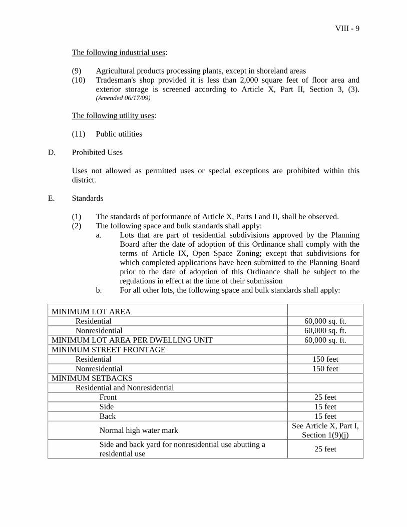
VIII - 9
The following industrial uses:
(9) Agricultural products processing plants, except in shoreland areas
(10) Tradesman's shop provided it is less than 2,000 square feet of floor area and
exterior storage is screened according to Article X, Part II, Section 3, (3). (Amended 06/17/09)
The following utility uses:
(11) Public utilities
D. Prohibited Uses
Uses not allowed as permitted uses or special exceptions are prohibited within this
district.
E. Standards
(1) The standards of performance of Article X, Parts I and II, shall be observed.
(2) The following space and bulk standards shall apply:
a. Lots that are part of residential subdivisions approved by the Planning
Board after the date of adoption of this Ordinance shall comply with the
terms of Article IX, Open Space Zoning; except that subdivisions for
which completed applications have been submitted to the Planning Board
prior to the date of adoption of this Ordinance shall be subject to the
regulations in effect at the time of their submission
b. For all other lots, the following space and bulk standards shall apply:
MINIMUM LOT AREA
Residential 60,000 sq. ft.
Nonresidential 60,000 sq. ft.
MINIMUM LOT AREA PER DWELLING UNIT 60,000 sq. ft.
MINIMUM STREET FRONTAGE
Residential 150 feet
Nonresidential 150 feet
MINIMUM SETBACKS
Residential and Nonresidential
Front 25 feet
Side 15 feet
Back 15 feet
Normal high water mark See Article X, Part I,
Section 1(9)(j)
Side and back yard for nonresidential use abutting a
residential use 25 feet
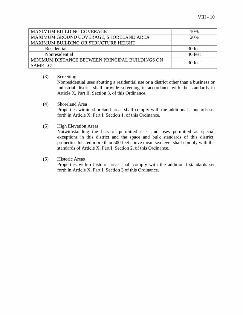
VIII - 10
MAXIMUM BUILDING COVERAGE 10%
MAXIMUM GROUND COVERAGE, SHORELAND AREA 20%
MAXIMUM BUILDING OR STRUCTURE HEIGHT
Residential 30 feet
Nonresidential 40 feet
MINIMUM DISTANCE BETWEEN PRINCIPAL BUILDINGS ON
SAME LOT 30 feet
(3) Screening
Nonresidential uses abutting a residential use or a district other than a business or
industrial district shall provide screening in accordance with the standards in
Article X, Part II, Section 3, of this Ordinance.
(4) Shoreland Area
Properties within shoreland areas shall comply with the additional standards set
forth in Article X, Part I, Section 1, of this Ordinance.
(5) High Elevation Areas
Notwithstanding the lists of permitted uses and uses permitted as special
exceptions in this district and the space and bulk standards of this district,
properties located more than 500 feet above mean sea level shall comply with the
standards of Article X, Part I, Section 2, of this Ordinance.
(6) Historic Areas
Properties within historic areas shall comply with the additional standards set
forth in Article X, Part I, Section 3 of this Ordinance.
VIII - 11
Section 4. Rural Recreation District (RR)
A. Purpose
The Rural Recreation District includes lands that are both fragile and provide unique
opportunity for public, outdoor recreation. The purpose of the district is to provide for a
controlled mix of activity typical of, and necessary to the successful operation of, a
multiple-season recreational area open to the public.
B. Permitted Uses
The following uses are permitted in the Rural Recreation District:
The following resource protection uses:
(1) Uses listed in Section 1 of this Article, Natural Resource Protection District,
paragraph B
The following resource production uses:
(2) Timber harvesting
The following municipal and institutional uses:
(3) Municipal uses
The following commercial uses:
(4) Storage within barns or similar accessory structures existing as of the date of
adoption of this Ordinance
The following utility uses:
(5) Essential services
C. Uses Permitted as Special Exceptions
The following uses may be permitted only upon approval as special exceptions in
accordance with the appropriate provisions of this Ordinance:
The following municipal and institutional uses:
(1) Community buildings
(2) Quasi-public facilities
(3) Nursery schools and day care centers
VIII - 12
The following commercial uses:
(4) Campgrounds
(5) Commercial schools
(6) Fast food restaurants, excluding drive-through windows
(7) Sit-down restaurants
(8) Retail sales
(9) Theaters
The following recreational uses:
(10) Golf courses, ski area and lifts, toboggan chutes and other outdoor recreational
facilities, including commercial outdoor recreation and the rental of nonmotorized
sports equipment, but excluding games and activities common to amusement
parks
The following utility uses:
(11) Commercial parking facilities
(12) Public utilities
(13) Road construction
D. Prohibited Uses
Uses not allowed as permitted uses or special exceptions are prohibited within this
district.
E. Standards
(1) The standards of performance of Article X, Parts I and II, shall be observed.
(2) The following space and bulk standards shall apply:
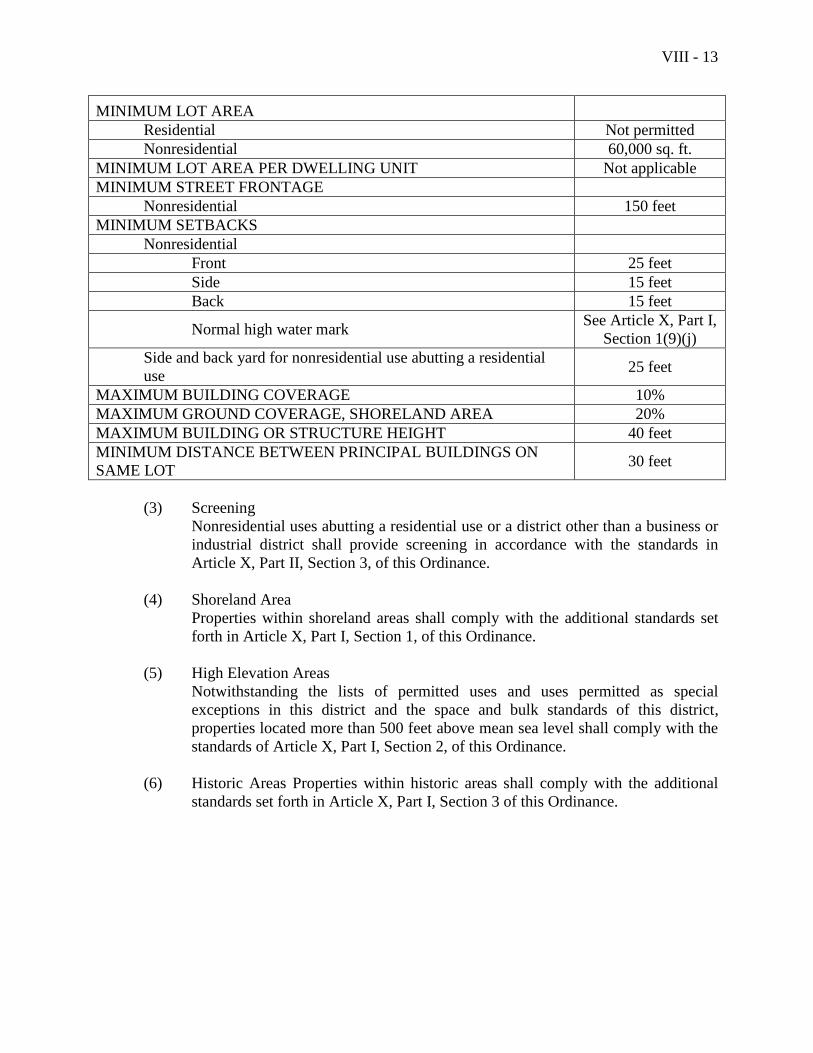
VIII - 13
MINIMUM LOT AREA
Residential Not permitted
Nonresidential 60,000 sq. ft.
MINIMUM LOT AREA PER DWELLING UNIT Not applicable
MINIMUM STREET FRONTAGE
Nonresidential 150 feet
MINIMUM SETBACKS
Nonresidential
Front 25 feet
Side 15 feet
Back 15 feet
Normal high water mark See Article X, Part I,
Section 1(9)(j)
Side and back yard for nonresidential use abutting a residential
use 25 feet
MAXIMUM BUILDING COVERAGE 10%
MAXIMUM GROUND COVERAGE, SHORELAND AREA 20%
MAXIMUM BUILDING OR STRUCTURE HEIGHT 40 feet
MINIMUM DISTANCE BETWEEN PRINCIPAL BUILDINGS ON
SAME LOT 30 feet
(3) Screening
Nonresidential uses abutting a residential use or a district other than a business or
industrial district shall provide screening in accordance with the standards in
Article X, Part II, Section 3, of this Ordinance.
(4) Shoreland Area
Properties within shoreland areas shall comply with the additional standards set
forth in Article X, Part I, Section 1, of this Ordinance.
(5) High Elevation Areas
Notwithstanding the lists of permitted uses and uses permitted as special
exceptions in this district and the space and bulk standards of this district,
properties located more than 500 feet above mean sea level shall comply with the
standards of Article X, Part I, Section 2, of this Ordinance.
(6) Historic Areas Properties within historic areas shall comply with the additional
standards set forth in Article X, Part I, Section 3 of this Ordinance.

VIII - 14
This page intentionally left blank
VIII - 15
Section 5. Coastal Residential District (CR)
A. Purpose
The Coastal Residential District includes lands along scenic coastal corridors north and
south of the village area. The purpose of the district is to allow for a moderate level of
residential and other development while assuring that these corridors retain their scenic
landscapes and vistas and continue to serve as attractive gateways to Camden. The
intention is that development be designed to fit into the existing character that includes
rolling terrain and interspersed woods, fields, structures, and views of the water.
B. Permitted Uses
The following uses are permitted in the Coastal Residential District:
The following resource protection uses:
(1) Uses listed in Section 1 of this Article, Natural Resource Protection District,
paragraph B
The following resource production uses:
(2) Agriculture
(3) Timber harvesting
The following residential uses:
(4) Single family dwellings
(5) Two-family dwellings
(6) Open space residential developments that meet the standards of Article IX
(7) Cottages
The following municipal and institutional uses:
(8) Family cemeteries, as defined by state law (13 MRSA §1142), covering no more
than one-quarter of an acre of land, a description of which is recorded with the
Town Clerk or with the Knox County Registry of Deeds
The following commercial uses:
(12) Outdoor storage of boats, provided the screening standards of Article X, Part II,
Section 3(5) are met and indoor storage of boats in buildings on lots of 5 or more
acres in size provided that the storage facility was in existence on January 1, 2003
and is located at least 125 feet from any residential lot boundary or a public way. (Amended – 11/11/03)
(10) Storage within barns or similar accessory structures existing as of the date of
adoption of this Ordinance
VIII - 16
The following marine uses:
(11) Municipal boat ramps and municipal piers
The following utility uses:
(12) Essential services
(13) Road construction
The following accessory activities:
(14) Accessory uses
(15) Home occupations
(16) Homestay
C. Uses Permitted as Special Exceptions
The following uses may be permitted only upon approval as special exceptions in
accordance with the appropriate provisions of this Ordinance:
The following municipal and institutional uses:
(1) Cemeteries
(2) Municipal uses
(3) Quasi-public facilities, provided no structures are involved
(4) Nursery schools and day care centers
The following recreational uses:
(5) Golf courses
The following utility uses:
(6) Public utilities
The following commercial uses:
(7) Expansion of hotels or motels with ten or more rooms offered for rent legally in
existence as of March 11, 1985, within a lot of record existing as of March 11,
1985, subject to conformity with applicable space and bulk standards.
The following industrial uses:
(8) Expansion of facilities used for the storage and maintenance of construction
equipment and which were legally in existence as of March 11, 1985, within lots of
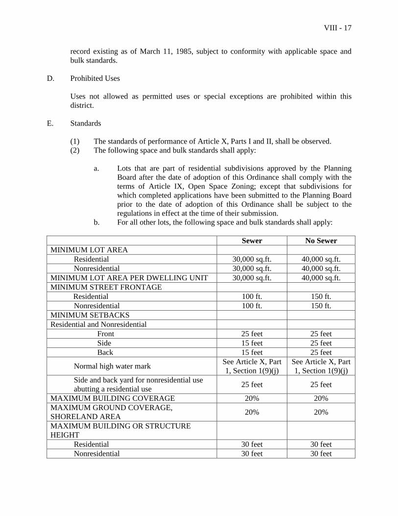
VIII - 17
record existing as of March 11, 1985, subject to conformity with applicable space and
bulk standards.
D. Prohibited Uses
Uses not allowed as permitted uses or special exceptions are prohibited within this
district.
E. Standards
(1) The standards of performance of Article X, Parts I and II, shall be observed.
(2) The following space and bulk standards shall apply:
a. Lots that are part of residential subdivisions approved by the Planning
Board after the date of adoption of this Ordinance shall comply with the
terms of Article IX, Open Space Zoning; except that subdivisions for
which completed applications have been submitted to the Planning Board
prior to the date of adoption of this Ordinance shall be subject to the
regulations in effect at the time of their submission.
b. For all other lots, the following space and bulk standards shall apply:
Sewer No Sewer
MINIMUM LOT AREA
Residential 30,000 sq.ft. 40,000 sq.ft.
Nonresidential 30,000 sq.ft. 40,000 sq.ft.
MINIMUM LOT AREA PER DWELLING UNIT 30,000 sq.ft. 40,000 sq.ft.
MINIMUM STREET FRONTAGE
Residential 100 ft. 150 ft.
Nonresidential 100 ft. 150 ft.
MINIMUM SETBACKS
Residential and Nonresidential
Front 25 feet 25 feet
Side 15 feet 25 feet
Back 15 feet 25 feet
Normal high water mark See Article X, Part
1, Section 1(9)(j)
See Article X, Part
1, Section 1(9)(j)
Side and back yard for nonresidential use
abutting a residential use 25 feet 25 feet
MAXIMUM BUILDING COVERAGE 20% 20%
MAXIMUM GROUND COVERAGE,
SHORELAND AREA 20% 20%
MAXIMUM BUILDING OR STRUCTURE
HEIGHT
Residential 30 feet 30 feet
Nonresidential 30 feet 30 feet
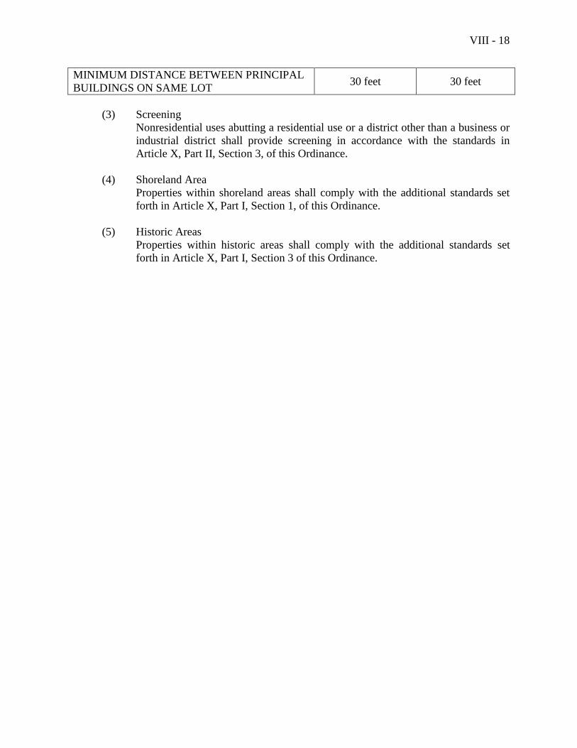
VIII - 18
MINIMUM DISTANCE BETWEEN PRINCIPAL
BUILDINGS ON SAME LOT 30 feet 30 feet
(3) Screening
Nonresidential uses abutting a residential use or a district other than a business or
industrial district shall provide screening in accordance with the standards in
Article X, Part II, Section 3, of this Ordinance.
(4) Shoreland Area
Properties within shoreland areas shall comply with the additional standards set
forth in Article X, Part I, Section 1, of this Ordinance.
(5) Historic Areas
Properties within historic areas shall comply with the additional standards set
forth in Article X, Part I, Section 3 of this Ordinance.
VIII - 19
Section 6. Village Extension District (VE)
A. Purpose
The Village Extension District lies outside of the traditional village but includes lands
that have, or can reasonably be expected to receive within the next ten years, public water
and sewer; can be readily provided with other municipal services; and can support a
significant share of the new development anticipated in the Town during the next ten to
fifteen years. The purpose of the district is to provide a range of housing opportunities
and of compatible, small-scale economic opportunities. The intent is to do so within a
setting that emulates the character of villages: with streets designed for safe and
convenient use by both pedestrians and motor vehicles and at a scale appropriate for
walkable neighborhoods; a mix of activities that serve some of the routine needs of
neighborhood residents; and a sense of security and protected investments.
B. Permitted Uses
The following uses are permitted in the Village Extension District:
The following resource protection uses:
(1) Uses listed in Section 1 of this Article, Natural Resource Protection District,
Paragraph B
The following resource production uses:
(2) Agriculture
(3) Timber harvesting
The following residential uses:
(4) Single family dwellings
(5) Two-family dwellings
(6) Open space residential developments that meet the standards of Article IX
(7) Cottages
(8) Mobile home parks
(9) Accessory apartments
The following municipal and institutional uses:
(10) Cemeteries
(11) Churches
VIII - 20
The following commercial uses:
(12) Outdoor storage of boats, provided the screening standards of Article X, Part II,
Section 3(5) are met
(13) Storage within barns or similar accessory structures existing as of the date of
adoption of this Ordinance
The following water-dependent uses:
(14) Municipal boat ramps and municipal piers
The following utility uses:
(15) Essential services
(16) Road construction
The following accessory activities:
(17) Accessory uses
(18) Home occupations
(19) Homestay
A 1 following a listed use means the use must be located wholly within structures existing
as of the date of adoption of this Ordinance.
C. Uses Permitted as Special Exceptions
The following uses may be permitted only upon approval as special exceptions in
accordance with the appropriate provisions of this Ordinance:
The following municipal and institutional uses:
(1) Community buildings
(2) Quasi-public facilities
(3) Municipal uses
(4) Nursery schools and day care centers
(5) Private schools
(6) Public schools
The following utility uses:
(7) Public utilities
(8) Commercial parking facilities, provided there is no demolition of buildings
existing as of the date of adoption of this Ordinance

VIII - 21
The following commercial uses:
(9) Inns located on lots of 2 or more acres 1
(10) Low impact uses, as defined in this Ordinance and not otherwise allowed in this
district, on lots that are located wholly or in part within 500 feet of a business or
industrial district (B-1, B-2, B-3, B-H, B-R, B-TR, or I), and that meet the terms
of Article VII, Section 4(9).
The following residential uses:
(11) Community living uses
(12) Elderly congregate housing served by public sewer
(13) Nursing and convalescent homes
D. Prohibited Uses
Uses not allowed as permitted uses or special exceptions are prohibited within this
district.
E. Standards
(1) The standards of performance of Article X, Parts I and II, shall be observed.
(2) The following space and bulk standards shall apply:
Sewer No Sewer
MINIMUM LOT AREA
Residential 10,000 sq.ft. 40,000 sq.ft.
Nonresidential 10,000 sq.ft. 40,000 sq.ft.
MINIMUM LOT AREA PER DWELLING
UNIT
Single Family 10,000 sq.ft. 40,000 sq.ft.
Accessory Apartments No increase in lot area
required
No increase in
lot area required
Two-Family Dwellings 7,500 sq.ft. 40,000 sq.ft.
Multi-Family Dwellings (as part of
open space subdivisions) 7,500 sq.ft. Not permitted
Table continued on next page
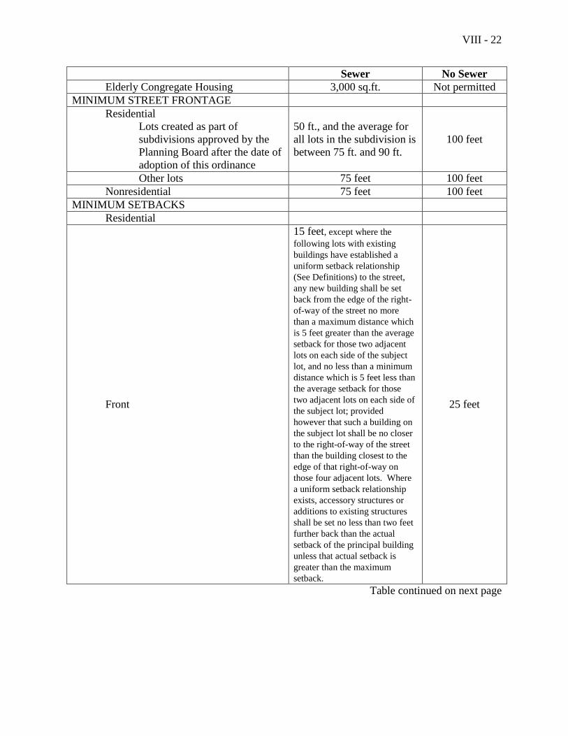
VIII - 22
Sewer No Sewer
Elderly Congregate Housing 3,000 sq.ft. Not permitted
MINIMUM STREET FRONTAGE
Residential
Lots created as part of
subdivisions approved by the
Planning Board after the date of
adoption of this ordinance
50 ft., and the average for
all lots in the subdivision is
between 75 ft. and 90 ft.
100 feet
Other lots 75 feet 100 feet
Nonresidential 75 feet 100 feet
MINIMUM SETBACKS
Residential
Front
15 feet, except where the
following lots with existing
buildings have established a
uniform setback relationship
(See Definitions) to the street,
any new building shall be set
back from the edge of the right-
of-way of the street no more
than a maximum distance which
is 5 feet greater than the average
setback for those two adjacent
lots on each side of the subject
lot, and no less than a minimum
distance which is 5 feet less than
the average setback for those
two adjacent lots on each side of
the subject lot; provided
however that such a building on
the subject lot shall be no closer
to the right-of-way of the street
than the building closest to the
edge of that right-of-way on
those four adjacent lots. Where
a uniform setback relationship
exists, accessory structures or
additions to existing structures
shall be set no less than two feet
further back than the actual
setback of the principal building
unless that actual setback is
greater than the maximum
setback.
25 feet
Table continued on next page
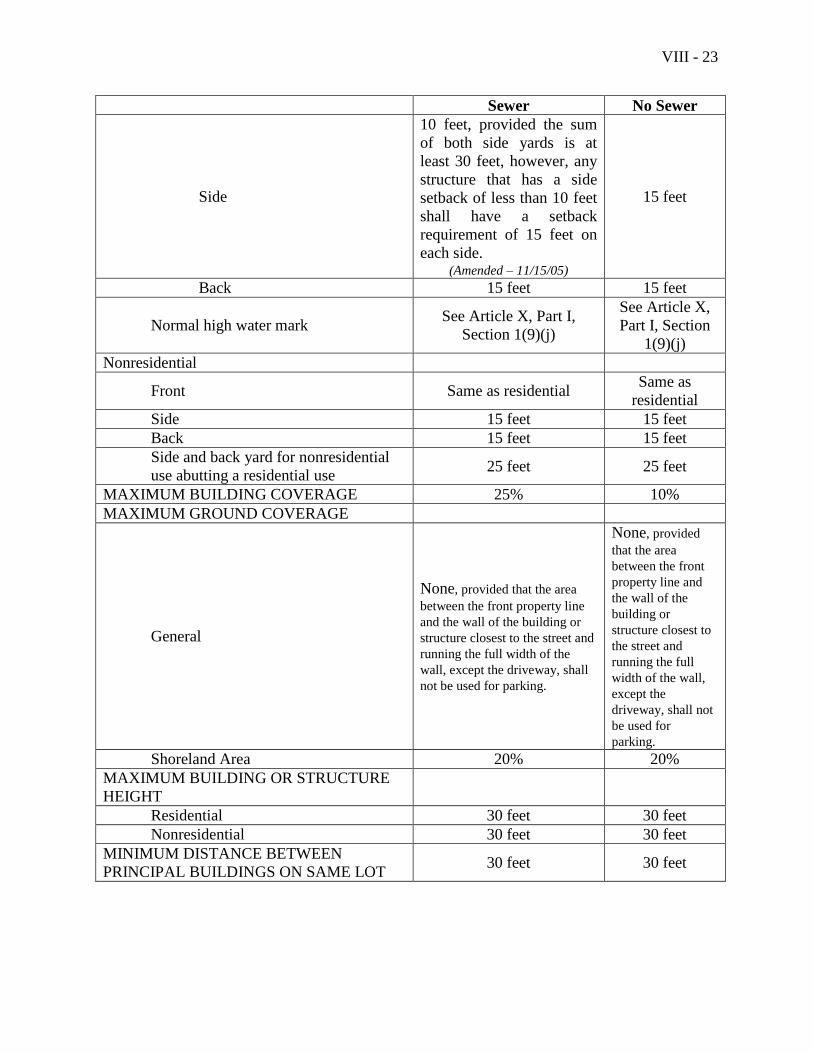
VIII - 23
Sewer No Sewer
Side
10 feet, provided the sum
of both side yards is at
least 30 feet, however, any
structure that has a side
setback of less than 10 feet
shall have a setback
requirement of 15 feet on
each side. (Amended – 11/15/05)
15 feet
Back 15 feet 15 feet
Normal high water mark See Article X, Part I,
Section 1(9)(j)
See Article X,
Part I, Section
1(9)(j)
Nonresidential
Front Same as residential Same as
residential
Side 15 feet 15 feet
Back 15 feet 15 feet
Side and back yard for nonresidential
use abutting a residential use 25 feet 25 feet
MAXIMUM BUILDING COVERAGE 25% 10%
MAXIMUM GROUND COVERAGE
General
None, provided that the area
between the front property line
and the wall of the building or
structure closest to the street and
running the full width of the
wall, except the driveway, shall
not be used for parking.
None, provided
that the area
between the front
property line and
the wall of the
building or
structure closest to
the street and
running the full
width of the wall,
except the
driveway, shall not
be used for
parking.
Shoreland Area 20% 20%
MAXIMUM BUILDING OR STRUCTURE
HEIGHT
Residential 30 feet 30 feet
Nonresidential 30 feet 30 feet
MINIMUM DISTANCE BETWEEN
PRINCIPAL BUILDINGS ON SAME LOT 30 feet 30 feet
VIII - 24
(3) Screening
Nonresidential uses abutting a residential use or a district other than a business or
industrial district shall provide screening in accordance with the standards in
Article X, Part II, Section 3, of this Ordinance.
(4) Shoreland Area
Properties within shoreland areas shall comply with the additional standards set
forth in Article X, Part I, Section 1, of this Ordinance.
(5) Historic Area
Properties within historic areas shall comply with the additional standards set
forth in Article X, Part I, Section 3 of this Ordinance.
VIII - 25
Section 7. Traditional Village District (V)
A. Purpose
The Traditional Village District encompasses the older residential neighborhoods near the
center of the community, where historically a majority of the Town's population lived
within walking distance of the central business district and governmental and cultural
facilities. The purpose of this district is to maintain these highly livable neighborhoods,
which include single family homes, small-scale multifamily structures, compatible
residential-scale businesses, and a distinct village design.
B. Permitted Uses
The following uses are permitted in the Traditional Village District:
The following resource protection uses:
(1) Uses listed in Section 1 of this Article, Natural Resource Protection District,
paragraph B
The following resource production uses:
(2) Timber harvesting
The following residential uses:
(3) Single family dwellings
(4) Two-family dwellings
(5) Multifamily dwellings
(6) Open space residential developments that meet the standards of Article IX
(7) Accessory apartments
The following municipal and institutional uses:
(8) Cemeteries
(9) Churches
The following commercial uses:
(10) Outdoor storage of boats, provided the screening standards of Article X, Part II,
Section 3(5) are met
(11) Storage within barns or similar accessory structures existing as of the date of
adoption of this Ordinance
(12) Hotels or motels with more than ten (10) but fewer than fifteen (15) sleeping
rooms on lots of 3.5 or more acres, provided that the sleeping rooms are in
existence and used as such and are located wholly within one structure existing as
VIII - 26
of June 8, 1993, and further provided that any restaurant facilities located therein
shall prepare food and serve meals only to overnight guests of that hotel or motel.
The following water-dependent uses:
(13) Municipal boat ramps and municipal piers
The following utility uses:
(14) Essential services
(15) Road construction
The following accessory activities:
(16) Accessory uses
(17) Home occupations
(18) Homestay
A 1 following a listed use means the use must be located wholly within structures existing
as of the date of adoption of this Ordinance.
C. Uses Permitted as Special Exceptions
The following uses may be permitted only upon approval as special exceptions in
accordance with the appropriate provisions of this Ordinance:
The following residential uses:
(1) Community living uses
(2) Elderly congregate housing
(3) Nursing and convalescent homes
(4) Rooming houses
The following municipal and institutional uses:
(5) Community buildings
(6) Municipal uses
(7) Nursery schools and day care centers
(8) Public schools
(9) Quasi-public facilities
The following commercial uses:
(10) Low impact uses, as defined in this Ordinance and not otherwise allowed in this
district, on lots that are located wholly or in part within 500 feet of a business or
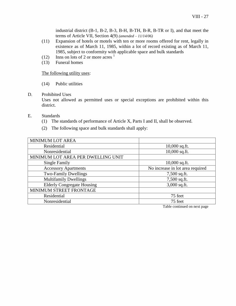
VIII - 27
industrial district (B-1, B-2, B-3, B-H, B-TH, B-R, B-TR or I), and that meet the
terms of Article VII, Section 4(9) (amended – 11/14/06)
(11) Expansion of hotels or motels with ten or more rooms offered for rent, legally in
existence as of March 11, 1985, within a lot of record existing as of March 11,
1985, subject to conformity with applicable space and bulk standards
(12) Inns on lots of 2 or more acres 1
(13) Funeral homes
The following utility uses:
(14) Public utilities
D. Prohibited Uses
Uses not allowed as permitted uses or special exceptions are prohibited within this
district.
E. Standards
(1) The standards of performance of Article X, Parts I and II, shall be observed.
(2) The following space and bulk standards shall apply:
MINIMUM LOT AREA
Residential 10,000 sq.ft.
Nonresidential 10,000 sq.ft.
MINIMUM LOT AREA PER DWELLING UNIT
Single Family 10,000 sq.ft.
Accessory Apartments No increase in lot area required
Two-Family Dwellings 7,500 sq.ft.
Multifamily Dwellings 7,500 sq.ft.
Elderly Congregate Housing 3,000 sq.ft.
MINIMUM STREET FRONTAGE
Residential 75 feet
Nonresidential 75 feet Table continued on next page
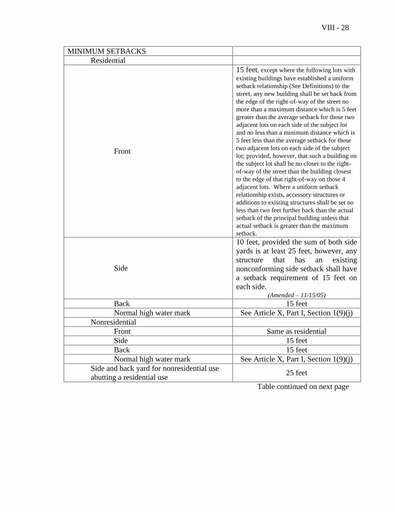
VIII - 28
MINIMUM SETBACKS
Residential
Front
15 feet, except where the following lots with
existing buildings have established a uniform
setback relationship (See Definitions) to the
street, any new building shall be set back from
the edge of the right-of-way of the street no
more than a maximum distance which is 5 feet
greater than the average setback for those two
adjacent lots on each side of the subject lot
and no less than a minimum distance which is
5 feet less than the average setback for those
two adjacent lots on each side of the subject
lot; provided, however, that such a building on
the subject lot shall be no closer to the right-
of-way of the street than the building closest
to the edge of that right-of-way on those 4
adjacent lots. Where a uniform setback
relationship exists, accessory structures or
additions to existing structures shall be set no
less than two feet further back than the actual
setback of the principal building unless that
actual setback is greater than the maximum
setback.
Side
10 feet, provided the sum of both side
yards is at least 25 feet, however, any
structure that has an existing
nonconforming side setback shall have
a setback requirement of 15 feet on
each side. (Amended – 11/15/05)
Back 15 feet
Normal high water mark See Article X, Part I, Section 1(9)(j)
Nonresidential
Front Same as residential
Side 15 feet
Back 15 feet
Normal high water mark See Article X, Part I, Section 1(9)(j)
Side and back yard for nonresidential use
abutting a residential use 25 feet
Table continued on next page
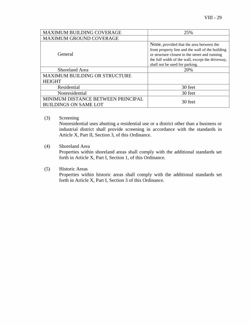
VIII - 29
MAXIMUM BUILDING COVERAGE 25%
MAXIMUM GROUND COVERAGE
General
None, provided that the area between the
front property line and the wall of the building
or structure closest to the street and running
the full width of the wall, except the driveway,
shall not be used for parking.
Shoreland Area 20%
MAXIMUM BUILDING OR STRUCTURE
HEIGHT
Residential 30 feet
Nonresidential 30 feet
MINIMUM DISTANCE BETWEEN PRINCIPAL
BUILDINGS ON SAME LOT 30 feet
(3) Screening
Nonresidential uses abutting a residential use or a district other than a business or
industrial district shall provide screening in accordance with the standards in
Article X, Part II, Section 3, of this Ordinance.
(4) Shoreland Area
Properties within shoreland areas shall comply with the additional standards set
forth in Article X, Part I, Section 1, of this Ordinance.
(5) Historic Areas
Properties within historic areas shall comply with the additional standards set
forth in Article X, Part I, Section 3 of this Ordinance.

VIII - 30
This page intentionally left blank
VIII - 31
Section 8. Downtown Business District (B-1)
A. Purpose
The purpose of the Downtown Business District is to provide for a compact, pedestrian
oriented, year-round business center with a focus on small scale specialty and comparison
shopping and services compatible with the existing scale and character of Downtown
Camden.
B. Permitted Uses
The following uses are permitted in the Downtown Business District:
The following resource protection uses:
(1) Uses listed in Section 1 of this Article, Natural Resource Protection District,
paragraph B
The following residential uses:
(2) Single family dwellings, except no residential use shall occur on a floor at street
level†
(3) Two-family dwellings, except no residential use shall occur on a floor at street
level†
(4) Multifamily dwellings, except no residential use shall occur on a floor at street
level
(5) Elderly congregate housing, except no residential use shall occur on a floor at
street level
†The restriction on residential use on a floor at street level shall not apply to structures in
the Chestnut Street Historic District.
The following municipal and institutional uses:
(6) Churches
(7) Community buildings
(8) Municipal uses
(9) Nursery schools and day care centers
(10) Private schools
(11) Public schools
(12) Quasi-public facilities
The following commercial uses:
(13) Boat and marine sales and service, provided there is no exterior storage or display
(14) Commercial schools
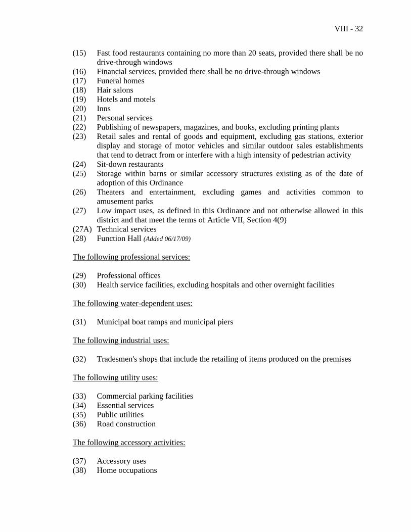
VIII - 32
(15) Fast food restaurants containing no more than 20 seats, provided there shall be no
drive-through windows
(16) Financial services, provided there shall be no drive-through windows
(17) Funeral homes
(18) Hair salons
(19) Hotels and motels
(20) Inns
(21) Personal services
(22) Publishing of newspapers, magazines, and books, excluding printing plants
(23) Retail sales and rental of goods and equipment, excluding gas stations, exterior
display and storage of motor vehicles and similar outdoor sales establishments
that tend to detract from or interfere with a high intensity of pedestrian activity
(24) Sit-down restaurants
(25) Storage within barns or similar accessory structures existing as of the date of
adoption of this Ordinance
(26) Theaters and entertainment, excluding games and activities common to
amusement parks
(27) Low impact uses, as defined in this Ordinance and not otherwise allowed in this
district and that meet the terms of Article VII, Section 4(9)
(27A) Technical services
(28) Function Hall (Added 06/17/09)
The following professional services:
(29) Professional offices
(30) Health service facilities, excluding hospitals and other overnight facilities
The following water-dependent uses:
(31) Municipal boat ramps and municipal piers
The following industrial uses:
(32) Tradesmen's shops that include the retailing of items produced on the premises
The following utility uses:
(33) Commercial parking facilities
(34) Essential services
(35) Public utilities
(36) Road construction
The following accessory activities:
(37) Accessory uses
(38) Home occupations
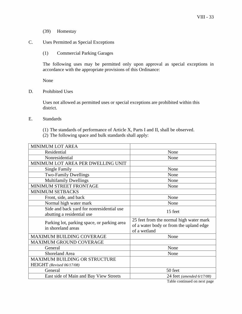
VIII - 33
(39) Homestay
C. Uses Permitted as Special Exceptions
(1) Commercial Parking Garages
The following uses may be permitted only upon approval as special exceptions in
accordance with the appropriate provisions of this Ordinance:
None
D. Prohibited Uses
Uses not allowed as permitted uses or special exceptions are prohibited within this
district.
E. Standards
(1) The standards of performance of Article X, Parts I and II, shall be observed.
(2) The following space and bulk standards shall apply:
MINIMUM LOT AREA
Residential None
Nonresidential None
MINIMUM LOT AREA PER DWELLING UNIT
Single Family None
Two-Family Dwellings None
Multifamily Dwellings None
MINIMUM STREET FRONTAGE None
MINIMUM SETBACKS
Front, side, and back None
Normal high water mark None
Side and back yard for nonresidential use
abutting a residential use 15 feet
Parking lot, parking space, or parking area
in shoreland areas
25 feet from the normal high water mark
of a water body or from the upland edge
of a wetland
MAXIMUM BUILDING COVERAGE None
MAXIMUM GROUND COVERAGE
General None
Shoreland Area None
MAXIMUM BUILDING OR STRUCTURE
HEIGHT (Revised 06/17/08)
General 50 feet
East side of Main and Bay View Streets 24 feet (amended 6/17/08) Table continued on next page

VIII - 34
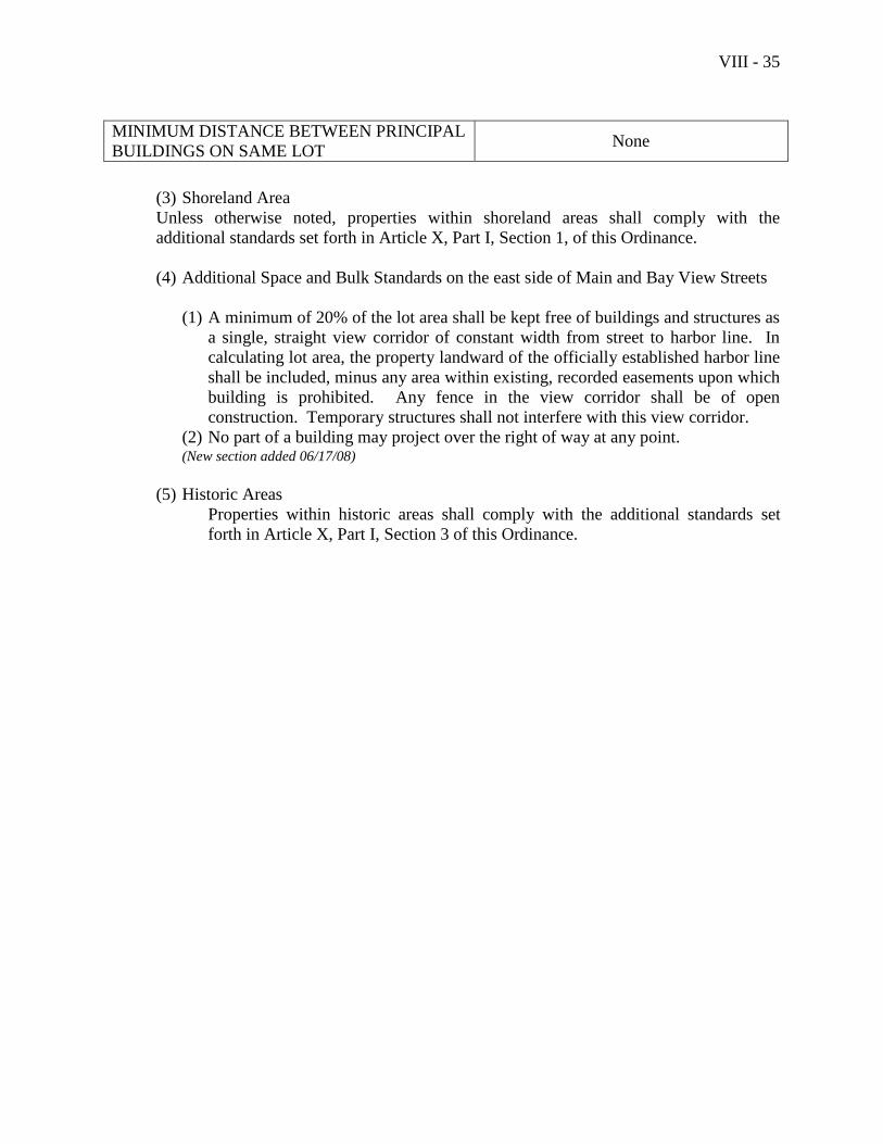
VIII - 35
MINIMUM DISTANCE BETWEEN PRINCIPAL
BUILDINGS ON SAME LOT None
(3) Shoreland Area
Unless otherwise noted, properties within shoreland areas shall comply with the
additional standards set forth in Article X, Part I, Section 1, of this Ordinance.
(4) Additional Space and Bulk Standards on the east side of Main and Bay View Streets
(1) A minimum of 20% of the lot area shall be kept free of buildings and structures as
a single, straight view corridor of constant width from street to harbor line. In
calculating lot area, the property landward of the officially established harbor line
shall be included, minus any area within existing, recorded easements upon which
building is prohibited. Any fence in the view corridor shall be of open
construction. Temporary structures shall not interfere with this view corridor.
(2) No part of a building may project over the right of way at any point. (New section added 06/17/08)
(5) Historic Areas
Properties within historic areas shall comply with the additional standards set
forth in Article X, Part I, Section 3 of this Ordinance.

VIII - 36
Section 9. Highway Business District (B-2)
A. Purpose
The purpose of the Highway Business District is to provide an area suitable for highway-
oriented businesses at a moderate density.
B. Permitted Uses
The following uses are permitted in the Highway Business District:
The following resource protection uses:
(1) Uses listed in Section 1 of this Article, Natural Resource Protection District,
paragraph B
The following residential uses: (Amended 06/17/2008)
(2) Single family dwellings
(3) Two-family dwellings
(4) Multifamily dwellings served by public sewer
(5) Community living uses
(6) Elderly congregate housing served by public sewer
(7) Nursing and convalescent homes
(8) Accessory apartments
The following municipal and institutional uses: (Amended 06/17/2008)
(9) Churches
(10) Community buildings
(11) Hospitals
(12) Municipal uses
(13) Nursery schools and day care centers
(14) Private schools
(15) Public schools
(16) Quasi-public facilities
The following commercial uses: (Amended 06/17/08)
(17) Auction barns
(18) Auto repair garages
(19) Boat and marine sales and service (Amended 06/17/08)
(20) Clinics for animals
(21) Commercial schools
(22) Fast food restaurants, provided there shall be no drive-through windows
(23) Financial services
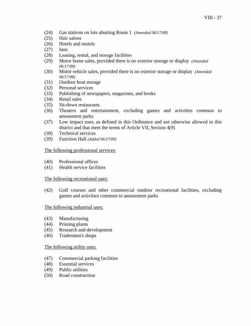
VIII - 37
(24) Gas stations on lots abutting Route 1 (Amended 06/17/08)
(25) Hair salons
(26) Hotels and motels
(27) Inns
(28) Leasing, rental, and storage facilities
(29) Motor home sales, provided there is no exterior storage or display (Amended
06/17/08) (30) Motor vehicle sales, provided there is no exterior storage or display (Amended
06/17/08) (31) Outdoor boat storage
(32) Personal services
(33) Publishing of newspapers, magazines, and books
(34) Retail sales
(35) Sit-down restaurants
(36) Theaters and entertainment, excluding games and activities common to
amusement parks
(37) Low impact uses, as defined in this Ordinance and not otherwise allowed in this
district and that meet the terms of Article VII, Section 4(9)
(38) Technical services
(39) Function Hall (Added 06/17/09)
The following professional services:
(40) Professional offices
(41) Health service facilities
The following recreational uses:
(42) Golf courses and other commercial outdoor recreational facilities, excluding
games and activities common to amusement parks
The following industrial uses:
(43) Manufacturing
(44) Printing plants
(45) Research and development
(46) Tradesmen's shops
The following utility uses:
(47) Commercial parking facilities
(48) Essential services
(49) Public utilities
(50) Road construction
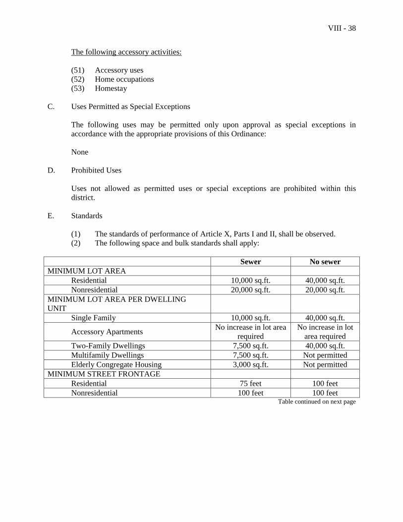
VIII - 38
The following accessory activities:
(51) Accessory uses
(52) Home occupations
(53) Homestay
C. Uses Permitted as Special Exceptions
The following uses may be permitted only upon approval as special exceptions in
accordance with the appropriate provisions of this Ordinance:
None
D. Prohibited Uses
Uses not allowed as permitted uses or special exceptions are prohibited within this
district.
E. Standards
(1) The standards of performance of Article X, Parts I and II, shall be observed.
(2) The following space and bulk standards shall apply:
Sewer No sewer
MINIMUM LOT AREA
Residential 10,000 sq.ft. 40,000 sq.ft.
Nonresidential 20,000 sq.ft. 20,000 sq.ft.
MINIMUM LOT AREA PER DWELLING
UNIT
Single Family 10,000 sq.ft. 40,000 sq.ft.
Accessory Apartments No increase in lot area
required
No increase in lot
area required
Two-Family Dwellings 7,500 sq.ft. 40,000 sq.ft.
Multifamily Dwellings 7,500 sq.ft. Not permitted
Elderly Congregate Housing 3,000 sq.ft. Not permitted
MINIMUM STREET FRONTAGE
Residential 75 feet 100 feet
Nonresidential 100 feet 100 feet Table continued on next page
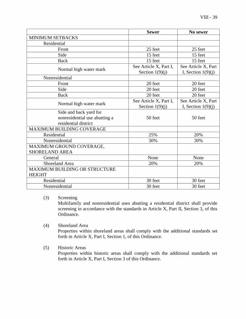
VIII - 39
Sewer No sewer
MINIMUM SETBACKS
Residential
Front 25 feet 25 feet
Side 15 feet 15 feet
Back 15 feet 15 feet
Normal high water mark See Article X, Part I,
Section 1(9)(j)
See Article X, Part
I, Section 1(9)(j)
Nonresidential
Front 20 feet 20 feet
Side 20 feet 20 feet
Back 20 feet 20 feet
Normal high water mark See Article X, Part I,
Section 1(9)(j)
See Article X, Part
I, Section 1(9)(j)
Side and back yard for
nonresidential use abutting a
residential district
50 feet 50 feet
MAXIMUM BUILDING COVERAGE
Residential 25% 20%
Nonresidential 30% 30%
MAXIMUM GROUND COVERAGE,
SHORELAND AREA
General None None
Shoreland Area 20% 20%
MAXIMUM BUILDING OR STRUCTURE
HEIGHT
Residential 30 feet 30 feet
Nonresidential 30 feet 30 feet
(3) Screening
Multifamily and nonresidential uses abutting a residential district shall provide
screening in accordance with the standards in Article X, Part II, Section 3, of this
Ordinance.
(4) Shoreland Area
Properties within shoreland areas shall comply with the additional standards set
forth in Article X, Part I, Section 1, of this Ordinance.
(5) Historic Areas
Properties within historic areas shall comply with the additional standards set
forth in Article X, Part I, Section 3 of this Ordinance.
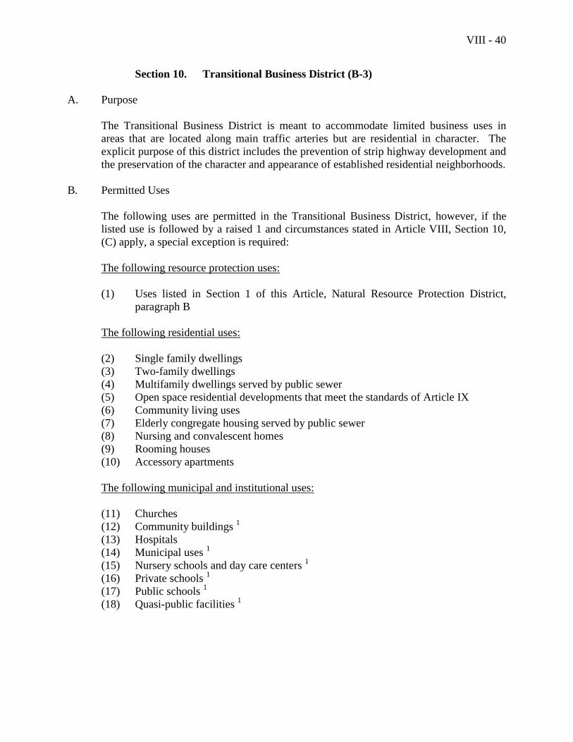
VIII - 40
Section 10. Transitional Business District (B-3)
A. Purpose
The Transitional Business District is meant to accommodate limited business uses in
areas that are located along main traffic arteries but are residential in character. The
explicit purpose of this district includes the prevention of strip highway development and
the preservation of the character and appearance of established residential neighborhoods.
B. Permitted Uses
The following uses are permitted in the Transitional Business District, however, if the
listed use is followed by a raised 1 and circumstances stated in Article VIII, Section 10,
(C) apply, a special exception is required:
The following resource protection uses:
(1) Uses listed in Section 1 of this Article, Natural Resource Protection District,
paragraph B
The following residential uses:
(2) Single family dwellings
(3) Two-family dwellings
(4) Multifamily dwellings served by public sewer
(5) Open space residential developments that meet the standards of Article IX
(6) Community living uses
(7) Elderly congregate housing served by public sewer
(8) Nursing and convalescent homes
(9) Rooming houses
(10) Accessory apartments
The following municipal and institutional uses:
(11) Churches
(12) Community buildings 1
(13) Hospitals
(14) Municipal uses 1
(15) Nursery schools and day care centers 1
(16) Private schools 1
(17) Public schools 1
(18) Quasi-public facilities 1
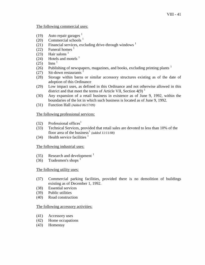
VIII - 41
The following commercial uses:
(19) Auto repair garages 1
(20) Commercial schools 1
(21) Financial services, excluding drive-through windows 1
(22) Funeral homes 1
(23) Hair salons 1
(24) Hotels and motels 1
(25) Inns 1
(26) Publishing of newspapers, magazines, and books, excluding printing plants 1
(27) Sit-down restaurants 1
(28) Storage within barns or similar accessory structures existing as of the date of
adoption of this Ordinance
(29) Low impact uses, as defined in this Ordinance and not otherwise allowed in this
district and that meet the terms of Article VII, Section 4(9) 1
(30) Any expansion of a retail business in existence as of June 9, 1992, within the
boundaries of the lot in which such business is located as of June 9, 1992.
(31) Function Hall (Added 06/17/09)
The following professional services:
(32) Professional offices1
(33) Technical Services, provided that retail sales are devoted to less than 10% of the
floor area of the business1
(added 11/11/08)
(34) Health service facilities 1
The following industrial uses:
(35) Research and development 1
(36) Tradesmen's shops 1
The following utility uses:
(37) Commercial parking facilities, provided there is no demolition of buildings
existing as of December 1, 1992.
(38) Essential services
(39) Public utilities
(40) Road construction
The following accessory activities:
(41) Accessory uses
(42) Home occupations
(43) Homestay
VIII - 42
The following additional Commercial Uses are permitted only on Lots which were in
existence and had no structures as of June 8, 1993 and were also in the B-3 District prior
to June 8, 1993:
(44) Retail Sales, if either of the following criteria, a or b, is met:
a. The cumulative floor space devoted to retail sales on the lot is limited to
50% of the total floor space of the structures on the lot, or
b. The maximum building coverage on the lot is 20% or less.
(45) Rental of goods and equipment, provided there is no outdoor storage or display of
such goods or equipment. Floor space devoted to rentals shall not be considered
as being devoted to retail sales on the lot as set forth in Article VIII, Section
10.B(41), above, in determining the cumulative floor space devoted to retail sales
on the lot.
(46) Personal services
A 1 following a listed use in the B-3 District means the use must be located wholly within
structures existing as of November 4, 1992 or wholly within structures constructed or to
be constructed upon lots which were in existence and had no structures as of June 8,
1993 or permitted as a special exception under the circumstances set forth in C.
C. Uses Permitted as Special Exceptions
The permitted uses listed for the Transitional Business District (B-3) which are
designated by a raised 1 following the listed use shall be allowed upon approval as
special exceptions in accordance with the appropriate provisions of this Ordinance in the
circumstances set forth below:
(1) The expansion, substantial alteration, or replacement for such a permitted use of
an existing principal structure, provided that the Zoning Board of Appeals finds,
as part of its review, that such expansion, alteration, or replacement of the
structure will retain the appearance of and reflect the existing residential character
of the district.
(2) The construction, on a lot that had a structure as of June 8, 1993, including
subsequent divisions of said lot, for a permitted use in this District. (Amended –
11/15/05
D. Prohibited Uses
Uses not allowed as permitted uses or special exceptions are prohibited within this
district.
E. Standards
(1) The general standards of performance of Article X, Parts I and II, shall be
observed.
(2) The following space and bulk standards shall apply:
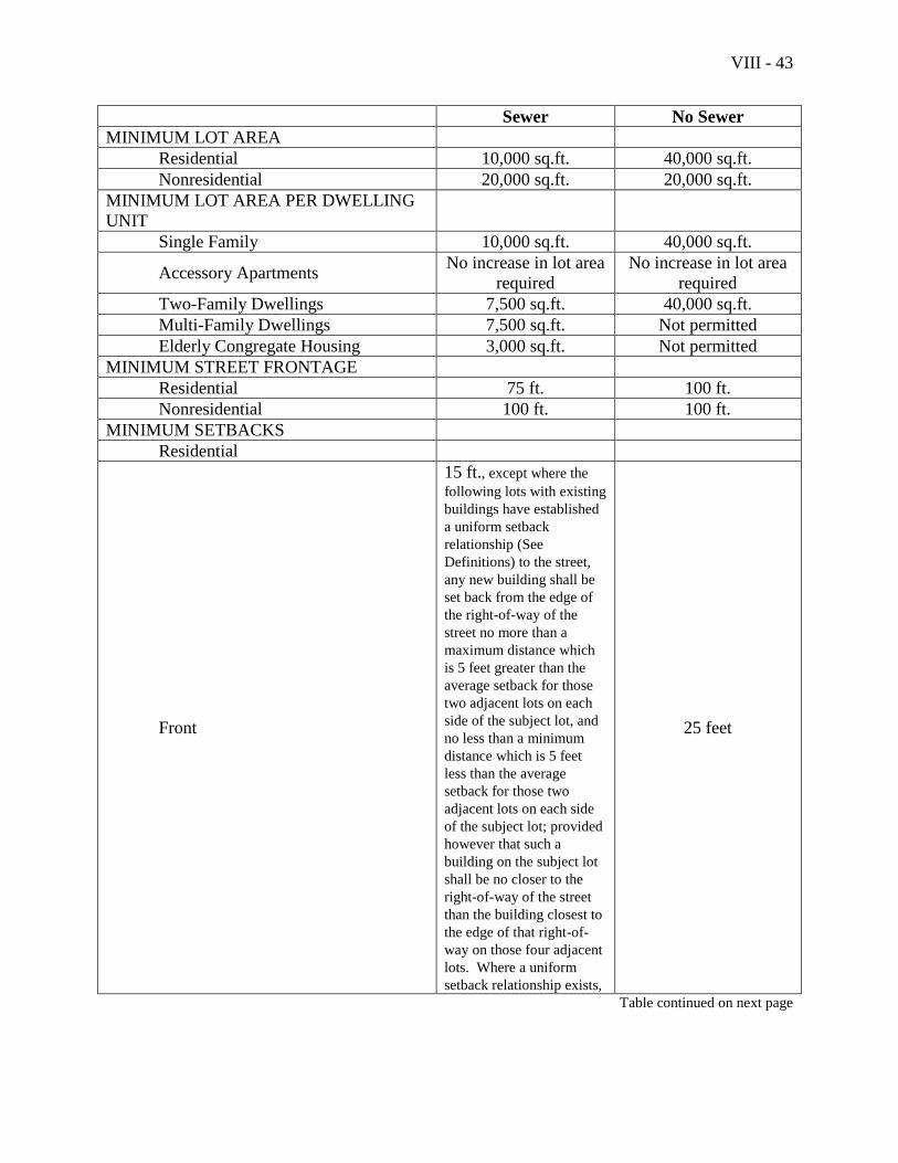
VIII - 43
Sewer No Sewer
MINIMUM LOT AREA
Residential 10,000 sq.ft. 40,000 sq.ft.
Nonresidential 20,000 sq.ft. 20,000 sq.ft.
MINIMUM LOT AREA PER DWELLING
UNIT
Single Family 10,000 sq.ft. 40,000 sq.ft.
Accessory Apartments No increase in lot area
required
No increase in lot area
required
Two-Family Dwellings 7,500 sq.ft. 40,000 sq.ft.
Multi-Family Dwellings 7,500 sq.ft. Not permitted
Elderly Congregate Housing 3,000 sq.ft. Not permitted
MINIMUM STREET FRONTAGE
Residential 75 ft. 100 ft.
Nonresidential 100 ft. 100 ft.
MINIMUM SETBACKS
Residential
Front
15 ft., except where the
following lots with existing
buildings have established
a uniform setback
relationship (See
Definitions) to the street,
any new building shall be
set back from the edge of
the right-of-way of the
street no more than a
maximum distance which
is 5 feet greater than the
average setback for those
two adjacent lots on each
side of the subject lot, and
no less than a minimum
distance which is 5 feet
less than the average
setback for those two
adjacent lots on each side
of the subject lot; provided
however that such a
building on the subject lot
shall be no closer to the
right-of-way of the street
than the building closest to
the edge of that right-of-
way on those four adjacent
lots. Where a uniform
setback relationship exists,
25 feet
Table continued on next page
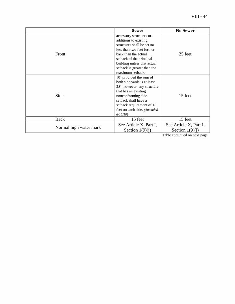
VIII - 44
Sewer No Sewer
Front
accessory structures or
additions to existing
structures shall be set no
less than two feet further
back than the actual
setback of the principal
building unless that actual
setback is greater than the
maximum setback.
25 feet
Side
10’ provided the sum of
both side yards is at least
25’; however, any structure
that has an existing
nonconforming side
setback shall have a
setback requirement of 15
feet on each side. (Amended
6/15/10)
15 feet
Back 15 feet 15 feet
Normal high water mark See Article X, Part I,
Section 1(9)(j)
See Article X, Part I,
Section 1(9)(j) Table continued on next page
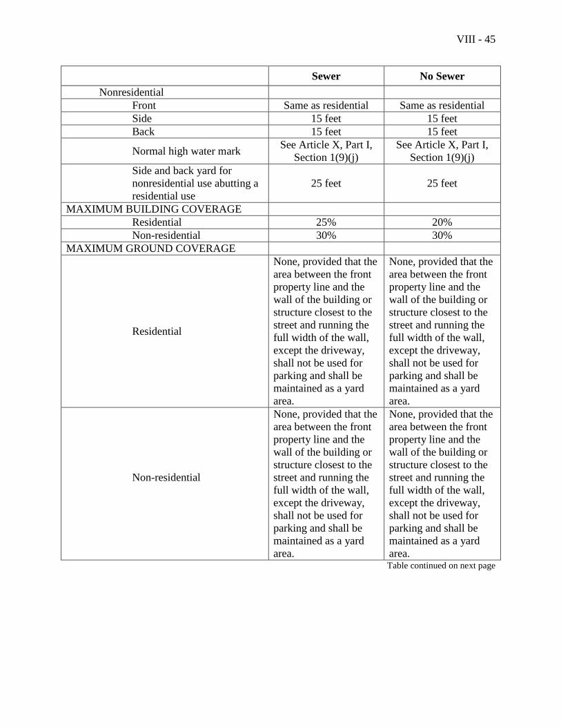
VIII - 45
Sewer No Sewer
Nonresidential
Front Same as residential Same as residential
Side 15 feet 15 feet
Back 15 feet 15 feet
Normal high water mark See Article X, Part I,
Section 1(9)(j)
See Article X, Part I,
Section 1(9)(j)
Side and back yard for
nonresidential use abutting a
residential use
25 feet 25 feet
MAXIMUM BUILDING COVERAGE
Residential 25% 20%
Non-residential 30% 30%
MAXIMUM GROUND COVERAGE
Residential
None, provided that the
area between the front
property line and the
wall of the building or
structure closest to the
street and running the
full width of the wall,
except the driveway,
shall not be used for
parking and shall be
maintained as a yard
area.
None, provided that the
area between the front
property line and the
wall of the building or
structure closest to the
street and running the
full width of the wall,
except the driveway,
shall not be used for
parking and shall be
maintained as a yard
area.
Non-residential
None, provided that the
area between the front
property line and the
wall of the building or
structure closest to the
street and running the
full width of the wall,
except the driveway,
shall not be used for
parking and shall be
maintained as a yard
area.
None, provided that the
area between the front
property line and the
wall of the building or
structure closest to the
street and running the
full width of the wall,
except the driveway,
shall not be used for
parking and shall be
maintained as a yard
area. Table continued on next page
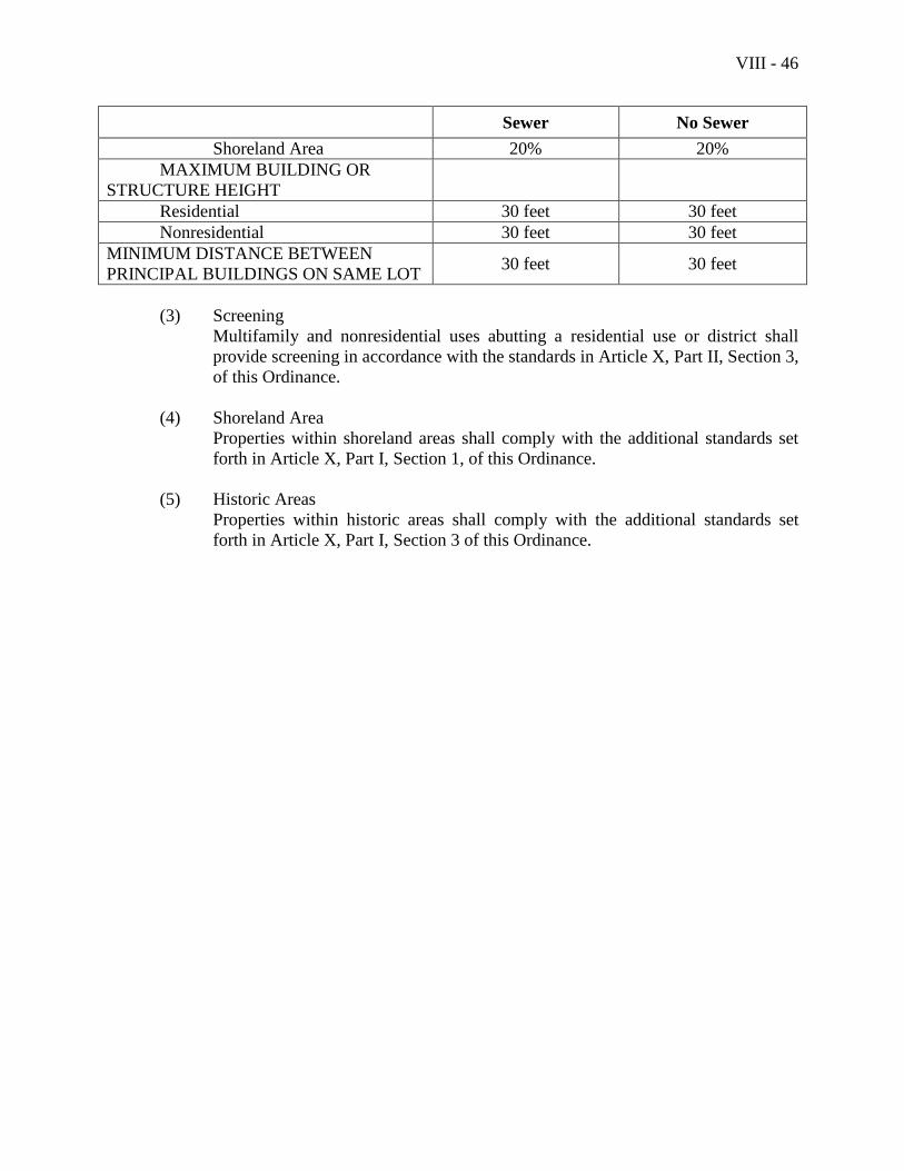
VIII - 46
Sewer No Sewer
Shoreland Area 20% 20%
MAXIMUM BUILDING OR
STRUCTURE HEIGHT
Residential 30 feet 30 feet
Nonresidential 30 feet 30 feet
MINIMUM DISTANCE BETWEEN
PRINCIPAL BUILDINGS ON SAME LOT 30 feet 30 feet
(3) Screening
Multifamily and nonresidential uses abutting a residential use or district shall
provide screening in accordance with the standards in Article X, Part II, Section 3,
of this Ordinance.
(4) Shoreland Area
Properties within shoreland areas shall comply with the additional standards set
forth in Article X, Part I, Section 1, of this Ordinance.
(5) Historic Areas
Properties within historic areas shall comply with the additional standards set
forth in Article X, Part I, Section 3 of this Ordinance.

VIII - 47
This page intentionally left blank
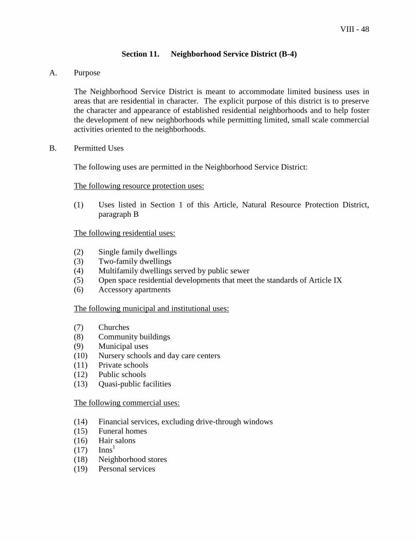
VIII - 48
Section 11. Neighborhood Service District (B-4)
A. Purpose
The Neighborhood Service District is meant to accommodate limited business uses in
areas that are residential in character. The explicit purpose of this district is to preserve
the character and appearance of established residential neighborhoods and to help foster
the development of new neighborhoods while permitting limited, small scale commercial
activities oriented to the neighborhoods.
B. Permitted Uses
The following uses are permitted in the Neighborhood Service District:
The following resource protection uses:
(1) Uses listed in Section 1 of this Article, Natural Resource Protection District,
paragraph B
The following residential uses:
(2) Single family dwellings
(3) Two-family dwellings
(4) Multifamily dwellings served by public sewer
(5) Open space residential developments that meet the standards of Article IX
(6) Accessory apartments
The following municipal and institutional uses:
(7) Churches
(8) Community buildings
(9) Municipal uses
(10) Nursery schools and day care centers
(11) Private schools
(12) Public schools
(13) Quasi-public facilities
The following commercial uses:
(14) Financial services, excluding drive-through windows
(15) Funeral homes
(16) Hair salons
(17) Inns1
(18) Neighborhood stores
(19) Personal services
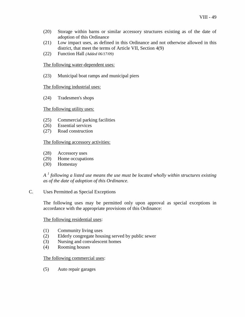
VIII - 49
(20) Storage within barns or similar accessory structures existing as of the date of
adoption of this Ordinance
(21) Low impact uses, as defined in this Ordinance and not otherwise allowed in this
district, that meet the terms of Article VII, Section 4(9)
(22) Function Hall (Added 06/17/09)
The following water-dependent uses:
(23) Municipal boat ramps and municipal piers
The following industrial uses:
(24) Tradesmen's shops
The following utility uses:
(25) Commercial parking facilities
(26) Essential services
(27) Road construction
The following accessory activities:
(28) Accessory uses
(29) Home occupations
(30) Homestay
A 1 following a listed use means the use must be located wholly within structures existing
as of the date of adoption of this Ordinance.
C. Uses Permitted as Special Exceptions
The following uses may be permitted only upon approval as special exceptions in
accordance with the appropriate provisions of this Ordinance:
The following residential uses:
(1) Community living uses
(2) Elderly congregate housing served by public sewer
(3) Nursing and convalescent homes
(4) Rooming houses
The following commercial uses:
(5) Auto repair garages
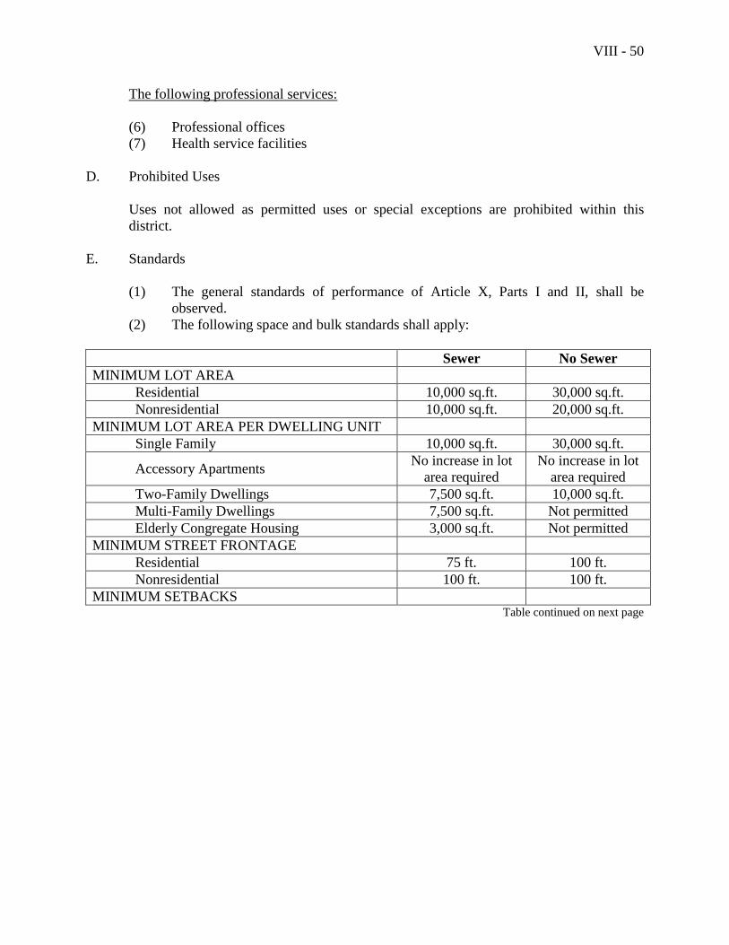
VIII - 50
The following professional services:
(6) Professional offices
(7) Health service facilities
D. Prohibited Uses
Uses not allowed as permitted uses or special exceptions are prohibited within this
district.
E. Standards
(1) The general standards of performance of Article X, Parts I and II, shall be
observed.
(2) The following space and bulk standards shall apply:
Sewer No Sewer
MINIMUM LOT AREA
Residential 10,000 sq.ft. 30,000 sq.ft.
Nonresidential 10,000 sq.ft. 20,000 sq.ft.
MINIMUM LOT AREA PER DWELLING UNIT
Single Family 10,000 sq.ft. 30,000 sq.ft.
Accessory Apartments No increase in lot
area required
No increase in lot
area required
Two-Family Dwellings 7,500 sq.ft. 10,000 sq.ft.
Multi-Family Dwellings 7,500 sq.ft. Not permitted
Elderly Congregate Housing 3,000 sq.ft. Not permitted
MINIMUM STREET FRONTAGE
Residential 75 ft. 100 ft.
Nonresidential 100 ft. 100 ft.
MINIMUM SETBACKS Table continued on next page
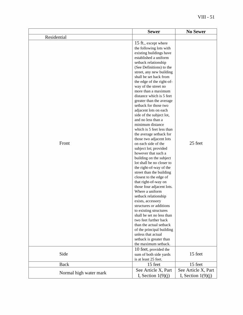
VIII - 51
Sewer No Sewer
Residential
Front
15 ft., except where
the following lots with
existing buildings have
established a uniform
setback relationship
(See Definitions) to the
street, any new building
shall be set back from
the edge of the right-of-
way of the street no
more than a maximum
distance which is 5 feet
greater than the average
setback for those two
adjacent lots on each
side of the subject lot,
and no less than a
minimum distance
which is 5 feet less than
the average setback for
those two adjacent lots
on each side of the
subject lot; provided
however that such a
building on the subject
lot shall be no closer to
the right-of-way of the
street than the building
closest to the edge of
that right-of-way on
those four adjacent lots.
Where a uniform
setback relationship
exists, accessory
structures or additions
to existing structures
shall be set no less than
two feet further back
than the actual setback
of the principal building
unless that actual
setback is greater than
the maximum setback.
25 feet
Side 10 feet, provided the
sum of both side yards
is at least 25 feet.
15 feet
Back 15 feet 15 feet
Normal high water mark See Article X, Part
I, Section 1(9)(j)
See Article X, Part
I, Section 1(9)(j)

VIII - 52
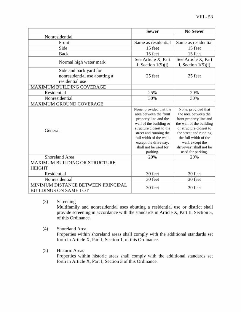
VIII - 53
Sewer No Sewer
Nonresidential
Front Same as residential Same as residential
Side 15 feet 15 feet
Back 15 feet 15 feet
Normal high water mark See Article X, Part
I, Section 1(9)(j)
See Article X, Part
I, Section 1(9)(j)
Side and back yard for
nonresidential use abutting a
residential use
25 feet 25 feet
MAXIMUM BUILDING COVERAGE
Residential 25% 20%
Nonresidential 30% 30%
MAXIMUM GROUND COVERAGE
General
None, provided that the
area between the front
property line and the
wall of the building or
structure closest to the
street and running the
full width of the wall,
except the driveway,
shall not be used for
parking.
None, provided that
the area between the
front property line and
the wall of the building
or structure closest to
the street and running
the full width of the
wall, except the
driveway, shall not be
used for parking.
Shoreland Area 20% 20%
MAXIMUM BUILDING OR STRUCTURE
HEIGHT
Residential 30 feet 30 feet
Nonresidential 30 feet 30 feet
MINIMUM DISTANCE BETWEEN PRINCIPAL
BUILDINGS ON SAME LOT 30 feet 30 feet
(3) Screening
Multifamily and nonresidential uses abutting a residential use or district shall
provide screening in accordance with the standards in Article X, Part II, Section 3,
of this Ordinance.
(4) Shoreland Area
Properties within shoreland areas shall comply with the additional standards set
forth in Article X, Part I, Section 1, of this Ordinance.
(5) Historic Areas
Properties within historic areas shall comply with the additional standards set
forth in Article X, Part I, Section 3 of this Ordinance.

VIII - 54
This page intentionally left blank

VIII - 55
Section 12. Harbor Business District (B-H)
A. Purpose
The purpose of the Harbor Business District is to preserve and maintain for the citizens of
Camden the character of Camden Harbor, including its scenic value and views from the
land, its accessibility to the public, and its economic value for functionally water-
dependent uses.
B. Permitted Uses
The following uses are permitted in the Harbor Business District:
The following resource protection uses:
(1) Uses listed in Section 1 of this Article, Natural Resource Protection District,
paragraph B
The following residential uses: (Amended 06/17/08)
(2) Single family dwellings, provided the standards of E, (6) are met.
(3) Two-family dwellings, provided the standards of E, (6) are met.
(4) Multifamily dwellings, provided the standards of E, (6) are met.
The following marine-related uses: (Added 06/17/08)
(5) Boat and marine sales, service, maintenance, repair and construction, including
marine fabrication, sail making, canvas manufacturing, marine metal casting
(6) Indoor and outdoor boat storage
(7) Marine and oceanographic research laboratories
(8) Marine transportation offices including shipping offices
(9) Professional and business offices where maritime issues and products are the
primary use, i.e. naval architects, surveyors, maritime publishers, maritime
lawyers, etc;
(10) Maritime or historical museums
(11) Yachting or sailing clubs, and schools which give marine or nautical instruction
The following commercial uses: (Amended 06/17/2008)
(12) Financial services, except on a floor at street level
(13) Inns, located at least 276 feet from the harbor line (Amended 06/17/2008)
(14) Leasing, rental, and storage facilities, excluding those that serve or benefit any
dwelling unit or owner thereof, within the same structure or on a common lot or
tract of land. (Amended – 11/13/07)
(15) Publishing of newspapers, magazines, and books (excluding printing plants),
except on a floor at street level
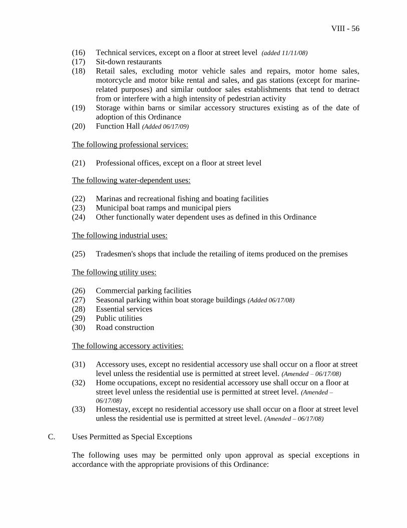
VIII - 56
(16) Technical services, except on a floor at street level (added 11/11/08)
(17) Sit-down restaurants
(18) Retail sales, excluding motor vehicle sales and repairs, motor home sales,
motorcycle and motor bike rental and sales, and gas stations (except for marine-
related purposes) and similar outdoor sales establishments that tend to detract
from or interfere with a high intensity of pedestrian activity
(19) Storage within barns or similar accessory structures existing as of the date of
adoption of this Ordinance
(20) Function Hall (Added 06/17/09)
The following professional services:
(21) Professional offices, except on a floor at street level
The following water-dependent uses:
(22) Marinas and recreational fishing and boating facilities
(23) Municipal boat ramps and municipal piers
(24) Other functionally water dependent uses as defined in this Ordinance
The following industrial uses:
(25) Tradesmen's shops that include the retailing of items produced on the premises
The following utility uses:
(26) Commercial parking facilities
(27) Seasonal parking within boat storage buildings (Added 06/17/08)
(28) Essential services
(29) Public utilities
(30) Road construction
The following accessory activities:
(31) Accessory uses, except no residential accessory use shall occur on a floor at street
level unless the residential use is permitted at street level. (Amended – 06/17/08)
(32) Home occupations, except no residential accessory use shall occur on a floor at
street level unless the residential use is permitted at street level. (Amended –
06/17/08) (33) Homestay, except no residential accessory use shall occur on a floor at street level
unless the residential use is permitted at street level. (Amended – 06/17/08)
C. Uses Permitted as Special Exceptions
The following uses may be permitted only upon approval as special exceptions in
accordance with the appropriate provisions of this Ordinance:
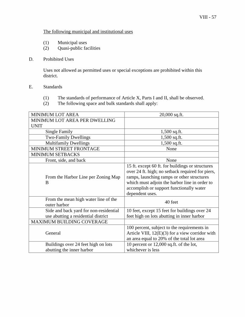
VIII - 57
The following municipal and institutional uses
(1) Municipal uses
(2) Quasi-public facilities
D. Prohibited Uses
Uses not allowed as permitted uses or special exceptions are prohibited within this
district.
E. Standards
(1) The standards of performance of Article X, Parts I and II, shall be observed.
(2) The following space and bulk standards shall apply:
MINIMUM LOT AREA 20,000 sq.ft.
MINIMUM LOT AREA PER DWELLING
UNIT
Single Family 1,500 sq.ft.
Two-Family Dwellings 1,500 sq.ft.
Multifamily Dwellings 1,500 sq.ft.
MINIMUM STREET FRONTAGE None
MINIMUM SETBACKS
Front, side, and back None
From the Harbor Line per Zoning Map
B
15 ft. except 60 ft. for buildings or structures
over 24 ft. high; no setback required for piers,
ramps, launching ramps or other structures
which must adjoin the harbor line in order to
accomplish or support functionally water
dependent uses.
From the mean high water line of the
outer harbor 40 feet
Side and back yard for non-residential
use abutting a residential district
10 feet, except 15 feet for buildings over 24
feet high on lots abutting in inner harbor
MAXIMUM BUILDING COVERAGE
General
100 percent, subject to the requirements in
Article VIII, 12(E)(3) for a view corridor with
an area equal to 20% of the total lot area
Buildings over 24 feet high on lots
abutting the inner harbor
10 percent or 12,000 sq.ft. of the lot,
whichever is less
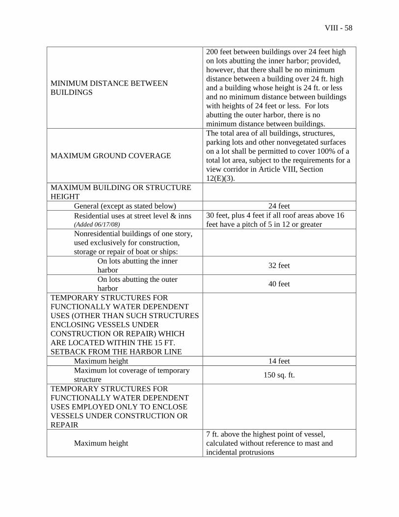
VIII - 58
MINIMUM DISTANCE BETWEEN
BUILDINGS
200 feet between buildings over 24 feet high
on lots abutting the inner harbor; provided,
however, that there shall be no minimum
distance between a building over 24 ft. high
and a building whose height is 24 ft. or less
and no minimum distance between buildings
with heights of 24 feet or less. For lots
abutting the outer harbor, there is no
minimum distance between buildings.
MAXIMUM GROUND COVERAGE
The total area of all buildings, structures,
parking lots and other nonvegetated surfaces
on a lot shall be permitted to cover 100% of a
total lot area, subject to the requirements for a
view corridor in Article VIII, Section
12(E)(3).
MAXIMUM BUILDING OR STRUCTURE
HEIGHT
General (except as stated below) 24 feet
Residential uses at street level & inns (Added 06/17/08)
30 feet, plus 4 feet if all roof areas above 16
feet have a pitch of 5 in 12 or greater
Nonresidential buildings of one story,
used exclusively for construction,
storage or repair of boat or ships:
On lots abutting the inner
harbor 32 feet
On lots abutting the outer
harbor 40 feet
TEMPORARY STRUCTURES FOR
FUNCTIONALLY WATER DEPENDENT
USES (OTHER THAN SUCH STRUCTURES
ENCLOSING VESSELS UNDER
CONSTRUCTION OR REPAIR) WHICH
ARE LOCATED WITHIN THE 15 FT.
SETBACK FROM THE HARBOR LINE
Maximum height 14 feet
Maximum lot coverage of temporary
structure 150 sq. ft.
TEMPORARY STRUCTURES FOR
FUNCTIONALLY WATER DEPENDENT
USES EMPLOYED ONLY TO ENCLOSE
VESSELS UNDER CONSTRUCTION OR
REPAIR
Maximum height
7 ft. above the highest point of vessel,
calculated without reference to mast and
incidental protrusions
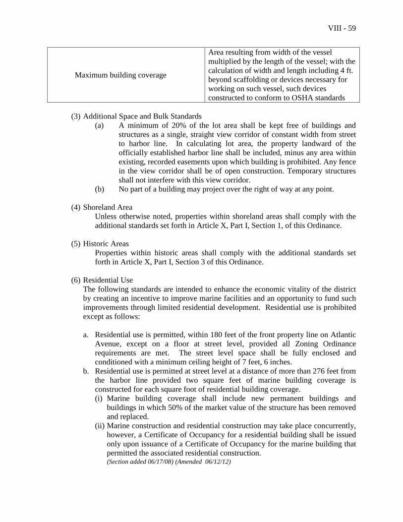
VIII - 59
Maximum building coverage
Area resulting from width of the vessel
multiplied by the length of the vessel; with the
calculation of width and length including 4 ft.
beyond scaffolding or devices necessary for
working on such vessel, such devices
constructed to conform to OSHA standards
(3) Additional Space and Bulk Standards
(a) A minimum of 20% of the lot area shall be kept free of buildings and
structures as a single, straight view corridor of constant width from street
to harbor line. In calculating lot area, the property landward of the
officially established harbor line shall be included, minus any area within
existing, recorded easements upon which building is prohibited. Any fence
in the view corridor shall be of open construction. Temporary structures
shall not interfere with this view corridor.
(b) No part of a building may project over the right of way at any point.
(4) Shoreland Area
Unless otherwise noted, properties within shoreland areas shall comply with the
additional standards set forth in Article X, Part I, Section 1, of this Ordinance.
(5) Historic Areas
Properties within historic areas shall comply with the additional standards set
forth in Article X, Part I, Section 3 of this Ordinance.
(6) Residential Use
The following standards are intended to enhance the economic vitality of the district
by creating an incentive to improve marine facilities and an opportunity to fund such
improvements through limited residential development. Residential use is prohibited
except as follows:
a. Residential use is permitted, within 180 feet of the front property line on Atlantic
Avenue, except on a floor at street level, provided all Zoning Ordinance
requirements are met. The street level space shall be fully enclosed and
conditioned with a minimum ceiling height of 7 feet, 6 inches.
b. Residential use is permitted at street level at a distance of more than 276 feet from
the harbor line provided two square feet of marine building coverage is
constructed for each square foot of residential building coverage.
(i) Marine building coverage shall include new permanent buildings and
buildings in which 50% of the market value of the structure has been removed
and replaced.
(ii) Marine construction and residential construction may take place concurrently,
however, a Certificate of Occupancy for a residential building shall be issued
only upon issuance of a Certificate of Occupancy for the marine building that
permitted the associated residential construction. (Section added 06/17/08) (Amended 06/12/12)

VIII - 60
This page intentionally left blank
VIII - 61
Section 13. River Business District (B-R)
A. Purpose
The purpose of the River Business District is to provide for the maintenance,
development and redevelopment of lands and buildings in river-oriented locations that
have historically been used for economic activity, or for which there is opportunity for
such activity. It is intended that development and redevelopment proceed in a way that
respects and maintains the environmental and scenic qualities of the river.
B. Permitted Uses
The following uses are permitted in the River Business District:
The following resource protection uses:
(1) Uses listed in Section 1 of this Article, Natural Resource Protection District,
paragraph B
The following resource production uses:
(2) Timber harvesting
The following residential uses:
(3) Multifamily dwellings, except that no residential use shall occur on a floor at
street level
(4) Mobile home parks existing as of November 4, 2008 (added 11/11/08)
The following municipal and institutional uses:
(5) Municipal uses (added 6/20/06)
(6) Quasi-public facilities
The following commercial uses:
(7) Auction barns
(8) Auto repair garages
(9) Boat and marine sales and service
(10) Clinics for animals
(11) Commercial schools
(12) Fast food restaurants, excluding drive-through windows
(13) Financial services
(14) Hair salons
(15) Hotels and motels
(16) Inns
VIII - 62
(17) Leasing, rental, and storage facilities
(18) Outdoor boat storage
(19) Personal services
(20) Publishing of newspapers, magazines, and books
(21) Retail sales and rental of goods and equipment, provided there is no exterior
storage or display of motor vehicles
(22) Sit-down restaurants
(23) Storage within barns or similar accessory structures existing as of the date of
adoption of this Ordinance
(24) Theaters and entertainment, excluding games and activities common to
amusement parks
(25) Low impact uses, as defined in this Ordinance and not otherwise allowed in this
district, that meet the terms of Article VII, Section 4(9)
(26) Technical services
(27) Function Hall (Added 06/17/09)
The following professional services:
(28) Professional offices
(29) Health service facilities
The following industrial uses:
(30) Agricultural products processing plants
(31) Manufacturing
(32) Printing plants
(33) Research and development
(34) Storage and maintenance of construction equipment
(35) Tradesmen's shops
(36) Warehousing, excluding truck terminals
(37) Wholesale trade
The following utility uses:
(38) Commercial parking facilities
(39) Essential services
(40) Public utilities
(41) Road construction
The following accessory activities:
(42) Accessory uses
(43) Home occupations
(44) Homestay
VIII - 63
C. Uses Permitted as Special Exceptions
The following uses may be permitted only upon approval as special exceptions in
accordance with the appropriate provisions of this Ordinance:
D. Prohibited Uses
Uses not allowed as permitted uses or special exceptions are prohibited within this
district.
E. Standards
(1) The standards of performance of Article X, Parts I and II, shall be observed.
(2) The following space and bulk standards shall apply:
MINIMUM LOT AREA
Residential None
Nonresidential None
MINIMUM LOT AREA PER DWELLING UNIT
Single Family Not permitted
Two-Family dwellings Not permitted
Multifamily dwellings 1,500 sq.ft.
Elderly congregate housing Not permitted
MINIMUM STREET FRONTAGE None
MINIMUM SETBACKS
Front, side, and back None
Normal high water mark
Parking lots and paved surfaces 75 feet
Structures 30 feet
Side and back yard for nonresidential use abutting a
residential district or a lot wholly or partially in
residential use
25 feet
MAXIMUM BUILDING COVERAGE 70 percent
MAXIMUM GROUND COVERAGE 70 percent
MAXIMUM BUILDING OR STRUCTURE HEIGHT
Residential 40 feet
Nonresidential 40 feet
MINIMUM DISTANCE BETWEEN PRINCIPAL
BUILDINGS ON SAME LOT None
(3) Screening
Multifamily and nonresidential uses abutting a residential use or district shall
provide screening in accordance with the standards in Article X, Part II, Section 3,
of this Ordinance.
VIII - 64
(4) Shoreland Area
Unless otherwise noted, properties within shoreland areas shall comply with the
additional standards set forth in Article X, Part I, Section 1, of this Ordinance.
(5) Historic Areas
Properties within historic areas shall comply with the additional standards set
forth in Article X, Part I, Section 3 of this Ordinance.
VIII - 65
Section 14. Transitional River Business District (B-TR)
A. Purpose
The purpose of the Transitional River Business District is to provide for a compact,
pedestrian oriented, year round business center in keeping with the scale and character of
downtown Camden, with a focus on small scale specialty and comparison shopping,
while also encouraging development and redevelopment of lands and buildings in river-
oriented locations that have historically been used for economic activity, or for which
there is opportunity for such activity.
B. Permitted Uses
The following uses are permitted in the Transitional River Business District:
The following resource protection uses:
(1) Uses listed in Section 1 of this Article, Natural Resource Protection District,
Paragraph B
The following residential uses:
(2) Single family dwellings, except no residential uses shall occur on a floor at street
level
(3) Two-family dwellings, except no residential uses shall occur on a floor at street
level
(4) Multifamily dwellings, except no residential uses shall occur on a floor at street
level
(5) Elderly congregate housing, except no residential uses shall occur on a floor at
street level
The following municipal and institutional uses:
(6) Churches
(7) Community buildings
(8) Municipal uses
(9) Nursery schools and day care centers
(10) Private schools
(11) Public schools
(12) Quasi-public facilities
The following commercial uses:
(13) Boat and marine sales and services
(14) Commercial schools
(15) Food service, excluding drive-through windows
VIII - 66
(16) Financial services, excluding drive-through windows
(17) Funeral homes
(18) Hair salons
(19) Hotels and motels
(20) Inns
(21) Auction sales
(22) Outdoor boat storage incidental to other uses, or in conjunction with boat
maintenance or repair
(23) Personal services
(24) Publishing of newspapers, magazines, and books
(25) Retail sales and rental of goods and equipment, excluding gas stations, or exterior
display or storage of motor vehicles
(26) Storage within barns or similar accessory structures existing as of the date of
adoption of this Ordinance
(27) Theaters and entertainment, excluding outdoor games and activities common to
amusement parks
(28) Low impact uses, as defined in this Ordinance and not otherwise allowed in this
district and that meet the terms of Article VII, Section 4(9)
(28A) Technical services
(29) Function Hall (Added 06/17/09)
The following professional services:
(30) Professional offices
(31) Health service facilities
The following water-dependent uses:
(32) Municipal boat ramps and municipal piers
The following industrial uses:
(33) Manufacturing, excluding fish or animal processing and petroleum processing
(34) Printing plants
(35) Research and development
(36) Interior storage and maintenance of construction equipment
(37) Tradesmen's shops
(38) Warehousing within structures existing as of the date of adoption of this
Ordinance, excluding truck terminals
(39) Wholesale trade
The following utility uses:
(40) Commercial parking facilities
(41) Essential services
(42) Public utilities
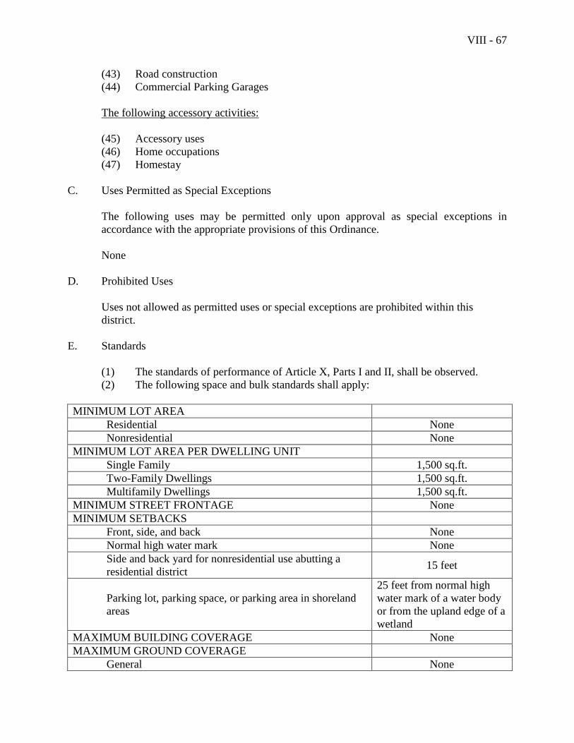
VIII - 67
(43) Road construction
(44) Commercial Parking Garages
The following accessory activities:
(45) Accessory uses
(46) Home occupations
(47) Homestay
C. Uses Permitted as Special Exceptions
The following uses may be permitted only upon approval as special exceptions in
accordance with the appropriate provisions of this Ordinance.
None
D. Prohibited Uses
Uses not allowed as permitted uses or special exceptions are prohibited within this
district.
E. Standards
(1) The standards of performance of Article X, Parts I and II, shall be observed.
(2) The following space and bulk standards shall apply:
MINIMUM LOT AREA
Residential None
Nonresidential None
MINIMUM LOT AREA PER DWELLING UNIT
Single Family 1,500 sq.ft.
Two-Family Dwellings 1,500 sq.ft.
Multifamily Dwellings 1,500 sq.ft.
MINIMUM STREET FRONTAGE None
MINIMUM SETBACKS
Front, side, and back None
Normal high water mark None
Side and back yard for nonresidential use abutting a
residential district 15 feet
Parking lot, parking space, or parking area in shoreland
areas
25 feet from normal high
water mark of a water body
or from the upland edge of a
wetland
MAXIMUM BUILDING COVERAGE None
MAXIMUM GROUND COVERAGE
General None
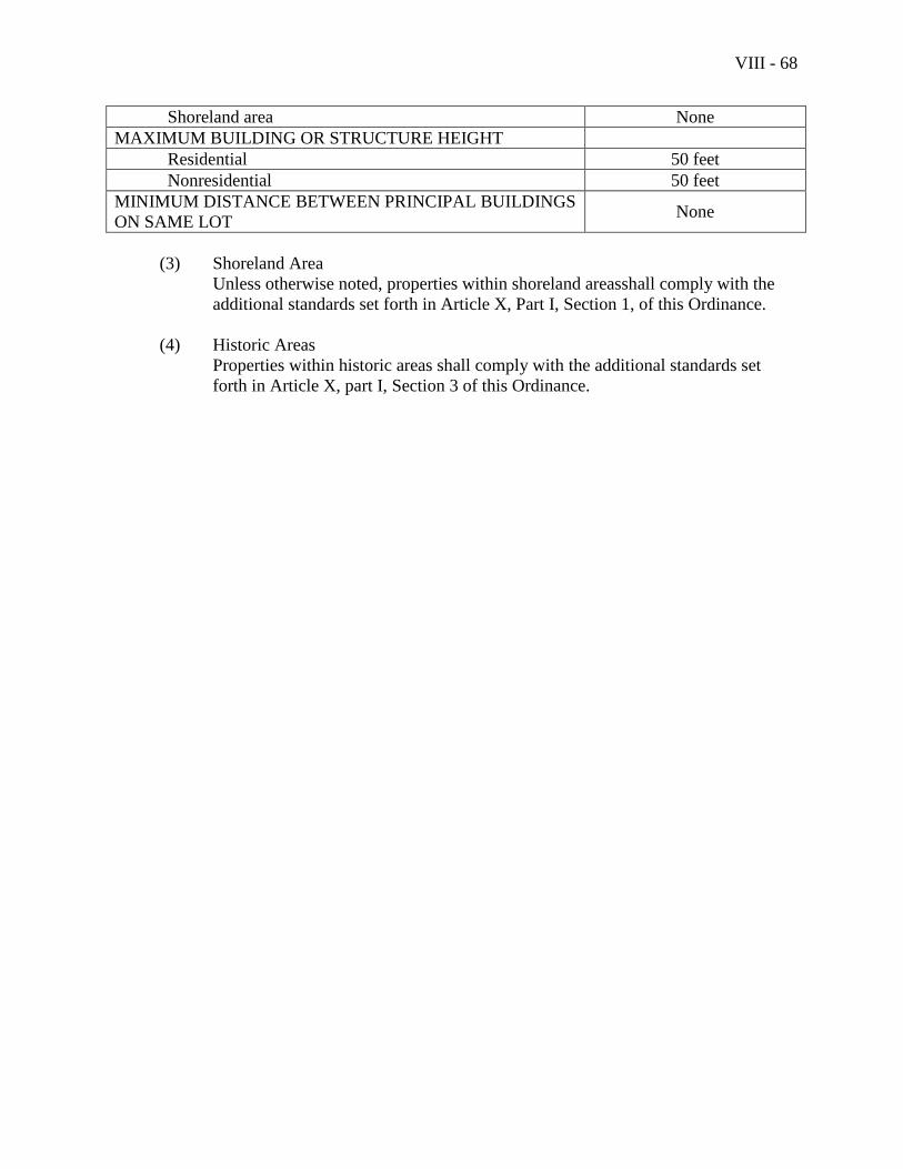
VIII - 68
Shoreland area None
MAXIMUM BUILDING OR STRUCTURE HEIGHT
Residential 50 feet
Nonresidential 50 feet
MINIMUM DISTANCE BETWEEN PRINCIPAL BUILDINGS
ON SAME LOT None
(3) Shoreland Area
Unless otherwise noted, properties within shoreland areasshall comply with the
additional standards set forth in Article X, Part I, Section 1, of this Ordinance.
(4) Historic Areas
Properties within historic areas shall comply with the additional standards set
forth in Article X, part I, Section 3 of this Ordinance.
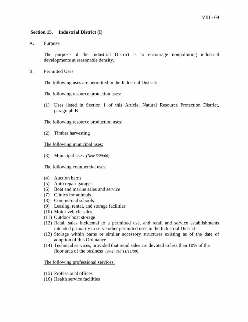
VIII - 69
Section 15. Industrial District (I)
A. Purpose
The purpose of the Industrial District is to encourage nonpolluting industrial
developments at reasonable density.
B. Permitted Uses
The following uses are permitted in the Industrial District:
The following resource protection uses:
(1) Uses listed in Section 1 of this Article, Natural Resource Protection District,
paragraph B
The following resource production uses:
(2) Timber harvesting
The following municipal uses:
(3) Municipal uses (New 6/20/06)
The following commercial uses:
(4) Auction barns
(5) Auto repair garages
(6) Boat and marine sales and service
(7) Clinics for animals
(8) Commercial schools
(9) Leasing, rental, and storage facilities
(10) Motor vehicle sales
(11) Outdoor boat storage
(12) Retail sales incidental to a permitted use, and retail and service establishments
intended primarily to serve other permitted uses in the Industrial District
(13) Storage within barns or similar accessory structures existing as of the date of
adoption of this Ordinance
(14) Technical services, provided that retail sales are devoted to less than 10% of the
floor area of the business (amended 11/11/08)
The following professional services:
(15) Professional offices
(16) Health service facilities
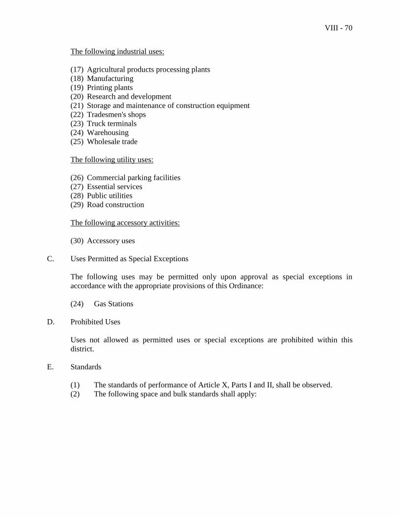
VIII - 70
The following industrial uses:
(17) Agricultural products processing plants
(18) Manufacturing
(19) Printing plants
(20) Research and development
(21) Storage and maintenance of construction equipment
(22) Tradesmen's shops
(23) Truck terminals
(24) Warehousing
(25) Wholesale trade
The following utility uses:
(26) Commercial parking facilities
(27) Essential services
(28) Public utilities
(29) Road construction
The following accessory activities:
(30) Accessory uses
C. Uses Permitted as Special Exceptions
The following uses may be permitted only upon approval as special exceptions in
accordance with the appropriate provisions of this Ordinance:
(24) Gas Stations
D. Prohibited Uses
Uses not allowed as permitted uses or special exceptions are prohibited within this
district.
E. Standards
(1) The standards of performance of Article X, Parts I and II, shall be observed.
(2) The following space and bulk standards shall apply:
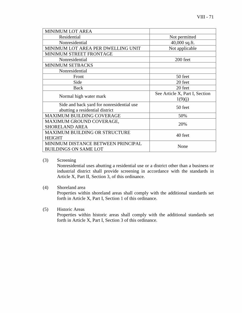
VIII - 71
MINIMUM LOT AREA
Residential Not permitted
Nonresidential 40,000 sq.ft.
MINIMUM LOT AREA PER DWELLING UNIT Not applicable
MINIMUM STREET FRONTAGE
Nonresidential 200 feet
MINIMUM SETBACKS
Nonresidential
Front 50 feet
Side 20 feet
Back 20 feet
Normal high water mark See Article X, Part I, Section
1(9)(j)
Side and back yard for nonresidential use
abutting a residential district 50 feet
MAXIMUM BUILDING COVERAGE 50%
MAXIMUM GROUND COVERAGE,
SHORELAND AREA 20%
MAXIMUM BUILDING OR STRUCTURE
HEIGHT 40 feet
MINIMUM DISTANCE BETWEEN PRINCIPAL
BUILDINGS ON SAME LOT None
(3) Screening
Nonresidential uses abutting a residential use or a district other than a business or
industrial district shall provide screening in accordance with the standards in
Article X, Part II, Section 3, of this ordinance.
(4) Shoreland area
Properties within shoreland areas shall comply with the additional standards set
forth in Article X, Part I, Section 1 of this ordinance.
(5) Historic Areas
Properties within historic areas shall comply with the additional standards set
forth in Article X, Part I, Section 3 of this ordinance.

VIII - 72
This page intentionally left blank
VIII - 73
Section 16. Transitional Harbor Business District (B-TH)
A. Purpose
The purpose of the Transitional Harbor Business District is to provide a transition
between the inner harbor retail district and the residential neighborhood of the outer
harbor while preserving and maintaining the character, scenic value, accessibility and
economic value for functionally water-dependent uses in Camden Harbor. (New 6/20/06)
B. Permitted Uses
The following uses are permitted in the Transitional Harbor Business District:
The following resource protection uses:
(1) Uses listed in Section 1 of this Article, Natural Resource Protection District,
paragraph B
The following residential uses: (Amended 06/17/08)
(2) Single family dwellings within 55 feet of the front property line on Bay View
Street, except no residential use shall occur on a floor at street level
(3) Two-family dwellings within 55 feet of the front property line on Bay View
Street, except no residential use shall occur on a floor at street level
(4) Multifamily dwellings within 55 feet of the front property line on Bay View
Street, except no residential use shall occur on a floor at street level
The following marine-related uses: (New 06/17/08)
(5) Boat and marine sales, service, maintenance, repair and construction including
marine fabrication, sail making, canvas manufacturing, & marine metal casting
(6) Indoor and outdoor boat storage
(7) Marine and oceanographic research laboratories
(8) Marine transportation offices including shipping offices
(9) Professional and business offices where maritime issues and products are the
primary use, i.e. naval architects, surveyors, maritime publishers, maritime
lawyers, etc;
(10) Maritime or historical museums
(11) Yachting or sailing clubs, and schools which give maritime or nautical instruction
The following commercial uses:
(12) Financial services (Amended 06/17/09)
(13) Inns (Amended 06/17/09)
(14) Leasing, rental, and storage facilities
(15) Publishing (Amended 06/17/09)
VIII - 74
(16) Technical services, except on a floor at street level (added 11/11/08)
(17) Sit-down restaurants
(18) Retail sales, excluding motor vehicle sales and repairs, motor home sales,
motorcycle and motor bike rental and sales, and gas stations (except for marine-
related purposes) and similar outdoor sales establishments that tend to detract
from or interfere with a high intensity of pedestrian activity
(19) Storage within barns or similar accessory structures existing as of the date of
adoption of this Ordinance
(20) Theaters and entertainment (excluding games and activities common to
amusement parks), except on a floor at street level
(21) Function Hall (Added 06/17/09)
(22) Commercial schools within 55 feet of the front property line on Bay View Street (Added 06/17/09)
(23) Funeral homes within 55 feet of the front property line on Bay View Street (Added
06/17/09) (24) Hair salons within 55 feet of the front property line on Bay View Street (Added
06/17/09)
(25) Personal services within 55 feet of the front property line on Bay View Street (Added 06/17/09)
The following professional services:
(26) Professional offices (Amended 06/17/09)
The following water-dependent uses:
(27) Marinas and recreational fishing and boating facilities
(28) Municipal boat ramps and municipal piers
(29) Other functionally water dependent uses as defined in this Ordinance
The following industrial uses:
(30) Tradesmen's shops that include the retailing of items produced on the premises
The following utility uses:
(31) Commercial parking facilities
(32) Essential services
(33) Public utilities
(34) Road construction
The following accessory activities:
(35) Accessory uses
(36) Home occupations
(37) Homestay
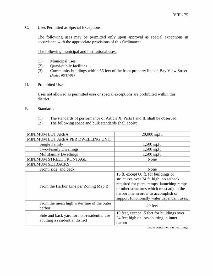
VIII - 75
C. Uses Permitted as Special Exceptions
The following uses may be permitted only upon approval as special exceptions in
accordance with the appropriate provisions of this Ordinance:
The following municipal and institutional uses:
(1) Municipal uses
(2) Quasi-public facilities
(3) Community buildings within 55 feet of the front property line on Bay View Street (Added 06/17/09)
D. Prohibited Uses
Uses not allowed as permitted uses or special exceptions are prohibited within this
district.
E. Standards
(1) The standards of performance of Article X, Parts I and II, shall be observed.
(2) The following space and bulk standards shall apply:
MINIMUM LOT AREA 20,000 sq.ft.
MINIMUM LOT AREA PER DWELLING UNIT
Single Family 1,500 sq.ft.
Two-Family Dwellings 1,500 sq.ft.
Multifamily Dwellings 1,500 sq.ft.
MINIMUM STREET FRONTAGE None
MINIMUM SETBACKS
Front, side, and back None
From the Harbor Line per Zoning Map B
15 ft. except 60 ft. for buildings or
structures over 24 ft. high; no setback
required for piers, ramps, launching ramps
or other structures which must adjoin the
harbor line in order to accomplish or
support functionally water dependent uses.
From the mean high water line of the outer
harbor 40 feet
Side and back yard for non-residential use
abutting a residential district
10 feet, except 15 feet for buildings over
24 feet high on lots abutting in inner
harbor Table continued on next page
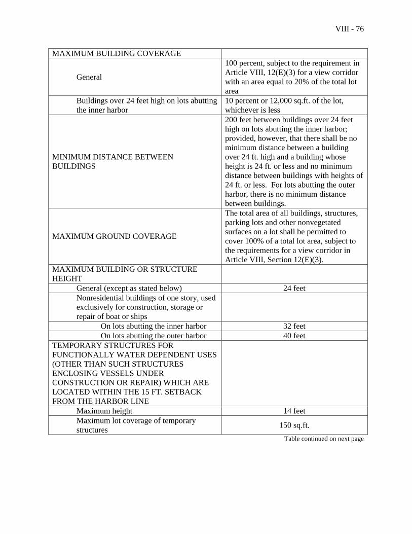
VIII - 76
MAXIMUM BUILDING COVERAGE
General
100 percent, subject to the requirement in
Article VIII, 12(E)(3) for a view corridor
with an area equal to 20% of the total lot
area
Buildings over 24 feet high on lots abutting
the inner harbor
10 percent or 12,000 sq.ft. of the lot,
whichever is less
MINIMUM DISTANCE BETWEEN
BUILDINGS
200 feet between buildings over 24 feet
high on lots abutting the inner harbor;
provided, however, that there shall be no
minimum distance between a building
over 24 ft. high and a building whose
height is 24 ft. or less and no minimum
distance between buildings with heights of
24 ft. or less. For lots abutting the outer
harbor, there is no minimum distance
between buildings.
MAXIMUM GROUND COVERAGE
The total area of all buildings, structures,
parking lots and other nonvegetated
surfaces on a lot shall be permitted to
cover 100% of a total lot area, subject to
the requirements for a view corridor in
Article VIII, Section 12(E)(3).
MAXIMUM BUILDING OR STRUCTURE
HEIGHT
General (except as stated below) 24 feet
Nonresidential buildings of one story, used
exclusively for construction, storage or
repair of boat or ships
On lots abutting the inner harbor 32 feet
On lots abutting the outer harbor 40 feet
TEMPORARY STRUCTURES FOR
FUNCTIONALLY WATER DEPENDENT USES
(OTHER THAN SUCH STRUCTURES
ENCLOSING VESSELS UNDER
CONSTRUCTION OR REPAIR) WHICH ARE
LOCATED WITHIN THE 15 FT. SETBACK
FROM THE HARBOR LINE
Maximum height 14 feet
Maximum lot coverage of temporary
structures 150 sq.ft.
Table continued on next page
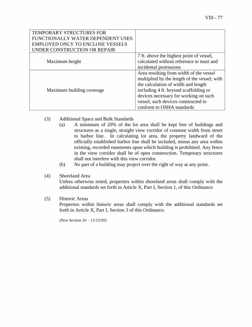
VIII - 77
TEMPORARY STRUCTURES FOR
FUNCTIONALLY WATER DEPENDENT USES
EMPLOYED ONLY TO ENCLOSE VESSELS
UNDER CONSTRUCTION OR REPAIR
Maximum height
7 ft. above the highest point of vessel,
calculated without reference to mast and
incidental protrusions
Maximum building coverage
Area resulting from width of the vessel
multiplied by the length of the vessel; with
the calculation of width and length
including 4 ft. beyond scaffolding or
devices necessary for working on such
vessel, such devices constructed to
conform to OSHA standards
(3) Additional Space and Bulk Standards
(a) A minimum of 20% of the lot area shall be kept free of buildings and
structures as a single, straight view corridor of constant width from street
to harbor line. In calculating lot area, the property landward of the
officially established harbor line shall be included, minus any area within
existing, recorded easements upon which building is prohibited. Any fence
in the view corridor shall be of open construction. Temporary structures
shall not interfere with this view corridor.
(b) No part of a building may project over the right of way at any point.
(4) Shoreland Area
Unless otherwise noted, properties within shoreland areas shall comply with the
additional standards set forth in Article X, Part I, Section 1, of this Ordinance.
(5) Historic Areas
Properties within historic areas shall comply with the additional standards set
forth in Article X, Part I, Section 3 of this Ordinance.
(New Section 16 – 11/15/05)

VIII - 78
This page intentionally left blank
IX - 1
Article IX Open Space Zoning
Section 1. Purpose
The purpose of this Article is, within rural areas of Camden, to maintain the rural,
natural, and scenic qualities of the Town; and, within developing areas, to provide for
flexibility in the design of open space residential development. (Amended – 6/20/2007)
Section 2. Applicability
(1) Rural-1, Rural-2, and Coastal Residential Districts
The provisions of this Article shall be mandatory for residential subdivisions with
three or more lots that are located in the Rural-1, Rural-2, or Coastal Residential
Districts. These provisions are not mandatory for lots within subdivisions that are
located in other districts. (Amended – 6/20/2007)
(2) Village and Village Extension Districts
In Village and Village Extension districts, the provisions of this Article shall be
optional. (Amended – 6/20/2007)
(3) Lots Located In More than One Zoning District
When a lot is located in two or more zoning districts and a majority of the lot falls
within one of the mandatory open space zoning districts, then the lot shall meet
the provisions of this Article. (Amended – 6/20/2007)
Section 3. General Standards
Open space residential developments proposed under the terms of this Article shall meet
all requirements of this Article, unless otherwise noted. The uses of the land shall not
differ from the uses permitted in the district in which the development is located.
“Buildable” land is all land except land within street rights-of-way, wetlands as defined
in this Ordinance, 100-year flood plains, water bodies, or sustained slopes in excess of
20%. Modifications of space and bulk provisions shall not be construed as granting
variances to relieve hardship. (Amended – 6/20/2007)
(1) Within the Rural-1 District:
(a) the total number of dwelling units shall not exceed one unit per 7 acres.
(b) each lot within the subdivision shall contain a minimum of 1 acre of
buildable land. (Amended – 6/20/2007)
IX - 2
(c) lots and/or dwelling units shall be laid out so that, on average, they
encompass (or, in the case of dwelling units not on individual lots,
occupy) no more than two acres of buildable land per lot or dwelling unit,
and so that at least 60% of the parcel remains as open space outside of the
lots and not otherwise assigned to individual dwelling units. (Amended –
6/20/2007)
(d) minimum road frontage shall be 75 feet. However, no individual lot or
dwelling unit shall have its required frontage on a public road existing at
the time of application for development or gain its access from such a
road.
(e) no building or structure shall be located within 25 feet of any property
line.
(f) neither shore frontage nor setbacks from the normal high water marks of
water bodies shall be reduced below the minimum otherwise required in
the district.
(g) dwelling units may be clustered within a single building or series of
attached units. In these cases the provisions of this paragraph (1) shall
apply, with the following exceptions and additions:
(i) the parcel of land proposed for development shall have a minimum
of 150 feet of frontage;
(ii) the minimum distance between principal buildings on the same lot
shall be equivalent to the height of the taller building;
(iii) no building shall contain more than six dwelling units and no more
than an average of four units per building for the development as a
whole; and attached dwellings shall include no more than six
dwelling units in any single series, and no more than an average of
four per series for the development as a whole.
(2) Within the Rural-2 District:
(a) the total number of dwelling units shall not exceed one unit per 4 acres.
(b) each lot within the subdivision shall contain a minimum of 30,000 square
feet of buildable land. (Amended – 6/20/2007)
(c) lots and/or dwelling units shall be laid out so that, on average, they
encompass (or, in the case of dwelling units not on individual lots,
occupy) no more than one-and-a-half acres of buildable land per lot or
dwelling unit, and so that at least 50% of the parcel remains as open space
IX - 3
outside of the lots and not otherwise assigned to individual dwelling units. (Amended – 6/20/2007)
(d) minimum road frontage shall be 50 feet. However, no individual lot or
dwelling unit shall have its required frontage on a public road existing at
the time of application for development or gain its access from such a
road.
(e) no building or structure shall be located within 25 feet of any property
line.
(f) neither shore frontage nor setbacks from the normal high water marks of
water bodies shall be reduced below the minimum otherwise required in
the district.
(g) dwelling units may be clustered within a single building or series of
attached units. In these cases the provisions of this paragraph (2) shall
apply, with the following exceptions and additions:
(i) the parcel of land proposed for development shall have a minimum
of 150 feet of frontage;
(ii) the minimum distance between principal buildings on the same lot
shall be equivalent to the height of the taller building;
(iii) no building shall contain more than six dwelling units and no more
than an average of four units per building for the development as a
whole; and attached dwellings shall include no more than six
dwelling units in any single series, and no more than an average of
four per series for the development as a whole.
(3) Within the Coastal Residential District:
(a) the total number of dwelling units shall not exceed one unit per 30,000
square feet if the property is served by public sewerage, or one unit per
60,000 square feet if the property is served by one on-site waste water
disposal system.
(b) each lot within the subdivision shall contain a minimum of 10,000 square
feet of land if served by public sewerage, or a minimum of 30,000 square
feet of buildable land if the property is served by on-site waste water
disposal systems. (Amended – 6/20/2007)
(c) lots and/or dwelling units shall be laid out so that, on average, they
encompass (or, in the case of dwelling units not on individual lots,
occupy) no more than one-and-a-half acres of buildable land per lot or
dwelling unit, and so that at least 33% of the parcel remains as open space
IX - 4
outside of the lots and not otherwise assigned to individual dwelling units. (Amended – 6/20/2007)
(d) minimum road frontage shall be 50 feet. However, no individual lot or
dwelling unit shall have its required frontage on a public road existing at
the time of application for development or gain its access from such a
road.
(e) no building or structure shall be located within 25 feet of any property
line.
(f) neither shore frontage nor setbacks from the normal high water marks of
water bodies shall be reduced below the minimum otherwise required in
the district.
(g) dwelling units may be clustered in a single building or a series of single
family attached units, in which case the provisions of this paragraph (3)
shall apply, with the following exceptions and additions:
(i) the parcel of land proposed for development shall have a minimum
of 150 feet of frontage;
(ii) the minimum distance between principal structures on the same lot
shall be equivalent to the height of the taller structure;
(iii) attached dwellings shall include no more than six dwelling units in
any single series, and no more than an average of four per series
for the development as a whole.
(4) Within the Village and Village Extension Districts, dwelling units may be
clustered on individual lots, within a single building, or within a series of attached
buildings. (Amended – 6/20/2007)
(a) If the open space residential development is of individual lots for single
family detached or two-family dwellings and lots and/or dwelling units are
laid out so that, on average, at least 20% of the parcel remains as open
space outside of the lots and not otherwise assigned to individual dwelling
units and at least 20% of the open space is buildable land: (Amended –
6/20/2007)
(i) the total number of dwelling units shall not exceed one unit per
10,000 square feet, plus a 20% incentive bonus, however, no
individual lot shall be less than 5,000 square feet (example:
200,000 square foot parcel = 20 lots plus 20% bonus = 24 total),
provided that any lot not served by a public sewer or other
approved community sewage collection and treatment system shall
contain at least 20,000 square feet; (Amended – 6/20/2007)
IX - 5
(ii) each lot shall have at least 50 feet of frontage on an approved way,
either existing or proposed;
(iii) front yard setbacks shall not be reduced by more than 50%;
(iv) side yard setbacks shall together contain a total of at least 20 feet;
(v) neither shore frontage nor setbacks from the normal high water
marks of water bodies shall be reduced below the minimum
otherwise required in the district.
(b) If the open space residential development is of individual lots for single
family detached or two-family dwellings and lots and/or dwelling units are
to be laid out so that, on average, at least 10% of the parcel remains as
open space outside of the lots and not otherwise assigned to individual
dwelling units and at least 20% of the open space is buildable land: (Amended – 6/20/2007)
(i) the total number of dwelling units shall not exceed one unit per
10,000 square feet, plus a 10% incentive bonus, however, no
individual lot shall be less than 5,000 square feet (example –
200,000 square foot parcel = 20 lots plus 10% bonus = 22 lots
total), provided that any lot not served by a public sewer or other
approved community sewage collection and disposal system shall
contain at least 20,000 square feet; (Amended – 6/20/2007)
(ii) each lot shall have at least 63 feet of frontage on an approved way,
either existing or proposed; (Amended – 6/20/2007)
(iii) front yard setbacks shall not be reduced by more than 25%; (Amended – 6/20/2007)
(iv) side yard setbacks shall together contain a total of at least 23 feet; (Amended – 6/20/2007)
(v) neither shore frontage nor setbacks from the normal high water
marks of water bodies shall be reduced below the minimum
otherwise required in the district. (Amended – 6/20/2007)
(c) If the development does not include creation of individual lots for single
family detached or two-family dwellings:
(i) the parcel of land proposed for development shall contain a
minimum gross lot area of 100,000 square feet provided,
however, that the minimum lot area per dwelling unit described
in paragraph (4)(a)(i) above shall be met, and the parcel shall
IX - 6
have a minimum of 150 feet of frontage on an approved way,
existing or proposed;
(ii) no building or structure shall be located within 25 feet of any
property line;
(iii) the minimum distance between principal buildings on the same
lot shall be equivalent to the height of the taller structure;
(iv) no structure shall contain more than six dwelling units and no
more than an average of four dwelling units per structure for the
development as a whole; and attached dwellings shall include no
more than six dwelling units in any single series, and no more
than an average of four per series for the development as a
whole;
(v) neither shore frontage not setbacks from the normal high water
marks of water bodies shall be reduced below the minimum
otherwise required in the district.
Section 4. Design Standards
In addition to other standards of this zoning ordinance and of the Town's subdivision
ordinance, individual building lots shall be laid out to achieve the following objectives
(which are listed in order of priority as it is recognized that some may conflict with others
on a given site):
(1) Within the Rural-1 and Rural-2 districts:
(a) where on-site wastewater disposal is to be used, on suitable soils for
subsurface wastewater disposal;
(b) below elevation 500 feet;
(c) in a manner that maximizes as part of the required open space the amount
of undisturbed, contiguous wildlife habitat; (Amended – 6/20/2007)
(d) in a manner that maximizes as part of the required open space the amount
of contiguous, usable area for agriculture or woodlot production;
(e) such that all buildings are located along the edges of open fields or within
adjacent woodlands; (Amended – 6/20/2007)
(f) in locations least likely to block or interrupt scenic vistas, as seen from the
public roadway.
IX - 7
(2) Within the Coastal Residential district:
(a) where on-site wastewater disposal is to be used, on suitable soils for
subsurface wastewater disposal;
(b) in a manner that preserves existing vegetation and other landscape features
adjacent to public roadways;
(c) in a manner that maximizes the amount of contiguous open space; (Amended – 6/20/2007)
(d) in a manner that preserves existing scenic vistas as seen from public
roadways;
(e) in a manner that minimizes the length of roadways, public utility lines, and
other infrastructure within the proposed development.
(3) Within the Village and Village Extension Districts: (Amended – 6/20/2007)
(a) where on-site wastewater disposal is to be used, on suitable soils for
subsurface wastewater disposal;
(b) in a manner that minimizes the length of roadways, public utility lines, and
other infrastructure within the proposed development;
(c) in a manner that maximizes the amount of contiguous open space; (Amended – 6/20/2007)
(d) to provide planting, landscaping, fencing, and screening to buffer the
development from, and integrate it with, the character of any surrounding
development;
(e) in locations where buildings will not interfere with the solar access of
other properties.
Section 5. Common Open Spaces
(1) The common open space created by the development shall be shown on the
subdivision plan with the following notation on the face of the plan: "Common
open space shall not be further divided or used for future building lots."
(2) The common open space shall be accessible to the residents of the development,
either by locating lots in a manner that they abut the common open space, or via a
roadway, right-of-way, easements, or a combination of these mechanisms.
(3) The common open space shall be used only for agriculture, woodlands, preserving
the natural features of the site, or low-intensity recreation. Such uses shall not
IX - 8
include rights-of-way (except easements for underground utilities), driveways, or
parking areas, or tennis courts, swimming pools, or similar recreation
development. Buildings related to allowed activities may be located in the
common open space, provided that the footprints of such buildings shall not count
toward the percentage of open space required by this Article.
(4) The formation and incorporation by the developer of a homeowner's association
shall be accomplished prior to final subdivision approval. Covenants for
mandatory membership in the association shall be approved by the Planning
Board and included in the deed for each lot or unit or incorporated by reference
from a master document recorded in the Knox County Registry of Deeds. The
association's documents shall specify that:
(a) The association shall have the responsibility of maintaining the common
open spaces and other private facilities dedicated to the use in common by
the development's residents.
(b) The association shall levy annual charges against all property owners to
defray the expenses, if any, connected with maintenance of the common
open spaces and facilities.
(c) The developer shall maintain control of common open spaces and facilities
and be responsible for their maintenance until at least 51% of the
development's lots or units have been completed and sold, with evidence
of such completion and sales submitted to and approved by the Planning
Board.
X - 1
Article X Performance Standards
Part I. Standards in Overlay Areas
This Part contains three sections: Shoreland Areas, High Elevation Areas, and Historic Areas.
Each Section identifies an area or areas in which special standards shall apply to the uses and
activities within the area or areas. Unless otherwise indicated, the uses allowed within these
areas shall not differ from those listed as Permitted Uses or Uses Permitted by Special Exception
in the applicable underlying zoning district.
Part I, Section 1. Shoreland Areas
(1) Applicability
This section applies to all land areas within two hundred fifty (250) feet, horizontal
distance, of the normal high water line of any great pond or river; within two hundred
fifty (250) feet, horizontal distance, of the upland edge of a coastal wetland, including all
areas affected by tidal action; within two hundred fifty (250) feet, horizontal distance, of
the upland edge of a freshwater wetland; within two hundred fifty (250) feet of the
Official Harbor Line as described in the Official Zoning Map B of the Town of Camden
(where the Harbor Line is different from the normal high water line); and within seventy-
five (75) feet, horizontal distance, of the normal high water line of a stream. The
shoreland area is further depicted on the shoreland map of the Official Zoning Map on
file in the Code Enforcement Office. This section also applies to any structure built on,
over or abutting a dock, wharf or pier, or other structure extending below the normal high
water line of a water body or within a wetland, or beyond the Harbor Line. (Amended
11/10/09)
(2) Agriculture
(a) All spreading of manure shall be accomplished in conformance with the Maine
Utilization Guidelines published by the Maine Department of Agriculture on
November 1, 2001, and the Nutrient Management Law (7 M.R.S.A. sections
4201-4209. (Amended 11/10/09)
(b) Manure shall not be stored or stockpiled within 100 feet, horizontal distance, of a
great pond classified GPA or a river flowing to a great pond, classified GPA, or
within 75 feet horizontal distance of other water bodies, tributary streams, or
wetlands. All manure storage areas within the shoreland area must be constructed
or modified such that the facility produces no discharge of effluent or
contaminated storm water. (Amended 11/10/09)
(c) Agricultural activities involving tillage of soil greater than 40,000 square feet in
surface area within the shoreland area shall require a Conservation Plan to be filed
with the Planning Board. Nonconformance with the provisions of said plan shall
be considered to be a violation of this Ordinance. (Amended 11/10/09)
X - 2
NOTE: Assistance in preparing a soil and water conservation plan may be
available through the local Soil and Water Conservation District office.
(d) There shall be no new tilling of soil within 100 feet, horizontal distance, of the
normal high-water line of a great pond classified GPA, within 75 feet, horizontal
distance, from other water bodies and coastal wetlands; nor within 25 feet,
horizontal distance, of tributary streams and freshwater wetlands. Operations in
existence on the effective date of this amendment and not in conformance with
this provision may be maintained. (Amended 11/10/09, 6/15/10)
(e) Newly established livestock grazing areas shall not be permitted within 100 feet,
horizontal distance, of the normal high-water line of a great pond classified GPA;
within 75 feet, horizontal distance of other water bodies and coastal wetlands, nor
within 25 feet, horizontal distance, of tributary streams and freshwater wetlands.
Livestock grazing associated with ongoing farm activities, and which are not in
conformance with the above setback provisions may continue, provided that such
grazing is conducted in accordance with a Conservation Plan. (Amended 11/10/09)
(3) Beach Construction and Alteration of Shorelines
Beach construction on any great pond or coastal wetland shall require a permit from the
Department of Environmental Protection. Beach construction on any river, stream, or
brook capable of floating watercraft shall require approval from the Commissioner of the
Department of Environmental Protection (DEP), as required by law.
(4) Campgrounds and Individual Private Campsites
(a) Campgrounds shall conform to the minimum requirements imposed under State
licensing procedures and the following:
1. Campgrounds shall contain a minimum of five thousand (5000) square
feet of land, not including road and driveways, for each site. Land
supporting wetland vegetation and land below the normal high water line
of a water body shall not be included in calculating land area per site.
2. The areas intended for placement of a recreational vehicle, tent or shelter,
and utility and service buildings, shall be set back a minimum of one
hundred (100) feet, horizontal distance, from the normal high water line of
a great pond classified GPA or a river flowing to a great pond classified
GPA, and seventy five (75) feet, horizontal distance, from the normal high
water line of other water bodies, tributary streams, or the upland edge of a
wetland. (Amended 11/10/09)
(b) Individual, private campsites not associated with campgrounds are allowed
provided the following conditions are met:
X - 3
1. One campsite per lot existing as of November 1, 1991, or 30,000 square
feet of lot area within a shoreland area, whichever is less, may be
permitted.
2. Campsite placement on any lot, including the area intended for a
recreational vehicle or tent platform, shall be set back 100 feet, horizontal
distance, from the normal high water line of a great pond classified GPA,
or a river flowing to a great pond classified GPA, and 75 feet, horizontal
distance, from the normal high water line of other water bodies, tributary
streams, or the upland edge of a wetland. (Amended 11/10/09)
3. Only one recreational vehicle shall be allowed on a campsite. A
recreational vehicle shall not be located on any type of permanent
foundation except for a gravel pad, and nothing except a canopy shall be
attached to the recreational vehicle. (Amended 11/10/09)
4. The clearing of vegetation for the siting of the recreational vehicle, tent or
similar shelter in a Resource Protection District shall be limited to one
thousand (1,000) square feet. (Added 11/10/09)
5. A written sewage disposal plan describing the proposed method and
location of sewage disposal shall be required for each campsite and shall
be approved by the Local Plumbing Inspector. Where disposal is off-site,
written authorization from the receiving facility or land owner is required.
6. When a recreational vehicle, tent or similar shelter is placed on-site for
more than one hundred twenty (120) days per year, and not serviced by
public sewage facilities, a sewage disposal system shall be installed in
compliance with the State of Maine Subsurface Wastewater Disposal
Rules.
(5) Reserved.
(6) Erosion and Sedimentation Control (Extensively revised 11/10/09)
On slopes greater than 25%, there shall be no grading or filling within 100 feet of the
normal high water mark except to protect the shoreline and prevent erosion.
(a) All activities which involve filling, grading, excavation or other similar activities
which result in unstabilized soil conditions shall comply with this section.
Activities which require a permit shall also require a written soil erosion and
sedimentation control plan. The plan shall include, where applicable, provisions
for:
Mulching and revegetation of disturbed soil
X - 4
Temporary runoff control features such as hay bales, silt fencing or diversion
ditches
Permanent stabilization structures such as retaining walls or rip-rap
(b) In order to create the least potential for erosion, development shall be designed to
fit with the topography and soils on the site. Areas of steep slopes where high
cuts and fills may be required shall be avoided wherever possible, and natural
contours shall be followed as closely as possible.
(c) Erosion and sedimentation control measures shall apply to all aspects of the
proposed project involving land disturbance, and shall be in operation during all
stages of the activity. The amount of exposed soil at every phase of construction
shall be minimized to reduce the potential for erosion.
(d) Any exposed ground area shall be temporarily or permanently stabilized within
one (1) week from the time it was last actively worked, by use of rip-rap, sod,
seed, and mulch, or other effective measures. In all cases permanent stabilization
shall occur within nine (9) months of the initial date of exposure. In addition:
Where mulch is used, it shall be applied at a rate of at least one (1) bale per
five hundred (500) square feet and shall be maintained until a catch of
vegetation is established.
Anchoring the mulch with netting, peg and twine or other suitable method
may be required to maintain the mulch cover.
Additional measures shall be taken where necessary in order to avoid siltation
into the water. Such measures may include the use of staked hay bales and/or
silt fences.
(e) Natural and man-made drainage ways and drainage outlets shall be protected from
erosion from water flowing through them Drainageways shall be designed and
constructed in order to carry water from a twenty-five (25) year storm or greater,
and shall be stabilized with vegetation or lined with rip-rap.
(7) Mineral Exploration and Extraction
Mineral exploration to determine the nature or extent of mineral resources shall be
accomplished by hand sampling, test boring, or other methods which create minimal
disturbance of less than one hundred (100) square feet of ground surface, except that
exploration which exceeds the above limitation may be permitted by the Code
Enforcement Officer. All excavations, including test pits and holes, shall be immediately
capped, filled or secured by other equally effective measures so as to restore disturbed
areas and to protect the public health and safety.
X - 5
Mineral extraction may be permitted under the following conditions:
(a) The activity is carried out in accordance with a site plan approved by the Planning
Board in accordance with Article XII.
(b) No part of any extraction operation, including drainage and runoff control
features, shall be permitted within 100 feet, horizontal distance, of the normal
high water line of a great pond classified GPA or a river flowing to a great pond
classified GPA, and within 75 feet, horizontal distance, of the normal high water
line of any other water body, tributary stream, or upland edge of a wetland.
Extraction operations shall not be permitted within 75 feet, horizontal distance, of
any property line, without written permission of the owner of such adjacent
property. (Amended 11/10/09)
(c) Within twelve (12) months following the completion of extraction operations at
any extraction site, which operations shall be deemed complete when less than
one hundred (100) cubic yards of materials are removed in any consecutive
twelve (12) month period, ground levels and grades shall be established in
accordance with the following:
1. All debris, stumps, and similar material shall be removed for disposal in
an approved location, or shall be buried on-site. Only materials generated
on-site may be buried or covered.
2. The final grade slope shall be two and one-half to one (2-1/2:1) slope or
flatter. (Amended 11/10/09)
3. Topsoil or loam shall be retained to cover all disturbed land areas, which
shall be reseeded and stabilized with vegetation native to the area.
Additional topsoil or loam shall be obtained from off-site sources if
necessary to complete the stabilization project.
(8) In addition to Federal or State permits which may be required for such structures and
uses, piers, docks, wharves, breakwaters, causeways, marinas, bridges over 20 feet in
length, and uses projecting in water bodies shall conform to the following standards: (All
references to Inner Harbor, Outer Harbor, and Coastal Harbor shall mean those areas as
defined in the Harbor Rules and Regulations of the Town of Camden.)
(d) Height of walkway of piers and wharves in the shoreland area adjacent to the
Inner Harbor and Outer Harbor areas as defined in the Harbor Rules and
Regulations of the Town of Camden shall not exceed six feet above mean high
water. In the shoreland area adjacent to the Coastal Harbor, the height shall not
exceed ten feet above mean high water.
(e) The maximum width of the walkway of the pier in the shoreland area adjacent to
the Coastal and Outer Harbor areas shall not exceed 4' (four feet). The overall
X - 6
width of the pier at the walkway shall not exceed 6' (six feet). Piers and wharves
in the shoreland area adjacent to the Inner Harbor area shall not exceed 12'
(twelve feet) in width. The width of the base of the pier shall be in conformance
to standard engineering practices.
(f) Fender pilings, bollards, railings, or other accessory structures which extend
above the walkway or a pier or wharf shall be limited to a height of 6' (six feet)
above the walkway. Railings shall be substantially open in construction to
minimize visual interference from both shore and water.
(g) No pier shall be constructed within 30' (thirty feet) (horizontal distance) of the
point where the property line intersects the Harbor line in the shoreland area
adjacent to the Coastal and Outer Harbor areas. In the Inner Harbor area there
shall be no required setback except where a business district abuts a residential
district in which case the setback shall be 10' (ten feet) from the line between the
two districts.
(h) No pier shall be built within 300' (three hundred feet) as measured along the
shoreline from an existing or from an approved pier, wharf, or breakwater, except
in the shoreland area adjacent to the Inner Harbor area of the Shoreland Zone
where separation between piers shall not be less than 40' (forty feet) and, except
where the Harbor Business District abuts a residential district, the separation
between piers shall be no less than 20' (twenty feet).
(i) The location of the structure or the use of the facility shall not conflict with the
applicable sections of the Harbor Rules and Regulations of the Town of Camden.
(j) No structures shall be permitted on piers, wharves, or breakwaters, except
temporary structures and permanent non-building type structures allowed under
the regulations of that District.
(k) No filling is permitted beyond the officially established Harbor Line except in
connection with construction of a municipal pier or boat ramp.
(8A) Consolidated Piers
(a) Where permitted by the District Regulations section of this Ordinance,
consolidated piers shall comply with the following standards:
1. Participating property owners shall have combined continuous, contiguous
frontage of at least 600' (six hundred feet).
2. The pier shall not be constructed within 30' (thirty feet) (horizontal
distance along the shoreline) of the exterior property lines of the combined
properties, as the pier intersects the harbor line.
X - 7
3. The maximum width of the walkway of the pier shall not exceed 6' (six
feet). Height of the walkway shall not exceed 6' (six feet) above mean high
water. In the shoreland area adjacent to the Coastal Harbor, the height
shall not exceed ten feet above mean high water.
4. The width of the base of the pier shall be in conformance with standard
engineering practice.
5. No pier shall be constructed within 300' (three hundred feet) as measured
along harbor line from an existing or from an approved pier, wharf,
breakwater, or other similar construction.
6. Construction of a pier shall not be such as to substantially impede the
public's right of passage over the shores and flats.
7. Where two or more property owners combine to participate in a
consolidated pier under this provision, common use easements shall be
provided for the use of the pier.
8. Pier rights on contributing properties shall be relinquished by the property
owners in a written instrument.
9. Recordable instruments or agreement on cross-easements shall be
submitted with the application and certified by the applicant(s) in writing
to the Planning Board.
(b) Procedure
In addition to those called for under the Site Plan Review section of this Ordinance, the
following procedures will be followed for consolidated piers:
1. Application shall be made to the Code Enforcement Officer
(i) Property shall be identified as for site plan review
(ii) Proof of ownership shall be provided
(iii) A copy of the written agreement between the participants shall be
submitted with the application.
2. The application will be referred to the Planning Board for approval under
the site plan review section of this Ordinance. The Planning Board shall
obtain input from the Harbor Committee, and may solicit information
from the Conservation Commission, as well as other appropriate Town
officials and committees. All federal and state permits shall have been
obtained prior to making the application to the Town.
X - 8
(8B) Bulkheads
(a) After all applicable Federal and State permits have been obtained, existing
bulkheads may be repaired or replaced, providing the replacement or repair does
not extend beyond the harbor line.
(b) New bulkheads shall be constructed in conformance with generally accepted
engineering practice subject to obtaining all applicable Federal and State permits.
New bulkheads shall not extend beyond the harbor line.
(9) Lots and Structures
All land use activities within the shoreland area, except in the Downtown Business (B-1),
the Transitional River Business (B-TR), the River Business (B-R), the Harbor Business
(B-H) and the Transitional Harbor Business (B-TH) districts, shall conform with the
space and bulk standards of the districts in which they are located or with the following
standards, whichever are the stricter: (amended – 11/14/06)
(a) Minimum Lot Standards
Minimum Lot
Area (sq. ft.)
Minimum Shore
Frontage (ft.)
Residential/per dwelling unit
Along tidal waters 30,000 150
Along nontidal waters 40,000 200
Governmental, , Institutional, Commercial or
Industrial/per principal structure (Amended
11/10/09)
Along tidal waters 40,000 200
Along nontidal waters 60,000 300
Public and private recreational facilities
Along all waters 40,000 200
(b) Calculating minimum lot area: Land below the normal high water line of a water
body or the upland edge of a wetland, and land beneath roads serving more than two
(2) lots, shall not be included toward calculating the minimum lot area. (Amended
11/10/09)
(c) Minimum width: The minimum width of any portion of any lot within 100 feet,
horizontal distance, of the normal high water line of a water body or upland edge of a
wetland shall be equal to or greater than the shore frontage requirement for a lot with
the proposed use.
(d) Separate tracts or parcels: Lots located on opposite sides of a public or private road
shall be considered each a separate tract or parcel of land for purposes of calculating
X - 9
the lot area and dimensional requirements set forth in the Ordinance unless such road
was established by the owner of land on both sides of that road after September 22,
1971.
(e) Multiple structures: If more than one (1) residential dwelling unit or more than one
(1) principal, governmental, institutional, commercial or industrial structure or use is
constructed or established on a single parcel, all dimensional requirements shall be
met for each additional dwelling unit or principal structure or use, except for dwelling
units, or commercial or industrial structures located in the Downtown Business (B-1),
the Transitional River Business (B-TR), the River Business (BR), and the Harbor
Business (B-H) districts. (Amended 11/10/09)
(f) Lodging facilities: In the event that lodging facilities are permitted or are permitted as
a special exception in the zoning district, then any such lodging facilities located in
the shoreland area of the zoning district shall be allowable provided that all applicable
standards contained in this Ordinance are met, including the residential shore frontage
and minimum lot size requirements for each rental unit. Lodging facilities located in
the Downtown Business, Transitional River Business, River Business, and Harbor
Business Districts are exempt from this provision.
(g) Lowest floor elevation: The establishment of the lowest floor elevation or openings of
all buildings and structures and including basements, located in a shoreland area shall
comply with the requirements and provisions of the Flood Plan Management
Ordinance of the Town of Camden, being Chapter IV of the Camden Code. (Amended 11/10/09)
(h) Ground coverage: The total footprint area of all structures, parking lots and other
nonvegetated surfaces on a lot shall not exceed twenty per cent (20%) of the lot or a
portion thereof located within the shoreland area, including land area previously
developed; except in the Harbor Business (B-H), the Transitional River Business (B-
TR), the Downtown Business (B-1), and the River Business (B-R) districts. (Amended
11/10/09)
(i) Stairways: Notwithstanding the requirements stated above, stairways or similar
structures may be allowed with a permit from the Code Enforcement Officer, to
provide shoreline access in areas of steep slopes or unstable soils provided that the
structure is limited to a maximum of four feet in width, that the structure does not
extend below or over the normal high water line of a water body or upland edge of a
wetland (unless permitted by the Department of Environmental Protection pursuant to
the Natural Resources Protection Act, Title 38, Section 480-C), and that the applicant
demonstrates that no reasonable access alternative exists on the property. (Amended
11/10/09)
(j) Nearest horizontal distance – water bodies, tributary streams & wetlands: The nearest
horizontal distance of all new principal and accessory structures shall be set back
from the normal high-water line as follows:
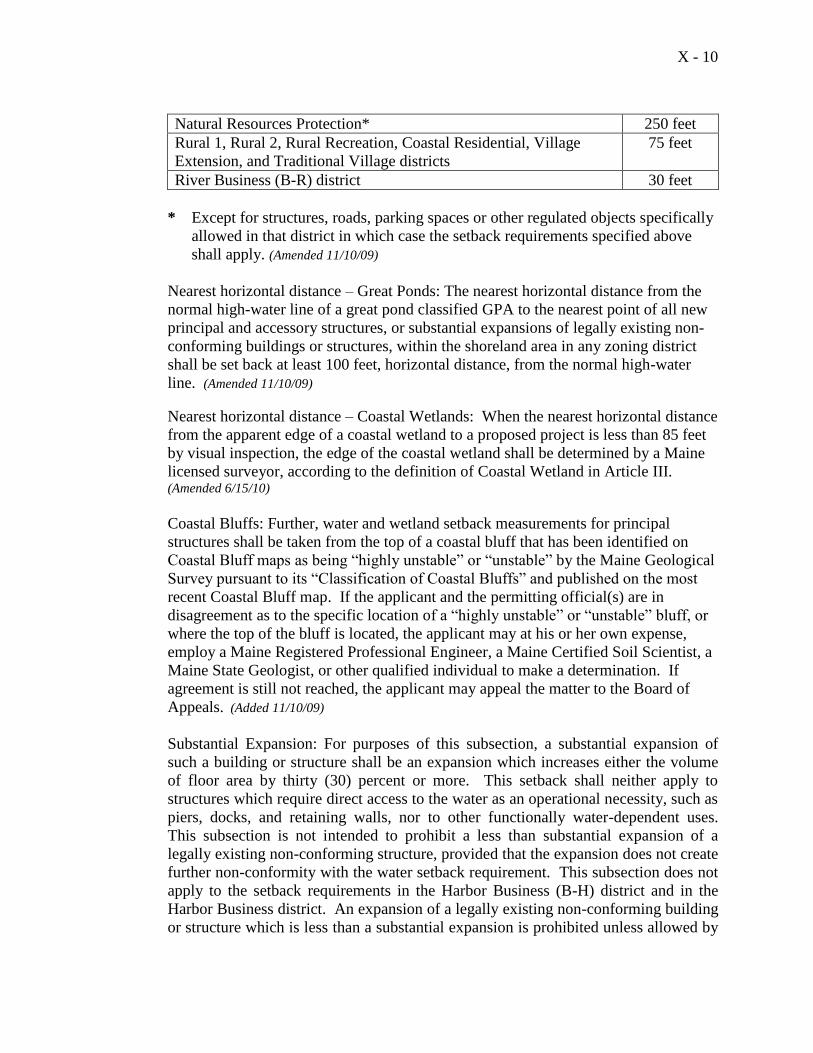
X - 10
Natural Resources Protection* 250 feet
Rural 1, Rural 2, Rural Recreation, Coastal Residential, Village
Extension, and Traditional Village districts
75 feet
River Business (B-R) district 30 feet
* Except for structures, roads, parking spaces or other regulated objects specifically
allowed in that district in which case the setback requirements specified above
shall apply. (Amended 11/10/09)
Nearest horizontal distance – Great Ponds: The nearest horizontal distance from the
normal high-water line of a great pond classified GPA to the nearest point of all new
principal and accessory structures, or substantial expansions of legally existing non-
conforming buildings or structures, within the shoreland area in any zoning district
shall be set back at least 100 feet, horizontal distance, from the normal high-water
line. (Amended 11/10/09)
Nearest horizontal distance – Coastal Wetlands: When the nearest horizontal distance
from the apparent edge of a coastal wetland to a proposed project is less than 85 feet
by visual inspection, the edge of the coastal wetland shall be determined by a Maine
licensed surveyor, according to the definition of Coastal Wetland in Article III. (Amended 6/15/10)
Coastal Bluffs: Further, water and wetland setback measurements for principal
structures shall be taken from the top of a coastal bluff that has been identified on
Coastal Bluff maps as being “highly unstable” or “unstable” by the Maine Geological
Survey pursuant to its “Classification of Coastal Bluffs” and published on the most
recent Coastal Bluff map. If the applicant and the permitting official(s) are in
disagreement as to the specific location of a “highly unstable” or “unstable” bluff, or
where the top of the bluff is located, the applicant may at his or her own expense,
employ a Maine Registered Professional Engineer, a Maine Certified Soil Scientist, a
Maine State Geologist, or other qualified individual to make a determination. If
agreement is still not reached, the applicant may appeal the matter to the Board of
Appeals. (Added 11/10/09)
Substantial Expansion: For purposes of this subsection, a substantial expansion of
such a building or structure shall be an expansion which increases either the volume
of floor area by thirty (30) percent or more. This setback shall neither apply to
structures which require direct access to the water as an operational necessity, such as
piers, docks, and retaining walls, nor to other functionally water-dependent uses.
This subsection is not intended to prohibit a less than substantial expansion of a
legally existing non-conforming structure, provided that the expansion does not create
further non-conformity with the water setback requirement. This subsection does not
apply to the setback requirements in the Harbor Business (B-H) district and in the
Harbor Business district. An expansion of a legally existing non-conforming building
or structure which is less than a substantial expansion is prohibited unless allowed by
X - 11
the provisions of Article VIII, Section 12 (e) (2). (Amended third sentence – 11/9/04)
(Amended second sentence 11/10/09)
Setbacks from Great Ponds classified GPA: In addition, notwithstanding any other
provision of this Ordinance, new principal and accessory structures, and substantial
expansions of legally existing non-conforming buildings and structures, within the
shoreland area in any zoning district shall be set back at least 100 feet, horizontal
distance, from the normal high water line of any great pond classified GPA and rivers
that flow to great ponds classified GPA. (Amended 11/10/09)
(k) The minimum lot size in the Village and Village Extension Districts shall be 10,000
square feet, when the entire lot is at least 75 feet from the normal high water mark
and public sewer is available. (New 6/20/06)
(l) Retaining walls that are not necessary for erosion control shall meet the structure
setback requirement, except for low retaining walls and associated fill, provided all of
the following conditions are met:
1. The site has been previously altered and an effective vegetative buffer does not
exist;
2. The wall(s) is(are) at least 25 feet, horizontal distance, from the normal high-
water line of a water body, tributary stream, or upland edge of a wetland;
3. The site where the retaining wall will be constructed is legally existing lawn or is
a site eroding from lack of naturally occurring vegetation, and which cannot be
stabilized with vegetative plantings;
4. The total height of the wall(s), in the aggregate, are no more than 24 inches;
5. Retaining walls are located outside the 100-year floodplain on rivers, streams,
coastal wetlands, and tributary streams, as designated on the Federal Emergency
Management Agency’s (FEMA) Flood Insurance Rate Maps or Flood Hazard
Boundary Maps, or the flood of record, or in the absence of these, by soil types
identified as recent flood plain soils;
6. The area behind the wall is revegetated with grass, shrubs, trees, or a combination
thereof, and no further structural development will occur within the setback area,
including patios and decks; and
7. A vegetated buffer area is established within 25 feet, horizontal distance, of the
normal high-water line of a water body, tributary stream, or upland edge of a
wetland when a natural buffer area does not exist. The buffer area must meet the
following characteristics:
The buffer must include shrubs and other woody and herbaceous vegetation.
Where natural ground cover is lacking the area must be supplemented with
leaf or bark mulch;
Vegetation plantings must be in plantings sufficient to retard erosion and
provide for effective infiltration of storm water runoff;
Only native species may be used to establish the buffer area;
A minimum buffer width of 15 feet, horizontal distance, is required, measured
perpendicularly to the normal high-water line or upland edge of a wetland;
X - 12
A footpath not to exceed the standards in Article X, Part 1, Section 1, (14) (b)
(1) may traverse the buffer. (Section added 11/10/09, amended 6/15/10)
(10) Roads, Driveways, and associated drainage systems, culverts and related features (Amended 11/10/09) (a) Road crossings of watercourses shall be kept to the minimum number necessary.
(b) Bottoms of culverts shall be installed at stream bed elevation.
(c) All cut or fill banks and areas of exposed mineral soil shall be revegetated or
otherwise stabilized as soon as possible.
(d) Bridges or culverts of adequate size and design shall be provided for all road
crossings of watercourses which are to be used when surface waters are unfrozen.
(e) Roads and Driveways (Amended 11/10/09)
1. New roads and driveways shall be set back at least one hundred (100) feet,
horizontal distance, from the normal high water line of a great pond classified
GPA or a river that flows to a great pond, classified GPA, and seventy-five
(75) feet, horizontal distance, from the normal high water line of other water
bodies, tributary streams, or the upland edge of a wetland, unless no
reasonable alternative exists as determined by the Planning Board. If no other
reasonable alternative exists, the Planning Board may reduce the road and/or
driveway setback requirement to no less than fifty (50) feet, horizontal
distance, upon clear showing by the applicant to the Board that appropriate
techniques will be used to prevent sedimentation of the water body, tributary
stream, or wetland. Such techniques may include, but are not limited to, the
installation of settling basins and/or the effective use of additional ditch relief
culverts and turnouts placed so as to avoid sedimentation of the water body,
tributary stream, or wetland. (Amended 11/10/09)
This paragraph shall neither apply to approaches to water crossings nor to
roads or driveways that provide access to permitted structures, and facilities
located nearer to the shoreline or tributary stream due to an operational
necessity, excluding temporary docks for recreational uses. Roads and
driveways providing access to permitted structures within the setback area
shall comply fully with the requirements of this section except for that portion
of the road or driveway necessary for direct access to the structure. (Amended
11/10/09)
On slopes greater than twenty (20) percent the road and/or driveway setback
shall be increased by ten (10) feet, horizontal distance, for each five (5)
percent increase in slope above twenty (20) percent. (Added 11/10/09)
2. Existing public roads may be expanded within the legal road right-of-way
regardless of its setback from the water body or wetland.
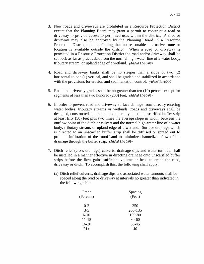
X - 13
3. New roads and driveways are prohibited in a Resource Protection District
except that the Planning Board may grant a permit to construct a road or
driveway to provide access to permitted uses within the district. A road or
driveway may also be approved by the Planning Board in a Resource
Protection District, upon a finding that no reasonable alternative route or
location is available outside the district. When a road or driveway is
permitted in a Resource Protection District the road and/or driveway shall be
set back as far as practicable from the normal high-water line of a water body,
tributary stream, or upland edge of a wetland. (Added 11/10/09)
4. Road and driveway banks shall be no steeper than a slope of two (2)
horizontal to one (1) vertical, and shall be graded and stabilized in accordance
with the provisions for erosion and sedimentation control. (Added 11/10/09)
5. Road and driveway grades shall be no greater than ten (10) percent except for
segments of less than two hundred (200) feet. (Added 11/10/09)
6. In order to prevent road and driveway surface damage from directly entering
water bodies, tributary streams or wetlands, roads and driveways shall be
designed, constructed and maintained to empty onto an unscarified buffer strip
at least fifty (50) feet plus two times the average slope in width, between the
outflow point of the ditch or culvert and the normal high-water line of a water
body, tributary stream, or upland edge of a wetland. Surface drainage which
is directed to an unscarfied buffer strip shall be diffused or spread out to
promote infiltration of the runoff and to minimize channelized flow of the
drainage through the buffer strip. (Added 11/10/09)
7. Ditch relief (cross drainage) culverts, drainage dips and water turnouts shall
be installed in a manner effective in directing drainage onto unscarified buffer
strips before the flow gains sufficient volume or head to erode the road,
driveway or ditch. To accomplish this, the following shall apply:
(a) Ditch relief culverts, drainage dips and associated water turnouts shall be
spaced along the road or driveway at intervals no greater than indicated in
the following table:
Grade Spacing
(Percent) (Feet)
0-2 250
3-5 200-135
6-10 100-80
11-15 80-60
16-20 60-45
21+ 40
X - 14
(b) Drainage dips may be used in place of ditch relief culverts only where the
grade is ten (10) percent or less.
(c) On sections having slopes greater than ten (10) percent, ditch relief
culverts shall be placed at approximately a thirty (30) degree angle
downslope from a line perpendicular to the centerline of the road or
driveway.
(d) Ditch relief culverts shall be sufficiently sized and properly installed in
order to allow for effective functioning, and their inlet and outlet ends
shall be stabilized with appropriate materials. (Added 11/10/09)
8. Ditches, culverts, bridges, dips, water turnouts and other storm water runoff
control installations associated with roads and driveways shall be maintained
on a regular basis to assure effective functioning. (Added 11/10/09)
(10A) Parking Areas (Added 11/10/09)
(a) Parking areas shall meet the shoreline and tributary stream setback requirements for
structures for the parking district in which such areas are located except that in the B-
H district parking areas shall be set back at least twenty-five (25) feet, horizontal
distance, from the shoreline. The setback requirements for parking areas serving
public boat launching facilities in districts other than the B-H district shall be no less
than fifty (50) feet, horizontal distance, from the shoreline or tributary stream if the
Planning Board finds that no other reasonable alternative exists further from the
shoreline or tributary stream.
(b) Parking areas shall be adequately sized for the proposed use and shall be designed to
prevent storm water runoff from flowing directly into a water body, tributary stream
or wetland and where feasible, to retain runoff on-site.
(c) In determining the appropriate size of proposed parking facilities, the following shall
apply:
i. Typical parking space: Approximately ten (10) feet wide and twenty (20) feet
long, except that parking spaces for a vehicle and boat trailer shall be forty (40)
feet long.
ii. Internal travel aisles: Approximately twenty (20) feet wide.
(11) Septic Waste Disposal
All subsurface sewage disposal systems shall be installed in conformance with the State
of Maine Subsurface Wastewater Disposal Rules, and the following:
(a) Clearing or removal of woody vegetation necessary to site a new system and any
associated fill extensions, shall not extend closer than seventy-five (75) feet,
X - 15
horizontal distance, from the normal high-water line of a water body or the upland
edge of a wetland, and
(b) A holding tank is not allowed for a first-time residential use in the shoreland zone. (Amended 11/10/09)
(12) Timber Harvesting (Amended 11/10/09)
The municipal regulation of timber harvesting activities is repealed on the statutory date
established under 38 M.R.S.A. section 438-B, (5), at which time the State of Maine
Department of Conservation’s Bureau of Forestry shall administer timber harvesting
standards in the shoreland zone. On the date established under 38 M.R.S.A section 438-
B, (5), Article X, Part 1, Section 1, (12) is repealed. (Added 11/10/09)
(a) Within a shoreland area zoned as a Natural Resource Protection District abutting a
great pond, there shall be no timber harvesting within the strip of land extending
seventy-five (75) feet, horizontal distance, inland from the normal high water line,
except that timber harvesting may be conducted when the following conditions are
met: (Amended 11/10/09
(i) The ground is frozen;
(ii) There is no resultant soil disturbance;
(iii) The removal of trees is accomplished using a cable or boom and there is no
entry of tracked or wheeled vehicles into the 75-foot strip of land;
(iv) There is no cutting of trees less than 6 inches in diameter; no more than 30%
of the trees 6 inches or more in diameter, measured at 4½ feet above the
ground level, are cut in any 10-year period; and a well-distributed stand of
trees and other natural vegetation remains; and
(v) A licensed professional forester has marked the trees to be harvested prior to a
permit being issued by the municipality. (Added 11/10/09)
(b) Except in areas described in Paragraph (a) above, timber harvesting shall conform
with the following provisions:
Selective cutting of no more than forty (40) percent of the total volume of trees four
(4) inches or more in diameter measured at 4½ feet above ground level on any lot in
any ten (10) year period is permitted. In addition: (Added 11/10/09)
1. Within 100 feet, horizontal distance, of the normal high water line of a
great pond classified GPA or a river flowing to a great pond classified
GPA, and within 75 feet, horizontal distance, of the normal high water line
of other water bodies, tributary streams, or the upland edge of a wetland,
there shall be no clear cut openings and a well distributed stand of trees
and other vegetation, including existing ground cover, shall be maintained.
X - 16
2. At distances greater than 100 feet, horizontal distance, of a great pond
classified GPA or a river flowing to a great pond classified GPA, and
greater than 75 feet, horizontal distance, of the normal high water line of
other water bodies or the upland edge of a wetland, harvesting operations
shall not create single clear cut openings greater than 10,000 square feet in
the forest canopy. Where such openings exceed 5,000 square feet, those
openings shall be at least 100 feet, horizontal distance, apart. Such clear
cut openings shall be included in the calculation of total volume removal.
For purposes of these standards, volume may be considered to be
equivalent to basal area. (Amended 11/10/09)
NOTE: The provisions contained in paragraph 2 above shall not apply to land
areas located greater than 75 feet, horizontal distance, from the normal high water
line of streams since the shoreland area extends only 75 feet from the normal high
water line of a stream.
3. No accumulation of slash shall be left within seventy-five (75) feet,
horizontal distance, of the normal high water line of a water body. In all
other areas slash shall either be removed or disposed of in such a manner
that it lies on the ground and no part thereof extends more than four (4)
feet above the ground. Any debris that falls below the normal high water
mark of a water body or within a wetland shall be removed. (Amended
11/10/09)
4. Timber harvesting equipment shall not use stream channels as travel
routes except when:
(i) Surface waters are frozen; and
(ii) The activity will not result in any ground disturbance.
5. All crossing of flowing water shall require a bridge or culvert, except in
areas with low banks and channel beds which are composed of gravel,
rock or similar hard surface which would not be eroded or otherwise
damaged.
6. Skid trail approaches to water crossings shall be located and designed so
as to prevent water runoff from directly entering the water body or
tributary stream. Upon completion of timber harvesting, temporary
bridges and culverts shall be removed and areas of exposed soil
revegetated. (Amended 11/10/09)
7. Except for water crossings, ski trails and other sites where the operation of
machinery used in timber harvesting results in the exposure of mineral soil
shall be located such that an unscarified strip of vegetation of at least
seventy-five (75) feet, horizontal distance in width, for slopes up to ten
(10) percent shall be retained between the exposed mineral soil and the
normal high water line of a water body or upland edge of a wetland. For
X - 17
each ten (10) percent increase in slope, the unscarified strip shall be
increased by twenty (20) feet, horizontal distance. The provisions of this
paragraph apply only to a face sloping toward the water body or wetland,
provided, however, that no portion of such exposed mineral soil on a back
face shall be closer than twenty-five (25) feet from the normal high water
line of a water body or upland edge of a wetland. (Amended 11/10/09)
(13) The subdivision of land containing less than 750 feet of shoreline and within the 250 feet
shoreland area, must provide at least one right-of-way 25 feet in width to water for
community use. The subdivision of 750 feet or more of shoreline must provide a 50 foot
right-of-way to water for community use for each 750 feet of shoreline. Land in the
Downtown Business (B-1), the Transitional River Business (B-TR), the River Business
(BR), and the Harbor Business (B-H) districts shall be exempt from this standard.
(14) Clearing or Removal of Vegetation for Activities Other Than Timber Harvesting (Entire section amended 11/10/09)
(a) In a shoreland area zoned as a Natural Resource Protection District abutting a great
pond, there shall be no cutting of vegetation within the strip of land extending
seventy-five (75) feet, horizontal distance, inland from the normal high water line,
except to remove safety hazards.
Elsewhere, in any Natural Resource Protection District the clearing of vegetation
shall be limited to that which is necessary for uses expressly authorized in that
district.
(b) Except in areas as described in paragraph a, above, and except to allow for the
development of permitted uses, within a strip of land extending 100 feet, horizontal
distance, inland from the normal high water line of a great pond classified GPA or a
river flowing to a great pond classified GPA, and within a strip of land 75 feet,
horizontal distance, from any other water body, tributary stream, or the upland edge
of a wetland, a buffer strip of vegetation shall be preserved as follows:
1. There shall be no cleared opening or openings greater than two hundred fifty
(250) square feet in the forest canopy (or other existing woody vegetation if a
forested canopy is not present) as measured from the outer limits of the tree or
shrub crown. However, a footpath not to exceed six (6) feet in width as measured
between tree trunks and/or shrub stems is allowed provided that a cleared line of
sight to the water through the buffer strip is not created, is permitted.
2. Selective cutting of trees within the buffer strip is allowed provided that a well-
distributed stand of trees and other natural vegetation is maintained.
3. In order to protect water quality and wildlife habitat, adjacent to great ponds, and
streams and rivers which flow to great ponds, existing vegetation under three (3)
feet in height and other ground cover, including leaf litter and the forest duff
X - 18
layer, shall not be cut, covered or removed, except to provide for a footpath or
other permitted uses as described in this section.
4. Pruning of tree branches on the top 2/3 of the tree is prohibited.
5. In order to maintain a buffer strip of vegetation, when the removal of storm-
damaged, diseased, unsafe, or dead trees results in the creation of cleared
openings, these openings shall be replanted with native tree species unless
existing new tree growth is present.
The provisions contained in paragraph (b) above do not apply to those portions of
publicly owned recreational facilities adjacent to public swimming areas. Cleared
areas, however, shall be limited to the minimum area necessary.
(c) At distances greater than 100 feet, horizontal distance, from a great pond classified
GPA or a river flowing to a great pond classified GPA, and at distances greater than
75 feet, horizontal distance, from the normal high water line of any other water body,
tributary stream, or the upland edge of a wetland, there shall be permitted on any lot,
in any 10 year period, selective cutting of not more than forty (40) percent of the
volume of trees, four (4) inches or more in diameter, measured 4-1/2 feet above
ground level. Tree removal in connection with the development of permitted uses
shall be included in the forty (40) percent calculation. For purposes of these
standards, volume may be considered to be the equivalent to basal area.
In no event shall cleared openings for any purpose, including but not limited to, principal
and accessory structures, driveways, lawns and sewage disposal areas, exceed in the
aggregate 25% of the lot area or 10,000 square feet, whichever is greater, including land
previously cleared. This provision shall not apply to the Downtown Business (B-1), the
Transitional River Business (B-TR), River Business (BR), and the Harbor Business (B-
H) districts.
NOTE: The provision of paragraph (c) above shall not apply to land areas located greater
than 75 feet from the normal high water line of a stream since the shoreland area extends
only 75 feet from the normal high water line of a stream.
(d) Cleared openings in existence on the effective date of this Ordinance may be
maintained, but they shall not be enlarged, except as permitted by this Ordinance.
(e) Fields and other cleared openings which have reverted to primarily shrubs, trees, or
other woody vegetation shall be regulated under this section.
(15) Storm Water Runoff
(a) All new construction and development shall be designed to minimize storm water
runoff from the site in excess of the natural predevelopment conditions. Where
possible, existing natural runoff control features, such as berms, swales, terraces and
X - 19
wooded areas shall be retained in order to reduce runoff and encourage infiltration of
storm waters.
(b) Storm water runoff systems shall be maintained as necessary to ensure proper
functioning.
(16) Essential Services
(a) Where feasible, the installation of essential services shall be limited to existing public
ways and existing service corridors.
(b) The installation of essential services, other than road-side distribution lines, is not
permitted in a Natural Resource Protection or Stream Protection District except to
provide services to a permitted use within said district, or except where the applicant
demonstrates that no reasonable alternative exists. Where permitted, such structures
and facilities shall be located so as to minimize any adverse impacts on surrounding
uses and resources, including visual impacts. (Amended 11/10/09)
(c) Damaged or destroyed public utility transmission and distribution lines, towers and
related equipment may be replaced or reconstructed without a permit. (Added 11/10/09)
(17) Soils
All land uses shall be located on soils in or upon which the proposed uses or structures
can be established or maintained without causing adverse environmental impacts,
including severe erosion, mass soil movement, improper drainage, and water pollution,
whether during or after construction. Proposed uses requiring subsurface waste disposal,
and commercial or industrial development and other similar intensive land uses, shall
require a soils report based on an on-site investigation and prepared by state-certified
professionals. Certified persons may include Maine Certified Soil Scientists, Maine
Registered Professional Engineers, Maine State Certified Geologists and other persons
who have training and experience in the recognition and evaluation of soil properties.
The report shall be based upon an analysis of the characteristics of the soil and
surrounding land and water areas, maximum ground water elevation, presence of ledge,
drainage conditions, and other pertinent data which the evaluator deems appropriate. The
soils report shall include recommendations for a proposed use to counteract soil
limitations where they exist. (Amended 11/10/09)
(18) Commercial and Industrial Uses
(a) The following new commercial and industrial uses are prohibited within the
shoreland area adjacent to great ponds classified GPA, and rivers and streams
which flow to great ponds classified GPA: (Amended 11/10/09)
1. Auto washing facilities
X - 20
2. Auto or other vehicle service and/or repair operations, including body
shops
3. Chemical and bacteriological laboratories
4. Storage of chemicals, including herbicides, pesticides or fertilizers other
than amounts normally associated with individual households or farms
5. Commercial painting, wood preserving, and furniture stripping
6. Dry cleaning establishments
7. Electronic circuit assembly
8. Laundromats, unless connected to a sanitary sewer
9. Metal plating, finishing, or polishing
10. Petroleum or petroleum product storage and/or sale except storage on
same property as use occurs and except for storage and sales associated
with marinas
11. Photographic processing
12. Printing
(b) For the purposes of this Ordinance lobster, scallop, mussel and similar fishing
activities shall not be considered a commercial activity provided that:
1. The activity involves only one boat which is less than forty (40) feet in
length;
2. The operation employs no more than two (2) persons including the
owners; and
3. No wholesale or retail sales of the catch occurs on-site unless conforming
to the standards of a home occupation.
(19) Water Quality
No activity shall deposit on or into the ground or discharge to the waters of the State any
pollutant that, by itself or in combination with other activities or substances, will impair
designated uses or the water classification of the water body, tributary stream or wetland. (Amended 11/10/09)
(20) Archaeological Sites
In the event that a proposed land use activity involves structural development or soil
disturbance on or adjacent to sites listed on, or eligible to the be listed on the Maine
Historic Preservation Commission list, then the permitting authority shall submit a notice
of that land use activity to the Maine Historic Preservation Commission for review and
comment at least twenty (20) days prior to action by that permitting authority on the
application. The permitting authority shall consider any comments received from the
Commission prior to rendering a decision on the application. (Amended 11/10/09)
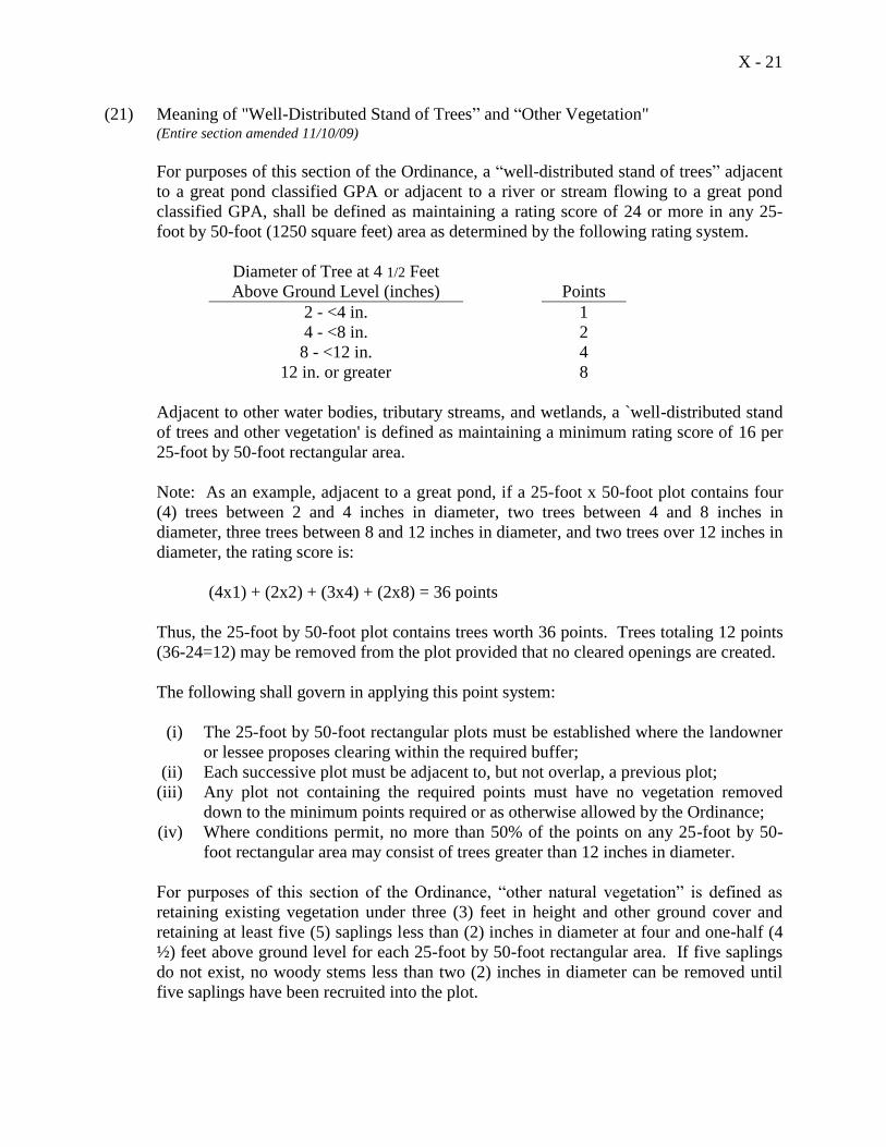
X - 21
(21) Meaning of "Well-Distributed Stand of Trees” and “Other Vegetation" (Entire section amended 11/10/09)
For purposes of this section of the Ordinance, a “well-distributed stand of trees” adjacent
to a great pond classified GPA or adjacent to a river or stream flowing to a great pond
classified GPA, shall be defined as maintaining a rating score of 24 or more in any 25-
foot by 50-foot (1250 square feet) area as determined by the following rating system.
Diameter of Tree at 4 1/2 Feet
Above Ground Level (inches)
Points
2 - <4 in. 1
4 - <8 in. 2
8 - <12 in. 4
12 in. or greater 8
Adjacent to other water bodies, tributary streams, and wetlands, a `well-distributed stand
of trees and other vegetation' is defined as maintaining a minimum rating score of 16 per
25-foot by 50-foot rectangular area.
Note: As an example, adjacent to a great pond, if a 25-foot x 50-foot plot contains four
(4) trees between 2 and 4 inches in diameter, two trees between 4 and 8 inches in
diameter, three trees between 8 and 12 inches in diameter, and two trees over 12 inches in
diameter, the rating score is:
(4x1) + (2x2) + (3x4) + (2x8) = 36 points
Thus, the 25-foot by 50-foot plot contains trees worth 36 points. Trees totaling 12 points
(36-24=12) may be removed from the plot provided that no cleared openings are created.
The following shall govern in applying this point system:
(i) The 25-foot by 50-foot rectangular plots must be established where the landowner
or lessee proposes clearing within the required buffer;
(ii) Each successive plot must be adjacent to, but not overlap, a previous plot;
(iii) Any plot not containing the required points must have no vegetation removed
down to the minimum points required or as otherwise allowed by the Ordinance;
(iv) Where conditions permit, no more than 50% of the points on any 25-foot by 50-
foot rectangular area may consist of trees greater than 12 inches in diameter.
For purposes of this section of the Ordinance, “other natural vegetation” is defined as
retaining existing vegetation under three (3) feet in height and other ground cover and
retaining at least five (5) saplings less than (2) inches in diameter at four and one-half (4
½) feet above ground level for each 25-foot by 50-foot rectangular area. If five saplings
do not exist, no woody stems less than two (2) inches in diameter can be removed until
five saplings have been recruited into the plot.
X - 22
Notwithstanding the foregoing definition, no more than 40% of the total volume of the
trees four (4) inches or more in diameter, measured at 4 1/2 feet above ground level, may
be removed in any ten (10) year period.
Part I, Section 2. High Elevation Areas
(1) Applicability
This section applies to lands more than 500 feet above mean sea level, as shown on the
High Elevation Areas map located in the Code Enforcement Office. Land uses in high
elevation areas shall be limited to residential, agricultural, forest management, and
nonintensive recreational activities, except that within the Rural Recreation District, ski
trails and related facilities also shall be allowed.
(2) Special Space and Bulk Standards
(a) Notwithstanding the requirements of Article VIII, District Regulations, and
Article IX, Open Space Zoning, lots wholly in high elevation areas shall not be
clustered in the pattern of open space residential development.
(b) For lots wholly within the high elevation area, the minimum lot size in the Rural-
1 District shall be 7 acres, with a maximum residential density of one unit per 7
acres; and the minimum lot size in the Rural-2 District shall be 4 acres, with a
maximum residential density of one unit per 4 acres. Elsewhere, the minimum lot
size shall be 3 acres, with a maximum residential density of one unit per 3 acres.
(c) Maximum ground coverage of that portion of the lot in a high elevation area shall
be five percent.
(3) Special Performance Standards
(a) In addition to all other applicable performance standards in this ordinance, the
following special performance standards shall apply in high elevation areas in all
districts except the Rural Recreation District.
(b) Except as provided in paragraphs (c) and (d) below, existing vegetation shall be
retained as a natural visual screen between structures located more than 500 feet
above mean sea level and public roadways below this level.
(c) Existing vegetation may be removed to allow driveway access, not to exceed 20
feet in width, to structures.
(d) Tree cutting for noncommercial or forest management purposes is permitted,
provided that no more than 40 percent of existing trees five or more inches in
diameter, measured two feet above the ground, are removed from any contiguous
X - 23
stand or grouping of trees. In no case shall the area of continuous clearing exceed
7,500 sq. ft.
(e) No development, tree cutting, or clearing of land shall be allowed on slopes which
are in excess of 25 percent in their natural state. Roads, driveways, or other
access ways shall not be constructed on slopes which are in excess of 25 percent
in their natural state, either in high elevation areas or en route to high elevation
areas.
(f) The highest point of any structure in a high elevation area within 1,000 feet of any
segment of a ridge line shown on the High Elevation map on file in the Town
Office shall be at least 10 feet below the elevation of said segment. If the site is
wooded, the height of the structure shall not exceed 75 percent of the average
height of the tree canopy within a 100-foot radius of the proposed building site.
(g) Any structure built in a high elevation area shall be finished with materials and
colors that blend into the natural setting so as to minimize visual impacts.
Part I, Section 3. Historic Areas
(1) Applicability
This Section applies to lots designated as historic and so identified on the Historic Areas
Overlay Map in the Code Enforcement Office. In general, these areas shall consist of
properties listed on the National Register of Historic Places.
(2) Special Performance Standards
In addition to all other applicable performance standards in this Ordinance, all projects
proposed by the Town or by the state or federal governments that affect properties within
the designated Historic Areas shall be reviewed for the Selectmen by the Historic
Resources Committee, and no such project shall proceed without the authorization of the
Selectmen. The Committee shall evaluate the impact of such projects using the current
edition of the Secretary of Interior's Standards for Rehabilitation and Guidelines for
Rehabilitating Historic Buildings.
Part II. Performance Standards Generally
Part II of Article X contains performance standards applicable generally in the Town. The
performance standards contained in this Part shall apply to all uses and activities in the Town,
unless otherwise specified, whether or not specific approval or a permit is required.
Part II, Section 1. Environmental
(1) Sewage Disposal
X - 24
Any use which relies on the soils for treatment of wastewater shall comply with the
requirements of the Maine State Plumbing Code. The discharge of wastewater other than
to soils shall be to the public sewer system in compliance with the Town Sewer
Ordinance or to another system in compliance with the regulations of the Maine
Department of Environmental Protection.
(2) Soils and Earth-Moving
(a) Erosion Control
No person shall perform any act or use of the land in a manner which could cause
substantial or avoidable erosion or significantly alter existing patterns of natural
water flow in the Town.
(b) Excavation and Extraction of Minerals
Any excavation or filling of land or extraction of minerals causing the removal or
filling of earth in volumes exceeding one hundred (100) cubic yards in a period of
one (1) year shall require an excavation permit from the Code Enforcement
Officer. If the excavation or filling affects an area greater than 10,000 sq. ft.
within a five-year period, site plan review also shall be required.
Standards for granting of a permit for extraction of minerals or excavation or
filling of land are as follows:
(i) The activity will not create a condition adversely affecting the natural
drainage of the land;
(ii) No excavation shall be extended below the grade of adjacent streets unless
100 feet from the street line or unless provision has been made for
reconstruction of the street at a different level;
(iii) Sufficient topsoil or loam shall be retained to cover all excavated areas, so
that they may be seeded and restored to natural conditions;
(iv) No topsoil shall be removed, except for approved construction and
landscaping, from lands which, due to their soil characteristics, are
identified as prime farm land.
The excavation or filling of earth for driveways, septic systems, or foundations in
connection with projects that also require a building permit are excluded from the
requirement of obtaining an excavation permit from the Code Enforcement
Officer.
(3) Storm Water Drainage
X - 25
(a) Storm water drainage systems shall be designed to minimize the volume and rate
of outflow from the development.
(b) Design, construction, and maintenance of drainage facilities shall accommodate at
a minimum, a 25-year storm frequency of 2-hour duration.
(4) Dust, Fumes, Vapors, and Gases
Emission of dust, fly ash, fumes, vapors or gases which could damage human health,
animals, vegetation, or property, or which could soil or stain persons or property, at any
point beyond the lot line of the commercial or industrial establishment creating that
emission shall comply with applicable Federal and State regulations.
(5) Odors
No land use shall be permitted to produce offensive or harmful odors perceptible beyond
their lot lines either at ground or habitable elevation.
(6) Glare
No land use shall be permitted to produce a stray, dazzling light or reflection of that light
beyond its lot lines onto neighboring properties, or onto any public way so as to impair
the vision of the driver of any vehicle upon that way.
(7) Wetlands
The Code Enforcement Officer may require a certified wetlands plan, performed by a
qualified soils scientist at the expense of the applicant for a building or use permit, to be
submitted for any activity which takes place on a lot containing a wetlands.
Part II, Section 2. Keeping of Animals
(1) Two and One-half Acres or More (Amended 06/17/09)
Animals incidental to residential activities may be kept; provided, however, that animals
such as horses, cattle, goats, sheep, llamas, pigs, turkeys, ducks, roosters or more than a
total of 9 hens and/or rabbits shall not be kept on a premise having a lot area less than
two- and one-half acres, and shall be kept no closer than 50 feet to any property line.
(2) Less than Two and One-half Acres (Added 06/17/09)
No more than nine small animals such as hens and/or rabbits may be kept incidental to
residential activities, provided the animals are kept as pets or for personal use only.
Slaughtering and the sale of meat, eggs or fertilizer for commercial purposes is
prohibited. At all times, animals shall be contained in housing and pens which shall meet
a minimum setback requirement of 15 feet and shall not be located in a front yard area.
X - 26
Part II, Section 3. Screening and Landscaping
(1) General Standards
(a) For the purpose of this Ordinance, a canopy tree is a tree that reaches at least 35
feet in height at maturity. Canopy trees are used to help create identity and
establish the character of an area, to help define large spaces, and to provide shade
in the hotter months of the year. An evergreen tree is at least 35 feet at maturity.
Evergreen trees are used to create year-round interest with their dominant forms
and color, to screen or direct views, act as windbreaks, and to provide a backdrop
for other elements of a site. An understory tree reaches 10 feet to 35 feet at
maturity. Understory trees are used to provide eye-level landscaping features, to
define minor spaces, and to provide a variety of form, color and accents to a site.
Shrubs have mature heights of two to ten feet. They are used to form physical
and visual barriers, add seasonal interest and color, and help define the scale and
location of buildings.
(b) The plant materials defined in paragraph (a) shall meet the following minimum
size standards at time of installation, with calipers measured at dbh (diameter at
breast height):
i. Canopy trees 1 1/2" caliper
ii. Evergreen trees 4' height
iii. Understory trees 1 1/2" caliper
iv. Shrubs 18" height
(c) Plants required by this Section that die shall be replaced within one growing
season.
(2) Parking Areas
(a) Interior Landscaping
1. In addition to required perimeter landscaping, at least five percent of the
gross area of all parking lots with twelve or more parking spaces shall be
landscaped. Parking lots and commercial parking garages in B-1, B-TR
and B-H shall be exempt from this requirement.
2. The required interior landscaping shall include a minimum of one canopy
tree, one understory tree, and five shrubs for every twelve parking spaces
or fraction thereof. For every mature canopy tree that exists on the
proposed site of a parking lot prior to the parking lot's development and
that is retained and integrated into the parking lot's design, the number of
required new canopy and/or understory trees may be reduced by two. If
any such retained tree dies within five years of the date of the building
X - 27
permit issued for the development, it shall be replaced with two canopy
trees meeting the standard of this Ordinance.
3. The landscaping shall be:
i. in planting areas at least 10 feet wide and located to demarcate the
ends of parking rows and to channel pedestrian circulation;
ii. located to break up parking areas into smaller areas of no more
than 50 parking spaces each; and
iii. designed to accommodate snow plowing and storage without
damage to the plants and trees.
(b) Perimeter Landscaping
1. Abutting a public right-of-way
Where a parking area that includes five or more parking spaces abuts a
public right-of-way, a continuous landscaped strip shall be established
between the right-of-way boundary line and the parking area and shall be
maintained in good condition. It shall be at least 6 feet wide and may be
interrupted only by a driveway meeting the standards of this Ordinance. It
shall be planted with at least one canopy tree per 35 linear feet of street
frontage or fraction thereof exclusive of the width of the driveway. The
plantings shall be designed and located so as not to interfere with sight
distance along the right-of-way and traffic safety.
2. A commercial parking facility or a parking area serving a nonresidential
use abutting a residential district or lot in residential use
Where a commercial parking facility or a parking area serving a
nonresidential use abuts a residential district or a lot wholly or partially in
residential use, a continuous landscaped buffer at least 10 feet wide shall
be provided and maintained in good condition. The buffer may be
interrupted only by a single pedestrian pathway at each abutting property
line no more than five feet wide. The landscaped strip shall include, for
each 100 feet of length, a minimum of two canopy or evergreen trees, four
understory trees, and six shrubs. For every mature canopy or evergreen
tree existing in the area prior to construction of the parking lot and
preserved within the buffer area, the required number of new trees may be
reduced by two. If any such retained tree dies within five years of the date
of the building permit issued for the development, it shall be replaced with
two canopy trees meeting the standard of this Ordinance.
X - 28
3. A commercial parking garage above street level shall be exempt from any
perimeter landscaping.
(3) Multifamily and Nonresidential Uses Abutting Residential Uses or District
(a) The required side and back yards of nonresidential uses that abut properties in
residential district, or of multifamily uses that abut properties in single family
residential use, shall be retained in their natural vegetated state to the maximum
extent possible to provide a visual screen between uses.
(b) Where natural buffering does not exist, or is not possible to be retained, or is not
sufficient to achieve an effective visual screen, the required side and back yards
shall be landscaped to provide a visual screen between uses. The buffer shall be a
minimum of 6 feet wide and may be interrupted only by a single pedestrian
pathway at each abutting property line no more than five feet wide. The buffer
shall include, for each 100 feet of length, a minimum of two canopy or evergreen
trees, four understory trees, and six shrubs. For every mature canopy or evergreen
tree existing area prior to the development and retained within the buffer area, the
required number of new trees may be reduced by two. If any such retained tree
dies within five years of the date of the building permit issued for the
development, it shall be replaced with two canopy trees meeting the standard of
this Ordinance.
(4) Front Yards of Multifamily and Nonresidential Uses
The required front yards of multifamily and nonresidential uses shall be maintained in a
landscaped condition.
(5) Exposed Areas and Areas for Commercial Outdoor Storage of Boats
Exposed storage areas, areas for commercial outdoor storage of boats, exposed
machinery installation, sand and gravel extraction operations, and areas for the storage or
collection of discarded or uninspected vehicles, auto parts, metal or any other articles of
salvage or refuse, shall have sufficient setbacks and screening to provide a visual buffer
sufficient to minimize their adverse impact on surrounding properties. At a minimum,
the screening shall include a dense evergreen hedge six feet or more in height. All such
plantings shall be maintained as an effective visual screen. Where a potential safety
hazard to children would be likely to arise, physical screening sufficient to deter small
children from entering the premises shall be provided and be maintained in good
condition.
(6) Low Impact Uses
The perimeters of parking lots on the sites of low impact uses, as required by Article X, Part II,
Section 3 shall be landscaped to the same standards established for other parking lots, as set forth
in this Section.
X - 29
Part II, Section 4. Off Street-Parking and Loading Standards
(1) Off-Street Parking Requirements
(a) Off-street parking and loading shall be provided in accordance with the
requirements of paragraphs (b) and (c) and subsection (4) for each project
requiring a permit under Article V, Section 2(1) or Section 2(2) of this Ordinance
(except as excluded from that requirement by Article V, Section 3).
(b) Off-street parking shall be provided and maintained in accordance with the
following schedule:
1. Dwelling units
i. Dwelling units, including mobile homes, but excluding accessory
apartments, elderly congregate housing and housing designed for
and restricted to occupancy by elderly persons who receive
assistance from governmental programs in the payment of rent:
2 spaces per unit
ii. Accessory Apartments:
1 space per unit
iii. Elderly congregate housing and housing designed for and restricted
to occupancy by elderly persons:
1 space per unit
2. General business uses
i. The following shall require 1 space per 150 square feet of floor
area:
Medical offices
ii. The following shall require 1 space per 250 square feet of floor
area:
Retail establishments
Business and professional offices
Personal service establishments and banks
Sports and fitness centers
X - 30
iii. The following shall require 1 space per 500 square feet of floor
area:
Industrial, manufacturing, and warehousing uses
3. Lodgings
i. Motels and hotels:
1 space for each room offered for rent plus 3 spaces
ii. Inns and rooming houses:
1 space for each room offered for rent plus 2 spaces for each
dwelling unit
4. Restaurants
1 space for each 4 seats in dining area plus 1 space for each 100 square
feet of lounge, bar, and waiting area, plus 1 space for each exterior serving
window
5. Commercial passenger vessels for hire, as defined in the Harbor and
Waterways Ordinance, which require a victualer's license from the Town
of Camden for the sale of food and/or drink.
1 space for each 4 passengers for which the vessel has capacity to serve
6. Schools
i. Commercial schools:
1 space for each 3 students, based on the maximum number of
students attending the school at any one period in the day
ii. Day care centers and nursery schools:
1 space for each 6 children, based on the maximum number of
children attending the facility at any one period in the day
iii. Public and private schools providing instruction for students up to
and including those 15 years of age:
1 space for each room used for purposes of instruction
X - 31
iv. Public and private schools providing instruction for students 16
years of age and over:
1 space for each 10 seats used for instruction or, if no fixed seats, 1
parking space for each 100 square feet used for purposes of
instruction
7. Medical care facilities, excluding medical offices (see general business
uses):
i. Hospitals:
1 space for each 2 beds
ii. Nursing and convalescent homes:
1 space for each 4 beds
8. Places of public assembly, theaters, halls
1 space for each 4 seats if fixed seating is provided; otherwise 1 space for
each 100 square feet of area available for assembly
9. Churches
1 space for each 4 seats in principal assembly room; no additional parking
spaces shall be required for other types of rooms, spaces, or uses
10. Campgrounds
1 space, plus 1 space for each site available for occupancy
Where a proposed use cannot be reasonably fit into one of the above
categories, the Planning Board shall prescribe the required number of off-
street parking spaces, based on projected use of and volume of traffic to
the proposed facility.
(c) In computing the required off-street parking, the following rules shall apply:
1. The floor area used to determine the off-street parking requirement shall
be the sum on the floors of the net floor area as defined in Article III.
2. If the number of parking spaces required is not a whole number, the partial
space shall be counted as a whole space if the fraction is one-half or
greater (e.g., 13.5 = 14 spaces; 13.4 = 13 spaces).
X - 32
3. For buildings with two or more uses, the parking requirement shall apply
to each use and the parking requirement for the building shall be the sum
of the requirements for the individual uses.
4. In the case of an expansion of an existing building or structure, the
required number of new spaces shall be the number of spaces required for
the addition itself. The new spaces for the addition shall not be required to
make up any deficit that may attend the original building or structure, if
such building or structure was in lawful existence at the time of adoption
of this Ordinance.
5. In the case of a change of use, the required number of spaces shall be the
number of spaces required for the new use, except in the B-1 District. In
the B-1 District, the required number of spaces shall be the number of
spaces required for the new use itself minus the number of spaces which
were required for the original use, whether or not such original use, if in
lawful existence at the time of adoption of this Ordinance, actually
provided its required number of spaces. Vacant or abandoned buildings or
spaces, for which the original use cannot be determined, shall be deemed
to have required 1 space per 350 square feet of gross floor area.
(d) In no case shall the number, dimensions, location, or layout of off-street parking
spaces or areas as authorized by a building permit or pursuant to a plan approved
by the Planning Board or the Zoning Board of Appeals be altered without prior
approval of the permit granting authority.
(e) Off-street parking spaces used in the fulfillment of the requirements of this
Section shall be available for use at all times and shall not be obstructed by trash
receptacles, snow, leaves, or other debris, accessory structures or activities, or
other obstacles that will prevent their use for off-street parking.
(f) No off-street parking area presently in conformance with this Section shall be
made nonconforming as to number, dimensions, location, or layout of spaces; and
no off-street parking area that is presently lawfully nonconforming with respect to
number, dimensions, location, or layout of spaces shall be altered such that the
nonconformity is worsened.
(2) Methods of Meeting Parking Requirements
(a) Off-street parking shall be provided by means of covered or uncovered spaces.
(b) The location of off-street parking shall be in a commercial parking facility located
within 1000 feet of the principal use measured along lines of public roads.
(c) The location of the required off-street parking shall conform to one or a
combination of the following methods:
X - 33
1. The spaces are located on the same lot as the principal building or use; or
2. The spaces are located on a different lot than the principal building or use
and the lot is held in the same ownership as the principal lot and an
affidavit by the owner establishing the ownership as of the date of
submission is submitted to the Code Enforcement Officer; or
3. The spaces are located on a different lot under different ownership and the
spaces are leased to the principal use pursuant to paragraph (5)(d) (Terms
of agreements and leases) of this Section; or
4. The spaces are located in a parking lot serving another use and:
i. The spaces are leased to the principal use pursuant to paragraph
(5)(d) of this Section, and
ii. The owner of the principal use who supplies the spaces conforms
with the minimum parking requirement of this Ordinance, after
deducting spaces leased to a second or alternate use; or
iii. The Zoning Board of Appeals has approved the joint use of the
parking spaces by 2 or more principal buildings or uses based upon
a finding that the parking facility will substantially meet the intent
of the parking regulations for each use by reason of variation in
probable time of maximum use by patrons or employees among the
various establishments, and
iv. Evidence of agreement between the parties jointly using the
parking lot is submitted to the Code Enforcement Officer.
5. Upon application to the Zoning Board of Appeals the off-street parking
requirement shall be waived for uses located in the Downtown,
Transitional River Business, Harbor Business District and Transitional
Harbor Business District if one of the following conditions has been met:
i. In the event that a special parking district is created pursuant to the
laws of the State of Maine and approved by the Town, offering
cooperative solutions to the need for off-street parking, and the
property is a participant in the district and the Code Enforcement
Officer finds that the property is in full compliance with the rules
and regulations pertaining thereto; or
ii. The Code Enforcement Officer finds that the property is a
participant in the Parking Trust Fund through the payment of a
onetime fee, however, Zoning Board approval is not required for
participants making annual payments to the Parking Trust Fund; or (Amended 6/15/10)
X - 34
iii. A private or public system is established for satellite off-street
parking lots, a shuttle service or park-and-ride program, or similar
program by which customers and employees may park their
vehicles outside of the Downtown, Transitional River Business,
and Harbor areas and be brought into the area by common
transportation, and the Code Enforcement Officer finds that the use
is a participant in such a system for as long as the use for which the
parking is required is in place. To qualify as meeting the terms of
this Ordinance, the satellite lot or lots and shuttle service must be
available to the use for the same hours, days, and months as the use
is open for public business.
If the satellite lot or lots and shuttle service are in the same
ownership as, and are operated by, the owner or operator of the use
in question, evidence of such ownership or operation in the form of
an affidavit shall be submitted annually to the Code Enforcement
Officer on the anniversary of the building permit for which the
parking spaces are required. If the satellite lot or lots or the shuttle
service are in the ownership or control of another party, all leases
and agreements for their use shall be for a term of not less than five
(5) years, and no lapse, termination, or expiration of such leases
and agreements shall create a lawful nonconforming situation, and
evidence that such leases and agreements are in force shall be
submitted annually to the Code Enforcement Officer on the
anniversary of the building permit authorizing use of the satellite
lot or lots and shuttle service. In no case shall the lapse of
ownership pertaining to the satellite lot or lots or lapse of a shuttle
or similar service create a lawful nonconforming situation.
In its review of an application for a waiver on account of
participation on a satellite lot or lots and shuttle or similar service,
the Zoning Board of Appeals may attach such conditions as it
deems necessary to ensure that off-street parking is being provided
and that the intent of this Ordinance is being met. The conditions
may address areas such as, without limitation, a program to inform
patrons of the availability of the satellite lot, provision of a safe
drop-off point near the applicant's place of business or use, and the
location of the satellite lot to be used.
X - 35
(d) Terms of agreements and leases
Wherever a lease of parking spaces is used to meet the requirements of this
section, the lessee of the spaces shall obtain a lease having a term of no less than 1
year, and in no case shall the lapse, termination, or expiration of the lease create a
lawful nonconforming situation. The lease shall stipulate that the parking spaces
will be in the continuous possession of the lessee and for the lessee's exclusive
use, unless shared use of the parking spaces is otherwise authorized pursuant to
paragraph (2)(c)4(iii) and (iv) of this Section.
(e) Evidence of compliance with parking requirements
The lease, agreement, or affidavit of ownership relating to use of a lot for parking
other than the lot on which the principal building or use is located shall be
submitted to the Code Enforcement Officer annually on the anniversary of the
building permit authorizing the use for which the parking spaces are required, or
upon the anniversary of any change of use, as evidence that the lease and/or
agreement is in force and that the terms of this Section are continuing to be met.
Failure to submit such evidence shall be a violation of this Ordinance (see Article
V, Section 6, Penalties).
In addition to the requirements of Article X, Part II, Section 4 (2) (d), the lease
relating to use of a lot for parking shall contain a provision requiring that the
Owner of the commercial parking facility (Lessor) shall submit to the Lessee an
annual list showing the number of leased spaces, the names of all Lessees, the
expiration date of the leases, and the number of spaces available for lease, as
evidence that the lease and/or agreement is in force and that the terms of this
Section are continuing to be met. Failure of the Lessee to obtain such a list from
the Owner (Lessor) and to submit that evidence to the Code Enforcement Officer
by July 1 of each year shall cause the Lessee to be in violation of this Ordinance
(See Article V, Section 6 - Penalties).
(3) Parking Facility Layout and Design
(a) No parking space shall be located in a buffer zone or landscaped area required by
this Ordinance. Roadways and drives shall be permitted to cross buffer zones and
required landscaped areas only to provide access to parking areas. Such crossings
shall follow the shortest practical route between the property line and the parking
area. Internal circulation within a parking area shall not be located within a buffer
zone or required landscaping area.
(b) The following design standards shall apply to all parking areas for five or more
vehicles:
1. Access drives and aisles shall be laid out to provide clear and orderly
traffic flow. The minimum width of each aisle between parking stalls
X - 36
shall be thirteen (13) feet for angle parking of forty-five (45) degrees or
less, eighteen (18) feet when spaces are angled from forty-five (45) to
sixty (60) degrees, and twenty-four (24) feet when spaces are angled sixty
(60) to ninety (90) degrees from the aisle direction.
2. Appropriate driveways from streets or alleys shall be provided.
Multifamily residential uses shall be served by driveways no less than ten
(10) feet wide nor more than twenty-five (25) feet wide, and no such
driveway shall be located within one hundred (100) feet of the center of an
intersection of two roads used by the public. Commercial and industrial
uses shall be served by driveways no less than fifteen (15) feet wide nor
more than forty (40) feet wide, and no such driveway shall be located
within one hundred (100) feet of the center of an intersection of two roads
used by the public. Where appropriate, a separation island may be placed
in a driveway and the maximum width increased by the width of the
island. Lots with less than 150 feet of frontage shall be limited to one
driveway for access, while lots with 150 feet or more of frontage shall
have not more than two.
3. Parking spaces for residential uses shall be seventeen (17) feet long and
eight (8) feet six (6) inches wide.
4. Parking spaces for non-residential uses shall be seventeen (17) feet long
and eight (8) feet six (6) inches wide; provided, however, that in lots with
more than 20 spaces, not more than 20% of the spaces may be reserved for
small cars and these parking spaces reduced to sixteen (16) feet long and
eight (8) feet wide.
5. Parking spaces for industrial, warehouse and similar uses shall be at least
seventeen (17) feet long and eight (8) feet six (6) inches wide. Motorcycle
parking spaces at least ten (10) feet long and five (5) feet wide may be
substituted for not more than 10% of the required parking.
6. The parking area shall include screening and landscaping in conformance
with Article X, Part II, Section 3.
7. The surface of driveways, maneuvering areas and parking areas shall be
uniformly graded with a subbase consisting of at least ten (10) inches of
well compacted gravel topped with a wearing surface at least equivalent in
qualities of compaction and durability to fine gravel.
(c) In the case of an existing unmarked parking lot, instead of following standards of
subsection (b) above, the capacity of the existing parking lot may be determined
by deducting the required buffer zone space from the total area available and
dividing the resulting square footage by 300 square feet; calculations to be
X - 37
submitted to the Code Enforcement Officer and approved before spaces may be
leased for off-premise parking requirements.
(4) Off-Street Loading Standards
Retail, wholesale, and industrial operations with a gross floor area of more than 5,000 sq.
ft. shall provide one loading bay, with a minimum dimension of fourteen (14) feet by
fifty (50) feet, for each 60,000 sq. ft. of floor area or fraction thereof. Any required bay
or bays shall be in addition to the required off-street parking.
(5) Corner Clearance
For the purposes of traffic safety, no building or structure may be erected nor any
vegetation other than canopy trees maintained above a height of three (3) feet within the
triangle formed by the point of intersection of the center line of two intersecting roads
and the two points located on the center line of the roads 40 feet from the point of
intersection.
Part II, Section 5. Lots
(1) Corner Lots
Corner lots shall conform to the front yard requirements on each street and the side yard
requirements between structures and the adjoining property on each street.
(2) Front Yard Averaging
The prescribed front setback may be lessened without a variance at the option of the
property owner to conform with the average setback of existing buildings located in the
same zoning district on immediately adjacent lots.
Part II, Section 6. Fences
Fences located within a required front, back or side setback area shall not exceed six feet in
height.
Part II, Section 7. Home Occupations
(1) The occupation or profession shall be carried on wholly within the principal building(s)
and/or within building(s) or other structure(s) accessory thereto.
(2) There shall be not more than one full-time or two part-time employees not resident in the
place of business. This limitation on number of employees shall extend to all nonfamily
employees working on the premises, but shall not extend to employees who do not work
on the premises. Any employee working 30 hours or more in a week shall be considered
full-time.
X - 38
(3) There shall be no exterior storage of materials, no exterior display or other exterior
indications of the home occupation other than one sign which shall be attached to the
building, shall not exceed four square feet in area, and shall contain no more than the
name and business of the proprietor. There shall be no other variation from the
residential character of the principal building.
(4) No nuisance, offensive noise, vibration, smoke, dust, odors, heat, glare, or electrical
disturbance shall be generated. In furtherance of the standard, no commercial or
industrial machinery, ovens or other equipment normally associated with a commercial or
industrial scale facility shall be used by a home occupation to process goods, materials, or
foods.
(5) A home occupation located in a Rural-1, Rural-2, Coastal Residential, Village Extension,
or Traditional Village district shall not be permitted if it would generate more than a daily
average of ten vehicular trip ends on week days, based on data contained in the latest
edition of "Trip Generation," published by the Institute of Transportation Engineers, or if
it in fact generates more than an average of ten trip ends per day in any seven day period.
Nor shall the home occupation make or receive shipments in trucks more than 3 times in
a seven day period.
(6) The home occupation shall not require, nor shall it provide, more than two off-street
parking spaces in addition to the off-street parking spaces provided to meet the normal
requirements of the dwelling. The number of spaces required shall be based on the
standards contained in Part II, Section 4 of this Article, or, if the type of use cannot be
classified as one of the uses listed in Part II, Section 4, the number may be based on the
average rates per 1,000 square feet of building area for peak parking spaces occupied as
identified in the latest edition of "Parking Generation," published by the Institute of
Transportation Engineers.
(7) The home occupation shall not utilize more than 50% of the total floor area of the
dwelling unit plus accessory structure(s).
(8) The home occupation shall include the retailing only of items actually produced on the
premises and of other items clearly incidental thereto.
(9) Where more than one home occupation is carried on in a dwelling and/or its accessory
structure(s), the standards contained herein relating to number of employees, signs and
exterior appearance, traffic generated, and the percentage of floor space used shall apply
cumulatively, such that all home occupations taken together shall not exceed the
standards for one home occupation.
Part II, Section 8. Approval of State Fire Marshall
All businesses and all multifamily dwellings which contain two or more floors shall conform
with State Law requirements concerning approval by the State Fire Marshall.
X - 39
Part II, Section 9. Mobile Home Parks
All mobile home parks shall conform to the standards set forth in this section of Article X.
Mobile home parks are also subject to the requirements of the Subdivision Ordinance of the
Town of Camden and other applicable state laws, local ordinances and regulations.
Notwithstanding the definition of "lot" to the contrary, the use of the term "mobile home park
lot" refers to the leased area on which a mobile home is located.
(1) Placement of Units on Lots
Within a licensed mobile home park, which has been approved by the Planning Board in
accordance with the Subdivision Ordinance of the Town of Camden, units of
manufactured housing or older mobile homes shall be placed upon mobile home park
lots. Each lot shall be occupied by only one unit of manufactured housing or by one older
mobile home. Each such unit of housing shall be placed on a pad.
(2) Lot Requirements
Notwithstanding the minimum lot area requirements of Article VIII of this Ordinance,
mobile home park lots in a mobile home park shall meet the following lot area and lot
width requirements:
(a) Lots served by individual subsurface waste water disposal systems:
Minimum lot area - 20,000 square feet
Minimum lot width - 100 feet
(b) Lots served by one or more centralized subsurface waste water disposal systems
serving two or more dwelling units and approved by the Maine Department of
Human Services:
Minimum lot area - 12,000 square feet
Minimum lot width - 75 feet
(c) Lots served by a public sewer system:
Minimum lot area - 6,500 square feet
Minimum lot width - 50 feet
Mobile home park lots located within any designated shoreland area shall meet the lot
area, lot width and shore frontage requirements of the zoning district in which that lot is
located, or the requirements for the shoreland area pursuant to Article X, Part I, Section
1(9), whichever are stricter.
X - 40
(3) Overall Density
Notwithstanding the lot requirements set forth above, the overall density of any mobile
home park served by a central, on-site, subsurface waste water disposal system approved
by the Maine Department of Human Services shall not exceed one dwelling unit for each
20,000 square feet.
(4) Setbacks
On lots which abut a public way, either within the park or adjacent to the park, the
individual manufactured housing unit or older mobile home unit shall be placed upon
those lots in such a manner that the individual unit is set back from the public way
according to the setback requirements applicable to other residential developments in the
zoning district in which the mobile home lot is located.
On lots which are located in a shoreland area, the individual units shall be placed upon
the lots in such a manner that the setback requirements, measured from the normal high
water mark required in that zoning district, are met.
Individual units shall be so located on individual mobile home park lots that all parts of
the structure of the individual unit are a minimum of fifteen feet from all boundary lines
of the individual lot, and a minimum of thirty feet from any other unit; subject to the
provision that such setbacks do not have the effect of requiring lots larger than the
minimum lot areas set forth in paragraph 2 of this Section. Where a mobile home was
lawfully placed on a lot prior to the date of adoption of this Ordinance such that it does
not meet these setbacks, it may be replaced by another mobile home in the same location
on the lot, as long as the nonconforming aspect of the original placement is not worsened.
(5) Buffer Requirements
If a mobile home park is proposed within a residential district at a density which is at
least twice the density of existing adjacent development, or at least twice the density
permitted in the zoning district in which the mobile home park is proposed to be located
in the event that the adjacent land is undeveloped, the mobile home park shall be
designed with a fifty-foot wide buffer strip along the perimeter boundary lines of that
property. The buffer strip shall be maintained as a landscaped area containing no
structures. Roads may cross the buffer strip to provide access to the park, and to provide
access to utilities.
Within the first twenty-five feet of the buffer strip, as measured from the exterior
boundaries of the park, the buffer strip shall be improved and maintained in accordance
with Article X, Part II, Section 3(3), Multifamily and Nonresidential Uses Abutting
Residential Uses or Districts, of this Zoning Ordinance.
X - 41
(6) Open Space Reservation
For a mobile home park served by a public sewer system, an area equaling 10% of the
combined area of the individual lots within the mobile home park shall be set aside and
reserved as open space to meet the recreational and community needs of the residents of
the mobile home park. The area reserved as open space shall be suitable for use by
residents for recreational purposes, or for use by residents for storage. In addition, the
area reserved for open space may be used for those uses specifically set forth in Article
IX, Section 5(3) of this Zoning Ordinance. The reserved open space shall have slopes of
less than 5%, shall not be located on poorly or very poorly drained soils, and shall be
accessible directly from roads within the mobile home park.
(7) Road Standards
The layout, design and construction of roads within the park shall conform to the
following standards:
(a) The road system shall be designed to provide safe and convenient access to all
lots within the park and shall provide for all-season emergency vehicle access to
every unit in the park.
(b) Roads within a mobile home park which the applicant proposes to dedicate as
public ways shall be designed and constructed in accordance with the Article VI,
Section 3, Design and Construction Standards of the Subdivision Ordinance.
(c) Roads within a mobile home park which the applicant proposes to remain private
ways shall meet the following minimum standards:
(1) The roads shall be designed by a professional engineer, registered in the
State of Maine.
(2) The roads shall have a minimum right-of-way of twenty-three (23) feet.
(3) The roads shall have a paved travel surface with a minimum width of
twenty (20) feet.
(4) The construction of these roads shall meet the standards of the
Manufactured Housing Board.
(d) The roads and lots shall be laid out so that no lot within the park shall have direct
vehicular access onto a public street.
(e) Any mobile home park expected to generate average daily traffic of two hundred
(200) trips per day or more shall have at least two (2) street connections with
existing public streets. Any street within a park with an average daily traffic of
two hundred (200) trips per day or more shall have at least two (2) street
X - 42
connections leading to existing public streets, other streets within the park, or
other streets shown on an approved subdivision plan.
(f) The intersection of any street within a park and an existing public street shall meet
the following standards.
(1) Angle of Intersection. The desired angle of intersection shall be 90
degrees. The minimum angle of intersection shall be 75 degrees.
(2) Maximum Grade within one hundred (100) feet of intersection. The
maximum permissible grade within one hundred (100) feet of the
intersection shall be 3 percent.
(3) Minimum Sight Distance. A minimum sight distance of ten (10) feet for
every mile per hour of posted speed limit on the existing road shall be
provided. Sight distances shall be measured from the driver's seat of a
vehicle that is ten (10) feet behind the curb or edge of shoulder line with
the height of the eye three and a half (3 1/2) feet above the pavement and
the height of object four and a quarter (4 1/2) feet.
(4) Distance from other intersections. The centerline of any street within a
park intersecting an existing public street shall be no less than one hundred
twenty-five (125) feet from the centerline of any other street intersecting
that public street.
(g) Any application for approval of a mobile home park shall contain an estimate of
the average daily traffic projected to be generated by the park. Estimates of traffic
generation shall be based on the Trip Generation Manual, current edition,
published by the Institute of Transportation Engineers. If the park is projected to
generate more than 400 vehicle trip ends per day, the application shall also
include a traffic impact analysis, by a registered professional engineer with
experience in transportation engineering.
(8) Groundwater Impacts
(a) Assessment Submitted
Accompanying an application for approval of any mobile home park which is not
served by public sewer shall be an analysis of the impacts of the proposed mobile
home park on ground water quality. The hydrogeologic assessment shall be
prepared by a Certified Geologist or Registered Professional Engineer,
experienced in hydrogeology and shall contain at least the following information.
(1) A map showing the basic soils types.
X - 43
(2) The depth to the water table at representative points throughout the mobile
home park.
(3) Drainage conditions throughout the mobile home park.
(4) Data on the existing ground water quality, either from test wells in the
mobile home park or from existing wells on neighboring properties.
(5) An analysis and evaluation of the effect of the mobile home park on
groundwater resources. The evaluation shall, at a minimum, include a
projection of post development nitrate-nitrogen concentrations at any
wells within the mobile home park, at the mobile home park boundaries
and at a distance of one thousand (1,000) feet from potential
contamination sources, whichever is a shorter distance. For mobile home
parks within the watershed of a land or pond, projections of the
development's impact on groundwater phosphate concentrations shall also
be provided.
(6) A map showing the location of any subsurface wastewater disposal
systems and drinking water wells within the mobile home park and within
two hundred (200) feet of the mobile home park boundaries.
(b) Standards for Acceptable Groundwater Impacts
(1) Projections of groundwater quality shall be based on the assumption of
drought conditions (assuming 60% of annual average precipitation).
(2) No mobile home park shall increase any contaminant concentration in the
groundwater to more than one half of the Primary Drinking Water
Standards. No mobile home park shall increase any contaminant
concentration in the groundwater to more than the Secondary Drinking
Water Standards.
(3) If groundwater contains contaminants in excess of the primary standards,
and the mobile home park is to be served by on-site groundwater supplies,
the applicant shall demonstrate how water quality will be improved or
treated.
(4) If groundwater contains contaminants in excess of the secondary
standards, the mobile home park shall not cause the concentration of the
parameters in question to exceed 150% of the ambient concentration.
(c) Subsurface waste water disposal systems and drinking water wells shall be
constructed as shown on the map submitted with the assessment. If construction
standards for drinking water wells are recommended in the assessment, those
standards shall be included as a note on the Plan.
X - 44
(9) Ownership of Park
The land within the mobile home park shall remain in a lot in single or joint ownership.
No lots or interest in lots shall be individually conveyed, except that a leasehold interest
in lots, or the use of lots through a written rental agreement, is permissible.
(10) Conversion of Park
No development or subdivision which is approved by the Planning Board as a mobile
home park shall be converted to another use without the approval of the Planning Board
for such other use, and without the approval of the Zoning Board of Appeals for such
change of use, if required under the terms of this Zoning Ordinance. The conversion
shall meet the appropriate lot size, lot width, setback, and other requirements of the
Zoning Ordinance and the Subdivision Ordinance for the proposed use.
(11) Utility Requirements
All mobile home parks shall provide permanent electrical, water and sewage disposal
connections to each lot in accordance with applicable state and local rules and
regulations. Electrical utilities and telephone lines may be located above ground.
(12) Sidewalks/Walkways
The mobile home park shall contain pedestrian walkways that link all units and all
service and recreational facilities. Such walkways shall be adequately surfaced and lit. A
portion of the road surface may be reserved for walkways provided the roadway width is
increased accordingly. Walkways shall be a minimum width of three (3) feet.
(13) Lighting
Outdoor lighting shall be provided to adequately illuminate internal streets and pedestrian
walkways. Lights shall be sized and directed to avoid adverse impact on adjacent
properties.
(14) Signs
Signs and advertising devices shall be prohibited in mobile home park except:
(a) One (1) identifying sign at each entrance of the mobile home park no larger than
twenty-four (24) square feet which may be indirectly lit, but not flashing.
(b) Directional and informational signs for the convenience of tenants and the public
relative to parking, office, traffic movement, etc.
X - 45
(c) Mobile/manufactured home "for sale" signs, provided that such signs that face a
public road shall be no more than ten (10) square feet and shall be limited to two
(2) signs per mobile home park.
(d) Mobile/manufactured home address signs.
The styles and location of the identifying sign shall not interfere with vehicle sight
distance and shall be constructed in accordance with local sign regulations.
(15) Storage
At least three hundred (300) cubic feet of enclosed tenant storage facilities shall be
conveniently provided on or near each mobile home lot for the storage of materials and
equipment.
(16) Park Administration
The owner or operator of a mobile home park shall be responsible for ensuring the
maintenance of all park-owned structures and their sites. Park management shall
conform to state laws.
Compliance with this Ordinance shall not exempt the park owner, developer, or manager
from complying with other applicable local, state, and federal codes and regulations.
Part II, Section 10. Standards for Older Mobile Homes
These standards are designed to establish a level of safety for older mobile homes to assure that
the unit will perform in a manner that will greatly reduce hazards that present an imminent and
unreasonable risk of death or serious personal injury.
No mobile home which was constructed prior to June 15, 1976, or which was not built in
accordance with the National Manufactured Housing Construction and Safety Standards Act of
1974 shall be used as a residential dwelling unit in the Town of Camden unless the Code
Enforcement Officer certifies that the unit complies with the following standards:
(1) Exit Facilities - Exterior Door
(a) Required egress doors shall not be located where a lockable interior door must be
used in order to exit.
(b) Mobile homes shall have a minimum of two (2) exterior doors not less than
twelve (12) feet from each other as measured in any straight line direction
regardless of the length of the travel between doors. One of the required exit
doors must be accessible from the doorway of each bedroom without traveling
more than thirty-five (35) feet.
X - 46
(c) All exterior swinging doors shall provide a minimum twenty-eight (28) inches
wide by seventy-four (74) inches high clear opening. All exterior sliding glass
doors shall provide a minimum twenty-eight (28) inches wide by seventy-two
(72) inches high clear opening. Lock shall not require the use of a key for
operation from the inside.
(2) Exit Facilities - Egress Windows and Devices
Homes shall have the following emergency egress facilities:
(a) Every room designed expressly for sleeping purposes, unless it has an exit door,
shall have at least one (1) outside window or approved exit device. If an exit
window or device is installed, it shall be listed in accordance with procedures and
requirements of AAMA 1704-1985.
(b) The bottom of the window opening shall not be more than thirty-six (36) inches
above the floor.
(c) Locks, latches, operating handles, tabs and any other window, screen or storm
window devices, which need to be operated in order to permit exiting, shall not be
located in excess of fifty-four (54) inches from the finished floor.
(3) Interior Doors
Each interior door, when provided with a privacy lock, shall have a privacy lock that has
an emergency release on the outside to permit entry when the lock has been locked by a
locking knob, lever, button or other locking devices on the inside.
(4) Fire Detection Equipment
At least one smoke detector (which may be a single station alarm device) shall be
installed in the home in the following locations:
(a) A smoke detector shall be installed on any wall in the hallway or space
communicating with each bedroom area between the living area and the first
bedroom door unless a door separates the living area from that bedroom area, in
which case the detector shall be installed on the living area side as close to the
door as practical. Homes having bedroom areas separated by any one or
combination of communication areas such as kitchen, dining room, living room,
or family room (but not a bathroom or utility room) shall have at least one
detector protecting each bedroom area.
(b) When located in hallways, the detector shall be between the return air intake and
the living area.
(c) The smoke detector shall not be placed in a location which impairs its
effectiveness.
X - 47
(d) Smoke detectors shall be labeled as conforming with the requirements of
Underwriters Laboratory Standards No. 217, current edition, for single and
multiple station smoke detectors.
(e) Each smoke detector shall be installed in accordance with its listing. The top of
the detectors shall be located on a wall 4 inches to 12 inches below the ceiling.
However, when a detector is mounted on an interior wall below a sloping ceiling,
it shall be located four (4) inches to twelve (12) inches below the sloping ceiling
(cathedral ceiling). The required detector(s) shall be attached to an electrical
outlet box and the detector connected by permanent wiring method into a general
electrical circuit. There shall be no switches in the circuit to the detector between
the overcurrent protection device protecting the branch circuit and the detector.
The smoke detector shall not be placed on the same branch circuit or any circuit
protected by a ground fault circuit interrupter.
(5) Flame Spread
(a) Ceiling interior finish shall not have a flame spread rating exceeding 75.
(b) Walls and ceilings adjacent to or enclosing a furnace or water heater shall have an
interior finish with a flame spread rating not exceeding 25. Sealants and other
trim material two (2) inches or less in width used to finish adjacent surfaces
within this space are exempt if supported by framing members or by materials
having a flame spread rating not exceeding 25.
(c) Exposed interior finishes adjacent to the cooking range shall have flame spread
rating not exceeding 50.
(d) Kitchen cabinet doors, countertops, back splashes, exposed bottoms, and end
panels shall have a flame spread rating not to exceed 200.
(e) Finish surfaces of plastic bathtubs, shower units, and tub or shower doors shall
not exceed a flame spread of 200.
(f) No burner of a surface cooking unit shall be closer than twelve (12) horizontal
inches to a window or an exterior door.
(6) Kitchen Cabinet Protectors
(a) The bottom and sides of combustible kitchen cabinets over cooking ranges to a
horizontal distance of six (6) inches from the outside edge of the cooking range
shall be protected with at least 5/16-inch thick gypsum board or equivalent limited
combustible material. One-inch nominal framing members and trim are exempted
from this requirement. The cabinet area over the cooking range or cooktops shall
be protected by a metal hood with not less than a 3-inch eyebrow projecting
X - 48
horizontally from the front cabinet face. The 5/16-inch thick gypsum board or
equivalent material which is above the top of the hood may be supported by the
hood. A 3/8-inch enclosed air space shall be provided between the bottom surface
of the cabinet and the gypsum board or equivalent material. The hood shall be at
least as wide as the cooking range.
(b) The metal hood will not be required if there is an oven installed between the
cabinet and the range.
(c) Ranges shall have a vertical clearance above the cooking top of not less than
twenty-four (24) inches to the bottom of combustible cabinets.
(7) Carpeting
Carpeting shall not be used in a space or compartment designed to contain only a furnace
and/or water heater. Carpeting may be installed in other areas where a furnace or water
heater is installed, provided that it is not located under the furnace or water heater.
(8) Roof Loads
All homes with roofs added after construction will require a professional engineer to
inspect the roof to determine that the roof and home can withstand the rigors of a State of
Maine winter or wind uplifts that may occur.
(9) Heating and Fuel Burning System
A person holding a master license issued by the State of Maine Oil and Solid Fuel
Examining Board shall in inspect and certify that the heating and fuel system meets the
requirements of NFPA-31 - Inspection of Oil Burning Equipment as adopted by that
Board, or other applicable standards.
(10) Electrical System
A person holding a master license issued by the State of Maine Electricians Examining
Board shall inspect and certify that the electrical system is safe and meets the National
Electrical code in effect at the time the home was constructed.
XI - 1
Article XI Signs
Section 1. Purpose
The Town, after due and careful consideration, finds and declares that it desires to preserve the
natural and scenic beauty of the Town, its rural area and water ways, where a proliferation of
advertising and other signs would despoil the beauty of the Town and create hazards to vehicular
and pedestrian traffic.
It is the intent and purpose of this Article to preserve the beauty of the Town and the safety and
well-being of the inhabitants while at the same time allowing reasonable advertising and
informational signs by regulating the type, number, location, and size of such signs.
Section 2. Definitions
BANNER: Any sign of lightweight fabric or similar material that is mounted to a pole or a
building at one or more edges. National, state, or municipal flags, or the official flag of any
institution or business, shall not be considered banners. (Amended 11/10/09)
FLAG: Any fabric or bunting containing distinctive colors, patterns, or symbols. (Amended
11/10/09)
PENNANT: Any lightweight plastic, fabric, or other material, whether or not containing a
message of any kind, suspended from a rope, wire, or string, usually in series, designed to move
in the wind.
SIGN: Any device, fixture, placard, or structure that uses any color, form, graphic, illumination,
symbol, or writing to advertise, announce the purpose of, or identify the purpose of a person or
entity, or to communicate information of any kind to the public, including a sign located inside a
window or door so that it is visible from the exterior of the building. Brand names and logos that
are integral parts of a good to be sold are not considered signs under this Ordinance. (Amended
11/10/09)
SIGN AREA: The area on one side of the smallest simple geometric shape exemplified by a
square, rectangle, triangle, circle, etc., encompassing all lettering, wording, design, or symbols,
together with any background which is distinguishable from the building. For the purpose of
calculating the area of a sign, an inconspicuous support exemplified by a slim post is not part of
the sign.
SIGN, CANOPY: A sign that is a part of or attached to an awning, canopy, or other fabric,
plastic, or structural protective cover over a door, entrance, window, or outdoor service area.
XI - 2
SIGN, CONSOLIDATED: A single on-premise sign that serves two or more businesses or
entities, all of which are located on the same lot of record, which sign is on a single device,
fixture, placard, or structure.
SIGN, FREESTANDING: A sign supported by one or more upright poles, columns, braces or
structure anchored in the ground and not attached to any building or other structure.
SIGN, ILLUMINATED: A sign lit in any manner by an artificial source of light.
SIGN, EXTERNALLY ILLUMINATED: A sign that is lit entirely from an external
source, such as flood or spotlights, and is so arranged that no direct rays of light are
projected from the external source into adjoining properties or public streets.
SIGN, INTERNALLY ILLUMINATED: A sign whose lighting is integral to the sign
and/or shines through a plastic or other translucent covering.
SIGN, LADDER: A sign with two or more signs attached to the same support. The
components of a ladder sign must comply, cumulatively, with the dimensional limitations
imposed by this Section.
SIGN, OFF-PREMISE: A sign that is not located on the same lot of record that the business,
facility, or point of interest is located.
SIGN, ON-BUILDING: A sign that is attached to the building wall and extends not more than
six inches from the face of such wall.
SIGN, ON-PREMISE: A sign that is located on the same lot of record that the business,
facility, or point of interest is located.
SIGN, PORTABLE: A sign that is not permanently attached to the ground or other permanent
structure, or a sign designed to be transported, including, but not limited to, signs designed to be
transported by means of wheels or trailers, balloons used as signs, and signs attached to or
painted on vehicles parked and visible from the public right-of-way, unless said vehicle is used
in the normal day-to-day operations of the business. For the purpose of this Ordinance, menu
and sandwich board signs are not considered portable signs.
SIGN, PROJECTING: A sign that is attached to the building wall and extends more than six
inches from the face of such wall.
SIGN, TEMPORARY: A sign of a temporary nature, erected less than 90 days within any 12-
month period, exemplified by the following: political signs, charitable signs, fundraising signs,
construction signs, carnival signs, garage sales, lawn sales, rummage sales, and all signs
advertising sales of real estate and personal property, and for rent signs. Any exterior sign
displayed by an ongoing business on the business' premises in which the written or printed
message changes while the structure of the sign remains unchanged shall not be considered as a
XI - 3
temporary sign. For example, chalkboards and signs with removable lettering shall not be
considered temporary signs. (Amended 11/10/09)
Section 3. Permit Required
No person, firm or corporation shall hereafter erect, hang, place, or alter a sign or sign structure
of any kind without a permit having been issued by the Code Enforcement Officer, upon
payment of a permit fee as determined annually by the Selectmen. Any permit obtained
subsequent to the erecting, hanging, placing, or altering a sign or structure shall be subject to a
permit fee five times the scheduled fee. Every application for a sign permit shall be
accompanied by plans to scale, showing the area of the sign, the position of the building,
structure or lot to which or upon which the sign is to be attached or erected, the method of
illumination if any, and such other information as the Code Enforcement Officer shall require to
show full compliance with this and all other laws and Ordinances of the Town. If it appears that
the proposed sign is in compliance with all such requirements and laws, the permit shall be
issued. (Amended 11/10/09)
Section 4. Excepted Signs
The following signs are excepted from the provisions of this Ordinance:
(1) Any sign which was lawfully in existence prior to the date of the adoption of this
Ordinance, provided, however, any change in lettering, size, construction, wording,
location, or lighting of said sign shall constitute a new sign and such change shall be
governed by the terms of this Ordinance;
(2) House addresses, family name signs, and no trespassing signs;
(3) Traffic control signs and safety signs including handicapped access signs
(4) Signs painted on the window of a business which do not exceed 10 percent of the area of
the glass.
(5) Informational and directional signs concerning hospitals, and emergency medical care
facilities.
(6) Vending and dispensing machines; however, vending and dispensing machines located
outside a building shall not be internally illuminated. (New 6/20/06)
(7) A single blackboard sign on which the message may change, located near an entrance and
attached to a building located in the Downtown Business (B-1), Highway Business (B-2),
Business Transition (B-3), Neighbor Service (B-4), Harbor Business (B-H), Transitional
Harbor Business (B-TH), Transitional River Business (B-TR), or River Business (B-R),
for the purpose of posting information such as, but not limited to, menus, specials, new
products, sales, real estate listings, or sample designs, provided the sign does not exceed
3 square feet. (Added 11/10/09, Amended 11-6-2012 )
XI - 4
(8) Temporary sandwich board signs used to direct vehicles or pedestrians to an event
sponsored by a civic group, organization or arts group, however, except as permitted
under Section 11, (3), (e), other uses of sandwich board signs are prohibited. (Added
11/10/09, Amended 11-6-2012)
(9) Signs to direct vehicles or pedestrians within private or public property, provided the
signs are no larger than 3” by 18”. (Added 11/10/09)
(10) A single sign advertising fresh produce grown on the premises provided the sign does not
exceed 4 square feet in area. (Added 11/10/09)
(11) Directional and informational signs on municipal property with the approval of the Code
Enforcement Officer. (Added 11/10/09)
Section 5. Community, Municipal, and Quasi-Municipal Facilities
Signs shall meet the requirements of Section 11. "Specifications."
Section 6. Obsolete Signs
Any sign now or hereafter existing which no longer advertises a bona fide business conducted,
product sold, or activity or campaign being conducted shall be taken down and removed by the
owner, agent, or person having the beneficial use of the building, structure, or lot upon which
such sign may be found within 10 days after written notification from the Code Enforcement
Officer. Failure to comply with such notice constitutes a violation of the terms of this
Ordinance.
Section 7. Illuminated Signs
If an exterior sign is to be illuminated it must be illuminated externally only, and shall be lighted
from sources which are shielded from streets and adjoining property, with no exposed source of
illumination. Businesses are allowed to display one (1) internally illuminated “Open” sign with a
maximum size of two (2) square feet in a window visible from the street with a permit from the
Code Officer. Any permitted “Open” sign shall not advertise or contain a logo of any product or
company. The intensity of light from any illuminated sign visible from the exterior of the
business shall remain constant in color, location, and brightness. No sign shall constitute a
hazard to the flow of vehicular or pedestrian safety.
Section 8. Flags, Banners and Pennants
Flags, banners, and pennants may be used for the promotion of an event by a civic group,
organization, or arts group, provided they are displayed for no longer than seven consecutive
days. Flags, banners and pennants may be used for customer or employee appreciation days,
provided the are displayed no more than once a year and no longer than seven consecutive days;
or upon the grand opening of a new business provided they are displayed for more than seven
consecutive days. A permit from the Code Enforcement Officer for such flags, banners, and
XI - 5
pennants shall be required for each event. All other use of flags, banners, and pennants as signs
is prohibited; provided, however, that nothing in this Ordinance shall prohibit the flying of
national, state, or municipal flags, or the official flag of any institution or business. (Amended
11/10/09)
Section 9. General Prohibitions in All Zones
(1) Billboards, animated signs, flashing signs, roof signs, rotating signs, signs containing any
visible moving parts and portable signs are prohibited in all zones. Engraved
cornerstones and stone engraved building or structure names are exempt from this
prohibition.
(2) Sandwich board signs, easels, and other sidewalk signs not affixed to a structure or sign
post are prohibited on any public or private way except as permitted under Section 11
Specifications, (3),(e). (Amended 11/10/09, Amended 11/6/12)
(3) Ladder signs affixed by the use of hooks and chains are prohibited, except that such signs
no larger than 3 inches by 18 inches may be used to indicate whether a business is open
or closed or its vacancy status.
Section 10. Off Premises Signs
(1) Off-premises signs, including Official Business Directional Signs (OBDS), as defined by
the State of Maine Department of Transportation, are prohibited in all zones, except that
any off-premises sign approved by the Department of Transportation and in place at any
time in the twelve months preceding June 27, 1985, may remain.
(2) The location of traffic, public parking, public transportation, and roadside municipal
directional signs must be approved by the Code Enforcement Officer.
Section 11. Specifications
The following designate the maximum allowable specifications of signs in all zones:
(1) Industrial District (I): one on-premise sign identifying the business, with a maximum
area of 30 square feet.
(2) Rural 1 (RU-1), Rural 2 (RU-2), Rural Recreation (RR), Village Extension (VE),
Traditional Village (V), and Coastal Residential (CR) Districts: two on-premise signs
pertaining to a permitted use conducted on the premises, with a maximum area of sixteen
square feet. Approved subdivisions may be allowed one sign designating the name of the
subdivision in accordance with the specifications of paragraph (3)(a) of this Section. (Amended 11/10/09, , Amended 11/6/12)
(3) Downtown Business (B-1), Highway Business (B-2), Business Transition (B-3), Harbor
Business (B-H), Transitional Harbor Business (B-TH) (added 11/11/08), Transitional River
Business (B-H), River Business (B-R), and Neighborhood Service Districts (B-4): a
XI - 6
business situated on its own, individual lot may have no more than three signs in any
combination of the following approved types:
(a) Freestanding signs: one sign with a maximum height of 9 feet
measured from the ground to top of the highest support or top of sign,
with a maximum sign area of 16 square feet.
(b) On-building signs: one sign identifying the name of the business
conducted on the premises and limited additional information which
explains the nature of the business or profession. The sign shall be
limited to one row of letters of a maximum height of 16" or one row of
letters of a maximum height of 12" identifying the name of the business
and one additional row of letters of a maximum height of 6" providing
limited additional information which explains the nature of the
business; or to a sign identifying the name and/or logo of the business
which is no greater than one square foot of sign for each two linear feet
of the building fronting on the thoroughfare or waterfront and shall not
exceed a maximum of 50 square feet in area. (Amended 11/10/09)
(c) Canopy signs and projecting signs: one sign with a maximum sign area
of 12 square feet, except that such signs that overhang a public right-of-
way shall have a maximum sign area of six square feet and a minimum
vertical clearance of 10 feet. (Amended 11/10/09)
(d) One additional sign shall be permitted if the building fronts upon more
than one thoroughfare (including the harbor), said additional sign to
front on said thoroughfare or waterfront. (Added 11/10/09)
(e) One (1) freestanding or A-frame blackboard sign up to 17” x 28” in
size may be allowed with a permit from the Code Enforcement Officer,
on private property in the Downtown Business (B-1), Transitional
Harbor Business (B-TH), and Transitional River Business (B-TR). One
(1) freestanding or A-frame blackboard sign up to 24” x 36” in size
may be allowed with a permit from the Code Enforcement Officer, on
private property in the Highway Business (B-2), Business Transition
(B-3), and Neighborhood Service (B-4). In determining whether to
issue a permit the CEO shall consider pedestrian and vehicle safety. (New – 11/6/12)
(f) In addition to signs otherwise permitted, two signs not to exceed two
square feet each in sign area, designating an entrance or exit to a
parking lot, shall be allowed.
(g) Approved subdivisions may be allowed a single permanent sign
designating the name of the subdivision in accordance with the
specifications of paragraph (3), (a) of this Section. (New – 11/15/05)
XI - 7
(4) Businesses that share a building each may have no more than two on-building, canopy, or
projecting signs according to the specifications set forth in paragraph (3) above. One
additional sign shall be permitted if the building fronts upon more than one thoroughfare
(including the harbor), said additional sign to front on said thoroughfare or waterfront.
(a) In addition, the building may accommodate a single consolidated sign, no greater
than the square footage equivalent to the linear footage of the building fronting on
the thoroughfare or waterfront, with a maximum sign area of 100 square feet,
except in the Business Transition District (B-3), where the maximum sign area
shall be 16 square feet. (Amended 11/10/09)
(b) Street level businesses that share a building may have an individual free standing
sign, provided that the business has a separate street level entrance. (Added
11/10/09)
(c) A consolidated sign may take the form of a ladder sign.
(5) Home Occupations and Tradesman Shops permitted as Special Exceptions
(Amended 11/6/12)
(a) Home Occupations
One on-building sign is allowed for a home occupation in the Traditional Village (V) and
Village Extension (VE) zoning districts, with a maximum sign area of six square feet.
One free standing sign is allowed for a home occupation in the Traditional Village (V)
and Village Extension (VE) zoning districts, where the speed limit is 35 MPH or greater,
with a maximum sign area of six square feet. One on-building and one free standing sign
is allowed for a home occupation in the Rural 1 (RU-1), Rural 2 (RU-2), and Coastal
Residential (CR) Zoning Districts, with a maximum combined sign area of sixteen square
feet. Properties with more than one home occupation shall be required to place all
information on the one sign. (Amended 11/10/09 & 11-6-12)
(b) Tradesman Shops permitted as Special Exceptions
One on-building and one free standing sign is allowed for a Tradesman Shop permitted as
a Special Exception in the Rural 2 (RU-2) with a maximum combined sign area of
sixteen square feet. (Added 11-6-12)
(6) Nonconforming signs in existence prior to the date of adoption of this Ordinance on
November 4, 1992, may be replaced by new signs that comply with the terms of this
Section or that are not larger than 75% of the existing sign area. A nonconforming sign
which is discontinued for a period of 24 consecutive months, may not be resumed.
(7) A sign allowed in the front setback area may not protrude outside the property line,
except for canopy or projecting signs in conformance with paragraph 3(c) of this Section.
(8) All roadside municipal directional signs for public facilities, except those covered under
#9, shall be standard "symbol" signs approved by the Code Enforcement Officer,
measuring no larger than 12" by 18" with an additional directional arrow sign where
XI - 8
needed. No wording shall be used on the sign. These signs shall be placed on a single
metal post or pressure treated wood post, or on sign posts erected for other purposes.
(9) Roadside signage for public parking and transportation facilities shall be no larger than
12" by 18". Free standing signs within public parking facilities shall be no larger than 16
square feet.
Section 12. Temporary Signs
(1) A temporary sign, as defined in this Ordinance, shall not exceed six square feet in sign
area and shall not be illuminated.
(2) A sign permit shall be required for any sign erected longer than 90 days within any 12-
month period, except real estate signs offering property for sale or rent, which may be left
in place without a permit until the sale or rental of the property, and construction signs,
which shall be allowed without a permit for the duration of the project. Real estate signs
shall not be placed in traffic islands, within town right of ways or at any location that
could cause a traffic hazard. (Amended 11/10/09)
(3) New construction requiring Site Plan Review shall be allowed one construction sign of
up to 16 square feet for the duration of the project.
Section 13. Town Directional Signage (Section added 06/17/09)
(1) A permit for town directional signage shall be issued by the Code Enforcement Officer
upon the recommendation of the Camden Planning Board and the recommendation of the
Parking, Transportation and Traffic Committee and the approval of the Camden Select
Board.
(2) Town directional signage shall be of consistent design and shall use international symbols
whenever possible.
(3) The specific placement of town directional signage shall be approved by the Maine
Department of Transportation when located along State roads; and by the Road
Commissioner and Chief of Police when located along Town of Camden Roads.
(4) Minor changes to town directional signage are permitted with the approval of the Code
Enforcement Officer.
XII - 1
Article XII Site Plan Review
Section 1. Purpose and Applicability
The purpose of site plan review is to assess the impact of new development on surrounding
properties, municipal facilities and services, and the natural environment. Only uses that have
been established as permitted uses, either as a matter of right or as a result of successful review
as a special exception, are intended to be able to proceed to site plan review. Therefore, the
purpose of site plan review is not to establish the right of a use to be located in the area proposed,
but rather it is to assure that the way the use is designed and placed on a lot is appropriate to its
surroundings. This section shall apply to:
(1) Proposals for new construction of nonresidential buildings or structures and of
multifamily dwellings, including accessory buildings or structures, having a total area for
all floors of more than 1,000 sq. ft.
(2) Proposals for enlargement of nonresidential buildings or structures and of multifamily
dwellings, including accessory buildings and structures, if the enlargement has a total
area for all floors within a five-year period of more than 1,000 sq. ft.
(3) Proposals to pave, strip, remove earth materials from, or grade areas of more than 10,000
sq. ft. within a five-year period for non-residential uses and mineral extraction in
accordance with Article X, Part II, Section 1(2)(b), except that Site Plan Review is not
required for roads and infrastructure for approved subdivisions or for construction,
maintenance or repair of municipal or state roads and infrastructure. (Amended – 11/13/07)
(4) Proposals to pave, strip, remove earth materials from, or grade areas of more than 40,000
sq. ft. within a five-year period for residential uses; however, in reviewing such
proposals, the Planning Board shall only consider Section 6, Approval Criteria, (1), (2)
and (5). (Amended – 11/13/07)
(5) Proposals to change residential uses to nonresidential uses having a total non-residential
floor area of more than 1,000 square feet. (Amended - 6/20/06)
(6) Proposals to construct, enlarge, or extend piers, wharves, bulkheads, breakwaters,
consolidated piers, causeways, marinas, bridges over 20 feet in length, and uses
projecting into water bodies. (Amended – 6/20/06)
(7) Proposals to construct new wireless telecommunications facilities, and any expansion of
an existing wireless telecommunications facility that increases the height of the facility
by more than 20 feet. Such proposals shall also be reviewed according to the Wireless
Telecomunications Facility Siting Ordinance.
XII - 2
(8) Proposals under (1) and (2) above or proposals that include two or more of the following
types of exterior renovations to a non-residential or multi-family building within a two-
year period, in the B-1, B-TH or B-TR zoning districts:
(a) façade
(b) roof
(c) siding
(d) awnings
(e) exterior lighting
(f) historic or architectural details (Item 8 added – 11/2/10)
This Section does not apply to agricultural land management practices and forest management
practices.
Section 2. Procedures
(1) No building permit or plumbing permit shall be issued by the Code Enforcement Officer
or Local Plumbing Inspector for any use or development within the scope of this Article
until a site plan of development has been approved by the Planning Board.
(2) Applicants are encouraged to meet in a pre-application conference with the Planning
Board prior to formal submission of an application.
(3) Every applicant applying for site plan approval shall submit to the Code Enforcement
Officer nine (9) copies of a complete site plan of the proposed development, which shall
be prepared in accordance with Section 3 of this Article, accompanied by a fee as
determined by the Selectmen. All approved site plans produced with a computer assisted
design program shall be submitted with a digital copy of the plan in a form acceptable to
the Town. A fee schedule for site plan review shall be established by the Selectmen
annually. The schedule shall include a fee for applications for site plan review and for
site plan amendments that are filed after the commencement of the activity for which
approval is required, such fee to be greater than the fee for an application that was filed in
a timely manner. The Code Enforcement Officer shall retain two (2) copies of the plan
and forward one copy each to the fire chief, town manager, police chief, superintendent
of the wastewater treatment plant, and director of the solid waste disposal system. (New
second sentence – 11/15/05)
(4) A complete application for site plan approval shall be submitted at least fifteen (15) days
prior to the Planning Board meeting at which the applicant wishes to be heard. However,
any application which is not complete shall not be placed on the agenda but shall be
returned to the applicant by the Code Enforcement Officer with instructions as to the
additional information required. The Code Enforcement Officer shall review the
proposed project for Zoning Ordinance compliance and to determine that all special
exceptions and/or variances which may be necessary first have been obtained from the
Zoning Board of Appeals. The Code Enforcement Officer shall continue to review the
XII - 3
project for Zoning Ordinance compliance as changes are made during the site plan review
process. Within ten (10) days after receipt of their copies of the complete site plan, the
town officials who have been forwarded copies of the plan shall submit their written
comments to the Code Enforcement Officer. Any supplemental information or plan
revisions shall be submitted no less than seven days prior to the Planning Board meeting.
(5) Within sixty (60) days after the date on which the site plan application first appears on
the Planning Board agenda, the Board shall act to approve, approve with conditions, or
disapprove the site plan application submitted or amended. The time limit for review
may be extended by mutual agreement between the Planning Board and the applicant.
During this sixty (60) day period, the Board may schedule an on-site visit.
(a) In connection with the review, the Planning Board shall hold a Public Hearing
within thirty (30) days after the site plan application first appears on the Planning Board
agenda, however, the Planning Board may waive the public hearing for applications
under Section 1, (8); the time limit for scheduling such public hearing may also be
extended by mutual agreement of the Planning Board and the applicant. Any mutual
agreement for extension of the time for a public hearing or of the time for review set forth
in Article XII, Section 2(5), shall be in writing, signed by the Planning Board and the
applicant or the applicant's agent. (Amended – 11/2/10)
(6) Within thirty (30) days of reaching its decision, the Planning Board shall notify the
applicant in writing of its action and the reason for taking such action. (Amended - 6/15/04)
(7) For applications under Article XII, Section 1, (6), the Planning Board shall obtain
comments from the Harbor Committee. The Conservation Commission as well as other
appropriate Town Officials and committees may also be asked to comment. In addition,
the Planning Board may schedule a public hearing to obtain additional information from
the public. No construction authorized under this procedure shall be considered usable or
completed until a certificate of completion has been issued by the Code Enforcement
Officer certifying completion in conformance to all terms and conditions under which the
application was approved. (First sentence amended – 6/20/06)
(8) An appeal from a decision of the Planning Board concerning a site plan application may
be filed by an aggrieved party with the Zoning Board of Appeals. Such an appeal shall
be filed within 15 days of the decision of the Planning Board. The Zoning Board of
Appeals shall have no authority to decide any appeal that is not filed within that 15-day
period. (Amended – 11/13/07)
On appeal, the review of the site plan decision shall be limited to correction of clear
errors of law made by the Planning Board in connection with the site plan decision, and
the Zoning Board of Appeals shall have no authority to reverse or modify a factual
finding of the Planning Board. In connection with such an appeal, the review of the
Zoning Board of Appeals shall be based exclusively on the record before the Planning
Board. Upon receipt of an appeal of a site plan decision, the Zoning Board of Appeals
may defer consideration of that appeal for a period not to exceed 30 days, in order to
XII - 4
permit consideration of that appeal to occur at the same meeting of the Board as
consideration of an appeal of the issuance or denial of a building permit for the same
project. At such a meeting concerning both appeals, the appeal of the issuance or denial
of the building permit shall not be limited to the review of clear errors of law, and shall
be considered separately from the appeal of the site plan decision of the Planning Board.
A decision of the Zoning Board of Appeals concerning an appeal of a site plan decision
of the Planning Board shall be appealable to the Superior Court within 45 days after that
decision, as provided by Title 30-A M.R.S.A., Section 2691, as the same shall be
amended from time to time.
(9) Any permit or approval granted hereunder is subject to all elements of the final plans and
specifications submitted by the applicant and to all representations, oral or written, made
by or on behalf of the applicant in support of the application or with respect to the nature
and scope of the use, activity or work proposed, and all such permits or approvals shall
include, as an express condition, a written statement to said effect.
Section 3. Site Plan Content
When the owner of the property or his authorized agent makes formal application for site plan
review, his application shall contain at least the following exhibits and information:
(a) owner's name and address
(b) names and addresses of all abutting property owners
(c) sketch map showing general location of the site within the Town
(d) boundaries of all contiguous property under the control of the owner or applicant
regardless of whether all or part is being developed at this time.
(e) zoning classification(s) of the property lines of the property to be developed and the
source of this information.
(f) the bearing and distances of all property lines of the property to be developed and the
source of this information. The Board may require a formal boundary survey when
sufficient information is not available to establish on the ground, all property boundaries.
(g) the location of all building setbacks required by this Ordinance.
(h) the location, dimensions, front view, and ground floor elevations of all existing and
proposed buildings in the site.
(i) the location and dimensions of driveways, parking and loading areas, and walkways.
(j) location of intersecting roads or driveways within 200 feet of the site.
XII - 5
(k) the location and dimensions of all provisions for water supply and wastewater disposal
(l) the location of open drainage courses, wetlands, stands of trees, and other important
natural features, with a description of such features to be retained and of any new
landscaping planned.
(m) location and dimensions of any existing easements and copies of existing covenants or
deed restrictions.
(n) location, front view, and dimensions of existing and proposed signs.
(o) location and type of exterior lighting.
(p) copies of applicable State and Federal approvals and permits, provided, however, that the
Board may approve site plans subject to the issuance of specified State and Federal
approvals and permits where it determines that it is not feasible for the applicant to obtain
them at the time of site plan review.
(q) a signature block on the site plan, including space to record a reference to the order by
which the plan is approved.
Section 4. Supplemental Information
The Planning Board may require any or all of the following submissions where it determines
that, due to the scale, nature of the proposed development or relationship to surrounding
properties, such information is necessary to assure compliance with the intent and purposes of
this Ordinance.
(1) Existing and proposed topography of the site at two foot contour intervals, or such other
interval as the Board may determine, prepared and sealed by a surveyor licensed in the
State of Maine.
(2) A storm water drainage and erosion control plan prepared by an engineer or landscape
architect registered in the State of Maine, showing:
(a) the existing and proposed method of handling storm water runoff.
(b) the direction of flow of the runoff through the use of arrows.
(c) the location, elevation, and size of all catch basins, dry wells, drainage ditches,
swales, retention basins, and storm sewers.
(d) engineering calculations used to determine drainage requirements based upon a 25-
year storm frequency, if the project will significantly alter the existing drainage
pattern due to such factors as the amount of new impervious surfaces (such as paving
and building area) being proposed.
XII - 6
(e) methods of controlling erosion and sedimentation during and after construction.
(3) A utility plan showing, in addition to provisions for water supply and wastewater
disposal, the location and nature of electrical, telephone, and any other utility services to
be installed on the site.
(4) A planting schedule keyed to the site plan and indicating the varieties and sizes of trees,
shrubs, and other plants to be planted.
(5) In addition to items (a), (c), (d), (l), (m), (o) and q in Section 3, applications for Piers,
Wharves, Breakwaters and Boat Ramps shall include: (Amended - 11/2/10)
(a) A site plan stamped and sealed by an engineer registered in the State of Maine.
(b) An elevation showing the height of the pier in relation to normal high water.
(c) A pier section.
(d) A detailed erosion control plan, including a schedule of construction. The
schedule shall include the kind of motorized equipment, how and when it will be
used below high or low water.
(e) A detailed plan showing how oils, greases or other contaminates will be separated
and handled.
(f) Copies of required Maine Department of Conservation submerged lands lease,
Maine Department of Environmental Protection and United States Army Corps of
Engineers permits, provided, however, that the Board may approve site plans
subject to the issuance of specified State and Federal approvals and permits where
it determines that it is not feasible for the applicant to obtain them at the time of
site plan review.
(6) In addition to the submission requirements above, applications for exterior renovations in
the downtown as required in Section 1, (8), shall include the following, if applicable:
(a) an elevation sketch of the proposed façade(s)
(b) sample materials or cut sheets
(c) digital color photos of the streetscape
(d) renderings or photo simulations of the proposed exterior
(e) photos of historic or architectural details
(Item 6 Added - 11/2/10)
Section 5. Waiver of Submission Requirements
XII - 7
The Planning Board may modify or waive any of the submission requirements when it
determines that because of the size of the project or circumstances of the site such requirements
would not be applicable or would be an unnecessary burden upon the applicant and that such
modification or waiver would not adversely affect the abutting landowners or the general health,
safety, and welfare of the Town.
Section 6. Approval Criteria
The following criteria are to be used by the Planning Board in judging applications for site plan
reviews and shall serve as minimum requirements for approval of the site plan. The site plan
shall be approved unless in the judgment of the Planning Board the applicant is not able to
reasonably meet one or more of these standards. In all instances the burden of proof shall be on
the applicant and such burden of proof shall include the production of evidence necessary to
complete the application.
(1) Preserve and Enhance the Landscape
The landscape shall be preserved in its natural state insofar as practical by minimizing
tree removal, disturbance of soil, and by retaining existing vegetation during
construction. After construction is completed, landscaping shall be designed and planted
to define, soften, or screen the appearance of off-street parking areas from the public
right-of-way and abutting properties and/or structures and to minimize the encroachment
of the proposed use on neighboring land uses.
(2) Erosion Control
Filling, excavation, and earth moving activity shall be carried out in a way that keeps
erosion and sedimentation to a minimum, including:
(a) preservation and protection of natural vegetation where possible
(b) keeping duration of exposure of disturbed soils to as short a period as possible and
stabilizing the disturbed soils as quickly as practicable.
(c) use of temporary vegetation or mulching to protect exposed critical areas during
development.
(d) use of debris basins, sediment basins, silt traps or other acceptable methods to trap
the sediment from stormwater runoff.
(e) no storage of fill materials within 50 feet of the banks of any stream, intermittent
or perennial, or water body.
(f) no removal of topsoil from any lot, except for that removed from areas to be
occupied by buildings, paving, or other surfaces that will not be revegetated.
XII - 8
(3) Relationship of the Proposed Building to Environment and Neighboring Buildings
The physical placement of proposed buildings or structures on the site shall fit
harmoniously with the terrain of the site and with neighboring buildings or structures,
taking into account the bulk, location, and height of the buildings or structures and such
natural features as slope, soil type, and drainage ways. The proposed buildings or
structures shall not interfere unreasonably with the solar access of existing buildings or
adjacent parcels.
(4) Vehicular Access, Parking, and Circulation
The proposed site layout shall provide for safe access to and egress from public and
private roads:
(a) any exit driveway shall be so designed as to provide the following minimum sight
distance measured in each direction, as measured from the point at which the
driveway meets the public or private right-of-way:
Posted Limit
(miles per hour)
Require Sight
Distance (feet)
25 175
30 210
35 245
40 280
45 325
50 350
55 425
(b) the street serving the site shall be adequate to carry the anticipated traffic, and the
site plan shall locate points of access to avoid hazardous conflicts with existing
turning movements and traffic flows.
(c) pedestrian ways shall be safely separated from vehicular traffic.
(5) Surface Water Drainage
Adequate provision shall be made for surface drainage so that removal of storm waters
will not have an unreasonably adverse effect on neighboring properties, downstream
water quality, soil erosion or the public storm drain system. Whenever possible, on-site
absorption of runoff waters shall be used to minimize discharges from the site. Drainage
facilities shall be designed for a twenty-five year storm frequency.
XII - 9
(6) Public Utilities
The development shall not impose an unreasonable burden on sewers and storm drains,
water lines or other public utilities. New utilities shall be sized and existing utilities
upgraded to adequately handle the demands of the development. (Heading added – 6/20/06)
(7) Special Features of Development
Exposed storage areas, exposed machinery installation, service areas, truck loading areas,
utility buildings and similar structures shall have setbacks and screening to provide a
buffer to sight and sound sufficient to minimize their adverse impact on other land uses
within the development area and on surrounding properties.
(8) Exterior Lighting
All exterior lighting shall be designed and shielded to avoid undue adverse impact on
neighboring properties and rights-of-way.
(9) Emergency Vehicle Access
Provisions shall be made for convenient and safe emergency vehicle access to all
buildings and structures at all times of the year, including 20 foot wide fire lanes at
locations as may be recommended by the fire department.
(10) Special criteria for Piers, Wharves, Breakwaters, Municipal Boat Ramps, Municipal
Piers, Consolidated Piers, Causeways, Marinas, Bridges over 20 feet in length and other
uses projecting into water bodies requiring site plan approval under the terms of this
Ordinance. In addition to the above approval criteria, the site must be demonstrated to be
suitable for the proposed use according to the following special criteria. (First sentence
amended - 6/20/06)
(a) The project must not cause undue erosion on or near the site.
(b) The proposed use must not cause degradation of marine life in or near the area.
The Board may ask for an examination and statement by a qualified marine
biologist regarding the impact of the project, and that statement shall show no
significant adverse impact on marine life.
(11) Design standards for new construction, additions or exterior renovations in the B-1, B-TH
or B-TR Zoning Districts. The applicant is strongly encouraged to adhere to these
standards, however, the decision of the Planning Board on these design standards shall be
non-binding on the applicant.
The downtown area is a symbol of community economic health, local quality of life,
pride, and community history. A thriving downtown preserves a sense of place and
promotes the economic well-being of its residents. (Camden Comprehensive Plan – June,
14, 2005).
XII - 10
(a) The wall of the building facing a street or the harbor shall be treated as a front
façade and shall incorporate pedestrian-scale design features such as doors and
windows to create a character that complements the overall visual character of the
streetscape.
(b) The roof shall be designed to maintain the overall visual character of the
streetscape, to the extent practical.
(c) Building scale should take into consideration the unique qualities and character of
the surrounding area. Buildings should reduce their apparent bulk by dividing the
building mass into several smaller-scaled components.
(d) Siding should be visually compatible with other exterior finishes on the building
and with those buildings to which it is visually related. Any quality material that
simulates traditional features will be considered on a case-by-case basis.
(e) Awnings shall complement the overall visual character of the district. Rigid
metal or plastic awnings are prohibited.
(f) Other than general lighting for the commercial space, there shall be no spot lights,
flashing lights or strobe lights other than permitted lighting for signage.
(g) Buildings with historic features or specific architectural details, shall preserve
those features and details to the maximum extent feasible. (Item 11 added -11/2/10)
Section 7. Expiration of Approval
Approval of the site plan and any building permit issued for development within the scope of this
Ordinance shall expire after a period of twenty-four months after the date of site plan approval if
development has not begun.
Section 8 Site Plan Review
(a) The Code Enforcement Officer may approve and allow minor field adjustments to
an approved Site Plan if the Code Enforcement Officer is satisfied that such
changes have no adverse effect upon approval criteria or conditions of approval.
(b) Upon request of an applicant, the Planning Board may allow amendments to an
approved Site Plan without requiring a new Site Plan Application if the Board is
satisfied by majority vote that such amendment has only minor or no new effect
upon approval criteria or conditions of approval. If the Planning Board is
satisfied by the above criteria that the matter may be heard as an amendment, the
Planning Board may allow an amendment if it is satisfied the amendment meets
the site plan approval criteria.

XII - 11
(c) Notice of the consideration of a request for an amendment to a Site Plan by the
Planning Board shall be accomplished by posting the agenda and publication at
least seven (7) days prior to the Planning Board meeting.

XII - 12
This page intentionally left blank
XIII - 1
Article XIII Historic Resources Committee
Section 1. Appointment and Composition
There shall be a Historic Resources Committee which shall consist of five members and two
alternates, all of whom shall be residents of the Town appointed by the Selectmen. Members of
the Committee shall have demonstrated an interest in the historical and architectural character of
the Town and shall be appointed with due regard to proper representation of such fields as
history, architectural history, architecture, landscape architecture, and archaeology to the extent
such individuals are available in the community. Members shall serve staggered, three-year
terms and no member may serve more than two consecutive terms.
Section 2. Procedures
The Committee shall establish procedures necessary for the execution of its duties as set forth in
this Ordinance. All meetings of the Committee shall be open to the public and the Committee
shall keep a record of its resolutions, proceedings, and actions.
Section 3. Duties
The Committee shall be authorized to:
(1) Conduct a survey of historic resources within Camden and maintain a record of such
resources. These resources shall include buildings, building sites, designed landscapes,
prehistoric sites and materials, and documents relating to these.
(2) Recommend methods and procedures necessary to preserve, restore, maintain, and
operate historic sites and properties owned by the Town.
(3) Review alterations, relocation, and demolition of designated historic properties owned by
the Town.
(4) Review all proposed nominations to the National Register for properties owned by the
Town.
(5) Recommend ordinances and otherwise provide information for the purposes of historic
preservation within the Town, including evaluations of the potential impacts of proposed
governmental projects on properties within the Town's designated Historic Areas,
pursuant to Article X, Part I, Section 3 of this Ordinance.
(6) Act in an advisory role to other officials and departments of local government regarding
the protection of local historic resources.
(7) Act as local liaison on behalf of local government to individuals and organizations
concerned with historic preservation.
XIII - 2
(8) Promote and conduct an educational and interpretive program on historic preservation
and historic properties and sites within the Town.
(9) Cooperate with federal, state, and local governments in the pursuit of the objectives of
historic preservation.
(10) Participate in the conduct of land use and other planning processes undertaken by the
Town, the state or federal government and the agencies of those entities.
XIV - 1
Article XIV Regulation of Private Ways
Section 1. Purpose and Applicability
The purpose of the regulation of private ways is to control the development, construction or use
of private ways providing vehicular access to a lot or a principal use in such a manner as to avoid
safety hazards and undue burdens on municipal services, including emergency vehicle
accessibility. In order to accomplish that purpose, this article shall apply to the following
activities:
(1) The development, construction, or use of a private way constructed after June 9,
1998, which has a length of more than 500', for the purpose of vehicular access to
a lot of land or a principal use on a lot or to meet the frontage requirements in the
ordinance; and
(2) The extension of or addition to a private way constructed on or before June 9,
1998) which provides vehicular access to serve additional lots or additional
principal uses which were not served by the existing private way, in combination
with an existing private way, which is more than 500', in length (such length shall
be measured from the terminus of the portion of an existing private way which
meets the approval criteria set forth in this ordinance in Article XIV(Section 4),
or, in the event that no portion of the existing private way meets those approval
criteria, then such length shall be measured from a Town road or approved
subdivision right-of-way which does meet the approval criteria set forth in that
section of the ordinance).
Section 2. Application
For private ways within the scope of Section 1. (1) and (2) above, no private way shall be
developed, constructed, or used after June 9, 1998 and no private way constructed prior to June
9, 1998 shall be extended to serve additional lots or principal uses until a permit for that private
way has been approved by the Planning Board and the permit issued for that purpose.
(1) A complete application for approval of a private way shall be submitted at least
15 days prior to the Planning Board meeting at which the Applicant wishes to be
heard. Within 30 days after the date on which the application for approval of a
private way first appears on the Planning Board agenda, the Planning Board shall
act to approve, approve with conditions, or disapprove the application for the
permit. During this 30 day period, the Board may schedule an on-site visit.
(2) An application for a permit for a private way shall contain, at least, the following
information:
(a) applicant's name and address;
XIV - 2
(b) name and addresses of all abutting lot owners served by the private way;
(c) a plan prepared by a registered land surveyor which shall delineate the
existing and the proposed private way and each of the lots to be served by
the private way, and that plan shall be labeled "Plan of a Private Way";
(i) the plan shall bear a note that the Town of Camden shall not be
responsible for the maintenance, repair, plowing or sanding of the
private way, and that further lot divisions utilizing the private way
are prohibited without the prior approval of the Planning Board.
(ii) the plan shall show the intersection of the private way with any
public way or Town road and the sight distances from that
intersection on both approaches to the private way from the public
way or Town road;
(d) a maintenance agreement shall be submitted with the application and that
maintenance agreement shall specify in writing the rights and
responsibilities of each lot owner with respect to maintenance, repair,
plowing and sanding of the private way, except as stated otherwise in
Section 4(9) of this Article.
(e) a storm water drainage, and erosion control plan prepared by an engineer
or landscape architect registered in the State of Maine, showing:
(i) the proposed method of handling storm water runoff;
(ii) the direction or flow of run off through the use of arrows; and
(iii) the location of drainage ditches, swales, retention basins, and other
features designed to regulate or control drainage.
(f) The Applicant shall submit such further information as the Planning Board
may require in circumstances, in which the Planning Board determines
that, due to the scale, nature of the proposed private way, or the impact of
the private way on safety considerations, such information is necessary to
insure compliance with the intent and purposes of this Article of the
Ordinance.
Section 3. Waiver of Submission Requirements
The Planning Board may modify or waive any of the submission requirements or application
requirements when it determines that, because of the size of the project or circumstances of the
proposed private way, such requirements would not be applicable or would be an unnecessary
burden on the Applicant and that such modification or waiver would not adversely affect the
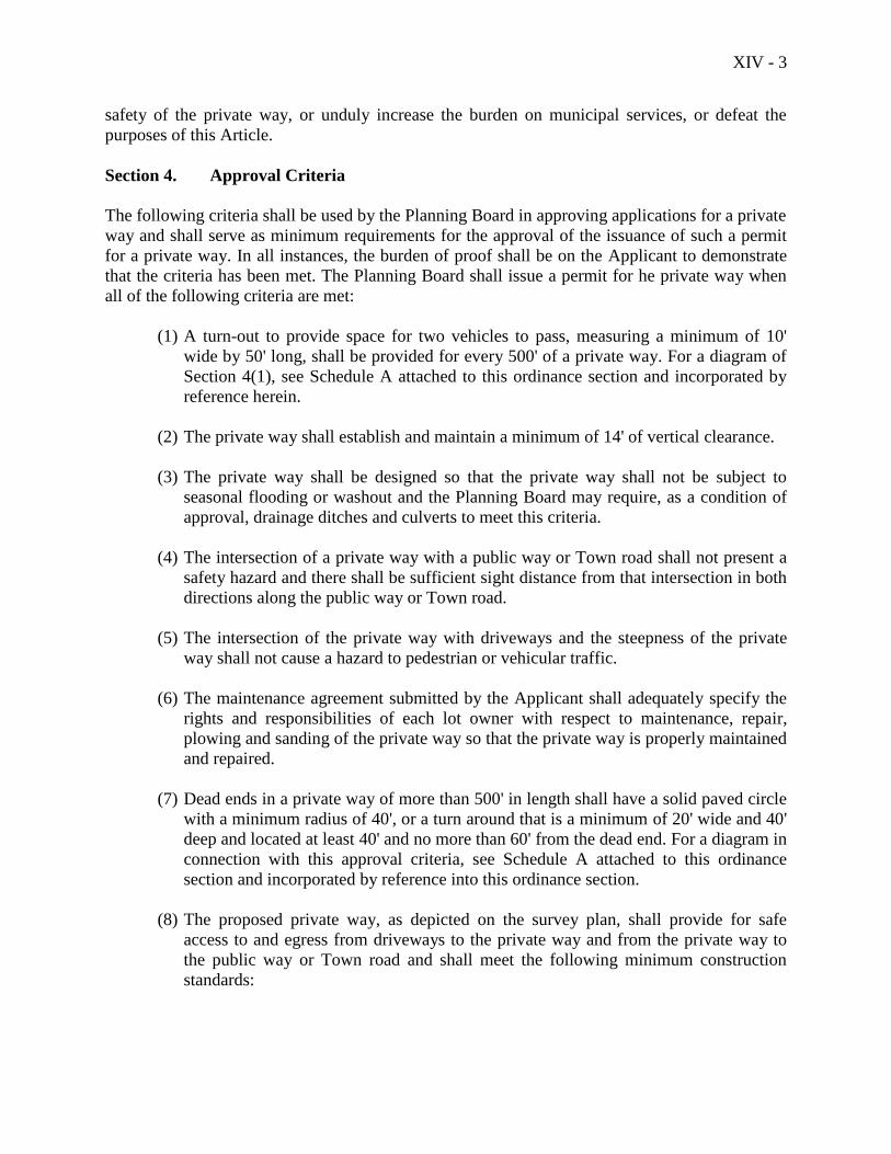
XIV - 3
safety of the private way, or unduly increase the burden on municipal services, or defeat the
purposes of this Article.
Section 4. Approval Criteria
The following criteria shall be used by the Planning Board in approving applications for a private
way and shall serve as minimum requirements for the approval of the issuance of such a permit
for a private way. In all instances, the burden of proof shall be on the Applicant to demonstrate
that the criteria has been met. The Planning Board shall issue a permit for he private way when
all of the following criteria are met:
(1) A turn-out to provide space for two vehicles to pass, measuring a minimum of 10'
wide by 50' long, shall be provided for every 500' of a private way. For a diagram of
Section 4(1), see Schedule A attached to this ordinance section and incorporated by
reference herein.
(2) The private way shall establish and maintain a minimum of 14' of vertical clearance.
(3) The private way shall be designed so that the private way shall not be subject to
seasonal flooding or washout and the Planning Board may require, as a condition of
approval, drainage ditches and culverts to meet this criteria.
(4) The intersection of a private way with a public way or Town road shall not present a
safety hazard and there shall be sufficient sight distance from that intersection in both
directions along the public way or Town road.
(5) The intersection of the private way with driveways and the steepness of the private
way shall not cause a hazard to pedestrian or vehicular traffic.
(6) The maintenance agreement submitted by the Applicant shall adequately specify the
rights and responsibilities of each lot owner with respect to maintenance, repair,
plowing and sanding of the private way so that the private way is properly maintained
and repaired.
(7) Dead ends in a private way of more than 500' in length shall have a solid paved circle
with a minimum radius of 40', or a turn around that is a minimum of 20' wide and 40'
deep and located at least 40' and no more than 60' from the dead end. For a diagram in
connection with this approval criteria, see Schedule A attached to this ordinance
section and incorporated by reference into this ordinance section.
(8) The proposed private way, as depicted on the survey plan, shall provide for safe
access to and egress from driveways to the private way and from the private way to
the public way or Town road and shall meet the following minimum construction
standards:
XIV - 4
Minimum, roadway width - 10'
Minimum width of right-of-way - 30'
Minimum sub-base (6) inch minus) - 12"
Minimum wearing surface (1 inch minus) - 2"
Maximum grade - 10%
Minimum grade - 0.5%
(9) For an application for the extension or addition to an existing private way constructed
on or before June 9, 1998, the Board shall not require that the existing portion of the
private way meet the approval criteria set forth above or that the Applicant submit a
maintenance agreement for lot owners served prior to that date by the existing private
way, but the Board can disapprove a permit for such extension or addition to that,
private way on grounds that the existing portion of the private way does not meet the
criteria above, or the Board may add as a condition of the Board's approval a
requirement of compliance of that existing private way with the criteria set forth
above,
Section 5. Expiration of Approval
The approval of the issuance of a permit for the construction and use of a private way within the
provisions of this Article of the Ordinance shall expire after a period of 24 months after the date
of approval if the private way has not been completed and the use of that private way
commenced.
Section 6. Recording Plan
The survey plan delineating the proposed private way including any conditions required for
approval by the Planning Board, shall be recorded in the Knox County Registry of Deeds within
90 days of the date of approval by the Planning Board. If the survey plan is not recorded within
this time period, the approval shall be null and void.
Section 7. Appeal
An appeal from a decision of the Planning Board concerning a permit for a private way may be
filed by an aggrieved party with the Zoning Board of Appeals. Such an appeal shall be filed no
more than 15 days after the date of the mailing of the written decision of the Planning Board to
the Applicant. The Zoning Board of Appeals shall have no authority to decide any appeal that is
not filed within that 15 day period.
A decision of the Zoning Board of Appeals concerning an appeal of a decision of the Planning
Board shall be appealable to Superior Court within 45 days after that decision as provided by
Title 30-A M.R.S.A. S2691, as the same shall be amended from time to time.

XIV - 5
Section 8. Definition of Private Way
For purposes of Article XIV only, a private way shall mean a right-of-way used for vehicular
access from a public way or a Town road to a lot or a principal use on a lot in the event that the
right-of -way used for that vehicular access is more than 500' in length, or for an extension of
existing private way with a length of more than 500', with the length measured as set forth in
Article XIV Section 1.(2). Private ways constructed and used after June 9, 1998 shall meet the
requirements of Article XIV (as amended) of the Zoning Ordinance.
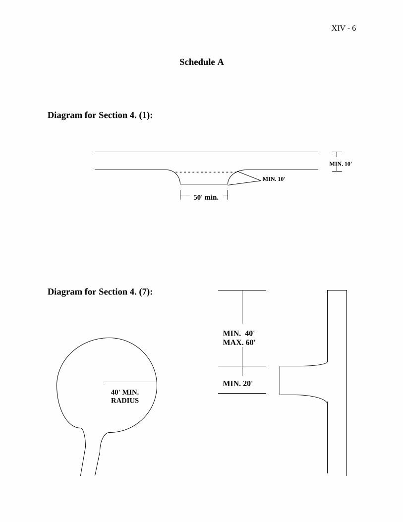
XIV - 6
Schedule A
Diagram for Section 4. (1):
MIN. 10'
- - - - - - - - - - - - - - - MIN. 10'
50' min.
Diagram for Section 4. (7):
MIN. 40'
MAX. 60'
MIN. 20' 40' MIN.
RADIUS
XV - 1
Article XV
Amendment and Other Interpretive Provisions
Section 1. Interpretation
Interpretation of what may not be clear in this Ordinance shall be according to the intent of the
Ordinance and the comprehensive plan.
Section 2. Conflict with Other Ordinances
Whenever the provisions of this Ordinance conflict with or are inconsistent with those of another
Ordinance or other regulations administered by the municipality, or wherever the regulations of
one part of this Ordinance conflict with another part of this Ordinance, the stricter shall apply,
except as expressly stated otherwise in this Ordinance. (Amended 11/10/09)
Section 3. Severability
If any section, subsection, sentence, clause, phrase or portion of this Ordinance is for any reason
held invalid or unconstitutional by any court of competent jurisdiction, such portion shall be
deemed a separate, distinct and independent provision and such holding shall not affect the
validity of the remaining portions.
Section 4. Amendment
No land use regulation or amendment thereof or change in the Official Zoning Map shall be
adopted until after the Selectmen of the Town have held a public hearing thereon at least ten
days before it is submitted to the Legislative Body for consideration. Public notice of the
hearing shall be made at least ten days prior to the hearing. Amendments to this Ordinance shall
be considered following petition, recommendation of the Planning Board, or motion of the
Selectmen. The petitioner shall bear the cost of advertising and of any postage for notification of
neighboring property owners.
Any amendments dealing with the shoreland area shall be effective only upon approval of the
Commissioner of Department of Environmental Protection. Within fourteen (14) days following
adoption of any shoreland amendments, the Municipal Clerk shall send a certified copy of the
amendments to the Commissioner of Department of Environmental Protection for approval. If
the Commissioner of Department of Environmental Protection fails to act on the amendments
within forty-five (45) days of the Department's receipt of the certified copy, the amendments
shall be deemed to be approved. Any application submitted to the Town within the forty-five
(45) day review period shall be governed by the terms of the amendment, if such amendment is
approved by the Commissioner of Department of Environmental Protection.
XV - 2
Section 5. Repeal
(1) The zoning ordinance herein shall be enacted and be of full force and effect on the day
following the date of approval of this zoning ordinance by the voters of the Town of
Camden at a town meeting, and any zoning ordinance of the Town of Camden in effect
prior to the date of enactment of this zoning ordinance shall be repealed as of that date.
(2) Persons who have applied for permits or approval or filed appeals under terms of the
previous Zoning Ordinance for the Town of Camden and prior to its repeal shall be
governed by the terms of said previous Ordinance, unless they elect, in writing to the
Code Enforcement Officer, to be governed by the terms of this Ordinance.
Section 6. Availability
A copy of this Zoning Ordinance certified by the Chairman of the Board of Selectmen shall be
filed with the Town Clerk and the Code Enforcement Officer and shall be accessible to any
member of the public. Copies shall be made available to the public at reasonable cost at the
expense of the person making the request. Notice of the availability of this Ordinance shall be
posted in the office of the Town Clerk.
State Law Reference: 12 MRSA Sec. 4811, 23 MRSA Sec. 1901 et seq.; 30 MRSA Sections
2411, 4961-4966, Sec. 4956; 30-A, MRSA Section 4358.