Embed Size (px)
Citation preview

UNITED NATIONS Working Paper GROUP OF EXPERTS ON No. 26 GEOGRAPHICAL NAMES Twenty-sixth session Vienna, 2-6 May 2011 Item 9 of the provisional agenda Activities relating to the Working Group on Toponymic Data Files and Gazetteers
National gazetteer of Poland: “Geographical names of Poland”
Vol. 1. “Hydronyms”
Submitted by Poland*
* Prepared by Maciej Zych, Commission on Standardization of Geographical Names Outside the Republic of Poland

1
National gazetteer of Poland: “Geographical names of Poland” Vol. 1. “Hydronyms”
(Summary) National gazetteer of Poland Geographical names of Poland, vol.1. Hydronyms (Nazewnictwo geograficzne Polski, tom 1. Hydronimy) published in 2006 mention a total of 15,857 names – 8252 names of flowing waters and 7605 names of standing waters (for comparison, the list of 1991 mentioned around 2000 names of flowing waters and 1800 names of standing waters). The names were formally standardized between 2002 and 2005. The list consists of two parts, the first with 348 pages entitled Flowing waters, sources, waterfalls and the second part with 410 pages entitled Standing waters. The first part mentioned a total of 8252 names divided into three sections: List of names of flowing waters (8100 names), List of names of sources (136 names) and List of names of waterfalls (16 names). The foreword to this part which is also the foreword to the whole first volume, gives an abbreviated characteristic of Polish hydronyms, a history of the standardization of names of water objects in Poland and also the work connected with publication of this list. The second part with 410 pages entitled Standing waters mentioned the names of 7605 lakes, reservoirs, ponds, bays, straits and shape forms of the Baltic Sea bed and its bays. There is only one list entitled List of names of standing waters that gives the names of objects in alphabetic order. This list is in two languages. The information is in Polish and in English beginning from the cover title, through the text of the preface and introduction up to tables’ titles and columns’ headings. However the main part of text in columns is given exclusively in Polish. All introductory information in Russian is additionally enclosed in the form of a 20-page brochure. The gazetteer is accessible in PDF format (English-language version is accessible on http://ksng.gugik.gov.pl/english/ngopv_01.php, while the Polish version can be found on http://ksng.gugik.gov.pl/narodowy_gazeter_polski_t_01.php).

2
National gazetteer of Poland: “Geographical names of Poland” Vol. 1. “Hydronyms”
The elaboration and publishing of national gazetteers in paper or electronic form stems from the implementation of the United Nations resolution approved by the First United Nations Conference on the Standardization of Geographical Names in Geneva in 1967, with the purpose of unifying geographical names. That conference recommended that individual countries elaborate and publish lists of officially acknowledged geographic names together with their localisation. Official lists should ensure uniformity in using geographical names in various types of publications and mass media. A full national gazetteer has not yet appeared in Poland. The work on standardizing geographical names reaches the first years after World War One, thought they never bore fruit in the publication of a full collection of geographical names within Poland. Two list of localities however were published between two World Wars: Index of localities of Republic of Poland, according to the first national census of 30th September 1921 and other official sources (Skorowidz miejscowości Rzeczypospolitej Polskiej opracowany na podstawie wyników pierwszego powszechnego spisu ludności z dn. 30 września 1921 r. i innych źródeł urzędowych) published in 16 volumes by Central Statistical Office in 1923-26 and Index of localities of the Republic of Poland with corresponding governmental agencies and offices, including communication facilities (Skorowidz miejscowości Rzeczypospolitej Polskiej z oznaczeniem terytorjalnie im właściwych władz i urzędów oraz urządzeń komunikacyjnych) published in 28 volumes by Scientific Publishing House in 1931-37. Standardization of geographical names in Poland after World War Two was initially tackled in 1946 by Commission for Establishing Names of Localities (in 1948 it was transformed to the Commission for Establishing Names of Localities and Physiographical Objects and, in 2003, into the Commission on Names of Localities and Physiographical Objects). In period 1946-51 German names of localities and physiographical objects on the Regained Territories were Polonized by this Commission and gazetteer of such standardized names was published: Dictionary of geographical names of Western and Northern Poland (Słownik nazw geograficznych Polski Zachodniej i Północnej). The gazetteer contained 2 volumes with former German and new official Polish names. From 1964 to 1974 Commission for Establishing Names of Localities and Physiographical Objects published Official names of localities and physiographical objects (Urzędowe nazwy miejscowości i obiektów fizjograficznych) in 197 volumes – each volume contained names of localities and physiographical objects of one county (second order administrative unit). In 1975, after administrative reform and liquidation of counties, standardizing works were abandoned. Solely names of localities were listed in two gazetteers: List of localities of People's Republic of Poland (Spis Miejscowości Polskiej Rzeczypospolitej Ludowej) published in one volume in 1967 and List of official names of localities in Poland (Wykaz urzędowych nazw miejscowości w Polsce) published in 3 volumes in 1980-82. The Head Office of Geodesy and Cartography initiated publication of a national gazetteer in the late 1970s, the outcome of many years of effort was the publication of a list Geographical names of the Republic of Poland (Nazwy geograficzne Rzeczypospolitej Polskiej) in 1991 but holding only 28,000 standardized names. Due to its size this gazetteer corresponded to the accuracy of medium-scale maps (around 1:250,000 – 1:300,000). The Polish State Register of Geographical Names corresponding to a names detail accuracy more or less of 1:10,000 maps has been elaborated for several years, the result of this work being a collection of more than 195,000 place names, forms of land shapes and also water objects. These names are presently undergoing verification and formal standardization by the Commission on Names of Localities and Physiographical Objects. Successive parts of

3
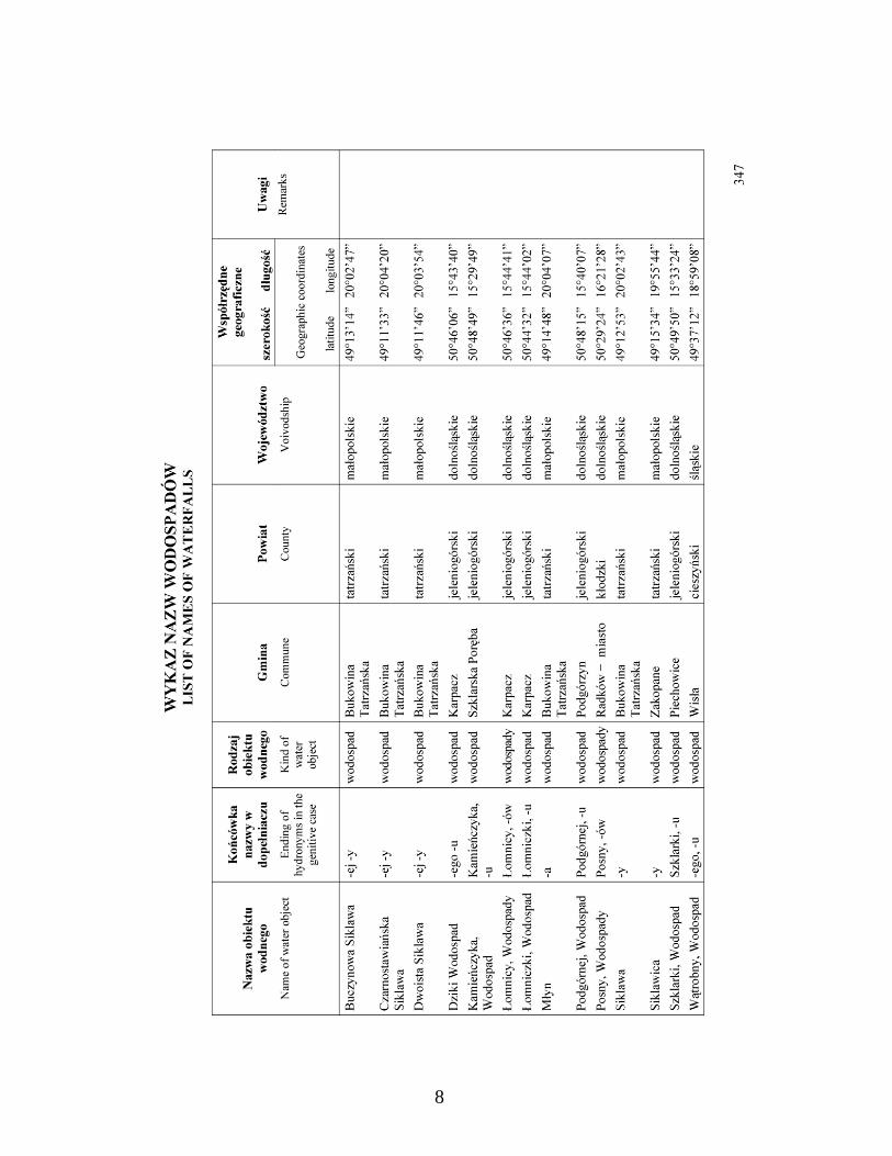
the national gazetteer are to be published as work progresses, a list of hydronyms having appeared as the first volume in 2006. Geographical names of Poland, vol.1. Hydronyms (Nazewnictwo geograficzne Polski, tom 1. Hydronimy) mention a total of 15,857 names – 8252 names of flowing waters and 7605 names of standing waters (for comparison, the list of 1991 mentioned around 2000 names of flowing waters and 1800 names of standing waters). The names were formally standardized between 2002 and 2005. The list consists of two parts, the first with 348 pages entitled Flowing waters, sources, waterfalls and the second part with 410 pages entitled Standing waters. The first part mentioned a total of 8252 names divided into three sections: List of names of flowing waters (8100 names), List of names of sources (136 names) and List of names of waterfalls (16 names). The foreword to this part which is also the foreword to the whole first volume, gives an abbreviated characteristic of Polish hydronyms, a history of the standardization of names of water objects in Poland and also the work connected with publication of this list. In the introduction to the first part, the system used in the whole list was also highlighted in the form of a table. Definitions of used terms were also given like river, stream, creek, brook etc. The introduction to the edition is supplemented with bibliography of toponomastic elaborations. Similar information has also been given in the introduction to the second part. A map: Poland. Main basins and drainage areas in a scale of 1:3,000,000 is an enclosure to the first part of the list. Three separate lists of geographic names are given in part one of the list Flowing waters, sources, waterfalls. The first entitled List of names of flowing waters contains the names of 8100 water objects given in a table in alphabetic order. The following information is given in columns for each name.
• Column 1 – standardized name of the object, (without giving alternant names). The list mentions both names concerning the whole flowing water as well as names of its separate sections (names of sections are given in italics). In the case of flowing waters along which a state frontier runs as well as rivers partly flowing abroad, only the Polish name is given. In multiple-word names holding a generic term, an interrupted order is used the name members being divided by a comma, a simple order is used in the case of other names.
• Column 2 – the genitive of the name’s end • Column 3 – the kind of object. In the case of flowing waters 9 kinds are mentioned:
river, stream, creek, brook, canal, ditch, outlet branch, side branch, old river bed. • Column 4 – the recipient, that is the flowing water or reservoir to which the given
flowing water flows. Only its Polish name (exonym) is given if it exists should the recipient be outside the Polish borders and if none such exists then its endonim is given. In the case of navigable canals linking two rivers, both rivers are given as the recipient.
• Column 5 – geographic coordinates with an accuracy of one angular second have been given for a flowing water outlet junction, i.e. the outlet of a tributary to a recipient. For rivers “intersected” by a state frontier and having their origins in Poland, the point where the river and frontier intersect is accepted as the outlet junction. Should a flowing water have several names for individual section, the coordinates of the point on the river at which, according to data, the river changes its name mainly in open territory, is given as the outlet junction’s coordinates.
• Column 6 – remarks referring to explanations of specific cases appearing in a river network as well as information about names of the flowing water in its other sections.

4
The second list entitled List of names of sources contains the names of 136 objects presented in a table in alphabetic order. The following information is given for each name in the columns:
• Column 1 – an object’s standardized name (without giving alternant names). In multiple-word names holding a generic term, an interrupted order is used the name members being divided by a comma, a simple order is used in the case of other names.
• Column 2 – the genitive of the name’s end • Column 3 – the kind of object: spring or springs • Column 4 – administrative location of the object in a commune (third level
administration unit) • Column 5 – administrative location of the object in a county (second level
administration unit) • Column 6 – administrative location of an object in a voivodship (first level
administration unit) • Column 7 – geographic coordinates given with an accuracy to one angular second • Column 8 – remarks concerning a special importance of an object (e.g. a nature
reserve) The third list entitled List of names of waterfalls holds the names of 16 objects given in a table in alphabetic order. Information for each name is given in analogical columns as information in the List of names of sources, with one difference – in column 3 the kind of object is given as “waterfall” or “waterfalls”. The second part with 410 pages entitled Standing waters mentioned the names of 7605 lakes, reservoirs, ponds, bays, straits and shape forms of the Baltic Sea bed and its bays. There is only one list entitled List of names of standing waters that gives the names of objects in alphabetic order. The following information is given in columns for each name:
• Column 1 – standardized name of the object (without giving alternant names) situated within Poland together with territorial waters. The list mentions both names relating to the whole object as well as names concerning its fragments e.g. lake bays (names of parts of objects are given in italics). In the case of objects “intersected” by a national frontier only Polish names have been given. In multiple-word names holding a generic term, an interrupted order is used the name members being divided by a comma, a simple order is used in the case of other names.
• Column 2 – the genitive of the name’s end • Column 3 – the kind of object. Eight kinds of standing waters are mentioned: lake,
pond, reservoir, bay, strait, sea, deep, bank. • Column 4 – the administrative location of the object within a commune (third level
administration unit). Should an object be situated in several units than the central point of a given stretch is given as its administrative affiliation.
• Column 5 – the administrative location of the object within a county (second level administration unit). Should the object be situated in several units then its administrative affiliation is given as the affiliation of the central point of a given stretch.
• Column 6 – the administrative location of an object within a voivodship (first level administration unit). Should the object be situated in several units then its administrative affiliation is given as the affiliation of the central point of a given stretch.

5
• Column 7 – the geographic coordinates are given with an accuracy of one angular second for the central point of an object. For objects partly outside Polish borders, the coordinates are given of the central point of the Polish part.
• Column 8 – remarks referring to the object’s component parts, the intersection of the object with a national frontier and objects of special importance e.g. a nature reserve and other special cases.
This list is in two languages. The information is in Polish and in English beginning from the cover title, through the text of the preface and introduction up to tables’ titles and columns’ headings. However the main part of text in columns is given exclusively in Polish. All introductory information in Russian is additionally enclosed in the form of a 20-page brochure. The whole of Volume 1. Geographical names of Poland is accessible in PDF format on the website of the Commission on Standardization of Geographical Names Outside the Republic of Poland. The English-language version is accessible on http://ksng.gugik.gov.pl/english/ngopv_01.php, while the Polish version can be found on http://ksng.gugik.gov.pl/narodowy_gazeter_polski_t_01.php. The list of hydronyms is also accessible on the interactive version of database on website www.geoportal.gov.pl. Examples of pages of various parts of the list are shown in enclosures.

6

7
8

9