Embed Size (px)
Citation preview

WJEC Eduqas GCE AS in
GEOGRAPHY
SPECIFICATION
Teaching from 2016For award from 2017
This Ofqual regulated qualification is not available forcandidates in maintained schools and colleges in Wales.
ACCREDITED BY OFQUAL
GCE AS
Version 2 January 2019

AS GEOGRAPHY
SUMMARY OF AMENDMENTS
Version Description Page number
2 'Making entries' section has been amended to clarify resit rules.
26
1
© WJEC CBAC Ltd.
WJEC Eduqas GCE AS in
GEOGRAPHY
For teaching from 2016 For award from 2017
Page Summary of assessment 2 1. Introduction 3 1.1 Aims and objectives 3 1.2 Prior learning and progression 4 1.3 Equality and fair access 5 2. Subject content 6 2a. The place of fieldwork in the specification 7 2b. The place of geographical skills in the specification 9 2.1 Component 1 11 2.2 Component 2 19 3. Assessment 24 3.1 Assessment objectives and weightings 24 3.2 Arrangements for fieldwork 25 4. Technical information 26 4.1 Making entries 26 4.2 Grading, awarding and reporting 26 Appendix A: Geographical skills 27 Appendix B: Opportunities for fieldwork 32

AS GEOGRAPHY 2
© WJEC CBAC Ltd.
GCE AS GEOGRAPHY
SUMMARY OF ASSESSMENT
Component 1: Changing Landscapes Written examination: 2 hours 15 minutes 60% of qualification Section A: Changing Landscapes Choice between two themes, either Coastal or Glaciated Landscapes; two compulsory structured questions with data response Section B: Tectonic Hazards One compulsory structured question with data response and two extended response questions Section C: Challenges in the 21st Century One compulsory extended response question drawing on both Components 1 and 2, with resource material Component 2: Changing Places Written examination: 1 hour 15 minutes 40% of qualification Section A: Changing Places Two compulsory structured questions with data response Section B: Fieldwork Investigation in Physical and Human Geography Three compulsory structured questions with data response on fieldwork and the learner's own fieldwork investigation
This linear qualification will be available in the summer series each year. It will be awarded for the first time in summer 2017.
Qualification Accreditation Number: 601/8848/0

3
© WJEC CBAC Ltd.
GCE AS GEOGRAPHY 1 INTRODUCTION
1.1 Aims and objectives The WJEC Eduqas AS in Geography specification encourages learners to apply selected geographical knowledge, theory and skills to the world around them to foster an understanding of the world’s people, places and environments in the 21st century. The skills developed in this AS qualification will enable learners to transfer many of these to a range of related A levels, higher education courses and a range of employment opportunities. The focus of the specification is to encourage an enthusiasm for geography by using contemporary real-world contexts, from a range of specified spatial scales. The specification also focuses on practical application of geographical skills and techniques in fieldwork at the local scale to enable learners to pose enquiry questions. The specification covers the required subject content at an appropriate level of rigour and challenge for a GCE AS qualification. The content is organised into the required core and non-core themes. The non-core content is presented as one compulsory theme on Tectonic Hazards. This non-core theme allows for in-depth treatment. The core and non-core content has been selected to be co-teachable with the WJEC Eduqas A level Geography. The specialised concepts and geographical skills (quantitative and qualitative skills and approaches) as noted below in the aims and objectives are embedded in the core and non-core content. The WJEC Eduqas GCE AS in Geography requires learners to:
• develop their knowledge of locations, places, processes and environments, at all geographical scales from local to global across the specification as a whole
• develop an in-depth understanding of the selected core and non-core processes in physical and human geography at a range of temporal and spatial scales, and of the concepts which illuminate their significance in a range of locational contexts
• recognise and be able to analyse the complexity of people-environment interactions at all geographical scales, and appreciate how these underpin understanding of some of the key issues facing the world today
• develop their understanding of, and ability to apply, the concepts of place, space, scale and environment, that underpin both the national curriculum and GCSE, including developing a more nuanced understanding of these concepts

AS GEOGRAPHY 4
© WJEC CBAC Ltd.
• gain understanding of specialised concepts relevant to the core and non-
core content. These must include the concepts of causality, equilibrium, feedback, identity, inequality, interdependence, globalisation, mitigation and adaptation representation, risk, resilience, sustainability, systems, and thresholds
• improve their understanding of the ways in which values, attitudes and circumstances have an impact on the relationships between people, place and environment, and develop the knowledge and ability to engage, as citizens, with the questions and issues arising
• become confident and competent in selecting, using and evaluating a range of quantitative and qualitative skills and approaches, (including observing, collecting and analysing geo-located data) and applying them as an integral part of their studies
• understand the fundamental role of fieldwork as a tool to understand and generate new knowledge about the real world, and become skilled at planning, undertaking and evaluating fieldwork in appropriate situations
• apply geographical knowledge, understanding, skills and approaches in a rigorous way to a range of geographical questions and issues, including those identified in fieldwork, recognising both the contributions and limitations of geography
• develop as critical and reflective learners, able to articulate opinions, suggest relevant new ideas and provide evidenced argument in a range of situations.
Aims and objectives as listed in the DfE Geography GCE AS and A level subject content (December 2014).
1.2 Prior learning and progression There are no prior learning requirements. Any requirements set for entry to a course following this specification are at the discretion of centres. It is reasonable to assume that many learners will have achieved qualifications equivalent to Level 2 at KS4. Skills in Numeracy/Mathematics, Literacy/English and Information Communication Technology will provide a good basis for progression to this qualification. This specification builds on the knowledge, understanding and skills established at GCSE and particularly aims to develop a deeper understanding of, and ability to apply, the concepts of place, space, scale and environment. Some learners will have already gained knowledge, understanding, and skills through their study of geography at GCSE. This specification provides a suitable foundation for the study of geography at A level. In addition, the specification provides a coherent, satisfying and worthwhile course of study for learners who do not progress to further study in this subject. This specification is not age specific and, as such, provides opportunities for candidates to extend their life-long learning.

5
© WJEC CBAC Ltd.
1.3 Equality and fair access This specification may be followed by any learner, irrespective of gender, ethnic, religious or cultural background. It has been designed to avoid, where possible, features that could, without justification, make it more difficult for a learner to achieve because they have a particular protected characteristic. The protected characteristics under the Equality Act 2010 are age, disability, gender reassignment, pregnancy and maternity, race, religion or belief, sex and sexual orientation. The specification has been discussed with groups who represent the interests of a diverse range of learners, and the specification will be kept under review. Reasonable adjustments are made for certain learners in order to enable them to access the assessments (e.g. candidates are allowed access to a Sign Language Interpreter, using British Sign Language). Information on reasonable adjustments is found in the following document from the Joint Council for Qualifications (JCQ): Access Arrangements and Reasonable Adjustments: General and Vocational Qualifications. This document is available on the JCQ website (www.jcq.org.uk). As a consequence of provision for reasonable adjustments, very few learners will have a complete barrier to any part of the assessment.

AS GEOGRAPHY 6
© WJEC CBAC Ltd.
2 SUBJECT CONTENT The subject content focuses on the dynamic nature of physical systems and processes in the real world, and on the interactions and connectivity between people, places and environments in both time and space. The core themes are divided into two separate physical and human themes. The non-core content draws on both physical and human geography and also people-environment interactions. All themes integrate geographical skills, scale and specialised concepts. Appendix A lists the geographical skills in this specification and identifies where these skills can be integrated. Component 1, Changing Landscapes has three sections. In the first section, learners will develop knowledge and understanding of physical geography, primarily at the local level, although wider scales are addressed where appropriate to the context. In the second section, learners will develop in-depth knowledge of Tectonic Hazards through study of selected physical and human processes, their linkages and the inter-relationships between people and environment. In the third section, Section C, the assessment will focus on application of knowledge and understanding to draw together elements from across the course. Component 2, Changing Places has two sections. In the first section, learners will develop knowledge and understanding of human geography, primarily at the local level, although wider scales are addressed where appropriate to the context. In the second section the focus is on fieldwork opportunities related to Changing Landscapes and Changing Places as the content in both provides a range of opportunities for physical and human geography fieldwork. Skills in physical and human fieldwork and the learner’s own fieldwork investigations will be assessed in this component. In order to fulfil the requirement for fieldwork investigations, fieldwork must be integrated into study. The fieldwork must cover both physical geography fieldwork and human geography fieldwork, and be undertaken through the equivalent of at least two days. Centres must verify that the required fieldwork has taken place. For learners to be able to apply their geographical skills, the specification focuses on the six-stage enquiry method for fieldwork investigations, which ranges from setting a research question to collecting and analysing data and to producing written work on the stages of their investigation. Appendix B lists suggested opportunities for fieldwork to provide possible starting points.
Within the specification an introduction to each theme is followed by the required knowledge and understanding, which is set out in two columns. The focus of study is presented in the first column, with amplification of the geographical content in the second column. The introduction to each theme presents a rationale of the content and details the specialised concepts central to each theme. The rationale will not be assessed. However, the assessment actively requires learners to demonstrate understanding of the specialised concepts. Knowledge and understanding of the specialised concepts helps learners to develop as critical and reflective learners with the capability to analyse, interpret and evaluate key geographical information and issues; this enables learners to think like geographers. There is no hierarchy implied by the order in which the content is presented in each theme, but it reflects the order in which it will appear in the assessment component. Examples and case studies selected for study by centres to exemplify the content must be contemporary, that is within the last two decades, unless an historical context is useful for a time dimension, which also informs the present context. Case studies and examples are not listed throughout this specification; instead learners are expected to demonstrate independent learning through the selection of examples and case studies. These examples and case studies should enable learners to develop knowledge and understanding of place, context and scale to reinforce the specialised concepts. Where case studies and examples are specified this is to highlight a context appropriate to the content.
7
© WJEC CBAC Ltd.
2a. The place of fieldwork in the specification
Geographical fieldwork is defined as applying specific geographical knowledge, understanding and skills to a particular and real out-of-classroom context. In total, the equivalent of at least two days of geographical fieldwork must be undertaken as required in the subject content. These days must be based both on physical geography fieldwork and on human geography fieldwork (some, but not all of this, may be within the context of people- environment questions and issues) and spread across the course.
Overall, this fieldwork will enable learners to:
• undertake fieldwork in relation to processes in both physical and human geography (some, but not all of this, may be within the context of people-environment questions and issues)
• identify appropriate field research questions, based on their knowledge and understanding of relevant aspects of physical and human geography
• understand how to observe and record phenomena in the field and be able to devise and justify practical approaches taken in the field, (including frequency/timing of observation, sampling, and data collection approaches)
• demonstrate knowledge and understanding of how to undertake practical field methodologies appropriate to the investigation of core human and physical processes
• demonstrate knowledge and understanding of implementing chosen methodologies to collect data/information of good quality that is relevant to the topic under investigation
• apply existing knowledge and concepts to identify, order and understand field observations.
Within this specification, a suitable starting point for physical geography is linked to Section A in Changing Landscapes, as the focus in either Coastal Landscapes (1.1) or Glaciated Landscapes (1.2) is on the local scale. This can then be followed by fieldwork linked to Changing Places in Component 2. Here again the focus is on the local scale; in both cases the local scale is well suited to fieldwork. Appendix B lists the specific opportunities linked to both Components 1 and 2 and Appendix A gives geographical skills appropriate to fieldwork. The six stages of the enquiry process The enquiry process forms the framework for application of the fieldwork and geographical skills. Knowledge and understanding of the six stages will be developed overall through the fieldwork and each of the days undertaken may focus on some of the aspects of the six stages; that is all the geographical skills involved in the enquiry process need not be undertaken on the fieldwork days. The aim should be to build by the end of the fieldwork a holistic understanding of the six stages.

AS GEOGRAPHY 8
© WJEC CBAC Ltd.
Sequence and enquiry questions
Geographical skills
1. Context and planning – what is the geographical enquiry process?
Prepare to investigate a geographical question in the field; make and justify decisions on the task including data collection methods and how to use them; define and refine the research question(s) that underpin the context of the field investigation; risk and ethical issues
2. Data collection – how is data and information (evidence) collected?
Acquire field data (primary) and relevant literature (secondary data / information) pertinent to the research question; implement chosen methodologies to observe and record in the field using quantitative and qualitative methods and field (primary) and secondary data / information; understand the theory / context for the research question. Justify practical approaches taken in the field, (including frequency/timing of observation, sampling, and data collection approaches)
3. Presentation and display – how is the collected data and information presented?
Process a range of field and any relevant secondary data / information using quantitative and qualitative methods in order to lead to appropriate analysis
4. Analysis and interpretation of findings – how can the evidence be analysed?
Interrogate (interpret and analyse) data / information from field (primary) data, and, as relevant, secondary data / information; describe patterns, trends, relationships; apply knowledge and understanding of geographical knowledge, concepts and processes and theory to specific evidence collected to understand field observations
5. Conclusion – what conclusions can be drawn and how do these relate to the initial aim of the enquiry?
Synthesise findings to draw conclusions based on evidence and theoretical research
6. Evaluation of the whole investigation – what evaluative techniques should be applied to the enquiry process?
Critically reflect on every stage of the whole investigation in order to appreciate the strengths and limitations of the primary and secondary data, links to original question; note strengths and limitations (accuracy, validity and reliability) and anomalies and / or errors or misuse of data; evaluate the methodology including, if relevant, sampling techniques; suggest improvements for further research
9
© WJEC CBAC Ltd.
To prepare for each of their fieldwork activities, learners should be given opportunities to:
• pose geographical questions • consider appropriate data collection methodologies • design survey strategies before they go on field visits.
In considering and collecting appropriate raw data / information collected in the field (primary data / information), learners should be guided to observe and record by:
• taking measurements and surveys, including questionnaires, observations and interviews
• making images, including field sketches and photographs • obtaining raw census material • obtaining information from GIS.
Learners should also be guided towards sampling techniques, coding, timing and frequency as appropriate. In order to understand the theoretical or comparative context of their research question(s) learners also need to be guided to collect secondary information as appropriate. This is data that has already been processed in published materials. More details follow in Appendix A of this specification.
Data collected in the field is often referred to as primary data and involves such quantitative skills as measurements and qualitative skills as observations and interviews.
After their various fieldwork activities, learners should be given opportunities to: • consider appropriate methods of data / information presentation • reflect on their fieldwork findings by processing data • analyse patterns and trends and draw conclusions • evaluate techniques and the various fieldwork activities.
This exercise of collecting and analysing field data and reflecting on the fieldwork provides the preparation necessary for the assessment of the learner’s own physical and human geography fieldwork. The writing up of the physical and human geography fieldwork will help learners’ understanding of the stages undertaken.
Centres will be required to verify that the prescribed fieldwork for each learner has taken place. See Section 3.2 for the verification arrangements for fieldwork.
2b. The place of geographical skills in the specification Geographical skills should be addressed in all components, not as a separate theme or topic. Learners must be introduced to a roughly equal balance of quantitative and qualitative skills across the specification as a whole, although the balance between the two will vary depending on the theme. Sections 2.1 and 2.2 specify the particular geographical skills that must be addressed in each theme. Appendix A identifies where these skills can be integrated.
Learners are required to: • understand the nature and use of different types of geographical information,
including qualitative and quantitative, primary and secondary, images, factual text and discursive/creative material, digital data, numerical and spatial data and innovative forms of data, including crowd-sourced and 'big data'
• collect, analyse and interpret such information, and demonstrate the ability to understand and apply suitable analytical approaches for the different information types
• undertake informed and critical questioning of data sources, analytical methodologies, data reporting and presentation, including the ability to identify sources of error in data and to identify the misuse of data.

AS GEOGRAPHY 10
© WJEC CBAC Ltd.
For qualitative data, learners must demonstrate the following skills: • use and understand a mixture of methodological approaches, including using
interviews • interpret and evaluate a range of source material including textual and
visual sources • understand the opportunities and limitations of qualitative techniques such
as coding and sampling, and appreciate how they actively create particular geographical representations
• understand the ethical and socio-political implications of collecting, studying and representing geographical data about human communities.
For quantitative data, learners must demonstrate the following skills: • understand what makes data geographical and the geospatial technologies
(e.g. GIS) that are used to collect, analyse and present geographical data • demonstrate an ability to collect and to use digital, geo-located data, and to
understand a range of approaches to the use and analysis of such data • understand the purposes and difference between the following and be able to
use them in appropriate contexts: descriptive statistics of central tendency and dispersion
• descriptive measures of difference and association, inferential statistics and the foundations of relational statistics, including (but not limited to) measures of correlation and lines of best fit on a scatter plot
• measurement, measurement errors, and sampling.

11
© WJEC CBAC Ltd.
2.1 Component 1 Changing Landscapes Written examination: 2 hours 15 minutes 60% of qualification 120 marks This component is divided into three sections: A, B and C. SECTION A – Changing Landscapes In this section there is a choice between either coastal or glaciated landscapes. 1.1 Coastal Landscapes or 1.2 Glaciated Landscapes Scale in this section is fundamentally at the local level, but includes a wider region to put the local level into context; it also emphasises linkages between local and regional and extends to national and international. The content of this section must be treated with the same depth as Section A in Component 2. SECTION B – Tectonic Hazards The questions in this compulsory section focus on physical and human geography and the inter-relationships between people and environment. SECTION C – Challenges in the 21st Century This section is compulsory. The assessment will have one extended response question with resource material and draws on both Components 1 and 2. Scale in this section covers local to global as appropriate to the context.
Geographical skills
In Section A, Changing Landscapes, learners should use quantitative approaches including developing observation skills, measurement and geo-spatial mapping skills, together with data manipulation and statistical skills applied to field measurement. Qualitative approaches may be used if appropriate. Appendix A identifies where these skills can be integrated. In Section B, Tectonic Hazards, learners are expected to apply the skills acquired through the delivery of Components 1 and 2, where appropriate.

AS GEOGRAPHY 12
© WJEC CBAC Ltd.
SECTION A – Changing Landscapes Either 1.1: Coastal Landscapes This optional theme involves the study of coastal landscapes developed by the interaction of winds, waves and currents and the sediment supply from terrestrial and offshore sources. Study takes place within a systems framework, focusing on spatial and temporal variations in the geomorphological processes that operate within coastal landscapes and how the flows of energy and movement of materials combine to create specific landforms on rocky, sandy and estuarine coastlines. Scale in this theme is fundamentally at the local level but includes a wider region to put the local into context. Some content moves beyond the local to the global to embrace a variety of landscapes not evident in the UK, for example the study of mangrove coastlines. The impact of human activity as a factor causing change within coastal landscape systems will also be studied. As an outcome of studying this theme, learners will gain an understanding of specialised concepts: causality (linking processes to landforms and landscapes), equilibrium (related to dynamic equilibrium), feedback (the process by which the coastal system responds to changing inputs and outputs), interdependence (the relationship between human activity and coastal landscape systems), mitigation (related to coastal management), adaptation (related to shoreline plans), risk (in the context of the impact of extreme weather events associated with anthropogenic climate change on coastal processes and landforms), resilience (related to coastal management), systems (especially coastal sediment budgets) and thresholds (a factor that complicates the self-regulation of the coastal system: when crossed, it sets irreversible changes in motion). Focus Geographical content 1.1.1 The operation of the coast as a system
• The coastal system including inputs, outputs, stores and transfers of energy and materials
• Terrestrial and offshore supplies of sediment • Coastal sediment cells • Dynamic equilibrium in the coastal system and zone of rapid
changes 1.1.2 Landforms and landscape systems, their distinctive features and distribution
• High energy coastal environments and associated erosional landforms and landscape systems including rocky coastlines
• Low energy coastal environments and associated depositional landforms and landscape systems including sandy coastlines and estuarine coastlines
1.1.3 Factors affecting coastal processes and landforms
• Diurnal tides, offshore and onshore currents • Constructive and destructive wave types and their
characteristics and seasonal variations • Fetch, wave type, wave orientation, wave refraction and
reflection • Lithological factors of mineral composition, hardness and
solubility of rocks • Structural geology including bedding, dip, joints, folding and
faulting 1.1.4 Processes of coastal weathering, mass movement, erosion and the characteristics and formation of associated landforms and landscapes
• Sub aerial processes of weathering (physical, chemical and biotic) and mass movement including landslides, slumps and rock falls
• Marine erosional processes of hydraulic action, abrasion (corrasion), corrosion and attrition
• Characteristics of coastal landforms and landscapes including cliffs, headlands and bays, cave-arch-stack-stump sequence and wave-cut platforms, geos and blowholes both for and beyond the UK

13
© WJEC CBAC Ltd.
Focus Geographical content 1.1.5 Processes of coastal transport and deposition and the characteristics and formation of associated landforms and landscapes
• Processes of coastal transport of solution, suspension, saltation and traction including longshore drift
• Processes of coastal deposition result from reduced energy levels including flocculation and sediment sorting
• Characteristics of coastal landforms and landscapes including beaches, spits, bars, tombolos and cuspate forelands both for and beyond the UK
1.1.6 Aeolian, fluvial and biotic processes and the characteristics and formation of landforms in coastal landscapes
• Action of wind and associated landforms of sand dunes • Action of fluvial processes in estuarine environments and
associated landforms of tidal flats, salt marshes and micro-features of channels and rills
• Action of biotic processes and associated development of coral reefs and mangrove coastlines
1.1.7 Variations in coastal processes, coastal landforms and landscapes over different time scales
• Process and landform changes in seconds: high energy storm events and rapid mass movement processes causing changes in cliff profiles
• Seasonal process and landform changes: seasonal changes in beach profiles associated with seasonal variations in wave types
• Process and landform and landscape changes over millennia: either eustatic or isostatic changes in sea level and their impact on one landform
1.1.8 Coastal processes are a vital context for human activity
• Positive impacts of coastal processes on human activity including the growth of tourism
• Negative economic and social losses associated with coastal erosion
• Case study of one management strategy to manage the impacts of coastal processes on human activity
1.1.9 The impact of human activity on coastal landscape systems
• Positive impacts of human activity on coastal processes and landforms including management and conservation
• Negative impacts of human activity on coastal processes and landform including offshore dredging and erosion of sand dunes
• Case study of one management strategy to manage the impacts of human activity on coastal processes, landforms and landscapes
AS GEOGRAPHY 14
© WJEC CBAC Ltd.
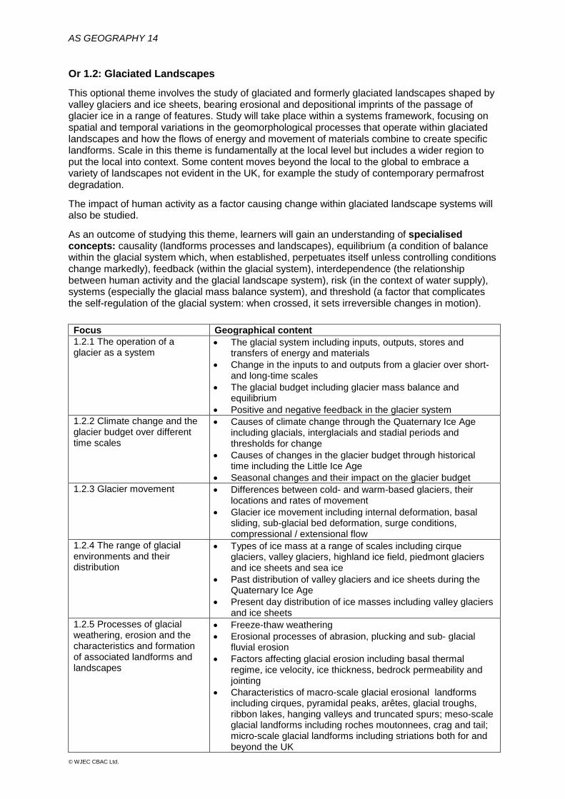
Or 1.2: Glaciated Landscapes
This optional theme involves the study of glaciated and formerly glaciated landscapes shaped by valley glaciers and ice sheets, bearing erosional and depositional imprints of the passage of glacier ice in a range of features. Study will take place within a systems framework, focusing on spatial and temporal variations in the geomorphological processes that operate within glaciated landscapes and how the flows of energy and movement of materials combine to create specific landforms. Scale in this theme is fundamentally at the local level but includes a wider region to put the local into context. Some content moves beyond the local to the global to embrace a variety of landscapes not evident in the UK, for example the study of contemporary permafrost degradation. The impact of human activity as a factor causing change within glaciated landscape systems will also be studied.
As an outcome of studying this theme, learners will gain an understanding of specialised concepts: causality (landforms processes and landscapes), equilibrium (a condition of balance within the glacial system which, when established, perpetuates itself unless controlling conditions change markedly), feedback (within the glacial system), interdependence (the relationship between human activity and the glacial landscape system), risk (in the context of water supply), systems (especially the glacial mass balance system), and threshold (a factor that complicates the self-regulation of the glacial system: when crossed, it sets irreversible changes in motion).
Focus Geographical content 1.2.1 The operation of a glacier as a system
• The glacial system including inputs, outputs, stores and transfers of energy and materials
• Change in the inputs to and outputs from a glacier over short- and long-time scales
• The glacial budget including glacier mass balance and equilibrium
• Positive and negative feedback in the glacier system 1.2.2 Climate change and the glacier budget over different time scales
• Causes of climate change through the Quaternary Ice Age including glacials, interglacials and stadial periods and thresholds for change
• Causes of changes in the glacier budget through historical time including the Little Ice Age
• Seasonal changes and their impact on the glacier budget 1.2.3 Glacier movement • Differences between cold- and warm-based glaciers, their
locations and rates of movement • Glacier ice movement including internal deformation, basal
sliding, sub-glacial bed deformation, surge conditions, compressional / extensional flow
1.2.4 The range of glacial environments and their distribution
• Types of ice mass at a range of scales including cirque glaciers, valley glaciers, highland ice field, piedmont glaciers and ice sheets and sea ice
• Past distribution of valley glaciers and ice sheets during the Quaternary Ice Age
• Present day distribution of ice masses including valley glaciers and ice sheets
1.2.5 Processes of glacial weathering, erosion and the characteristics and formation of associated landforms and landscapes
• Freeze-thaw weathering • Erosional processes of abrasion, plucking and sub- glacial
fluvial erosion • Factors affecting glacial erosion including basal thermal
regime, ice velocity, ice thickness, bedrock permeability and jointing
• Characteristics of macro-scale glacial erosional landforms including cirques, pyramidal peaks, arêtes, glacial troughs, ribbon lakes, hanging valleys and truncated spurs; meso-scale glacial landforms including roches moutonnees, crag and tail; micro-scale glacial landforms including striations both for and beyond the UK

15
© WJEC CBAC Ltd.
Focus • Geographical content 1.2.6 Processes of glacial and fluvioglacial transport and glacial and fluvioglacial deposition and the characteristics and formation of associated landforms and landscapes
• Processes of glacial and fluvioglacial transport including supraglacial, englacial and sub glacial transfers and their resultant sediment characteristics (size, shape and sorting)
• Landforms of glacial deposition including types of till (ablation, lodgement and deformation) and types of moraine (terminal, recessional, lateral, medial and push) and drumlins
• Processes of fluvioglacial transport and deposition lead to ice-contact features including eskers, kames, kame terraces and proglacial features including sandurs, varves, kettle holes and kettle lakes both for and beyond the UK
1.2.7 Periglacial processes and the formation of associated features and landscapes
• Ground ice formation and associated features, including ice lenses, ice wedge polygons, patterned ground, pingos and thermokarst landscape
• Frost weathering and mass movement can lead to features including nivation hollows, blockfields and scree slopes, pro-talus ramparts, solifluction terraces and head deposits
• Periglacial action of water and wind and associated landforms of dry valleys (water) and loess plateaux (wind)
• Variations in glacial landscapes between highland and lowland • Variations in glacial landscapes between ice sheets and valley
glaciers 1.2.8 Variations in glacial processes, glacial landforms and landscapes over different time scales
• Process and landform changes in seconds: rapid mass movement processes causing changes in glacial valley profiles
• Seasonal process and landform changes: landform changes associated with seasonal variations in fluvioglacial transport and deposition
• Process and landform changes over millennia: post glacial reworking of glacial deposits, infilling of glacial lakes and creation of misfit streams by fluvial processes
1.2.9 Glacial processes are a vital context for human activity
• Impacts of glacial processes and landforms on human activity including glacial lake outburst floods (GLOFs)
• Impacts of human activity on glacial processes and landforms including extraction of sands and gravels and creation of reservoirs
• (Case study of one) management strategy to manage either the impacts of glacial processes / landforms on human activity or human activity impacts on glacial processes / landforms
• Permafrost degradation through human activity
AS GEOGRAPHY 16
© WJEC CBAC Ltd.
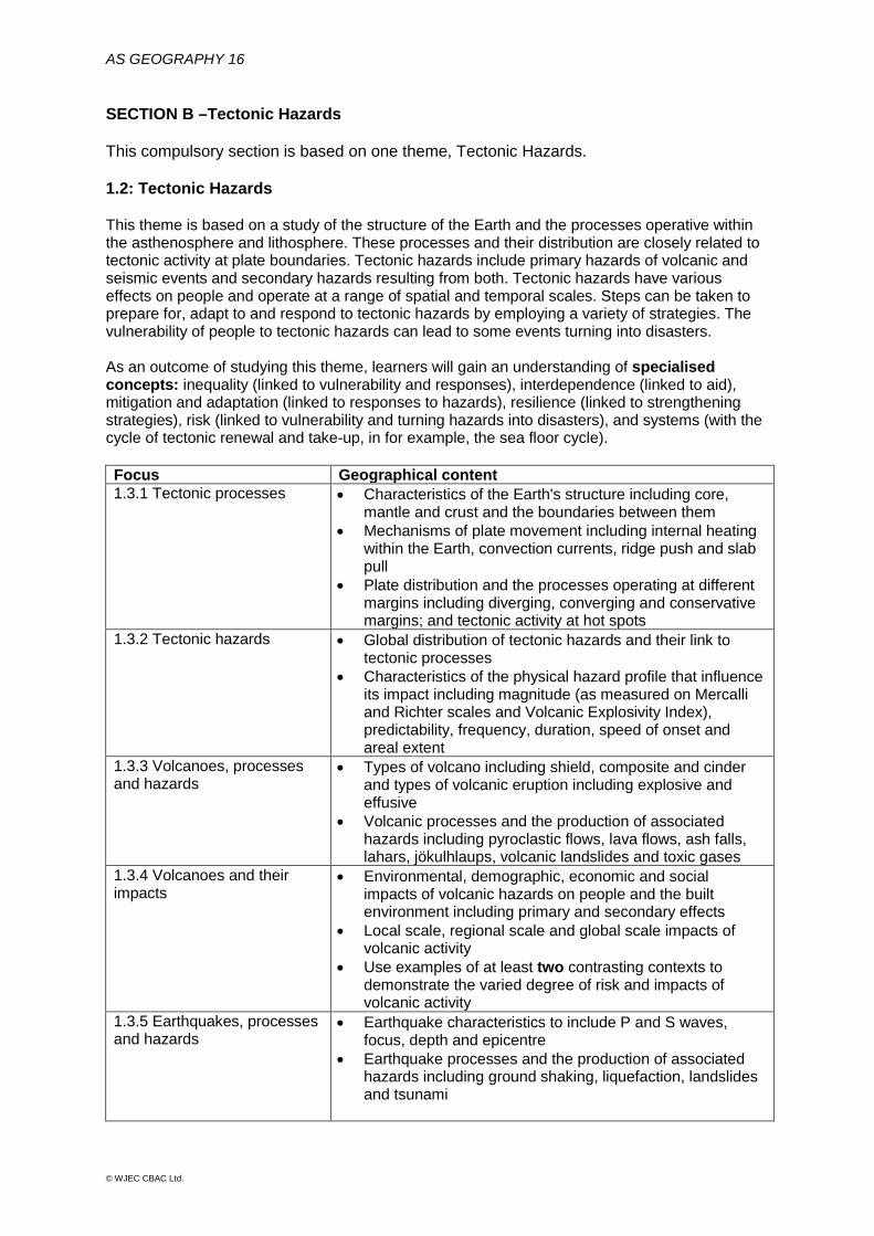
SECTION B –Tectonic Hazards This compulsory section is based on one theme, Tectonic Hazards. 1.2: Tectonic Hazards This theme is based on a study of the structure of the Earth and the processes operative within the asthenosphere and lithosphere. These processes and their distribution are closely related to tectonic activity at plate boundaries. Tectonic hazards include primary hazards of volcanic and seismic events and secondary hazards resulting from both. Tectonic hazards have various effects on people and operate at a range of spatial and temporal scales. Steps can be taken to prepare for, adapt to and respond to tectonic hazards by employing a variety of strategies. The vulnerability of people to tectonic hazards can lead to some events turning into disasters. As an outcome of studying this theme, learners will gain an understanding of specialised concepts: inequality (linked to vulnerability and responses), interdependence (linked to aid), mitigation and adaptation (linked to responses to hazards), resilience (linked to strengthening strategies), risk (linked to vulnerability and turning hazards into disasters), and systems (with the cycle of tectonic renewal and take-up, in for example, the sea floor cycle). Focus Geographical content 1.3.1 Tectonic processes
• Characteristics of the Earth's structure including core, mantle and crust and the boundaries between them
• Mechanisms of plate movement including internal heating within the Earth, convection currents, ridge push and slab pull
• Plate distribution and the processes operating at different margins including diverging, converging and conservative margins; and tectonic activity at hot spots
1.3.2 Tectonic hazards • Global distribution of tectonic hazards and their link to tectonic processes
• Characteristics of the physical hazard profile that influence its impact including magnitude (as measured on Mercalli and Richter scales and Volcanic Explosivity Index), predictability, frequency, duration, speed of onset and areal extent
1.3.3 Volcanoes, processes and hazards
• Types of volcano including shield, composite and cinder and types of volcanic eruption including explosive and effusive
• Volcanic processes and the production of associated hazards including pyroclastic flows, lava flows, ash falls, lahars, jökulhlaups, volcanic landslides and toxic gases
1.3.4 Volcanoes and their impacts
• Environmental, demographic, economic and social impacts of volcanic hazards on people and the built environment including primary and secondary effects
• Local scale, regional scale and global scale impacts of volcanic activity
• Use examples of at least two contrasting contexts to demonstrate the varied degree of risk and impacts of volcanic activity
1.3.5 Earthquakes, processes and hazards
• Earthquake characteristics to include P and S waves, focus, depth and epicentre
• Earthquake processes and the production of associated hazards including ground shaking, liquefaction, landslides and tsunami

17
© WJEC CBAC Ltd.
Focus Geographical content 1.3.6 Earthquakes and tsunamis and their impacts
• Environmental, demographic, economic and social impacts of earthquake and tsunami activity on people and the built environment including primary and secondary effects
• Local scale, regional scale and global scale impacts of earthquake and tsunami activity
• Use examples of at least two contrasting contexts to demonstrate the varied degree of risk and impacts of earthquake activity
• Use examples of at least two contrasting contexts to demonstrate the varied degree of risk and impacts of tsunami activity
1.3.7 Human factors affecting risk and vulnerability
• Economic factors including level of development and level of technology
• Social factors including the population density, population profile (age, gender) and levels of education
• Political factors including the quality of governance • Geographical factors including rural / urban location, time
of day and degree of isolation 1.3.8 Responses to volcanic hazards
• Monitoring, predicting and warnings of volcanic eruptions, and
• Mitigating volcanic hazards and modifying the event, vulnerability, and loss
• Short-term and long-term responses to the effects of volcanic hazards (the hazard management cycle)
1.3.9 Responses to earthquakes and tsunamis
• Monitoring, predicting and warnings of volcanic eruptions, earthquakes and tsunami
• Mitigating earthquake and tsunami hazards and modifying the event, vulnerability, and loss
• Short-term and long-term responses to the effects of earthquake and tsunami hazards (the hazard management cycle)

AS GEOGRAPHY 18
© WJEC CBAC Ltd.
SECTION C – Challenges in the 21st Century The assessment in this section will focus on the learners’ ability to draw together elements from across the course. There will be one extended response question, with resource material, which will require application of knowledge and understanding from both Component 1 and Component 2. Similarly, application of knowledge and understanding of appropriate specialised and such key concepts as place, space, scale and environment will be relevant. The core themes become linked through applied understanding of these key concepts. These concepts underpin the study of both physical and human geography and provide unity for the study of geography as a whole: they help learners to gain a better understanding of what thinking like a geographer means. Stimulus material is included in the assessment and learners should use the issues presented to answer one extended response question.
19
© WJEC CBAC Ltd.
2.2 Component 2 Changing Places Written examination: 1 hour 15 minutes 40% of qualification 80 marks This component is divided into two sections: A and B. SECTION A – Changing Places This section is compulsory. 2.1 Changing Places Scale in this section is fundamentally at the local level but includes a wider region to put the local level into context: it also emphasises linkages between local and regional and extends to national and international. The content of this section must be treated with the same depth as Section A in Component 1. SECTION B – Physical and Human Fieldwork Investigation In this compulsory section, the assessment will be on both fieldwork skills and practical fieldwork activity through the six-stage enquiry method. Geographical Skills In Section A, Changing Places, learners should use qualitative approaches involved in representing place, and to analyse critically the impacts of different media on place meanings and perceptions. The use of quantitative data, including the use of geospatial data must also be used to present place characteristics. Appendix A identifies where these skills can be integrated.

AS GEOGRAPHY 20
© WJEC CBAC Ltd.
SECTION A – Changing Places This compulsory theme focuses on places and their dynamic nature. While the UK and especially the place(s) where the learner lives / lived and / or studies are the context for study, appropriate examples from different regional and national contexts may be used, both in class and in field studies. 'Place' is a portion of geographic space to which meaning has been given by people. Different places have distinct characteristics due to their natural features and the landscapes that people have created. Places change over time and develop layered history. This history helps to shape the identity and 'personality' of a place. The identity is also shaped by the relationship to other places at a range of scales. A place, such as London’s Trafalgar Square or the Lake District, may symbolise different things for different people. Places can evoke feelings of nostalgia, pride, hope, adventure, tranquillity or fear. Places are a vital part of learners' own lives and the lives of others. Places are dynamic because the population, society, and the economy upon which they depend and the environment in which they are situated are in a constant state of flux. The changing economic environment impacts on employment structure with consequent effects on the nature of the environment, the demography of the place and the consequent socio-economic characteristics. As places change there is often a need for government and society to respond through innovation, marketing and reinvention. This leads to the ‘remaking’ of rural and urban places. Economic restructuring drives change. This has major impacts on social inequalities, culture, and the environment in relation to learners' own lives and the lives of others. Learners must begin by studying their ‘home’ place or the location of their studies. They should investigate how and why it has changed over time, both in reality and how it is represented (for instance in tourist literature or the media). These changes should be in a wider regional and national and global context as the characteristics and impacts of external forces operate at different scales (individuals, businesses, interest groups, government policies and the decisions of multinational corporations). Through this knowledge, learners will gain an understanding of the way in which their own lives and the lives of others are affected by continuity and change in the nature of places As an outcome of studying this theme, learners will gain understanding of specialised concepts: adaptation (the ability to respond to changing events and to reduce current and future vulnerability to change), attachment (the linkages between individuals and places), identity (how people view changing places from different perspectives and experiences), inequality (social inequalities between people and places: income and wealth inequality as a threat to society), interdependence (links between the economy and society: relations of mutual dependence and interdependence are worldwide and part of the world economy, trade, communications and production), globalisation (impact of world development on nations, regions and localities), representation (how places are portrayed by formal and informal agencies: people represent what they see and experience; how people are represented in a political sense; how place is represented in literature, art and the media), sustainability (linked to rebranding, marketing and place making), and thresholds (the minimum demand or population needed to support the provision of a good or service: the tipping point for change within places).

21
© WJEC CBAC Ltd.
Focus Geographical content 2.1.1 Changing place; changing places – relationships and connections
• The demographic, socio-economic and cultural characteristics of places as exemplified by the 'home' place (this may be a locality, neighbourhood or a small community) and at least one further contrasting place
• Factors (shifting flows of and connections between people, resources, money and investment and ideas) that have shaped and continue to shape the characteristics of place at all scales from local to global, including MNC fast food chains
• The way in which continuity and change of these local to global factors affect learner's own lives and the lives of others
2.1.2 Changing place; changing places – meaning and representation
• Places are given meaning as a result of people's perceptions, engagement with and attachments to the place in question and are related to different identities, perspectives and experiences, for example the Lake District
• Places are represented in a variety of different forms including advertising and promotional material through different media and publications, for example, Birmingham Grand Central
• Contrasting images portrayed by and between the formal statistical, media and popular images of places
• The way in which place meanings have an effect on continuity and change in the nature of places
• The way in which continuity and change of these local to global factors affect learner's own lives and the lives of others
2.1.3 Changes over time in the economic characteristics of places
• Economic change in places over time can lead to structural changes in employment shown by the Clark Fisher Model
• External forces and factors influencing economic restructuring including changing technology and lifestyles, government strategy and globalisation
• Examples of the decline in primary employment in rural areas and in secondary employment in urban places, using the home area where possible and the way in which these changes affect the learners' own lives and the lives of others
2.1.4 Economic change and social inequalities in deindustrialised urban places
• Consequences of the loss of traditional industries in urban areas including the cycle of deprivation, social exclusion, and lower pollution levels
• Consequences of loss of secondary industries in urban areas including unemployment
• Government policies in deindustrialised places including re-training, economic (local to global), environmental policies and stimulating tertiary growth and investment by foreign MNCs
2.1.5 The service (tertiary) economy and the 21st Century knowledge economy (quaternary) and its social and economic impacts
• Retailing, commercial and entertainment expansion in some central areas and their demographic and economic drivers including rising affluence and technological change
• Gentrification and associated social changes in central urban places experiencing re-urbanisation
• The complexity of the changing service economy including the continuing decline for some central urban places, out-of-town retailing and office-parks, internet shopping and central entertainment and the impacts of these changes on learners' own lives and the lives of others
• Knowledge economy clusters including education, research, culture / creative industries, digital / IT companies, science and biotechnology
• Locational factors encouraging cluster growth including proximity to universities and research institutes, government support, planning regulations and infrastructure
• Impacts of quaternary industry clusters on people and places including place making and marketing, demographic change and global connectivity
AS GEOGRAPHY 22
© WJEC CBAC Ltd.
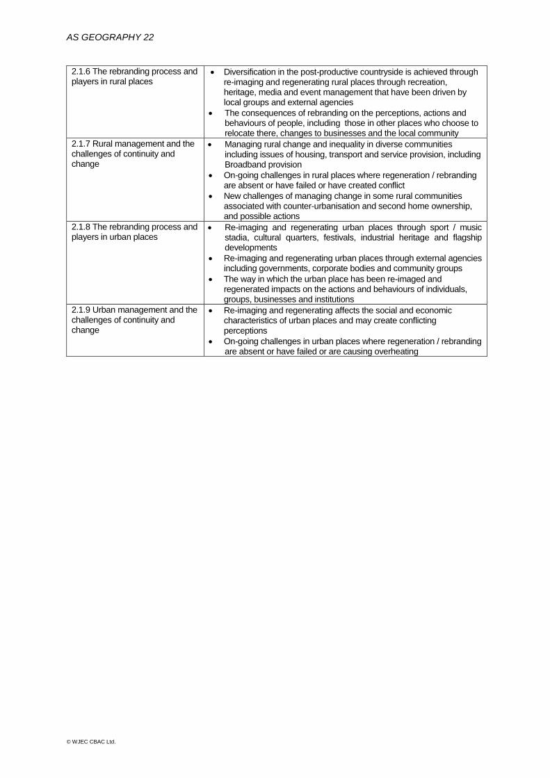
2.1.6 The rebranding process and players in rural places
• Diversification in the post-productive countryside is achieved through re-imaging and regenerating rural places through recreation, heritage, media and event management that have been driven by local groups and external agencies
• The consequences of rebranding on the perceptions, actions and behaviours of people, including those in other places who choose to relocate there, changes to businesses and the local community
2.1.7 Rural management and the challenges of continuity and change
• Managing rural change and inequality in diverse communities including issues of housing, transport and service provision, including Broadband provision
• On-going challenges in rural places where regeneration / rebranding are absent or have failed or have created conflict
• New challenges of managing change in some rural communities associated with counter-urbanisation and second home ownership, and possible actions
2.1.8 The rebranding process and players in urban places
• Re-imaging and regenerating urban places through sport / music stadia, cultural quarters, festivals, industrial heritage and flagship developments
• Re-imaging and regenerating urban places through external agencies including governments, corporate bodies and community groups
• The way in which the urban place has been re-imaged and regenerated impacts on the actions and behaviours of individuals, groups, businesses and institutions
2.1.9 Urban management and the challenges of continuity and change
• Re-imaging and regenerating affects the social and economic characteristics of urban places and may create conflicting perceptions
• On-going challenges in urban places where regeneration / rebranding are absent or have failed or are causing overheating
23
© WJEC CBAC Ltd.
SECTION B – Fieldwork Investigation in Physical and Human Geography
This compulsory section involves the assessment of physical and human geography fieldwork. Details of geography fieldwork, the six stages of enquiry and geographical skills are given in full in Sections 2a and 2b of this specification.
The assessment will be based on both: • physical geography fieldwork linked to Section A, Changing Landscapes (1.1) in
Component 1, and • human geography fieldwork, linked to Section A, Changing Places (2.1) in Component 2
because the focus in each, is on local scale, which is well suited to fieldwork. Appendix B lists specific opportunities to develop fieldwork linked to both components. Geographical skills appropriate to fieldwork should be selected from Appendix A.
The focus of the assessment will be on both fieldwork skills and the learner’s own fieldwork, which is based on the enquiry process undertaken for physical and human geography. The assessment of the learner’s own fieldwork can include any of the related elements in the six stages. The following table, from Section 2a links the six stages to the assessment objectives.
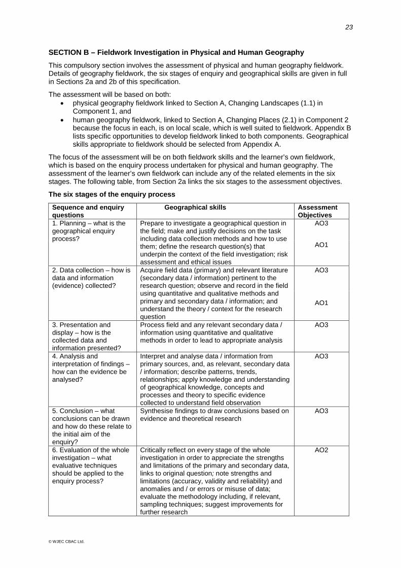
The six stages of the enquiry process
Sequence and enquiry questions
Geographical skills Assessment Objectives
1. Planning – what is the geographical enquiry process?
Prepare to investigate a geographical question in the field; make and justify decisions on the task including data collection methods and how to use them; define the research question(s) that underpin the context of the field investigation; risk assessment and ethical issues
AO3
AO1
2. Data collection – how is data and information (evidence) collected?
Acquire field data (primary) and relevant literature (secondary data / information) pertinent to the research question; observe and record in the field using quantitative and qualitative methods and primary and secondary data / information; and understand the theory / context for the research question
AO3
AO1
3. Presentation and display – how is the collected data and information presented?
Process field and any relevant secondary data / information using quantitative and qualitative methods in order to lead to appropriate analysis
AO3
4. Analysis and interpretation of findings – how can the evidence be analysed?
Interpret and analyse data / information from primary sources, and, as relevant, secondary data / information; describe patterns, trends, relationships; apply knowledge and understanding of geographical knowledge, concepts and processes and theory to specific evidence collected to understand field observation
AO3
5. Conclusion – what conclusions can be drawn and how do these relate to the initial aim of the enquiry?
Synthesise findings to draw conclusions based on evidence and theoretical research
AO3
6. Evaluation of the whole investigation – what evaluative techniques should be applied to the enquiry process?
Critically reflect on every stage of the whole investigation in order to appreciate the strengths and limitations of the primary and secondary data, links to original question; note strengths and limitations (accuracy, validity and reliability) and anomalies and / or errors or misuse of data; evaluate the methodology including, if relevant, sampling techniques; suggest improvements for further research
AO2
AS GEOGRAPHY 24
© WJEC CBAC Ltd.
3 ASSESSMENT
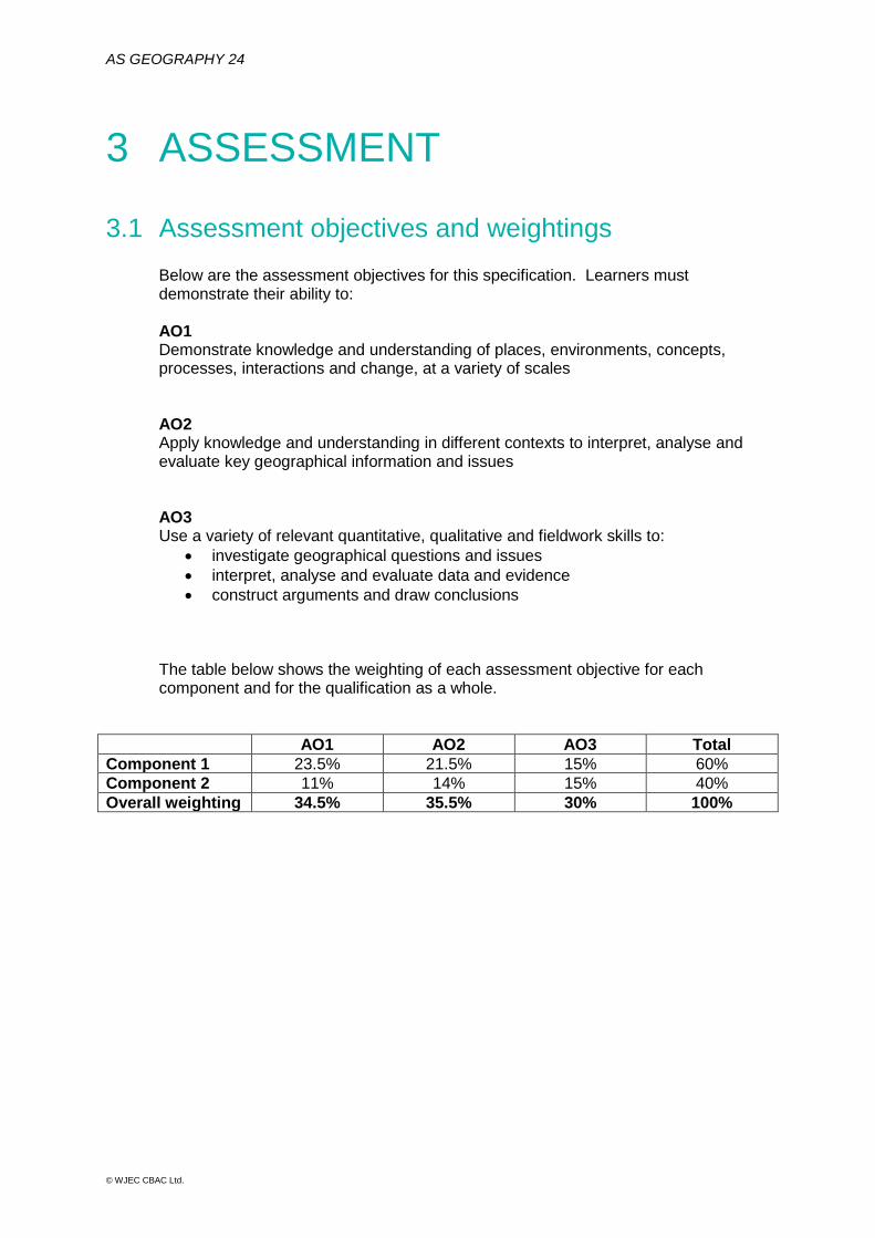
3.1 Assessment objectives and weightings Below are the assessment objectives for this specification. Learners must demonstrate their ability to: AO1 Demonstrate knowledge and understanding of places, environments, concepts, processes, interactions and change, at a variety of scales AO2 Apply knowledge and understanding in different contexts to interpret, analyse and evaluate key geographical information and issues AO3 Use a variety of relevant quantitative, qualitative and fieldwork skills to:
• investigate geographical questions and issues • interpret, analyse and evaluate data and evidence • construct arguments and draw conclusions
The table below shows the weighting of each assessment objective for each component and for the qualification as a whole.
AO1 AO2 AO3 Total Component 1 23.5% 21.5% 15% 60% Component 2 11% 14% 15% 40% Overall weighting 34.5% 35.5% 30% 100%

25
© WJEC CBAC Ltd.
3.2 Arrangements for fieldwork Each centre must provide a Fieldwork Declaration to WJEC by the end of May in the year in which the assessment is taking place, which details that the two days of fieldwork, including a focus on both physical and human geography, has been carried out by each learner. This is required in each assessment cycle. Failure to provide a fieldwork declaration will be treated as malpractice and / or maladministration.
Centre Number: Name of Head of Centre: AS Geography Fieldwork Statement I, the head of Centre, confirm that all students who have been entered for an AS Geography qualification have undertaken the minimum requirement of two days of fieldwork. This included fieldwork in relation to both physical and human geography processes, not all of which was in the context of people-environment questions and issues.
Centres will be able to make their Fieldwork Declaration by downloading the form from the Geography homepage on the public website. Centres must use this form to confirm that each learner listed has undertaken geographical fieldwork on two days in both physical and human geography processes.

AS GEOGRAPHY 26
© WJEC CBAC Ltd.
4 TECHNICAL INFORMATION
4.1 Making entries This is a linear qualification in which all assessments must be taken at the end of the course. Assessment opportunities will be available in the summer series each year, until the end of the life of this specification. Summer 2017 will be the first assessment opportunity. A qualification may be taken more than once. Candidates must resit all examination components in the same series. The entry code appears below. WJEC Eduqas AS Geography: B110QS The current edition of our Entry Procedures and Coding Information gives up-to-date entry procedures.
4.2 Grading, awarding and reporting AS qualifications are reported as a grade on the scale from A to E. Results not attaining the minimum standard for the award will be reported as U (unclassified). AS qualifications are free-standing and are awarded in their own right. Assessments at AS cannot contribute to an A level grade.
27
© WJEC CBAC Ltd.
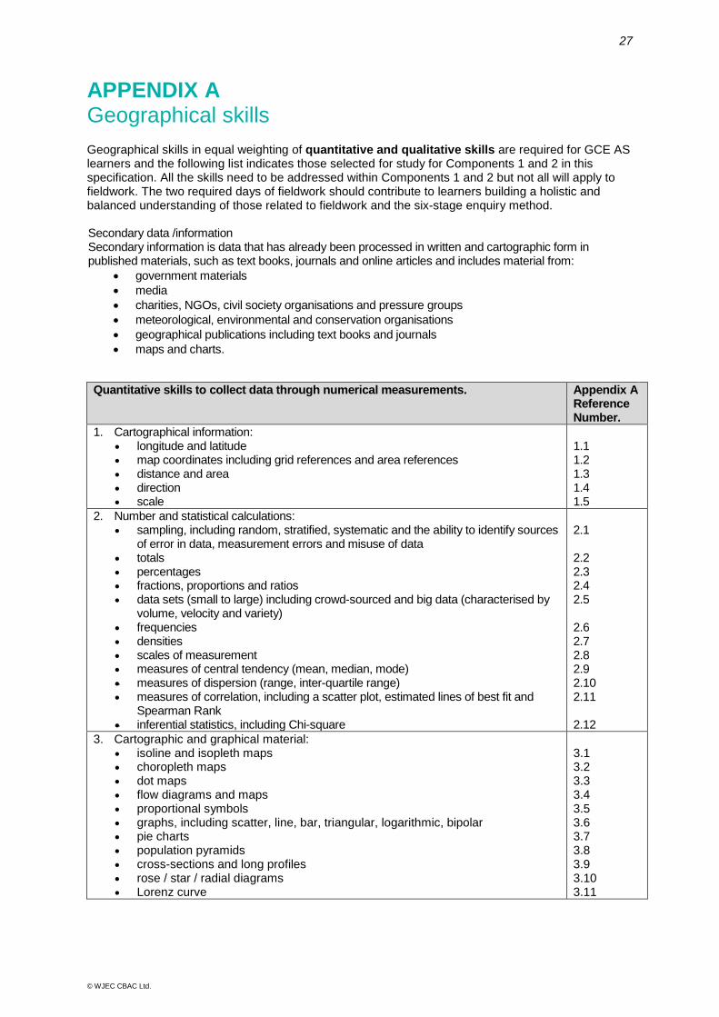
APPENDIX A Geographical skills Geographical skills in equal weighting of quantitative and qualitative skills are required for GCE AS learners and the following list indicates those selected for study for Components 1 and 2 in this specification. All the skills need to be addressed within Components 1 and 2 but not all will apply to fieldwork. The two required days of fieldwork should contribute to learners building a holistic and balanced understanding of those related to fieldwork and the six-stage enquiry method. Secondary data /information Secondary information is data that has already been processed in written and cartographic form in published materials, such as text books, journals and online articles and includes material from:
• government materials • media • charities, NGOs, civil society organisations and pressure groups • meteorological, environmental and conservation organisations • geographical publications including text books and journals • maps and charts.
Quantitative skills to collect data through numerical measurements. Appendix A Reference Number.
1. Cartographical information: • longitude and latitude • map coordinates including grid references and area references • distance and area • direction • scale
1.1 1.2 1.3 1.4 1.5
2. Number and statistical calculations: • sampling, including random, stratified, systematic and the ability to identify sources
of error in data, measurement errors and misuse of data • totals • percentages • fractions, proportions and ratios • data sets (small to large) including crowd-sourced and big data (characterised by
volume, velocity and variety) • frequencies • densities • scales of measurement • measures of central tendency (mean, median, mode) • measures of dispersion (range, inter-quartile range) • measures of correlation, including a scatter plot, estimated lines of best fit and
Spearman Rank • inferential statistics, including Chi-square
2.1 2.2 2.3 2.4 2.5 2.6 2.7 2.8 2.9 2.10 2.11 2.12
3. Cartographic and graphical material: • isoline and isopleth maps • choropleth maps • dot maps • flow diagrams and maps • proportional symbols • graphs, including scatter, line, bar, triangular, logarithmic, bipolar • pie charts • population pyramids • cross-sections and long profiles • rose / star / radial diagrams • Lorenz curve
3.1 3.2 3.3 3.4 3.5 3.6 3.7 3.8 3.9 3.10 3.11

AS GEOGRAPHY 28
© WJEC CBAC Ltd.
4. Digital and geo-located data: • geospatial technologies including aerial photographs, digital images, satellite
images, geographic information systems (GIS), global positioning systems (GPS), databases
4.1
Qualitative skills to collect data through non-numerical techniques 5. Cartographical information for:
• landscape system identification • land-use identification • risk assessment
5.1 5.2 5.3
6. Cartographic and graphical material: • mental maps • GOAD plans • Ordnance Survey maps (1:25 000 and 1:50 000)
6.1 6.2 6.3
7. Digital and geo-located data: • geospatial technologies including aerial photographs, digital images, satellite
images, geographic information systems (GIS), global positioning systems (GPS), databases
• field sketches
7.1 7.2
8. Textual and visual sources: • interview material including coding • images • factual text • discursive / creative material • oral histories
8.1 8.2 8.3 8.4 8.5
Integrating geographical skills in delivery of the core themes
Learners need to develop competence in using the geographical skills specified in the DfE Geography GCE AS and A Level Subject Content (December, 2014) shown in the tables below in italics for each Component. The tables illustrate how the skills can be integrated into the delivery of the core themes in Components 1 and 2. These skills are not exclusive to the core themes in Components 1 and 2; learners will need to be able to apply them across the selected non-core theme, Tectonic Hazards in Component 1.
Component 1: Changing Landscapes (Coastal or Glaciated)
The following geographical skills referred to above (using Appendix A reference numbers) are linked to the study of Changing Landscapes and cover both Coastal Landscapes and Glaciated Landscapes (centres choose from either Coastal Landscapes or Glaciated Landscapes). These skills are not exclusive to Component 1; learners will need to be able to apply these skills across any suitable focus area throughout their course of study. Quantitative skills to collect data through numerical measurements
Measurement, data manipulation and statistical skills applied to field measurement Appendix A Reference Number
Geographical Skill Focus area in specification
1. Cartographical information 1.2 • map coordinates including grid references and area references opportunities
throughout 1.3 • distance and area - calculate the maximum fetch using an atlas
comparison of past and present distribution of glaciated landscapes using global and regional maps
1.1.3 1.2.4
1.4 • direction - prevailing wind and wave direction cirque orientation
1.1.3 1.2.5
1.5 • scale - trace a 30-40 km coastline at a range of scales (1: 1000 000, 1: 50 000 and 1:25 000 and comment on the influence of scale on the
plan of the coastline types of ice mass at a range of scales
1.1.2 1.2.4

29
© WJEC CBAC Ltd.
2. Number and statistical calculations 2.1 • sampling - including random, stratified, systematic - samples of beach
pebbles, including the ability to identify sources of error in data, measurement errors and misuse of data samples of glacial clasts, including the ability to identify sources of error in data, measurement errors and misuse of data
1.1.5 1.2.6
2.2 • totals - use of numerical data to calculate sediment budgets and glacier mass balance
1.1.1 1.2.1
2.5 • data sets (small to large) - samples of beach pebbles samples of glacial clasts
1.1.5 1.2.6
2.6 • frequencies - record frequencies of roundness of beach pebbles record frequencies of roundness of glacial clasts using Power's scale
1.1.5 1.2.6
2.9 • measures of central tendency (mean, mode) - mean wave frequency or mean rate of cliff retreat per year by rock type modal Power's scale of beach pebbles mean rates of glacial recession in different global regions modal Power's scale of glacial clasts
1.1.3 1.1.5 1.2.1 1.2.6
2.10 • measures of dispersion (range, standard deviation, inter-quartile range) - calculate the range, standard deviation and interquartile range from a sample of beach pebbles calculate the range, standard deviation and interquartile range from a sample of glacial clasts
1.1.5 1.2.6
2.11 • measures of correlation, including scatter plot, lines of best fit and Spearman Rank - use scatter plot, lines of best fit and Spearman Rank to investigate changes in pebble size and shape along a drift aligned beach use scatter plot, lines of best fit and Spearman Rank to investigate changes in [scree] size along a transect from the top to the base of a scree data
1.1.5 1.2.7
2.12 • inferential statistics, including Chi-square to test the hypothesis that the distribution of observed pebble shapes between foreshore and storm ridge or size of scree deposits between the upper and lower parts of the scree is no different from an expected even distribution
1.1.5 1.2.7
3. Cartographic and graphical material measurement and geo-spatial mapping skills 3.6 • graphs, including scatter - relationship between wind speed and wave
height relationship between slope angle/ice velocity/thickness and glacial erosion
1.1.3 1.2.5
3.9 • cross-sections and long profiles - cross-section of sand dune/salt marsh longshore beach profile cross-section of cirque long profile of glacial trough
1.1.5 1.1.6 1.1.7 1.2.5
3.10 • rose/star/radial diagrams - prevailing wind direction till fabric analysis using radial diagrams
1.1.3 1.2.6
4. Digital and geo-located data 4.1 • geospatial technologies including aerial photographs, digital images,
satellite images, geographic information systems (GIS), databases - use of GIS and aerial photo interpretation to measure rates of coastal retreat use of GIS and aerial photo interpretation to measure rate of glacial retreat
1.1.4 1.2.1

AS GEOGRAPHY 30
© WJEC CBAC Ltd.
Qualitative skills to collect data through non-numerical techniques
developing observation skills 5. Cartographical information for: 5.1 • landscape system identification - classification of coastal
and glacial landscapes according to landscape character type (LCT) 1.1.2 1.2.7
5.3 • risk assessment - for Coastal Landscapes or Glaciated Landscapes
1.1 1.2
6. Cartographic and graphical material 6.3 • Ordnance Survey maps (1:25,000 and 1:50,000 - map interpretation of a
distinctive landform indicating past sea level [change] cirque orientation analysis using OS maps
1.1.7 1.2.5
7. Digital and geo-located data 7.1 • geospatial technologies including aerial photographs, digital images,
satellite images, geographic information systems (GIS), global positioning systems (GPS), database - GIS mapping of the variety of coastal (rocky, sandy and estuarine) landscapes both for and beyond the UK GIS mapping of landscapes shaped by valley glaciers and ice sheets both for and beyond the UK
1.1.2 1.2.4
7.2 • Field sketches - field sketches of cliff profiles field sketches of glacial landforms of erosion
1.1.4 1.2.5
8. Textual and visual sources: 8.2 • images - photographic interpretation of coastal landforms
photo interpretation of glacial landforms 1.1 1.2
Component 2: Changing Places
The following geographical skills referred to above (using Appendix A reference numbers) are linked to the study of Changing Places. These skills are not exclusive to Component 2; learners will need to be able to apply these skills across any suitable focus area throughout their course of study.
Quantitative skills to collect data through numerical measurements
use of geo-spatial data used to present place characteristics Appendix A Ref Number
Focus area in specification
1. Cartographical information 1.2 • map coordinates including grid references and area references opportunities
throughout 2. Number and statistical calculations: 2.3 • percentages - percentage employed in primary, secondary and tertiary
sectors 2.1.3 2.1.4
3. Cartographic and graphical material 4. Digital and geo-located data 4.1 • geospatial technologies including aerial photographs, digital images,
satellite images, geographic information systems (GIS), global positioning systems (GPS), database - use of GIS and aerial photo interpretation to measure land use changes in regenerated urban places
2.1.8
Qualitative skills to collect data through non-numerical techniques
give particular weight to qualitative approaches involved in representing place and to analysing critically the impacts of different media on place meanings and perceptions 5. Cartographical information for: 5.2 • land-use identification - land use changes in regenerated urban places 2.1.8
31
© WJEC CBAC Ltd.
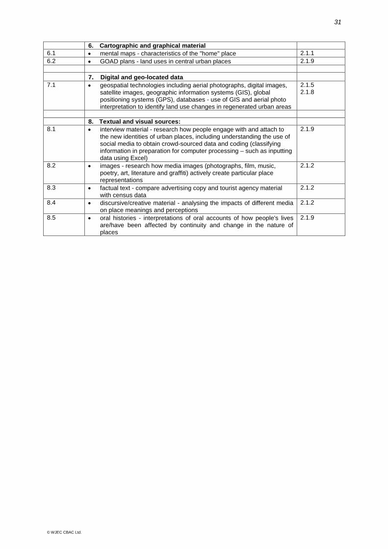
6. Cartographic and graphical material 6.1 • mental maps - characteristics of the "home" place 2.1.1 6.2 • GOAD plans - land uses in central urban places 2.1.9 7. Digital and geo-located data 7.1 • geospatial technologies including aerial photographs, digital images,
satellite images, geographic information systems (GIS), global positioning systems (GPS), databases - use of GIS and aerial photo interpretation to identify land use changes in regenerated urban areas
2.1.5 2.1.8
8. Textual and visual sources: 8.1 • interview material - research how people engage with and attach to
the new identities of urban places, including understanding the use of social media to obtain crowd-sourced data and coding (classifying information in preparation for computer processing – such as inputting data using Excel)
2.1.9
8.2 • images - research how media images (photographs, film, music, poetry, art, literature and graffiti) actively create particular place representations
2.1.2
8.3 • factual text - compare advertising copy and tourist agency material with census data
2.1.2
8.4 • discursive/creative material - analysing the impacts of different media on place meanings and perceptions
2.1.2
8.5 • oral histories - interpretations of oral accounts of how people's lives are/have been affected by continuity and change in the nature of places
2.1.9

AS GEOGRAPHY 32
© WJEC CBAC Ltd.
APPENDIX B Opportunities for fieldwork The following list provides suggestions of fieldwork opportunities that may be carried out in relation to each theme that is specifically linked to fieldwork. These suggestions are designed as guidance in order to provide starting points and are neither comprehensive nor mandatory. Suggestions where the field element is in brackets may be studied using either primary or secondary data. Component 1: Changing Landscapes Coastal Landscapes
• Field survey of wave characteristics (wave height, frequency, wavelength) along a stretch of coast
• Field survey of changing erosion and deposition on a stretch of coast before and after a storm to look at the impact of processes on coastal features (possibly using previous field work records)
• Field survey of raised beaches to look at their distribution, height and post-glacial modifications
• Mapping areas of weathering and mass movement and their relationship to geology maps
• Field survey of coastal erosion features: cliff height and profiles (hard rock/soft rock contrasts), mapping of incidence of faults, joints, and bedding planes to study the distribution of micro features e.g. caves, arches and stacks and the relationship between erosional features and geology maps
• Field survey of beach profiles: long and cross transects to map changes in beach material, gradient, pebble length (long axis) and pebble roundness along a transect from low to high tide and across the width of the beach (linking to the process of longshore drift)
• Field survey of a single or double spit using a range of transects to study shape, size and type of deposits on windward and lee sides (linking to the process of longshore drift)
• Field survey of sand dunes using transects to show dune topography, plant zonation and succession
• Field survey of a salt marsh using transects to show salt marsh topography, plant zonation and succession
• Field survey of impact of humans on coastal environments - foot path erosion, trampling of dunes, beach litter (in and out of season, before or after each clean up)
• Field survey of coastal nature reserves and their management • Field survey of coastal management schemes along a stretch of coast threatened by
either erosion or flooding to investigate the impact of management structures on sediment transfer e.g. groynes; undertake cost benefit analysis or study shoreline management plans
33
© WJEC CBAC Ltd.
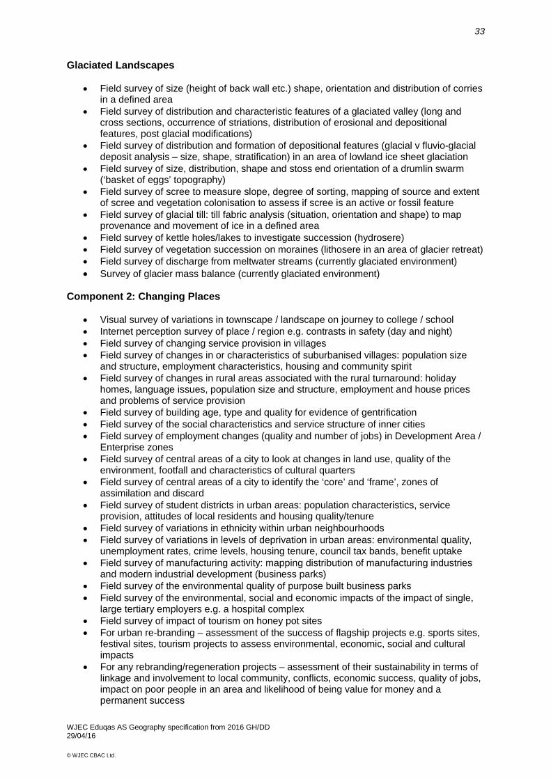
Glaciated Landscapes
• Field survey of size (height of back wall etc.) shape, orientation and distribution of corries in a defined area
• Field survey of distribution and characteristic features of a glaciated valley (long and cross sections, occurrence of striations, distribution of erosional and depositional features, post glacial modifications)
• Field survey of distribution and formation of depositional features (glacial v fluvio-glacial deposit analysis – size, shape, stratification) in an area of lowland ice sheet glaciation
• Field survey of size, distribution, shape and stoss end orientation of a drumlin swarm (‘basket of eggs’ topography)
• Field survey of scree to measure slope, degree of sorting, mapping of source and extent of scree and vegetation colonisation to assess if scree is an active or fossil feature
• Field survey of glacial till: till fabric analysis (situation, orientation and shape) to map provenance and movement of ice in a defined area
• Field survey of kettle holes/lakes to investigate succession (hydrosere) • Field survey of vegetation succession on moraines (lithosere in an area of glacier retreat) • Field survey of discharge from meltwater streams (currently glaciated environment) • Survey of glacier mass balance (currently glaciated environment)
Component 2: Changing Places
• Visual survey of variations in townscape / landscape on journey to college / school • Internet perception survey of place / region e.g. contrasts in safety (day and night) • Field survey of changing service provision in villages • Field survey of changes in or characteristics of suburbanised villages: population size
and structure, employment characteristics, housing and community spirit • Field survey of changes in rural areas associated with the rural turnaround: holiday
homes, language issues, population size and structure, employment and house prices and problems of service provision
• Field survey of building age, type and quality for evidence of gentrification • Field survey of the social characteristics and service structure of inner cities • Field survey of employment changes (quality and number of jobs) in Development Area /
Enterprise zones • Field survey of central areas of a city to look at changes in land use, quality of the
environment, footfall and characteristics of cultural quarters • Field survey of central areas of a city to identify the ‘core’ and ‘frame’, zones of
assimilation and discard • Field survey of student districts in urban areas: population characteristics, service
provision, attitudes of local residents and housing quality/tenure • Field survey of variations in ethnicity within urban neighbourhoods • Field survey of variations in levels of deprivation in urban areas: environmental quality,
unemployment rates, crime levels, housing tenure, council tax bands, benefit uptake • Field survey of manufacturing activity: mapping distribution of manufacturing industries
and modern industrial development (business parks) • Field survey of the environmental quality of purpose built business parks • Field survey of the environmental, social and economic impacts of the impact of single,
large tertiary employers e.g. a hospital complex • Field survey of impact of tourism on honey pot sites • For urban re-branding – assessment of the success of flagship projects e.g. sports sites,
festival sites, tourism projects to assess environmental, economic, social and cultural impacts
• For any rebranding/regeneration projects – assessment of their sustainability in terms of linkage and involvement to local community, conflicts, economic success, quality of jobs, impact on poor people in an area and likelihood of being value for money and a permanent success
WJEC Eduqas AS Geography specification from 2016 GH/DD 29/04/16