Embed Size (px)
Citation preview
1941
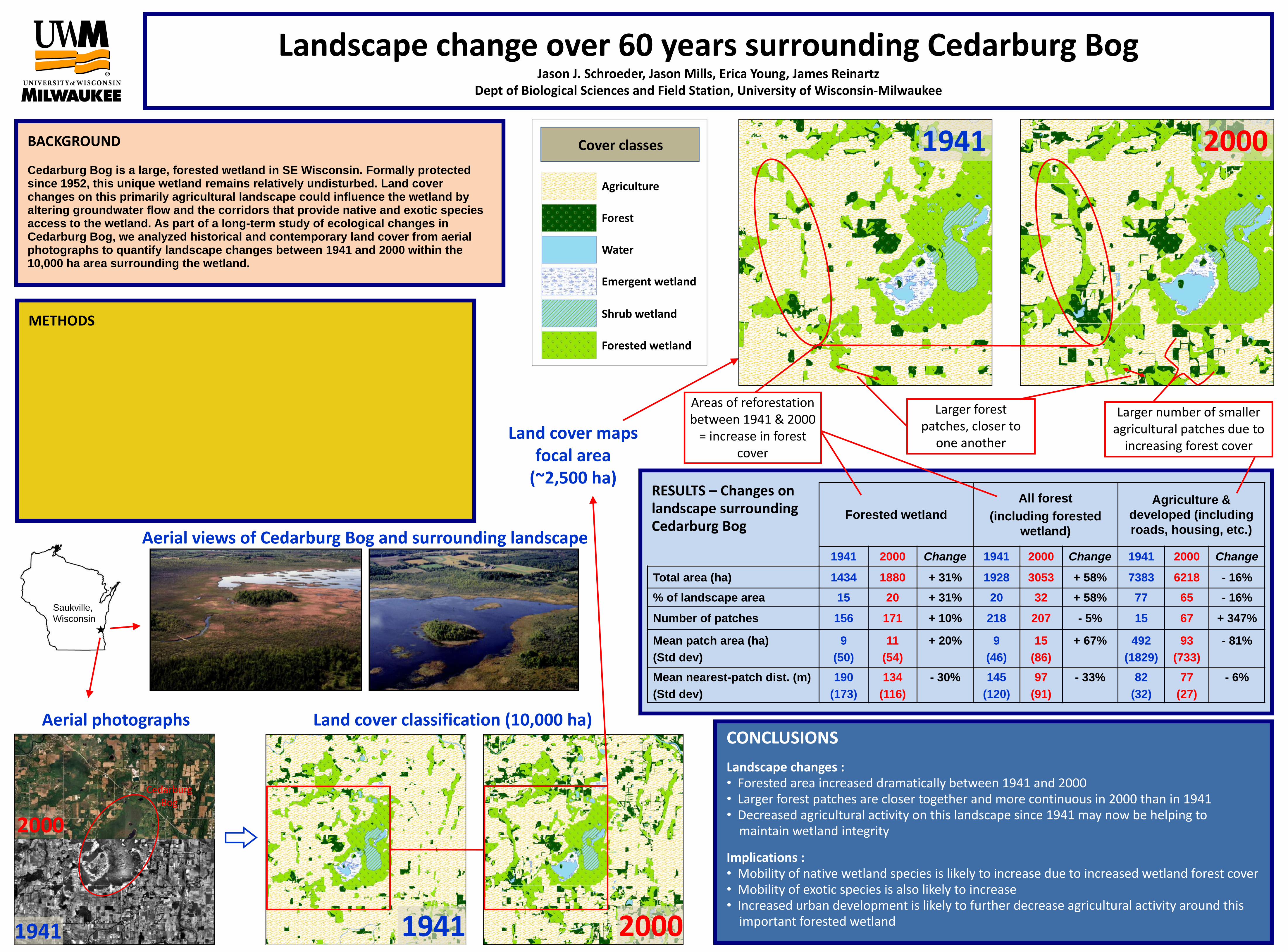
RESULTS – Changes onlandscape surrounding Cedarburg Bog
Forested wetland
All forest
(including forested
wetland)
Agriculture &
developed (including
roads, housing, etc.)
1941 2000 Change 1941 2000 Change 1941 2000 Change
Total area (ha) 1434 1880 + 31% 1928 3053 + 58% 7383 6218 - 16%
% of landscape area 15 20 + 31% 20 32 + 58% 77 65 - 16%
Number of patches 156 171 + 10% 218 207 - 5% 15 67 + 347%
Mean patch area (ha)
(Std dev)
9
(50)
11
(54)
+ 20% 9
(46)
15
(86)
+ 67% 492
(1829)
93
(733)
- 81%
Mean nearest-patch dist. (m)
(Std dev)
190
(173)
134
(116)
- 30% 145
(120)
97
(91)
- 33% 82
(32)
77
(27)
- 6%
METHODS
Landscape change over 60 years surrounding Cedarburg BogJason J. Schroeder, Jason Mills, Erica Young, James Reinartz
Dept of Biological Sciences and Field Station, University of Wisconsin-Milwaukee
CONCLUSIONS
Landscape changes :• Forested area increased dramatically between 1941 and 2000• Larger forest patches are closer together and more continuous in 2000 than in 1941• Decreased agricultural activity on this landscape since 1941 may now be helping to
maintain wetland integrity
Implications :• Mobility of native wetland species is likely to increase due to increased wetland forest cover• Mobility of exotic species is also likely to increase• Increased urban development is likely to further decrease agricultural activity around this
important forested wetland
Larger forest patches, closer to
one another
BACKGROUND
Cedarburg Bog is a large, forested wetland in SE Wisconsin. Formally protected since 1952, this unique wetland remains relatively undisturbed. Land cover changes on this primarily agricultural landscape could influence the wetland by altering groundwater flow and the corridors that provide native and exotic species access to the wetland. As part of a long-term study of ecological changes in Cedarburg Bog, we analyzed historical and contemporary land cover from aerial photographs to quantify landscape changes between 1941 and 2000 within the 10,000 ha area surrounding the wetland.
1941
Land cover classification (10,000 ha)
20001941
Areas of reforestation between 1941 & 2000
= increase in forest cover
Larger number of smaller agricultural patches due to
increasing forest coverLand cover maps
focal area (~2,500 ha)
Aerial photographs
Saukville,
Wisconsin
2000
Aerial views of Cedarburg Bog and surrounding landscape
Cedarburg Bog
2000
Agriculture
Forest
Water
Emergent wetland
Shrub wetland
Forested wetland
Cover classes


![Bog Je Jedan,Bog Je u Nama[1]](https://img.dokumen.tips/doc/110x75/544a8aa9af7959a8438b49d0/bog-je-jedanbog-je-u-nama1.jpg)