Embed Size (px)
Citation preview
Wigan Replacement Unitary Development Plan – April 2006
1
CONTENTS
Chapter 1 Introduction 2 The Context for the UDP 3 The UDP Strategy 4 Monitoring the Plan: Targets and Indicators 5 Sustainability Appraisal 6 Green Belt and Safeguarded Land Policies GB1 GREEN BELT GB1A Re-use of Buildings GB1B Extensions to Existing Dwellings in the Green Belt and in
Safeguarded Land GB1C Replacement Dwellings in the Green Belt and in Safeguarded
Land GB1D Development in Green Belt Settlements (Haigh and Bickershaw) GB1E Major Existing Developed Sites in the Green Belt GB2 SAFEGUARDED LAND GB3 AGRICULTURAL LAND PROTECTION 7 Employment Policies EM1 LAND AND BUILDINGS FOR EMPLOYMENT USES EM1A Primary Employment Areas EM1B Re-use of Employment Land and Buildings for Other Uses EM1C Employment Development Outside Primary Employment Areas EM1D Offices EM1E Motor Vehicle Servicing, Repairs, Hire and Sales EM1F Restriction of Industrial Development – Former Maypole Colliery
Site POLICY DELETED EM1G Mixed Use Development – Former Bickershaw Colliery Site EM1H Mixed Use Development – Wigan Pier Quarter EM2 TOURISM EM2A Tourism Development
8 Housing policies R1 LAND FOR NEW HOUSE BUILDING POLICY DELETED R1A Housing Provision POLICY DELETED R1B New Housing Sites R1C Care Homes and Homes for the Elderly R1D The Design of New Residential Development and House
Extensions R1E Open Space in New Housing Developments R1F Sites for Gypsies and Showmen's Permanent Quarters R1G Conversion to Dwellings R1H Affordable Housing
Wigan Replacement Unitary Development Plan – April 2006
2
9 Environment and Design Policies EV1 ENVIRONMENTAL PROTECTION AND ENHANCEMENT EV1A Land Reclamation and Renewal EV1B Pollution EV2 NATURE CONSERVATION EV2A Special Areas of Conservation EV2B Sites of Special Scientific Interest, Sites of Biological Importance
and Local Nature Reserves EV2C Features of Major Importance for Nature Conservation and
Wildlife Corridors EV2DS Species Protection EV2E Trees, Woodlands and Hedgerows EV3 DESIGN EV3A Design of New Development EV3B Advertisements EV3C Design of Frontages to Shops and Commercial Premises EV3D Landscaping of Development EV3F The River Douglas, Canal Network and Other Water Features EV3G Telecommunications Development EV3H Public Art EV4 CONSERVATION EV4A Development and Design in Conservation Areas EV4B Listed Buildings EV4C Buildings and Structures of Local Architectural or Historic
Interest EV4D Historic Parks, Gardens and Cemeteries EV4E Archaeology, Ancient Monuments and Development 10 Accessibility Policies A1 ACCESSIBILITY A1A Transport Assessments A1B Travel Plans A1C Access for All A1D Walking A1E Cycling A1F Bus Provision – New Development A1G Physical Improvements to Bus Network A1H Leigh, Ellenbrook, Manchester Public Transport Corridor A1J Rail Infrastructure A1K Integration of Wigan Rail Stations A1L Taxis – New Development A1M Freight – New Development A1N Strategic Route Network A1P Major Highway Schemes A1R Highway Access – New Development A1S Parking in New Development A1T Park and Ride A1U Improving Access to Support a Sustainable Pattern of
Settlement 11 Shopping and Town Centre Policies S1 HIERARCHY AND ROLE OF CENTRES S1A Principal Shopping Areas S1B Town Centres S1C Retail Development – Station Road, Wigan Town Centre S1D Local Centres S1E Small Shops and Services
Wigan Replacement Unitary Development Plan – April 2006
3
S1F Retail and Leisure Development Outside Town Centres and
Local Centres S1G Retail Development – Liverpool Road, Ashton-in-Makerfield S1H Retail Development – Leigh East ARLFC Site, Leigh 12 Community Facilities, Sport and Recreation Policies C1 COMMUNITY FACILITIES, OPEN SPACE, SPORT AND RECREATION C1A Community Facilities C1B Open Space, Sport and Recreation Provision C1C Protection of Open Space and Sport and Recreation Provision C1D Leigh Sports Village, Pennington, Leigh C1E Greenway Network C1F The River Douglas, Canal Network and Other Water Features C1G Regional Park C1H Public Rights of Way 13 Mineral Working Policies
MW1 MINERAL WORKING MW1A Protection of Mineral Resources POLICY DELETED MW1B Aggregate Production POLICY DELETED MW1C Mineral Working and Exploration POLICY DELETED MW1D Remnant Mossland POLICY DELETED MW1E Operation and Restoration of Mineral Workings POLICY DELETED MW1F Control of Mineral Workings POLICY DELETED 14 Waste Management Policies
WM1 WASTE MANAGEMENT POLICY DELETED WM1A Waste Management Facilities POLICY DELETED WM1B Operation and Restoration of Waste Management Facilities POLICY DELETED WM1C Control of Waste Management Facilities POLICY DELETED 15 General Policies
G1A Impact of Development on Amenity G1B Planning Obligations G1C Development and Flood Risk G1D Renewable Energy APPENDICES
1. Appendix 1. DELETED 2. Appendix 2 - Major Existing Developed Sites in the Green Belt 3. Known Environmental and Nature Conservation Issues Affecting Primary
Employment Areas
4. Appendix 4 - Housing Sites with Planning Permission 5. Sites of Biological Importance 6. Historic Parks Gardens and Cemeteries 7. Sustainability Appraisal 8. Appendix 8. DELETED 9. Parking Standards 10. Buildings and Structures of Local Architectural or Historic Interest
25Wigan Replacement Unitary Development Plan April 2006
Introduction Green Belts are one of the best known and understood planning policies. Their function in restricting the growth of urban areas and safeguarding the countryside from encroachment is well recognised and respected. The Borough is perhaps fortunate in having an adopted Green Belt which has been in force since 1984 in the form of the Greater Manchester Green Belt. This has been largely incorporated unchanged into the UDP and has proved effective over the years in containing urban sprawl and achieving the other purposes of Green Belts. Green Belt boundaries differ from other aspects of the Plan in that they are intended to be as permanent as is possible and therefore are not subject to review within or at the end of the Plan period but are intended to remain unchanged for a period in excess of the life of the Plan. Safeguarded Land is land between the urban area and the Green Belt. This land, shown on the Proposals Map, is treated in a similar way to Green Belt except that its protection is not necessarily guaranteed beyond the plan period. Safeguarded Land ensures the protection of Green Belt within the longer time-scale by reserving land which may be required to meet longer-term development needs without the need to alter Green Belt boundaries. Within the Green Belt there is a presumption against development except for certain specified exceptions in line with Government Guidance (PPG2). Development Control policies are provided to clarify those circumstances in which it may be permissible to allow specified types of development in Green Belt and Safeguarded Land. For the first time this Plan identifies Major Developed Sites in the Green Belt which are either in continuing use or redundant and where, subject to the policies of the Plan, infilling or redevelopment may be allowed, in line with guidance in PPG2. The Council’s policy towards development on agricultural land is also specified.
Chapter 6 – GREEN BELT AND SAFEGUARDED LAND POLICIES
27Wigan Replacement Unitary Development Plan April 2006
* GB1A Re-use of Buildings In the Green Belt or in Safeguarded Land the re-use of buildings will be permitted if the fully detailed submissions satisfy the following criteria:- (a) The building must be structurally sound, capable of re-use without major
reconstruction and large enough to be converted without the need for major or prominent additions;
(b) The building must be of permanent and substantial construction and its form,
bulk and general design must be in keeping with its surroundings. The degree to which it makes a positive contribution to the rural scene or involves the improvement of buildings which currently detract from the character of the area will also be a significant consideration;
(c) The proposals must be architecturally consistent with the existing building or
group of buildings and consideration will be given to the retention of the existing height, shape, mass, internal spaces, plan form and internal and external functional and architectural details. Proposals must respect local building styles and materials. In order to be considered, proposed extensions, additions or buildings in the curtilage of re-used buildings (whether carried out as part of the original conversion, or subsequently) must meet the requirements of this and clause (a) and will be limited to single storey construction up to a maximum of 50 cubic metres volume;
(d) A comprehensive scheme of external works and landscaping must be
included and any encroachment onto agricultural land to form a curtilage should be minimised;
(e) In the case of a Listed Building, a building in a Conservation Area or a
building of local interest proposed for conversion to residential use, no alternative more sympathetic use is feasible;
(f) On sites within the green belt the scheme must not have a materially greater
impact than the present use on the openness of the green belt and the purposes of including land within it. On sites within safeguarded land the scheme must not prejudice the possibility of achieving later comprehensive development.
*(All pages) This policy applies to buildings in both the Green Belt and Safeguarded Land and specifies the circumstances in which the Council will allow existing buildings to be retained by permitting a change of use. Such development, if sensitively carried out, can not only help to retain attractive rural buildings but also help to diversify the local economy.
28Wigan Replacement Unitary Development Plan April 2006
When considering making proposals under this policy, applicants are strongly advised to discuss the project at an early stage with the Council and to employ the services of a Chartered Architect. Applications will not be accepted in outline form and full and precise details of both internal and external features must be submitted. A building will be considered to be needing major reconstruction (and therefore not capable of re-use under this policy) if more than 20% of its fabric needs to be rebuilt, although the replacement of the roof covering in appropriate material will usually be acceptable. Wherever possible new window or other openings should not be made and existing ones (or previously closed off ones) should be re-used. The design should minimise the visual impact of the conversion both externally and internally, for example by using minimal and discrete new openings, retaining open roof structures and existing partitions and minimising new floors especially over threshing spaces. Existing materials should be re-used wherever possible. Permitted development rights under the General Development Order will normally be removed and for business uses the approval will be specific to the use applied for to prevent unsuitable changes of use within the Use Class. After conversion any proposals for further extensions or for outbuildings will be considered against the provisions of this policy and the building will not be considered to be an existing house for the purposes of policies GB1B and GB1C. * GB1B Extensions to Existing Dwellings in the Green Belt and in Safeguarded Land In the Green Belt and in Safeguarded Land extensions to existing dwellings will only be allowed where:- (a) they do not exceed the cubic content of the original property by more than
75%; and (b) in any case, are not more than 200 cubic metres and that the sum of additions
to the original property does not exceed 200 cubic metres. (c) On sites within the green belt the scheme must not have a materially greater
impact than the present use on the openness of the green belt and the purposes of including land within it. On sites within safeguarded land the scheme must not prejudice the possibility of achieving later comprehensive development.
*(All pages) The restrictive policy applied to Green Belt and Safeguarded Land is not intended to prevent modest extensions to existing dwellings which are in scale and character with the building. This policy specifies the limits which will normally be applied to proposals for extensions as a guide to judging when their scale and size would prejudice the primary purposes of Green Belt or Safeguarded Land policy and would be likely to be refused.

29Wigan Replacement Unitary Development Plan April 2006
The restrictions in clauses (a) and (b) are to be applied to the ‘original’ property which means the property as existing on 4th November 1991 (the date the policy first came into force), or if built after that date, as originally built. If any existing extensions or parts of the existing dwelling are to be demolished as part of the scheme, the volume of these demolitions will be permitted as an addition to the maximum volume of extension permissible under this policy. Cubic content will be determined by external measurement. Special considerations may be applied to such extensions on Buildings of Special Architectural or Historic Interest. See policy EV4B. Extensions For the purposes of this policy, ‘extensions’ will be taken to include garages and permanent domestic outbuildings within the curtilage, any part of which is within 5 metres of the original dwelling, as well as attachments to the main dwelling. * GB1C Replacement Dwellings in the Green Belt and in Safeguarded Land In the Green Belt and in Safeguarded Land the replacement of existing dwellings will only be allowed where:- (a) the existing dwelling can lawfully be used for residential purposes; and (b) the proposed dwelling is not higher than, does not occupy a larger area of the
site than, occupies substantially the same position on the site as and is substantially the same volume as the existing dwelling; and
(c) the proposal does not involve an enlargement of the residential curtilage. (d) On sites within the green belt the scheme must not have a materially greater
impact than the present use on the openness of the green belt and the purposes of including land within it. On sites within safeguarded land the scheme must not prejudice the possibility of achieving later comprehensive development.
*(All pages) New dwellings in the Green Belt are generally contrary to Green Belt policy. However, in accordance with advice in PPG2, the replacement of existing dwellings in the Green Belt may be acceptable providing the new dwelling is not materially larger than the dwelling it replaces. The same considerations are also applied to replacement dwellings in Safeguarded Land. The policy is intended to make clear the approach the Council will take to such proposals and must be read in conjunction with the other policies of the Plan particularly the final paragraph of policies GB1 and GB2 and policy R1D. The Council will encourage the protection and enhancement of buildings and structures of local architectural or historic interest.

32Wigan Replacement Unitary Development Plan April 2006
*GB2 SAFEGUARDED LAND THE SAFEGUARDED LAND, DEFINED ON THE PROPOSALS MAP, MAY BE REQUIRED TO SERVE DEVELOPMENT NEEDS IN THE LONGER TERM, WELL BEYOND THE PLAN PERIOD. IT IS IDENTIFIED FOR THIS PURPOSE IN ORDER THAT THE BOUNDARIES OF THE ADOPTED GREEN BELT WILL NOT NEED TO BE ALTERED AT THE END OF THE PLAN PERIOD IN 2016. THIS LAND IS NOT ALLOCATED FOR DEVELOPMENT AT PRESENT. IT WILL BE KEPT FREE OF PERMANENT DEVELOPMENT SO THAT IT MAY FULFIL ITS PURPOSE OF MEETING POSSIBLE LONGER TERM DEVELOPMENT NEEDS. ALTHOUGH TEMPORARY DEVELOPMENT MAY BE PERMITTED IF THIS WOULD ASSIST IN ENSURING THAT THE LAND IS PROPERLY LOOKED AFTER, NO DEVELOPMENT WHICH WOULD PREJUDICE LATER COMPREHENSIVE DEVELOPMENT WILL BE PERMITTED. PLANNING PERMISSION FOR THE PERMANENT DEVELOPMENT OF SAFEGUARDED LAND WILL BE GRANTED ONLY FOLLOWING A REVIEW OF THE DEVELOPMENT PLAN WHICH PROPOSES THIS. *(3, 4, 6, 7, 15-19, 21-25, 27, 28) Safeguarded land comprises areas and sites between the urban area and the Green Belt which may be required to meet longer-term development needs beyond the plan period without the need to alter the Green Belt boundary. The designation of such land therefore helps to strengthen the permanence of Green Belts, as suggested in paragraph 2.12 of PPG2. Planning permission for the development of this land (other than for temporary developments which may assist in ensuring that the land is appropriately managed) will only be granted following a Plan Review which proposes the development of particular areas of Safeguarded Land. The detailed Part 2 policies which apply to Safeguarded Land are policies GB1A, GB1B and GB1C which also apply to Green Belt.

Chapter 7 – EMPLOYMENT POLICIES
Introduction
Economic regeneration remains a fundamental priority. The Council is committed to increasing the number and range of jo b opportunit ies for th e Borough’s residents and encouraging employment development.
Much progress has already been made. The number of jobs in the Borough now exceeds the level in 1971, following a considerable drop in the intervening years. In addition, over one-third of people with jobs now work outside the Borough. Consequently, unemployment has fallen significantly and it is now only slightly above the national, regional and Greater Manchester levels.
However, there is a band of Wards east to west through the middle of the Borough where unemployment is persistently higher than it is for the Borough overall. These Wards also experience problems of low average household income and low educational achievement, together with a high incidence of poor health, disability and child poverty.
Employment in the Borough is also biased towards traditional industries, in particular, manufacturing which is still in decline in terms of numbers employed. It is less well represented in service industries and other growth sectors.
As a result there is st ill much to be done. It remains an objective to increase the number and range of job opportunities available within the Borough, particularly in the growth sectors. This will help to strengthen the local economy, reduce the need for people to travel longer distances for work, provide jobs for those without work and extend choice for those in jobs that do not meet their needs.
The main change to employment policies in t his Plan compared to the first UDP is an increased emphasis on retaining employment land and buildings for employment uses. This is needed, in part, because of the increased pressure on employment sites for housing development. This has arisen because of the national requirement that a high proportion of new housing be built on previously developed land.
It is also needed because a huge amount of employment land has, in the past, become disused and a lot has been redeveloped for other uses, notably housing. This has signif icantly improved the quality of residentia l environments and enhanced the image of the Borough. However, as a result, the stock of older employment land and buildings is much reduced. For the most part, what remains is more readily suited to existing and future employment use without undue adverse impact on surrounding areas. Retaining it will enable people to access employment opportunities close to where they live, and reduce the pressure for employment development on greenfield sites in less acce ssible locations. This is in line with the Regional Spatial Strategy for the North West (RPG 13) and the national agenda for an urban renaissance.

Wigan Replacement Unitary Development Plan – April 2006
Wigan Replacement Unitary Development Plan – April 2006 6
* EM1A Primary Employment Areas Within the Primary Employment Areas, development for, or changes of use to, uses w ithin Classes B1, B2 and B8 or other emp loyment u ses w ill be permitted provided that there will be no unacceptable environmental, amenity, highway, road safety or other adverse impact. Other uses will only be permitted when:- (a) They will be small scale and complementary to the primary employment
function of the Area or part thereof; or (b) They are on the fringe of the Primary Employment Area and it can be
demonstrated that it will improve the physical relationship between the employment uses and adjacent uses, and it will not result in any greater constraint on the development and use of the remaining Employment Area for employment uses.
Where all, or a substantial part of a Primary Employment Area is proposed for development or it is substantially undeveloped, a masterplan or development brief shall be agreed with, and approved by, the Council. Development shall accord substantially with the approved masterplan. At sites identified as suitable for knowledge based industries, a legal agreement will be sought to ensure that the site, or an agreed part of the site, is set aside for such businesses over a reasonable period of time.
*(4, 6, 7, 9-12, 14-19, 21, 23-25, 27, 28, See Table 1) Primary Employment Areas are identified to safeguard the primary employment land resource in Wigan Borough. The 35 Primary Employment Areas do not comprise the total land requirements for employment uses – Policy EM1B refers to development and changes of use on other existing employment sites and additional land will be brought forward - see Policy EM1. However, they do include all sites not currently in employment use that are allocated for such uses, with the exception of the mixed use allocation at the former Bickershaw Colliery site (Policy EM1G) and the Leigh Sports Village proposal (Policy C1D). The Primary Employment Areas include modern busi ness parks, older industrial estates and other industrial and employment areas. They do not all share the same attributes and characteristics but they do have particular advantages for continuing employment use, including:- (a) a critical mass of employment uses and/or land for employment development which is, and
will continue to be, capable of meeting a wide variety of business needs; (b) an emphasis on reuse and redevelopment of brownfield land and sites, and consequent
reduced need to release greenfield sites; (c) a balanced geographical spread throughout the Borough; (d) good accessibility for workers and potential workers (including in the most disadvantaged
areas), by a choice of mode of transport including on foot and, wherever possible, by public transport;
(e) good accessibility for goods either to and from local markets and suppliers and/or to and
from the national road network, including a number of locations with potential for rail connection.
Table 1 lists all the Primary Employment Areas with a short description and shows the total area of land available for development within each at the end of December 2001.

Wigan Replacement Unitary Development Plan – April 2006
Wigan Replacement Unitary Development Plan – April 2006 7
Table 1 Ref. Location Description Area (hectares) (including Proposals Map page
number(s)) Total Available
EM1A 1 Stone Cross Park, Golborne *(27) Modern business park, large units 31.6 6.4 EM1A 2 Golborne Enterprise Park (27) Modern business park, smaller units 4.0 1.1 EM1A 3 Bridge Street, Golborne * (27) Mixed traditional employment area 7.3 - EM1A 4 Newton Road, Lowton (27, 28) Modern business park and traditional
employment area 7.1 -
EM1A 5 Moss Industrial Estate, Lowton* (28) Industrial estate 20.0 4.9 EM1A 6 Parsonage, Leigh *(23) Reclaimed for mer col liery and mi ll l and
with modern factory 23.6 18.2
EM1A 7 Bridgewater, Leigh (23) Factory sites 15.3 1.2 EM1A 8 Hope Carr/Leigh Commerce Park ,
Leigh * (23, 28) Modern industrial estate an d business park extension
33.5 11.0
EM1A 9 Chaddock Lane, Astley * (18, 19, 2 4, 24)
Mixed employment ar ea with e xpansion land
41.5
18.6
EM1A 10 Parr Brow, Tyldesley (19, 25) Small industrial estate, factory and business park
7.4 -
EM1A 11 Chanters Industrial Estate, Hindsford (18)
Low amenity industrial estate 11.4 -
EM1A 12 Gibfield, Atherton * (12, 17) Mixed em ployment are a with pro posed business park
29.8
9.5
EM1A 14 West of Leigh Road, Hindley Green * (16, 17)
Established industrial uses a nd a djacent land
52.4 -
EM1A 15 Swan Lane, Hindley Green * (17) Industrial estate with adjacent industrial sites and land
29.6 7.0
EM1A 16 Makerfield Way, Ince (11) Reclaimed site with mixed employment uses
24.1 11.9
EM1A 17 Wigan Enterprise Park, Ince (11) Established employment site undergoing reorientation and redevelopment
12.8 1.8
EM1A 18 Dobson Park Industrial Estate, Ince (11)
Industrial estate 13.7 2.1
EM1A 19 Rosebridge, Ince * (10, 11) Two industrial estates and adjacent factory
8.4 1.2
EM1A 20 Westwood Park, Wigan * (10, 15) Major development site with existing office development
33.9 21.3
EM1A 21 Wigan Pier Business Park/ R iverside, Wigan (10)
Office park and adjacent factory 5.6 0.9
EM1A 22 Chapel Lane, Wigan (10) Mixed employment area 7.1 - EM1A 23 Wallgate, Wigan * (10) Mixed employment area 17.3 0.3 EM1A 24 Springfield and Miry Lane, Wigan *
(7, 10) Traditional employment area along rail corridor
32.2 5.5
EM1A 25 Martland Park and Heinz, Wigan * (6, 7, 9, 10)
Large factory site an d modern business park
100.4 11.9
EM1A 26 Gidlow Lane, Beech Hill (7) Large factory site 6.6 - EM1A 27 Bradley Lane, Standish * (4) Industrial estate and adjacent sites 28.5 3.3 EM1A 28 Richmond Hill Industrial Estate,
Pemberton (9) Small industrial estate 2.2 0.4
EM1A 29 Lamberhead Industrial Estate, Pemberton (9, 14)
Industrial estate 18.0 -
EM1A 30 Pemberton Colliery * (15) Major development site 20.2 18.7 EM1A 31 Warrington Road Industrial Estate,
Wigan * (10, 15) Industrial estate 8.3 -
EM1A 32 Warrington Road, Hawkley (15) Factory site and adjacent land 13.7 4.2 EM1A 33 Wheatlea Industrial Estate, Wigan(15) Industrial estat 20.4 0.4 EM1A 34 Haslemere and Land Gate, Bryn
(15, 21) Two small industrial estates with low amenity uses to rear
7.8 -
EM1A 35 Park Brook, Wigan Road, Bryn * (15, 21)
Established employment site 3.2 -
EM1A 36 South Lancashire Industrial Estate, Ashton * (21)
Industrial estate with expansion land 91.0 39.2#
TOTAL
789.9 201.0#

Wigan Replacement Unitary Development Plan – April 2006
Wigan Replacement Unitary Development Plan – April 2006 8
see Appendix 3 regarding known env ironmental and natu re conservation issues within the Primary Employment Area and/or locality. # Development of the ava ilable land at the South Lancashire Industrial Estate must be l imited to schemes which, due to their in herent nature or their in tegration with ach ievable o ff-site works, will not sig nificantly i ncrease the traffic flows through Ashton-in-Makerfield town centre. As Table 1 shows, within the Primary Employment Areas at the end of 2001 there were 201 hectares available for development, either immediately or in the medium to longer term, subject to the identified restrictions at the South Lancashire Industrial Estate. The employment land identified covers over 50 sites ranging from very small infill sites to larger sites at Westwood Park and Pemberton Colliery. Two Primary Employment Areas - Westwood Park an Pemberton Colliery - are largely undeveloped. For these and other Primary Employment Areas where substantial development or redevelopment is proposed, including the extension site at Chaddock Lane, Astley (EM1 A 9), a masterplan and/or development brief will be required to guide development. The masterplan and/or development brief should be prepared with, and approved by, the Council. Wigan needs to attract more of the growth sector industries including knowledge-based businesses as highlighted in Regional Planning Guidance, namely:-
• Environmental Technologies; • Life Science Industries (biotechnology and pharmaceuticals); • Medical Equipment and Technology; • Financial and Professional Services; • Computer Software and Services/Internet-based Services; and • Creative Industries, (media, advertising and public relations). These sectors account for a smaller percentage of employment in Wigan Borough than throughout Greater Manchester and the North West, but Wigan does have a small but potentially signif icant specialism in environmental technologies as well as a important presence in financial and professional services. Wigan Sout h Central has been identified by the Northwest Development Agency (NWDA) as a strategic opportunity for encouraging the development of k nowledge-based industry. At least two of the Primary Employment Areas in Wigan Borough, Westwood Park and Wigan Pier Business Park, already accommodate businesses within these sectors and have the potential for further expansion. At Wigan Pier Business Park, this approach could be extended into the adjacent Wigan Pier Quarter (see Policy EM1H) and contribute significantly to its regenera tion. There is also potenti al at the Pemberton Colliery site . The Council, in partnership with the NWDA, will identify other sites suitable for knowledge based industries and will work with landowners to agree a means by which they will be made available fo r such businesses over a reasonable period of time. In such circumstances a legal agreement will be sought between all parties including the NWDA. Five of the Primary Employment Areas, 6 and 7 and 12, 14 and 15 within the Table, are within an area centred on the A579 Atherleigh Way that is being forwarded by the Council a nd partners for a comprehensive regeneration in itiative. Within these 5 are as there is a total of 3 5.9 hectare s of undeveloped land available for development. The mixed use designation at the former Bickershaw Colliery (Policy EM1G) and the pro posed Leig h Sports Village (Policy C1D) are other important regeneration proposals in the ‘Atherleigh Corridor’. In respect of amenity, Class B2 and B8 uses and other employment uses will not be acceptable in all lo cations within Primary Employment Area s. Each proposal will be subject t o Policy G1A (Amenity) and, if possible, features and/or measures to mitigate any adverse amenity impact will be sought. If the required mitigation cannot be achieved, development will not be acceptable.
Wigan Replacement Unitary Development Plan – April 2006
Wigan Replacement Unitary Development Plan – April 2006 9
Proposals that will generate lorry traffic and/or high volumes of other traffic will need to demonstrate that the road connect ion between the site and the Strategic Route Network (Policy A1N) will be suitable for such traffic without undue adverse impact on amenity, congestion or road safety. A Transport Assessment will be required for proposals that will generate high volumes of traffic (Policy A1A). Class B1 of fice uses that will generate significant numbers of trips are subject to Policy EM1D. There are known environmental and nature conservation issues affecting a number of Prima ry Employment Areas that have been i dentified with an asterisk in Table 1 above. Th ese issues are outlined in Appendix 3. Complementary uses are small-scale uses t hat would provide a service primarily to local employees and businesses, for example, a snack bar, cafe, local shop, day nursery or fitness gym. EM1B Re-use of Employment Land and Buildings for other uses Outside of the Primary Employment Areas covered by Policy EM1A, the development or change of use of land or premises currently or last in employment use to uses other than employment uses, will only be permitted if it can be demonstrated that:- (a) there is no current or likely future demand for the site or premises for
employment uses and it could not reasonably be made suitable to meet current or likely future demand; or
(b) the site or use gives rise to a significant environmental problem, such as
pollution, noise or traffic generation on unsuitable roads, and redevelop ment for uses other than employment uses is the only means by which mitigation can be achieved; or
(c) it is the only viable means of retaini ng a building of architectural or historical
significance; or (d) redevelopment and/or change of use of part of the site or premises for/to a
use other than an employment use, is the most appropriate means by which upgrading, modernisation or redevelopment of the majority of the site or premises w ill be achieved, necessary to ensure its retention in employment use; or
(e) it is an important component of a wider regeneration proposal supported by
the Local Strategic Partnership; or (f) it will meet an established need in accordance with other po licies in the Plan
and it can be demonstrated that there is no alternative site reasonably available and the benefits, in planning terms, outweigh the loss of the employment land; or
(g) it is a small site (below , at or around 0.4 hectares) that is physically isolated
from other employment sites; or Development or change of use will not be permitted if it would detract from the employment use of other nearby employment sites. This policy is concerned with the circumstances when the loss of an employment site outside of a Primary Employment Area is acceptable. Other than the safeguard in the final sentence about protecting remaining employment sites, it is not concerned with the acceptability of alternative

Wigan Replacement Unitary Development Plan – April 2006
Wigan Replacement Unitary Development Plan – April 2006 10
developments and uses which are subject to other policies in the Plan as applicable. Sites 'last in' employment use are defined as sites that are vacant or un used but for which the last (authorised) use was an employment use. Outside of the Primary Employment Areas there are many o ther employment areas and sites that meet the need of businesses and provide employment (or are currently vacant but were most recently in employment use). Altogether, they represent a significant land resource for employment uses which also needs to be safeguarded in support of employment and the local economy. The Borough has lost significant amounts of employment land to other uses, most notably housing, and this has been appropriate because of the legacy of derelict employment land left by industry and mining and the significant demand for higher standards of housing and amenity. The supply of land for employment and housing has now balanced out with an increased need to retain the employment land that remains. The presumption, therefore, is that employment land will be retained unless clear policy reasons indicate otherwise. In this context, outside of the Primary Employment Areas it is appropriate to consider circumstances when the benefits for the wider community of redevelopment or change of use would outweigh the loss of employment land. The emphasis is on the applicant to demonstrate this case to the satisfaction of the Council. In order to demonstrate that the site/premises are no longer suitable for continued employment use, the Council will require evidence that it has been effectively marketed and/or that the means by which it could be made suitable, such as demolition and rebuild have been costed and can be shown to be uneconomic against prevailing land prices and rentals being achieved in the area. The availability of grant assistance to make it fi nancially viable will also need to b e discounte d. Similar evidence will also be required in order to demonstrate that uses other than employment uses are the only means by which a substantial environmental problem can be mitiga ted; or that a building of architectural or historic interest can be retained; or that the remainder of the site can be maintained in employment use. Regeneration is an ongoing priority and, over time, different initiatives are advanced in different areas according to need and opportunity. In some circumstances there can be advantages in reorganising land uses such that it is appropriate for redevelopment of an employment site for other uses. Such a proposal would need to have the support of the Local Strategic Partnership in order to ensure that it is in the wider economic, social and environmental interests of the area. In order to demonstrate that a development or use proposed is needed and cannot reasonably be implemented on a sitennot in, or last in, employment use, evidence will need to be presented against relevant planning policy for the development and/or use concerned. For housing this will include evidence of the supply of housing land against the Borough's annual target for new housing set out in Regional Planning Guidance and this Plan. Evidence of capacity on brownfield sites not in, or last in, employment use or otherwise meeting one of the criteria in Policy EM1B will also be relevant. To be isolated from other employment sites a site should share three-quarters of its boundary with non-employment uses (including on opposite sides of a highway). Any alternat ive development or use should not detract from the use of other nearby employment premises for employment purposes, including the need for access by heavy goods vehicles and other commercial vehicles, and will be subject to other policies in the Plan. Policy EM1B does not apply to employment sites that are identified as major developed sites in the Green Belt under Policy GB1E.

Wigan Replacement Unitary Development Plan – April 2006
Wigan Replacement Unitary Development Plan – April 2006 11
EM1C Employment Development Outside Primary Employment Areas Employment development outside of the Primary Employment Areas, including redevelopment or change of use at, or extension to, existing premises, will be permitted provided that:- (i). As first preference, it will make effective use of an existing building, unless
there are no suitable buildings available and viable for the proposed use within an agreed area of search, in which case:
(ii). As second preference, it will be all, or substantially, on brownfield land
unless it can be demonstrated that there is no such land available, appropriate and viable for the purpose within an agreed area of search; and
(a) there will be no unacceptable environmental or amenity impact; (b) there will be satisfactor y and safe vehicular access and on- site provision for
parking and servicing; and (c) for a site not currently or last in emplo yment use, it is, or is capable of being,
accessible by a choice of means of transport, including public transport. This policy applies to all employment development and changes of use to employment uses outside of t he Primary Employment Areas, both on sites in, or last in , employme nt use and on other sites. The first and second preferences stated are in line with the core development principles in Regional Planning Guidance. For proposed development on gree n-field sites, the areas o f search within which the availability of alternative sites will be considered will be principally determined by an understanding of the economic role which the development will serve. It will include its sourcing and market requirements, including access for goods, and its employment requirements, including the number and type of jobs, the skills required and the employment needs and requirements of the workforce, including those seeking work. It is likely to include the relevant Township and adjoining Townships but for larger developments could include the whole of the Borough. Proposals that will generate lorry traffic and/or high volumes of other traffic will need to demonstrate that the road connect ion between the site and the Strategic Route Network (Policy A1N) will be suitable for such traffic without undue adverse impact on amenity or road safety. Class B1 office uses that will generate significant numbers of trips are subject to Policy EM1D.

Wigan Replacement Unitary Development Plan – April 2006
Wigan Replacement Unitary Development Plan – April 2006 12
E EM1E Motor Vehicle Servicing, Repairs, Hire and Sales The development or extension of, or change of use to, motor vehicle servicing, repairs, hire and/or sales will be permitted within areas of predominantly employment and commercial uses, including Primary Employment Areas, provided that the appearance of the use will not unduly dominate the area and there will be no adverse impact on the amenity of nearby uses. The development or extension of, or change of use to, motor vehicle servicing, repairs, hire and/or sales will not be permitted in residential areas or adjacent to residential uses unless the design, layout and precise nature of the business can be shown to not adversely affect the amenity of residential uses and this can be adequately secured by conditions of planning approval. Planning approval for motor vehicle sales will be conditioned to prevent other retail sales except ancillary goods. Amenity problems are often associated with motor vehicle servicing, repairs, hire and sales. This policy is intended to ensure that such uses are located within suitable existing employment and commercial areas such that adverse amenity impacts will be avoided. Unless they are conditioned to prevent it, sites used for motor vehicle sales can subsequently be used for oth er retailing without needing plannin g permission. A condition will be put on any such approval in order to ensure that any future proposals for retail will need planning permission and can duly be considered against prevailing planning policies. Ancillary goods are defined as good related to the primary use such as vehicle parts,accessories and manuals, together with themed goods, provided that such retail sales are incidental to the primary use in terms of scale and the nature of the business.
Wigan Replacement Unitary Development Plan – April 2006
Wigan Replacement Unitary Development Plan – April 2006 13
* EM1G Mixed Use Development – former Bickershaw Colliery Site This site is allocated for a comprehensive mixed use redevelopment comprising employment uses and housing w ith potential for canalside and associated leisure and tourism uses. Proposals will be required to:-
(a) secure the comprehensive reclamation and redevelopment of the site, for
which a legal agreement will be sought;
(b) accord substantially with a planning brief prepared by the Council and/or a masterplan submitted by the applicant and approved by the Council;
(c) demonstrate the design principles to be employed, with particular regard to
the appearance of the site from Plank Lane, the Leeds and Liverpool Canal (Leigh Branch) and the adjoining Green Belt;
(d) undertake a transport assessment and carry out or fund associated highway
works or other measures, including traffic management and measures to improve accessibility by walking, cycling and public transport;
(e) incorporate measures to prevent surface water run-off increasing the risk of
flooding or adversely affecting the water environment; and
(f) allow in the layout for access to be provided to the remaining Bickershaw Colliery area in Green Belt to the north, for potential leisure or other uses
appropriate in the Green Belt. *(22, 23)
Wigan Replacement Unitary Development Plan – April 2006
Wigan Replacement Unitary Development Plan – April 2006 14
Bickershaw Colliery closed in 1992 leaving a substantial area of derelict land on either side of Plank Lane, Leigh. A large part is within Green Belt and not subject to this policy. The area that is subject to the policy is largely in public owne rship and the policy is in line with an economic appraisal undertaken for the site and the seque ntial approach to meeting development needs set out in the Regional Spatial Strategy. In particular, it is previously developed land within the urban area that is accessible by public transport, walking and cycling. In order to bring about a comprehensive improvement it is essential that the whole site is planned and implemented in its entirety. It has the potential to meet locally generated needs for employment land, provide high quality canalside housing and incorporate a marina and chandlery on the adjacent Leigh Branch of the Leeds and Liverpool Canal. It is also close to the Pennington Flash Country Park and canal related tourism and leisure features could complement the Country Park. Employment uses will be restricted to those which will not generate significant additional lorry traffic, because access is through predominantly residential areas of Leigh eastwards and Lowton westwards. Pennington Flash to the south and Nevison’s Flash to the north east are Sites of Biological Importance. Measures will be required to ensure that sur face water run-off does not adversel y affect these locations or other adjacent areas. An amphibian survey is also needed because there are great crested newts at Pennington Flash. The site is within the proposed ‘Atherleigh’ regeneration area identified under Policy EM1A. T he remaining former colliery land to the north is in Green Belt and has the potential to be reclaimed for outdoor leisure uses. The design should allow for future access to this land. * EM1H Mixed Use Development – Wigan Pier Quarter
Wigan Pier Quarter is identified for comprehensive mixed use conservation-led regeneration comprising employment, housing, tourism, leisure and other major visitor attractors. Key features against which proposals for development, refurbishment and reuse will be judged are:- (a) the realisation of an appropriate mix and balance of the above uses; (b) the contribution to the heritage value and character of the Quarter; (c) the achievement of a high quality environment; (d) the integration of the canal and river within the built environment; (e) the integration of the existing tourism facilities; (f) the achievement of an accessible environment; and (g) the ability of the proposals to promote the physical, economic and cultural regeneration of the area.
Wigan Replacement Unitary Development Plan – April 2006
Wigan Replacement Unitary Development Plan – April 2006 15
A proposal for retailing (other than small-scale kiosks) or other major visitor attractor that would normally be located in a town centre , will onl y be permitted when it can be demonstrated that it will not harm the vitality and viability of Wigan town centre, or other centres, and is the only means of: i. supporting the complete and comprehensive regeneration of the Pier Quarter; ii. securing an appropriate mix of housing, employment uses and cultural and
leisure facilities; and iii. providing long term financial security f or the existing Wigan Pier tourism
attractions. *(10)
Wigan Pier Quarter acts as a Gateway to Wigan town centre on the busy A49 road. It is also strategically placed between the town centre, close to the two railway stations, and the Robin Park retail and leisure area at Newtown, including the JJB Stadium. The Quarter has a diverse character and range of uses including the Wigan Pier tourism and heritage attractions adjacent to the Leeds and Liverpool Canal, older industrial and mill buildings, post war industrial and commercial buildings and small pockets of housing. A large part of the Quarter is within the Wigan Pier Conservation Area and there are also a number of listed buildings. The investment that has taken place over recent years, notably the tourism and heritage attractions and, to the immediate east of the Quarter, the Wigan Pier Business Park, have been successful. However, the benefits have not rippled out to adjacent commercial and industrial areas. Many of the older buildings continue to suffer from under-use and a lack of investment. The area is also adversely affected by the effects of traffic on the A49. It is recognised that the transformation of the area is likely to take several years but public space enhancements and building repairs can be undertaken early on. The approach is based upon conservation-led regeneration but allows for new high quality developments that will enhance the character of the area. This will build upon underused heritage assets and promote the special character of the area. The Quarter has the potential to accommodate employment uses in the target sectors identified in the Regional Economic Strategy i.e. knowledge-based industries and tourism, building on the achievement of Wigan Pier Business Park and Wigan Pier. The Quarter could also be an appropriate location for high quality housing, both conversion and new build. Retailing may be appropriate to the tourism role of the Pier Quarter but only if it would not harm the vitality and viability of Wigan town centre, or other centres. As such, typical 'high street' type comparison goods would not be permitted unless they are directly related to the long-term theme of the tourism package on offer and, accord ingly, the range of goods is narrowly focused. In all cases,it will have to be demonstrated that retailing is an essential part of the development package, being necessary to achieve the complete and comprehensive regeneration of the Pier Quarter; bring about an appropriate mix of uses; and secure the financial viability of the existing tourism attractions. A range of other policies will also be relevant to proposals in the Pier Quarter. As noted a large part is within a Conservation Area and many buildings are listed. The canal and adjacent Parson's Meadow are wildlife corridors (Policy EV2C). The Council has adopted a Strategy and Masterplan for the Quarter together with more detailed development guidance for the Trencherfield Mill area.
Wigan Replacement Unitary Development Plan – April 2006
Wigan Replacement Unitary Development Plan – April 2006 18
Chapter 8 - HOUSING POLICIES
Introduction It is the intention of national housing policy that everyone should have the opportunity of a decent home, that there should be greater choice of housing and that the housing needs of all in the community should be recognised. The Council therefore, through the housing policies and proposals laid down here, seeks to meet the housing requirements of the whole community in providing sufficient land but giving priority to re-using previously-developed land within urban areas, bringing empty homes back into use and converting existing buildings, in preference to the development of greenfield sites. The amount of new housing that the UDP is required to make provision for is set by Regional Spatial Strategy (RPG13). This requires the Council to monitor and manage the availability of land so as to achieve the provision of 410 houses per year for the period from April 2002 to 2016. In addition, an allowance of 100 dwellings per year has been added to this total to provide for clearance replacement. This figure represents a slowing down in the rate of housebuilding compared to the last ten years when some 1,0 00 new houses per yea r have been constructed in the Borough. It has not proved necessary to specifically allocate sites for new housebuilding in the Plan although sites with planning permission for housing (housing commitments) are shown on the Proposals Map for information. The remainder of the housing requirement will be provided by dwellings arising from conversions and changes of use of non-residential buildings and by so far unidentified sites (windf alls) which are likely to come forward at a similar high rate as in recent years. Also derived from Regional Spatial Strategy is the target that 80% of new dwellings to be provided between 1996 and 2016 will use previously developed (or brownfield) land and existing buildings in the part of Greater Ma nchester th at includes Wigan Borough. Most of the land that is likely to come forward for new housing development will be previously-developed but the target of 80% is a realistic one in view of the greenfield sites with planning permissions which were granted before the publication of Planning Policy Guidance Note 3 and t he shift in emphasis in housing policy away from the development of greenfield sites. Such sites have produ ced houses since 1996 and will continue to do so into the future.
Wigan Replacement Unitary Development Plan – April 2006 23
R1E Open Space in New Housing Developments In considering new residential development (including the conversion of buildings to residential use) the Council will require that:- (a) Where a scheme consists of betw een 1 and 99 dwellings, developers make a
financial contribution to the capital and commuted maintenance costs of off-site amenity open space and play space provision commensurate with the number of units in the scheme, in lieu of on-site provision, unless otherwise agreed or required by the Council;
(b) Where a scheme exceeds 99 dwellings, developers provide a total amount of
public open space equivalent to a minimum of 25m² per dwelling and a financial contribution in lieu of play equipment provision and to cover commuted maintenance costs unless otherwise agreed or required by the Council. The above standard for open space has been adopted by the Council in order to ensurethat appropriate provision for general amenity purposes is provided for in new development. In view of the problems of providing open space on small housing sites without detrimentto adjoining properties and creating spaces which are too small for high quality recreational and amenity provision, the Council will seek a financial contribution from developers towards the cost of off-site amenity and play provision in schemes of under 100 dwellings, the sum required being proportionate to the number of dwellings in the scheme. Such provision will be local to the development and accessible from it. In largerschemes the Council will expect developers to provide for public open space in accordance with the above standard in an appropriate location within the site but will also seek a financial contribution towards the cost of play equipment which the Council will provide, either on or off-site at its discretion and to cover the commuted maintenance costs. As part of the open space provision, the Council will expect developers to have due regard to the potential for nature conservation enhancement and progress towards targets set in the Greater Manchester Biodiversity Plan. Such an approach not only avoids the problems associated with disturbance and security of residents on small housing sites but also allows for much higher quality recreational and amenity provision by way of improvements to nearby existing sites. Supplementary Planning Guidance is available from the Council giving further guidance on when on-site or off-site provision is appropriate and on the scale of charges which will be levied for both the provision and maintenance of amenity open space and thecapital and commuted maintenance costs of off-site play equipment required in connection with the development. Where appropriate, such financial contributions will be agreed as part of an obligation under section 106 of the Planning Acts.
Wigan Replacement Unitary Development Plan – April 2006
Wigan Replacement Unitary Development Plan – April 2006 24
The above standard for open space has been adopted by the Council in order to ensure that appropriate provision for general amenity purposes is provided for in new development. In view of the problems of providing open space on small housing sites without detriment to adjoining properties and creating spaces which are too small for high quality recreational and amenity provision, the Council will seek a financial contribution from developers towards the cost of off-site amenity and play provision in schemes of under 100 dwelling s, the sum required bei ng proportionate to the number of dwellings in the scheme. Such provision will be local to the development and accessible from it. In larger schemes the Council will expect developers to provide for public open space in accordance with the above standard in an appropriate location within the si te but will also seek a financial contribution towards the cost of play equipment which the Council will provide, either on or off-site at its discretion and to cover the commuted maintenance costs. As part of the open space provision, the Council will expect developers to have due regard to the potential for nature conservation enhancement and progress towards targets set in the Greater Manchester Biodiversity Plan. Such an approach not only avoids the problems associated with disturbance and security of residents on small housing sites but also allows for much higher quality recreational and ameni ty provision by way of improvements to nearby existing sites. Supplementary Planning Guidance is available from the Council giving further guidance on when on-site or off-site provision is appropriate and on the scale of charges which will be levied for both the provision and maintenance of amenity open space and the capital and commuted maintenance costs of off-site play equipment required in connection with the development. Where appropriate, such financial contributions will be agreed as part of an obligation under secti on 106 of the Planning Acts.

63Wigan Replacement Unitary Development Plan April 2006
Introduction The protection and enhancement of the cultural heritage and natural resources along with the promotion of sustainable development are key aims of the planning system as a whole. In this context the UDP has an important role to play in providing for needs for commercial and industrial development, food production, minerals extraction, new homes and other buildings while respecting environmental objectives. The policies in this chapter therefore cover a broad range of topics from derelict land reclamation to nature conservation including biodiversity and include policy guidance on the role of design considerations in planning, in view of the increased importance attached to good design in producing a high quality living environment. As well as reflecting changes in emphasis in national policy there are now new policies to cover Public Art, Viewpoints and Buildings and Structures of Local Architectural or Historic Interest.
Chapter 9 – ENVIRONMENT AND DESIGN POLICIES
64Wigan Replacement Unitary
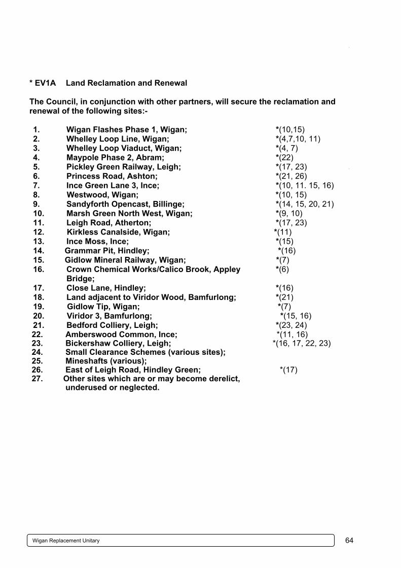
* EV1A Land Reclamation and Renewal The Council, in conjunction with other partners, will secure the reclamation and renewal of the following sites:- 1. Wigan Flashes Phase 1, Wigan; *(10,15) 2. Whelley Loop Line, Wigan; *(4,7,10, 11) 3. Whelley Loop Viaduct, Wigan; *(4, 7) 4. Maypole Phase 2, Abram; *(22) 5. Pickley Green Railway, Leigh; *(17, 23) 6. Princess Road, Ashton; *(21, 26) 7. Ince Green Lane 3, Ince; *(10, 11. 15, 16) 8. Westwood, Wigan; *(10, 15) 9. Sandyforth Opencast, Billinge; *(14, 15, 20, 21) 10. Marsh Green North West, Wigan; *(9, 10) 11. Leigh Road, Atherton; *(17, 23) 12. Kirkless Canalside, Wigan; *(11) 13. Ince Moss, Ince; *(15) 14. Grammar Pit, Hindley; *(16) 15. Gidlow Mineral Railway, Wigan; *(7) 16. Crown Chemical Works/Calico Brook, Appley
Bridge; *(6)
17. Close Lane, Hindley; *(16) 18. Land adjacent to Viridor Wood, Bamfurlong; *(21) 19. Gidlow Tip, Wigan; *(7) 20. Viridor 3, Bamfurlong; *(15, 16) 21. Bedford Colliery, Leigh; *(23, 24)
22. Amberswood Common, Ince; *(11, 16) 23. Bickershaw Colliery, Leigh; *(16, 17, 22, 23) 24. Small Clearance Schemes (various sites); 25. Mineshafts (various); 26. East of Leigh Road, Hindley Green; *(17) 27. Other sites which are or may become derelict, underused or neglected.
65Wigan Replacement Unitary Development Plan April 2006
Derelict land reclamation is an important tool in the environmental and economic regeneration of the Borough. An attractive environment, as evidenced by a green and pleasant landscape, can only serve to enhance the Borough’s image and, in the longer term, help to stimulate and sustain its economic revival through the creation of sites for development and the attraction of developers who will invest in the area. The priorities of the Council’s Derelict Land Reclamation activities remain to:- (a) Remove dangers and eyesores; (b) Provide sites for development and to encourage commercial and industrial
investment; (c) Improve the Borough’s environment, renew its landscape, protect and enhance its
existing and potential biodiversity and provide opportunities for recreation. The sites listed above and shown on the Proposals Map are those which the Council considers to have the highest priority for reclamation and restoration and which it will seek to reclaim, either directly through its own Strategic Programme of Land Reclamation or by others. However the Council recognises that many sites contain features of nature conservation interest or support protected species. Where reclamation takes place on these sites, thorough ecological assessments will be undertaken. Where the assessments indicate that there is substantial biodiversity interest or protected species on the site, these will be protected and, where appropriate, enhanced in accordance with the Greater Manchester Biodiversity Action Plan. Wherever possible, sites will be reclaimed by re-using materials which are on-site. It is also important to ensure the continued maintenance of such sites after they have been reclaimed or restored. Current programmes for derelict land reclamation include the Council’s Strategic Programme of Reclamation, the Greater Manchester Derelict Land Strategy and the Forestry Commission’s Newlands Initiative for the regeneration of derelict and neglected land by means of woodland planting. In addition, the Red Rose Forest has played a significant role in the restoration of derelict land to community woodland through the Forestry Commission’s Capital modernisation fund and the Newlands restoration programme. Consideration will be given to the Red Rose Forest Plan in any future reclamation initiatives. These programmes may, of course, be changed by circumstances beyond the Council’s direct control during the plan period. * EV1B Pollution The Council will reduce pollution and the effects of pollution by:- (a) Not permitting development which would result in unacceptable levels of air
pollution or which would have an unacceptable effect on air quality, particularly in or adjacent to the Air Quality Management Areas declared by

66Wigan Replacement Unitary Development Plan April 2006
the Council under the Environment Act 1995. Sensitive development will not be allowed in areas of unacceptably poor air quality;
*(All pages) (b) Not permitting development which would result in unacceptable levels of
pollution in watercourses or groundwater or which would result in the transfer of contaminated run-off to foul or surface water sewers;
(c) Not permitting development which would result in unacceptable levels of noise in relation to noise sensitive uses or prejudice the use of land reserved for other purposes;
(d) Not permitting development on land with unacceptable levels of contamination without ensuring that remedial measures are taken to remove, stabilise, contain or treat the land before development takes place.
The prevention and reduction of pollution of all sorts is an important aspect of the Council’s environmental aims. Many of the potential sources of pollution are outside the controls which can be exercised under the Council’s planning powers as laid down in the Unitary Development Plan and the Planning Acts. This policy specifies where the controls will be exercised to prevent or reduce pollution. The policy does not specify measurable standards which will be enforced but instead refers to preventing “unacceptable levels of pollution”. This is an essential element of the flexibility of the policy which enables the appropriate standards to be applied to proposals, usually on the advice of the Council’s Director of Environmental Health and Consumer Protection, according to the location and context of the proposals and the generally accepted or achievable standards applicable at the time. Particular attention will be given to proposals which would be likely to impact on the Air Quality Management Areas declared by the Council and any detrimental impact on the air quality of such areas will count against them. Equally, new sensitive development, like housing, in areas which suffer from unacceptably poor air quality is unlikely to be acceptable.
70Wigan Replacement Unitary Development Plan April 2006
* EV2C Features of Major Importance for Nature Conservation and Wildlife Corridors Development which would adversely affect, directly or indirectly, the landscape features listed below (which are of major importance for wild fauna and flora) will not be permitted unless the permission can be subject to conditions that will prevent damaging impacts on wildlife habitats or important physical features or if other material considerations are sufficient to override these. Appropriate management of these features will be sought through the imposition of conditions on planning permissions, the use of planning obligations and by entering into management agreements with landowners and developers where appropriate. Developers will also be expected to protect and enhance habitats and species listed in the UK and Greater Manchester Biodiversity Action Plans. Hedgerows Watercourse corridors Linear tree belts/shelter belts Canals Plantations and small woodlands Lakes Semi natural or ancient woodlands Reservoirs Semi natural grassland Ponds and lodges Ditches and banks Reedbeds Heathlands Green Lanes Mosslands The Council will also protect and enhance the Borough’s wildlife corridor network. Only in exceptional circumstances will it permit development proposals which would destroy or adversely affect the integrity of this. *(4, 6, 7, 8, 10, 11, 15, 16, 21-23, 27-29) This policy fulfils the requirement of the Conservation (Natural Habitats &c) Regulations to protect features of the landscape which are of major importance for wild fauna and flora but which are not necessarily designated nature conservation sites. Where important features are lost, a scheme for their replacement or other measures of mitigation may sometimes render a development acceptable and the Council will seek to explore such possibilities. Proposals for the creation or enhancement of habitats should use the UK and GM Biodiversity Action Plans to inform their development. The problems experienced by some groups of flora and fauna in colonising new areas can be reduced and the diversity of species increased by preserving wildlife corridors, reducing obstructions to the movement of flora and fauna and by preventing isolated ‘islands’ of wildlife from developing. Therefore, although it is important to protect sites of wildlife importance, it is equally important to protect and enhance the routes along which wildlife can travel and to create new links into the network. In October 1994 the Habitats Regulations and PPG9 Nature Conservation were issued. Both support the necessity to identify wildlife corridors/networks. The Habitat Regulations identified that planning and development policies should encourage “the management of features of the landscape which are of major importance for wild flora and fauna”. It highlighted the importance of linear features and their adjacent habitats, in particular where they support species listed in Annex iv (a) of the Regulations. PPG 9 supports these

71Wigan Replacement Unitary Development Plan April 2006
Regulations and states that “Statutory and non-statutory sites together with countryside features which provide wildlife corridors, links or stepping stones from one habitat to another all help to form a network necessary to ensure the maintenance of the current range and diversity of our flora, fauna, geological and landform features and the survival of important species”. The Borough’s primary wildlife corridors are shown on the Proposals Map. They contain both statutory and non-statutory sites and support species listed under Annex iv of the Habitats Directive.
77Wigan Replacement Unitary Development Plan April 2006
* EV3F The River Douglas, Canal Network and Other Water Features The Council will have regard to the potential of the canals, the river and other significant water features when evaluating development proposals which adjoin or affect them, in particular by ensuring that such development, by reason of its layout, external appearance and access arrangements, is sympathetic to the visual qualities of the area and its traditional waterside character and the wildlife value of its features. *(4, 5, 6, 7, 8, 10, 11, 15, 16, 22, 23, 24, 25) The canals, the River Douglas and other significant water features within the Borough form, or have the potential to form, distinctive landscape features for much of their length in both the built up and open areas. Traditionally, buildings located near the canal were both functionally and aesthetically strongly related to them. Unfortunately, more recently both the river and the canals have been seen as a hazard and much development has minimised or precluded access and ignored any design relationship to these water areas. In future, the Council will seek to enhance the canals and river as a landscape feature by increasing accessibility, removing or relieving eyesores and by the creation of a positive relationship between the canals, the river and any new development which adjoins them.
81Wigan Replacement Unitary Development Plan April 2006
i * EV4A Development and Design in Conservation Areas In addition to other development and design policies which apply throughout the Borough, the following considerations will be applied within Conservation Areas and their settings:- (a) The Council will ensure that any proposal for development within a
Conservation Area will preserve or enhance and will not harm the character or appearance of that area;
(b) The demolition or inappropriate alteration of buildings which make a positive
contribution to the historical, architectural or industrial archaeological character or appearance of a Conservation Area will not be permitted;
(c) Consent for demolition will only be granted subject to the building not being
demolished before a contract for carrying out the redevelopment of the site to a high standard of design is made for which planning permission has been granted or some other legally binding commitment has been made;
(d) Proposals which include the demolition of significant features including
porches, chimneys and boundary walls/railings or which remove or alter architectural features of value will not be permitted. The retention or, where features are missing, restoration or where inappropriate forms or features are present, the remodelling of the external character of buildings, particularly with regard to windows, roofs, materials and advertising will be required;
(e) Signs should preserve or enhance the character or appearance of the
Conservation Area and its setting and will be permitted provided they meet the following criteria:- (i) Fascia signs should, particularly in terms of their size, proportions,
degree of projection, positioning, materials, type of construction, colour and the style and size of lettering, be in keeping with the character of the shop front, fascia details and materials, the building as a whole and the area. If they are to be illuminated they should be externally illuminated using unobtrusive and discreet light fittings or take the form of individually illuminated and individually affixed letters;
(ii) The cumulative impact of advertisements should not detract from the character or appearance of the building or locality. Advertisement structures should not be superimposed on other advertisement structures;
(iii) Projecting or hanging signs should be of small size, thin section and if illuminated, should be discreetly externally illuminated and located at fascia level;

82Wigan Replacement Unitary Development Plan April 2006
(f) The Council will encourage the preservation and, where necessary, the
sensitive relocation of attractive items of street furniture and will encourage the preservation and, where possible, the enhancement and extension of stone sett and flag surfaces. Where works are undertaken to these and other special surfaces, such as paviors, temporary or permanent reinstatement should be in the original material;
(g) The Council will encourage the removal of buildings detrimental to the
character of Conservation Areas; (h) The rendering or cladding of stone and brick buildings will not be permitted. (j) Proposals which involve development, including relatively large-scale
extensions, within the grounds/gardens of dwellings and other buildings such as churches where the grounds contribute to the character of the Conservation Area will not be allowed.
*(4, 5, 6, 7, 8, 10, 11, 16, 17, 18, 21, 23, 24, 26, 28) These considerations are only applicable where planning permission or advertisement consent is required and do not purport to restrict permitted development rights. There are currently 22 Conservation Areas in the Borough which represents a major part of its historical and architectural heritage. This policy details the main considerations that the Council will apply when assessing development proposals within them or within other Conservation Areas which may be designated in the future. Buildings which are considered to make a positive contribution to the character of the Conservation Area include those with some defects such as inappropriate window frames, advertisements or shop fronts or which are in need of repair. Any development of such premises will be expected to include suitable repairs and the replacement of inappropriate features with more sympathetic ones. Advertisements can have a dramatic impact on the appearance of Conservation Areas. Well designed signage can be both sensitive and visually interesting in relation to the character and appearance of such areas whilst being commercially effective. It is important however that signs are not too prominent or dominant and that they do not cover up high quality materials such as brickwork, stone, tiles or polished finishes which are integral to the building. Signs should also not cover up, obscure, detract from or damage architectural features of the building, or fascia area and their size, proportions and location should not alter the extent of glazing in the shop front or the proportions of the upper façade and fenestration pattern. Standardised solutions such as the use of illuminated boxes or box-like structures are unlikely to be acceptable. For certain building types such as public houses a location for hanging signs above the fascia level may be justifiable in relation to traditional practice in the area.
84Wigan Replacement Unitary Development Plan April 2006
* EV4D Historic Parks, Gardens and Cemeteries Permission will not be given to any proposal which is likely to adversely affect the character or setting of any of the following Historic Parks, Gardens or Cemeteries:- 1. Haigh Hall grounds, Haighlands, Moat House and Haigh House Gardens,
Haigh; *(4, 5, 7, 8) 2. Standish Hall remnant parkland and Ashfield House gardens, Standish;
*(3, 4, 6, 7) 3. Kilhey Court grounds, Worthington; *(4) 4. Bispham Hall and Winstanley Hall Parks, Billinge; *(14) 5. Golborne Hall Park, Golborne; *(26, 27, 30) 6. Hindley Hall Park, Aspull; *(11) 7. Atherton Hall Park, Atherton; *(17, 18, 23, 24) 8. Astley Hospital, (former) Astley Vicarage and The Meads, Tyldesley; *(24) 9. Hindley, Atherton, Ince, Tyldesley and Leigh Cemeteries;
*(10, 11, 15, 17, 18, 23, 24) 10. Historic public parks at Mesnes Park, Wigan and Lilford Park and Firs Park,
Leigh; *(10, 17, 18, 23, 24) 11. Other historic parks and gardens which may from time to time be identified. These areas are those where a landscape of particular historic interest remains and where special protection is needed to ensure their survival. Such a designation would not necessarily preclude development but would certainly require that particular consideration be given to the amount and design of any development which may be allowed. Similarly, there may be some proposals which involve only the change in the use of the land without any building development but which could be unacceptable by virtue of their impact on the landscape. The Council will apply the terms of this policy to other historic parks and gardens which may from time to time be identified only after these have been listed in supplementary planning guidance which has been adopted in accordance with the advice of PPG12. This supplementary planning guidance will be incorporated in the development plan at the next review. The relative weight to be given to the content of an adopted development plan and of supplementary planning guidance is set out in PPG12. Mesnes Park, Wigan is included on the National Register of Historic Parks and Gardens compiled by English Heritage. Appendix 6 gives further details of these sites.
87Wigan Replacement Unitary Development Plan April 2006
Introduction Through increasing the mobility of people and goods, transport has had a fundamental role in achieving the standard of living we enjoy today. It is instrumental to a healthy economy and people’s ability to access jobs, shopping and other services. However, this has not been achieved without a cost to the environment, society and economy. The road network is increasingly busy and congested. This blights local communities with heavy traffic, noise, air pollution and concerns of road safety and adds substantially to journey times. In addition, those without access to a car have suffered as land uses have become more dispersed and less accessible without a car. The Greater Manchester Local Transport Plan 2 (LTP2) is the primary means of delivering transport improvements in the Borough. Its strategy seeks to secure a transport system that is better integrated, more accessible and less damaging, thereby meeting people’s needs and helping to regenerate the Borough. The UDP and LTP are consistent. The transport policies seek to promote greater travel choice, reducing our dependence on the car and promoting public transport, walking and cycling in particular. This is reinforced by land use policies that seek to ensure that development is accessible by a choice of means of transport by virtue of its location, layout and design. The Council’s powers with regard to bus and rail services are limited. However through working closely with the Greater Manchester Passenger Transport Executive (GMPTE), public transport operators and other relevant bodies, the Council will seek to ensure that the bus and rail network and service provision fully meets the needs of people and businesses in the Borough. The Council has adopted Walking and Cycling Strategies and is implementing measures in accordance with them. Freight is heavily dependent on road traffic. While opportunities for rail use will be actively pursued and facilitated wherever possible, the primary aim is to reduce the environmental, amenity and safety impacts of freight. Changes from the first UDP have been extensive in response to fundamental changes in national transport policy. Major new proposals include the integration of the two railway stations in Wigan, a new railway station at Golborne and the safeguarded route of the guided busway between Leigh and Manchester.
Chapter 10 – ACCESSIBILITY POLICIES
93Wigan Replacement Unitary Development Plan April 2006
* A1G Physical Improvements to Bus Network The following routes are being developed as Quality Bus Corridors:- (1) Wigan to Leigh/Atherton (A577/A578) *(10, 11, 16, 17, 18, 23) (2) Wigan to Chorley (A49) *(2,4,7,10)(3) Wigan to Skelmersdale (A49/A577) *(9,10) (4) Leigh to Bolton (B5215/A579) *(17,18, 23) (5) Wigan to St Helens (A573/A58/A49) *(10, 15, 21, 26) Developments close to a proposed Quality Bus Corridor that require a Transport Assessment should contribute towards the implementation of Quality Bus Corridor measures as far as they are material to the proposed development. Bus services form the heart of the public transport network in the Borough. It is the Council’s vision to have a high quality frequent service network between main settlements. Key routes have been identified as Quality Bus Corridors along which comprehensive improvements have and will be undertaken in order to improve the overall environment for bus users. The main objectives are to reduce journey times, increase the reliability of services and provide high quality accessible vehicles, waiting environments and passenger information. A range of measures can be used to achieve these objectives including bus gates at junctions, bus priority at traffic lights, more convenient and safely located bus stops and shelters and measures to ensure that parking and delivery needs can be provided for without disrupting bus services.
94Wigan Replacement Unitary Development Plan April 2006
D * A1H Leigh, Ellenbrook, Manchester Public Transport Corridor Development that would prejudice the construction and operation of a guided busway between Leigh and the Borough boundary at Ellenbrook (together with a link to Higher Folds), as part of a Quality Bus Corridor eastwards to Manchester, will not be permitted. The route will also be safeguarded from development that would prejudice its future upgrading to light or heavy rail. *(23, 24, 18, 19) The Council has been working with GMPTE and Salford Council to progress proposals for a Quality Bus Corridor from Leigh to Manchester. The scheme has undergone a comprehensive programme of public consultation and an application for an Order under the Transport and Works Act was made in January 2002, with a public inquiry held in the Autumn of that year. Within the Borough it will comprise a new guided busway along 8 km of the former railway line from Leigh through Tyldesley to Ellenbrook, together with a spur to Higher Folds. High quality bus priority measures will link Ellenbrook to Manchester City Centre, primarily along the A580, giving comprehensive bus priority along the entire route. Integral to the proposal is the creation of a safe access and waiting environment for users. The implementation of the scheme will significantly reduce journey times between Leigh and Manchester and improve travel opportunities for those without access to a car. It should also result in fewer car journeys, thereby reducing congestion for the benefit of other road users and residents. Swifter public transport links will also improve the attraction of Leigh and Tyldesley as locations for business. At the present time the Council sees the development of a Quality Bus Corridor as the most feasible means of providing a high quality integrated transport route between Leigh and Manchester. However provision is made to allow for the route to be upgraded to light or heavy rail if feasible in the future.
95Wigan Replacement Unitary Development Plan April 2006
* A1J Rail Infrastructure The development of new or improved services and facilities at existing rail stations will be sought. The construction of a new rail station at Golborne will be pursued within land shown on the Proposals Map. *(27) As stressed by the Government, Local Authorities in conjunction with the Strategic Rail Authority (SRA) need to fully consider the potential for improving rail travel in their areas. There are a number of infrastructure improvements required at many of the stations in the Borough, including the need to enhance security and accessibility, upgrade facilities and improve the provision of information and interchange with other modes. In determining priorities the Council will work closely with GMPTE and the local community. A new station is proposed at Golborne. It is dependent upon a number of factors including the introduction of a local service on the West Coast Main Line, south of Wigan. * A1K Integration of Wigan Rail Stations Within the land shown on the Proposals Map, the integration of Wigan North Western and Wigan Wallgate Stations will be pursued. *(10) Wigan North Western is a key station on the West Coast Main Line and Wigan Wallgate and North Western are the focus for local rail services. The two stations are poorly integrated, being separated by a busy road and with inadequate and unattractive pedestrian links between them. The Council wants to see the combination of the two stations into a single entity providing significantly improved facilities. Wallgate Station and most of the other buildings along the north-west side of Wallgate to the railway bridge are Listed Buildings and, together with buildings on the south-east side of Wallgate as far as the vehicular access to North Western Station, they are all within the Town Centre Conservation Area. The design for this scheme will need to be sensitive to this context. This scheme forms one of a closely associated package of wider proposals called the Wigan Hub. Integral to it is the construction of the A5225 and Town Centre Link Road (see Policy A1P) which will provide access to Wigan town centre and the railway stations. Through the implementation of the Wigan Inner Relief Road (see Policy A1P) significant improvements in access arrangements for pedestrians, cyclists and buses can be achieved, with the potential for high quality interchange facilities between car, bus, taxi, cycle, walking and rail. The Council is committed to working with relevant landowners to produce a development brief for the area that is also consistent with Policy S1B.

96Wigan Replacement Unitary Development Plan April 2006
A A1M Freight – New Development Proposals that will generate freight movements will be required to have appropriate access to the Strategic Route Network. Proposals for rail connections for freight will be permitted provided that there will be no undue impacts on amenity, safety or congestion and any additional road traffic generated will have appropriate access to the Strategic Route Network. The efficient movement of freight is essential to a competitive local and national economy. Given its flexibility, road transport will remain the primary mode for the movement of freight. However the road network in the Borough is increasingly affected by congestion. Proposals should be located where access between the site and the Strategic Route Network is suitable for the traffic likely to be generated, without undue adverse impact on congestion, road safety and amenity (see Policy G1A). Rail can play an important role in the sustainable distribution of goods. It has particular strengths in the movement of goods over longer distances. Subject to the safeguards outlined its use for freight will be facilitated. A Transport Assessment will be required for new developments likely to generate significant freight movements, in order to assess the full implications of traffic movements and how they can be carried out in the most sustainable way.

97Wigan Replacement Unitary Development Plan April 2006
A * A1N Strategic Route Network The Council will safeguard, maintain and improve the Strategic Route Network to accommodate main flows of general traffic in the Borough. *(1-11, 13-29) An effective road network is integral to meeting the future transport needs of the Borough. The Strategic Route Network (SRN) comprises the main arterial roads carrying the highest volumes of traffic and linking the main settlements. It is important that this network is able to accommodate the efficient movement of people and goods between urban areas and the motorway system, thereby helping to reduce the impact of traffic elsewhere. In certain circumstances, new roads are required to overcome problems of traffic congestion and to improve accessibility to locations that are constrained by poor access (see Policy A1P). The use of the Strategic Route Network for main flows of general traffic should not prejudice walking, cycling and public transport accessibility. Parts of the SRN are also being developed as Quality Bus Corridors (see Policy A1G). Walking and cycling, both along and across the SRN, should also be facilitated. * A1P Major Highway Schemes The Council will safeguard the land required for the following road schemes and will not permit any development which might prejudice their construction:- (1) Westwood Park/Town Centre Link Road *(10) (2) Wigan Inner Relief Road West *(10) The highlighted schemes are important new road links required to resolve traffic conflicts and support the Borough’s economy. (1) Westwood Park/Town Centre Link Road This road will link the town centre with Westwood Park. It involves a major upgrading of Chapel Lane and Poolstock Lane with improved access to Westwood Park to enable the development to proceed. It is anticipated that the road will be completed in 2006.

98Wigan Replacement Unitary Development Plan April 2006
(2) Wigan Inner Relief Road West This road proposal will link the A49 at the Saddle Junction with the Inner Relief Road at New Market Street, thereby completing the inner ring road around the town centre. It is part of the Wigan Integrated Transport Scheme (WITS) and will allow for improved access to the rail and bus stations by public transport, cycling and walking and remove general road traffic from Wallgate. It will also provide access to new employment sites close to areas of high deprivation. In addition, the Council will advocate to the Highways Agency, that Junction 25 be made an ‘all ways’ junction.
99Wigan Replacement Unitary Development Plan April 2006
A1S Parking in New Development In new development, convenient, safe and secure provision will be required for:- (a) cycle and motorcycle parking and car parking for disabled people in accordance with the minimum standards adopted by the Council; (b) car parking in line with the maximum standards adopted by the Council. The scope for providing cycle or motorcycle parking or car parking for disabled people below the minimum standards, or car parking below the maximum standard, will be considered against the following factors:- (i) the accessibility of the site by public transport;
(ii) the availability of convenient and safe off-street parking;
(iii) the availability of on-street car parking without detriment to residential amenity and highway safety;
(iv) the feasibility of providing on-site parking relative to other planning issues such as the reuse of a constrained site or building and urban design.
Where necessary, a legal agreement will be sought to secure the developer's contribution to the provision and/or management of off-site parking. Government guidance (PPG13) states that maximum car parking standards should be applied to new development as part of wider measures to reduce car use. This does not apply to car parking for disabled people in order to maximise accessibility for disabled people, nor to cycling in order to encourage cycle use, nor to motorcycling. The Council has developed maximum car parking standards and minimum standards for cycle and motorcycle parking and car parking for disabled people in conjunction with other Greater Manchester authorities. The standards are based on the ‘urban conurbation’ standards in Regional Planning Guidance and national standards in PPG13 and are set out in Appendix 9. When development is proposed with car parking in excess of the maximum standards, it should be demonstrated by way of a Transport Assessment why it is needed. The criteria in the policy set out the circumstances when parking provision below any of the standards is appropriate, either because there is satisfactory alternative provision; good accessibility by public transport or proposals in place to improve its use (for example, by way of a Travel Plan); or it is outweighed by other planning considerations such as the desirable reuse of a constrained site or for reasons of good urban design. On many occasions the car is the only means of access for disabled people. The minimum standards for car parking for disabled people seek to ensure that there are adequate spaces to ensure equal opportunity of access. Such provision should always be made as close as possible to, and usually within 50 metres of, the main entrance(s) to the building(s) and accord with nationally recognised design guidance.
103Wigan Replacement Unitary Development Plan April 2006
Introduction Shopping is the lifeblood of a successful centre. It is the primary incentive for regular trips into centres from surrounding residential areas, generating considerable expenditure and creating employment. Moreover, shopping is an essential service. Convenient access to a comprehensive range of competitively priced goods is an important component of a good quality of life and social inclusion. Town centres are the most accessible locations for shopping. As central locations they generate shorter car journeys and, in larger centres, the concentration of shopping and other activities sustains bus services from surrounding areas. Local centres are well located for access on foot from surrounding areas. By comparison, most out-of-centre locations are only easily accessible for people in cars and, because they are not centrally located, they usually generate longer car journeys overall. Accordingly, Government planning guidance promotes town centres as the preferred locations for developments that will generate significant numbers of trips, in particular, retail, leisure and office developments. This is further reinforced by Regional Planning Guidance. This Plan evolves the approach taken in the first UDP to more closely accord with national and regional policy. The hierarchy of 2 Main Town Centres, 7 Town Centres and 25 Local Centres in this Plan has evolved from the hierarchy of centres in the first UDP. A Principal Shopping Area is identified in each of the Town Centres as well as the Main Town Centres. A further change is the allocation of sites in Wigan, Ashton and Leigh for retail development in response to quantitative and qualitative needs for new development that have been identified in the Wigan Borough Retail Study 2001-2016 prepared for the Council. In particular, there is :- (a) a considerable quantitative need for additional comparison retail floorspace in
Wigan town centre, amounting to 17,400 square metres (net) by 2006 rising to 25,173 square metres (net) by 2011;
(b) a quantitative need for improved convenience retail floorspace in Ashton-in-
Makerfield town centre, to stem leakage from the town to out-of-centre stores elsewhere, and a further need to retain a greater share of locally generated 'high street' comparison shopping expenditure;
(c) a quantitative need for additional bulky goods retail floorspace in Leigh to stem
leakage to stores outside of the town's catchment area in the east of the Borough; and
(d) a need to strengthen the role of some of the smaller centres through improved top-
up food shopping provision.
Chapter 11 – SHOPPING AND TOWN CENTRE POLICIES

104Wigan Replacement Unitary Development Plan April 2006
In order to consider the future of town centres in greater detail the Council is working with traders and local communities on ‘Centreplans’. A ‘Centreplan’ has been produced for Wigan town centre and a number of the projects identified in it have come to fruition. A Centreplan for Atherton town centre has also now been adopted by the Council and one for Hindley town centre is being prepared. Adopted Centreplans have the status of Supplementary Planning Guidance to the UDP and can set out in greater detail proposals for individual sites and locations. They can also inform future reviews of the Development Plan.
106Wigan Replacement Unitary Development Plan April 2006
a * S1A Principal Shopping Areas At ground floor or mall level (fronting the street, mall or other main public space) within the Principal Shopping Areas of Wigan, Leigh, Atherton, Ashton-in-Makerfield, Golborne, Hindley, Pemberton, Standish and Tyldesley town centres, the development of, or change of use to, shops will be permitted. Food and drink outlets and financial and professional services provided principally to visiting members of the public will be permitted provided that:- (a) there will be no adverse impact on the vitality and viability of the Principal
Shopping Area; and (b) a shop front with a suitable window display will be incorporated or
maintained (except in buildings to be retained that were not originally designed with shopfronts).
Other uses will only be permitted when the above criteria are met and it can be demonstrated, to the satisfaction of the Council, that the use could not reasonably be located outside of the Principal Shopping Area. *(4, 9-11, 18, 21, 23, 26, 27) Principal Shopping Areas (PSA's) are identified in Wigan, Leigh, Atherton, Ashton-in-Makerfield, Golborne, Hindley, Pemberton, Standish and Tyldesley town centres. They are the areas in each centre with the most significant concentrations of retail uses. Retailing is the core function of town centres and Principal Shopping Areas are identified in order to ensure that a central concentration of retail activity is maintained and enhanced. Many food and drink and financial and professional service uses also wish to locate in central areas. Such uses will be permitted provided that they will not detract from the vitalityand viability of the location and that a suitable window display will be maintained. Other uses will be permitted only in exceptional circumstances when, in addition to the above, the Council is satisfied that the use could not reasonably be located outside of the PSA. Relevant considerations will include the number of vacant units in the PSA, the length of time these units have been vacant and the availability of units outside, but otherwise well related to the PSA. Vitality is determined by actual and perceived activity at different times of day. This includes pedestrian activity in the street and activity 'visible’ within buildings, including the presence of displays in shop windows and lighting at night; the maintenance of buildings and spaces; the perception of safety and occurrence of crime; and the ease of access to/from and within the centre. Viability is concerned with economic issues including retailer representation, rental levels, the returns on investment in property and vacancy rates. Diversity of use is also an indicator but more appropriate to the centre overall rather than the retail core.
107Wigan Replacement Unitary Development Plan April 2006
A proposed development or change of use within a Principal Shopping Area will be considered likely to have an adverse impact on the vitality and viability of the Area when it is likely to attract significantly fewer customers during the daytime than adjacent shop uses, to the extent that this will materially affect the commercial attraction of the location for remaining shop uses. This will be a matter of degree concerning:- (a) the length of frontage involved relative to the block of frontages that it is within; (b) the type and characteristics of other uses in the frontage; (c) the importance of the location for the profile of shopping within the Principal
Shopping Area; (d) the existence of vacant shop units within the Principal Shopping Area and outside
but clearly visible from it; and (e) the potential benefits of the proposal for the wider commercial and community
interests of the town centre. Buildings not requiring the incorporation of a shopfront include traditional bank and public house buildings and former churches and chapels. Upper floors, basements and other locations within Principal Shopping Areas not fronting the street, mall or other main public space are covered by Policy S1B.
108Wigan Replacement Unitary Development Plan April 2006
* S1B Town Centres In Town Centres, other than within Principal Shopping Areas as covered by Policy S1A, the development of, or change of use to, shops, food and drink outlets, financial and professional services provided principally to visiting members of the public, taxi/private hire booking offices, hotels, community and cultural facilities, leisure and entertainment uses and housing – including mixed use developments – will be permitted provided that:- (a) it will be a scale and character appropriate to the size, function and character
of the centre, part of the centre or the building concerned; (b) it will not adversely affect the vitality and viability of the centre, including the
Principal Shopping Area and/or the part of the centre concerned; and (c) it will be compatible with surrounding land uses, including the maintenance
or inclusion of a shopfront where appropriate, and will not detract from the amenity of nearby uses or road safety.
*(4, 9-11, 16-18, 21, 23, 26, 27) Policy S1B applies to development and changes of use in the 2 Main Town Centres and 7 Town Centres outside of the Principal Shopping Areas covered by Policy S1A. It also applies within the Principal Shopping Areas to upper floors, basements and other locations not fronting the street, mall or other main public space. Town Centres are appropriate locations for a wide range of uses, principally those that individually or in combination attract large numbers of people but also, in appropriate locations, housing. The objective is to maximise the potential and development of centres, both commercially and as focal points for community facilities, while ensuring compatibility between uses within and adjacent to the centre. Securing the reuse or redevelopment of unused or underused sites promotes confidence and generates new activity within a centre, benefiting existing traders and the wider community alike. Shopping is the core function of town centres in respect of the number and frequency of trips generated. Without shopping the vitality and viability of centres would be much reduced and fragmented. The Principal Shopping Areas are the main locations for shops and other shopfront uses in the town centres and the priority will be to concentrate retailing activity within and immediately adjacent to these areas. Shops will only be permitted elsewhere in a town centre when it would not dilute the retail content of that centre, thus potentially impacting upon its vitality and viability.
109Wigan Replacement Unitary Development Plan April 2006
Where the street scene is dominated by premises with shopfronts, a new development or use will be required to incorporate or maintain a shopfront unless it is evident that the continued vitality and viability of the centre would be best served by alternative development. Indicators will include the number of vacant premises with shopfronts in the immediate locality (not just the application site) and how peripheral the location is in relation to the Principal Shopping Area. Many centres include Conservation Areas within which conservation policies will also be considered. Bars, restaurants and clubs can generate considerable activity for the ‘evening economy’ in a centre. However, if sited in close proximity to residential properties, both within and adjacent to a centre and/or in locations where a main dispersal route will clearly be through a residential area, they can disrupt the amenity of nearby residents. In such cases conflict occurs which is not easily resolved, blights people’s quality of life and can counteract measures to promote vitality and viability. Care is needed in the siting of such uses. Care is also needed in the siting of new residential development and uses within centres. Residential development is promoted within centres because it increases the proportion of floorspace in active use, promotes investment in the improvement and maintenance of buildings and retains a human presence in centres when shops, offices and even pubs and clubs have closed, making it safer both for people and property. However, inappropriately sited or designed it can restrain potential future commercial development, either by land take or incompatibility of uses. It is often most appropriate as part of a mixed use development with commercial uses on the ground floor along main frontages. Residential development can also be advantageous for the regeneration of underused sites on the edge of centres, which can also help to better integrate a town centre with a neighbouring residential area and consolidate commercial activity into a smaller, more viable, central core. In a centre where activity has become dispersed, this can help to make it more attractive to customers and more successful for businesses. In all cases, development should be sensitive to its surroundings including the commercial requirements of businesses and the amenity requirements of nearby housing. Residential development must comply with Policies R1B, R1D and/or R1G, as appropriate. *S1C Retail Development – Station Road, Wigan Town Centre Land at Station Road, Wigan, bounded by Crompton Street, River Way and Millgate, is allocated for retail-led redevelopment also comprising other ‘town centre uses’ as appropriate. Retail development should be fully integrated into the adjoining Principal Shopping Area at Standishgate and have good pedestrian linkages with other adjacent streets, including the bus stops on Crompton Street. The multi-storey car parks at Millgate and Station Road should be retained, remodelled or replaced with the proposed number of spaces to be agreed on the basis of a Transport Assessment. A proposed scheme has received planning consent. *(10) Much of this part of Wigan town centre is degraded and underused. There are a number of vacant and underused premises and sites. It is close to the core of the town centre but contributes little to its vitality and viability.
110Wigan Replacement Unitary Development Plan April 2006
There has been a gap of ten years since the early 1990s when the town centre last benefited from major retail investment/development and it has consequently suffered. Relatively few major retailers have located in Wigan town centre in that time and rental growth has remained static compared to similar sized towns elsewhere. A particular constraint is a shortage of the larger floorspace units now being sought by many retailers. Considerable capacity has been identified in the Wigan Borough Retail Study 2001-2016 for the expansion of the town centre’s retail core, as noted in the Chapter Introduction. In 2002, planning permission was granted for a comprehensive retail-led development within the area identified that would fulfil a large part of this need. The approved development comprises a department store, retail units, food outlets, a leisure unit, service areas and modification/improvements to car parking. The main pedestrian entrance into the development would be at the top of Standishgate and the scheme would integrate with existing major retailers and a department store building on Standishgate within the Principal Shopping Area (Policy S1A). Identification of the site in the UDP does not make possible objections to the existing planning approval. * S1D Local Centres Within local centres the development of, or change of use to, shops, food and drink outlets, financial and professional services provided principally to visiting members of the public, offices, taxi/private hire booking offices, community and cultural facilities and other uses appropriate in a local centre will be permitted provided that:- (a) it will be of a scale and character appropriate to the size, role and function of
the centre, including its accessibility by public transport; and (b) it will be compatible with surrounding land uses and will not detract from
residential amenity or road safety; and (c) in respect of hot food establishments, further to (a) and (b) above it will not
result in an over concentration of such uses to the detriment of amenity and/or the shopping function of the centre.
The conversion of ground floor residential properties to commercial use will only be permitted when:- (i) it is needed to enable an existing business to expand that could not
reasonably relocate elsewhere in the centre; or (ii) it would help to consolidate a commercial frontage; or (iii) it can be demonstrated that there are no suitable vacant premises available in
the centre. New residential development or use at the ground floor on a main frontage will only be permitted where there is a high overall vacancy rate or an undeveloped or derelict site and it will assist regeneration. *(6-11, 14-16, 18, 21, 24, 27)
111Wigan Replacement Unitary Development Plan April 2006
Outside of the town centres, local centres are the main concentrations of shops, services and associated facilities primarily serving local communities. Local centres have an important role in facilitating access to services and facilities, particularly those that we use briefly but on a regular basis, thereby promoting social inclusion and reducing the need to travel. The overall objective is to sustain and support the local centre functions in these locations, with particular regard to its shopping function, and secure regeneration where needed. The scale and character of development that will be appropriate will be dependent on the scale and character of the centre concerned and its surroundings. A small supermarket, up to approximately 1,500 square metres gross, might be appropriate in some of the larger local centres such as Higher Ince, where it would assist regeneration. Similarly, there is a need to ensure that a range of different local centre uses is maintained as far as possible. Hot food establishments, including take-aways, cafes and restaurants can be important components of local centres. However, when they predominate they can fundamentally change the nature of a centre, to the detriment of its shopping function and amenity. This can result in a predominance of 'dead' shopping frontages during daytime hours, such that the function of the centre for the everyday shopping needs of the local community is overtaken by its evening economy function serving a much wider area. Additional guidance, in the form of Supplementary Planning Guidance on restaurants, cafes and hot food takeaways, is available from the Council. Many local centres include housing. The retention of such premises will be the preferred option unless redevelopment or change of use would be in the interests of the vitality and viability of the centre overall, or in the overriding interests of an adjacent business in need of larger premises. New housing would only be acceptable when it would have no negative impact on the vitality or viability of the centre. It also must comply with Policies R1B, R1D and/or R1G, as appropriate. S1E Small Shops and Services Outside existing town centres and local centres the development of, or change of use to, shops and other services of less than 150 square metres gross floorspace, including shops at petrol filling stations, hot food establishments and extensions to existing premises, will be permitted provided that:- (a) it will be suitably located in terms of access on foot from the surrounding
area and considerations of road safety; and (b) it will not unduly affect the amenity of nearby residents and businesses; and (c) in respect of hot food establishments, further to (a) and (b) above it will not
result in an over concentration of such uses to the detriment of amenity and/or the shopping function of the area.
112Wigan Replacement Unitary Development Plan April 2006
Larger shops up to 500 square metres gross floorspace, including extensions to existing stores, will be permitted provided that the above criteria are met and:- (d) the applicant has demonstrated that no suitable sites or buildings are
available, or likely to become available within a reasonable period of time, in or on the edge of a nearby town centre or local centre from which a similar catchment could be served; and
(e) it will not have an adverse impact on the vitality and viability of an existing
local centre to the detriment of residents served primarily by that centre. Shops and other services of less than 150 square metres gross floorspace are unlikely to have any adverse impacts beyond considerations of amenity and road safety. Hot food establishments, including take-aways, cafes and restaurants can provide a valuable service for a local community, provided that the use would not have an unacceptable impact on amenity or road safety. The presence of existing hot food establishments does not necessarily mean that a further hot food establishment will be acceptable. The cumulative impact of such uses can have a detrimental impact on the shopping function of a location, including a predominance of 'dead' shopping frontages during daytime hours. In addition, an area can change to effectively serve a much wider area than the local community, but predominantly in the evening and early hours of the morning when the impact on amenity is greatest. The objective is to avoid hot food establishments predominating in unsuitable locations to the detriment of the local community. Additional guidance, in the form of Supplementary Planning Guidance on restaurants, cafes and hot food takeaways, is available from the Council. Larger shops up to a maximum 500 square metres gross floorspace, in particular, multi-purpose convenience stores that are open from early morning to late evening, seven days a week, typically selling food, licensed drinks, newspapers and magazines and other convenience goods and renting videos and DVDs, can have a significant impact on local shopping patterns. Wherever possible, these stores should be located within or on the edge of existing centres in order to support the function of these centres. They should only be located outside an existing centre when criteria (d) and (e) are satisfied. Shops over 500 square metres will be subject to the sequential approach and other tests set out in Policy S1F. For clarification, extensions to existing shops under Policy S1E should not result in the extended shop exceeding the floorspace threshold concerned.
114Wigan Replacement Unitary Development Plan April 2006
* S1H Retail Development – Leigh East ARLFC Site, Leigh Land at Leigh East Amateur Rugby League Football Club’s site, off Atherleigh Way, Leigh is allocated for non-food retail development comprising ‘bulky goods’ and associated retail sales only, provided that:- (a) replacement new rugby pitches and facilities are provided elsewhere in Leigh
of modern equivalent standard and facilities for both adult and child amateur rugby league, prior to development commencing;
(b) safe, direct and accessible pedestrian linkages are provided between the site
and Leigh town centre and bus services on Leigh Road and Kirkhall Lane, facilitated by the siting and orientation of the proposed store(s);
(c) a suitable and safe vehicular access is provided to/from Atherleigh Way; and (d) the development will not unduly affect the amenity of nearby residents or
other uses. The range of goods permitted for sale from the site will be restricted in order to protect the vitality and viability of Leigh town centre. A legal agreement will be sought to ensure that the development value of the site is directed entirely towards the provision of the alternative sporting facilities required under this Policy. *(23) Out-of-centre retailing at Parsonage Retail Park has clawed back expenditure otherwise lost from the eastern end of the Borough to retail parks in Bolton and Warrington, but caution is now required in considering further out-of-centre shopping in Leigh. In this context, the Wigan Borough Retail Study 2001-2016 identified a quantitative need for additional bulky goods retailing, as noted in the Chapter Introduction. Further work needs to be done to identify the precise nature of this need within the overall bulky goods category. This will need to be undertaken and the results made known before planning permission is given for development in accordance with this policy. The planning permission will be conditioned accordingly. The Leigh East site at Atherleigh Way is within relatively easy walking distance of the town centre. No site within or closer to the town centre is available, or likely to become available within a reasonable period of time, for a development of this size. Accordingly, against the tests set out in national planning policy and under Policy S1F, the site is ‘sequentially preferable’.

115Wigan Replacement Unitary Development Plan April 2006
For the sale of other goods to be permitted, the applicant would have to demonstrate need and that the store would not compete unduly with existing stores in Leigh town centre. Additionally, the development would contribute significantly to the capital receipts required to secure the Leigh Sports Village development covered by Policy C1D. The need for that development is set out with the policy. It is intended, however, that it will incorporate a large part of the replacement facilities for Leigh East Amateur Rugby League Football Club, necessary for the retail development to proceed.
117Wigan Replacement Unitary Development Plan April 2006
Introduction Community facilities, open space, sport and recreation underpin our quality of life. They are key factors in promoting social inclusion and community cohesion, improving health and well being and securing an urban renaissance. Everyone benefits from community facilities such as schools, colleges, hospitals, health centres, places of worship and social centres. The Council will ensure that land is reserved for new facilities where it can and will support the replacement or improvement of existing facilities. The aim is to provide accessible facilities that will reduce reliance on the car and encourage people to walk, cycle or use public transport. The creation of local accessible facilities can also help to foster local identity, bring a community together and reduce social exclusion. Likewise, open space and sport and recreation facilities are important factors in determining quality of life, whether it is participation in sport, informal play or exercise, or a passive appreciation of open space for amenity reasons. As such, a wide variety of provision is required including sports halls and pitches, playgrounds, landscaped open space and off-road routes for walking, cycling and horse riding. To ensure effective planning for open space, sport and recreation it is important that the needs of the Borough’s population are known. The first UDP adopted the National Playing Field Association’s standards for open space provision. However, national standards cannot cater for local circumstances and detailed local standards are now required. Standards for football and rugby pitches have been drawn up and are included in this Chapter. For open space and other sports and recreation provision, a detailed assessment of need and opportunities has to be undertaken. Opportunities for access to the countryside between the urban areas are a valuable resource for recreation. Policies are continued for a network of Greenways and the recreational use of waterway corridors. A new policy sets out a vision for the further co-ordination and improvement of recreational provision throughout much of the countryside, to be designated a Regional Park. The Plan reflects the requirements of The Countryside and Rights of Way Act 2000 which extends the public’s ability to enjoy the countryside whilst also providing safeguards for landowners. The Act introduces a new statutory right of access and modernises the existing rights of way system. There is one further significant new proposal, for the Leigh Sports Village, incorporating a new football and rugby league stadium together with other sport, education and leisure facilities.
Chapter 12 – COMMUNITY FACILITIES, SPORT AND RECREATION POLICIES
119Wigan Replacement Unitary Development Plan April 2006
C1B Open Space, Sport and Recreation Provision Local standards for the provision of football and rugby pitches are:- Pitch size Football Rugby Mini 1 per 14,000 population 1 per 15,000 population Junior 1 per 5,500 population 1 per 14,000 population Senior 1 per 4,500 population 1 per 9,000 population The Council will undertake a local assessment of needs and opportunities for other open space, sport and recreation requirements. In seeking to meet shortfalls against the standards or otherwise improve the provision of sport and recreation facilities, the development or provision of new or enhanced facilities will be permitted provided that:- (a) they will be accessible for the community or communities that they are
intended to serve by means of walking, cycling and, where appropriate, public transport;
(b) there will be no undue impact upon the amenity of surrounding land uses; and (c) there will be no adverse impact on road safety. In order to plan effectively for open space, sport and recreation, it is essential that the needs of local communities are known. Detailed local assessments are required in order to understand exactly what needs there are. In this way, local standards for the provision of grass pitches for football and rugby have been developed, as shown in the Policy. The Council is committed to undertaking detailed local assessments for open space and built sports and recreational facilities in addition to football and rugby. The assessment will include built sports and recreation facilities and all open space of public value, including:- • outdoor sports facilities including tennis courts, bowling greens, sports pitches, golf
courses, athletics tracks and playing fields; • public parks and gardens; • children’s playspace; • provision for teenagers including skateboard parks, outdoor basketball hoops and other
informal areas; • amenity greenspace; • natural and semi-natural urban greenspaces; • allotments and community gardens; • cemeteries and churchyards; • accessible river and canal banks; • accessible countryside in the urban fringe; and • civic spaces.
120Wigan Replacement Unitary Development Plan April 2006
In order to ensure that opportunities to use (and enjoy) open space or sports and recreation are available to all, it is important that shortfalls in the provision of facilities are met and modern equivalent facilities provided. This will include new facilities that can be used more intensively, such as floodlit 'all weather' multi-use games areas and synthetic pitches. These need to be located sensitively in order to avoid undue impacts on neighbouring land uses, such as noise, light spillage, traffic and parking. The policy seeks to secure an acceptable balance between these issues. C1C Protection of Open Space and Sport and Recreation Provision Development on open space, or on land or of buildings in use, or most recently in use, for sport or recreation, will not be permitted unless:- (a) it is ancillary to the principal use of the site and will not adversely affect the
quantity or quality of provision; or (b) it will be replaced in a suitable location by alternative provision of equivalent
or better quantity and quality; or (c) it is for an indoor or outdoor sports facility, the provision of which would be
of sufficient benefit to the development of sport as to outweigh the detriment caused by the loss of existing open space or playing fields, or part thereof, and it could not reasonably be located elsewhere; or
(d) a carefully quantified and documented assessment of current and future
needs has demonstrated, to the satisfaction of the Council, that there is an excess of open space or playing field provision in the catchment and the site has no special significance as open space or for sport or recreation; or
(e) it is clearance land that has been temporarily landscaped for amenity
purposes pending redevelopment. The Council will seek to enter into a legal agreement with the developer in order to secure provision or other necessary works in accordance with this policy. This policy applies to all forms of sport and recreation facilities and open space of public value as set out in the list under Policy C1B. In order to ensure that opportunities to use (or enjoy) open space or sports and recreation facilities are available to all, the loss of such facilities will be resisted except in the limited circumstances described in the policy. Ancillary development will be small scale and related to the recreational use of the site, for example, changing rooms, storage space for maintenance equipment or interpretation facilities. When replacement provision is to be made available, it should be at least as accessible to current and potential new users, and at least equivalent in terms of size, usefulness, attractiveness and quality. Wherever possible the aim will be to achieve qualitative improvements. Planning obligations and/or conditions will be used to secure the exchange land, ensure any necessary works are undertaken and that the new facilities are capable of being maintained adequately through management and maintenance agreements.

121Wigan Replacement Unitary Development Plan April 2006
In exceptional circumstances it may be advantageous to site a new sports facility on an existing playing field or area of open space, provided that the new facility be of sufficient benefit to the development of sport that it will outweigh the loss of the existing provision. In such circumstances it would need to be demonstrated that it could not be reasonably located on a suitable site elsewhere, including considerations of accessibility. In order to satisfy the Council that the land is no longer needed for recreational use, a local assessment of needs must be undertaken. In doing so, it will be necessary to consider all of the potential recreational functions that the land could perform, not just its current or most recent use. In the absence of a robust and up-to-date assessment by the Council, the applicant will be required to produce written evidence based upon a comprehensive and carefully documented assessment of supply and demand in the catchment, using a methodology acceptable to the Council. Developers will be required to consult the local community and Sport England and demonstrate that their proposals are widely supported. Such an assessment is not required for cleared areas that have been landscaped on a temporary basis in order to remove an eyesore in advance of redevelopment. Such locations are commonplace in many parts of Wigan Borough where there has been a need for clearance in the past but no initial demand or funding for redevelopment. The Council will seek to enter a legal agreement to secure improved provision when appropriate. * C1D Leigh Sports Village, Pennington, Leigh Land at Atherleigh Way/Marshall Street in Pennington, Leigh is allocated for a comprehensive sports-led mixed use development to include:- (a) a stadium of a standard suitable for the Football League and Super League
Rugby; (b) a competition standard athletics track with associated field athletics and
spectator facilities; (c) pitches of a standard suitable for senior amateur rugby football league,
together with a club house; (d) outdoor pitches and other sports and recreation facilities for community use; (e) a sports hall; (f) replacement accommodation for Wigan and Leigh College; (g) a replacement primary school; and (h) other outdoor sports facilities (within Use Class D2) as appropriate.
122Wigan Replacement Unitary Development Plan April 2006
In association with the above, the following uses: (i) related commercial uses including leisure, food and drink and retail; (ii) a hotel; (iii) residential accommodation; and (iv) small scale Class B1 business units; will also be permitted provided that it can be demonstrated that they will not, individually or cumulatively, harm the vitality and viability of Leigh town centre or other centres, and are necessary to support the complete and comprehensive development of the Sports Village. *(23, 28) Leigh has two professional/semi professional sports clubs, Leigh Centurions Rugby Football League Club and Leigh RMI Association Football Club. Both clubs occupy Leigh Centurions’ traditional but outdated ground at Hilton Park. Similarly, Leigh Harriers Athletics Club has outdated facilities at Holden Road. In addition, Leigh East Amateur Rugby Football League Club occupies land to the immediate south of Hilton Park and would benefit from improved new facilities. There is, therefore, considerable potential and demand for a substantial new sports development in Leigh, providing modern equivalent facilities for all of these clubs, and a site has been identified at Pennington. The site is currently part occupied by sports pitches and premises used by Wigan and Leigh College, both of which will be replaced with modern equivalent and additional facilities as part of the development. However, much of the remainder including the former BARLA (British Amateur Rugby League Association) site and land owned by British Waterways is largely unused. The sports village concept envisages:- • a 10,000 capacity (estimated) all-seater stadium; • an athletics track and related facilities, including spectator facilities; • various grass pitches; • replacement college buildings; • a sports hall; • a jogging track; • a skate park; • tennis courts; and • a replacement primary school.

123Wigan Replacement Unitary Development Plan April 2006
These uses form the cornerstone of the development but rely also upon a wider mix of complementary and related activities in order to provide a commercial basis for the development. Additional uses that will be permitted, but only as part of a sports-led mixed use development as far as they are necessary to support that development, include:- • commercial leisure and related retail uses such as sports retail, health and fitness,
indoor leisure and food and drink uses; • a hotel; • crèche facilities; • residential development including possible student accommodation; and • small scale business units. The Sports Village should be designed and built in a way that is sensitive to sustainable development principles, including the efficient use of energy and water, the reduction and reuse of primary minerals and measures to promote safety and security. A Travel Plan will be required to ensure that the site is widely accessible by means other than the car, both at peak times including match days and at other times including evenings and weekends (see Policy A1B). Good access on foot and for cyclists should be provided between the site and neighbouring residential areas, and convenient access by bus from Leigh town centre and surrounding areas should be facilitated. The sports village will be linked to the provision of associated additional playing fields adjacent to the Howe Bridge Sports Centre and will be contingent upon the redevelopment of the site presently occupied by Leigh East ARLFC (Policy S1H). All of these developments will be linked by legal agreements governing the development of each. The proposal for the Sports Village is consistent with the conclusions of the Mersey Belt Study commissioned by the Northwest Development Agency, that major investment in leisure, tourism and sports is needed to ‘re-image’ south-central Wigan. Pennington Flash Country Park is on the opposite side of Atherleigh Way and there are existing links with it at the Westleigh Brook Bridge on Atherleigh Way. Linkages for pedestrians/joggers, cyclists and horse riders should be enhanced as part of the Sports Village development. The northern boundary of the allocation abuts the Leeds and Liverpool Canal (Leigh Branch) and development should enhance the canal corridor and secure appropriate linkages with the towpath. Westleigh Brook abuts the southern boundary of the site and due attention will need to be given to this brook as a wildlife corridor and its value as habitat for water voles, which will need to be surveyed. An amphibian survey will also be needed because great crested newts have been recorded in the general area. Landscaping should be used creatively to integrate the development with its surroundings, providing screening where appropriate and using native species to promote biodiversity.

124Wigan Replacement Unitary Development Plan April 2006
The provision for a school is for replacement premises for Christ Church Pennington Church of England Primary School at West Bridgewater Street, which has substandard buildings. * C1E Greenway Network The Council will continue to develop the Greenway Network for walkers and, wherever practicable, disabled people, cyclists and horse riders. The Network will be protected from development which would negate its purpose. Extensions to the Greenway Network will be identified when opportunities arise. *(4, 6-8, 10, 11, 14-19, 21-25, 27) The Greenway Network includes public rights of way, canal towpaths and disused railways and is one of the Borough’s key recreational assets for residents and visitors alike. Much of it involves the reclamation of derelict land. The aim is to develop a network of attractive, safe, off-road routes linking the countryside and recreational facilities with urban areas across the Borough. Greenways will link into proposals of neighbouring authorities including long distance footpath and cycle routes, such as the National Cycle Network, and complement the Council’s Walking and Cycling Strategies and initiatives to improve the bridleway network. Agreements will be sought to secure advantageous links across private land or other improvements, including as part of new development through negotiation, planning conditions and/or legal agreement. * C1F The River Douglas, Canal Network and Other Water Features Proposals to enhance the use of the River Douglas, the Leeds and Liverpool Canal, the Bridgewater Canal and other significant water features for leisure and recreational purposes, will be permitted provided that there will be no detrimental impact on:- (a) the safety and amenity of existing users and of nearby uses; (b) the value of the location as a habitat for wildlife; (c) the industrial or architectural heritage of the location; and (d) priorities for management of the water environment, including pollution and
flooding. *(4, 6-8, 10, 11, 15, 16, 22-25) The Borough’s waterways are a valuable and attractive resource and provide a range of recreational activities, from formal pursuits such as sailing and fishing to informal activities such as walking and cycling along banksides. The Council, in conjunction with relevant agencies, will encourage water-based recreational activities on the canals, rivers, lakes, reservoirs and flashes through measures such as increasing facilities for boats, improving the towpath surface, and removing eyesores. However, this will only be done where it is compatible with wildlife and other environmental interests.

137Wigan Replacement Unitary Development Plan April 2006
Introduction The following general policies are those which may well apply to all sorts of development and cannot therefore be readily classified into the topic chapters that the rest of the UDP policies fall into.
Chapter 15 - GENERAL POLICIES

159Wigan Replacement Unitary Development Plan April 2006
APPENDIX 5 SITES OF BIOLOGICAL IMPORTANCE Ref. Site Name Grade EV2B(b) 1 Bispham Hall Woods and Billinge Plantations B EV2B(b) 2 Abbey Lakes C EV2B(b) 3 Moss Wood C EV2B(b) 4 Orrell Brickworks B EV2B(b) 5 Dean Wood A EV2B(b) 6 Forest Fold A EV2B(b) 7 Gathurst Wood C EV2B(b) 8 Martlands Wood C EV2B(b) 9 Calico and Hullet Hole Woods B EV2B(b) 10 Big Wood and Wrightington Ponds A EV2B(b) 11 Barton Clough C EV2B(b) 12 Winstanley Hall Woods B EV2B(b) 13 Porter’s Wood C EV2B(b) 14 Ackhurst Lane Sand Workings C EV2B(b) 15 Crooke West Clay Pits A EV2B(b) 16 Leeds-Liverpool Canal – Parbold to Wigan C EV2B(b) 17 Gathurst – between canal and river C EV2B(b) 18 Otters Croft, Crooke and Greaves Woods A EV2B(b) 20 Wetland by M6 C EV2B(b) 22 Glead Wood and Tan Pit Slip C EV2B(b) 23 Blundell’s Wood C EV2B(b) 24 Crooke B EV2B(b) 25 Lawns Wood B EV2B(b) 26 Follient Wood B EV2B(b) 27 John Pit Woods A EV2B(b) 28 Pond at Primrose Hill B EV2B(b) 29 Ponds South of Langtree Lane A EV2B(b) 30 Ponds at Robin Hill Farm West B EV2B(b) 31 Scotman’s Flash A EV2B(b) 32 Fairhurst Lane C EV2B(b) 33 Barrowcroft Wood B EV2B(b) 34 White Bridge Wood B EV2B(b) 35 Bibi’s Sand Pit A EV2B(b) 36 Bryn Marsh A EV2B(b) 37 Ochre Flash C EV2B(b) 38 Turner’s Flash B EV2B(b) 39 Pearson’s Flash A EV2B(b) 40 Westwood Flash A EV2B(b) 41 Whelley Loop C EV2B(b) 42 Fairclough Wood C EV2B(b) 43 Leeds-Liverpool Canal – Adlington to Wigan (South) C EV2B(b) 44 Arley Woods (West) A EV2B(b) 45 Worthington Lakes A
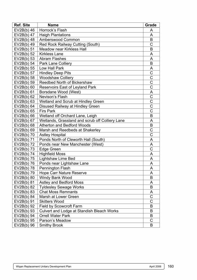
160Wigan Replacement Unitary Development Plan April 2006
Ref. Site Name Grade EV2B(b) 46 Horrock’s Flash A EV2B(b) 47 Haigh Plantations A EV2B(b) 48 Amberswood Common B EV2B(b) 49 Red Rock Railway Cutting (South) C EV2B(b) 51 Meadow near Kirkless Hall B EV2B(b) 52 Kirkless Lane A EV2B(b) 53 Abram Flashes A EV2B(b) 54 Park Lane Colliery B EV2B(b) 55 Low Hall Park A EV2B(b) 57 Hindley Deep Pits C EV2B(b) 58 Woodshaw Colliery C EV2B(b) 59 Reedbed North of Bickershaw C EV2B(b) 60 Reservoirs East of Leyland Park C EV2B(b) 61 Borsdane Wood (West) A EV2B(b) 62 Nevison’s Flash C EV2B(b) 63 Wetland and Scrub at Hindley Green C EV2B(b) 64 Disused Railway at Hindley Green C EV2B(b) 65 Firs Park C EV2B(b) 66 Wetland off Orchard Lane, Leigh B EV2B(b) 67 Wetlands, Grassland and scrub off Colliery Lane A EV2B(b) 68 Atherton and Bedford Woods B EV2B(b) 69 Marsh and Reedbeds at Shakerley C EV2B(b) 70 Astley Hospital C EV2B(b) 71 Ponds North of Cleworth Hall (South) A EV2B(b) 72 Ponds near New Manchester (West) A EV2B(b) 73 Edge Green C EV2B(b) 74 Highfield Moss A EV2B(b) 75 Lightshaw Lime Bed A EV2B(b) 76 Ponds near Lightshaw Lane A EV2B(b) 78 Pennington Flash A EV2B(b) 79 Hope Carr Nature Reserve A EV2B(b) 80 Windy Bank Wood B EV2B(b) 81 Astley and Bedford Moss A EV2B(b) 82 Tyldesley Sewage Works B EV2B(b) 83 Chat Moss Remnants A EV2B(b) 84 Marsh at Lower Green C EV2B(b) 91 Skitters Wood C EV2B(b) 92 Field by Scowcroft Farm B EV2B(b) 93 Culvert and Lodge at Standish Bleach Works B EV2B(b) 94 Orrell Water Park B EV2B(b) 95 Parson’s Meadow C EV2B(b) 96 Smithy Brook B
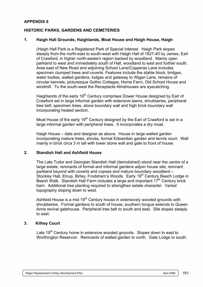
161Wigan Replacement Unitary Development Plan April 2006
APPENDIX 6 HISTORIC PARKS, GARDENS AND CEMETERIES 1. Haigh Hall Grounds, Haighlands, Moat House and Haigh House, Haigh
(Haigh Hall Park is a Registered Park of Special Interest. Haigh Park slopes steeply from the north-east to south-west with Haigh Hall of 1827-40 by James, Earl of Crawford, in higher north-eastern region backed by woodland. Mainly open parkland to west and immediately south of Hall, woodland to east and further south. Area east of New Road and adjoining School Lane/Copperas Lane includes specimen clumped trees and coverts. Features include the stable block, bridges, water bodies, walled gardens, lodges and gateway to Wigan Lane, remains of circular kennels, picturesque Gothic Cottages, Home Farm, Old School House and windmill. To the south-west the Receptacle Almshouses are eyecatching.
Haighlands of the early 19th Century comprises Dower House designed by Earl of
Crawford set in large informal garden with extensive lawns, shrubberies, peripheral tree belt, specimen trees, stone boundary wall and high brick boundary wall incorporating heated section.
Moat House of the early 19th Century designed by the Earl of Crawford is set in a large informal garden with peripheral trees. It incorporates a dry moat.
Haigh House – date and designer as above. House in large walled garden
incorporating mature trees, shrubs, formal Edwardian garden and tennis court. Wall mainly in brick circa 3 m tall with lower stone wall and gate to front of house.
2. Standish Hall and Ashfield House The Late Tudor and Georgian Standish Hall (demolished) stood near the centre of a
large estate, remnants of formal and informal gardens adjoin house site, remnant parkland beyond with coverts and copses and mature boundary woodland – Stockley Hall, Elnup, Birley, Frodsham’s Woods. Early 19th Century Beech Lodge in Beech Walk. Standish Hall Farm includes a large and important 17th Century brick barn. Additional tree planting required to strengthen estate character. Varied topography sloping down to west.
Ashfield House is a mid 19th Century house in extensively wooded grounds with
shrubberies. Formal gardens to south of house, southern tongue extends to Queen Anne revival gatehouse. Peripheral tree belt to south and east. Site slopes steeply to east.
3. Kilhey Court Late 19th Century home in extensive wooded grounds. Slopes down to east to
Worthington Reservoir. Remnants of walled garden to north. Gate Lodge to south.
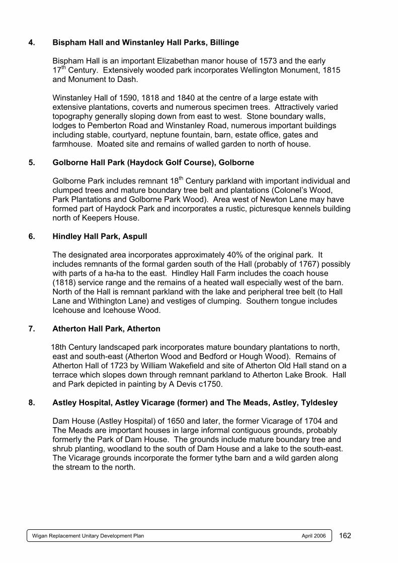
162Wigan Replacement Unitary Development Plan April 2006
4. Bispham Hall and Winstanley Hall Parks, Billinge Bispham Hall is an important Elizabethan manor house of 1573 and the early
17th Century. Extensively wooded park incorporates Wellington Monument, 1815 and Monument to Dash.
Winstanley Hall of 1590, 1818 and 1840 at the centre of a large estate with
extensive plantations, coverts and numerous specimen trees. Attractively varied topography generally sloping down from east to west. Stone boundary walls, lodges to Pemberton Road and Winstanley Road, numerous important buildings including stable, courtyard, neptune fountain, barn, estate office, gates and farmhouse. Moated site and remains of walled garden to north of house.
5. Golborne Hall Park (Haydock Golf Course), Golborne Golborne Park includes remnant 18th Century parkland with important individual and
clumped trees and mature boundary tree belt and plantations (Colonel’s Wood, Park Plantations and Golborne Park Wood). Area west of Newton Lane may have formed part of Haydock Park and incorporates a rustic, picturesque kennels building north of Keepers House.
6. Hindley Hall Park, Aspull The designated area incorporates approximately 40% of the original park. It
includes remnants of the formal garden south of the Hall (probably of 1767) possibly with parts of a ha-ha to the east. Hindley Hall Farm includes the coach house (1818) service range and the remains of a heated wall especially west of the barn. North of the Hall is remnant parkland with the lake and peripheral tree belt (to Hall Lane and Withington Lane) and vestiges of clumping. Southern tongue includes Icehouse and Icehouse Wood.
7. Atherton Hall Park, Atherton 18th Century landscaped park incorporates mature boundary plantations to north,
east and south-east (Atherton Wood and Bedford or Hough Wood). Remains of Atherton Hall of 1723 by William Wakefield and site of Atherton Old Hall stand on a terrace which slopes down through remnant parkland to Atherton Lake Brook. Hall and Park depicted in painting by A Devis c1750.
8. Astley Hospital, Astley Vicarage (former) and The Meads, Astley, Tyldesley
Dam House (Astley Hospital) of 1650 and later, the former Vicarage of 1704 and The Meads are important houses in large informal contiguous grounds, probably formerly the Park of Dam House. The grounds include mature boundary tree and shrub planting, woodland to the south of Dam House and a lake to the south-east. The Vicarage grounds incorporate the former tythe barn and a wild garden along the stream to the north.
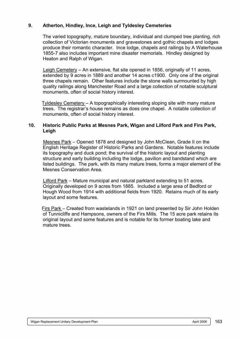
163Wigan Replacement Unitary Development Plan April 2006
9. Atherton, Hindley, Ince, Leigh and Tyldesley Cemeteries The varied topography, mature boundary, individual and clumped tree planting, rich
collection of Victorian monuments and gravestones and gothic chapels and lodges produce their romantic character. Ince lodge, chapels and railings by A Waterhouse 1855-7 also includes important mine disaster memorials. Hindley designed by Heaton and Ralph of Wigan.
Leigh Cemetery – An extensive, flat site opened in 1856, originally of 11 acres,
extended by 9 acres in 1889 and another 14 acres c1900. Only one of the original three chapels remain. Other features include the stone walls surmounted by high quality railings along Manchester Road and a large collection of notable sculptural monuments, often of social history interest.
Tyldesley Cemetery – A topographically interesting sloping site with many mature
trees. The registrar’s house remains as does one chapel. A notable collection of monuments, often of social history interest.
10. Historic Public Parks at Mesnes Park, Wigan and Lilford Park and Firs Park,
Leigh Mesnes Park – Opened 1878 and designed by John McClean, Grade II on the
English Heritage Register of Historic Parks and Gardens. Notable features include its topography and duck pond; the survival of the historic layout and planting structure and early building including the lodge, pavilion and bandstand which are listed buildings. The park, with its many mature trees, forms a major element of the Mesnes Conservation Area.
Lilford Park – Mature municipal and natural parkland extending to 51 acres.
Originally developed on 9 acres from 1885. Included a large area of Bedford or Hough Wood from 1914 with additional fields from 1920. Retains much of its early layout and some features.
Firs Park – Created from wastelands in 1921 on land presented by Sir John Holden
of Tunnicliffe and Hampsons, owners of the Firs Mills. The 15 acre park retains its original layout and some features and is notable for its former boating lake and mature trees.
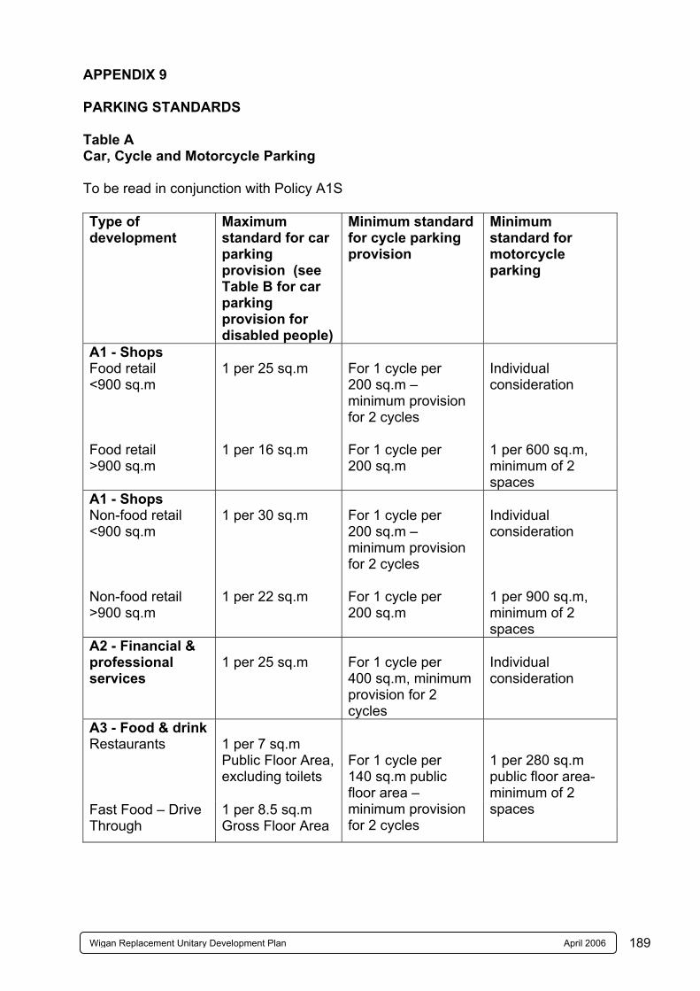
189Wigan Replacement Unitary Development Plan April 2006
APPENDIX 9 PARKING STANDARDS Table A Car, Cycle and Motorcycle Parking To be read in conjunction with Policy A1S Type of development
Maximum standard for car parking provision (see Table B for car parking provision for disabled people)
Minimum standard for cycle parking provision
Minimum standard for motorcycle parking
A1 - Shops Food retail <900 sq.m
1 per 25 sq.m
For 1 cycle per 200 sq.m – minimum provision for 2 cycles
Individual consideration
Food retail >900 sq.m
1 per 16 sq.m For 1 cycle per 200 sq.m
1 per 600 sq.m, minimum of 2 spaces
A1 - Shops Non-food retail <900 sq.m
1 per 30 sq.m
For 1 cycle per 200 sq.m – minimum provision for 2 cycles
Individual consideration
Non-food retail >900 sq.m
1 per 22 sq.m For 1 cycle per 200 sq.m
1 per 900 sq.m, minimum of 2 spaces
A2 - Financial & professional services
1 per 25 sq.m
For 1 cycle per 400 sq.m, minimum provision for 2 cycles
Individual consideration
A3 - Food & drink Restaurants
1 per 7 sq.m Public Floor Area, excluding toilets
Fast Food – Drive Through
1 per 8.5 sq.m Gross Floor Area
For 1 cycle per 140 sq.m public floor area – minimum provision for 2 cycles
1 per 280 sq.m public floor area- minimum of 2 spaces
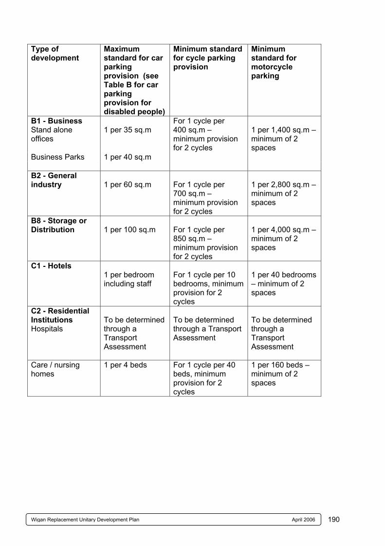
190Wigan Replacement Unitary Development Plan April 2006
Type of development
Maximum standard for car parking provision (see Table B for car parking provision for disabled people)
Minimum standard for cycle parking provision
Minimum standard for motorcycle parking
B1 - Business Stand alone offices
1 per 35 sq.m
Business Parks
1 per 40 sq.m
For 1 cycle per 400 sq.m – minimum provision for 2 cycles
1 per 1,400 sq.m – minimum of 2 spaces
B2 - General industry
1 per 60 sq.m
For 1 cycle per 700 sq.m – minimum provision for 2 cycles
1 per 2,800 sq.m – minimum of 2 spaces
B8 - Storage or Distribution
1 per 100 sq.m
For 1 cycle per 850 sq.m – minimum provision for 2 cycles
1 per 4,000 sq.m – minimum of 2 spaces
C1 - Hotels
1 per bedroom including staff
For 1 cycle per 10 bedrooms, minimum provision for 2 cycles
1 per 40 bedrooms – minimum of 2 spaces
C2 - Residential Institutions Hospitals
To be determined through a Transport Assessment
To be determined through a Transport Assessment
To be determined through a Transport Assessment
Care / nursing homes
1 per 4 beds For 1 cycle per 40 beds, minimum provision for 2 cycles
1 per 160 beds – minimum of 2 spaces
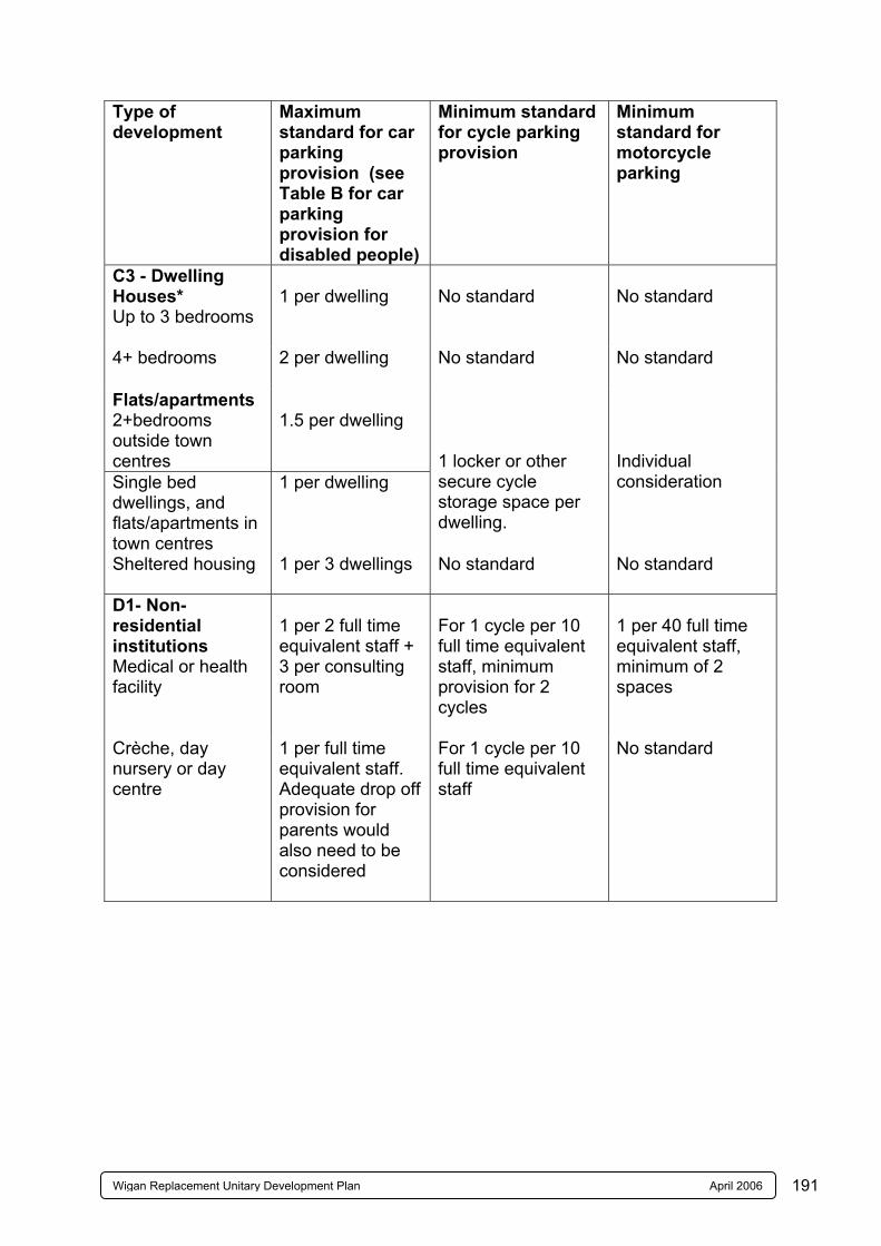
191Wigan Replacement Unitary Development Plan April 2006
Type of development
Maximum standard for car parking provision (see Table B for car parking provision for disabled people)
Minimum standard for cycle parking provision
Minimum standard for motorcycle parking
C3 - Dwelling Houses* Up to 3 bedrooms
1 per dwelling
No standard
No standard
4+ bedrooms 2 per dwelling No standard No standard
Flats/apartments 2+bedrooms outside town centres
1.5 per dwelling
Single bed dwellings, and flats/apartments in town centres
1 per dwelling
1 locker or other secure cycle storage space per dwelling.
Individual consideration
Sheltered housing 1 per 3 dwellings No standard No standard
D1- Non-residential institutions Medical or health facility
1 per 2 full time equivalent staff + 3 per consulting room
For 1 cycle per 10 full time equivalent staff, minimum provision for 2 cycles
1 per 40 full time equivalent staff, minimum of 2 spaces
Crèche, day nursery or day centre
1 per full time equivalent staff. Adequate drop off provision for parents would also need to be considered
For 1 cycle per 10 full time equivalent staff
No standard
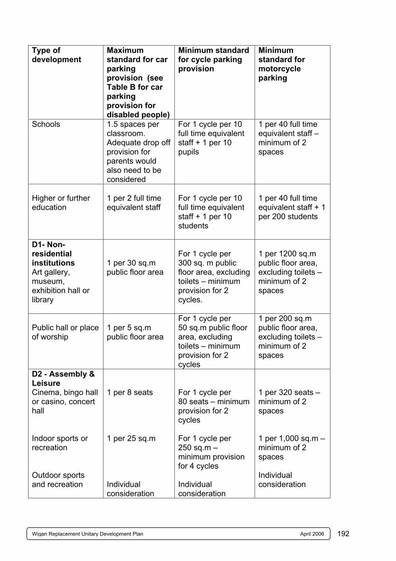
192Wigan Replacement Unitary Development Plan April 2006
Type of development
Maximum standard for car parking provision (see Table B for car parking provision for disabled people)
Minimum standard for cycle parking provision
Minimum standard for motorcycle parking
Schools
1.5 spaces per classroom. Adequate drop off provision for parents would also need to be considered
For 1 cycle per 10 full time equivalent staff + 1 per 10 pupils
1 per 40 full time equivalent staff – minimum of 2 spaces
Higher or further education
1 per 2 full time equivalent staff
For 1 cycle per 10 full time equivalent staff + 1 per 10 students
1 per 40 full time equivalent staff + 1 per 200 students
D1- Non-residential institutions Art gallery, museum, exhibition hall or library
1 per 30 sq.m public floor area
For 1 cycle per 300 sq. m public floor area, excluding toilets – minimum provision for 2 cycles.
1 per 1200 sq.m public floor area, excluding toilets – minimum of 2 spaces
Public hall or place of worship
1 per 5 sq.m public floor area
For 1 cycle per 50 sq.m public floor area, excluding toilets – minimum provision for 2 cycles
1 per 200 sq.m public floor area, excluding toilets – minimum of 2 spaces
D2 - Assembly & Leisure Cinema, bingo hall or casino, concert hall
1 per 8 seats
For 1 cycle per 80 seats – minimum provision for 2 cycles
1 per 320 seats – minimum of 2 spaces
Indoor sports or recreation
1 per 25 sq.m
For 1 cycle per 250 sq.m – minimum provision for 4 cycles
1 per 1,000 sq.m – minimum of 2 spaces
Outdoor sports and recreation
Individual consideration
Individual consideration
Individual consideration
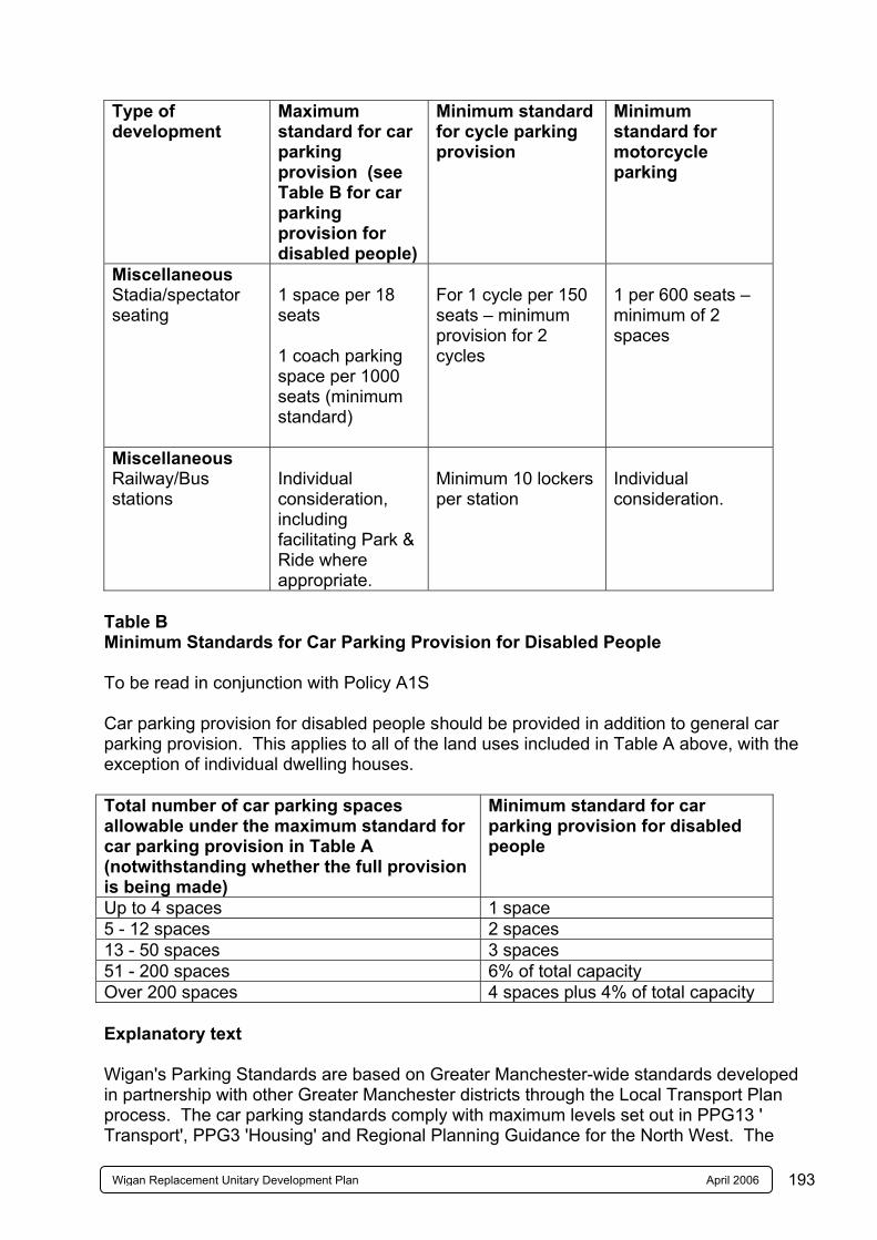
193Wigan Replacement Unitary Development Plan April 2006
Type of development
Maximum standard for car parking provision (see Table B for car parking provision for disabled people)
Minimum standard for cycle parking provision
Minimum standard for motorcycle parking
Miscellaneous Stadia/spectator seating
1 space per 18 seats 1 coach parking space per 1000 seats (minimum standard)
For 1 cycle per 150 seats – minimum provision for 2 cycles
1 per 600 seats – minimum of 2 spaces
Miscellaneous Railway/Bus stations
Individual consideration, including facilitating Park & Ride where appropriate.
Minimum 10 lockers per station
Individual consideration.
Table B Minimum Standards for Car Parking Provision for Disabled People To be read in conjunction with Policy A1S Car parking provision for disabled people should be provided in addition to general car parking provision. This applies to all of the land uses included in Table A above, with the exception of individual dwelling houses. Total number of car parking spaces allowable under the maximum standard for car parking provision in Table A (notwithstanding whether the full provision is being made)
Minimum standard for car parking provision for disabled people
Up to 4 spaces 1 space 5 - 12 spaces 2 spaces 13 - 50 spaces 3 spaces 51 - 200 spaces 6% of total capacity Over 200 spaces 4 spaces plus 4% of total capacity Explanatory text Wigan's Parking Standards are based on Greater Manchester-wide standards developed in partnership with other Greater Manchester districts through the Local Transport Plan process. The car parking standards comply with maximum levels set out in PPG13 ' Transport', PPG3 'Housing' and Regional Planning Guidance for the North West. The

194Wigan Replacement Unitary Development Plan April 2006
standards for car parking for disabled people are based on recommendations in the Department of Transport Advisory Note 'Parking for Disabled People'. The cycle parking standards are based on standards in the National Cycling Strategy. The motorcycle parking standards generally allow for motorcycle parking at 2.5% of maximum car parking provision. *Garages within a residential curtilage are not regarded as off-street parking spaces for the purpose of applying maximum car parking standards to residential development.
195Wigan Replacement Unitary Development Plan April 2006
APPENDIX 10 BUILDINGS OF LOCAL ARCHITECTURAL OR HISTORIC INTEREST Introduction The list is not exhaustive but provides exemplars. The list will be extended for each of the sub-areas of the Borough and any additions will be published as Supplementary Planning Guidance and incorporated into the Plan at Review. The Borough has a large collection of buildings which, although they do not merit Listed Building status on a national basis or are unsuitably located for inclusion in a Conservation Area, nonetheless are of local architectural or historic interest. Such buildings contribute significantly to the familiar and cherished scene for the Borough’s residents and visitors. Recent Mori polls undertaken on behalf of English Heritage indicated that people care about the historic environment. For example 98% of the population think that all schoolchildren should be given the opportunity to find out about the historic environment. Respondents to a poll in Liverpool also thought that heritage education in schools was, alongside physical regeneration, the top priority for funding. 95% of people think that the historic environment is important because it gives them places to visit and things to do. (From State of the Historic Environment Report 2002. Pub. English Heritage Nov 2002). Importance Buildings of local interest provide:- i. physical evidence and positive reminders of the Borough’s rich social and economic
history and physical development; ii. significant stimulants for individual, family and communal memory and community
history; iii. a rich and diverse resource for educational interpretation for children and adults; iv. valuable evidence and markers of the Boroughs material culture at various periods
in relation to design, materials, technology and craftsmanship; v. a major contribution to the interest and quality of landscapes and townscapes; vi. a major contribution to local identity and distinctiveness; vii. stability in the environment of daily life and occasional events; viii. a useful stock of occupied buildings for the long term; ix. a significant input to local property markets and national, regional and local
sustainability objectives when the buildings are re-used and conserved. Selection Criteria Criteria for the selection of the buildings are similar to those used for Listed Buildings but the buildings are assessed on their local significance rather than on a national basis. The criteria used include age, rarity, and architectural quality, including group value and townscape contribution and historic interest. For these criteria the degree of local interest will increase directly in relation to the buildings value in respect of each criterion. In contrast interest may be diminished by extensive or particularly damaging alterations.
196Wigan Replacement Unitary Development Plan April 2006
i. Age
- up to 1870 most buildings which are recognisable as belonging to historic periods will qualify;
- from 1870 to 1918 more selection is required because of greater numbers surviving;
- from 1918 to 1945 greater selectivity is required; - after 1945 only particularly good examples are included.
ii. Rarity
- some types of buildings or building materials are extremely rare in the Borough. For instance despite the widespread occurrence of coal mining in the Borough only a few mining buildings remain, similarly buildings associated with the metal trades of Tyldesley, Atherton, Ashton and Orrell are now rare as are those of the engineering industries of Leigh and Wigan. Buildings using header bond brickwork and, between 1910 and 1945, faience are extremely rare.
iii. Architectural Quality
- derives from many sources including:- - builders and architects using either characteristic or unusual architectural styles
or materials or details for particular periods in the Borough; - the use of essentially local or vernacular materials and details; - how the form of buildings relate to specific functions; - buildings illustrating the work of local or other architects; - buildings whether detached, semi-detached or in terraces may have group value
based on uniformity or with formal variations (such as introducing gables at regular intervals) or the use of architectural features or details or materials to promote variations on a theme or diversity;
- buildings may contribute to townscape for instance by containing or enclosing attractive spaces or by responding to a particular location such as a main corner with a corner feature.
iv. Historical Interest includes:
- rural settlement patterns including farms, hamlets and villages and the evolving pattern relating to agricultural improvement and the transformation of villages to suburbs or commuter settlements;
- the buildings may define and illustrate periods of growth in the Borough’s towns; and the associated form and layout of town development;
- other buildings show the rise and evolving needs of various industries and other businesses sometimes on a widespread scale; such building may be associated with the reason for the settlements origin and subsequent growth.
- buildings and structures representing the industrial archaeology of the Borough. - the buildings also illustrate the evolving forms of housing for different social
groups especially in relation to size, layout, external spaces and decoration; - various buildings are associated with the evolving patterns of local
administration and services and entertainment;
197Wigan Replacement Unitary Development Plan April 2006
- the form, layout and details of farm buildings also evolved in relation to farming
practices and estate policies; - some buildings are associated with particular local people of note or historic
events. v. Degree of Alteration
- the significance of alterations for interest will vary between building types and locations. Often the form and fundamental character of buildings remains recognisable despite considerable changes. Other buildings may be far more sensitive to change.
Building Types - typical building types can be recognised for a range of uses.
i. Houses
- types include rural and urban vernacular houses, architect designed detached, semi-detached and terrace houses aimed at the middle classes and workers with a range of three dimensional forms and levels of architectural quality and group character;
- of particular note are domestic handloom weavers’ cottages found mainly around Leigh which incorporated loom shops associated initially with muslin weaving and subsequently silk weaving.
- early and some later local authority housing estates are notable. ii. Industrial
- the Borough’s historic industries have produced an evolving range of characteristic buildings typified by the contrast between multi-storey spinning mills and single storey weaving sheds;
- a number of rural smithies can still be identified and a small range of Atherton bolt works survive as do engineering workshops at Wigan, Leigh and Tyldesley.
iii. Farm Buildings
- a range of characteristic forms of threshing barns, hay barns, stables, cow shippons and cart and shelter sheds and granaries occur in the Borough. A small number of “model” farmsteads are also present.
iv. Shops
- types include corner shops, shops formed in residential properties, purpose built parades of shops, local branches of regional or national retail businesses and co-operative central and branch premises.
- historic shop fronts are of special interest.
v. Community Buildings include:
- churches, chapels and schools;
198Wigan Replacement Unitary Development Plan April 2006
- own halls and civic buildings. - park and cemetery buildings; - cinemas, theatres, halls and swimming pools; - public houses and hotels; - such buildings have particular forms and features and have strong communal
memory and community history associations. vi. Transport Buildings
- the Borough has a number of buildings and structures associated with canal, tram and railway transport.
vii. Other Structures
- include bridges, war memorials, electricity sub-stations, industrial remains, walls and water structures.
Planning Powers and Buildings of Local Interest Whilst the presence of a building on the local interest list does not currently provide any special powers to control demolition, Policy EV4C is a material consideration in determining planning applications affecting the premises. The reasoned justification to Policy GB1C makes it clear that replacement dwellings will not be permitted in the Green Belt where houses of local interest are demolished. Additionally, Regional Planning Guidance for the North West has introduced a sequential test requiring justification for not re-using existing buildings and Policies R1B, R1G and EHIC in the UDP reflect this. Other policies of the UDP refer to buildings of local interest and as far as windows are concerned such buildings are exempt from Part L of the Building Regulations, so enabling the continued use of historic window frame materials, design and details. The Council has already had a number of decisions using the previous policy upheld at appeal. LIST OF BUILDINGS OF LOCAL ARCHITECTURAL OR HISTORIC INTEREST Code Name No Road etc Area ABRAM Blint AB 1 Naylor’s Farm Bickershaw Lane Abram Blint AB 2 Naylor’s Farm Barn Bickershaw Lane Abram Blint AB 3 Queen’s Hotel 323 Bickershaw Lane Abram Blint AB 4 Bickershaw Hall Bickershaw Lane Abram Farm Barn (J Winstanley Paper
Recycling) Blint AB 5 Bucks Head Hotel 256 Warrington Road Abram Blint AB 6 St John’s Evangelist Warrington Road Abram Church Blint AB 7 Maypole Colliery Warrington Road Abram Disaster Monument Blint AB 8 Former Town Hall 313-315 Warrington Road Abram
199Wigan Replacement Unitary Development Plan April 2006
BILLINGE WITH WINSTANLEY Blint BW1 Entrance Lodge Smethurst Road Billinge and to Bispham Hall Winstanley Brick and Terracotta Works (North side) Blint BW2 Brickworks Building North of and parallel Billinge to Smethurst Road Blint BW3 Brick Kiln off Smethurst Road Billinge (National Grid Ref. 3522/402909) Blint BW4 Brick Kiln off Smethurst Road Billinge (National Grid Ref. 3521/402855) Blint BW5 Former winding and off Smethurst Road Billinge engine house (National Grid Ref. 3522/402830) Blint BW6 Colliery Building adjoining Billinge Smethurst Road Blint BW7 Fixed crushing machine located to South West Billinge of Blint BW6 off
Smethurst Road GOLBORNE Blint GL1 Locking Stoop Farmhouse Winwick Lane Lowton/Golborne Blint GL2 Locking Stoop Farm off Winwick Lane Lowton/Golborne Threshing Barn Blint GL3 Locking Stoop Farm off Winwick Lane Lowton/Golborne Cart Shed and Granary STANDISH WITH LANGTREE Blint St.1 Ashfield House off Ashfield Park Drive Standish Blint St.2 Barkers Farm 24 Chorley Road Standish Blint St.3 12 Chorley Road Standish Blint St.4 Water Tower Green Lane Standish Blint St.5 St Marie’s RC Church Almond Brook Rd Standish Blint St.6 St Marie’s RC Presbytery Almond Brook Rd Standish
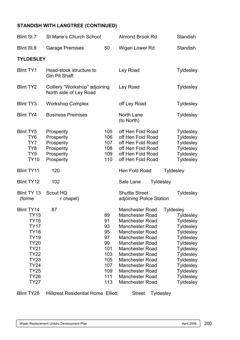
200Wigan Replacement Unitary Development Plan April 2006
STANDISH WITH LANGTREE (CONTINUED) Blint St.7 St Marie’s Church School Almond Brook Rd Standish Blint St.8 Garage Premises 50 Wigan Lower Rd Standish TYLDESLEY Blint TY1 Head-stock structure to Ley Road Tyldesley
Gin Pit Shaft Blint TY2 Colliery “Workshop” adjoining Ley Road Tyldesley North side of Ley Road Blint TY3 Workshop Complex off Ley Road Tyldesley Blint TY4 Business Premises North Lane Tyldesley
(to North) Blint TY5 Prosperity 105 off Hen Fold Road Tyldesley TY6 Prosperity 106 off Hen Fold Road Tyldesley TY7 Prosperity 107 off Hen Fold Road Tyldesley TY8 Prosperity 108 off Hen Fold Road Tyldesley TY9 Prosperity 109 off Hen Fold Road Tyldesley TY10 Prosperity 110 off Hen Fold Road Tyldesley Blint TY11 120 Hen Fold Road Tyldesley Blint TY12 102 Sale Lane Tyldesley Blint TY 13 Scout HQ Shuttle Street Tyldesley (forme r chapel) adjoining Police Station Blint TY14 87 Manchester Road Tyldesley TY15 89 Manchester Road Tyldesley TY16 91 Manchester Road Tyldesley TY17 93 Manchester Road Tyldesley TY18 95 Manchester Road Tyldesley TY19 97 Manchester Road Tyldesley TY20 99 Manchester Road Tyldesley TY21 101 Manchester Road Tyldesley TY22 103 Manchester Road Tyldesley TY23 105 Manchester Road Tyldesley TY24 107 Manchester Road Tyldesley TY25 109 Manchester Road Tyldesley TY26 111 Manchester Road Tyldesley TY27 113 Manchester Road Tyldesley Blint TY28 Hillcrest Residential Home Elliott Street Tyldesley