Embed Size (px)
Citation preview
Wetlands in Oregon
DEPARTMENT OF STATE LANDS FACT SHEET
Additional information is available on the DSL website: www.oregonstatelands.us
Identifying Wetlands
Wetland Determinations and Delineations
Working with a Wetland Consultant
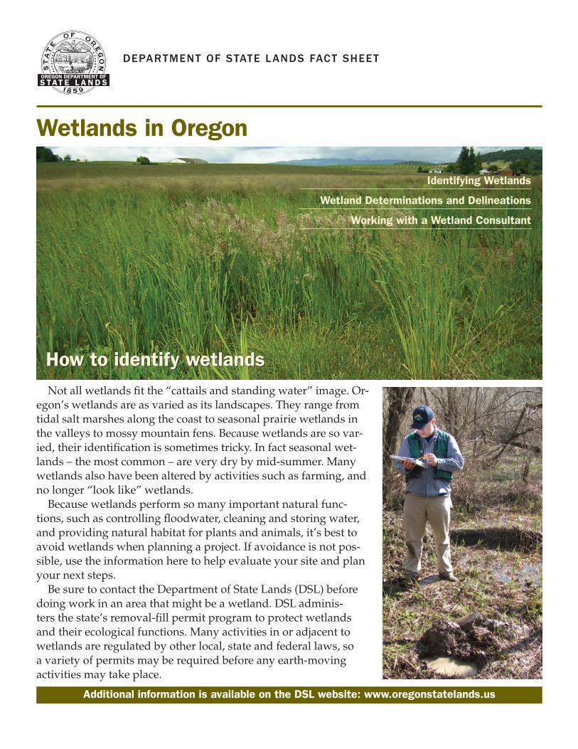
How to identify wetlandsNot all wetlands fit the “cattails and standing water” image. Or-
egon’s wetlands are as varied as its landscapes. They range from tidal salt marshes along the coast to seasonal prairie wetlands in the valleys to mossy mountain fens. Because wetlands are so var-ied, their identification is sometimes tricky. In fact seasonal wet-lands – the most common – are very dry by mid-summer. Many wetlands also have been altered by activities such as farming, and no longer “look like” wetlands.
Because wetlands perform so many important natural func-tions, such as controlling floodwater, cleaning and storing water, and providing natural habitat for plants and animals, it’s best to avoid wetlands when planning a project. If avoidance is not pos-sible, use the information here to help evaluate your site and plan your next steps.
Be sure to contact the Department of State Lands (DSL) before doing work in an area that might be a wetland. DSL adminis-ters the state’s removal-fill permit program to protect wetlands and their ecological functions. Many activities in or adjacent to wetlands are regulated by other local, state and federal laws, so a variety of permits may be required before any earth-moving activities may take place.
How to identify wetlands
WETLANDS IN OREGON
What characteristics do wetlands share?
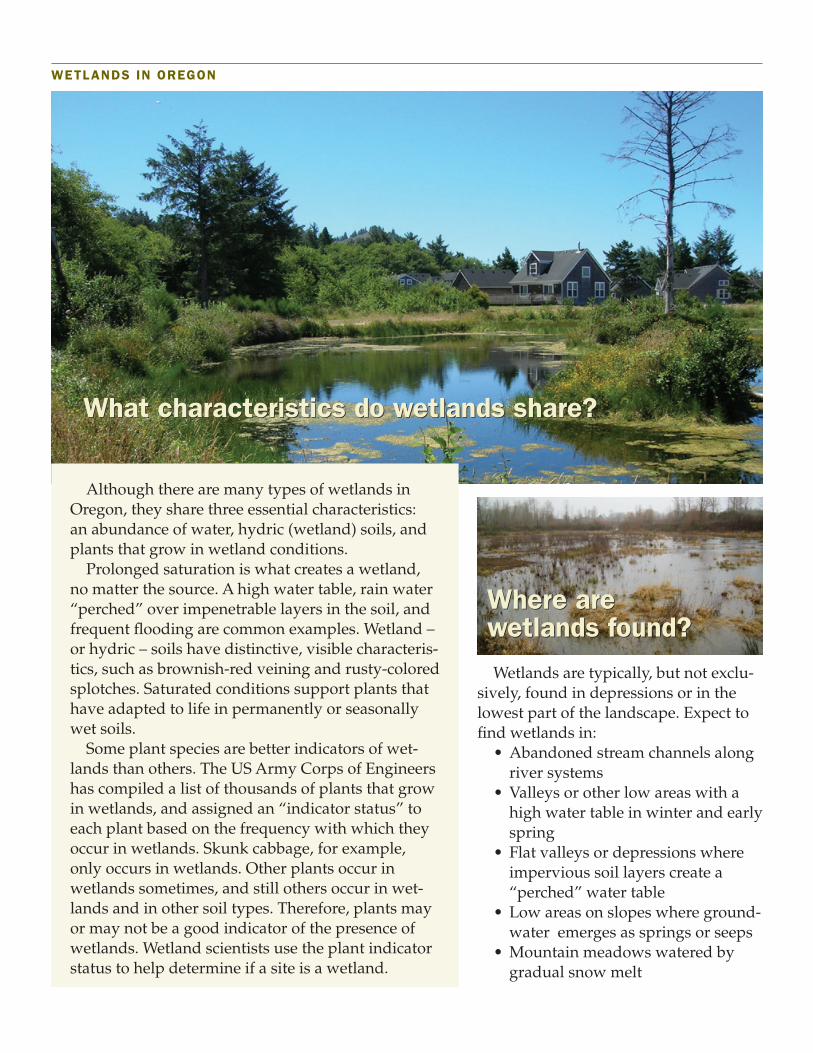
Although there are many types of wetlands in Oregon, they share three essential characteristics: an abundance of water, hydric (wetland) soils, and plants that grow in wetland conditions.
Prolonged saturation is what creates a wetland, no matter the source. A high water table, rain water “perched” over impenetrable layers in the soil, and frequent flooding are common examples. Wetland – or hydric – soils have distinctive, visible characteris-tics, such as brownish-red veining and rusty-colored splotches. Saturated conditions support plants that have adapted to life in permanently or seasonally wet soils.
Some plant species are better indicators of wet-lands than others. The US Army Corps of Engineers has compiled a list of thousands of plants that grow in wetlands, and assigned an “indicator status” to each plant based on the frequency with which they occur in wetlands. Skunk cabbage, for example, only occurs in wetlands. Other plants occur in wetlands sometimes, and still others occur in wet-lands and in other soil types. Therefore, plants may or may not be a good indicator of the presence of wetlands. Wetland scientists use the plant indicator status to help determine if a site is a wetland.
Wetlands are typically, but not exclu-sively, found in depressions or in the lowest part of the landscape. Expect to find wetlands in:
• Abandoned stream channels alongriver systems
• Valleys or other low areas with ahigh water table in winter and earlyspring
• Flat valleys or depressions whereimpervious soil layers create a“perched” water table
• Low areas on slopes where ground-water emerges as springs or seeps
• Mountain meadows watered bygradual snow melt
Where are wetlands found?Where are wetlands found?
What characteristics do wetlands share?

A “yes” answer to any of the questions below may indi-cate that the area is a wetland. A site inspection by a wetland scientist is the only way to verify whether an area is a wet-land or not.
WETLANDS IN OREGON
Working with DSL
Wetlands staff provides off-site wetland determinations at no cost. By using existing wet-land maps, aerial photographs, and other mapped information, it may be possible for the wet-lands specialist to determine if there are wetlands on your property. This starts as a desk audit and may not involve a trip to the site. A form is avail-able on the DSL website to get this process started.
Wetland consultants
It may be necessary to hire a consultant to evaluate your site and prepare a wetland delineation for DSL review and concurrence. Delineations are detailed maps of wetland boundaries that require spe-cialized training to produce. They are an important part of the removal-fill permit applica-tion. Wetland scientists use the U.S. Army Corps of Engineers Wetlands Delineation Manual and Regional Supplements, the wetland plant list, and other state and federal agency guid-ance and rules for delineating wetlands.
Does the National Wetlands Inventory or Local Wetlands Inventory map show a wetland on the property?
Does the county soil survey map show hydric soils within the site?
Are there natural drainage channels or swales?
Is the ground soggy underfoot in the spring?
Are there depressions where water pools for a week or more in the spring?
Do you avoid the area with heavy equipment in the spring to keep from getting bogged down?
Would you need to ditch the site to dry it out for planting or building?
Are seeps or springs present?
Dig an 18-inch deep hole and remove a clump of soil. Are there rusty red “veins” on a gray back-ground?
Is there evidence of surface scour from water flow-ing over the site? Is there a drift line of leaves or debris caught in the stems of shrubs or lodged along an elevation contour?
Do you see many clumps of grass-like rushes (round stems) or sedges (angular stems), skunk cabbage, willows or Oregon ash? (These are just a few of the many plants that grow in wetlands.)
If farmed, must you work the soil later than other areas because soils are poorly drained?
Did the area fail a septic system test and/or require a special system due to poorly draining soils?
YES NO QUESTION
How to identify wetlands
Continued
Wetland determinations
and delineations
Wetland determinations
and delineations

Working with consultantsA wetland consultant should have:• An educational background in science or
ecology, with wetland-specific training, in-cluding wetland delineations
• A thorough knowledge of local, state andfederal permit requirements and processes
• An understanding of development stan-dards and options
• The ability to help develop workable solu-tions for challenging sites
• Good communication skills and profession-al ethics
• Good working relationships with DSL per-mit staff
An experienced consultant can facilitate the wetland permit process with minimal delays. DSL cannot provide specific recommendations, but the Society of Wetland Scientists keeps a current list of members on their website: www.sws.org/Pacific-Northwest-Chapter/pacific-northwest-resources.html.
WETLANDS IN OREGON
We suggest you contact at least three firms for a cost estimate, and ask for a Statement of Quali-fications in the bid process. Ask for and check ref-erences, and inquire about the firm’s professional certifications. If it’s a larger firm, ask who will be doing your work, and about the consultant’s experience in such areas as wetland delinea-tions, permit applications, and mitigation design and construction. Ask if the consultant has any
Oregon Department of State LandsAquatic Resource Management Program
775 Summer St. NE, Suite 100Salem, Oregon 97301-1279
(503) 986-5200 | www.oregonstatelands.us
Professional CertificationThe Society of Wetland Scientists administers the Profes-sional Wetland Scientist (PWS) certification program for individuals who meet specific educational and experience requirements. The certification does not guarantee that an individual is qualified to provide a specific service; for example, a “wetland delineator” certification. Likewise, certification does not guarantee the quality of work, but it does identify those individuals who have the necessary academic background and wetland-specific experience to provide good service. Wetland specialists come from a variety of academic disciplines including botany, soil science, environmental studies, and wildlife management. Some may have additional professional certification, such as Professional Soil Scientist.
specialized experience that would apply to your project, such as agricultural wetland delineation.
Things to keep in mind
• Keep communication lines open. Provide allpertinent information about the site, includ-ing legal description, any previous studiesand land uses, and your development objec-tives.
• Plan well in advance of when you wantto start your project. Wetland delineationstypically take several months from initiationto DSL approval, and permit applicationscan take up to 120 days for the most com-plex projects.
• The landowner or applicant is the legallyresponsible party for meeting permit re-quirements and conditions. The consultantoften is the primary contact with DSL staff.Make sure you receive regular updates fromyour consultant on the permit process andtimeline.
Obtaining a removal-fill permit
Oregon’s removal-fill law (ORS 196.795-990) requires people who plan to remove or fill mate-rial in waters of the state to obtain a permit from the Department of State Lands.
The purpose of the law, enacted in 1967, is to protect public navigation, fisheries and recre-ational uses of the waters. “Waters of the state” include wetlands on private and public land.
The Oregon Department of State Lands administers the removal-fill permit program, and has developed many resources for property owners and consultants. The Removal-Fill Guide (RFG), as well as forms and other resources, are available on the DSL website: www.oregon.gov/DSL/WW/Documents/Removal_Fill_Guide.pdf.
3/15