Embed Size (px)
Citation preview
Local Development PlanPreparatory Studies
Paper 12 (Part 1): Countryside - Landscape Character Assessment
March 2017
Contents PageNumber
Figure Table 1
Purpose and Content 2
1.0 Introduction 3
2.0 Regional Planning Context 4(a)Regional Development Strategy 2035 4(b)Strategic Planning Policy Statement 4(c) Planning Policy Statement 21: Sustainable
Development in the Countryside5
(d)Planning Policy Statement 2: Natural Heritage 5(e)Planning Policy Statement 6: Planning
Archaeological and the Built Heritage6
(f) Existing Development Plans 6
3.0 Northern Ireland Landscape Character Assessment
7
4.0 NIEA Supplementary Planning Guidance – Wind Energy Development in NI Landscapes
14
5.0 Northern Ireland Regional Landscape Character Assessment
17
6.0 Northern Ireland Regional Seascape Character Assessment
22
7.0 Local Biodiversity Action Plans 25
8.0 Local Landscape Policy Areas 28
9.0 Conclusions 29
Appendix 1 – Landscape Character Areas and Wind Energy Classification for Newry, Mourne & Down District
31
Appendix 2 - Criteria for assessing landscape sensitivity
53
Appendix 3 - NMD Regional Seascape Character Areas
55
Figure Table
Figure 1 Landscape Character Areas for Northern Ireland
Figure 2 Landscape Character Areas within Newry, Mourne & Down District Council
Figure 3 Wind Turbine Applications with LCA Wind Energy Sensitivity Ratings
Figure 4 Regional Landscape Boundaries overlaid with Local Landscape Character Areas
Figure 5 The landscape wheel
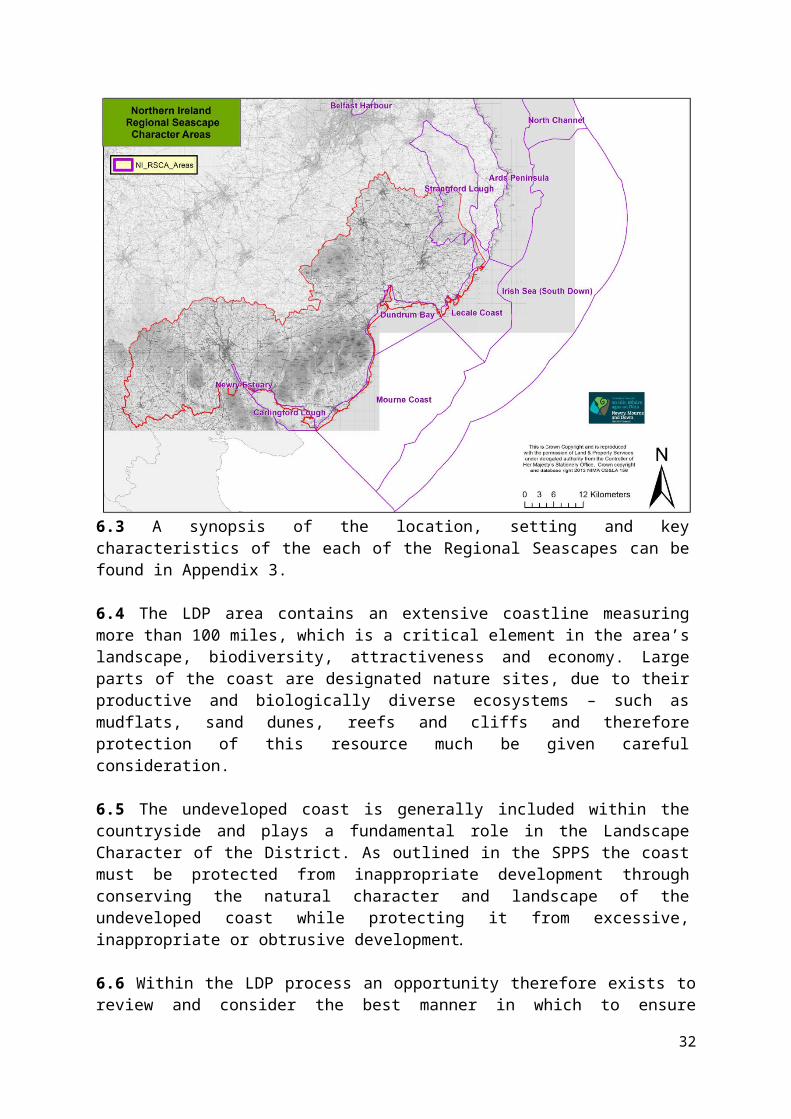
Figure 6 Regional Seascape Character Areas
Figure 7 Priority Habitats within Newry, Mourne & Down District
1
Landscape Character Assessment of Newry, Mourne and Down District
Purpose To provide members with a report on the Landscape Assessment for the District highlighting the diverse mix of landscapes within the Newry, Mourne & Down Council area while identifying the issues influencing the landscape condition and sensitivity.
ContentThe paper provides information on:-
(i) The regional planning context in the assessment and protection of our landscape,
(ii) An analysis of the existing Landscape Character Assessments and associated guidance as they apply to the District.
2

Introduction
1.0 The Newry, Mourne & Down District is comprised of a diverse and varied landscape including the Mourne Mountains, Slieve Gullion, a sensitive coastline including Strangford and Carlingford Loughs, distinctive woodlands, prominent ridges, a series of drumlins, river corridors and basins with many of these landscapes having international or national conservation designations associated with them.
1.1 This paper identifies the diverse landscapes within the Plan Area and the varying degree of capacity to absorb further development due to the vulnerable nature of a large portion of the District. This therefore involves recognising the differences between areas that are particularly sensitive to change and those with lower sensitivities which could potentially provide opportunities to accommodate sustainable development, identifying any potential constraints to future development while also taking into account the role and responsibilities of rural settlements.
1.2 The Districts landscape has many different roles including serving as an important tourist asset, providing a rich resource of agricultural land which in turn plays a pivotal role in the Districts economy while also being rich in archaeological, historical and nature conservation all of which are worthy of protection.
1.3 The Landscape Character Assessment (LCA) forms an integral part of the Development Plan process and forms one of the interrelated strands of the Countryside Assessment. The LCA process identifies and describes the variations in the character of landscapes by explaining the unique combination of elements and features that make landscapes distinctive. The process will therefore play an important role in developing and adding to a robust evidence base which is required to inform the Local Development Plan
1.4 In addition to identifying the key characteristics of each landscape character area, the paper also assesses the principal forces for change and issues influencing landscape condition and sensitivity
1.5 This paper forms part of the Countryside Assessment for the District and is to be read in conjunction with Paper 6: Environmental Assets Paper together with Paper 12 (Part 2): Countryside - Rural Pressure Analysis and Paper 13: Settlement Appraisals which are currently under preparation.
3

2.0 Regional Policy Context
2.1 The Regional Planning Policy context is provided by the Regional Development Strategy 2035 (RDS) and a suite of regional planning policy statements. A summary of these documents and how they pertain to the plan making process and the Countryside Assessment are provided in the following section.
(a) The Regional Development Strategy 2035
2.2 The RDS provides an overarching strategic framework to facilitate and guide the public and private sectors. Sustainable development is at the heart of the RDS and therefore aims to meet the needs of the present without compromising the ability of future generations.
2.3 The RDS provides long term policy direction to guide the public, private and community sectors in the form of both regional and spatial framework guidance. The policy which is most relevant to this paper is Regional Guidance 11 which aims to ‘Conserve, protect and, where possible enhance our built heritage and our natural environment’ through;
- Recognising and promoting the conservation of local identity and distinctive landscape character,
- Conserving, protecting and where possible enhance areas recognised for their landscape quality, and
- Protecting designated areas of countryside from inappropriate development (either directly or indirectly) and continuing to assess areas for designations.
(b) Strategic Planning Policy Statement for Northern Ireland2.4 The Strategic Planning Policy Statement for Northern Ireland (SPPS) published in September 2015 places sustainable development at the heart of the planning system with the three pillars of sustainable development being defined as social, economic and environmental. These factors should therefore be integrated into the formulation of all plans and policies. With regards to the environment the SPPS sets out the need to protect and enhance the built and natural environment, including heritage assets, seascape and landscape character.
2.5 The SPPS places an emphasis on the protection of special landscapes from inappropriate development, overdevelopment and the need for Councils to take into account Landscape Character Assessments. The SPPS advises that;
‘In preparing Local Development Plans (LDPs) councils must take account of the Regional Development Strategy for Northern Ireland, the SPPS and any other policies or advice in guidance issued by the Department such as Landscape Character Assessments and conservation area design guides’
4
2.6 The SPPS also states that when formulating policies and plans, planning authorities will be guided by the precautionary approach in that, where there are significant risks of damage to the environment, its protection will generally be paramount, unless there are imperative reasons of overriding public interest. Preserving and improving the natural and built environment is deemed as being fundamental in achieving the long term public interest of sustainable development.
2.7 The SPPS states that where there are areas of the countryside which exhibit exceptional landscapes, and visual amenity value such as lough shores and important views and vistas development should only be permitted in exceptional circumstance. The SPPS therefore suggests that additional layers of policy control may be considered to protect against adverse development.
2.8 Therefore one of the key aims of this paper is to begin discussion as to whether the District would benefit from further designations or amending those that are currently in place. Members should therefore consider whether lands which currently lie outside designated and controlled areas such as Areas of Outstanding Natural Beauty (AONB) are worthy of a different layer of protection such as Special Countryside Areas (SCA) to which there are currently 3 in the District, Mournes, Ring of Gullion and Slieve Croob SCA’s or Areas of High Scenic Value (AHSV). The District currently shares a small portion of the Magheraknock Loughs AHSV which is located to the north of Ballynahinch.
2.9 The SPPS also states that the LDP process plays an important role in identifying key features and assets of the countryside and balancing the needs of rural areas and communities with the protection of the environment. It states that this process should include an environmental assets appraisal and landscape assessment which will provide the evidence base for the purposes of bringing forward an appropriate policy approach to development in the countryside.
(c) Planning Policy Statement 21: Sustainable Development in the Countryside (PPS21)
2.10 The RDS and SPPS are complemented by Planning Policy Statements with the most relevant one to this paper being PPS 21 Sustainable Development in the Countryside. This documents sets out policies for managing development in the countryside with one of its key themes being to conserve the landscape and natural resources of the rural area, to protect it from excessive inappropriate or obtrusive development and from the actual or potential effects of pollution. PPS21 also outlines the four interrelated strands of the Countryside Assessment which includes the Landscape Assessment.
(d) Planning Policy Statement 2: Natural Heritage (PPS2)
5
2.11 PPS2 sets out the Department’s planning policies for the conservation, protection and enhancement of our natural heritage, which is defined as ‘the diversity of our habitats, species, landscapes and earth science features’. This policy recognises that natural heritage features will normally be identified as part of the Countryside Assessment carried out in association with the plan preparation. Local designations arising from the plan should be identified and policies brought forward for their protection and where possible their enhancement. PPS2 also indicates that the plan process should seek to identify and promote the design of ecological networks throughout the plan area.
(e) Planning Policy Statement 6: Planning, Archaeological and the Built Heritage (PPS6)2.12 In the preparation of LDPs the Council will take full account of the implications of proposed landuse zonings, locations for development and limits of development on all features of the archaeological and built heritage and their settings within a plan area. These features have been identified in Paper 6: Environmental Assets which has added to the this section of the Countryside Assessment.
(f) Existing Development Plans for Newry, Mourne & Down2.13 The Ards and Down Area Plan 2015 (ADAP) and the Banbridge/Newry and Mourne Area Plan 2015 (BNMAP) are the current statutory plans for the District and provide the framework against which to assess development proposals.
2.14 In preparing LDPs, Councils shall bring forward a strategy for sustainable development in the countryside together with appropriate policies and proposals that reflect the aims, objectives and policy approach of the SPPS, while also tailoring the Plan to the specific circumstances of the plan area.
2.15 The LDP process will play an important role for councils in identifying key features and assets of the countryside and balancing the need of rural areas and communities with the protection of the environment.
6
3.0 Northern Ireland Landscape Character Assessment3.1 ‘Landscape character is what makes an area unique. It is defined as ‘a distinct, recognisable and consistent pattern of elements, be it natural (soil, landform) and/or human (for example settlement and development) in the landscape that makes one landscape different from another, rather than better or worse’. Informed and responsible decisions on the management and planning of sustainable future landscapes can only be made if proper regard is paid to their existing character’ (RDS 2035 – Building a better future Page 50)
3.2 The process of identifying and describing variation in the character of the landscape is commonly known as Landscape Character Assessment (LCA). LCA documents identify and explain the unique combination of elements and features that make landscapes distinctive by mapping and describing character types and areas.
3.3 Northern Ireland is currently covered by an existing Landscape Character Assessment Series. These documents were undertaken by the former Department of the Environment, Environment and Heritage Service (EHS) to distinguish local identities and to assess the visual aspects of landscape character.
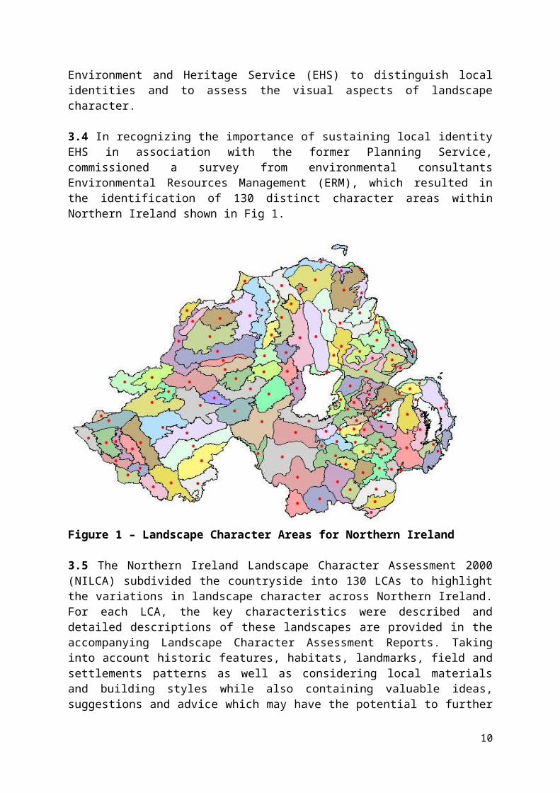
3.4 In recognizing the importance of sustaining local identity EHS in association with the former Planning Service, commissioned a survey from environmental consultants Environmental Resources Management (ERM), which resulted in the identification of 130 distinct character areas within Northern Ireland shown in Fig 1.
7
Figure 1 – Landscape Character Areas for Northern Ireland
3.5 The Northern Ireland Landscape Character Assessment 2000 (NILCA) subdivided the countryside into 130 LCAs to highlight the variations in landscape character across Northern Ireland. For each LCA, the key characteristics were described and detailed descriptions of these landscapes are provided in the accompanying Landscape Character Assessment Reports. Taking into account historic features, habitats, landmarks, field and settlements patterns as well as considering local materials and building styles while also containing valuable ideas, suggestions and advice which may have the potential to further assist the aims of the LDP. Each LCA has also considered local patterns of geology, landform, land use, cultural and ecological features while detailing the landscapes condition and its sensitivity to change.
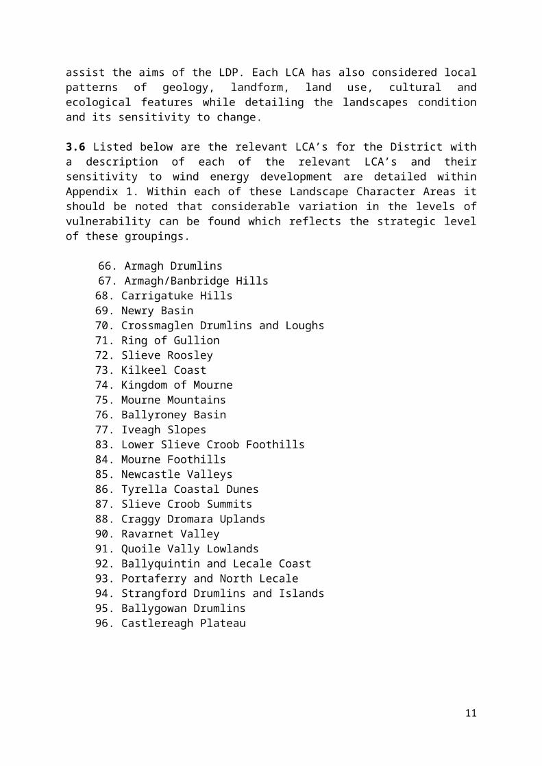
3.6 Listed below are the relevant LCA’s for the District with a description of each of the relevant LCA’s and their sensitivity to wind energy development are detailed within Appendix 1. Within each of these Landscape Character Areas it should be noted that considerable variation in the levels of vulnerability can be found which reflects the strategic level of these groupings.
66. Armagh Drumlins 67. Armagh/Banbridge Hills68. Carrigatuke Hills69. Newry Basin
8
70. Crossmaglen Drumlins and Loughs71. Ring of Gullion72. Slieve Roosley73. Kilkeel Coast74. Kingdom of Mourne75. Mourne Mountains76. Ballyroney Basin77. Iveagh Slopes83. Lower Slieve Croob Foothills84. Mourne Foothills85. Newcastle Valleys86. Tyrella Coastal Dunes87. Slieve Croob Summits88. Craggy Dromara Uplands90. Ravarnet Valley91. Quoile Vally Lowlands92. Ballyquintin and Lecale Coast93. Portaferry and North Lecale94. Strangford Drumlins and Islands95. Ballygowan Drumlins96. Castlereagh Plateau
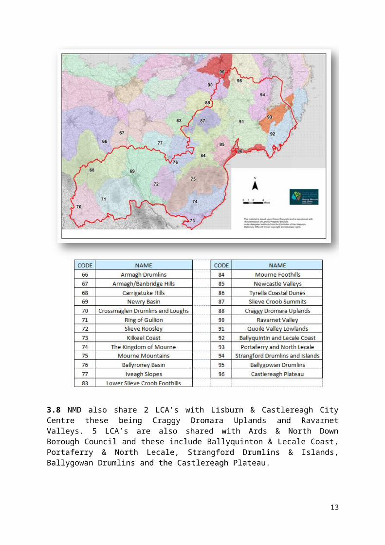
3.7 Off the 25 LCAs (LCAs) included within the District a substantial number of these traverse the Districts boundary into neighbouring council areas as shown within Figure 2. Armagh, Banbridge & Craigavon Council share 8 LCA’s with the District and include the Armagh Drumlin, Armagh/Banbridge Hills, Carrigatuke Hills, Newry Basin, Ballyroney Basin, Iveagh Slopes, Lower Slieve Croob Foothills and the Mourne Foothills.
FIGURE 2 – Landscape Character Areas included within Newry, Mounre & Down District Council
9
3.8 NMD also share 2 LCA’s with Lisburn & Castlereagh City Centre these being Craggy Dromara Uplands and Ravarnet Valleys. 5 LCA’s are also shared with Ards & North Down Borough Council and these include Ballyquinton & Lecale Coast, Portaferry & North Lecale, Strangford Drumlins & Islands, Ballygowan Drumlins and the Castlereagh Plateau.
3.9 The NILCA also identified Areas of Scenic Quality (ASQ’s) which represent the second tier in the hierarchy of landscape classifications and may include significant sites or features of nature conservation, historic or cultural importance. In many instances these areas may also be visually
10
prominent landscapes such as ridgetops, scarp slopes or lough shores. This classification then aids in LDPs designating Areas of High Scenic Value (AoHSV)
3.10 Presently the Newry, Mourne & Down District contains 3 AONB’s which cover 55.7% of the District due to the landscapes being recognised as being of regional or local importance. The District includes a small portion of Magheraknock Loughs AoHSV which is found north of Ballynahich and is therefore mainly included within the neighbouring Lisburn and Castlereagh City Council area. AoHSV designation with the District is therefore something that members may wish to consider implementing within the new Area Plan to protect landscapes which are characterised by visually pleasing patterns or combinations of landscape elements free from major intrusion.
3.11 Since the publication of the NICLA series through both natural and man-made forces landscapes have continued to evolve and change. By tailoring individual approaches to reflect and respond to each distinct landscape their character can be both reinforced and enhanced for the benefit of future generations.
Key settlements and landscapes identified within NILCA series3.12 Landscape sensitivity is based on the ability for an individual area to accommodate specific types of change of development without significant adverse impacts on its landscape character, visual amenity or landscape value. A broad overview of the District has been provided below highlighting some of the distinctive areas which add to the creation of a highly valuable and distinctive landscape.
3.13 The central core of Down is dominated by the rugged uplands of Slieve Croob which are generally surrounded by marginal farmland. Roads traversing this area often provide long views across the foothills to the Mournes and over the surrounding drumlin lowlands and deep valleys. The area has a relatively enclosed landscape with a domestic scale and diverse intricate pattern with the drumlins providing a scenic landscape settling for Strangford Lough. Careful consideration must be given to the distinctively low drumlin topography with its infinite variety of long established characteristics/patterns alongside the protection on the long intricate coastline. To the west of Tyrella and Murlough sand dunnes together with the long sandy beaches and mudflats of Dundrum Bay form part of the diverse range of coastal features found within the District.
3.14 The Mournes and The Ring Gullion dominate the eastern section of the District with the landscape then moving towards a gradual transition of extensive foothills and drumlins. The steep Mourne Mountain slopes provide a dramatic backdrop to the striking and unified farmland which is defined mainly by distinctive stone walls which then descend onto the surrounding coast. To the west, the scenic deep waters of Carlingford
11

Lough, the surrounding forested area and the steep sided valley of the Newry River are some of the defining characteristics.
3.15 Within the NILCA series reference is made to six of the larger settlements within the Newry & Mourne section of the District while in contrast, settlements varying in scale and nature are referred to within the former Down segment of the Council area in terms of important landscapes. These documents have assessed and evaluated the landscapes while providing a tool to analyse the relative vulnerability of the different landscape elements, features and patterns which contribute to landscape character. A synopsis of their landscape setting is detailed below.
3.16 Newry City Landscape Setting - Newry has a superb landscape setting. The town is sited on the Newry River at the head of Carlingford Lough and is flanked by strong ridge-lines with a north-south alignment. The eastern fringe of the Ring of Gullion dominates views to the west and Slieve Roe is prominent to the east. The town has expanded from its centre on the narrow flat valley floor to the slopes of the ridges on either side. To the east, the long, shallow valleys of the Derryleckagh area contain a series of bogs and loughs of ecological value. To the north, the ridges are influenced by drumlins but the valley of the Newry River is a strong feature. Newry has a dense town centre with attractive stone buildings and winding streets with traditional buildings rendered or built of local light grey stone. The central bridges, canal and churches are also deemed as focal points.
3.17 Crossmaglen Landscape Setting - Crossmaglen is a border market town, located around a square and presently dominated by its vacant police station. It is an attractive small town set within a historic landscape of loughs, hummocks and fens.
3.18 Kilkeel Landscape Setting - Kilkeel is an expanded fishing village located along the coast to the south of the Mournes. The harbour is close to the confluence of the Kilkeel River and the Aughrim River. Both watercourses flow in steep, narrow valleys and are relatively inconspicuous within the town. There are long, dramatic views to the Mournes to the north of Kilkeel which suffer from the impact of extensive ribbon development. This blurs each of the entrances to the town and detracts from the character of the attractive open stone wall landscape surrounding the town.
3.19 Warrenpoint Landscape Setting - Warrenpoint has a dramatic landscape setting on the shores of Carlingford Lough at the entrance to the Newry River. The town is backed by the foothills of the Mournes and has views to the steep, wooded slopes of Anglesey Mountain on the opposite shores. The industrial port is on the flat strip of land to the west of the town and its cranes are prominent on the approach road from the north. Narrow Water Castle and the Narrow Water estate form the
12
gateway to Warrenpoint from the north. There are long views along the waterfront from the coastal road to the east. The town is backed by the steep slopes of Slievecarnane. The lower slopes have an intricate pattern of streams, with numerous archaeological sites on local ridge-tops.
3.20 Annalong Landscape Setting - Annalong is a small coastal port close to the foot of the Mournes. The town has a stunning setting and is dwarfed by the peaks of Slieve Donard and Slieve Binnian to the north. The port is at the mouth of the Annalong River, which flows through the built up area in a rocky gully. Like Kilkeel, Annalong is surrounded by ribbon development, which blurs the immediate landscape setting.
3.21 Rostrevor Landscape Setting - Rostrevor is at the head of the Kilbroney / Rostrevor River, on the northern shores of Carlingford Lough. It is an attractive town, backed by the steep mountain slopes of Slievemartin, with stunning views across the Lough to Carlingford Mountain in the Republic to the south. Rostrevor is squeezed against the side of an attractive wooded glen and the opposite side of the river has been developed as a park (Kilbroney Park). This is a popular recreational resource and the start of some long distance walks into the mountains. The glen is locally known as Fairy Glen.
3.22 Within the NILCA series reference is also made to 14 principle settlements within the previous Down District which are listed as follows Ardglass, Ballyhornan, Ballynahinch, Castlewellan, Clough, Crossgar, Downpatrick, Dundrum, Drumaness, Killough, Killyleagh, Loughinisland, Newcastle and Saintfield. A synopsis of the character of a number of the larger settlements is detailed below.
3.23 Downpatrick Landscape Setting - Downpatrick has a distinctive and historic landscape setting with a sequence of impressive views along the northern approach. The Quoile River and loughs to the north along with the drumlins to the south-west and the undulating ridge-tops of Slievegrane and Struell Hills to the east add to the impressive setting of this market town. The Finnebrogue woodland estate to the west and the steep slopes above the race course to the south west of the town offer additional enclosure to the settlement.
3.24 Ballynahinch Landscape Setting - Ballynahinch has an attractive landscape setting provided by a series of distinct and undeveloped drumlins. The town lies in a hollow between the drumlins with little development creeping up the slopes. Approaches across and around the drumlins given sudden and unexpected views of the settlement with the Monalto Estate providing a wooded backdrop to the west.
3.25 Newcastle Landscape Setting - Newcastle impressive setting is characterised by the striking contrast between the Mourne mountains backdrop, the flat dune landscape at the shore and the series of river valleys which radiate inland from the town. Reference should also be
13
made to the locally distinctive landscape within the town, including the Shimna valley, Tipperary Wood and Donard Park and the river corridors associated with the Glen, the Tullybrannigan and the Burren rivers.
3.26 Ardglass Landscape Setting - Ardglass is a very distinctive coastal fishing village. Rocky headlands provide a strong landscape setting and the large harbour has a robust character and a diverse mix of buildings and open space. Local landmarks include a prominent church on the summit of the steep southern headland and the castle.
3.27 The settlement is situated on a low hill, Green Hill which is quite prominent in the local landscape, particularly from the west and south west. It is located between two headlands referred to in the NILCA as providing a landscape setting for the village. Isabella Tower is a significant local landmark
3.28 Castlewellan Landscape Setting - The wooded slopes of Castlewellan Country Park provide a strong backdrop while the mature planting in Bunkers Hill provides further enclosure and setting to the south. Extensive views of the Mourne Mountains to the south also add to the setting of this village.
3.29 Killyleagh Landscape Setting – Killyleagh is a distinctive town with the prominent castle and wooded estate forming a backdrop to the west of the settlement, while the harbour and Strangford Lough to the east offer a natural focus. Prominent lands west of Shrigley Road, Coily Hill to the north west and lands between Comber Road and Holm Bay to the north east of the village also provide distinctive landscape settings.
14
4.0 NIEA Supplementary Planning Guidance - Wind Energy Development in NI Landscapes (2010)
4.1 In addition to NILCA 2000 further broad strategic guidance with regard to the sensitivity of Northern Ireland’s landscape is contained within NIEA Supplementary Planning Guidance (SPG) Wind Energy Development in Northern Irelands Landscapes (2010). This document contains an assessment of each of the 130 LCAs by highlighting and detailing the visual impact of wind energy development by referencing the characteristics associated with each LCA using the criteria detailed in Appendix 2.
4.2 The supplementary guidance indicates some of the landscape challenges and opportunities that should be taken into account when considering the location, siting, layout and design for wind energy development proposals while also indicating potential transboundary issues in relation to existing and future development. Although this document is specifically concerned with the impact of wind energy development it is also considered to be a useful tool in identifying those landscapes that are particularly vulnerable to change while remaining mindful that within each LCA there may be considerable variation in the sensitivity level of the landscapes.
4.3 Within this guidance each LCA is given an overall sensitivity level using a five point scale ranging from a high to low scaling system. The sensitivity level for each LCA has been assessed by considering the combined weight of many factors including the enclosure, visibility, condition, scenic, perceptual and natural heritage qualities of the landform.
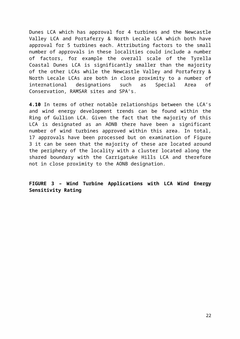
4.4 Figure 3 details the location of approved, refused and pending applications for wind turbines within the District. An analysis of the most recent data suggests that approximately 270 wind turbine applications have been approved in the District between the period 1st April 2002 and 31st March 2015 while approximately 60 have been refused in the same timeframe. It should also be noted that from this most recent data was published by the Department of Infrastructure significant progress has been made on the number of applications being processed for wind turbine development within the District. An analysis of internal figures show that of the proposals for wind energy development submitted on or before the 31st March 2015 approximately 21 turbine applications have issued as approvals, 23 issued as refusals, 12 have been withdrawn
15
before a decision has been issued leaving approximately 14 turbines legacy applications.
4.5 Off the 25 LCA’s that fall within the Newry, Mourne and Down District 13 LCA’s fall within the high sensitivity wind energy rating which equates to 66% of the total area of the District, 9 within the high to medium category which measures as 26% of the District leaving 3 LCAs which were all graded as having a medium sensitivity. These LCAs are Armagh/Banbridge Hills (67), Carrigutuke Hills (68) and Iveagh Slopes (77) and equate to 8% of the District. As shown in Figure 3 all three of the medium sensitivity landscapes lie on the periphery of the District which highlights the fact that the District, in its entirety remains sensitive to wind energy and other forms of development.
4.6 Figure 3 also highlights that certain sections of the District have experienced a higher concentration of acceptable proposals for wind energy development than others. Within the timeframe of 2002 to 2015 the highest concentration of approvals were found in the following LCA’s. Within Quoile Valley Lowlands LCA 38 wind turbines were approved while 32 were approved within The Mourne Foothills LCA both of which have been identified as having a high sensitivity rating in the Wind Energy Planning Guidance. Figure 3 indicates that while there has been quite an even distribution of approvals throughout the Quoile Valley Lowlands LCA approvals appear to be concentrated in the eastern section of The Mourne Foothills with approximately 10% of the wind turbines being located in the southern sections of the LCA and therefore in close proximity to the Mourne Mountains LCA which is also protected under an AONB designation.
4.7 Carrigatuke Hills has the third highest concentration of approvals with 29 turbines granted. Again they appear evenly spread across the LCA. As this LCA has a medium sensitivity rating in terms of wind energy development it would have been expected that a higher proportion of wind turbines would be situated in this locality rather than those outlined in paragraph 4.6.
4.8 In contrast, other areas of the District appear to be comparatively unaffected by wind energy development. The Mourne Mountain LCA has neither any pending nor granted applications located within its entirity, while others including Ravarnet Valley LCA has only 1 approval followed closely by Castlereagh Plateau which has permission granted for 3 turbines. When assessing this data one should be mindful that only a portion of both these LCAs are included within the District.
4.9 Off the LCAs which are included in their entirety within the District the other LCAs which appear to be largely unaffected by wind turbine development include Tyrella Coastal Dunes LCA which has approval for 4 turbines and the Newcastle Valley LCA and Portaferry & North Lecale LCA
16
which both have approval for 5 turbines each. Attributing factors to the small number of approvals in these localities could include a number of factors, for example the overall scale of the Tyrella Coastal Dunes LCA is significantly smaller than the majority of the other LCAs while the Newcastle Valley and Portaferry & North Lecale LCAs are both in close proximity to a number of international designations such as Special Area of Conservation, RAMSAR sites and SPA’s.
4.10 In terms of other notable relationships between the LCA’s and wind energy development trends can be found within the Ring of Gullion LCA. Given the fact that the majority of this LCA is designated as an AONB there have been a significant number of wind turbines approved within this area. In total, 17 approvals have been processed but on examination of Figure 3 it can be seen that the majority of these are located around the periphery of the locality with a cluster located along the shared boundary with the Carrigatuke Hills LCA and therefore not in close proximity to the AONB designation.
FIGURE 3 – Wind Turbine Applications with LCA Wind Energy Sensitivity Rating
17
As outlined in Paper 9: Public Utilities it must be considered as part of the LDP process as to whether specific areas within the District should be zoned specifically for turbine development which would help to eradicate the piecemeal development which is currently found in some sections of the District.
It should also be noted that within many of the LCAs that considerable variation maybe evident in sensitivity level across each individual area, reflecting the fact that the LCAs by definition are broad character or identity areas. The overall sensitivity level is therefore the level that prevails over most of the LCA’s geographic area and is indicative of the relative overall sensitivity of each LCA. A high sensitivity level does not necessarily mean that there is likely to be no capacity for wind energy development within a given LCA and conversely a low sensitivity does not mean that there are no constraints to development.
5.0 Northern Ireland Regional Landscape Character Assessment
5.1 The Northern Ireland Regional Landscape Character Assessment 2016 (NIRLCA) was developed by NIEA as a map based resource available online to provide advice and guidance to decision makers and the general public.
5.2 The main purpose and aims of the NIRLCA is to provide an up-to-date evidence base which will enable people to make informed decisions concerning the planning and protection of Northern Ireland’s landscapes by :-
- Providing a regional framework for landscape character,- Guiding strategic decisions about landscapes, - Serving as an impartial evidence base,- Giving context for more detailed local landscape studies,- Outlining a basis for monitoring landscape change, - Providing a comparable baseline with the rest of UK, and - Being readily updateable and accessible via an online presentation.
5.3 As outlined previously there has been substantial building and other development in both the urban and rural areas of Northern Ireland in recent years including single dwellings and renewable energy projects which have impacted on the character of many of our landscapes since the publication of the NILCA 1999. As such, the NIRLCA does not draw directly from this study, though the document serves as a valuable source of detailed information on the landscape.
5.4 This document has divided Northern Ireland into 26 discrete areas, referred to as regional landscape character areas (RLCA). The NIRLCA provides a strategic view of the landscape by drawing together
18
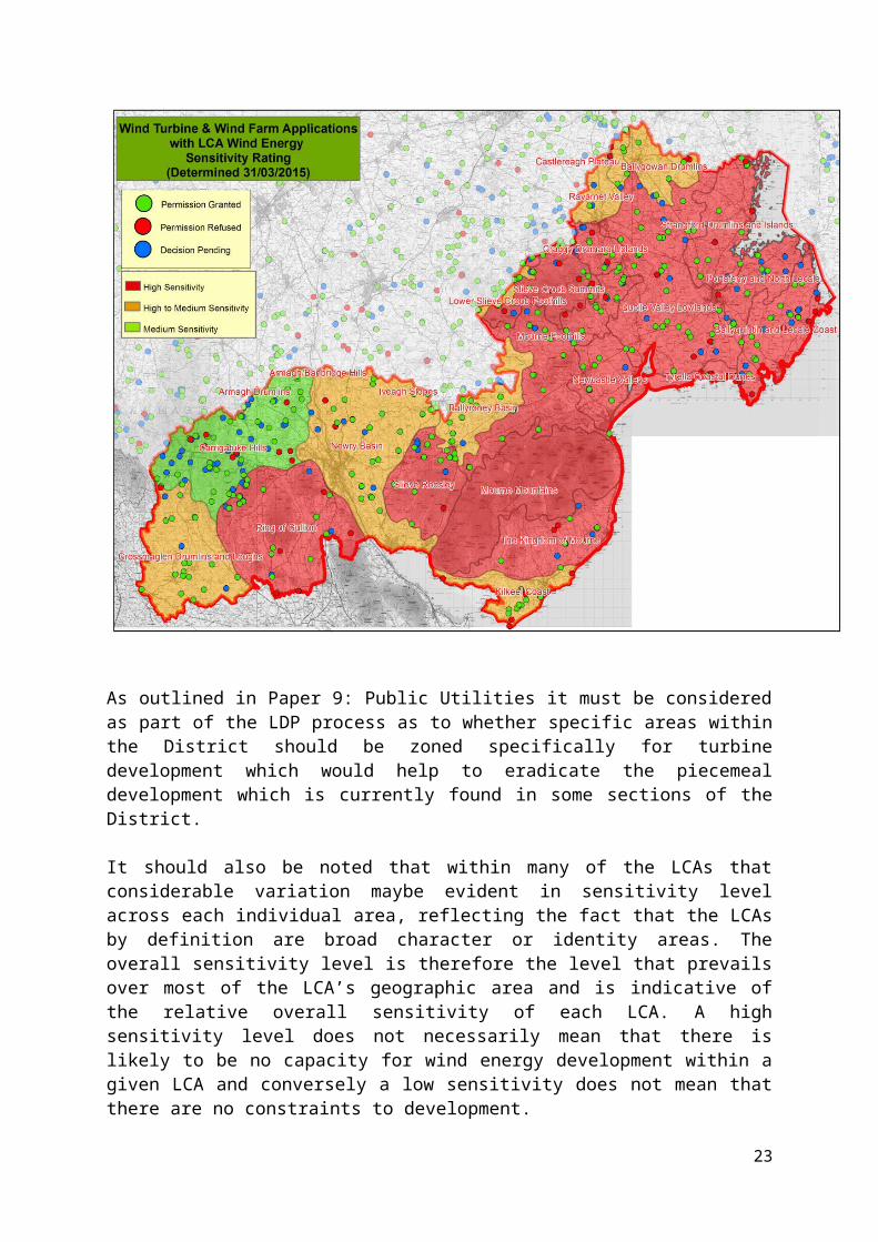
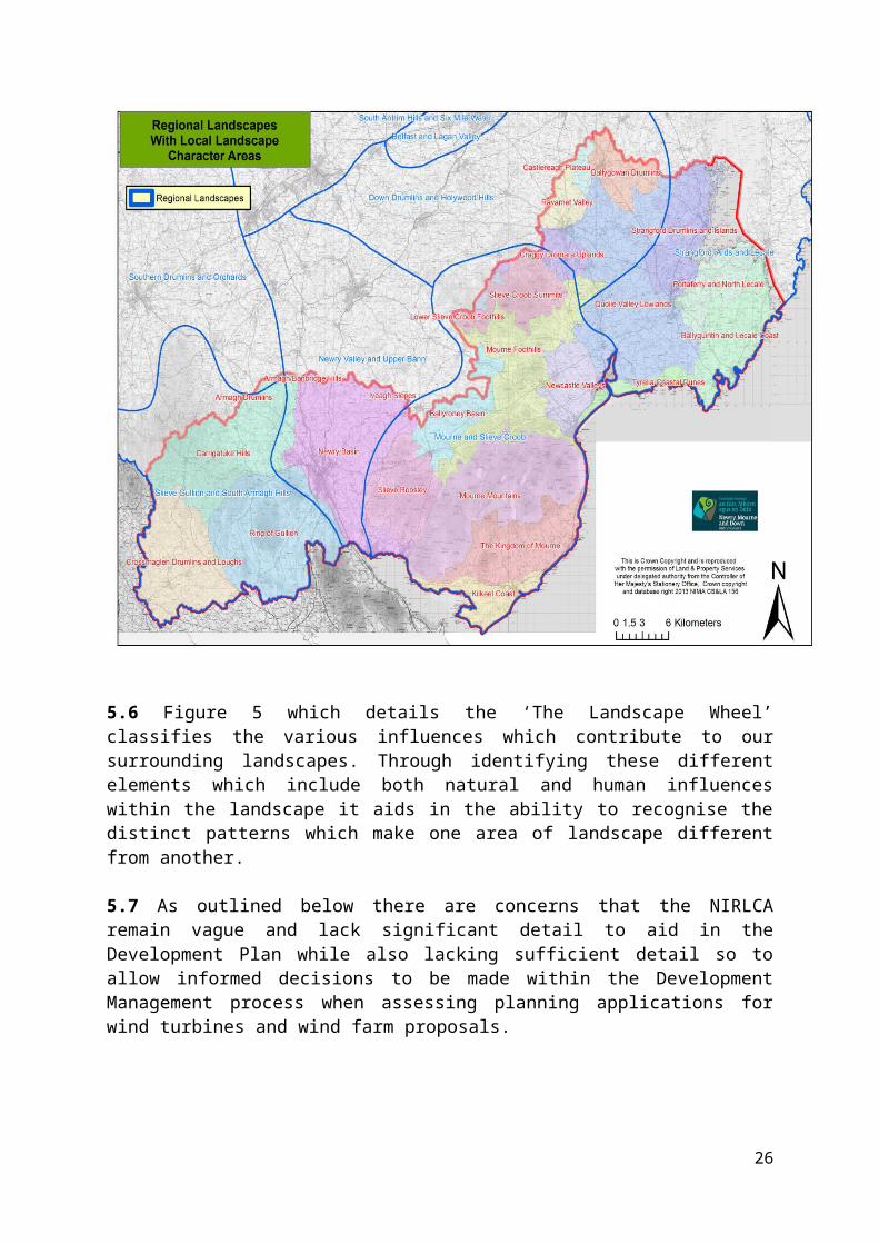
information on both place and people which has facilitated in the creation of the unique landscapes found in Northern Ireland. It is intended that each of these areas is a recognisable landscape; with its own distinct character and sense of place with names which should be locally understood and clearly associated with the area. The assessment identifies 5 Regional Landscape Character Areas for the Newry, Mourne and Down Council Area with Figure 4 demonstrating how they read in relation to the 25 LCA’s found within NMD.
22 - Down Drumlins and Holywood Hills 23 - Newry Valley and Upper Bann 24 - Slieve Gullion and South Armagh Hills 25 - Mourne and Slieve Croob 26 - Strangford, Ards and Lecale
5.5 Within this document NIEA has taken the opportunity to encourage all individual Councils to review and refine landscape character assessments at a local scale. Concerns however have been raised by various bodies that if work is carried out in a piecemeal approach the independence of the existing LCA document will be called into question. It is felt that the NIRLCA document offers a significant generalisation of the previous work carried out within this area of expertise and offers a broad strategic and regional overview of the intrinsic landscape of the province. Figure 4: Regional Landscape Boundaries overlaid with Local
Landscape Character Areas
19
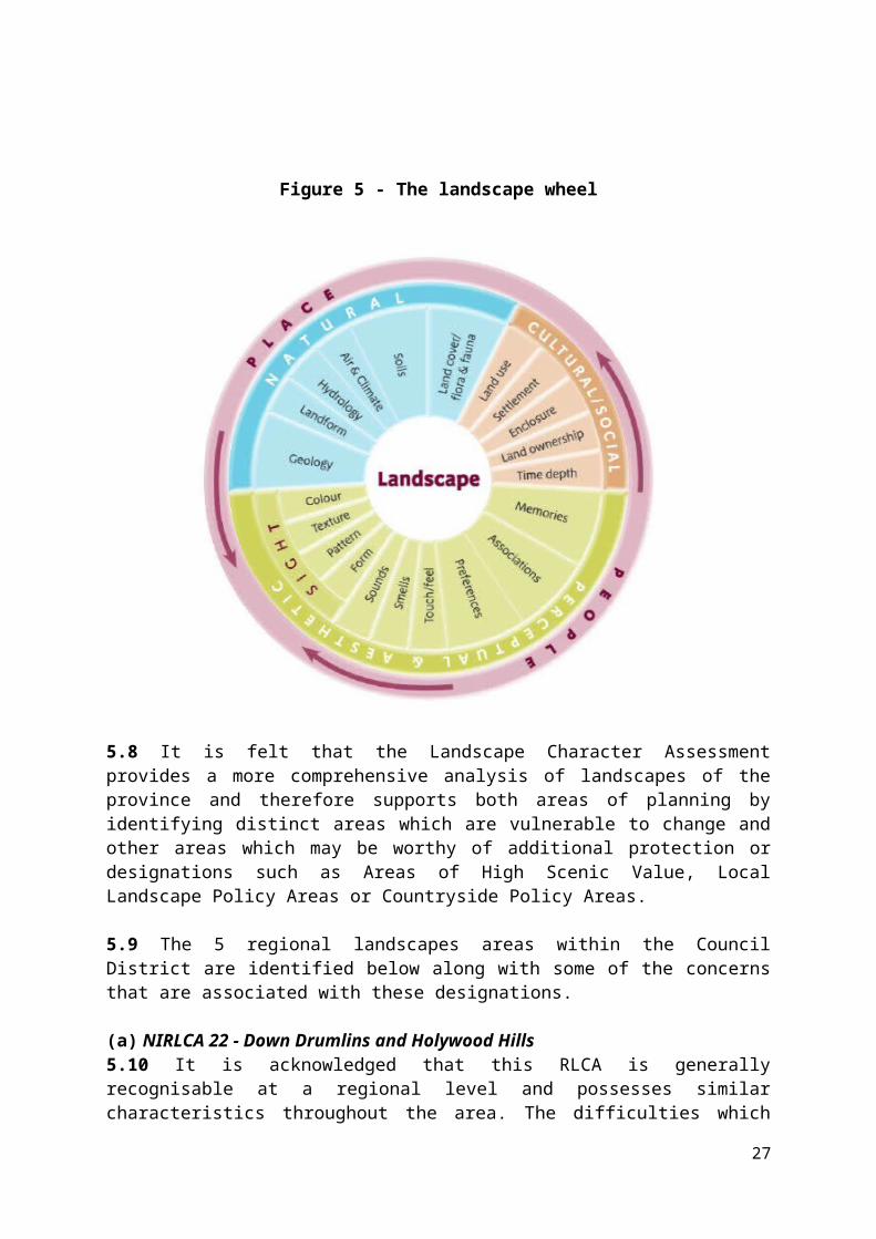
5.6 Figure 5 which details the ‘The Landscape Wheel’ classifies the various influences which contribute to our surrounding landscapes. Through identifying these different elements which include both natural and human influences within the landscape it aids in the ability to recognise the distinct patterns which make one area of landscape different from another.
5.7 As outlined below there are concerns that the NIRLCA remain vague and lack significant detail to aid in the Development Plan while also lacking sufficient detail so to allow informed decisions to be made within the Development Management process when assessing planning applications for wind turbines and wind farm proposals.
Figure 5 - The landscape wheel
20
5.8 It is felt that the Landscape Character Assessment provides a more comprehensive analysis of landscapes of the province and therefore supports both areas of planning by identifying distinct areas which are vulnerable to change and other areas which may be worthy of additional protection or designations such as Areas of High Scenic Value, Local Landscape Policy Areas or Countryside Policy Areas.
5.9 The 5 regional landscapes areas within the Council District are identified below along with some of the concerns that are associated with these designations.
(a) NIRLCA 22 - Down Drumlins and Holywood Hills 5.10 It is acknowledged that this RLCA is generally recognisable at a regional level and possesses similar characteristics throughout the area. The difficulties which arise from a plan making perspective centre around the fact that the area extends across 5 different Councils. Therefore agreement would need to be sought from each Council to ensure that a consistent approach is taken when classifying the condition and sensitivity of the area.
(b) NIRLCA 23 - Newry Valley and Upper Bann 5.11 In the southern section of this NIRLCA the Newry Basin LCA (69) along with narrow eastern sections of the Carrigatuke Hills (68) and Ring of Gullion (71) LCAs are incorporated into this designation with the landscape being dominated by Newry City and an extensive drumlin
21
topography to the south and east. These lands are nestled between the uplands of the Mournes to the east and Slieve Gullion to the west and therefore both these boundaries are easily recognisable while the northern boundary merges into the adjoining Armagh, Banbridge and Craigavon Council District.
5.12 Due to its intrinsic location between 2 distinctive landforms this landscape therefore plays a pivotal role in providing panoramic views of both mountain ranges and in doing so heightens the visual sensitivity of the landscape. Therefore grouping the area together with less distinct landscapes to the north raises concerns that this may detract from the area.
(c) NIRLCA 24 – Slieve Gullion & South Armagh5.13 This RLCA encompasses 3 of the original LCAs and it is considered that due to the significant and distinct variations in the sensitivity of the landscape there may be merit in having retained the designations as per the 1999 publication. The topography of this large area includes smooth rolling hills, deep wooded valleys, rolling drumlins, bogs, loughs and the striking Ring of Gullion. In grouping these 3 areas together in terms of landscape there may therefore be a risk diminishing the integrity of The Ring of Gullion.
5.14 These concerns are intensified by the fact that the Ring of Gullion is designated as an AONB and is therefore recognised as having a unique landscape. In grouping these 3 areas together it may lead to a relaxation in granting certain types of development which may not be deemed acceptable under the previous Landscape Character Areas such as wind energy development, which in turn may lead to a further degradation of these protected landscapes.
5.15 On the contrary it is recognised that there is a strong social and community cohesion already existing within this area even when taking into consideration the sparse settlement arrangement.
(d) NIRLCA 25 - Mourne and Slieve Croob 5.16 The Mourne and Slieve Croob NIRLCA contains 13 of the original Landscape Character Areas and therefore covers a significant portion of the Newry Mourne & Down District. The fact that the original Character Assessment document felt it both appropriate and beneficial to divide the area into so many sections highlights the diversity and complexity of this given landscape. The new designation groups together the Mourne Mountains (84) and Slieve Croob summits (87) with numerous other landscapes including coastal areas, flat open expansive areas, rolling hillsides and geometric pastures. It is therefore felt that due to their distinct and unique dramatic peak formation of the Mournes and the rugged rounded summits of these landscapes that there would be considerable merit in retaining the original individual designations of these mountainous landscapes.
22
5.17 On the contrary it is however accepted that almost all this RLCA is highly sensitive to wind energy development and this may have played a significant role in designating the regional boundary.
(e) NIRLCA 26 - Strangford, Ards and Lecale5.18 This RLCA groups 5 of the former LCA’s together. The flat open and exposed coastal area along with lough shores define the eastern and southern limits of this character area and contain extensive sand dunes, mudflats, islands and inlets and therefore contrast significantly with the undulating drumlin landscapes of the Quoile Valley Lowlands, Strangford Drumlins and Islands and Portaferry and North Lecale.
5.19 Grouping together a deeply rural area which includes a substantial number of small coastal settlements with the large town of Downpatrick, the largest settlement in the eastern portion of the District may have the potential to introduce conflicts in terms of landscape policy. The introduction of this larger RLCA has also led to both the Tyrella Coastal Dune LCA and the Quoile Valley Lowlands LCA being distributed between 2 of the regional zonings which in turn has led to the river courses of the River Quoile and Blackstaff being separated along with significant differences in the complex topography of the landscapes.
23
6.0 Northern Ireland Regional Seascape Character Assessment (NIRSCA)
6.1 The Northern Ireland Environment Agency (NIEA) commissioned and published the NIRSCA in 2014 which provided a strategic understanding of different areas of regional seascape character along the entire Northern Ireland coast. This will contribute to the aims of the European Landscape Convention through promoting the protection, management and planning of the seascape, and to support European co-operation on landscape issues. The objectives of the study includes relating the description of each seascape character area to its neighbouring terrestrial landscape character areas (as described in the Northern Ireland Character Assessment, 2000) and to take account of boundaries identified in relation to neighbouring seascape areas for the British and Irish coastline. A Seascape Character Area is defined as a unique geographic area of land, intertidal and marine area with a recognisable sense of place and identity.
6.2 As shown in Figure 6 the 7 Regional Seascape Character Areas within the Newry, Mourne and Down Council area include:
16 - Strangford Lough 17 - Lecale Coast 18 - Dundrum Bay 19 - Mourne Coast 20 - Carlingford Lough 21 - Newry Estuary 24 - Irish Sea (South Down)
Figure 6 : Regional Seascape Character Areas
24
6.3 A synopsis of the location, setting and key characteristics of the each of the Regional Seascapes can be found in Appendix 3.
6.4 The LDP area contains an extensive coastline measuring more than 100 miles, which is a critical element in the area’s landscape, biodiversity, attractiveness and economy. Large parts of the coast are designated nature sites, due to their productive and biologically diverse ecosystems – such as mudflats, sand dunes, reefs and cliffs and therefore protection of this resource much be given careful consideration.
6.5 The undeveloped coast is generally included within the countryside and plays a fundamental role in the Landscape Character of the District. As outlined in the SPPS the coast must be protected from inappropriate development through conserving the natural character and landscape of the undeveloped coast while protecting it from excessive, inappropriate or obtrusive development.
6.6 Within the LDP process an opportunity therefore exists to review and consider the best manner in which to ensure suitable protection to the coastal zone. As detailed in Paper 8: The Coast the previous draft Banbridge, Newry & Mourne Area Plan 2015 (dBNMAP) contained a Coastal Policy Area (CPA) (Policy COU 2). Following the introduction of PPS21 and the loss of the majority of Green Belt/Countryside Policy Area designations this limited coastal policy designation was removed from the plan prior to final adoption.
25
6.6 The opportunity now exists as part of the new plan process to review this previous CPA and consider whether it should form part of an enlarged coastal zone with both a landward and seaward element. A synopsis of the information contained with the Draft Plan is detailed below.
6.7 The CPA in the Plan Area extended from an area in Newry City south of the Greenbank Industrial Estate to beyond Maggie’s Leap, 1km south of Newcastle. It extends to the Low Water Mark, and included the narrow strips of coast between the High Water Mark and the Low Water Mark along with other selected land.
6.8 The CPA followed the shores of Carlingford Lough and then travelled along the east coast of the Mournes between Greencastle and Maggie’s Leap. The Policy Area was contained totally within the Newry and Mourne District, with breaks at Warrenpoint Port, Warrenpoint Watersports Centre, Kilkeel Harbour and Annalong Port. The CPA runs parallel to the protected A2 route between Newry and Killowen and then moves away from the road to follow the coast before coming together again between Glassdrumman and Maggie’s Leap.
6.9 The CPA included portions of a number of landscape character areas including Newry Basin, Mourne Mountains, Kilkeel Coast and The Kingdom of Mourne, with descriptions included in Appendix 3A of this report.
6.10 The CPA can be considered in three sections: 1. Newry City to Rostrevor; 2. Rostrevor to Kilkeel; and 3. Kilkeel to Plan boundary, north of Shannaghmore Outdoor Pursuits Centre.
6.11 Newry City to Rostrevor The CPA began south of the Greenbank Industrial Estate in Newry City and followed the channel of the Carlingford Lough inlet, past Victoria Lock towards Warrenpoint. It included mud and shingle either side of Newry River between Greenbank and Narrow Water Castle. The CPA excluded Warrenpoint Port area, before resuming at the Warrenpoint Marina and travelling along the coast between Warrenpoint and Rostrevor. It consisted of all land between the road and the Lough, except for occupied dwellings along the coastline past Dobbins Point and Rosetta towards Rostrevor. In Rostrevor, the Policy Area passed the weir, excluding the Ghann River and continues to the Quay on Shore Road, east of the village.
6.12 Rostrevor to Kilkeel The second leg of the CPA extended from Rostrevor Quay through to Kilkeel. This area contains a strip of land that travels past Killowen point, Sheep Rock, Greencastle Point, Soldiers Point, Cranfield Point, Nicholsons Point, along the beach at Kilkeel, south of Mourne Esplanade and concludes at Kilkeel Harbour. The first 3-4 km of this leg included
26
undeveloped land south of the A2 coastal road from Rostrevor to Killowen Cottage at Sheep Rock. The next 7-8 km was principally the rock / sand / shingle / mudflats area between Sheep Rock and Greencastle Point. The final 9-10 km of this leg ran from Greencastle Point to Kilkeel Harbour.This portion of the Policy Area includes undeveloped land and rock/sand/shingle/ mudflats south of Greencastle Pier Road, Ameracam Lane, Cranfield caravan park and Windmill Road. This final segment finished by following the sand and shingle coastal strip south of Mourne Esplanade to the harbour in Kilkeel.
6.13 Kilkeel to Plan boundary, north of Maggie’s Leap The final section of the Policy Area resumed east of the Kilkeel Harbour along the shore front, and continues past Kilkeel Point, Lee Stone Point, Ballykeel Point and Mahulas Well, south of Ballymartin. It then follows the sand and shingle coastal strip south of Ballymartin and continues as a thin strip beyond Long Point, Black Rock, Murphy’s Point to Wreck Port south of Annalong to the Port where the CPA broke before resuming on the northern side of the port. It resumed on the northern side of Annalong Port, with the shore area of shingle and flat rock to LWMMT, continues to Mullartown Point, Glassdrumman Port, east of Dunmore Cottages, Dunmore Head and includes the area around the Crock Horn Stream between Green Harbour and Ballagh Bridge. The CPA then continued north beyond Portmore, east of the Ballagh Road, past William’s Harbour and includes the ruins of St. Mary’s Church, before carrying on past The Broad Cove to the Plan boundary 100m north of Maggie’s Leap.
7.0 Local Biodiversity Action Plans
7.1 As outlined in the Environmental Assets Paper, paragraphs 2.14 to 2.25 conserving the biodiversity of the District is best achieved by the designation, protection and the management of the most important nature conservation sites within out Council area, many of which fall within the rural areas of the District.
7.2 At a local level the aim of the 3 Biodiversity Action Plans which currently serve the District is to guide the conservation and enhancement of the biodiversity within the locality while identifying a sample of the rich natural heritage and habitats that also exist. It is also intended that the delivery of agreed actions for priority habitats and species that are both under pressure and in decline will continue through local partnerships.
7.3 Outlined below are a number of the habitats and species within the District which add to the rich tapestry of biodiversity and landscape within our locality. Those represented in the Council Area include
27
- Woodlands including mixed ashwoods, oakwoods, parkland and species rich hedgerowns
- Wetlands including rivers, streams, lakes, fens and reedbeds- Peatlands including lowland raised bog, European dry health and
montane heath- Coastal areas including maritime cliffs and slopes, sand dunes and
saltmarshes- Marine including mudflats and saline lagoons- Grasslands including arable or cultivated land, lowland meadows
and floodplain grazing marsh- Urban habitats and green spaces, industrial sites and gardens
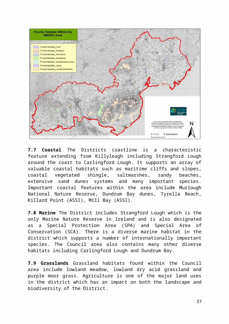
7.4 Detailed below and shown in Figure 7 are a number of examples of each of these diverse environments found within our District. 7.5 Woodlands play an important part in the heritage, culture and biodiversity of Northern Ireland. Northern Ireland remains the least wooded country in Europe with only 6% of the available land. Examples within our District include Bohill Forest Nature Reserve, Castleward Country Park, Tollymore and Castlewellan Forest Park, Fathom Mountain, Rostrevor Oakwood, Creggan Poets Glen
7.6 Wetlands support a variety of plants and animals such as invertebrates, fish, amphibians, mammals and birds. Examples of wetlands include the Newry River, Shimna River ASSI, Aughnadarragh Lough ASSI, Loughkeelan ASSI and Greenan Lough ASSI
7.7 Peatland and Heathland are characteristic of the Irish landscape due to the cold, wet climate found in this area. Areas of interest with regards to this habitat include the Eastern Mournes, Black Lough ASSI, Drumlougher Lough ASSI and Cashel Lough which are home to areas of lowland and blanket bog alongside upland and montane heath.Figure 7: Priority Habitats within Newry, Mourne & Down District
28
7.7 Coastal The Districts coastline is a characteristic feature extending from Killyleagh including Strangford Lough around the coast to Carlingford Lough. It supports an array of valuable coastal habitats such as maritime cliffs and slopes, coastal vegetated shingle, saltmarshes, sandy beaches, extensive sand dunes systems and many important species. Important coastal features within the area include Murlough National Nature Reserve, Dundrum Bay dunes, Tyrella Beach, Killard Point (ASSI), Mill Bay (ASSI).
7.8 Marine The District includes Strangford Lough which is the only Marine Nature Reserve in Ireland and is also designated as a Special Protection Area (SPA) and Special Area of Conservation (SCA). There is a diverse marine habitat in the district which supports a number of internationally important species. The Council area also contains many other diverse habitats including Carlingford Lough and Dundrum Bay.
7.9 Grasslands Grassland habitats found within the Council area include lowland meadow, lowland dry acid grassland and purple moor grass. Agriculture is one of the major land uses in the district which has an impact on both the landscape and biodiversity of the District.
7.10 Gardens and green spaces Often overlooked urban spaces which include gardens, urban parks and industrial sites offer special importance in relation to biodiversity and the species they offer shelter and a haven for.
29
Each of the above areas contain many of our key flora and fauna species with further information included within the Biodiversity Strategies covering the District.
30
8.0 Local Landscape Policy Areas
8.1 At a local level Local Landscape Policy Areas (LLPAs) are those areas within or adjoining settlements that are considered to be of greatest amenity value, landscape quality or local significance, and therefore worthy of protection from undesirable or damaging development. In accordance with SPPS and PPS 6, LLPAs are designated to help protect such environmental assets. LLPAs may include:
1. archaeological sites and monuments and their surroundings; 2. listed and other locally important buildings and their surroundings; 3. river banks and shore lines and associated public access;
attractive vistas, localised hills and other areas of local amenity importance; and
4. areas of local nature conservation importance, including areas of woodland and important tree groups
8.2 LLPAs will help to ensure that new development does not dominate areas of distinctive landscape and townscape character. They may also function as buffer zones between different uses and help to reduce the likelihood of over-intensive development. LLPAs will help to protect those features considered of greatest importance to the local landscape setting.
8.3 With regard to the Newry, Mourne & Down landscape it is worth noting that LLPA’s have been designated across the District and are identified in the existing legacy Area Plans. The features or combination of features that contribute to the environmental quality, integrity or character of an LLPA are specific to individual settlements and differ from place to place. The Ards & Down Plan 2015 and the Banbridge/Newry & Mourne Area Plan 2015 have identified landscape features and spaces in and around the periphery of settlements which are deemed visually important. These designations can provide a setting to the settlement or represent individual features which enhance the settlement of the District. Further details of LLPA’s, including maps indicating their boundaries is contained Paper 6: Environmental Assets.
8.4 In reference to the Landscape Character Assessment it is therefore important that all existing LLPA’s are assessed and that survey work is undertaken to consider other notable areas which may be worthy of future designation, while also assessing whether any existing LLPA’s should be undesignated due to unsuitable development or a detrition in the landscape.
31
9.0 Conclusions9.1 The Newry, Mourne & Down Plan Area contains a diverse range of valuable and vulnerable landscapes. It is therefore evident that following careful consideration of a number of key documents including the Northern Ireland Landscape Character Assessment (NILCA) 2000, the SPG on Wind Energy Development, the Northern Ireland Regional Landscape Character Assessments and the Biodiversity studies carried out for the District that the landscape is highly sensitive to change with a high proportion of the District lying within some form of landscape designation.
9.2 The quality of the Newry, Mourne & Down landscape is world renowned. Its exceptional quality provides an important contribution to our sense of place, history and cultural identity. As the District is both rich and diverse in archaeological and built heritage assets alongside a distinctive and beautiful landscape and therefore must be managed in a sustainable manner to preserve and improve the built and natural environment and halt the loss of biodiversity.
9.3 The planning system therefore plays an important role in conserving, protecting and enhancing this valued environment whilst ensuring it remains responsive and adaptive to the everyday needs of society. This theme therefore remains a key focus of the wider objective of furthering sustainable development which planning authorities and committees have to consider in the preparation of their LDPs.
9.4 Areas identified as being vulnerable to change within the District include
- All of the iconic Mournes AONB, with particular reference being made to the high Mournes, the entirety of the Ring of Gullion AONB and the southern portion of the Strangford and Lecale AONB.
- Strangford & Carlingford Loughs are considered particularly sensitive to all types of development given its wealth of nature heritage features all of which are identified within Paper 6: Environmental Assets.
- All European designated sites, including 3 SPA’s, 11 SAC’s and 4 Ramsar Sites as also identified within the Paper 6.
9.5 It is therefore apparent that the Local Development Plan process plays an important role for Council in identifying key features and assets of the countryside while balancing the needs of the rural areas and communities against protecting the environment. Additional or amended local policies may therefore be brought forward in the LDP to complement or amplify regional policies on matters specific to the local circumstances.
9.6 This will involve consultation with local communities and the general public. Consideration must therefore also be given to whether the Area of
32
High Scenic Value (AoHSV) included within the Magheraknock Loughs Area should be extended further into the District as well as considering whether other areas of the District would both merit and benefit from being designated as an AoHSV.
9.7 These designations represent a further tier in the landscape classification hierarchy. The District has areas of visually pleasing patterns or combinations of prominent landscape elements which may be free from major intrusion and therefore are particularly sensitive to change and may therefore require additional levels of protection.
9.8 With regards to other landscape designations consideration must also be given to whether all existing LLPAs should remain in the new Plan while also identifying any further areas merit of inclusion.
9.9 Other subjects which should also to be considered as part of this process include whether specific areas within the District should be zoned specifically for turbine development which would help to eradicate the piecemeal development which is currently found in some sections of the District.
9.10 The opportunity now also exists to review the previous Coastal Policy Area which was included within the dBNMAP 2015 and whether this should be extended along the full length of the Districts distinct coastal landscape, while working with adjacent authorities to ensure where possible that a consistent approach is undertaken.
9.11 While the countryside of the District has traditionally contained a substantial number of individual houses and other buildings, significant concern has been expressed by many about development trends and the enhanced pressures being exerted on the countryside.
9.12 It should also be noted that the Landscape Assessment forms part of the Countryside Assessment and will be taken into account when formulating the LDP. It will also form part of the Sustainability Appraisal and should be used to inform the Strategic Environmental Assessment (SEA).
33
Appendix 1 – Landscape Character Areas and Wind Energy Classification for Newry, Mourne & Down District
66. Armagh Drumlins Only a small south easterly portion of this LCA lies within the plan area. The Armagh Drumlins cover an extensive area of rolling north - south orientated drumlins. They are overlooked by the Carrigatuke Hills to the south and fall towards the Loughgall Orchard Belt and fringes of Lough Neagh to the north. The area is drained by numerous small winding streams. Occasional loughs and sedgy mosses occupy the hollows between drumlins. The landform becomes progressively lower and the drumlins more pronounced to the north. Land use is dominated by improved pastures, which are separated by overgrown hedgerows and tree belts. Mature hedgerow ash trees are common.
There are a number of wooded historic estates, which are associated with stone walls and stands of mature trees. The largest estate in the area is at Mullaghbawn. There are numerous scattered dwellings and farms, connected by a network of winding, hedged roads. Large farm barns and ruined stone cottages are common features. There are open views across the landscape from higher points, whist the landscapes between the hills are intimate and enclosed.
Principles for Accommodating New Development
New development can be integrated into the landscape if it is sited on the mid-slopes of drumlins, or close to the break of slope.
Existing hedgerows should be retained or replaced in and around building sites to maintain a continuous landscape pattern and help integrate the edges of new development into the landscape.
Scattered development in the countryside can be accommodated if located sympathetically between trees and hills and if constructed of traditional materials, either stone or white painted pebbledash, with grey roofs.
There are opportunities for the restoration and reuse of traditional older buildings.
Wind Energy Development - High to medium sensitivityThis is a large LCA with a strong drumlin topography and a generally robust landscape pattern that should in theory contribute to a lower sensitivity. However wind energy development is strongly constrained by
34
the relatively small scale and pronounced form of most drumlins. Archaeological settings on drumlin skylines are especially sensitive.
The foothills of Carrigatuke Hills in the south-west of the LCA may offer the best capacity for some form of wind energy development.
67. Armagh/Banbridge Hills The southern tips of this LCA form part of the Newry, Mourne & Down Plan Area. The Armagh/Banbridge Hills character area traverses the border of Banbridge and Armagh Districts. The Upper Bann corridor runs north-south along this border from which hills rise eastwards towards Banbridge and westwards towards Markethill. The landscape is characterised by rolling hills, ridges and shallow valleys. Most slopes have a relatively smooth profile but there are rocky outcrops on the slopes leading up to the summit of Knockiveagh to the south. This is a varied farmland landscape, with a diverse pattern of fields, woodlands and patches of scrub. There are areas of both arable and pasture land but pasture predominates overall. Arable land is generally concentrated on the broad, upper slopes of ridges. To the south, the fields become larger and more open in character as the landform flattens out at the base of the slopes. Here, there is extensive sheep grazing and stud farming. The broader valleys have flatter pastures subdivided by drainage ditches, with patches of moss and regenerating birch-alder woodland.
Substantial farmsteads and outbuildings are often prominent on the upper slopes. Many buildings are associated with shelter stands of mixed broadleaf trees but elsewhere there are typically few hedgerow trees. Many of the buildings are of stone. There are many groups of residential dwellings scattered along rural roads in this area, as well as larger farmhouses and estates.
Principles for Accommodating New Development
Broadleaf woodland planting would help to reinforce the small-scale character of parts of the landscape and to contain recent and future built development.
The use of local building materials, in particular local stone, will help to integrate new buildings into the landscape.
Extensive woodland planting may be a suitable way to integrate new built development into the landscape.
Wind energy development - Medium sensitivityThe broad scale landform and landcover patterns of much of this LCA are of relatively low sensitivity to wind energy development. The landscapes convex form and undulations could offer some topographic screening while features of natural and cultural heritage interest are relatively infrequent on the higher lands. The settings of settlements, historic features and loughs are more sensitive.
35
The higher hills in the west and centre of the LCA, which lie outside the NM&D District may have the best capacity for some form of wind energy development.
68. Carrigatuke Hills The southern half of this LCA forms part of the local plan area. The Carrigatuke Hills extend across southern Armagh from the Ring of Gullion to Keady. This is a large scale landscape of smooth rolling green hills and deep wooded valleys. The higher hills have a wild exposed character, with areas of blanket bog and heather moorland. The hills form a broad continuous upland area with few valleys. The rounded summits are separated by broad upland plateaux. Large conifer plantations create a series of straight edged blocks on the highest hills, where they stand out clearly against open moorland. On the lower rolling hills there are many small woodlands, mature trees and treebelts resulting in a landscape of well treed character.
Bushy hedgerows bound fields, giving a locally enclosed landscape and creating a strong field pattern which enhances the distinctive landform of rounded hills. Wooded streams and loughs are attractive features of the valleys which drain from the hills. These include the valleys of the Carnagh estate, Glen Anne and Ballymoye. Large houses, farms and buildings amongst rolling hills are linked by numerous winding roads, houses and farms, which are often at the end of long tracks. There are no small settlements and Newtownhamilton is the local market town. Archaeological features are associated with some of the hill-tops, such Mullyash Mountain. There are extensive and breathtaking views from the hill-tops particularly Carrigatuke, over the surrounding lowlands.
Principles for Accommodating New Development
TV masts on the hill summits should be kept to a minimum. Large farm buildings require sympathetic siting so that they are
sheltered by landform and existing vegetation. New native planting alongside developments would help integrate development into the landform. Non-native planting would not fit well into the landscape.
The large scale rolling hills provide opportunities to shelter pockets of development. It would be out of character on tops of the higher hills and moorlands but the lower hills and valley sides are more typical locations.
The restoration of old stone cottages and farms is preferable to the construction of new buildings.
Traditional buildings are typically at the end of long access drives rather than on roadside locations. Stone or white painted pebbledash with grey slate roofs are the traditional building materials.
The settings to historic monuments and open hilltops would benefit from protection against development.
Wind Energy Development – Medium sensitivity
36
The large scale landscape of the LCA, the extent of the upland area and the fact that there are relatively few short-range views mean that parts of this LCA are well suited to the accommodation of wind energy development.
The lower and more prominent slopes to the east of the area are more sensitive to wind energy development as is the south-east section of the LCA because of its proximity to the Ring of Gullion. Care should therefore be taken to avoid adverse impacts on the highly sensitive landscape settings of the parts of the uplands that lie close to Newry and the Ring of Gullion.
69. Newry Basin The Newry Basin is a large scale rolling drumlin landscape situated between the Ring of Gullion and the Mourne Mountains. The area is drained by tributaries of the Newry River which flow in attractive river valleys. The drumlins are orientated north-north-west to south-south-east. To the south east, the drumlins are displaced by broader ridges separated by narrow, flat-bottomed valleys with ribbon loughs and bogs such as Derryleckagh Lake and Greenan Lough. To the south of Newry, the Newry River flows in a dramatic, steep sided narrow valley. The Newry Basin is a very diverse area, with a rich heritage of historic landscapes and archaeological sites. The rolling fields have a neat and artificially green appearance, although pastures become increasingly marginal with rocky knolls, bracken and gorse hedgerows towards the foothills of the Mourne Mountains. Elsewhere, well trimmed low hedges and tree belts separate fields, creating an intact and unified landscape pattern. Small woodlands, such as Derryleckagh Wood, are often found on valley sides.
There are occasional panoramic views of the Mourne Mountains from the tops of the drumlins. The landscape seems open and exposed on ridge-tops and enclosed and sheltered within the valleys. There are scattered individual bungalows and large farms throughout the area and the many new immaculate dwellings have a neat suburban feel. New bungalows and derelict stone cottages are often sited on drumlin tops, particularly towards Slieve Roosley. There is a network of small hedged and hedge banked winding roads connecting scattered dwellings. These and the major roads 'roller coaster' over the drumlins, creating a confusing and often disorientating landscape for the traveller. The town of Newry is at the head of the Newry River which leads to Carlingford Lough, the port of Warrenpoint and the small town of Rostrevor are located in sheltered bays along the coast. Narrow Water Castle is an important historic landmark at the entrance to the Newry River.
Principles for Accommodating New Development
Ribbon and scattered rural development within the broader fringes of Newry is visually intrusive where it is sited on ridge-lines. Development
37
should be concentrated in coherent groups located on lower slopes, close to existing buildings.
Development is inappropriate in the broad tranquil valleys at Derryleckagh.
Single dwellings in the countryside could be integrated more easily if located on lower slopes amongst native vegetation. Non-native species are inappropriate. It is important to keep views of the Mournes open. Restoration of old stone cottages would be beneficial.
Large new elements would be visible but the rolling landform can easily accommodate carefully sited development, providing that it is associated with new planting which is designed to link with local field patterns.
Wind energy development - High to medium sensitivityThis diverse landscape contains a number of elements that are sensitive to wind energy development around the fringes of the area. South of Newry the LCA is located between Slieve Gullion and the Mourne Mountains which heightens its landscape and visual sensitivity.
The least sensitive parts of the LCA are the broad drumlin ridges to the north-east, the area around Burren and the rivers edge and industrial landscape south of Newry city centre.
70. Crossmaglen Drumlins and Loughs Crossmaglen Drumlins and Loughs is a lowland landscape on the southern border which is confined to the north and east by the uplands of the Carrigatuke Hills and the Ring of Gullion. This is a diverse and well structured landscape of rolling green drumlins and some elevated hills with scrub, bog or small loughs occupying the land in between. Some lough shores are wooded and many are inaccessible as they are fringed with extensive areas of moss. Fields are predominantly pasture and are of a regular shape and size.
They are enclosed by dense hedgerows with numerous hedgerow trees, which create strong field patterns. Some pastures are abandoned and scrubby. Rivers, including Creggan River, pass inconspicuously between drumlins and are crossed by attractive stone bridges. Roller-coaster roads wind across the drumlins making orientation difficult. They connect roadside houses, which are traditionally situated at the ends of access tracks. Scattered derelict stone cottages and wooden bungalows are prominent on drumlin summits and there is piecemeal new development. The principal settlement is Crossmaglen, at the junction of several rural roads. Archaeological features, such as the Drumhill standing stone, are important.
The Ring of Gullion creates a strong backdrop, with hilltop towers overlooking the drumlins. Isolation of the area by the uplands has given it a remote and deeply rural character.
38
Principles for Accommodating New Development
Dereliction of traditional dwellings could be curbed by their restoration. The use of vernacular styles and materials in new buildings (ie stone bungalows with slate roofs) would help conserve the landscape character. Traditional locations for houses are on the tops or sides of drumlins.
Small-scale development may be accommodated within this rolling, well structured landscape, provided it is accompanied by new planting. Development should occur within the existing landscape framework, retaining hedgerows and trees where possible; large-scale development may be prominent in views from the adjacent uplands.
Development should not impinge on the wider landscape setting of archaeological features such as crannogs and raths.
Wind Energy Development – High to medium sensitivityThe higher ground towards the centre of the LCA may have greater capacity than other areas to accommodate wind energy developmentThe role of the area as forming part of the setting of the nearby Ring of Gullion together with its strong rural and relatively unspoilt character alongside its wealth of archaeological sites increase this areas sensitivity.
71. Ring of Gullion Situated on the southern border of Northern Ireland, the Ring of Gullion is a distinctive circle of hills around the striking landmark of Slieve Gullion, which originated as a volcanic plug. The 'Ring' is underlain by a dome of intrusive igneous rocks. The volcanic hills create a knobbly, uneven skyline with many rocky outcrops. Between the steep hills are river valleys and extensive areas of bog. Cam Lough is a linear lough within a valley to the north of Slieve Gullion. The vegetation is predominantly upland grass, heather and moorland on the hilltops, with pasture on the lower land, bordered by stone walls and gorse hedgerows. Field boundaries form striking patterns on some hill sides, particularly in areas where there are long 'ladder farms'. Commercial forestry plantations occur in large blocks on the hillsides.
In the southern part of the area, these extend across the summits and diminish the apparent scale of the landform. The lower slopes are dotted with a mixture of stone small holdings and modern pebbledash bungalows. The majority of the new development is sited in an ad-hoc fashion, often at a distance from the roads. Forkill and Meigh are two of the main settlements within the area. The whole area has an enclosed, isolated character, with derelict stone walls on the upper slopes and abandoned stone farmsteads and barns. It has long been an important 'gateway' landscape at the border between the Republic and Northern Ireland. The area is extremely rich in archaeological and historical features, including a variety of cairns, castles and cashels. Radio masts and towers dominate the skylines.
39
Principles for Accommodating New Development
The uplands are very scenic and wild and over development would not be characteristic.
The restoration of traditional dwellings should be encouraged. Development on ridges would be highly visible but the landform may
accommodate some small scale development within low undulating areas.
The proliferation of scattered piecemeal development throughout the inner basin of the Ring is already threatening the special scenic qualities of this distinctive landscape; further ad hoc development should be discouraged and the use of building materials carefully controlled.
Wind Energy Development – HighSensitivity to wind energy development is very high due to the topography of the landscape, the dispersed settlement pattern and a high concentration of cultural and natural assets.
Slieve Gullion is located centrally within the LCA and turbines located within this vicinity could dominate the entire area. Care should therefore be taken to avoid adverse impacts on the extremely sensitive, open, exposed hills or upper slopes. It should also be noted that due to its close proximity to Carlingford Lough there may be seaward issues to consider in the future.
72. Slieve Roosley Between Newry and the Mourne Mountains in the south of the country, the Slieve Roosley landscape comprises a group of open, exposed hills with a rugged profile. These rise to 364m at Slieve Roe and include the surrounding farmed footslopes, which are dissected by river valleys. The Rostrevor Glen and Kilbroney River together form a marked feature along the eastern boundary of the area, which is underlain by a complex geology of igneous and sedimentary rocks. The hills are used for sheep grazing and are characterised by rough, open, unfenced pastures of moorland grasses, gorse, bracken and sedges. The fringes comprise semi-improved pastures of small fields enclosed by stone walls and gorsey hedgerows, which progressively becomes rougher as the land rises. There are a few trees in the hedgerows on the footslopes and in the glens but no trees on the hilltops.
Scattered settlement is concentrated around the edges of the hills and along the glens, including the village of Mayobridge. There is a mixture of old cottages and farms, as well as some new buildings, which are predominantly small in scale. Narrow roads are unfenced on the hilltops and enclosed by stone walls at lower elevations. They connect settlements and wind across the hills providing long, open, panoramic views to the dramatic horizon of the Mourne Mountains and into the intricate patchwork of the valleys below. This is an attractive open landscape of windswept, wild hilltops and more intimate valleys and
40
footslopes. The area is rich in archaeological remains such as raths, standing stones, graves and earthworks. On the upper slopes, the historic townland boundaries are prominent in areas enclosed during the potato famine, adding interest and diversity to the landscape.
Principles for Accommodating New Development
Radio masts are the main threat to the open summits and should be kept to a minimum.
The restoration of derelict stone cottages would help conserve traditional buildings within the area.
New buildings would be least intrusive if they were constructed near to Mayobridge and built in traditional styles using local building materials.
Wind Energy Development – HighThe combination of an elevated landscape which includes intimate valleys and footslope landscapes gives rise to an area of high scenic quality.
The outer hills to south and north of Mayobridge may be better equipped to accommodate wind energy development. Particular care should be taken to avoid adverse impacts on the distinctive skyline of the upland ridges and views to and from the Mournes, Carlingford Lough and Carlingford Mountain.
Transboundary issues and seaward issues may arise if wind energy development were to occur within areas of County Louth or Carlingford Lough
73. Kilkeel Coast The Kilkeel Coast extends from Killowen Point to Ballymartin. It comprises gently undulating, coastal lowland between 0 m and 30 m AOD. The land falls gently and flattens out towards the shallow, sandy coastline. The lowland is dissected by numerous rocky burns and by the larger Kilkeel River, White Water and Cassy Water. The rivers flow in deep, narrow channels strewn with rocks and boulders. They are not prominent in the wider landscape but are attractive local features. The steep gullies are often clothed with trees and scrubby vegetation. Medium sized fields are separated by open banks, hedgerows and a few trees, as well as distinctive, robust walls built from rounded granite boulders. The walls are often topped with hedges. There are small attractive areas of tall yellow reeds and marsh associated with the ponds and wetlands near to the mouth of the White Water and an extensive salt marsh at Mill Bay.
There is a scattered mix of old cottages and more recent development along the A2 coastal road and numerous minor roads. Extensive ribbon development has blurred the fringes of Kilkeel and is a prominent element in this open landscape. Caravan sites are located along flat grassy headlands of the coastal fringe. Green Castle is a local landmark on Greencastle Point and is one of a number of sites of archaeological
41
interest in the area. The flat landscapes just inland from the coast are pitted with sand and gravel quarries, many of which are disused. There are open, expansive views across the coast, Carlingford Lough and mudflats, into the farmland of the 'Kingdom of Mourne' and the Mourne Mountains. It is a peaceful landscape of calm lapping water, salty air and calling sea birds along muddy estuary sides.
Principles for Accommodating New Development
Existing ribbon development already detracts from local landscape character. Further development should be clustered in small coherent groups of buildings to reduce further intrusion and should be associated with tree planting.
A combination of planting and gently graded embankments may help to reduce the impact of existing works to the west of Kilkeel.
Pressure from tourism and the continued expansion of caravan sites requires careful management to avoid detracting from the existing landscape character. Strategic shelterbelts and minor earth mounding may help screen existing and new developments.
Wind Energy Development – High to mediumA large portion of this LCA forms an important setting and foreground to views of the Mournes and Carlingford Lough and Mountain. Towards the south-east coast the influence of development and limited inland views tend to reduce landscape sensitivity. The open, exposed uninhabited coastal areas should also be protected.
74. Kingdom of Mourne The Kingdom of Mourne comprises the rolling footslopes of the Mourne Mountains, including the outlying mountain of Knockchree. The land falls to the coastal fringe to the south and is dissected by numerous parallel streams and rivers running broadly north-west to south-east towards the coast. A patchwork of medium sized square pastures is divided by highly distinctive and robust stone walls of glacial granite boulders. These rounded boulder walls without mortar dominate the landscape, creating a unique and unified landscape pattern. Vegetation is limited to occasional scattered trees, distinctive yellow gorse along field boundaries and patchy deciduous woodland in the valleys.
Large regular shaped coniferous plantations clothe the summit of Knockhree and the valley slopes of Annalong River. There are numerous scattered individual houses and farms along a dense network of narrow roads, which are aligned perpendicular to the slopes and in parallel with the landform. Most roads run along spurs with occasional links across the valley streams via stone bridges. Buildings are a mixture of old white painted stone cottages and farms and new pebbledash bungalows and houses. Most buildings are small in scale. There are long views to the coast and to the Mourne Mountains, the latter providing a backcloth to the
42
intricate pattern of blocky stone walls and fields. This rural 'stone wall landscape', is known locally as the 'Kingdom of Mourne'.
Principles for Accommodating New Development
Continued scattered housing and bungalow development throughout the area is leading to the erosion of its rural character. In particular, the impact of ornamental plants and garden 'furniture' often has a negative influence. The area has reached its capacity for such development and the restoration of any derelict stone buildings should be a priority over the construction of new buildings.
Large scale or vertical development (including telegraph poles and telecommunication masts) would be particularly disruptive in this area, as would the use of any building material other than stone.
Wind Energy Development – HighThis landscape is highly sensitive to physical and visual disruption due to the landscape being generally open with a distinctive pattern of small to medium field enclosures which appear visible from within the landscape and higher land.
Care should be taken to avoid adverse impacts on the sensitive visually prominent and open exposed upper slopes and shorelines. Transboundary and seaward issues may arise due to the proximity of County Louth and the coastline.
75. Mourne Mountains The prominent pyramidal peaks of the Mourne Mountains form a stunning backdrop to views throughout south-eastern Northern Ireland. They comprise an area of distinct steep rocky summits rising to 850m at Slieve Donard. The underlying geology is granite which is reflected by the characteristic tors which cap the mountain tops. It is a landscape of exposed, thin grass cover, rock and scree slopes. There are no less than 12 high peaks grouped close together near the highest summit of Slieve Donard. The open mountain slopes are predominantly rough grass and heather, close-cropped by sheep. Stone walls snake up the lower slopes but higher up there are no field boundaries. Loughs, reservoirs and rocky mountain streams occupy the steep combes and glens, which dissect the mountain ridges. Areas of blanket bog on the narrow plateau between the peaks are punctuated by small rounded loughs, the sources of the many rivers and streams which radiate from the mountains. Broadleafed woodland extends up the glens from the surrounding lowlands, where there is also some commercial forestry. The Silent Valley, containing the Silent Valley Reservoir, is a popular tourist destination and the whole area is a mecca for walkers and climbers.
There is no settlement on the upper hillslopes and mountain tops and only sparse derelict stone cottages and barns on the lower hillside fringes. Very few roads penetrate the mountains, Spelga Pass being the only place
43
where the landform allows the passage of a road. There are stunning, long distance, panoramic views to the sea, across the unique stone wall landscape known as the 'Kingdom of Mourne' and across the lower land to the north. It is an open, exposed, wilderness mountain landscape and its distinctive character is reflected by its designation as an Area of Outstanding Natural Beauty. The Eastern Mournes are also designated as an ASSI, as a result of their geological and physiographical features as well as heathland and upland flora. The Mourne Wall is of historic interest.
Any development on skylines or within open treeless landscapes would be highly visible. Its accommodation within hollows sheltered by scrub and traditional stone walls should be encouraged.
The restoration of traditional, small stone cottages and barns is preferable to the construction of new buildings; the use of local stone is essential. Large scale barns would be inappropriate in this upland landscape.
The development of wind farms, radio masts, reservoirs and associated infrastructure should be discouraged in this highly sensitive landscape. Careful visual analysis would be required before construction.
Wind Energy Development – HighWithin this character area there is a collection of distinctive mountain summits, widespread visibility and memorable skyline profiles. Care should therefore be taken to avoid adverse impacts on the visually prominent and open, exposed upper slopes, ridges or rocky crags. There were no operational wind farms in this LCA.
76. Ballyroney Basin The Ballyroney Basin occupies a lowland waterlogged area of land enclosed by the Slieve Croob Summits to the north-east, the Mourne Mountains to the south-east and the Iveagh Slopes to the west. The area is underlain by a solid geology of intrusive igneous rocks, resulting in a flat and waterlogged landscape of extensive moss and loughs, which is interrupted by distinct drumlins. The moss supports rushes and sedges, heather, gorse and scrubby woodland consisting of regenerating birch and willow. Lackan Bog, to the east of Ballyroney, has been assigned ASSI status and represents one of the largest single blocks of lowland peatland left in County Down. Drumlins are farmed and pastures are enclosed by gappy hedgerows with occasional hedgerow trees.
Built development is clustered on drumlins and is linked by roads, which cross the waterlogged basin on high embankments. A number of settlements are sited on drumlins in riverside locations but built development is scattered evenly across higher land. The small white-rendered settlements create attractive features in the landscape. The striking town of Rathfriland sits on top of a prominent hill which rises out of the flat plain. It is a major landmark and acts as a radial focus for roads across the Basin. Views are typically short as they are interrupted by
44
drumlins and the dense pockets of gorse and birch on the waterlogged land. However, the Mourne Mountains form a striking backdrop to the Basin as a whole. The River Bann passes through the basin but its course does not influence the landscape as it winds its way inconspicuously between drumlins and under stone bridges.
Principles for Accommodating New Development
New development will be most inconspicuous if it is concentrated around existing hamlets rather than spreading across the rural countryside, or as dense ribbon development along the roads.
Wind Energy Development – High to mediumThe variation in topography over short distances and the small scale drumlins mean that the landscape could become overwhelmed by poorly sited wind energy development
To the south of this LCA there are regular views out of the landscape to the Mourne Mountains and this section therefore plays an important role in providing a key setting. Within the northern section there are fewer sensitive sites and the landscape is less significant in forming a setting to the Mourne Mountains, however the majority of this portion lies outside the Newry, Mourne & Down District. There are also a considerable number of cultural heritage features worthy of protection.
77. Iveagh Slopes The Iveagh Slopes are the northern slopes of Knockiveagh. They support marginal pasture which is grazed by sheep and some cattle; scattered patches of gorse add texture to the landscape. The upper plateau is undulating, with areas of bog within the numerous shallow depressions. These hollows are often emphasised by the hedgerow pattern, which radiates from the centre of the depression. The upper slopes of Knockiveagh are littered with rocky outcrops. There is a distinctive elongated field pattern, with hedgerows running parallel to the slope contours. The landscape is relatively open, with scattered hedgerow trees, particularly on lower slopes. However, many of the narrow roads have a more sheltered character and are bounded by hedgerows with hedgerow trees. The settlement pattern is a regular scattering of farmsteads and their outbuildings; villages are rare, although small clusters have grown up at the main road junctions. The farms are often situated at the end of long, straight lanes which sets them back from the road. There are long views across Northern Ireland to the Sperrins and the Mournes when visibility is clear.
Principles for Accommodating New Development The siting of built development at the end of long driveways, set back
from the road, is appropriate to the character of the area.
45
Siting new development on the lower slopes will ensure that the wild rocky character of the upland areas is conserved.
The use of natural stone for built development and farm outbuildings is characteristic of this upland area.
Small clusters of dwellings are sited at road junctions; ribbon development spreading out from these junctions is not typical of the area.
Wind Energy Development - MediumA small southerly portion of this LCA is contained within the Newry, Mourne & Down District Council Area. Care should be taken to avoid adverse impacts on areas with long distance views to the Mournes as well as protecting prominent and open exposed upper slopes.
83. Lower Slieve Croob Foothills The Lower Slieve Croob Foothills form a smooth, rolling, rural area of high ground (reaching approximately 200m) to the west of the craggy, pointed Slieve Croob Summits. It comprises rolling ridges and gently incised glens which are mostly aligned in a SW-NE direction. Pasture is the predominant land use and the strong geometric field pattern is an important and prominent feature of the landscape. Farms are relatively large and most have numerous outbuildings. They are often well integrated by a unified style or colour scheme. Those on the floor of the glen are often associated with stands of beech trees. The brightly coloured roofs of farm buildings are attractive, contrasting with the landscape and relating the outbuildings to their farms. Farms are evenly distributed and there are no major settlements within the area.
Principles for Accommodating New Development
Colours and finishes applied to farm outbuildings may create a sense of unity between buildings. Traditional colours such as reds are common in this area.
Inappropriate building styles and ornamental gardens associated with new housing could be intrusive within the tranquil rural landscape of the glens.
Wind Energy Development – High to Medium A small easterly section of this LCA is located within the Newry, Mourne & Down District. The open landscape offers wide visibility to the landscapes beyond, most notably the Mourne AONB increasing the sensitivity of the area. Particular care should be taken to avoid adverse impacts on areas with distinctive views to the surrounding Slieve Croob Summits.
84. Mourne Foothills The Mourne Foothills landscape wraps around the northern fringes of the massive summits of Slieve Croob and the Mourne Mountains. The area includes the town of Castlewellan which lies between these two major upland areas at a height of 100 m above sea level. The characteristic rugged scenery, which includes some distinctive hill summits, rocky
46
outcrops and patches of gorse, has been moulded from intrusive igneous rocks, primarily granites. A strong landscape pattern of geometric pastures is reinforced by sturdy stone walls and well maintained hedgerows, which are often boosted by gorse; stands of wind-blown pines add further texture to the landscape. Sheep grazing dominates, especially on upper slopes. The scattered whitewashed dwellings and farms and red painted outbuildings stand out clearly against the greens and browns of the landscape. The traditional buildings are small in scale and are well integrated within the upland landscape.
Settlements are distributed densely across the valley sides, linked by a network of small roads, which follow local ridge-lines and valleys. Large conifer plantations clothe the lower slopes of the Mournes in this area. They include the Castlewellan and Tollymore Forest Parks and the plantations on the slopes above Newcastle. Quarries are present, both working and disused and archaeological remains are commonplace including cashels, raths, forts and the famous Legananny Dolmen. Elevated points, such as White Hill, give dramatic views over the surrounding lowland landscapes of the Newcastle Valleys and the Quoile Valley Lowlands.
Principles for Accommodating New Development
Traditional stone cottages should act as a reference for modern styles of housing in this area; simple designs using local materials and incorporating vernacular features are most appropriate.
Features such as stands of pine should be conserved; they may be used to shelter dwellings in exposed positions or as a means for integrating new development.
Wind Energy Development – HighThe majority of this landscape is highly sensitive to wind energy development. It is a varied and rugged landscape of high scenic quality which performs an important role in providing an outstanding setting to other more elevated landscapes adjacent. Care should also be taken to avoid adverse impacts on areas with distinctive views to the surrounding Slieve Croob Summits.
The north-eastern part of the LCA may be the best suited area to accommodate some form of wind energy development.
85. Newcastle Valleys The Newcastle Valleys is an area of rolling ridges of pasture which links the Mourne Foothills to the Tyrella Coastal Dunes. It includes the river courses of the Burren, Ballybannan and Moneycarragh Rivers as far as Dundrum Bay. This is a diverse landscape, with medium-sized pastures divided by broken stone walls and gorse hedgerows. Hedgerow trees and shelterbelts around farms add some tree cover and the mature linear woodlands along some parts of the river corridors provide a visual link to
47
the more extensive wooded landscapes of the Tollymore Forest Park to the north.
Houses are scattered throughout the area; vernacular single storey white-finished cottages are prominent, although there has been a proliferation of the modern bungalows, especially on the low ground around Newcastle. Newcastle is sheltered by the looming silhouettes of Slieve Donard and Slievnacloy, which dwarf the surrounding landscape. The scattering of individual roadside houses in the vicinity of Newcastle tends to blur the edges between the larger settlement and the distinctive neighbouring villages of Maghera, Bryansford and Dundrum. The relatively dense road network has encouraged this pattern of piecemeal development. There are small conifer plantations and patches of linear woodland in the upper reaches of the valleys and numerous archaeological remains including raths, standing stones, chambered graves and souterrains.
Principles for Accommodating New Development
Built development, which is located within the valleys and avoids prominent ridge-lines, will be most easily accommodated.
The siting of new built development in a concentrated form, around existing settlements, will avoid continuous urban sprawl along the roads.
The conservation of the 'green tongues' of linear woodland along the river valleys would protect the setting of the villages and the integrity of the wider landscape pattern since the woodlands provide valuable links to the more extensive Forest Parks to the north.
Traditional cottages should be conserved where possible to retain the character of the area. New buildings may use traditional architectural forms and features to integrate them into this rural area.
Wind Energy Development – HighThe mixture of ridges and valleys contained within this LCA on the margins of the Mournes make this area very vulnerable to change due to their complex and varied character together with a high concentration of archaeological sites. The north eastern part of the LCA is the most likely to be able to accommodate some form of wind energy while particular care should be taken to avoid adverse impacts pm areas with distinctive views to the Slieve Croob summits.
86. Tyrella Coastal Dunes The Tyrella Coastal Dunes is a strip of coastline which lies behind Dundrum (Outer) Bay on the south Down coast, between St John's Point in the east and Newcastle in the west. The area is dominated by extensive sand dunes. Their hummocky forms are covered in windswept Marram grass backed by flat farmland which supports rough grazing. A long sandy beach and the extensive mudflats at Dundrum Inner Bay together create a flat expanse which contrasts dramatically with the looming peaks of the Mourne Mountains. The beach becomes progressively stonier towards
48
Newcastle. The flat coastal strip also contrasts with the undulating land of the Quoile Valley Lowlands and Newcastle Valleys to the north and west. The main A2 road runs along the coast and is bordered by a ribbon of housing and development. Close to Newcastle, caravan sites and industrial development add to the variety of modern housing styles which back the dunes. The greens of the Royal County Down golf course provide a further contrast in landscape character on the fringes of Newcastle.
Principles for Accommodating New Development The vernacular style (ie low, white-finished cottages) may be replicated
in modern architecture. Small clustered settlements should be sought rather than infill along the coastal road which would lead to continuous ribbon development; views to the dunes and sea should be conserved by ensuring that undeveloped sections are maintained between settlements.
Boundaries around housing are most appropriate if they respond to traditional styles and materials; stone walls, hedgerows or post and wire fencing with gorse are all suitable forms of boundary. Ranch style fencing, brick walls or ornamental planting are inappropriate in this open, coastal and windswept landscape.
Caravan parks should be sheltered by landforms and use local plant species to provide screening and some integration in the landscape. They should be set well back from the dunes where their visual and landscape impact would be minimised.
Wind Energy Development – HighThe Tyrella Coastal Dunes are highly sensitive to wind energy development primarily due to their open and exposed character and the important role they play in providing a setting to the Mourne Mountains. Any form of wind energy development is likely to interrupt important skylines and would therefore be intrusive into this sensitive landscape.
Due to the proximity of Carlingford Lough and the south Down coast there may be seaward issues to consider in the future.
87. Slieve Croob Summits The Slieve Croob Summits are a series of rounded summits formed from intrusive igneous rocks within a surrounding lowland area of sedimentary rocks. They stand out as distinct massive rocky summits with thin grass cover and shattered rocky screes. The land rises to a height of 534m at Slieve Croob. The lower slopes are marginal pasture divided by broken stone walls and small stone cottages, many of which lie derelict. Stunted, wind-sculpted trees stand against these cottages or nestle in the more sheltered slopes of this exposed environment. The summits are an open, rugged landscape, with only a few conifer plantations. Drumkeeragh Forest, on the slopes of White Hill, is the largest. Few roads cross the landscape but viewpoints such as Windy Gap allow panoramic views over the surrounding lowlands, as well as across to the Mourne Mountains. The prominent ridge-lines are visible from miles around, particularly those
49
formed by the Slieve Croob/Slievenisky complex and Slievegarran. Cashels, raths and standing stones are found on many of the slopes leading to the Slieve Croob summits. The most important is the Legananny Dolmen, an important chambered grave site
Principles for Accommodating New Development
This upland landscape is extremely sensitive to built development; renovation of traditional stone cottages should take precedence over building new dwellings.
Wind Energy Development – HighThe openness of this landscape together with its high visibility and its important role in providing a gateway and mid-distance views to the Mournes AONB make this LCA very sensitive to wind energy development.
The lower slopes on the north-eastern fringe of this LCA away from the higher ridgelines may be the most appropriate location for wind energy development. Care should be taken to avoid adverse impacts on the sensitive prominent ridgelines of Slieve Croob.
88. Craggy Dromara Uplands An elevated drumlin landscape to the east of Dromara with a rugged, relatively wild character and a rough texture. The summits are separated by a rolling plateau of marginal farmland and the rounded drumlin landform is broken by numerous rocky outcrops and clumps of gorse. Pastures are of varied shapes and sizes and many are enclosed by low, broken stone walls. Overgrown hedgerows, clumps of gorse, rocky outcrops and patches of marshy farmland give the landscape an untamed character, although these pockets of rough land are interspersed by rolling pastures. There are no woodlands, but stands of Scot's pine and groups of mature oak trees shelter some of the older farmsteads. Holly is characteristic of hedgerows. Derelict farmsteads are often juxtaposed with more recent bungalow development along principal roads, such as the B2 and the roads alongside Lough Aghery and Cluntagh Lough. Traditional white farmsteads with stone barns are prominent and are often sited close to dramatic rocky outcrops. A rath, sited on a local skyline to the north west of Dromara, is a special local landscape feature and forms part of the setting for the attractive historic mill buildings at Woodford.
Principles for Accommodating New Development
Local roads are already reaching their capacity to accommodate linear ribbon development.
The presence of existing trees of stature and the planting of native species may assist the integration of new buildings in the landscape.
Conservation of existing stone walls and gateposts, using local stone for repairs and building new stone walls will help to retain local identity.
50

Restoration of derelict buildings and their adjacent paddocks will conserve the traditional built styles of the area.
Wind Energy Development – HighThe eastern section of this LCA is located within the Newry, Mourne & Down District Council area. The landscape forms a foreground to views of the Mournes and Slieve Croob summits. Wind energy development on the drumlins found to the east may not be appropriate due to the scale of the landscape not being sufficiently large enough to accommodate this type of development.
90. Ravarnet Valley Only the southern portion falls within the plan area. The Ravarnet Valley landscape is found to the south of Lisburn, in the broad valley of the Ravarnet River and its tributaries. The lowland has an undulating landform, with numerous shallow drumlins and elongated, rounded hills. Many of the drumlins have a rather amorphous form and are separated by shallow hollows; the inter-drumlin hollows are often poorly drained, with patches of marsh and a hummocky, uneven terrain. The broader floodplains have a more remote, tranquil character and the relatively long views in these areas contrast with the enclosure of the surrounding drumlin landscapes. The neat patchwork of fields and hedgerows on the drumlins is less predictable in the floodplains and is sometimes interrupted by patches of dense carr woodland, rushes and gorse. There are some loughs on parts of the valley floor, particularly in areas where the valley floor has a slightly undulating landform. The group of loughs to the north of Magheraknock are particularly attractive. The area has a fairly homogeneous character, with a patchwork of farmland and hedgerows, interspersed with numerous small farmsteads.
The farms are always sited on the midslopes of the drumlins and are linked by winding, narrow roads which follow the higher ground. Recent development has been concentrated along these roads and forms a broadly linear pattern. Hedgerow trees are scattered thinly throughout the landscape and have an important visual presence. Stands of mature trees are concentrated around farmsteads and patches of damp woodland thrive in waterlogged areas. A larger area of woodland persists at Larchfield estate, on the eastern slopes of Windmill Hill, although it is largely hidden behind the high stone walls which surround the estate.
Wind Energy Development – High to mediumThe most easterly quarter of this LCA is included within the Newry, Mourne & Down District. The area around Ballynahinch may be the most appropriate for wind energy development where existing quarrying activity has influenced the character of the landscape, however care must be taken to minimise turbines being associated with pylons.
91. Quoile Valley Lowlands
51
The Quoile Valley Lowlands extend north-south down the centre of Down District, encompassing the courses of the Ballynahinch, Annacloy and Blackstaff Rivers. To the west, the land rises to the summits of Slieve Croob and to the east, the numerous islands of the Strangford Drumlins and Islands stretch into the sea lough. The height and density of the drumlins varies; the landform becomes progressively shallower towards the south but the drumlins on the fringes of Strangford Lough are relatively steep and have a pronounced egg-shaped form. Water courses wind around the drumlins and form small inland loughs or bogs in the inter-drumlin hollows. The loughs often have wooded margins and the bogs show varying degrees of vegetational succession, from open heather and rushes to gorse scrub and small trees. The prominent field pattern is emphasised by well maintained stone walls and hedgerows. Small to medium sized farms support mainly sheep and cattle grazing, although there are arable fields on the better drained drumlins.
Avenues of beech and stands of pine are characteristic features which stand out in the landscape, especially where they occur on the summits of the smooth hillocks. The influence of estates adds to the appearance of a fairly well wooded landscape. Large, white-finished farm houses and small traditional stone dwellings are both present, as well as scattered modern housing; they are connected by a dense network of roads and lanes. Red painted outbuildings are common and add character to the landscape. The drumlin landforms create distinctive landscape settings for the many clustered settlements, including Ballynahinch and Downpatrick. Small roads cross the numerous watercourses on stone bridges. Raths, standing stones and mottes are prominent landscape features, creating a strong sense of landscape history.
Principles for Accommodating New Development
Farm outbuildings may be landmarks within the landscape if they are painted appropriately; red finishes are characteristic of the area.
Traditional stone cottages are particularly characteristic of the area; restoration of these is preferable to new built development.
Wind Energy Development – HighThe small scale of the drumlins and topography, their distinctive profiles and the high concentration of natural and cultural landscape features heighten the areas sensitivity.
Due to the proximity of the south Down coast and Strangford Lough there may be seaward issues to consider. It should also be noted that although Carlingford Lough is located between 30-40km away from the LCA this relationship should be considered especially form higher ground to the south.
92. Ballyquintin and Lecale Coast
52
The Ballyquintin and Lecale Coast landscape character area is underlain by sedimentary rocks which have numerous Dolerite dykes aligned in a NE direction. It occupies the southern tip of the Ards Peninsula below Cloghy and the eastern section of Down District. This is a predominantly coastal landscape and its character is influenced by its extremely windswept position. The flat coastal topography becomes gently undulating towards Downpatrick where it meets the North Lecale Hills. Throughout the area, there are low drumlins with wide open inter-drumlin hollows, often with fen and wetland. The agricultural landscape has a deeply rural character, with extensive sheep grazing. Gorse, which has encroached into the hedgerows and grassland in exposed areas, adds texture to the landscape. The settlements tend to be small; Ardglass is the largest. Scattered dwellings are evenly distributed between the small hamlets and villages. Small vernacular cottages, which assume a simple one storey form, are plentiful. There is a disused airfield at Ringawaddy. Traditional small settlements may be seen throughout the area, notably the clachan of houses at Kearney which has been restored by the National Trust. The A2 runs the length of the coast, linking adjacent settlements. The area has a strong sense of history with numerous historical sites including standing stones, castles, chambered graves, crosses, churches, raths and holy wells. Landmarks such as forts, castles and windmills are highly visible in the open landscape and are often sited on hilltops.
Principles for Accommodating New Development
There are opportunities for the conversion and upgrading of the traditional buildings, which contribute to the distinctive character of the local landscape.
The architectural style and finish of any new buildings and their siting is of utmost importance in such a sensitive rural landscape. Simple, white- rendered finishes are the most appropriate.
Wind Energy Development – HighA significant proportion of this landscape is valued for its scenic quality and openness of the area, wide ranging views and high concentration of natural and cultural sites of interest, many of which are located along the coast. Due to the open low lying and gentle topography wind energy development has the potential to interrupt important skylines.
Care should also be taken to avoid adverse impacts on the historic character of Killough and Ardglass.
It should also be noted that although Carlingford Lough is located between 30-40km away from the LCA this relationship should be considered
93. Portaferry and North Lecale The North Lecale Hills extend from Downpatrick, along the southern edge of Strangford Lough, to Portaferry on the Ards Peninsula, where they create a `gateway' at the mouth of Strangford Lough. The strong visual
53
connection between Strangford and Portaferry is reinforced by the wooded estates on both shores and the physical link provided by the ferry between the two settlements. The hills form a highly visible undulating ridge of gorse covered hills which create a setting for Downpatrick at one end and settings for both Portaferry and Strangford at the other. The hills rise to over 100m at Castlemahon Mountain and at Slieve Patrick, where the landmark of St Patrick's shrine is visible from the surrounding low ground. The foothills support grazing and well structured farmland with well maintained stone walls and white-rendered buildings. Estates and shoreline parkland are an important influence in the landscape contributing stone walls, deciduous woodland and buildings of stature. The overall effect is that of a well managed landscape and the use of traditional colours such as red painted doors, windows, gates and outbuildings create a sense of continuity throughout.
Principles for Accommodating New Development
Conversion of traditional vernacular dwellings is preferable to modern housing styles; new buildings which respond to the vernacular style (rural white-rendered buildings) are most appropriate.
Small scale development of isolated rural dwellings or small clusters of buildings on lower slopes will be most easily accommodated; large scale built development is inappropriate.
There is much potential for improved public access within the hills and some selective access to shoreline areas. Visitor pressure may be accommodated by providing parking facilities and signed footpaths through more robust areas; small, rough surfaced car parks and lay-bys, which avoid urban elements, are most suitable. These may be sheltered by gorse, stone walls and shelterbelts which are typical of the area.
Wind Energy Development – HighThis landscape is of exceptionally high sensitivity to wind energy development due to its small scale and complexity, prominent skylines, important settings, and high visibility. There is also a very strong concentration of valued landscape characteristics and features, reflected in the areas AONB designation.
94. Strangford Drumlins and Islands This waterside landscape of drumlins and loughs, islands and inlets, occupies the southern and western shores of Strangford Lough. The influence of glacial action has produced a complex, convoluted coastline with rocky islets or `pladdies' which is a haven for wildlife and provides a variety of experiences, including long sweeping views, colourful quays, isolated islands and tranquil inlets. The drumlins form a dense pattern and many of the hills are unusually high. Inland, drumlin farmland with a robust network of stone walls predominates. The hollows between the drumlins contain marshy pasture or loughs, which often have well wooded margins. The many small wooded estates make a significant contribution to the wooded character of the area. White-finished farm houses, some
54
large and complex in form, stand out as features in the landscape. Farm outbuildings are often painted red and contrast attractively with the subdued colours of the landscape.
Towards the shores of Strangford Lough the pattern is reversed, with water dominating and the drowned drumlins rising out of the water as small round islands. Their isolated and tranquil character has made them favoured sites for churches, castles and chambered graves, as well as the restored monastic site on Mahee Island. Small settlements lie clustered around local quays and small vernacular white-finished cottages may still be seen in their original form. Sheep grazing dominates, particularly at the edge of the lough. Numerous small roads wind around and across the drumlins, linking small farms and coastal settlements. However, the main A22 cuts directly SE/SW across the landscape, traversing and cutting through drumlins, rather than winding around them. Stone walls and stands of pine and beech are familiar features which enhance the experience of the rolling farmland and water's edge.
Principles for Accommodating New Development
Traditional cottages should be restored or converted before building new dwellings; new houses should be of a small scale, especially along the lough edge and should incorporate traditional features, materials and colours such as simple shapes and white-rendered finishes.
The potential for views across the lough from high points should be maximised by providing viewing places and by ensuring built development is not intrusive.
Wind Energy Development – HighThis landscape consists of small drumlin formations, valued landscape characteristics and features including Strangford Lough. Care should be take taken to avoid impacting on the islands and shores of Strangford Lough and on the sensitive prominent drumlin skylines.
95. Ballygowan Drumlins The Ballygowan Drumlins area is underlain by ancient Silurian rocks which have been covered by glacial deposits. The smooth, rolling drumlin landforms create a dynamic landscape pattern and the eye is constantly drawn to landmarks, such as prominent houses and hilltop features. Ground levels fall gradually towards Strangford Lough and in more low-lying areas, the drumlins exhibit a relatively waterlogged character (and with amore extensive network of watercourses than amongst the drumlins of the adjacent Castlereagh Plateau). This is an open, rolling farmland landscape of large pasture and arable fields divided by low, trimmed hedgerows or wire fences. The occasional hedgerow tree stands out in silhouette against the sky.
55
Large farmhouses of complex architectural form, with extensions and outbuildings, are scattered across the farmland but the settlements of Ballygowan, Saintfield and Comber form clustered nuclei which are linked by fast main roads and a dense network of country roads which are aligned NE/SW. Loughs and damp woodland are found within lowland hollows between drumlins, providing an organic landscape element within a relatively regular landscape pattern. These marshy patches make a valuable contribution to the diversity of the landscape. To the south east of Dundonald, the Enler Valley has a particularly subtle, intimate landscape. The scenic, lush valley slopes provide a contrast to the wetlands and meadows of the valley floor, where the abandoned, overgrown railway embankments are a local landscape feature.
Principles for Accommodating New Development
Siting of new housing should take account of the existing density of development in the countryside. Dwellings which are positioned too close together will create disharmony but the careful use of materials and simple vernacular architectural features may be used to unify a group.
Views from Scrabo Hill are an important issue when considering the siting of new development in the eastern part of the character area.
Some shelter and potential screening for development is provided by the rolling landform; development on drumlin ridge-tops will usually be prominent.
The subtle meadow landscape of the Enler valley is particularly vulnerable to the impact of large scale development; only small groups of buildings can be accommodated here, provided they are associated with informal groups of trees and provided development site boundaries are carefully integrated with surrounding field patterns.
Wind Energy Development – High to mediumThe southern half of this LCA is located within the District. Wind energy development is constrained due to the open character of the landscape with minimal drumlin formations.
96. Castlereagh Plateau – High to medium Only southern tip of this LCA forms part of the plan area. This landscape character area occupies much of Castlereagh District and extends into adjacent areas to the west and south. It is underlain by Silurian sedimentary rocks but its geomorphology has been strongly influenced by glaciation which has created a compact rolling landform of small hummocks and narrow valleys. Its fertile soils create rich pasture which is the predominant land use of the area. Small fields are partitioned by hedges which rise and fall across the landscape, emphasising its contours. The hedges, although often unmanaged and gappy, imbue the landscape with a prominent structure and texture, occasionally enhanced by
56
hedgerow trees. Although large woods are scarce, hedgerow trees and small copses create the impression of a well wooded landscape, especially within low-lying hollows and valleys. Occasional areas of marsh also help to break up the impression of uniform pasture.
Due to its proximity to Belfast, the area is well settled. The edges of towns and villages are ill-defined because of the sprawl of new housing and peripheral cottages. Numerous modern houses and bungalows, often in prominent locations and emphasised by white walls and manicured gardens, are scattered across the open countryside. The traditional grey stone farm buildings are heavily outnumbered by this rural housing. The area is dissected by a network of roads and small lanes. Transmission lines are also prominent and detract from the rural character of the area. The landscape possesses an intriguing mix of scales, sometimes offering long distance views to the sea or the mountainous backdrop of Slieve Croob across a rhythmic rolling landform, and sometimes presenting a more intimate, small scale experience due to the enclosure by hills, hedges and trees.
Principles for Accommodating New Development
The establishment of compact, contained communities rather than disparate, isolated properties will improve the relationship between new buildings and their landscape context and will encourage a more co-ordinated approach.
The use of native planting on the boundaries of developments and of a limited range of building materials - for garden fences and walls, as well as for the buildings themselves, will improve the unity and integration of buildings within the countryside.
Wind Energy Development – High to mediumA small southerly portion is included within the Newry, Mourne & Down District.
Key constraints to wind energy development in this location are the presence of small scale landscape features and views towards Strangford Lough and Slieve Croob within a landform that shows variation in terms of scale and enclosure.
57
Appendix 2: Criteria for Assessing Landscape Sensitivity to Wind Energy Development
58
59
60
Appendix 3 – NMD Regional Seascape Character Areas
Strangford Lough - Seascape 16Strangford Lough is a nearly land locked and sheltered marine inlet with a highly indented coastline that contains a highly distinctive and visually stunning composition of numerous whale-backed islands produced from the drowning of countless drumlins by the sea. The drumlins are found mainly on the west coast with most of those on the east coast having been removed by marine erosion forming small islands and numerous rocky reefs known as ‘pladdies’. Strangford Lough is of particular importance for its marine flora and fauna and is Northern Ireland’s only Marine Conservation Zone. The intimacy experienced along the seclusion of the western shore contrasts with the larger scale and more open appearance of the northern and eastern shores. The area has a long history of settlement with religion, industry and pleasure reflected in a large number of historical features associated with the Lough.
Key Characteristics - A large, sheltered and complex sea lough with a sinuous shoreline. - A visually stunning composition and varied views of the many
drumlin islands, pladdies and inlets. - Long fast-running tidal narrows, with whirlpools and eddies. - An exceptional diversity of marine life. - Extensive areas of mudflats and saltmarsh. - Dense concentration of cultural sites, reflecting the use of the Lough
for settlement, religion, industry and pleasure for many centuries. - Stone bridges and causeways cross water and link islands. - Dense network of winding roads scattered with traditional white-
painted cottages. - Nearly entirely land locked and enclosed by soft rounded hills and
wooded estates.
Lecale Coast – Seascape 17(includes Ballyquinton and Lecale)
The Lecale Coast SCA extends along the east facing coast from Ballyquintin Point down to St. Johns Point and includes a relatively extensive circalittoral zone that extends several kilometres out to sea. There are long distance views across the Irish Sea (South Down) SCA towards the Isle of Man, backed by the more distant coast of north-west England. Inland, gently undulating farmland enclosed by stone walls provides a low lying backdrop with a localised visual influence on the setting of the seascape. The Mourne Mountains are also visible in the backdrop from some areas of open coast towards the southern part of the SCA.
With a horizontal emphasis, the SCA is a low-lying, exposed and windswept coastline with extensive views out to sea. The coastline is predominantly formed of intricate rocks with sections of low-lying soft
61
cliffs, punctured by two small secluded inlets of Killough Bay and Ardglass Harbour which supports an important commercial fishing centre. There are many shipwrecks submerged in shallow water and a scattering of archaeological remains along the coast. There are sheltered fishing harbours at Killough and Ardglass and the open coast road is separated from the sea by a narrow section of open farmland with patches of gorse and stone walls.
Key Characteristics - An intricate and low lying rocky coast punctured by two small
secluded inlets of Killough Bay and Ardglass Harbour. - An open, exposed and windswept appearance with a strong
horizontal emphasis. - The open coastal road and Lecale Way coast path provide
panoramic views across open sea with distant views towards the Isle of Man with the coast of north-west England beyond.
- High energy waves crashing against the rocky shore. - Water of up to 50 m deep with infralittoral fine sands, circalittoral
fine sands, mixed sediments and sandy muds with a large number of shipwrecks scattered across the sea bed.
- Sheltered historic fishing harbours at Killough Bay and Ardglass. - Occasional drumlins and sections of low lying cliffs. - At low tide, the patterns and textures of mud flats and rocky
outcrops add to visual interest. - Guns Island lies just offshore at Ballyhornan and its cliffs support a
small colony of breeding seabirds. - Gently undulating farmland along the coastal edge with patches of
gorse, scrub and stone walls.
Dundrum Bay – Seascape 18 (Includes Ballyquintin and Lecale Coast, Tyrella Coastal Dunes, The Mourne Mountains)
Dundrum Bay SCA, incorporating Dundrum Inner Bay, extends from St John’s Point down to Ballagh Bridge where the Mourne Mountains meet the coast, and includes the shallow waters in the sweeping bay. The Mourne Mountains provide a stunning backdrop to the SCA and the imposing summit of Slieve Donard (850 m) is prominent in views from across the entire seascape. There are distant views across the Irish Sea towards the Isle of Man and the north-west coast of England beyond. Views along the wider coastline are curtailed by intervening landform.
Dundrum Bay is the largest natural bay in Northern Ireland and its sweeping formation provides a contained and sheltered setting for the busy coastal resort of Newcastle, which hosts a range of popular visitor attractions. A huge swath of sandy beach, popular for recreation, is backed by the extensive Murlough dunes. The dune system, dating back 6000 years, has an unusually intact and extensive transition including
62
sand dunes, yellow and grey dunes, dune grassland, heath and scrub. Intertidal mudflats in Inner Dundrum Bay and sublittoral sands in Dundrum Bay are important for wintering birds. Dundrum derives its name from its Norman Castle, in Irish Dún Droma, meaning "fort of the ridge" which is located just outside the SCA boundary. The imposing outline of the Mourne Mountains is integral to the contained and instantly recognisable setting of the bay, particularly when viewed from the sea.
Key Characteristics - A broad sweeping bay with extensive sandy beaches, backed by the
imposing and dramatic outline of the Mourne Mountains. - The huge sweep of sandy beach from Newcastle to Tyrella is backed
by the Murlough dunes which comprise a series of important dune systems.
- Extensive submerged sand banks. - Intertidal mudflats in Inner Dundrum Bay and sublittoral sands in
Dundrum Bay are important for wintering birds. - Beyond the shelter of the inner bay, the coastline has an open and
relatively exposed, windswept appearance. - Distant views across the Irish Sea towards the Isle of Man. - A section of low-lying rocky shore west of St John’s Point. - Shallow waters over infralittoral fine sands with mixed sediments
and occasional rocks close to the shore. - A concentration of archaeological sites reflecting long history of
settlement, with many industrial sites associated with coastal trade and industry.
Mourne Coast – Seascape 19(The Kingdom of Mourne, The Kikeel Coast)
The Mourne Coast SCA extends from St John’s point, across the outer reaches of Dundrum Bay to Ballagh Bridge, and along the coast to Cranfield Point. It also includes a relatively extensive area of shallow sea in the circalittoral zone. The Mourne Mountains provide a stunning backdrop to the SCA and the imposing summit of Slieve Donard (850 m) is prominent in views from across the entire seascape. There are distant views across the Irish Sea SCA towards the Isle of Man and the north-west coast of England beyond and further south, the Cooley Mountains located above the southern side of Carlingford Lough. Inland, the gently undualting coastal plain forms a localised setting to the seascape.
With an imposing and dramatic backdrop of the Mourne Mountains, the SCA has a prevailing open, exposed and windswept appearance with panoramic views of the extensive Irish Sea. The low-lying coast bulges out into the sea and is exposed to the east and south-east to high energy waves. A series of rock platforms alternate with sand beaches with greywacke rock outcrops and gravel beaches further north. Maritime cliffs and slopes and coastal vegetated shingles occur at the northern end of
63
the SCA. Kilkeel is an important commercial fishing centre and there are a large number of shipwrecks scattered across the sea bed.
Key Characteristics- The coast bulges out into the Irish Sea and is exposed to the east
and south-east to waves crashing against rocky platforms. - An open, exposed and windswept appearance with panoramic views
of the Irish Sea. - A gently undulating, coastal lowland with much of the coast
composed of low to moderate sized cliffs, many formed of boulder clay.
- Maritime cliffs and slopes and coastal vegetated shingles occur at the northern end of the SCA.
- From Cranfield Point to Ballymartin, a series of rock platforms alternate with sand beaches.
- From Ballymartin to Green Harbour, there are greywacke rock outcrops and gravel beaches.
- Igneous dyke swarms abound along the northernmost stretch of coast, with 130 dykes occurring between Ballymartin and Newcastle.
- Circalittoral fine sands, infralittoral mixed and coarse sediments and rocks with significant populations of scallop.
Carlingford Lough – Seascape 20(Kilkeel Coast, Mourne Mountains, Newry Basin)
The Carlingford Lough SCA follows the road near to Lough shore from Cranfield Point at the Lough mouth, to the edge of Warrenpoint, and along the southern coast (within the Republic of Ireland) to the outermost headland. To the north, the Mourne Mountains and to the south, the Cooley Mountains combine to form a dramatic backdrop and a partly wooded sense of enclosure to the Lough. Contained by headlands at the Lough mouth, there are long distance views across the Irish Sea.
Carlingford Lough is a shallow and relatively broad sea lough sheltered from the rough waters of the Irish Sea, and is particularly noted for its glacial fjord or sea inlet form. The surrounding summits of the stunning Mourne and Cooley Mountains, with large areas of wooded slopes, are integral features to its contained setting. It is a particularly dynamic and busy seascape with a diversity of land and sea uses and busy shipping lanes leading out to sea. The Newry River and the Newry Canal link the Lough to the nearby city of Newry. There is an extensive shellfish culture and the Lough is also a very popular visitor attraction, offering a wide range of recreational activities. There are extensive mudflats and areas of saltmarsh supporting large numbers of wintering water birds.
Key CharacteristicsA relatively shallow and broad glacial fjord sheltered from the rough waters of the Irish Sea.
64
- Contained by the wooded slopes of the Mourne Mountains to the north of the Lough, and Carlingford Mountain and Black Mountain to the south.
- A predominantly dynamic and busy seascape with a diversity of land and sea uses, - including an extensive shellfish culture.
- A deep, marked shipping channel is busy with passing ferries and container ships.
- Greenore and Warrenpoint are significant commercial freight ports. - Extensive mudflats with saltmarsh occur in Mill Bay, supporting
large numbers of wintering water birds. - Undeveloped headlands provide pockets of remoteness and
tranquillity. - Several marinas, sailing clubs, jetties and slipways provide an
important resource for water-based recreation. - A long history of settlement, defence and maritime industry.
Newry Estuary – Seascape 21(includes Newry Basin)
The Newry Estuary SCA is centred on the lower reaches of the Newry River before it empties into the expanse of Carlingford Lough. It extends up river from the narrow mouth at Warrenport, as far north as the embankment at the south end of the Greenbank Industrial Estate, where the character becomes more riverine in nature. It also includes the Newry Canal that follows the path of the river on its western side. The steep wooded valley sides along much of its length are particularly important to its contained setting. Port and industrial development at Warrenport and Newry also contribute to its setting. Medium range views out to Carlingford Lough are contained by development at the narrow mouth of the river.
With a long association of maritime trade, the SCA is centred on the narrow lower reaches of the Newry River set within a dramatic, steep-sided narrow valley. Running alongside the river, the Newry Canal links the Lough to the nearby city of Newry. The gently meandering river is flanked by a series of historic navigational features with channel markers along its length. Newry Canal, with its impressive archaeological features including pump houses, quays, locks and lock houses, contribute to a strong sense of place. The seclusion of the wooded valley sides contrast with areas of busy large-scale land use of port infrastructure, industrial and commercial development.
Key Characteristics- A very gently meandering tidal river enclosed by dramatic, wooded
valley sides. - Channel markers and navigational features, including the two
lighthouses which replicate round towers on either side of the river, are distinctive features.
65
- A long history of settlement, defence and maritime industry with a number of important Scheduled Monuments.
- Newry Canal and associated impressive industrial archaeological features including pump houses, quays, locks and lock houses.
- The historic Narrow Water Keep is a striking landmark feature on the bank of the Newry.
- Prominent large-scale land use of port infrastructure, industrial and commercial development.
- Deep mudbanks along the river are important feeding areas for wintering wildfowl and waders.
Irish Sea South Down - Seascape 21(does not include any Landscape Character Areas)
The Irish Sea (South Down) SCA is located off the south-east coast and adjoins the outer marine extents of several SCAs located along the coast. Formed above the deep circalittoral zone, sea depth extends to approximately 200 m along the outer northern boundary, becoming progressively shallower to the south and towards the coast where depth is up to approximately 50 m. Habitats are predominantly deep circalittoral mud with smaller areas of deep circalittoral sand, faunal communities on circalittoral rock, with deep circalittoral course and mixed sediments to the north of the SCA. At this distance, features along the low-lying coastline would be hardly discernible although the dramatic outline of the Mourne Mountains and the Cooley
Mountains form a distinctive skyline. To the east, there are distant views the Rhins of Galloway, the Isle of Man and the north-west coast of England beyond. The SCA is notable for its important prawn grounds.
Key Characteristics - A relatively deep sea bed with low energy waves and strong
currents. - Commercial shipping lanes with passing container ships, passenger
ferries and cruise ships. - Important prawn grounds and fisheries. - Sea fishing and sailing across the SCA. - The dramatic outline of the Mourne Mountains and the Cooley
Mountains form important visual features. - Compared to the North Channel SCA, the SCA has a greater sense of
exposure to open sea. - Habitats are predominantly deep circalittoral mud with smaller
areas of deep circalittoral sand, faunal communities on circalittoral rock with deep circalittoral course and mixed sediments to the north of the SCA.
- Several ship wrecks scattered across the sea bed.
66