Embed Size (px)
Citation preview

Wawasee Carrying Capacity Report Elkhart, Kosciusko, and Noble Counties, Indiana
October 2007
Prepared for: Wawasee Area Conservancy Foundation
P.O. Box 584 Syracuse, Indiana 46567
Prepared by:
c/o Sara Peel
708 Roosevelt Road Walkerton, Indiana 46574
(574) 586-3400


Wawasee Carrying Capacity Report October 2007 Elkhart, Kosciusko and Noble Counties, Indiana
Page i 030737.06
TABLE OF CONTENTS PAGE
1.0 Introduction .............................................................................................................................................. 1 2.0 Recreational Carrying Capacity .............................................................................................................. 1 2.1 Lake Physical Characteristics ................................................................................................................. 2 2.2 Use Characteristics ................................................................................................................................... 2 2.3 Environmental Impacts .......................................................................................................................... 3 2.4 Determining Useable Lake Area ............................................................................................................ 5 2.5 Boating Density Options ........................................................................................................................ 5 3.0 Watercraft Census .................................................................................................................................... 7 3.1 BMV Watercraft Registration Census ................................................................................................... 8 3.2 On-lake Watercraft Census .................................................................................................................. 10 3.3 Aerial Watercraft Census ...................................................................................................................... 14 3.4 Census Summary .................................................................................................................................... 16 4.0 User Opinions ........................................................................................................................................ 17 4.1 Survey Methodology .............................................................................................................................. 17 4.2 Survey Results ......................................................................................................................................... 17 5.0 Lake Wawasee Carrying Capacity Analysis ........................................................................................ 22 5.1 Physical Characteristics ......................................................................................................................... 22 5.2 Lake Use Characteristics ....................................................................................................................... 25 5.3 Usable Lake Area ................................................................................................................................... 26 5.4 Optimum Boat Density ........................................................................................................................ 34 5.5 Carrying Capacity Ranges ..................................................................................................................... 35 6.0 Conclusion .............................................................................................................................................. 40 6.1 Lake Wawasee ........................................................................................................................................ 40 6.2 Syracuse Lake ......................................................................................................................................... 41 7.0 Discussion .............................................................................................................................................. 40 7.1 Self-Regulation ....................................................................................................................................... 42 7.2 Public Access Controls ......................................................................................................................... 43 7.3 Riparian Access Controls ..................................................................................................................... 44 7.4 Watercraft-based Regulations .............................................................................................................. 46 7.5 Education and Enforcement ............................................................................................................... 48 8.0 Recommendations ................................................................................................................................. 49 9.0 Literature cited ....................................................................................................................................... 50

Wawasee Carrying Capacity Report October 2007 Elkhart, Kosciusko and Noble Counties, Indiana
Page ii 030737.06
TABLE OF FIGURES PAGE
Figure 1. Impacts of watercraft to aquatic plant communities ...................................................... 4 Figure 2. Approximate viewing locations used for Lake Wawasee on-lake boat censuses ....................................................................................................... 11 Figure 3. General location of common activities on Lake Wawasee .......................................... 16 Figure 4. Activities in which Lake Wawasee and Syracuse Lake users engage by location ................................................................................................... 19 Figure 5. Distribution of crowdedness of Lake Wawasee and Syracuse Lake perception responses ......................................................................................................... 20 Figure 6. Lake depth (bathymetric) map of Lake Wawasee ......................................................... 24 Figure 7. Lake depth (bathymetric) map of Syracuse Lake .......................................................... 25 Figure 8. Areas of Lake Wawasee and Syracuse Lake available for us under Scenario 1, where there are no restrictions on recreational use for any portion of the lake ............................................................................................................. 27 Figure 9. Areas of Lake Wawasee available for use under Scenario 2, where areas already restricted by Indiana statute are excluded from high-speed boat access ............................................................................................ 28 Figure 10. Areas of Syracuse Lake available for use under Scenario 2, where
areas already restricted by Indiana statute are excluded from high-speed boat access ............................................................................................ 29 Figure 11. Areas of Lake Wawasee available for use under Scenario 3A, where high speed boat access is restricted in areas measuring five feet or less in depth ................................................................................................................... 30 Figure 12. Areas of Lake Wawasee available for use under Scenario 3B, where high speed boat access is restricted in areas measuring ten feet or less in depth ................................................................................................................... 31 Figure 13. Areas of Syracuse Lake available for use under Scenario 3A, where high speed boat access is restricted in areas measuring five feet or less in depth ................................................................................................................... 32 Figure 14. Areas of Syracuse Lake available for use under Scenario 3B, where high speed boat access is restricted in areas measuring ten feet or less in depth ................................................................................................................... 33
Wawasee Carrying Capacity Report October 2007 Elkhart, Kosciusko and Noble Counties, Indiana
Page iii 030737.06
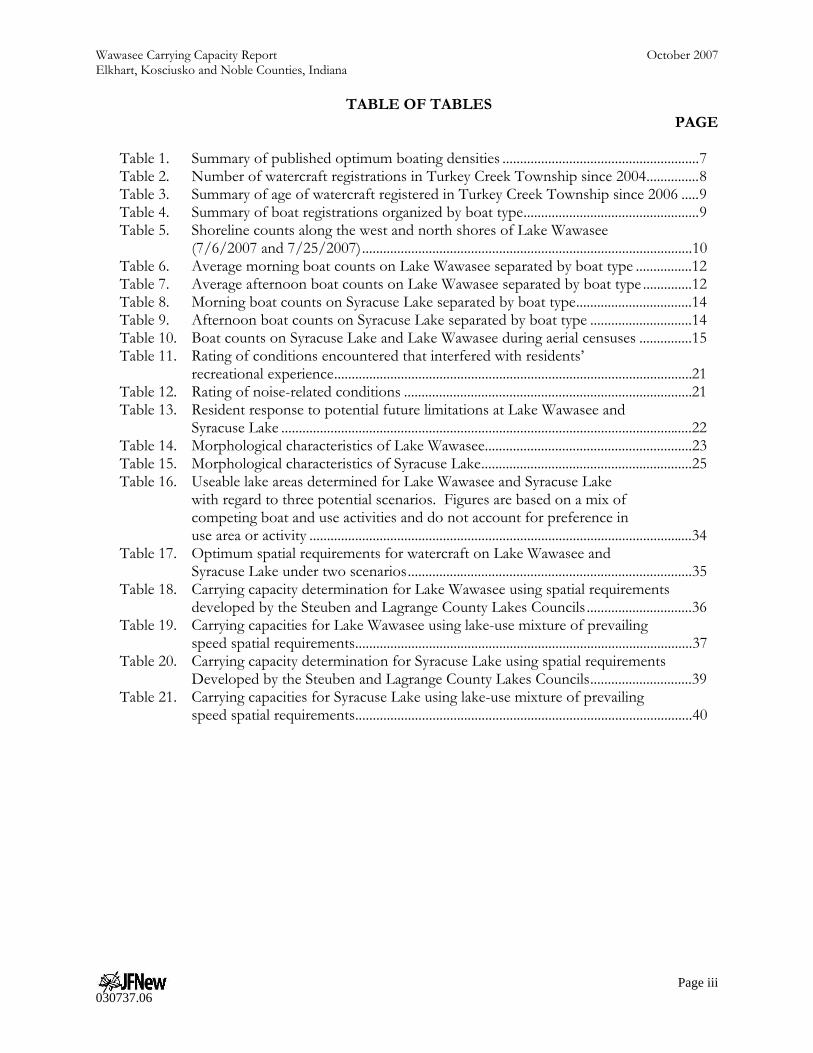
TABLE OF TABLES PAGE
Table 1. Summary of published optimum boating densities ........................................................ 7 Table 2. Number of watercraft registrations in Turkey Creek Township since 2004 ............... 8 Table 3. Summary of age of watercraft registered in Turkey Creek Township since 2006 ..... 9 Table 4. Summary of boat registrations organized by boat type .................................................. 9 Table 5. Shoreline counts along the west and north shores of Lake Wawasee (7/6/2007 and 7/25/2007) .............................................................................................. 10 Table 6. Average morning boat counts on Lake Wawasee separated by boat type ................ 12 Table 7. Average afternoon boat counts on Lake Wawasee separated by boat type .............. 12 Table 8. Morning boat counts on Syracuse Lake separated by boat type ................................. 14 Table 9. Afternoon boat counts on Syracuse Lake separated by boat type ............................. 14 Table 10. Boat counts on Syracuse Lake and Lake Wawasee during aerial censuses ............... 15 Table 11. Rating of conditions encountered that interfered with residents’ recreational experience ...................................................................................................... 21 Table 12. Rating of noise-related conditions .................................................................................. 21 Table 13. Resident response to potential future limitations at Lake Wawasee and Syracuse Lake ..................................................................................................................... 22 Table 14. Morphological characteristics of Lake Wawasee........................................................... 23 Table 15. Morphological characteristics of Syracuse Lake ............................................................ 25 Table 16. Useable lake areas determined for Lake Wawasee and Syracuse Lake with regard to three potential scenarios. Figures are based on a mix of competing boat and use activities and do not account for preference in use area or activity ............................................................................................................. 34 Table 17. Optimum spatial requirements for watercraft on Lake Wawasee and Syracuse Lake under two scenarios ................................................................................. 35 Table 18. Carrying capacity determination for Lake Wawasee using spatial requirements developed by the Steuben and Lagrange County Lakes Councils .............................. 36 Table 19. Carrying capacities for Lake Wawasee using lake-use mixture of prevailing speed spatial requirements ................................................................................................ 37 Table 20. Carrying capacity determination for Syracuse Lake using spatial requirements Developed by the Steuben and Lagrange County Lakes Councils ............................. 39 Table 21. Carrying capacities for Syracuse Lake using lake-use mixture of prevailing speed spatial requirements ................................................................................................ 40

Wawasee Carrying Capacity Report October 2007 Elkhart, Kosciusko and Noble Counties, Indiana
Page iv 030737.06
TABLE OF APPENDICES
Appendix A. Boat Categories Appendix B. User Survey Results

Wawasee Carrying Capacity Report October 2007 Elkhart, Kosciusko and Noble Counties, Indiana
Page 1 030737.06
1.0 INTRODUCTION Lake Wawasee and Syracuse Lake are two connected lakes located south and east of the Town of Syracuse in the northwest corner of Kosciusko County, Indiana. Both lakes are located within Turkey Creek Township, a township which continues to grow at a higher than average rate for Kosciusko County (StatsIndiana, 2007). Much of this growth is centered around Lake Wawasee and Syracuse Lake. Recently, more summer cottages around the lakes have been converted to year-round housing and the number of condominiums and multi-family housing units has increased. As the number of residences adjacent to Lake Wawasee and Syracuse Lake increase, the number of lake users also increase. As evidenced by the user survey, nearly 100% of respondents indicate that they used the lake during their visit. Most users enjoyed swimming and boating activities. The Wawasee Area Conservancy Foundation (WACF) indicated a need to understand the use of Lake Wawasee and Syracuse Lake in terms of boating, fishing, swimming, and other uses. Additionally, WACF desired an understanding of the appropriate level of use of the lakes. Finally, WACF wanted to know how lake users perceived the use level, aesthetic value, and environmental resources of Lake Wawasee and Syracuse Lake. In order to accomplish these tasks, WACF hired JFNew to determine the number of boats presently in use on Lake Wawasee and Syracuse Lake; to ascertain the level of use and enjoyment by the lakes’ users; and to develop a target use rate, or carrying capacity, for the lakes. Additionally, a review of the characteristics of Lake Wawasee and Syracuse Lake as they relate to the lakes’ boat carrying capacity was completed. 2.0 RECREATIONAL CARRYING CAPACITY Lakes are finite resources which are in high demand. As residential development increases around lakes, boating and other on-lake recreational activities increase as well. This increased use coupled with increases in boat size and speed has brought lake over-crowding to the forefront in many communities. Balancing lake use with ecological, economical, and aesthetic impacts is paramount in arriving at balanced, sustainable use levels. Mahoney and Stynes (1995) noted that recreational carrying capacity is based as much on science as it is on user perception. Other researchers agree that every waterbody has a carrying capacity; however, what that capacity is determined to be depends on a number of factors including the waterbody’s size, shape, depth, shoreline development, and most importantly the aesthetic preference of the lake’s user group. Wagner (1990) suggests that there is not one true carrying capacity for each waterbody; rather each lake user has their own perception. This results in there being no single boating densities that will satisfy all users at all times. Jaakson et al. (1994) may state recreational carrying capacity best by indicating that carrying capacity is more a value judgment than a technical decision. With this in mind, Lake Wawasee and Syracuse Lake users should not consider the determination of the recreational carrying capacity of these lakes as the final answer to the lake use question of how many boats is too many boats. Instead, users should consider this determination among other tools and data to limit lake over-crowing and negative environmental and aesthetic impacts. Many factors influence the estimation of a lake’s recreational carrying capacity. These include the physical characteristics of the lake; the lake’s use characteristics (the number of lakeside homes, number of moored and off-lake boats, number of access sites and density of their use, etc.); environmental impacts such as those to the aquatic plant community or lake sediment; area of the lake available for boating; boat density (calculated and actual); and the lake use rate. As each of these include several factors, they will be discussed in more detail below with specifics for each of the lakes discussed in
Wawasee Carrying Capacity Report October 2007 Elkhart, Kosciusko and Noble Counties, Indiana
Page 2 030737.06
subsequent sections.
2.1 Lake Physical Characteristics Many factors affect the recreational carrying capacity of a lake. However, the one factor that cannot be regulated or altered no matter the effort involved is the lake’s physical characteristics or morphology. The lake’s surface area and maximum depth are the most important factors in determining the lake’s use, aesthetic value, and environmental resource. Additionally, the location of shallow shoals, deep holes, and shoreline wetlands determine the locations of highest ecological quality. Another important factor is the lake’s fetch. The fetch represents the maximum open water distance across the lake. Finally, the shoreline development, or how convoluted the shoreline is, determines how much impact motorized craft will have on a waterbody. The shoreline development ratio (SDR) is often used to measure the convolution or the development potential of a lake. It is calculated by dividing the shoreline length by the circumference of a circle that has the same area as the lake. Wagner (1990) detailed the impact of high shoreline development ratios noting that as SDRs increase so does the potential for ecological consequence and safety risk. Wagner noted the following reasons for increased negative impacts: 1) more shoreline housing units and thus users per unit of surface area; 2) tighter and more confined recreational spaces; 3) additional shoreline subject to wake-induced erosion; and 4) greater probability for near-shore, shallow-water depths that are more vulnerable to motor boat impacts. Motorized watercraft impacts to waterbodies are directly correlated with the lake’s physical characteristics; impacts to water clarity, shoreline erosion, and plant distribution increase as boat traffic increases, especially in shallow waters less than several feet deep (UWEX, 2002). 2.2 Use Characteristics Jones (1996) identified the ability of waterbody to accommodate a variety of users attempting mixed uses as the predominant factor in determining a lake’s use rate. As demands for the same space increase, so do the potential conflicts between users. During surveys completed on the Ririe River Reservoir, users noted that social and facility capacity were the two predominant factors in their use of the lake (UDSI, 2004). Users typically stopped using the lake when they perceived that the lake was crowded, therefore the lake was limited by social capacity. Secondarily, users did not enter the lake when they were required to wait for access to the lake through the boat launch. User conflicts are typically based on speed, noise, or maneuverability (Klessig, 2001). Under crowded conditions, Kusler (1972) noted that users typically attempt one of the following:
Tolerance of higher levels of interference or interruption from other users than that which they are comfortable;
Engaging in riskier or more aggressive behavior than is their norm; Movement to less ideal or optimal locations within the same waterbody so that they may continue their activity; or
Leaving the lake. A lake’s major use is determined both by its physical characteristics and by its users. Use levels can be determined in many ways including the number of shoreline dwellings, number of moored boats, number of boats launched daily at the lake’s boat access points, or the number of boats in use. Additional factors that should be considered when assessing waterbody use include craft type, speed, and predominant movement pattern; operator behavior; and overall impacts to the environment. Mahoney and Stynes (1995) identified the following items as keys in determining a lake’s carrying capacity: spatial and temporal use patterns; craft characteristics; and surrounding land use. The

Wawasee Carrying Capacity Report October 2007 Elkhart, Kosciusko and Noble Counties, Indiana
Page 3 030737.06
number of users and their use patterns are defined by the lake’s social carrying capacity or the level of use where the social experience is negatively impacted. 2.3 Environmental Impacts One of the most common impacts associated with motor boating is a decrease in water clarity. As motor boats travel through shallow water, the energy from movement of the boat propeller may be sufficient to resuspend sediment from the lake bottom, decreasing the lake’s water clarity. Several researchers have documented either an increase in turbidity or a decrease in Secchi disk transparency during and following motor boat activity (Wagner, 1990; Asplund, 1996; Yousef et al., 1980). Crisman (1986) reports a decrease in Secchi disk transparency following holiday weekend use of Lake Maxinkuckee in Culver, Indiana. Asplund (1996) also observed poorer water clarity in his study of lakes following weekend boating and that this decrease in water clarity is more pronounced in lakes with generally better water clarity. This finding is particularly significant for many lakes throughout the watershed as they generally exhibit better water clarity than the typical Indiana lake. The ability of a motor boat to resuspend sediment from the lake bottom depends on several factors. Some of these factors, such as boat length, motor size, and boat speed, are related to the boat itself and the boat’s operator. Yousef et al. (1978) found that 10 horsepower (hp) motors were capable of mixing the water column to a depth of 6 feet (1.8 m), while 50 hp motors were capable of mixing the water column to a depth of 15 feet (4.6 m). While larger motor sizes have a greater potential to resuspend sediments than smaller motors, longer boats and higher speeds do not automatically translate to a greater ability to resuspend sediments. Boats that are ‘planing’ on the water actually have little impact on the lake’s bottom. This is because the velocity of water at the lake bottom created by a motor boat depends on the boat’s displacement, which is a function of boat length and speed. Beachler and Hill (2003) suggest that boat speeds in the range of 7 to 12 mph may have the greatest potential to resuspend sediment from the lake bottom. (This range is based on typical recreational boat length.) Certain characteristics of lakes also influence the ability of motor boats to resuspend sediments. Shallow lakes are obviously more prone to water clarity degradation associated with motor boating than deeper lakes. Wagner (1990) suggests little impacts from motor boating are likely in water deeper than 10-15 feet (3.0-4.6 m). Lakes with soft fine sediments are more likely to suffer from sediment resuspension than lakes with coarser substrates. Lakes with extensive rooted plant coverage throughout the littoral zone are less prone to motor boat related resuspension problems than lakes with sparse vegetation since plants help hold the lake’s bottom substrate in place. It is important to note that the decrease in water clarity is not usually permanent. Once motor boating activity ceases, resuspended materials will sink to the lake bottom again. However, this process can take several days. Wagner (1990) found that while turbidity levels steadily decreased following boating activity in his shallow study lakes, the turbidity had not returned to baseline levels even two days after the activity. Crisman (1986) found similar lags on Lake Maxinkuckee. Thus, Lake Wawasee residents may need to wait several days before their lake returns to its baseline clarity following heavy weekend motor boating use. In addition to a decrease in water clarity, several other potential ecological impacts from motor boating exist. Various researchers have documented increased phosphorus concentrations, damage to rooted plants, changes in rooted plant distribution, and increased shoreline erosion associated

Wawasee Carrying Capacity Report October 2007 Elkhart, Kosciusko and Noble Counties, Indiana
Page 4 030737.06
with motor boating activity (Asplund, 1996; Asplund and Cook, 1997; Schloss, 1990; Yousef et al., 1980). Less commonly studied concerns include potential increases in heavy metal and hydrocarbon pollution, changes in algal populations, and impacts to lake fauna. Just as the potential impact of motor boating on a lake’s water clarity depends in large part on the specific characteristics of the lake, the potential for other ecological impacts associated with motor boating often depend on characteristics of the specific lake (Wagner, 1990). For example, Yousef et al. (1980) found increases in total phosphorus concentrations associated with motor boating activity in all his study lakes. However, only one of Wagner’s study lakes showed an increase in phosphorus concentrations associated with motor boating activity. This lake possessed a nutrient rich, fine particle substrate. Similarly, Schloss (1990) reported greater increases in phosphorus concentrations due to motor boat activities in those New Hampshire lakes with high levels of internal phosphorus loading. New Hampshire lakes with lower levels of internal phosphorus loading were less likely to see large increases in phosphorus concentration associated with motor boat activity. Finally, boating activities can cause negative impacts to the aquatic plant community. Vermaat and Bruyne (1993) noted that boat-generated waves were the key factor in determining the distribution of aquatic plans. This is likely due to the potential impacts of boat motors through uprooting, dragging, and tearing of plant material. Figure 1 details the mechanisms and impacts that watercraft can have on aquatic plant communities. All of these factors lead to the ecological carrying capacity of a lake or the maximum level of use before an unacceptable or irreversible decline in the ecosystem occurs (Pigram, 1983).
Figure 1. Impacts of watercraft to aquatic plant communities. Source: Morisch and Arthington, 1998.
2.4 Determining Useable Lake Area

Wawasee Carrying Capacity Report October 2007 Elkhart, Kosciusko and Noble Counties, Indiana
Page 5 030737.06
The first step in determining a lake’s carrying capacity is to determine the area of the lake that is available for use by watercraft. Every lake contains a portion where boating activities cause safety issues or negative environmental impacts. Ideally, boating should not occur in these areas which results in these areas being subtracted from the overall lake area. The resulting acreage is then used as the available area for the carrying capacity calculation. There are many ways to determine this acreage, which results in a number of scenarios as described below. Specific acreages that result from each of these calculations are detailed in subsequent sections. The different lake areas and the calculations used to arrive at those areas are detailed as follows: Scenario 1: The entire lake is useable for idle speed boating; therefore, the useable lake area is equal to the surface area of the lake. Scenario 2: Some areas of the lakes are already restricted to boating activity; therefore, those areas were subtracted from the value obtained from Scenario 1. This determination begins by removing those areas of the lake where high-speed boating is already limited. According to the Indiana Code (IC 14-15-3-17):
A person may not pass within two hundred (200) feet of the shoreline of a lake or channel of the lake at a point where the lake or channel is at least five hundred (500) feet in width, except for the purpose of trolling or for the purpose of approaching or leaving a dock, pier, or wharf or the shore of the lake or channel.
Using this section of the administrative code, all areas of the main lake that are within 200 feet of the shoreline are removed from the available boating area as are areas within channels. Additionally, those areas that are considered to be part of an eco-zone or boat usage zone are also removed from the available acreage. Scenario 3: Studies indicate that shallow areas (0-10 feet) are extremely susceptible to negative impacts due to boating activities (Asplund, 1996); therefore, those areas that are less than 10 feet in depth were subtracted from the value obtained from Scenario 1. This was completed in two steps, where Scenario 3A results from the removal of areas less than 5 feet in depth, while Scenario 3B results from the removal of all areas less than 10 feet in depth. 2.5 Boating Density Options Boating density is one of the most difficult pieces of information to obtain for a carrying capacity determination. This is also the most important factor used in the calculation of a waterbody’s carrying capacity. Several studies have been completed that state what the optimum boating density, or the number of acres per boat by type, for a specific waterbody should be. The levels of expertise used in these decisions are varied. In fact, some are based on user opinion, on expert opinions designed with years of planning experience, or based solely on author opinions. As Kusler (1972) indicated, estimates of optimum boat density vary widely among sources. The first, and most important step, is to determine the optimal use in singular and in combination with other uses that the waterbody user group will tolerate. Additionally, Kusler noted the need to determine the activity of the boat in addition to its primary use. For instance, a ski boat is typically used for high speed boating activities, but can be used for fishing, slow-speed lake enjoyment, or as an anchor point for swimming or other off-boat activities. Each of these activities requires a different acreage and therefore ski boats in general should not be assigned a singular boat density. Rather, boats engaged

Wawasee Carrying Capacity Report October 2007 Elkhart, Kosciusko and Noble Counties, Indiana
Page 6 030737.06
in skiing or other high-speed boating activities should be assigned one density, while boats used for slow-speed boating should be assigned a separate density. The following details some of the boat density options determined during the completion of other studies:
• Ashton (1971) determined an optimum boating density of 4 to 11 acres/boat for boats engaged in various uses on three lakes in Michigan.
• Jaakson et al. (1989) studied three lakes in Canada and determined that motorboats cruising or skiing required 20 acres/boat; fishing boats required 10 acres/boat; and canoeing, kayaking, or sailing boats required 8 acres/boat. Additionally, Jaakson et al (1989) suggested that an average of 10 acres/boat was required for multi-use areas and that this estimate would suffice for most lakes.
• Warren and Rea (1989) estimated that motorboats required 9 acres/boat, while fishing boats and canoes or kayaks required only 1.3 acres/boat, sail boats required 4.3 acres/boat, and water skiing or racing users needed 12 acres/boat.
• Wagner (1990) reported that boaters generally prefer a density of 25 acres/boat for recreational uses (skiing, fishing, etc.) and that users feel restricted at a density of 10 acres/boat.
• Warbach et al. (1994) indicated that the optimal density for boats with motors larger than 5 hp was 30 acres/boat.
• Aukerman et al. (2004) stated that in multi-use zones, boats on urban lakes require 1 to 10 acres/boat, boats on suburban lakes require 10 to 20 acres/boat, boats on rural, developed lakes require 20 to 50 acres/boat, and that boats on rural, natural lakes require 50 to 110 acres/boat.
• The Lake Ripley Management District (2003) determined that boating densities based entirely on a per boat by type and use category would be excessive for their calculations. Therefore, they used a range of densities based on the percent of speed for the craft using the area. Their ranges are as follows: 100% idle speed requires 10 acres/boat, 75% idle and 25% fast users require 15 acres/boat, 50% idle and 50% fast user require 20 acres/boat, 25% idle and 75% fast require 25 acres/boat, and 100% fast moving boats require 30 acres/boat. Their ranges are based on the idea suggested by Threinen (1964) whereby a boat’s space requirements are directly proportional to the speed at which the boat is traveling. This translates to boaters involved in more passive activities (fishing, canoeing) require less space than those that are involved in more aggressive activities (skiing, wake-boarding).
• Progressive AE (2005) found that a boating density greater than 10 acres/boat would create safety problems, user conflicts, and environmental degradation.
• The Steuben County and Lagrange County Lakes Councils (SCLC and LCLC, 2005) developed an independent calculation for the area required for three types of boats including ski boats towing a skier, pontoon boats, and personal watercraft. Their calculation is based on the area required for each use multiplied by the shoreline development ratio for the lake. For ski boats, the required area is 4.6 acres/boat, for high-speed fishing boats the required area is 3.91 acres/boat, while pontoon boats were calculated to require 3.3 acres/boat and personal watercraft were determined to require 3.7 acres/boat. Note that all of these areas need to be multiplied by the lake’s shoreline development ratio in order to calculate that lake’s boating density.

Wawasee Carrying Capacity Report October 2007 Elkhart, Kosciusko and Noble Counties, Indiana
Page 7 030737.06
The decision for choosing the correct boat density lies in the hands of the users themselves. Survey data and discussion with user groups assisted in narrowing the options for boat density down to a few different densities for each lake. Table 1 summarizes the various potential densities as detailed above. More details on the specific densities selected for Lake Wawasee and Syracuse Lake are included in the following sections. Table 1. Summary of published optimum boating densities.
Source Boating Use Suggested Density
Ashton (1971) All uses combined 4 to 11 boats/acre
Kusler (1972) Water skiing combined with other uses 40 acres/boat Water skiing only 20 acres/boat Coordinated water skiing 15 acres/boat
Jaakson et al. (1989)
Waterskiing and motorboat cruising 20 acres/boat Fishing 10 acres/boat Canoeing, kayaking, or sailing 8 acres/boat All uses combined 10 acres/boat
Warren and Rea (1989) Motor boat uses 9 acres/boat Canoeing, kayaking, or fishing 1.3 acres/boat Sail boating 4.3 acres/boat
Wagner (1990) All uses combined 25 acres/boat Warbach et al. (1994) All motorized (>5 hp) uses 30 acres/boat
Aukerman et al. (2004) All uses combined (urban lake) 1 to 10 acres/boat All uses combined (suburban lake) 10 to 20 acres/boat All uses combined (rural, developed lake) 20 to 50 acres/boat
Progressive AE (2005) All uses combined 10 acres/boat
SCLC and LCLC (2005)
Water skiing only 4.6 acres/boat*SDI High speed boat only 3.9 acres/boat*SDI Pontoon boats (pleasure boating) 3.3 acres/boat*SDI Personal watercraft 4.0 acres/boat*SDI Manual-powered boat 2.9 acres/boat*SDI
LRMD (2003)
All uses: 100% idle 10 acres/boat All uses: 75% idle; 25% fast users 15 acres/boat All uses: 50% idle; 50% fast users 20 acres/boat All uses: 25% idle; 75% fast users 25 acres/boat All uses: 100% fast users 30 acres/boat
3.0 WATERCRAFT CENSUS JFNew used three primary methods to approximate the number of watercraft moored and in use on Lake Wawasee and Syracuse Lake during July and August 2007. Three methods include review of the number of watercraft registered with the state of Indiana that are located within Turkey Creek
Township; two on lake counts, which occurred once during a typical mid-summer day
Wawasee Carrying Capacity Report October 2007 Elkhart, Kosciusko and Noble Counties, Indiana
Page 8 030737.06
and again during a busy mid-summer day; and two aerial tours of the lakes during a typical mid-summer day and again during a busy mid-summer day. The first method provided an estimate of the maximum number of boats that could potentially be in use by Turkey Creek Township residents within Lake Wawasee and Syracuse Lake. The second methodology provides an estimate of the number of users throughout the day in various areas of the lake. The third methodology provides a point in time capture of watercraft activity within the entirety of the Lake Wawasee and Syracuse Lake. Specifics regarding methodology and findings are detailed in the subsequent sections. 3.1 BMV Watercraft Registration Census The Indiana Bureau of Motor Vehicles (BMV) provided information on the number of boat registrations within Kosciusko County by township. Since Lake Wawasee lies entirely within Turkey Creek Township, registrations from that township were used to estimate boat ownership around Lake Wawasee and Syracuse Lake. Other lakes lie within Turkey Creek Township. Therefore, using data from the township likely overestimates boat use and ownership from within township residents on Lake Wawasee and Syracuse Lake. However, since Lake Wawasee is the largest and most used lake in the township, township-level data likely does not overestimate boat usage to the point of misrepresenting activity on the lake. Additionally, it should be noted that not all boats that are moored and/or used on Lake Wawasee and Syracuse Lake are registered in Turkey Creek Township. Many of these boats are likely registered to the owner’s primary residence and are therefore not included in the BMV records for Turkey Creek Township. Due to the various factors affecting the true number of boats present on the lake and the number of boats registered in Turkey Creek Township, registration numbers should be evaluated as an example or rough estimate of the number and type of boats present on the lakes. These numbers should not be viewed as a fixed estimate. Boat registration data also provided information on the year and model of registered boats. This information was used to sort boats into general categories based on type and primary use. Records of the number of boat registrations in Turkey Creek Township provided by the BMV dated back to 2004. Table 2 displays boat registration records provided by the BMV from 2004 to 2007. Records from 2004 and 2005 likely undercounted boats in the township since the records show only five boats registered in 2004 and 255 registered boats in 2005. Likewise, 2007 records also under represent the number of boats present on the lakes as the 2007 data details boats registered from January through the middle of June. Therefore, 2006 records were used to assess boat ownership on Lake Wawasee. Table 2. Number of watercraft registrations in Turkey Creek Township since 2004.
County Township Registration Year Number of Registrations Kosciusko Turkey Creek 2004 5 Kosciusko Turkey Creek 2005 255 Kosciusko Turkey Creek 2006 3,056 Kosciusko Turkey Creek 2007 1,365
In 2006, residents registered 3,056 boats in Turkey Creek Township. Table 3 displays a summary of boats registered by Turkey Creek Township residents in 2006 by the year the boat was constructed. Most of the boats (78.8%) were less than 20 years old. Nearly half of all boats (47.4%) were less than ten years old. Speed boats were the most prevalent type of boat registered comprising 35.5% of all registered boats. Fishing boats, personal watercraft, and pontoon boats were registered in

Wawasee Carrying Capacity Report October 2007 Elkhart, Kosciusko and Noble Counties, Indiana
Page 9 030737.06
approximately equal numbers comprising 19.8%, 19.6%, and 18.5% of all boats, respectively. No other category of boat comprised more than 5% of the total number of boats registered. Table 3. Summary of age of watercraft registered in Turkey Creek Township in 2006. Watercraft
Year Number of Watercraft
Registered Watercraft
Year Number of Watercraft
Registered 2006-2010 100 1966-1970 83 2001-2005 651 1961-1965 41 1996-2000 696 1956-1960 44 1991-1995 538 1951-1955 13 1986-1990 422 1946-1950 5 1981-1985 180 1941-1945 1 1976-1980 167 1936-1940 2 1971-1975 113
Total Number of Registered Boats: 3,056 The types of boat owned around Lake Wawasee indicate that high-speed recreation dominates use of the lake. When categorized by use, motorized recreational boats (speed boats, PWCs, and pontoon boats) dominate the boating community, comprising 73.6% of all boats registered. Within the recreational use category, fast-moving boats (speed boats and PWCs) comprised 74.8% of boat registrations. While users likely do not operate speed boats and PWCs at fast-speeds at all times, this indicates that high-speed recreational use is likely the most common use of the lake. Fishing boats (motorized and jon boats) comprised the next largest general use category with 22.0% of the boat community. However, shoreline counts indicate that this may overestimate fishing activity on the lake. Non-motorized recreational boating comprised 3.2% of the boating community. Table 4 provides a summary of boat registrations in 2006 organized by boat type. Table 4. Summary of boat registrations organized by boat type for 2006 registrations.
Boat Type Number of Boats Registered Percent of Total Registrations
Speed boat 999 35.5% Fishing boat 557 19.8%
Personal watercraft 551 19.6% Pontoon 522 18.5% Jon boat 63 2.2% Sailboat 61 2.2%
Canoe/kayak 29 1.0% Yacht 27 0.9% Zodiac 5 0.2%
Tug boat 1 <0.1% Total 2,815* 100%
*Total number is less than the total number of registrations as not all registered boats contained sufficient information to categorize the boat by type. Since boat registration records reflected township-wide boat ownership and are not considered to

Wawasee Carrying Capacity Report October 2007 Elkhart, Kosciusko and Noble Counties, Indiana
Page 10 030737.06
account for all boats present on the lake, data on the number and types of boats used on Lake Wawasee were corroborated using two shoreline boat counts along the lake. One shoreline count occurred along the west shore of the lake and another occurred along the north shore of the lake and in the channel between Lake Wawasee and Mud Lake. A total of 99 boats were counted along approximately 1,000 linear feet of shoreline (Table 5). Percentages observed compared well with BMV boat count data for most categories, with the exception of fishing boats. Fishing boats comprised 10.1% of boats in shoreline counts compared with 19.8% of registered boats. This indicates that fishing boats may not be as prevalent in Lake Wawasee as compared to other parts of Turkey Creek Township. If it is assumed that boats present along Lake Wawasee’s shoreline follow a similar density pattern as those observed in these two locations, it is estimated that nearly 19,200 boats are present along the shoreline of Lake Wawasee. Using this same estimate of density, nearly 1,245 boats are estimated to be present along Syracuse Lake’s shoreline. Table 5. Shoreline counts along the west and north shores of Lake Wawasee (7/6/2007 and 7/25/2007).
Boat Type West Shore North Shore Total
Count Percent Count Percent Count Percent Speed Boats 18 35.3% 23 47.9% 41 41.4% Pontoons 12 23.5% 4 8.3% 16 16.2%
Fishing Boats 2 3.9% 8 16.7% 10 10.1% PWC 13 25.5% 11 22.9% 24 24.2%
Sailboats 4 7.8% 0 0% 4 4.0% Canoes/Kayaks 2 3.9% 2 4.2% 4 4.0%
Yachts 0 0% 0 0 % 0 0% Total 51 100.00% 48 100 % 99 100 %
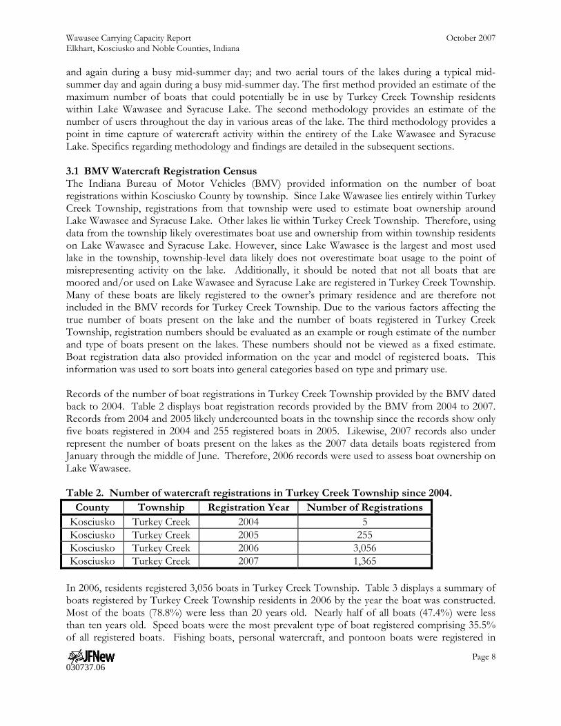
3.2 On-Lake Watercraft Census JFNew conducted an on-lake census during a busy mid-summer day on Friday, July 6, 2007 and during a normal mid-summer day on Wednesday, July 25, 2007. The busy day census occurred during a sunny, warm day, while skies were generally cloudy during the normal day census. On-lake censuses were intended to provide information on lake usage in different areas of the lake. Censuses were conducted using a motorized jon boat at various locations around the lake. Since the entire lake could be observed from one vantage point, Syracuse Lake was surveyed from a single location in the middle of the lake. Conversely, since the entire lake could not be observed from a single vantage point, observations on Lake Wawasee were conducted in several sections based on usage and practical concerns. For example, many boats use Conklin Bay for prolonged periods during their activities. Therefore, Conklin Bay was separated from the rest of the lake as a separate area. Conversely, many boats that use the main basin travel throughout the lake. However, the size of the lake prevents observers from accurately counting boats within the entire lake over a short time period. Therefore, the main basin was broken into three different areas. Most areas contained multiple viewing locations to maintain complete visual coverage of the area. Figure 2 displays viewing locations used during the study. At each viewing location, boating activities were observed in all directions until it was determined that all boats had been counted. Typically, observation in each location lasted for approximately 5-10 minutes. Observers attempted to prevent counting of boats that had previously been counted in other areas. However, many boats do not confine
themselves to one area of the lake, making some amount of double counting likely.
Wawasee Carrying Capacity Report October 2007 Elkhart, Kosciusko and Noble Counties, Indiana
Page 11 030737.06
Therefore, on-lake boat counts should be considered as counts of usage in specific areas of the lake, not of usage on the entire lake.
Figure 2. Approximate viewing locations used for Lake Wawasee on-lake boat censuses. Boats were counted and categorized in two different ways. First, boats were categorized based on their intended use. Categories included: speed boats, pontoons, fishing boats, personal watercraft, sailboats, canoes/kayaks, and yachts. Photos of typical boats included in each category are displayed in Appendix A. Most boats were categorized in the field based on appearance. However, some boats could not easily be distinguished in the field by sight. For example, many speed boats and fishing boats have similar shapes and motors. For these boats, field distinctions were made based on the observed use. The second categorization related to the boat usage as the time of observation. As each boat was observed, it was noted whether it was moving fast or slow. Boats were determined to be moving fast if they were producing a wake. 3.2.1 Lake Wawasee Tables 6 and 7 display summaries of the boat counts for all areas in Lake Wawasee. During all counts, speed boats comprised the largest category of boats using Lake Wawasee (40-45%). Pontoons, fishing boats, and personal watercrafts (PWCs) were observed in similar numbers on average (approximately 15-20% in each category) with sailboats, canoes, and kayaks comprising a small percentage of lake users. Fast-moving boats comprised between 39.4% and 54.4% of all

Wawasee Carrying Capacity Report October 2007 Elkhart, Kosciusko and Noble Counties, Indiana
Page 12 030737.06
boats. During both the busy day and the normal day surveys, the number of speed boats, pontoon boats, and PWCs increased during the afternoon as compared to the morning. Conversely, the number of fishing boats decreased during the afternoon as compared to the morning during both surveys. This decrease was notable during the busy day survey, when fishing boat usage decreased by more than 50%. This suggests that more recreational users are present on the lake during the afternoon and that these users may be inhibiting usage of fishing and slower-moving boats on the lake during busy periods. Table 6. Average morning boat counts on Lake Wawasee separated by boat type.
Boat Type Normal Day Busy Day
Count Percent Count Percent Speed Boats 27 39.7% 43 44.3% Pontoons 11 16.2% 14 14.4% Fishing Boats 14 20.6% 16 16.5% PWC 11 16.2% 20 20.6% Sailboats 3 4.4% 2 2.1% Canoes/Kayaks 2 2.9% 2 2.1% Yachts 0 <0.1% 0 <0.1% Total 68 100% 97 100% Fast Moving 37 54.4% 40 41.3% Slow Moving 31 45.6% 57 58.7%
Table 7. Average afternoon boat counts on Lake Wawasee separated by boat type.
Boat Type Normal Day Busy Day
Count Percent Count Percent Speed Boats 36 38.3% 58 42.0% Pontoons 25 26.6% 31 22.5% Fishing Boats 13 13.8% 7 5.1% PWC 12 12.8% 36 26.1% Sailboats 7 7.5% 4 2.9% Canoes/Kayaks 0 <0.1% 0 <0.1% Yachts 1 1.1% 2 1.5% Total 94 100% 138 100% Fast Moving 37 39.4% 67 48.6% Slow Moving 57 60.6% 71 51.4% Approximately 45% more boats were observed during the busy day survey than during the normal day survey. A majority of these increases can be attributed to speed boats and PWC’s; more speed boats and PWCs were observed during the busy day boat counts compared to the normal day boat counts, while the number of boats observed for each of the other categories remained approximately the same or decreased from the normal day to the busy day. The number of fishing boats observed in the morning was similar between both the busy day and the normal day; however, the number of fishing boats observed in the afternoon during the busy day survey measured approximately half the number observed during the normal day survey. This supports the idea described above—that fast-

Wawasee Carrying Capacity Report October 2007 Elkhart, Kosciusko and Noble Counties, Indiana
Page 13 030737.06
moving boats and recreational users may inhibit fishing and slow-moving boat use during busy periods. When boat density was compared across the lake, more boats were observed in the north and south ends of the lake than in any other part of the lake. However, most of the boats observed in the south end of the lake were traveling to or from the marina of the lake and not using that area of the lake for a prolonged period of time. Boats that did use the south end of the lake for prolonged periods of time used the area for both fast-moving recreation and fishing. Few boats used the middle third of the lake for prolonged periods of time. Most boats used this area to travel from the south end of the lake to the north end of the lake and vice versa. Fast and slow-moving recreation dominated use in the northern part of the lake. Within the main basin of Lake Wawasee, the northern end of the lake contained the most activity and densest boat use. Fast-moving recreation dominated use in Johnson and Conklin bays. Most boats traveled in and out of the bays, using them to waterski or wakeboard. Fishing boats also used the north end of Johnson Bay. 3.2.2 Syracuse Lake Tables 8 and 9 display summaries of the boat counts for Syracuse Lake. (See Appendix B for field data from both the normal day survey and the busy day survey.) Lake use was more varied on Syracuse Lake than on Lake Wawasee. Recreational and fishing boats were observed on Syracuse Lake in roughly equal numbers during all but one survey period. Most boats were not being driven at a speed sufficient to create a wake during all survey periods. Boat counts during the busy day survey were more than seven times greater than normal day boat counts in the morning and more than 2.5 times greater in the afternoon. The relative difference in lake usage between the normal day and busy day surveys was greater than the relative difference observed on Lake Wawasee. This can be attributed to the few boats using Syracuse Lake on normal days (8) compared to the typical usage rate of Lake Wawasee (162). In the morning, approximately equal numbers of boaters engaged in both recreational and fishing activities on Syracuse Lake during both the busy day and the normal day. Use in both categories was higher during the busy day survey compared to the normal day survey. Afternoon use tended toward recreational use of Syracuse Lake with fishing boats comprising a third or less of the total number of boats on the lake during both normal and busy periods. Similar to the morning counts, the total number of boats on Syracuse Lake during the afternoon was higher during the busy day (17) compared to the normal day (6).

Wawasee Carrying Capacity Report October 2007 Elkhart, Kosciusko and Noble Counties, Indiana
Page 14 030737.06
Table 8. Morning boat counts on Syracuse Lake separated by boat type.
Boat Type Normal Day Busy Day
Count Percent Count Percent Speed Boats 1 50.0% 3 20.0% Pontoons 0 0% 5 33.3% Fishing Boats 1 50.0% 7 46.7% PWC 0 0% 0 0% Sailboats 0 0% 0 0% Canoes/Kayaks 0 0% 0 0% Yachts 0 0% 0 0% Total 2 100% 15 100% Fast Moving 1 50.0% 3 20.0% Slow Moving 1 50.0% 12 80.0% Table 9. Afternoon boat counts on Syracuse Lake separated by boat type.
Boat Type Normal Day Busy Day
Count Percent Count Percent Speed Boats 2 33.3% 10 58.8% Pontoons 1 16.7% 2 11.8% Fishing Boats 2 33.3% 2 11.8% PWC 1 16.7% 3 17.7% Sailboats 0 0% 0 0% Canoes/Kayaks 0 0% 0 0% Yachts 0 0% 0 0% Total 6 100% 17 100% Fast Moving 2 33.3% 6 35.3% Slow Moving 4 66.7% 11 64.7% 3.3 Aerial Watercraft Census Using volunteer assistance coordinated through the WACF, JFNew conducted an aerial census during a busy mid-summer day on Friday, July 6, 2007 and during a normal mid-summer day on Friday, August 10, 2007 (Table 10). Aerial censuses were intended to provide a better estimate of boat usage over the entire lake during one specific snapshot in time than the on-lake censuses. During both aerial censuses, the pilot and observer circled the lake twice during approximately one hour. During the flights, the observer took photographs of different areas within the lake. These photographs were then analyzed and boats in each area counted. Since all photographs were taken within a short timeframe, the amount of double counting was assumed to be minimized compared to the on-lake boat censuses. Therefore, boat counts of each area were summed to provide a total count for the lake.

Wawasee Carrying Capacity Report October 2007 Elkhart, Kosciusko and Noble Counties, Indiana
Page 15 030737.06
Table 10. Boat counts on Syracuse Lake and Lake Wawasee during aerial censuses.
Location Number of Fast
Moving Boats Number of Slow Moving Boats Total
Normal Busy Normal Busy Normal Busy
Syracuse Lake 1 10 6 20 7 30 Lake Wawasee
Sand bar 0 0 7 67 7 67 Conklin Bay 4 17 3 4 7 21 Johnson Bay 6 6 8 4 14 10 North third 11 15 14 13 25 28
Middle third 4 10 10 4 14 14 South third 7 6 7 5 14 11
Total (without sandbar) 32 54 42 30 74 84 Total (with sand bar) 32 54 49 97 81 151
3.3.1 Lake Wawasee Nearly double the number of boats were observed using Lake Wawasee during the busy day survey than during the normal day survey. However, the biggest difference in boat usage between the two surveys was due to usage of the sand bar near the south end of the lake. During the busy day survey, 67 boats were observed using the sand bar compared to seven during the normal day survey. Ignoring the sand bar, more boats were observed during the busy day survey than during the normal day survey. Comparing specific areas of the lake, much of the difference in use during the normal day survey compared to the busy day survey was observed in Conklin Bay where nearly three times as many users were present during the busy day count compared with the normal day count. The number of boats within the main basin was approximately the same during both surveys. Boats were generally slower during the normal day survey than during the busy day survey. Fast-moving boats comprised 64.3% of all boats observed during the busy day survey, compared to 43.2% of all boats during the normal day survey. As with the total number of boats, this trend was most noticeable in Conklin Bay. 81.0% of all boats in Conklin Bay were observed moving fast during the busy day but only 57.1% of all boats were moving fast during the normal day. Additionally, aerial censuses were used to identify general usage patterns of the lake. Figure 3 demonstrates a general map of activities on the lake. As discussed during the On-Lake Watercraft Census section, speed boats and other fast-moving recreational boats were observed mainly in the north end of the lake and in Conklin and Johnson bays with some activity at the south end of the lake. The middle of the lake is primarily used for travel from one part of the lake to another. Many boats set anchor to allow for swimming and lounging at the sand bar near the south end of the lake. Slower moving boats and fishing boats were observed scattered throughout the lake. While overall boat traffic was slower during the normal day survey compared to the busy day survey, general usage patterns were similar for most parts of the lake. Less fast-moving boats used Conklin Bay during the normal day compared to the busy day survey. Additionally, more slow-moving boats used the middle part of the lake during the normal day survey than in the busy day survey.

Wawasee Carrying Capacity Report October 2007 Elkhart, Kosciusko and Noble Counties, Indiana
Page 16 030737.06
Figure 3. General location of common activities on Lake Wawasee. 3.3.2 Syracuse Lake More than four times the number of boats were observed during the busy day survey than during the normal day survey. The number of boats on Syracuse Lake comprised less than 20% of the total number of boats on Lake Wawasee during both surveys. However, during the busy day survey, the boat density was higher on Syracuse Lake (13.8 acres/boat) than on Lake Wawasee (22.6 acres/boat). Fast-moving boats comprised a larger percentage of boats during the busy day survey than during the normal day survey. However, slow-moving boats comprised a majority of all boats during both surveys. 3.4 Census Summary Based on information gained from all boat counts and censuses, fast-moving recreation is the primary use of Lake Wawasee, while slow moving recreation is the primary use on Syracuse Lake. BMV records indicate that property owners around Lake Wawasee own more speed boats and personal watercrafts than any other type of boat. On-lake and aerial boat censuses indicated that these same categories of boat are also the most used boats on the lake. Pontoon boats and slow-moving recreational boats ranked as the second-most owned and used type of boat on the lake. A small percentage of boaters use fishing boats or non-motorized boats (sailboats, canoes, and kayaks)

Wawasee Carrying Capacity Report October 2007 Elkhart, Kosciusko and Noble Counties, Indiana
Page 17 030737.06
on both lakes. However, on-lake and aerial censuses indicate that some of these activities may be inhibited by the presence of faster-moving boats. Estimates of the total number of boats moored on Lake Wawasee and Syracuse Lake range from 3,056 using BMV records to 20,445 using an extrapolation of boats along two shorelines. These numbers represent the permanent fleet present on Lake Wawasee and Syracuse Lake. While the use of BMV records likely underestimates the total number of boats moored at the lakes, extrapolation of boat density from two shorelines along Lake Wawasee to the entire shoreline of the lakes is likely an over-estimate. The true number of boats moored at these lakes likely falls somewhere in between these two estimates. Regardless of which estimate of the total number of moored boats is used, only a small percentage of boats available for use are actually out on the lakes. Only 7 and 30 boats were in use on Syracuse Lake during normal and busy summer days, respectfully, while 165 boats were in use on Lake Wawasee during a normal summer day and 232 boats were in use on a busy day. This usage rate indicates that less than 8% of the fleet of boats moored on the lakes are actually in use on a busy day. (This number results from dividing the largest number of boats using the lakes (255) by the lowest possible estimate of the fleet (3,056) present on the lakes.) 4.0 USER OPINIONS 4.1 Survey Methodology Recreational users, lakeshore residents, and commercial operations were surveyed via a single mail-back survey conducted during the month of August. Surveys were mailed to individuals and businesses in the WACF database. This database does not represent all shoreline owners; however, a majority of individuals living on or using Lake Wawasee and Syracuse Lake are represented in this database. In total, surveys were sent to approximately 2,100 residences and commercial businesses on July 28, 2007. The survey was designed to obtain user demographic and use level information, determine recreational activity use level, and obtain opinions on the adequacy of recreational facilities, services, and overall crowding. The survey form was submitted to WACF for review, input, and approval prior to distribution to the public. A copy of the resident survey is included in Appendix B. 4.2 Survey Results In total, 515 surveys were returned, which represents a 24.5% return rate. All surveys returned within the month of August were tallied. Most individuals that responded to the survey were over the age of 46 with 49% falling in the 46 to 65 age range and 43% in the over 65 range. Small percentages of respondents were under the age of 45 with only 7% in the 31 to 45 age range and <1% under the age of 30. Results and raw survey data are included in Appendix B. Specific findings are detailed in the following sections. 4.2.1 Respondent Characteristics A majority of respondents’ primary residence was waterfront at either Lake Wawasee or Syracuse Lake. Approximately 52% of respondents indicated that their primary residence was lakefront at Lake Wawasee (52%); another 14% indicated that their primary residence was at Syracuse Lake. The remainder of respondents indicated primary residence within Indiana (12%), outside of Indiana (10%), and within Noble or Kosciusko counties but not directly on the shoreline of the lakes (4%). An additional 8% indicated an alternate residence not specified on the survey form. A majority of

Wawasee Carrying Capacity Report October 2007 Elkhart, Kosciusko and Noble Counties, Indiana
Page 18 030737.06
respondents (63%) indicated that they typically stayed at the lake for the entire summer, while 21% stated that they were typically at the lake for one-month periods. Nearly 10% of respondents typically stay at the lake for a period of one to three months, while only 4% are at the lake for only the weekend. Less than 2% of respondents typically reside at the lake for only one week periods. During their current trip to the lake, respondents primarily indicated that they planned to stay at the lake for the weekend (47%) or for the week (35%). An additional 11% of respondents indicated plans to stay for longer periods of time including two weeks, one to seven months, and throughout the entire year. Only 6% of respondents indicated that they would be staying for one day or less during their current trip to the lakes. While at the lake, respondents indicated their preference for pleasure boating (21%), swimming (18%), fishing (16%), use of personal watercraft (11%), and skiing (10%). Additionally, 6% of individuals indicated that they sail, canoe, or kayak while at the lake, while 5% of respondents wake board, 3% picnic and 1% wind surf. An additional 3% of respondents indicate a preference for an activity not listed including gardening; tubing; using the sand bar; paddle-boating; and enjoying the view, nature, and the people around them. The vast majority of respondents indicated that their primary activity while at the lake was pleasure boating. Respondents to the survey stated that the distribution of watercraft at their property included 487 power boats (34%); 349 personal watercraft (24%); 197 pontoons (14%); 187 canoes, kayaks, and paddle boats (13%); 142 sail boats (10%); 48 jon boats or row boats (3%); and 24 wake board boats (2%). In total, respondents own 1,434 boats which are moored as part of the permanent fleet at Lake Wawasee and Syracuse Lake. This suggests that that the average household for these 445 respondents maintains 3.2 boats. If these numbers are extrapolated for the potential group of respondents, nearly 6,800 boats are typically present on Lake Wawasee and Syracuse Lake. 4.2.2 Lake Use Patterns Users indicated that they engage in more activities at their dock or on their property than at any other location within the lake. Overall, users partake of lake-based activities (skiing, fishing, wake-boarding, swimming, personal watercraft use, etc.) from their own dock 33% of the time. Individuals indicated that they use the main body of Lake Wawasee 28% of the time, Syracuse Lake 15% of the time, Johnson Bay 14% of the time, and Conklin Bay 10% of the time. While at their dock, individuals typically swim (37%), fish (20%), ski (13%), use personal watercraft (12%), and canoe or kayak (11%). Personal watercraft use (25%) and skiing (22%) are the most popular activities in which to engage while in the main body of Lake Wawasee. Swimming (17%), fishing (16%), and wake-boarding (10%) are also popular within the main body of Lake Wawasee. In Syracuse Lake, individuals are typically skiing (25%) or swimming (20%). However, personal watercraft use accounts for 19% of users in Syracuse Lake, while fishing (15%), canoeing/kayaking (10%), and wake-boarding (7%) account for most of the remaining activity within Syracuse Lake. While in Conklin or Johnson bays, individuals typically engage in skiing (32% and 37%, respectively), personal watercraft use (22% and 21%, respectively), fishing (17% and 15%, respectively), and wake-boarding (16% and 15%, respectively). Canoeing, kayaking, and other activities account for the remaining 10% of time spent in either Conklin Bay or Johnson Bay. Skiing is the most popular activity within the lakes: 23% of users indicating that they ski, while 21% of users indicate that they swim, 19% use personal watercraft, 17% fish, 10% wake-board, 8% canoe or kayak, and 3% engage in other activities (Figure 4). Skiing most often occurs in the main body of Lake Wawasee (28%), followed by use of Johnson Bay (23%), and from residents’ docks (19%). Individual docks (59%) are the most popular location for swimming to occur, while the main body
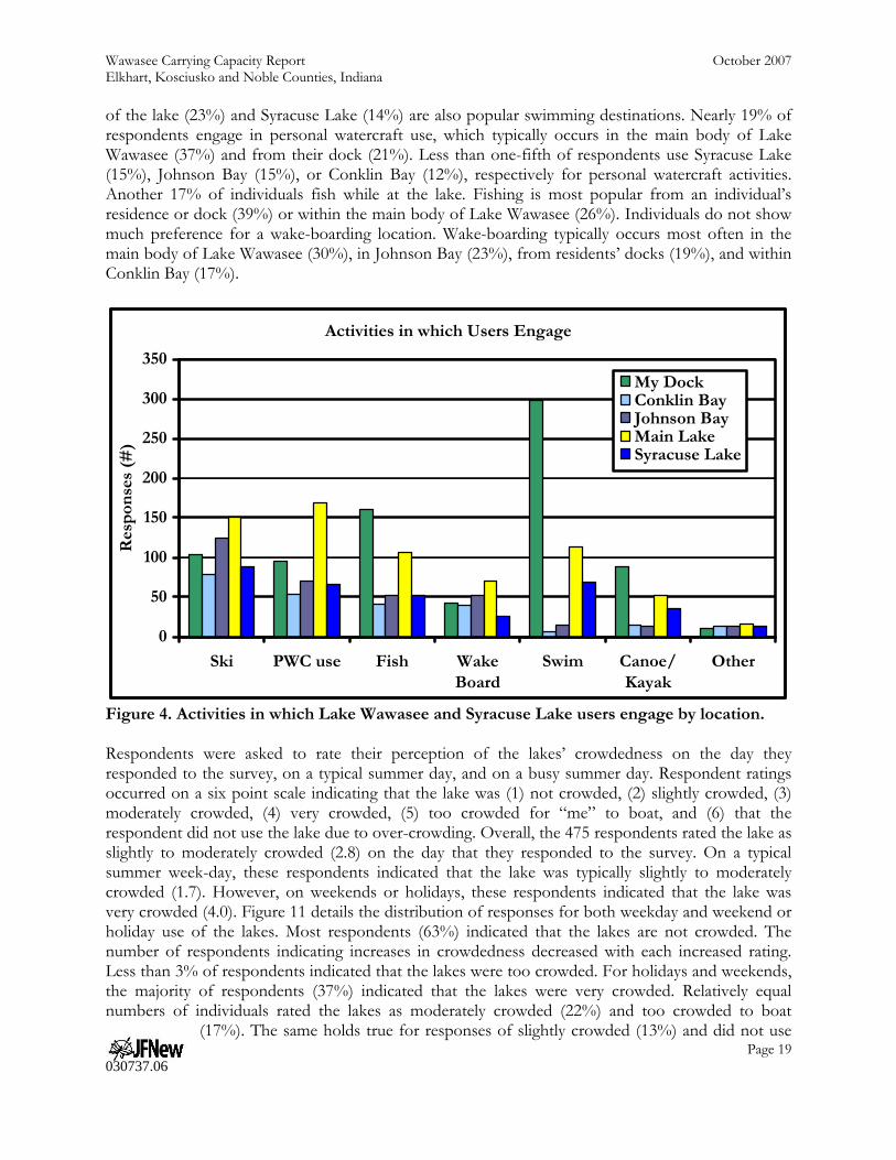
Wawasee Carrying Capacity Report October 2007 Elkhart, Kosciusko and Noble Counties, Indiana
Page 19 030737.06
of the lake (23%) and Syracuse Lake (14%) are also popular swimming destinations. Nearly 19% of respondents engage in personal watercraft use, which typically occurs in the main body of Lake Wawasee (37%) and from their dock (21%). Less than one-fifth of respondents use Syracuse Lake (15%), Johnson Bay (15%), or Conklin Bay (12%), respectively for personal watercraft activities. Another 17% of individuals fish while at the lake. Fishing is most popular from an individual’s residence or dock (39%) or within the main body of Lake Wawasee (26%). Individuals do not show much preference for a wake-boarding location. Wake-boarding typically occurs most often in the main body of Lake Wawasee (30%), in Johnson Bay (23%), from residents’ docks (19%), and within Conklin Bay (17%).
Activities in which Users Engage
0
50
100
150
200
250
300
350
Ski PWC use Fish WakeBoard
Swim Canoe/Kayak
Other
Res
pon
ses
(#)
My DockConklin BayJohnson BayMain LakeSyracuse Lake
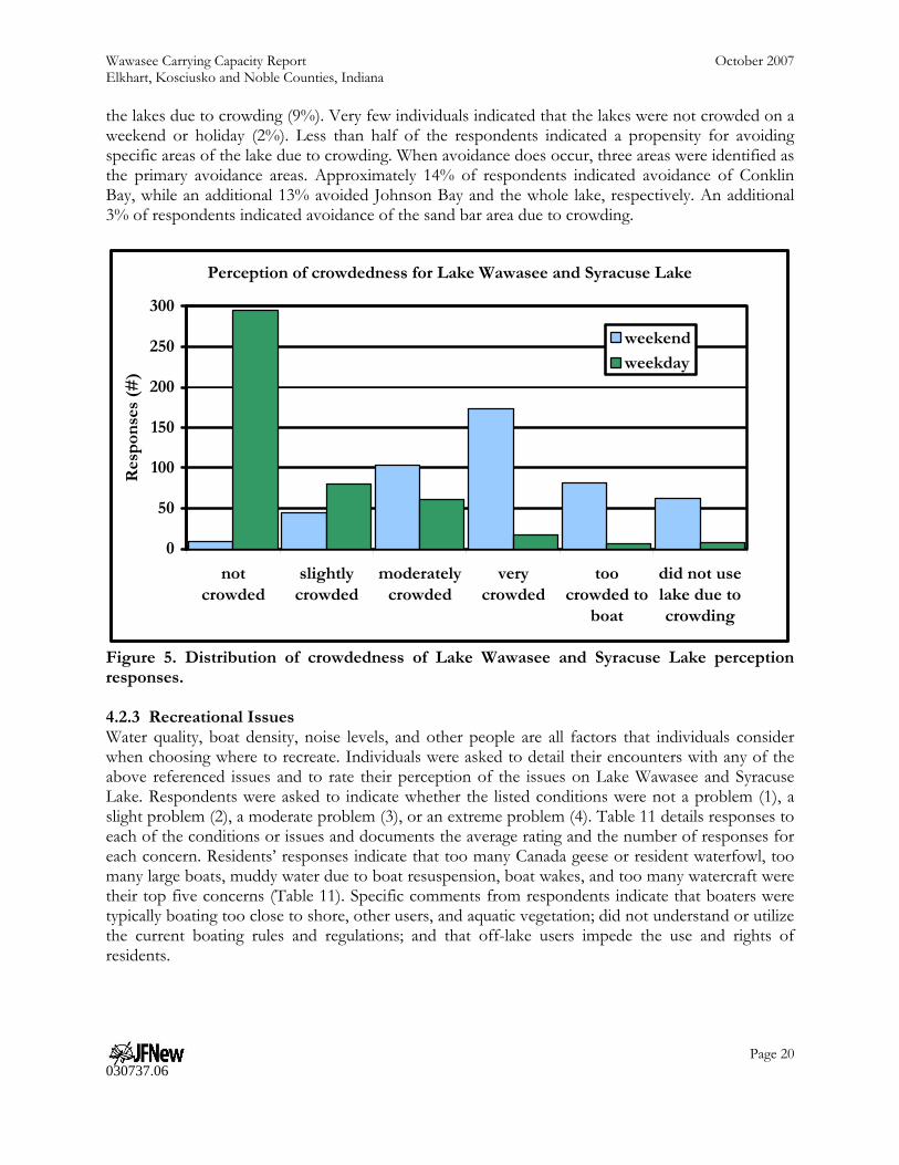
Figure 4. Activities in which Lake Wawasee and Syracuse Lake users engage by location. Respondents were asked to rate their perception of the lakes’ crowdedness on the day they responded to the survey, on a typical summer day, and on a busy summer day. Respondent ratings occurred on a six point scale indicating that the lake was (1) not crowded, (2) slightly crowded, (3) moderately crowded, (4) very crowded, (5) too crowded for “me” to boat, and (6) that the respondent did not use the lake due to over-crowding. Overall, the 475 respondents rated the lake as slightly to moderately crowded (2.8) on the day that they responded to the survey. On a typical summer week-day, these respondents indicated that the lake was typically slightly to moderately crowded (1.7). However, on weekends or holidays, these respondents indicated that the lake was very crowded (4.0). Figure 11 details the distribution of responses for both weekday and weekend or holiday use of the lakes. Most respondents (63%) indicated that the lakes are not crowded. The number of respondents indicating increases in crowdedness decreased with each increased rating. Less than 3% of respondents indicated that the lakes were too crowded. For holidays and weekends, the majority of respondents (37%) indicated that the lakes were very crowded. Relatively equal numbers of individuals rated the lakes as moderately crowded (22%) and too crowded to boat
(17%). The same holds true for responses of slightly crowded (13%) and did not use
Wawasee Carrying Capacity Report October 2007 Elkhart, Kosciusko and Noble Counties, Indiana
Page 20 030737.06
the lakes due to crowding (9%). Very few individuals indicated that the lakes were not crowded on a weekend or holiday (2%). Less than half of the respondents indicated a propensity for avoiding specific areas of the lake due to crowding. When avoidance does occur, three areas were identified as the primary avoidance areas. Approximately 14% of respondents indicated avoidance of Conklin Bay, while an additional 13% avoided Johnson Bay and the whole lake, respectively. An additional 3% of respondents indicated avoidance of the sand bar area due to crowding.
Perception of crowdedness for Lake Wawasee and Syracuse Lake
0
50
100
150
200
250
300
notcrowded
slightlycrowded
moderatelycrowded
verycrowded
toocrowded to
boat
did not uselake due tocrowding
Res
pon
ses
(#)
weekend
weekday
Figure 5. Distribution of crowdedness of Lake Wawasee and Syracuse Lake perception responses. 4.2.3 Recreational Issues Water quality, boat density, noise levels, and other people are all factors that individuals consider when choosing where to recreate. Individuals were asked to detail their encounters with any of the above referenced issues and to rate their perception of the issues on Lake Wawasee and Syracuse Lake. Respondents were asked to indicate whether the listed conditions were not a problem (1), a slight problem (2), a moderate problem (3), or an extreme problem (4). Table 11 details responses to each of the conditions or issues and documents the average rating and the number of responses for each concern. Residents’ responses indicate that too many Canada geese or resident waterfowl, too many large boats, muddy water due to boat resuspension, boat wakes, and too many watercraft were their top five concerns (Table 11). Specific comments from respondents indicate that boaters were typically boating too close to shore, other users, and aquatic vegetation; did not understand or utilize the current boating rules and regulations; and that off-lake users impede the use and rights of residents.
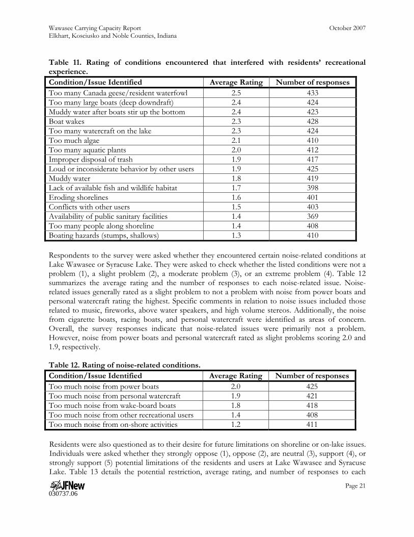
Wawasee Carrying Capacity Report October 2007 Elkhart, Kosciusko and Noble Counties, Indiana
Page 21 030737.06
Table 11. Rating of conditions encountered that interfered with residents’ recreational experience. Condition/Issue Identified Average Rating Number of responses Too many Canada geese/resident waterfowl 2.5 433 Too many large boats (deep downdraft) 2.4 424 Muddy water after boats stir up the bottom 2.4 423 Boat wakes 2.3 428 Too many watercraft on the lake 2.3 424 Too much algae 2.1 410 Too many aquatic plants 2.0 412 Improper disposal of trash 1.9 417 Loud or inconsiderate behavior by other users 1.9 425 Muddy water 1.8 419 Lack of available fish and wildlife habitat 1.7 398 Eroding shorelines 1.6 401 Conflicts with other users 1.5 403 Availability of public sanitary facilities 1.4 369 Too many people along shoreline 1.4 408 Boating hazards (stumps, shallows) 1.3 410 Respondents to the survey were asked whether they encountered certain noise-related conditions at Lake Wawasee or Syracuse Lake. They were asked to check whether the listed conditions were not a problem (1), a slight problem (2), a moderate problem (3), or an extreme problem (4). Table 12 summarizes the average rating and the number of responses to each noise-related issue. Noise-related issues generally rated as a slight problem to not a problem with noise from power boats and personal watercraft rating the highest. Specific comments in relation to noise issues included those related to music, fireworks, above water speakers, and high volume stereos. Additionally, the noise from cigarette boats, racing boats, and personal watercraft were identified as areas of concern. Overall, the survey responses indicate that noise-related issues were primarily not a problem. However, noise from power boats and personal watercraft rated as slight problems scoring 2.0 and 1.9, respectively. Table 12. Rating of noise-related conditions. Condition/Issue Identified Average Rating Number of responses Too much noise from power boats 2.0 425 Too much noise from personal watercraft 1.9 421 Too much noise from wake-board boats 1.8 418 Too much noise from other recreational users 1.4 408 Too much noise from on-shore activities 1.2 411 Residents were also questioned as to their desire for future limitations on shoreline or on-lake issues. Individuals were asked whether they strongly oppose (1), oppose (2), are neutral (3), support (4), or strongly support (5) potential limitations of the residents and users at Lake Wawasee and Syracuse Lake. Table 13 details the potential restriction, average rating, and number of responses to each
Wawasee Carrying Capacity Report October 2007 Elkhart, Kosciusko and Noble Counties, Indiana
Page 22 030737.06
issue or concern. Residents indicated support for a limit of residential and commercial development, the need for more law enforcement, and stricter noise regulations. Residents indicated slight support for limitations on the size, horsepower, and type of boats allowed on the lake. Many respondents indicated the need to restrict cigarette boats, racing boats, wake-board boats, and large, Great Lakes- style or ocean-going boats. A majority of individuals commented on the need to further restrict development of condominiums; however, several individuals indicated the desire for additional restaurants along the lakeshore. Many respondents stressed the need for education, including the need for individuals to know and understand boating rules and regulations, be aware of the typical use and traffic patterns of the lakes, and be required to obtain certification prior to accessing the lake. Other respondents indicated concern over restricting usage of Conklin Bay and the subsequent impact that this may have on Johnson Bay or other areas of the lakes. Additionally, although these items were not specifically included as questions in the survey, many respondents indicated a desire to limit the use of the lakes by off-shore or out-of-state boaters. Multiple comments indicated the desire to charge an access fee at the boat ramp, limit the number of individuals that can access the lakes via the boat ramps, and to decrease the number of bass tournaments. Table 13. Resident response to potential future limitations at Lake Wawasee and Syracuse Lake.
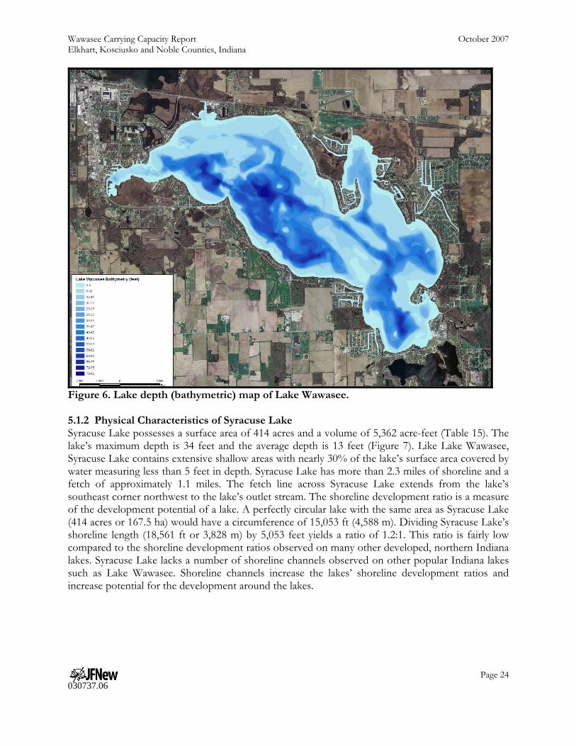
Potential Limitation Number of responses average Limit commercial development 426 3.9 Greater law enforcement on the lake 436 3.7 Limit residential development 432 3.7 Stricter noise restrictions 421 3.7 Limit the down-draft allowed for boats in use on the lake 422 3.6 Limit the area available for boats with deep drafts 414 3.6 Decrease the maximum allowed size for boats on the lake 427 3.4 Decrease the maximum allowed horsepower on the lakes 430 3.2 Institute expanded/new no wake zones 420 3.1 Institute lower speed limits or new speed zones 409 3.0 Create special areas for non-motorized craft 410 2.8 5.0 LAKE WAWASEE CARRYING CAPACITY ANALYSIS 5.1 Physical Characteristics As detailed above, the one factor that cannot be regulated or altered no matter the effort involved is the lake’s physical characteristics or morphology. The following sections discuss the physical characteristics of Lake Wawasee and Syracuse Lake. 5.1.1 Lake Wawasee Physical Characteristics Lake Wawasee is the largest natural lake in Indiana covering 3,410 acres. The lake possesses a volume of 75,020 acre-feet and a mean depth of 22 feet (Table 14). The lake extends to a depth of 77 feet immediately east of South Park. Lake Wawasee reaches 75 feet at no less than three other locations within the lake and reaches 40 feet at a minimum of 20 locations throughout the lake (Figure 6). Additionally, Lake Wawasee contains extensive shallow areas. For example, in terms of impacts to the lake bottom from motorized watercraft, nearly 15% of the lake is covered by water less than 5 feet deep, while more than 40% of the lake is covered by water measuring less than 10

Wawasee Carrying Capacity Report October 2007 Elkhart, Kosciusko and Noble Counties, Indiana
Page 23 030737.06
feet in depth. Based on these facts, consideration should be given to the ecological impacts that are possible due to Lake Wawasee’s shallow nature, extensive shoreline, and physical limitations. Lake Wawasee has more than 36.5 miles of shoreline and a fetch of 4.3 miles. The fetch represents the maximum open water distance across the lake, which on Lake Wawasee is measured from the mouth of Turkey Creek in the lake’s southeast corner northwest to the lake’s northern shoreline near Oakwood. Lake Wawasee is long and thin with its longest axis occurring on the northwest-southeast trajectory. The lake contains two smaller bays, Conklin Bay at the lake’s northwestern corner and Johnson Bay at the lakes northeastern corner. Lake Wawasee has a relatively high shoreline development ratio (SDR) measuring 4.5:1. The shoreline development ratio (SDR) is a measure of the development potential of a lake. It is calculated by dividing the shoreline length by the circumference of a circle that has the same area as the lake. A perfectly circular lake with the same area as Lake Wawasee (3,410 acres or 1,380 ha) would have a circumference of 43,204 feet (13,168 m). Dividing Lake Wawasee’s shoreline length (193,586 feet or 59,005 m) by 43,204 feet yields a ratio of 4.5:1. Lake Wawasee’s shoreline development ratio indicates that the shoreline is 350% longer than a perfectly round lake of the same size. This ratio is fairly high compared to the shoreline development ratios observed on many other developed, northern Indiana lakes. Shoreline channels increase the lakes’ shoreline development ratios and increase potential for the development around the lakes. Table 14. Morphological characteristics of Lake Wawasee. Lake Wawasee Surface Area 3,410 acres Volume 75,020 acre-feet Maximum Depth 77 feet Mean Depth 22 feet Fetch 4.3 miles Shoreline Length 193,586 feet (36.5 miles) Shoreline Development Ratio 4.5:1 Residence Time* 2.5 years *Time required to flush water through the lake.
Wawasee Carrying Capacity Report October 2007 Elkhart, Kosciusko and Noble Counties, Indiana
Page 24 030737.06
Figure 6. Lake depth (bathymetric) map of Lake Wawasee. 5.1.2 Physical Characteristics of Syracuse Lake Syracuse Lake possesses a surface area of 414 acres and a volume of 5,362 acre-feet (Table 15). The lake’s maximum depth is 34 feet and the average depth is 13 feet (Figure 7). Like Lake Wawasee, Syracuse Lake contains extensive shallow areas with nearly 30% of the lake’s surface area covered by water measuring less than 5 feet in depth. Syracuse Lake has more than 2.3 miles of shoreline and a fetch of approximately 1.1 miles. The fetch line across Syracuse Lake extends from the lake’s southeast corner northwest to the lake’s outlet stream. The shoreline development ratio is a measure of the development potential of a lake. A perfectly circular lake with the same area as Syracuse Lake (414 acres or 167.5 ha) would have a circumference of 15,053 ft (4,588 m). Dividing Syracuse Lake’s shoreline length (18,561 ft or 3,828 m) by 5,053 feet yields a ratio of 1.2:1. This ratio is fairly low compared to the shoreline development ratios observed on many other developed, northern Indiana lakes. Syracuse Lake lacks a number of shoreline channels observed on other popular Indiana lakes such as Lake Wawasee. Shoreline channels increase the lakes’ shoreline development ratios and increase potential for the development around the lakes.

Wawasee Carrying Capacity Report October 2007 Elkhart, Kosciusko and Noble Counties, Indiana
Page 25 030737.06
Table 15. Morphological characteristics of Syracuse Lake. Syracuse Lake Surface Area 414 acres (167.5 ha) Volume 5,362 acre-feet (71,176,679 m3) Maximum Depth 34 feet (10.4 m) Mean Depth 13 feet (3.9 m) Shoreline Length 12,561 ft (3,828 m) Shoreline Development Ratio 1.2 Residence Time * 0.2 years (73 days) *Time required to flush water through the lake.
Figure 7. Lake depth (bathymetric) map of Syracuse Lake. 5.2 Lake Use Characteristics 5.2.1 Lake Wawasee As indicated by the user survey responses, Lake Wawasee is used primarily for skiing, swimming, fishing, and personal watercraft uses. Speed boats, personal watercraft, fishing boats, and pontoons are the most popular types of watercraft present on the lake. As determined during the boat counts, fast-moving watercraft are typically the most prevalent accounting for 40 to 55% of boaters during

Wawasee Carrying Capacity Report October 2007 Elkhart, Kosciusko and Noble Counties, Indiana
Page 26 030737.06
typical summer weekday and weekends, respectfully. Respondents to the user survey indicated a propensity for using the main body of the lake for skiing, personal watercraft use, and swimming and the two main bays, Conklin Bay and Johnson Bay, for skiing, swimming, and fishing. Overall, estimates of the number of watercraft present on the lake (3,056) compared with the number of watercraft in use on the lake (232) suggest that less than 7% of the permanent, moored fleet of boats on Lake Wawasee are in use at any one time. Nonetheless, given Lake Wawasee’s shallow nature and convoluted shoreline, this number of users may be too high to protect social, aesthetic, and environmental concerns. 5.2.2 Syracuse Lake Like Lake Wawasee, Syracuse Lake is predominantly used for skiing, swimming, fishing, and personal watercraft usage. On a typical weekday, very few boaters are present on Syracuse Lake. This is especially true in the morning, when only two watercraft were present on the lake. Both individuals were engaged in fishing activities at the time of the assessment. Use generally increases on the lake in the afternoon, with 15 watercraft present a majority of whom were fishing during the assessment. Even on weekends, usage rates of Syracuse Lake are much lower than that observed for Lake Wawasee with a total of six users in the morning and 17 in the afternoon. Again, a mix of users and watercraft were present during the weekend or holiday assessment. During the aerial assessments, more than four times as many boaters were using Syracuse Lake during the weekend or holiday assessment as those observed during the normal or weekday assessment. Most of the users were engaged in stationary or slow-moving activities such as swimming, pleasure boating, and fishing. Overall, estimates of the number of watercraft present in the lake’s moored fleet (1245) compared to the number of watercraft in use on the lake (30) suggest that less than 2.5% of the permanent, moored fleet of boats on Syracuse Lake are in use at any one time. Given Syracuse Lake’s relatively small size and shallow nature (30% of the lake is 5 feet deep or less), this number of users may be too high; however, if exceedences occur, it is likely that they occur only on the busiest weekends or during the highest use periods and do not occur on a regular basis. 5.3 Usable Lake Area As described in previous sections, every lake contains portions where boating activity may not provide adequate protection for all social, aesthetic, and environmental concerns. Rather these areas can create safety and/or environmental problems; therefore, these areas should be excluded from the total lake area. This results in a usable lake area which can then be used to calculate the appropriate carrying capacity. With this in mind, three potential scenarios are possible at Lake Wawasee and Syracuse Lake. These include: the entire lake is available for boating; areas already restricted for use, such as those areas contained within an existing eco-zone or within 200 feet of the lake’s shoreline, are not available for boating; and areas of specific depths (five feet and shallower or ten feet and shallower) are restricted for boating. Subsequent sections detail the methodologies used to determine each of these areas and documents the remaining area available using each scenario. Scenario 1: Entire Lake Under Scenario 1, the entire area of lake is available for boating. This scenario does not consider restrictions of any kind; therefore, both high speed and idle speed uses are included for all areas of the lake under this scenario. If this is the case, then 3,410 acres of Lake Wawasee are available for recreational access and 414 acres of Syracuse Lake are available for recreational use. It should be noted that for higher than “no wake” speeds, this scenario is contrary to current state statute. Figure 8 depicts this scenario.

Wawasee Carrying Capacity Report October 2007 Elkhart, Kosciusko and Noble Counties, Indiana
Page 27 030737.06
Figure 8. Areas of Lake Wawasee and Syracuse Lake available for use under Scenario 1, where there are no restrictions on recreational use for any portion of the lake. Scenario 2: Restrictions Already Present Under Indiana Code (IC 14-15-3-17), high-speed boating is already restricted in all areas of Lake Wawasee and Syracuse Lake that are narrower than 500 feet (channels) or within 200 feet of a shoreline. The use of a 200-foot buffer from the shoreline is reinforced by the fact that many boats, piers, and other structures extend from the lake’s shoreline approximately 100 feet with the maximum pier length measuring over 150 feet. The restrictive zone already created by these structures readily restricts free and equal access to areas within 200 feet of the lake’s shoreline, which is the area limited by current state statute. Additionally, the DNR enacted a series of eco-zones in Lake Wawasee and Syracuse Lake in 2003. Eco-zones around Lake Wawasee restrict high-speed boating access in portions of Conklin Bay including a 50 foot buffer along portions of the wetland, in portions of Johnson Bay as detailed by the 50 foot buffer along both the east and west shorelines, and in portions of North Bay along the northern shoreline of Lake Wawasee. As these areas are already restricted to high speed boating, under this scenario, these areas are excluded from boat access. In total, 450 acres of Lake Wawasee are already limited for idle speed boating. This results in 2,960 acres of the lake equally available and unrestricted for all competing uses (Figure 9). In Syracuse Lake, high speed boat activity is restricted within one eco-zone (the Wetland) in the lake’s southeast corner. This area covers 14 acres. Combining this area with the area of the lake located
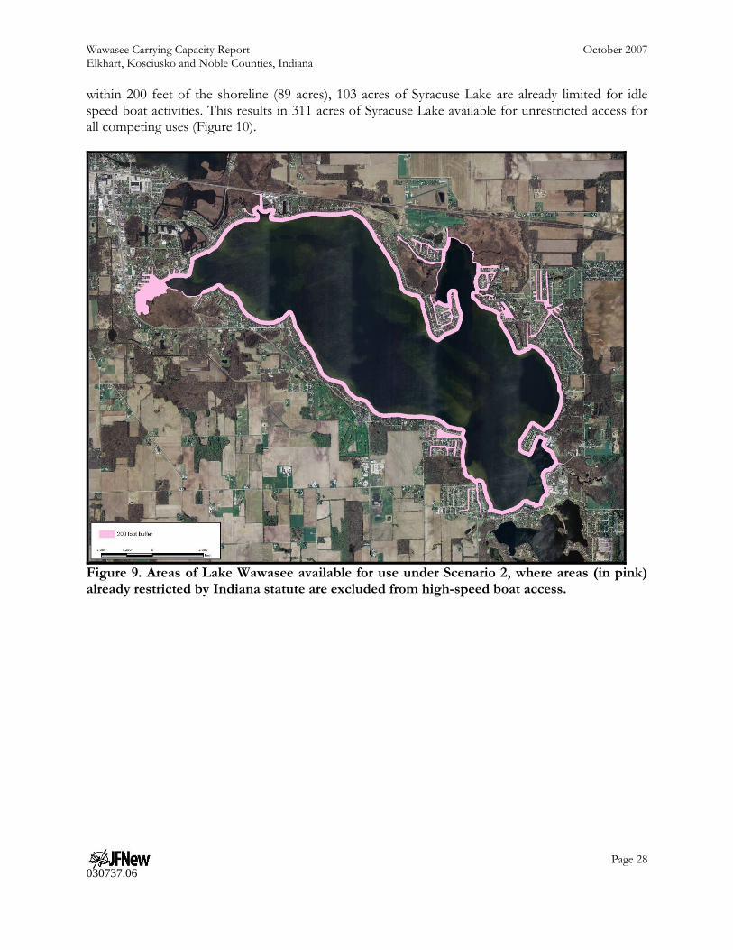
Wawasee Carrying Capacity Report October 2007 Elkhart, Kosciusko and Noble Counties, Indiana
Page 28 030737.06
within 200 feet of the shoreline (89 acres), 103 acres of Syracuse Lake are already limited for idle speed boat activities. This results in 311 acres of Syracuse Lake available for unrestricted access for all competing uses (Figure 10).
Figure 9. Areas of Lake Wawasee available for use under Scenario 2, where areas (in pink) already restricted by Indiana statute are excluded from high-speed boat access.

Wawasee Carrying Capacity Report October 2007 Elkhart, Kosciusko and Noble Counties, Indiana
Page 29 030737.06
Figure 10. Areas of Syracuse Lake available for use under Scenario 2, where areas (in pink) already restricted by Indiana statute are excluded from high-speed boat access. Scenario 3: Lake Use Restricted by Depth Several researchers document the impacts of high-speed boating on areas of lakes which measure 10 feet or less. Asplund (1996) details the impacts of high speed boats on sediment resuspension, water clarity, and fish and wildlife habitat in shallow areas of lakes. As detailed above, Wagner (1990) observed that the shallowness ratio is a good indicator for the potential impact of motorized watercraft. In Lake Wawasee, nearly 15% of the lake’s surface cover water that measures 5 feet deep or less, while nearly 40% of the lake measured 10 feet deep or less. Based on this and other studies, Lake Wawasee residents may decide to restrict high-speed boat access to areas shallower than 10 feet. As Lake Wawasee possesses a highly variable lake bottom, these restrictions may be necessary to protect and improve water quality and to limit aesthetic and safety concerns. However, residents may not wish to restrict the entire area of the lake that has a depth of 10 feet or less; therefore, this scenario was broken into two steps. These include: limitations of lake use in areas reaching a maximum depth of 5 feet (Scenario 3A) and limitations of lake use in areas reaching a maximum depth of 10 feet (Scenario 3B). If high-speed boat access is restricted in the most shallow and environmentally sensitive portions of the lake—areas where depths of five feet or less occur—then approximately 555 acres of Lake Wawasee are off-limits (Figure 11). This scenario leaves 2,855 acres
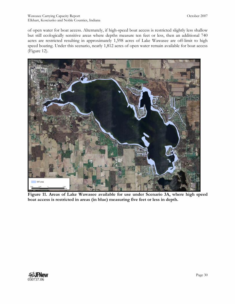
Wawasee Carrying Capacity Report October 2007 Elkhart, Kosciusko and Noble Counties, Indiana
Page 30 030737.06
of open water for boat access. Alternately, if high-speed boat access is restricted slightly less shallow but still ecologically sensitive areas where depths measure ten feet or less, then an additional 740 acres are restricted resulting in approximately 1,598 acres of Lake Wawasee are off-limit to high speed boating. Under this scenario, nearly 1,812 acres of open water remain available for boat access (Figure 12).
Figure 11. Areas of Lake Wawasee available for use under Scenario 3A, where high speed boat access is restricted in areas (in blue) measuring five feet or less in depth.

Wawasee Carrying Capacity Report October 2007 Elkhart, Kosciusko and Noble Counties, Indiana
Page 31 030737.06
Figure 12. Areas of Lake Wawasee available for use under Scenario 3B, where high speed boat access is restricted in areas (in blue) measuring ten feet or less in depth. In Syracuse Lake, nearly 30% of the lake’s surface cover water that measures 5 feet deep or less, while nearly 45% of the lake measured 10 feet deep or less. Based on this and other studies, Syracuse Lake residents may decide to restrict high-speed boat access to areas shallower than 10 feet. As Syracuse Lake is relatively shallow, these restrictions may be necessary to protect and improve water quality and to limit aesthetic and safety concerns. However, as with Lake Wawasee, Syracuse Lake residents may not wish to restrict the entire area of the lake to a depth of 10 feet; therefore, this scenario was broken into two steps. These include: limitations of lake use in areas reaching a maximum depth of 5 feet (Scenario 3A) and limitations of lake use in areas reaching a maximum depth of 10 feet (Scenario 3B). If high-speed boat access is restricted in the most shallow and environmentally sensitive portions of the lake—areas where depths of five feet or less occur—then approximately 128 acres of Syracuse Lake are off-limits (Figure 13). This scenario leaves 286 acres of open water for boat access. Alternately, if high-speed boat access is restricted slightly less shallow but still ecologically sensitive areas where depths measure ten feet or less, then an additional 58 acres are restricted resulting in approximately 186 acres of Syracuse Lake are off-limit to high speed boating. Under this scenario, nearly 228 acres of open water remain available for boat access (Figure 14).

Wawasee Carrying Capacity Report October 2007 Elkhart, Kosciusko and Noble Counties, Indiana
Page 32 030737.06
Figure 13. Areas of Syracuse Lake available for use under Scenario 3A, where high speed boat access is restricted in areas (in blue) measuring five feet or less in depth.
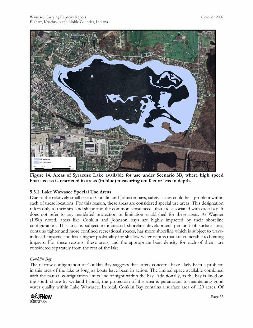
Wawasee Carrying Capacity Report October 2007 Elkhart, Kosciusko and Noble Counties, Indiana
Page 33 030737.06
Figure 14. Areas of Syracuse Lake available for use under Scenario 3B, where high speed boat access is restricted in areas (in blue) measuring ten feet or less in depth. 5.3.1 Lake Wawasee Special Use Areas Due to the relatively small size of Conklin and Johnson bays, safety issues could be a problem within each of these locations. For this reason, these areas are considered special use areas. This designation refers only to their size and shape and the common sense needs that are associated with each bay. It does not refer to any mandated protection or limitation established for these areas. As Wagner (1990) noted, areas like Conklin and Johnson bays are highly impacted by their shoreline configuration. This area is subject to increased shoreline development per unit of surface area, contains tighter and more confined recreational spaces, has more shoreline which is subject to wave-induced impacts, and has a higher probability for shallow-water depths that are vulnerable to boating impacts. For these reasons, these areas, and the appropriate boat density for each of them, are considered separately from the rest of the lake. Conklin Bay The narrow configuration of Conklin Bay suggests that safety concerns have likely been a problem in this area of the lake as long as boats have been in action. The limited space available combined with the natural configuration limits line of sight within the bay. Additionally, as the bay is lined on the south shore by wetland habitat, the protection of this area is paramount to maintaining good water quality within Lake Wawasee. In total, Conklin Bay contains a surface area of 120 acres. Of

Wawasee Carrying Capacity Report October 2007 Elkhart, Kosciusko and Noble Counties, Indiana
Page 34 030737.06
this area, 64 acres are already restricted through the 200-foot idle zone and the eco-zone that is already present. This leaves 56 acres available for unrestricted use and access. Johnson Bay Like Conklin Bay, Johnson Bay’s narrow configuration creates limitations on the available space for unrestricted, free access. However, Johnson Bay is much more open than Conklin Bay, therefore space limitations are a concern but are not as great of a concern as those in Conklin Bay. Additionally, line-of-sight is better in Johnson Bay, which reduces some of the safety concerns. Nonetheless, this area is much more restrictive than the main body of Lake Wawasee. As such, this area is considered separately with regards to available use area. In total, Johnson Bay measure 140 acres. Nearly 55 acres of this area are restricted by the eco-zone and the 200 foot restriction due to state law. This leaves 85 acres of available open water for free and unrestricted use. 5.3.2 Useable Lake Area Summary Many scenarios exist by which the useable area of Lake Wawasee and Syracuse Lake can be determined. In order for free and unrestricted use of the lakes to occur and to minimize safety, aesthetic, and environmental concerns, the correct useable lake area needs to be determined. Table 17 summarizes the restricted areas and useable lake areas available for unrestricted, equal use for all scenarios detailed above. Table 16. Useable lake areas determined for Lake Wawasee and Syracuse Lake with regard to three potential scenarios. Figures are based on a mix of competing boat and use activities and do not account for preference in use area or activity.
Scenario Total Lake Area
(acres) General Restricted Area
(acres) Useable Lake Area
(acres) Lake Wawasee No restriction 3,410 0* 3,410 Current legal restriction 3,410 450 2,960 Five foot depth restriction 3,410 555 2,855 Ten foot depth restriction 3,410 1,598 1,812 Conklin Bay 120 64 56 Johnson Bay 140 55 85 Syracuse Lake No restriction 414 0* 414 Current legal restriction 414 103 311 Five foot depth restriction 414 128 286 Ten foot depth restriction 414 186 228 *Available only for “no-wake” boating. Any higher speed boating activity using the entire lake is contrary to state statute. 5.4 Optimum Boat Density As previously described, there has been much research completed which details the optimum spatial requirement for various watercraft and their associated uses. Many studies (Table 1) detail results determined after evaluation of user-based satisfaction surveys. Despite the basis for these determinations, no single density standard will satisfy all lake users in all situations. Some researchers looked at multiple user groups and the space required for each to interact safely, while other researchers identified space needs associated with just one user group. In order to determine the best possible spatial requirements for Lake Wawasee, researcher methodologies were reviewed to

Wawasee Carrying Capacity Report October 2007 Elkhart, Kosciusko and Noble Counties, Indiana
Page 35 030737.06
determine the most relevant and replicable research methods and showed the highest correlation across studies. Because of the mixed uses that typically occur on Lake Wawasee, two methodologies were selected. The first was developed by the SCLC and LCLC (2005) and relies specifically upon the calculation of space required for the physical watercraft itself and for the activity in which the watercraft is engaged. The second methodology was developed by the LRMD (2003) and utilizes Theiren’s (1964) idea theory that a watercraft’s space requirements are directly proportional to the speed at which the watercraft is traveling. Under this scenario, activities that involve passive recreation, like canoeing, kayaking, or paddle boating, require less space than those that are more active or aggressive, such as speed boating, skiing, tubing, or engaging in personal watercraft use. Following this guidance, a low spatial requirement (10 acres/boat) is required when all users are engaged in passive (stationary or idle speed) activities. A lower density (30 acres/boat) is required when all users are engaged in aggressive (fast-moving watercraft) activities. An equal mix of passive and aggressive uses results in a mid-point density of 20 acres/boat. Table 17 details the optimal space requirements necessary for each of these methodologies. Table 17. Optimum spatial requirements for watercraft on Lake Wawasee and Syracuse Lake under two scenarios. Boat Type Optimal Area Lake Usage Optimal Area
Lake Wawasee Pontoon/Motor boat 14.85 acres/boat All uses: 100% idle 10 acres/boat Sailboat/Canoe/Kayak 13.05 acres/boat All uses: 75% idle; 25% fast users 15 acres/boat Water ski/Wake board boat 20.7 acres/boat All uses: 50% idle; 50% fast users 20 acres/boat Personal watercraft 16.65 acres/boat All uses: 25% idle; 75% fast users 25 acres/boat All uses: 100% fast users 30 acres/boat Syracuse Lake Pontoon/Motor boat 3.96 acres/boat All uses: 100% idle 10 acres/boat Sailboat/Canoe/Kayak 3.48 acres/boat All uses: 75% idle; 25% fast users 15 acres/boat Water ski/Wake board boat 5.52 acres/boat All uses: 50% idle; 50% fast users 20 acres/boat Personal watercraft 4.44 acres/boat All uses: 25% idle; 75% fast users 25 acres/boat All uses: 100% fast users 30 acres/boat
5.5 Carrying Capacity Ranges The two procedures detailed above result in two different carrying capacity determinations for each lake. Tables 18 and 19 detail carrying capacity determinations for Lake Wawasee, while carrying capacity determinations for Syracuse Lake are listed in Tables 20 and 21. 5.5.1 Lake Wawasee Using the watercraft area requirements developed by the SCLC and LCLC (2005), a specific required area is assigned to each watercraft type. This methodology suggests that only one type of watercraft is in use at any one time on Lake Wawasee. As detailed in the Watercraft Census section of the report, this is not the case on Lake Wawasee. Nonetheless, this option provides a general idea of the number of each type of watercraft that could use Lake Wawasee at any one point in time given the three available use area scenarios (Table 18). As indicated below, if there is no limitation on the area in which users can recreate, then a total of 261 canoes or kayaks, 165 pontoons or motor boats, 205 personal watercraft, and 230 water ski or wake board boats can be in operation on Lake Wawasee at any one time. This results in 861 boats or approximately 4 boats per open water acre in use in Lake
Wawasee if no restriction to area or activity were in place. As detailed in Table 18, as

Wawasee Carrying Capacity Report October 2007 Elkhart, Kosciusko and Noble Counties, Indiana
Page 36 030737.06
more restrictions are enacted, the available space on the lake decreases. This results in less space available for each watercraft thereby reducing the overall potential density on Lake Wawasee. In order to maintain the same density of boats that can be in action on the lake given the restriction in surface area, the number of boats are also reduced. Using conditions that are already present on Lake Wawasee, where boating is limited to idle speed uses within 200 feet of shoreline and within the eco-zones already present in Conklin Bay, in Johnson Bay, and along the northern shoreline of the lake, then a total of 781 boats could use Lake Wawasee at any one time. Likewise, restricting greater than idle speed access to all areas of Lake Wawasee measuring five feet or less in depth results in space for 762 watercraft to be in use on the lake at any one time. If restrictions of greater than idle -peed use for areas measuring 10 feet or more in depth are enacted, then 580 watercraft could be in use at any one time on Lake Wawasee.
Table 18. Carrying capacity determination for Lake Wawasee using spatial requirements developed by the Steuben and Lagrange County Lakes Councils. Boat Type Optimal Area Useable Lake Area Carrying Capacity Scenario 1: Entire lake available for free, multi-use boating Sailboat/Canoe/Kayak 13.05 acres/boat 3,410 acres 261 boats Pontoon/Motor boat 14.85 acres/boat 3,410 acres 230 boats Personal watercraft 16.65 acres/boat 3,410 acres 205 boats Water ski/Wake board boat 20.70 acres/boat 3,410 acres 165 boats Scenario 2: Restrictions already present Sailboat/Canoe/Kayak 13.05 acres/boat 3,410 acres* 261 boats Pontoon/Motor boat 14.85 acres/boat 2,960 acres 199 boats Personal watercraft 16.65 acres/boat 2,960 acres 178 boats Water ski/Wake board boat 20.70 acres/boat 2,960 acres 143 boats Scenario 3A: Boating limited within areas measuring 5 feet in depth or less Sailboat/Canoe/Kayak 13.05 acres/boat 3,410 acres* 261 boats Pontoon/Motor boat 14.85 acres/boat 2,855 acres 192 boats Personal watercraft 16.65 acres/boat 2,855 acres 171 boats Water ski/Wake board boat 20.70 acres/boat 2,855 acres 138 boats Scenario 3B: Boating limited within areas measuring 10 feet in depth or less Sailboat/Canoe/Kayak 13.05 acres/boat 3,410 acres* 261 boats Pontoon/Motor boat 14.85 acres/boat 1,812 acres 122 boats Personal watercraft 16.65 acres/boat 1,812 acres 109 boats Water ski/Wake board boat 20.70 acres/boat 1,812 acres 88 boats
*Figure is adjusted to include all portions of the lake so that boats that only engage in idle-speed activities are not restricted in this area regardless of the scenario enacted. Using procedures developed by the Lake Ripley Management District, an optimal boat density range of 10 to 30 acres/boat was developed. Following their recommendations, the optimum boat density varies along the range of passive and aggressive uses. This results in a range in carrying capacities relative to the useable lake area calculations detailed in the scenarios listed above. Table 19 details the optimal area, useable lake area, and resultant carrying capacity for each of the three scenarios previously discussed. Under the first scenario, where the entire lake is available for all uses, a maximum of 341 boats could use Lake Wawasee at any one time if, and only if, all of those

Wawasee Carrying Capacity Report October 2007 Elkhart, Kosciusko and Noble Counties, Indiana
Page 37 030737.06
watercraft were stationary or moving at idle speed. As watercraft speed increases, the area required to balance safety, aesthetic, and environmental concerns also increases. This results in less available space for watercraft. If the entire lake were open for high speed or aggressive boating, then a total of only 114 watercraft could be in action on Lake Wawasee at any one time. Based on results detailed in the Watercraft Census section, it is most likely that a mixture of slow and fast moving watercraft are present on the lake at any one time; therefore, if an equal mix of fast and slow users are present, then 171 watercraft could use Lake Wawasee at any one time. As indicated while using the spatial requirements developed by SCLC and LCLC, as more limitations are placed on the surface area of Lake Wawasee, the space available for boats decreases. This results in less watercraft being able to use the lake at any one time. If an equal mix of watercraft speeds are present, then 148 boats can be active on the lake under its current surface area restrictions. If further restrictions are enacted, then less watercraft can safely use the lake: if boating in areas less than 5 feet of water are restricted 143 watercraft can safely use the lake. Additionally, if restriction of areas of the lake less than 10 feet in depth occurs then only 91 boats can safely use the lake.
Table 19. Carrying capacities for Lake Wawasee using lake-use mixture of prevailing speed spatial requirements. Boat Type Optimal Area Useable Lake Area Carrying Capacity Scenario 1: Entire lake available for free, multi-use boating 100% Idle Speed 10 acres/boat 3,410 acres 341 boats 75% Idle; 25% Fast Moving 15 acres/boat 3,410 acres 227 boats 50% Idle; 50% Fast Moving 20 acres/boat 3,410 acres 171 boats 25% Idle; 75% Fast Moving 25 acres/boat 3,410 acres 136 boats 100% Fast Moving 30 acres/boat 3,410 acres 114 boats Scenario 2: Restrictions already present 100% Idle Speed 10 acres/boat 3,410 acres* 341 boats 75% Idle; 25% Fast Moving 15 acres/boat 2,960 acres 197 boats 50% Idle; 50% Fast Moving 20 acres/boat 2,960 acres 148 boats 25% Idle; 75% Fast Moving 25 acres/boat 2,960 acres 118 boats 100% Fast Moving 30 acres/boat 2,960 acres 99 boats Scenario 3A: Boating limited within areas measuring 5 feet in depth or less 100% Idle Speed 10 acres/boat 3,410 acres* 341 boats 75% Idle; 25% Fast Moving 15 acres/boat 2,855 acres 190 boats 50% Idle; 50% Fast Moving 20 acres/boat 2,855 acres 143 boats 25% Idle; 75% Fast Moving 25 acres/boat 2,855 acres 114 boats 100% Fast Moving 30 acres/boat 2,855 acres 95 boats Scenario 3B: Boating limited within areas measuring 10 feet in depth or less 100% Idle Speed 10 acres/boat 3,410 acres* 341 boats 75% Idle; 25% Fast Moving 15 acres/boat 1,812 acres 121 boats 50% Idle; 50% Fast Moving 20 acres/boat 1,812 acres 91 boats 25% Idle; 75% Fast Moving 25 acres/boat 1,812 acres 72 boats 100% Fast Moving 30 acres/boat 1,812 acres 60 boats
*Figure is adjusted to include all portions of the lake so that boats that only engage in idle-speed activities are not restricted in this area regardless of the scenario enacted.

Wawasee Carrying Capacity Report October 2007 Elkhart, Kosciusko and Noble Counties, Indiana
Page 38 030737.06
5.5.2 Syracuse Lake Using the watercraft area requirements developed by the SCLC and LCLC (2005), a specific required area is assigned to each watercraft type. This methodology suggests that only one type of watercraft is in use at any one time on Syracuse Lake. As detailed in the Watercraft Census section of the report and similar to Lake Wawasee, this is not the case on Syracuse Lake. Nonetheless, this option provides a general idea of the number of each type of watercraft that could use Syracuse Lake at any one point in time given the three available use area scenarios (Table 20). As indicated below, if there is no limitation on the area in which users can recreate, then a total of 118 canoes or kayaks, 104 pontoons or motor boats, 93 personal watercraft, and 75 water ski or wake board boats can be in operation on Syracuse Lake at any one time. This results in 390 boats or approximately 4 boats per open water acre in use in Syracuse Lake if no restriction to area or activity were in place. As detailed in Table 20, as more restrictions are enacted, the available space on the lake decreases. This results in less space available for each watercraft thereby reducing the overall potential density on Syracuse Lake. Using conditions that are already present on Syracuse Lake (Scenario 2), where boating is limited to idle speed uses within 200 feet of shoreline and within the eco-zone already present in The Wetland, then a total of 323 boats could use Syracuse Lake at any one time. Likewise, restricting greater than idle speed access to all areas of Syracuse Lake measuring five feet or less in depth results in space for 306 watercraft to be in use on the lake at any one time. If restrictions of greater than idle speed use for areas measuring 10 feet or more in depth are enacted, then 268 watercraft could be in use at any one time on Syracuse Lake.

Wawasee Carrying Capacity Report October 2007 Elkhart, Kosciusko and Noble Counties, Indiana
Page 39 030737.06
Table 20. Carrying capacity determination for Syracuse Lake using spatial requirements developed by the Steuben and Lagrange County Lakes Councils. Boat Type Optimal Area Useable Lake Area Carrying Capacity Scenario 1: Entire lake available for free, multi-use boating
Sailboat/Canoe/Kayak 3.48 acres/boat 414 acres 118 boats Pontoon/Motor boat 3.96 acres/boat 414 acres 104 boats Personal watercraft 4.44 acres/boat 414 acres 93 boats Water ski/Wake board boat 5.52 acres/boat 414 acres 75 boats Scenario 2: Restrictions already present Sailboat/Canoe/Kayak 3.48 acres/boat 414 acres* 118 boats Pontoon/Motor boat 3.96 acres/boat 311 acres 79 boats Personal watercraft 4.44 acres/boat 311 acres 70 boats Water ski/Wake board boat 5.52 acres/boat 311 acres 56 boats Scenario 3A: Boating limited within areas measuring 5 feet in depth or less Sailboat/Canoe/Kayak 3.48 acres/boat 414 acres* 118 boats Pontoon/Motor boat 3.96 acres/boat 286 acres 72 boats Personal watercraft 4.44 acres/boat 286 acres 64 boats Water ski/Wake board boat 5.52 acres/boat 286 acres 52 boats Scenario 3B: Boating limited within areas measuring 10 feet in depth or less Sailboat/Canoe/Kayak 3.48 acres/boat 414 acres* 118 boats Pontoon/Motor boat 3.96 acres/boat 228 acres 58 boats Personal watercraft 4.44 acres/boat 228 acres 51 boats Water ski/Wake board boat 5.52 acres/boat 228 acres 41 boats
*Figure is adjusted to include all portions of the lake so that boats that only engage in idle-speed activities are not restricted in this area regardless of the scenario enacted. Using procedures developed by the Lake Ripley Management District, an optimal boat density range of 10 to 30 acres/boat was developed. Following their recommendations, the optimum boat density varies along the range of passive and aggressive uses. This results in a range in carrying capacities relative to the useable lake area calculations detailed in the scenarios listed above. Table 21 details the optimal area, useable lake area, and resultant carrying capacity for each of the three scenarios previously discussed. Under the first scenario, where the entire lake is available for all uses, a maximum of 41 boats could use Syracuse Lake at any one time if, and only if, all of those watercraft were stationary or moving at idle speed. As watercraft speed increases, the area required to balance safety, aesthetic, and environmental concerns also increases. This results in less available space for watercraft. If the entire lake were open for high speed or aggressive boating, then a total of only 14 watercraft could be in action on Syracuse Lake at any one time. Based on results detailed in the Watercraft Census section, it is most likely that a mixture of slow and fast moving watercraft are present on the lake at any one time; therefore, if an equal mix of fast and slow users are present, then 21 watercraft could use Syracuse Lake at any one time. As indicated while using the spatial requirements developed by SCLC and LCLC, as more limitations are placed on the surface area of Syracuse Lake, the space available for boats decreases. This results in less watercraft being able to use the lake at any one time. If an equal mix of watercraft speeds are present, then 16 boats can be active on the lake under its current surface area restrictions. If further restrictions are enacted, then

Wawasee Carrying Capacity Report October 2007 Elkhart, Kosciusko and Noble Counties, Indiana
Page 40 030737.06
less watercraft can safely use the lake: if boating in areas less than 5 feet of water are restricted 14 watercraft can safely use the lake. Additionally, if restriction of areas of the lake less than 10 feet in depth occurs then only 11 boats can safely use Syracuse Lake. Table 21. Carrying capacities for Syracuse Lake using lake-use mixture of prevailing speed spatial requirements. Boat Type Optimal Area Useable Lake Area Carrying Capacity Scenario 1: Entire lake available for free, multi-use boating 100% Idle Speed 10 acres/boat 414 acres 41 boats 75% Idle; 25% Fast Moving 15 acres/boat 414 acres 28 boats 50% Idle; 50% Fast Moving 20 acres/boat 414 acres 21 boats 25% Idle; 75% Fast Moving 25 acres/boat 414 acres 17 boats 100% Fast Moving 30 acres/boat 414 acres 14 boats Scenario 2: Restrictions already present 100% Idle Speed 10 acres/boat 414 acres* 41 boats 75% Idle; 25% Fast Moving 15 acres/boat 311 acres 21 boats 50% Idle; 50% Fast Moving 20 acres/boat 311 acres 16 boats 25% Idle; 75% Fast Moving 25 acres/boat 311 acres 12 boats 100% Fast Moving 30 acres/boat 311 acres 10 boats Scenario 3A: Boating limited within areas measuring 5 feet in depth or less 100% Idle Speed 10 acres/boat 414 acres* 41 boats 75% Idle; 25% Fast Moving 15 acres/boat 286 acres 19 boats 50% Idle; 50% Fast Moving 20 acres/boat 286 acres 14 boats 25% Idle; 75% Fast Moving 25 acres/boat 286 acres 11 boats 100% Fast Moving 30 acres/boat 286 acres 10 boats Scenario 3B: Boating limited within areas measuring 10 feet in depth or less 100% Idle Speed 10 acres/boat 414 acres* 41 boats 75% Idle; 25% Fast Moving 15 acres/boat 228 acres 16 boats 50% Idle; 50% Fast Moving 20 acres/boat 228 acres 11 boats 25% Idle; 75% Fast Moving 25 acres/boat 228 acres 9 boats 100% Fast Moving 30 acres/boat 228 acres 8 boats
*Figure is adjusted to include all portions of the lake so that boats that only engage in idle-speed activities are not restricted in this area regardless of the scenario enacted. 6.0 CONCLUSIONS 6.1 Lake Wawasee According to data collected during this project, there were a minimum of 68 boats operating on Lake Wawasee during a typical weekday and a maximum of 232 boats in operation on Lake Wawasee on a typical holiday or weekend. The ratio of stationary or slow moving boats to fast moving on a typical weekday was 1.7:1, while nearly 2 slow or stationary boats were present for every 1 fast moving boat on a weekend or holiday. When using the sliding scale of spatial requirements, this usage balance results in an optimum density of 18 acres/boat on a weekday (60%
slow moving; 40% fast moving) and 22 acres/boat on a weekend (67% slow to 33%

Wawasee Carrying Capacity Report October 2007 Elkhart, Kosciusko and Noble Counties, Indiana
Page 41 030737.06
fast). Using these applied densities and the current surface area restrictions, recreational carrying capacity under present conditions would be 164 boats during the week and 135 boats on the weekend or during holidays. If further restrictions were enacted, the number of watercraft which could safely boat on Lake Wawasee would decrease. Under current conditions, the optimum, safe boat density indicates that current usage rates during a typical weekday ranges between 49% and 120% of Lake Wawasee’s weekday carrying capacity, while during a weekend the results in a capacity that is between 111% and 143% of Lake Wawasee’s weekend carrying capacity. This analysis suggests that ample space is typically available on the lake for all users to equally enjoy their time on the lake during normal summer weekdays. However, the over-abundance of watercraft present on the weekend or during holidays suggests a high probability for user conflicts and environmental degradation on Lake Wawasee as a result of the over-crowding. 6.2 Syracuse Lake According to data collected during this project, there were a minimum of 11 boats operating on Syracuse Lake during a typical weekday and a maximum of 26 boats in operation on Syracuse Lake on a typical holiday or weekend. The ratio of stationary or slow moving boats to fast moving on a typical weekday was 6:1, while 2 slow or stationary boats were present for every 1 fast moving boat on a typical weekend or holiday. When using the sliding scale of spatial requirements, this usage balance results in an optimum density of 13 acres/boat on a weekday (86% slow moving; 14% fast moving) and 22 acres/boat on a weekend (67% slow to 33% fast). Using these applied densities, recreational carrying capacity under present conditions would be 24 boats during the week and 14 boats on the weekend or during holidays. If further restrictions were enacted, the number of watercraft which could safely boat on Syracuse Lake would decrease. Under current conditions, the optimum, safe boat density indicates that current usage rates during a typical weekday ranges between 50% and 57% of Syracuse Lake’s weekday carrying capacity, while during a weekend the results in a capacity that is between 125% and 133% of Syracuse Lake’s weekend carrying capacity. This analysis suggests that ample space is typically available on the lake for all users to equally enjoy their time on the lake during normal summer weekdays. However, the over-abundance of watercraft present on the weekend or during holidays suggests a high probability for user conflicts and environmental degradation on Syracuse Lake as a result of the over-crowding. 7.0 DISCUSSION Evidence suggests that boating conditions on Lake Wawasee routinely exceed the lake’s estimated carrying capacity. Conditions on Syracuse Lake also exceed the lake’s estimated carrying capacity; however, this occurs only on weekends or during periods of high use. As a result of both of these conditions, the balance between aesthetic, ecological, and safety concerns may not be met. In order to achieve a balance between ecological, aesthetic, economic, and safety concerns, policy makers must develop reasonable and effective regulatory mechanisms to meet the demands upon these resources. This balance must include opinions and buy-in from both off-shore boaters and individuals owning shoreline property or riparian owners. A specific course of action recommendation is beyond the scope and purpose of this current project. Nonetheless, a number of management strategies are possible in order to balance use at these lakes for future generations. The following list and discussion are not exhaustive; rather the purpose is to lay a foundation for future discussions and decision making. Potential options include: riparian access controls, public access limitations, watercraft restrictions—speed and horsepower limits, lake use zoning, number limits, etc.—pier ordinances, land use controls, and development ordinances. To better equip policy

Wawasee Carrying Capacity Report October 2007 Elkhart, Kosciusko and Noble Counties, Indiana
Page 42 030737.06
makers, residents, and lake users with the proper tools to effectively manage Lake Wawasee and Syracuse Lake for future generations, an overview of some measures are detailed below. 7.1 Self-Regulation It is a long accepted principle that the use of a lake in a safe and enjoyable manner is finite. User type, preference, perception, and actual lake physical limitation will determine the individual user’s limit. Effectively, based on an individual’s comfort, users will determine when the safety of the lake has declined to a point where they are no longer comfortable engaging in their planned activity in a safe and enjoyable manner. At this point, their use of the lake becomes self-regulating—they leave the lake to pursue more enjoyable, safe, and user-friendly pursuits. Individuals that live along the shoreline of Lake Wawasee and Syracuse Lake can make this decision based on instantaneous data, thereby choosing to use the lake only when conditions meet their requirements. This decision making process is supported by responses from the lake use survey-the average crowdedness rating for a typical weekend rated as “too crowded for me to use the lake.” These individuals likely chose not to engage in on-lake activities at this time due to their level of enjoyment and safety rating. However, off-lake users cannot use instantaneous data to make their decisions. They often travel much longer distances and expend a greater effort in order to access the lakes; therefore, they are not likely to abort their plans once they reach their selected recreational waterbody even if the conditions do not meet their personal comfort and enjoyment requirements. Rather, off-lake users will store this information for future visits and may decide to either cut their visit short due to a negative experience or not return in the future due to over-crowding. The University of Wisconsin-Extension (2002) details the idea that users will continue to recreate even when their personal satisfaction level is not being met. Specifically, they state that “people often continue to be satisfied even when conditions become more crowded, often to the detriment of the resource.” In Wisconsin, more bodies of water are being managed for higher user densities due to individual’s acceptance of crowded conditions (UWEX, 2002). This means that high numbers of individuals will continue to recreate even when the condition on the waterbody does not meet their personal safety, aesthetic, or enjoyment requirements. Additionally, activities that are more tolerant to high density and high use conditions are likely to overpower activities which require lower densities. A few general issues result from the use of self regulation, which is what is currently occurring on Lake Wawasee and Syracuse Lake. Namely, a first-come, first-served system results from self-regulation. This means that if you like the use rate, then you will stay and use the lake. However, if it is too crowded for your taste, then you will either not go out on the lake in the first place or will alter your predetermined activity to better meet the use level currently in play. In general, this pre-selects for more dominant and aggressive activities and displaces passive uses or those that are more sensitive to noise, boat wakes, or congestion. Finally, as boating increases, congestion increases. As congestion increases, user conflicts increase. At this point, users either decide to leave the lake and reduce congestion or act in a manner which is more risky than what typical given the nature and timing of their activity of choice. Additionally, these users likely encroach further on other users and on areas of the lakes that are more sensitive to or not suited for their activities. In the end, self-regulation does not balance ecological, aesthetic, and safety concerns rather it results in an ineffective and inequitable control measure where first and more aggressive dominates late arriving individuals or those engaging in less aggressive on-lake activities.

Wawasee Carrying Capacity Report October 2007 Elkhart, Kosciusko and Noble Counties, Indiana
Page 43 030737.06
7.2 Public Access Controls Two main options exist in regards to public access controls. These include facility or parking limitations and the use of launch fees. 7.2.1 Facility Limitation The primary access points on Lake Wawasee and Syracuse Lake are owned and maintained by the Indiana DNR. These ramps currently allow unlimited launches; however, limits on the availability of parking spaces limit the number of users that can access the lakes. Currently, the DNR-owned boat ramp on the south side of Lake Wawasee provides parking for approximately 60 vehicles and trailers with alternate parking for an additional 30 vehicles. On Syracuse Lake, parking is available for approximately 30 vehicles and trailers with alternate vehicle parking for approximately 20 vehicles. Wisconsin allows for control of the number of off-shore boaters with access to a particular waterbody. Specifically, a formula is used to determine whether the lake access site provides adequate parking and facilities for off-shore boaters. This formula requires one or more access sites for lakes the size of Lake Wawasee and Syracuse Lake which in total provide one vehicle-trailer unit for every 30 acres of open water for a lake the size of Syracuse Lake and one unit for every 50 acres for lakes the size of Lake Wawasee (LRMD, 2003). For Lake Wawasee, nearly 86 spaces would be required, while approximately 14 spaces would be required for Syracuse Lake. If the lake does not meet the off-shore user parking requirements, then the lake is not eligible for funding assistance and resource enhancement such as fish stocking (LRMD, 2003). Wisconsin also has a formula to determine if the lake has too much boating access. Under this formula, lakes the size of Syracuse Lake cannot contain access sites for more than one vehicle-trailer combination for every 15 acres of water, while lakes the size of Lake Wawasee cannot provide access for more than one vehicle-trailer combination for every 30 acres of open water. This translates to parking for no more than 28 vehicle-trailer combinations for Syracuse Lake and no more than 144 for Lake Wawasee. The fact that these limitations are established for the state of Wisconsin suggests that the Wisconsin DNR considers boat carrying capacity as a factor in lake management. The state of Indiana does not currently provide a definition as to the level of use or the appropriate number of spaces for off-shore boaters. The state may wish to consider implementing such controls. However, it should be noted that if controls similar to those used in Wisconsin were implemented for lakes in Indiana, then Lake Wawasee would not qualify for assistance as the current parking facility does not provide enough parking spaces for off-shore users. Therefore, if these controls were implemented, then the parking facilities present at Lake Wawasee would require expansion. Expanding the existing facilities or constructing new public access locations is expected to exacerbate congestion and user conflicts. Conversely, lake residents indicated during the user survey that too many off-shore boaters use their lakes and that these individuals do not know or understand the rules and regulations or respect other individual’s property. However, limiting the access or decreasing the number of parking spaces is not likely to result in reduced user conflict or congestion. Additionally, as Wagner (1990) noted limiting access to public facilities does not eliminate the impacts of watercraft as off-shore users are typically replaced by lakeshore owners. Additionally, this limitation is often perceived as unfair by lake users. At this time, facility changes are not recommended as management options for reducing user conflicts and balancing the social, aesthetic, ecological, and economic factors in boat usage at these lakes.
Wawasee Carrying Capacity Report October 2007 Elkhart, Kosciusko and Noble Counties, Indiana
Page 44 030737.06
7.2.2 Launch Fees Another option for the use of public access controls is through the use of launch fees. All individuals who wish to access Lake Wawasee or Syracuse Lake can do so without paying any fees, save boat registration. This is not the case at some lakes throughout the state and region. At a number of Indiana lakes, public access sites that are not state owned require a per-launch fee. At Chapman Lake, the DNR owned ramp does not provide parking facilities for many vehicle-trailer combinations. The Chapman Lakes Conservation Association recognized that users will continue to access their lakes and decided to allow for overflow parking to occur at their facility for a nominal fee (CLCA members, personal communication). The same is true for a number of lakes in Wisconsin. At Lake Ripley in Wisconsin, the Town of Oakland owns the boat ramp and requires a daily or seasonal launch pass if individuals plan to leave their trailer parked at the facility after launching occurs. Under Wisconsin state law, the DNR allows for launch fees to be charged for the purpose of owning and maintaining a public access site. The fee schedule allows for a base fee (same cost as launching a boat at a state-owned facility); public boating access surcharges for providing an attendant, on-site facilities, or for large boats (greater than 20 feet and greater than 26 feet); a daily launch fee; a seasonal pass; and a alternate fee based on residency. Wisconsin DNR suggests the following fee schedule for lakes like Lake Wawasee and Syracuse Lake: $5.00 daily resident pass, $7.00 daily non-resident pass, $18.00 annual resident pass, and $25.00 annual non-resident pass. At this time, the boat launches are both state-owned, the likelihood of a launch fee being implemented is very low. This may, however, be something that the Indiana DNR may consider in the future. 7.3 Riparian Access Controls As previously discussed, access to Lake Wawasee and Syracuse Lake comes in two forms: from off-shore boaters and from those individuals with shoreline access or riparian owners. Common sense dictates that high density shoreline use translates to high density, and often high intensity, lake use. As higher numbers of residences are located along the shoreline, the potential for more riparian users increases. As the number of shoreline or riparian users increases so does the number of boats, piers, and structures along the shoreline and in the water. This phenomenon is already apparent at Lake Wawasee and Syracuse Lake where the more than 40 miles of shoreline are already densely populated. There are, however, areas along the shorelines of both lakes where development has not yet occurred. Land use zoning is required to curb high density development. The following lists a number of land use regulations employed by communities in the state and region including: minimum lot size requirements, frontage requirements, dock and group pier controls, marina or other high intensity use controls, subdivision regulations, dredging and lagoon development regulations, and regulation of fills which reduce the water’s surface area. All of these may be used to limit increased access of riparian or shoreline property owners to Lake Wawasee and Syracuse Lake. 7.3.1 Funneling Ordinances Funneling is an increasingly critical issue for many lakes as more and more residents seek the joy of lake living. Funneling occurs when one lakefront property and acreage near that lake property are purchased. The owner then constructs housing units on the property near the lake property and provides lake access to these housing units through the lakefront property. Funneling can result in the immediate increase in the permanent fleet of watercraft moored on the lake in question. Oftentimes, this occurs by the owner obtaining a group pier permit, which will be discussed in greater detail in subsequent sections.

Wawasee Carrying Capacity Report October 2007 Elkhart, Kosciusko and Noble Counties, Indiana
Page 45 030737.06
In 2005 and 2006, thirteen lake associations throughout Kosciusko County joined together to request that Kosciusko County establish a residential use zone within one-half mile of the county’s larger lakes (those measuring 10 acres or larger). This zone would allow the county to limit uses of property in the zone for uses that would not damage lake ecosystems. In January 2006, Kosciusko County planning staff presented a zoning ordinance amendment that would prevent or limit funneling to these lakes. Additionally, this amendment offered an erosion control enforcement addition to the proposal. The following ordinance sections detail the intent of the ordinance, the enforcement provisions, and the requirements for each housing unit. The funneling prevention amendment was clear in its intent:
“The intent of this provision is to minimize the impacts of Back Lot Development on the Shoreline. Further, it is the intent of this provision to (1) discourage the funneling of State regulated lakes lake access for multiple residences through narrow access points, (2) establish a balanced and orderly relationship between development and the amount of Shoreline available for use by residents, and (3) to assure responsible “lake access” for Lakefront Development. Such Lakefront, channel front, or Back Lot Development, including, but not limited to, lake front access points, (1) lake front recreational areas, beaches, parks, playgrounds, regardless of whether such area has been specifically denominated as a common area or access point, whether located in a residential subdivision, apartment building development, condominium cooperative, neighborhood association, or associated with an organization, club, retirement community, mobile home park, mobile home subdivision, subdivisions subject to the provisions of the subdivision control ordinance, and (2) multi-family residential units, mobile home parks, and camp grounds, planned unit development with a residential component, residential development under the horizontal property regime, and platted or exempt residential subdivisions in all zoning districts shall comply with the following linear footage requirements:
First residential unit: 50 feet of shoreline Second residential unit: 25 feet of shoreline Third residential unit: 15 feet of shoreline
In its erosion control change, planners stiffened existing language in several sections, including the following that is indicative of those changes:
“9.11 Erosion and sediment control measures that minimize the amount of sediment leaving a site will be utilized, including but not limited to properly installed perimeter stabilization including silt fences, stabilization of stock pile areas, and installation of a stable construction entrance.”
The new enforcement provision, when proposed, read as follows: “13.6 Failure to implement any provision laid out under section 9.1 for an individual construction site will result in the immediate withdrawal of Improvement Location Permit. Said permit shall not be released or reissued until the violations are corrected and no work may proceed on said property. If said violations are not corrected within five (5) working days of notification or posting of violation fines, not less than fifty dollars ($50.00) and not more then three hundred dollars ($300.00) shall begin accruing. Enforcement action may be instituted in the name and against the owner and/or the party actually responsible for the violation of this ordinance including but not limited to the owner, lessee, agent or contractor.”
The ordinance was recommended by the Area Plan commission to the Kosciusko County Commissioners on September 19, 2006 and passed. This regulation is currently in place and all developments occurring around the shoreline of Lake Wawasee and Syracuse Lake are subject to

Wawasee Carrying Capacity Report October 2007 Elkhart, Kosciusko and Noble Counties, Indiana
Page 46 030737.06
these requirements. 7.3.2 Boat Ramp and Pier Ordinances In addition to the two state-owned public access sites, several smaller, independently-owned or marina-controlled boat ramps exist around Lake Wawasee and Syracuse Lake. Additionally, several group piers exist around Lake Wawasee. There are limited restrictions on the creation of individually-owned access ramps, which will likely result in the increase in these structures over time. This is problematic as more individuals can access the lakes through these uncontrolled access points. Other issues, including environmental and aesthetic issues, will likely arise and conflicts increase as the number of unregulated access points increase. There are a number of statewide ordinances and regulations in place which limit the placement, length, and type of pier allowed on Lake Wawasee and Syracuse Lake. Ordinances are in place to limit the length of piers as follows: if the water is greater than six (6) feet in depth, then piers must not extend more than 75 feet from the shoreline; if the water is less than six (6) feet in depth, then piers must not extend more than 150 feet from the shoreline (IAC 3-11-1). Regulations are also in place with relation to group piers. The state defines a group pier as one that provides docking space for at least five separate property owners or rental units, an association, a condominium, subdivision, conservancy district, campground, mobile home park, or yacht club. The state of Indiana requires that a DNR permit application be submitted for construction of a group pier or marina. Permit applications are submitted under that Lake Preservation Act. The Indiana Lakes Management Work Group continues to discuss group pier regulations. If residents around Lake Wawasee and/or Syracuse Lake want to provide comment on boat ramp and pier ordinances, they can contact Jim Ray, the Indiana Lakes Management Work Group Coordinator. 7.4 Watercraft-based Regulations Regulation of watercraft based on boat type or size is a tricky and somewhat difficult subject. Wagner (1990) concluded that the prohibition of certain types of watercraft for safety concerns is justified, especially when the anticipated impact from a specific type of watercraft on the ecosystem is inconsistent with management objectives. In Wisconsin, previous court rulings agree with Wagner’s ideas but limit their implementation stating that across the board regulation by boat size and type is an unwarranted restriction of public rights (Engfer, 1992). The rulings were based on the equal protection clause of the U.S. Constitution and Wisconsin’s Public Trust Doctrine. It is likely that a similar ruling would occur in the state of Indiana. O’Connor (1998) stated the following in regard to laws that violate the equal protection clause when based on irrational or arbitrary classifications:
While a local boating regulation need not solve all of the watercraft related problems facing a lake community, a regulation must reflect a thoughtful effort to address an actual threat to public health, welfare, or the environment. Although the courts will generally defer to the policy decisions of elected officials, they may not sustain regulations on the free use of public waters which impose unnecessary restrictions on one type of watercraft, if other watercraft types present similar threats to public health and safety and environmental resources.
In the state of Michigan, watercraft control regulations can be enacted if there are identified safety concerns due to boating activities. The Michigan DNR has authority under Part 801 (Marine Safety) of the Natural Resources and Environmental Protection Act. Part 801 states:
The department may regulate the operation of vessels, water skis, water sleds, aquaplanes, surfboards, and other similar contrivances on the waters of this state. Where special regulations are determined necessary, the department

Wawasee Carrying Capacity Report October 2007 Elkhart, Kosciusko and Noble Counties, Indiana
Page 47 030737.06
may establish vessel speed limits; prohibit the use of vessels, water skis, water sleds, aquaplanes, surfboards, and other contrivances by day and hours, establish and designate areas restricted solely for boating, skiing or scuba diving, fishing, swimming, or water skiing, and prescribe any other regulations relating to the use or operation of vessels, water skis, water sleds, aquaplanes, surfboards or other contrivances which will ensure compatible use of state waters and best protect the public safety. The department shall prescribe special local regulations in such a manner as to make the regulations uniform with other special local regulations established on other waters of this state insofar as is reasonably possible.
As detailed by Progressive AE (2005), these regulations are often used to restrict the hours at which boating occurs and are not used for whole lake limitations of a particular watercraft type. With this in mind, unless a reasonable argument can be crafted from established data and information, an outright ban on watercraft may not be possible or feasible. However, limitations based on size, space, timing, uses, horsepower, and speed may be possible. These potential restrictions are discussed in greater detail in subsequent sections. 7.4.1 Horsepower and Speed Limitations When discussing limitations on watercraft, the two most popular opinions lean towards horsepower and speed limitations. Wagner (1990) indicates that horsepower limits, or limits that address engine size not boat design, are easier to implement and subsequently, to enforce. However, the positive impacts of horsepower limits are likely not as wide-spread as the positive impact achieved through a speed limit. Speed limits address operational design of the watercraft and are likely to create the most positive ecological and aesthetic benefit. However, enforcement of speed limits is difficult. Previous cases indicate that across the board limitations of horsepower are considered to be restrictions of public rights (Engfer, 1992). Furthermore, the Wisconsin DNR states that horsepower regulations are overly restrictive and are not justifiable as these regulations do not take into account the fact that large horsepower motors can be operated within speed limits (O’Conner, 1998). Overall, the Wisconsin DNR feels that use zones and timing limits are more effective and are perceived as more equitable than horsepower limitations (LRMD, 2003). The size and shape of Syracuse Lake likely acts as a natural deterrent to excessive speeds and racing activities; however, the same cannot be said for Lake Wawasee. Individuals identify the large surface area of Lake Wawasee as providing appropriate levels of open water for any type of activity. However, Lake Wawasee is a relatively shallow lake with several shallow sand bars located throughout the lake basin. Racing and high-speed activities are likely to negatively impact water quality within Lake Wawasee. Existing state regulations limit high speed activities in close proximity to swimmers, other boaters, piers, rafts, other structures. However, currently, there are not any speed limits in place on Lake Wawasee and Syracuse Lake during daylight hours. The implementation of use zones or timing-related speed limits may be an option to reduce the negative impacts to Lake Wawasee and Syracuse Lake. However, speed limits may not be the most effective option to reduce negative environmental impacts. Hill and Beachler (2001) identified the period of initial acceleration in shallow water as that of highest impact to water quality and ecology. However, other studies indicate that boat motors can resuspend sediment in water to a depth of 15 feet. Based on Lake Wawasee’s morphology, speed and horsepower limits will likely not significantly positively impact water quality within Lake Wawasee and Syracuse Lake.

Wawasee Carrying Capacity Report October 2007 Elkhart, Kosciusko and Noble Counties, Indiana
Page 48 030737.06
7.4.2 Time and Space Zoning (Eco-Zones) Likely the most effective tool by which boating impacts to water quality can be limited and user conflicts reduced is through the use of time and space zoning. Time zoning requires that users set specific hours aside for specific activities (i.e. quiet hours reserved for passive recreation before 8 a.m. and after 6 p.m.). Many lakes throughout the state of Indiana maintain time zoning. For instance, Lake George in Steuben County employs time zoning where high speed boating is allowed between the hours of 10 a.m. and 6:30 p.m. (IC 14-15-3-9). Wagner (1990) strongly suggests that users reach consensus and that all user groups adopt the time zoning that will allow for the greatest number of groups to be satisfied the greatest amount of time. Space zoning is used to set aside specific areas of a waterbody for specific uses. Space zoning is already in use on Lake Wawasee and Syracuse Lake through the use of eco-zones, which limit high speed boating activities within portions Conklin Bay, Johnson Bay, North Bay, and the Wetland. Other areas of the lakes could be set aside for fishing, swimming, canoeing or other activities or to protect ecologically sensitive areas of the lake that are not currently protected. If additional eco-zones are pursued for adoption, lake users must agree to the area to be restricted, then petition the Indiana DNR in order to proceed with eco-zone implementation. An additional space zone that is already in use on Lake Wawasee and Syracuse Lake is the use of no-wake zone buoys. The state of Indiana already restricts high speed boating within 200 feet of shore or fixed objects. No wake zones are also in use in the channels attached to both lakes. Space zoning may be the best opportunity to balance aesthetic, environmental, and safety needs and limit user conflicts. 7.5 Education and Enforcement Using the methods above, which include ordinance, rule, and law changes, does not always result in a change in user behavior. In order for users to truly understand their impact and the rules and laws that limit their use of the lakes, education is necessary. Hosting boater education classes, disseminating information, and providing forums for user input as to boat usage and regulations will all help to make Lake Wawasee and Syracuse Lake a safer place to boat. Ultimately, education of users is the key in creating balance among ecological, aesthetic, and safety factors. The dissemination of information regarding existing Indiana navigation laws can help reduce many of the problems associated with boating activities at Lake Wawasee and Syracuse Lake. The following details boating regulations already in place in the state of Indiana. With regards to the age limitation for boat operation:
Motorboat operators who are 15 may operate a motorboat or PWC until they become a licensed driver only if they complete a boater education course approved by the Department of Natural Resources and have on board an ID card issued by the Indiana Bureau of Motor Vehicles (BMV). A person who has never been licensed by the BMV must successfully complete an approved boater education course and have on board an ID issued by the Indiana BMV to legally operate a motorboat. No one under 15 years of age may legally operate a motorboat greater than 10 horsepower or a PWC.
The only time limitations in place at Lake Wawasee and Syracuse Lake are as follows:
Subject to section 9 of this chapter, a person may not operate a boat during the period between sunset and sunrise at a speed greater than ten (10) miles per hour.
Wawasee Carrying Capacity Report October 2007 Elkhart, Kosciusko and Noble Counties, Indiana
Page 49 030737.06
And finally, in regards to operation near a shoreline: A person operating a motorboat may not approach or pass within two hundred (200) feet of the shore line of a lake or channel of the lake at a place or point where the lake or channel is at least five hundred (500) feet in width, except for the purpose of trolling or for the purpose of approaching or leaving a dock, pier, or wharf or the shore of the lake or channel. A person operating a motorboat may not approach or pass within two hundred (200) feet of the shore line of a lake or channel of the lake at a speed greater than idle speed.
A summary of boating information including Indiana’s regulations, tournament information, and boater education course locations can be accessed online at http://www.in.gov/dnr/boating/. The DNR also offers an online boater education course. 8.0 RECOMMENDATIONS Currently, Lake Wawasee and Syracuse Lake provide a safe boating environment. During periods of heavy use, both lakes exceed their projected carrying capacity. However, self-regulation appears to control most user conflicts. This does not however, address ecological or aesthetic issues associated with high density boating. The following efforts are recommended to help reduce user conflicts and better balance aesthetic, ecological, and safety concerns at Lake Wawasee and Syracuse Lake. Establish and monitor off-shore lake users. The user survey targeted lakeshore property owners and did not account for views and opinions of off-shore users. Their opinions are necessary to achieve a balance and reduce user conflicts.
Establish and monitor lake carrying capacity. Boat counts were conducted during a small portion of the boating season in order to identify use patterns and estimate boat usage and density. However, these numbers only estimate the actual number of boats moored in the permanent fleet, that enter the lake through public and private access sites, and that are in use on the lakes. A better understanding of the boat usage pattern and ratio between shoreline and off-shore boaters will assist WACF in their education efforts. Establish a regular boating safety class and publicize the class to local residents, lake users, and individuals throughout the county.
Establish noise monitors and, if noise is deemed a problem in the future, work with the Indiana DNR to establish noise regulations.
Work with the local conservation officers to provide additional enforcement during peak use periods. Determine whether additional eco-zones are necessary and if time and space zoning may be appropriate for Lake Wawasee and Syracuse Lake. Additional boat counts and user surveys are necessary to determine the feelings of lake users who pursue non-aggressive uses (canoeing, kayaking, fishing, etc.).
Determine the impact of the Indiana DNR’s tournament permit requirements on the lakes. The DNR permit requirement is relatively new and the impacts of this requirement have not yet been determined for the lakes. An assessment of the program with the DNR staff should lead to a better

Wawasee Carrying Capacity Report October 2007 Elkhart, Kosciusko and Noble Counties, Indiana
Page 50 030737.06
understanding between tournament participants and other lake users. Publicize the results of the assessment to WACF members and lakeshore owners. 9.0 LITERATURE CITED Asplund, T.R. 1996. Impacts of motorized watercraft on water quality in Wisconsin lakes. Wisconsin
Department of Natural Resources, Madison, Wisconsin. Asplund, T.R. and C.M. Cook. 1997. Effects of motorbotas on submerged aquatic macrophytes. J.
of Lake and Reserv. Mgmt. 13(1): 1-12. Ashton, P.G. 1971. Recreational boating carrying capacity: A preliminary study of three heavily used
lakes in southeastern Michigan. Doctoral thesis, Department of Resource Development, Michigan State University.
Aukerman, R., G. Haas, V. Lovejoy, and D. Welch. 2004. Water Recreation Opportunity Spectrum
(WROS) User’s Guide. U.S. Department of the Interior, Bureau of Reclamation. Beachler, M.M. and D.F. Hill. Stirring up trouble? Resuspension of bottom sediments by
recreational watercraft. J. Lake and Reserv. Manage. 19(1): 15-25. Crisman, T.L. 1986. Historical analysis of Lake Maxinkuckee. For the Indiana Department of
Natural Resources, Indianapolis, Indiana. Loose-leaf publication. Engfer, W.G. 1992. Guidelines for ordinance writing and buoy placement in Wisconsin waters.
Wisconsin Department of Natural Resources, Bureau of Law Enforcement. Jaakson, R., M.D. Buszynski, and D. Botting. 1989. Carrying capacity and lake recreation planning.
The Michigan Riparian, NOvermber 1989, pp. 11-12, 14. Jones, W.J. 1996. Balancing recreation user demands and conflicts on multiple use public waters.
American Fisheries Society Symposium 16: 179-185. Klessig, L.L. 2001. Load limits for lakes. Article for the University of Wisconsin-Extension. Kusler, J.A. 1972. Carrying capacity controls for recreation water uses. Upper Great Lake Reional
Commission. Lake Ripley Mangement District. 2003. Lake Ripley watercraft census and recreational carrying
capacity analysis. Cambridge, Wisconsin. Mahony, E.M. and D.J. Stynes. 1995. Recreational boating carrying capacity: A framework for
managing inland lakes. Michigan State University, Department of Park, Recreation, and Tourism Resources, East Landing, Michigan.
Morisch, T.D. and A.H. Arthington. 1998. The impacts of power boating and water skiing on lakes
and reservoirs. Lake and Reservoirs: Research and management, 3:1-17.

Wawasee Carrying Capacity Report October 2007 Elkhart, Kosciusko and Noble Counties, Indiana
Page 51 030737.06
O’Connor, W.P. 1998. Local boating regulation in Wisconsin: A guide for lake management
organizations. Wisconsin Associations of Lakes, Inc. Pigram, J. 1983. Outdoor recreation and resource management. Croom Helm Ltd, Beckenham. Progress AE. 2005. Little Long Lake recreational and environmental carrying capacity study. Four
Township Water Resources Council, Richland, Michigan. Schloss, J. 1990. Personal Communication. New Hampshire Lay Monitoring Program Coordinator,
Durham. Cited in Wagner, 1990. Steuben County Lakes Council and Lagrange County Lakes Council. 2006. Full to overflowing: A
study of lake carrying capacity. Angola, Indiana. Threinen, W.W. 1964. An analysis of space demands for water and shore. Wildlife Management
Institute, Transactions of the twenty-ninth North American Wildlife and Natural Resources Conference, March 1964, Washington D.C.
United States Department of the Interior. 2004. Ririe River Reservoir recreational carrying capacity
study. USDI, Bureau of Reclamation, Pacific Northwest Region, Snake River Area Office. University of Wisconsin-Extension (UWEX). 2002. How’s the water? Planning for recreational use
on Wisconsin lakes and rivers. Madison, Wisconsin. Vermaat, J.E. and R.J. de Bruyne. 1993. Factors limiting the distribution of submerged waterplants
in the lowland River Vecht (the Netherlands). Freshwater Biology, 30: 147-157. Wagner, K.J. 1990. Assessing the impacts of motorized watercraft on lakes: Issues and perceptions.
pp: 77-93. In: Proceedings of a National Conference on Enhancing States’ Lake Management Programs, May 1990. Northeastern Illinois Planning Commission, Chicago, Illinois.
Warbach, J.D., M.A. Wyckoff, G.E. Fisher, P. Johnson, and G. Gruenwald. 1994. Regulating
keyhole development: Carrying capacity analysis and ordinances providing lake access regulations. Planning and Zoning Center, Inc.
Warren, R. And P. Rea. 1989. Management of aquatic recreational resources. Publishing Horizons,
Inc., Columbus, Ohio. Yousef, Y.A., W.M. McLellon, R.H. Fagan, H.H. Zebuth, and C.R. Larrabee. 1978. Mixing effects
due to boating activities in shallow lakes. Draft Report to OWRT, U.S. Dep. Inter. Tech. Rep. ESEI Number 78-10, Washington, D.C.
Yousef, Y.A. W.M. McLellon, and H.H. Zebuth. 1980. Changes in phosphorus concentrations due
to mixing by boat motors in shallow lakes. Water Res. 14: 841-852.