Embed Size (px)
Citation preview
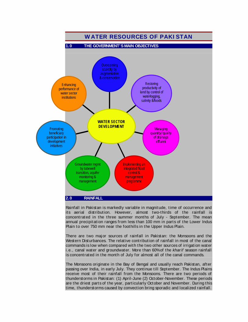
WATER RESOURCES OF PAKISTAN 1.0 THE GOVERNMENT’S MAIN OBJECTIVES
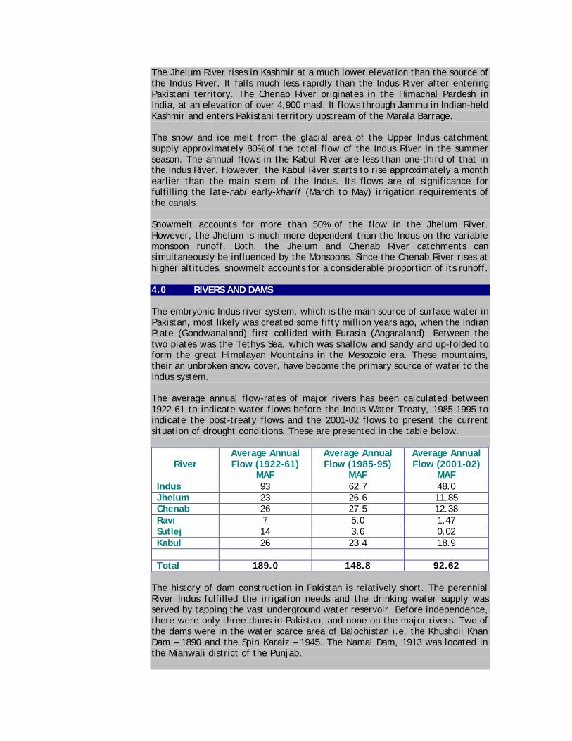
2.0 RAINFALL Rainfall in Pakistan is markedly variable in magnitude, time of occurrence and its aerial distribution. However, almost two-thirds of the rainfall is concentrated in the three summer months of July - September. The mean annual precipitation ranges from less than 100 mm in parts of the Lower Indus Plain to over 750 mm near the foothills in the Upper Indus Plain. There are two major sources of rainfall in Pakistan: the Monsoons and the Western Disturbances. The relative contribution of rainfall in most of the canal commands is low when compared with the two other sources of irrigation water i.e., canal water and groundwater. More than 60% of the kharif season rainfall is concentrated in the month of July for almost all of the canal commands. The Monsoons originate in the Bay of Bengal and usually reach Pakistan, after passing over India, in early July. They continue till September. The Indus Plains receive most of their rainfall from the Monsoons. There are two periods of thunderstorms in Pakistan: (1) April-June (2) October-November. These periods are the driest parts of the year, particularly October and November. During this time, thunderstorms caused by convection bring sporadic and localized rainfall.
Overcoming scarcity by
augmentation & conservation
Restoring productivity of
land by control of waterlogging,
salinity &floods
Managing quantity/ quality
of drainage effluent
Implementing an integrated flood
control & management programme
Groundwater mgmt by tubewell
transition, aquifer monitoring & management
Promoting beneficiary
participation in development
initiatives
Enhancing performance of
water sector institutions
WATER SECTOR DEVELOPMENT

Pakistan lies in an arid and semi-arid climate zone. The entire Indus Plains (canal command areas) receive an average seasonal rainfall of 212 mm (95% confidence interval ± 28) and 53 mm (95% confidence interval ± 8) in the kharif and rabi seasons, respectively. The rainfall varies as we move from the north and northeast to the south of the country. It is only the canal command areas in the North-West Frontier Province (NWFP) and the northern-most canal commands of the Punjab Province that receive some appreciable amount of rainfall during the summer as well as the winter season. The canal commands upstream of the rim stations (i.e., in the NWFP) receive almost 55% of their annual rainfall during the kharif season. The canal commands in the Upper and Lower Indus Plains receive 75% and 85- 90% of the annual rainfall respectively, during the kharif season. The annual variability of rainfall increases as one moves south. The canal command areas of Guddu and Sukkur Barrages fall in an area where variability is the highest. Based on 10-year average (1990-1999), data from the Pakistan Meteorological Department of annual rainfall in some of the major cities is as follows:
183
310147
130155
322
724
247
528
276
1326
346
0
200
400
600
800
1000
1200
1400
Mill
imet
res
Baha
wal
pur
D.I.
Khan
Hyd
erab
ad
Jaco
baba
d
Kara
chi
Khuz
dar
Laho
re
Mul
tan
Pesh
awar
Que
tta
Raw
alpi
ndi
Zhob
RAINFALL DATA OF MAJOR CITIES10 years average (1990-99)
3.0 GLACIER The catchment area of the Indus Basin contains some of the largest glaciers in the world, outside the Polar Regions. The glacial area of the upper Indus catchment is about 2,250 km2 and accounts for most of the river runoff in summer. The Kabul River, which is mainly snow-fed, originates from the Unai Pass of the Southern Hindukush at an elevation of 3,000 m above sea level (masl). It drains eastern Afghanistan and then enters Pakistan just north of the Khyber Pass.
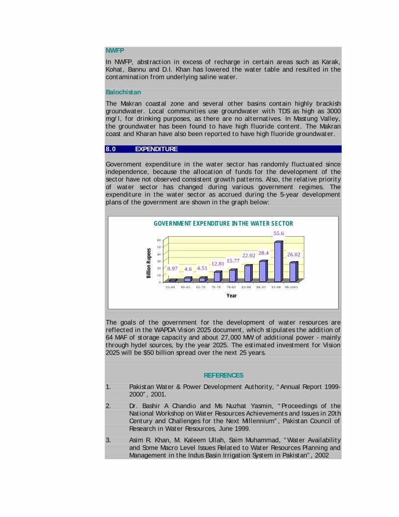
The Jhelum River rises in Kashmir at a much lower elevation than the source of the Indus River. It falls much less rapidly than the Indus River after entering Pakistani territory. The Chenab River originates in the Himachal Pardesh in India, at an elevation of over 4,900 masl. It flows through Jammu in Indian-held Kashmir and enters Pakistani territory upstream of the Marala Barrage. The snow and ice melt from the glacial area of the Upper Indus catchment supply approximately 80% of the total flow of the Indus River in the summer season. The annual flows in the Kabul River are less than one-third of that in the Indus River. However, the Kabul River starts to rise approximately a month earlier than the main stem of the Indus. Its flows are of significance for fulfilling the late-rabi early-kharif (March to May) irrigation requirements of the canals. Snowmelt accounts for more than 50% of the flow in the Jhelum River. However, the Jhelum is much more dependent than the Indus on the variable monsoon runoff. Both, the Jhelum and Chenab River catchments can simultaneously be influenced by the Monsoons. Since the Chenab River rises at higher altitudes, snowmelt accounts for a considerable proportion of its runoff. 4.0 RIVERS AND DAMS The embryonic Indus river system, which is the main source of surface water in Pakistan, most likely was created some fifty million years ago, when the Indian Plate (Gondwanaland) first collided with Eurasia (Angaraland). Between the two plates was the Tethys Sea, which was shallow and sandy and up-folded to form the great Himalayan Mountains in the Mesozoic era. These mountains, their an unbroken snow cover, have become the primary source of water to the Indus system. The average annual flow-rates of major rivers has been calculated between 1922-61 to indicate water flows before the Indus Water Treaty, 1985-1995 to indicate the post-treaty flows and the 2001-02 flows to present the current situation of drought conditions. These are presented in the table below.
River
Average Annual Flow (1922-61)
MAF
Average Annual Flow (1985-95)
MAF
Average Annual Flow (2001-02)
MAF Indus 93 62.7 48.0 Jhelum 23 26.6 11.85 Chenab 26 27.5 12.38 Ravi 7 5.0 1.47 Sutlej 14 3.6 0.02 Kabul 26 23.4 18.9 Total 189.0 148.8 92.62
The history of dam construction in Pakistan is relatively short. The perennial River Indus fulfilled the irrigation needs and the drinking water supply was served by tapping the vast underground water reservoir. Before independence, there were only three dams in Pakistan, and none on the major rivers. Two of the dams were in the water scarce area of Balochistan i.e. the Khushdil Khan Dam – 1890 and the Spin Karaiz – 1945. The Namal Dam, 1913 was located in the Mianwali district of the Punjab.

The construction of dams in Pakistan was initiated in 1955, when the country was facing an acute power shortage. Work on the Warsak Dam on Kabul River near Peshawar was undertaken. Later, when India stopped water supplies to the network of canals in Pakistan, it became imperative to build large storages and link canals to restore water to the affected canal system. This resulted in the construction of two gigantic dams, Mangla with a gross storage capacity of 5.88 MAF and Tarbela with 11.62 MAF, as a part of the Indus Basin Replacement Works. Apart from replacement works, a number of relatively smaller schemes of irrigation and water supply dams were also undertaken. 5.0 SURFACE WATER The accounting of surface water resources in the Indus System is based on river inflows measured at Rim Stations. A rim station, in the context of the Indus Basin Irrigation System, is defined as a control structure (reservoir, barrage, etc.) on the river just when the river enters into Pakistani territory or upstream of the canal-irrigated Indus Plains of Punjab and Sindh Provinces. The rim stations for the Indus System rivers are the Kalabagh Barrage (or sometimes Tarbela Reservoir) for the main Indus River, Mangla Reservoir for the Jhelum River, Marala Barrage for the Chenab River and Balloki and Sulemanki Barrages for the Ravi and Sutlej Rivers. The Indus River and its tributaries, on an average, bring 154 MAF of water annually. This includes 144.91 MAF from the three Western rivers and 9.14 MAF from the Eastern rivers. Most of this, about 104.73 MAF, is diverted for irrigation. 39.4 MAF flows to the sea and about 9.9 MAF is consumed by the system losses which include evaporation, seepage and spills during floods.
Surface Water SuppliesTotal = 154 MAF
Eastern Rivers
6%
Western Rivers94%
Surface Water ConsumptionTotal = 154 MAF
Irrigation68%
Flow to Sea26%
System Losses
6%
The flows of the Indus and its tributaries vary widely from year to year and within the year. As is the case with the water availability, there is significant variation in annual flows to the sea. The waters of the Indus Basin Rivers are diverted through reservoirs/barrages into canals, classified as Main Canals. These main canals then distribute the irrigation water into their command areas through a network of branch canals. The Indus Basin Irrigation System comprises of three major reservoirs, 16 barrages, 2 head-works, 2 siphons across major rivers, 12 inter river link canals, 44 canal systems (23 in Punjab, 14 in Sindh, 5 in NWFP and 2 in Balochistan) and more than 107,000 water courses. The aggregate length of the canals is about 56,073 km. In addition, the watercourses, farm channels and field ditches cover another 1.6 million km. The system utilizes over 41.6 MAF of

groundwater, pumped through more than 500,000 tube wells, in addition to the canal supplies. Outside the Indus Basin, there are smaller river basins. One on the Mekran coast of Balochistan drains directly in to the sea and a closed basin (Kharan). These in total amount to an inflow of less than 4 MAF annually. 6.0 GROUNDWATER – HISTORIC DEVELOPMENT Before the introduction of widespread irrigation, the groundwater table in the Indus Basin varied from about 40 feet in depth in Sindh and Bahawalpur areas to about 100 feet in Rechna Doab (the area between Ravi and Chenab Rivers). After the introduction of weir-controlled irrigation, the groundwater table started rising due to poor irrigation management, lack of drainage facilities and the resulting additional recharge from the canals, distributaries, minors, water courses and irrigation fields. At some locations, the water table rose to the ground surface or very close to the surface causing waterlogging and soil salinity, reducing productivity. In the late 1950s, the Government embarked upon a programme of Salinity Control and Reclamation Projects (SCARPS) wherein large deep tube wells were installed to control the groundwater table. Over a period of about 30 years, some 13,500 tubewells were installed by the Government to lower the groundwater table. Of these, about 9,800 tube wells were in the Punjab. The projects initially proved to be quite effective in lowering the water table but with time, the performance of the SCARP tubewells deteriorated. The development of deep public tube wells under the SCARPS was soon followed by private investment in shallow tube wells. Particularly in the eighties, the development of private tube wells received a boost, when locally manufactured inexpensive diesel engines became available. Most of these shallow tube wells were individually owned. Now more than 500,000 tubewells supply about 41.6 MAF of supplemental irrigation water every year, mostly in periods of low surface water availability. These tubewells compensated the loss of pumping capacity of the SCARP tubewells and helped in lowering the water table. 7.0 STATUS OF GROUNDWATER IN PAKISTAN The Indus Basin was formed by alluvial deposits carried by the Indus and its tributaries. It is underlain by an unconfined aquifer covering about 15 million acres in surface area. In the Punjab, about 79% of the area and in Sindh, about 28% of the area is underlain by fresh groundwater. This is mostly used as supplemental irrigation water and pumped through tubewells. Some groundwater is saline. Water from the saline tube wells is generally put into drains and, where this is not possible, it is discharged into large canals for use in irrigation, after diluting with the fresh canal water. In the last 25- 30 years, ground water has become a major supplement to canal supplies, especially in the Upper Indus Plain, where ground water quality is good. Large scale tubewell pumpage for irrigation started in the early sixties. There are presently more than 500,000 tubewells in the Indus Basin Irrigation System (IBIS) and the annual pumpage in all canal command areas has been

estimated to be over 50 BCM. According to a study, the total groundwater potential in Pakistan is of the order of 55 MAF. Major part of the groundwater abstraction for irrigation is within the canal commands or in the flood plains of the rivers. However, the amount of abstraction varies throughout the area, reflecting inadequacy/unreliability of surface water supplies and groundwater quality distribution. The quality of groundwater ranges from fresh (salinity less than 1000 mg/l TDS) near the major rivers to highly saline farther away, with salinity more than 3000 mg/l TDS. The general distribution of fresh and saline groundwater in the country is well known and mapped, as it influences the options for irrigation and drinking water supplies.
Groundwater QualityTotal Area = 29.31 Million Acres
Salinity More Than 3000 mg/l
TDS36%
Salinity Less Than 1000 mg/l
TDS49%
Salinity between 1000-3000 mg/l
TDS15%
Punjab
About 79% of the Punjab province has access to fresh groundwater. Some 9.78 million acres are underlain with groundwater of less than 1000 mg/l TDS, 3 million acres with salinity ranging from 1000 to 3000 mg/l TDS and 3.26 million acres with salinity more than 3000 mg/l TDS. Saline waters are mostly encountered in the central Doab areas. The Cholistan area in southern Punjab is well known for highly brackish waters, which can not be used for drinking purposes. Groundwater with high fluoride content is found in the Salt Range, Kasur and Mianwali. There are also reports of high fluoride content, ranging from 65 to 12 mg/l in groundwater in the Bahawalpur area. Samplings of groundwater in Jhelum, Gujrat and Sargodha districts have shown concentrations of arsenic well above the WHO guideline value of 50 g/l. Sindh
Around 28% of the Sindh province has access to fresh groundwater suitable for irrigation i.e. the water has less than 1000 mg/l TDS. Close to the edges of the irrigated lands, fresh groundwater can be found at 20 - 25 m depth. Large areas in the province are underlain with groundwater of poor quality. Indiscriminate pumping has resulted in contamination of the aquifer at many places where the salinity of tubewell water has increased. The areas with non-potable, highly brackish water include Thar, Nara and Kohistan. In Tharparkar and Umarkot, the situation is further complicated by the occurrence of high fluoride in the groundwater.
NWFP
In NWFP, abstraction in excess of recharge in certain areas such as Karak, Kohat, Bannu and D.I. Khan has lowered the water table and resulted in the contamination from underlying saline water. Balochistan
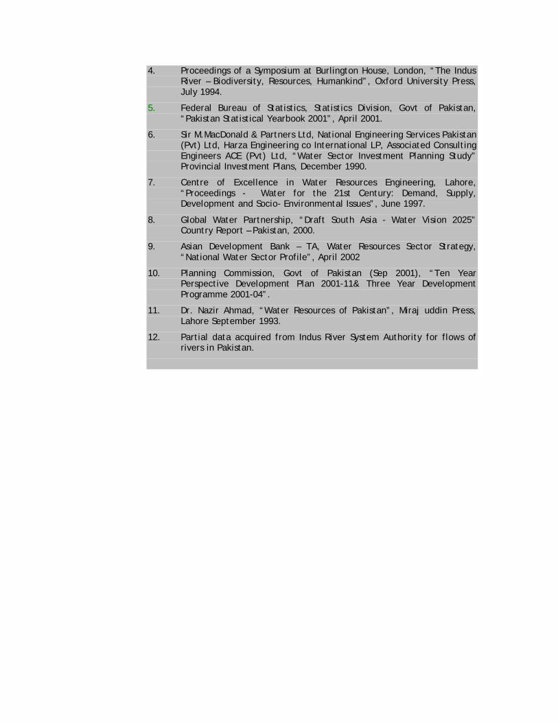
The Makran coastal zone and several other basins contain highly brackish groundwater. Local communities use groundwater with TDS as high as 3000 mg/l, for drinking purposes, as there are no alternatives. In Mastung Valley, the groundwater has been found to have high fluoride content. The Makran coast and Kharan have also been reported to have high fluoride groundwater. 8.0 EXPENDITURE Government expenditure in the water sector has randomly fluctuated since independence, because the allocation of funds for the development of the sector have not observed consistent growth patterns. Also, the relative priority of water sector has changed during various government regimes. The expenditure in the water sector as accrued during the 5-year development plans of the government are shown in the graph below:
0.97 4.6 4.5112.81
15.7722.02 28.4
55.6
26.02
0
10
20
30
40
50
60
Bill
ion
Rup
ees
55-60 60-65 65-70 70-78 78-83 83-88 88-93 93-98 98-2001
Year
GOVERNMENT EXPENDITURE IN THE WATER SECTOR
The goals of the government for the development of water resources are reflected in the WAPDA Vision 2025 document, which stipulates the addition of 64 MAF of storage capacity and about 27,000 MW of additional power - mainly through hydel sources, by the year 2025. The estimated investment for Vision 2025 will be $50 billion spread over the next 25 years.
REFERENCES
1. Pakistan Water & Power Development Authority, “Annual Report 1999-2000”, 2001.
2. Dr. Bashir A Chandio and Ms Nuzhat Yasmin, “Proceedings of the National Workshop on Water Resources Achievements and Issues in 20th Century and Challenges for the Next Millennium”, Pakistan Council of Research in Water Resources, June 1999.
3. Asim R. Khan, M. Kaleem Ullah, Saim Muhammad, “Water Availability and Some Macro Level Issues Related to Water Resources Planning and Management in the Indus Basin Irrigation System in Pakistan”, 2002
4. Proceedings of a Symposium at Burlington House, London, “The Indus River – Biodiversity, Resources, Humankind”, Oxford University Press, July 1994.
5. Federal Bureau of Statistics, Statistics Division, Govt of Pakistan, “Pakistan Statistical Yearbook 2001”, April 2001.
6. Sir M.MacDonald & Partners Ltd, National Engineering Services Pakistan (Pvt) Ltd, Harza Engineering co International LP, Associated Consulting Engineers ACE (Pvt) Ltd, “Water Sector Investment Planning Study” Provincial Investment Plans, December 1990.
7. Centre of Excellence in Water Resources Engineering, Lahore, “Proceedings - Water for the 21st Century: Demand, Supply, Development and Socio- Environmental Issues”, June 1997.
8. Global Water Partnership, “Draft South Asia - Water Vision 2025” Country Report – Pakistan, 2000.
9. Asian Development Bank – TA, Water Resources Sector Strategy, “National Water Sector Profile”, April 2002
10. Planning Commission, Govt of Pakistan (Sep 2001), “Ten Year Perspective Development Plan 2001-11& Three Year Development Programme 2001-04”.
11. Dr. Nazir Ahmad, “Water Resources of Pakistan”, Miraj uddin Press, Lahore September 1993.
12. Partial data acquired from Indus River System Authority for flows of rivers in Pakistan.