Embed Size (px)
Citation preview
WATER MOVEMENTS AND WINDS AT THE MOUSE LIGHT-VESSEL, THAMES ESTUARY
By J. N. C A m w r H m s , D.Sc., P.1nst.P. and Cdr. A. L. LAWFORD, R.N. (Ittd.)’ Roljal Naval Scientific Service
INTRODUCTION (by J . N. c.) l’l1c investigator of currents in the deep open oceans and of the winds which
p~idiice or rule them has problems enough, but a t least he may hope to work out a correlation between the two which will suffice for prediction purposes. It ran hnrtlly 1)c hoped, however, that instrumentally-made observations of current speed ant1 direction over the deep open oceans will ever be really great in amount.
l’he man who would make solid additioiih to knowledge of the water movements in our shallow seas, wherein tidal streams hold sway, cannot possibly remain content with observations relating only to brief periods. He is, of coiirse. concerned with bodies of water which already have their own intrinsic movements irrespective of wind influences. In response to the changing stand of thv tide, the horizontal water movements will vary in speed (and perhapq in direction) within each tidal period : they will, moreover, be of differing speed (wind influence quite apart ) a t springs and neaps. Many complications exist : where shallow waters are concerned, particularly where extensive banks iincover. the hydraulics of the situation will change with water depth. The tractive effect of wind will depend upon whether the water is otherwise without movement, i.r. for a brief spell a t slack waters ; or whether it is streaming into the wind, or at angles to the wind. Thus the effect of the wind locally exerted will not be the same upon the hydraulic situation for all states of the tide ; particularly, again, where extensive banks dry out a t low-water. Finally, the effects upon the water movement of winds far afield may be powerful indeed ; according as the Southern Bight of the North Sea is ponded up or the reverse, so will the water movements be affected in ways which have been amply described in existing literature.
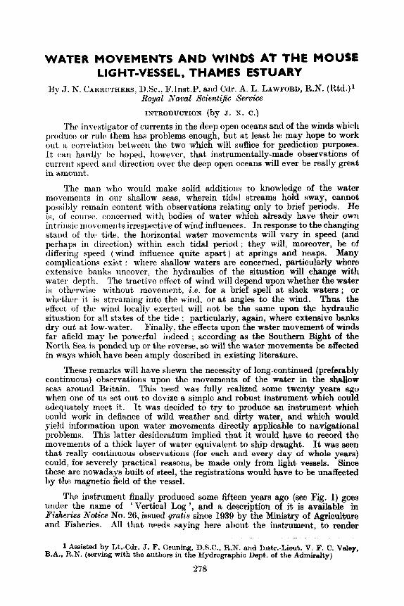
These remarks will have shewn the necessity of long-continued (preferably continuous) observations upon the movements of the water in the shallow seas around Britain. This need was fully realized some twenty years ago when one of us set out to devjze a simple and robust instrument which could adequately meet it. It was decided to try to produce an instrument which could work in defiance of wild weather and dirty water, and which would yield information upon water movements directly applicable to navigational problems. This latter desideratum implied that i t would have to record the movements of a thick layer of water equivalent to ship draught. It was seen that really continuous observations (for each and every day of whole years) could, for severely practical reasons, be made only from light vessels. Since these are nowadays built of steel, the registrations would have to be unaffected by the magnetic field of the vessel.
The instrument finally produced some fifteen years ago (see Fig. 1) goes under the name of ‘ Vertical Log ’, and a description of it is available in Fiaheria Notice No. 26, issued gratis since 1939 by the Ministry of Agriculture and Fisheries. All that needs saying here ahout the iiistniment, to render
1 Assisted by Lt.-Cdr. J. F. Gruning, D.S.C., R.N. and 1nstr.-Lieut. V. F. C. Vdey, B.A., R.N. (servkig with the authors in the Hydrographic Dept. of the Admiralty)
378
subsequent remarks intelligible, is that the water movements we recorded by noting the number of revolutions made by a cup system aa registered on eight counters which operate within the box supporting the cup system. Each of these counters is put into use manually whilst the water is moving towards that compass octant to which it relates. As to direction, a dumb wooden compass is kept in alignment with the ship’s own compass reading, and a pointer which moves over it transfers water-flow direction from the sea unit to a convenient inboard position. Thus it is simply arranged that the proper counter is always in use (Carruthers, J. N., 1947).
Fig. 1. Vertical Log Current-meter, aa used aboard veseels
Up to the present time, continuous observations upon the water move- ments past various British (and one French) light vessels, totalling some 4,400 days have been published (op. cit . ) and some 3,300 days of observations await publication, a mass of data which was gathered with the requirements of fisheriee research in view. In addition, whole years of work with the instrument have been carried out from Netherlands lightships, where coastal erosion problems were the chief concern. A variant of the instrument is now in use from Naval survey vetxwAs. A form of vertical log which can work for about a month from an unattended buoy has recently passed its tests. It avoids the great expense of immobilizing a vessel, and records the data on a time scale controlled by a clock. A future simplification of it will provide the same kind of observational dtkta as have hitherto been obtained from lightships.
The information given below is a study of estuarine water movements, and it bears upon a topic of present-day interest in the field of marine biology; the contribution of manurial ertlts made by rivers to the sea. The observations to be reported upon were, in a sense, a continuation into the War years of work upon which one of us (J. N. C.) had been long engaged. That this con- tinuation ww possible was due to the good offices of the Hydrographer of the
979
Navy in the first place, and to the English Fisfiwies Department for providing the apparatus in the second. The Statistical Branch of that department worked out the results, as hacl long been customary, and thanks are tendered to its personnel concerned. and to the officers and crew of the light vessel who did the actual observing.
It is intended to publish elsewhere as soon as possible all outstanding data of the type with which this paper is concerned.
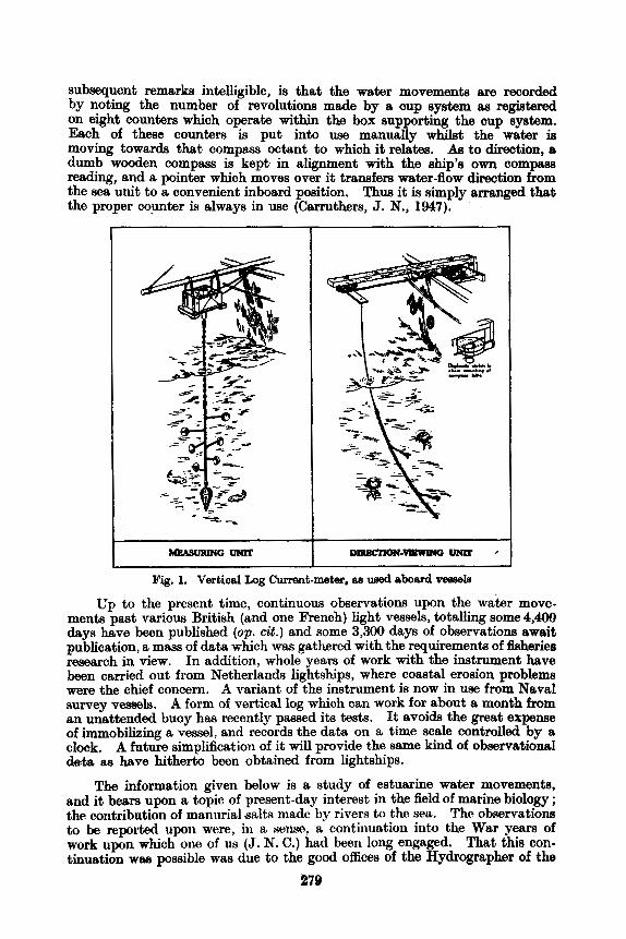
RESULTS (by A . I,. L . ) ‘I’hv obschrvtltions were commenced aboard the Mousc Tight Vessel on
20 March 1940, when she was in a position 2.3 miles 111” from the Msplin Measured Mile S.E. Beacon. On 5 June observations were interrupted while she was moved to a, povitioll 7.5 mi 224;t” from the West Harrow Beacon.
. . . T H E C A N T
L
Fig. 2. Portion of the Thames Estuary showing Light Vessel
,.*.’ ...... . . . . . . . . . . . . . ....
;he two positions of the Mouse
The work was resumed a t this pwition on 6 June, and continued, with a break in the observations from 11-13 November, until 18 November 1940, shortly before the withdrawal of thv vessel owing to the war. She has not h e n replaced. .In all, 232 observations, each lasting a lunar day, were made-74 a t the first position and 168 a t the second.
In the first position. to be referred to as A, the Mouse Light Vessel was in R rnc*itii tlcptli of !) f;itlmns n h i t 2 niilvs to the west of the rntmilc*r to the Harrow 1)ec’l). 111 I i w sc~~nici position ( K ) , she was ill a metin tlcptli o f 11 fathoms a t the entraiicc of the Oaze k e l ) (see Fig. 2). Water movements
280
at both positions were always within 206 north and‘south of (magnetic) ewt and west, and the overall or residual movements were either towards east or west.
During the period under review the centre of the cup system of the measur- ing unit was 9 ft below the sea surface. The water layer in which observations were taken was from one fathom to two fathoms below the surface. The total revolutions, and the revolutions of the east and west counters per lunar day were simply obtained by subtracting the readings of the day before. The total daily revolutions and the sum of the revolutions of the east and west counters agreed to within 3 revs.-the disparity, which represented a fraction per thousand of the whole, was due to the time taken to change over counters. The water movement in sea miles per lunar day was obtained by applying the ‘ calibration constant ’ of the instrument to the revolutions. In this case, 300 rev were the equivalent of one mile (6080 f t ) of passing water.
The wind was estimated every three hours, the strength being recorded in Beaufort scale numbers. The mean wind for the day was calculated by geometrically averaging the winds recorded between the initial and h a 1 readings of the counters each day. When the local tractive effect of the wind is considered in this paper, sight is not lost of the fact that the observations related to a layer of water well below the surface.
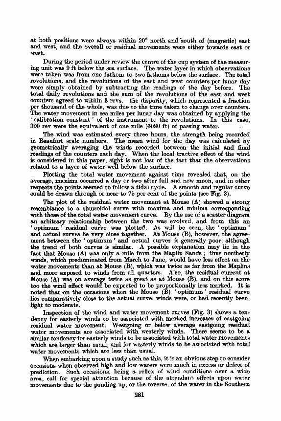
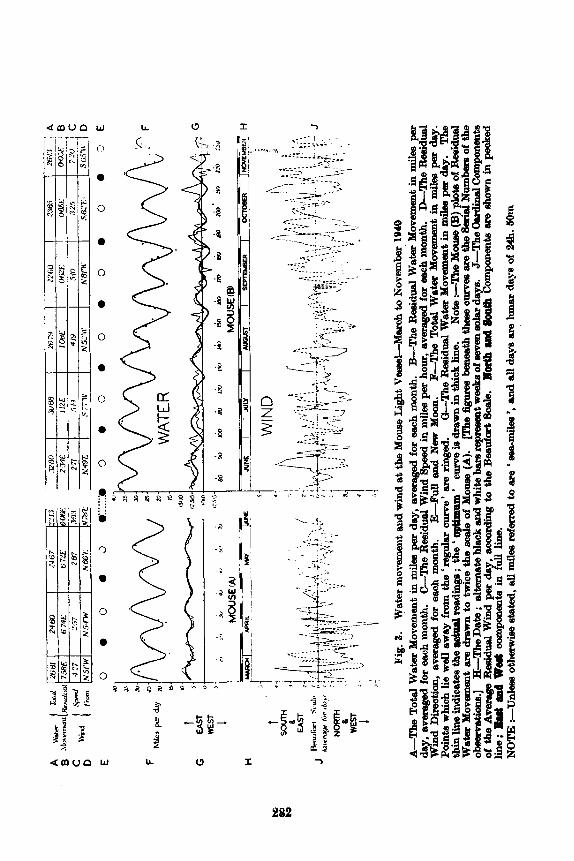
Plotting the total water movement against time revealed that, on the average, maxima occurred a day or two after full and new moon, and in other respects the points seemed to follow a tidal cycle. A smooth and regular curve could be b w n through or near to 75 per cent of the points (see Fig. 3).
The plot of the residual water movement a t Mouse (A) showed a strong resemblance to a sinusoidal curve with maxima and minima corresponding with those of the total water movement curve. By the use of a scatter diagram an arbitrary relationship between the two was evolved, and from this an ‘optimum’ residual purve was plotted. As will be seen, the ‘ 0 timum’ and actual curves lie very close together. At Mouse (B), however, t K e agree- ment between the ‘ optimum ’ and actual curves is generally poor, although the trend of both curvea is similar. A possible explanation may lie in the fact that Mouse (A) was only a mile from the Maplin Sands ; thus northerly winds, which predominated from March to June, would have less effect on the water movements than at Mouse (B), which was twice m far from the lbplim and more exposed to winds from all quarten. Also, the residual current a t Mouse (A) waa on average twice as great as at Mouse (B), and on this score too the wind effect would be expected to be proportionally less marked. It is noted that .on the occasions when the Mouse (B) ‘ optimum ’ residual curve lies comparatively close to the actual curve, winds were, or had recently been, light to moderate.
Inspection of the wind and water movement curves (Fig. 3) shows a ten- dency for easterly winds to be associated with marked increases of eastgoing residual weter movement. Westgoing or below average eaatgoing residual water movements are associated with westerly winds. There seems to be a similar tendency for easterly winds to be amooiated with total water movement8 which a= larger than usual, and for westerly winds to be associated with total water movements which are less than usual.
m e n embarking upon a study such as this, it is an obvious step to consider occasions when observed high and low waters were much in excess or defect of prediction. Such occasions, being a reflex of wind conditions over a wide area, call for special attention kccluxe of the attendant effects upon water movements due to the ponding up, or the reverse, of the water in the Southern
281
I 1
Fig
. 3.
Wat
er m
owm
emt
and
win
d at
the
Mo
m L
ight
Vea
ml-M
mh
to h
'ove
mbe
r 19
40
dsy, 8
ve~m
ged fo
r ea
ch m
onth
. &
The
Res
idua
l Wind
Spee
d in
mile
s per hour,
swrs
ged
far
eeo
h m
onth
. L
Th
e R
eaid
ual
Win
d D
irec
tion,
averaged
for each m
onth
. F-
The
Tot
el W
sbr Movement in
mile
s pe
r day.
Poi
nts
whi
ch
The
thin lin
e. indicetee t
he m
tu8l
din
p ; t
he '
' cu
rve ie drawn in t
hick
line.
Note :-
-The
Moue (B
) plota o
f R
eeid
ual
Wab
r M
ovem
ent
prhe
fie;
ures
ben
eeth
thes
e c
ma
are the 8aia
Nam
bepe
of
the
ob
~8
tio
ns.
] H--T
he
D8t
e ; s
ltern
ste b
lack
and w
hite
bers re
pree
mat
wee
h of
mem
so
h d
8p.
J--Th
e clvdinsl C
ompo
nent
s of
the
Ave
mge
Rd
du
al W
ind
per dsy. w
oord
ing to t
he B
eeuf
ort S
de
. llath udl
ht
h C
ompo
nent
s are &own in
peoked
NOTE :-
Ude
es
0th-
st
ated
, all d
es
referred to
8re ' e
ea-m
ilee ', e
nd
all d
sys 81.~ lunar
da
p of
!24
h. M
lm
A--T
he
TO
td w
8k
Mov
emen
t in
per
d8y,
8V
m
for
wh
mon
th.
%Th
e R
&d
d w
8br
MW
-mt
in m
ih pe
r
%Fu
ll end New Moon.
Wen
8w
8y fr
om t
he 'r
egu
lsr
curv
e' 8
1.~ ringe
d.
%Th
e R
eeid
usl w
ater
M0-t
in m
k per d8y.
drewn to t
mce
the
de
of
Mou
se (
A).
lin
e; Bad l
ad Wd oamponente in
full
line.
Bight of the North Sea. In this, there were no particular period oxcursions from prediction of sufficient magnitude to warrant detailed attention.
Thanks are expressed to Dr. A. T. Doodson, P.R.S., Director of the Liverpool Observatory and Tidal Institute, and to Commander A. M. Coleman, O.B.E., D.B.C., R.N. (retd.), River Superintendent and Chief Harbour Mavter to the Port of London Authority, for relevant information.
SUMMARY OF OBSERVATIONS A broad survey of the water movements recorded during the 74 and 158 days of obaerv-
(1) At both positions the water moved alternately towards the east and west ochnts
(2) Total water movemente (the summed daily mileage of eastgoing and wostgoing
ing 86 positions A and B respectively rev& the following facts of chief interest :-
of the compees, and towards these directions only.
travel) : the maXimum/average/minimum vdues were as follows :- A 33.5/24*8/15-9 mi day. B 37*9/27-1/11-7 day.
A 21*6/16.8/10.6 mi day. B 20.5/14*1/7-1 mi day.
A 11-8/9.0/6.3 mi day. B 18.1/13.0/4+3 mi day.
(3) The daily eastgoing water movement6 (maximum/uveruge/miriimurti) were :-
and the daily westgoing movements were :-
(4) "he residual current (the nett travel or ' overall make ' of the water) wan towardo h t on 100 per cent of the days at position A and on 84 per cent of the days at position B.
(6) Averaged over the entire periods under review (vector averages) the residual current was 6 4 m i day towards East at position A and 1.0 mi day towards Eaat at position B.
(6) Extreme residual current velues in mi day were 10.2 Eastand 3.0 East at pooition A and 4.1 Eaat and 2-4 West at position B.
REFERENCE carruthem, J. N. 1947 Realism in current-meclsuring in the upper layers of the
See. I d . Hych. Rw.. Molaaco. Vol. 24, pp. 6P64
WEATHER ORDER FORM
To R O Y A ~ METEOROLO~IOAL SOOIETY (Weather), 49, Cromwell Road,
LONDON, S.W.7. I wieh to receive Weather for twelve months, commencing ............................ for which I enclose a remittance of 18s. Od. (cheque or crossed postal order) or U.S. $2.50 (postal money order).
Name (BLOCK LETTERS) ................................................................................................
AI.l&reaa (BLOCK L E ~ E R S ) ............................................................................................
.......................................................................................................................
Dale ................................................ 283