Embed Size (px)
Citation preview

The Giles Track
Watarrka National Park F
act
Sh
eet Watarrka National Park (Kings
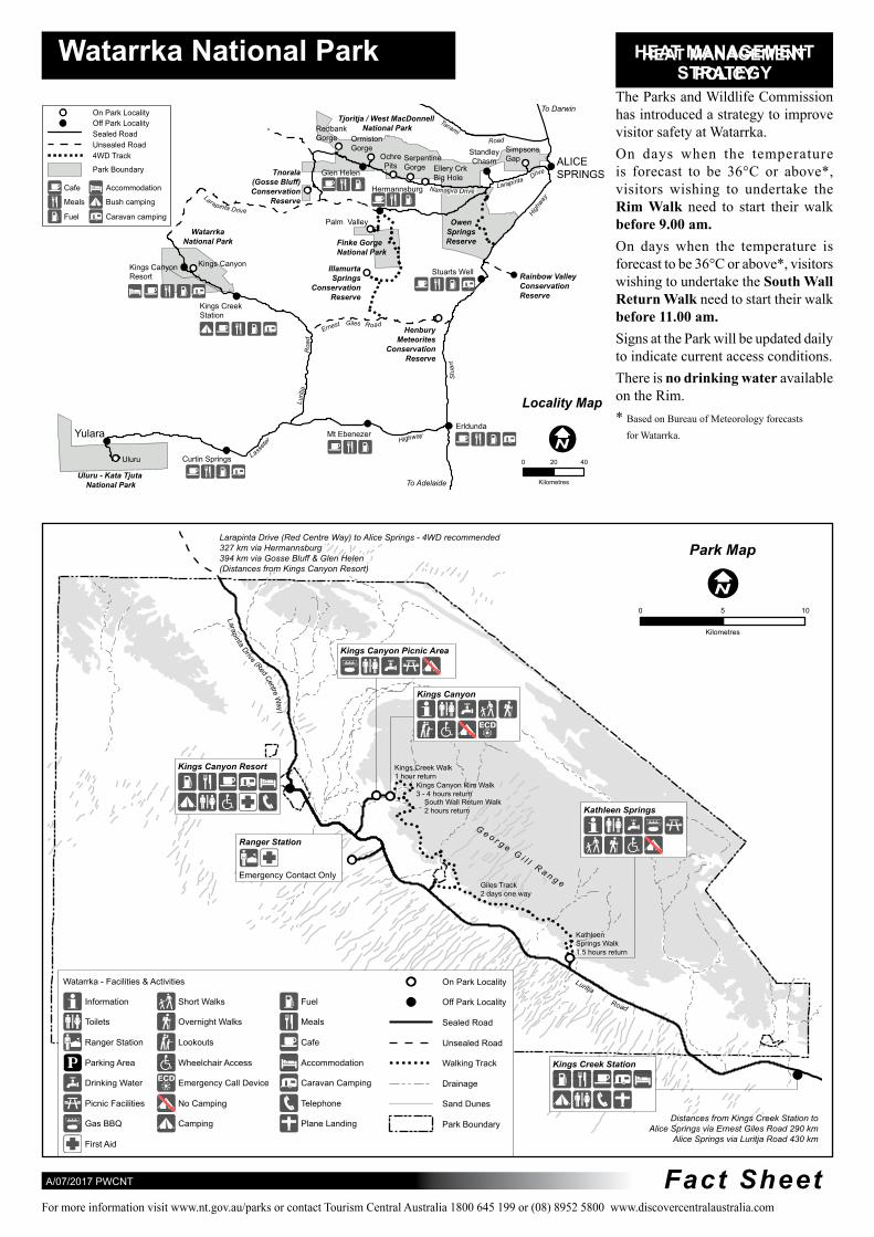
Canyon) includes the western end of the George Gill Range This scenic landscape of rugged ranges rockholes and moist gorges acts as a refuge for many plants and animals This makes the Park an important conservation area and a major visitor attraction in Central Australia
Access The Park is located southwest of Alice Springs and can be reached via a number of routes
bull via the Stuart Highway Lasseter Highway and Luritja Road (sealed roads)
bull via Larapinta Drive through the West MacDonnell National Park A Mereenie Loop pass is required to travel this route and is available from the Alice Springs Tourist Information Centre Glen Helen Resort and Kings Canyon Resort (4WD is essential)
bull via the Stuart Highway Ernest Giles Road (4WD essential) and Luritja Road
When to visit The Park is accessible all year round See overleaf for access information during hot weather
The cooler months (April to September) are the most pleasant
Overnight camping in tents or campervans is not
permitted in the National Park
Commercial motel and camping accommodation is the only option available for visitors wishing to stay overnight at Watarrka
Kings Canyon Resort Ph (08) 8956 7442 Kings Canyon Wilderness Lodge Ph (08) 8955 8311
Kings Creek Station Ph (08) 8956 7474
What to do Walking - Before undertaking any of the
following walks consider your personal health fitness and available time Visit the Safety Information Shelter and check the signs at the start of the walks
The Kings Creek Walk (26 km one hour return) The gentle slope of the track meanders up Kings Creek This walk is suitable for families Wheelchairs can access the first 700 metres
The Kings Canyon Rim Walk (6 km loop 3-4 hours) After an initial steep climb the walk offers spectacular views from the Canyon rim Along the way are the weathered domes of the lsquoLost Cityrsquo and the lush vegetation of the lsquoGarden of Edenrsquo This walk is suitable for fit experienced walkers
South Wall Return Walk (48 km 2 hours return) Starts with a steep climb up the southern rim of Kings Canyon and offers stunning views of the Parkrsquos geological features Suitable for fit experienced walkers
Kathleen Springs Walk (26 km 15 hour return) leads to a delightful spring-fed waterhole suitable for families Wheelchair accessible
Parks amp Wildlife Commission of the Northern Territory Watarrka Ranger Station Regional Office - Arid Zone Research Institute Ph (08) 8956 7460 South Stuart Highway ALICE SPRINGS NT 0870
PO Box 1120 ALICE SPRINGS NT 0871 wwwntgovauparks Ph (08) 8951 8250 Fax (08) 8951 8290
(22 km 2 days) traverses the top of the range from
Kathleen Springs to Kings Canyon with a halfway entranceexit point at Reedy CreekLilla Notify a reliable person of your intended walk plans and ensure they know to contact police if you do not return by the arranged date Carry a satellite phone or personal locator beacon
Emergencies - Emergency Call Devices are located on the Kings Canyon Walk and at the
Canyon car park Please use them to contact the Rangers in an emergency only
Safety and Comfort bull Observe park safety signs bull Carry and drink plenty of water bull Wear a shady hat sunscreen
insect repellent suitable clothing and footwear
bull Avoid strenuous activity during the heat of the day Please read information about the Heat Management Strategy overleaf
bull Consider your health and fitness when choosing a walk
Please Remember bull Keep to designated roads and
tracks bull Stay at least 2m from cliff edges bull All historic cultural items and
wildlife are protected bull Firewood collection is not
permitted in the park bull Fires are not permitted in the
park bull Bins are not provided please
take your rubbish with you bull Pets are permitted on a leash in
the Kings Canyon carpark only bull Please do not throw rocks over
cliff edges as there may be people below
Tanami Road
ive r
Larapinta D
ve
y L aa
wrapinta Drive
hgiH
Ernest Gile Road
Roa
d
Stu
art
L ur it
ja
Highway r ete
Lass
Larap inta Drive (Red Centre Way)
G e o r g e G i l l R a n g e
Luritja Road
Watarrka National Park HEAHEA T MANAGEMENTT MANAGEMENT STRATEGYPOLICY
The Parks and Wildlife Commission To Darwin has introduced a strategy to improveOn Park Locality
Tjoritja West MacDonnellOff Park Locality Redbank National Park visitor safety at WatarrkaSealed Road Gorge Ormiston
Unsealed Road Gorge SimpsonsStandley On days when the temperatureChasm ALICE4WD Track Ochre Serpentine Gap
Pits Gorge is forecast to be 36degC or aboveEllery CrkPark Boundary Tnorala Glen Helen SPRINGSBig Hole(Gosse Bluff) Conservation visitors wishing to undertake theCafe Accommodation
Meals Bush camping
Fuel Caravan camping
Hermannsburg Namatjira DriReserve Rim Walk need to start their walk
before 900 am On days when the temperature is
Palm Valley Owen Watarrka
National Park Finke Gorge Springs Reserve
National Park
Kings Canyon Kings Canyon forecast to be 36degC or above visitorsIllamurta Stuarts Well Rainbow ValleyResort Springs Conservation wishing to undertake the South WallConservation
Reserve Reserve Return Walk need to start their walkKings Creek before 1100 amStation
s Henbury
Meteorites Signs at the Park will be updated daily Conservation
Reserve to indicate current access conditions There is no drinking water available on the RimLocality Map Based on Bureau of Meteorology forecasts
ErldundaYulara Mt Ebenezer for Watarrka
Uluru Curtin Springs 0 4020
Uluru - Kata Tjuta National Park To Adelaide Kilometres
Larapinta Drive (Red Centre Way) to Alice Springs - 4WD recommended 327 km via Hermannsburg Park Map394 km via Gosse Bluff amp Glen Helen (Distances from Kings Canyon Resort)
0 5 10
Kilometres
Kings Canyon Picnic Area
Kings Canyon
Kings Canyon Resort Kings Creek Walk 1 hour return
Kings Canyon Rim Walk 3 - 4 hours return
South Wall Return Walk 2 hours return Kathleen Springs
Ranger Station
Emergency Contact Only Giles Track 2 days one way
Kathleen Springs Walk 15 hours return
Watarrka - Facilities amp Activities On Park Locality
Information Short Walks Fuel Off Park Locality
Toilets Overnight Walks Meals Sealed Road
Ranger Station Lookouts Cafe Unsealed Road
Parking Area Wheelchair Access Accommodation Walking Track Kings Creek Station
Drinking Water Emergency Call Device Caravan Camping Drainage
Picnic Facilities No Camping Telephone Sand Dunes
Gas BBQ Camping Plane Landing Park Boundary Distances from Kings Creek Station to
Alice Springs via Ernest Giles Road 290 km
First Aid Alice Springs via Luritja Road 430 km
A072017 PWCNT Fact Sheet For more information visit wwwntgovauparks or contact Tourism Central Australia 1800 645 199 or (08) 8952 5800 wwwdiscovercentralaustraliacom