Embed Size (px)
Citation preview
C:\Users\jardiner\AppData\Local\Microsoft\Windows\Temporary Internet Files\Content.Outlook\D3NW668I\LTSAppendix6 ATP 28Nov.doc 25/07/2017 1
Walking and Cycling to a Healthier Stirling
DRAFT for Council 8th December 2016
C:\Users\jardiner\AppData\Local\Microsoft\Windows\Temporary Internet Files\Content.Outlook\D3NW668I\LTSAppendix6 ATP 28Nov.doc 25/07/2017 DRAFT Document 2
Introduction Walking and cycling help support many environmental and social objectives. Accordingly the aspiration of more people walking and cycling in Scotland is set out in a number of Scottish Government documents, not least of these is ‘A More Active Scotland’ published in February 2014 (Appendix A provides an overview of the relevant policy framework, at a national, regional and local level). At a more local level walking and cycling as part of an active lifestyle can contribute to Stirling’s Single Outcome Agreement (SOA)1 In particular they are important elements of the SOA’s identified prevention and intervention activity, and assist with:
Improving accessibility of facilities and services
Maintaining the quality of the environment and adapting to climate change
Tackling inequalities in health, income and housing As such, and in order to maximise opportunities (including funding opportunities), this walking and cycling plan was developed in partnership with Community Planning Partners (CPPs), via the Tackling Poverty and Inequalities Group (TPIG). It was also considered during the Local Transport Strategy (LTS) consultation that took place between 2nd August and 30th September 2016. Where possible we have taken on board comments from key stakeholders, and will
1 http://my.stirling.gov.uk/services/community-life-and-leisure/your-community/your-community-community-planning/community-planning-single-outcome-agreement
continue to develop the detailed Partnership Action Plan (see Appendix B for initial partnership action plan) in conjunction with partners, including:
Sustrans
Paths for All
NHS Forth Valley
Loch Lomond and Trossachs National Park Authority (LLTNPA)
Cycle Stirling
Walkable Stirling
Stirling Cycle Hub
University of Stirling The intended key outcomes of this plan are:
To increase the percentage of people walking and cycling in Stirling
To increase the percentage of children and students walking and cycling to/from places of education in Stirling
A variety of data sources are used to help determine how we can maximise modal shift from single occupancy car use to more sustainable travel modes, such as walking, cycling and public transport use. From the latest Census data (2011), it can be seen that 45% of all people aged 16 and over who are studying or aged 16 to 74 in employment travel 10km or less to work/education. Distance travelled to work/education by people aged 16 and over who are studying or aged 16 to 74 in employment
15% Work or study mainly at or from home
18% 10km to less than 30km
34% Less than 5km 13% 30km and over
11% 5km to less than 10km 9% Other
C:\Users\jardiner\AppData\Local\Microsoft\Windows\Temporary Internet Files\Content.Outlook\D3NW668I\LTSAppendix6 ATP 28Nov.doc 25/07/2017 DRAFT Document 3
Traffic modelling suggests that of all car trips within Stirling City, only 38% and 46% have their origin AND destination within the city. In other words, 54% - 62% of trips start of end beyond the built up area of Stirling. Hence it is only the 30% - 46% of car trips we can realistically expect to influence, where possible, away from car use and onto sustainable/active travel.
Therefore, given the importance of encouraging a modal shift from single
occupancy car use and the role that active travel has in achieving this, the LTS
has adopted a number of targets that relate to active travel:
Subject Indicator Baseline
Targets
By 38% of LDP Build
Out (2022)
By 74% of LDP Build
Out (2027)
School travel planning
% schools with ‘live’
travel plan in line with
Council guidance
2015: 18%
submitted
By June 2017, all schools to have a
‘live’ school travel plan in line with
Council guidance
Walking Proportion of people
accessing Stirling City
Centre on foot
2015 4% 10% increase
compared to
2017 levels
Cycling % increase of annual
average number of
cyclists on monitored
routes
2016 20% 50% increase
compared to
2017 levels
% of everyday trips
made by bike
2011: % of trips
made to work or
education by
bike
National Target: 10% of all trips by
2020 (=488% increase)
This plan will seek to work towards these outcomes, and subsequently make Stirling a healthier place, through each of the SOA’s life stages, by identifying activities and resources under the following key outputs:
walking and cycling infrastructure improvements; and
behaviour change, training and promotion activities
Whilst many of the activities included in this plan are embedded in other LTS
delivery plans, an active travel plan has been produced as a succinct
document that the many partners interested in encouraging walking and
cycling can work together in delivering. In this plan walking and cycling have been separated into four main themes, as they cover such a wide range of activities:
Walkable Stirling
Cycling in Stirling
School Travel Planning
Travel Plans and Promotions Walkable Stirling
Stirling City is a compact and attractive city where many daily trips are within
walking distance. The city already offers:
a good network of existing paths
routes of historic and cultural interest
a relatively flat environment
a pedestrianised City Centre
relatively low traffic levels compared to many other urban areas
To maximise the potential of walking in Stirling, we developed the Walkable
Stirling project with a variety of stakeholders, including:
C:\Users\jardiner\AppData\Local\Microsoft\Windows\Temporary Internet Files\Content.Outlook\D3NW668I\LTSAppendix6 ATP 28Nov.doc 25/07/2017 DRAFT Document 4
NHS Forth Valley
Tactran
University of Stirling
Forth Valley College
Paths for All
Living Streets
Active Stirling
Sustrans
The main aim of the Walkable Stirling project is to co-ordinate and maximise opportunities to promote and improve Stirling as a walkable city, by:
Promoting opportunities to residents and visitors (behaviour change, training and promotion activities)
Improving pedestrian facilities and routes (Infrastructure improvements)
Ensuring Stirling grows in a manner, which continues to enable and
encourage walking
We will also ensure, via an access audit and improvement programme, that
pedestrian routes to local centres within and outwith the city are accessible
by all, including people with mobility difficulties.
Key Outputs The initial key outputs of Walkable Stirling, in relation to Stirling Council, are: Infrastructure improvements
enhance existing and identify new pedestrian routes into the city centre from neighbouring areas
continue to improve the city centre environment as a place for people, to encourage pedestrian movement and enhance access to commercial premises
Undertake an access audit and improvement programme, to ensure that pedestrian routes to local centres within and outwith the city are accessible by all, including people with mobility difficulties.
provide a network of active travel routes across the urban area
Behaviour change, training and promotion activities Promote the walkability of Stirling to residents and visitors through:
the Internet
route planning apps
walking clubs and groups
signage
promotion of routes
promotional activities
C:\Users\jardiner\AppData\Local\Microsoft\Windows\Temporary Internet Files\Content.Outlook\D3NW668I\LTSAppendix6 ATP 28Nov.doc 25/07/2017 DRAFT Document 5
Cycling in Stirling
Although Stirling has a wide rural hinterland, the Stirling City area, including
Bannockburn, Bridge of Allan and Dunblane, is a compact area that is
relatively flat with many trips short enough to be easily done by bicycle.
There are many issues, however, that are seen as barriers to cycling which affect people’s decision whether to cycle or not. Some of the key issues are detailed below:
Safety, and perceived safety, especially on busy roads
Maintenance of existing routes
Lack of information/ signage on routes
Distance to travel
Lack of cycle parking
Weather
While many of these issues can be addressed through the provision of
additional infrastructure and facilities, there are also many elements where
the solution lies in addressing the perception of a problem through some
form of education or information.
To maximise the potential of cycling in and around Stirling, the Council is
working with a number of partners, including:
Sustrans
Cycle Stirling
Stirling Cycle Hub
Loch Lomond and the Trossachs National Park Authority
NHS Forth Valley
Transport Scotland
Key Outputs The initial key outputs of cycling in Stirling, in relation to Stirling Council, are: Infrastructure improvements
Development of a network of routes to serve the key destinations
through the Stirling area (the provisional network schedule is shown in
Appendix E) together with a complementary strategic cycle routes
network map.
Complete and improve the National Cycle Network (NCN) routes through
Stirling, as well as core leisure and tourist routes
Better integration of walking and cycling with public transport
In partnership with key stakeholders, to provide cycle parking at key
destinations throughout Stirling
Provision of cycle hire opportunities
Behaviour change, training and promotion activities
Promotion of routes and facilities, including signing of the network
Cycle training, skills and maintenance courses
Promotion, in particular via Stirling Cycle Hub
Promotional activities
C:\Users\jardiner\AppData\Local\Microsoft\Windows\Temporary Internet Files\Content.Outlook\D3NW668I\LTSAppendix6 ATP 28Nov.doc 25/07/2017 DRAFT Document 6
School Travel Planning Walking and cycling to school is important for a number of reasons, including:
Improving children’s health
Reducing the number of cars being used to take children to school
Providing children with the essential road and traffic awareness skills Stirling Council will therefore be supporting nurseries and schools in the area to ensure that every one has a ‘live’ travel plan, in line with Council guidance, in place by June 2017. As such the Council has developed a guide on how to write travel plans (STP) (see Appendix F). By January 2017 all schools, including nurseries, must be actively engaged in developing a school travel plan. On an annual basis all schools must submit a report to Stirling Council, to inform the ongoing school travel planning progress. Responsibility for developing and implementing school travel plans lies with the head teacher of each school, although it is expected that the wider school community will also be engaged throughout the process. Schools are also required to take part in the annual Sustrans ‘Hands up Survey’, which is the largest national dataset to look at travel to school across Scotland. Only schools engaging in STPs or the Planning (STP) process, will be considered for safer routes to schools measures, which will seek to provide:
Enhanced safety for pupils travelling to school
Reduced congestion and improved air quality around schools
Increased physical activity levels of school children
In order to determine where the limited amount of funding is spent each year a ‘school travel prioritisation criteria template’ has been developed (see Appendix F). As well as support from the Council, schools may also wish to: 1. utilise external promotional resources and work towards being recognised
as:
An eco school, which is an international award scheme, promoting sustainability
A cycle friendly school, which is a national accreditation focusing on infrastructure, promotion and incentives to inspire pupils to cycle to school
2. apply for opportunities to improve cycle parking Key Outputs Whilst each school will tailor its travel plan round its own needs, the following initial outputs will be relevant to all the school travel plans: Infrastructure improvements
Continued development of safer routes to school and network
improvements
Cycle parking
Behaviour change, training and promotion activities
Every nursery and school in Stirling to have a ‘live’ travel plan, in line with Stirling Council guidance, from June 2017 onwards
All primary 5 plus school children to be able to access bikeability training
Continued development and promotion of routes and facilities, including
signage

C:\Users\jardiner\AppData\Local\Microsoft\Windows\Temporary Internet Files\Content.Outlook\D3NW668I\LTSAppendix6 ATP 28Nov.doc 25/07/2017 DRAFT Document 7
Travel Plans and Promotions A travel plan allows a business to encourage employees to travel in a more sustainable manner to/from work, via the implementation of a series of travel measures such as:
promoting walking and cycling; salary sacrifice schemes
providing bicycle parking and lockers
parking controls
introducing a car sharing scheme promotion of working at home; compressed hours; flexible working
promoting sustainable travel at work
promotion of public transport
Employee travel plans also provide a number of benefits to the business, employees, and the wider community, for example:
helping to improve the health of employees
helping to reduce the carbon footprint of the business and its employees
helping to reduce congestion in the local area
Case Study: Stirling Council
Stirling Council introduced its employee travel plan in 2009 and continues to develop this document in response to changing business and employee needs, for example by developing a staff travel to work guide in response to the major relocation of premises in the city.
During the seven years that the Stirling Council employee travel plan has been active, the following key measures have been introduced:
Promotional items, primarily secured via funding from Tactran, the regional transport partnership, including:
o An employee travel guide that was published in relation to the relocation of the majority of Council employees
o A series of promotional events carried out on a regular basis, such as Dr Bike and walking challenges
Introduction of pool bikes
Development of facilities such as: showers; lockers; covered bike parking;
and open bike parking
Introduction of a car sharing scheme
Introduction of a cycle to work scheme, whereby employees can purchase a bicycle via the salary sacrifice scheme, as long as it is used at least half of the time for commuting purposed
Corporate membership of Next Bike, a bike hire scheme, and onsite bike hire stations at city based Council buildings
Allocation of carsharing spaces
Requirement for pool vehicles to be used
Removal of essential car allowance
Key Outputs Going forward, Stirling Council will: 1. Continue to develop its employee travel plan and be seen to be leading by
example. 2. Support other organisations to develop their travel plans 3. Require major developments to provide travel plans
C:\Users\jardiner\AppData\Local\Microsoft\Windows\Temporary Internet Files\Content.Outlook\D3NW668I\LTSAppendix6 ATP 28Nov.doc 25/07/2017 DRAFT Document 8
Developing and delivering the Active Travel Plan Action Plan in Partnership
As stated previously, encouraging and achieving modal shift from single
occupancy car use can only be achieved by working in partnership with key
stakeholders, including Stirling’s people, to minimise problems and provide
the most appropriate solutions.
The following actions will also be undertaken to maximise partnership working:
Establishing an Active Travel Steering Group
This steering group will be created to decide on the priorities of the
Partnership Action Plan, and will be responsible for the tracking and reporting
progress of the Partnership Action Plan. Membership will include elected
members / Councillors/ senior representatives from Stirling Council and other
partnership organisations. It will feedback to the Community Planning
Partnerships on an annual basis.
Setting up a coordinating group for Active Travel initiatives This working group will be created as a sub group of the Steering Group, to coordinate all Active Travel Initiatives in Stirling, with its primary focus being the delivery of the initiatives in the Partnership Action Plan. The Group will consist of representatives of Stirling Council and relevant other bodies such as Cycle Stirling and Walkable Stirling. It will report project progress into the Steering Group, and identify funding opportunities in the first instance.
Developing the Active Travel Partnership Action Plan
We will work with partners, including neighbouring Local Authorities, Cycle
Stirling, Walkable Stirling, and employers to develop a robust partnership
action plan taking into account short-medium- and long-term actions, as well
as any potential funding opportunities
Developing the monitoring framework and reporting structure Whilst we will be collecting relevant data as part of the overall Local Transport Strategy, we will also be working with partners to agree a monitoring framework and reporting structure, via the Active Travel Steering Group. A range of core indicators will be collected consistently from a number of different partners and collated centrally and fed into an annual report to showcase progress towards modal shift.
Training We will make use of training offered by partners, such as Cycling Scotland, Living Streets, Sustrans, Paths for All, for all key stakeholders including Stirling Council Officers who plan, design, construct and maintain streets, footways and cycleways Targets, Monitoring and Review
Targets
As stated previously, given the importance of encouraging a modal shift from
single occupancy car use and the role that active travel has in achieving this,
the LTS has adopted a number of targets that relate to active travel.
Monitoring
It is proposed that we report progress on an annual basis, to the Community
Planning Partnership. Our proposals for monitoring are set out below, and
will be develop to include core indicators collected by partners.
C:\Users\jardiner\AppData\Local\Microsoft\Windows\Temporary Internet Files\Content.Outlook\D3NW668I\LTSAppendix6 ATP 28Nov.doc 25/07/2017 DRAFT Document 9
Monitoring: data to be collected
Percentage of journeys made by bicycle as main mode of transport
Percentage of journeys made by walking as main mode of transport
Percentage mode share of pupils travelling to school
Percentage of schools with a ‘live’ school travel plan in line with Stirling Council guidance
Percentage of children provided with cycle training
Percentage of cycle instructors and volunteers at each school
Number of children killed or seriously injured in road traffic accidents
Number of people car sharing
Proportion of people accessing Stirling City Centre by car
Proportion of people accessing Stirling Centre by foot
Annual average number of cyclists on monitored routes
Distance travelled to work/education by people aged 16 and over who are studying or aged 16 to 74 in employment
Percentage of employees covered by an Employee Travel Plan
Please note: A modal share is the percentage of travellers using a particular type of transportation or number of trips using said type.
The current status of the above data can be seen in Appendix C.
Review In order to achieve the desired outputs and outcomes the Active Travel Partnership Plan will be reviewed annually in line with other Local Transport documents, and then every five years together with the Local Development Plan.
C:\Users\jardiner\AppData\Local\Microsoft\Windows\Temporary Internet Files\Content.Outlook\D3NW668I\LTSAppendix6 ATP 28Nov.doc 25/07/2017 DRAFT Document 10
Cross-cutting Themes The following actions apply to both walking and cycling: Marketing and promotion Marketing and promotion are key factors in increasing the number of people travelling by walking and cycling. As such the Council will brand all Council schemes and promotions as part of Stirling’s Local Transport Strategy. We will also work with partners to:
promote walking and cycling as desirable means of transport; as well as for leisure and health, for all abilities
keep updated, and promote, walking and cycling websites and apps, eg, Walkable Stirling, Walkit.com, GoToo,
develop the current cycling map for Stirling City to include walking and public transport routes and relevant information
expand and promote the Comfort Partnership
explore the variety of funding opportunities to promote active travel, such as Smarter Choices Smarter Places
work together to support local initiatives to promote walking and cycling
Maintenance The Council will continue to implement:
vegetation management and winter maintenance of the footways, paths and carriageways, for the benefit of pedestrian and cyclists
a programme of low cost improvements as part of maintenance schemes such as installation of dropped kerbs and addition of advanced stop lines for cyclists at traffic signals, where funding and circumstances allow.
Public transport interchange facilities
Lockers for cyclists to use have been provided at Stirling Rail Station and the
Springkerse Park and Ride site, and are proving to be very popular. The
Council will therefore continue to:
maintain and improve, where necessary, public transport interchange
facilities to increase walking and cycling, as well as public transport use.
Accessibility
We will work with partners, including communities, to:
undertake access audits and implement an improvement programme to
ensure the street environment and routes to facilities are accessible for
all, including people with mobility difficulties
ensure opportunities for addressing known access barriers are addressed
when undertaking works
Development Planning
Stirling Council and LLTNPA development planning processes seek to ensure
that:
developments are realistically accessible
new developments are designed to enhance the quality of place and
specifically create environments that are attractive for walking and cycling
in line with policy contained within the Scottish Government’s ‘Designing
Streets’
travel plans are required for significant developments
Improving the quality of roads and the street environment
The Council will continue to identify opportunities to enhance the quality
of Stirling’s public realm
when undertaking works the Council will identify opportunities to reduce
street clutter
C:\Users\jardiner\AppData\Local\Microsoft\Windows\Temporary Internet Files\Content.Outlook\D3NW668I\LTSAppendix6 ATP 28Nov.doc 25/07/2017 DRAFT Document 11
Maximising the attractiveness of Stirling City Centre
By supporting the City Development Framework projects and major road
schemes, such as:
City Park – active travel routes
The Harbour and Grow on Space, Forthside – reviewing hierarchy of
Forthside Way with associated traffic calming, cycle, pedestrian and bus
priority improvements
The River – new pedestrian and cycle river crossins, Riverside active travel
route
City Centre pedestrian and public realm enhancements – Stirling Station
Gateway and City South public realm improvements
C:\Users\jardiner\AppData\Local\Microsoft\Windows\Temporary Internet Files\Content.Outlook\D3NW668I\LTSAppendix6 ATP 28Nov.doc 25/07/2017 DRAFT Document 12
Appendix A: Policy Framework
National A More Active Scotland
Let’s Get Scotland Walking - National Walking Strategy
A Long Term Vision for Active Travel in Scotland 2030
Cycling Action Plan for Scotland
Climate Change Act (Scotland)
Community Empowerment (Scotland) Act 2015
Tourism Development Framework for Scotland
National Planning Framework 3 (NPF3)
The Equality Act 2010 (Specific Duties) (Scotland) Regulations 2012
Regional
Regional Transport Strategy (inc Health and Transport Framework)
Regional Walking and Cycling Strategy and Action Plan Local
Stirling Single Outcome Agreement
Stirling City Development Framework
Stirling Local Development Plan
Stirling Local Transport Strategy (City and Towns, Villages and Rural Area Transport Plans; Road Maintenance Plan, Road Safety Plan)
Stirling Sports, Physically Activity, and Wellbeing Strategy
Stirling Council Education Service, Strategic Plan 2016-2017
Loch Lomond and Trossachs National Park Local Plan 2010-2015
Loch Lomond and the Trossachs National Park Authority (LLTNPA) Outdoor Recreation Plan, 2013 - 2017
C:\Users\jardiner\AppData\Local\Microsoft\Windows\Temporary Internet Files\Content.Outlook\D3NW668I\LTSAppendix6 ATP 28Nov.doc 25/07/2017 DRAFT Document 13
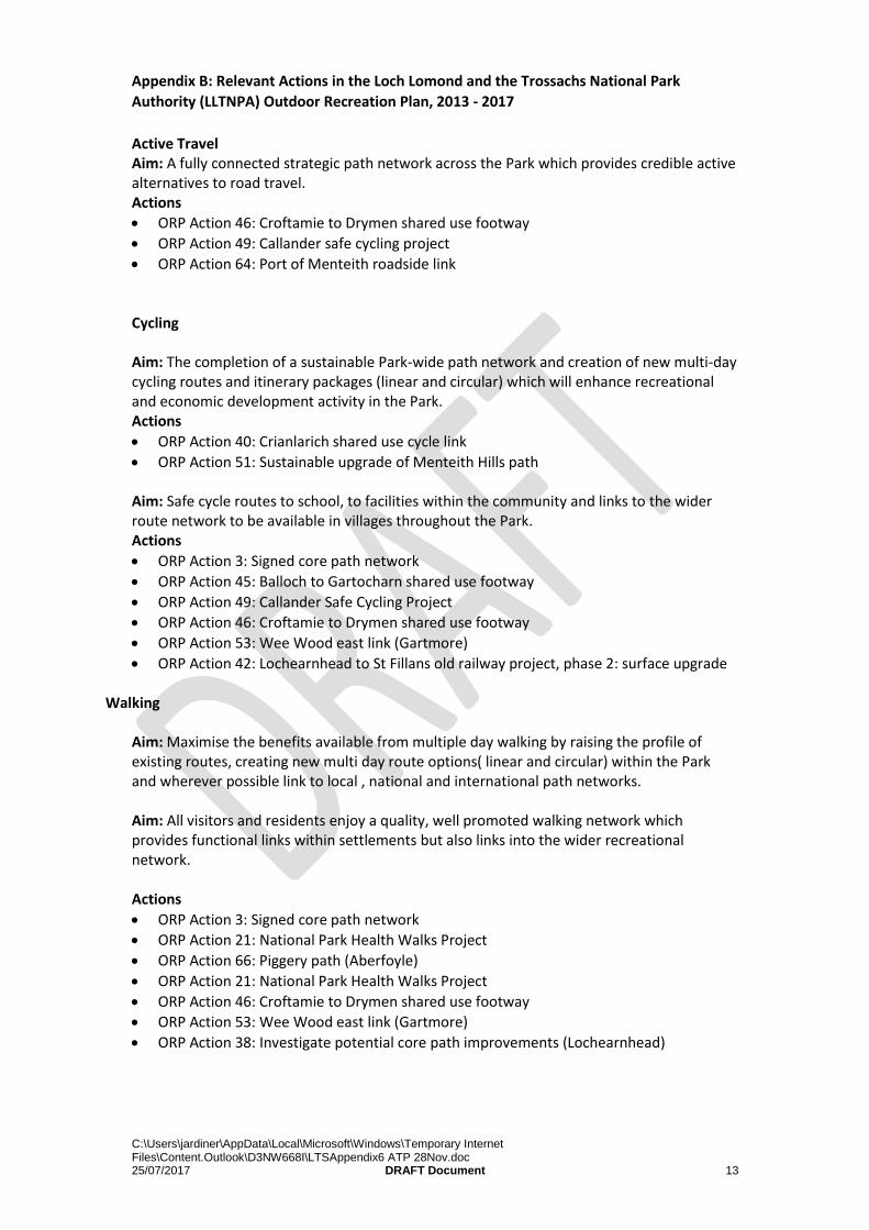
Appendix B: Relevant Actions in the Loch Lomond and the Trossachs National Park
Authority (LLTNPA) Outdoor Recreation Plan, 2013 - 2017
Active Travel Aim: A fully connected strategic path network across the Park which provides credible active alternatives to road travel. Actions
ORP Action 46: Croftamie to Drymen shared use footway
ORP Action 49: Callander safe cycling project
ORP Action 64: Port of Menteith roadside link Cycling Aim: The completion of a sustainable Park-wide path network and creation of new multi-day cycling routes and itinerary packages (linear and circular) which will enhance recreational and economic development activity in the Park. Actions
ORP Action 40: Crianlarich shared use cycle link
ORP Action 51: Sustainable upgrade of Menteith Hills path Aim: Safe cycle routes to school, to facilities within the community and links to the wider route network to be available in villages throughout the Park. Actions
ORP Action 3: Signed core path network
ORP Action 45: Balloch to Gartocharn shared use footway
ORP Action 49: Callander Safe Cycling Project
ORP Action 46: Croftamie to Drymen shared use footway
ORP Action 53: Wee Wood east link (Gartmore)
ORP Action 42: Lochearnhead to St Fillans old railway project, phase 2: surface upgrade Walking
Aim: Maximise the benefits available from multiple day walking by raising the profile of existing routes, creating new multi day route options( linear and circular) within the Park and wherever possible link to local , national and international path networks. Aim: All visitors and residents enjoy a quality, well promoted walking network which provides functional links within settlements but also links into the wider recreational network. Actions
ORP Action 3: Signed core path network
ORP Action 21: National Park Health Walks Project
ORP Action 66: Piggery path (Aberfoyle)
ORP Action 21: National Park Health Walks Project
ORP Action 46: Croftamie to Drymen shared use footway
ORP Action 53: Wee Wood east link (Gartmore)
ORP Action 38: Investigate potential core path improvements (Lochearnhead)
C:\Users\jardiner\AppData\Local\Microsoft\Windows\Temporary Internet Files\Content.Outlook\D3NW668I\LTSAppendix6 ATP 28Nov.doc 25/07/2017 DRAFT Document 14
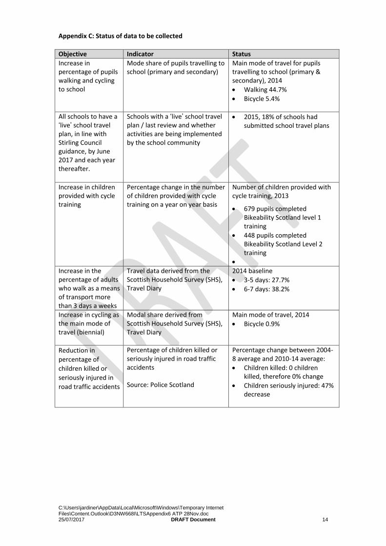
Appendix C: Status of data to be collected
Objective Indicator Status
Increase in percentage of pupils walking and cycling to school
Mode share of pupils travelling to school (primary and secondary)
Main mode of travel for pupils travelling to school (primary & secondary), 2014
Walking 44.7%
Bicycle 5.4%
All schools to have a ‘live’ school travel plan, in line with Stirling Council guidance, by June 2017 and each year thereafter.
Schools with a ‘live’ school travel plan / last review and whether activities are being implemented by the school community
2015, 18% of schools had submitted school travel plans
Increase in children provided with cycle training
Percentage change in the number of children provided with cycle training on a year on year basis
Number of children provided with cycle training, 2013
679 pupils completed Bikeability Scotland level 1 training
448 pupils completed Bikeability Scotland Level 2 training
Increase in the percentage of adults who walk as a means of transport more than 3 days a weeks
Travel data derived from the Scottish Household Survey (SHS), Travel Diary
2014 baseline
3-5 days: 27.7%
6-7 days: 38.2%
Increase in cycling as the main mode of travel (biennial)
Modal share derived from Scottish Household Survey (SHS), Travel Diary
Main mode of travel, 2014
Bicycle 0.9%
Reduction in
percentage of
children killed or
seriously injured in
road traffic accidents
Percentage of children killed or seriously injured in road traffic accidents Source: Police Scotland
Percentage change between 2004-8 average and 2010-14 average:
Children killed: 0 children killed, therefore 0% change
Children seriously injured: 47% decrease
C:\Users\jardiner\AppData\Local\Microsoft\Windows\Temporary Internet Files\Content.Outlook\D3NW668I\LTSAppendix6 ATP 28Nov.doc 25/07/2017 DRAFT Document 15
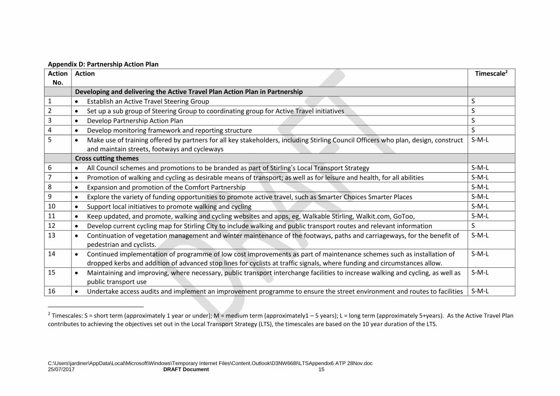
Appendix D: Partnership Action Plan
Action No.
Action
Timescale2
Developing and delivering the Active Travel Plan Action Plan in Partnership
1 Establish an Active Travel Steering Group S
2 Set up a sub group of Steering Group to coordinating group for Active Travel initiatives S
3 Develop Partnership Action Plan S
4 Develop monitoring framework and reporting structure S
5 Make use of training offered by partners for all key stakeholders, including Stirling Council Officers who plan, design, construct and maintain streets, footways and cycleways
S-M-L
Cross cutting themes
6 All Council schemes and promotions to be branded as part of Stirling’s Local Transport Strategy S-M-L
7 Promotion of walking and cycling as desirable means of transport; as well as for leisure and health, for all abilities S-M-L
8 Expansion and promotion of the Comfort Partnership S-M-L
9 Explore the variety of funding opportunities to promote active travel, such as Smarter Choices Smarter Places S-M-L
10 Support local initiatives to promote walking and cycling S-M-L
11 Keep updated, and promote, walking and cycling websites and apps, eg, Walkable Stirling, Walkit.com, GoToo, S-M-L
12 Develop current cycling map for Stirling City to include walking and public transport routes and relevant information S
13 Continuation of vegetation management and winter maintenance of the footways, paths and carriageways, for the benefit of pedestrian and cyclists.
S-M-L
14 Continued implementation of programme of low cost improvements as part of maintenance schemes such as installation of dropped kerbs and addition of advanced stop lines for cyclists at traffic signals, where funding and circumstances allow.
S-M-L
15 Maintaining and improving, where necessary, public transport interchange facilities to increase walking and cycling, as well as public transport use
S-M-L
16 Undertake access audits and implement an improvement programme to ensure the street environment and routes to facilities S-M-L
2 Timescales: S = short term (approximately 1 year or under); M = medium term (approximately1 – 5 years); L = long term (approximately 5+years). As the Active Travel Plan
contributes to achieving the objectives set out in the Local Transport Strategy (LTS), the timescales are based on the 10 year duration of the LTS.
C:\Users\jardiner\AppData\Local\Microsoft\Windows\Temporary Internet Files\Content.Outlook\D3NW668I\LTSAppendix6 ATP 28Nov.doc 25/07/2017 DRAFT Document 16
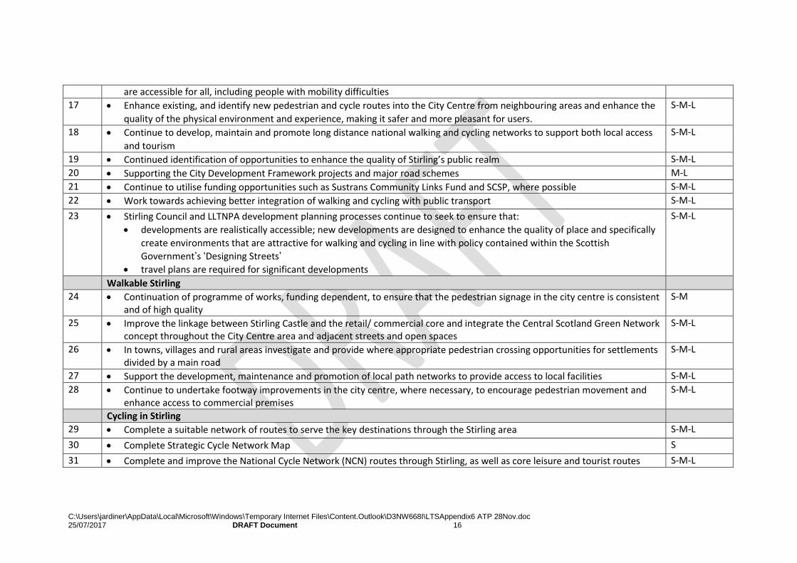
are accessible for all, including people with mobility difficulties
17 Enhance existing, and identify new pedestrian and cycle routes into the City Centre from neighbouring areas and enhance the
quality of the physical environment and experience, making it safer and more pleasant for users.
S-M-L
18 Continue to develop, maintain and promote long distance national walking and cycling networks to support both local access
and tourism
S-M-L
19 Continued identification of opportunities to enhance the quality of Stirling’s public realm S-M-L
20 Supporting the City Development Framework projects and major road schemes M-L
21 Continue to utilise funding opportunities such as Sustrans Community Links Fund and SCSP, where possible S-M-L
22 Work towards achieving better integration of walking and cycling with public transport S-M-L
23 Stirling Council and LLTNPA development planning processes continue to seek to ensure that:
developments are realistically accessible; new developments are designed to enhance the quality of place and specifically
create environments that are attractive for walking and cycling in line with policy contained within the Scottish
Government’s ‘Designing Streets’
travel plans are required for significant developments
S-M-L
Walkable Stirling
24 Continuation of programme of works, funding dependent, to ensure that the pedestrian signage in the city centre is consistent and of high quality
S-M
25 Improve the linkage between Stirling Castle and the retail/ commercial core and integrate the Central Scotland Green Network concept throughout the City Centre area and adjacent streets and open spaces
S-M-L
26 In towns, villages and rural areas investigate and provide where appropriate pedestrian crossing opportunities for settlements divided by a main road
S-M-L
27 Support the development, maintenance and promotion of local path networks to provide access to local facilities S-M-L
28 Continue to undertake footway improvements in the city centre, where necessary, to encourage pedestrian movement and enhance access to commercial premises
S-M-L
Cycling in Stirling
29 Complete a suitable network of routes to serve the key destinations through the Stirling area S-M-L
30 Complete Strategic Cycle Network Map S
31 Complete and improve the National Cycle Network (NCN) routes through Stirling, as well as core leisure and tourist routes S-M-L
C:\Users\jardiner\AppData\Local\Microsoft\Windows\Temporary Internet Files\Content.Outlook\D3NW668I\LTSAppendix6 ATP 28Nov.doc 25/07/2017 DRAFT Document 17
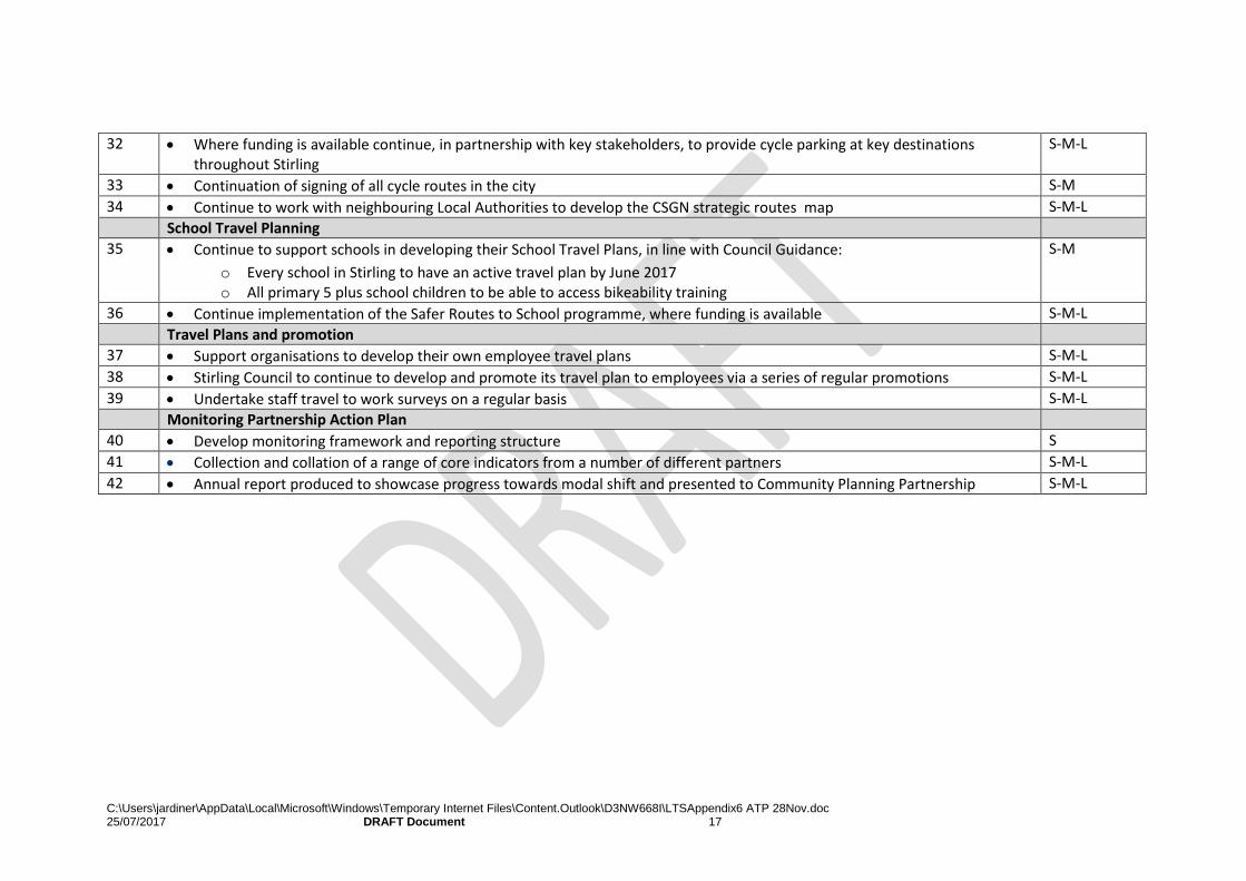
32 Where funding is available continue, in partnership with key stakeholders, to provide cycle parking at key destinations throughout Stirling
S-M-L
33 Continuation of signing of all cycle routes in the city S-M
34 Continue to work with neighbouring Local Authorities to develop the CSGN strategic routes map S-M-L
School Travel Planning
35 Continue to support schools in developing their School Travel Plans, in line with Council Guidance:
o Every school in Stirling to have an active travel plan by June 2017 o All primary 5 plus school children to be able to access bikeability training
S-M
36 Continue implementation of the Safer Routes to School programme, where funding is available S-M-L
Travel Plans and promotion
37 Support organisations to develop their own employee travel plans S-M-L
38 Stirling Council to continue to develop and promote its travel plan to employees via a series of regular promotions S-M-L
39 Undertake staff travel to work surveys on a regular basis S-M-L
Monitoring Partnership Action Plan
40 Develop monitoring framework and reporting structure S
41 Collection and collation of a range of core indicators from a number of different partners S-M-L
42 Annual report produced to showcase progress towards modal shift and presented to Community Planning Partnership S-M-L
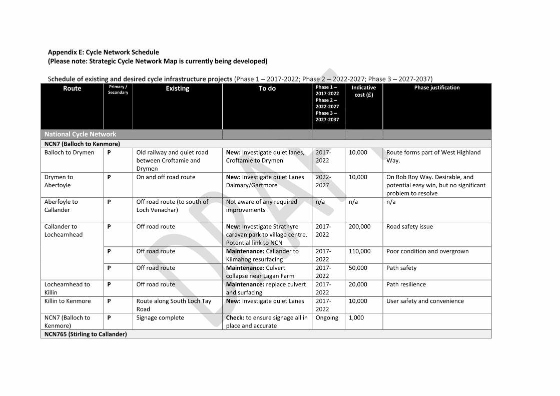
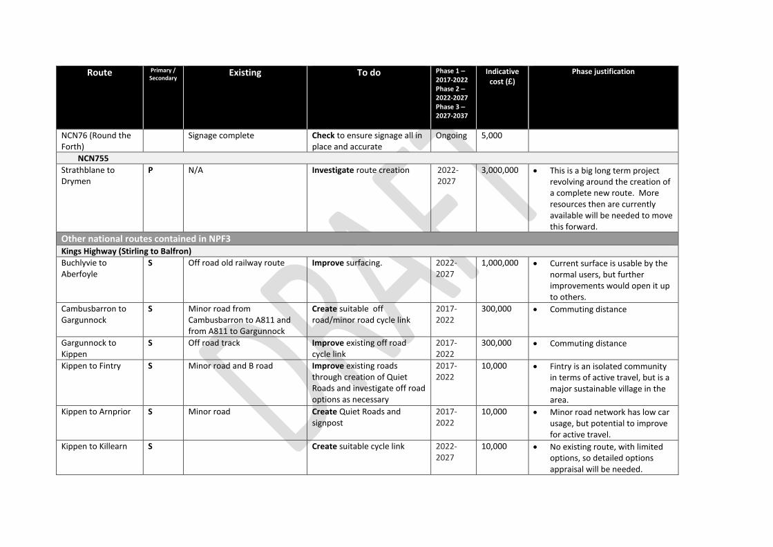
Appendix E: Cycle Network Schedule (Please note: Strategic Cycle Network Map is currently being developed) Schedule of existing and desired cycle infrastructure projects (Phase 1 – 2017-2022; Phase 2 – 2022-2027; Phase 3 – 2027-2037)
Route Primary / Secondary
Existing To do Phase 1 – 2017-2022 Phase 2 – 2022-2027 Phase 3 – 2027-2037
Indicative cost (£)
Phase justification
National Cycle Network NCN7 (Balloch to Kenmore)
Balloch to Drymen
P Old railway and quiet road between Croftamie and Drymen
New: Investigate quiet lanes, Croftamie to Drymen
2017-2022
10,000 Route forms part of West Highland Way.
Drymen to Aberfoyle
P On and off road route New: Investigate quiet Lanes Dalmary/Gartmore
2022-2027
10,000 On Rob Roy Way. Desirable, and potential easy win, but no significant problem to resolve
Aberfoyle to Callander
P Off road route (to south of Loch Venachar)
Not aware of any required improvements
n/a n/a n/a
Callander to Lochearnhead
P Off road route New: Investigate Strathyre caravan park to village centre. Potential link to NCN
2017-2022
200,000 Road safety issue
P Off road route Maintenance: Callander to Kilmahog resurfacing
2017-2022
110,000 Poor condition and overgrown
P Off road route Maintenance: Culvert collapse near Lagan Farm
2017-2022
50,000 Path safety
Lochearnhead to Killin
P Off road route Maintenance: replace culvert and surfacing
2017-2022
20,000 Path resilience
Killin to Kenmore P Route along South Loch Tay Road
New: Investigate quiet Lanes 2017-2022
10,000 User safety and convenience
NCN7 (Balloch to Kenmore)
P Signage complete Check: to ensure signage all in place and accurate
Ongoing 1,000
NCN765 (Stirling to Callander)
Route Primary / Secondary
Existing To do Phase 1 – 2017-2022 Phase 2 – 2022-2027 Phase 3 – 2027-2037
Indicative cost (£)
Phase justification
University to City Centre
P NCN765
Cycle lanes on Causewayhead Rd
Traffic calmed route on Dumyat Rd
Toucan at Causewayhead / Cornton junction and revised signage.
2022-2027
30,000
P Investigate route improvement (to reflect route’s usage)
2017-2022
8,000 Assists Council’s modal shift requirements for City
P Aithrey Rd: Off road cycle path on south side, on road cycle lane on north side
Convert cycle only section on south side to shared use
2022-2027
1,000 Assists Council’s modal shift requirements for City
Bridge of Allan to Dunblane (A9)
P Glen Rd opened as
temporary measure
Fourways Roundabout off road bypass route
Investigate off road route along A9 for long term
2022-2027
150,000 Glen Rd will cease to be usable as NCN at some, unknown time, due to landslips
P Kier Roundabout to Dunblane (B8033) off road
2022-2027
50,000 Glen Rd will cease to be usable as NCN at some, unknown time, due to landslips
P Links to Dunblane Station 2017-2022
1,000,000 NCN should be linked to access points such as rail stations
Dunblane to Doune Off road route between Dunblane High Street and Doune
Resurface and improve drainage between Dunblane High School and Argaty.
2017-2022
200,000 Poor route condition
Doune to Callander (A84 / Drumloist Rd)
P Bridge of Kelty to Callander converted railway and residential streets
Doune to Burn of Cambus including road and river crossings.
2017-2022
3,000,000
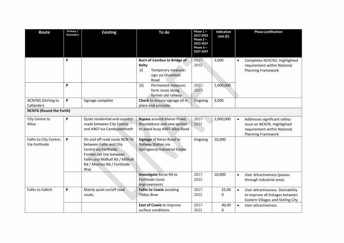
Route Primary / Secondary
Existing To do Phase 1 – 2017-2022 Phase 2 – 2022-2027 Phase 3 – 2027-2037
Indicative cost (£)
Phase justification
P Burn of Cambus to Bridge of Kelty (i) Temporary measure:
sign via Drumloist Road
2017-2022
3,000 Completes NCN765. Highlighted requirement within National Planning Framework
P (ii) Permanent measure: form route along former old railway
2022-2027
1,000,000
NCN765 (Stirling to Callander)
P Signage complete Check to ensure signage all in place and accurate
Ongoing 3,000
NCN76 (Round the Forth)
City Centre to Alloa
P Quiet residential and country roads between City Centre and A907 via Cambuskenneth
Bypass around Manor Powis Roundabout and new section to avoid busy A907 Alloa Road
2017-2022
2,000,000 Addresses significant safety issue on NCN76. Highlighted requirement within National Planning Framework
Fallin to City Centre: Via Forthside
P On and off road route NCN 76 between Fallin and City Centre via Forthside: Former rail line between Fallin and Millhall Rd / Millhall Rd / Muirton Rd / Forthside Way
Signage of Kerse Road to Railway Station via Springkerse Industrial Estate.
Ongoing 10,000
Investigate Kerse Rd to Forthside route improvements
2017-2022
10,000 User attractiveness (passes through industrial area)
Fallin to Falkirk P Mainly quiet on/off road route,
Fallin to Cowie avoiding Tibbys Brae
2017-2022
25,000
User attractiveness. Desirability to improve all linkages between Eastern Villages and Stirling City
East of Cowie to improve surface conditions.
2017-2022
40,000
User attractiveness
Route Primary / Secondary
Existing To do Phase 1 – 2017-2022 Phase 2 – 2022-2027 Phase 3 – 2027-2037
Indicative cost (£)
Phase justification
NCN76 (Round the Forth)
Signage complete Check to ensure signage all in place and accurate
Ongoing 5,000
NCN755
Strathblane to Drymen
P N/A Investigate route creation 2022-2027
3,000,000 This is a big long term project revolving around the creation of a complete new route. More resources then are currently available will be needed to move this forward.
Other national routes contained in NPF3 Kings Highway (Stirling to Balfron)
Buchlyvie to Aberfoyle
S Off road old railway route Improve surfacing. 2022-2027
1,000,000 Current surface is usable by the normal users, but further improvements would open it up to others.
Cambusbarron to Gargunnock
S Minor road from Cambusbarron to A811 and from A811 to Gargunnock
Create suitable off road/minor road cycle link
2017-2022
300,000 Commuting distance
Gargunnock to Kippen
S Off road track Improve existing off road cycle link
2017-2022
300,000 Commuting distance
Kippen to Fintry S Minor road and B road Improve existing roads through creation of Quiet Roads and investigate off road options as necessary
2017-2022
10,000 Fintry is an isolated community in terms of active travel, but is a major sustainable village in the area.
Kippen to Arnprior S Minor road Create Quiet Roads and signpost
2017-2022
10,000 Minor road network has low car usage, but potential to improve for active travel.
Kippen to Killearn S Create suitable cycle link 2022-2027
10,000 No existing route, with limited options, so detailed options appraisal will be needed.
Route Primary / Secondary
Existing To do Phase 1 – 2017-2022 Phase 2 – 2022-2027 Phase 3 – 2027-2037
Indicative cost (£)
Phase justification
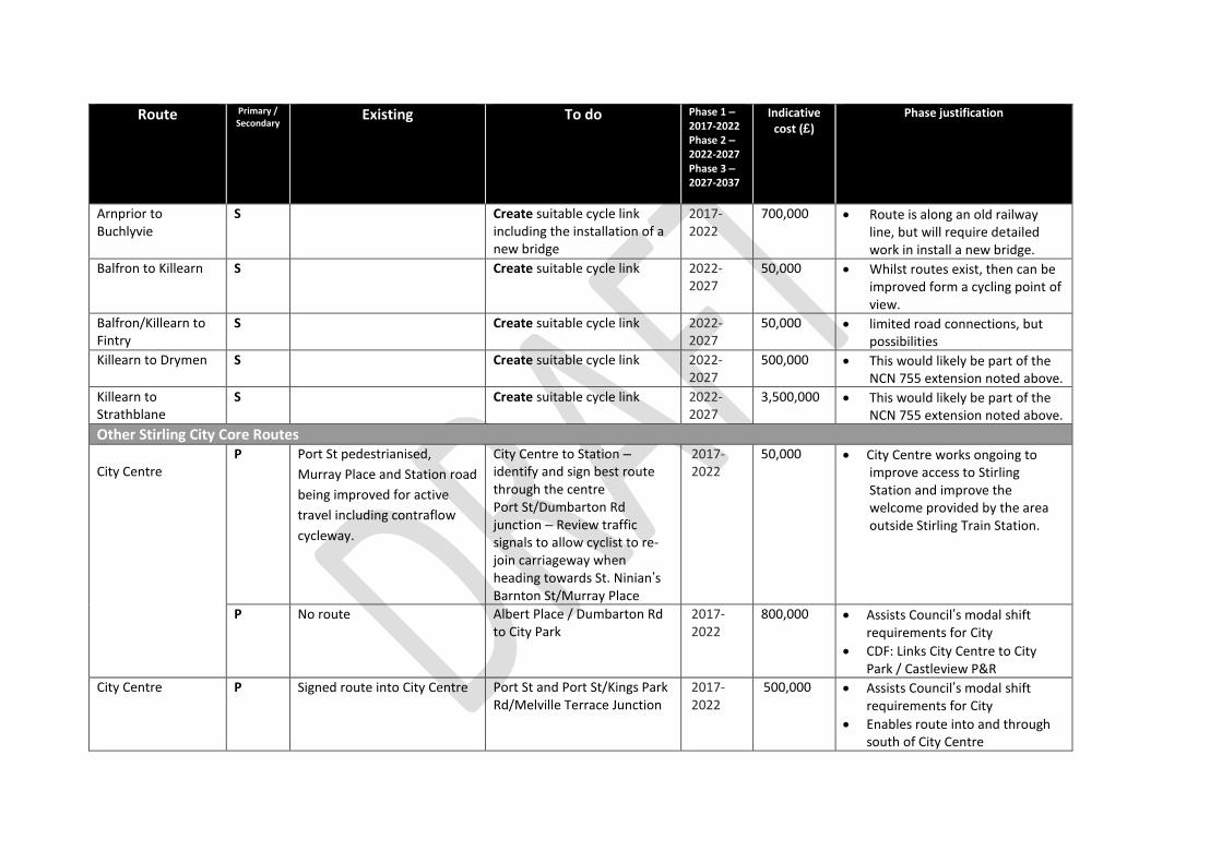
Arnprior to Buchlyvie
S Create suitable cycle link including the installation of a new bridge
2017-2022
700,000 Route is along an old railway line, but will require detailed work in install a new bridge.
Balfron to Killearn S Create suitable cycle link 2022-2027
50,000 Whilst routes exist, then can be improved form a cycling point of view.
Balfron/Killearn to Fintry
S Create suitable cycle link 2022-2027
50,000 limited road connections, but possibilities
Killearn to Drymen S Create suitable cycle link 2022-2027
500,000 This would likely be part of the NCN 755 extension noted above.
Killearn to Strathblane
S Create suitable cycle link 2022-2027
3,500,000 This would likely be part of the NCN 755 extension noted above.
Other Stirling City Core Routes City Centre
P Port St pedestrianised,
Murray Place and Station road
being improved for active
travel including contraflow
cycleway.
City Centre to Station – identify and sign best route through the centre Port St/Dumbarton Rd junction – Review traffic signals to allow cyclist to re-join carriageway when heading towards St. Ninian’s Barnton St/Murray Place
2017-2022
50,000 City Centre works ongoing to improve access to Stirling Station and improve the welcome provided by the area outside Stirling Train Station.
P No route Albert Place / Dumbarton Rd to City Park
2017-2022
800,000 Assists Council’s modal shift requirements for City
CDF: Links City Centre to City Park / Castleview P&R
City Centre P Signed route into City Centre Port St and Port St/Kings Park Rd/Melville Terrace Junction
2017-2022
500,000 Assists Council’s modal shift requirements for City
Enables route into and through south of City Centre
Route Primary / Secondary
Existing To do Phase 1 – 2017-2022 Phase 2 – 2022-2027 Phase 3 – 2027-2037
Indicative cost (£)
Phase justification
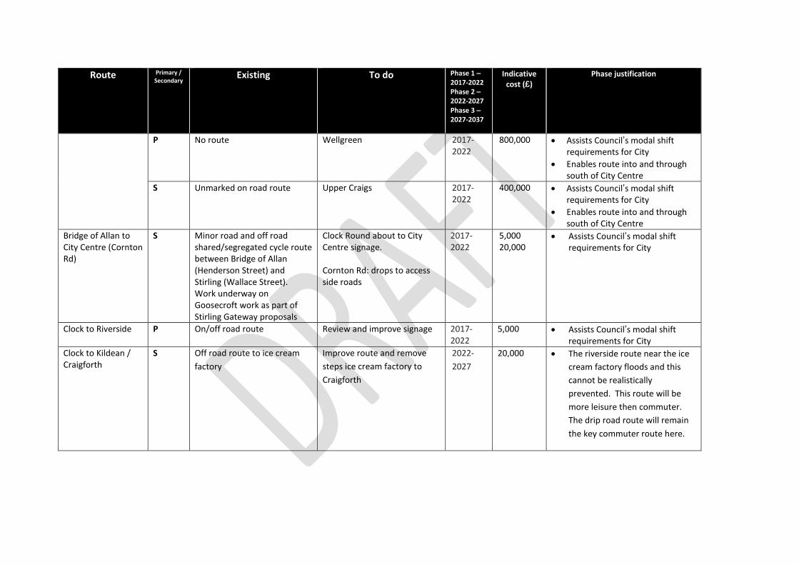
P No route Wellgreen 2017-2022
800,000 Assists Council’s modal shift requirements for City
Enables route into and through south of City Centre
S Unmarked on road route Upper Craigs 2017-2022
400,000 Assists Council’s modal shift requirements for City
Enables route into and through south of City Centre
Bridge of Allan to City Centre (Cornton Rd)
S Minor road and off road shared/segregated cycle route between Bridge of Allan (Henderson Street) and Stirling (Wallace Street). Work underway on Goosecroft work as part of Stirling Gateway proposals
Clock Round about to City Centre signage. Cornton Rd: drops to access side roads
2017-2022
5,000 20,000
Assists Council’s modal shift requirements for City
Clock to Riverside P On/off road route Review and improve signage 2017-2022
5,000 Assists Council’s modal shift requirements for City
Clock to Kildean / Craigforth
S
Off road route to ice cream
factory
Improve route and remove
steps ice cream factory to
Craigforth
2022-
2027
20,000
The riverside route near the ice
cream factory floods and this
cannot be realistically
prevented. This route will be
more leisure then commuter.
The drip road route will remain
the key commuter route here.
Route Primary / Secondary
Existing To do Phase 1 – 2017-2022 Phase 2 – 2022-2027 Phase 3 – 2027-2037
Indicative cost (£)
Phase justification
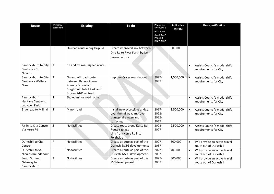
P On road route along Drip Rd Create improved link between
Drip Rd to River Forth by ice
cream factory
30,000
Bannockburn to City Centre via St Ninians
P on and off road signed route. Assists Council’s modal shift requirements for City
Bannockburn to City Centre via Wallace Glen
P On and off road route between Bannockburn Primary School and Burghmuir Retail Park and Broom Rd/Pike Road.
Improve Craigs roundabout. 2027-2037
1,500,000 Assists Council’s modal shift requirements for City
Bannockburn Heritage Centre to Ladywell Park
S Signed minor road route. Assists Council’s modal shift requirements for City
Braehead to Millhall S Minor road. Install new accessible bridge over the railway, improve signage, drainage and surfacing.
2017-2022/ 2022-2027
3,500,000 Assists Council’s modal shift requirements for City
Fallin to City Centre Via Kerse Rd
S No facilities Create route along Kerse Rd Route signage Link from Kerse Rd into Forthside
2022-2027
2,500,000 Assists Council’s modal shift requirements for City
Durieshill to City Centre
P No facilities Create a route as part of the Durieshill/SSG developments
2027-2037
800,000 Will provide an active travel route out of Durieshill
Durieshill to St. Ninains Roundabout
P No facilities Create a route as part of the Durieshill/SSG development
2027-2037
40,000 Will provide an active travel route out of Durieshill
South Stirling Gateway to Bannockburn
P No facilities Create a route as part of the SSG development
2027-2037
300,000 Will provide an active travel route out of Durieshill
Route Primary / Secondary
Existing To do Phase 1 – 2017-2022 Phase 2 – 2022-2027 Phase 3 – 2027-2037
Indicative cost (£)
Phase justification
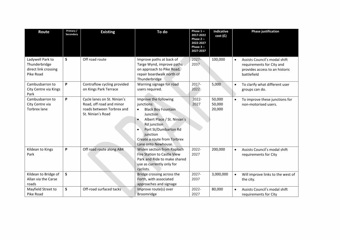
Ladywell Park to Thunderbridge direct link crossing Pike Road
S Off road route Improve paths at back of Targe Wynd, improve paths on approach to Pike Road, repair boardwalk north of Thunderbridge
2027-2037
100,000 Assists Council’s modal shift requirements for City and provides access to an historic battlefield
Cambusbarron to City Centre via Kings Park
P Contraflow cycling provided on Kings Park Terrace
Warning signage for road users required.
2017-2022
5,000 To clarify what different user groups can do.
Cambusbarron to City Centre via Torbrex lane
P Cycle lanes on St. Ninian’s Road, off road and minor roads between Torbrex and St. Ninian’s Road
Improve the following junctions:
Black Boy Fountain Junction
Albert Place / St. Ninian’s Rd junction
Port St/Dumbarton Rd junction
Create a route from Torbrex Lane onto Newhouse.
2022-2027
50,000 50,000 20,000
To improve these junctions for non-motorised users.
Kildean to Kings Park
P Off road route along A84 Widen section from Raploch Fire Station to Castle View Park and Ride to make shared use as currently only for cyclists.
2022-2027
200,000 Assists Council’s modal shift requirements for City
Kildean to Bridge of Allan via the Carse roads
S Bridge crossing across the Forth, with associated approaches and signage
2027-2037
3,000,000 Will improve links to the west of the city.
Mayfield Street to Pike Road
S Off-road surfaced tacks Improve route(s) over Broomridge
2022-2027
80,000 Assists Council’s modal shift requirements for City
Route Primary / Secondary
Existing To do Phase 1 – 2017-2022 Phase 2 – 2022-2027 Phase 3 – 2027-2037
Indicative cost (£)
Phase justification
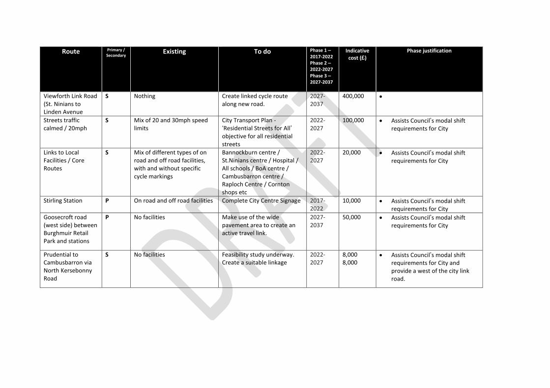
Viewforth Link Road (St. Ninians to Linden Avenue
S Nothing Create linked cycle route along new road.
2027-2037
400,000
Streets traffic calmed / 20mph
S Mix of 20 and 30mph speed limits
City Transport Plan - ‘Residential Streets for All’ objective for all residential streets
2022-2027
100,000 Assists Council’s modal shift requirements for City
Links to Local Facilities / Core Routes
S Mix of different types of on road and off road facilities, with and without specific cycle markings
Bannockburn centre / St.Ninians centre / Hospital / All schools / BoA centre / Cambusbarron centre / Raploch Centre / Cornton shops etc
2022-2027
20,000 Assists Council’s modal shift requirements for City
Stirling Station P On road and off road facilities Complete City Centre Signage 2017-2022
10,000 Assists Council’s modal shift requirements for City
Goosecroft road (west side) between Burghmuir Retail Park and stations
P No facilities Make use of the wide pavement area to create an active travel link.
2027-2037
50,000 Assists Council’s modal shift requirements for City
Prudential to Cambusbarron via North Kersebonny Road
S No facilities Feasibility study underway. Create a suitable linkage
2022-2027
8,000 8,000
Assists Council’s modal shift requirements for City and provide a west of the city link road.
Route Primary / Secondary
Existing To do Phase 1 – 2017-2022 Phase 2 – 2022-2027 Phase 3 – 2027-2037
Indicative cost (£)
Phase justification
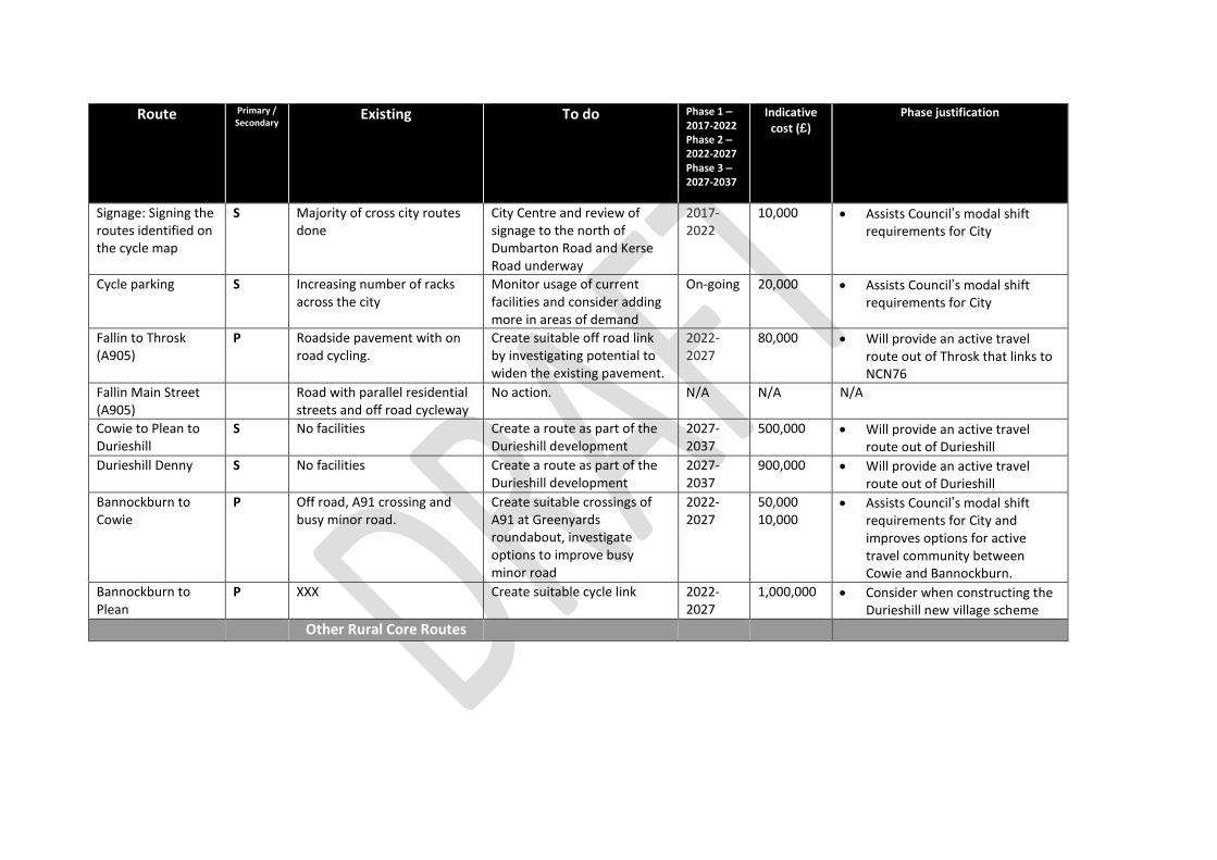
Signage: Signing the routes identified on the cycle map
S Majority of cross city routes done
City Centre and review of signage to the north of Dumbarton Road and Kerse Road underway
2017-2022
10,000 Assists Council’s modal shift requirements for City
Cycle parking
S Increasing number of racks across the city
Monitor usage of current facilities and consider adding more in areas of demand
On-going 20,000 Assists Council’s modal shift requirements for City
Fallin to Throsk (A905)
P Roadside pavement with on road cycling.
Create suitable off road link by investigating potential to widen the existing pavement.
2022-2027
80,000 Will provide an active travel route out of Throsk that links to NCN76
Fallin Main Street (A905)
Road with parallel residential streets and off road cycleway
No action. N/A N/A N/A
Cowie to Plean to Durieshill
S No facilities Create a route as part of the Durieshill development
2027-2037
500,000 Will provide an active travel route out of Durieshill
Durieshill Denny S No facilities Create a route as part of the Durieshill development
2027-2037
900,000 Will provide an active travel route out of Durieshill
Bannockburn to Cowie
P Off road, A91 crossing and busy minor road.
Create suitable crossings of A91 at Greenyards roundabout, investigate options to improve busy minor road
2022-2027
50,000 10,000
Assists Council’s modal shift requirements for City and improves options for active travel community between Cowie and Bannockburn.
Bannockburn to Plean
P XXX Create suitable cycle link 2022-2027
1,000,000 Consider when constructing the Durieshill new village scheme
Other Rural Core Routes
Route Primary / Secondary
Existing To do Phase 1 – 2017-2022 Phase 2 – 2022-2027 Phase 3 – 2027-2037
Indicative cost (£)
Phase justification
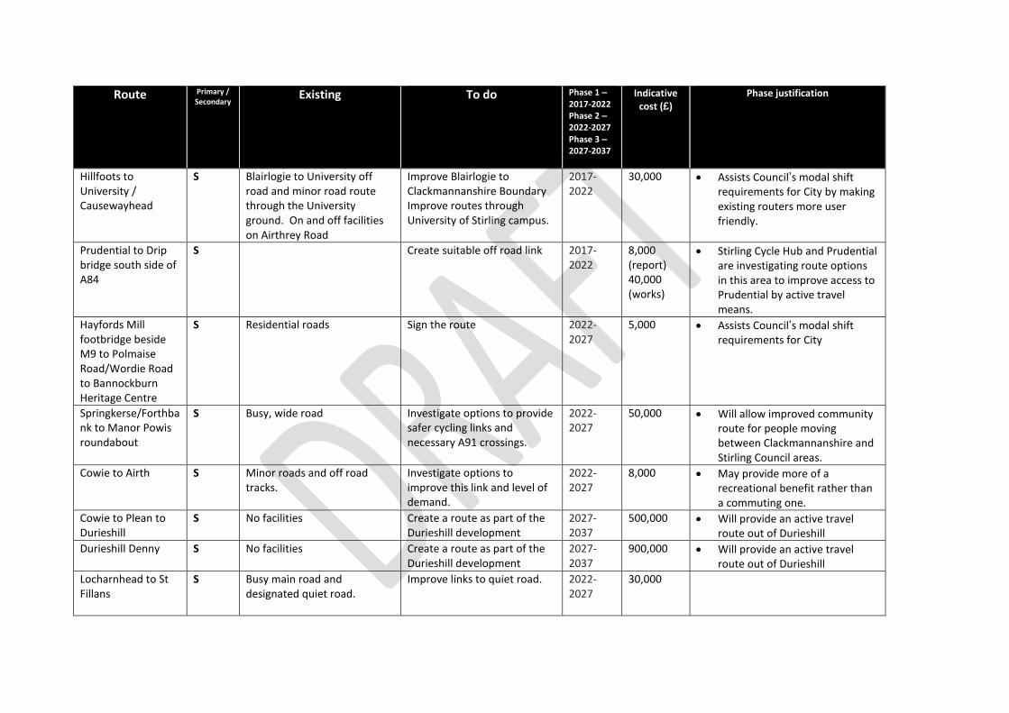
Hillfoots to University / Causewayhead
S Blairlogie to University off road and minor road route through the University ground. On and off facilities on Airthrey Road
Improve Blairlogie to Clackmannanshire Boundary Improve routes through University of Stirling campus.
2017-2022
30,000 Assists Council’s modal shift requirements for City by making existing routers more user friendly.
Prudential to Drip bridge south side of A84
S Create suitable off road link 2017-2022
8,000 (report) 40,000 (works)
Stirling Cycle Hub and Prudential are investigating route options in this area to improve access to Prudential by active travel means.
Hayfords Mill footbridge beside M9 to Polmaise Road/Wordie Road to Bannockburn Heritage Centre
S Residential roads Sign the route 2022-2027
5,000 Assists Council’s modal shift requirements for City
Springkerse/Forthbank to Manor Powis roundabout
S Busy, wide road Investigate options to provide safer cycling links and necessary A91 crossings.
2022-2027
50,000 Will allow improved community route for people moving between Clackmannanshire and Stirling Council areas.
Cowie to Airth S Minor roads and off road tracks.
Investigate options to improve this link and level of demand.
2022-2027
8,000 May provide more of a recreational benefit rather than a commuting one.
Cowie to Plean to Durieshill
S No facilities Create a route as part of the Durieshill development
2027-2037
500,000 Will provide an active travel route out of Durieshill
Durieshill Denny S No facilities Create a route as part of the Durieshill development
2027-2037
900,000 Will provide an active travel route out of Durieshill
Locharnhead to St Fillans
S Busy main road and designated quiet road.
Improve links to quiet road. 2022-2027
30,000
Route Primary / Secondary
Existing To do Phase 1 – 2017-2022 Phase 2 – 2022-2027 Phase 3 – 2027-2037
Indicative cost (£)
Phase justification
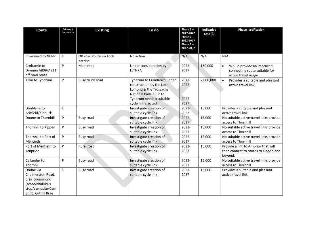
Inversnaid to NCN7
S Off road route via Loch Katrine
No action N/A N/A N/A
Croftamie to Drymen A809/A811 off road route
P Main road Under consideration by LLTNPA
2022-2027
150,000 Would provide an improved connecting route suitable for active travel usage.
Killin to Tyndrum P Busy trunk road Tyndrum to Crianlarich under construction by the Loch Lomond & the Trossachs National Park. Killin to Tyndrum needs a suitable cycle link created.
2017-2022 2022-2027
2,000,000 Provides a suitable and pleasant active travel link
Dunblane to Ashfield/Kinbuck
S Investigate creation of suitable cycle link
2022-2027
15,000 Provides a suitable and pleasant active travel link
Doune to Thornhill P Busy road Investigate creation of suitable cycle link
2022-2027
15,000 No suitable active travel links provide access to Thornhill
Thornhill to Kippen P Busy road Investigate creation of suitable cycle link
2022-2027
15,000 No suitable active travel links provide access to Thornhill
Thornhill to Port of Mentieth
P Busy road Investigate creation of suitable cycle link
2022-2027
15,000 No suitable active travel links provide access to Thornhill
Port of Mentieth to Arnprior
P Rural road Investigate creation of suitable cycle link
2022-2027
15,000 Provide a link to Arnprior that will then connect to routes to Kippen and beyond.
Callander to Thornhill
P Busy road Investigate creation of suitable cycle link
2022-2027
15,000 No suitable active travel links provide access to Thornhill
Doune via Chalmerston Road, Blair Drummond (school/hall/bus stop/campsite/Camphill), Cuthill Brae
S Busy road Investigate creation of suitable cycle link
2027-2037
15,000 Provides a suitable and pleasant active travel link
Route Primary / Secondary
Existing To do Phase 1 – 2017-2022 Phase 2 – 2022-2027 Phase 3 – 2027-2037
Indicative cost (£)
Phase justification
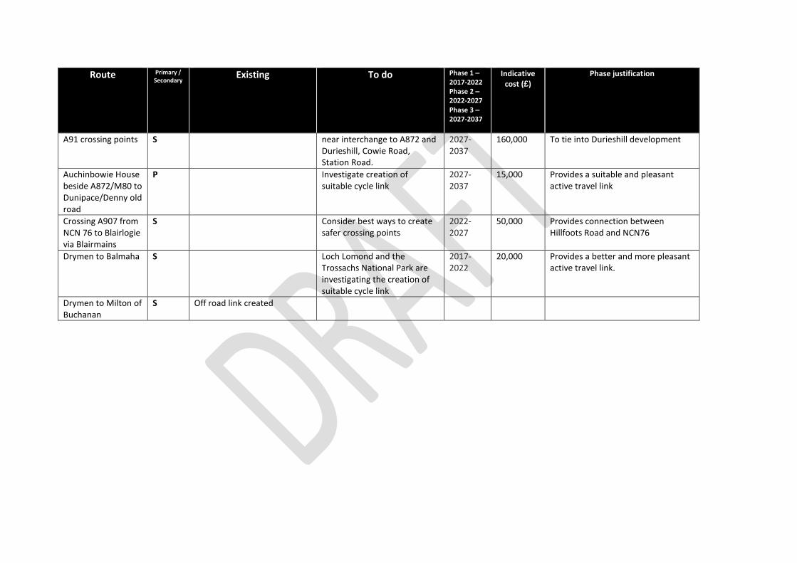
A91 crossing points S near interchange to A872 and Durieshill, Cowie Road, Station Road.
2027-2037
160,000 To tie into Durieshill development
Auchinbowie House beside A872/M80 to Dunipace/Denny old road
P Investigate creation of suitable cycle link
2027-2037
15,000 Provides a suitable and pleasant active travel link
Crossing A907 from NCN 76 to Blairlogie via Blairmains
S Consider best ways to create safer crossing points
2022-2027
50,000 Provides connection between Hillfoots Road and NCN76
Drymen to Balmaha S Loch Lomond and the Trossachs National Park are investigating the creation of suitable cycle link
2017-2022
20,000 Provides a better and more pleasant active travel link.
Drymen to Milton of Buchanan
S Off road link created
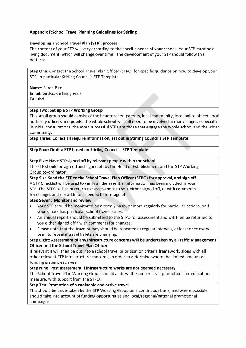
Appendix F:School Travel Planning Guidelines for Stirling Developing a School Travel Plan (STP): process The content of your STP will vary according to the specific needs of your school. Your STP must be a living document, which will change over time. The development of your STP should follow this pattern:
Step One: Contact the School Travel Plan Officer (STPO) for specific guidance on how to develop your STP, in particular Stirling Council’s STP Template Name: Sarah Bird Email: [email protected] Tel: tbd
Step Two: Set up a STP Working Group This small group should consist of the headteacher, parents, local community, local police officer, local authority officers and pupils. The whole school will still need to be involved in many stages, especially in initial consultations; the most successful STPs are those that engage the whole school and the wider community.
Step Three: Collect all require information, set out in Stirling Council’s STP Template
Step Four: Draft a STP based on Stirling Council’s STP Template
Step Five: Have STP signed off by relevant people within the school The STP should be agreed and signed off by the Head of Establishment and the STP Working Group co-ordinator
Step Six: Send the STP to the School Travel Plan Officer (STPO) for approval, and sign off A STP Checklist will be used to verify all the essential information has been included in your STP. The STPO will then return the assessment to you, either signed off, or with comments for changes and / or additions needed before sign off
Step Seven: Monitor and review
Your STP should be monitored on a termly basis, or more regularly for particular actions, or if your school has particular school travel issues.
An annual report should be submitted to the STPO for assessment and will then be returned to you either signed off / with comments for changes.
Please note that the travel survey should be repeated at regular intervals, at least once every year, to reveal if travel habits are changing.
Step Eight: Assessment of any infrastructure concerns will be undertaken by a Traffic Management Officer and the School Travel Plan Officer If relevant it will then be put into a school travel prioritisation criteria framework, along with all other relevant STP infrastructure concerns, in order to determine where the limited amount of funding is spent each year
Step Nine: Post assessment if infrastructure works are not deemed necessary The School Travel Plan Working Group should address the concerns via promotional or educational measure, with support from the STPO.
Step Ten: Promotion of sustainable and active travel This should be undertaken by the STP Working Group on a continuous basis, and where possible should take into account of funding opportunities and local/regional/national promotional campaigns
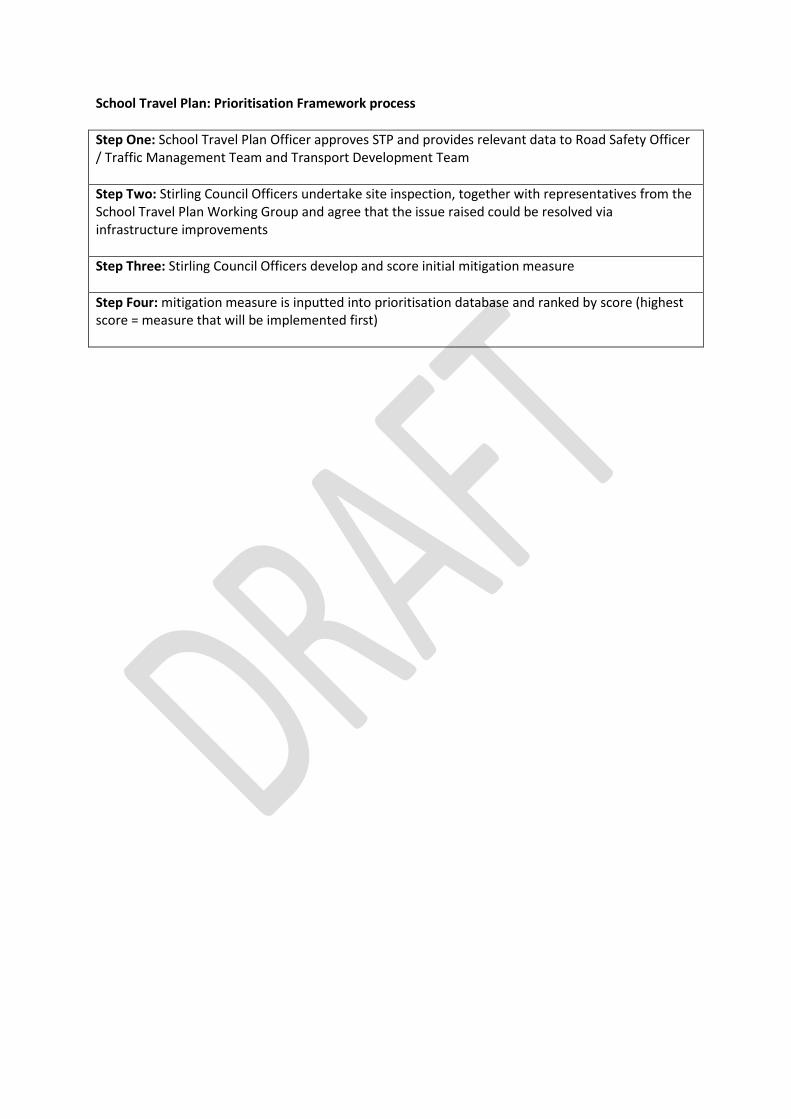
School Travel Plan: Prioritisation Framework process
Step One: School Travel Plan Officer approves STP and provides relevant data to Road Safety Officer / Traffic Management Team and Transport Development Team
Step Two: Stirling Council Officers undertake site inspection, together with representatives from the School Travel Plan Working Group and agree that the issue raised could be resolved via infrastructure improvements
Step Three: Stirling Council Officers develop and score initial mitigation measure
Step Four: mitigation measure is inputted into prioritisation database and ranked by score (highest score = measure that will be implemented first)
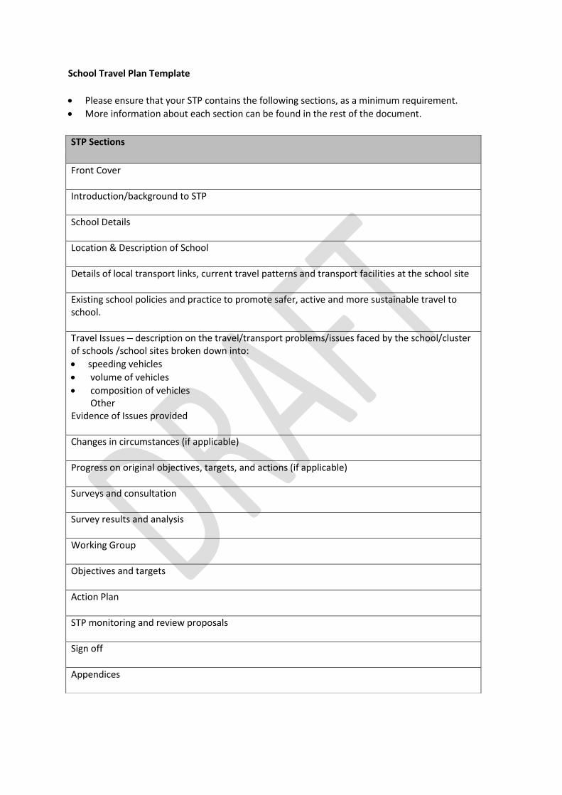
School Travel Plan Template
Please ensure that your STP contains the following sections, as a minimum requirement.
More information about each section can be found in the rest of the document.
STP Sections
Front Cover
Introduction/background to STP
School Details
Location & Description of School
Details of local transport links, current travel patterns and transport facilities at the school site
Existing school policies and practice to promote safer, active and more sustainable travel to school.
Travel Issues – description on the travel/transport problems/issues faced by the school/cluster of schools /school sites broken down into:
speeding vehicles
volume of vehicles
composition of vehicles Other
Evidence of Issues provided
Changes in circumstances (if applicable)
Progress on original objectives, targets, and actions (if applicable)
Surveys and consultation
Survey results and analysis
Working Group
Objectives and targets
Action Plan
STP monitoring and review proposals
Sign off
Appendices
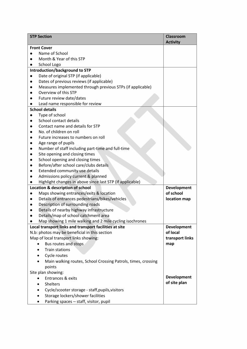
STP Section Classroom Activity
Front Cover Name of School Month & Year of this STP School Logo
Introduction/background to STP Date of original STP (if applicable) Dates of previous reviews (if applicable) Measures implemented through previous STPs (if applicable) Overview of this STP Future review date/dates Lead name responsible for review
School details Type of school School contact details Contact name and details for STP No. of children on roll Future increases to numbers on roll Age range of pupils Number of staff including part-time and full-time Site opening and closing times School opening and closing times Before/after school care/clubs details Extended community use details Admissions policy current & planned Highlight changes in above since last STP (if applicable)
Location & description of school Maps showing entrances/exits & location Details of entrances pedestrians/bikes/vehicles Description of surrounding roads Details of nearby highway infrastructure Details/map of school catchment area Map showing 1 mile walking and 2 mile cycling isochrones
Development of school location map
Local transport links and transport facilities at site N.b: photos may be beneficial in this section Map of local transport links showing:
Bus routes and stops
Train stations
Cycle routes
Main walking routes, School Crossing Patrols, times, crossing points
Site plan showing:
Entrances & exits
Shelters
Cycle/scooter storage - staff,pupils,visitors
Storage lockers/shower facilities
Parking spaces – staff, visitor, pupil
Development of local transport links map Development of site plan
STP Section Classroom
Activity
Local transport links and transport facilities at site (cont) Pedestrian facilities – details of:
Shelters
Use/positions of all entrances/exits
Opening/closing times of all entrances
Locker details staff & pupil & allocation Public transport information
Bus routes – details of
School bus – details of
Trains – details of
Bus & train timetables in appendix Bike/scooter facilities/route details
Routes - location/distance from school/where they go from/to
Storage facilities – number. & description
Demand on storage – adequate?
Security of storage – details
Lockers/showers – details staff & pupil Car parking spaces
Number of spaces available – to different users
Adequate number? How are spaces allocated?
Collation of data related to local transport links and site transport facilities
Existing school travel related policies and practice – details of (where applicable):
Policies – eg cycling to school, behaviour on buses, Travel to School Agreement etc
Copies of Policies in Appendix
Campaigns/activities eg Walk to School
Curriculum – current Road Safety & Active/sustainable Travel elements
Training – eg scooter, pedestrian, cycle
Park & Stride site – details & promotion of
School Crossing Patrol times, location etc
Collation of school activities
Travel Issues – description on the travel/transport problems/issues
Description on the travel/transport problems/issues faced by the school/cluster of schools /school sites broken down into:
o speeding vehicles; o volume of vehicles; o composition of vehicles; o other
Evidence of how above were identified
Changes in circumstances since last STP (where applicable)
Details of changes, with dates/numbers where relevant, to: o School buildings/grounds – include plans/maps o No. of children on roll – details of
Admissions policy
Catchment
Infrastructure/transport facilities nearby
Any improvements
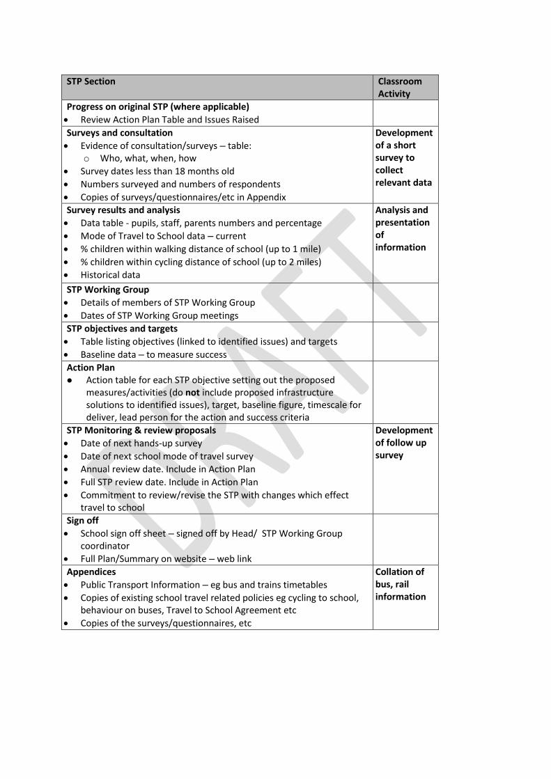
STP Section Classroom Activity
Progress on original STP (where applicable)
Review Action Plan Table and Issues Raised
Surveys and consultation
Evidence of consultation/surveys – table: o Who, what, when, how
Survey dates less than 18 months old
Numbers surveyed and numbers of respondents
Copies of surveys/questionnaires/etc in Appendix
Development of a short survey to collect relevant data
Survey results and analysis
Data table - pupils, staff, parents numbers and percentage
Mode of Travel to School data – current
% children within walking distance of school (up to 1 mile)
% children within cycling distance of school (up to 2 miles)
Historical data
Analysis and presentation of information
STP Working Group
Details of members of STP Working Group
Dates of STP Working Group meetings
STP objectives and targets
Table listing objectives (linked to identified issues) and targets
Baseline data – to measure success
Action Plan Action table for each STP objective setting out the proposed
measures/activities (do not include proposed infrastructure solutions to identified issues), target, baseline figure, timescale for deliver, lead person for the action and success criteria
STP Monitoring & review proposals
Date of next hands-up survey
Date of next school mode of travel survey
Annual review date. Include in Action Plan
Full STP review date. Include in Action Plan
Commitment to review/revise the STP with changes which effect travel to school
Development of follow up survey
Sign off
School sign off sheet – signed off by Head/ STP Working Group coordinator
Full Plan/Summary on website – web link
Appendices
Public Transport Information – eg bus and trains timetables
Copies of existing school travel related policies eg cycling to school, behaviour on buses, Travel to School Agreement etc
Copies of the surveys/questionnaires, etc
Collation of bus, rail information