Embed Size (px)
Citation preview
Volcanic-Rich Middle and
Upper Eocene Sedimentary
Rocks Northwest of
Rattlesnake Hills
Central Wyoming
GEOLOGICAL SURVEY PROFESSIONAL PAPER 274-A
Prepared as part of a program of the
Department of the Interior for
development of the Missouri River basin
Volcanic-Rich Middle and
Upper Eocene Sedimentary
Rocks Northwest of
Rattlesnake Hills
Central WyomingBy FRANKLYN B. VAN HOUTEN
A SHORTER CONTRIBUTION TO GENERAL GEOLOGY
GEOLOGICAL SURVEY PROFESSIONAL PAPER 274-A
Prepared as part of a -program of the
Department of the Interior for
development of the Missouri River basin
LIMITED STATES GOVERNMENT PRINTING OFFICE, WASHINGTON : 1955
UNITED STATES DEPARTMENT OF THE INTERIOR
Douglas McKay, Secretary
GEOLOGICAL SURVEY
W. E. Wrather, Director
For sale by the Superintendent of Documents, U. S. Government Printing Office Washington 25, D. C. - Price 65 cents (paper cover)
CONTENTS
Abstract.______________________________Introduction. ____-_-_______-____-_-__.
Purpose and scope of investigation.__. Location and topography____________Previous work_________-____-___-__.Field work._-_-__-_____-_-_--_____.Laboratory work_ ---______-_______.Acknowledgments^ _ _ ________________
Stratigraphy..---_-____-___-_______.__.General features._-___-_-_-________.Wind River formation (lower Eocene).
Page 1 1 1 1 3 3 3 3 3 3 5
Stratigraphy—C ontinued, Middle and upper Eocene rocks. _ -
Unit !_____._.__._.__-_____.Unit 2_____._______-.-.__._.Unit 3_-_-------------------Unit 4_— -...__---.________Unit 5—_--_-_------ —~~Unit 6___-_-_-_-_-------_---
White River formation (Oligocene).Geologic history of area._____________Literature cited.__________--__---_--_
Page
667899
10111213
ILLUSTRATIONS
Page PLATE 1. Stratigraphic sections uf Tertiary sedimentary rocks, Canyon Creek area, Fremont and Natrona Counties,
Wyo.___-_______-__________-___________-_____________-_---_-------__----------_--------------_ In pocket2. Sedimentary features of middle and upper Eocene rocks.__________________________-_--__--_---_-__----- Faces 43. Volcanic rock types in pebbles in middle and upper Eocene rocks.__________________ _-________-__-_-__-__ Faces 5
FIGURE 1. Index map showing location of Rattlesnake Hills volcanic field and measured sections _!-£?________-_______---- 22. Relative abundance of volcanic minerals in middle and upper Eocene rocks, Canyon Creek area.______________ 73. Variation in roundness of large volcanic pebbles in unit 6, middle and upper Eocene rocks_._______-_-___-___-_ 11
TABLES
PageTABLE 1. Minerals in Tertiary sedimentary rocks, Canyon Creek area____ _______-__-__-__-___________----_-____- In pocket
2. Variation in composition and texture of conglomerate in unit 6, middle and upper Eocene rocks. _ — _________ 10


Volcanic-Rich Middle and
Upper Eocene Sedimentary
Rocks Northwest of
Rattlesnake Hills
Central WyominBy FRANKLYN B. VAN HOUTEN
A SHORTER CONTRIBUTION TO GENERAL GEOLOGY
GEOLOGICAL SURVEY PROFESSIONAL PAPER 274-A
Prepared as part of a program of the
Department of the Interior for
development of the Missouri River basin
UNITED STATES GOVERNMENT PRINTING OFFICE, WASHINGTON : 1955
UNITED STATES DEPARTMENT OF THE INTERIOR
Douglas McKay, Secretary
GEOLOGICAL SURVEY
W. E. Wrather, Director
For sale by the Superintendent of Documents, U. S. Government Printing Office Washington 25, D. C. - Price 65 cents (paper cover)
CONTENTS
Abstract.-.---_--_-________________.__Introduction. _-__-_-___--___-_________.
Purpose and scope of investigation-... Location and topography____________Previous work______________________Field work._...-_.____._____._____.Laboratory work_---___-_____-____.Acknowledgments-..- _ ______________
Stratigraphy. __________________________General features.-_.-___________.__.Wind River formation (lower Eocene).
Page 1 1 1 1 3 3 3 3 3 3 5
Stratigraphy — Continued, Middle and upper Eocene rocks
Unit 1 __ __________----_Unit 2_______.__. _.______Unit 3-.... — — _-_ — _ — — _Unit 4_
Unit 6— .------_-_-.- _ ._-White River formation (Oligocene).
Geologic history of area. _____-____-_- Literature cited- _________-_-_--_-_-_-
Page
667899
10111213
ILLUSTRATIONS
Page PLATE 1. Stratigraphic sections of Tertiary sedimentary rocks, Canyon Creek area, Fremont and Natrona Counties,
Wyo__________________________________________________________________________________________ In pocket2. Sedimentary features of middle and upper Eocene rocks._-________-_---_-_____-_-_----__--_----____---_ Faces 43. Volcanic rock types in pebbles in middle and upper Eocene rocks_______________-____ ____________________ Faces 5
FIGURE 1. Index map showing location of Rattlesnake Hills volcanic field and measured sections A—E__________________ 22. Relative abundance of volcanic minerals in middle and upper Eocene rocks, Canyon Creek area.______________ 73. Variation in roundness of large volcanic pebbles in unit 6, middle and upper Eocene rocks___________________ 11
TABLES
Page TABLE 1 . Minerals in Tertiary sedimentary rocks, Canyon Creek area. _________ — _ — ______ — — _ — — __ — ___ — ___- In pocket
2. Variation in composition and texture of conglomerate in unit 6, middle and upper Eocene rocks __ __________ 10

A SHORTER CONTRIBUTION TO GENERAL GEOLOGY
VOLCANIC-RICH MIDDLE AND UPPER EOCENE SEDIMENTARY ROCKS NORTHWEST OFRATTLESNAKE HILLS, CENTRAL WYOMING
By FKANKLYN B. VAN HOUTEN
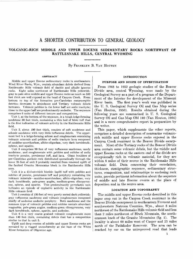
ABSTRACT
Middle and upper Eocene sedimentary rocks in southeastern Wind River Basin, Wyo., contain abundant debris derived from Rattlesnake Hills volcanic field of dacitic and alkalic igneous rocks. Eight miles northwest of Rattlesnake Hills yellowish- gray to pale-olive middle and upper Eocene rocks as much as 550 feet thick are well exposed at the head of Canyon Creek. From bottom to top of the formation pre-Cambrian metamorphic detritus decreases in abundance and Tertiary volcanic debris increases. Volcanic pebbles in the lower half are sodic trachyte; those in the upper half are predominantly andesite. The sequence comprises 6 units of different texture and composition.
Unit 1, at the bottom of the sequence, is a tough ledge-forming mudstone 30 feet thick, containing a thin bed of felsic tuff that is the first indication of volcanic activity in the Rattlesnake Hills field.
Unit 2, about 100 feet thick, consists of soft mudstone and arkosic sandstone with very little tuffaceous debris. The upper most bed is a ledge-forming arkose and conglomerate containing volcanic minerals and pebbles of sodic trachyte lava composed of sanidine-anorthoclase, albite-oligoclase, very dark hornblende, sphene, and apatite.
Unit 3 comprises 90 feet of very tuffaceous sandstone, sandy mudstone, and conglomerate with pebbles and cobbles of sodic trachyte pumice, pumiceous tuff, and lava. Giant boulders of pre-Cambrian gneissic rock distributed sporadically through the lower 25 feet of unit 3 probably resulted from renewed uplift of the faulted Granite Mountains block in the Rattlesnake Hills area.
Unit 4 is a 45-foot-thick biotitic lapilli tuff with pebbles and cobbles of pumice, pumiceous tuff and porphyry containing the volcanic minerals—sanidine-anorthoclase, albite-oligoclase, very dark hornblende, pale-green augite, medium-green clinopyrox- ene, sphene, and apatite. This predominantly pyroclastic unit indicates an episode of explosive activity in the Rattlesnake Hills volcanic field.
Unit 5 consists of 130 feet of very poorly sorted dark-yellowish- gray tuffaceous sandstone and volcanic conglomerate composed chiefly of andesine andesite porphyry. Both sandstone and the common type of volcanic pebbles and cobbles contain abundant magnetite, pale-green augite, medium-green clinopyroxene, very dark hornblende, sphene, apatite, and andesine.
Unit 6 is a very coarse grained volcanic conglomerate more than 140 feet thick, containing debris that has a composition similar to that in unit 5.
Uplift and deep erosion of middle and upper Eocene rocks are revealed by a rugged unconformity at the base of the White River formation of Oligocene age.
INTRODUCTION
PURPOSE AND SCOPE OF INVESTIGATION
From 1948 to 1952 geologic studies of the Beaver Divide area, central Wyoming, were made by the Geological Survey as a part of a program of the Depart ment of the Interior for development of the Missouri River basin. The first year's work was published in the U. S. Geological Survey Oil and Gas Map series (Van Houten, 1950). Results obtained during the following years are summarized in U. S. Geological Survey Oil and Gas Map OM 140 (Van Houten, 1954) and in a more comprehensive report in preparation by the writer.
This paper, which supplements the other reports, comprises a detailed description of nonmarine volcanic- rich middle and upper Eocene rocks exposed in the Canyon Creek reentrant in the Beaver Divide escarp ment. Most of the Tertiary rocks of the Beaver Divide area contain some volcanic debris, but the middle and upper Eocene rocks at the eastern end of the divide are exceptionally rich in volcanic material, for they are within 8 miles of their source in the Rattlesnake Hills volcanic field. Data concerning then* correlation, thickness, stratigraphic sequence, sedimentary struc tures, composition, and relationships to enclosing rock units, provide pertinent information about the sequence of middle and late Eocene events at the place of deposition and in the source area.
LOCATION AND TOPOGRAPHY
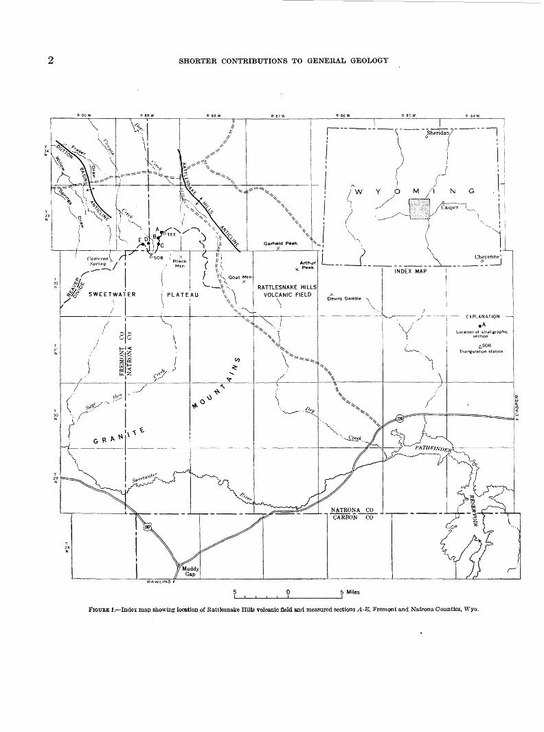
The middle and upper Eocene rocks described in this paper crop out in the Canyon Creek reentrant in the Beaver Divide escarpment in southeastern Fremont and southwestern Natrona Counties, Wyo., about 8 miles northwest of the Rattlesnake Hills volcanic field and less than 2 miles northwest of Black Mountain, the north ernmost knob of the Granite Mountains (fig. 1). The locality is about 60 miles west of Casper and 25 miles north of the Pathfinder Reservoir. The area can be reached by car on the unimproved road that leads
1
SHORTER CONTRIBUTIONS TO GENERAL GEOLOGY
RAWLINS t
5 Miles
FIGTJEE 1.—Index map showing location of Rattlesnake Hills volcanic field and measured sections A-E, Fremont and Natrona Counties, Wyo.
VOLCANIC-RICH MIDDLE AND UPPER EOCENE ROCKS, CENTRAL WYOMING
northwestward from Wyoming State Highway 220 in the vicinity of the reservoir.
Along the southern margin of the Wind River Basin, Beaver Divide separates northward-flowing tributaries of the Wind River from the southward-flowing tribu taries of the Sweetwater River. The crest of the divide rises from an elevation of 7,000 feet at its southwestern end to 7,600 feet on the west flank of the Rattlesnake Hills, 55 miles to the east. Beaver Divide also marks the boundary between two distinctive types of topog raphy. To the north the Wind River Basin is etched out of nearly horizontal Tertiary rocks, whereas the Sweetwater Plateau, which lies to the south, is relatively flat and undissected. In the north-facing Beaver Divide escarpment that rises as much as 1,200 feet above the basin, an unusually complete section of Eocene to Miocene sedimentary rocks is exposed. These strata extend southward and overlap on older rocks of the Granite Mountains and the Rattlesnake Hills. In the Rattlesnake Hills area some 35 deeply eroded volcanoes (Carey, 1954b) surmount a northern projection of the Granite Mountains and its flanking structure, the northwest-trending Rattlesnake Hills anticline.
PREVIOUS WORK
In 1913 and 1914 a field party directed by C. J. Hares, of the Geological Survey, mapped the Rattle snake Hills region (Hares, 1946) as part of a geological examination of central Wyoming (Hares, 1917). In 1944 J. D. Love collected the first fossil mammals recovered from the White River formation in the vicinity of Cameron Spring, and in 1950 lie discovered the first plant and mammalian fossils in the Tertiary deposits of the Canyon Creek area. Subsequently, J. F. Rachou * found larger collections which are the basis of present age assignments. B. D. Carey, Jr. (1954a, 1954b) made a detailed study of the Rattle snake Hills Tertiary volcanic field, and information supplied by him has been compiled on the Geologic Map of Wyoming (Love, Weitz, and Hose, 1952).
FIELD WORK
During the summer of 1951 the Tertiary formations west of Rattlesnake Hills were mapped and studied with the able assistance of Colin C. McAneny. Strati- graphic sections (pi. 1) were measured by hand level, and elevations were established by aneroid barometer readings based on the triangulation stations of the Survey. The elevations and thicknesses of the sections were then adjusted to the U. S. Geological Survey topographic sheets, Gas Hills, Wyo., and Ervay Basin SW, Wyo.
i Rachou, J. F., 1951, Tertiary stratigraphy of the Rattlesnake Hills, central Wyo ming: Unpublished Master of Arts thesis in flies of Univ. of Wyo. library.
LABORATORY WORE
The mineral composition of selected sedimentary rocks and pebbles of volcanic rocks recorded in table 1 is based largely on a study of magnetic separates. Minerals in the very fine sand grade (0.06 to 0.12 mm) of crushed and seived samples were separated magnet ically at a maximum current of 0.70 amperes. The very fine sand fraction of the sedimentary rocks con sistently contains essentially the same accessory min erals as the coarser fractions and generally in greater abundance. Shards and volcanic biotite, however, are more abundant in the coarser sand grades of some samples. The mineral colors reported here are those seen under the petrographic microscope.
Feldspars in the nonmagnetic fraction of crushed chips of volcanic pebbles have been studied by immer sion methods and checked in thin sections of some of the pebbles.
ACKNOWLEDGMENTS
It is a pleasure to acknowledge information about volcanic rocks of the Rattlesnake Hills furnished by B. D. Carey, Jr. During discussions in the field and laboratory, as well as by correspondence, Mr. Carey made available unpublished data concerning the rock types and their relationships. I am also indebted to J. D. Love for his continued interest and helpful advice during the preparation of this report, and to J. R. Smith, for his careful study of the feldspars reported in this paper. A. F. Buddington and H. H. Hess helped with the igneous-rock nomenclature and mineral identification.
STRATIGRAPHY
GENERAL FEATURES
The Tertiary deposits in the Canyon Creek area comprise four distinct formations. Variegated rocks of the lower Eocene Wind River formation, character ized by lenticular beds of poorly sorted feldspathic mudstone, sandstone, and conglomerate, are exten sively exposed in the Wind River Basin north of Beayer Divide. Conformably overlying the Wind River formation is an unnamed sequence of light- yellowish-gray to pale-olive middle and upper Eocene rocks at least 550 feet thick. In contrast to the lenticular deposits of the Wind River formation, the middle and upper Eocene rocks are more persistently bedded and contain abundant volcanic debris. This sequence is separated from the overlying White River formation of Oligocene age by a marked erosional unconformity. The light-gray to grayish-orange de posits of the White River formation generally are massive rather well-sorted tuflfaceous fine-grained sand stone arid mudstone with rare thin lenses of conglom erate composed chiefly of pre-Cambrian metamorphic
SHORTER CONTRIBUTIONS TO GENERAL GEOLOGY
rock. Because of the topographic relief at its base, the White River formation varies in thickness. The maximum thickness in this area is about 275 feet. Massive coarse arkosic conglomerate 50 to 100 feet thick forms a conspicuous cliff at the top of the Beaver Divide escarpment west of Canyon Creek. This coarse capping unit, which locally is separated from the White River formation by an erosional unconformity, is here considered to be the basal part of an unnamed formation that yields Miocene mammalian fossils south of Rattlesnake Hills.
The volcanic and nonvolcanic minerals in the mag netic separates of the Tertiary sedimentary rocks in the Canyon Creek area are listed below.
Derived from Tertiary volcanic rocks:Pale-green augiteMedium-green clinopyroxeneHyperstheneOxyhornblendeDark-brown hornblendeDark-green-brown hornblendeDark-green hornblendeAmber biotiteBrown biotiteGreenish-brown biotiteApatiteSpheiieMagnetite
Derived from pre-Cambriaii igneous and meta- morphic rocks:
MuscoviteGrayish-green biotiteBlue-green hornblendeFibrous colorless amphibole (including anthophyllite and
tremolite)Epidote (including clinozoisite) Garnet Tourmaline
Sand-size pyroclastic debris in the Tertiary rocks is composed of three kinds of material: (1) crystals; (2) vitric fragments consisting of clear flat or keeled plates, or glass containing elongate bubbles and inclusions commonly giving the shard a "fibrous" appearance; and (3) lithic fragments of groundmass containing microlites. Crystals and lithic fragments are the more common pyroclastic materials in most of the volcanic- rich deposits in the Canyon Creek area although beds of vitric tuff are present.
The composition of volcanic plagioclases present cannot be accurately identified by means of standard extinction or index of refraction curves. The orien tation of the optical indicatrix of volcanic plagioclases differs from that of plutonic and metamorphic plagio clases on which standard extinction curves are based (Kohler, 1949; Reynolds, 1952), and 2V and refractive indices of sodic plagioclases are lower in high-tempera-
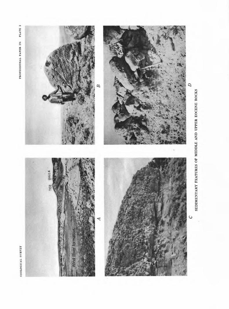
location of section A and triangulatio hite band on upper slope in right bacl
<N
WH < t-3PH
O
&OhH
H < &<HH"PMXw
T3owar
H-=>
73f-l03^
Jg03
t-t
OabD
_fl
O
^,£<"oS
^
t-l
us o
U~
r-H
-ki'3r-t
CO
Oof-l
0}
O 0 0
Wt-t
aOH
73fl030^
73 73
'3cc o3
•8
f and terrace
M— f
O
£_g -ijoCO OH0 t->O
^
'3V —— '
SK
CO
O0
• F- 1aOH
1
§
^O2O2o CO-l-a
O"§
OH
73
73aoob
ot-l.fl
-e03
S
03
OHfl O
station TEE
oo"
o<v-^CO
oo<i>flo o
S3OH OH
fl03
73 73
a'3
<4-<occ
73
"08 cc o3
X3_G ""— '•Soo
& oa03 -^OJa
_o3
1Oi
OH
co oX cc3 S3•rt ^fl 3P O 0 X3bC -^
Sb
Lower finer grained deposit is a poorJ oarse conglomerate in unit 6 (p. 10). Lower finer grained deposit is crude!
73 ol£cc
1"5occbJO
't^
O
ofS
oCO
oiT0o
Eocene
hM
^
OHOH
fl03
7373
a"o
OHO
•§CO
^3'3ppH
•l— 1
0)SS3a
"bbao o
ssive volcanic
o3
^
0
^ -iJCM O
cc Oaa03
73~20CO
S3H-=>•8,0
a03
73fl
O
OH
0)S
8aOH
fl•^_CC
1
0)•sa3a
'bbrH
oo
3 •SOH
cc
1
sorted tuffaci
•d H^
0 02
bDfl3o1 '
ofS.2 +3 o
CO
aToo<»flo o
^
OH &
fl03
rt73 73
a"o
OHo
CO
'3
fH
'<B
.-,
03Sg
"bba o0
oP o3 o"3
1 occ
OPH
j-l
v?J
73
tfl0'303o"o^cc
K0>•aa02
^H
•§
03
"o
CO
aGO
O•SCO
'3
<4-<Oocc'B
10
.25o>N'cc
• F-t
03
"o
QC
bedded. Ra
O
GE
OL
OG
ICA
L
SU
RV
EY
PR
OF
ES
SIO
NA
L
PA
PE
R
274
PL
AT
E
2
TE
E
Un
it 4
*-T
rr^ •
•••;>
. .^
u-V
v-^
a
•'•^
•l»»?%
r•#**
^^W
- ^^.^ijfc^^^T B
cS
ED
IME
NT
AR
Y F
EA
TU
RE
S O
F M
IDD
LE
AN
DU
PP
ER
EO
CE
NE
RO
CK
S
• »w
yt ^•^•jt
GEOLOGICAL SURVEY PROFESSIONAL PAPEE 274 PLATE 3
C £>
VOLCANIC ROCK TYPES IN PEBBLES IN MIDDLE AND UPPER EOCENE ROCKS
VOLCANIC-RICH MIDDLE AND UPPER EOCENE ROCKS, CENTRAL WYOMING
ture than in low-temperature forms (Tuttle and Bo wen, 1950). Because of these identification diffi culties, the refractive indices of high-temperature plagioclases have been recorded in table 1 so that these data may be used for identification when appropriate curves for high-temperature plagioclases are available. The approximate compositions have been estimated, however, on the basis of information published by Tuttle and Bowen (1950, p. 574-577).
All the feldspars studied were cleavage fragments immersed in index liquids; no attempt was made to identify different generations of feldspar phenocrysts. Sanidine-anorthoclase was identified by its low re fractive index and small optic angle. Measurements of 2V of some of the plagioclases on a universal stage reveals that they are high-temperature forms (that is, 2V of sodic plagioclase is 60° to 71°). Rather consist ently, the plagioclases in pumice fragments and in tuff contain conspicuous inclusions—chiefly elongate microlites, bubbles, and dust—and are not zoned. In all analyzed pebbles of volcanic rock the refractive index of the hypocrystalline groundmass is lower than 1.540.
For hand-specimen identification the sanidine- anorthoclase and albite-oligoclase rocks have been named sodic trachyte on the basis of abundant sodic plagioclase and a rarity of quartz. It should be noted that the name soda trachyte is commonly used for trachyte containing soda-rich mafic minerals. The oligoclase-andesine rocks-are called andesite.
Staining of thin sections with sodium cobalti-nitrite (Chayes, 1952) indicates the presence of considerable potash in the groundmass of both the sodic trachyte and andesite. Moreover, chemical analysis undoubtedly will reveal different proportions of the diagnostic minerals in these rocks, requiring their assignment to different, though closely related types (Stobbe, 1949, p. 1067). On the basis of their normative mineral composition the rocks called sodic trachyte may actually
be quartz latite or rhyodacite, and the andesite maybe an alkalic trachyte or andesite, as suggested byB. D. Carey, Jr. (personal communication, 1953).
WIND BIVEB FOBMATION (LOWEB EOCENE)
The upper part of the Wind River formation crops out in low knolls in the lowland north of the Canyon Creek reentrant. The deposit consists chiefly of soft lenticular limonite-stained micaceous arkose and arko- sic pebble conglomerate that locally support scant ever green vegetation. Interbedded with the 5- to 25-foot layers of coarse-grained rocks are thinner beds of soft light-greenish-gray and grayish-yellow-green to yellow ish-gray and rarely reddish-brown biotite-rich sandy mudstone (table 1, sample 1). Small limonite-stained selenite fragments commonly lie on mudstone outcrops. Although the mudstone is very sticky when wet, sug gesting that it may be bentonitic, no shards or other fragments of volcanic origin have been found in the rock in this area. About 6 miles west of Canyon Creek, however, hexagonal greenish-brown biotite, amber biotite, and a few shards and lithic fragments are present in upper beds of the Wind River formation.
Inliers of folded Paleozoic rock surrounded by deposits of the Wind River formation in sees. 22, 23, 26, T. 33 N., R. 89 W, and the unconformable relation between the Wind River formation and older rocks on the flanks of the Rattlesnake Hills anticline, clearly reveal that the Wind River formation accumulated after major deformation in this area during the Lara- mide Revolution.
Crumbly carbonaceous shale about 60 feet below the top of the Wind River formation in SWKNE^ sec. 27, T. 33 N., R. 89. W, yields poorly preserved leaves of the following species identified by R. W. Brown, of the Geological Survey (Rachou; 2 J. L. Weitz, personal communication, 1954): Zizyphus cinnamonoides, Zel* kova nervosa, Quercus castaneopsis, Sparganium anti-
J Rachou, J. F., 1951, op. cited.
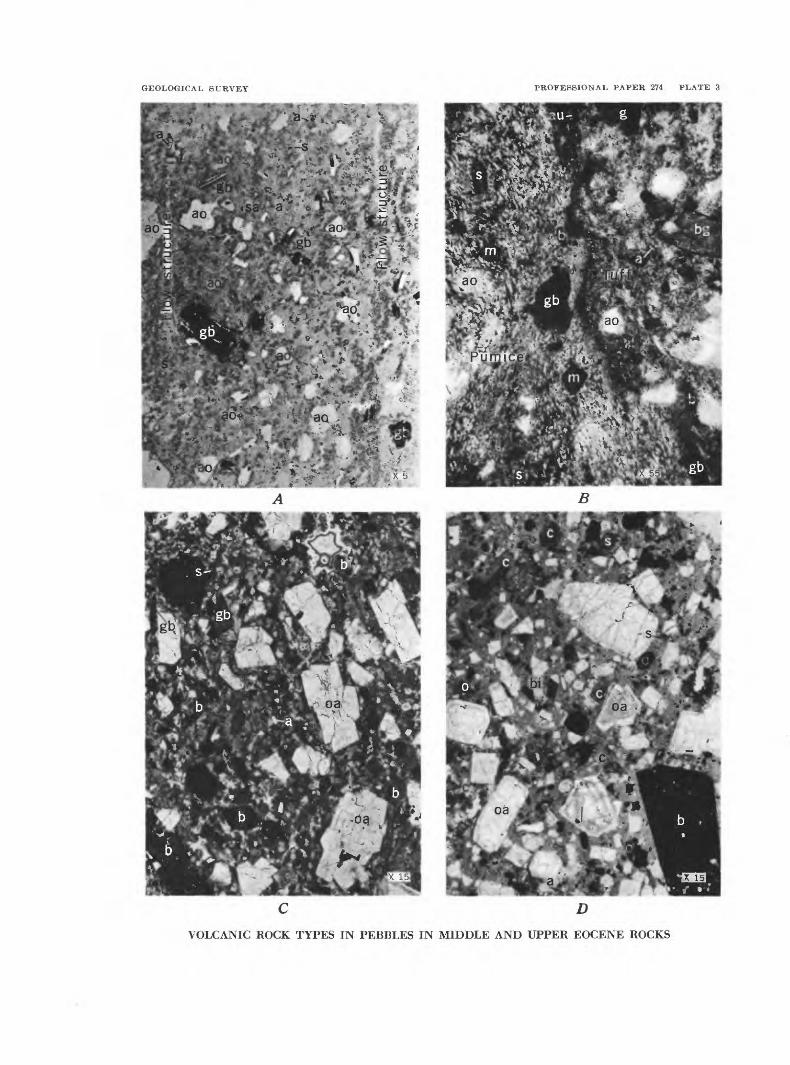
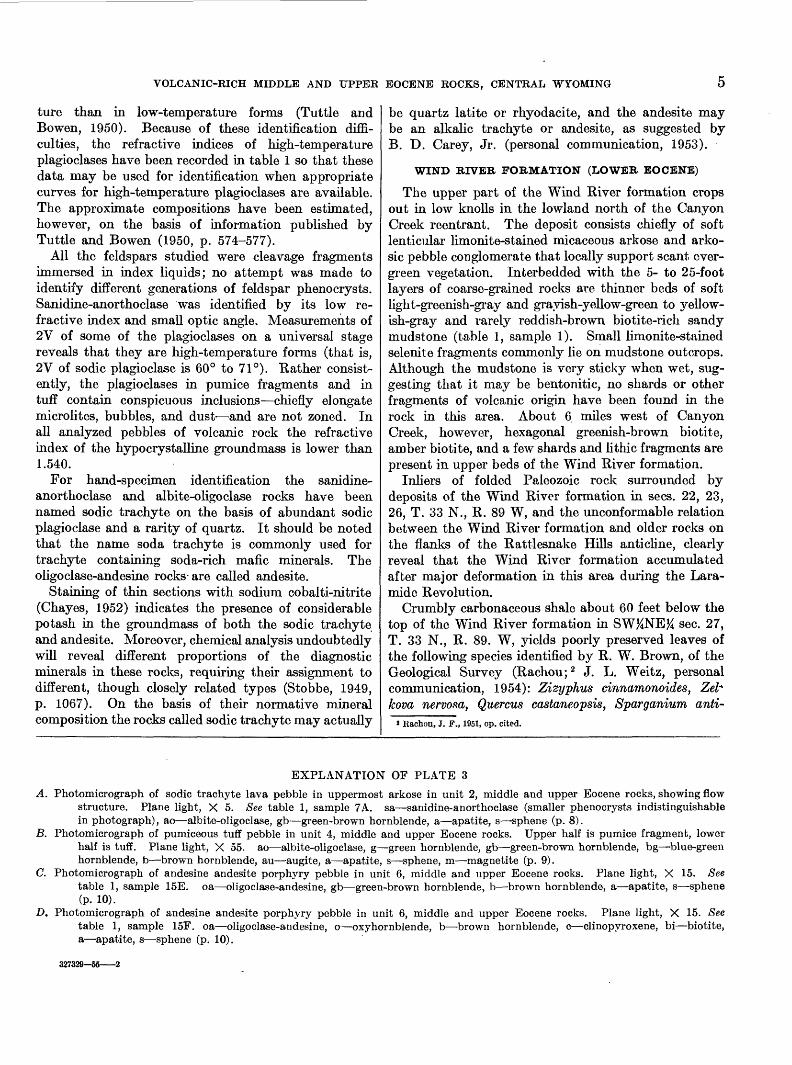
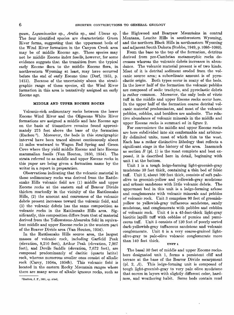
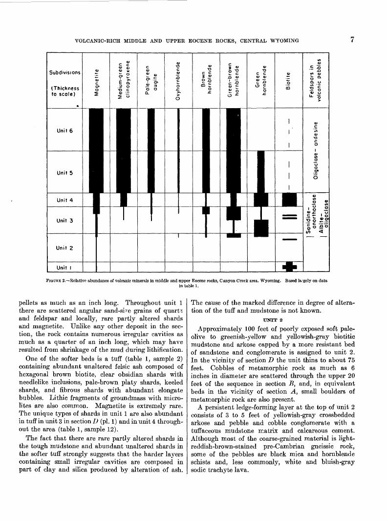
EXPLANATION OF PLATE 3
A. Photomicrograph of sodic trachyte lava pebble in uppermost arkose in unit 2, middle and upper Eocene rocks, showing flow structure. Plane light, X 5. See table 1, sample 7A. sa—sanidine-anorthoclase (smaller phenocrysts indistinguishable in photograph), ao—albite-oligoclase, gb—green-brown hornblende, a—apatite, s—sphene (p. 8).
B. Photomicrograph of pumiceous tuff pebble in unit 4, middle and upper Eocene rocks. Upper half is pumice fragment, lower half is tuff. Plane light, X 55. ao—albite-oligoclase, g—green hornblende, gb—green-brown hornblende, bg—blue-green hornblende, b—brown hornblende, au—augite, a—apatite, s—sphene, m—magnetite (p. 9).
C. Photomicrograph of andesine andesite porphyry pebble in unit 6, middle and upper Eocene rocks. Plane light, X 15. See table 1, sample 15E. oa—oligoclase-andesine, gb—green-brown hornblende, b—brown hornblende, a—apatite, s—sphene (P. 10).
D. Photomicrograph of andesine andesite porphyry pebble in unit 6, middle and upper Eocene rocks. Plane light, X 15. See table 1, sample 15F. oa—oligoclase-andesine, o—oxyhornblende, b—brown hornblende, c—clinopyroxene, bi—biotite, a—apatite, s—sphene (p. 10).
327329—66-
6 SHORTER CONTRIBUTIONS TO GENERAL GEOLOGY
guum, Leguminosites sp., Aralia sp., and Ulmus sp. The four identified species are characteristic Green River forms, suggesting that the uppermost beds of the Wind River formation in the Canyon Creek area may be of middle Eocene age. These species may not be middle Eocene index fossils, however, for some evidence suggests that the transition from the typical early Eocene flora to the middle Eocene flora, in northwestern Wyoming at least, may have occurred before the end of early Eocene time (Dorf, 1953, p. 1413). Because of the uncertainty about the strati- graphic range of these species, all the Wind River formation in this area is tentatively assigned an early Eocene age.
MIDDLE AND UPPER EOCENE BOCKS
Volcanic-rich sedimentary rocks between the lower Eocene Wind River and the Oligocene White River formations are assigned a middle and late Eocene age on the basis of titanothere remains found approxi mately 275 feet above the base of the formation (Rachou 3). Moreover, the beds in this stratigraphic interval have been traced almost continuously about 55 miles westward to Wagon Bed Spring and Green Cove where they yield middle Eocene and late Eocene mammalian fossils (Van Houten, 1950, 1954). The strata referred to as middle and upper Eocene rocks in this paper are being given a formation name by the writer in a report in preparation.
Observations indicating that the volcanic material in these sedimentary rocks was derived from the Rattle snake Hills volcanic field are (1) middle and upper Eocene rocks at the eastern end of Beaver Divide thicken markedly in the vicinity of the Rattlesnake Hills, (2) the amount and coarseness of the volcanic debris present increases toward the volcanic field, and (3) the volcanic debris has the same composition as volcanic rocks in the Rattlesnake Hills area. Sig nificantly, this composition differs from that of material derived from the Yellowstone-Absaroka field in equiva lent middle and upper Eocene rocks in the western part of the Beaver Divide area (Van Houten, 1954).
In the Rattlesnake Hills source area, the largest masses of volcanic rock, including Garfield Peak (elevation, 8,210 feet), Arthur Peak (elevation, 7,907 feet), and Devils Saddle (elevation, 7,672 feet), are composed predominantly of dacitic (quartz latite) rock, whereas numerous smaller ones consist of alkalic rock (Carey, 1954a, 1954b). This volcanic field is located in the eastern Rocky Mountain ranges where there are many areas of alkalic igneous rocks, such as
a Rachou, J. F., 1951, op. cited.
the Highwood and Bearpaw Mountains in central Montana, Leucite Hills in southwestern Wyoming, and the northern Black Hills in northeastern Wyoming and adjacent South Dakota (Stobbe, 1949, p. 1086-1089).
From the base to the top of the formation, detritus derived from pre-Cambrian metamorphic rocks de creases whereas the volcanic debris increases in abun dance. The volcanic material present is of two kinds. Most of it is detrital sediment eroded from the vol canic source area; a subordinate amount is of pyro- clastic origin. Both types occur in many of the beds. In the lower half of the formation the volcanic pebbles are composed of sodic trachyte, and pyroclastic debris is rather common. Moreover, the only beds of vitric tuff in the middle and upper Eocene rocks occur here. In the upper half of the formation coarse detrital vol canic material predominates, and most of the volcanic pebbles, cobbles, and boulders are andesite. The rela tive abundance of volcanic minerals in the middle and upper Eocene rocks is summari ed in figure 2.
For convenience the middle and upper Eocene rocks are here subdivided into six conformable and arbitrar ily delimited units, most of which thin to the west. Each has a rather distinctive lithology that reflects a significant stage in the history of the area. Inasmuch as section B (pi. 1) is the most complete and best ex posed, it is described here in detail, beginning with unit 1 at the bottom.
Unit 1 is a tough ledge-forming light-greenish-gray mudstone 30 feet thick, containing a thin bed of felsic tuff. Unit 2, about 100 feet thick, consists of soft pale- olive to greenish-yellow and yellowish-gray mudstone and arkosic sandstone with little volcanic debris. The uppermost bed in this unit is a ledge-forming arkose and conglomerate with volcanic minerals and pebbles of volcanic rock. Unit 3 comprises 90 feet of greenish- yellow to yellowish-gray tuffaceous sandstone, sandy mudstone, and conglomerate with pebbles and cobbles of volcanic rock. Unit 4 is a 45-foot-thick light-gray biotitic lapilli tuff with cobbles of pumice and pumi- ceous tuff. Unit 5 consists of 130 feet of poorly sorted dark-yellowish-gray tuffaceous sandstone and volcanic conglomerate. Unit 6 is a very coarse-grained light- olive-gray to pale-olive volcanic conglomerate more than 140 feet thick.
UNIT 1
The basal 30 feet of middle and upper Eocene rocks, here designated unit 1, forms a persistent cliff and terrace at the base of the Beaver Divide escarpment (pi. 2, A). This ledge-forming unit is composed of tough light-greenish-gray to very pale olive mudstone that occurs in layers with slightly different color, hard ness, and weathering habit. Some beds contain mud
VOLCANIC-RICH MIDDLE AND UPPER EOCENE ROCKS, CENTRAL WYOMING
FIGURE 2.—Relative abundance of volcanic minerals in middle and upper Eocene rocks, Canyon Creek area. Wyoming. Based la.-gely on datain table 1.
pellets as much as an inch long. Throughout unit 1 there are scattered angular sand-sbe grains of quarts and feldspar and locally, rare partly altered shards and magnetite. Unlike any other deposit in the sec tion, the rock contains numerous irregular cavities as much as a quarter of an inch long, which may have resulted from shrinkage of the mud during lithification.
One of the softer beds is a tuff (table 1, sample 2) containing abundant unaltered felsic ash composed of hexagonal brown biotite, clear obsidian shards with needlelike inclusions, pale-brown platy shards, keeled shards, and fibrous shards with abundant elongate bubbles. Lithic fragments of groundmass with micro- lites are also common. Magnetite is extremely rare. The unique types of shards in unit 1 are also abundant in tuff in unit 3 in section D (pi. 1) and in unit 4 through out the area (table 1, sample 12).
The fact that there are rare partly altered shards in the tough mudstone and abundant unaltered shards in the softer tuff strongly suggests that the harder layers containing small irregular cavities are composed in part of clay and silica produced by alteration of ash.
The cause of the marked difference in degree of altera tion of the tuff and mudstone is not known.
UNIT 2
Approximately 100 feet of poorly exposed soft pale- olive to greenish-yellow and yellowish-gray bio titic mudstone and arkose capped by a more resistant bed of sandstone and conglomerate is assigned to unit 2. In the vicinity of section D the unit thins to about 75 feet. Cobbles of metamorphic rock as much as 6 inches in diameter are scattered through the upper 20 feet of the sequence in section B, and, in equivalent beds in the vicinity of section A, small boulders of metamorphic rock are also present.
A persistent ledge-forming layer at the top of unit 2 consists of 3 to 5 feet of yellowish-gray crossbedded arkose and pebble and cobble conglomerate with a tuffaceous mudstone matrix and calcareous cement. Although most of the coarse-grained material is light- reddish-brown-stained pre-Cambrian gneissic rock, some of the pebbles are black mica and hornblende schists and, less commonly, white and bluish-gray sodic trachyte lava.
8 SHOBTEB CONTRIBUTIONS TO GENERAL GEOLOGY
As in the Wind River formation below, the minerals present throughout most of unit 2 (table 1, samples 3 to 5) were derived from pre-Cambrian metamorphic rocks. Similarly, much of the mudstone is sticky when wet and may be bentonitic. There is very little vol canic debris in the deposits below the capping layer at the site of section B, but in section D lithic fragments and shards, as well as hexagonal brown and amber biotite (table 1, sample 6) occur in a bed of yellowish- gray bentonitic sandy claystone about 10 feet below the top of the unit.
Very dark hornblendes, sphene and apatite in the uppermost ledge-forming layer (table 1, sample 7) marks the lowest occurrence of these volcanic minerals in the section. The lowest occurrence of volcanic pebbles is also in the capping sandstone and conglomer ate. All are pebbles of sodic trachyte lava (table 1, samples 7A, 7B; pi. 3, A) . In most of them the ground- mass is glassy; in some it is pumiceous. This kind of volcanic pebble is present, though rare, throughout the overlying middle and upper Eocene deposits.
UNIT 3
Unit 3 consists of about 90 feet of soft, locally cal careous, very tuffaceous sandstone and sandy mudstone, some conglomerate which generally is coarser in the lower part of the unit, and a few beds of coarse-grained lapilli tuff. The mudstone layers are greenish yellow to pale olive and very bentonitic. The poorly sorted sandstone and conglomerate are yellowish gray and contain abundant shards and lithic fragments, volcanic minerals, rather soft pebbles and small cobbles of pumice and pumiceous tuff, and rare pebbles of sodic trachyte lava. Pebbles and cobbles of metamorphic rock are also present.
In the upper 15 feet several layers of sandstone well cemented with manganese oxide, form minor light- brownish-gray ledges. Coarse-grained lapilli tuff and very tuffaceous arkosic conglomerate between these ledge-forming layers contain pebbles and small cobbles of gray sodic trachyte porphyry and vitrophyre with white feldspar phenocrysts. This is the lowest known occurrence of porphyry pebbles in the section. Locally, there is a 6-inch bed of greenish-yellow chert and silicified mudstone at the top of the unit.
In section D (pi. 1), where unit 3 is 55 feet thick and consists mainly of bentonitic sandy mudstone, two tuff beds are present in the upper half of the unit. The lower bed is a green-brown biotite tuff with abundant lithic fragments and keeled and fibrous shards. The upper tuff contains green-brown hornblende and biotite as well as abundant keeled and fibrous shards.
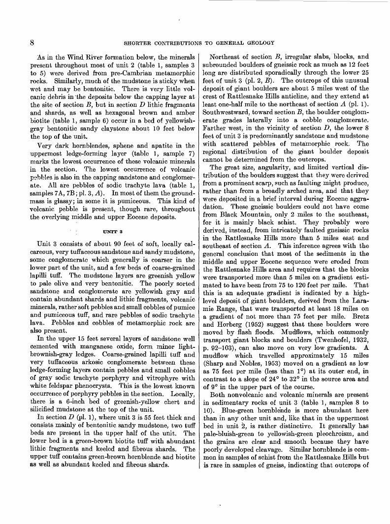
Northeast of section B, irregular slabs, blocks, and subrounded boulders of gneissic rock as much as 12 feet long are distributed sporadically through the lower 25 feet of unit 3 (pi. 2, B). The outcrops of this unusual deposit of giant boulders are about 5 miles west of the crest of Rattlesnake Hills anticline, and they extend at least one-half mile to the northeast of section A (pi. 1). Southwestward, toward section B, the boulder conglom erate grades laterally into a cobble conglomerate. Farther west, in the vicinity of section D, the lower 8 feet of unit 3 is predominantly sandstone and mudstone with scattered pebbles of metamorphic rock. The regional distribution of the giant boulder deposit cannot be determined from the outcrops.
The great size, angularity, and limited vertical dis tribution of the boulders suggest that they were derived from a prominent scarp, such as faulting might produce, rather than from a broadly arched area, and that they were deposited in a brief interval during Eocene aggra dation. These gneissic boulders could not have come from Black Mountain, only 2 miles to the southeast, for it is mainly black schist. They probably were derived, instead, from intricately faulted gneissic rocks in the Rattlesnake Hills more than 5 miles east and southeast of section A. This inference agrees with the general conclusion that most of the sediments in the middle and upper Eocene sequence were eroded from the Rattlesnake Hills area and requires that the blocks were transported more than 5 miles on a gradient esti mated to have been from 75 to 120 feet per mile. That this is an adequate gradient is indicated by a high- level deposit of giant boulders, derived from the Lara- mie Range, that were transported at least 18 miles on a gradient of not more than 75 feet per mile. Bretz and Horberg (1952) suggest that these boulders were moved by flash floods. Mudflows, which commonly transport giant blocks and boulders (Twenhofel, 1932, p. 92-103), can also move on very low gradients. A mudflow which travelled approximately 15 miles (Sharp and Nobles, 1953) moved on a gradient as low as 75 feet per mile (less than 1°) at its outer end, in contrast to a slope of 24° to 32° in the source area and of 9° in the upper part of the course.
Both nonvolcanic and volcanic minerals are present in sedimentary rocks of unit 3 (table 1, samples 8 to 10). Blue-green hornblende is more abundant here than in any other unit and, like that in the uppermost bed in unit 2, is rather distinctive. It generally has pale-bluish-green to yellowish-green pleochroism, and the grains are clear and smooth because they have poorly developed cleavage. Similar hornblende is com mon in samples of schist from the Rattlesnake Hills but is rare in samples of gneiss, indicating that outcrops of
VOLCANIC-RICH MIDDLE AND UPPER EOCENE ROCKS, CENTRAL WYOMING 9
hornblende schist supplied relatively more sand-size detritus during deposition of the upper part of unit 2 and unit 3 than at any other time in the Tertiary history of the Canyon Creek area.
The lower beds of unit 3 contain the same volcanic minerals found in the uppermost strata of unit 2 (table 1, sample 8). In addition to these minerals, deposits in the upper half of unit 3 contain more magnetite and the lowest occurring augite in the section (table 1, sample 9). Moreover, some medium-green clinopy- roxene occurs in the uppermost beds (table 1, sample 10). Significantly, magnetite and pyroxene persist through most of the overlying middle and upper Eocene rocks.
Some pumice pebbles and pebbles of pumiceous tuff (table 1, sample 10B) as well as a few porphyry and vitrophyre pebbles in the upper 15 feet of the unit have the same mafic minerals as the sodic trachyte pebbles in unit 3 and the uppermost bed of unit 2. Other pumice pebbles (table 1, sample 9A) and porphyry pebbles (table 1, sample 10A) from the uppermost part of unit 3 are the lowest occurring fragments of pyroxene- bearing volcanic rock.
UNIT
This is one of the most uniform stratigraphic units in the middle and upper Eocene sequence, and comprises 45 feet of light-gray to pale-yellowish-gray calcareous coarse-grained lapilli tuff and fine-grained vitric tuff, with a few layers and lenses of conglomerate containing both volcanic and metamorphic detritus. These rocks form a conspicuous scarp between the slopes of units 3 and 5. Most of the beds in unit 4 are 1 to 2 feet thick. Locally, some are only a few inches thick, and minor channeling is common. Throughout the tuff there are abundant pebbles and cobbles of pumice and pumiceous tuff, as well as some pebbles of sodic trachyte lava. About a quarter of a mile north of section B a conglomerate lens 50 feet wide and 8 feet thick consists of very poorly sorted detritus composed largely of abundant angular fragments of porphyry and rounder pieces of pumice as much as 2 feet in diameter and some pre-Canibrian metamorphic debris.
Westward, in the vicinity of section D, unit 4 is 25 feet thick and contains considerable greenish-yellow tuffaceous muds tone like that in unit 3.
Although fine-grained vitric tuff in unit 4 (table 1, sample 12) is composed of felsic shards like those in the tuffs in units 1 and 3, the lapilli tuff (table 1, sample 11) contains the light- and dark-green pyroxenes character istic of the deposits of units 5 and 6. All the pebbles examined in unit 4 are sodic trachyte, but few contain the same mafic minerals as the common type of sodic trachyte pebble in unit 3 and the uppermost bed of unit 2. Instead, the sodic trachyte pumice and pumi
ceous tuff pebbles in unit 4 (table 1, sample 11 A; pi. 3, B) have pyroxene minerals much like those in andesite pebbles in units 5 and 6. The predominant hornblende, however, is a rather distinctive very dark green variety.
UNIT 5
Approximately 130 feet of light-olive-gray to pale- olive and yellowish-gray poorly sorted bentonitic tuffaceous mudstone, sandstone, and conglomerate constitutes unit 5. Calcareous cement is common, especially in the coarser grained deposits. Equivalent beds are only 75 feet thick in section D (pi. 1).
Throughout unit 5 the conglomerate, which com monly is in lenticular channel-fill deposits, consists of pebbles and cobbles of both pre-Cambrian metamorphic rock and Tertiary volcanic rock. Most of the coarsest material is metamorphic rock. In contrast to the con glomerates in lower units, however, those in unit 5 contain abundant volcanic debris which is composed predominantly of brown-weathering medium-gray ande- sine andesite porphyry with conspicuous white feldspar phenocrysts. There are also rare pebbles and cobbles of light-gray pumice and reddish-brown aphanitic andesite.
A primitive titanothere, Eometarhinus ervayensis (Univ. Wyo. 928; Rachou 4), was found about 9 feet above the base of unit 5 in soft poorly sorted sandstone and small pebble conglomerate. According to Rachou, this species is structurally intermediate between the middle and the late Eocene species of the genus.
The middle part of unit 5 is a crumbly tuffaceous sandstone and mudstone about 55 feet thick, which contains abundant chips of pinkish-gray bentonite and white pumice fragments as much as a quarter of an inch long. At the top of the unit there are irregular patches of yellowish-gray chert and silicified mudstone several inches thick.
Throughout unit 5 the sandstone matrix contains abundant volcanic minerals and rare nonvolcanic ones (table 1, sample 13). Magnetite, pale-green augite, and medium-green clinopyroxene are more abundant here than in any of the underlying units, and oxyhorn- blende, though rare, is consistently present. The me dium-green clinopyroxene commonly is darker than it is in lower units.
In contrast to the volcanic pebbles in underlying units, most of those in unit 5 are andesiiie andesite; a few are sodic trachyte. Moreover, the most common rock type is andesite porphyry (table 1, sample 14B) characterized by very dark brown and green-brown hornblendes like those in the sodic trachyte porphyry pebbles in the upper 15 feet of unit 3 (table 1, sample
< Rachou, J. F., 1951, op. cited.
10 SHORTER CONTRIBUTIONS TO GENERAL GEOLOGY
10A). The rare pebbles of andesite pumice in unit 5 (table 1, sample 14A) have a similar mafic mineral com position.
UJN1T 6
East of Canyon Creek unit 6 forms the prominent cliff at the top of Beaver Divide and consists of as much as 140 feet of very coarse grained light-olive-gray to pale-olive conglomerate (pl.2, C, D) which locally lies on an erosional surface cut on unit 5. At the site of section B (pi. 1) unit 6 is rather firmly indurated, but eastward and westward along the divide it is commonly unconsolidated. Unlike the coarse deposits of under lying units which contain much fine-grained matrix, the coarser grained beds of unit 6 are composed largely of pebbles, cobbles, and boulders with only a minor amount of mudstone and sandstone. About two- thirds of the coarse debris consists of volcanic rock, predominantly a brown-weathering medium-gray an desite porphyry with conspicuous white feldspar phen- ocrysts. Kare pebbles of aphanitic andesite, sodic trachyte porphyry, and pumice are also present. The other third of the coarse debris is pre-Cambrian meta- morphic rock. Although most of the boulders are less than 3 feet in diameter, some are as much as 5 feet long. Many of the boulders are rather well rounded; some are quite angular, however. Distinct bedding occurs only in the finer grained beds of pebble con glomerate. At the site of section B a 30-foot lens of crumbly tuffaceous poorly sorted mudstone and sand stone containing abundant crystal tuff is present in the lower half of the unit.
Southeastward, deposits of unit 6 extend beyond underlying Tertiary rocks and overlap on pre-Cambrian rocks of Black Mountain.
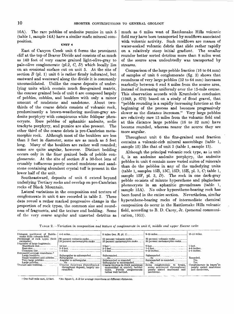
Lateral variations in the composition and texture of conglomerate in unit 6 are recorded in table 2. These data reveal a rather marked progressive change in the proportion of rock types, the common size and round- ness of fragments, and the texture and bedding. Some of the very coarse angular and unsorted detritus as
I much as 6 miles west of Rattlesnake Hills volcanic field may have been transported by mudflows associated with volcanic activity. Such mudflows are masses of water-soaked volcanic debris that slide rather rapidly on a relatively steep initial gradient. The smaller rounder better sorted detritus more than 8 miles west of the source area undoubtedly was transported by streams.
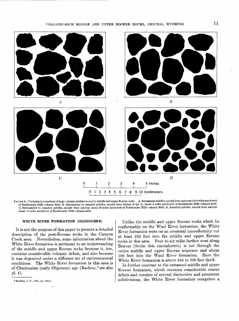
Comparison of the large pebble fraction (16 to 64 mm) of samples of unit 6 conglomerate (fig. 3) shows that roundness of very large pebbles (32 to 64 mm) increases markedly between 6 and 8 miles from the source area, instead of increasing uniformly over the 15-mile course. This observation accords with Krumbein's conclusion (1940, p. 670) based on a study of flood gravel, that "pebble rounding is a rapidly increasing function at the beginning of the process and becomes progressively slower as the distance increases." Very large pebbles are relatively rare 15 miles from the volcanic field and at this distance large pebbles (16 to 32 mm) have become rounded, whereas nearer the source they are more angular.
Throughout unit 6 the fine-grained sand fraction contains a volcanic-rich mineral assemblage (table 1, sample 15) like that of unit 5 (table 1, sample 13).
Although the principal volcanic rock type, as ia unit 5, is an andesine andesite porphyry, the andesite pebbles in unit 6 contain more varied suites of minerals than do the pebbles in any of the underlying units (table 1, samples 15B, 15C, 15D, 15E, pi. 3, C; table 1, sample 15F, pi. 3, D}. The rock in one dark-gray pebble consists of minute hypersthene and plagioclase phenocrysts in an aphanitic groundmass (table 1, sample 15A). No other hypers then e-bearing rock has been found in the entire section. Nevertheless, similar hypersthene-bearing rocks of intermediate chemical composition do occur in the Rattlesnake Hills volcanic field, according to B. D. Carey, Jr. (personal communi cation, 1953).
TABLE 2.—Variation in composition and texture of conglomerate in unit 6, middle and upper Eocene rocks
snake Hills volcanic field.
estimates). Diameter of large fragments:
Rare size. ------- __ --..-___
Estimated average roundness: 2
Small boulders and cobbles, -_Very large pebbles. __ _ __ -Large pebbles.------- .--__ .
4-6 miles ____ - ______ . _ .
\10 percent metamorphic rocks _ ..
3-5 feet---. -----_------.---..-.._
__ do __ . _________ - .....
throughout deposit, largely un- stratified.
35 percent metamorphic rocks — _.
K foot 1
l-3Ieet———— — —— — — —
——do—— — — —————— —
unstratified or crudely bedded units. Pebble conglomerate rather well bedded.
9-10 miles ............... .........
50 percent metamorphic rocks, ... _
9 feet— -——— — — — _—--l-3feet— — . ----------------- ..
— . .do— — —— -------------
——do——— — —— — — — .——
some scattered throughout poorly sorted mudstone and sandstone.
13-15 miles.
1 foot.4-8 inches.1-3 inches.
Rounded.Do.Do.
poorly sorted mudstone and sandstone.
One-half mile east, 12 feet. 2 See figure 3, A-D for average roundness at different distances.
VOLCANIC-RICH MIDDLE AND UPPER EOCENE ROCKS, CENTRAL WYOMING 11
A B
D5 Inchesj
012345678 9 10 Centimetersi i i i i i i i i i i
FIGURE 3.—Variation in roundness of large volcanic pebbles in unit 6, middle and upper Eocene rocks A, Subangular pebbles, sample from outcrops 4 to 6 miles northwest of Rattlesnake Hills volcanic field; B, Subrounded to rounded pebbles, sample from section B (pi. 1), about 8 miles northwest of Rattlesnake Hills volcanic field; C, Subrounded to rounded pebbles, sample from outcrop about 10 miles northwest of Rattlesnake Hills volcanic field; D, Rounded pebbles, sample from outcrop about 15 miles northwest of Rattlesnake Hills volcanic field.
WHITE RIVER FORMATION (OUGOCENE)
It is not the purpose of this paper to present a detailed description of the post-Eocene rocks in the Canyon Creek area. Nevertheless, some information about the White River formation is pertinent to an understanding of the middle and upper Eocene rocks because it, too, contains considerable volcanic debris, and also because it was deposited under a different set of environmental conditions. The White River formation in this area is of Chadronian (earlv Oligocene) age (Rachou; 5 see also pl. D.
6 Rachou, J. F., 1951, op. cited.
Unlike the middle and upper Eocene rocks which lie conformably on the Wind River formation, the White River formation rests on an erosional unconformity cut at least 250 feet into the middle and upper Eocene rocks in this area. Four to six miles farther west along Beaver Divide this unconformity is cut through the entire middle and upper Eocene sequence and about 100 feet into the Wind River formation. Here the White River formation is about 450 to 500 feet thick.
In further contrast to the unnamed middle and upper Eocene formation, which contains considerable coarse debris and consists of several distinctive and persistent subdivisions, the White River formation comprises a
12 SHORTER CONTRIBUTIONS TO GENERAL GEOLOGY
maximum of about 275 feet of massive generally well- sorted fine-grained sedimentary rocks with only a subordinate amount of conglomerate. The lowest 50 feet of the formation, preserved between sections C and D (pi. 1.) is predominantly light-gray calcareous biotitic vitric tuff (table 1, sample 16) and very tuffa- ceous mudstone. The upper part of the formation consists chiefly of grayish-orange to yellowish-gray sandy mudstone with some layers of light-gray cal careous vitric tuff and rare lenses of conglomerate.
Most of the conglomerate lenses in the White River formation are composed of abundant somewhat angular pre-Cambrian rock fragments and rounder pebbles and cobbles of andesite porphyry (table 1, sample 16A) like those in the upper part of the middle and upper Eocene rocks. The andesite porphyry pebbles and cobbles are most numerous in the vicinity of section C where the upper part of the White River formation rests uncon- formably on middle and upper Eocene strata.
In some of the conglomerate lenses in the White River formation rather soft rounded very light gray volcanic pebbles and small cobbles are common. Although most of these light-gray pebbles are porphy- ritic sodic trachyte lava (table 1, samples 16B, 16C), some are coarse-grained tuff of similar composition. The feldspar present is like that in pebbles in the lower half of the middle and upper Eocene rocks, but unlike these pebbles the soft porous light-gray pebbles in the White River formation contain large sanidine-anortho- clase phenocrysts.
The composition and field occurrence of the coarse volcanic detritus in the White River formation suggest that the detritus was derived from middle and upper Eocene volcanic rocks. Most of the andesite porphyry pebbles and cobbles may have been reworked from the underlying volcanic conglomerate, although some may have been eroded directly from the Rattlesnake Hills area. Most of the soft very light gray sodic trachyte porphyry pebbles, on the contrary, probably were derived directly from middle and upper Eocene irrup- tive rock exposed in. the volcanic field. Reworking of the underlying volcanic conglomerate in the Canyon Creek area presumably would have destroyed the rare pebbles of softer sodic trachyte, thus producing a con glomerate composed chiefly of the tougher types of volcanic rock.
Although the abundance of uncontaminated tuff in the White River formation suggests that volcanoes may have been active in the Rattlesnake Hills field during Oligocene time, present data provide no good evidence that the tuff was derived locally.
Rachou 6 reports the following Chadronian (early Oligocene) mammals from the lower part of the White
8 Rachou, J. F., op. cited.
River formation in the vicinity of sections D and E: Hyracodon, cf. H. leidyanus (U. S. G. S. specimen); Agriochoerus intermedius (Univ. Wyo 932); Archaeothe- rium, cf. A. mortoni (Univ. Wyo. 927); Cylindrodon, cf. C.jontis (Univ. Wyo. 933); Ischyromys, cf. /. typus (Univ. Wyo. 934); and a titanothere. Fossil leaves of Acer glabroides were also collected here. A larger Chad ronian fauna collected from the lower 200 feet of the White River formation in the vicinity of Cameron Spring, about 4^ miles west southwest of Canyon Creek, in sec. 1, T. 32 N., R. 90 W., consists of the fol lowing mammals (Hough, 1955): Peratherium beaveri, Oligoryctes cameronensis, Titanotheriomys cf. T. veterior, Cylindrodon fontisf, Cylindrodon brownii, Pseudocylin- drodonl wyomingensis, Cedromusl sp., Palaeolagus temnodon, Megalagus brachyodon, Hyaenodon sp., Pseudo- cynodictis cf. P. paterculus, Mesohippus cf. M. montan- ensis, Menodus heloceras, Trigonias sp., Caenopus sp., Hyracodon sp., Leptomeryx sp., Leptomeryx esulcatus, Bathygenys alpha, Merycoidodon culbertsoni, and Mery- coidodon gracilis.
GEOLOGIC HISTORY OF AREA
The Eocene and Oligocene history of the Canyon Creek area is summarized here in the following sequence of events.
After the Granite Mountains and other structures formed during the Laramide Revolution had been de formed and deeply eroded, prolonged aggradation of the Wind River Basin began with deposition of the lower Eocene Wind River formation. Arkosic sand and gravel accumulated in stream channels while varie gated sandy mud was deposited on flood plains and carbonaceous layers formed in local swamps. Most of this detritus was derived from the Granite Mountains, and is coarser grained along the southern margin of the basin than it is farther north. As the deposits ac cumulated in the lowland of the basin they gradually spread marginward across truncated Paleozoic and Mesozoic strata flanking the Granite Mountains and the Rattlesnake Hills and Button Basin anticlines.
No volcanic debris is known from the Wind River formation in the Canyon Creek area. Six miles to the west, however, some tuff is present, and, about 50 miles west of Canyon Creek, tuff is common in the upper part of the formation. The westward increase in amount of lower Eocene tuff, together with the distribution, thickness, and texture of tuff in the Wind River forma tion in the central and western parts of the Wind River Basin (Hay 7)? indicates that this pyroclastic debris
7 Hay, R. L., 1952, Stratigraphy of the lower volcanic rocks in the southern part of the Absaroka Range: Unpublished Doctor of Philosophy thesis in flies of Prmceton Univ. library.
VOLCANIC-RICH MIDDLE AND TJPPEK EOCENE ROCKS, CENTRAL WYOMING 13
was produced by explosions during early Eocene time in the Yellowstone-Absaroka volcanic field.
Accumulation of lenticular deposits of the Wind River formation was followed without significant interruption by deposition of more persistent beds of light-yellowish-gray to pale-olive mud and sand of the middle and upper Eocene sequence. The first sediment reflecting the change was a uniform and widespread layer of mud and felsic ash (unit 1) which apparently accumulated on broad flood plains or, perhaps, in broad, shallow lakes. The ash in this basal bed is the first evidence of volcanic activity in the Rattlesnake Hills volcanic field.
Deposition of the succeeding flood plain and channel deposits of mud and sand with very little volcanic debris (unit 2) ended with the influx of coarse arkosic gravel derived from pre-Cambrian rocks of the Granite Mountains. The gravel was first deposited east of section B only, while coarse sand and mud and a thin bed of biotitic ash accumulated farther west. Sub sequently, some of the streams transporting the pre- Cambrian detritus began to erode volcanic debris from the Rattlesnake Hills area, and an extensive sheet of arkosic sand and gravel containing volcanic minerals and pebbles of sodic trachyte lava was spread through out the region.
Accumulation of the coarse arkosic sediments cul minated in the deposition of giant gneissic boulders in the lower part of unit 3 in the vicinity of section A; tuffaceous sand and gravel accumulated farther west. This giant boulder bed may have been deposited by flash floods or by mass flowage which moved the boulders and blocks northwestward at least 5 miles on a gradient that was less than 2° in the lower part of the course. The gneissic blocks were, perhaps, derived from scarps produced by renewed deformation of the intricately faulted pre-Cambrian rocks in the Rattle snake Hills area. This episode of deformation may have accompanied the volcanic activity that supplied the first abundant volcanic debris deposited in the Canyon Creek area. Although some beds of vitric ash were of primary eruptive origin, most of the volcanic debris in unit 3 was brought in by streams along with detritus eroded from pre-Cambrian rocks. Pebbles of sodic trachyte pumice, pumiceous tuff, and lava were the dominant coarse material eroded from the volcanic field. During deposition of the upper part of unit 3 sodic trachyte porphyry pebbles, as well as pyroxene and abundant magnetite grains, were transported to the Canyon Creek area for the first time.
Deposition of these dominantly detrital volcanic- rich sediments was interrupted by explosive volcanic activity in the source area which produced an extensive
pyroclastic deposit of fine-grained vitric tuff and lapilli tuff (unit 4). The sodic trachyte debris of this eruption contains more pyroxene than any of the material previously derived from the volcanic field.
As a result of renewed uplift of the Rattlesnake Hills area and possibly the piling up of volcanic debris, streams were powerful enough to transport coarse volcanic gravel more than 8 miles northwestward. Significantly, this coarse detritus and the associated pyroclastic materials in units 5 and 6 have a distinctive composition and texture. No longer were pumice, felsic shards, and sodic trachyte porphyry and lava the principal products derived from the volcanic source area. Instead, dirty yellowish-gray poorly sorted volcanic-rich mud and sand, ash of lithic fragments, abundant augite, clinopyroxene, and magnetite, and pebbles and cobbles of andesite porphyry were deposited in the Canyon Creek area. As the slopes in the source area became steeper, mudflows and powerful streams transported a great mass of very coarse volcanic and metamorphic debris that forms the thick cobble and boulder conglomerate of unit 6 at the top of the middle and upper Eocene rocks.
Following the deposition of the coarsest of all the volcanic sediments in the middle and upper Eocene deposits, uplift and deep erosion of the region inter rupted aggradation in the southern part of the Wind River Basin.
Widespread aggradation was renewed when sedi ments of the White River formation began to accumu late on the rugged erosional surface in early Oligocene time. Deposition of at least 275 feet of rather well- sorted mud with local gravel lenses was accompanied by several prolonged showers of felsic ash.
LITERATURE CITED
Bretz, J. H., and Horberg, Leland, 1952, A high-level boulderdeposit east of the Laramie Range, Wyo.: Jour. Geology,v. 60, p. 480-488.
Carey, B. D., Jr., 1954a, A brief sketch of the geology of theRattlesnake Hills, in Wyo. Geol. Assoc. Guidebook 9thAnn. Field Conf., p. 32-34.
———— 1954b, Geologic map and structure sections of the Rattle snake Hills Tertiary volcanic field, in Wyo. Geol. Assoc. Guidebook 9th Ann. Field Conf.
Chayes, Felix, 1952, Notes on the staining of potash feldspar with sodium cobalti-nitrite in thin section: Am. Mineralo gist, v. 37, p. 337-340.
Dorf, Erling, 1953, Succession of Eocene floras in northwestern Wyoming [abs.]: Geol. Soc. America, Bull., v. 64, p. 1413.
Hares, C. J., 1917, Anticlines in central Wyoming: U. S. Geol. Survey Bull. 641-1, p. 233-279.
———— 1946, Geologic map of the southeastern part of the Wind River Basin and adjacent areas in central Wyoming: U. S. Geol. Survey, Oil and Gas Inv. Prelim. Map 51.
14 SHORTER CONTRIBUTIONS TO GENERAL GEOLOGY
Hough, Jean, 1955, A lower Oligocene fauna from the easternBeaver Divide area near Cameron Spring Reservoir, Fre-mont County, Wyo. [in preparation].
Kohler, Alexander, 1949, Recent results of investigation on thefeldspars: Jour. Geology, v. 57, p. 592-599.
Krumbein, W. C., 1940, Flood deposits of San Gabriel Canyon,Calif.: Geol. Soc. America Bull., v. 51, p. 639-676.
Love, J. D., Weitz, J. L., and Hose, R. K., 1952, Geologic mapof Wyoming, U. S. Geological Survey.
Rachou, J. F., 1951, Tertiary stratigraphy of the RattlesnakeHills, central Wyoming [abs.]: Geol. Soc. America Bull., v.62, p. 1541.
Reynolds, D. L., 1952, The difference in optics between volcanicand plutonic plagioclases, and its bearing on the graniteproblem: Geol. Mag., v. 89, no. 4, p. 233-250.
Sharp, R. P., and Nobles, L. H., 1953, Mudflow of 1941 atWrightwood, southern California: Geol. Soc. America Bull.,v. 64, p. 547-560.
Stobbe, H. R., 1949, Petrology of volcanic rocks of northeasternNew Mexico: Geol. Soc. America Bull., v. 60, p. 1041-1095.
Tuttle, O. F., and Bowen, N. L., 1950, High temperature albiteand contiguous feldspars: Jour. Geology, v. 58, p. 572-583.
Twenhofel, W. H., 1932, Treatise on sedimentation, 2d ed.: 926p., The Williams & Wilkins Co.
Van Houten, F. B., 1950, Geology of the western part of BeaverDivide area, Fremont County, Wyo.: U. S. Geol. Survey Oiland Gas Inv. Map OM 113.
———— 1954, Geology of the Long Creek-Beaver Divide area,Fremont County, Wyo.: U. S. Geol. Survey Oil and GasInv. Map OM 140.
O