Embed Size (px)
Citation preview

Visibility, Monumentality, and Community in theChacoan Community at Kin Bineola, New Mexico
Item Type text; Electronic Thesis
Authors Dungan, Katherine Ann
Publisher The University of Arizona.
Rights Copyright © is held by the author. Digital access to this materialis made possible by the University Libraries, University of Arizona.Further transmission, reproduction or presentation (such aspublic display or performance) of protected items is prohibitedexcept with permission of the author.
Download date 20/06/2018 05:16:02
Link to Item http://hdl.handle.net/10150/193393

VISIBILITY, MONUMENTALITY, AND COMMUNITY IN THE CHACOAN COMMUNITY AT KIN BINEOLA, NEW MEXICO
by
Katherine Ann Dungan
________________________
A Thesis Submitted to the Faculty of the
DEPARTMENT OF ANTHROPOLOGY
In Partial Fulfillment of the Requirements For the Degree of
MASTER OF ARTS
In the Graduate College
THE UNIVERSITY OF ARIZONA
2009

2
STATEMENT BY AUTHOR
This thesis has been submitted in partial fulfillment of requirements for an advanced degree at The University of Arizona and is deposited in the University Library to be made available to borrowers under rules of the Library.
Brief quotations from this thesis are allowable without special permission, provided that accurate acknowledgment of source is made. Requests for permission for extended quotation from or reproduction of this manuscript in whole or in part may be granted by the head of the major department or the Dean of the Graduate College when in his or her judgment the proposed use of the material is in the interests of scholarship. In all other instances, however, permission must be obtained from the author.
SIGNED: Katherine Ann Dungan
APPROVAL BY THESIS DIRECTOR
This thesis has been approved on the date shown below:
March 25, 2009 Dr. Barbara J. Mills Professor and Head of Anthropology

3
ACKNOWLEDGMENTS
A number of people graciously gave their time and effort to make this project possible. Thanks are due first and foremost to my committee. Dr. Barbara Mills provided information, encouragement, much needed critiques, and went above and beyond the call of duty of a committee chair by cheerfully volunteering to carry several pounds of PVC pipe around the rural San Juan Basin. Dr. Gary Christopherson helped to deflate my occasional GIS crises, and Dr. Mark Aldenderfer provided an insightful reading of this research including more constructive criticism than I was able to incorporate into the final product. In the earliest stages of this research, Bob Powers and Ruth Van Dyke offered their data and their expertise; thanks to them and to all those who gave me permission to cite their chapters of the Chaco Additions Survey report. Lou Haecker provided assistance at ARMS. Thanks are due to Wendy Bustard, Roger Moore, and Dabney Ford, for their assistance with the NPS permitting process and our fieldwork at the Park. Dabney in particular made us feel at home during our brief stay in the canyon. Natalie Farrell very kindly volunteered to serve as our third field crew member.
Research funding for this project was provided by the University of Arizona=s Integrative Graduate Research and Traineeship Program in the Archaeological Sciences, and, during this project, I was supported first by a University of Arizona IGERT Program Traineeship and then by a National Science Foundation Graduate Research Fellowship.
My friends and colleagues have provided congratulations, encouragement, and commiseration as needed and have helped to make this entire academic adventure a rewarding experience. Thank you, Wendi, Kenichiro, Deanna, Rob, Lizzy, and everyone else. Finally, my family have always been there for me - thank you all.

4
TABLE OF CONTENTS
LIST OF TABLES .................................................................................................. 6 LIST OF FIGURES.................................................................................................. 7 ABSTRACT............................................................................................................. 9 CHAPTER 1: INTRODUCTION............................................................................. 10 CHAPTER 2: COMMUNITY, MONUMENTALITY AND VISIBILITY IN CHACOAN ARCHITECTURE.... .................................... 15 Chacoan Communities.................................................... ................................... 15 Great Kivas and Great Houses: Integrative Structures in the San Juan Basin.. 18 Monumentality, Meaning, and Visibility............................................................. 24 CHAPTER 3: PREVIOUS RESEARCH AT KIN BINEOLA…………………… 29 The Kin Bineola Community: Site Types, Histories, and Descriptions............... 31 Kin Bineola...................................................................................................... 31 The Isolated Great Kiva (29MC261)............................................................... 33 The Chacoan Structure (29MC291)................................................................. 34 Shrines.............................................................................................................. 36 Habitations Sites............................................................................................... 42 CHAPTER 4: METHODOLOGY............................................................................ 45 Visibility Modeling in Archaeology...................................................................... 45 Viewshed Generation at Kin Bineola.................................................................... 49 Visibility and Distance.......................................................................................... 53 Sensitivity Analysis................................................................................................ 59

5
TABLE OF CONTENTS - Continued Site Visits.............................................................................................................. 60 CHAPTER 5: RESULTS OF THE ANALYSIS....................................................... 63 Comparison of Original Analysis to Field Results............................................... 63 Visibility Among Habitation Sites........................................................................ 69 Visibility at Kin Bineola, 29MC261, and 29MC291............................................. 72 Visibility at Shrines................................................................................................ 79 CHAPTER 6: DISCUSSION, FUTURE DIRECTIONS, AND CONCLUSION…. 85 Kin Bineola, the Great Kiva, and 29MC291: Invisible Monuments and Monumental Strategies................................................. 85 Shrines: Visibility without Monumentality............................................................ 92 Intervisibility and Temporal Patterning in Habitation Sites................................. 94 Future Directions and Methodological Caveats................................................... 96 Conclusion............................................................................................................. 99 APPENDIX A: TABLES AND FIGURES……………………………………… 101 WORKS CITED..................................................................................................... 146

6
LIST OF TABLES
Table 1. Comparison of field determinations for intervisibility to those from the original GIS model..................................................................................... 101
Table 2. Comparison of results from the original model for habitations to the revised model results using GPS points both as viewpoints and for target site locations................................................................................... 101 Table 3. Comparison of original results for habitations to revised model results using GPS points for viewshed generation and original survey map site areas for target sites.................................................................................. 101 Table 4. Average number of habitation sites visible per habitation site................... 102 Table 5. Average number of sites visible per habitation site (calculated as in Table 4) with 29MC250 and 29SJ1578 removed from the dataset........... 102 Table 6. Number of habitation sites visible from community or monumental structures..................................................................................................... 103 Table 7. Proportions based on the counts in Table 6. .............................................. 103 Table 8. Count of habitation sites intervisible with shrines, assuming a maximum date range of between A..D. 900 and 1150 for all shrines and omitting 29MC250 and 29SJ1578 from the total habitation site count…………..... 104 Table 9. Counts of habitation sites intervisible with shrines, using ceramic date ranges (the two omitted shrines could not be assigned dates).................... 104 Table 10. Proportions of contemporary habitation sites intervisible with shrines,
using ceramic date ranges (the two omitted shrines could not be assigned dates)…………………………………………………………... 105

7
LIST OF FIGURES Figure 1. The study area, including habitations and monumental or community
structures used in the visibility analysis.................................................... 106 Figure 2. The count of habitation sites in the study area through time.................... 107 Figure 3. A-R. Habitation sites in the Kin Bineola survey area between A.D. 500
and 1150..................................................................................................... 108 Figure 4. A-D. Examples of changing visibility at short, middle, and long distances............................................................................................ 113 Figure 5. The average number of habitation sites visible per habitation site through time for short-, medium-, and long-distance connections using both the minimum and maximum networks........................................................... 115 Figure 6. Average proportion of contemporary habitation sites visible per habitation through time using all three distance categories and both minimum and maximum networks............................................................ 116 Figure 7. A-B. Maximum (A) and minimum (B) visibility networks for the Kin Bineola great house, showing the locations of the two problematic habitation sites, 29SJ1578 and 29MC250.................................................. 117 Figure 8. Visibility network for the isolated great kiva, 29MC261.......................... 119 Figure 9. Visibility network for the small Chacoan structure, 29MC291................ 120 Figure 10. Counts of habitation sites intervisible with Kin Bineola, the great kiva (29MC261) and 29MC291 within medium-distance range, over time...... 121 Figure 11. Counts of habitation sites intervisible with Kin Bineola, the great kiva,
and 29MC291 within long-distance visibility range................................ 122 Figure 12. Proportions of habitation sites with short- and medium-distance visual connections to Kin Bineola, the great kiva, and 29MC291.................... 123 Figure 13. Proportions of habitation sites with long-distance visual connections to Kin Bineola, the great kiva, and 29MC291.............................................. 124 Figure 14. A-F. Visibility networks for the shrines................................................... 125

8
LIST OF FIGURES - continued Figure 15. A-G. Counts of habitation sites intervisible at medium distances with shrines or possible shrines through time.................................................. 131 Figure 16. A-G. Counts of habitation sites intervisible at distances over 1 km with
shrines or possible shrines through time................................................... 134 Figure 17. A-G. Proportions of habitation sites intervisible at medium distances with shrines or possible shrines through time........................................... 138 Figure 18. A-G. Proportions of habitation sites intervisible at distances over 1 km with shrines or possible shrines through time........................................... 142

9
ABSTRACT
Chacoan great houses have been described as providing “ritual” or “integrative”
venues and as “monumental” in scale and in the amount of labor required for their
construction. This study takes the approach that part of the function of community,
monumental, or ritual structures is to transmit meaning and that an examination of
visibility connections between these structures and small habitation sites in the
surrounding community may provide information about the role of these messages in
daily practice. Survey data from the Chacoan community at Kin Bineola, New Mexico is
analyzed in a GIS environment using a model of visibility and distance developed for this
project. The results show that, contrary to expectations, the great house is much less
visible than a less monumental “Chacoan structure.” Shrines, small structures interpreted
as having a ritual function, are by far the most visible, suggesting a more complex
relationship between monumentality and visibility.

10
CHAPTER 1: INTRODUCTION
During the 11th century, Chaco Canyon, located in the central San Juan basin in
what is now northwestern New Mexico, became the center of a regional “phenomenon”
in the Ancestral Puebloan world. Settlements throughout the basin and perhaps even at
greater distances participated in or emulated trends that saw their greatest elaboration in
the canyon. While archaeologists have applied a great deal of study to the entire breadth
of the Chacoan material culture repertoire, many if not most “Chacoan” defining features
are architectural. At least twelve “great houses” were built in the canyon between
approximately A.D. 900 and 1150 (see Lekson 2006, 2007; Mills 2002; and Van Dyke
2008 for recent discussions and syntheses). These structures are distinguished from
contemporary habitations by their larger size, the formality of their layouts, the massive
masonry used in their construction, and the scale of building or remodeling events. Large
additions and even whole great houses (e.g., Wijiji) seem to have been planned and built
in single stages completed over the course of a few years (Lekson 1986, 2007).
“Outliers,” or settlements with Chacoan characteristics located outside of the canyon, are
typically identified by the presence of what Keith Kintigh (2003:97) has called a
“Chacoan architectural complex,” a group of structures or features similar to those found
in the canyon, including great houses, road segments, possible earthworks, and formal
great kivas. Elements of great house architecture include massive tabular sandstone
masonry, large rooms, elevated kivas built into great houses, and multiple story
construction.
The purpose of great houses continues to be subject to debate, although there is

11
growing consensus that the Chaco Canyon great houses housed only very small
populations (Bernardini 1999; Mills 2002; Windes 1984). The degree to which outlying
great houses were residential remains an open question, as few great houses outside the
canyon have been extensively excavated, and the application of conclusions about
occupancy drawn from canyon great houses, or even a few outlying great houses, to all
such structures throughout the San Juan Basin is problematic at best. Most authors do
characterize great houses and other Chacoan features of the built landscape as having
provided ritual or “integrative” venues for members of the surrounding community, most
of whom would have been residents of much smaller, less formal “unit pueblo”
habitations (e.g., Durand 2003; authors in Kantner and Mahoney 2000; Van Dyke 2008).
Even if residency in and access to great houses was restricted to high status individuals or
ritual elites, the great houses are “community structures,” at least in the sense of requiring
labor investment at a larger scale than could have been provided by a few households
alone. They are arguably “monumental” in scale, particularly when compared to
contemporary southwestern structures, and possibly also in terms of the communication
of meaning. Van Dyke (2008:101) has argued that great houses represent a Chacoan
ideology, that is, that the messages transmitted by these structures reinforced the
legitimacy of a Chacoan power structure. If these structures are ideological,
monumental, or integrative in purpose, the degree to which they are visible from the
surrounding landscape may tell us something about the role played by these structures
and by the messages they communicated within the daily practice of the community.
Most studies of visibility for Chacoan structures have focused on long distance visibility

12
within possible signaling networks, but intervisibility between habitation sites and great
houses has been used to support an integrative role for great houses within the
community (Van Dyke 2008:187-189; Windes et al 2000:49). Van Dyke (2008:42,
following Foucault 1977) has also suggested that, if great houses are highly visible from
the surrounding community, this placement may represent an attempt to assert power
through real or perceived surveillance. Within this study I frame the discussion of
visibility somewhat differently, focusing on the capacity of the Chacoan structures to
convey meaning and the role of these transmitted messages in the daily practice of the
community. I focus on the community at Kin Bineola, a Chacoan outlier located
approximately 17 km southwest of the core group of Chaco Canyon great houses and
outside of, but comparatively near to, the canyon.
In several ways, the National Park Service tract surrounding Kin Bineola provides
an ideal setting for the analysis of visibility within a Chacoan community. Survey data
are available from the Chaco Additions Survey carried out by the Park Service in 1983
(Altschul and Sebastian n.d.; Mills n.d.; Van Dyke n.d.), and the resulting data set is
reasonably diverse in terms of community and residential architecture without being
prohibitively large in size. In addition to Kin Bineola itself, which is one of the largest
great houses outside of Chaco Canyon, the survey tract contains another possible small
“Chacoan structure” or proto-great house (29MC291), an isolated great kiva (29MC261),
and several shrines – structures that arguably served a primarily ritual purpose but are
relatively simple in construction (Marshall et al.1979:57-68; Sebastian and Altschul n.d.).
The survey also recorded some 49 small habitation sites occupied at some point during

13
the interval between approximately A.D. 500 and 1150.
The primary focus of this study was the creation of a geographic information
systems (GIS) based model of visibility between community or monumental structures
(that is, the specific structures mentioned above and described in detail in Chapter 3) and
habitation sites, and of visibility among habitation sites or among community structures.
The fundamental assumption here is that, in addition to any other purposes served or
roles played by community structures, these buildings also convey meaning to members
of the community; following this, one might expect the most overbuilt, “monumental”
structures to be the most visible within the physical area of the community, although it
will be seen below that this assumption does not hold true at Kin Bineola. In an attempt
to reconcile GIS-generated lines of sight with human perception, a distance-based
classification for visibility connections was developed, drawing on concepts originating
in the fields of proxemics, architecture, and landscape design. The initial GIS model was
then “ground-truthed” in the field and modified based on the data collected during
fieldwork. The results of the final model suggest that there are significant differences in
visibility among the community and monumental structures in the Kin Bineola
community, with the great house and great kiva sharing visibility connections with
comparatively few habitation sites while the much smaller “Chacoan Structure” is highly
visible. The most visible structures in the survey area are the shrines; every or nearly
every habitation sites is visible from at least one of these small, fairly simple structures.
These results are discussed within the framework of monumentality, community, and the
transmission of meaning described below. Chapter 2 outlines the approach to the

14
concepts of community and monumentality utilized in this study and provides a culture-
historical context for Chacoan “integrative” structures, while Chapter 3 outlines previous
research at Kin Bineola itself and describes the set of structures included in this study.
Chapter 4 describes the study methodology, including the basic context of visibility
modeling in archaeology, the distance classification developed for this project, and the
particular methodology used in the generation of the model and subsequent fieldwork and
revisions. Chapter 5 contains the results of the analysis, and Chapter 6 discusses these
results within the framework outlined in earlier chapters and offers possible future
directions for analysis.

15
CHAPTER 2: COMMUNITY, MONUMENTALITY, AND VISIBILITY
IN CHACOAN ARCHITECTURE
Chacoan Communities
“Communities” have been part of the essential Chacoan vocabulary since the
earliest systematic studies of Chaco as a pattern extending outside of the canyon itself
(e.g., Marshall et al. 1979; Powers et al. 1983). In these original studies, the word was
used to refer to a spatial pattern in the archaeological record, in particular the clustering
of small habitation structures on the landscape in conjunction with a Chacoan great
house. Although the difficulties with defining discrete clusters or cluster edges on the
landscape using standard survey methodology have been widely acknowledged, and
much remains to be learned about the spatial patterning of small habitation sites and their
relationship to great houses, these settlement clusters are a reality of the Chacoan
archaeological record (Gilpin 2003). More recent discussions of Chacoan communities
have focused on the implications of these spatial clusters for our understanding of the
organization of Chacoan society throughout the San Juan basin. Introducing their co-
edited volume on Chacoan communities, Mahoney and Kantner (2000:11-12) draw on
several different definitions of “community,” and primarily that outlined by Kolb and
Snead (1997:611), who defined “the community” as “a minimal, spatially defined locus
of human activity that incorporates social reproduction, subsistence production, and self-
identification.” Elsewhere, Mahoney (2000) and Gilpin (2003) focus heavily on
biological reproductive sustainability in their discussion of Chacoan communities.
Mahoney has specifically argued that certain Chacoan settlement clusters do not

16
represent “sustainable communities” because they were never home to sufficiently large
populations, and that integrative structures would have been targeted to sustainable
communities (i.e., a network including people not resident in the immediate settlement
cluster) rather than to just the local population (Mahoney 2000:27).
Beyond the confines of Chacoan archaeology, contributors to two recent volumes
on “communities” in archaeology have wed the concept of community to practice theory
(Varien and Potter 2008; Yaeger and Canuto 2000) or to the concept of “imagined
communities” (Isbell 2000) first formulated by Benedict Anderson (1983) in his
examination of nationality and nationalism. These authors emphasize the interplay
between practice and structure that continuously creates and recreates a community, both
as an explicit idea or identity within the minds of its members, which was Anderson’s
primary concern, and as a social institution embedded in individual dispositions and
operating below the level of discourse, which is more in keeping with the “habitus”
described in Bourdieu’s [1977, 1990] approach to practice theory. Such an approach
allows us to escape characterizing communities as bounded, self-sufficient, homogenous
wholes. Practice theory does not, however, dictate any particular definition of
“community,” and, particularly given the prevalence of the term in modern English-
language discourse, the idea of “community” as a social network or institution constituted
by the shared practice of its individual members can be applied at any number of scales
and in extremely broad to extremely narrow contexts. This is even more the case with
imagined communities, in which “community” becomes nearly synonymous with
“identity.” In order to tie their practice-based approach to prehistoric Southwestern

17
settlements, Varien and Potter (2008:5) return to what they refer to as “first-order, face-
to-face communities,” borrowing the phrase from Lipe (1992:3) and ultimately from
Murdock’s (1949, cited in Gilpin 2003:173; Varien and Potter 2008:2) widely used
definition of community as a group individuals living in close enough proximity to one
another to engage in regular or even daily face-to-face interaction. They note that it is
precisely this face-to-face interaction that constitutes shared practice (“social interaction
in the context of copresence”) and emphasize that their use of “first order” recognizes the
applicability of the concept of “community” to larger, possibly nested, scales (Varien and
Potter 2008:2,5).
Within this paper, I adopt an approach to community and a definition of the term
similar to that of Varien and Potter. I use the phrase “the Kin Bineola community” in two
senses. The first refers to the place, the cluster of habitations and other structures or use
areas surrounding the Kin Bineola wash. The second, and more important, refers to the
group of people who built the structures and occupied the landscape during the several
centuries of Ancestral Puebloan occupation. In referring to these settlements as a
community, I am making certain assumptions, particularly that the spatial proximity of
these dwellings indicates that their occupants must have interacted on a daily or regular
basis and that this interaction constituted shared practice that both shaped and was
constrained by the social structure. Admittedly, these assumptions (and particularly the
first) may merit closer examination than I give them here. I do not assume that what I
refer to as the Kin Bineola community constituted an “entire” community or a “closed”
community. Kin Bineola falls within the territory described as the “Chaco Halo,” or

18
“Chaco Core” a hypothetical agricultural hinterland of or zone of particularly strong
influence from Chaco Canyon (Doyel et al. 1984; Vivian et al. 2006:46). The degree to
which the Kin Bineola community constituted a separate community from the canyon
core is a valid question, although it is not the primary focus of this study. The people of
the Kin Bineola community built a number of structures using particularly “Chacoan”
forms distinct from quotidian habitations. I argue that in their construction and
maintenance, use, and visible presence, these structures served to facilitate the continuous
creation and recreation of the community. The remaining two sections in this chapter
provide, first, the cultural and historical context of these “integrative structures” at the
Kin Bineola community and, second, the theoretical framework that I will use to examine
the visibility of these “monumental” structures within the context of the community.
Great Kivas and Great Houses: Integrative Structures in the San Juan Basin
Oversized pit structures appear in the southwest as early as the Basketmaker III
period, and several authors (Lekson et al. 2006:74; Van Dyke 2007, 2008; Wilshusen and
Van Dyke 2006; Windes 2007) have argued that both great houses and great kivas have
antecedents in Pueblo I period communities in the Northern San Juan. More particularly,
Van Dyke and others (Van Dyke 2007:94, 2008:74; Wilshusen and Van Dyke 2006) have
argued for origins in two distinct traditions practiced by separate populations. For the
Pueblo I northern San Juan, Van Dyke distinguishes between “great kivas” (e.g., the
structure at Grass Mesa Village), which in this area and time period are slightly removed
from residential room blocks and which tend to have few distinct floor features, and

19
“great pit structures” (e.g., those at McPhee village), which are directly associated with
room blocks and which have formal floor features similar to those that appear in some
smaller pit structures. These horseshoe-shaped room blocks have been suggested to be
predecessors of the later great houses. McPhee Pueblo, a large masonry room block with
two joined, U-shaped segments that is built at least partially of masonry similar to that
used in the earliest great houses may illustrate such a connection (Van Dyke 2008:74;
Wilshusen and Van Dyke 2006:216; Windes 2007:61). The early Northern San Juan
great kivas are significantly larger than great pit structures, with diameters approaching
or exceeding 20 m (e.g., 22.5 m for the structure at Grass Mesa [Adler and Wilshusen
1990:138]) compared to only 9-11 m for great pit structures (Van Dyke 2008:75).
Population seems to have shifted away from the short-lived aggregated settlements in the
Northern San Juan by approximately A.D. 875, and there has been increasing emphasis
on northern migrants as bringing both population and architectural and/or ritual traditions
to the southern (i.e., Chacoan) San Juan basin.
Proto-great houses or early great houses, structures larger than quotidian
habitation sites and using multiple-storied, masonry construction rather than the adobe
typically used in the construction of habitation sites in the southern San Juan Basin,
appear in the southern San Juan basin by the late 9th century (Windes 2007). Three
canyon great houses (Pueblo Bonito, Peñasco Blanco, and Una Vida) are known to have
very early components; however, they do not seem necessarily to predate such early
developments elsewhere in the region. Van Dyke (2008:89) points out that early
outlying communities (i.e., those dating between A.D. 875 and 925) tend to have either

20
great houses or great kivas, but rarely have both. She argues that this represents the
continuation of the separate traditions originating in the northern San Juan and, further,
that the integration of the two traditions was an innovation of the Chaco Canyon center
(Van Dyke 2008:91). Few early great kivas have been excavated, making it difficult to
determine which large pit structure- or kiva-like depressions had formal floor features
and the degree to which the later, extremely formal “Chacoan-style” great kiva floor
features were repeated in outlying communities. It is worth noting that Kin Bineola is
one of the few communities that does possess both a great house with an adjacent
(probably early) large pit structure or kiva as well as an isolated great kiva (in addition to
another possible proto-great house).
The construction at Chaco Canyon in the 11th century far outstrips that in
contemporary settlements in the rest of the San Juan basin (and arguably the Southwest).
Most of the great houses still visible in the canyon were built or expanded in multiple
stages to their current dimensions between about A.D. 1020 and 1115 (Lekson 1986).
During the same period, formal “Chacaon” great kivas, with a distinct set of features
including a bench, floor vaults, four massive roof-supporting posts or pillars, a raised fire
box and deflector, and an antechamber, were constructed in the canyon both as “isolated”
great kivas (Casa Rinconada, the most famous example, is closely associated with a
group of small habitation sites) and as elements incorporated into great houses (e.g.,
structures at Pueblo Bonito and Chetro Ketl) (Van Dyke 2007). The use of outlying great
houses seems to have peaked (that is, the largest number of great houses are known to
have been in use) between the mid 11th and early 12th century (Kantner and Kintigh

21
2006:Figure 5.9). The relationship of these outliers to Chaco Canyon is subject to debate.
While the quantities of imported timber, ceramics, and lithic material (Cameron 2001;
English et al. 2001; Toll 2001) suggest that the canyon had very strong ties with at least
some areas at substantial distances from the canyon core, Chacoan great houses in other
parts of the San Juan basin may have had much more intermittent or tenuous relationships
with the developments in the canyon (see Kantner and Kintigh 2006; authors in Kantner
and Mahoney 2000). Aztec Ruin, the most spectacular of the outlying great houses (or
more properly, a group of great houses) seems to have been founded in the early 12th
century in the area of the middle San Juan River (Lipe 2006:272). Nearby Salmon Ruin
was constructed in the last decade of the 11th century, and many have argued that this
group of great houses represents a shift in centrality (or at least an attempted shift) from
Chaco to the San Juan (e.g., Lekson 1999). The late expansion (see below) that made
Kin Bineola one of the largest great houses outside of Chaco Canyon also took place in
the early 12th century. Major construction in the canyon seems to have ceased by A.D.
1140, with the canyon becoming largely depopulated by the mid-12th century.
Oversized pit structures or great kivas are typically characterized as community
structures from their earliest appearances in the archaeological record onward. Adler and
Wilshusen (1990:141) have argued that the very large size and distinct lack of domestic
features of Pueblo I great kivas, as well as their placement in settlements with a lack of
other apparently integrative structures, suggest that these structures served an integrative
function within the community. They have also argued that, given the sheer amount of
labor required to excavate and particularly to roof the great kivas, these structures should

22
be considered “monumental architecture” (Adler and Wilshusen 1990:138), a subject
which will be discussed at much greater length in the next section. The terms “integrate”
and “integrative” are often used in discussions of apparently communal, oversized, or
monumental structures in the archaeological record but are less often explicitly defined.
Here I use “integrative structures” and, more often, “community structures” to refer to
non-domestic physical structures that serve in some sense to naturalize, justify, and
reproduce the social structures that form the community. They do this by uniting
community members in their construction and maintenance, providing venues for other
(possibly ritual) activities that serve to regenerate and legitimate the social structure, and
by providing a lasting testimony to both previous events through their presence on the
landscape. This is not to say that these buildings are not venues for or objects of conflict;
what they do help to do is to define the context and framework in which these conflicts
play out. The interplay between practice and social structure may produce changes in the
role or meaning of these built structures through time, but if the framework that the
buildings help to provide becomes invalid, the buildings (and the types of buildings of
which they are examples) must be either radically reinterpreted or abandoned altogether.
Although archaeologists have achieved a certain amount of consensus in the
interpretation of great kivas, great houses, with their ambiguously domestic form, have
provoked more debate. Many archaeologists feel that the canyon great houses were home
to only small populations (e.g. Bernardini 1999; authors in Neitzel 2003; Windes 1984),
but there is little comparative data available for great houses outside of the canyon.
There is some evidence, in the form of particularly elaborate burials and large collections

23
of unique, probably ritually important, material in Pueblo Bonito, that great house
residents occupied some sort of elite status (Mills 2008; authors in Neitzel 2003). Many
interpretations now consider these people to have been religious or ritual leaders.
Sebastian (2006) has argued persuasively, however, that debating the “ritual” vs.
“political” nature of Chaco is not particularly productive; Chaco was almost certainly a
venue for ritualized politics and politicized ritual, and the religious/secular dichotomy
implied by the debate is highly unlikely to have been valid in the Ancestral Puebloan
past. Great house rooms, though large, would not have provided a public venue equal to
that provided by great kivas. However, great house plazas, which are implied by the “U”
or bracket shapes of the earlier incarnations of canyon great houses and are formalized
and enclosed by later canyon great house construction, could have provided gathering
spaces or performance venues. The large empty great house rooms have been suggested
to be storage rooms, and the excavators of Pueblo Alto argued that this great house was
host to periodic, large scale feasting events (e.g., Toll 2001:70-71; but see Wills 2001).
Durand (2003) examined material from excavated outlying great houses and found that
apparently ritual objects are found at all excavated great houses and that such objects are
found more often at great houses than in small habitation sites. Although the actual role
played by great houses outside the canyon within local communities remains somewhat
ambiguous, Durand’s work, the real parallels with the Chaco Canyon great houses, and
the scale of and labor invested in these structures suggest that they played a significant
role in the lives of member of the community. The next section examines the
“monumentality” of these structures, both in terms of scale and the transmission of

24
meaning, and provides the beginnings of a framework for using visibility to examine the
role played by these structures within the community.
Monumentality, Meaning, and Visibility
Both great houses and great kivas have been called “monumental,” often drawing
on definitions of monumental architecture based on the scale of a structure and the
amount of labor invested in its construction. Bruce Trigger (1990:119) provided one
such definition: “monumental architecture embraces large houses, public buildings, and
special purpose structures. Its principal defining feature is that its scale and elaboration
exceed the requirements of any practical functions that a building is intended to perform.”
He goes on to describe monumental architecture as a form of “conspicuous
consumption,” and particularly conspicuous consumption of human energy or labor. The
“function” portion of the definition is somewhat problematic when applied to Chacoan
great houses, where the function of the building is subject to debate (one could also argue
that being impressive or “monumental” is itself a practical function of a structure such as
a palace). At Chaco, the designation as monumental architecture is at least partially
contextual. Great houses seem to have been highly planned and, with their massive core-
and-veneer or compound masonry walls, are arguably overbuilt. The monumental scale
of Chacaon architecture becomes most clear, however, when great houses and great kivas
are considered in comparison with earlier and contemporary habitation sites. It seems
reasonable to suggest that, in the eyes of their original public as well as modern
archaeologists, the grandeur of these structures would have been significantly enhanced

25
by their position in a landscape where small, informal, single-story structures were the
norm.
Several authors have produced or discussed labor estimates for great house
construction (e.g. Lekson 1986; Metcalf 2003; Wills 2000). While such estimates are
always subject to a fairly large amount of uncertainty, they do help create a clearer
picture of the sheer amount of time and energy invested in these structures, particularly in
activities, such as the procurement of timber, which are not readily apparent from the
stabilized ruins visible today. The large quantity of labor required to build these
structures, and the planning and scale evident in individual construction events, have
often been used as evidence for hierarchical organization at Chaco. Certainly the amount
of labor implies some community investment; great houses could not realistically have
been constructed by single households. The process of construction has itself been
suggested to have served as an integrative activity, both in the case of early great kivas
(Alder and Wilshusen 1990:141) and Chaco Canyon great houses (Wills 2000).
An alternative approach to monumental architecture focuses on the
communication of meaning. As Richard Blanton pointed out in his discussion of
prehistoric architecture in the valley of Oaxaca, architecture has a “meaning function” in
addition to an “activity function” (1989:413); whatever “practical functions” a building is
meant to perform, it also transmits socially significant messages to those who see and
make use of it. Meaning is, of course, contextual; it is dependent on both the societal and
biographical background of the individual making the interpretation (or his or her
habitus, in the lexicon of practice theory) and is therefore particularly difficult to

26
approach using archaeological data. In addition, the multivalence of any symbol (the
presence of layers of meaning, even in a single individual’s interpretation) make the
interpretation of meaning in architecture a somewhat subjective exercise even in modern
or well documented historical contexts. Blanton (1989:413) argued, however, that while
the content of a structure’s meaning may be largely inaccessible, the mechanisms by
which that meaning is transmitted may be more amenable to study through archaeological
remains; he refers to this as a “syntactic” rather than “semantic” approach. Jerry Moore
(1996:93) constructs a similar argument in his work on Andean monumental architecture,
suggesting that variation in the physical attributes of monuments had social significance
and that this variation can be analyzed such that the results may be tested or reproduced
by other researchers.
Both Blanton and Moore borrowed the concepts of “imageability” and “legibility”
from Kevin Lynch’s work in urban planning; Lynch treated the terms as near synonyms,
with the former referring to an object’s ability to produce a strong response in the viewer
and the latter referring to the degree to which a built landscape can be comprehended and
sorted into recognizable (and particularly navigable) patterns (Lynch 1960:2, 9; see also
Blanton 1989:415). Moore (1996:97) applies the terms to monumental architecture as the
“capacity for conveying meaning” (imageability) and “the clarity with which meaning
can be read” (legibility). While Lynch was primarily concerned about the
comprehensibility of modern urban landscapes, the visual properties of architecture
would have been equally important for the transmission of meaning in the landscape of
the Ancestral Puebloan San Juan basin. While the visual properties contributing to the
27
imageability and legibility of a structure are much more complex that the simple
existence of a line of sight from the viewer’s location (see the extended discussion of
visibility below), even a basic analysis of lines of sight should provide some spatial
context for the imageability and legibility of a monumental structure. By locating the
places in which the messages transmitted by the structures were more or less apparent,
we can obliquely approach the role played by these messages (or the passive presence of
the structures themselves) in the daily practice of those places. The places in question
here are the small habitation sites within the Kin Bineola settlement cluster. The GIS-
based model developed for this study specifically modeled lines of sight between the
monumental, community, or ritual structures described above and quotidian habitation
sites, with lines of sight among habitation sites (i.e., the average number of other
habitation sites visible per habitation) serving as a basis for comparison. If monuments
transmit meaning and integrative structures contextualize the conflict and cooperation
that constitute practice within the community, we might expect both monumental and
integrative structures to be highly visible. Structures might serve both monumental and
integrative functions without being highly visible, but this would imply some segregation
of these structures, the messages they transmit, and the framework they provide for
practice from the daily practice of the community.
One group of structures utilized in the study but not discussed in the preceding
sections are the shrines. These small structures are manifestly not monumental in scale,
but appear to have occupied a position of ritual significance. The visual capacity of these
structures for conveying meaning (their legibility and imageability) would thus have

28
depended heavily on their position on the landscape. As with the more obviously
monumental structures, an analysis of the visibility of these structures should provide
some idea of the contexts in which the messages of the shrines were received.
Furthermore, the contrast between these structures, which cannot be described as having
required large amounts of labor, planning, or labor organization, and the monumental
structures should provide a useful point of comparison. The shrines, as well as the other
structures in the Kin Bineola community used in this study are described in detail in the
next chapter.

29
CHAPTER 3: PREVIOUS RESEARCH AT KIN BINEOLA
The Kin Bineola community is located approximately 17 km southwest of the
heart of “downtown” Chaco, along Kim-me-ni-oli (or Kin Bineola) Wash. Kin Bineola
itself is located in the northern portion of the Park Service tract, approximately 400 m
east of the wash, at the foot of a southward facing cliff (Figure 1). The site name is an
anglicized version of the Navajo kin bii’ naayoli, “house in which the wind whirls,” or
possibly kin bil dahnyoli, “house with fabric in the wind.” A largely obsolete alternative
name is kin joleehi, translated as “roping house” (Marshall et al. 1979:57). The great
house appears (translated as “House of Winds” by Kluckhohn) in the Navajo
“Prostitution Way” story, along with Pueblo Bonito and places referred to as Valley
House and Black House (the latter is probably either Kin Klizhin, for which this is a
literal translation, or Chetro Ketl) (Kluckhohn 1967:166; Marshall et al. 1979:57, 69).
Tree-ring dates from the great house fall into two clusters, the first at A.D. 942-943 and
the second at A.D. 1111-1120 (Bannister 1964), while the 1983 survey assigned the great
house a date range of approximately A.D. 900 to 1125 based on surface collection of
ceramics (Altuschul and Sebastian n.d.; Mills n.d.).
Noted early amateur archaeologist Richard Wetherill is supposed to have found
burials in “a ruin near Kin Bineola” in 1900, but no there seems to be no extant
documentation of the location or content of those burials (Lister and Lister 1981:233).
Although samples for tree-ring dates were collected between 1923 and 1963, and the Park
Service stabilized the great house in the 1960s, no professional or known amateur
excavations have been carried out at the Kin Bineola great house (Lister and Lister

30
1981:233). Test excavations and an aerial photography study carried out by the Park
Service in the 1970s focused on possible water management features in the Kin Bineola
area (Lyons et al. 1972; Lyons et al. 1976, cited in Marshall et al. 1979:67). Gordon
Vivian and later Gwinn Vivian mapped and recorded water control features in the Kin
Bineola community in the 1960s and 70s (Van Dyke and Powers n.d.). Marshall and
colleagues’ Anasazi Communities of the San Juan Basin (1979) contains detailed
descriptions of Kin Bineola, the isolated great kiva (29MC261) in the southern portion of
the Kin Bineola NPS tract, and some of the smaller sites discussed below, as well as a
tabulation of a surface collection of ceramics from the isolated great kiva.
Legislation passed in 1980 transformed the Chaco Canyon National Monument
into a National Park and added approximately 13,000 acres to the area administered by
the Park Service. This territory included tracts north and south of the central portion of
the park, on Chacra Mesa, and surrounding the great houses of Kin Bineola, Kin Klizhin
and Kin Y’aa. While the Kin Bineola great house and the area immediately to the north
and east had been part of the Monument, the newly annexed territory included 1168 acres
south and west of the great house. This area was surveyed during the 1983 field season
of the Chaco Additions Survey, directed by Robert Powers, which covered all previously
unsurveyed areas newly incorporated into the park. A draft report, including spatial
analysis, for the entire Chaco Additions Survey was prepared, but remains in preparation
for publication (Van Dyke n.d.). Data for this study were taken from copies of the
original site forms, curated at the New Mexico State Laboratory of Anthropology
Archaeological Records Management Section (ARMS). Spatial data was obtained from a
31
detailed map produced by the survey (see below for a more complete discussion of data
collection and capture). Note that the survey study area did not include the area north
and east of the great house, which had been within the original monument boundary,
although the survey crew did analyze ceramic collections from Kin Bineola itself and
from what seems to be an associated construction debris mound to the east of the great
house (29MC2531, Altschul and Sebastian n.d.). The exclusion of this portion of the Kin
Bineola community was taken into account in the interpretation of data in this study, and
the possible ramifications of this exclusion will be discussed below. Unique sites and site
types used in this study are described in the next section.
The Kin Bineola Community: Site Types, Histories, and Descriptions
Kin Bineola
Kin Bineola (29SJ1580) is a massive, E-shaped great house, with a footprint of
approximately 4,100 m2. Marshall and colleagues (1979:58) reported an estimate of 105
ground floor rooms, 58 second floor rooms, and 34 third floor rooms with the three story
portion of the house being the northern or back wall (the spine of the ‘E’). Other
estimates suggest a total room count of 230 or more (Van Dyke 2008:208, after Powers et
al. 1983:Table 41). There are 10 enclosed kivas within the house, two of which were
elevated or possibly multistoried constructions (Marshall et al. 1979:58-59). A great kiva
was located approximately 10 m west of the great house, although comparatively little
trace of this structure is visible on the surface. The trash mounds located to the south or
southeast of the great house have alternately been described as four (Marshall et al.

32
1979:59; Van Dyke 2008:226) or 13 distinct deposits (Sebastian and Altschul n.d.,
following Powers et al. 1983:Figure 1). Ceramic sampling for the survey used the latter
description. The largest of the Kin Bineola trash deposits was originally assigned a
unique site number by the survey (29SJ2531); it appears to contain primarily construction
debris, and may fall nearer to the architectural end of the continuum between informal
middens and formal earthworks (Sebastian and Altschul n.d.; Van Dyke 2008:226).
The 26 tree-ring dates from Kin Bineola fall into two clusters, the first at A.D.
942-943 and the second at A.D. 1111-1120. The early dates are from rooms 35, 50 and
51, all of which are located in or immediately adjacent to the central wing of the “E.”
This portion of the great house also contains “Type I” masonry, a masonry style
consisting of uncoursed, irregularly faced or unfaced, long, thin slabs of tabular
sandstone set in abundant mortar and associated with early great house construction.
Marshall and colleagues (1979:59) suggested that the early construction at Kin Bineola
included at least this portion of the structure. Windes (2007:72-75) has identified Type I
masonry in portions of the back of the great house (the spine of the E) as well. He
suggests that the early great house was T-shaped and two-storied, with at least 64 rooms
and a long axis of 83 m (Windes 2007:74). Windes (2007:74) also suggests that the early
use or occupation of the structure produced only a relatively small volume of refuse,
implying relatively low-intensity use. Marshall and colleagues (1979:59) reported that
ceramics collected from the trash mound directly south of the great kiva associated with
Kin Bineola were almost uniformly Pueblo I types, leading them to suggest that the great
kiva may have been associated with the early use of the great house. The late tree-ring

33
dates were taken from rooms in the western wing and spine of the great house and seem
to be associated with later masonry styles, with regular courses of faced tabular sandstone
and core and veneer construction. As stated above, the Chaco Addition Survey ceramic
collection from Kin Bineola suggested an approximate end date of A.D. 1125. Although
the two tree-ring clusters should not be considered proof positive that Kin Bineola was
constructed in only two stages, it does seem clear that some construction, and probably
the major expansion of the great house, was carried out very late in the occupation of the
great house, the community, and the Chacoan fluorescence at a regional level. Ruth Van
Dyke (2008:226) has suggested that the late construction at Kin Bineola “represents an
attempt to demonstrate the continuing power of Chaco – overbuilding in a time of
uncertainty to quell a popular notion that Chaco’s resources and influence were under
threat.”
The Isolated Great Kiva (29MC261)
The isolated great kiva is located some 3 km south of Kin Bineola, east of the
wash, on a low rise below a cliff face. Like the other architectural features included in
this study, 29MC261 is unexcavated. Visible walls define an internal area with a
diameter between 11 and 13 m. Marshall and colleagues describe seven peripheral rooms
attached to the great kiva:
Four of the rooms are rectangular . . . .3.5 x 2.5 meters in size, which are oriented
roughly to the cardinal directions. These units have rubble mound elevations of
50 cm to 1 m and appear quite similar to alcove rooms observed elsewhere. The
34
three additional rooms which are appended to the alcove are subrectangular units
6 m x 5 m. These units exhibit mound elevations of 25 cm and represent
antechambers of the alcoves, giving the kiva a rather unusual appearance
[Marshall et al. 1979:61].
The Chaco Additions Survey form describes an estimate of as many as 17 peripheral
rooms, although the associated sketch map is somewhat difficult to interpret. The great
kiva masonry is substantial, possibly with core and veneer construction and with extant
walls of approximately 60 cm in width. Two room blocks are located immediately north
of the great kiva; these are recorded under the same site number and assumed to have the
same approximate date range. The ceramic collection discussed by Marshall and
colleagues contained almost exclusively Pueblo I period material; based on this, they
assigned the great kiva a date of A.D. 850-900 and suggested that it was utilized prior to
the initial construction of Kin Bineola. The Chaco Additions Survey surface collection
and field analysis of ceramics suggested a wider date range, A.D. 750-1000, for the entire
site. Provided that these dates accurately reflect the construction and use of the great kiva
itself, this structure remained in use long after the initial construction of Kin Bineola and
of 29MC291, the additional “Chacoan structure” recorded by the Additions Survey.
The Chacoan Structure (29MC291)
29MC291 is a room block, classified by the survey as a “Chacoan Structure” and
occasionally referred to as a “proto-great house” (Van Dyke 2008:96), that occupies a
mesa top east of the wash in the southernmost part of the survey area, approximately 500

35
m to the south of the isolated great kiva. The survey guidebook (Powers and McKenna
1983) defines a “Chacoan Structure” as:
A town or greathouse type structure identified by a varying complex of such
features as: core and veneer Chaco style masonry, large rooms with high ceilings,
multiple stories, large scale planning, direct association with a prehistoric road
and/or great kiva, and large size and mound height relative to surrounding sites.
The room block at 29MC291 occupies an area of only 572 m2, giving it a footprint
smaller than that of the largest room blocks recorded as habitation sites and almost
certainly smaller than that of the original structure at Kin Bineola, even if the earliest
construction consisted only of the central wing of the E. When recorded by the survey,
however, the structure did have a relatively high mound (1.75 m); thick, possibly
compound or core and veneer masonry; and comparatively large recognizable rooms (the
largest was 5 m by 6 m, and may have been a blocked-in kiva). The site is also located in
very close proximity (slightly more than 100 m) to a shrine (29MC292, see below). A
reasonably substantial trash mound is present south of the room block, however,
suggesting more than the very light use associated with the shrines themselves. The
ceramic date range assigned to the site was A.D. 925 to 1100, making it roughly
contemporaneous with the late use of the isolated great kiva and with most of the
occupation or use of Kin Bineola, with 29MC291 notably falling out of use before the
final expansion of Kin Bineola.
Shrines

36
The Chacoan sites referred to in the archaeological literature as “shrines” are
typically small, masonry constructions located on prominent points in the landscape. The
early discussion of such features reserved the term for J- or C- shaped, low masonry
structures, tending to open to the west or southwest (Hayes and Windes 1974:150).
Hayes and Windes excavated one such structure on West Mesa near Peñasco Blanco
uncovering a cache consisting of a pecked sandstone bowl, covered by a large rectangular
sandstone lid and containing 146 turquoise beads. The interior area of the shrine also
contained 85 additional turquoise beads and 146 chips or fragments of turquoise, as well
as pieces of black shale, shell, and malachite or azurite (Hayes and Windes 1974:149).
The presence of such a cache supports the contention of a ritual role for these structures.
At least five shrines had been recorded in Chaco Canyon by 1978; another had been
identified at a point roughly 2.5 km east of Kin Bineola and 4.5 km southwest of Kin
Klizhin (Windes 1978:Figure 1). Van Dyke’s (2008:Figure 6.1) very recent map of the
canyon shows nine shrines, a category in which she includes a group of “barrel-shaped
shrines,” constructed using massive tabular sandstone (“Bonito style”) masonry, located
at the western edge of West Mesa in Chaco Canyon. Van Dyke (2008:Figure 6.1, 155)
maintains the distinction between shrines and “stone circles,” which are also sited on high
points on the landscape. These structures are more often elliptical than circular, and vary
widely in size with long axes between 9 and 32 m and short axes of 7 to 20 m (Van Dyke
2008:155). The 20 known stone circles in Chaco Canyon were constructed using a
variety of masonry styles, some more formal and some less, with compound masonry
being the most common. Like those of shrines, the extant walls of stone circles are

37
relatively short, never standing more than a meter in height, and it is probable that these
were never roofed structures (Windes 1978:8). Both site types are rarely associated with
surface artifact scatters of any appreciable volume, although ceramics collected from
some of the stone circles in Chaco Canyon support a date range of between A.D. 1000
and 1150 (Windes 1978:37). Based on masonry style, both site types are usually
assumed to be associated with the height of Chacoan occupation (the “Classic Bonito”
and “Late Bonito” phases), between A.D. 1020 and 1140. Both shrines and stone circles,
and particularly the former, have been associated with visibility and regional visibility
networks (Hayes and Windes 1974; Van Dyke 2008; Windes 1978). While this
association makes an examination of the role of shrines in intracommunity visibility
networks all the more germane, care must be taken to avoid the creation of circular
argument: if archaeologists classify structures as shrines partially based on the presence
of an impressive view, it becomes more difficult to make an argument about the
significance of the view from shrines. Nevertheless, where shrines and stone circles have
been explored in greater detail, they do show evidence (such as the offerings described
above) for specialized, probably ritual, activities, and it seems clear that these site types
are in some sense “real” and ideally can be identified by more than the presence of a
large viewshed.
The Additions Survey grouped both J-shaped shrines and stone circles under the
“shrine” rubric, and I follow that precedent here. Six shrines or possible shrines were
recorded in the Kin Bineola survey area. Four of these had been previously described by
Marshall and colleagues (1979). The first of these, 29MC146, is located on a small, low

38
mesa, often referred to in the survey notes and reports as Tear Drop Mesa, about 500 m
west-southwest of the great house. Although two possible “ledge rooms” on the
southeast side of the mesa are also recorded under this site number, the shrine area
consists of two possible rooms on the mesa top attached to a small “courtyard,” which
opens toward the mesa edge, slightly east of south (Marshall et al. 1979:65). The unusual
shape of the structure and its location, including its proximity to the complex of features
at the base of Tear Drop Mesa that have been variously interpreted as water control
features or as ceremonial structures, led both Marshall and colleagues and the Additions
Survey crew to suggest some sort of special role for the structure. Only nine sherds were
recovered from the structure itself, but a slightly larger collection from the surrounding
area of mesa top suggested a tentative date of A.D.1075 to 1150 for that portion of the
site.
The second shrine, located on a mesa top slightly less than a kilometer south of
Kin Bineola, was not described in Marshall and colleagues’ volume. This site,
29MC257, appears to fit very well with the stone circles in Chaco Canyon described by
Windes (1978), including the presence of a sandstone edge abrader, a poorly understood
artifact type that Windes (1978:67) argued may have been used to smooth the bedrock
surface within the stone circle (although evidence for such grinding is rare) or perhaps in
the manufacture of wooden artifacts. The larger portion of the site is a large oval of low,
compound masonry, with a longer, east-west axis of approximately 22 m and a shorter,
approximately 12.5 m north-south axis. There is an entrance, or break in the oval, to the
northwest. This portion of the site is situated on the southern edge of the mesa, below the

39
landform’s highest elevation. Directly to the north and above the oval is a very small
stone circle, less than 2 m in diameter, referred to as a “herradura” (usually used to refer
to horseshoe-shaped structures associated with Chacoan roads) on the site form. This
much smaller structure is located at more or less the highest elevation of that part of the
mesa and has a better view, particularly to the north, than does the “stone circle” itself.
Sixty-four sherds were recovered from the general area of the two features, providing a
tentative date range of A.D. 1050 to 1150.
Site 29MC264, Marshall and colleagues’ Shrine 2, is a J-shaped structure located
on a point jutting out of the mesa about 120 m east of the isolated great kiva. Its walls
are of comparatively massive compound masonry, between .5 and .9 m in width and
standing .7 m high, which is probably not substantially lower than the their original
height (Marshall et al. 1979:64). The J opens to the southwest, toward the cliff edge,
defining an interior area no more than 6 m in length. A small break or entrance, as well
as a possible blocked former entrance, appear on the east part of the structure. Two small
cairns to the east and west of the main structure are likely part of the same structural
complex. The survey found no artifacts associated with the shrine. A scatter of
sandstone slabs and refuse on the slope below, recorded under the same site number,
yielded a ceramic date range of A.D. 725 to 850, but such an early date is unlikely to be
associated with a Chacoan shrine, and the general area below this shrine and around the
great kiva seems to have seen fairly intense use possibly beginning as early as the 6th
century A.D.
Site 29MC292, Marshall and colleagues’ Shrine 1, is located 600 m south of the

40
great kiva and 120 m directly west of, and on the same landform as, the southern
Chacoan structure, 29MC291. The site consists of a courtyard or plaza wall built on the
western edge of the mesa and attached to a circular surface structure built on a slightly
higher ledge. The courtyard wall is built of core and veneer masonry standing between .5
and .88 m in width and up to .6 m in height, and encloses a very roughly rectangular area
with maximum dimensions of approximately 18 m by 12 m. Although the courtyard wall
does not seem to have ever stood much higher than a meter, the amount of debris
associated with the circular room led both the survey crew and Marshall and colleagues
to suggest that its walls could have stood a single story in height; Marshall and colleagues
were certain, however, that there was not enough debris to suggest the presence of a
tower (Marshall et al. 1979:64). The extant walls of this structure are compound or core
and veneer masonry, ranging from .55 to .6 m in width and standing about 1 m in height.
They enclose an area approximately 4.8 m in diameter. The structure was built on
exposed bedrock, and therefore could not have been a semisubterranean kiva. The
ceramic collection from the area of the site suggested a range of A.D. 950 to 1075.
The stone circle 29MC342 was described in both Marshal et al. (1979:64) and
Windes (1978:64) before being recorded by the Additions Survey. The site, located some
350 m east of 29MC291, is actually outside of the official survey boundary and, because
of this, was the only shrine that was not visited during the brief fieldwork carried out for
this project. The enclosure has a north-south long axis of approximately 14 m and a
shorter, east-west axis of about 10 m. The surrounding wall is of compound or core-
veneer masonry between .6 and .7 m and, as with other stone circles, probably never

41
stood more than a single meter high. Within the enclosure is a short curved wall partially
surrounding a depression, now filled with sediment, in the bedrock. A small ground
depression, approximately 4 cm deep and 7 cm in diameter, appears in the southern
portion of the circle. The nearby remnants of a compound or core and veneer wall might
represent an exterior room, or possibly an additional walled area originally attached to the
circle. The survey crew could not assign a date based on the 12 sherds found at the site,
but noted a presumed post-A.D. 950 date on the site form, probably based on the masonry
and stone circle form.
The last site within this category, 29MC305, was recorded by the survey as a field
house or possible shrine. The site is located on a mesa edge about 100 m west of the
wash almost directly across from 29MC292. The suggestive portion of the site, which as
a whole also incorporates a probable hearth, scatter of tabular sandstone slabs, and
possible room area downslope, is an alignment of tabular sandstone slab rubble forming a
C or J shape, opening to the east, with a maximum length of 10 m. The alignment stands
no more than 30 cm high and could possibly represent the collapsed masonry of a poorly
preserved shrine. The impressive view from this site was a consideration the survey crew
took into account in making the suggestion that the site might have been a shrine; further
discussion of the possible circularity here will be incorporated into the final discussion.
This site would be the only recorded shrine on the west (or left, following the direction of
flow) side of the wash (while 29MC146 is actually further west than 29MC305, the wash
turns west to the south of Tear Drop Mesa and now flows into a small lake created by the
modern Kin Bineola dam). Note that the opening of the curve is to the east rather than

42
the west or south, although only one true-to-type J-shaped shrine opening to the west
seems to appear in this community (29MC264). The survey assigned a tentative date
range of A.D. 1025 to 1075 to 29MC305 based on a collection of 19 sherds.
Habitation Sites
The survey classified as habitation sites all “Anasazi small house or pueblo
residence sites of three or more masonry, jacal, and/or adobe rooms, or isolated and
multiple pithouses of the Basketmaker/Pueblo tradition.” Fifty such sites were identified
in the Kin Bineola area, although one of these (29MC344) does not appear on the survey
map, perhaps because it was significantly outside the survey boundary. Four habitation
sites that fall outside the survey boundary were plotted on the survey map, and these are
included in the study. All 49 habitation sites plotted on the map were used in this study,
although my focus is primarily on those sites that are contemporaneous with at least one
of the specialized community or ritual structures described above. The number of
occupied habitation sites through time is plotted in Figure 2, using the individual date
ranges assigned to each site. The earliest material was assigned to a time period ranging
between A.D. 500 and 700 and the site counts for this period almost certainly
overestimate the number of contemporaneous habitations. All other time periods are 25
years in length, except for the 50-year period between A.D. 1025 and 1075, as no
habitation sites were assigned a beginning or end date of A.D. 1050. This may inflate the
number of habitation sites assumed to be occupied during that period, although only two
habitation sites in use during that period are not also in use in the succeeding period. The

43
average habitation date range is approximately 168 years in length, although the long
early period may inflate this figure somewhat. Only sites estimated to have been
occupied after A.D. 900 based on ceramic surface collections were visited in the field.
Site forms include both “visible” and “estimated” room counts. Because the
count of visible rooms was frequently zero, I use the estimated number of rooms
(predicted by field crews based on the size of visible rooms and area of room block
debris). The majority of the habitation sites recorded (40 of the 49 recorded for the entire
Ancestral Puebloan history of the survey area) have aboveground rooms. Taking into
account all of these habitation sites, the mean number of estimated rooms is 8.92 and the
median number of estimated rooms is 8. For the same set of sites, the mean estimated
room block area is 290.41 sq. m with a median of 217.5 sq. m, although estimated room
block areas should be treated with caution as they sometimes include presumed
courtyard-like areas. Note that both estimated room counts and room block size are
skewed to the right; there are many more small habitation sites than large ones. For
habitation sites occupied after A.D. 900 (i.e., those with ceramic estimated end dates after
A.D. 900), the mean room count is 10.33 and the median 10. Mean room block area is
371.32 with a median of 280. The smallest sites from this time period have only three
surface rooms, and some of them seem to fit particularly poorly into the category of
habitation sites; this will be considered at greater length in the evaluation of the study
results. The largest single room block area recorded was 840 m2 and contained an
estimated 25 rooms, also the largest estimated room count for a habitation site in the
survey area. Only six sites have more than one room block; four of these were occupied

44
after A.D. 900.
Habitation sites tend to occur in clusters. Some areas seem to have been centers
of occupation for long periods of time (see Figure 3, A-R). An area northwest of Kin
Bineola seems to have been occupied for most of the Ancestral Puebloan occupation of
the study area. The area around the great kiva was in use as early as A.D. 550 and
remained occupied until at least A.D. 950. A very dense cluster west of the wash, on the
same landform as 29MC305, seems to have been founded in a previously unoccupied
area beginning around A.D. 925. Elements of this cluster remained occupied until the
general abandonment of the area at around A.D. 1150. It may not be coincidental that
this habitation cluster is founded at the same time as the abandonment of the habitation
sites around the great kiva.

45
CHAPTER 4: METHODOLOGY
Visibility Modeling in Archaeology
Visibility modeling has become a reasonably popular application of GIS
processes to archaeological problems. Using GIS platforms, various authors have
analyzed, for example, the visibility of or views from British monuments and earthworks
(e.g. Llobera 2001; Wheatley 1996; and many others), Iroquois villages (Jones 2006),
Fijian hilltop fortifications (Field 1998), and Chacoan sites across large areas of the
landscape (Kantner and Hobgood 2003; Robinson et al 2007). Although I don’t deny the
practical ramifications of visibility for site defense and the intentional transmission of
signals over long distances, my focus in this study is the possible role of intervisibility
among quotidian habitation sites and monumental or community architecture in the day-
to-day practice of members of the community.
While several different kinds of visibility maps can be produced in a GIS
environment (see Conolly and Lake 2006:226-228 for a concise summary), the general
process for determining visibility between two points on the landscape remains the same.
In a data set to be used for visibility analysis, the landscape is represented as a continuous
grid of cells (a raster data set), each with an elevation value (a digital elevation model, or
DEM). The program projects a three-dimensional line from the viewpoint to the target
cell. If no cells along this line exceed the height of the line at that distance, the target cell
is considered to be visible from the viewpoint. This process is repeated for every cell in
the raster, producing a map in which each cell is coded as either visible or invisible from
one or multiple view points. In this type of modeling, the area visible from a given
46
location is typically referred to as its “viewshed” (after “watersheds” in hydrologic
modeling). Visibility is almost always calculated using the center of the target cell as the
endpoint of the projected visibility line, but GIS software platforms vary in whether they
use the actual coordinates of the viewpoint or the center of the cell in which the
viewpoint is located in the calculation. The program used for this analysis, ArcGIS 9.2,
uses the actual viewpoint coordinates and interpolates the height of that point from the
neighboring cells as well as the home cell of the DEM. Unless given specific input by
the user, GIS programs typically use a default viewer eye-height (for example, current
and previous versions of the ArcGIS viewshed tool use one map unit, typically one meter
or foot depending on the coordinate system) and also assume that the viewer is sighting
to ground level. Both viewer height and additional height at the target cell can be
specified by the user; a robust analysis should at the very least make certain that the
viewer eye height is appropriate to the problem at hand (e.g., a default value of one meter
is too short to represent average adult eye level). A model that sights from any given
viewer-height to ground level, however, runs the risk of producing a viewshed that does
not contain all of the area intervisible with the viewpoint, because a reciprocal viewer at
the target cell would presumably be taller than ground height; intervisibility should
technically be guaranteed when siting from a viewer height to an offset of equal height
(i.e., theoretically, individuals could look into one another’s eyes). Actual analytical
procedures can complicate this somewhat; the specific methods of assessing
intervisibility used in this analysis are discussed in detail below.
Possible difficulties with or criticisms of GIS visibility analyses can be divided

47
into three categories: physical/environmental issues, computational issues, and theoretical
issues (see extended discussions in Wheatley and Gillings 2000; Conally and Lake
2006:228-233). Physical or environmental issues include properties of human vision
(e.g., visual acuity) or the environment (e.g., changing weather conditions or time of day)
that control the distance at which objects or areas are visible. Note that, unless the user
sets a maximum distance, the GIS routine will evaluate every cell in the raster no matter
how great the distance from the viewpoint. Other environmental properties include the
possible prehistoric presence of tall and/or dense vegetation and whether or not the object
“to be seen” offers some kind of contrast with its background, as in a difference in color
or a position outlined against the horizon. More ambiguously “physical” issues are the
movement of people around the landscape (complicating the extent to which we can say
that the visibility or invisibility of any particular spot is meaningful) and the necessary
assumption that two intervisible sites are contemporaneous.
Computational issues are those arising from the process of modeling within the
GIS framework. One possible difficulty is the variation among programs in the
algorithms used to create a viewshed, for example, in how the height of a cell is
compared to the height of the line of sight (Fisher 1993). The curvature of the earth may
also contribute to error in viewshed calculation. From a given viewpoint, the effect of
this curvature is to reduce the apparent elevation of an observed object by d2 /(1.273 x
109) meters, where d is the distance from the viewpoint in meters (Ruggles and
Medyckyj-Scott 1996:133); for example, at 10 km from the viewpoint the elevation of a
target point is reduced by about 7.86 m in comparison with the viewpoint. Like most GIS

48
procedures, visibility models may be prone to edge effects; the actual area visible from
points near the edge of the DEM may continue for a substantial distance beyond the
edges of the study area, making it difficult to compare absolute viewshed sizes. As with
any spatial analysis, visibility analysis is sensitive to error in the location of the
viewpoints or target points, as well as to error in the DEM. In particular, features of the
terrain, erroneous or real, closer to the viewpoint will have a much greater effect on
visibility than those at a greater distance.
Theoretical criticisms that have been raised include charges of “technological
determinism” (i.e., performing visibility analysis because we can rather than because it
tells us anything about the archaeological record or the human past), of privileging vision
over the other senses, and of perpetuating a depiction of the landscape (the top-down
map) which does not depict the landscape as it would have been experienced by
prehistoric people. Related to the latter two criticisms and particularly important to this
study is the suggestion that visibility analysis risks conflating vision and perception: basic
viewshed analysis tells us little about the degree to which an object is obvious, obtrusive,
or significant in the mind of the viewer. Finally, viewshed analyses have been criticized
for relying too heavily on qualitative interpretation, designing studies that cannot be
subjected to statistical tests.
Some of these possible problems, for example differences in algorithms among
programs, are inherent in the method and must be borne in mind in the interpretation of
any analysis. Most theoretical criticisms fall into this category as well, although such
criticisms are also perhaps more open to debate. A few of the more situational issues can

49
be dismissed in this analysis. Modern vegetation at Kin Bineola is low and sparse;
prehistoric cultivated fields would have been slightly taller and denser, but also would
have been located on the valley floor, below the elevation of most habitation sites, and
would not have substantially altered visibility within the study area. For the purposes of
this study, I did not correct for the earth’s curvature. The maximum diagonal distance
across the study area is slightly less than 5 km; thus the absolute maximum change in
apparent elevation between any two points in the study area is less than 2 m, which is
within the error range (about 3 m) permitted by the USGS in creation of the original
contour map. More importantly, the primary focus in this study is on visibility
connections over distances less than 1 km, within which distance relative change in
elevation is negligible (about 0.08 m at 1 km). In the specific methodology described
below, I have tried to address to a greater or lesser extent issues of movement, distance,
perception, and DEM or locational error.
Viewshed Generation at Kin Bineola
The digital elevation model for this analysis was downloaded from the USGS
National Elevation Dataset Seamless Data Distribution Service and has a resolution of
1/3 arc second (approximately 9.48 m). The USGS produced this dataset from the
elevation contours, stream lines, and benchmark elevations of its 7.5 minute series of
maps. Accuracy standards for this map series require that tested points be accurate
within half a contour interval, approximately 3 m for a map with 20 ft contours (U.S.
Geological Survey 1999). Site location data was digitized from a map produced by the

50
Chaco Additions Survey. The survey crew originally plotted site areas on aerial
photographs; these areas were then transferred to an enlarged version of the study area
from USGS 7.5 minute quad maps. All sites plotted on this final map were digitized by
the author, and basic information from site forms was entered into a Microsoft Access
database. Sites coded as habitation sites or shrines using the criteria described above, as
well as Kin Bineola, 29MC261, and 29MC291, were extracted from this broader data set
and used in the analysis. All spatial analysis was performed using ESRI’s ArcGIS 9.2
software platform.
While the most basic form of viewshed analysis uses a single viewpoint to
generate the viewshed for an archaeological site or feature, this obscures any variation in
view within the confines of an area considered to be a single site, that is, the area in
which a person could theoretically move and still be “at” the habitation. In order to treat
sites as areas rather than single points, it is necessary to use multiple viewpoints to
construct a viewshed for each site. In the discussion below, a “viewpoint” refers to a
single point from which visibility is tested, while “viewpoint site” refers to the entire
archaeological site (and aggregated viewpoints) for which a viewshed was generated.
Very brief initial experimentation suggested that using the vertices of the line defining a
site perimeter produced very similar, but sometime very slightly larger, viewsheds
compared to those produced by using points in a grid within a site area (i.e., the center
points of raster cells). I chose the former method, in part because it requires fewer steps
to implement within the program. The resulting viewsheds contain values ranging
between zero and the total number of vertices in the line, a number dependent on the

51
length and shape of the site’s perimeter. While this approach does not address the issue
of viewer movement across the larger landscape, it can at least provide a better model of
visibility in terms of movement within a site.
Because there was no reliable way to determine the specific locations of structures
within site boundaries drawn on the map (site boundaries include various activity and
trash disposal areas in addition to the formal structures, and field maps of each site
typically do not include the “site boundary” plotted on the larger map), the potential for
prehistoric structures to block views or enhance visibility could not be accounted for,
except in the case of Kin Bineola. Because of Kin Bineola’s massive size, and because
the polygon representing Kin Bineola did approximate the actual edge of the great house,
a height of 6 m (the estimated maximum wall height of the structure) was added to the
DEM at this location for the generation of all viewsheds except those from Kin Bineola
itself. Two Kin Bineola viewsheds were created; the first assumes a viewer standing at
ground level (a viewer eye height of 1.6 m) at the edges of the great house, and treats the
great house itself as opaque (views were only calculated for the portion of the 360 degree
horizontal field of vision of each viewpoint that did not cross the line delineating the
great house). The second assumes a viewer standing within the great house area at roof
level (i.e., using a grid of points within the great house area with a viewer offset of 7.6 m
from the unaltered DEM). All other viewsheds used a viewer eye level of 1.6m. Each
viewshed also used a target offset of 1.6 m, assuming that the viewer was sighting not to
ground level, but to the face of a standing person.
In order to determine which target sites were visible from a particular viewpoint
52
site, the set of site polygons were transformed into a raster with the same cell size and
extent as the DEM and viewshed layers, and in which each cell was coded with NoData
(not a site) or with a particular site number. A simple conditional statement creates a
raster showing only those portions of cells in the site layer that overlay cells in the
viewshed with a value greater than zero (those cells that are visible from at least one
point on the viewpoint-site’s perimeter).
Using a target-cell offset equal to the viewer height should allow for the
assumption of mutual visibility. However, the difference in the representation in the
analysis of the viewpoint site and target site (e.g., as a set of points along the site
perimeter vs. a grid of cells representing the entire site area) complicates this assumption
in a small number of cases (the site perimeter may cross cells that are not included in the
raster version of the site layer because the majority of the cell does not overlap the site
polygon in space). Because viewsheds were calculated for every site, it was possible to
test intervisibility directly by comparing the viewsheds of both sites. In the original
analysis, non-reciprocity was not often a problem (occurring in only 25 connections of
the 366 in the original analysis). Any relationship where one of the sites appeared in the
viewshed of the other was considered a valid connection in the original analysis, and
several of these connections were tested again during the fieldwork, the generation of the
revised model, or both. Only sites that were considered to be contemporary based on
ceramic date ranges, however, were considered eligible to be intervisible. For display
and analysis purposes, visibility connections were mapped as a network of lines.

53
Visibility and Distance
The distance at which objects of interest, be they people, structures or landforms,
can be distinguished by the human eye is a critical question in any visibility analysis;
because this distance is dependent on the object in question (e.g., a mountain vs. a
person) and a number of other factors, viewshed routines do not use any inherent
maximum distance other than the extent of the DEM. The simplest way to address this
issue is to set a maximum distance at which an object can be considered visible. Other
authors have created “fuzzy” viewsheds by adjusting a simple binary viewshed using a
model representing decaying chance of visibility with increasing distance (Fisher 1994;
and see Ogburn 2005 for an archaeological example).
The approach I have taken here is to categorize visual linkages between sites into
three groups based on distance. In his work on visibility as a property of landscapes,
Higuchi (1983:12-17) proposed short-, middle-, and long-distance views based on the
changing appearance of the landscape at increasing distances, and specifically on the
appearance of trees. In his short-distance view, trees appear as individual units, and the
movement of leaves and branches in the wind can be seen and possibly heard; Higuchi
defined the maximum distance for this view as the distance at which a single tree
occupies a horizontal angle of steady gaze of 1 degree, or approximately 60 times the
horizontal size of the tree. In the middle-distance view, individual trees cannot be
distinguished, instead appearing as texture on the landscape. The maximum distance here
is suggested (“provisionally”) to be that at which the individual treetop occupies a
horizontal angle of 3 minutes, or about 1,100 times the width of the treetop. In a long-

54
distance view, which continues to the horizon or the absolute maximum visible distance,
trees appear only as color or as indistinguishable from the larger, topographic
“backdrop.” Wheatley and Gillings (2000) attempted to adapt Higuchi’s model for use in
the generation of archaeological viewsheds. While their article offers a particularly
insightful approach to visibility analysis, I feel that Wheatley and Gillings erred in
retaining Higuchi’s use of trees as the standard for defining distance categories, as
vegetation is rarely if ever the object of interest in archaeological studies of visibility.
Higuchi was himself influenced by a number of authors who were primarily
interested in distance in terms of architecture or human experience. Because the end goal
of this study is to discuss visual connections and the transmission of messages in terms of
community practice, it is particularly important here to find a workable human scale for
visibility. In his groundbreaking work in proxemics, Edward Hall (1966) described the
human sense of space as a product of all the senses, as well as in historical,
psychological, and cultural context. He described a continuum of distances between
communicating individuals, from “intimate” to “public.” His “far phase” of public
distance begins at 25 to 30 ft, and he noted that at this distance it becomes necessary to
speak and gesture in a more exaggerated, public style in order to convey meaning (Hall
1966:117-120). Moore (1996:155) reports a study suggesting that, in open-air theaters
protected from the wind, unamplified performers can be heard by an audience in an area
85 ft wide and 75 ft deep; he also argues from personal experience that a spectator
distance of 75 to 100 m provided a very effective, if largely inaudible, view of an annual
modern recreation of an Incan winter solstice ceremony for a crowd possibly as large as

55
100,000 people. For the site sizes in this study, much of Hall’s “public distance” would
typically fall within the confines of a single habitation site, particularly if the 75 to 85 ft
figure from outdoor theaters is taken as a maximum distance. Indeed, it might be worth
questioning if contemporaneous archaeological sites located within these relatively short
distances from one another should actually be considered separate entities. Moore’s 75 to
100 m figure, however, may provide a more reasonable approximation of a “short-
distance” view between sites, in which the activities of individuals at one location may be
clearly observed from the other.
The19th-century German architect H. Märtens found that the maximum distance at
which an individual’s face can be identified is between 21 and 25 m, at which the bridge
of the nose occupies a horizontal angle of 1 minute of the range of vision (Märtens 1884
and 1890; cited in Blumenfeld 1953:35 and Higuchi 1983:9-10). The 1 minute angle is
sometimes used as a general measure of the “smallest discernable distance” and therefore
the maximum distance (approximately 3,450 times the width of the object) at which an
object is visible (Blumenfeld 1953:35-36), although, as mentioned in the preceding
paragraphs, Higuchi used an angle of 3 minutes and noted a study suggesting that this
was the minimal angle at which individuals could identify black patterns against a white
background. Blumenfeld suggested a maximum of 4000 ft for the distance at which one
can “perceive the presence of a human being,” a distance that falls somewhere between
the 1 and 3 minutes ranges depending on the predicted “width” of a human being (1.16
feet if the distance is defined by 1 minute, 3.49 feet if defined by 3 minutes).
Applying this welter of numbers to the problem at hand produces a workable set

56
of distance divisions. While Hall’s distances are too small to be applied to intersite
interaction (and this in itself is telling), Moore’s spectator distance of 75 to 100 m
provides at least a rule of thumb for a short distance view. Because distances for this
study were measured between site datum points or site center points, it seems reasonable
to expand this distance to account for movement within the site boundary. The median
site diameter for habitation sites (calculated by treating site areas as circular) is
approximately 55 m; if we assume a maximum distance between two datum points at
opposite edges of two sites of approximately 100 m, we arrive at a working maximum
short-distance view of 200 m. At a distance of 200 m, a human being standing or moving
while performing a task and occupying an area between .5 and 2 m in width (expanding
the “width” of an individual provides a crude way of accounting for movement) would
occupy a horizontal angle of vision between 17 and 35 minutes, about a quarter to a half
of one degree, the short-distance view angle that Higuchi set as a benchmark for his trees.
Using a rough approximation for room block width (median room block diameter,
calculated assuming a circular room block to account for the problem of orientation in
determining the “width” of a rectangular room block as perceived from a viewpoint),
suggests that a room block with a width of 16.5 m would occupy a bit less than 5 degrees
of the horizontal field of view. An entire site area, including exterior features, work
areas, trash disposal areas, etc., with the median diameter of 55 m, would occupy almost
16 degrees. At this distance, the architecture of a neighboring site, and even more so the
entire site area itself, would probably be at least reasonably obtrusive. This also agrees
reasonably well with the highly subjective data from observations made in the field,

57
during the site visits described below; flag markers left on sites were noted as “close” or
“very visible” at distances up to 250 m (see below for an extended discussion of
fieldwork methodology).
A distance of 1 km, about 200 m short of Blumenfeld’s 4000 ft figure for the
maximum distance at which a human being is visible, provides a reasonable conservative
figure for the divide between middle- and long-distance views. At this distance, a human
being acting in an area between .5 and 2 m in width would occupy an angle of between
approximately 2 and 7 minutes. A room block, again using the median diameter of 16.5
m for width, would occupy about 1 degree of the horizontal view. Although the entire
site area would technically occupy a larger proportion of the field of vision (about 3
degrees), at this distance the lower, flatter external features and areas would probably be
highly unobtrusive. At this distance, and certainly beyond it, a lack of contrast between
structures and the surrounding landscape could negatively impact the visibility of a site.
Again, this assessment agrees reasonably well with the highly subjective data from the
field. The maximum distance at which any flag was noted to be visible without
binoculars was 900 m. Flags were markedly less obtrusive than human beings would
have been (pole widths were approximately 3 cm in diameter, with each pole supporting
three flags approximately 30 cm in length and 10 cm in height). In the single incidence
in which it was possible to sight back to a person, the individual at the target site was
very clearly visible at distance of about 800 m.
To summarize, three distance categories were used for this analysis (see Figure 4
for examples of each category as observed in the field). Short-distance visual

58
connections were those 200 m or less in length. The occupants of sites linked by these
connections were probably very rarely within vocal communication range (shouting
might have been audible, but probably wouldn’t have been comprehensible), but could
relatively easily observe the activities of individuals at the neighboring site (and could be
observed in the same way). Moore’s examples of the amphitheater and the Incan
performance, as well as Hall’s discussion of public distance, suggest that vocal
performances are unlikely to have been clearly audible at this distance, but the carrying
distance of loud music (particularly drums) and the sounds made by large crowds fall
outside of the scope of the above examples and likely require more investigation both in
terms of generalizable principles and the specific acoustic properties of the landscape
before they can be integrated into a model such as this one. Middle-distance visual
connections were between 200 and 1000 m in length. At these distances structures and
individuals remained visible, but activities would have been increasingly more difficult to
discern, and, barring the presence of large crowds or exceptional events, visible sites
would have been relatively unobtrusive. At distances above 1 km, the long-distance
category used here, individuals and habitation structures are not assumed to be easily
visible, and visibility connections begin to depend as much on a knowledge of the
landscape (e.g., there are people living on the south slope of that mesa) as on the
existence of an actual line of sight. Short-distance connections may themselves
constitute “face-to-face” interaction of the kind that defines the “first order communities”
described in Chapter 1. Structures at middle distances, however, and to a lesser extent
the activities they may have hosted would have remained visible to some degree, and

59
therefore available as an element in daily practice. These distances are applied to all
cases, although distance and visibility as a function of structure size is explored in greater
depth with regard to Kin Bineola itself.
Sensitivity Analysis
As mentioned above, viewshed generation relies on the use of a reasonably
accurate digital elevation model, and error in the DEM, particularly an error close to the
viewpoint site or target site, can create substantial errors in a visibility model. DEM error
became a particular concern in this analysis when notation from an original site form,
which suggested that a particular site had a clear view of Kin Bineola, contradicted the
visibility model, which showed no visibility between the two sites. One method of
testing the sensitivity of a visibility model to DEM error is to create a Monte Carlo
simulation, adding random error to the existing DEM and recalculating site viewsheds,
then comparing the results over a large number of iterations. In this analysis, random
values between -3 and 3 m (approximately equal to the USGS acceptable error for a 20 ft
contour map), were added to the original DEM, and site viewsheds were generated from
each randomly altered DEM. This process was repeated 500 times, using ArcGIS
ModelBuilder to automate the process. Because of the processing time required for such
an analysis, only the viewsheds from Kin Bineola, 29MC261, and 29MC291 were tested.
Viewsheds were generated using the sets of points described above. Each viewshed for
each iteration was then transformed into a binary surface (visible and non-visible); the set
of all binary viewsheds for each site was then summed (producing a raster with values

60
ranging between 0 and 500). From this surface it was possible to calculate values for
both the maximum number of iterations in which any part of a target site was considered
visible and the average number of iterations for all cells in a target site. The presence or
absence of sites in this final summed viewshed was compared to the original visibility
model, and the proportion of iterations in which any given site appears gives some idea of
the sensitivity of that connection to error in the DEM (a very rough approximation of the
probability of that line of sight being accurate).
Site Visits
In order to test the initial models of visibility from habitation sites to Kin Bineola,
29MC261, 29MC291, and the shrines, visibility connections were checked on the ground
during four days of fieldwork at the Kin Bineola section of Chaco Culture National
Historical Park. Only sites falling within the park boundary and only the sites listed
above or habitation sites occupied after A.D. 900 were visited. One additional habitation
site could not be visited within the time allotted for fieldwork because the presence of
flowing water in Kin Bineola wash limited pedestrian access. In total, 22 habitation sites
and five shrines were visited in addition to Kin Bineola, the great kiva, and the southern
Chacoan structure. Visibility between sites was tested by relocating and placing flags at
each of the shrines, 29MC261 and 29MC291 (Kin Bineola was considered to be more
than sufficiently massive to be visible without any additional marker), and then sighting
between these markers and from habitation sites to the markers. Note that visibility
among habitation sites could not be tested. Markers were approximately 5 ft tall, with

61
strips of brightly colored nylon attached to a PVC pipe stand and base; they were
intended to enhance the obtrusiveness of sites and to give an approximation of human eye
level. The flags allowed for some direct observance of changes in visibility with
distance, but provided only a very rough approximation of a human presence and, despite
being heavily weighted, were prone to collapse under constant windy conditions.
The author and two volunteer crew members sighted back to these markers from
each habitation site using both unaided vision (or rather, vision aided only by prescription
lenses) and binoculars. Clearly, binoculars don’t accurately represent prehistoric
behavior (and visual acuity in general is a valid source of critique of this sort of study),
but they do allow a field crew operating without detailed experiential knowledge of the
landscape to confirm the existence of a line of site beyond the distance at which a flag or
architectural bump was easily visible; someone intimately familiar with the landscape
would certainly be able to recognize a portion of the landscape at these distances, and
even the experience gained in four days greatly increased our ability to recognize a
particular landform at a glance. Digital photographs representing 360 degree views from
each site were taken, and were later used to confirm or occasionally correct
determinations made in the field. GPS points were recorded for each site datum, if it
could be relocated, or the point at which the site datum was estimated to have been based
on the original survey site sketch map if it could not. Points were also taken for flag
placements and for the point from which visibility connections were tested if this was a
point other than the site datum. No GPS points were recorded for Kin Bineola, as the
location of the great house could be confirmed by georeferenced aerial photograph.
62
Visibility determinations were usually made from the highest point of a site. All GPS
points were recorded using a Trimble GPS unit with an estimated submeter accuracy.
All sites were relocated with reasonable ease, and approximately half of GPS site
datum points recorded in the field fell within the site boundaries from the digitized map.
Of the 15 remaining sites, six datum points were within 10 m of the digitized boundary,
and only two (one at about 32 m and one at about 35 m) were greater than 25 m from the
digitized boundary. Given the technology available for the production of the source map
(in the 1980s) this level of accuracy is relatively impressive. The GPS points were used
to generate new viewsheds for all sites in which the collected point did not fall within the
original site boundary. Visibility from these viewpoint sites to target sites was calculated
using both the site areas used in the original analysis and the GPS points collected in the
field.

63
CHAPTER 5: RESULTS OF THE ANALYSIS
Comparison of Original Analysis to Field Results
A comparison of visibility between sites as recorded in the field to visibility as
predicted by the original analysis is shown in Table 1. Note that for this table, each
connection between two sites is counted only once; sites are assumed to be intervisible.
In some instances, the visibility between community structures, which was tested in both
directions, was recorded differently at the two sites involved (typically, one direction was
recorded as indeterminate while the other was recorded as visible or nonvisible); these
instances were resolved by the examination of the photographs taken at both sites. While
visibility to the great kiva (29MC261) was checked in the field for all habitation sites,
only habitation sites contemporary with the great kiva are included in the counts in Table
1. In-field testing seems to suggest that the original viewshed model was at least
reasonably accurate. Of all connections tested in the field, about 70 percent (n=137)
confirmed the original model (i.e., were recorded as visible or not visible in both the
original model and the field test). The percentage increases to 88 percent if connections
marked as indeterminate are excluded from the total. Only about 9 percent of
connections (n=18) were recorded in the field as being in disagreement with the original
model; of these, 11 were errors of omission (connections were not in the original model)
and 7 were errors of commission (connections appearing in the original model were not
real). These connections represent 12 percent of all connections not marked as
indeterminate. Approximately 21 percent of connections (n=41) were recorded as
indeterminate. Most of these (33 of 41) had been recorded as visible in the original
64
model. I tended to be fairly conservative in the classification of connections in the field
as indeterminate; these often represent connections for which the landform on which a
given site was known to be located was clearly visible, but the site architecture or marker
was too far away to be visible even using binoculars. Most (33 of the 39 for which
measurements were available) indeterminate connections occurred over distances greater
than a kilometer, the distance at which, in this study, sites are considered to become part
of the landscape background. The shape of the surrounding topography also strongly
affected the subjective visibility of sites; this will become particularly important in the
discussion of shrine visibility. Nearly all of the connections recorded as indeterminate in
the field (31 of those appearing in the original analysis and 6 of those not recorded in the
original analysis, or 95 percent of the total) appeared as valid connections in the
viewsheds generated using the GPS point locations collected in the field. These factors
are used in the creation of maximum and minimum visibility networks, discussed below.
The incidences in which lines of sites were recorded in the field that had not been
predicted by the original analysis (errors of omission) seem to be primarily a factor of
error in site locations recorded on the original survey map, although such error is
problematic primarily when it causes a significant difference in elevation. Of the eleven
such visual connections, nine involve the shrine 29MC264; the location plotted on the
original survey map placed this site slightly to the south of (and therefore much lower
than) the extremely prominent point on which it actually stands. The absence of other
lines of sight that were predicted by the model (errors of commission) is less easy to
explain, but probably results from a combination of error in site location and error or

65
generalization in the DEM. For example, the original analysis predicted a line of sight
between habitation 29MC254 and shrine 29MC257, two sites located about 250 m apart.
Standing at the site datum of 29MC254, it becomes clear that no line of sight exists; the
habitation site is located immediately below a steep drop and cannot sight back to the
shrine on the landform above. The viewshed model predicts a line of site even when the
new GPS locations for both sites are used, suggesting that the difficulty lies in the DEM.
This type of “error” is an inevitable product of a digital elevation model created by
interpolation from contour lines; such processes cannot predict sudden changes in terrain
and depict a smoother landscape than that which exists in reality. If the slope of the mesa
were more gradual, or if the site were located slightly higher on the incline, the shrine
would be visible; one could probably also make a valid argument for the use area of the
site extending far enough up the slope for the shrine to become visible. A similar
problem exists at 29MC309, a habitation site very close to the possible shrine 29MC305;
in this case, while visibility was recorded from the site datum at the base of the slope, the
site area does arguably extend onto the mesa top, from which point the shrine would be
visible.
GPS data collected in the field was used to generate new viewsheds in all cases
where the collected datum or viewpoint did not fall within the original site boundaries
digitized from the survey map; this included 10 habitation sites, all five shrines visited in
the field, and 29MC291, the small Chacoan structure. The effect of these new locations
on the original model can be examined using both raw viewshed areas and visibility
connections among sites. Of the 16 new viewsheds, 10 have smaller visible areas than

66
the original viewshed, a not unexpected outcome given that the original analysis used
points surrounding an entire site perimeter to generate viewsheds rather than the single
viewpoints used in the later analysis, and 6 have visible areas that are at least slightly
larger. Six of the new viewsheds (five of which were smaller than the original and one of
which was larger) are very similar to those produced by the original model, with original
and recalculated viewsheds sharing at least 90 percent of their respective areas. Five
more sets are at least reasonably similar (four smaller and one larger), sharing at least 80
percent of their area. Only two sites produced viewsheds that shared less than 70 percent
of their area with the original viewsheds. The original viewshed generated for habitation
site 29MC243 shares only about 60 percent of the area of the new viewshed. The
original viewshed for the shrine 29MC264 contains only 55 percent of the area of the
new viewshed. In both cases the new viewshed does contain almost all (nearly 100
percent in the case of 29MC243 and about 90 percent for 29MC264) of the original
viewshed, suggesting that the error is largely in underestimating viewshed size and
therefore number of visible sites. Twenty-eight visual connections (bearing in mind that
a connection between two sites is counted only once) absent from the original model
appear in the viewsheds generated from GPS locations; of these, 21 involve either
29MC264 or 29MC243.
Visibility to target sites within the GPS location viewsheds was calculated using
both GPS point locations and original survey map areas for target sites; the latter method
was necessary not only because single points, as I have argued above, significantly
underestimate site area, but also because GPS point locations were available only for

67
those locations visited in the field. Using the original areas for target sites allowed the
exploration of changes in visibility from a viewpoint site with an updated location to all
sites included in the analysis. As in the original model, only sites that were
contemporaneous were considered eligible to be intervisible. The results of these point-
to-point and point-to-area calculations for connections among habitation sites are shown
in Tables 2 and 3. Note that the use of each site’s individual time range in determining
its number of possible connections made prohibitively difficult the calculation of the
number of “non-connections” predicted by the original model and confirmed by the new
model. The tables seem to suggest that the original analysis was reasonably accurate, but
that the analysis would benefit from the incorporation of the additional connections
predicted by the revised viewsheds and reevaluation of connections that do not appear in
the revised viewsheds. The method by which these connections are incorporated into the
final analysis is included in the discussion of “minimum and maximum visibility
networks” below. The viewsheds generated for the shrines and for 29MC291 from the
point locations collected in the field generally agree very well with the visibility
connections recorded in the field. In three cases, visibility connections that were
recorded in the field as non-existent appear in the new model: 29MC257 to 29MC254,
discussed above in the context of errors of commission in the original model; 29MC305
to 29MC276, a connection that is over 2.5 km in length and the recording of which as
non-visible could represent human error; and 29MC257 to 29MC2528 a connection of
1.2 km in length that also may represent human error or DEM error. These connections
are included in the maximum visibility network despite the “non-visible” field

68
determination. In four cases, visibility connections that were confirmed in the field (and
that appear in the original model) do not appear in the new model; these seem to be
related to DEM error and the danger of using a single point to represent visibility, as
these connections are all at very short distances and were very clear in the field.
The results from the original analysis, from direct observation in the field, and
from the viewsheds generated with data collected in the field were combined to create
minimum and maximum visibility networks. The maximum network contains every
connection generated by at least one of the above means, with the exception of
connections from the original analysis that were determined to be non-visible based on a
site visit and that do not appear in the viewsheds generated from the GPS point locations.
The minimum network includes all connections coded as visible in the field (even where
the original or revised model disagrees); where connections were not tested in the field or
were coded as indeterminate, those that were confirmed by GPS points falling in a
revised viewshed were included (i.e., those for which GPS locations collected in the field
were mutually visible). If no point-to-point test was possible for a connection, those
confirmed by the presence of the original digitized site area in a revised viewshed were
included (i.e., those connections for which only one of the two sites had a field-collected
location for which a revised viewshed was generated). Where a connection could not be
tested in any way by data collected in the field, the original model was assumed to be
correct. Minimum and maximum networks are very similar (and in some cases identical),
not only because of the large number of links between habitation sites, and particularly
those occupied prior to A.D. 900, not tested by the revised model, but also because of the

69
general agreement between the two models. Short-, middle- and long-distance views are
discussed for each set of visibility connections.
Visibility Among Habitation Sites
The network of visibility connections among habitation sites is the largest data set
produced by this analysis, and covers a period of time stretching from the Basketmaker
III period to the Ancestral Puebloan abandonment of the Kin Bineola area. As expected,
the difference between the minimum and maximum networks is not particularly large,
although this network and the set of connections between habitation sites and shrines
show the greatest difference between the two versions. For habitation sites, the
maximum network contains two more middle-distance and nine more long-distance
connections than the minimum network, for a total number of 228 connections in the
minimum network and 239 connections in the maximum network (recall that a
connection refers to the relationship of intervisibility between two sites, but that each
relationship is counted only once: e.g., A-B is the same as B-A). The argument for using
the maximum network is particularly strong here, given than none of the connections
between habitation sites were checked in the field.
An additional complicating factor is the inclusion of two habitation sites that, it
was determined during the course of the analysis and fieldwork, were very unlikely to
have served as habitations. The site visits undertaken as part of this research were very
brief and were not intended to reevaluate the information recorded by the original survey,
but for these two cases corroborating evidence is available. The first, 29MC250, has the

70
smallest total site area of any included in the analysis (about 76 m2, with the second
largest habitation site occupying an area of 247 m2). It also has the second smallest room
block area (12.8 m2) of any site in the analysis, which is also the smallest room block
area by far for any site in use after the 10th century A.D. The dating of this site is also
somewhat problematic, ranging from A.D. 750 to 1200, with some suggestion that the
earlier material might have been intrusive; the classification as a habitation was felt to be
somewhat tentative by the survey, and it seems likely that this site served as a “field
house” or some other auxiliary structure. The second questionable site, 29SJ1578, is a
rectangular block of three rooms built on a very narrow, exposed and prominent point,
projecting from the mesa top less than 500 m west of Kin Bineola. Again, the total site
area is small (583 m2, the fourth smallest of the habitation sites recorded), but more
striking is the extreme scarcity of surface artifacts. The site had been previously
collected by the earlier NPS survey (Hayes 1981), but the Additions Survey collection of
only 20 sherds still seems very small for even a previously sampled habitation. Marshall
and colleagues (1979:66) recorded 29MC1578 as possibly having a “special
nondomiciliary function,” and it is described (somewhat questionably, from my point of
view) in one early study of shrines and the possible shrine line of sight network as a
“tower-like” structure (Hayes and Windes 1974:152). The classification of these sites is
of more than passing interest because of their relationship to Kin Bineola – they are the
two closest habitations to the great house and are both intervisible with the great house.
Their inclusion in or exclusion from the habitaiton network makes relatively little
difference in the trends in average number of sites visible or average proportion of

71
contemporary sites visible (see Tables 4 and 5); their removal results in the removal of 12
or 11 connections in the maximum or minimum visibility network, respectively. The two
sites are excluded from the following quantitative discussion of the network among
habitation sites, but will be discussed in relationship to Kin Bineola and, in the case of
29MC1578, to the shrines. These two sites are included in the descriptive statistics in the
preceding comparison of the original model to field determinations and revised
viewsheds, because the question here is one of classification rather than of the validity of
visual connections.
The average number of short-, middle-, and long-distance connections for
habitation sites through the entire Ancestral Puebloan occupation of the area is shown in
Tables 4 and 5. This would suggest that a typical view contained one or no sites within
the intimate observational distance, but about four sites within clearly visible (middle)
distance, and about four sites at distances where a clear visual connection is doubtful
(long-distance). These figures represent the number of other sites intervisible with the
average habitation site through the entire occupation of the site, however, and the
average number of visible sites at each distance per site during any given period is
somewhat smaller. Figure 5 shows the changing average number of intervisible
habitation sites per site over time at all three lengths of view using the maximum and
minimum viewsheds and excluding the two sites just discussed. The time periods used
here are the minimum intervals defined by date ranges assigned to sites in the field
(typically 25 years). The averages shown in Figure 5 can be standardized to some extent
for changes in the number of sites over time by transforming them into the average

72
proportions of contemporary sites visible to a site (Figure 6).
Short-distance visibility connections are relatively uncommon over time, while
middle- and long-distance views are more common. The very high averages and
proportions in the first time period are a product of low resolution; early material was
assigned to a two hundred year time range, and it is extremely unlikely that all of the sites
involved in these connections were contemporaneous. Middle-length visibility may offer
the most interesting patterns, as short-distance views are rare and long-distance views are
assumed to be less meaningful. After the earliest periods, middle-distance intervisibility
among habitation sites drops, but rises again from the mid 9th to 10th century. The plunge
in middle-distance (and, to a much lesser extent long-distance) intervisibility in the late
10th and early 11th century is partially the result of reduction in the total number of sites,
but the decline in site numbers is far less extreme than the drop in visibility. Middle-
distance visibility rises again between A.D. 1025 and 1125, before dropping off before
the abandonment of the community. Viewed as a per site average, this late rise looks
very sharp; viewed as a proportion, the increase is more modest, because of the
corresponding large increase in the number of habitation sites. It is difficult to make an
argument for the possible significance of these results (although I will make the attempt
below); the changing visibility among habitation structures should, however, provide a
baseline for comparison with ritual or community structures.
Visibility at Kin Bineola, 29MC261, and 29MC291
As mentioned above, prior to any fieldwork, two viewsheds were generated for

73
the Kin Bineola great house, one assuming a viewer standing at ground level and one
assuming a viewer at roof level. Height was also added to the DEM at the location of the
great house, so that views to the greathouse were assumed to be sighting to a person
standing at roof level. All of these connections were checked in the field. All
connections based on the ground-level Kin Bineola viewshed were verified, while none
of the connections based solely on the Kin Bineola roof-height viewshed (or in one case
on the nonreciprocal appearance of the great house in a site viewshed; see above for
discussion of reciprocity) were coded as existent in the field. This latter circumstance is
not entirely unexpected, given that the model assumed views to and from the prehistoric,
maximum height of Kin Bineola, not the height at which most of the structure currently
stands. It should be noted, however, that even if the six additional connections would
have been valid in the past, the view of the great house from these habitation sites would
have been somewhat unobtrusive, as only the upper part of the great house would have
been visible. Five of the six connections also stretch over very long distances (2.9 km or
more, see Figure 7). Applying the criteria for minimum and maximum networks to the
ground-level visibility connections produces identical minimum and maximum sets. In
contrast, the criteria for minimum networks would reject all of the roof-height
connections, and the maximum criteria would allow them all. Thus, the maximum
figures in Table 6 utilize the roof-height connections, while the minimum use only those
connections from the ground-level set. The classification of the two problematic
habitation sites, 29SJ1578 and 29MC250, becomes particularly important here, as these
sites comprise two of the four (or five at maximum) habitation sites with middle-distance

74
views to Kin Bineola. My own feeling is that the evidence for a non-occupational
function for these two sites, and particularly for 29MC1578, seems fairly strong, which
suggests that Kin Bineola may have shared medium-distance visibility connections with
as few as two habitation sites. Kin Bineola’s position on the landscape, surrounded on
the northwest, north and east by cliffs, and blocked to the south-east by a nearby mesa,
cuts off the view of much of the study area.
Minimum and maximum visibility networks for the isolated great kiva
(29MC261) are very similar, with only one long-distance connection present in the
maximum network that is absent from the minimum network (Figure 8). While the great
kiva’s location slightly to the south of the crest of a low hill limits visibility to or from
areas to the north, sites to the west, on high ground on the opposite side of the wash, have
clear visibility to the great kiva. This includes a number of sites founded after the great
kiva was apparently abandoned, which are therefore not included as valid visual
connections. It is probably worth bearing in mind, however, that a view of the great kiva
may have remained significant even after the structure itself no longer saw intensive use.
The presence of the shrine 29MC264 at a highly visible point directly above the great
kiva may support this contention. The great kiva is also the only one of these three
structures to be located within short-distance visual range of any habitation site, with two
visible sites located immediately to the north of the great kiva, in addition to the room
blocks recorded under the same site number as the great kiva (these were not considered
to be a separate entity for the purposes of the visibility analysis). The possible “Chacoan
structure” or proto-great house recorded as 29MC291 was the most visible of the three

75
structures discussed in this section, with more than twice the number of medium-
connections of Kin Bineola’s absolute maximum possible visibility network. The mesa-
top location of this site undoubtedly contributes to its large number of connections, as
does the presence of particularly dense settlement in the surrounding, southern portion of
the community (Figure 9). The great kiva and 29MC291 are visible from one another,
and neither is intervisible with Kin Bineola using any version of the great house
viewshed.
Table 6 and the foregoing discussion use counts of visual connections through the
entire occupation of each of these sites. Alternatively, these can be expressed as
proportions of the number of habitation sites contemporary with these structures (Table
7). This further highlights the visibility of 29MC291, which was visible within the
middle-distance range from approximately 46 percent of contemporary habitation sites; if
long-distance views are taken into account this site was visible to more than 70 percent of
contemporary habitations. If 29MC250 and 29SJ1578 are considered to be habitations,
the middle-distance proportion for 29MC291 decreases to 42 percent, or about 69 percent
with long-distance views considered as well. Even with the inclusion of the two doubtful
sites and using the roof-height calculations for visibility, however, only 19 percent of Kin
Bineola’s contemporary habitation sites are intervisible with the great house within the
middle-distance range; slightly less than 41 percent are intervisible when the absolute
maximum possible number of long-distance views is also taken into consideration.
As with the average for habitation sites, both the raw count of habitation sites
visible from one of these structures (Figures 10 and 11) and the proportion of habitation

76
sites visible from the structure may be plotted through time (Figure 12 and 13). As with
the average for habitation sites, the raw counts here are lower at any given moment than
the total through time. Medium-distance visibility for 29MC291 is consistently higher
than that for Kin Bineola, however, even when the two problematic structures and the
roof-height viewshed are used. Medium-distance visibility for 29MC291 is also greater
than or equal to that for the Great Kiva where the two structures overlap in time.
Intervisibility between 29MC291 and habitation sites in both the middle and long
distance ranges, calculated by site count, peaks during the large increase in number of
habitations after AD 1025, with eight habitation sites sharing medium distance
connections with the Chacoan structure and four sharing long-distance connections
(omitting the connection with 29SJ1578). As a proportion, medium-distance connections
for the Chacoan structure peak in the previous time period, between A.D. 1000 and 1025,
when more than half (omitting 29MC250 from the total count) of the occupied habitation
sites share medium-distance intervisibility with 29MC291. Medium-distance visibility
for the Great Kiva peaks after A.D. 950, near the end of the apparent use life of the
structure and after the two sites sharing short-distance visual connections with the great
kiva, one of which was occupied when the great kiva was built and the other of which
was founded around A.D. 850, were abandoned. The trends in long distance counts in
Figure 11 demonstrate the large difference between the ground-level viewshed and that
generated using a roof-level viewer (as the two “problem sites” are less than 1 km from
Kin Bineola, they do not contribute to the difference here). As I stated above, none of the
roof-level long-distance connections were confirmed in the field. If these connections are

77
real, they represent at most the existence of a line of sight from the upper portion of the
great house to habitations about 3 km away, all of which are visible at medium-distances
to 29MC291. My feeling is that the minimum network for Kin Bineola long distance
visibilty (i.e., one site only) is the more accurate representation of visibility to and from
the great house.
The site visits and revised visibility model superseded the sensitivity analysis in
determining the final minimum and maximum visibility networks discussed above,
particularly because the Monte Carlo simulation used in the sensitivity analysis was
carried out prior to the fieldwork and therefore used the original site locations rather than
the corrected locations recorded in the field. The results of the sensitivity analysis do
provide some idea, however, of the degree to which the visibility analyses at Kin Bineola,
the great kiva, and 29MC291 are sensitive to error in the digital elevation model. The
maximum number of iterations in which a single cell within each habitation site area was
considered visible was used to represent the number of model iterations for which the
entire site was considered visible. Within the simulation assuming a viewer standing at
ground level for Kin Bineola, the five sites (including 29MC250 and 29SJ1578) that
appear in the minimum network were visible in 53, 55, 59, 88, and 99 percent of the
simulation’s 500 iterations, respectively. Five other sites, not considered visible in the
minimum network, were visible in nine percent or fewer of the iterations. In the
simulation using a roof-top viewpoint from Kin Bineola, eight of the eleven sites
included in the maximum network were visible in between 50 and 99.8 percent of the
iterations; the other three were present in 46, 38, and 22 percent of iterations,

78
respectively. One of the six sites included in the maximum but not minimum networks
appeared in 64 percent of iterations; the others occurred in 56 percent or fewer of the
iterations, consistently less frequently than the sites included in both the minimum and
maximum networks. Three sites not included in either network appeared in 13 percent or
fewer of the iterations. Taken together, these results seem to suggest that the five
(counting 29MC250 and 29SJ1578) sites in both the minimum and maximum networks
for Kin Bineola are somewhat less sensitive to error than those that appear in the
maximum network only.
In the sensitivity analysis for the great kiva viewshed, the two sites considered to
have short-distance visibility in both the minimum and maximum networks appear in 100
and 75 percent of iterations respectively. The four sites with medium-distance
connections, again in both the minimum and maximum networks, appear in between 48
and 67 percent of simulation iterations. Ten sites that were not included in the networks
used here appeared in between 0.6 and 45 percent of iterations. Perhaps most
interestingly, the single long-distance connection site, which appears in the maximum
network only, appeared in only 6 percent of simulation iterations; this site was not visited
during the fieldwork, and it might be best to treat this connection with caution. In the
sensitivity analysis for 29MC291, 13 of the 18 sites (including 29SJ1578) included in the
visibility network with middle- or long-distance connections were visible in between 54
and 98 percent of the model iterations. The remaining five appeared in between 21 and
44 percent of the iterations. Three sites that were not included in the network were
visible in the simulations, two at .2 percent and one at 19 percent. The relatively low

79
percentage of iterations in which some sites included in the visibility networks appear (as
well as the similar percentages for some sites that were not included in the visibility
networks) suggest that, particularly for the great kiva and the Chacoan structure, error in
the DEM could have a significant impact on the results of the visibility analysis. As
mentioned above, however, the results of the fieldwork and the revised visibility model
using data collected in the field should be taken as more reliable indicators of the actual
visibility of the sites in question.
Visibility at Shrines
Because of their general scarcity of surface artifacts, Chacoan shrines have
traditionally been very difficult to date. Two of the six shrines used in this study could
not be dated, and two others were assigned somewhat tentative date ranges. 29MC292
had by far the largest collection of sherds (N=122), possibly because of its very close
proximity to the Chacoan structure 29MC291, and was assigned a date range of A.D. 950
to 1075. The original visibility network created for shrines assumed a maximum date
range for all shrines of A.D. 900 to 1150, allowing for all sites contemporary with the
great house, and therefore all sites visited in the field, to be tested for possible
intervisibility with shrines (see Figure 14, A-F). The results of this largest possible date
range, as applied to all six sites classified as shrines or possible shrines by the survey, is
shown in Table 8, using the standard criteria for minimum and maximum visibility
networks and omitting the two “problem” habitation sites. Counts of intervisible
habitation sites using the survey assigned date ranges for the four sites with at least

80
tentative date ranges are in Table 9 (see Table 10 for the same information expressed as
proportions). This table also contains counts for 29SJ1578, the problematic rectangular
site on the mesa edge west of Kin Bineola. If, as I have suggested, this site is not a
habitation, its location might suggest that the site had a specialized purpose similar to the
shrines. It should be borne in mind, however, that the layout of the site (a rectangular
room block) is very unlike that of the originally defined J-shaped shrines or stone circles,
and applying the “shrine” classification to any unusual structure in a high location does
run the risk of diluting the label to the point at which it is no longer meaningful. Plotting
visibility over time (Figures 15 and 16) allows a much clearer picture of visibility from
the two shrines, 29MC264 and 29MC342, which lack even tentative bracketing dates,
and also allows the sort of synchronic comparison applied to the community structures
discussed in the preceding section.
The difference between minimum and maximum visibility networks is fairly
small, with only one short-, two medium-, and two long-distance connections in the
maximum network that are absent from the minimum network using the A.D. 900 to
1150 date range for all sites. Three of the six original shrines are highly intervisible with
habitation sites within the medium-distance visibility range; 29MC292 and 29MC305
have 10 and 7 connections (48 or 41 percent of their contemporary habitations)
respectively, using the ceramic collection date ranges, compared to 11 for the Chacoan
structure (29MC291), a minimum of two for Kin Bineola, and about four for the among-
habitation site average. The shrine on the mesa above the Great Kiva, 29MC264, could
not be assigned a ceramic date range, but is intervisible within the medium distance range

81
with 9 (minimum) or 10 (maximum) habitation sites occupied between A.D. 900 and
1150 (36 or 40 percent of these sites), and with a maximum of six habitation sites during
its peak period of visibility, between A.D. 1025 and 1075; note that the maximum
number of medium-distance connections for a community structure during any time
period is eight, the number of connections from both 29MC291 and 29MC292 between
A.D. 1025 and 1075. 29MC264 and 29MC305 also have short-distance visibility
connections with habitation sites, one in the case of the former, or a minimum of one and
maximum of two in the case of the latter. Two more shrines, 29MC146 and 29MC257,
are moderately visible within the medium-distance range, with three or four medium-
distance connections using the ceramic date ranges (or a maximum of 6 using the A.D.
900 to 1150 date range). The southern stone circle, 29MC342, is by far the least visible
of the shrines, being intervisible with only one habitation site (using a date range of A.D.
900 to 1150) within medium-distance range and two within long-distance range. If
29MC1578 is considered to be a shrine, it is also among the least visible, with one short-
distance, one or two medium-distance, and one-long distance connection during its
assigned date range of A.D. 1025 to 1100. For all shrines, the count of medium-distance
connections with habitations peaks during the large increase in number of habitations
between A.D. 1025 and 1075. Proportions of contemporary habitation sites with
medium-distance connections (Figures 17 and 18) are more complicated, with the three
southern shrines (omitting 29MC342) peaking between A.D. 1000 and 1025 or A.D.
1025 and 1075, and the two northern shrines, 29MC146 and 29MC257, peaking at the
very end of the occupation if consideration is limited to their ceramic date ranges.

82
Two shrines have particularly high numbers of long-distance connections with
habitation sites; 29MC257 has 9 or 10 long-distance connections using the ceramic date
range and 29MC264 is intervisible at long-distance ranges with 10 sites occupied
between A.D. 900 and 1150, and with 8 sites during its peak period of visibility, between
A.D. 1025 and 1075. The other shrines have more moderate counts of long-distance
connections, with 29MC146, 29MC342, and 29MC1578 (if it is counted among the
shrines) having only two connections. The southern stone circle, 29MC342, was not
visited in the field, and it is possible that the survey map plotted this feature location
below an actual, more visible location, as was the case with 29MC264; the site is also
located outside of the survey boundary, however, and the viewshed generated for this
site, although highly impacted by the edge effect, seems to be focused on the landscape to
the south of the site, most of which is outside the boundaries of the survey area. It is
possible that this shrine was intended to overlook an entirely different portion of the
landscape. As with the medium-distance connections, long-distance connections for
almost all shrines peak between A.D. 1025 and 1075; the exception is 29MC146, which
reaches its peak, with a total of two long-distance visible habitations, between A.D. 1075
and 1125. The plot of visible proportions of habitation sites is murkier, although
29MC257 and 29MC264 do have consistently higher proportions than the other shrines,
particularly after A.D. 1000.
The data recorded in the field suggest a contrast between the visibility of the two
shrines with large numbers of long-distance connections: of the maximum of 13 long-
distance connections between 29MC257 and habitation sites and maximum of five long-

83
distance connections between this shrine and other community or ritual structures
(including 29MC1578), one was not tested in the field, one was coded as nonvisible in
the field (but appears in all GIS models), one was coded as visible in the field, and the
remaining 14 were coded as indeterminate. Of the maximum of 10 long-distance
habitation connections and maximum of three long-distance community or ritual structure
connections (including 29MC1578) for 29MC264, two were not tested in the field, two
were coded as indeterminate (including the connection with 29MC257), and the
remaining nine were coded as visible in the field, even at distances over 3 km in length.
This difference is primarily a product of the difference in the two sites’ topographical
locations. Both sites are on mesa tops, but 29MC257 is located on the south central
portion of its landform, near, but not directly above the south-facing drop. The other,
29MC264, is located on the westernmost, isolated tip of its landform, facing relatively
sheer drops to the north, west, and south, and from parts of the survey area the
architectural “bump” of the shrine is clearly outlined against the sky. While dwelling too
much on the topographic factors influencing the comparative obtrusiveness of the two
shrines risks projecting the field crew’s relative ignorance of the landscape onto
prehistoric people, the two factors enhancing 29MC264's visibility, namely contrast
(“skylining”) and angle of incidence (the angle at which the line of vision meets a visible
surface, with more vertical surfaces being easier to see) are objective factors that affect
human vision. While the current analysis cannot incorporate these factors, it should be
possible to find a way to use such elements of visibility in an analysis without resorting
entirely to subjective impressions.

84
Note that the three shrines with the greatest number of medium-distance
connections are associated with the dense cluster of settlement in the south, while the two
with a moderate number of medium distance connections are very close to Kin Bineola.
Visibility between shrines and the larger community structures reflects this spatial layout;
29MC264 and 29MC292 share short-distance intervisibility with the great kiva and
Chacoan structure, respectively, and are intervisible at within the middle-distance range
with one another. 29MC305 is intervisible within the medium-distance range with both of
these shrines and both community structures. The two northern shrines, 29MC146 and
29MC257 both share medium-distance connections with Kin Bineola; the distance
between these two shrines is about 1.1 km, and the intervisibility between them is
therefore classified as “long-distance.” Connections at longer distances join the three
southern shrines (29MC264, 29MC292, and 29MC305) to 29MC257, and two of the
southern shrines (29MC264 and 29MC292) and the Chacoan structure (29MC291) to the
Teardrop Mesa shrine (29MC146). The original visibility analysis showed a connection
between 29MC305 and the roof-height of Kin Bineola, but because this connection was
coded as nonexistent in the field and in the revised visibility analysis using the GPS
location for the shrine, this connection is not included the visibility network used here.
Given the exclusion of this connection, minimum and maximum networks for
connections among community or ritual structures are identical.

85
CHAPTER 6: DISCUSSION, FUTURE DIRECTIONS, AND CONCLUSION
Kin Bineola, the Great Kiva, and 29MC291: Invisible Monuments and Monumental
Strategies
Perhaps the most striking result of the analysis is the lack of visibility of the Kin
Bineola great house. As stated earlier, I believe that the minimum network (the results
calculated assuming a viewer at ground level) is more representative of the effective
visibility of Kin Bineola as a monumental structure than is the maximum network
(assuming roof level visibility). The inclusion or exclusion of the two questionable
habitation sites, 29SJ1578 and 29MC250, is more open to debate, but, even including
these two sites, the number of visible habitations within one kilometer of the great house
(four) is approximately equal to the lifetime average for habitation sites (between 3.87
and 4.08, depending on the model used, for medium-distance connections). Using the
minimum network, the count or proportion of habitations intervisible with Kin Bineola
remains lower than the average count or proportion for intervisible habitations per
habitation site through nearly the entire occupation of the great house. Only one
habitation is intervisible at a long-distance range with the great house in the minimum
network, although the sheer mass of the great house arguably makes this connection more
significant than a connection at a similar distance between two small structures. All of
these data suggest that the great house was not any more visible to contemporary
habitations than were the quotidian habitations located throughout the rest of the survey
area. Kin Bineola has no short-distance visibility connections with any of the structures
included in the study, and, while it is intervisible with the two neighboring shrines (or

86
three if 29SJ1578 is included), it does not share a line of sight with either of the more
distant community structures.
The great kiva is slightly more visible, as it has the distinction of being the only
community or monumental structure to have short-distance visual connections with
habitation sites (two sites); if the room blocks recorded in the same site number as the
great kiva had been considered a separate habitation as well, the great kiva would have
been intervisible with three very close habitation sites during its lifetime, a much higher
count than the habitation average of approximately 0.9. The lifetime count of middle-
distance visibility connections for the great kiva is approximately equal to that for
habitation sites, although the great kiva seems to have been visible from a number of
habitations founded after the structure was no longer in use, and the inclusion of these
later habitation sites (which were excluded from the model for the great kiva because of
non-contemporaneity) might have produced a different impression. Of the three possible
“community” or “monumental” structures, only 29MC291, which is by far the least
monumental of the three in terms of size and labor input, seems to have been much more
visible than the average habitation site. Eleven habitation sites, or nearly half (46
percent) of all habitations occupied during the lifetime of the Chacoan structure, are
visible at distances of one kilometer or less. Another six habitations (or possibly seven if
29SJ1578 is included) have at least a long-distance line of sight, over which the
landform, or, depending on the distance and the size of the structure during its lifetime,
the Chacoan structure itself would have been visible, if not particularly obtrusive.
One possible explanation for the difference in visibility between Kin Bineola, the

87
great kiva, and the small Chacoan structure is a difference in monumental strategies, or
perhaps different forms of monumental “syntax,” in Blanton’s terminology. Recall
Moore’s (1996:97) use of “imageability” (as the capacity of a monumental structure for
conveying meaning) and “legibility” (the clarity with which that meaning can be read).
Kin Bineola might have drawn both imageability and legibility from the comparatively
massive size of even its earliest incarnation. Where the great house is visible, its sheer
mass makes it relatively obtrusive; from its most distant intervisible habitation, located
south of the great house at a distance of approximately 1.6 km, Kin Bineola still occupies
nearly two degrees of horizontal view (recall that the smallest distinguishable angle is
somewhere between one and three minutes). Most of the area within the survey boundary
that is intervisible with Kin Bineola is nearer to the great house than this point,
suggesting that, even where the orientation of the great house relative to the viewpoint
reduces its visible width, Kin Bineola is particularly noticeable where it is visible. The
great kiva, which is less massive, is located in particularly close proximity to and is
visible from some of the habitations that it presumably served. The Chacoan structure
recorded as 29MC291 is particularly small for monumental architecture, apparently
covering less area than even some of the largest habitations, and, unlike the great kiva, is
not immediately adjacent to any habitation sites. Assuming that the designation of this
structure as monumental or even communal is correct, its placement atop a highly visible
landform might have been an attempt to enhance the imageability and legibility of the
structure by borrowing the mass of the mesa to compensate for the comparatively tiny
size of the structure itself. If great kivas and great houses do represent two separate

88
traditions imported from the north, the southern Chacoan structure, with its line of sight
and relatively close proximity to the great kiva, may represent a foray into great house
construction by the people who primarily made use of the great kiva. This might explain
the structure’s diminutive size, although, if such was the case, the experiment seems to
have been so successful that 29MC291 replaced the great kiva (which was abandoned by
A.D. 1000) and outlasted it by about a century. Such an interpretation would also suggest
that the great kiva and Chacoan structure served a separate public from that of Kin
Bineola, although such a separation does not preclude the inclusion of both groups in a
single “first-order” community using the definition described above.
It is particularly important to note that intervisibility between monumental
structures and habitation sites depends on the positioning of the habitations as well as that
of the monuments. Of the five habitation sites (or possible habitation sites in the case of
29SJ1578 and 29MC250) definitely intervisible at any distance with Kin Bineola, four
have founding dates prior to that of the great house; only 29SJ1578, which is unlikely to
have been a habitation at all, was founded later, during the 11th century population
expansion. Although additional habitations were built in the northern part of the study
area after A.D. 900, none of these had a visual connection to Kin Bineola, unless the
maximum visibility network is considered accurate, in which case one northern habitation
and five southern habitations at distances of approximately 3 km or more would have
been able to see at least part of the upper portion of the great house. New Mexico
Laboratory of Anthropology Archaeological Records Management Section data seem to
suggest that there may be at least one more contemporary habitation site (information

89
stored in the ARMS database is not directly comparable to the data used here) located on
the mesa to the north of Kin Bineola, but the mesa edge would have blocked
intervisibility between the great house and any structure built on most areas of this
landform. In contrast, eight of the eleven visible habitations within a single kilometer of
29MC291 and three or four (depending on whether 29SJ1578 is included) of the six or
seven habitations with long distance connections to 29MC291 were founded after or at
roughly the same time as the approximate A.D. 925 construction date for this structure.
Approximately 80 percent of habitation sites (12 out of 15 or 11 out of 14) built at the
same time as or after 29MC291 had at least a long distance line of sight to this structure
and more than half had visual connections to the Chacoan structure of less than a
kilometer.
The chronological data presently available are not sufficient to track fluctuations
in the use of any of these structures over time, and it is tempting to draw the conclusion
from the data given above that 29MC291 saw more use in the 11th century while Kin
Bineola saw less. Certainly, the expansion represented by the late cluster of tree-ring
dates at Kin Bineola took place after the abandonment of 29MC291. However, new
habitations, including one particularly large room block (29SJ1579), were founded in the
northern portion of the study area during the mid-11th century, and the presence of the
stone circle (29MC257) on the mesa directly to the south of the great house and the
shrine atop Tear Drop Mesa (29MC146) suggest that Kin Bineola’s immediate area
retained importance during this time period. Furthermore, while 29MC291 seems to have
fallen out of use at around A.D. 1100, many of the surrounding habitations remained

90
occupied at least into the earlier part of the 12th century. It may be that the high visibility
of the southern Chacoan structure to 11th century habitations is more a factor of the
highly visible location of the structure than of intentional positioning of habitation sites.
The amount of labor that must have been required for the construction stages at
Kin Bineola suggests both that the structure is monumental, at least in the sense of scale,
and that some community contribution was required at least in the building and
expansion of the great house. The great kiva and particularly the smaller Chacoan
structure are less monumental in their labor requirements, but seem to show more
evidence for community interaction within their placement on the landscape. Any or all
of these structures may have been sites for “community integration” and all were likely
“monumental” in the sense of transmitting meaning about their builders and users and the
society of which they were a part. Kin Bineola’s lack of visual connections does suggest
that the messages transmitted by the great house or its “integrative” role in shaping
community practice were not themselves visually integrated into the daily practice of the
community. “Surveillance” in the Foucaultian sense does not seem to have been a
particular concern in the placement of the great house, or, if it was, it was executed
particularly unsuccessfully. Any messages transmitted by the great house would
presumably have been very clear in its immediate vicinity, however; that is to say, the
structure itself is arguably the most imageable and legible of those discussed here, insofar
as we can infer these traits from the great house’s mass and formal construction. While
the great house’s two courtyards, presumably defined by the late expansion, would have
held only relatively small groups of people, there is no shortage of level ground
91
surrounding the structure, and it may be that its role in the practice of the community was
primarily confined to events located at the great house.
Two alternative explanations are available for Kin Bineola’s lack of visual
integration into the daily practice of the community. The first is that the great house was
intentionally visually segregated, either in its initial placement or through reinterpretation
of its role in the community through time. Note that the great house could have
transmitted messages about power relationships and restricted access through having
restricted visibility. Alternatively, any concern for intervisibility may have been
superceded in the placement of the great house and the habitation sites by other concerns,
including access to agricultural land, the comparatively sheltered position of the great
house under the southward facing cliffs, or some previously existing significance of the
site. Certainly the late expansion of Kin Bineola was predicated on the existence of the
earlier structure at that spot, and the desire to make use of a preexisting meaningful
structure (whether by local elites or community members or by representatives of the
Chaco Canyon core) presumably superceded any desire for wider visibility.
Alternatively, land claims associated with the great house could have prevented the
construction of new habitations within the relatively small territory intervisible with the
great house.
I have argued that the greater visibility of the less monumental community
structures represents an alternative monumental strategy and that these structures were
more visually integrated into the daily practice of the community than was Kin Bineola
itself. I also believe that all the monumental structures, along with the shrines, comprised

92
a complementary system of integrative or community structures, whether they served
separate community segments, provided venues for different sets or types of activities, or
both.
Shrines: Visibility without Monumentality
Shrines have often been discussed in the context of visibility networks and are at
least partially defined by placement in highly visible locations. It is therefore not
particularly surprising that most of the shrines in the Kin Bineola survey area are highly
visible. The prevalence of visual connections between shrines and habitations does
suggest, however, that visibility within the community may have been as much or more
of a concern than visibility as part of a long distance signaling network. Two shrines in
particular, 29MC264 and 29MC292, are positioned at the edges of extremely
recognizable landforms, taking advantage of the high visibility of the vertical cliff faces
below them and of the contrast against the sky or the distant landscape. Both of these
shrines are positioned near large community structures (the great kiva and 29MC291
respectively), with 29MC292 in such close proximity to the Chacoan structure that it
might be reasonable to question its categorization as an independent entity. While
29MC264 almost certainly postdates the great kiva, it is hard to imagine that the
placement of this shrine was unrelated to the earlier significance of the location. If the
visual connections of all six of the sites originally classified as shrines or possible shrines
are included, no habitation site occupied after A.D. 900 is without a visual connection to
at least one shrine, and all but three post- A.D. 900 habitations (using the minimum
93
network) have at least one visual connection within 1 km; using the maximum network,
every post-A.D. 900 habitation site has one or more medium-distance connection. Even
using the minimum possible network and excluding 29MC305 (the “possible shrine”),
only one post-A.D. 900 habitation has no visual connection to any shrine. Unlike the
larger community structures, the shrines in the northern and southern portions of the
study area are visually connected, supporting the interpretation of the northern and
southern groups of structures as part of a single system of monumental architecture.
Compared to the three larger structures, shrines are somewhat more difficult to
justify as “integrative” structures; they are certainly too small to have accommodated
even moderate gatherings of people and their use may have been restricted to members of
specific groups or holders of particular offices. At the same time, their presumed ritual or
religious significance would have been a part of the practice of the community,
contributing to the framework in which daily practice was reproduced, interpreted, and
contested, and, while the structures themselves could not hold more than a few people,
the actions of anyone within the shrine (particularly given that the height of most of the
walls seems never to have exceeded waist height) would have been highly visible to
anyone watching from the mesa top or the valley floor below. These structures are
certainly not monumental in the sense of scale or labor expenditure, but their locations
seem to suggest that they did have a fairly strong capacity for the transmission of
meaning. Perhaps more importantly, and unlike the great house, the shrines’ inherent
messages would have been visible in the day-to-day life of most or all of the community.
Within this context, the shrines may have been more imageable and legible than the great

94
house as well as more highly integrated into daily practice. Shrines may also have served
in some sense as visual auxiliaries to the monuments, with the Tear Drop Mesa shrine
(29MC146) or even 29SJ1578 (although this site is less visually prominent) relaying or
amplifying the messages associated with Kin Bineola, and 29MC264 and 29MC292
serving the same purpose for the great kiva and the small Chacoan structure respectively.
Even so, I do not feel that the concept of “surveillance” is any more well suited to the
shrines than to the great house, as the small-scale architecture of the shrines does not
seem particularly well suited to conveying messages about power. Shrines could,
however, have conveyed messages about correct (that is, socially prescribed) behavior.
In his work on Western Apache place names, Keith Basso (1996:37-70) describes
“stalking with stories,” the use of stories associated with a particular place as a sort of
implied critique or correction of someone’s behavior. The place itself then becomes a
sort of mnemonic for both the story and the correction. Formal structures are completely
unnecessary for this particular use of place, but shrines could conceivably have provided
a continuing reminder of socially significant information in much the same way.
Intervisibility and Temporal Patterning in Habitation Sites
Intervisibility among habitation sites is primarily discussed here as a baseline for
comparison with intervisibility between habitations and monumental or community
structures. As demonstrated in the section above, Kin Bineola does not appear to be
more visible than the average habitation site, while the great kiva is somewhat more
visible in terms of very near sites, and the small Chacoan structure appears to be much

95
more visible than the habitation site average. A high level of intervisibility among
habitation sites could itself be a mechanism of community integration. As mentioned in
the discussion of visual distance classifications in Chapter 4, intervisibility, particularly at
short distances, could itself constitute the kind of “face-to-face” interaction used to define
first-order communities. Even at distances of up to a kilometer, intervisibility would
have provided some connection between the practice of the individuals dwelling in
intervisible locations. Without a standard of comparison, however, it is impossible to
determine what constitutes a higher than expected amount of intervisibility among
habitations (that is to say, a level of intervisibility higher than that likely to be produced
by siting habitations on the landscape without regard for visual connections). The logical
method for creating such a model would be to create visibility networks among a set of
randomly placed sites through time, repeating this process over a very high number of
iterations. The use of site areas rather than points and particularly the varying use life of
habitation sites would make such a model particularly complex to develop (though by no
means impossible), and the creation of such a model is therefore outside the scope of this
project.
The high early average count or proportions of visible habitations may be
primarily an artifact of the coarse early chronology, or could reflect an early concern with
intervisibility with contemporary and/or previous occupations. Outside of this early high
point, the highest average proportion of intervisible sites (and a particularly high period
of average count) falls between A.D. 850 and 950, encompassing the time period that saw
the initial construction of both Kin Bineola and the smaller Chacoan structure. This

96
could conceivably represent part of a larger trend toward new and possibly tighter forms
of community integration or community creation, but neither this nor any other
interpretation can be considered particularly valid without some sort of comparative
model. One interesting pattern in habitation sites, which may support the contention that
the Kin Bineola community was part of a Chaco Halo, is the sharp rise in the number of
habitation sites in the study area between A.D. 1025 and 1075. Although, as mentioned
above, we do not have sufficient chronological information to describe changing patterns
of use during the use lives of the community structures in the Kin Bineola community,
this time period seems to correspond with the beginning of the heyday of great house
construction within Chaco Canyon and not with any large construction event in the Kin
Bineola community itself.
Future Directions and Methodological Caveats
One question that may arise from the combination of GIS modeling and fieldwork
used in this study is, why model visibility in a GIS environment at all instead of simply
beginning with the fieldwork? If visibility to a structure of known importance (i.e., a
great house) is built into an initial survey plan, GIS analysis may indeed be superfluous,
although the need for an archaeological survey implies that not all structures of interest
(e.g., shrines) are already documented. Where the primary data are from previously
conducted surveys, GIS modeling remains far more time efficient, requiring fewer people
and typically less time spent with organizational and permitting issues, than additional
fieldwork. A GIS model should give some idea of whether any apparent patterns are

97
present that make the extra effort of fieldwork worthwhile. GIS-based visibility modeling
also allows analysis at a larger scale than can reasonably be carried out in the field (e.g.,
visibility among almost 50 habitation sites occupied over more than six centuries) and
provides an additional point of comparison for determinations made in the field that may
have been subject to human error based on distance, haste, or incomplete knowledge of
the landscape. It should be noted, however, that GIS-based visibility modeling makes its
strongest arguments in terms of general, comparative visibility (e.g., Kin Bineola is far
less visible from contemporary habitations than is 29MC291). For intervisibility between
two specific locations, physically checking the connection on site provides a more
reliable determination.
In this study, I have attempted to use distance categories based on the horizontal
angle of vision occupied by an object of interest as a rough guide to a viewer’s perception
of an object. Observations made in the field and recorded in the literature (e.g., Higuchi
1983) suggest that topographic prominence, contrast, and the angle of incidence (the
angle at which the line of vision meets the viewed surface) all contribute significantly to
the effective visibility of an object. All of these qualities should be measurable, and a
more robust GIS-based visibility analysis should develop tools for incorporating these
factors into a model. This study utilized habitation sites to represent locations of daily
practice of members of the community. Clearly, most individuals do not spend their
entire lives in the immediate vicinity of their residences; an examination of the visual
connections between monumental architecture or shrines and agricultural features or field
houses might broaden the approach to daily practice used here. As discussed above,

98
developing a standard of comparison for intervisibility among habitation sites would
require a complex Monte Carlo simulation; the development of such a model is another
possible future extension of this research.
The results discussed above describe visual connections in only one of the many
Chacoan communities located throughout the San Juan, and the most productive avenues
of future research might be those that allow for comparison with other Chacoan
communities and community structures. Categories for comparison might include great
houses within Chaco Canyon or the Chaco Halo and more distant outlying great houses
or great houses that were built or expanded at different times during the history of the
regional system. Within the Kin Bineola community, the great house, great kiva, and
smaller Chacoan structure seem to have had very different visual relationships with
habitation sites; additional research might determine if these differences are entirely local
or if they may represent a larger pattern in the placement of such structures. The shrines
analyzed here tended to be particularly intervisible with habitation sites in the
community, and further research might explore the visibility of shrines both within and
beyond their local communities, perhaps contributing evidence that one or the other scale
of visibility was of more concern in the positioning of these structures. Finally, this
research, like all archaeological spatial analysis, is limited by the extent of the surveyed
area; an ideal version of this study would utilize a study area with boundaries determined
by a severe drop in habitation site density or the upper limit of realistic visibility of the
community structures in question.

99
Conclusion
Visibility is an important characteristic of monumental architecture, particularly if
we consider the transmission of socially significant messages (the “meaning function”) to
be a primary function of such structures. While the content of that meaning is often
beyond the reach of archaeological inquiry, the methods by which meaning is transmitted
may be more amenable to the archaeological techniques available. The Chacoan
monumental structures described here are often assumed to be “integrative,” that is, to
play a role in framing practice within the community and therefore in the continuous
reproduction of the community itself. Despite certain limitations of the methodology,
GIS-based visibility models can provide some idea of the degree to which these
structures and their inherent messages were incorporated into the daily practice of
community members.
The three arguably monumental structures in the Kin Bineola community show
clearly different patterns of visibility, with the least monumental structure having the
most visual connections to contemporary habitation sites. Kin Bineola itself has very
limited intervisibility with contemporary small habitations, suggesting that we cannot
assume that massive, highly planned architecture implies that a structure is visually (or
perhaps even socially) central to the practice of the surrounding community. At the same
time, the massive construction at Kin Bineola would have required the contribution of
labor from the community. The sheer size of the great house suggests that the structure
would have been particularly apparent wherever it was visible, and any messages
transmitted by the great house could have been primarily on display during gatherings at

100
or around the structure. I have suggested that the massive construction of the great house
and the greater visibility of the great kiva and particularly the small Chacoan structure
represent alternative monumental strategies, with the latter two structures drawing
“imageability” and “legibility” from either the close associated with habitation sites (the
great kiva) or placement on a highly visible landform (the small Chacoan structure).
Notably, some of the most visible structures analyzed here are not monumental in the
sense of scale or labor input; shrines are so visible within the Kin Bineola community
landscape that few or no habitations occupied during the Chacoan period would have
been without a clear, relatively close view of a shrine. Some of these structures seem to
be positioned for maximum visibility on particularly apparent landforms, although more
refined GIS methodology is needed to make a strong argument for the significance of this
placement. I suggest that the shrines, which would have been much more visually
integrated into the daily practice of the community, were part of the same complementary
system of community architecture that included the more monumental structures, and that
the shrines might have served to lend visibility to the larger, less visible structures. Note
that, while Kin Bineola is not intervisible with either of the southern community or
monumental structures, shrines in the northern and southern portions of the community
do share visual connections. Future research may determine whether these results
represent broader “Chacoan” patterns, but it seems clear that, at the Kin Bineola
community, the relationship between the social meanings and frameworks for practice
embodied in integrative structures and the daily practice of the community is more
complex than an initial impression of the massive great house might lead us to believe.
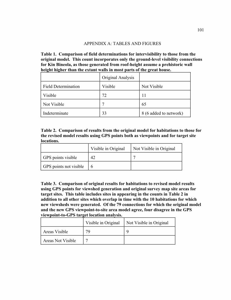
101
APPENDIX A: TABLES AND FIGURES Table 1. Comparison of field determinations for intervisibility to those from the original model. This count incorporates only the ground-level visibility connections for Kin Bineola, as those generated from roof-height assume a prehistoric wall height higher than the extant walls in most parts of the great house.
Original Analysis
Field Determination Visible Not Visible
Visible 72 11
Not Visible 7 65
Indeterminate 33 8 (6 added to network) Table 2. Comparison of results from the original model for habitations to those for the revised model results using GPS points both as viewpoints and for target site locations.
Visible in Original Not Visible in Original
GPS points visible 42 7
GPS points not visible 6 Table 3. Comparison of original results for habitations to revised model results using GPS points for viewshed generation and original survey map site areas for target sites. This table includes sites in appearing in the counts in Table 2 in addition to all other sites which overlap in time with the 10 habitations for which new viewsheds were generated. Of the 79 connections for which the original model and the new GPS viewpoint-to-site area model agree, four disagree in the GPS viewpoint-to-GPS target location analysis.
Visible in Original Not Visible in Original
Areas Visible 79 9
Areas Not Visible 7

102
Table 4. Average number of habitation sites visible per habitation site (calculated by doubling the total number of connections in the network and dividing this by the total number of habitation sites).
Minimum Network Maximum Network
Short-distance 0.90 0.90
Middle-distance 3.92 4.0
Long-distance 4.49 4.86 Table 5. Average number of sites visible per habitation site (calculated as in Table 4) with 29MC250 and 29SJ1578 removed from the dataset.
Minimum Network Maximum Network
Short-distance 0.89 0.89
Middle-distance 3.87 4.08
Long-distance 4.47 4.85

103

104
104

105
105

106
Figure 1. The study area, including habitations and monumental or community structures used in the visibility analysis.

107
0
2
4
6
8
10
12
14
16
18
20
500-700
700-725
725-750
750-775
775-800
800-825
825-850
850-875
875-900
900-925
925-950
950-975
975-1000
1000-1025
1025-1075
1075-1100
1100-1125
1125+
Figure 2. The count of habitation sites in the study area through time.

108

109

110

111

112
Figure 3. A-R. Habitation sites in the in Kin Bineola survey area between A.D. 500 and 1150.

113

114
Figure 4. A-D. Examples of changing visibility at short, middle, and long distances. A) A short distance connection, sighting to 29MC264 from 29MC260, a distance of approximately 160 m. B) A medium distance connection, sighting to 29MC264 from 29MC336, a distance of approximately 810 m. C and D) Long distance connections, sighting the 29MC264 from 29MC317 and 29MC276, distances of 1.42 and 2.05 km, respectively.

115
Figure 5. The average number of habitation sites visible per habitation site through time for short medium-, and long-distance connections using both the minimum and maximum networks.
0
0.51
1.52
2.53
3.54
4.55
500-7
0070
0-725
725-7
5075
0-775
775-8
0080
0-825
825-8
5085
0-875
875-9
0090
0-925
925-9
5095
0-975 97
5-100
0 1000
-1025 10
25-10
75 1075
-1100 11
00-11
2511
25+
Med
ium
Dis
tanc
e,M
inim
um N
etw
ork
Long
Dis
tanc
e,M
inim
um N
etw
ork
Sho
rt D
ista
nce
Min
imum
/Max
imum
Net
wor
k
Med
ium
Dis
tanc
e,M
axim
um N
etw
ork
Long
Dis
tanc
e,M
axim
um N
etw
ork

116
Sho
rt-di
stan
ce,
Min
imum
/Max
imum
Net
wor
k
Figure 6. Average proportion of contemporary habitation sites visible per habitation through time using all three distance categories and both minimum and maximum networks.
0
0.050.
1
0.150.
2
0.250.
3
0.35
500-7
0070
0-725
725-7
5075
0-775
775-8
0080
0-825
825-8
5085
0-875
875-9
0090
0-925
925-9
5095
0-975
975-1
000 10
00-10
25 1025
-1075 10
75-11
00 1100
-1125
1125
+
Med
ium
Dis
tanc
e,M
inim
um N
etw
ork
Long
Dis
tanc
e,M
inim
um N
etw
ork
Med
ium
Dis
tanc
e,M
axim
um N
etw
ork
Long
Dis
tanc
e,M
axim
um N
etw
ork

117

118
Figure 7. A-B. Maximum (A) and minimum (B) visibility networks for the Kin Bineola great house, showing the locations of the two problematic habitation sites, 29SJ1578 and 29MC250. Long-distance connections are displayed as dashed lines.

119
Figure 8. Visibility network for the isolated great kiva, 29MC261. Short-distance connections are displayed as bold lines, and the long-distance connection, which appears only in the maximum network, is displayed as a dashed line.

120
Figure 9. Visibility networks for the small Chacoan structure, 29MC291. Long-distance connections are displayed as dashed lines.

121
Kin
Bin
eola
Max
imum
Net
wor
k,M
ediu
m D
ista
nce
Kin
Bin
eola
Min
imum
Net
wor
k,M
ediu
m D
ista
nce
Figure 10. Counts of habitation sites intervisible with Kin Bineola, the great kiva (29MC261), and 29MC291 within medium-distance range, over time. Note that 0 values appear for Kin Bineola and 29MC291 prior to A.D. 900 and A.D. 925 respectively because these sites were not yet occupied (the same holds true for all subsequent graphs).
0123456789
750-
775
775-
800
800-
825
825-
850
850-
875
875-
900
900-
925
925-
950
950-
975
975-
1000
1000
-10
2510
25-
1075
1075
-11
0011
00-
1125
1125
+
29M
C29
1 N
etw
ork,
Med
ium
Dis
tanc
e
Gre
at K
iva
Net
wor
k, M
ediu
mD
ista
nce

122
Figure 11. Counts of habitation sites intervisible with Kin Bineola, the great kiva (29MC261), and 29MC291 within long-distance range, over time.
0123456
750-
775
775-
800
800-
825
825-
850
850-
875
875-
900
900-
925
925-
950
950-
975
975-
1000
1000
-10
2510
25-
1075
1075
-11
0011
00-
1125
1125
+
Kin
Bin
eola
Min
imum
Net
wor
k, L
ong
Dis
tanc
e
Kin
Bin
eola
Max
imum
Net
wor
k, L
ong
Dis
tanc
e
Gre
at K
iva
Max
imum
Net
wor
k, L
ong
Dis
tanc
e
29M
C29
1 N
etw
ork,
Lon
gD
ista
nce
29M
C29
1 N
etw
ork
with
Prob
lem
Site
s, L
ong
Dis
tanc
e

123
Kin
Bin
eola
Max
imum
Net
wor
k,M
ediu
m D
ista
nce
Kin
Bin
eola
Min
imum
Net
wor
k,M
ediu
m D
ista
nce
Figure 12. Proportions of habitation sites with short- and medium-distance visual connections to Kin Bineola, the great kiva, and 29MC291.
0
0.1
0.2
0.3
0.4
0.5
0.6
750-
775
775-
800
800-
825
825-
850
850-
875
875-
900
900-
925
925-
950
950-
975
975-
1000
1000
-10
2510
25-
1075
1075
-11
0011
00-
1125
1125
+
Gre
at K
iva
Net
wor
k, S
hort
Dis
tanc
e
Gre
at K
iva
Net
wor
k, M
ediu
mD
ista
nce
29M
C29
1 N
etw
ork,
Med
ium
Dis
tanc
e

124
Figure 13. Proportions of habitation sites with long-distance visual connections to Kin Bineola, the great kiva, and 29MC291.
0
0.050.1
0.150.2
0.250.3
0.35
750-
775
775-
800
800-
825
825-
850
850-
875
875-
900
900-
925
925-
950
950-
975
975-
1000
1000
-10
2510
25-
1075
1075
-11
0011
00-
1125
1125
+
Kin
Bin
eola
Min
imum
Net
wor
k, L
ong
Dis
tanc
e
Kin
Bin
eola
Max
imum
Net
wor
k, L
ong
Dis
tanc
e
Gre
at K
iva N
etw
ork,
Lon
gD
ista
nce
29M
C29
1 N
etw
ork,
Lon
gD
ista
nce

125

126

127

128

129

130
Figure 14. A-F. Visibility networks for the shrines. Short-distance connections are displayed as bold lines, long-distance connections are displayed as dashed lines, and connections which appear only in the maximum network are displayed in a darker orange.

131
0
1
2
3
4
5
6
7
8
9
900-925 925-950 950-975 975-1000 1000-1025
1025-1075
1075-1100
1100-1125
1125+
292, mid
0
1
2
3
4
5
6
7
8
9
900-925 925-950 950-975 975-1000 1000-1025
1025-1075
1075-1100
1100-1125
1125+
305, mid
0
1
2
3
4
5
6
7
8
9
900-925 925-950 950-975 975-1000 1000-1025
1025-1075
1075-1100
1100-1125
1125+
264, mid

132
0
1
2
3
4
5
6
7
8
9
900-925 925-950 950-975 975-1000 1000-1025
1025-1075
1075-1100
1100-1125
1125+
257, mid
0
1
2
3
4
5
6
7
8
9
900-925 925-950 950-975 975-1000 1000-1025
1025-1075
1075-1100
1100-1125
1125+
146, mid

133
0
1
2
3
4
5
6
7
8
9
900-925 925-950 950-975 975-1000 1000-1025
1025-1075
1075-1100
1100-1125
1125+
342, mid
0
1
2
3
4
5
6
7
8
9
900-925 925-950 950-975 975-1000 1000-1025
1025-1075
1075-1100
1100-1125
1125+
1578, mid
Figure 15 A-G. Counts of habitation sites intervisible at medium distances with shrines or possible shrines through time: A) 29MC292 B) 29MC305 C) 29MC264 D) 29MC257 E)29MC146 F)29MC342 G)29SJ1578.

134
292, long
0
1
2
3
4
5
6
7
8
9
10
900-925 925-950 950-975 975-1000
1000-1025
1025-1075
1075-1100
1100-1125
1125+
292, long
305, long
0
1
2
3
4
5
6
7
8
9
10
900-925 925-950 950-975 975-1000
1000-1025
1025-1075
1075-1100
1100-1125
1125+
305, long

135
264, long
0
1
2
3
4
5
6
7
8
9
10
900-925 925-950 950-975 975-1000
1000-1025
1025-1075
1075-1100
1100-1125
1125+
264, long
257, long
0
1
2
3
4
5
6
7
8
9
10
900-925 925-950 950-975 975-1000
1000-1025
1025-1075
1075-1100
1100-1125
1125+
257, long

136
146, long
0
1
2
3
4
5
6
7
8
9
10
900-925 925-950 950-975 975-1000
1000-1025
1025-1075
1075-1100
1100-1125
1125+
146, long
342, long
0
1
2
3
4
5
6
7
8
9
10
900-925 925-950 950-975 975-1000
1000-1025
1025-1075
1075-1100
1100-1125
1125+
342, long

137
1578, long
0
1
2
3
4
5
6
7
8
9
10
900-925 925-950 950-975 975-1000
1000-1025
1025-1075
1075-1100
1100-1125
1125+
1578, long
Figure 16. A-G. Counts of habitation sites intervisible at distances over 1 km with shrines or possible shrines through time: A) 29MC292 B) 29MC305 C) 29MC264 D) 29MC257 E)29MC146 F)29MC342 G)29SJ1578.
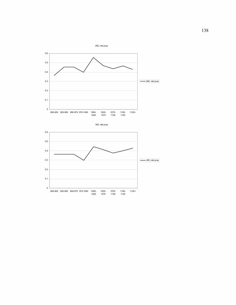
138
292, mid prop
0
0.1
0.2
0.3
0.4
0.5
0.6
900-925 925-950 950-975 975-1000 1000-1025
1025-1075
1075-1100
1100-1125
1125+
292, mid prop
305, mid prop
0
0.1
0.2
0.3
0.4
0.5
0.6
900-925 925-950 950-975 975-1000 1000-1025
1025-1075
1075-1100
1100-1125
1125+
305, mid prop

139
264, mid prop
0
0.1
0.2
0.3
0.4
0.5
0.6
900-925 925-950 950-975 975-1000 1000-1025
1025-1075
1075-1100
1100-1125
1125+
264, mid prop
257, mid prop
0
0.1
0.2
0.3
0.4
0.5
0.6
900-925 925-950 950-975 975-1000 1000-1025
1025-1075
1075-1100
1100-1125
1125+
257, mid prop

140
146, mid prop
0
0.1
0.2
0.3
0.4
0.5
0.6
900-925 925-950 950-975 975-1000 1000-1025
1025-1075
1075-1100
1100-1125
1125+
146, mid prop
342, mid prop
0
0.1
0.2
0.3
0.4
0.5
0.6
900-925 925-950 950-975 975-1000 1000-1025
1025-1075
1075-1100
1100-1125
1125+
342, mid prop

141
1578, mid prop
0
0.1
0.2
0.3
0.4
0.5
0.6
900-925 925-950 950-975 975-1000 1000-1025
1025-1075
1075-1100
1100-1125
1125+
1578, mid prop
Figure 17. A-G. Proportions of habitation sites intervisible at medium distances with shrines or possible shrines through time: A) 29MC292 B) 29MC305 C) 29MC264 D) 29MC257 E)29MC146 F)29MC342 G)29SJ1578.
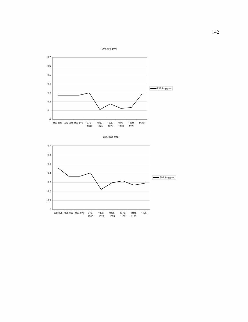
142
292, long prop
0
0.1
0.2
0.3
0.4
0.5
0.6
0.7
900-925 925-950 950-975 975-1000
1000-1025
1025-1075
1075-1100
1100-1125
1125+
292, long prop
305, long prop
0
0.1
0.2
0.3
0.4
0.5
0.6
0.7
900-925 925-950 950-975 975-1000
1000-1025
1025-1075
1075-1100
1100-1125
1125+
305, long prop

143
264, long prop
0
0.1
0.2
0.3
0.4
0.5
0.6
0.7
900-925 925-950 950-975 975-1000
1000-1025
1025-1075
1075-1100
1100-1125
1125+
264, long prop
257, long prop
0
0.1
0.2
0.3
0.4
0.5
0.6
0.7
900-925 925-950 950-975 975-1000
1000-1025
1025-1075
1075-1100
1100-1125
1125+
257, long prop

144
146, long prop
0
0.1
0.2
0.3
0.4
0.5
0.6
0.7
900-925 925-950 950-975 975-1000
1000-1025
1025-1075
1075-1100
1100-1125
1125+
146, long prop
342, long prop
0
0.1
0.2
0.3
0.4
0.5
0.6
0.7
900-925 925-950 950-975 975-1000
1000-1025
1025-1075
1075-1100
1100-1125
1125+
342, long prop

145
1578, long prop
0
0.1
0.2
0.3
0.4
0.5
0.6
0.7
900-925 925-950 950-975 975-1000
1000-1025
1025-1075
1075-1100
1100-1125
1125+
1578, long prop
Figure 18. A-G. Proportions of habitation sites intervisible at distances over 1 km with shrines or possible shrines through time: A) 29MC292 B) 29MC305 C) 29MC264 D) 29MC257 E)29MC146 F)29MC342 G)29SJ1578.

146
WORKS CITED
Adler, Michael A., and Richard H. Wilshusen 1990 Large-Scale Integrative Facilities in Tribal Societies: Cross-Cultural and
Southwestern US Examples. World Archaeology 22(2):133–146. Anderson, Benedict 1983 Imagined Communities. Verson, London. Bannister, Bryant 1964 Tree-Ring Dating of the Archaeological Sites in the Chaco Canyon Region, New
Mexico. Technical Series 6(2). Southwest Parks and Monuments Association, Globe, Arizona.
Basso, Keith H. 1996 Wisdom Sits in Places: Landscape and Language Among the Western Apache.
University of New Mexico Press, Albuquerque. Bernardini, Wesley 1999 Reassessing the Scale of Social Action at Pueblo Bonito, Chaco Canyon, New
Mexico. Kiva 64(4):447–470. Blanton, Richard 1989 Continuity and Change in Public Architecture: Periods I through V of the Valley
of Oaxaca, Mexico. In Monte Alban’s Hinterland Part II: Settlement Patterns in Tlacolula, Etla, and Ocatlan, Valley of Oaxaca, Mexico, vol. I, edited by Stephen Kowaleski, Gary Feinman, Richard Blanton, Laura Finsten, and Linda Nicholas, pp. 409–447. Museum of Anthropology, University of Michigan, Ann Arbor.
Blumenfeld, Hans 1953 Scale in Civic Design. Town Planning Review 24(1):35–46. Bourdieu, Pierre 1977 Outline of a Theory of Practice. Translated by Richard Nice. Cambridge
University Press, Cambridge. 1990 The Logic of Practice. Translated by Richard Nice. Stanford University Press,
Stanford, California. Cameron, Catherine M. 2001 Pink Chert, Projectile Points, and the Chacoan Regional System. American
Antiquity 66(1):79–102.

147
Conolly, James, and Mark Lake 2006 Geographical Information Systems in Archaeology. Cambridge University Press,
Cambridge. Doyel, David E., Cory D. Breternitz, and Michael P. Marshall 1984 Chacoan Community Structure: Bis sa'ani and the Chaco Halo. In Recent
Research on Chaco Prehistory, edited by W. James Judge and John D. Schelberg, pp. 37–54. Reports of the Chaco Center No. 8, Division of Cultural Research, National Park Service, Albuquerque.
Durand, Kathy Roler 2003 Function of Chaco-Era Great Houses. Kiva 69(2):141–169. English, Nathan B., Julio L. Betancourt, Jeffrey S. Dean, and Jay Quade 2001 Strontium Isotopes Reveal Distant Sources of Architectural Timber in Chaco
Canyon, New Mexico. Proceedings of the National Academy of Science of the United States of America 98(21):11891–11896.
Field, Julie S. 1998 Natural and Constructed Defenses in Fijian Fortifications. Asian Perspectives
37(1):32–49. Fisher, Peter F. 1993 Algorithm and Implementation Uncertainty in Viewshed Analysis. International
Journal of Geographical Information System 7(4):331–347. 1994 Probable and Fuzzy Models of the Viewshed Operation, in Innovations in GIS,
edited by M.F. Warboys, pp. 161–175. Taylor and Francis, London. Foucault, Michel 1977 Discipline and Punish: The Birth of the Prison. Translated by Alan Sheridan.
Vintage Books, Random House, New York. Gilpin, Dennis 2003 Chacoan-Era Site Clustering and the Concept of Community. Kiva 69(2):171–
205. Hall, Edward T. 1966 The Hidden Dimension. Doubleday, Garden City, New York. Hayes, Alden C. 1981 A Survey of Chaco Canyon Archeology. In Archeological Surveys of Chaco
Canyon, New Mexico, compiled by Alden C. Hayes, David M. Brugge, and W.

148
James Judge, pp. 1–68. Chaco Canyon Studies, Publications in Archeology 18A. National Park Service, U.S. Department of the Interior, Washington, D.C.
Hayes, Alden C. and Thomas C. Windes 1974 An Anasazi Shrine in Chaco Canyon. In Papers in Honor of Florence Hawley
Ellis, edited by Theodore R. Frisbie, pp 143–156. Papers of the Archaeological Society of New Mexico no. 2. Archaeological Society of New Mexico, Santa Fe.
Higuchi, Tadahiko 1983 The Visual and Spatial Structure of Landscapes. Translated by Charles S. Terry.
MIT Press, Cambridge, Massachusetts. Isbell, William H. 2000 What We Should Be Studying: the “Imagined Community” and the “Natural
Community.” In The Archaeology of Communities: A New World Perspective, edited by Marcello A. Canuto and Jason Yaeger, pp. 243–266. Routledge, London.
Jones, Eric E. 2006 Using Viewshed Analysis to Explore Settlement Choice: A Case Study of the
Onondaga Iroquois. American Antiquity 71(3):523–538. Kantner, John, and Ronald Hobgood 2003 Digital Technologies and Prehistoric Landscapes in the American Southwest. In
The Reconstruction of Archaeological Landscapes through Digital Technologies, edited by Maurizio Forte, Patrick Ryan Williams, and James Wiseman, pp. 117–123. Archaeopress, Oxford.
Kantner, John, and Keith W. Kintigh 2006 The Chaco World. In The Archaeology of Chaco Canyon: An Eleventh-Century
Pueblo Regional Center, edited by Stephen H. Lekson, pp. 153–188. School of American Research Press, Santa Fe.
Kantner, John and Nancy M. Mahoney (editors) 2000 Great House Communities Across the Chacoan Landscape. Anthropological
Papers of the University of Arizona, no. 64. University of Arizona Press, Tucson. Kintigh, Keith W. 2003 Coming to Terms with the Chaco World. Kiva 69(2):93–116. Kolb, Michael J., and James E. Snead 1997 It’s a Small World After All: Comparative Analysis of Community Organization
in Archaeology. American Antiquity 62(4):609–28.
149
Lekson, Stephen H. 1986 Great Pueblo Architecture of Chaco Canyon, New Mexico. University of New
Mexico Press, Albuquerque. 1999 The Chaco Meridian: Centers of Political Power in the Ancient Southwest.
AltaMira Press, Walnut Creek, California. Lekson, Stephen H. (editor) 2006 The Archaeology of Chaco Canyon: An Eleventh-Century Pueblo Regional
Center. School of American Research Press, Santa Fe. 2007 The Architecture of Chaco Canyon, New Mexico. University of Utah Press, Salt
Lake. Lekson, Stephen H., Thomas C. Windes, and Peter J. McKenna 2006 Architecture. In The Archaeology of Chaco Canyon: An Eleventh-Century
Pueblo Regional Center, edited by Stephen H. Lekson, pp. 67–116. School of American Research Press, Santa Fe.
Lipe, William D. 1992 Introduction. In The Sand Canyon Archaeological Project: A Progress Report,
edited by William D. Lipe, pp. 1–10. Crow Canyon Archaeological Center Occasional Paper no. 2. Crow Canyon Archaeological Center, Cortez, Colorado.
2006 Notes from the North. In The Archaeology of Chaco Canyon: An Eleventh-
Century Pueblo Regional Center, edited by Stephen H. Lekson, pp. 261–314. School of American Research Press, Santa Fe.
Lister, Robert H., and Florence C. Lister 1981 Chaco Canyon Archaeology and Archaeologists. University of New Mexico
Press, Albuquerque. Llobera, Marcos 2001 Building Past Landscape Perception with GIS: Understanding Topographic
Prominence. Journal of Archaeological Science 28:1005–1014. Lynch, Kevin 1960 The Image of the City. MIT Press and Harvard University Press, Cambridge,
Massachusetts Lyons, Thomas R., Robert K. Hitchcock, and Basil G. Pouls 1976 The Kin Bineola Irrigation Study: An Experiment in the Use of Aerial Remote

150
Sensing Techniques in Archaeology. In Remote Sensing Experiments in Cultural Resource Studies: Non-destructive Methods of Archeological Exploration, Survey, and Analysis, edited by Thomas R. Lyons, pp. 115–131. Reports of the Chaco Center, no. 1, National Park Service Division of Cultural Research, and University of New Mexico, Albuquerque.
Mahoney, Nancy M. 2000 Redefining the Scale of Chacoan Communities. In Great House Communities
Across the Chacoan Landscape, edited by John Kantner and Nancy M. Mahoney, pp. 19–27. Anthropological Papers of the University of Arizona, no. 64. University of Arizona Press, Tucson.
Mahoney, Nancy M., and John Kantner 2000 Chacoan Archaeology and Great House Communities. In Great House
Communities Across the Chacoan Landscape, edited by John Kantner and Nancy M. Mahoney, pp. 1–16. Anthropological Papers of the University of Arizona, no. 64. University of Arizona Press, Tucson.
Marshall, Michael P., John R. Stein, Richard W. Loose, and Judith E. Novotny 1979 Anasazi Communities of the San Juan Basin. Public Service Company,
Albuquerque, and New Mexico State Historic Preservation Bureau, Santa Fe. Märtens, H. 1884 Der optische Masstab in den bildenden Künsten, 2nd addition, Wasmuth, Berlin. 1890 Optisches Mass für den Städtebau. Max Cohen and Son, Bonn. Metcalf, Mary P. 2003 Construction Labor at Pueblo Bonito. In Pueblo Bonito: Center of the Chacoan
World, edited by Jill E. Neitzel, pp. 72–80. Smithsonian Books, Washington D.C. Mills, Barbara J. n.d. Regional Patterns of Ceramic Variability in the San Juan Basin: Ceramics of the
Chaco Additions Inventory Survey. In An Archaeological Survey of the Additions to Chaco Canyon National Historical Park, edited by Ruth M. Van Dyke. Unpublished paper on file in Anthropology Projects, Cultural Resources Management, National Park Service, Santa Fe.
2002 Recent Research on Chaco: Changing Views on Economy, Ritual, and Society.
Journal of Archaeological Research 10(1):65–117. 2008 Remembering while Forgetting: Depositional Practice and Social Memory at
Chaco. In Memory Work: Archaeologies of Material Practices, edited by Barbara

151
J. Mills and William H. Walker, pp. 81–108. School of Advanced Research Press, Santa Fe.
Moore, Jerry D. 1996 Architecture and Power in the Ancient Andes: the Archaeology of Public
Buildings. Cambridge University Press, Cambridge. Murdock, George Peter 1949 Social Structure. Macmillan, New York. Neitzel, Jill E. (editor) 2003 Pueblo Bonito: Center of the Chacoan World. Smithsonian Books, Washington
D.C. Ogburn, Dennis E. 2006 Assessing the Level of Visibility of Cultural Objects in Past Landscapes. Journal
of Archaeological Science 33:405–413. Powers, Robert P., and Peter J. McKenna 1983 Guidebook: Procedures, Guidelines, and Terminology for Completing Inventory
Survey Forms. Unpublished manuscript on file at New Mexico State Laboratory of Anthropology Archaeological Records Management Service.
Powers, Robert P., William B. Gillespie, and Stephen H. Lekson 1983 The Outlier Survey: A Regional View of Settlement in the San Juan Basin.
Reports of the Chaco Center no. 3. Division of Cultural Research, National Park Service, Albuquerque.
Robinson, Tucker, Ruth M. Van Dyke, and Thomas C. Windes 2007 Shrines and Great House Intervisibility across the Chacoan Landscape. Poster
presented at the 72nd Annual Meeting of the Society for American Archaeology, Austin, TX.
Ruggles, Clive L. N., and David J. Medyckyj-Scott 1996 Site Location, Landscape Visibility and Symbolic Astronomy: A Scottish Case
Study. In New Methods, Old Problems: Geographic Information Systems in Modern Archaeological Research, edited by Herbert D.G. Maschner, pp. 127–146. Occasional Paper no. 23, Center for Archaeological Investigations, Southern Illinois University, Carbondale.
Sebastian, Lynne 2006 The Chaco Synthesis. In The Archaeology of Chaco Canyon: An Eleventh-
Century Pueblo Regional Center, edited by Stephen H. Lekson, pp. 293–422.

152
School of American Research Press, Santa Fe. Sebastian, Lynne, and Jeffrey H. Altschul n.d. Settlement Pattern, Site Typology, and Demographic Analysis: the Anasazi,
Archaic, and Unknown Sites. In An Archaeological Survey of the Additions to Chaco Canyon National Historical Park, edited by Ruth M. Van Dyke, unpublished paper on file in Anthropology Projects, Cultural Resources Management, National Park Service, Santa Fe.
Toll, H. Wolcott 2001 Making and Breaking Pots in the Chaco World. American Antiquity 66(1):56–78. Trigger, Bruce 1990 Monumental Architecture: a Thermodynamic Explanation of Symbolic Behavior.
World Archaeology 22(2):119–132. U.S. Geological Survey 1999 Map Accuracy Standards. Fact Sheet FS-171-99. U.S. Geological Survey,
Reston, VA. Available at http:// erg.usgs.gov /isb/pubs/factsheets/fs17199.html. Accessed May 6, 2008.
Van Dyke, Ruth M. (editor) n.d. An Archaeological Survey of the Additions to Chaco Canyon National Historical
Park. Unpublished paper on file in Anthropology Projects, Cultural Resources Management, National Park Service, Santa Fe.
Van Dyke, Ruth M. 2007 Great Kivas in Time, Space, and Society. In The Archaeology of Chaco Canyon,
edited by Steven H. Lekson, pp. 93–126. School of American Research Press, Santa Fe.
2008 The Chaco Experience. School of American Research Press, Santa Fe. Van Dyke, Ruth M., and Robert P. Powers n.d. The Chaco Additions Survey. In An Archaeological Survey of the Additions to
Chaco Canyon National Historical Park, ed. Ruth M. Van Dyke. Unpublished paper on file in Anthropology Projects, Cultural Resources Management, National Park Service, Santa Fe.
Varien, Mark D., and James M. Potter 2008 The Social Production of Communities: Structure, Agency, and Identity. In The
Social Construction of Communities: Agency, Structure, and Identity in the Prehistoric Southwest, edited by Mark D. Varien and James M. Potter, pp. 1–18.

153
Altamira Press, Lanham, MD. Vivian, R. Gwinn, Carla R. Van West, Jeffrey S. Dean, Nancy J. Akins, Mollie S. Toll, and Thomas C. Windes 2006 Ecology and Economy. In The Archaeology of Chaco Canyon: An Eleventh-
Century Pueblo Regional Center, edited by Stephen H. Lekson, pp. 45–65. School of American Research Press, Santa Fe.
Wheatley, David 1996 The Use of GIS to Understand Regional Variation in Earlier Neolithic Wessex. In
New Methods, Old Problems: Geographic Information Systems in Modern Archaeological Research, edited by Herbert D. G. Maschner, pp 75–103. Occasional Paper No. 23, Center for Archaeological Investigations, Southern Illinois University, Carbondale.
Wheatley, David, and Mark Gillings 2000 Vision, Perception, and GIS: Developing Enriched Approaches to the Study of
Archaeological Visibility. In Beyond the Map: Archaeology and Spatial Technologies, edited by Gary Lock, pp. 1–27 IOS Press, Oxford.
Wilshusen, Richard H., and Ruth M. Van Dyke 2006 Chaco’s Beginnings. In The Archaeology of Chaco Canyon: An Eleventh-
Century Pueblo Regional Center, edited by Stephen H. Lekson, pp. 211–259. School of American Research Press, Santa Fe.
Wills, Wirt H. 2000 Political Leadership and the Construction of Chacoan Great Houses, A.D. 1020–
1140. In Alternative Leadership Strategies in the Prehispanic Southwest, edited by Barbara J. Mills, pp. 19–44. University of Arizona Press, Tucson.
2001 Ritual and Mound Formation During the Bonito Phase in Chaco Canyon.
American Antiquity 66(3):433–451. Windes, Thomas C. 1978 Stone Circles of Chaco Canyon, Northwestern New Mexico. Reports of the Chaco
Center 5. National Park Service, Department of the Interior, Albuquerque. 1984 A New Look at Population in Chaco Canyon. In Recent Research on Chaco
Prehistory, edited by W. James Judge and John D. Schelberg, pp. 75–87. Reports of the Chaco Center, no. 8, Division of Cultural Research, National Park Service, Albuquerque.
2007 Gearing Up and Piling On: Early Great Houses in the Interior San Juan Basin. In

154
The Archaeology of Chaco Canyon, edited by Steven H. Lekson, pp. 45–92. School of American Research Press, Santa Fe.
Windes, Thomas C., Rachel M. Anderson, Brian K. Johnson, and Cheryl A. Ford 2000 Sunrise, Sunest: Sedentism and Mobility in the Chaco East Community. In Great
House Communities Across the Chacoan Landscape, edited by John Kantner and Nancy M. Mahoney, pp. 39–59. Anthropological Papers of the University of Arizona, no. 64, University of Arizona Press, Tucson.
Yaeger, Jason, and Marcello A. Canuto 2000 Introducing an Archaeology of Communities. In The Archaeology of
Communities: A New World Perspective, edited by Marcello A. Canuto and Jason Yaeger, pp. 1–15. Routledge, London.