Embed Size (px)
Citation preview

COMFORT LAKE - FOREST LAKE WATERSHED DISTRICT RULESAdopted December 18, 2008Amended March 24, 2011
(2017 Proposed Amendment– November 28, 2017)
INTRODUCTION 2
RELATION OF WATERSHED DISTRICT TO MUNICIPALITIES 2
DEFINITIONS 2
DEFINITIONS – APPENDIX 91.0 PROCEDURAL REQUIREMENTS 102.0 STORMWATER MANAGEMENT 113.0 EROSION CONTROL 234.0 LAKE, STREAM, AND WETLAND BUFFER REQUIREMENTS 265.0 SHORELINE & STREAMBANK ALTERATIONS 326.0 WATERCOURSE AND BASIN CROSSINGS 377.0 FLOODPLAIN AND DRAINAGE ALTERATIONS 378.0 WETLAND MANAGEMENT 399.0 FEES 4110.0 FINANCIAL ASSURANCES 4211.0 VARIANCES 4312.0 ENFORCEMENT 44
ADDENDUM A. GROUNDWATER 47
GROUNDWATER APPROPRIATIONS 47VOLUME CONTROL 47GROUNDWATER QUALITY 48
Page 1 of 51

INTRODUCTION
The Comfort Lake - Forest Lake Watershed District (the "District") adopts these Rules and Regulations as required by Minnesota Statute 103D.341 to accomplish the purposes in Chapter 103D, implement the powers of the managers, and the policies of the District as contained in the District Watershed Management Plan (the "Plan").
RELATION OF WATERSHED DISTRICT TO MUNICIPALITIES
The District recognizes that the primary control and determination of appropriate land uses is the responsibility of the municipalities. Accordingly, the District will coordinate permit application reviews involving land development only after it is first demonstrated that the application has been submitted to the city where the land is located. It is the intention of the managers to ensure that development of land within the District proceeds in conformity with these Rules, in addition to conforming with the development guides and plans adopted by municipalities.
The District shall exercise control over development by its permit program described in these rules to ensure the maintenance of stormwater management features, protection of public waters, wetlands and groundwater, and protection of existing natural topography and vegetative features in order to preserve them for present and future beneficial uses.
The District will review and permit projects sponsored or undertaken by municipalities and other governmental units, and will require permits of the contractor in accordance with these Rules for governmental projects which have an impact on water resources of the District. These projects include but are not limited to, land development, road, trail and utility construction.
The District desires to serve as technical advisors to the municipal officials in the preparation of local surface water management plans and the review of individual development proposals prior to investment of significant public or private funds. To promote a coordinated review process between the District and the municipalities, the District encourages the municipalities to involve the District early in the planning process. The District's comments do not eliminate the need for permit review and approval if otherwise required under these rules. The District intends to coordinate with each municipality to ensure that property owners and other permit applicants are aware of the permit requirements of both bodies. By coordinating, the District and municipalities also can avoid duplication, conflicting requirements and unnecessary costs for permit applicants and taxpayers.
The District urges municipalities to develop, as rapidly as possible, local surface water management plans, providing a coordinated system of managing surface water and meeting water quality goals on a regional or subwatershed basis consistent with their local water management plan and the District’s Rules.
DEFINITIONS
“Agricultural activity” means agronomic, horticultural and silvicultural activity including but not limited to producing crops, including nursery stock, sod, fruits, vegetables, flowers, forages, cover crops, grains, and Christmas trees. Agricultural activity also includes animal husbandry and grazing.
Page 2 of 51

“Atlas 14” means the Precipitation Frequency Estimates released by the National Weather Service Hydrometeorlogical Studies Design Center. Volume 8, released in 2013, provides precipitation frequency estimates for many Midwestern states including Minnesota.
“Bed of waterbody” means all portions of a waterbody below the ordinary high-water level.
“Best management practices (BMPs)” means effective and practicable means of erosion prevention and sediment control, and water quality management practices that are effective and practicable to limit degradation of surface water.
“Better Site Design” means the control and management of stormwater quantity and quality through the application of Better Site Design Techniques as outlined in the Minnesota Stormwater Manual: http://stormwater.pca.state.mn.us/index.php/Main_Page, as revised. Better Site Design includes but is not limited to: preservation of natural areas; site reforestation; stream and shoreland buffers; open space design; disconnection of impervious cover by incorporated greenspace along the flowpath of stormwater runoff; discharge of rooftop runoff to green space; grass channels; stormwater landscaping; compost and amended soils; impervious surface reduction; and trout stream protection.
“Bioengineering” means the use of live plant materials to provide erosion control, slope and stream bank stabilization, landscape restoration, and wildlife habitat. These techniques are used alone or in conjunction with conventional engineering techniques.
“Buffer” means an upland area adjacent to a lake, stream or wetland that is maintained in or restored to primarily native vegetation.
“Common plan of development” means a tract or contiguous tracts where separate and distinct land disturbance occurs, concurrently or at different times, under one plan.
“Critical duration flood event” means the 100-year precipitation or snow melt event with a duration resulting in the maximum 100 year return period water surface elevation. The critical duration flood event is generally either the 100-year, 24 hour rainfall event as found in NOAA Atlas 14 or the ten-day snow melt event assumed to be 7.2 inches of runoff occurring on frozen ground (CN=100); however, other durations (e.g., 6-hour) may result in the maximum 100 year return period water surface elevation.
“Distributed CN-value approach” means an approach that separately assigns a curve number to each land use to more accurately reflect volume and timing of site-generated runoff. Impervious surfaces directly connected to stormwater conveyances may not be grouped together with disconnected impervious and pervious areas for calculation of drainage area curve numbers.
“Facility” means any part of a natural or constructed system contributing under the stormwater management plan to meeting a standard of Section 2.3.
“Feasible” means technically achievable at a cost that, in the District’s determination, not substantially disproportionate to the stormwater management benefit to be gained.
“Floodplain” means the area adjoining a watercourse or water basin that has been or would be covered by a flood expected to occur on an average frequency of the 100-year recurrence interval.
“General development lake” means a lake so designated by the Minnesota DNR pursuant to Minn. Rules 6120.3000.
Page 3 of 51
“Groundwater-dependent natural resource” (GDNR) means a feature with surface emergence of groundwater at a spring or seepage area, sufficiently mineral rich to support a plant community or aquatic ecosystem listed in the Appendix to these Definitions. Information used to identify a GDNR includes Minnesota Land Cover Classification System plant community data, information on known springs and groundwater seepages, wetland function and value assessments, flow and water quality data and site inspection data.
“Impervious surface” means a surface that has been compacted or covered with a layer of material, or is likely to become compacted from expected use, so that it is highly resistant to infiltration by water and increases the depth of runoff compared to natural soils and land cover. Including but not limited to roads, driveways, parking areas, sidewalks and trails, patios, tennis courts, basketball courts, swimming pools, building roofs, covered decks, and other structures.
“Land disturbance” or “land disturbing activity” means an activity that changes or alters the existing ground cover (vegetative or non-vegetative) and/or the existing soil topography. Land disturbing activity includes, but is not limited to, development, redevelopment, clearing, grading, filling, excavation and borrow pits. The following are among those that do not constitute land disturbance: mill, reclamation and overlay of impervious surface; routine vegetation management activity such as the clearing of cattails from ditches; and the use of land for new or continuing agricultural activity, home gardens, or landscaping adjacent to existing structures.
“Lowest basement floor elevation” means the lowest floor of the lowest enclosed area. An unfinished or flood resistant enclosure, used solely for parking of vehicles, building access, or storage in an area other than a basement area is not considered a building’s lowest basement floor.
“Landlocked basin” means a localized depression that does not have a natural outlet at or below the water elevation of the 10-day runoff (snowmelt) event with a 100-year return frequency using the 2000 Washington County Topographic Survey and Chisago County Topographic Survey.
“Manage 1,” as a wetland classification, means a wetland that does not qualify as a “Preserve” wetland but that meets one or more of the following rating levels pursuant to the most current version of Minnesota Routine Assessment Method (MnRAM) or other method approved by the District:
Function or Value Rating
Vegetative Diversity High
Wildlife Habitat High
Fish Habitat High
Aesthetics/education/recreation/cultural AND Wildlife Habitat High AND Medium
Stormwater Sensitivity AND Vegetative Diversity High AND Medium
Vegetative DiversityAND Maintenance of Hydrologic Regime Medium AND High
“Manage 2,” as a wetland classification, means a wetland that does not qualify as a “Preserve” or “Manage 1” wetland but that meets one or more of the following rating levels pursuant to the most current version of Minnesota Routine Assessment Method (MnRAM) or other method
Page 4 of 51

approved by the District:
Function or Value Rating
Wildlife Habitat Medium
Fisheries Habitat Medium
Aesthetics/education/recreation/cultural AND Wildlife Habitat Medium AND Low
“Manage 3,” as a wetland classification, means a wetland that does not qualify as a “Preserve,” “Manage 1” or “Manage 2” wetland.
“Mapped natural community” means a natural community identified in “Natural Communities and Rare Species Map for Washington and Chisago County” (Minnesota Department of Natural Resources, Natural Heritage Program, 1990), or in a natural resources inventory using the same protocol as established by the Minnesota Department of Natural Resources.
“Middle zone” is a vegetative buffer zone that extends from the upland edge of the streamside zone to the interior edge of the outer zone of a watercourse.
“Mill, reclamation and overlay” means the removal of the top layer(s) of an impervious surface (e.g. roadway, parking lot, sport court) by mechanical means, followed by the placement of a new layer of impervious surface, without disturbance of the underlying native soil.
“Natural environment lake” means a lake so designated by the Minnesota DNR pursuant to Minn. Rules 6120.3000.
“National Pollutant Discharge Elimination System (NPDES)” means the program for issuing, modifying, revoking, reissuing, terminating, monitoring, and enforcing permits under the Clean Water Act (Sections 301, 318, 402, and 405) and 33 CFR §§ 1317, 1328, 1342, and 1345 as amended.
“New development” means development on a site that has less than 15% impervious surface. Land that was developed beyond 15% impervious surface, but meets the definition of “redevelopment,” is not new development.
“Normal wetted perimeter” means the area of a conveyance, such as a ditch, channel, or pipe that is in contact with water during flow events that are expected to occur from a two-year, 24 hour storm event.
“NURP standard” means the design criteria developed pursuant to the Nationwide Urban Runoff Program (U.S. EPA, 1983) and published by the Minnesota Pollution Control Agency in Protecting Water Quality in Urban Areas 1991” (sections 4.1-4 through 4.1-7), as may be amended.
“Ordinary high-water level” or "OHWL" means the boundary of a public water or wetland as determined by the Department of Natural Resources, and is an elevation indicating the highest water level that has been maintained for a sufficient period of time to leave evidence on the landscape, commonly indicated by a change from predominantly aquatic to predominantly terrestrial vegetation. For watercourses, the ordinary high-water level is the elevation of the top of bank of the channel. For basins and flowages, it is the operating elevation of the summer pool.
Page 5 of 51
If the DNR has not defined an OHWL, the District, with DNR consultation, will establish the elevation for the purpose of the permit application.
“Outer zone” is a vegetative buffer zone that extends from the upland edge of the middle zone of a watercourse to a point specified in these Rules.
“Permanent cover” means surface types that will prevent soil failure under erosive conditions. Examples include: gravel, asphalt, concrete, rip rap, roof tops, perennial vegetative cover, or other landscaped material that will permanently arrest soil erosion. To constitute permanent cover, perennial vegetative cover must be evenly distributed, without large bare areas and with a density of 70% of background vegetative cover. Permanent cover does not include temporary erosion control practices.
“Permittee” means a person or persons, firm, governmental agency or other entity for whom a permit has been approved. A permittee and any co-permittee are responsible for permit compliance, along with any other party engaging in the activity subject to the permit.
“Pre-development condition” means the condition at the site prior to the proposed activity that serves as the baseline against which to measure impacts of the proposed activity for compliance with stormwater management requirements
“Preserve,” as a wetland classification, means a wetland meeting any of the following rating levels pursuant to the most current version of Minnesota Routine Assessment Method (MnRAM) or other method approved by the District:
Function or Value Rating
Vegetative Diversity Exceptional
Wildlife Habitat Exceptional
Fish Habitat Exceptional
Aesthetics/education/recreation/cultural AND Wildlife Habitat Exceptional AND High
Stormwater Sensitivity AND Vegetative Diversity Exceptional ANDMedium or greater
Vegetative DiversityAND Maintenance of hydrologic regime High AND High or greater
“Public linear project” means a project in which a public agency is a permittee and that involves a roadway, sidewalk, trail or linear utility not part of a development pursuant to subdivision.
“Public water” means a water basin or watercourse as defined in Minnesota Statutes § 103G.005, subd. 15.
“Receiving water” means the first of the following types of surface waters encountered by stormwater runoff from a site: a lake or stream designated as a public water, public wetland or wetland.
“Reconstructed Impervious Surface” means area where impervious surface is removed down to the underlying native soil and the underlying native soil, as distinguished from roadway subgrade material, is disturbed. The following are among those that do not constitute impervious surface reconstruction: structure renovation; impervious surface mill, reclamation and overlay; paving of
Page 6 of 51
an existing rural-section, gravel road; maintenance activities such as catch basin and pipe repair/replacement with same hydraulic capacity; and pedestrian ramp installation.
“Redevelopment” means development on a site that is currently developed below 15% impervious surface, or was developed beyond 15% impervious surface, but has been razed to below that measure in anticipation of redevelopment.
“Recreational development lake” means a lake so designated by the Minnesota DNR pursuant to Minn. Rules 6120.3000, as listed in Appendix 2.X.
“Revegetation” means the planting of native species.
“Saturated soil” means the highest seasonal elevation in the soil that is in a reduced chemical state because of soil voids being filled with water. Saturated soil is evidenced by the presence of redoximorphic features or other information.
“Sediment control” means methods employed to prevent sediment from leaving the site. Sediment control practices include but are not limited to: silt fences, sediment traps, earth dikes, drainage swales, check dams, subsurface drains, bio rolls, rock logs, compost logs, storm drain inlet protection, and temporary or permanent sedimentation basins.
“Shore impact zone” means land located between the OHWL of a public water and a line parallel to it at a distance defined under Minn. Rules 6120.
“Site” means the parcel or contiguous parcels of land on which the activity subject to District permitting is to occur. If subdivision triggers District permitting, the site is the area being subdivided. For an independent roadway, trail or other linear project, “site” means the area of right-of-way held and to be acquired for the project for the section or sections of roadway or trail to be disturbed.
“Site design practice” means a method of managing stormwater peak flow, flow volume or quality listed in Appendix 2.1 to Rule 2.0.
“Steep slope” means land with an average slope in the direction of flow exceeding twelve (12) percent over a distance of 50 feet or more or land defined as steep slope in the corresponding County Soil Survey (Chisago or Washington County), as amended.
“Stormwater” (as defined under Minn. Rule 7077.0105 subp. 41(b)) means precipitation runoff, stormwater runoff, snowmelt runoff, and any other surface runoff and drainage.
“Stormwater Pollution Prevention Plan” (SWPPP) means a plan for stormwater management that includes erosion prevention BMPs, sediment control BMPs, and permanent stormwater management systems that, when implemented, will decrease soil erosion on a parcel of land, and decrease off-site nonpoint pollution.
“Stream” means a natural or altered natural watercourse. “Stream buffer zone” means a streamside zone, middle zone or outer zone.
“Streamside zone” is a vegetative buffer zone that extends from the ordinary high-water mark of a watercourse to the interior edge of the middle zone.
“Structure” means anything that is constructed or placed on the ground and that is, or is intended, to remain for longer than a brief, temporary period of time.
“Subdivision” means the separation of an area, parcel, or tract of land under single ownership
Page 7 of 51

into two or more parcels or tracts.
“Subwatershed” means an area wholly or partly within the Comfort Lake - Forest Lake watershed defined by the drainage of all surface flows to a common waterbody.
“Temporary erosion protection” means methods employed to prevent erosion during construction activities. Examples of temporary erosion protection include, but are not limited to, hydromulch, straw, wood fiber blanket, wood chips, vegetation, mulch and rolled erosion control products.
“Thalweg” means the line connecting the points of lowest bed elevation in the direction of flow.
“Utility” means a facility for transmitting water, wastewater, steam, gas, electricity, data or similar commodities,
“Underground waters (Groundwater)” means water contained below the surface of the earth in the saturated zone including, without limitation, all waters whether under confined, unconfined, or perched conditions, in near surface unconsolidated sediment or regolith, or in rock formations deeper underground. The term groundwater is synonymous with underground water.
“Waterbody” means a watercourse or waterbasin.
“Waterbasin” means an enclosed natural depression with definable banks, capable of retaining water.
“Watercourse” means any definable channel including a natural channel, altered natural channel or artificial channel that has definable beds and banks capable of conducting confined runoff from adjacent land.
“Waters of the State” is as defined in Minnesota Statutes §115.01 subd. 22, as amended.
“Wetland” means land transitional between terrestrial and aquatic systems where the water table is usually at or near the surface or the land is covered by shallow water. A wetland (a) is predominated by hydric soils; (b) is inundated or saturated by surface water or groundwater at a frequency and duration sufficient to support a prevalence of hydrophytic vegetation typically adapted for life in saturated soil conditions; and (c) under normal circumstances, supports a prevalence of hydrophytic vegetation. A wetland is a waterbasin if it meets the definition of that term.
“Wetland Conservation Act or WCA” means the Minnesota Wetland Conservation Act of 1991 as amended. Wetlands shall be delineated using the methods outlined in the U.S. Army Corps of Engineers Wetlands Delineation Manual.
Page 8 of 51

DEFINITIONS – APPENDIX
Groundwater-Dependent Natural Resource Types(Following Minnesota Land Cover Classification System protocol)
Cold water trout stream
Spring creek
Groundwater-dependent lake
Tamarack swamp seepage subtype
Tamarack swamp minerotrophic subtype
Tamarack swamp sphagnum subtype
White cedar swamp seepage subtype
Black spruce bog
Black spruce bog intermediate subtype Black spruce bog raised subtype
Black ash swamp seepage subtype
Mixed hardwood swamp seepage subtype
Scrub tamarack poor fen
Birch bog, spiraea temporarily flooded shrubland
Shrub fen
Poor fen shrub subtype
Rich fen shrub subtype
Wet brush-prairie seepage subtype
Shrub swamp seepage subtype
Alder swamp - saturated soils
Birch bog, spiraea shrubland - saturated soils
Alder swamp
Birch bog, spiraea shrubland - seasonally flooded
Birch bog, spiraea shrubland - semipermanently flooded
Wet prairie seepage subtype - saturated soils
Calcareous seepage fen
Calcareous seepage fen boreal subtype
Calcareous seepage fen prairie subtype
Poor fen
Poor fen sedge subtype
Poor fen patterned fen subtype
Rich fen
Rich fen sedge subtype
Rich fen floating-mat subtype - saturated soils
Rich fen patterned fen subtype
Open bog Open sphagnum bog schlenke subtype
Graminoid bogWet meadow floating mat subtype
Rich fen floating-mat subtype - semipermanently flooded
Rich fen floating-mat subtype - intermittently exposed
Rich fen floating-mat subtype - permanently flooded
Talus slope algific subtype Seepage meadowWet cliffModerate cliff
Midwest sedimentary dripping cliff
Saline spring mud flats
Page 9 of 51
1.0 PROCEDURAL REQUIREMENTS
1.1 Application Required. Any person undertaking any activity for which a permit is required by these Rules shall first submit to the District for review a permit application, engineering design data and such other information as may be required by these Rules to determine whether the improvements are in compliance with the criteria established by these Rules. A permit application must bear the original signature of the landowner as applicant.
1.2 Forms. Permit applications shall be submitted using forms provided by the District. Forms are available from the District Office or on the District’s website at www.clflwd.org. Permit applications shall be addressed to the District address as indicated on the application.
1.3 Action by District. The District will act on applications in accordance with the time requirements and other terms of Minnesota Statutes §15.99, as amended. No application is considered complete unless it is on the District form and includes all required items listed in each applicable rule in a form acceptable to the District. The District will provide written notice to applicant of any missing items needed to complete the application. Land disturbing activity subject to these rules may not commence until a permit has been both approved and issued by the District. The approval action may impose conditions that the applicant must meet before the permit issues.
1.4 Conformity with Local Requirements. The District encourages the developer to seek District input starting at the concept stage, and to notify the District of any pre-application meetings required by a Local Governing Unit or other regulatory entity.
1.5 Notification Process. A certified list of property owners obtained from Washington County and/or Chisago County who reside adjacent to the subject property, and all property owners within five hundred (500) feet of the property boundary of a proposed project, must be submitted before an application is considered complete. District staff will send notice of the proposed project to the individuals on the mailing list for the applicant at the applicant’s expense. A copy of the list will be retained with the application at the District office.
If the project is proposed within the shoreland management area of a lake with a formal lake association known by the District, the District will notify the lake association of the application.
1.6 Alternative Notification. The District, upon written request from the applicant, may approve alternative notification for any of the following projects.
(a) A linear project, including but not limited to a road, sidewalk or trail, one-half mile or more in length.
(b) A project on a parcel or contiguous parcels with an area of one hundred (100) acres or more, where no more than five (5) percent of the area will be disturbed, provided the disturbed area does not include a wetland.
(c) A project where the applicant proposes to combine notification under this Rule with notification required under the approval procedures of another governmental body.
Page 10 of 51

The applicant must demonstrate that an alternative means of notification will provide adequate notice to residents near the proposed activity.
1.7 Permit Term, Renewals and Transfers. Work must be performed under an active permit. If a permit approval requires conditions to be met before the permit will issue, those conditions must be met within sixty (60) days of approval. A permit expires one year from the date the permit is issued unless the permit states otherwise or the permit is suspended or revoked. To renew or transfer a permit, the permittee must submit a written request to the District prior to the permit expiration date, stating the reason for the renewal or transfer. A renewal after the first may be conditioned on compliance with a District rule that has changed since the original permit approval. The District may impose reasonable conditions on renewal or transfer, including but not limited to requiring that any existing permit non-compliance be addressed.
1.8 Permit Decisions. Permit decisions will be made by the Board of Managers except as the Board, by written resolution, may delegate to the District administrator.
2.0 STORMWATER MANAGEMENT
2.1 Purposes and Policy. It is the policy of the District to:
2.1.1 Preserve natural infiltration, groundwater recharge and subsurface flows that support groundwater dependent resources including lakes, streams, channels, wetlands, plant communities and drinking water supplies.
2.1.2 Preserve existing water storage capacity within wetlands and landlocked basins in the watershed to minimize the frequency and severity of high water.
2.1.3 Work toward restoration of natural hydrology.
2.1.4 Limit off-site stormwater flow volume to prevent down-gradient flooding and impacts to waters within the Comfort Lake - Forest Lake watershed.
2.1.5 Require management of stormwater flow to limit sediment, nutrient and metals concentrations conveyed to ground and surface waters and promote water quality.
2.1.6 Minimize connectivity of impervious surfaces to stormwater conveyance systems and preserve the natural hydrology of landlocked basins to minimize basin and downgradient flood risk.
2.1.7 Assure that property owners control rate and volume of stormwater runoff originating from their property so that surface water and groundwater quantity and quality is protected, soil erosion is minimized, flooding potential is reduced, and thermal impacts are reduced.
Page 11 of 51
2.1.8 Encourage land use practices that consider the groundwater, surface water and associated natural resources in the decision making process.
2.1.9 Work with all communities and non-community public water supply systems as they develop and implement their wellhead protection plan.
2.1.10 Limit activities that result in the loss of locally unique groundwater dependent resources.
2.1.11 Follow general recommendations presented in the applicable county groundwater plan.
2.2 Applicability.
2.2.1 Permit Required. An approved stormwater management permit is required before land disturbance that meets any of the following criteria. The District encourages applicants to confer at the concept stage.
(a) Residential subdivision of a tract into three or more lots, with or without development.
(b) Non-residential or multifamily-residential development that creates at least 5,000 square feet of new or reconstructed impervious surface.
(c) A public linear project that creates at least 5,000 square feet of new or reconstructed impervious surface.
(d) Any project on a parcel riparian to a public water requiring a variance from the current local impervious surface requirements for the property.
2.2.2 Impervious Surface to be Treated. If a project disturbs more than 50 percent of the site or reconstructs more than 50 percent of the existing impervious surface, the standards of section 2.3 will apply to all impervious surface on the site. Otherwise, the standards will apply only to new and reconstructed impervious surface. Notwithstanding, for public linear projects, the standards will apply only to new and reconstructed impervious surface.
2.2.3 Cumulative and Future Development. The thresholds of 2.2.1 above are cumulative for a common plan of development on a parcel or contiguous parcels. A permit may contain conditions applicable to future development on the site subject to the permit.
2.2.4 Site Design. An applicant will use best efforts to incorporate Better Site Design techniques, as described in Appendix 2.2, into project design to the extent practicable.
Page 12 of 51

2.3 Standards. An applicant must demonstrate that the proposed land disturbance is designed to meet the standards of this subsection.
2.3.1 Peak Flow. Peak stormwater flow rate at each point of site discharge may not
increase from the pre-development condition for the 24-hour precipitation event with a return frequency of 2, 10, and 100 years and shall be calculated in accordance with subsection 2.3.10.
2.3.2 Stormwater Volume. Volume at each point of site discharge must be managed as
follows:
(a) New Development: Volume may not increase from the pre-development condition, calculated in accordance with subsection 2.3.10, for the 24-hour precipitation event with a return frequency of two years, or five years if the site is within a landlocked basin, or an area that drains to a landlocked basin.
(b) Redevelopment: The volume equal to 1.1 inches of runoff from new and reconstructed impervious surface must be captured and treated. This volume is calculated as follows:
(i) If the project will disturb more than 50 percent of the site or reconstruct more than 50 percent of existing impervious surface:
Required Treatment Volume (ft3) = Entire Site Impervious Surface (ft2) x 1.1 (in) ÷ Volume Conversion Factor ÷12 (in/ft)
(ii) If the project will disturb 50 percent or less of the site and reconstruct 50 percent or less of the existing impervious surface:
Required Treatment Volume (ft3) = Area of New and Reconstructed Impervious Surface (ft2) x 1.1 (in) ÷ Volume Conversion Factor ÷12 (in/ft)
(c) Public Linear: The volume equal to either 0.55 inches of runoff from all new and reconstructed impervious surfaces, or 1.1 inches of runoff from the net increase in impervious area, whichever greater, must be captured and treated. This volume is calculated as follows:
Required Treatment Volume (ft3) = Area of New and Reconstructed Impervious Surface (ft2) x 0.55 (in) ÷ Volume Conversion Factor ÷12 (in/ft), or
Required Treatment Volume (ft3) = Net increase in Impervious Surface (ft2) x 1.1 (in) ÷ Volume Conversion Factor ÷12 (in/ft)
Page 13 of 51

(d) In all cases, Appendix 2.3 must be used to model infiltration performance.
(e) The volume standard must be met, to the extent feasible, by one or more volume reduction practices including infiltration, rainwater reuse and harvesting, canopy interception and evapotranspiration, and other practices included in the MIDS calculator and the Minnesota Stormwater Manual. In assessing feasibility, the applicant must consider site design that allows the siting of effective volume reduction practices. The following are among the factors that may make some or all volume reduction practices infeasible:
(i) Karst geology
(ii) Shallow bedrock
(iii) High groundwater
(iv) Contaminated soils
(v) Proximity to a Drinking Water Source Management Area or drinking water well
(vi) Land use constraints under local code
(vii) Poor soils (infiltration rates that are too low such as Hydrologic Soil Group C and D, too high, or problematic urban soils)
The applicant must document the basis for infeasibility. If a claim of infeasibility rests on inconsistency with a local ordinance or state standard, a reasonable attempt to gain permission to incorporate the practice must be documented. Satisfactory documentation includes denial of an exception or variance or a written statement by the authority that an exception or variance would be unlikely to be granted.
(f) If the volume standard is not fully met by a volume reduction practice, other stormwater management practices must be used to provide the remaining volume equivalent. The volume conversion factor for alternative techniques is as follows:
Table 2.3.2 VOLUME CONVERSION FACTORS FOR PROPERLY DESIGNED BMPSBMP BMP Design Variation Volume Conversion
Factor*Infiltration ** Infiltration Feature 1.00Water Reuse ** Irrigation 1.00Biofiltration Underdrain 0.65
Filtration Iron-Enhanced Sand 0.70Sand or Rock Filter 0.50
Page 14 of 51

Stormwater Wetlands Shallow Wetland 0.40Pond/Wetland 0.55
Stormwater Ponds *** Wet Pond 0.50Multiple Pond 0.60
Source: Adapted from Table 7.4 from the Minnesota Stormwater Manual, MPCA. * Refer to MPCA Stormwater Manual for additional information on BMP performance. Volume conversion factors shown reflect comparative average annual total phosphorus percentage removal efficiencies to compare water quality treatment among various BMPs.** These BMPs reduce runoff volume. *** Stormwater ponds must also provide 2.5” of dead storage.
For alternative practices not found in Table 2.3.2, or to deviate from a volume conversion factor found in Table 2.3.2, the applicant may submit a volume conversion factor, expressed as annual percentage removal efficiency, with supporting technical data, for District approval.
(g) To the extent an applicant has not met the volume standard by application of paragraphs 2.3.2(e) and (f), the applicant may pay into the District’s Stormwater Impact Fund or, if the applicant is a Public Road Authority, may utilize District approved volume credits. Regardless, total suspended solids in runoff from regulated impervious surface must be reduced to the maximum extent practicable.
The required amount to contribute to the Stormwater Impact Fund will be set by resolution of the District Board, and amended from time to time, as the estimated cost of creating equivalent volume management and water quality benefit within the subwatershed under generally favorable conditions.
(i) Funds contributed to the Stormwater Impact Fund will be spent within the subwatershed where the project impact occurred. If the Board finds no reasonable opportunity to use the funds in that manner, it may in writing direct use of the funds to serve similar water resource purposes within the same geographic area. (ii) Funds contributed to the Stormwater Impact Fund will be allocated to volume reduction and water quality treatment by the District according to a fund implementation plan as approved by the District Board and amended from time to time.
2.3.3 Water Quality. The following additional water quality standards apply:
(a) For new development, in addition to meeting the standard of 2.3.2(a), the applicant must incorporate one or more stormwater management practices listed in Table 2.3.2, sized to capture the volume of stormwater runoff that the developed site will generate in the 24-hour precipitation event with a return
Page 15 of 51
frequency of two years. The order of preference for practices is infiltration, enhanced filtration, biofiltration, stormwater ponds, and stormwater wetlands. The applicant must justify use of a less preferred practice.
(b) For any impervious surface subject to regulation under subsection 2.3.2, total suspended solids in runoff that is not captured by a practice under paragraph 2.3.2(e) or (f) must be reduced to the maximum extent practicable.
2.3.4 Wetland Bounce and Inundation Period. A project must remain within the limits stated below for bounce in water level and duration of inundation, for a 24-hour precipitation event for each specified return period and for the downgradient wetland or lake management class. The analysis must use NOAA Atlas 14 data for the drainage area in which the site is located.
Wetland Management Class
Permitted Bounce for 2-Year and 10-Year Events
Inundation Period for 2-Year event
Inundation Period for 10-& 100-Year Events
Preserve Wetland Pre-development Existing Existing
Manage 1 Wetland Pre-development + 0.5 feet Existing plus 1 day Existing plus 2 days
Manage 2 Wetland Pre-development + 1.0 feet Existing plus 2 days Existing plus 14 days
Manage 3 Wetland and Lakes No limit Existing plus 7 days Existing plus 21 days
Source: State of Minnesota Stormwater Advisory Group, “Stormwater and Wetlands Planning and Evaluation Guidelines for Addressing Potential Impacts of Urban Stormwater and Snowmelt Runoff on Wetlands” (June 1997).
2.3.5 Flood Elevation Freeboard. Proposed development subject to Rule 2.0 must meet freeboard requirements of Rule 7.3.
2.3.6 Obligation to Ensure Performance. To find that the standards of this rule have been met, the District may require as-built drawings or impose additional requirements as a specific condition of approval. The District may require monitoring or performance evaluation as a condition of approving a stormwater management practice that has not been adequately demonstrated in the proposed application.
2.3.7 Assurance of Downgradient Capacity. An applicant may be required to demonstrate that downgradient stormwater conveyance structures and features will be adequate to handle proposed peak flow or flow volume from the site.
2.3.8 Off-Site Stormwater Management. One or more of the applicable standards of
section 2.3 may be met by use of an off-site stormwater management practice upgradient of downstream receiving waters, provided there are no local rate,
Page 16 of 51

volume, water elevation or water quality impacts. An applicant must document permission to use capacity of the practice and that it is in maintained condition, and the practice must be subject to a maintenance obligation under paragraph 2.4. The practice must provide volume reduction to the same extent as would be feasible on the site.
2.3.9 Local Stormwater Management Plan. A unit of government may prepare a plan by which regional stormwater management facilities may be constructed in anticipation of, or concurrent with, land disturbing activity within the jurisdiction of that unit of government. On finding that the standards of this Rule 2.0 are met, the District will approve or approve with conditions. Thereafter, the plan will apply to subsequent applications for permits according to its terms.
2.3.10 Calculating Off-Site Stormwater Flow. This paragraph will govern calculation of site discharge under this section 2.3. To calculate discharge, Soil Conservation Service TR-20 method shall be used. For New Development projects, the following curve numbers will be used for the pre-development condition:
Hydrologic Soil Group Curve Number
A 30B 58C 71D 78
For Redevelopment and Public Linear projects, curve numbers from NRCS Technical Release #55 (TR-55) representative of existing conditions, including impervious surfaces, may be used for the pre-development condition.
A distributed curve number approach must be used to calculate flows; i.e., runoff from pervious and impervious areas must be modeled separately.
To determine curve numbers for the post-development condition, the Hydrologic Soil Group (HSG) of areas within the construction limits must be lowered one classification for HSG B (to HSG C) and one-half classification for HSG A (to midway between HSG A and HSG B) to account for the impacts of grading on soil structure, unless the project specifications incorporate soil amendment or other method approved by the District to restore soil structure. This requirement only applies to that part of a site that has not been disturbed or compacted prior to the proposed project.
2.3.11 Pretreatment. An infiltration or filtration facility must be designed and maintained so that particulates settle before the stormwater discharges into the infiltration or filtration portion of the system. A pretreatment device such as a vegetated filter strip, small sedimentation basin, or water quality inlet (e.g., grit chamber) must be included in the design and sized according to MPCA Stormwater Manual
Page 17 of 51
guidance.
2.3.12 Basin in Contributing Area to Groundwater-Dependent Natural Resource. As the District develops the data to do so, it will by resolution of the Board adopt maps of the surface contributing areas to high-priority groundwater-dependent natural resources. If a stormwater basin is proposed within a mapped surface contributing area, it must contain and infiltrate the volume generated by a 2-year, 24-hour storm event, if feasible. The basin bottom must be at least three feet above the seasonally high water table. If this infiltration standard is not met, basin outflow must be non-erosive and routed through a subsurface system, flow spreader or other device that discharges water through or across the ground to lower discharge temperature to that of the ambient soil.
2.3.13 Wetland and Landlocked Basin Storage. Fill within the wetland and landlocked basin floodplain is prohibited unless compensatory floodplain storage volume is provided within the floodplain of the same water body, and within the permit term. If offsetting storage volume will be provided off-site, it shall be created before any floodplain filling by the applicant will be allowed.
2.3.14 Facility Construction Schedule. The applicant must submit a construction schedule showing that stormwater management facilities required for compliance with Rule 2.0 will be constructed concurrent with the work authorized by the permit. The District may use financial assurances in accordance with Rule 10.0 to provide for the timely completion of the facilities or to complete their construction if the approved schedule is not met.
2.4 Stormwater Management Facility Maintenance. The permittee, and all successors in title, are responsible to maintain in perpetuity all stormwater management facilities used to meet the standards of section 2.3. Unless the Board specifies otherwise, as a condition of permit issuance, the permittee must submit a maintenance instrument specifying the methods, schedule and responsible parties for maintenance for District review and, after District approval, provide for the instrument to be recorded or registered on the property title. In place of a recorded instrument, a public permittee may execute with the District a maintenance agreement that achieves the same purposes as an instrument on the title and provides that such an instrument will be recorded or registered if the public land is conveyed into private ownership. The District will make standard maintenance instruments and agreements available for permittee use.
2.5 Required Submittals. The following are to be prepared and certified by a professional engineer registered in the State of Minnesota, registered land surveyor, or other appropriate professional, and submitted to the District with the application for stormwater management permit. All submittals shall be in both electronic format and hard copy. Exhibits for flowage and drainage easements shall be submitted as shapefiles.
2.5.1 Property lines and delineation of lands under applicant’s ownership;
Page 18 of 51

2.5.2 For existing and proposed conditions, topography showing all off-site and on-site catchments contributing to surface flows onto or from the site;
2.5.3 The location, alignment and elevation of proposed and existing stormwater facilities;
2.5.4 Delineation of existing on-site wetland, shoreland, drain tiling and floodplain areas as defined in the Washington County FEMA base flood elevation mapping study (2008), or the most current District information which can be obtained by contacting the District offices or visiting the District website at clflwd.org;
2.5.5 Existing and proposed normal and 100-year water elevations on site;
2.5.6 Existing and proposed site contour elevations at two-foot intervals, related to NGVD 1929 datum;
2.5.7 Elevation of the OHWL of each public water on the site, if determined by the Minnesota Department of Natural Resources, and of any legal buffer associated with the public water;
2.5.8 Construction plans and specifications for all proposed facilities including construction sequence;
2.5.9 A maintenance schedule for all proposed facilities;
2.5.10 Stormwater runoff rate analyses for the 2-, 5-, 10-, and 100-year critical events and runoff volume for the 2-year critical event under pre-settlement and proposed conditions, using Appendix 2.3 to simulate infiltration losses in designed practices;
2.5.11 All hydrologic, water quality and hydraulic computations completed to design the proposed facilities, including a demonstration of conformance to standards in subsection 2.3 in the site aggregate;
2.5.12 Delineation of any flowage and drainage easements and other property interests dedicated to stormwater management purposes including, but not limited to, viable and current county or judicial ditches;
2.5.13 Documentation as to the status of a National Pollutant Discharge Elimination System stormwater permit for the project from the Minnesota Pollution Control Agency, with the Storm Water Pollution Prevention Plan (SWPPP) being provided when it becomes available;
2.5.14 Geotechnical information including soil maps, borings, site-specific recommendations, and other information necessary to evaluate the proposed stormwater management design; and
Page 19 of 51

2.5.15 Wetland function and value assessment for all impacted wetlands pursuant to the most current version of Minnesota Routine Assessment Method (MnRAM) or other method approved by the District.
2.6 Exceptions.
2.6.1 Linear trail no more than 10 feet wide, bordered downgradient by vegetated soil or filter strip at least 5 feet wide, is not considered impervious surface under Rule 2.0.
Page 20 of 51

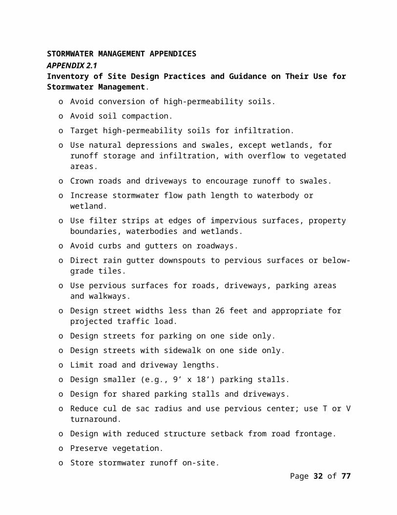
STORMWATER MANAGEMENT APPENDICESAPPENDIX 2.1 Inventory of Site Design Practices and Guidance on Their Use for Stormwater Management.
o Avoid conversion of high-permeability soils.
o Avoid soil compaction.
o Target high-permeability soils for infiltration.
o Use natural depressions and swales, except wetlands, for runoff storage and infiltration, with overflow to vegetated areas.
o Crown roads and driveways to encourage runoff to swales.
o Increase stormwater flow path length to waterbody or wetland.
o Use filter strips at edges of impervious surfaces, property boundaries, waterbodies and wetlands.
o Avoid curbs and gutters on roadways.
o Direct rain gutter downspouts to pervious surfaces or below-grade tiles.
o Use pervious surfaces for roads, driveways, parking areas and walkways.
o Design street widths less than 26 feet and appropriate for projected traffic load.
o Design streets for parking on one side only.
o Design streets with sidewalk on one side only.
o Limit road and driveway lengths.
o Design smaller (e.g., 9’ x 18’) parking stalls.
o Design for shared parking stalls and driveways.
o Reduce cul de sac radius and use pervious center; use T or V turnaround.
o Design with reduced structure setback from road frontage.
o Preserve vegetation.
o Store stormwater runoff on-site.
o Decrease flow frequency, duration, and peak runoff rates.
o Avoid channel erosion
Page 21 of 51
APPENDIX 2.2 Better Site Design
o To the maximum extent practicable, development projects shall be designed using the Better Site Design Techniques of the current version of the Minnesota Stormwater Manual.1 Better Site Design involves techniques applied early in the design process to preserve natural areas, reduce impervious cover, distribute runoff and use pervious areas to more effectively treat stormwater runoff. Site design should address open space protection, impervious cover minimization, and runoff distribution, minimization, and utilization through considerations such as:
1. Open space protection and restoration
conservation of existing natural areas (upland and wetland)
reforestation
re-establishment of prairies
restoration of wetlands
establishment or protection of stream, shoreline and wetland buffers
re-establishment of native vegetation into the landscape
2. Reduction of impervious cover
reduce new impervious through redevelopment of existing sites and use of existing roadways, trails etc.
minimize street width, parking space size, driveway length, sidewalk width
reduce impervious surface footprint (e.g. two story buildings, parking ramp)
3. Distribution and minimization of runoff
utilize vegetated areas for stormwater treatment (e.g. parking lot islands, vegetated areas along property boundaries, front and rear yards, building landscaping)
direct impervious surface runoff to vegetated areas or to designed treatment areas (roofs, parking, driveways drain to pervious areas, not directly to storm sewer or other conveyances)
encourage infiltration and soil storage of runoff through grass channels, soil compost amendment, vegetated swales, raingardens, etc.
1 Available at http://stormwater.pca.state.mn.us/index.php/Better_site_design.
Page 22 of 51

plant vegetation that does not require irrigation beyond natural rainfall and runoff from the site
4. Runoff utilization
capture and store runoff for use for irrigation in areas where irrigation is necessary
Page 23 of 51

APPENDIX 2.3 Design Infiltration Rates
HydrologicSoil Group Soil Textures* Corresponding Unified Soil
Classification**
Infiltration Rate
[inches/hour]
A
Gravel, Sandy Gravel, Silty Gravel
GW - Well-graded gravel or well-graded gravel with sand GP – Poorly graded gravel or poorly graded gravel with sandGM - Silty gravel or silty gravel with sandSW - Well-graded sand or well-graded sand with gravel
1.6
Sand, Loamy Sand, Sandy Loam
SP – Poorly graded sand or poorly graded sand with gravel 0.8
B Loam, Silt Loam
SM - Silty sand or silty sand with gravel 0.45MH – Elastic silt or elastic silt with sand or gravel 0.3
C Sandy Clay Loam
ML – Silts, very fine sands, silty or clayey fine sands 0.2
D
Clay LoamSilty Clay LoamSandy ClaySilty ClayClay
GC – Clayey gravel or clayey gravel with sandSC – Clayey sand or clayey sand with gravelCL – Lean clay or lean clay with sand or gravel or gravelly lean clayOL – Organic silt or organic silt with sand or gravel or gravelly organic silt CH – Fat clay or fat clay with sand or gravel or gravelly fat clayOH – Organic clay or organic clay with sand or gravel or gravelly organic clay
0.06
Source: Adapted from the “Design infiltration rates” table from the Minnesota Stormwater Manual, MPCA, (January 2014).
*U.S. Department of Agriculture, Natural Resources Conservation Service, 2005. National Soil Survey Handbook, title 430-VI. (Online) Available: http://soils.usda.gov/technical/handbook/.
**ASTM standard D2487-00 Standard Practice for Classification of Soils for Engineering Purposes (Unified Soil Classification System).
Page 24 of 51

3.0 EROSION CONTROL
3.1 Policy. It is the policy of the Board of Managers to require erosion and sediment control practices when land is disturbed to prevent the siltation and sedimentation of streams, channels, lakes, wetlands, and groundwater recharge areas in the District.
3.2 Applicability.
3.2.1 Prior to any land disturbance meeting one of the following thresholds, a person shall submit an Erosion and Sediment Control Plan to the District, and secure a permit from the District approving the erosion control plan:
(a) Grading, filling, or other land alteration activity that involves movement or stockpiling of fifty (50) cubic yards or more of earth or erodible material.
(b) Surface disturbance or removal of vegetative cover on five thousand (5,000) square feet or more of land.
(c) Any land disturbance with wetland impacts, grading within public waters, or grading within 40-feet of the bluff line.
(d) Land disturbance of greater than 100-square feet requiring a variance from the Local Governing Unit’s shoreland setback requirement for the property.
3.2.2 Land disturbance within a shore impact zone that does not meet a regulatory threshold established in Section 3.2.1 above, shall comply with the erosion and sediment control Best Management Practices set forth in Section 3.7 of these rules.
3.3 Regulation. The Erosion and Sediment Control Plan must meet the following standards:
3.3.1 The erosion and sediment control plan must be prepared by a qualified individual showing proposed methods of retaining waterborne sediments on site during the period of construction and showing how the site will be restored, covered, or revegetated after construction, including a timetable for completion;
3.3.2 The erosion and sediment control plan shall be consistent with the specifications of the MPCA manual “Protecting Water Quality in Urban Areas,” as amended. The Plan shall also be consistent with the requirements and specifications of the NPDES/SDS Construction Stormwater General Permit, as amended;
3.3.3 The erosion control plan will specify measures for indefinite stabilization of exposed soil and stockpiled earth and erodible materials in the event that site work is suspended. These measures will be implemented within 7 days of a request by the District, unless, on the basis of permittee’s written response and official inspection, the District finds that the site is active and actively managed under the erosion and sediment control plan. The District may set a later deadline for implementation if site
Page 25 of 51

conditions warrant.
3.4 Required Exhibits. The following items, prepared by an appropriate professional, shall accompany all erosion and sediment control permit applications submitted to the District pursuant to Rule 3.0:
3.4.1 Property lines and delineation of lands under applicant’s ownership;
3.4.2 Existing and proposed site contour elevations at two-foot intervals, related to NGVD, 1929 datum;
3.4.3 Documentation as to the status of a National Pollutant Discharge Elimination System stormwater permit for the project from the Minnesota Pollution Control Agency and provide the Storm Water Pollution Prevention Plan (SWPPP), if required, as it becomes available; and
3.4.4 An erosion and sediment control plan consistent with the standards of Sections 3.3 and 3.5.
3.5 Site Maintenance Practices.
3.5.1 All sediment control measures shall be installed, and the District shall be given three business days' notice in writing, before any land disturbing activity commences.
3.5.2 Sediment control measures shall not be removed until after the project is complete and the District determines that all disturbed areas have been fully stabilized. Sediment control measures shall be removed within 14 days thereafter.
3.5.3 Permanent wet detention basins used as temporary sedimentation basins during construction must be cleaned out after construction is complete and restored to their original design. Infiltration practices shall be protected from sedimentation and compaction during construction and shall remain offline until the contributing drainage area is stabilized.
3.5.4 The permittee is responsible at all times for the maintenance and proper operation of all erosion and sediment control facilities and practices. On any property on which land-disturbing activity has occurred pursuant to a permit issued under this Rule, the permittee shall, at a minimum, inspect, maintain, and repair all disturbed surfaces and all erosion and sediment control facilities or practices, and all soil stabilization measures, until land-disturbing activity has ceased: (1) every day construction activity is performed on the site, (2) after every rain event of one half inch (0.5”) or more total precipitation, and (3) at least weekly when construction activity is not performed on the site. Thereafter, the permittee shall perform these responsibilities after every rain event of one half inch (0.5”) or more total precipitation, and at least weekly, until vegetative cover is established.
3.5.5 All disturbed areas, exposed soils, and soil stockpiles must be stabilized. Stabilization must be initiated immediately to limit soil erosion on any portion of the site when
Page 26 of 51

construction activity has permanently ceased or will not resume for a period exceeding fourteen (14) calendar days. Stabilization must be completed no later than fourteen (14) calendar days after the construction activity in that portion of the site has ceased. Stabilization must be completed no later than twenty-four (24) hours after the construction activity has ceased in that portion of the site within two hundred (200) lineal feet of and draining to a wetland, waterbody, a discernable surface drainage feature or a stormwater system inlet. If an area is not permanently stabilized, it shall be managed in accordance with subsection 3.5.4.
3.5.6 The weekly inspection requirement of subsection 3.5.4, above, may be reduced to monthly between November 15 and snowmelt if site management conforms to the following:
(a) Exposed soils are stabilized with established vegetation, straw or mulch, matting, rock, or other approved product such as rolled erosion control product. Seeding is encouraged, but alone is not sufficient.
(b) Temporary and permanent ponds and sediment traps are graded to capacity before spring snowmelt. This does not include infiltration/filtration facilities, which must be kept free of sediment until the site is fully stabilized.
(c) Sediment barriers are properly installed perimeter downslope of all graded areas where offsite transport of sediment may occur without control, and around sensitive locations within the project site.
(d) Slopes and grades are properly stabilized with approved methods. Rolled erosion control products must be used on slopes greater than 3:1 (H:V) and where erosion conditions dictate.
(e) Stockpiled soils and other materials subject to erosion are protected by established vegetation, anchored straw or mulch, rolled erosion control product or other durable covering; a barrier prevents movement of eroded materials from the location.
(f) All construction entrances are properly stabilized.
(g) Snow management protects erosion and sediment control measures.
3.5.7 If a site is actively worked after November 15, all steep slope measures, downgradient and perimeter sediment controls, stockpile stabilization and sediment control measures, swales, channels, culvert outfalls and storm sewer inlets must be maintained in proper working condition at the end of each day construction activities occur.
3.6 Agricultural practices.
a. The erosion control measures described in section 3.2 of this Rule are not required for land that is used for agricultural activity, provided that a grass or natural
Page 27 of 51

vegetation buffer zone extending sixteen (16) feet or the width of an applicable shore impact zone, whichever wider, is maintained along any waterbody or wetland and no fertilizer is used in the zone.
b. The Board further encourages the use of BMPs (e.g., vegetative swales) in order to slow the flow of the runoff water and allow particulates to settle out and water to infiltrate into the soil prior to discharging to waterbodies and wetlands. BMPs can effectively remove small amounts of excess sediments, and associated nutrients and heavy metals.
3.7 Erosion and Sediment Control Best Management Practices
Any project that does not meet the regulatory thresholds established in Section 3.2.1 above, shall employ measures to prevent exposed soils from moving toward wetlands, surface waters, storm sewer inlets or public ways; seed and mulch or blanket exposed soils as soon as possible after work in that area is ceased; properly install and maintain erosion control fencing or other effective sedimentation barriers between areas of exposed soil and downgradient wetlands, surface waters and storm sewer inlets.
4.0 LAKE, STREAM, AND WETLAND BUFFER REQUIREMENTS
4.1 Purposes and Policy. The purpose of Rule 4.0 is to establish, maintain, and protect buffers adjacent to water resources in order to protect and improve the water quality, flow regime and habitat of the water resources in the Comfort Lake - Forest Lake Watershed District, consistent with the interest in avoiding undue disturbance to established public and private activities in littoral and riparian zones. Natural vegetation bordering the bed and banks of lakes, streams and wetlands serves a critical role in maintaining the ecological function of and societal benefits deriving from those water resources. Purposes served by vegetative buffers include bank and shoreline stabilization; erosion prevention; filtration of nutrients, sediments and other pollutants from storm flows; protection of stream beds and banks and mitigation of downstream flooding through moderation of peak flows both into and within the resource; regulation of in-stream temperatures; preservation of aquatic and terrestrial habitat; protection of scenic resources; and maintenance of property values.
4.2 Applicability.
4.2.1 Rule 4.0 applies to any lot containing land within the buffer zone of any General Development Lake, Recreational Development Lake, Natural Environment Lake, stream or wetland within the watershed; and
(a) that results from subdivision of land into two or more buildable lots on or after February 1, 2009; or
(b) that is subject to land disturbance for the purpose of a new primary use for which (i) a rezoning or (ii) a land use variance for lot hard surface percentage or structure setback from a wetland or surface water resource has been
Page 28 of 51
approved on or after February 1, 2009.
A “new primary use” under this paragraph is defined as a change from one use category (single-family residential, multi-family residential, institutional, commercial, industrial or agricultural) to another; or a change of use within the same use category that, due to the new location or intensity of use, is likely in the Board of Managers’ determination to have a measurable adverse impact on downgradient lake, stream or wetland function. Construction of a structure or hard surface on an unimproved lot of record, or on an improved lot of record following removal of all or the essential part of an existing main structure, is a “new primary use” without a Board determination of adverse impact.
4.2.2 Within 45 days of plat recordation under paragraph 4.2.1(a), and before a land disturbance under paragraph 4.2.1(a) or (b), a buffer permit shall be obtained from the District and an instrument incorporating the requirements of Rule 4.0 and approved by the District shall be recorded with the County.
4.2.3 A buffer shall be indicated by permanent, free-standing markers at the buffer's upland edge, with a design and text approved by Municipality and District staff in writing in order to maintain consistency throughout the community. A marker shall be placed at each lot line, with additional markers at an interval of no more than two hundred (200) feet. If a District permit is sought for a subdivision, the monumentation requirement will apply to each lot of record to be created. On public land or right-of-way, the monumentation requirement may be satisfied by the use of markers flush to the ground, breakaway markers of durable material, or a vegetation maintenance plan approved by City and District staff in writing in order to maintain consistency throughout the community.
4.2.4 Rule 4.0 applies in addition to, and not in place of, any local shoreland ordinance.
4.3 Zone Widths.
4.3.1 Subject to the special provisions in subsections 4.3.2 through 4.3.6, stream, wetland and lake buffer zones are as follows:
(a) Stream (measured from top of bank) 75 feet
(b) Lakes (measured from delineated OHWL)
(1) Natural environment lake 100 feet
(2) Recreational development lake 50 feet
(3) General development lake 25 feet
(c) Wetlands; Based on the wetland function and value assessment the following will be buffer requirement (measured from delineated wetland edge)
Page 29 of 51

(1) Preserve 100 feet
(2) Manage 1 75 feet
(3) Manage 2 50 feet
(4) Manage 3 25 feet
(d) If a lake or wetland is a groundwater-dependent natural resource, the buffer will be one hundred (100) feet. If the stream is a groundwater-dependent natural resource, the streamside zone will be fifty (50) feet, and the middle zone one hundred (100) feet.
4.3.2 Where a mapped natural community is associated with a stream, lake or wetland, the upland edge of the middle zone shall be as specified in subsection 4.3.1 or contiguous with the upland edge of the natural community area, whichever is greater.
4.3.3 Where a buffer zone encompasses all or part of a steep slope, the zone or buffer shall extend to the distance specified in subsection 4.3.1 or to the top of the slope, whichever is greater.
4.3.4 Where the 100-year floodplain extends further than the upland edge of the middle zone, the lake buffer or the wetland buffer as specified in subsection 4.3.1, the zone or buffer shall extend to the upland edge of the floodplain.
4.3.5 Where a lake or wetland is encompassed within or contiguous to a stream or lake to which Rule 4.0 applies, the most protective lake, stream, or wetland buffer shall apply.
4.3.6 The District may find compliance with the Rule if the wetland buffer, on average, meets the requirements of the Rule and is no less than fifty (50) percent of the required buffer width at any point. Only buffer up to two hundred (200) percent of the required width will be counted in determining average buffer. The averaged buffer must be at least as protective of the water resources as the non-averaged buffer.
For example, a recreational development lake with a required fifty (50) foot buffer zone width would have a minimum twenty-five (25) foot buffer zone width and a maximum one hundred (100) foot buffer zone width that would count to the determined average. The total area of the averaged buffer zone must meet or exceed the total area of the required buffer zone.
4.4 Required Exhibits. The following items shall accompany all permit applications submitted to the District pursuant to Rule 4.0:
4.4.1 Property lines and delineation of lands under applicant’s ownership;
4.4.2 Delineation of existing on-site wetland, shoreland, and floodplain areas;
4.4.3 Elevation of the OHWL of each public water on the site, if determined by the
Page 30 of 51
Minnesota Department of Natural Resources and of any legally established buffer associated with the public water;
4.4.4 Existing and proposed site contour elevations at two-foot intervals, related to NGVD, 1929 datum;
4.4.5 Wetland function and value assessment for all wetlands subject to buffer pursuant to Minnesota Routine Assessment Method (MnRAM) 3.2 (including groundwater function) or other method approved by the District;
4.4.6 Site plan indicating location of applicable buffer zone; Buffer zone location exhibits shall be submitted as shapefiles.
4.4.7 Survey of existing buffer vegetation in accordance with subsection 4.5.2; and 24
4.4.8 Buffer Planting Plan in accordance with subsection 4.5.3.
4.5 Limitations in Buffer Zones.
4.5.1 Lake, Stream, and Wetland Buffers;. The following activities are prohibited within a lake, stream, or wetland buffer:
(a) Creating impervious cover.
(b) Excavation or placing fill or debris, except for approved shoreline or streambank stabilization activities and temporary placement of fill or debris pursuant to duly- permitted work in the associated waterbody or wetland, in compliance with all conditions of the permit, and in compliance with section 4.6.
(c) Altering vegetation, except for (i) vegetative enhancements, as approved in writing by staff; and (ii) the removal of invasive exotic species or of trees for disease control, removal of safety hazards or revegetation. A tree larger than six inches in diameter at a point fifty-four (54) inches above the ground may be removed only on written authorization from District staff on a determination that the function of the buffer will not be diminished.
(d) Applying phosphorus-containing fertilizers, except on written authorization from District staff on a determination that phosphorus application is appropriate and will not injure the waterbody.
(e) Locating roads or utilities, except pursuant to a crossing of the associated watercourse in accordance with section 4.7. Structures and appurtenances associated with the road or utility shall not be located within the buffer unless no feasible alternative exists.
(f) Outlet, flood control and stormwater treatment facilities may be located within the buffer if so approved under Rule 2.0, except that a stormwater basin is not permitted within the buffer of a groundwater-dependent natural resource, unless the basin bottom is at least three (3) feet above the seasonal high water table, and the basin and
Page 31 of 51
associated facilities are designed and maintained to infiltrate the two-year, 24-hour precipitation event.
4.5.2 At the time a buffer is created under Rule 4.0, the District may, depending on site specific conditions, require a planting or landscaping plan to establish adequate native vegetative cover for an area that:
(a) Has vegetation composed more than thirty (30) percent of undesirable plant species (including, but not limited to reed canary grass, common buckthorn, purple loosestrife, leafy spurge, bull thistle, and other noxious weeds); or
(b) Consists more than ten (10) percent of bare or disturbed soil or turf grass.
4.5.3 Buffer areas described in this rule are to be maintained indefinitely. Where a planting or landscaping plan is required under subsection 4.5.2 or is otherwise needed, the buffer strip plantings must be identified on the site plan and shall comply with the following standards:
(a) Buffer strips shall be planted with a site appropriate native seed mix as specified by BWSR, MnDOT, NRCS or SWCD, with the exception of a one-time planting with an annual nurse or cover crop such as oats or rye. Native trees and shrubs may be added to supplement ground cover.
(b) The seed mix shall be broadcast according to BWSR, MnDOT, NRCS or SWCD specifications of the selected mix. The annual nurse or cover crop shall be applied at a minimum rate of thirty (30) pounds per acre. The seed mix selected for permanent cover shall be appropriate for soil site conditions and free of invasive species. BWSR, MnDOT, NRCS or SWCD approved mixtures appropriate for specific soil and moisture conditions can be used to meet these requirements.
(c) The buffer revegetation plan shall specify the method for the seeding or planting of the grasses, shrubs, and forbs.
(d) No fertilizer shall be used in establishing new buffer strips, except when necessary to establish acceptable buffer strip vegetation and then limited to amounts indicated by an accredited soil testing laboratory.
(e) All disturbed areas shall be mulched and stabilized immediately. Mulch shall be anchored with a disk or tackifier.
(f) Buffer strips (both natural and created) shall be protected by erosion and sediment control measures during construction in accordance with Rule 3.0.
4.5.4 Applicant may apply to District for grant monies or other District funds, when available, to offset a portion of the cost of re-stabilizing riparian buffer zones.
4.6 Temporary Alterations.
Page 32 of 51

4.6.1 Compliance with Rule 3.0 is required, irrespective of the area or volume of earth to be disturbed.
4.6.2 Buffer zones and the location and extent of vegetation disturbance shall be delineated on the erosion control plan.
4.6.3 Alterations must be designed and conducted to ensure only the smallest amount of disturbed ground is exposed for the shortest time possible. Mulches or similar materials must be used for temporary soil coverage and permanent natural vegetation established as soon as possible.
4.6.4 Fill or excavated material shall not be placed to create an unstable slope.
4.6.5 When construction, land disturbance, fill or excavation activity occurs within the outer zone, the boundary between the outer and middle zones shall be demarcated with siltation or other fencing to prevent disturbance of vegetation within the middle zone. When construction, land disturbance, fill or excavation activity occurs within the middle zone, the boundary between the middle and streamside zones shall be demarcated with siltation or other fencing to prevent disturbance of vegetation within the streamside zone.
4.7 Roads and Utilities.
4.7.1 A structure, impervious cover or right-of-way maintained permanently in conjunction with a crossing of the waterbody or wetland shall minimize the area of permanent vegetative disturbance to the degree feasible. Minimization includes, but is not limited to, approach roads and rights-of-way that are perpendicular to the crossing and of a minimum width consistent with use and maintenance access needs. 4.7.2 All work shall be in accordance with section 4.6.
4.8 Access to Waterbody or Wetland.
Access to a waterbody or wetland for a lawful private or public use of the resource may be created and maintained. All access surfaces within the buffer zone must be pervious and permanent vegetative disturbance shall be limited to that necessary for access in light of the nature and extent of the permitted use. No facility, other than a footpath or streambank/shoreline stabilization or a facility accessory to a permitted use of the waterbody or wetland and required by its nature to be adjacent to the water, may be located within the buffer zone. The access area must not exceed thirty (30) feet or fifty (50) percent of the lot width along the shoreline or streambank, whichever is less. The access area width should be only as wide as that needed for the intended purpose.
4.9 Trails in Buffer Zone.
The buffer may enclose a trail or a water quality facility on a demonstration that doing so will not significantly reduce the protection afforded the waterbody or wetland. A trail no more than ten (10) feet in width bordered by a pervious buffer of at least five (5) feet on each side is deemed to meet this requirement. The trail or water quality feature shall not
Page 33 of 51

count toward buffer width. A non-linear facility for general public use that is required by its nature to be adjacent to the water may be allowed in the buffer on a case-by-case basis if the impact to the buffer is minimized and the project will not negatively impact the lake, stream, or wetland.
5.0 SHORELINE & STREAMBANK ALTERATIONS
5.1 Policy. It is the policy of the District to:
5.1.1 Encourage the establishment and maintenance of natural vegetation on shorelines and streambanks and discourage use of other alteration of a shoreline or streambank unless erosion of the shoreline or streambank is occurring.
5.1.2 Assure that improvements or alterations of shoreline and streambank areas comply with accepted engineering principles to prevent erosion.
5.1.3 Preserve and, wherever feasible, enhance the ecological integrity and natural appearance of shoreline and streambank areas.
5.2 Regulation.
5.2.1 No person shall construct or install a shoreline or streambank stabilization partially or wholly below the ordinary high water mark of (a) a natural or altered natural watercourse defined as a public water; or (b) a waterbasin, without first securing District approval and, if required, posting a financial assurance. Construction or installation of a shoreline or streambank stabilization wholly above the ordinary high water mark of a waterbody may require a permit under Rule 7.0.
5.2.2 Notwithstanding subsection 5.2.1, a District permit under Rule 5.0 is required only if:
(a) a Minnesota Department of Natural Resources public waters work general permit covering shoreline and streambank alterations is in effect; and
(b) the general permit excuses from the DNR individual permit requirement property owners that hold a District permit.
5.3 Criteria for Bioengineering. The use of bioengineering is encouraged as an alternative to traditional engineered stabilization techniques for its cost advantage and ecological integrity. Bioengineering techniques should be used to the maximum extent possible under the following criteria.
5.3.1 The resultant project shall be structurally stable. Special emphasis shall be given to the stability of the toe of slope and protection of the shoreline and streambank during vegetation establishment.
5.3.2 Native vegetation shall be used in all cases. Preferable species include those that form dense root systems or can be planted from cuttings.
Page 34 of 51

5.3.3 Bioengineering projects shall include a long-term maintenance plan which will ensure that small erosion spots are corrected and that establishment of native plant materials is successful.
5.4 Bioengineering Required Exhibits. The following exhibits shall accompany the bioengineering permit application (one full-size; one set-reduced to maximum size of 11” x 17”):
5.4.1 Site plan showing property lines, delineation of lands under ownership of the applicant; delineation of the existing shoreline; delineation of wetland within the project area; existing contour elevations (if available); and locations and lineal footage of the proposed bioengineering treatment;
5.4.2 Site plan prepared by a professional engineer, landscape architect registered in the State of Minnesota, or other qualified professional experienced in the field of shoreline and stream restoration detailing the proposed bioengineering treatment, drawn to scale, with the horizontal and vertical scales noted on the drawing. The detail should show the finished slope, distance lakeward of the bioengineering treatment, ordinary high water level elevation and material specifications; and
5.4.3 Detailed planting plan using native vegetation.
5.5 Criteria for Rip Rap Placement. The District favors the use of bioengineering techniques and combined bioengineering/riprap for as much of a shoreline stabilization project as fetch, slope, soil and other relevant conditions allow. Live plantings incorporated in shoreline bioengineering must be native aquatic vegetation and/or native upland plants. For those parts of a stabilization project for which riprap is proposed, a permit applicant must evaluate the use of bioengineering techniques, as well as a combination of bioengineering and riprap, and show that they have been determined to be unsuitable. In addition, rip rap placement shall comply with the following criteria:
5.5.1 Rip rap material is to be durable, natural stone common to the setting and of a gradation that will result in a stable shoreline embankment able to withstand ice and wave action.
5.5.2 The finished slope of the rock fragments, boulders and/or cobbles should not be steeper than a ratio of three (3) feet horizontal to one (1) foot vertical (3:1) under normal conditions. Steeper slopes will generally require larger sized rip rap. The finished slope shall be no steeper than 2:1 (horizontal to vertical). Any rock/boulder stabilization project with a proposed finished slope steeper than 2:1 (horizontal to vertical) shall be evaluated in accordance with the conditions for retaining walls.
5.5.3 No rip rap or filter materials is to be placed more than (six) 6 feet waterward of the shoreline measured from the ordinary high water level (OHW) elevation under normal conditions. The encroachment into the water is the minimum amount necessary to provide protection and may not unduly interfere with the flow of water.
5.5.4 A transitional layer consisting of graded gravel, at least six (6) inches deep, and an
Page 35 of 51

appropriate geotextile filter fabric shall be placed between the soil material of the existing shoreline and the rip rap to prevent erosion of the embankment and to prevent settlement.
5.5.5 Rip rap placement shall not be attempted when underlying soils are not capable of supporting resulting loads. In these cases, a professional engineer registered in Minnesota should be consulted.
5.5.6 The thickness of the rip rap layers shall be at least 1.25 times the maximum stone diameter, exclusive of toe boulders at least fifty (50) percent buried.
5.5.7 The rip rap shall conform to the natural alignment of the shoreline (i.e., maintaining an undulating or meandering shoreline).
5.5.8 The design must reflect the engineering properties of the underlying soils and any soil corrections or reinforcements. For a shoreline, the design must conform to engineering principles for wave energy dispersion and resistance to deformation from ice pressure and movement, considering prevailing winds and fetch. For a streambank, the design shall conform to engineering principles for the hydraulic behavior of open channel flow, considering channel slope, velocity, tractive forces and upstream and downstream impacts.
5.5.9 Rip rap placement projects shall contain native vegetation planting within the rip rap in an area equal to or greater than twenty-five (25) percent of the overall area of the rip rap. The native vegetation planting plan shall be approved by District staff.
5.5.10 Materials used shall be non-polluting.
5.6 Rip Rap Required Exhibits. The following exhibits shall accompany the rip rap permit application (one full-size; one set-reduced to maximum size of 11” x 17”):
5.6.1 Site plan showing property lines, delineation of lands under ownership of the applicant; delineation of the existing shoreline; delineation of wetland within the project area; existing contour elevations (if available); and locations and lineal footage of the proposed rip rap treatment;
5.6.2 Cross-section detailing the proposed rip rap, drawn to scale, with the horizontal and vertical scales noted on the drawing. The detail should show the finished rip rap slope, transitional layer design and placement, distance lakeward of the rip rap placement, ordinary high water level elevation and material specifications;
5.6.3 Description of the underlying soil materials that will support the rip rap and, if the underlying soils will not support the rip rap, the recommendations of a qualified soils engineer;
5.6.4 Gradation, average diameter, quality and type of rip rap material to be used (normally, a Class III gradation is sufficient);
Page 36 of 51
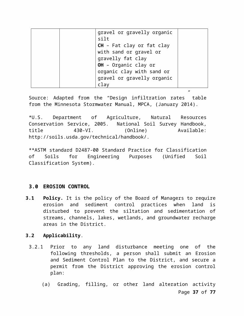
5.6.5 Gradation, quality and type of filter blanket material to be used (normally, Type I gradation is sufficient);
5.6.6 Manufacturer's material specifications for proposed geotextile fabric(s);
5.6.7 Detailed planting plan for native vegetation planting element of the project; and
5.6.8 Narrative and supporting documentation assessing the feasibility of bioengineering for the site.
5.7 Criteria for Retaining Walls.
5.7.1 A shoreline or streambank structure with a finished slope steeper than 2:1 (H:V), including but not limited to a rock, boulder or masonry installation, seawall, sheetpile structure or gabion basket, is subject to this section. A single course of riprap or other permanent material less than eighteen (18) inches in height is excepted.
5.7.2 A new retaining wall, or repair/reconstruction of an existing retaining wall that increases floodplain encroachment beyond that required by technically sound and accepted repair/reconstruction methods, is permitted only pursuant to a variance. The applicant must demonstrate there is no adequate stabilization alternative.
5.7.3 The location of the finished wall shall be verified with a certificate of survey prepared by a registered land surveyor,
5.8 Retaining Wall Required Exhibits. An application for retaining wall installation must contain an analysis of alternative solutions in addition to a structural/geotechnical analysis prepared by a professional engineer, practicing in civil engineering and registered in the State of Minnesota, showing that the design conforms to accepted engineering principals and will withstand expected ice and wave action and earth pressures.
5.9 Criteria for Laying Sandblankets. All permitted sandblanketing shall comply with the following standards.
5.9.1 The sandblanket installation shall comply with section 4.8 and the standards of the DNR for placement of a sandblanket without a public waters work permit.
5.9.2 Beaches that are operated by governmental entities, and available to the general public, shall be exempted from the following restrictions: (i) that sandblankets be no more than fifty (50) feet in width and (ii) that sandblankets be installed no more frequently than once every four years.
5.9.3 A natural zone of native shoreline plants of the same depth and equal to twenty (20) percent of the width of the sandblanket should be maintained adjacent to the sandblanket.
5.10 Sandblanket Required Exhibits. The following exhibits shall accompany the sandblanket permit application:
Page 37 of 51

5.10.1 Site plan showing property lines, delineation of the work area, existing elevation contours of the adjacent upland area, delineation of wetland within the project area, ordinary high water elevation, and regional flood elevation (if available). All elevations must be reduced to NGVD (1929 datum); and
5.10.2 Profile, cross-sections and/or topographic contours showing existing and proposed elevations and proposed side slopes in the work area. (Topographic contours should be at intervals not greater than one (1) foot);
5.11 Criteria for Streambank Stabilization. Intact, vegetated and stable shorelines and streambanks provide valuable functions to the associated water resource including prevention of erosion, reinforcement of soils through root structure, trapping of nutrients and sediments, and provision of fish and wildlife habitat. The CLFLWD promotes the preservation and enhancement of the ecological integrity and natural appearance of shorelines and streambanks with the intent of preventing erosion. When alteration is necessary, the CLFLWD encourages bioengineering, landscaping and preservation of natural vegetation practices.
All proposed streambank stabilization and restorations shall be designed with and in response to an intimate understanding of the aforementioned characteristics unique to the stream reach in question. The physical appearance and operation character of a stream is a product of the adjustment of the stream’s boundaries to the magnitude of stream flow and erosional debris produced from the contributing watershed. The individual stream characteristics are further modified by the influence of channel materials, basin relief, and other features of valley morphology along with a local history of land use and sediment deposition.
The unique characteristics of each stream reach shall be fully considered in the design of a streambank stabilization.
5.12 Streambank Stabilization Required Exhibits. The following exhibits shall accompany the streambank stabilization permit application:
5.12.1 Site plan prepared by a professional engineer or a landscape architect registered in the State of Minnesota and experienced in the field of stream restoration showing property lines; the ordinary high water (OHW) elevation and floodplain elevation; existing streambank and contour elevations;
5.12.2 Stream cross-section(s) depicting entire floodprone width; detailing channel dimensions, such as bankfull stage and the dimension and placement of the proposed stabilization/restoration measure(s). A longitudinal profile depicting the thalweg and top of bank; detailing the dimension and placement of the proposed stabilization/restoration measure(s);
5.12.3 Material specifications including plant species and whether species are rooted, seed or cutting;
5.12.4 Stream classification and design calculations and documentation; and
Page 38 of 51
5.12.5 Detail of proposed site-specific erosion and sediment control practices.
5.13 Other Shoreline Improvements. Types of shoreline improvements not specifically addressed by Rule 5.0 shall require a variance.
6.0 WATERCOURSE AND BASIN CROSSINGS
6.1 Policy. It is the policy of the District to discourage the use of lake beds and beds of waterbodies for the placement of roadways, utilities, water control structures, and associated structures.
6.2 Regulation. No person shall use the beds of any waterbody within the District for the placement of roadways, utilities, water control structures, and associated structures without first securing a permit from the District.
6.3 Criteria. Use of the bed:
6.3.1 For all public waters, shall meet a demonstrated public benefit;
6.3.2 Shall retain adequate hydraulic capacity;
6.3.3 Shall retain adequate navigational capacity;
6.3.4 Shall not adversely affect water quality;
6.3.5 Shall represent the "minimal impact" solution to a specific need with respect to all other reasonable alternatives; and
6.3.6 Shall preserve fish and wildlife passage.
6.4 Required Exhibits. The following exhibits shall accompany the permit application:
6.4.1 Construction plans and specifications;
6.4.2 Analysis prepared by a professional engineer or qualified hydrologist showing the effect of the project on hydraulic capacity and water quality;
6.4.3 An erosion control and restoration plan; and
6.4.4 Copy of permit application to Department of Natural Resources, Army Corps of Engineers, and Wetland Conservation Act LGU, if required based on proposed activities.
6.5 Maintenance. A declaration or other recordable instrument stating terms for maintenance of stability and hydraulic and navigational capacity shall be approved by the District shall be recorded in the office of the county recorder or registrar before permit issuance. In place of recordation, a public permittee or a permittee without a property interest sufficient for recordation may assume the maintenance obligation by means of a written agreement with the District. The agreement shall state that if the ownership of the structure is transferred, the owner shall require the transferee to comply with this subsection
6.6 Coordination with other Government Agencies. The District will communicate with the Department of Natural Resources and Wetland Conservation Act LGUs in the review and approval of proposed activities.
Page 39 of 51

7.0 FLOODPLAIN AND DRAINAGE ALTERATIONS
7.1 Policy. It is the policy of the District to:
7.1.1 promote the reasonable use of water resources, such that a landowner may dispose of surface water only in a manner that does not unreasonably burden other landowners;
7.1.2 preserve existing water storage capacity in the 100-year floodplain of all waterbodies and wetlands in the watershed to minimize the frequency and severity of high water;
7.1.3 prohibit development in the 100-year floodplain which will unduly restrict flood flows or aggravate known high water problems; and
7.1.4 preserve the natural hydrology of landlocked basins to minimize flooding risks to structures and ecological impacts within or downgradient of those basins.
7.2 Regulation. No person shall artificially redirect flow across drainage boundaries, nor obstruct the natural flow of surface water, without first obtaining a permit from the District. No person shall alter or fill land below the 100-year flood elevation of any stream, wetland, public water, stormwater management basin, or landlocked basin without first obtaining a permit from either:
(a) the District, or
(b) the appropriate local government unit in accordance with a state-approved floodplain management ordinance.
7.3 Criteria for Floodplain or Drainage Alterations.
7.3.1 Floodplain filling shall not cause a net decrease in flood storage capacity below the projected 100-year flood elevation. The fill volume shall be calculated by a professional engineer registered in the State of Minnesota or by a qualified hydrologist. All new residential, commercial, industrial, institutional buildings, and other habitable or non-habitable structures and stormwater management facilities shall be constructed so that the lowest basement floor and lowest entry elevations of structures comply with the following:
Regional Elevation
Detention Basins and Isolated
WetlandsInfiltration Basins Rain-gardens
Elevation 100-yr EOF 100-yr EOF Bottom 100-yr EOF EOF
Low Floor Freeboard 2 ft. 1 ft. 0 ft. NA 0 ft. NA NA NA
Low Opening Freeboard NA NA 2 ft. 1 ft. NA 2 ft. 1 ft. 0.5 ft.
Page 40 of 51

7.3.2 The minimum building elevation alternatively may be defined as the lowest grade elevation in contact with the structure rather than the lowest basement floor elevation for perched water basin situations if the following criteria are met:
(a) Geologic mapping and all available data sources indicate the adjacent waterbody is not a surface expression of a regional water table but is a perched groundwater system;
(b) The basement floor elevation will be four (4) feet above the currently observed ground water elevations in the area as demonstrated by two borings or observation wells located between each structure and the waterbody; and
(c) The basement floor elevation will be two (2) feet above the elevation of any known historic high groundwater elevations for the area.
7.3.3 Within the drainage area to a landlocked basin, the separation between the lowest basement floor elevation and the 100-yr high water elevation cited in subsection 7.3.1, shall be at least three feet, unless the building is at least two feet above the basin overflow.
7.3.4 No person will alter stormwater flow at a property boundary by changing land contours, diverting or obstructing surface or channel flow, or creating a basin outlet, unless the District finds that the alteration will not have an unreasonable impact on an upgradient or downgradient landowner and will not adversely affect flood risk, basin or channel stability, groundwater hydrology, stream or channel baseflow, water quality or aquatic or riparian habitat.
7.4 Required Exhibits. The following exhibits shall accompany the permit application:
7.4.1 Site Plan indicating location of 100-year flood elevation of any wetland, public water, stormwater management basin, or landlocked basin on or directly adjacent to the property;
7.4.2 Site Plan and supporting calculations indicating location and volume of any floodplain impact and mitigation;
7.4.3 Site Plan indicating lowest floor elevations of all proposed structures; and
7.4.4 Analysis of impact of alterations to surface flow on upgradient and downgradient landowners, flood risk, basin or channel stability, groundwater hydrology, stream or channel baseflow, water quality or aquatic or riparian habitat.
8.0 WETLAND MANAGEMENT
Wetlands are important to the District’s water resources because they reduce the likelihood of flood damage by functioning like natural sponges, storing water and slowly releasing it over
Page 41 of 51

time. Wetlands also help control increases in the rate and volume of runoff in urban areas and buffer shorelines against erosion. Wetlands help improve water quality by removing or retaining nutrients carried in surface runoff, processing organic wastes and reducing the amount of sediment before it reaches open water. Because of their value to surrounding water resources, natural wetlands should be protected from uses as primary discharge for untreated stormwater.
8.1 Policy. It is the policy of the Board of Managers to support the Wetland Conservation Act Local Governing Unit’s efforts to:
(a) Manage wetlands to achieve no-net loss in the quantity, quality, and biological diversity of wetlands in the District.
(b) Increase the quantity, quality, and biological diversity of wetlands in the District by restoring or enhancing diminished or drained wetlands.
(c) Avoid impacts from activities that destroy or diminish the quantity, quality, and biological diversity of District wetlands.
(d) Replace affected wetlands where avoidance is not feasible and prudent.
(e) Encourage natural vegetation around wetlands which is integral to maintaining the water quality and ecological functions that wetlands provide.
(f) Follow general recommendations presented in the County Groundwater Plans
8.2 Wetland Impact Permits. Any wetland impact (filling, draining, ditching, dredging, or altering vegetation or grades in a buffer zone surrounding a wetland) is required to conform to the Wetland Conservation Act (WCA). The District does not currently serve as the Local Governing Unit (LGU) for WCA for any of the communities in the District, and therefore does not require the review of wetland impact, permit, and replacement/mitigation plans. Local Governing Unit regulations must be followed.
Activities conducted in wetlands may require a permit from the District under the other Rules of the District, see Rules 2.0 through 7.0 in particular.
8.3 Wetland replacement. The District urges wetland replacement, where permitted, shall be of the same or improved quality, type and function, and in accordance with the following prioritization for the location of the replacement wetland (both constructed and banked).
(a) On site replacement is most preferred;
(b) Within the same sub-watershed;
(c) Within adjoining sub-watershed;
(d) Within the District;
(e) Outside of the District is the least preferred;
Page 42 of 51

8.4 Technical Evaluation Panel. The District shall participate as able, in the activities and deliberations of the technical evaluation panel (TEP) in accordance to the WCA process.
9.0 FEES
9.1 Policy Findings. The Board of Managers finds that:
9.1.1 When property owners are encouraged to seek permits for potential projects, the public benefits by improving or maintaining water quality and quantity of water resources in the District. Other benefits include reduced inspection and enforcement costs for correcting unpermitted activities in violation of District rules, state and federal clean water laws.;
9.1.2 It is in the public interest that land disturbance subject to District rules be inspected and analyzed by District staff to provide the Board of Managers sufficient information to evaluate compliance with District goals and Rules and applicable law. The District’s annual tax levy should not be used to pay the cost to monitor private development projects; and
9.1.3 From time to time persons perform work requiring a permit from the District without a permit, and persons perform work in violation of an issued District permit. In this case, the cost of engineering inspection and analysis and actions to gain compliance typically exceeds the ordinary cost of monitoring a compliant site. This cost should be borne by the property owner that has not followed required procedures, and not by the District’s annual tax levy.
9.2 Calculation of Fees. As an element of a complete application, the applicant shall submit to the District a permit fee that reflects the District's actual costs of permit application review and field inspection of the work, including investigation of the area affected by the work, analysis of the work, services of a consultant, including engineering and legal consultants, and activity performed to monitor and secure compliance with the permit and District rules. The permit fee schedule will be established, and amended from time to time, by resolution of the Board of Managers.
9.3 Payment of Fees.
9.3.1 The District may notify any person performing work that it finds to be in violation of a District rule or permit. If a permit has not been issued for the work, the person performing the work shall promptly apply for a permit and submit the permit application fee.
9.3.2 As a condition of permit issuance, a permittee must replenish the permit fee deposit to the scheduled amount. On permit approval, the Board shall notify the permit applicant of the fee due. The fee shall be paid to the District within thirty (30) days from the date of permit approval and must be received by the District before the permit will issue.
9.3.3 When the District determines that work under a permit has been completed, it will
Page 43 of 51

return to the permittee the remaining portion of the fee deposit. If the District expends funds in excess of the fee deposit, it may invoice the permittee for the excess at any time. The fee shall be paid to the District within thirty (30) days from the date of invoice. Failure to pay the fee is a violation of the permit terms and the District may recover the fee by any means authorized by law.
9.4 Governmental Agencies Exempt. The fee provided for in this Rule shall not be charged to any agency of the United States or any governmental unit in the State of Minnesota.
10.0 FINANCIAL ASSURANCES
10.1 Policy. It is the policy of the District to protect and conserve the water resources of the District by assuring that land disturbance within the District complies with the District’s Rules, and to require a permittee to maintain financial assurances conditioned on compliance so that the District need not expend general public funds to gain compliance.
10.2 Form and Conditions of a Letter of Credit, Surety Bond or Cash Escrow.
10.2.1 The District may require a letter of credit, surety bond or cash escrow in a form approved by the District for an activity regulated under these Rules. A commercial assurance shall be from an issuer licensed to issue such assurances in Minnesota. The principal for a letter of credit or bond need not be the permittee but the District’s access to the assurance may not be impeded by a claim that the principal is not responsible for permit non-compliance.
10.2.2 The assurance shall be in favor of the District and conditioned on the permittee’s performance of the activities authorized in the permit in compliance with the District Rules and governing law, the terms and conditions of the permit, and payment when due of any fees or other charges authorized by law. The assurance shall state that in the event the conditions of the assurance are not met, the District may make a claim against it.
10.2.3 The assurance must be valid and in force for at least the permit term.
10.2.4 The form of the assurance shall be as follows:
(a) Cash deposit - The first $5,000 of the financial assurance, and any additional amount as the permittee elects, shall be by cash deposit to the District. The cash will be held by District in an escrow account but may be commingled with other escrows and the permittee will not be entitled to interest. In conjunction with the deposit, the permittee will sign an escrow agreement acceptable to the District.
(b) Security deposit - Letter of credit or bond provide to the District, as beneficiary, an original of an irrevocable standby letter of credit or a negotiable permit bond.
10.3 Assurance Amount. A standard assurance schedule shall be set and revised from time to time by resolution of the Board of Managers as the amount the Board deems necessary to cover the following potential costs to the District:
Page 44 of 51
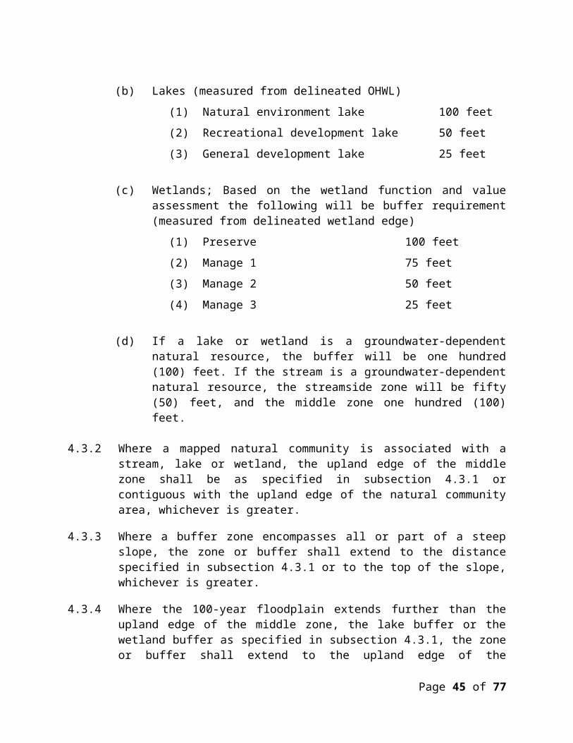
(a) Application, field inspection, monitoring and related fees authorized under Minn. Stat. § 103D.345;
(b) The cost of maintaining and implementing protective measures set forth in or incorporated into the permit; and
(c) The cost of remedying damage resulting from permit noncompliance or for which the permittee otherwise is responsible.
10.4 Use of Assurance. The District may obtain and use funds in accordance with the procedures stated here and those stated in the bond, letter of credit or cash escrow agreement. The District may apply the proceeds of any financial assurance it holds to reimburse its reasonable costs incurred for purposes set forth in paragraph 10.3. If the District’s reasonable costs exceed the proceeds of financial assurances, the property owner will be responsible for the outstanding amount.
10.5 Managing the Financial Assurance. If at any time during the course of the work the balance of the assurance falls below 50% of the total required deposit, the District may require the permittee to restore the assurance to the required amount. The District notice may provide that if the permittee does not do so within seven days after receipt of notice, work under the permit must be suspended.
10.6 Release of Financial Assurance. On written notification of completion of a project, the District will inspect the project to determine if the project is constructed in accordance with the terms of the permit and District Rules. If the project is completed in accordance with the terms of the permit and District Rules and there is no outstanding balance for unpaid review, inspection fees, and remedial work, the District will issue a letter of compliance and release the assurance. The original letter of credit or bond will be destroyed and the permittee so advised, unless the permittee instructs that it be returned. If the District has not inspected the project and made a determination of project completion within sixty (60) days of District receipt of written notification, the assurance is deemed released. In this event, the District will provide a written letter releasing the assurance if needed to meet the issuer’s requirements.
11.0 VARIANCES
11.1 Variances Authorized. The Board of Managers may hear requests for variances from the literal provisions of these Rules in instances where their strict enforcement would cause practical difficulty because of circumstances unique to the property under consideration. The Board of Managers may grant variances where it is demonstrated that such action will be in keeping with the spirit and intent of these Rules. A variance shall contain conditions to prevent or mitigate adverse impacts from the activity.
11.2 Standard. In order to grant a variance, the Board of Managers shall determine that the special conditions that apply to the structure or land in question do not apply generally to other land or structures in the District, that the granting of the variance will not merely serve as a convenience to the applicant, and that the variance will not impair or be contrary to the
Page 45 of 51

intent of these Rules. A hardship cannot be created by the landowner, the landowner’s agent or representative, or a contractor. Economic hardship alone is not grounds for issuing a variance.
11.3 Term. Unless terminated under section 11.5, a variance will remain valid for the same term as the permit of which it is a part.
11.4 Procedure. The procedure for requesting a variance to the District’s rules can be obtained from the contacting the District Administrator.
11.5 Violation. A violation of any condition set forth in a variance shall be a violation of the District Rules and may terminate the variance.
12.0 ENFORCEMENT
12.1 Inspection. Under state statutory law, the District is authorized to enter lands within the District to inspect compliance with District rules and permits. By engaging in land disturbance under a District permit, a property owner recognizes that the District may enter for inspection purposes.
12.2 Administrative Order. The District may issue a compliance order when it finds that land disturbance subject to but lacking a District permit, or disturbance pursuant to a permit, presents a serious threat of flooding, soil erosion, sedimentation, or adverse effect on water quality or otherwise violates any Rule of the District or condition of a District permit. The compliance order may direct that work cease, direct that actions be taken to prevent or remedy a violation, and otherwise contain terms to correct a violation and prevent future violations. An order will be issued by the Board of Managers only after due notice and hearing, but the Board may delegate to staff the authority to issue temporary compliance orders necessary to prevent or limit water resource impacts until the matter can be heard by the Board.
12.3 Violation of Rules a Misdemeanor. By statute, a violation of these Rules, a stipulation agreement made, an enforcement order, or a permit issued by the Board of Managers pursuant to these Rules is a misdemeanor and a violator is subject to a fine, imprisonment or both.
12.4 District Court Action. The Board of Managers may exercise all powers conferred upon it by Minnesota Statutes Chapter 103D in enforcing these Rules, including criminal prosecution, injunction, action to compel performance, restoration, abatement, and other appropriate action.
12.5 Enforcement of Erosion and Sediment Control.
(a) If sediment has moved to the perimeter of the site or of a surface water or wetland on site, the District may direct the permittee to immediately develop a cleanup and restoration plan and implement the plan within forty-eight (48) hours of District approval. When restoration to wetlands or other resources is required, the applicant shall work with the appropriate agencies to ensure that the work is done properly. If
Page 46 of 51
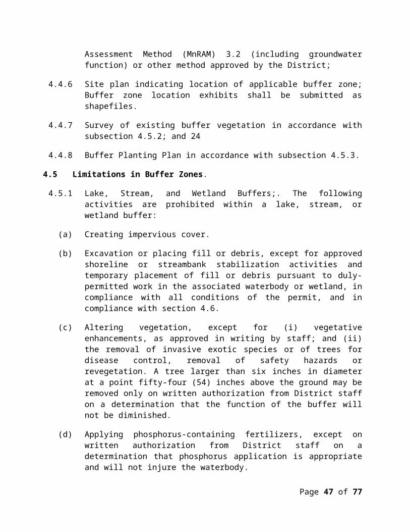
the permittee has not presented an acceptable plan within the time specified or the District finds that the permit holder has not effectively implemented the plan, the District may enter to perform work reasonably directed to prevent and correct the movement of sediment off site or into surface waters or wetlands.
(b) If erosion or sedimentation is discharging or directly threatening a discharge to surface waters or wetlands, the District may enter the site and require or take action as necessary to address the immediate harm.
(c) If eroded soils (including tracked soils from construction activities) enter or appear likely to enter streets, cleanup and repair shall be immediate. The applicant shall provide all traffic control and flagging required to protect the traveling public during the cleanup operations.
(d) In addition to the authorities provided in this subsection 12.5, the District may pursue any other enforcement remedy that Minnesota Statutes chapter 103D and section 12.0 provide.
(e) In implementing subsection 12.4, the District will transmit communications to the permittee or the permittee’s official representative as soon as reasonably possible. However, communication with and notice to the individual identified in the permit or on site as having site responsibility for erosion and sediment control will be considered notice to the permittee sufficient to meet the notice requirements of this subsection. If no such individual is present on site, the District may exercise authority under paragraph 12.4(b) before notice to the permittee.
Page 47 of 51

This is a true and correct copy of the Rules of the Comfort Lake - Forest Lake Watershed District as amended and adopted by the Board of Managers on ___________________, 2017;
The Effective date for the District’s adopted Rules shall be: a___________________, 2017.
_______________________________ Jackie A. Anderson, President
_______________________________ Jon W. Spence, Vice President
_______________________________ Wayne S. Moe, Secretary
_______________________________ Stephen Schmaltz, Treasurer
_______________________________ Jackie McNamara, Assistant Treasurer
Page 48 of 51

Addendum A. Groundwater
A.1.1 Background. The Washington County Water Consortium initiated the process of developing model groundwater rules for future adoption by watershed districts located in Washington County in spring 2004. As part of this process, Emmons and Olivier Resources (EOR) produced a report for the Washington County Water Consortium entitled, “Incorporating Groundwater Protection into Watershed District Rules”. The resulting report provided potential rule language pertaining to groundwater appropriations, volume control, groundwater quality, and groundwater dependent natural resources. The District’s proposed groundwater rules come directly from the EOR report. Because the District rules do not have a section specifically addressing groundwater, language addressing the referenced groundwater issues are scattered throughout the rules discussing other topics (i.e. stormwater management). For this reason, this groundwater addendum consolidates all the district rules concerning groundwater into one place. It is the general policy of the Board of Managers to follow general recommendations presented in the County Groundwater Plans (located in subsection 2.1.9 and section 4.1 of District rules). While Washington County does have an adopted groundwater plan, Chisago County currently does not. Chisago County started work on one in 2007 as part of the Chisago County Geologic Atlas project (in partnership with the Minnesota Geologic Survey and Minnesota Department of Natural Resources). The following bullets represent specific language within the District’s rules pertaining to groundwater and details where each are located in the District’s rules. Each specific rule is categorized in the four headings used in the Washington Water Consortium EOR report; groundwater appropriations, volume control, groundwater quality, and groundwater dependent natural resources.
Groundwater Appropriations
Objective: To monitor the use of groundwater in areas where existing wells and/or groundwater dependent natural resources could be negatively impacted by overuse of groundwater. Negative impacts include reduced flow to surface water bodies, lowering of lake and wetland levels, or interference with other wells.
To manage a sustainable water supply ensuring ample, high quality groundwater is
available for residential, commercial, and natural resource needs. (Appropriations not specifically addressed in rules, however, volume control standards help maintain groundwater supply and protect groundwater quality).
Volume control
Objective: To control the rate and volume of stormwater runoff so that surface water and groundwater quantity and quality are protected, soil erosion is minimized, flooding potential
Page 49 of 51
is reduced, and thermal impacts are reduced. In addition, it is designed to address the preservation of natural infiltration and recharge of groundwater to ensure that subsurface flows are maintained for groundwater dependent natural resources such as lakes, streams, wetlands, plant communities, and drinking water supplies Assure property owners control the rate and volume of stormwater runoff originating
from their property so that surface water and groundwater quantity and quality is protected, soil erosion is minimized, flooding potential is reduced and thermal impacts are reduced (located in subsection 2.1.6 of rules).
Preserve natural infiltration and recharge of groundwater and to maintain subsurface flows which maintain groundwater dependent resources including lakes, streams, wetlands, plant communities and drinking water supplies (located in subsection 2.1.1 of rules).
Groundwater Quality
Objective: To protect groundwater quality while promoting groundwater recharge. Many of the current stormwater management/water quality standards prohibit the use of volume control practices for groundwater in certain applications (e.g. commercial, industrial, and institutional land uses) due to the potential for groundwater contamination. This rule would allow for controlled infiltration in these areas by using best management practices (BMPs) to pre-treat the stormwater runoff before it is infiltrated.
Language included in the District rules pertaining to groundwater quality:
It is the policy of the District: Require management of stormwater flow to limit sediment, nutrient, and metals conveyed
to the groundwater (located in subsection 2.1.4 of rules). Manage land-use activities to minimize adverse impacts to groundwater quality (located
in subsections 2.1.7, 2.5.5, and 8.1 (f) of rules). The District will work with all communities and non-community public water supply
systems as they develop and implement their wellhead protection plan (located in subsection 2.1.8 of District rules).
Groundwater Dependent Natural ResourcesObjective: To protect the unique and sensitive resources found in Washington County. While there is some overlap in this standard with the volume control and groundwater quality standards, it addresses groundwater protection by providing specific criteria for vegetative buffers, stormwater management, water quality, and wetland bounce and duration. Promote groundwater/surface water management practices that protect the hydrologic
functions of groundwater dependent resources (located in subsection 2.5.7 of District rules);
Limit activities that result in the loss of locally/unique groundwater dependent resources (located in subsection 2.1.9 of District rules).
Basin in Contributing Area to Groundwater-Dependent Natural Resource. A stormwater basin within the surface contributing area to a groundwater-dependent natural resource must contain and infiltrate the volume generated by a two-year, 24-hour storm event, if
Page 50 of 51

feasible. The basin bottom must be at least three feet above the seasonally high water table. If this infiltration standard is not met, basin outflow must be non-erosive and routed through a subsurface system, flow spreader or other device that discharges water through or across the ground to lower discharge temperature to that of the ambient soil (located in 2.5.6 of District rules).
If a lake or wetland is a groundwater-dependent natural resource, the buffer will be one hundred (100) feet. If the stream is a groundwater-dependent natural resource, the streamside zone will be fifty (50) feet, and the middle zone one hundred (100) feet (located in subsection 4.3.1 (d) of District rules).
Page 51 of 51