Embed Size (px)
Citation preview
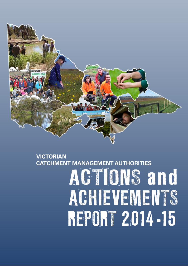
ACTIONS and ACHIEVEMENTS REPORT 2014-15
VICTORIAN CATCHMENT MANAGEMENT AUTHORITIES
Victorian Catchment Management Authorities Actions & Achievements Report 2014-15 page 2
CONTENTSOVERVIEW 4
REGIONS AT A GLANCE 7
KEY FOCUS AREAS 10
KEY FOCUS ONE - Engage Victoria’s Communities in Natural Resource Management 11
KEY FOCUS TWO - Protect and improve the environmental condition of Victoria’s waterways, land and biodiversity 12
KEY FOCUS THREE - Provide good governance and leadership 13
STATE-WIDE ACTIONS AND ACHIEVEMENTS 15
REGIONAL ACTIONS AND ACHIEVEMENTS 19
CORANGAMITE 21
EAST GIPPSLAND 27
GLENELG HOPKINS 33
GOULBURN BROKEN 39
MALLEE 45
NORTH CENTRAL 51
NORTH EAST 57
PORT PHILLIP & WESTERNPORT 63
WEST GIPPSLAND 69
WIMMERA 75
Victorian Catchment Management Authorities Actions & Achievements Report 2014-15 page 3
As a state-wide collective of CMAs it is our vision to inspire and facilitate partnerships and action that achieve improved catchment health. In the 2014-15 year we again worked towards this goal, and this Actions and Achievements Report 2014-15 provides a synopsis of our achievements across the state through the year.
We recognise that all these activities simply wouldn’t have been possible without strong support from our funding partners; the Australian Government and the Victorian State Government. We value our relationships with staff and Ministers at both levels of government and continue to reward this support by delivering excellent projects that improve catchment health. We also recognise the value of strong collaboration with our communities in attaining these outcomes.
The work we do in each CMA region is driven by priorities identified in Regional Catchment Strategies and their associated sub-strategies and plans. This report presents a snapshot of the broad range of activities we completed during the 2014-15 financial year to address these priorities.
We are proud of this work and what has been achieved through partnerships with government agencies, industry, land managers and the wider community. In presenting this Actions and Achievements Report for 2014-15 we hope that readers are encouraged to continue making their vital contributions to the long term health of our catchments; as it is only through these sustained and collaborative efforts that our aspirations for Victoria’s land, water and biodiversity resources can be realised.
FOREWORD
Angus Hume
Victorian Chair of CMA Chairs Group
Angus Hume
Victorian Chair of CMA Chairs Group
Victorian Catchment Management Authorities Actions & Achievements Report 2014-15 page 4
IntroductionThis report highlights the actions and achievements delivered by catchment management authorities in 2014-15 to benefit Victoria’s environment, communities and economy.
It provides a standardised ‘output’ approach to reporting actions delivered annually by funding administered by each of the ten Victorian CMAs; through partnerships with government agencies, industry, land managers and the wider community.
The first of these reports, which was released in 2013-14, focused on documenting the actions delivered under Victorian Government funding. In 2014-15 we have built on this approach by also including outputs achieved through Commonwealth and ‘other’ funding sources.
The report is designed to achieve the following:
Describe outputs simply – by applying a standardised framework to measuring the results of the work we do to improve the environment.
Aggregate outputs – by consistently reporting annual actions and achievements across the ten CMAs for all funding sources.
Improve accountability – by increasng the transparency and sharing of information with stakeholders.
The report is structured as follows:
Overview: Report context and a snapshot of outputs achievements in 2014-15.
Regions at a Glance: Summary of each CMA region.
Key Focus Areas: Highlights state-wide outputs achieved under three key focus areas for CMAs.
State-wide Actions and Achievements: Total outputs achieved by CMAs, key insights or events, and a case study highlighting state-wide delivery.
Regional Actions and Achievements: Outputs achieved by each CMA, key insights or events, and two case studies highlighting regional achievements.
OVERVIEW
Victorian Catchment Management Authorities Actions & Achievements Report 2014-15 page 5
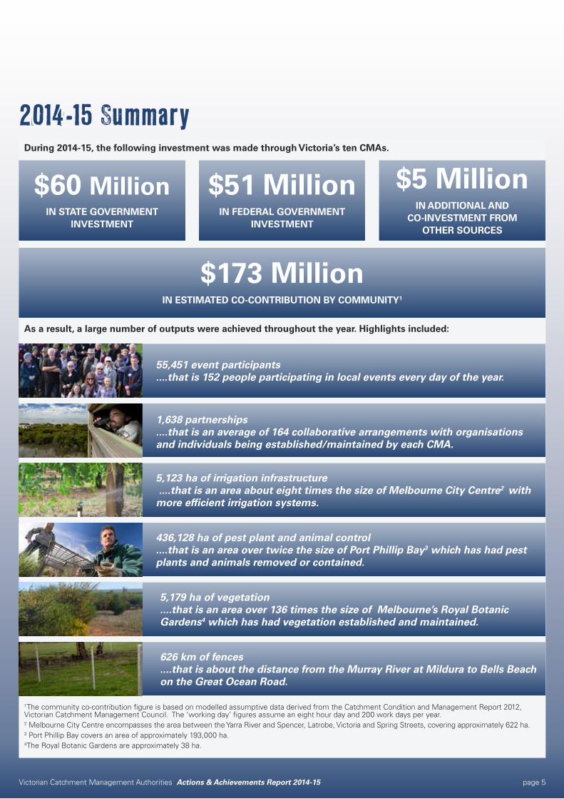
During 2014-15, the following investment was made through Victoria’s ten CMAs.
As a result, a large number of outputs were achieved throughout the year. Highlights included:
1The community co-contribution figure is based on modelled assumptive data derived from the Catchment Condition and Management Report 2012, Victorian Catchment Management Council. The ‘working day’ figures assume an eight hour day and 200 work days per year.2 Melbourne City Centre encompasses the area between the Yarra River and Spencer, Latrobe, Victoria and Spring Streets, covering approximately 622 ha.3 Port Phillip Bay covers an area of approximately 193,000 ha.4The Royal Botanic Gardens are approximately 38 ha.
2014-15 Summary
$51 MillionIN FEDERAL GOVERNMENT
INVESTMENT
$5 MillionIN ADDITIONAL AND
CO-INVESTMENT FROM OTHER SOURCES
$60 MillionIN STATE GOVERNMENT
INVESTMENT
$173 MillionIN ESTIMATED CO-CONTRIBUTION BY COMMUNITY1
1,638 partnerships ....that is an average of 164 collaborative arrangements with organisations and individuals being established/maintained by each CMA.
55,451 event participants....that is 152 people participating in local events every day of the year.
5,123 ha of irrigation infrastructure ....that is an area about eight times the size of Melbourne City Centre2 with more efficient irrigation systems.
436,128 ha of pest plant and animal control....that is an area over twice the size of Port Phillip Bay3 which has had pest plants and animals removed or contained.
5,179 ha of vegetation....that is an area over 136 times the size of Melbourne’s Royal Botanic Gardens4 which has had vegetation established and maintained.
626 km of fences....that is about the distance from the Murray River at Mildura to Bells Beach on the Great Ocean Road.
Victorian Catchment Management Authorities Actions & Achievements Report 2014-15 page 6
Victorian Catchment Management Authorities Actions & Achievements Report 2014-15 page 7
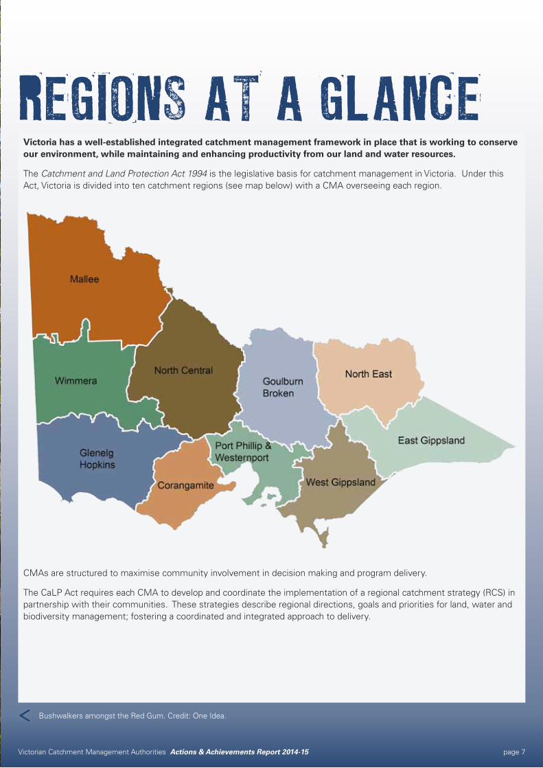
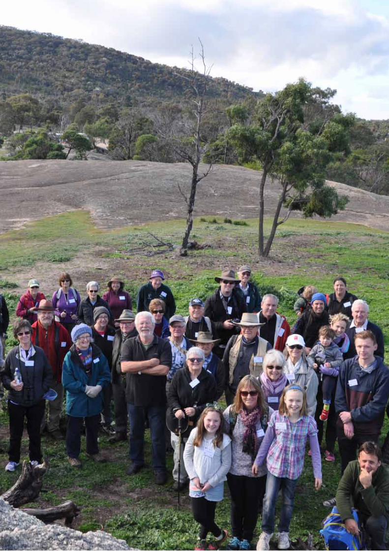
REGIONS AT A GLANCEVictoria has a well-established integrated catchment management framework in place that is working to conserve our environment, while maintaining and enhancing productivity from our land and water resources.
The Catchment and Land Protection Act 1994 is the legislative basis for catchment management in Victoria. Under this Act, Victoria is divided into ten catchment regions (see map below) with a CMA overseeing each region.
CMAs are structured to maximise community involvement in decision making and program delivery.
The CaLP Act requires each CMA to develop and coordinate the implementation of a regional catchment strategy (RCS) in partnership with their communities. These strategies describe regional directions, goals and priorities for land, water and biodiversity management; fostering a coordinated and integrated approach to delivery.
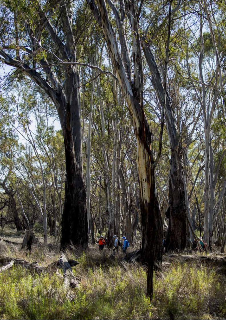
Bushwalkers amongst the Red Gum. Credit: One Idea.
Victorian Catchment Management Authorities Actions & Achievements Report 2014-15 page 8
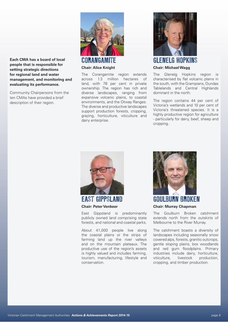
Each CMA has a board of local people that is responsible for setting strategic directions for regional land and water management, and monitoring and evaluating its performance.
Community Chairpersons from the ten CMAs have provided a brief description of their region.
CORANGAMITEChair: Alice Knight
The Corangamite region extends across 1.3 million hectares of land, with 78 per cent in private ownership. The region has rich and diverse landscapes, ranging from expansive volcanic plains, to coastal environments, and the Otway Ranges. The diverse and productive landscapes support production forests, cropping, grazing, horticulture, viticulture and dairy enterprise.
EAST GIPPSLANDChair: Peter Venkeer
East Gippsland is predominantly publicly owned land comprising state forests, and national and coastal parks.
About 41,000 people live along the coastal plains or the strips of farming land up the river valleys and on the mountain plateaux. The productive use of the region’s assets is highly valued and includes farming, tourism, manufacturing, lifestyle and conservation.
GLENELG HOPKINSChair: Michael Wagg
The Glenelg Hopkins region is characterised by flat volcanic plains in the south, with the Grampians, Dundas Tablelands and Central Highlands dominant in the north.
The region contains 44 per cent of Victoria’s wetlands and 10 per cent of Victoria’s threatened species. It is a highly productive region for agriculture - particularly for dairy, beef, sheep and cropping.
GOULBURN BROKENChair: Murray Chapman
The Goulburn Broken catchment extends north from the outskirts of Melbourne to the River Murray.
The catchment boasts a diversity of landscapes including seasonally snow covered alps, forests, granitic outcrops, gentle sloping plains, box woodlands and red gum floodplains. Primary industries include dairy, horticulture, viticulture, livestock production, cropping, and timber production.
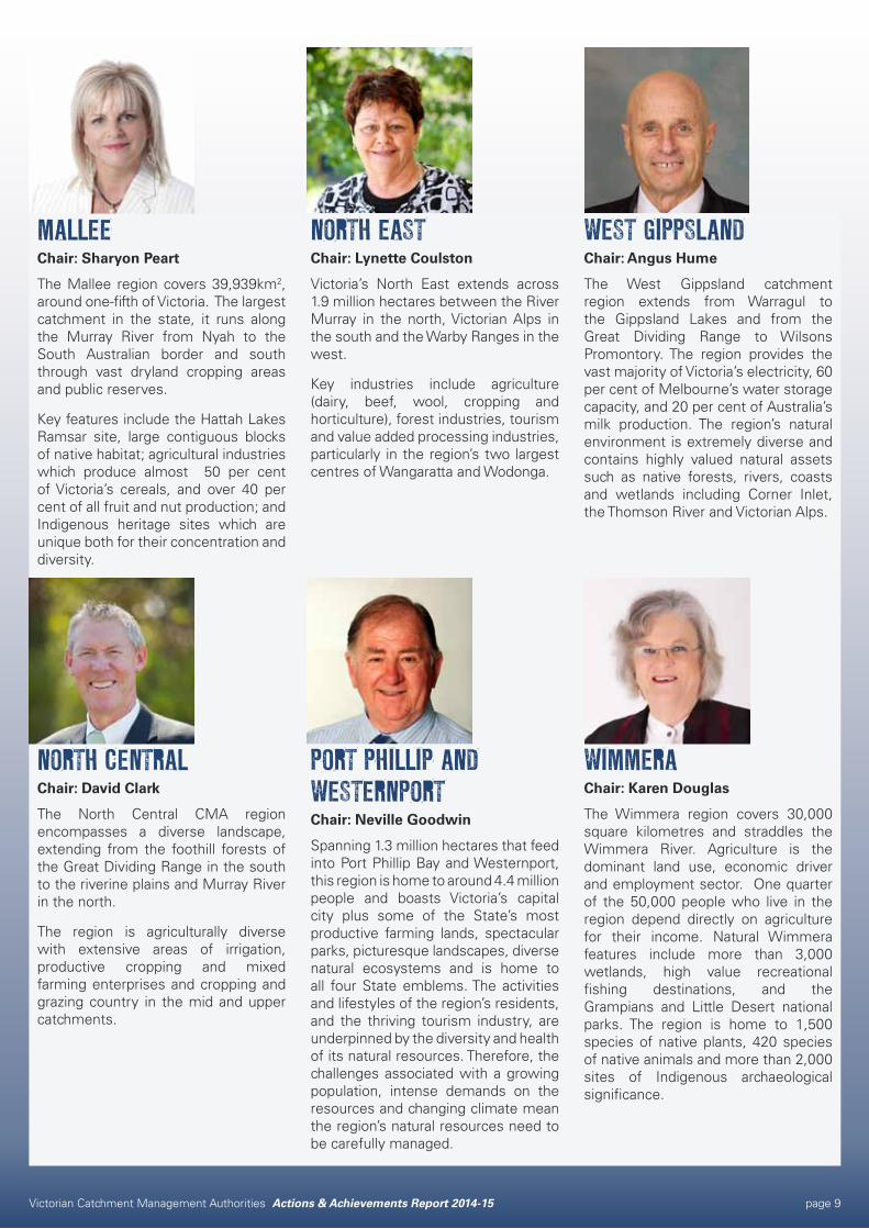
Victorian Catchment Management Authorities Actions & Achievements Report 2014-15 page 9
WEST GIPPSLANDChair: Angus Hume
The West Gippsland catchment region extends from Warragul to the Gippsland Lakes and from the Great Dividing Range to Wilsons Promontory. The region provides the vast majority of Victoria’s electricity, 60 per cent of Melbourne’s water storage capacity, and 20 per cent of Australia’s milk production. The region’s natural environment is extremely diverse and contains highly valued natural assets such as native forests, rivers, coasts and wetlands including Corner Inlet, the Thomson River and Victorian Alps.
WIMMERAChair: Karen Douglas
The Wimmera region covers 30,000 square kilometres and straddles the Wimmera River. Agriculture is the dominant land use, economic driver and employment sector. One quarter of the 50,000 people who live in the region depend directly on agriculture for their income. Natural Wimmera features include more than 3,000 wetlands, high value recreational fishing destinations, and the Grampians and Little Desert national parks. The region is home to 1,500 species of native plants, 420 species of native animals and more than 2,000 sites of Indigenous archaeological significance.
PORT PHILLIP AND WESTERNPORTChair: Neville Goodwin
Spanning 1.3 million hectares that feed into Port Phillip Bay and Westernport, this region is home to around 4.4 million people and boasts Victoria’s capital city plus some of the State’s most productive farming lands, spectacular parks, picturesque landscapes, diverse natural ecosystems and is home to all four State emblems. The activities and lifestyles of the region’s residents, and the thriving tourism industry, are underpinned by the diversity and health of its natural resources. Therefore, the challenges associated with a growing population, intense demands on the resources and changing climate mean the region’s natural resources need to be carefully managed.
MALLEEChair: Sharyon Peart
The Mallee region covers 39,939km2, around one-fifth of Victoria. The largest catchment in the state, it runs along the Murray River from Nyah to the South Australian border and south through vast dryland cropping areas and public reserves.
Key features include the Hattah Lakes Ramsar site, large contiguous blocks of native habitat; agricultural industries which produce almost 50 per cent of Victoria’s cereals, and over 40 per cent of all fruit and nut production; and Indigenous heritage sites which are unique both for their concentration and diversity.
NORTH CENTRALChair: David Clark
The North Central CMA region encompasses a diverse landscape, extending from the foothill forests of the Great Dividing Range in the south to the riverine plains and Murray River in the north.
The region is agriculturally diverse with extensive areas of irrigation, productive cropping and mixed farming enterprises and cropping and grazing country in the mid and upper catchments.
NORTH EASTChair: Lynette Coulston
Victoria’s North East extends across 1.9 million hectares between the River Murray in the north, Victorian Alps in the south and the Warby Ranges in the west.
Key industries include agriculture (dairy, beef, wool, cropping and horticulture), forest industries, tourism and value added processing industries, particularly in the region’s two largest centres of Wangaratta and Wodonga.
Victorian Catchment Management Authorities Actions & Achievements Report 2014-15 page 10
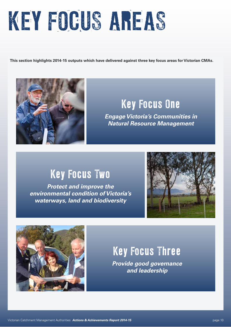
This section highlights 2014-15 outputs which have delivered against three key focus areas for Victorian CMAs.
Key Focus OneEngage Victoria’s Communities in Natural Resource Management
Key Focus TwoProtect and improve the
environmental condition of Victoria’s waterways, land and biodiversity
Key Focus ThreeProvide good governance
and leadership
KEY FOCUS AREAS
Victorian Catchment Management Authorities Actions & Achievements Report 2014-15 page 11
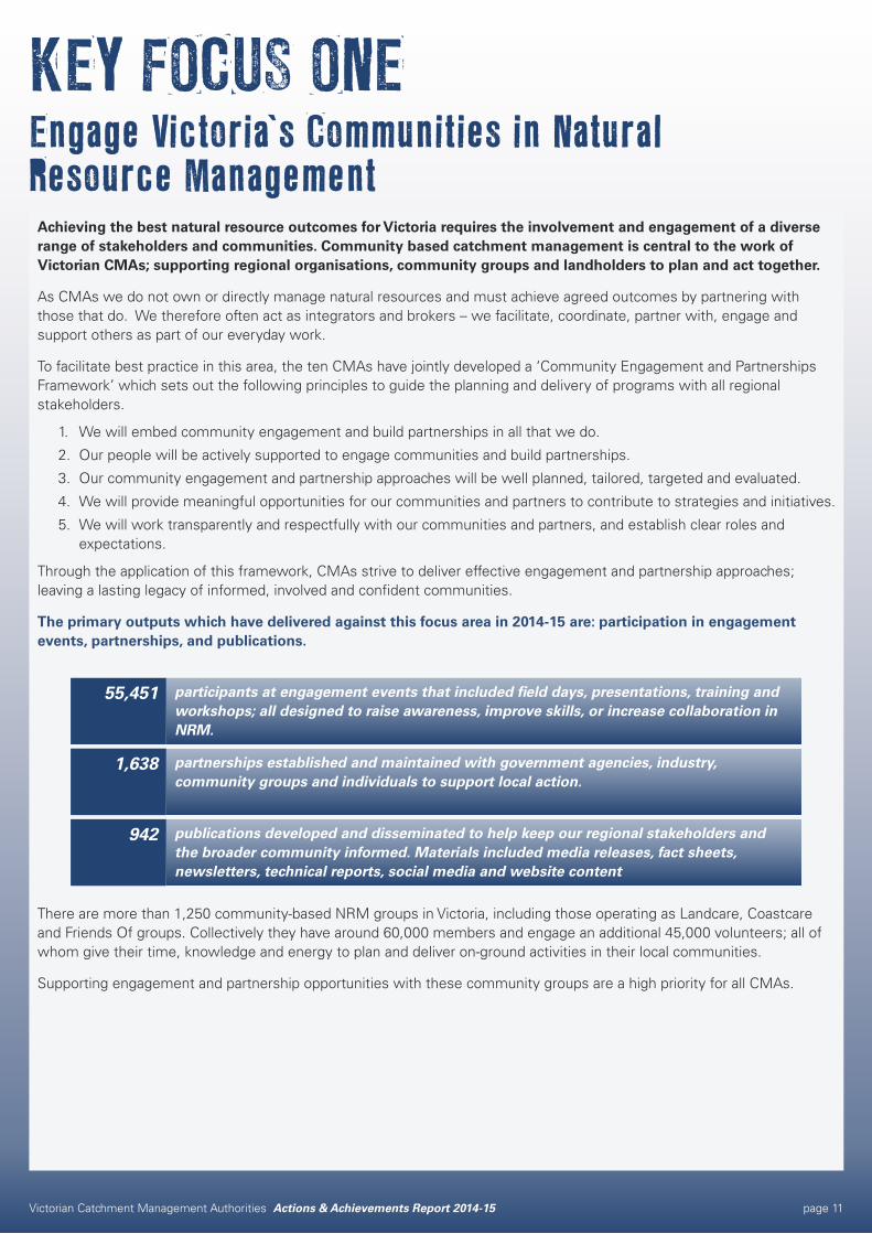
Achieving the best natural resource outcomes for Victoria requires the involvement and engagement of a diverse range of stakeholders and communities. Community based catchment management is central to the work of Victorian CMAs; supporting regional organisations, community groups and landholders to plan and act together.
As CMAs we do not own or directly manage natural resources and must achieve agreed outcomes by partnering with those that do. We therefore often act as integrators and brokers – we facilitate, coordinate, partner with, engage and support others as part of our everyday work.
To facilitate best practice in this area, the ten CMAs have jointly developed a ‘Community Engagement and Partnerships Framework’ which sets out the following principles to guide the planning and delivery of programs with all regional stakeholders.
1. We will embed community engagement and build partnerships in all that we do.
2. Our people will be actively supported to engage communities and build partnerships.
3. Our community engagement and partnership approaches will be well planned, tailored, targeted and evaluated.
4. We will provide meaningful opportunities for our communities and partners to contribute to strategies and initiatives.
5. We will work transparently and respectfully with our communities and partners, and establish clear roles and expectations.
Through the application of this framework, CMAs strive to deliver effective engagement and partnership approaches; leaving a lasting legacy of informed, involved and confident communities.
The primary outputs which have delivered against this focus area in 2014-15 are: participation in engagement events, partnerships, and publications.
There are more than 1,250 community-based NRM groups in Victoria, including those operating as Landcare, Coastcare and Friends Of groups. Collectively they have around 60,000 members and engage an additional 45,000 volunteers; all of whom give their time, knowledge and energy to plan and deliver on-ground activities in their local communities.
Supporting engagement and partnership opportunities with these community groups are a high priority for all CMAs.
publications developed and disseminated to help keep our regional stakeholders and the broader community informed. Materials included media releases, fact sheets, newsletters, technical reports, social media and website content
942
partnerships established and maintained with government agencies, industry, community groups and individuals to support local action.
1,638
participants at engagement events that included field days, presentations, training and workshops; all designed to raise awareness, improve skills, or increase collaboration in NRM.
55,451
KEY FOCUS ONEEngage Victoria’s Communities in Natural Resource Management
Victorian Catchment Management Authorities Actions & Achievements Report 2014-15 page 12
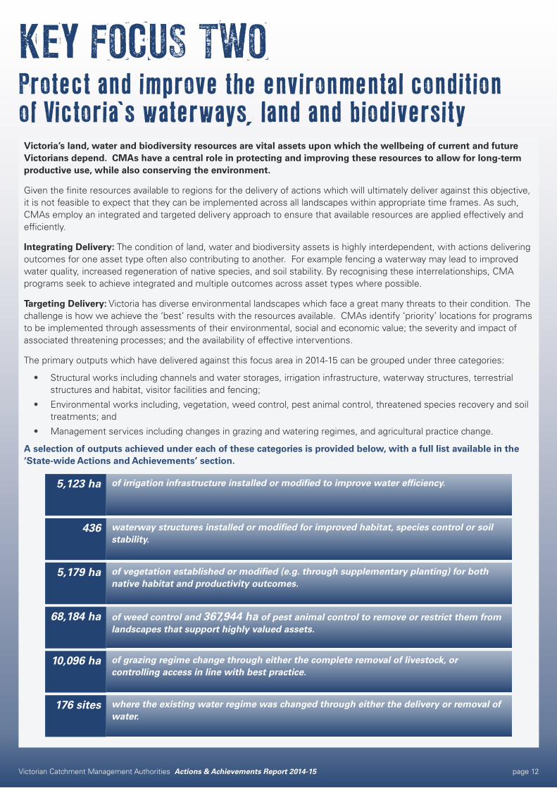
Victoria’s land, water and biodiversity resources are vital assets upon which the wellbeing of current and future Victorians depend. CMAs have a central role in protecting and improving these resources to allow for long-term productive use, while also conserving the environment.
Given the finite resources available to regions for the delivery of actions which will ultimately deliver against this objective, it is not feasible to expect that they can be implemented across all landscapes within appropriate time frames. As such, CMAs employ an integrated and targeted delivery approach to ensure that available resources are applied effectively and efficiently.
Integrating Delivery: The condition of land, water and biodiversity assets is highly interdependent, with actions delivering outcomes for one asset type often also contributing to another. For example fencing a waterway may lead to improved water quality, increased regeneration of native species, and soil stability. By recognising these interrelationships, CMA programs seek to achieve integrated and multiple outcomes across asset types where possible.
Targeting Delivery: Victoria has diverse environmental landscapes which face a great many threats to their condition. The challenge is how we achieve the ‘best’ results with the resources available. CMAs identify ‘priority’ locations for programs to be implemented through assessments of their environmental, social and economic value; the severity and impact of associated threatening processes; and the availability of effective interventions.
The primary outputs which have delivered against this focus area in 2014-15 can be grouped under three categories:
• Structural works including channels and water storages, irrigation infrastructure, waterway structures, terrestrial structures and habitat, visitor facilities and fencing;
• Environmental works including, vegetation, weed control, pest animal control, threatened species recovery and soil treatments; and
• Management services including changes in grazing and watering regimes, and agricultural practice change.
A selection of outputs achieved under each of these categories is provided below, with a full list available in the ‘State-wide Actions and Achievements’ section.
where the existing water regime was changed through either the delivery or removal of water.
176 sites
of grazing regime change through either the complete removal of livestock, or controlling access in line with best practice.
10,096 ha
of weed control and 367,944 ha of pest animal control to remove or restrict them from landscapes that support highly valued assets.
68,184 ha
of vegetation established or modified (e.g. through supplementary planting) for both native habitat and productivity outcomes.
5,179 ha
waterway structures installed or modified for improved habitat, species control or soil stability.
436
of irrigation infrastructure installed or modified to improve water efficiency.5,123 ha
KEY FOCUS TWOProtect and improve the environmental condition of Victoria’s waterways, land and biodiversity
Victorian Catchment Management Authorities Actions & Achievements Report 2014-15 page 13
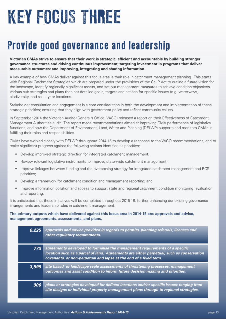
Victorian CMAs strive to ensure that their work is strategic, efficient and accountable by building stronger governance structures and driving continuous improvement; targeting investment in programs that deliver measurable outcomes; and improving, integrating and sharing information.
A key example of how CMAs deliver against this focus area is their role in catchment management planning. This starts with Regional Catchment Strategies which are prepared under the provisions of the CaLP Act to outline a future vision for the landscape, identify regionally significant assets, and set out management measures to achieve condition objectives. Various sub-strategies and plans then set detailed goals, targets and actions for specific issues (e.g. waterways, biodiversity, and salinity) or locations.
Stakeholder consultation and engagement is a core consideration in both the development and implementation of these strategic priorities; ensuring that they align with government policy and reflect community values.
In September 2014 the Victorian Auditor-General’s Office (VAGO) released a report on their Effectiveness of Catchment Management Authorities audit. The report made recommendations aimed at improving CMA performance of legislative functions; and how the Department of Environment, Land, Water and Planning (DELWP) supports and monitors CMAs in fulfilling their roles and responsibilities.
CMAs have worked closely with DELWP throughout 2014-15 to develop a response to the VAGO recommendations, and to make significant progress against the following actions identified as priorities:
• Develop improved strategic direction for integrated catchment management;
• Review relevant legislative instruments to improve state-wide catchment management;
• Improve linkages between funding and the overarching strategy for integrated catchment management and RCS priorities;
• Develop a framework for catchment condition and management reporting; and
• Improve information collation and access to support state and regional catchment condition monitoring, evaluation and reporting.
It is anticipated that these initiatives will be completed throughout 2015-16, further enhancing our existing governance arrangements and leadership roles in catchment management.
The primary outputs which have delivered against this focus area in 2014-15 are: approvals and advice, management agreements, assessments, and plans.
plans or strategies developed for defined locations and/or specific issues; ranging from site designs or individual property management plans through to regional strategies.
900
site based or landscape scale assessments of threatening processes, management outcomes and asset condition to inform future decision making and priorities.
3,599
agreements developed to formalise the management requirements of a specific location such as a parcel of land. Agreements are either perpetual, such as conservation covenants, or non-perpetual and lapse at the end of a fixed term.
773
approvals and advice provided in regards to permits, planning referrals, licences and other regulatory requirements.
6,225
KEY FOCUS THREE Provide good governance and leadership
Victorian Catchment Management Authorities Actions & Achievements Report 2014-15 page 14
Victorian Catchment Management Authorities Actions & Achievements Report 2014-15 page 15
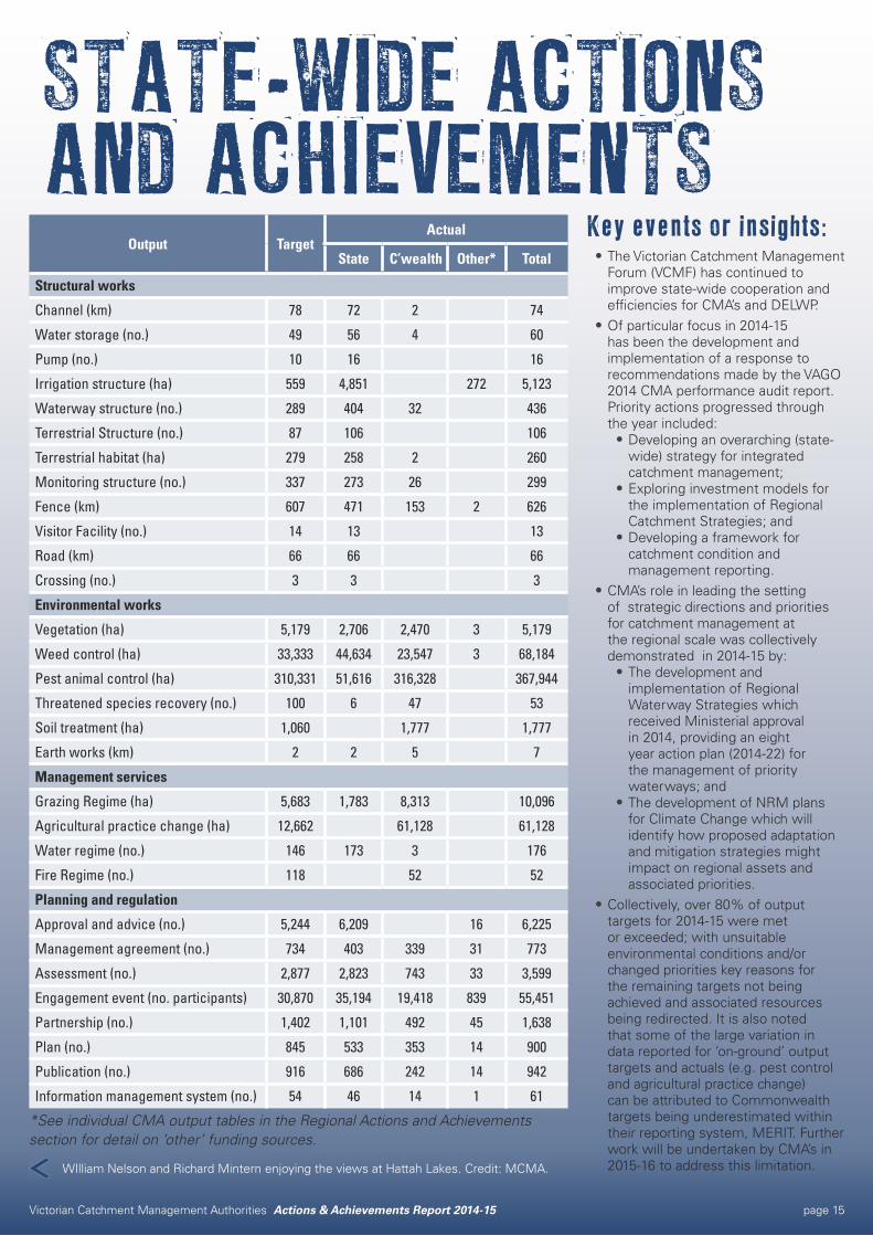
STATE-WIDE ACTIONS AND ACHIEVEMENTS
Output TargetActual
State C’wealth Other* Total
Structural works
Channel (km) 78 72 2 74
Water storage (no.) 49 56 4 60
Pump (no.) 10 16 16
Irrigation structure (ha) 559 4,851 272 5,123
Waterway structure (no.) 289 404 32 436
Terrestrial Structure (no.) 87 106 106
Terrestrial habitat (ha) 279 258 2 260
Monitoring structure (no.) 337 273 26 299
Fence (km) 607 471 153 2 626
Visitor Facility (no.) 14 13 13
Road (km) 66 66 66
Crossing (no.) 3 3 3
Environmental works
Vegetation (ha) 5,179 2,706 2,470 3 5,179
Weed control (ha) 33,333 44,634 23,547 3 68,184
Pest animal control (ha) 310,331 51,616 316,328 367,944
Threatened species recovery (no.) 100 6 47 53
Soil treatment (ha) 1,060 1,777 1,777
Earth works (km) 2 2 5 7
Management services
Grazing Regime (ha) 5,683 1,783 8,313 10,096
Agricultural practice change (ha) 12,662 61,128 61,128
Water regime (no.) 146 173 3 176
Fire Regime (no.) 118 52 52
Planning and regulation
Approval and advice (no.) 5,244 6,209 16 6,225
Management agreement (no.) 734 403 339 31 773
Assessment (no.) 2,877 2,823 743 33 3,599
Engagement event (no. participants) 30,870 35,194 19,418 839 55,451
Partnership (no.) 1,402 1,101 492 45 1,638
Plan (no.) 845 533 353 14 900
Publication (no.) 916 686 242 14 942
Information management system (no.) 54 46 14 1 61
*See individual CMA output tables in the Regional Actions and Achievements section for detail on ‘other’ funding sources.
Key events or insights:•The Victorian Catchment Management
Forum (VCMF) has continued to improve state-wide cooperation and efficiencies for CMA’s and DELWP.
•Of particular focus in 2014-15 has been the development and implementation of a response to recommendations made by the VAGO 2014 CMA performance audit report. Priority actions progressed through the year included:•Developing an overarching (state-
wide) strategy for integrated catchment management;
•Exploring investment models for the implementation of Regional Catchment Strategies; and
•Developing a framework for catchment condition and management reporting.
•CMA’s role in leading the setting of strategic directions and priorities for catchment management at the regional scale was collectively demonstrated in 2014-15 by:•The development and
implementation of Regional Waterway Strategies which received Ministerial approval in 2014, providing an eight year action plan (2014-22) for the management of priority waterways; and
•The development of NRM plans for Climate Change which will identify how proposed adaptation and mitigation strategies might impact on regional assets and associated priorities.
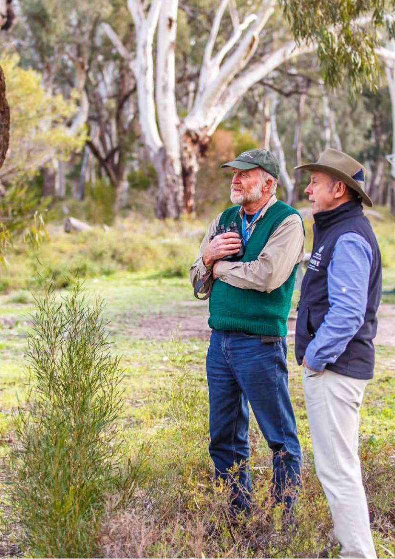
•Collectively, over 80% of output targets for 2014-15 were met or exceeded; with unsuitable environmental conditions and/or changed priorities key reasons for the remaining targets not being achieved and associated resources being redirected. It is also noted that some of the large variation in data reported for ‘on-ground’ output targets and actuals (e.g. pest control and agricultural practice change) can be attributed to Commonwealth targets being underestimated within their reporting system, MERIT. Further work will be undertaken by CMA’s in 2015-16 to address this limitation.WIlliam Nelson and Richard Mintern enjoying the views at Hattah Lakes. Credit: MCMA.
Victorian Catchment Management Authorities Actions & Achievements Report 2014-15 page 16
The objective of Victorian Landcare Program support delivered through each of Victoria’s ten CMAs is to promote effective participation in Landcare activities, help build volunteer capacity and assist communities to deliver local action.
There are more than 750 Landcare groups and networks, and more than 500 other community-based natural resource management groups (NRM) in Victoria. These groups include around 60,000 members and an additional 45,000 volunteers that contribute their time and energy each year to undertake local action to care for the land.
In 2014-15, CMAs worked together to strengthen community engagement, participation, and delivery partnerships through regional delivery of the Victorian Government’s Victorian Landcare Program.
Funding was delivered to 104 groups and 37 networks for new projects that supported their volunteers and landholders to address local priorities and undertake actions that improve the condition of our environment and the sustainability of farming. Start-up grants were also provided to help establish three new groups and increase volunteer participation in Landcare.
Cultural heritage information workshops conducted in eight CMA regions helped strengthen working relationships between non-Indigenous Landcare groups and Indigenous people. The Traditional Owner-led workshop ‘Walking Together Across Big Mountain’, for example, was delivered at the You Yangs in the Corangamite CMA region in partnership with Wadawurrung. The 52 participants increased their knowledge and understanding of the history of the local region, stone artefacts, rock wells, scatters, and processes for identifying cultural sites and tools.
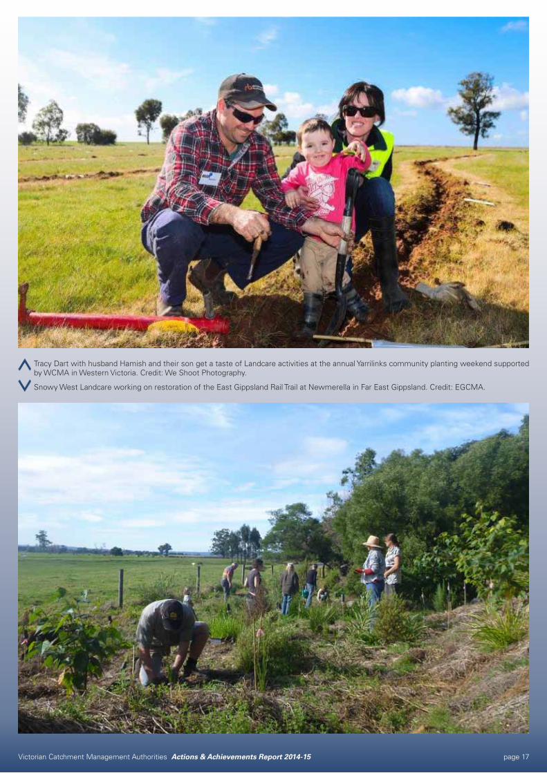
Overall, 3,679 people participated in events coordinated by CMAs with local Landcarers to recognise and celebrate volunteer efforts, while promoting the objectives of the Victorian Landcare Program. Tracy Dart, pictured with family, was one of the many Victorians who participated in Landcare activities for the first time in 2014-15.
CMAs were able to help thank volunteers for their enormous contribution through regional awards presented to 86 recipients in six regions. At the East Gippsland Regional Landcare Awards held in Lakes Entrance in May, for example, 100 attendees congratulated award winners including the Glenaladale Landcare Group. “We are such a small group, so it was terrific for our work to be recognised and show what a small but dedicated group can achieve,” group secretary Julie Webb said.
Regional delivery of the Victorian Landcare Program is funded annually by the Victorian Government. This funding supports each of the ten CMA regions to deliver on their shared commitment to Landcare groups and networks to help build community capacity for local planning, engaging people, building partnerships, doing on-ground works, sharing stories and skills, and celebrating success.
“Getting involved in Yarrilinks and Landcare has been a great experience for us as a family. It’s lovely to be part of a group that makes a real difference to the local environment and to our community.”
Tracy Dart, Yarrilinks group member
OUTPUTS 2014-15Engagement event participants: 3,679
Partnership: 497
Plan: 14
Publication: 125
PARTNERSDELWP
DEDJTR
Landcare networks and groups
Other community-based NRM groups
REGIONAL STRATEGIESRegional Catchment Strategies
Regional Landcare Support Plans
Victorian Landcare Program
Victorian Catchment Management Authorities Actions & Achievements Report 2014-15 page 17
Tracy Dart with husband Hamish and their son get a taste of Landcare activities at the annual Yarrilinks community planting weekend supported by WCMA in Western Victoria. Credit: We Shoot Photography.
Snowy West Landcare working on restoration of the East Gippsland Rail Trail at Newmerella in Far East Gippsland. Credit: EGCMA.
Victorian Catchment Management Authorities Actions & Achievements Report 2014-15 page 18
Victorian Catchment Management Authorities Actions & Achievements Report 2014-15 page 19
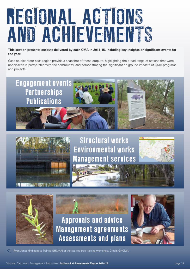
REGIONAL ACTIONS AND ACHIEVEMENTS
This section presents outputs delivered by each CMA in 2014-15, including key insights or significant events for the year.
Case studies from each region provide a snapshot of these outputs, highlighting the broad range of actions that were undertaken in partnership with the community, and demonstrating the significant on-ground impacts of CMA programs and projects.
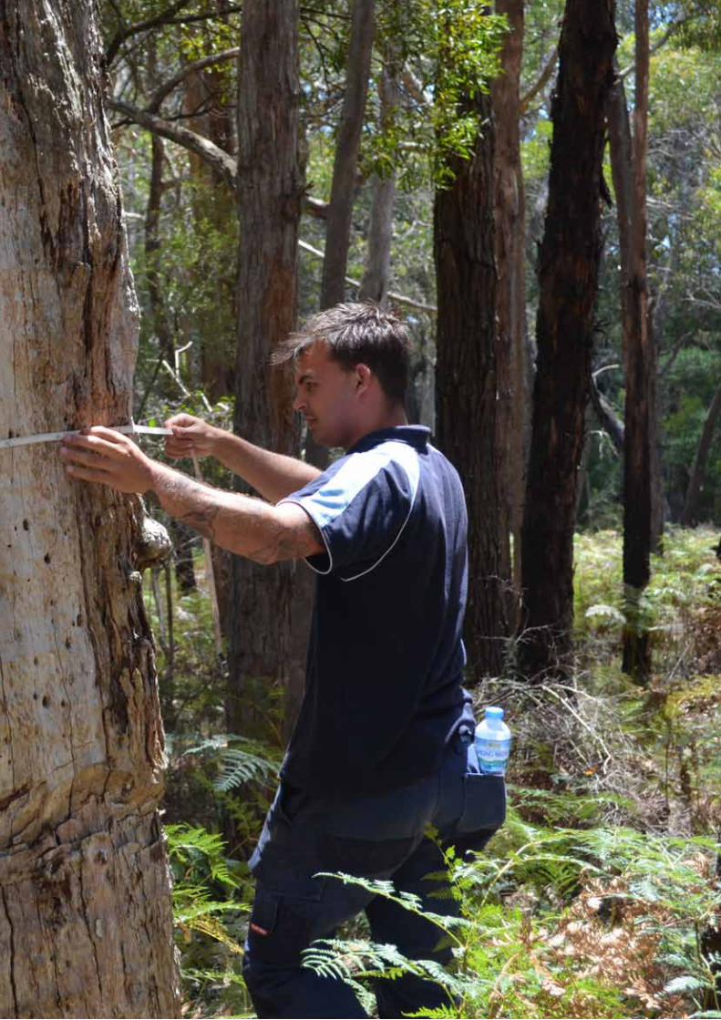
Ryan Jones (Indigenous Trainee GHCMA) at the scarred tree training workshop. Credit: GHCMA.
Engagement events Partnerships Publications
Structural worksEnvironmental worksManagement services
Approvals and adviceManagement agreementsAssessments and plans
Victorian Catchment Management Authorities Actions & Achievements Report 2014-15 page 20
Victorian Catchment Management Authorities Actions & Achievements Report 2014-15 page 21
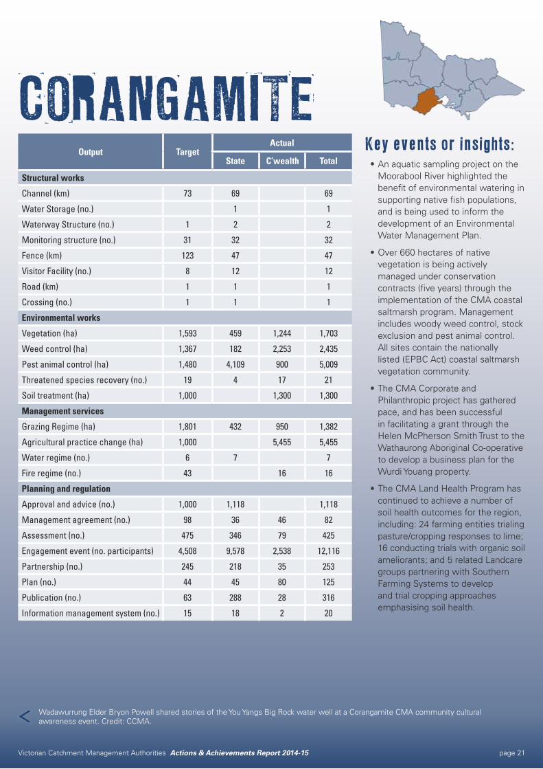
CORANGAMITEKey events or insights:•An aquatic sampling project on the
Moorabool River highlighted the benefit of environmental watering in supporting native fish populations, and is being used to inform the development of an Environmental Water Management Plan.
•Over 660 hectares of native vegetation is being actively managed under conservation contracts (five years) through the implementation of the CMA coastal saltmarsh program. Management includes woody weed control, stock exclusion and pest animal control. All sites contain the nationally listed (EPBC Act) coastal saltmarsh vegetation community.
•The CMA Corporate and Philanthropic project has gathered pace, and has been successful in facilitating a grant through the Helen McPherson Smith Trust to the Wathaurong Aboriginal Co-operative to develop a business plan for the Wurdi Youang property.
•The CMA Land Health Program has continued to achieve a number of soil health outcomes for the region, including: 24 farming entities trialing pasture/cropping responses to lime; 16 conducting trials with organic soil ameliorants; and 5 related Landcare groups partnering with Southern Farming Systems to develop and trial cropping approaches emphasising soil health.
Output TargetActual
State C’wealth Total
Structural works
Channel (km) 73 69 69
Water Storage (no.) 1 1
Waterway Structure (no.) 1 2 2
Monitoring structure (no.) 31 32 32
Fence (km) 123 47 47
Visitor Facility (no.) 8 12 12
Road (km) 1 1 1
Crossing (no.) 1 1 1
Environmental works
Vegetation (ha) 1,593 459 1,244 1,703
Weed control (ha) 1,367 182 2,253 2,435
Pest animal control (ha) 1,480 4,109 900 5,009
Threatened species recovery (no.) 19 4 17 21
Soil treatment (ha) 1,000 1,300 1,300
Management services
Grazing Regime (ha) 1,801 432 950 1,382
Agricultural practice change (ha) 1,000 5,455 5,455
Water regime (no.) 6 7 7
Fire regime (no.) 43 16 16
Planning and regulation
Approval and advice (no.) 1,000 1,118 1,118
Management agreement (no.) 98 36 46 82
Assessment (no.) 475 346 79 425
Engagement event (no. participants) 4,508 9,578 2,538 12,116
Partnership (no.) 245 218 35 253
Plan (no.) 44 45 80 125
Publication (no.) 63 288 28 316
Information management system (no.) 15 18 2 20
Wadawurrung Elder Bryon Powell shared stories of the You Yangs Big Rock water well at a Corangamite CMA community cultural awareness event. Credit: CCMA.
Victorian Catchment Management Authorities Actions & Achievements Report 2014-15 page 22
OUTPUTS 2014-15Vegetation: 1,129 Ha
Weed control: 458 Ha
Pest animal control: 420 Ha
Grazing regime: 1 Ha
Management agreement: 16
Assessment: 63
Engagement event participants: 162
Plan: 1
Publication: 4
PARTNERSAustralasian Native Orchid Society
Australian Government Environment Protection and Biodiversity Conservation Unit
Central Highlands Water
Colac Otway Shire
Country Fire Authority
DELWP
Friends of Inverleigh Flora & Fauna Reserve
Golden Plains Shire
Greening Australia
Linear reserve managers
Mt Rothwell Biodiversity Interpretation Centre
National Trust
Parks Victoria
Private landholders
Royal Botanical Gardens volunteers
Sovereign Hill (Narmbool)
Trust for Nature
REGIONAL STRATEGIESCorangamite Regional Catchment Strategy
Victorian Volcanic Plains and Western District Lakes Recovery Project
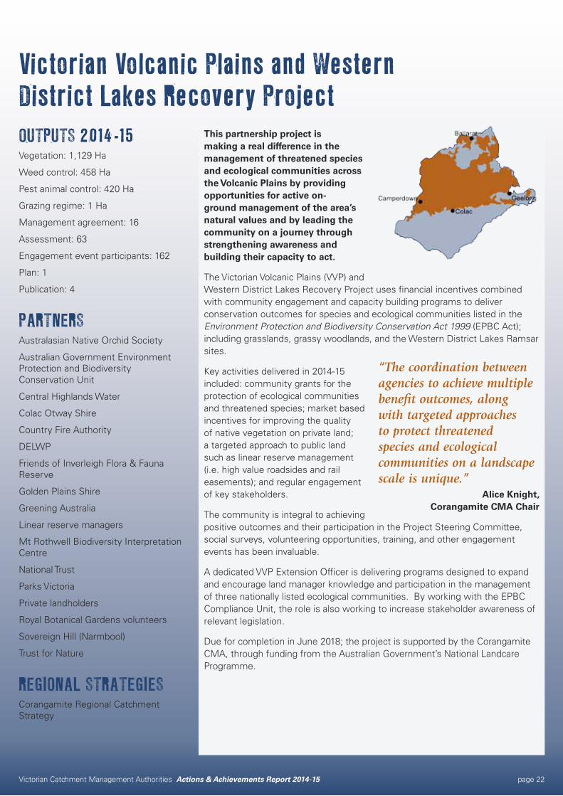
This partnership project is making a real difference in the management of threatened species and ecological communities across the Volcanic Plains by providing opportunities for active on-ground management of the area’s natural values and by leading the community on a journey through strengthening awareness and building their capacity to act.
The Victorian Volcanic Plains (VVP) and Western District Lakes Recovery Project uses financial incentives combined with community engagement and capacity building programs to deliver conservation outcomes for species and ecological communities listed in the Environment Protection and Biodiversity Conservation Act 1999 (EPBC Act); including grasslands, grassy woodlands, and the Western District Lakes Ramsar sites.
Key activities delivered in 2014-15 included: community grants for the protection of ecological communities and threatened species; market based incentives for improving the quality of native vegetation on private land; a targeted approach to public land such as linear reserve management (i.e. high value roadsides and rail easements); and regular engagement of key stakeholders.
The community is integral to achieving positive outcomes and their participation in the Project Steering Committee, social surveys, volunteering opportunities, training, and other engagement events has been invaluable.
A dedicated VVP Extension Officer is delivering programs designed to expand and encourage land manager knowledge and participation in the management of three nationally listed ecological communities. By working with the EPBC Compliance Unit, the role is also working to increase stakeholder awareness of relevant legislation.
Due for completion in June 2018; the project is supported by the Corangamite CMA, through funding from the Australian Government’s National Landcare Programme.
“The coordination between agencies to achieve multiple benefit outcomes, along with targeted approaches to protect threatened species and ecological communities on a landscape scale is unique.”
Alice Knight, Corangamite CMA Chair
Victorian Catchment Management Authorities Actions & Achievements Report 2014-15 page 23
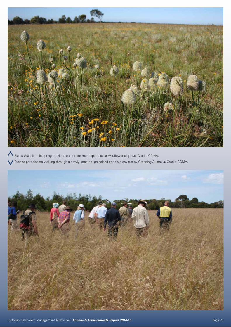
Plains Grassland in spring provides one of our most spectacular wildflower displays. Credit: CCMA.
Excited participants walking through a newly ‘created’ grassland at a field day run by Greening Australia. Credit: CCMA.
Victorian Catchment Management Authorities Actions & Achievements Report 2014-15 page 24
OUTPUTS 2014-15Plan: 1
Information management system: 1
PARTNERSCentre for eResearch and Digital Innovation
Surf Coast Inland Plains Network
Woady Yaloak Catchment Group
REGIONAL STRATEGIESCorangamite Marine and Coastal Biodiversity Strategy
Corangamite Native Vegetation Plan
Corangamite Regional Catchment Strategy
Corangamite Soil Health Strategy
Corangamite Waterway Strategy
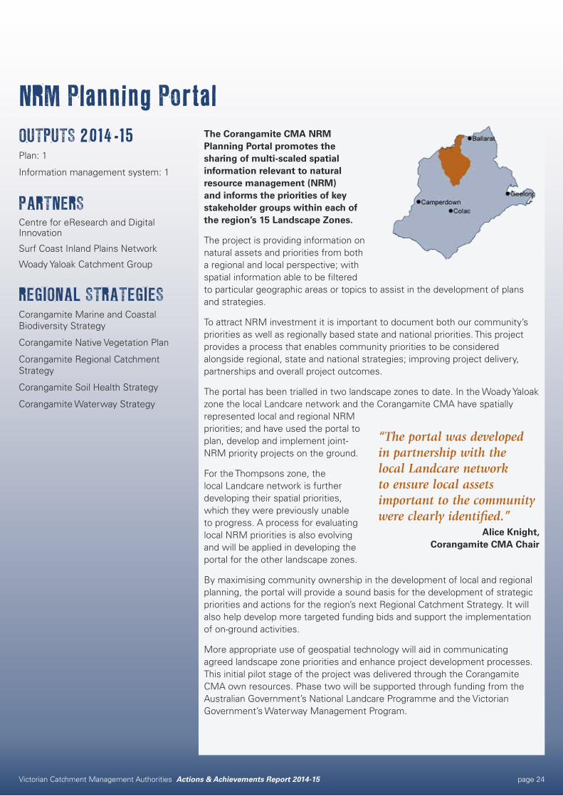
NRM Planning PortalThe Corangamite CMA NRM Planning Portal promotes the sharing of multi-scaled spatial information relevant to natural resource management (NRM) and informs the priorities of key stakeholder groups within each of the region’s 15 Landscape Zones.
The project is providing information on natural assets and priorities from both a regional and local perspective; with spatial information able to be filtered to particular geographic areas or topics to assist in the development of plans and strategies.
To attract NRM investment it is important to document both our community’s priorities as well as regionally based state and national priorities. This project provides a process that enables community priorities to be considered alongside regional, state and national strategies; improving project delivery, partnerships and overall project outcomes.
The portal has been trialled in two landscape zones to date. In the Woady Yaloak zone the local Landcare network and the Corangamite CMA have spatially represented local and regional NRM priorities; and have used the portal to plan, develop and implement joint-NRM priority projects on the ground.
For the Thompsons zone, the local Landcare network is further developing their spatial priorities, which they were previously unable to progress. A process for evaluating local NRM priorities is also evolving and will be applied in developing the portal for the other landscape zones.
By maximising community ownership in the development of local and regional planning, the portal will provide a sound basis for the development of strategic priorities and actions for the region’s next Regional Catchment Strategy. It will also help develop more targeted funding bids and support the implementation of on-ground activities.
More appropriate use of geospatial technology will aid in communicating agreed landscape zone priorities and enhance project development processes. This initial pilot stage of the project was delivered through the Corangamite CMA own resources. Phase two will be supported through funding from the Australian Government’s National Landcare Programme and the Victorian Government’s Waterway Management Program.
“The portal was developed in partnership with the local Landcare network to ensure local assets important to the community were clearly identified.”
Alice Knight, Corangamite CMA Chair

Victorian Catchment Management Authorities Actions & Achievements Report 2014-15 page 25
Corangamite CMA new online planning portal matching regional and local priorities to identify partnership opportunities in catchment management. Credit: CCMA.
Corangamite CMA Planning Portal up and running showing local and regional priorities. Credit: CCMA.
Victorian Catchment Management Authorities Actions & Achievements Report 2014-15 page 26
Victorian Catchment Management Authorities Actions & Achievements Report 2014-15 page 27
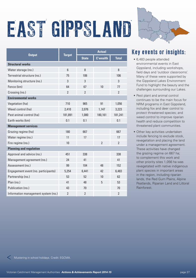
EAST GIPPSLANDKey events or insights:•6,483 people attended
environmental events in East Gippsland, including workshops, field days and ‘outdoor classrooms’. Many of these were supported by the Gippsland Lakes Environment Fund to highlight the beauty and the challenges surrounding our Lakes.
•Pest plant and animal control continues to be the main focus for NRM programs in East Gippsland, including fox and deer control to protect threatened species; and weed control to improve riparian health and reduce competition to threatened plant communities.
•Other key activities undertaken include fencing to exclude stock, revegetation and placing the land under a management agreement. These activities have changed the grazing regime on 667 ha; to complement this work and other priority sites 1,056 ha was revegetated with native indigenous plant species in important areas in the region, including riparian lands, the Red Gum Plains, Alpine Peatlands, Riparian Land and Littoral Rainforest.
Output TargetActual
State C’wealth Total
Structural works
Water storage (no.) 6 8 8
Terrestrial structure (no.) 75 106 106
Monitoring structure (no.) 3 3 3
Fence (km) 64 67 10 77
Crossing (no.) 2 2 2
Environmental works
Vegetation (ha) 710 965 91 1,056
Weed control (ha) 2,410 2,076 1,147 3,223
Pest animal control (ha) 181,891 1,080 180,161 181,241
Earth works (km) 0.1 0.1 0.1
Management services
Grazing regime (ha) 180 667 667
Water regime (no.) 11 17 17
Fire regime (no.) 10 2 2
Planning and regulation
Approval and advice (no.) 451 338 338
Management agreement (no.) 24 41 41
Assessment (no.) 99 104 48 152
Engagement event (no. participants) 5,254 6,441 42 6,483
Partnership (no.) 53 52 10 62
Plan (no.) 41 48 5 53
Publication (no.) 43 70 70
Information management system (no.) 2 2 2
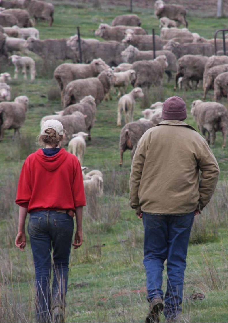
Mustering in school holidays. Credit: EGCMA.
Victorian Catchment Management Authorities Actions & Achievements Report 2014-15 page 28
Rehabilitating the Gippsland Lakes ShorelineOUTPUTS 2014-15Water storage: 17
Fence: 12 km
Vegetation: 84 ha
Weed control: 41 ha
Management agreement: 30
PARTNERSDELWP
Landholders
Parks Victoria
REGIONAL STRATEGIESEast Gippsland Regional Catchment Strategy
East Gippsland Waterway Strategy
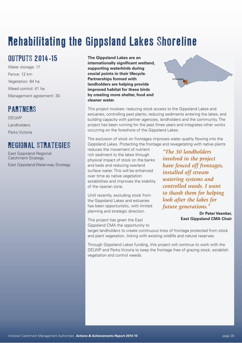
The Gippsland Lakes are an internationally significant wetland, supporting waterbirds during crucial points in their lifecycle. Partnerships formed with landholders are helping provide improved habitat for these birds by creating more shelter, food and cleaner water.
This project involves: reducing stock access to the Gippsland Lakes and estuaries; controlling pest plants; reducing sediments entering the lakes; and building capacity with partner agencies, landholders and the community. The project has been running for the past three years and integrates other works occurring on the foreshore of the Gippsland Lakes.
The exclusion of stock on frontages improves water quality flowing into the Gippsland Lakes. Protecting the frontage and revegetating with native plants reduces the movement of nutrient rich sediment to the lakes through physical impact of stock on the banks and beds and reducing overland surface water. This will be enhanced over time as native vegetation establishes and improves the stability of the riparian zone.
Until recently, excluding stock from the Gippsland Lakes and estuaries has been opportunistic, with limited planning and strategic direction.
This project has given the East Gippsland CMA the opportunity to target landholders to create continuous lines of frontage protected from stock and plant vegetation, linking with existing wildlife and natural reserves.
Through Gippsland Lakes funding, this project will continue to work with the DELWP and Parks Victoria to keep the frontage free of grazing stock, establish vegetation and control weeds.
“The 30 landholders involved in the project have fenced off frontages, installed off stream watering systems and controlled weeds. I want to thank them for helping look after the lakes for future generations.”
Dr Peter Veenker, East Gippsland CMA Chair
Victorian Catchment Management Authorities Actions & Achievements Report 2014-15 page 29
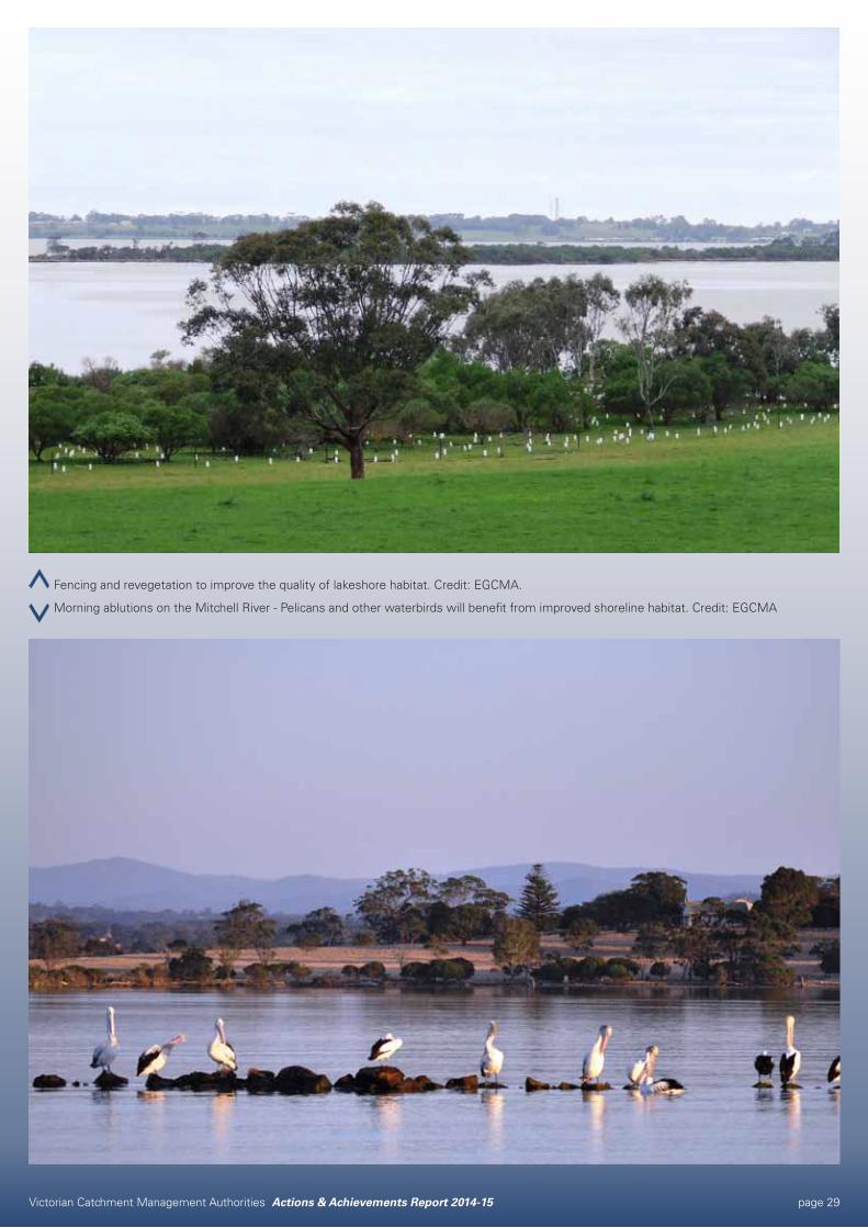
Fencing and revegetation to improve the quality of lakeshore habitat. Credit: EGCMA.
Morning ablutions on the Mitchell River - Pelicans and other waterbirds will benefit from improved shoreline habitat. Credit: EGCMA
Victorian Catchment Management Authorities Actions & Achievements Report 2014-15 page 30
East Gippsland’s TopsoilsOUTPUTS 2014-15Engagement event participants: 100
PARTNERSDEDJTR
Greening Australia
Landcare
Landholders
Southern Farming Systems
REGIONAL STRATEGIESEast Gippsland Regional Catchment Strategy
East Gippsland Soil Erosion Management Plan
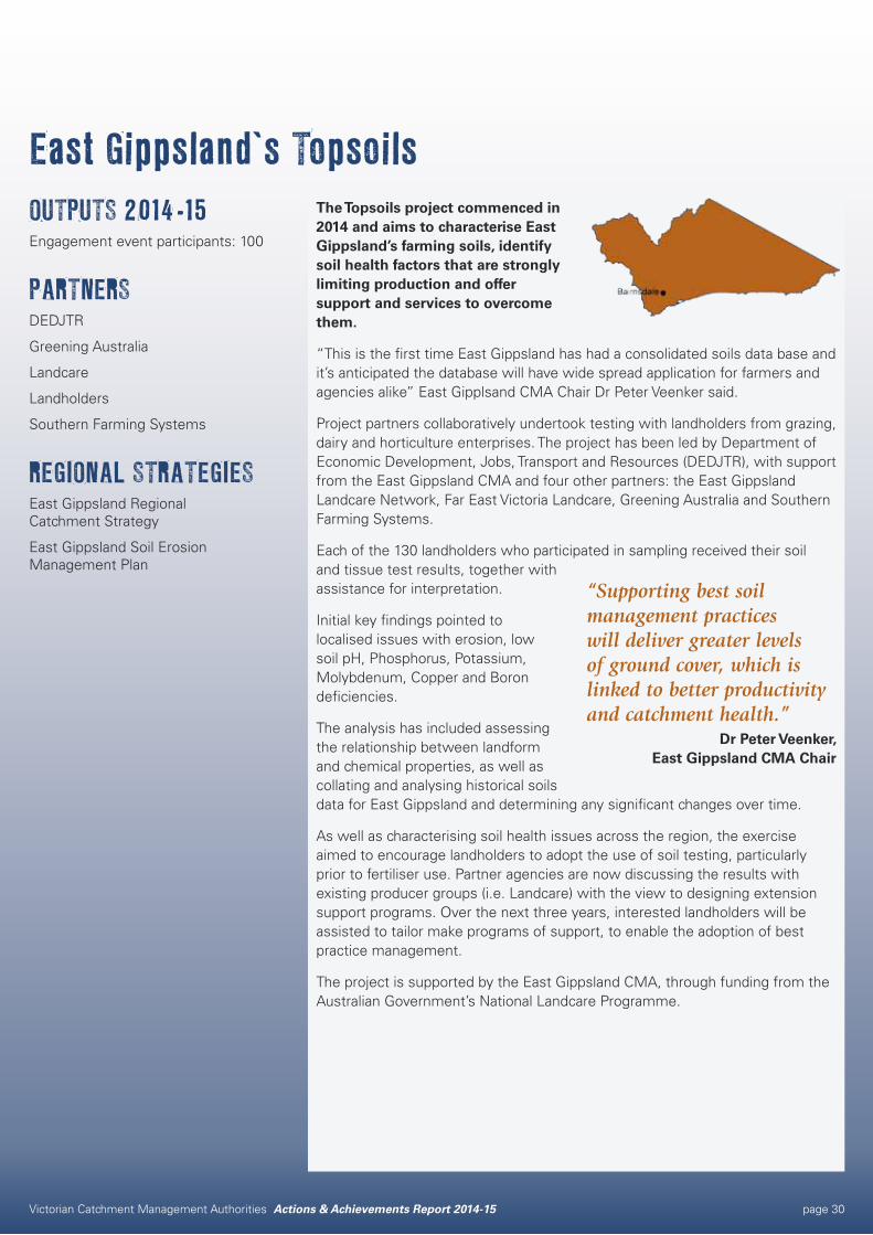
The Topsoils project commenced in 2014 and aims to characterise East Gippsland’s farming soils, identify soil health factors that are strongly limiting production and offer support and services to overcome them.
“This is the first time East Gippsland has had a consolidated soils data base and it’s anticipated the database will have wide spread application for farmers and agencies alike” East Gipplsand CMA Chair Dr Peter Veenker said.
Project partners collaboratively undertook testing with landholders from grazing, dairy and horticulture enterprises. The project has been led by Department of Economic Development, Jobs, Transport and Resources (DEDJTR), with support from the East Gippsland CMA and four other partners: the East Gippsland Landcare Network, Far East Victoria Landcare, Greening Australia and Southern Farming Systems.
Each of the 130 landholders who participated in sampling received their soil and tissue test results, together with assistance for interpretation.
Initial key findings pointed to localised issues with erosion, low soil pH, Phosphorus, Potassium, Molybdenum, Copper and Boron deficiencies.
The analysis has included assessing the relationship between landform and chemical properties, as well as collating and analysing historical soils data for East Gippsland and determining any significant changes over time.
As well as characterising soil health issues across the region, the exercise aimed to encourage landholders to adopt the use of soil testing, particularly prior to fertiliser use. Partner agencies are now discussing the results with existing producer groups (i.e. Landcare) with the view to designing extension support programs. Over the next three years, interested landholders will be assisted to tailor make programs of support, to enable the adoption of best practice management.
The project is supported by the East Gippsland CMA, through funding from the Australian Government’s National Landcare Programme.
“Supporting best soil management practices will deliver greater levels of ground cover, which is linked to better productivity and catchment health.”
Dr Peter Veenker, East Gippsland CMA Chair
Victorian Catchment Management Authorities Actions & Achievements Report 2014-15 page 31
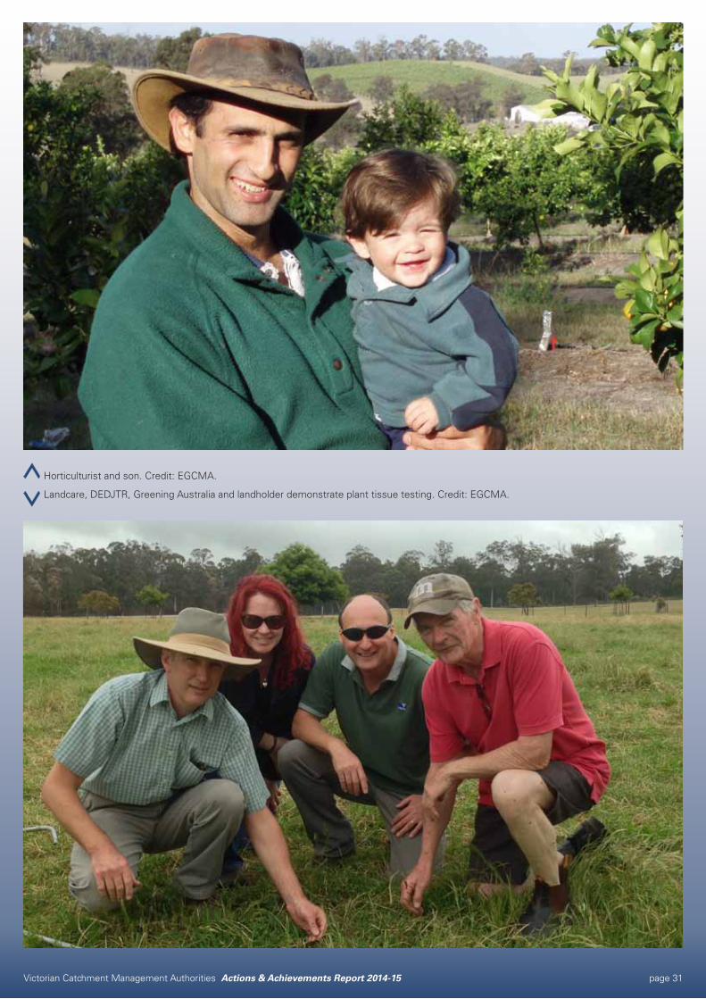
Horticulturist and son. Credit: EGCMA.
Landcare, DEDJTR, Greening Australia and landholder demonstrate plant tissue testing. Credit: EGCMA.

Victorian Catchment Management Authorities Actions & Achievements Report 2014-15 page 32
Victorian Catchment Management Authorities Actions & Achievements Report 2014-15 page 33
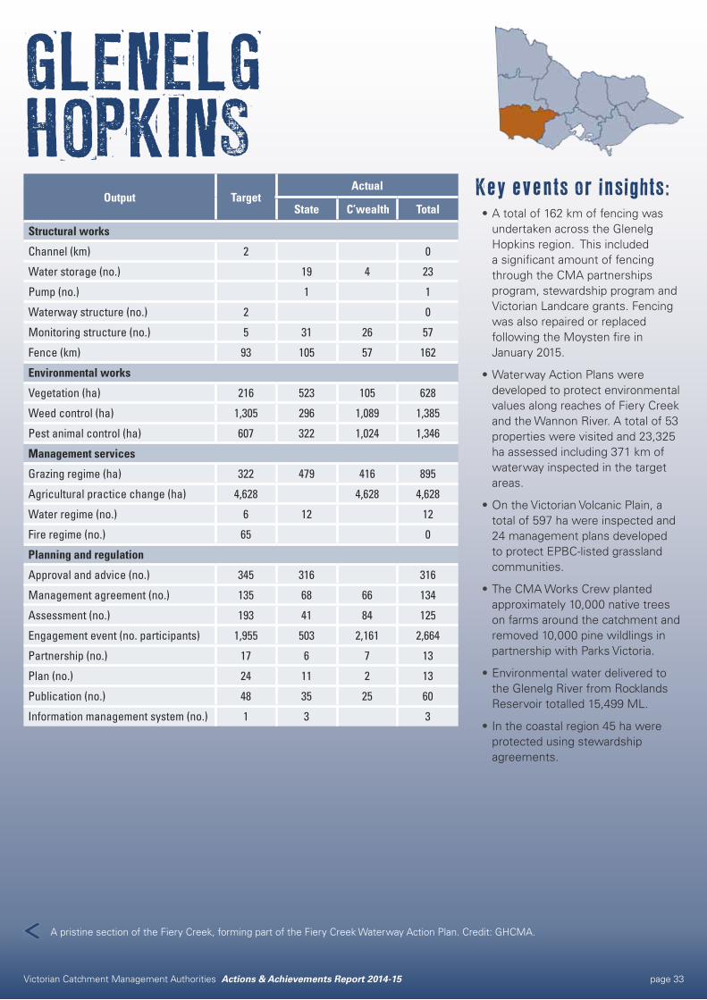
GLENELG HOPKINS
Key events or insights:•A total of 162 km of fencing was
undertaken across the Glenelg Hopkins region. This included a significant amount of fencing through the CMA partnerships program, stewardship program and Victorian Landcare grants. Fencing was also repaired or replaced following the Moysten fire in January 2015.
•Waterway Action Plans were developed to protect environmental values along reaches of Fiery Creek and the Wannon River. A total of 53 properties were visited and 23,325 ha assessed including 371 km of waterway inspected in the target areas.
•On the Victorian Volcanic Plain, a total of 597 ha were inspected and 24 management plans developed to protect EPBC-listed grassland communities.
•The CMA Works Crew planted approximately 10,000 native trees on farms around the catchment and removed 10,000 pine wildlings in partnership with Parks Victoria.
•Environmental water delivered to the Glenelg River from Rocklands Reservoir totalled 15,499 ML.
•In the coastal region 45 ha were protected using stewardship agreements.
Output TargetActual
State C’wealth Total
Structural works
Channel (km) 2 0
Water storage (no.) 19 4 23
Pump (no.) 1 1
Waterway structure (no.) 2 0
Monitoring structure (no.) 5 31 26 57
Fence (km) 93 105 57 162
Environmental works
Vegetation (ha) 216 523 105 628
Weed control (ha) 1,305 296 1,089 1,385
Pest animal control (ha) 607 322 1,024 1,346
Management services
Grazing regime (ha) 322 479 416 895
Agricultural practice change (ha) 4,628 4,628 4,628
Water regime (no.) 6 12 12
Fire regime (no.) 65 0
Planning and regulation
Approval and advice (no.) 345 316 316
Management agreement (no.) 135 68 66 134
Assessment (no.) 193 41 84 125
Engagement event (no. participants) 1,955 503 2,161 2,664
Partnership (no.) 17 6 7 13
Plan (no.) 24 11 2 13
Publication (no.) 48 35 25 60
Information management system (no.) 1 3 3
A pristine section of the Fiery Creek, forming part of the Fiery Creek Waterway Action Plan. Credit: GHCMA.
Victorian Catchment Management Authorities Actions & Achievements Report 2014-15 page 34
Indigenous partnerships for improved Natural Resource ManagementOUTPUTS 2014-15Engagement event participants: 213
Partnership: 2
Publication: 1
PARTNERSAboriginal Affairs Victoria
Aboriginal Corporations:
Gunditj Mirring Traditional Owner
Eastern Maar
Windamara
Wadawurrung (Wathaurung)
Baimbridge College
Barengi Gadjin Land Council
Budj Bim Rangers
DELWP
Greening Australia
Landcare
Landholders
Martang Registered Aboriginal Party
Parks Victoria
Southern Farming Systems
Victorian Aboriginal Landcare Facilitator
REGIONAL STRATEGIESGlenelg Hopkins Regional Catchment Strategy
Glenelg Hopkins Regional Landcare Strategy
Glenelg Hopkins Regional Waterway Strategy
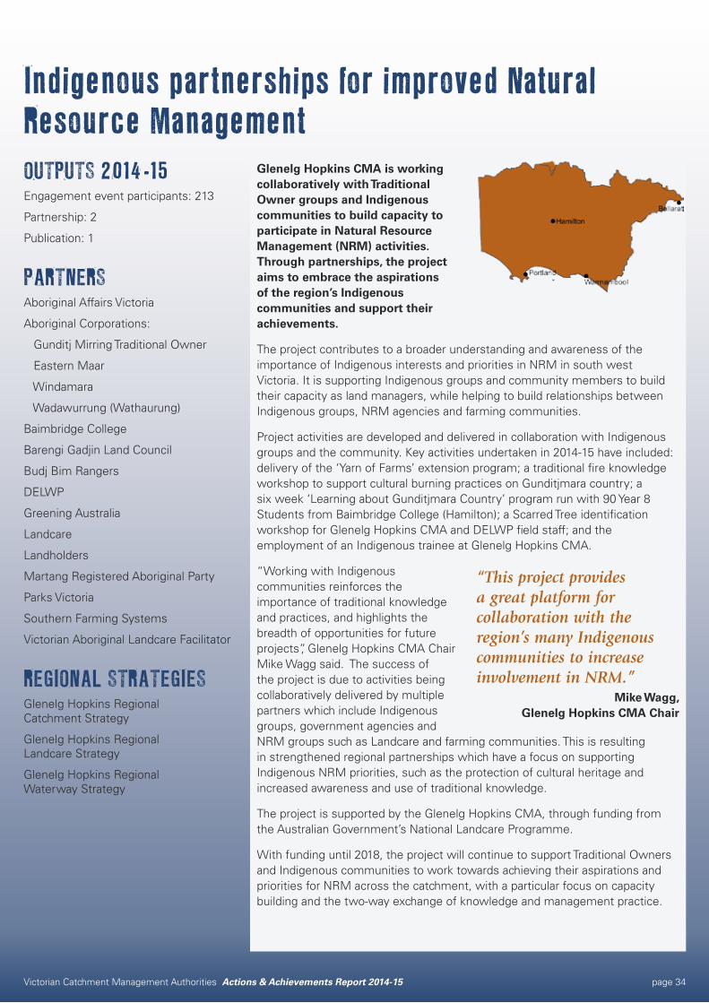
Glenelg Hopkins CMA is working collaboratively with Traditional Owner groups and Indigenous communities to build capacity to participate in Natural Resource Management (NRM) activities. Through partnerships, the project aims to embrace the aspirations of the region’s Indigenous communities and support their achievements.
The project contributes to a broader understanding and awareness of the importance of Indigenous interests and priorities in NRM in south west Victoria. It is supporting Indigenous groups and community members to build their capacity as land managers, while helping to build relationships between Indigenous groups, NRM agencies and farming communities.
Project activities are developed and delivered in collaboration with Indigenous groups and the community. Key activities undertaken in 2014-15 have included: delivery of the ‘Yarn of Farms’ extension program; a traditional fire knowledge workshop to support cultural burning practices on Gunditjmara country; a six week ‘Learning about Gunditjmara Country’ program run with 90 Year 8 Students from Baimbridge College (Hamilton); a Scarred Tree identification workshop for Glenelg Hopkins CMA and DELWP field staff; and the employment of an Indigenous trainee at Glenelg Hopkins CMA.
“Working with Indigenous communities reinforces the importance of traditional knowledge and practices, and highlights the breadth of opportunities for future projects”, Glenelg Hopkins CMA Chair Mike Wagg said. The success of the project is due to activities being collaboratively delivered by multiple partners which include Indigenous groups, government agencies and NRM groups such as Landcare and farming communities. This is resulting in strengthened regional partnerships which have a focus on supporting Indigenous NRM priorities, such as the protection of cultural heritage and increased awareness and use of traditional knowledge.
The project is supported by the Glenelg Hopkins CMA, through funding from the Australian Government’s National Landcare Programme.
With funding until 2018, the project will continue to support Traditional Owners and Indigenous communities to work towards achieving their aspirations and priorities for NRM across the catchment, with a particular focus on capacity building and the two-way exchange of knowledge and management practice.
“This project provides a great platform for collaboration with the region’s many Indigenous communities to increase involvement in NRM.”
Mike Wagg, Glenelg Hopkins CMA Chair

Victorian Catchment Management Authorities Actions & Achievements Report 2014-15 page 35
Tyson Lovett-Murray (Gunditj Mirring TOAC) and Craig Oliver (landowner) during a Yarns on Farms Extension Program visit. Credit: GHCMA.
Uncle Ken Saunders (Gunditjmara elder) overlooking Budj Bim Rangers during the Traditional Fire Knowledge Workshop. Credit: GHCMA.
Victorian Catchment Management Authorities Actions & Achievements Report 2014-15 page 36
Community action on the coastOUTPUTS 2014-15Vegetation: 39.5 ha
Weed control: 7 ha
Management agreement: 5
Engagement event participants: 382
Partnership: 10
PARTNERSCommunity Groups
Conservation volunteers
Landholders
REGIONAL STRATEGIESGlenelg Hopkins Regional Catchment Strategy
Glenelg Hopkins Regional Waterway Strategy
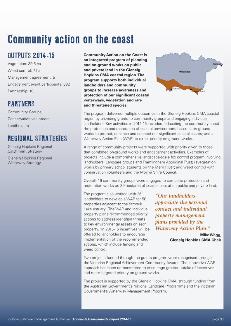
Community Action on the Coast is an integrated program of planning and on-ground works on public and private land in the Glenelg Hopkins CMA coastal region. The program supports both individual landholders and community groups to increase awareness and protection of our significant coastal waterways, vegetation and rare and threatened species.
The program delivered multiple outcomes in the Glenelg Hopkins CMA coastal region by providing grants to community groups and engaging individual landholders. Key activities in 2014-15 included: educating the community about the protection and restoration of coastal environmental assets; on-ground works to protect, enhance and connect our significant coastal assets; and a Waterway Action Plan (WAP) to direct priority on-ground works.
A range of community projects were supported with priority given to those that combined on-ground works and engagement activities. Examples of projects include a comprehensive landscape-scale fox control program involving landholders, Landcare groups and Framlingham Aboriginal Trust; revegetation works by primary school students on the Merri River; and weed control with conservation volunteers and the Moyne Shire Council.
Overall, 16 community groups were engaged to complete protection and restoration works on 39 hectares of coastal habitat on public and private land.
The program also worked with 26 landholders to develop a WAP for 58 properties adjacent to the Yambuk Lake estuary. The WAP and individual property plans recommended priority actions to address identified threats to key environmental assets on each property. In 2015-16 incentives will be offered to landholders to encourage implementation of the recommended actions, which include fencing and weed control.
Two projects funded through the grants program were recognised through the Victorian Regional Achievement Community Awards. The innovative WAP approach has been demonstrated to encourage greater uptake of incentives and more targeted priority on-ground works.
The project is supported by the Glenelg Hopkins CMA, through funding from the Australian Government’s National Landcare Programme and the Victorian Government’s Waterway Management Program.
“Our landholders appreciate the personal contact and individual property management plans provided by the Waterway Action Plan.”
Mike Wagg, Glenelg Hopkins CMA Chair
Victorian Catchment Management Authorities Actions & Achievements Report 2014-15 page 37
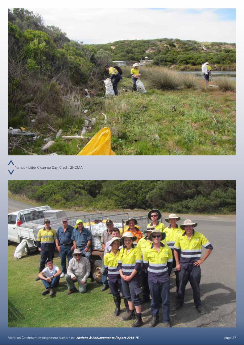
Yambuk Litter Clean-up Day. Credit GHCMA.
Victorian Catchment Management Authorities Actions & Achievements Report 2014-15 page 38
Victorian Catchment Management Authorities Actions & Achievements Report 2014-15 page 39
Key events or insights:•The Farm Water Program
consortium continued to achieve farm water savings through improved farm water use efficiency, earning the Australian Water Awards Program Innovation Award in 2015. Targets are not provided for this Program as they are subject to variation.
•The value of partnerships and community was demonstrated with assistance from volunteer groups, landholders, prisoners from Beechworth and Dhurringile Prison and the Woka Wolla crew to undertake significant recovery works following the Stewarton, Boweya and Creighton’s Creek fires in December 2014. This included the replacement or repair of over 33 kilometres of fencing along waterways. These and other volunteer contributions exceeded engagement targets for the year.
•339,318 megalitres of environmental water delivered to support fish, macroinvertebrate and vegetation ecological objectives in the lower Goulburn River, lower Broken Creek and key wetlands.
•$10.8 million over three and a half years was secured through the Australian Government’s National Landcare Programme to support landholders and community groups achieve long-term sustainable agriculture and environmental outcomes.
GOULBURN BROKEN
Output TargetActual
State C’wealth Total
Structural works
Water storage (no.) 11 15 15
Irrigation structure (ha) 4,745* 4,745
Waterway structure (no.) 236 358 358
Terrestrial habitat (ha) 215 240 240
Monitoring structure (no.) 58 32 32
Fence (km) 81 81 81
Visitor facility (no.) 2 1 1
Environmental works
Vegetation (ha) 261 215 82 297
Weed control (ha) 419 545 2,300 2,845
Pest animal control (ha) 21,854 21,574 639 22,213
Earth works (km) 0.3 1.1 1.1
Management services
Grazing regime (ha) 153 242 242
Agricultural practice change (ha) 228 597 597
Water regime (no.) 26 17 17
Planning and regulation
Approval and advice (no.) 835 1,036 1,036
Management agreement (no.) 56 36 36
Assessment (no.) 440 473 35 508
Engagement event (no. participants) 3,701 7,176 1,481 8,657
Partnership (no.) 309 400 179 579
Plan (no.) 181 172 11 183
Publication (no.) 52 43 11 54
Information management system (no.) 6 3 2 5
*Delivered under both State and Federal funding through the Farm Water Program.
Fish habitat works at Hughes Creek, upstream of Avenel. Credit: Australian UAV.

Victorian Catchment Management Authorities Actions & Achievements Report 2014-15 page 40
Protecting and enhancing Sand Ridge WoodlandsOUTPUTS 2014-15Fence Remnant Vegetation: 213.85 ha
Vegetation: 188.8 ha
Weed control: 108 ha
Pest animal control: 330 ha
PARTNERSCommunity Groups
CSIRO
Landholders
Murray Local Land Services
NSW National Parks and Wildlife Service
Parks Victoria
Yorta Yorta Nation Aboriginal Corporation
REGIONAL STRATEGIESBiodiversity Strategy for the Goulburn Broken Catchment
Goulburn Broken Regional Catchment Strategy
Yorta Yorta Whole of Country Action Plan 2012-17
The Goulburn Broken CMA Sand Ridge Woodland Project aims to protect the cultural heritage values of sand hills across Yorta Yorta Country, and to enhance native vegetation communities unique to sand ridges in the Goulburn and Murray valleys.
The program engages with Traditional Owners and public and private land managers across Yorta Yorta country in northern Victoria and southern New South Wales to revegetate and regenerate native vegetation sites on and near sand hills; control pest plant and animals; and protect cultural heritage sites. These works help protect and increase populations of plants such as White Cypress Pine, Yellow Box, Silver Banksia, Hooked Needlewood, Lightwood, Buloke and Sweet Bursaria; which provide important habitat for fauna species including Barking Owl, Powerful Owl, and the Squirrel Glider.
The unique approach of this project spanning catchment boundaries and the state border has provided opportunity for Yorta Yorta Nation Aboriginal Corporation (YYNAC) to develop partnerships in areas where there had previously been little engagement; and has allowed for the improved management of many sand ridge woodland sites and associated cultural values that were not previously recorded or protected.
Yorta Yorta people are being supported to work on Country through involvement with the Woka Wolla works crew, an enterprise of the YYNAC, which is creating employment opportunities for Indigenous people in natural resource management (NRM). “Participation in the Sand Ridge Woodland Program has been excellent and the young men and women who have been involved in the team are important ambassadors for the Aboriginal community”, Goulburn Broken CMA Chair Murray Chapman said.
The Woka Wolla business team was developed within YYNAC through support from the Goulburn Broken CMA to build true capacity and independence. It continues to receive project funds from the CMA but aims to deliver NRM services to any funder through skilled Indigenous employees.
The project is supported by the Goulburn Broken CMA, through funding from the Australian Government. It will continue to work over the next three years with partners to protect the important natural and cultural values of ridge woodlands. This will include ongoing support for Yorta Yorta people working on Country through the Woka Walla works crew.
“We are targeting sand hills on public and private land, protecting the cultural heritage values of these areas and putting back some of the rare and interesting plant species that were once found in these threatened vegetation communities.”
Murray Chapman, Goulburn Broken CMA Chair
Victorian Catchment Management Authorities Actions & Achievements Report 2014-15 page 41
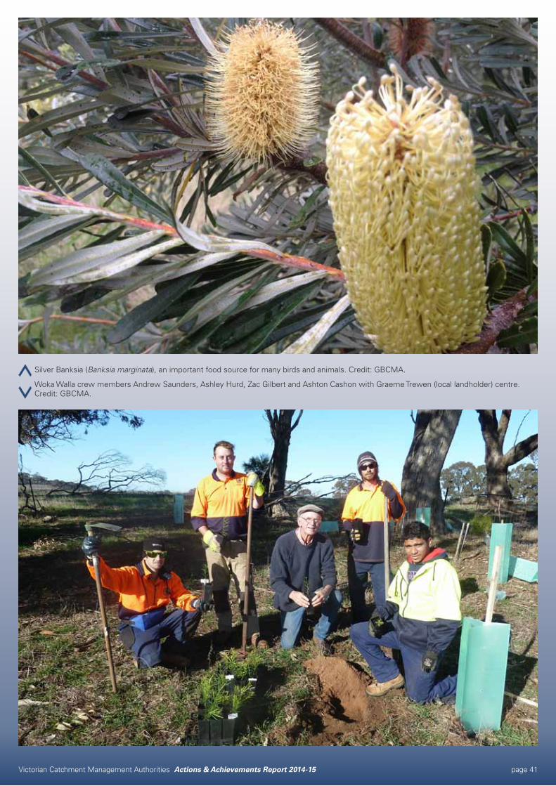
Silver Banksia (Banksia marginata), an important food source for many birds and animals. Credit: GBCMA.
Woka Walla crew members Andrew Saunders, Ashley Hurd, Zac Gilbert and Ashton Cashon with Graeme Trewen (local landholder) centre. Credit: GBCMA.
Victorian Catchment Management Authorities Actions & Achievements Report 2014-15 page 42
Environmental water delivery drives Golden perch breedingOUTPUTS 2014-15Water regime: 17
Approval and advice: 2
Assessment: 40
Partnership: 10
Plan: 10
PARTNERSArthur Rylah Institute for Environmental Research
Commonwealth Environmental Water Holder
Goulburn Murray Water
University of Melbourne
Victorian Environmental Water Holder
REGIONAL STRATEGIESGoulburn Broken Regional Catchment Strategy
Goulburn Broken Waterway Strategy
SES Local Plans
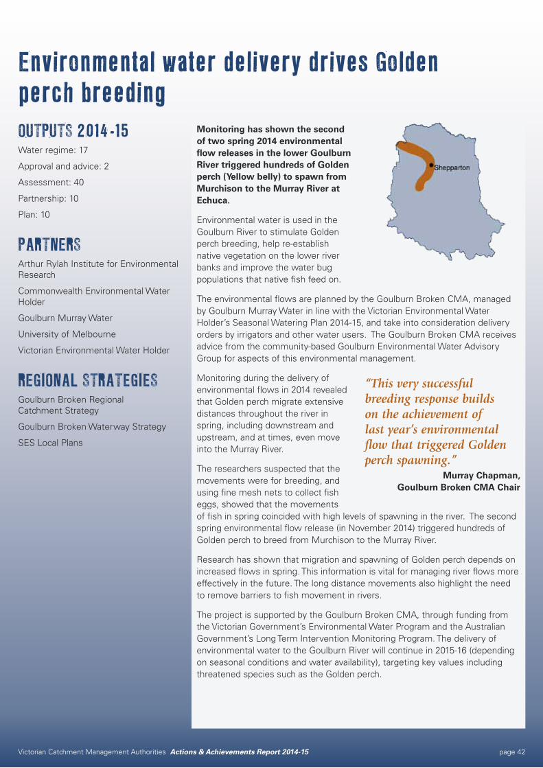
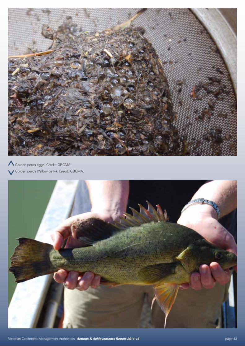
Monitoring has shown the second of two spring 2014 environmental flow releases in the lower Goulburn River triggered hundreds of Golden perch (Yellow belly) to spawn from Murchison to the Murray River at Echuca.
Environmental water is used in the Goulburn River to stimulate Golden perch breeding, help re-establish native vegetation on the lower river banks and improve the water bug populations that native fish feed on.
The environmental flows are planned by the Goulburn Broken CMA, managed by Goulburn Murray Water in line with the Victorian Environmental Water Holder’s Seasonal Watering Plan 2014-15, and take into consideration delivery orders by irrigators and other water users. The Goulburn Broken CMA receives advice from the community-based Goulburn Environmental Water Advisory Group for aspects of this environmental management.
Monitoring during the delivery of environmental flows in 2014 revealed that Golden perch migrate extensive distances throughout the river in spring, including downstream and upstream, and at times, even move into the Murray River.
The researchers suspected that the movements were for breeding, and using fine mesh nets to collect fish eggs, showed that the movements of fish in spring coincided with high levels of spawning in the river. The second spring environmental flow release (in November 2014) triggered hundreds of Golden perch to breed from Murchison to the Murray River.
Research has shown that migration and spawning of Golden perch depends on increased flows in spring. This information is vital for managing river flows more effectively in the future. The long distance movements also highlight the need to remove barriers to fish movement in rivers.
The project is supported by the Goulburn Broken CMA, through funding from the Victorian Government’s Environmental Water Program and the Australian Government’s Long Term Intervention Monitoring Program. The delivery of environmental water to the Goulburn River will continue in 2015-16 (depending on seasonal conditions and water availability), targeting key values including threatened species such as the Golden perch.
“This very successful breeding response builds on the achievement of last year’s environmental flow that triggered Golden perch spawning.”
Murray Chapman, Goulburn Broken CMA Chair
Victorian Catchment Management Authorities Actions & Achievements Report 2014-15 page 43
Golden perch eggs. Credit: GBCMA.
Golden perch (Yellow belly). Credit: GBCMA.
Victorian Catchment Management Authorities Actions & Achievements Report 2014-15 page 44
Victorian Catchment Management Authorities Actions & Achievements Report 2014-15 page 45
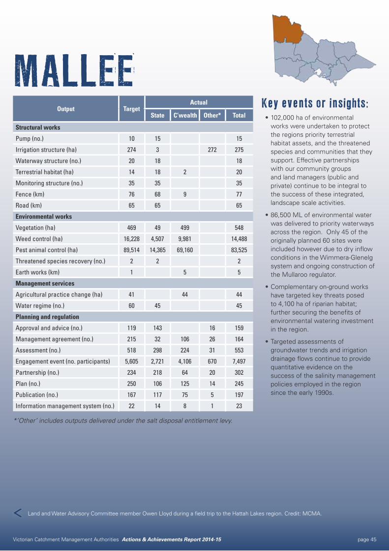
MALLEEKey events or insights:•102,000 ha of environmental
works were undertaken to protect the regions priority terrestrial habitat assets, and the threatened species and communities that they support. Effective partnerships with our community groups and land managers (public and private) continue to be integral to the success of these integrated, landscape scale activities.
•86,500 ML of environmental water was delivered to priority waterways across the region. Only 45 of the originally planned 60 sites were included however due to dry inflow conditions in the Wimmera-Glenelg system and ongoing construction of the Mullaroo regulator.
•Complementary on-ground works have targeted key threats posed to 4,100 ha of riparian habitat; further securing the benefits of environmental watering investment in the region.
•Targeted assessments of groundwater trends and irrigation drainage flows continue to provide quantitative evidence on the success of the salinity management policies employed in the region since the early 1990s.
Output TargetActual
State C’wealth Other* Total
Structural works
Pump (no.) 10 15 15
Irrigation structure (ha) 274 3 272 275
Waterway structure (no.) 20 18 18
Terrestrial habitat (ha) 14 18 2 20
Monitoring structure (no.) 35 35 35
Fence (km) 76 68 9 77
Road (km) 65 65 65
Environmental works
Vegetation (ha) 469 49 499 548
Weed control (ha) 16,228 4,507 9,981 14,488
Pest animal control (ha) 89,514 14,365 69,160 83,525
Threatened species recovery (no.) 2 2 2
Earth works (km) 1 5 5
Management services
Agricultural practice change (ha) 41 44 44
Water regime (no.) 60 45 45
Planning and regulation
Approval and advice (no.) 119 143 16 159
Management agreement (no.) 215 32 106 26 164
Assessment (no.) 518 298 224 31 553
Engagement event (no. participants) 5,605 2,721 4,106 670 7,497
Partnership (no.) 234 218 64 20 302
Plan (no.) 250 106 125 14 245
Publication (no.) 167 117 75 5 197
Information management system (no.) 22 14 8 1 23
*’Other’ includes outputs delivered under the salt disposal entitlement levy.
Land and Water Advisory Committee member Owen Lloyd during a field trip to the Hattah Lakes region. Credit: MCMA.
Victorian Catchment Management Authorities Actions & Achievements Report 2014-15 page 46
Connecting Mallee ParksOUTPUTS 2014-15Fence: 5 km
Vegetation: 107 ha
Weed control: 1,153 ha
Pest animal control: 18,367 ha
Agricultural practice change: 28 ha
Management agreement: 16
Engagement event participants: 20
Partnership: 5
Publication: 2
PARTNERSDELWP
Mallee and Murrayville Landcare groups
Mildura Rural City Council
Parks Victoria
Private landholders
REGIONAL STRATEGIESMallee Regional Catchment Strategy
Mallee Regional Landcare Support Strategy
Partnerships between private landholders, community groups and public land managers are helping to rebuild habitat connections between three of southern Australia’s most important refuges for native species.
Murray-Sunset and Wyperfeld National Parks, and Big Desert Wilderness Park provide essential habitat for the regions native plants and animals. While the land between these parks has been mostly cleared for agriculture, significant patches of remnant vegetation remain on roadsides, private land and public reserves.
The Connecting Mallee Parks (CMP) project is delivering targeted on-ground works to improve the condition of these existing small remnants; and to build on them, by revegetating areas of farmland with native species. Works which will ultimately aid species dispersal and support climate change adaptation.
Key to this projects success has been the establishment of delivery partnerships with private landholders, community groups and public land managers. “Strong partnerships are an integral part of natural resource management and this project shows how important collaboration can be to delivering long-term on-ground improvements,” Mallee CMA Chair Sharyon Peart said.
In 2014-15 these stakeholders collectively implemented over 18,000 ha of on-ground works to reduce key threats to vegetation within the project target area. Works which included fencing remnants to exclude stock, pest plant and animal control, dune reclamation, salinity discharge control plantings, and revegetation with native species.
A combination of market based incentives, grants and technical support were provided to land managers and community groups to deliver these activities; with significant in-kind contributions associated with this financial support helping to secure long-term outcomes.
Due for completion in June 2017; the project is supported by the Mallee CMA, through funding from the Australian Government.
“The partnerships established through this project provided a proactive way of protecting and enhancing some of Victoria’s most important refuges for native species.”
Sharyon Peart, Mallee CMA Chair
Victorian Catchment Management Authorities Actions & Achievements Report 2014-15 page 47
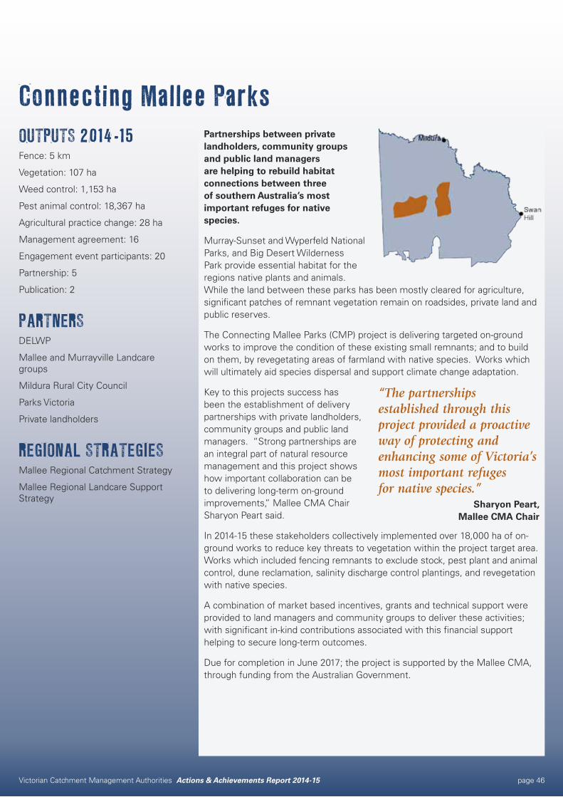
Flood Recovery Environmental Employment Program participants were engaged to plant seedlings. Credit MCMA.
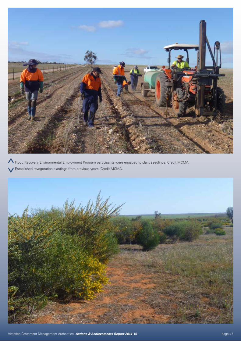
Established revegetation plantings from previous years. Credit MCMA.
Victorian Catchment Management Authorities Actions & Achievements Report 2014-15 page 48
Strategic framework delivers wins for community, catfish and native vegetationOUTPUTS 2014-15Assessment: 7
Engagement event participants: 224
Fence: 4 km
Monitoring structure: 1
Pest animal control: 15 ha
Plan: 2
Pump: 1
Road: 0.5 km
Water regime: 3
Weed control: 40 ha
PARTNERSFriends of Kings Billabong
Green Army
Lower Murray Water
Parks Victoria
Registered Aboriginal Group: Latje Latje
Riverside Golf Club
REGIONAL STRATEGIESMallee Regional Catchment Strategy
Mallee Waterway Strategy
The community, catfish and native vegetation are among the big winners in a range of important on-ground works delivered in line with a strong strategic framework at one of the Mallee’s most loved places.
The guidance provided by the Mallee Waterway Strategy 2014-22, which complements the asset based approach of the Mallee Regional Catchment Strategy 2013-19, has enabled a wide range of complementary actions to be undertaken in partnership with the community across the Nichols Point area.
The Nichols Point area encompasses high priority wetland and riparian assets such as Kings Billabong and Sandilong Creek and forms one of the 23 Waterway Management Units (WMUs) identified within the Mallee Waterway Strategy.
The WMUs group wetlands and reaches into planning units, in recognition of their interconnectedness and common issues. This approach allows for strategic planning outcomes and landscape scale/whole of system benefits to be achieved. The work undertaken at Nichols Point demonstrates the practical application of this approach.
In 2014-15 the Mallee CMA worked closely with land managers and community groups within the Nichols Point WMU to deliver priority actions, as identified in the Waterway Strategy. These included: investigating the population size, age and movement of freshwater catfish at Sandilong Creek; conducting flora surveys at Kings Billabong to measure the health and condition of the local vegetation; undertaking weed control around the irrigation pumps on Kings Billabong, with the assistance of local Green Army participants; improving recreational values at Kings Billabong; and monitoring and then controlling pest animals.
Within the Mallee Waterway Strategy, work plans for each of the 23 WMUs were developed through consultation with the community and other stakeholders. By detailing specific management priorities, these plans help to align the combined efforts of government, community, industry and individuals in specific areas such as Nichols Point; which will ultimately further enhance environmental, social, cultural and economic outcomes for waterways within these landscapes.
The work undertaken in the Nichols Point WMU was funded through the Victorian Government’s Waterway Management Program.
“The strong strategic framework provided by the Mallee Waterway Strategy allows for work to be undertaken in an integrated and effective way that will deliver lasting, landscape-scale results.”
Sharyon Peart, Mallee CMA Chair
Victorian Catchment Management Authorities Actions & Achievements Report 2014-15 page 49
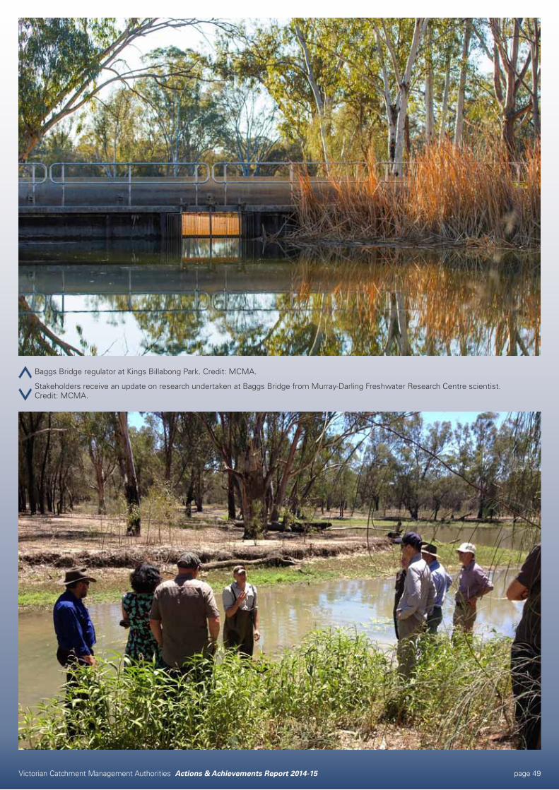
Baggs Bridge regulator at Kings Billabong Park. Credit: MCMA.
Stakeholders receive an update on research undertaken at Baggs Bridge from Murray-Darling Freshwater Research Centre scientist. Credit: MCMA.
Victorian Catchment Management Authorities Actions & Achievements Report 2014-15 page 50
Victorian Catchment Management Authorities Actions & Achievements Report 2014-15 page 51
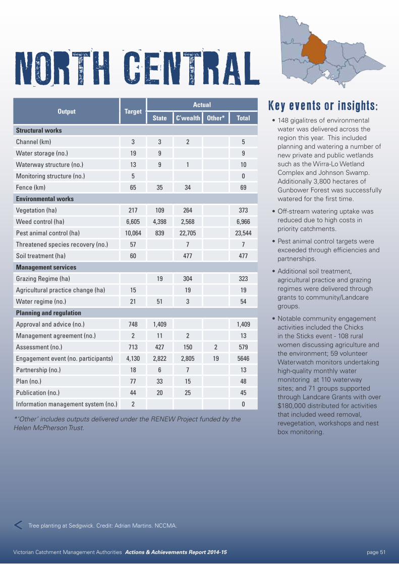
NORTH CENTRALKey events or insights:•148 gigalitres of environmental
water was delivered across the region this year. This included planning and watering a number of new private and public wetlands such as the Wirra-Lo Wetland Complex and Johnson Swamp. Additionally 3,800 hectares of Gunbower Forest was successfully watered for the first time.
•Off-stream watering uptake was reduced due to high costs in priority catchments.
•Pest animal control targets were exceeded through efficiencies and partnerships.
•Additional soil treatment, agricultural practice and grazing regimes were delivered through grants to community/Landcare groups.
•Notable community engagement activities included the Chicks in the Sticks event - 108 rural women discussing agriculture and the environment; 59 volunteer Waterwatch monitors undertaking high-quality monthly water monitoring at 110 waterway sites; and 71 groups supported through Landcare Grants with over $180,000 distributed for activities that included weed removal, revegetation, workshops and nest box monitoring.
Output TargetActual
State C’wealth Other* Total
Structural works
Channel (km) 3 3 2 5
Water storage (no.) 19 9 9
Waterway structure (no.) 13 9 1 10
Monitoring structure (no.) 5 0
Fence (km) 65 35 34 69
Environmental works
Vegetation (ha) 217 109 264 373
Weed control (ha) 6,605 4,398 2,568 6,966
Pest animal control (ha) 10,064 839 22,705 23,544
Threatened species recovery (no.) 57 7 7
Soil treatment (ha) 60 477 477
Management services
Grazing Regime (ha) 19 304 323
Agricultural practice change (ha) 15 19 19
Water regime (no.) 21 51 3 54
Planning and regulation
Approval and advice (no.) 748 1,409 1,409
Management agreement (no.) 2 11 2 13
Assessment (no.) 713 427 150 2 579
Engagement event (no. participants) 4,130 2,822 2,805 19 5646
Partnership (no.) 18 6 7 13
Plan (no.) 77 33 15 48
Publication (no.) 44 20 25 45
Information management system (no.) 2 0
*‘Other’ includes outputs delivered under the RENEW Project funded by the Helen McPherson Trust.
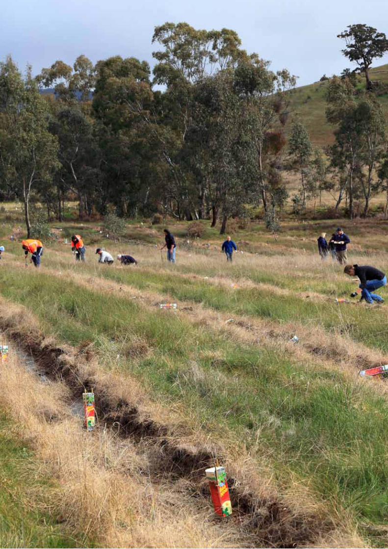
Tree planting at Sedgwick. Credit: Adrian Martins. NCCMA.
Victorian Catchment Management Authorities Actions & Achievements Report 2014-15 page 52
New approach saves timeOUTPUTS 2014-15Information management system: 1
PARTNERSContractors
DELWP
REGIONAL STRATEGIESCommunity Engagement Strategy
Regional Catchment Strategy
An innovative online tool is providing Bendigo residents and land owners access to automated online flood level reports. While the aim of the project was to improve data access and levels of service to the community, organisational efficiencies have also been an important outcome of the initiative.
Traditionally, flood level requests from developers and residents took up to 14 days to complete. Updated data from the Bendigo Urban Flood Study together with North Central CMA Board endorsed funding, provided the opportunity to develop an innovative online tool for the community to access this flood level data immediately.
The increased awareness of the risk of flooding following the 2010-11 floods has led to increased community interest in obtaining flood level information. The North Central CMA, on average, receives 900 requests per year. It is anticipated the tool will halve the number of requests requiring manual processing.
David Clark, Chair of the North Central CMA said the tool will change the way information is accessed: “People will be able to access data they require immediately from their own computer, 24 hours a day seven days a week.”
The system will be implemented with flood information for Bendigo, as a trial. Updates will be performed to ensure the community is delivered the latest data, as it becomes available.
The automated tool is made possible by the extensive flood information created through the Bendigo Urban Flood Study and other similar studies in the region. “The tool is the first of its kind in Victoria. The multiple benefits and improved levels of service for receiving accurate flood level information for properties in Bendigo are significant,” David said.
Flood levels for Castlemaine, Heathcote, Charlton, Donald, Creswick, Clunes, Dunolly, Quambatook, Rochester, Bridgewater and Carisbrook will be incorporated into the system. The project is supported by the North Central CMA and is a Board approved and funded activity.
“The tool is the first of its kind in Victoria. The multiple benefits and improved levels of service for receiving accurate flood level information for properties in Bendigo are significant.”
David Clark, North Central CMA Chair
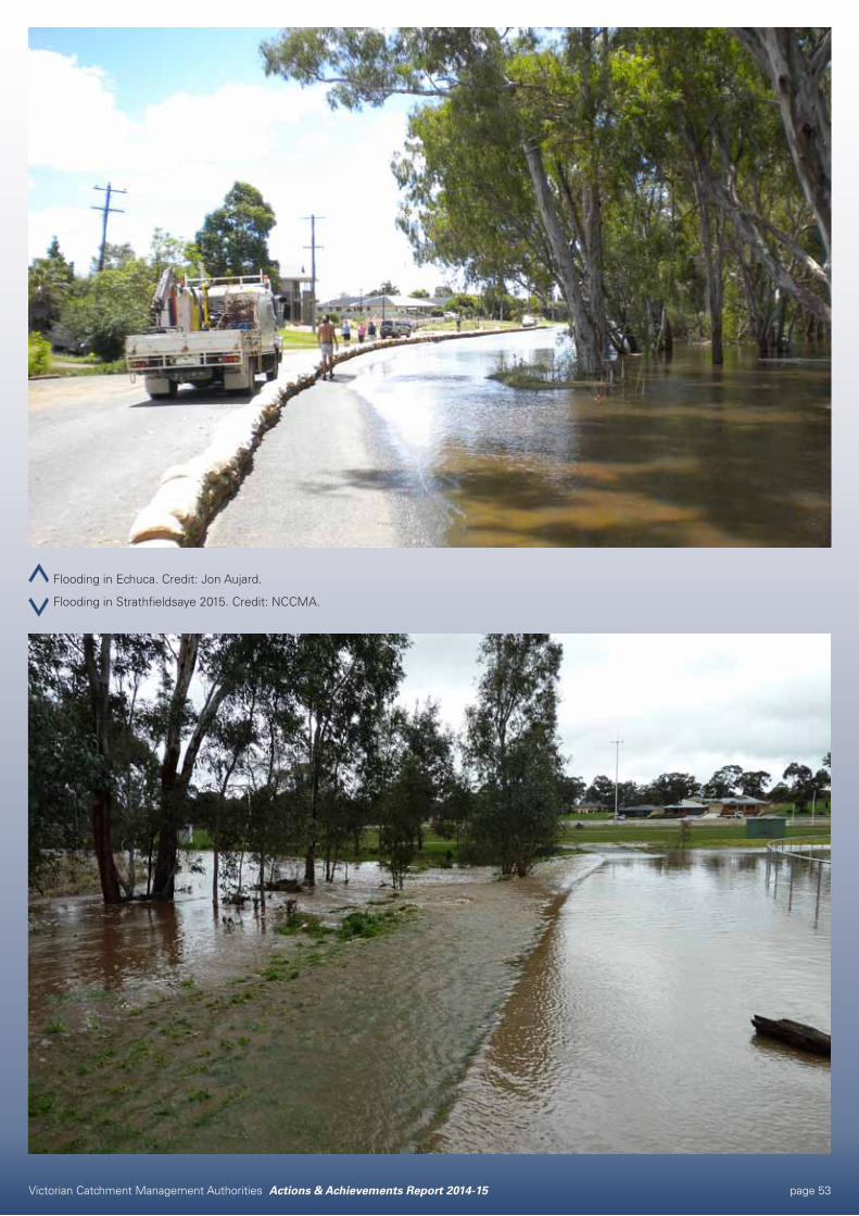
Victorian Catchment Management Authorities Actions & Achievements Report 2014-15 page 53
Flooding in Echuca. Credit: Jon Aujard.
Flooding in Strathfieldsaye 2015. Credit: NCCMA.
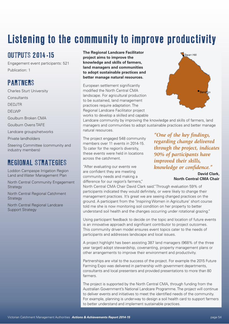
Victorian Catchment Management Authorities Actions & Achievements Report 2014-15 page 54
Listening to the community to improve productivityOUTPUTS 2014-15Engagement event participants: 521
Publication: 1
PARTNERSCharles Sturt University
Consultants
DEDJTR
DELWP
Goulburn Broken CMA
Goulburn Ovens TAFE
Landcare groups/networks
Private landholders
Steering Committee (community and industry members)
REGIONAL STRATEGIESLoddon Campaspe Irrigation Region Land and Water Management Plan
North Central Community Engagement Strategy
North Central Regional Catchment Strategy
North Central Regional Landcare Support Strategy
The Regional Landcare Facilitator project aims to improve the knowledge and skills of farmers, land managers and communities to adopt sustainable practices and better manage natural resources.
European settlement significantly modified the North Central CMA landscape. For agricultural production to be sustained, land management practices require adaptation. The Regional Landcare Facilitator project works to develop a skilled and capable Landcare community by improving the knowledge and skills of farmers, land managers and communities to adopt sustainable practices and better manage natural resources.
The project engaged 548 community members over 11 events in 2014-15. To cater for the region’s diversity, these events were held in locations across the catchment.
“After evaluating our events we are confident they are meeting community needs and making a difference for our region’s farmers,” North Central CMA Chair David Clark said.“Through evaluation 59% of participants indicated they would definitely, or were likely to change their management practices. It’s great we are seeing changed practices on the ground. A participant from the ‘Inspiring Women in Agriculture’ short course told me she is now monitoring soil condition on her property to better understand soil health and the changes occurring under rotational grazing.”
Using participant feedback to decide on the topic and location of future events is an innovative approach and significant contributor to project outcomes. This community driven model ensures event topics cater to the needs of participants and addresses landscape and local issues.
A project highlight has been assisting 387 land managers (968% of the three year target) adopt stewardship, covenanting, property management plans or other arrangements to improve their environment and productivity.
Partnerships are vital to the success of the project. For example the 2015 Future Farming Expo was delivered in partnership with government departments, consultants and local presenters and provided presentations to more than 80 farmers.
The project is supported by the North Central CMA, through funding from the Australian Government’s National Landcare Programme. The project will continue to deliver events and initiatives to meet the identified needs of the community. For example, planning is underway to design a soil health card to support farmers to better understand and implement sustainable practices.
“One of the key findings, regarding change delivered through the project, indicates 90% of participants have improved their skills, knowledge or confidence.”
David Clark, North Central CMA Chair
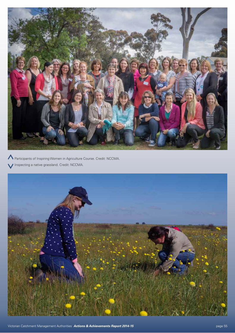
Victorian Catchment Management Authorities Actions & Achievements Report 2014-15 page 55
Participants of Inspiring Women in Agriculture Course. Credit: NCCMA.
Inspecting a native grassland. Credit: NCCMA.
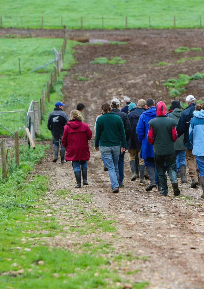
Victorian Catchment Management Authorities Actions & Achievements Report 2014-15 page 56
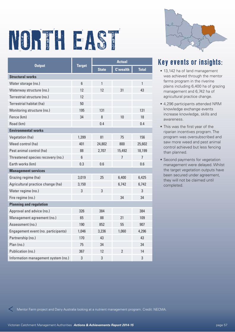
Victorian Catchment Management Authorities Actions & Achievements Report 2014-15 page 57
NORTH EASTKey events or insights:•13,142 ha of land management
was achieved through the mentor farms program in the riverine plains including 6,400 ha of grazing management and 6,742 ha of agricultural practice change.
•4,296 participants attended NRM knowledge exchange events increase knowledge, skills and awareness.
•This was the first year of the riparian incentives program. The program was oversubscribed and saw more weed and pest animal control achieved but less fencing than planned.
•Second payments for vegetation management were delayed. Whilst the target vegetation outputs have been secured under agreement, they will not be claimed until completed.
Output TargetActual
State C’wealth Total
Structural works
Water storage (no.) 6 1 1
Waterway structure (no.) 12 12 31 43
Terrestrial structure (no.) 12
Terrestrial habitat (ha) 50
Monitoring structure (no.) 195 131 131
Fence (km) 34 8 10 18
Road (km) 0.4 0.4
Environmental works
Vegetation (ha) 1,399 81 75 156
Weed control (ha) 401 24,802 800 25,602
Pest animal control (ha) 88 2,707 15,492 18,199
Threatened species recovery (no.) 6 7 7
Earth works (km) 0.3 0.6 0.6
Management services
Grazing regime (ha) 3,019 25 6,400 6,425
Agricultural practice change (ha) 3,150 6,742 6,742
Water regime (no.) 3 3 3
Fire regime (no.) 34 34
Planning and regulation
Approval and advice (no.) 326 384 384
Management agreement (no.) 65 88 21 109
Assessment (no.) 190 852 55 907
Engagement event (no. participants) 1,046 3,236 1,060 4,296
Partnership (no.) 170 43 43
Plan (no.) 75 34 34
Publication (no.) 367 12 2 14
Information management system (no.) 3 3 3
Mentor Farm project and Dairy Australia looking at a nutrient management program. Credit: NECMA.
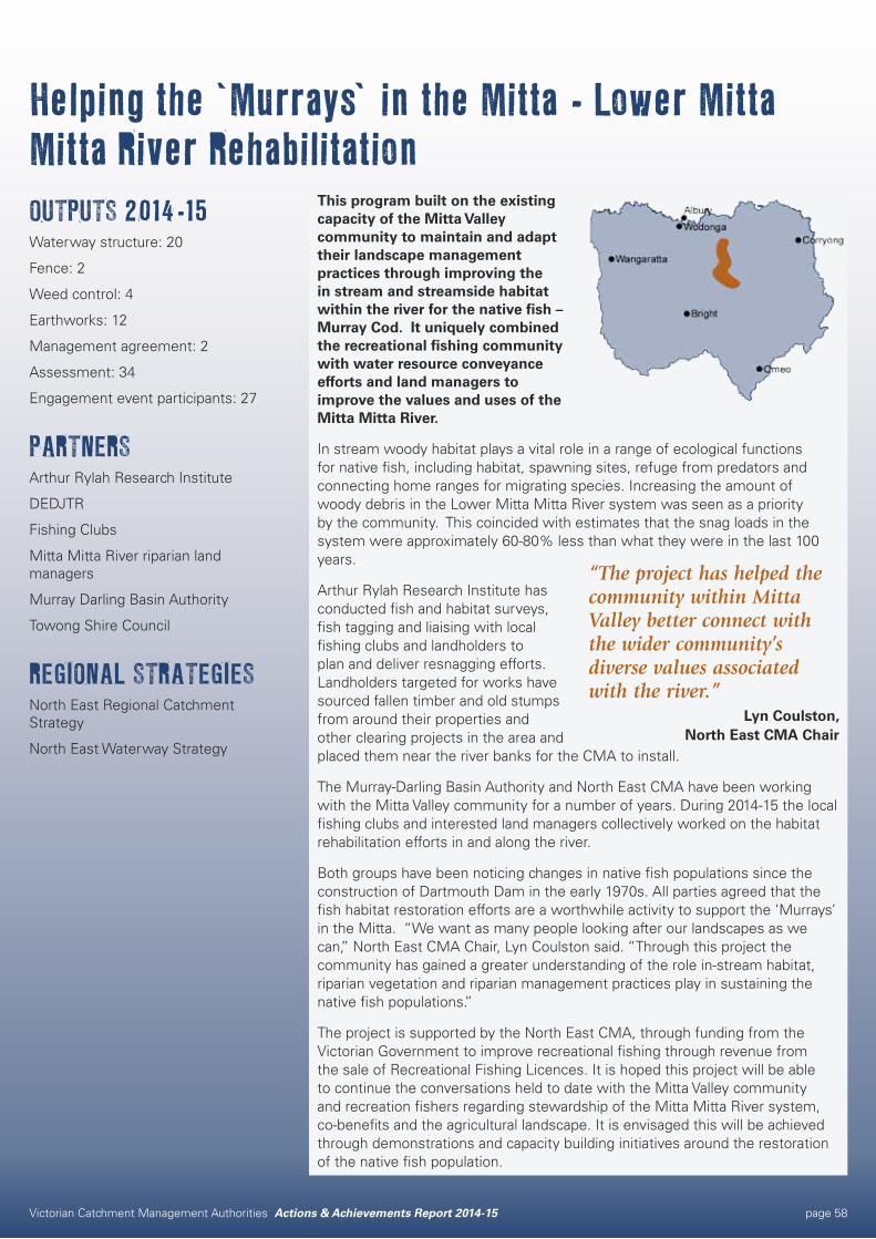
Victorian Catchment Management Authorities Actions & Achievements Report 2014-15 page 58
Helping the ‘Murrays’ in the Mitta - Lower Mitta Mitta River RehabilitationOUTPUTS 2014-15Waterway structure: 20
Fence: 2
Weed control: 4
Earthworks: 12
Management agreement: 2
Assessment: 34
Engagement event participants: 27
PARTNERSArthur Rylah Research Institute
DEDJTR
Fishing Clubs
Mitta Mitta River riparian land managers
Murray Darling Basin Authority
Towong Shire Council
REGIONAL STRATEGIESNorth East Regional Catchment Strategy
North East Waterway Strategy
This program built on the existing capacity of the Mitta Valley community to maintain and adapt their landscape management practices through improving the in stream and streamside habitat within the river for the native fish – Murray Cod. It uniquely combined the recreational fishing community with water resource conveyance efforts and land managers to improve the values and uses of the Mitta Mitta River.
In stream woody habitat plays a vital role in a range of ecological functions for native fish, including habitat, spawning sites, refuge from predators and connecting home ranges for migrating species. Increasing the amount of woody debris in the Lower Mitta Mitta River system was seen as a priority by the community. This coincided with estimates that the snag loads in the system were approximately 60-80% less than what they were in the last 100 years.
Arthur Rylah Research Institute has conducted fish and habitat surveys, fish tagging and liaising with local fishing clubs and landholders to plan and deliver resnagging efforts. Landholders targeted for works have sourced fallen timber and old stumps from around their properties and other clearing projects in the area and placed them near the river banks for the CMA to install.
The Murray-Darling Basin Authority and North East CMA have been working with the Mitta Valley community for a number of years. During 2014-15 the local fishing clubs and interested land managers collectively worked on the habitat rehabilitation efforts in and along the river.
Both groups have been noticing changes in native fish populations since the construction of Dartmouth Dam in the early 1970s. All parties agreed that the fish habitat restoration efforts are a worthwhile activity to support the ‘Murrays’ in the Mitta. “We want as many people looking after our landscapes as we can,” North East CMA Chair, Lyn Coulston said. “Through this project the community has gained a greater understanding of the role in-stream habitat, riparian vegetation and riparian management practices play in sustaining the native fish populations.”
The project is supported by the North East CMA, through funding from the Victorian Government to improve recreational fishing through revenue from the sale of Recreational Fishing Licences. It is hoped this project will be able to continue the conversations held to date with the Mitta Valley community and recreation fishers regarding stewardship of the Mitta Mitta River system, co-benefits and the agricultural landscape. It is envisaged this will be achieved through demonstrations and capacity building initiatives around the restoration of the native fish population.
“The project has helped the community within Mitta Valley better connect with the wider community’s diverse values associated with the river.”
Lyn Coulston, North East CMA Chair
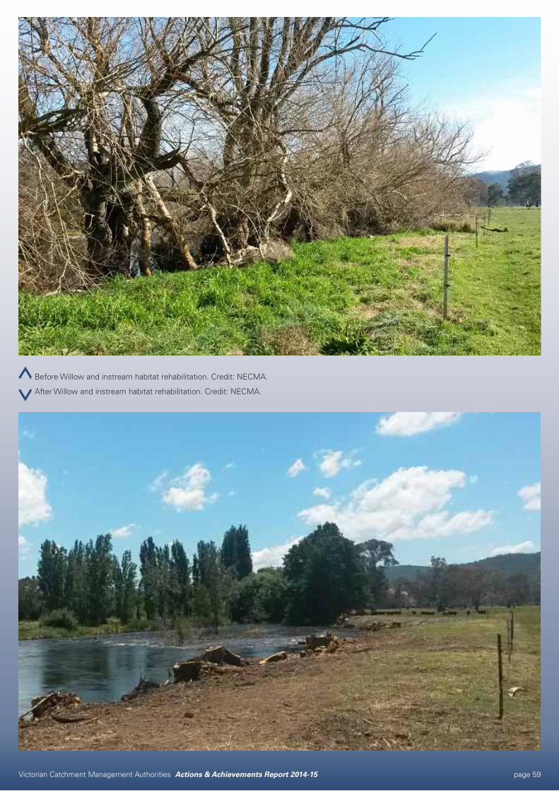
Victorian Catchment Management Authorities Actions & Achievements Report 2014-15 page 59
Before Willow and instream habitat rehabilitation. Credit: NECMA.
After Willow and instream habitat rehabilitation. Credit: NECMA.
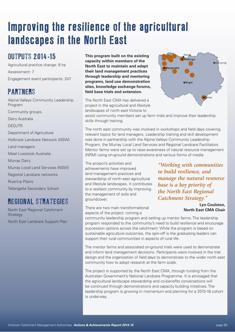
Victorian Catchment Management Authorities Actions & Achievements Report 2014-15 page 60
Improving the resilience of the agricultural landscapes in the North EastOUTPUTS 2014-15Agricultural practice change: 8 ha
Assessment: 7
Engagement event participants: 247
PARTNERSAlpine Valleys Community Leadership Program
Community groups.
Dairy Australia
DEDJTR
Department of Agriculture
Holbrook Landcare Network (NSW)
Land managers
Meat Livestock Australia
Murray Dairy
Murray Local Land Services (NSW)
Regional Landcare networks
Riverina Plains
Tallangatta Secondary School
REGIONAL STRATEGIESNorth East Regional Catchment Strategy
North East Landcare Support Plan
This program built on the existing capacity within members of the North East to maintain and adapt their land management practices through leadership and mentoring programs, land use demonstration sites, knowledge exchange forums, field base trials and extension.
The North East CMA has delivered a project in the agricultural and lifestyle landscapes of north east Victoria to assist community members set up farm trials and improve their leadership skills through training.
The north east community was involved in workshops and field days covering relevant topics for land managers. Leadership training and skill development was done in partnership with the Alpine Valleys Community Leadership Program, the Murray Local Land Services and Regional Landcare Facilitators. Mentor farms were set up to raise awareness of natural resource management (NRM) using on-ground demonstrations and various forms of media.
The project’s activities and achievements have improved land management practices and stewardship of north east agricultural and lifestyle landscapes. It contributes to a resilient community by improving the management of soils and groundcover.
There are two main transformational aspects of the project: running a community leadership program and setting up mentor farms. The leadership program responded to the community’s need to build resilience and encourage succession options across the catchment. While the program is based on sustainable agriculture outcomes, the spin-off is the graduating leaders can support their rural communities in aspects of rural life.
The mentor farms and associated on-ground trials were used to demonstrate and inform land management decisions. Participants were involved in the trial design and the organisation of field days to demonstrate to the wider north east community how to adopt research at the farm scale.
The project is supported by the North East CMA, through funding from the Australian Government’s National Landcare Programme. It is envisaged that the agricultural landscape stewardship and co-benefits conversations will be continued through demonstrations and capacity building initiatives. The leadership program is growing in momentum and planning for a 2015-16 cohort is underway.
“Working with communities to build resilience, and manage the natural resource base is a key priority of the North East Regional Catchment Strategy.”
Lyn Coulston, North East CMA Chair
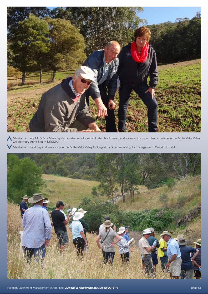
Victorian Catchment Management Authorities Actions & Achievements Report 2014-15 page 61
Mentor Farmers Mr & Mrs Maroney demonstration of a rehabilitated blackberry paddock near the crown land interface in the Mitta Mitta Valley. Credit: Mary Anne Scully, NECMA.
Mentor farm field day and workshop in the Mitta Mitta Valley looking at blackberries and gully management. Credit: NECMA.
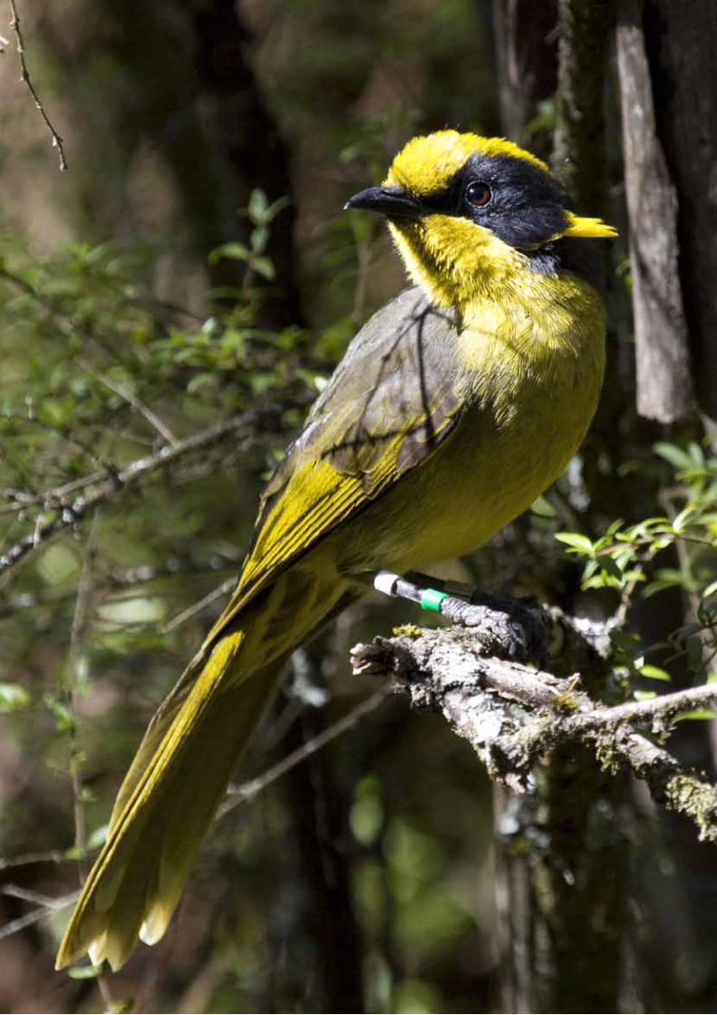
Victorian Catchment Management Authorities Actions & Achievements Report 2014-15 page 62
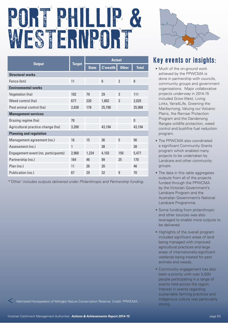
Victorian Catchment Management Authorities Actions & Achievements Report 2014-15 page 63
PORT PHILLIP & WESTERNPORT
Key events or insights:•Much of the on-ground work
achieved by the PPWCMA is done in partnership with councils, community groups and government organisations. Major collaborative projects under-way in 2014-15 included Grow West, Living Links, Yarra4Life, Greening the Maribyrnong, Valuing our Volcanic Plains, the Ramsar Protection Program and the Dandenong Ranges wildlife protection, weed control and bushfire fuel reduction program.
•The PPWCMA also coordinated a significant Community Grants program which enabled many projects to be undertaken by Landcare and other community groups.
•The data in this table aggregates outputs from all of the projects funded through the PPWCMA by the Victorian Government’s Landcare Program and the Australian Government’s National Landcare Programme.
•Some funding from philanthropic and other sources was also leveraged to enable more outputs to be delivered.
•Highlights of the overall program included significant areas of land being managed with improved agricultural practices and large areas of internationally-significant wetlands being treated for pest animals and weeds.
•Community engagement has also been a priority with over 5,000 people participating in a range of events held across the region. Interest in events regarding sustainable farming practices and Indigenous culture was particularly strong.
Output TargetActual
State C’wealth Other Total
Structural works
Fence (km) 11 6 2 8
Environmental works
Vegetation (ha) 102 79 29 3 111
Weed control (ha) 677 220 1,802 3 2,025
Pest animal control (ha) 2,838 178 25,790 25,968
Management services
Grazing regime (ha) 78 0
Agricultural practice change (ha) 3,200 43,194 43,194
Planning and regulation
Management agreement (no.) 16 15 36 5 56
Assessment (no.) 1 38 38
Engagement event (no. participants) 2,968 1,224 4,103 150 5,477
Partnership (no.) 164 46 99 25 170
Plan (no.) 11 26 20 46
Publication (no.) 67 29 32 9 70
*‘Other’ includes outputs delivered under Philanthropic and Partnership funding.
Helmeted Honeyeaters of Yellingbo Nature Conservation Reserve. Credit: PPWCMA.
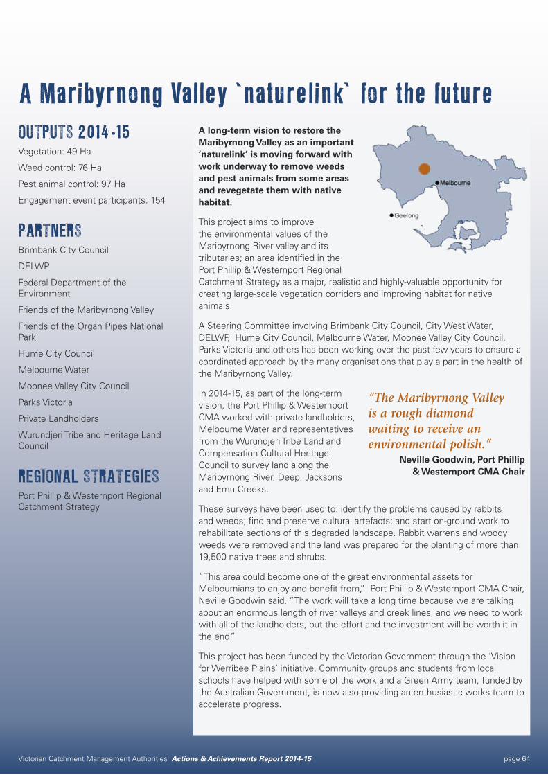
Victorian Catchment Management Authorities Actions & Achievements Report 2014-15 page 64
A Maribyrnong Valley ‘naturelink’ for the futureOUTPUTS 2014-15Vegetation: 49 Ha
Weed control: 76 Ha
Pest animal control: 97 Ha
Engagement event participants: 154
PARTNERSBrimbank City Council
DELWP
Federal Department of the Environment
Friends of the Maribyrnong Valley
Friends of the Organ Pipes National Park
Hume City Council
Melbourne Water
Moonee Valley City Council
Parks Victoria
Private Landholders
Wurundjeri Tribe and Heritage Land Council
REGIONAL STRATEGIESPort Phillip & Westernport Regional Catchment Strategy
A long-term vision to restore the Maribyrnong Valley as an important ‘naturelink’ is moving forward with work underway to remove weeds and pest animals from some areas and revegetate them with native habitat.
This project aims to improve the environmental values of the Maribyrnong River valley and its tributaries; an area identified in the Port Phillip & Westernport Regional Catchment Strategy as a major, realistic and highly-valuable opportunity for creating large-scale vegetation corridors and improving habitat for native animals.
A Steering Committee involving Brimbank City Council, City West Water, DELWP, Hume City Council, Melbourne Water, Moonee Valley City Council, Parks Victoria and others has been working over the past few years to ensure a coordinated approach by the many organisations that play a part in the health of the Maribyrnong Valley.
In 2014-15, as part of the long-term vision, the Port Phillip & Westernport CMA worked with private landholders, Melbourne Water and representatives from the Wurundjeri Tribe Land and Compensation Cultural Heritage Council to survey land along the Maribyrnong River, Deep, Jacksons and Emu Creeks.
These surveys have been used to: identify the problems caused by rabbits and weeds; find and preserve cultural artefacts; and start on-ground work to rehabilitate sections of this degraded landscape. Rabbit warrens and woody weeds were removed and the land was prepared for the planting of more than 19,500 native trees and shrubs.
“This area could become one of the great environmental assets for Melbournians to enjoy and benefit from,” Port Phillip & Westernport CMA Chair, Neville Goodwin said. “The work will take a long time because we are talking about an enormous length of river valleys and creek lines, and we need to work with all of the landholders, but the effort and the investment will be worth it in the end.”
This project has been funded by the Victorian Government through the ‘Vision for Werribee Plains’ initiative. Community groups and students from local schools have helped with some of the work and a Green Army team, funded by the Australian Government, is now also providing an enthusiastic works team to accelerate progress.
“The Maribyrnong Valley is a rough diamond waiting to receive an environmental polish.”
Neville Goodwin, Port Phillip & Westernport CMA Chair
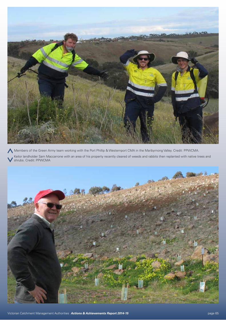
Victorian Catchment Management Authorities Actions & Achievements Report 2014-15 page 65
Members of the Green Army team working with the Port Phillip & Westernport CMA in the Maribyrnong Valley. Credit: PPWCMA.
Keilor landholder Sam Maccarrone with an area of his property recently cleared of weeds and rabbits then replanted with native trees and shrubs. Credit: PPWCMA
Victorian Catchment Management Authorities Actions & Achievements Report 2014-15 page 66
Caring for Country in a modern context – Combining today’s sustainable agriculture techniques and traditional Indigenous knowledgeOUTPUTS 2014-15Engagement event participants: 544
PARTNERSMelbourne Water
Wandoon Estate
REGIONAL STRATEGIESPort Phillip & Westernport Regional Catchment Strategy
Regional Healthy Waterways Strategy
Regional Landcare Support Strategy
The Regional Landcare Facilitator Project engages with agricultural industry groups, with a focus on high value horticultural industries and supporting their contribution towards managing our region’s environmental assets. This is achieved by working with each industry group, as well as partner organisations, to promote the adoption of innovative and emerging land management techniques.
Local Yarra Valley Indigenous women Brooke Collins and Jacqui Wandin have longed to bring the Wandoon Estate farm at Coranderrk back into profitable and sustainable agricultural production to honour their ancestors who farmed there successfully as an Aboriginal settlement in the mid-late 1800s. Now, a fruitful new partnership between them, Australian Government programs, the Port Phillip & Westernport Catchment Management Authority (PPWCMA)and Melbourne Water is demonstrating how Indigenous land management principles can work in modern communities and landscapes.
“Around a year ago Jacqui and I recognised that good farm management needs to start with a plan so we contacted Karen Thomas from the Catchment Management Authority and Katie Drummond from Melbourne Water to help us apply for start-up funds from the Indigenous Land Corporation. Our application was successful and the farm plan is now complete and maps out an exciting path for our property’s future”, said Brooke.
Work is now underway by Brooke, Jacqui and their families to bring the plan to life managing a small grazing herd and producing traditional bush foods for sale.
Karen Thomas, the Regional Landcare Facilitator with the PPWCMA said: “I do most of my work with agricultural industry groups such as fruit growers, vignerons and broad-acre cropping farmers to improve sustainable farming techniques, but it has been very exciting to work with Brooke and Jacqui at Coranderrk to combine modern sustainable agriculture principles with traditional Indigenous knowledge”. Authority Chairman Neville Goodwin added that “The National Landcare Programme is improving environmental values and sustainable agriculture and assisting local communities and Indigenous landowners as much as possible. The work done with Brooke and Jacqui and their families has hit all of these aims in one go which is fabulous”.
The project is supported by the PPWCMA, through funding from the Australian Government’s National Landcare Programme.
“Agricultural production around Melbourne is highly valuable and important. Wandoon Estate, a farm that is honouring Indigenous land management, is a special part of the agricultural landscape in this region.”
Neville Goodwin, Port Phillip & Westernport CMA Chair
Victorian Catchment Management Authorities Actions & Achievements Report 2014-15 page 67
Whole farm planning at Wandoon Estate. Credit: PPWCMA.
A farm walk at Wandoon Estate, filmed as part of a short Coranderrk video available via the PPWCMA Youtube channel. Credit: PPWCMA.
Victorian Catchment Management Authorities Actions & Achievements Report 2014-15 page 68
Victorian Catchment Management Authorities Actions & Achievements Report 2014-15 page 69
Key events or insights:•Partnerships with Agricultural
Industry, Landcare, our Traditional Owners and other NRM agencies has seen another successful year in protecting and enhancing our natural environment.
•Over 150 people walked down the ‘Landcare in West Gippsland Green Carpet’ to celebrate Landcare individuals, groups and partnerships, as well as sustainable agricultural innovators and young people who are championing the connection between environment and productivity.
•Funding for the successful Love your Waterhole Creek project has seen local residents actively involved in revegetation and fencing as well as annual clean up days, and water monitoring.
•2014-15 marks the first full year of implementing the MoU between Gunaikurnai Land and Waters Aboriginal Corporation (GLaWAC) and WGCMA. A highlight was WGCMA participation in the GLaWAC cultural heritage training program, including an inaugural overnight ‘On Country’ trip.
•The Regional Waterway Program, funded through the Victorian Government, achieved more than 500 ha of weed control; 165 ha of Spartina control; over 13 km of waterway fencing; installation of 13 water troughs and around 103 ha of revegetation works.
WEST GIPPSLAND
Output TargetActual
State C’wealth Total
Structural works
Water storage (no.) 7 13 13
Irrigation structure (ha) 285 103 103
Waterway structure (no.) 1 1 1
Monitoring structure (no.) 5 9 9
Fence (km) 29 16 16 32
Visitor facility (no.) 4 0
Environmental works
Vegetation (ha) 140 131 41 172
Weed control (ha) 1,431 1,033 651 1,684
Earth works (km) 0.5 0
Management services
Agricultural practice change (ha) 400 450 450
Water regime (no.) 7 4 4
Planning and regulation
Approval and advice (no.) 1,184 1,151 1,151
Management agreement (no.) 64 36 10 46
Assessment (no.) 167 185 15 200
Engagement event (no. participants) 762 696 763 1,459
Partnership (no.) 113 87 36 123
Plan (no.) 137 54 94 148
Publication (no.) 52 68 35 103
Information management system (no.) 3 3 2 5
Coastal mangrove vegetation, Corner Inlet Marine and Coastal Park, Toora. Credit: InDetail Comms & PR.
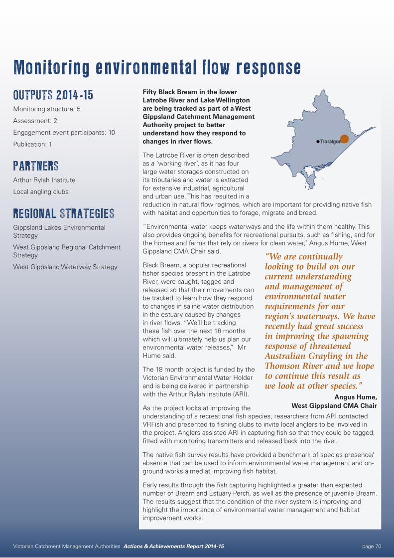
Victorian Catchment Management Authorities Actions & Achievements Report 2014-15 page 70
Monitoring environmental flow responseOUTPUTS 2014-15Monitoring structure: 5
Assessment: 2
Engagement event participants: 10
Publication: 1
PARTNERSArthur Rylah Institute
Local angling clubs
REGIONAL STRATEGIESGippsland Lakes Environmental Strategy
West Gippsland Regional Catchment Strategy
West Gippsland Waterway Strategy
Fifty Black Bream in the lower Latrobe River and Lake Wellington are being tracked as part of a West Gippsland Catchment Management Authority project to better understand how they respond to changes in river flows.
The Latrobe River is often described as a ‘working river’, as it has four large water storages constructed on its tributaries and water is extracted for extensive industrial, agricultural and urban use. This has resulted in a reduction in natural flow regimes, which are important for providing native fish with habitat and opportunities to forage, migrate and breed.
“Environmental water keeps waterways and the life within them healthy. This also provides ongoing benefits for recreational pursuits, such as fishing, and for the homes and farms that rely on rivers for clean water,” Angus Hume, West Gippsland CMA Chair said.
Black Bream, a popular recreational fisher species present in the Latrobe River, were caught, tagged and released so that their movements can be tracked to learn how they respond to changes in saline water distribution in the estuary caused by changes in river flows. “We’ll be tracking these fish over the next 18 months which will ultimately help us plan our environmental water releases,” Mr Hume said.
The 18 month project is funded by the Victorian Environmental Water Holder and is being delivered in partnership with the Arthur Rylah Institute (ARI).
As the project looks at improving the understanding of a recreational fish species, researchers from ARI contacted VRFish and presented to fishing clubs to invite local anglers to be involved in the project. Anglers assisted ARI in capturing fish so that they could be tagged, fitted with monitoring transmitters and released back into the river.
The native fish survey results have provided a benchmark of species presence/absence that can be used to inform environmental water management and on-ground works aimed at improving fish habitat.
Early results through the fish capturing highlighted a greater than expected number of Bream and Estuary Perch, as well as the presence of juvenile Bream. The results suggest that the condition of the river system is improving and highlight the importance of environmental water management and habitat improvement works.
“We are continually looking to build on our current understanding and management of environmental water requirements for our region’s waterways. We have recently had great success in improving the spawning response of threatened Australian Grayling in the Thomson River and we hope to continue this result as we look at other species.”
Angus Hume, West Gippsland CMA Chair
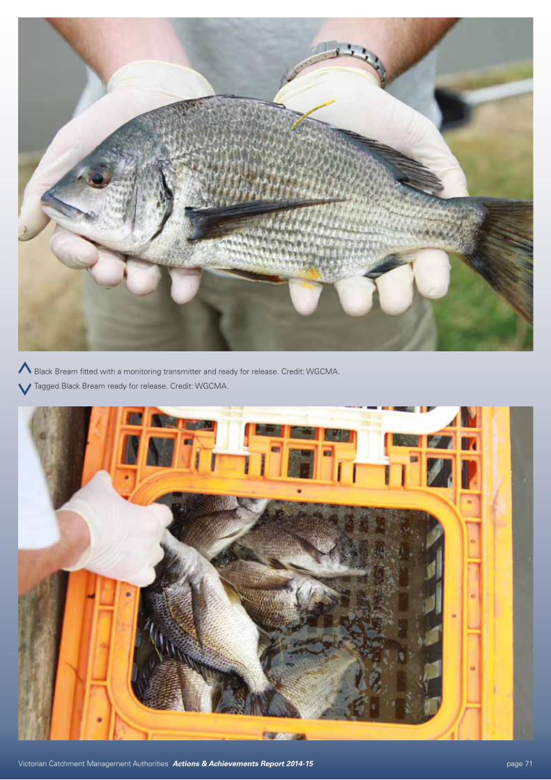
Victorian Catchment Management Authorities Actions & Achievements Report 2014-15 page 71
Black Bream fitted with a monitoring transmitter and ready for release. Credit: WGCMA.
Tagged Black Bream ready for release. Credit: WGCMA.
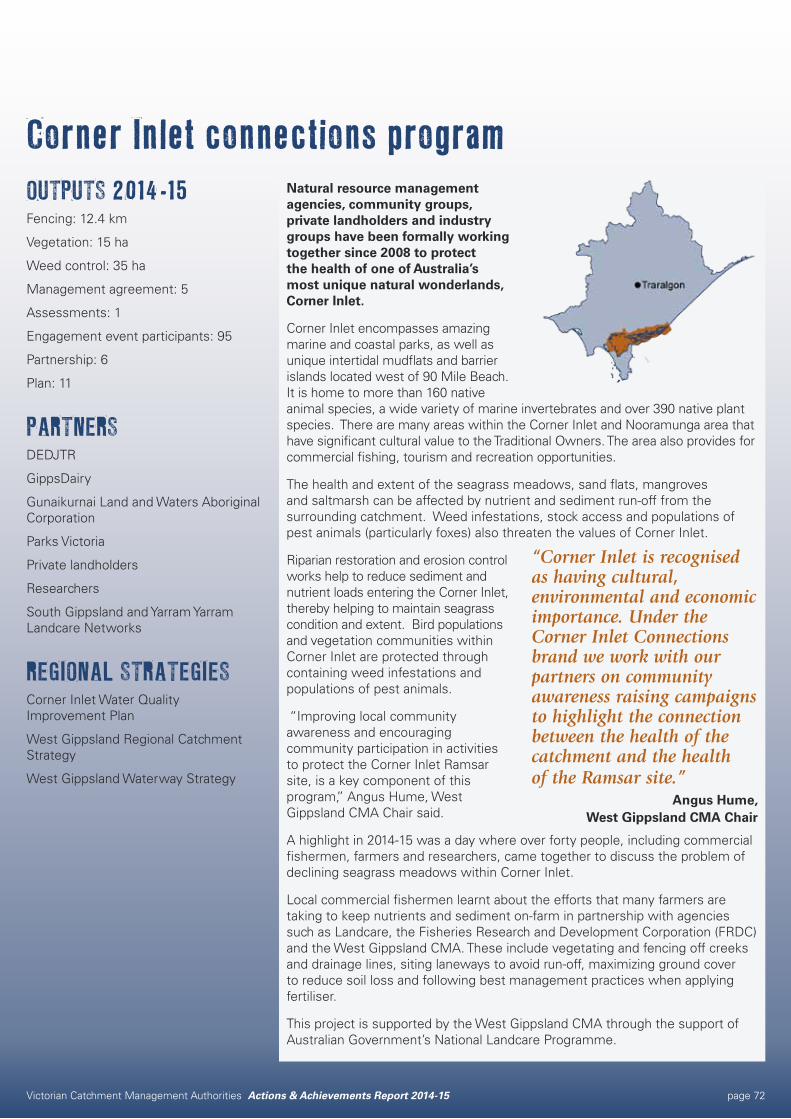
Victorian Catchment Management Authorities Actions & Achievements Report 2014-15 page 72
Corner Inlet connections programOUTPUTS 2014-15Fencing: 12.4 km
Vegetation: 15 ha
Weed control: 35 ha
Management agreement: 5
Assessments: 1
Engagement event participants: 95
Partnership: 6
Plan: 11
PARTNERSDEDJTR
GippsDairy
Gunaikurnai Land and Waters Aboriginal Corporation
Parks Victoria
Private landholders
Researchers
South Gippsland and Yarram Yarram Landcare Networks
REGIONAL STRATEGIESCorner Inlet Water Quality Improvement Plan
West Gippsland Regional Catchment Strategy
West Gippsland Waterway Strategy
Natural resource management agencies, community groups, private landholders and industry groups have been formally working together since 2008 to protect the health of one of Australia’s most unique natural wonderlands, Corner Inlet.
Corner Inlet encompasses amazing marine and coastal parks, as well as unique intertidal mudflats and barrier islands located west of 90 Mile Beach. It is home to more than 160 native animal species, a wide variety of marine invertebrates and over 390 native plant species. There are many areas within the Corner Inlet and Nooramunga area that have significant cultural value to the Traditional Owners. The area also provides for commercial fishing, tourism and recreation opportunities.
The health and extent of the seagrass meadows, sand flats, mangroves and saltmarsh can be affected by nutrient and sediment run-off from the surrounding catchment. Weed infestations, stock access and populations of pest animals (particularly foxes) also threaten the values of Corner Inlet.
Riparian restoration and erosion control works help to reduce sediment and nutrient loads entering the Corner Inlet, thereby helping to maintain seagrass condition and extent. Bird populations and vegetation communities within Corner Inlet are protected through containing weed infestations and populations of pest animals.
“Improving local community awareness and encouraging community participation in activities to protect the Corner Inlet Ramsar site, is a key component of this program,” Angus Hume, West Gippsland CMA Chair said.
A highlight in 2014-15 was a day where over forty people, including commercial fishermen, farmers and researchers, came together to discuss the problem of declining seagrass meadows within Corner Inlet.
Local commercial fishermen learnt about the efforts that many farmers are taking to keep nutrients and sediment on-farm in partnership with agencies such as Landcare, the Fisheries Research and Development Corporation (FRDC) and the West Gippsland CMA. These include vegetating and fencing off creeks and drainage lines, siting laneways to avoid run-off, maximizing ground cover to reduce soil loss and following best management practices when applying fertiliser.
This project is supported by the West Gippsland CMA through the support of Australian Government’s National Landcare Programme.
“Corner Inlet is recognised as having cultural, environmental and economic importance. Under the Corner Inlet Connections brand we work with our partners on community awareness raising campaigns to highlight the connection between the health of the catchment and the health of the Ramsar site.”
Angus Hume, West Gippsland CMA Chair
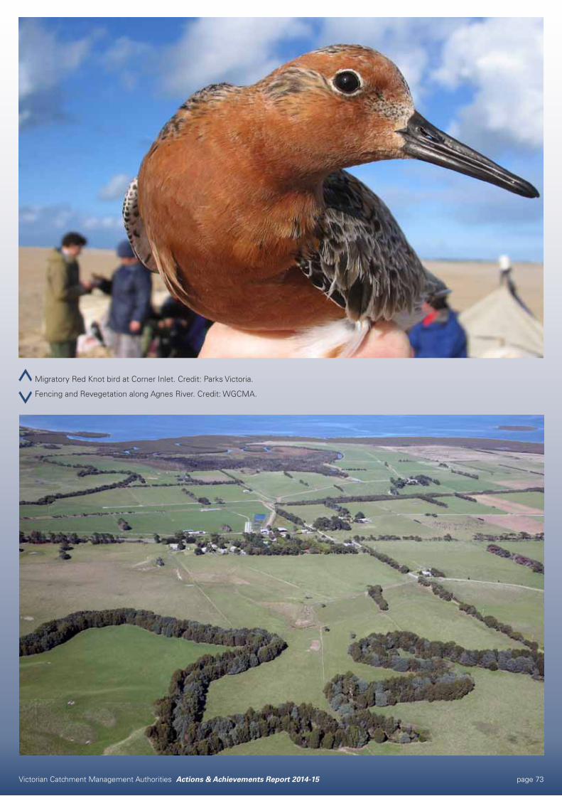
Victorian Catchment Management Authorities Actions & Achievements Report 2014-15 page 73
Migratory Red Knot bird at Corner Inlet. Credit: Parks Victoria.
Fencing and Revegetation along Agnes River. Credit: WGCMA.
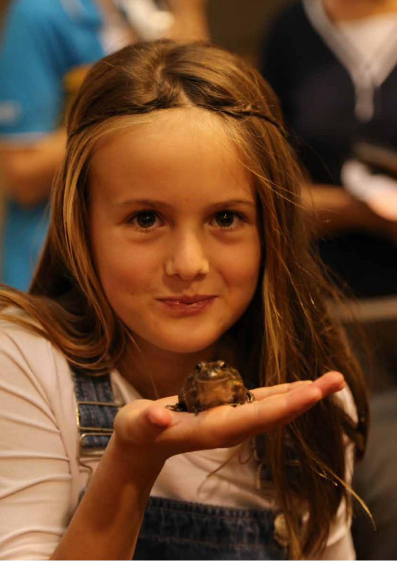
Victorian Catchment Management Authorities Actions & Achievements Report 2014-15 page 74
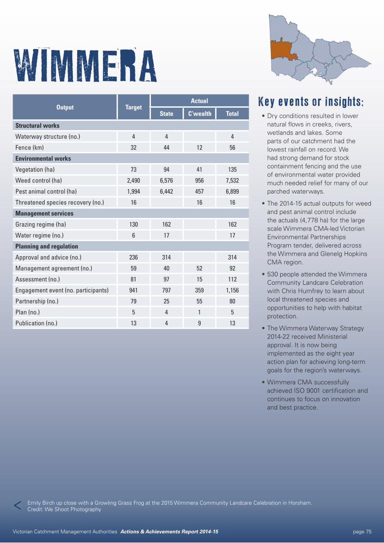
Victorian Catchment Management Authorities Actions & Achievements Report 2014-15 page 75
WIMMERAKey events or insights:•Dry conditions resulted in lower
natural flows in creeks, rivers, wetlands and lakes. Some parts of our catchment had the lowest rainfall on record. We had strong demand for stock containment fencing and the use of environmental water provided much needed relief for many of our parched waterways.
•The 2014-15 actual outputs for weed and pest animal control include the actuals (4,778 ha) for the large scale Wimmera CMA-led Victorian Environmental Partnerships Program tender, delivered across the Wimmera and Glenelg Hopkins CMA region.
•530 people attended the Wimmera Community Landcare Celebration with Chris Humfrey to learn about local threatened species and opportunities to help with habitat protection.
•The Wimmera Waterway Strategy 2014-22 received Ministerial approval. It is now being implemented as the eight year action plan for achieving long-term goals for the region’s waterways.
•Wimmera CMA successfully achieved ISO 9001 certification and continues to focus on innovation and best practice.
Output TargetActual
State C’wealth Total
Structural works
Waterway structure (no.) 4 4 4
Fence (km) 32 44 12 56
Environmental works
Vegetation (ha) 73 94 41 135
Weed control (ha) 2,490 6,576 956 7,532
Pest animal control (ha) 1,994 6,442 457 6,899
Threatened species recovery (no.) 16 16 16
Management services
Grazing regime (ha) 130 162 162
Water regime (no.) 6 17 17
Planning and regulation
Approval and advice (no.) 236 314 314
Management agreement (no.) 59 40 52 92
Assessment (no.) 81 97 15 112
Engagement event (no. participants) 941 797 359 1,156
Partnership (no.) 79 25 55 80
Plan (no.) 5 4 1 5
Publication (no.) 13 4 9 13
Emily Birch up close with a Growling Grass Frog at the 2015 Wimmera Community Landcare Celebration in Horsham. Credit: We Shoot Photography
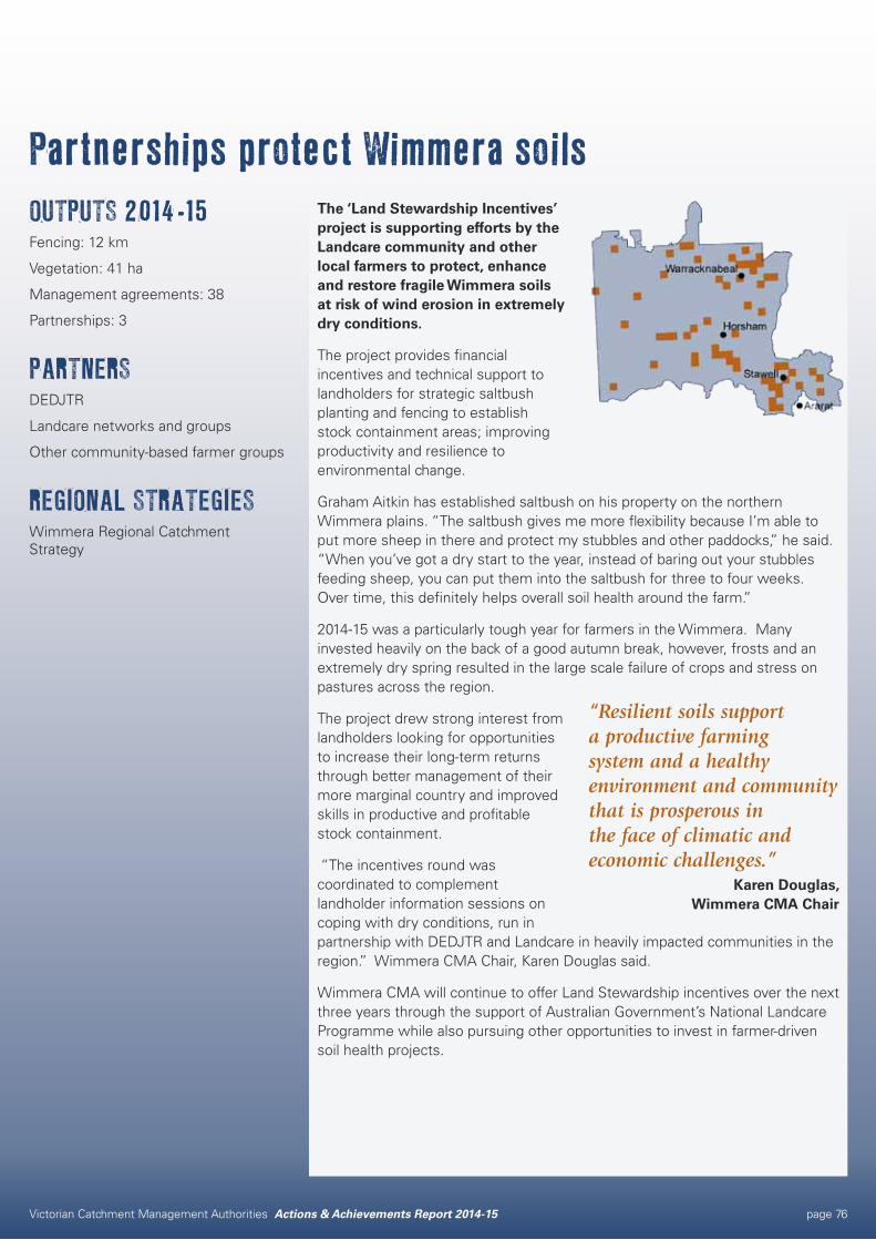
Victorian Catchment Management Authorities Actions & Achievements Report 2014-15 page 76
Partnerships protect Wimmera soilsOUTPUTS 2014-15Fencing: 12 km
Vegetation: 41 ha
Management agreements: 38
Partnerships: 3
PARTNERSDEDJTR
Landcare networks and groups
Other community-based farmer groups
REGIONAL STRATEGIESWimmera Regional Catchment Strategy
The ‘Land Stewardship Incentives’ project is supporting efforts by the Landcare community and other local farmers to protect, enhance and restore fragile Wimmera soils at risk of wind erosion in extremely dry conditions.
The project provides financial incentives and technical support to landholders for strategic saltbush planting and fencing to establish stock containment areas; improving productivity and resilience to environmental change.
Graham Aitkin has established saltbush on his property on the northern Wimmera plains. “The saltbush gives me more flexibility because I’m able to put more sheep in there and protect my stubbles and other paddocks,” he said. “When you’ve got a dry start to the year, instead of baring out your stubbles feeding sheep, you can put them into the saltbush for three to four weeks. Over time, this definitely helps overall soil health around the farm.”
2014-15 was a particularly tough year for farmers in the Wimmera. Many invested heavily on the back of a good autumn break, however, frosts and an extremely dry spring resulted in the large scale failure of crops and stress on pastures across the region.
The project drew strong interest from landholders looking for opportunities to increase their long-term returns through better management of their more marginal country and improved skills in productive and profitable stock containment.
“The incentives round was coordinated to complement landholder information sessions on coping with dry conditions, run in partnership with DEDJTR and Landcare in heavily impacted communities in the region.” Wimmera CMA Chair, Karen Douglas said.
Wimmera CMA will continue to offer Land Stewardship incentives over the next three years through the support of Australian Government’s National Landcare Programme while also pursuing other opportunities to invest in farmer-driven soil health projects.
“Resilient soils support a productive farming system and a healthy environment and community that is prosperous in the face of climatic and economic challenges.”
Karen Douglas, Wimmera CMA Chair
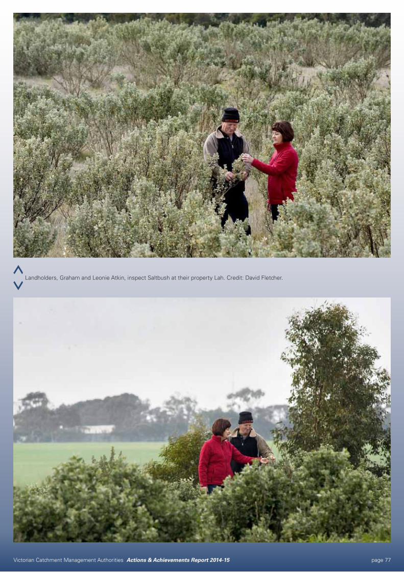
Victorian Catchment Management Authorities Actions & Achievements Report 2014-15 page 77
Landholders, Graham and Leonie Atkin, inspect Saltbush at their property Lah. Credit: David Fletcher.
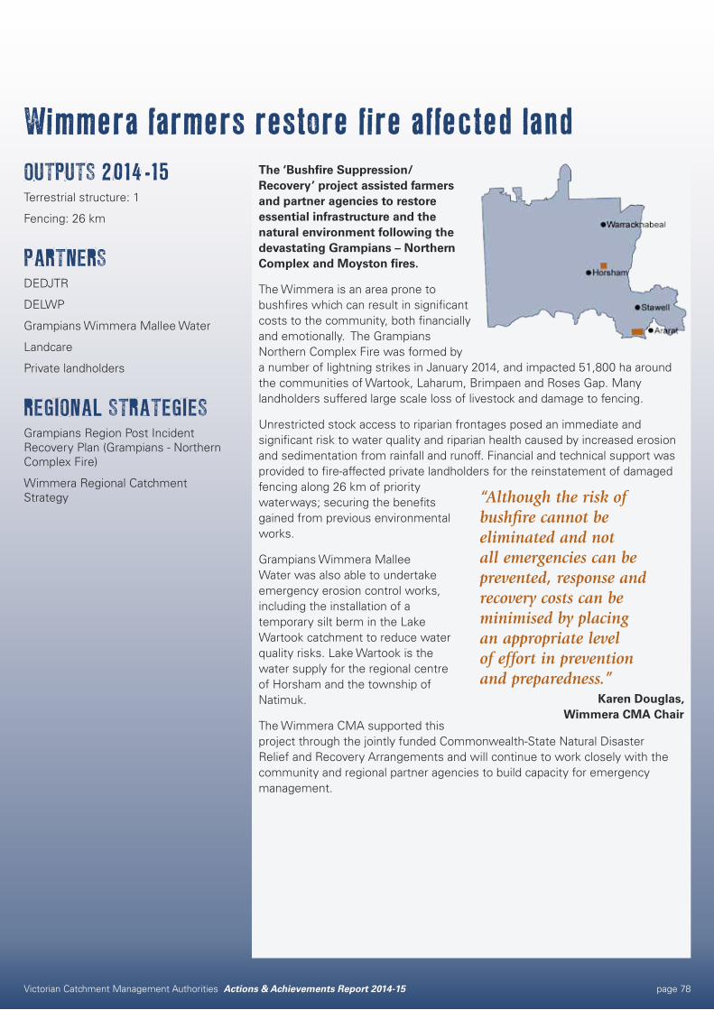
Victorian Catchment Management Authorities Actions & Achievements Report 2014-15 page 78
Wimmera farmers restore fire affected landOUTPUTS 2014-15Terrestrial structure: 1
Fencing: 26 km
PARTNERSDEDJTR
DELWP
Grampians Wimmera Mallee Water
Landcare
Private landholders
REGIONAL STRATEGIESGrampians Region Post Incident Recovery Plan (Grampians - Northern Complex Fire)
Wimmera Regional Catchment Strategy
The ‘Bushfire Suppression/Recovery’ project assisted farmers and partner agencies to restore essential infrastructure and the natural environment following the devastating Grampians – Northern Complex and Moyston fires.
The Wimmera is an area prone to bushfires which can result in significant costs to the community, both financially and emotionally. The Grampians Northern Complex Fire was formed by a number of lightning strikes in January 2014, and impacted 51,800 ha around the communities of Wartook, Laharum, Brimpaen and Roses Gap. Many landholders suffered large scale loss of livestock and damage to fencing.
Unrestricted stock access to riparian frontages posed an immediate and significant risk to water quality and riparian health caused by increased erosion and sedimentation from rainfall and runoff. Financial and technical support was provided to fire-affected private landholders for the reinstatement of damaged fencing along 26 km of priority waterways; securing the benefits gained from previous environmental works.
Grampians Wimmera Mallee Water was also able to undertake emergency erosion control works, including the installation of a temporary silt berm in the Lake Wartook catchment to reduce water quality risks. Lake Wartook is the water supply for the regional centre of Horsham and the township of Natimuk.
The Wimmera CMA supported this project through the jointly funded Commonwealth-State Natural Disaster Relief and Recovery Arrangements and will continue to work closely with the community and regional partner agencies to build capacity for emergency management.
“Although the risk of bushfire cannot be eliminated and not all emergencies can be prevented, response and recovery costs can be minimised by placing an appropriate level of effort in prevention and preparedness.”
Karen Douglas, Wimmera CMA Chair
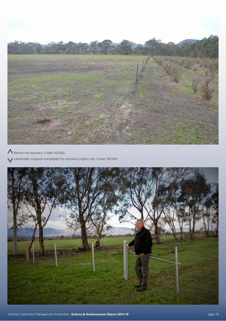
Victorian Catchment Management Authorities Actions & Achievements Report 2014-15 page 79
Before fire recovery. Credit: WCMA.
Landholder inspects completed fire recovery project site. Credit: WCMA.
Victorian Catchment Management Authorities Actions & Achievements Report 2014-15 page 80
Catchment Management AuthoritiesCONTACTS
North Central CMA
628-632 Midland Highway, PO Box 18, Huntly, Victoria 3551 Phone: 03 5448 71246 Fax: 03 5448 7148
www.nccma.vic.gov.au
North East CMA
1B Footmark Court, PO Box 616, Wodonga, Victoria 3689 Phone: 02 6043 7600 Fax: 02 6043 7601
www.necma.vic.gov.au
Port Phillip & Westernport CMA
Level 1, Landmark Corporate Centre 454-472 Nepean Hwy, Victoria 3199 Phone: 03 8781 7900 Fax: 03 9781 0199
www.ppwcma.vic.gov.au
West Gippsland CMA
16 Hotham Street, PO Box 1374, Traralgon, Victoria 3844 Phone: 03 5175 7800 Fax: 03 5175 7899
www.wgcma.vic.gov.au
Wimmera CMA
26 Darlot Street, PO Box 479, Horsham, Victoria 3402 Phone: 03 5382 1544 Fax: 03 5382 6076
www.wcma.vic.gov.au
Corangamite CMA
64 Dennis Street, Colac, Victoria 3250 Phone: 03 5232 9100 Fax: 03 5232 2759
www.ccma.vic.gov.au
East Gippsland CMA
574 Main Street, Bairnsdale, Victoria 3875 Phone: 03 5152 0600
www.egcma.com.au
Glenelg Hopkins CMA
79 French Street, Hamilton, Victoria 3300 Phone: 03 5571 2526 Fax: 03 5571 2935
www.ghcma.vic.gov.au
Goulburn Broken CMA
168 Welsford Street, Shepparton, Victoria 3630 Phone: 03 5820 1100 Fax: 03 5831 6254
www.gbcma.vic.gov.au
Mallee CMA
Cnr Eleventh Street and Koorlong Avenue, Irymple, Victoria 3498 Phone: 03 5051 4377 Fax: 03 5051 4279
www.malleecma.vic.gov.au