Embed Size (px)
Citation preview
5/20/2015
UNCLASSIFIED
UNCLASSIFIED
UNCLASSIFIED
UNCLASSIFIED
US National Ice Center - Sea Ice Analysis in Antarctic Waters
COMNAP 2015
13 May 2015
CDR K. TaylorCommanding Officer
LCDR R. AtkinsonExecutive Officer
Mr. S. HelfrichActing Deputy Director
USN USCG NOAA
Caryn PanowiczOperations Technical Director
5/20/2015
UNCLASSIFIED
UNCLASSIFIED
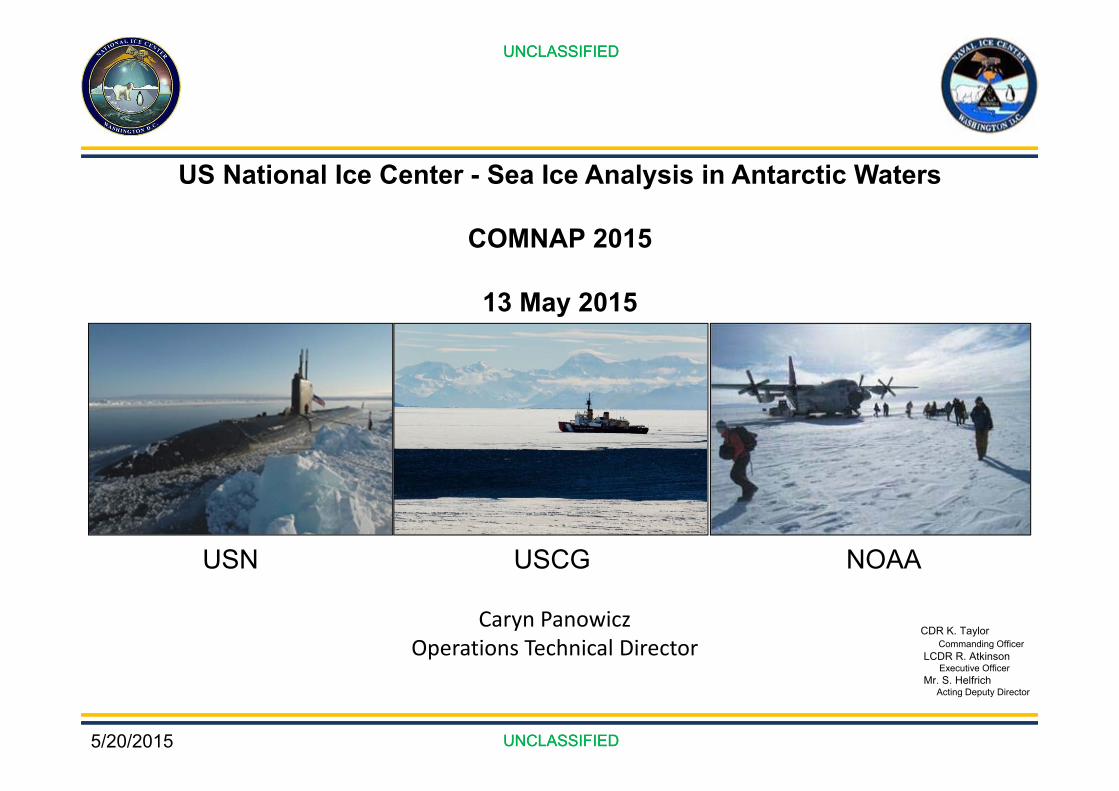
U.S. National Ice CenterMission
The U.S. National Ice Center (NIC) is a tri-agency partnership of the United States Navy (USN), the National Oceanic and Atmospheric Administration (NOAA), and the United
States Coast Guard (USCG) providing global ice and snow analysis and short term forecasting services for the maximum benefit of the United States government.
VisionTo be the U.S. government’s authority on global sea ice and snow analysis and
forecasting.
UNCLASSIFIED
UNCLASSIFIED
Goal 1. Develop Capabilities
Goal 2. Transition Science and Technology
Goal 3. Strengthen Partnerships
Goal 4. Professional Excellence
Goals
5/20/2015
UNCLASSIFIED
UNCLASSIFIED
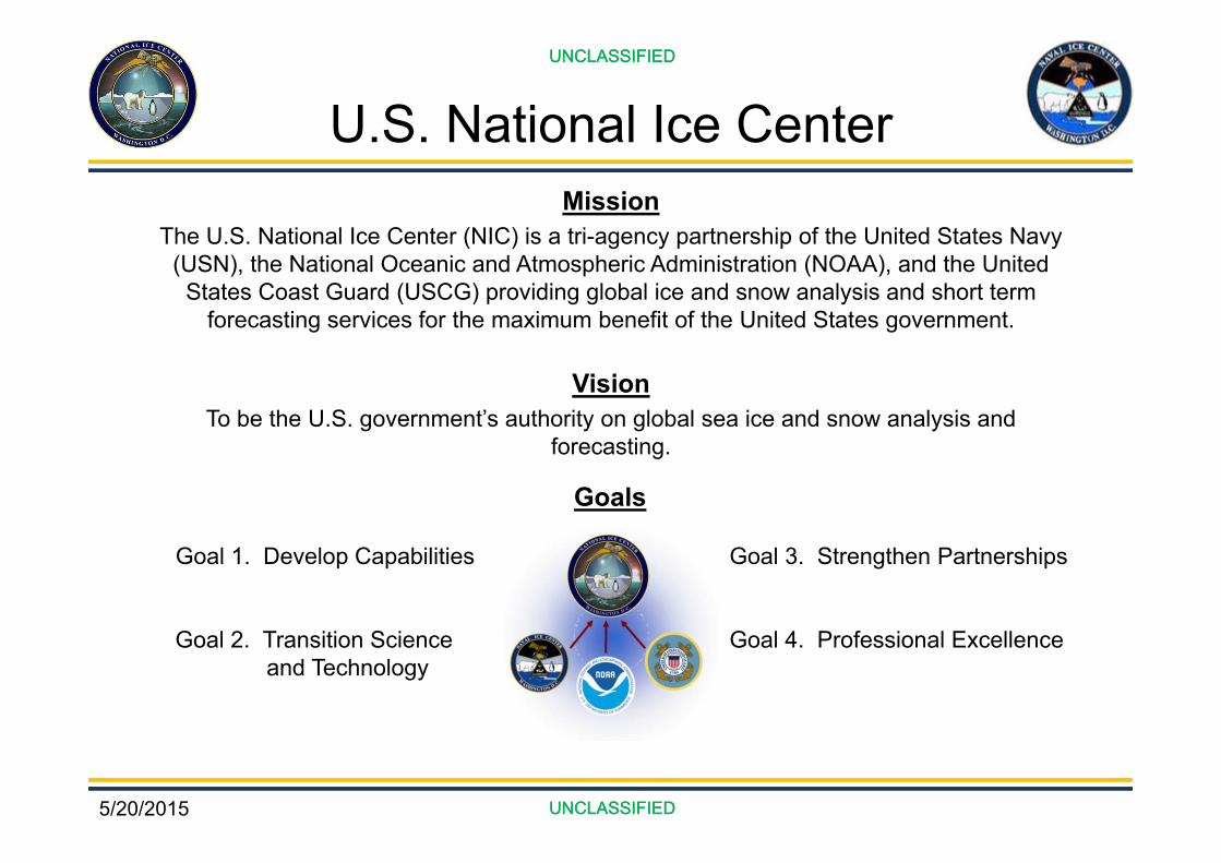
USNIC Organization
CommanderNaval Meteorology & Oceanography
Command(CNMOC)
Commander Naval Information
Dominance Forces (NAVIDFOR)
Naval Oceanographic Office
(NAVOCEANO)
Naval Ice Center(NAVICECEN)
National Environmental Satellite, Data &
Information Service(NESDIS)
Office of Satellite and Product Operations
(OSPO)/ Center for Satellite
Applications & Research (STAR)
Asst. Commandant for Prevention
Policy(CG‐5P)
Mobility and Ice Operations Division
(CG‐WWM‐3)
Director of Marine Transportation
Systems(CG‐5PW)
Office of Waterways and Ocean Policy
(CG‐WWM)
US National Ice Center(NIC)
5/20/2015
UNCLASSIFIED
UNCLASSIFIED
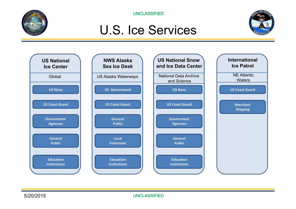
U.S. Ice ServicesUNCLASSIFIED
UNCLASSIFIED
US Navy
US Coast Guard
Government Agencies
General Public
EducationInstitutions
US NationalIce Center
Global
US Government
US Coast Guard
General Public
LocalFishermen
EducationInstitutions
NWS AlaskaSea Ice Desk
US Alaska Waterways
US Navy
US Coast Guard
Government Agencies
General Public
EducationInstitutions
US National Snow and Ice Data Center
National Data Archive and Science
US Coast Guard
MerchantShipping
NE AtlanticWaters
InternationalIce Patrol
5/20/2015
UNCLASSIFIED
UNCLASSIFIED
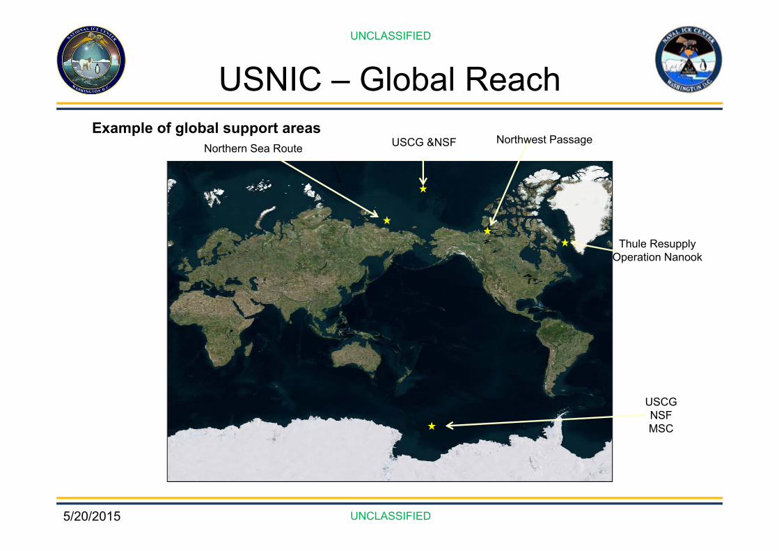
USNIC – Global ReachExample of global support areas
Northwest Passage
Thule ResupplyOperation Nanook
USCGNSFMSC
Northern Sea Route USCG &NSF

5/20/2015
UNCLASSIFIED
UNCLASSIFIED
Product Generation
SatellitesBuoys Models Ship ObsAircraft International
Partners
+Radar Surface
ObsWebcam
Arctic Maritime Domain Awareness
Fractures, Leads and Polynyas (FLAP)
Hemispheric and Regional
Ice Charts
Annotated Images
Blended Snow and ice cover
Automated Snow and Ice products
Ice Outlooks
Ice Thickness Estimations
Antarctic Icebergs
Blended Snow Depth
Interpretive Snow and Sea Ice Analysis and
Sea Ice Forecasting
Geographic Information System
Meteorology
Semi‐automation
Subject Matter Expertise
5/20/2015
UNCLASSIFIED
UNCLASSIFIED
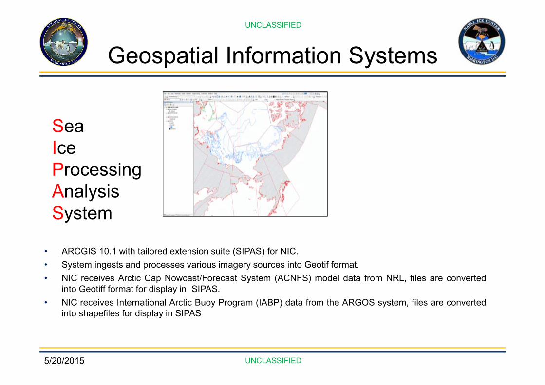
Geospatial Information Systems
• ARCGIS 10.1 with tailored extension suite (SIPAS) for NIC.• System ingests and processes various imagery sources into Geotif format.• NIC receives Arctic Cap Nowcast/Forecast System (ACNFS) model data from NRL, files are converted
into Geotiff format for display in SIPAS.• NIC receives International Arctic Buoy Program (IABP) data from the ARGOS system, files are converted
into shapefiles for display in SIPAS
SeaIceProcessingAnalysisSystem
5/20/2015
UNCLASSIFIED
UNCLASSIFIED
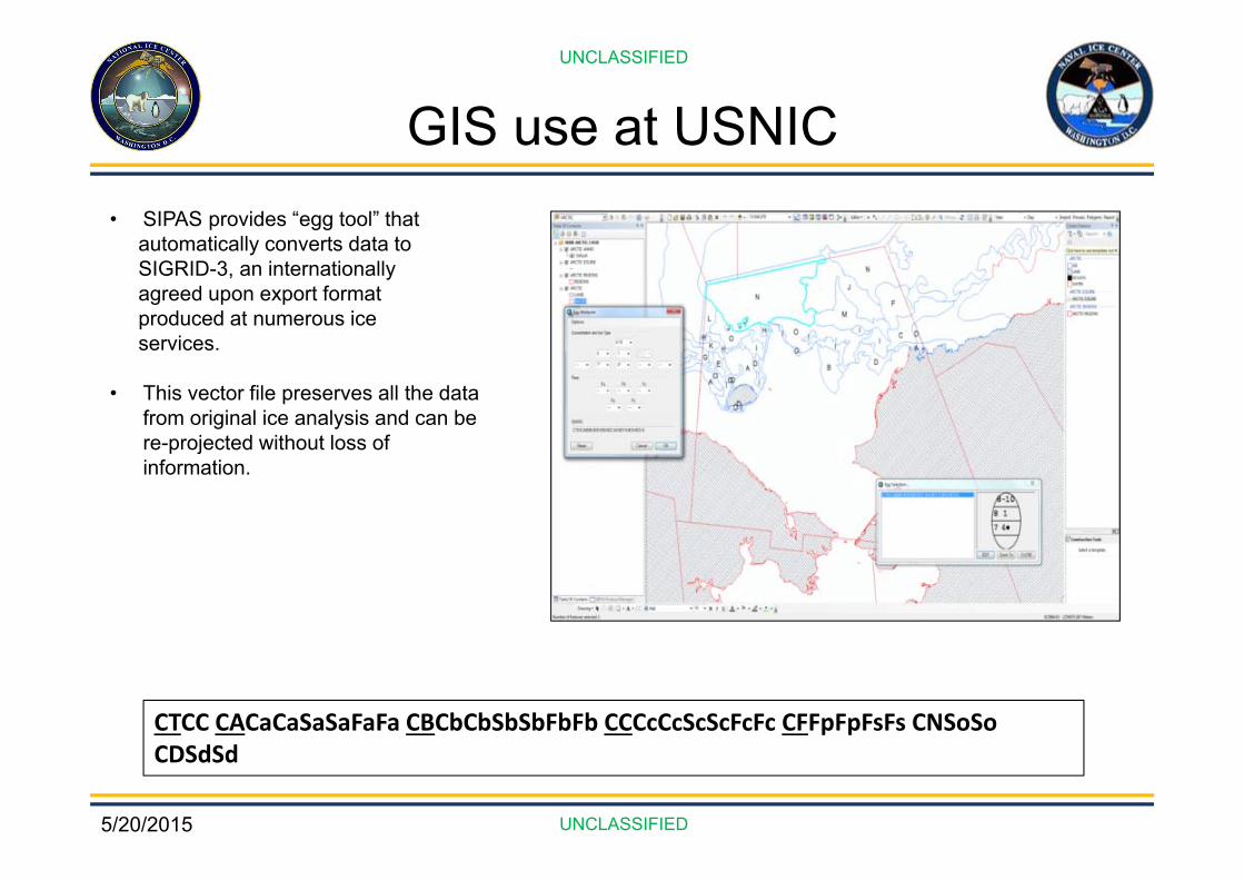
GIS use at USNIC• SIPAS provides “egg tool” that
automatically converts data to SIGRID-3, an internationallyagreed upon export format produced at numerous ice services.
• This vector file preserves all the data from original ice analysis and can be re-projected without loss of information.
CTCC CACaCaSaSaFaFa CBCbCbSbSbFbFb CCCcCcScScFcFc CFFpFpFsFs CNSoSo CDSdSd

5/20/2015
UNCLASSIFIED
UNCLASSIFIED
USNIC Data FormatsGeodatabase of selected sea ice parameters enables some sharing of data with international ice services, modelling community, research organizations.
SIGRID-3 – Export format allowingPartner Nation Ice Centers to ingest NIC analysis.
With ARCGIS10.2 +GRIB3Net CDFHDF
NIC PRODUCT FILE FORMATDaily Arctic and Antarctic Ice Edge
ASCIIShapefilesOverlaykmz
Arctic and Antarctic Marginal Ice Zone
ASCIIShapefilesOverlaykmz
Environmental Awareness Products
jpgkmz
NAIS Iceberg Chart .pdf
Arctic and Antarctic Hemispheric
.pdfShapefilesKmz (being revised for publication)
Antarctic Icebergs .pdf.csv
Alaska Ice Information GRIB
Great Lakes Analysis ASCII Shapefiles GRIB .jpgKmz
Ice and Snow Products GRIB2GeoTiff

5/20/2015
UNCLASSIFIED
UNCLASSIFIED
USNIC Routine Support
5/20/2015
UNCLASSIFIED
UNCLASSIFIED
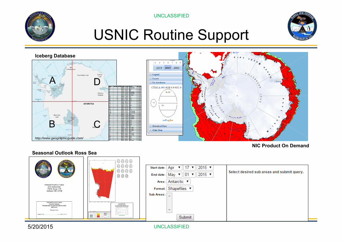
USNIC Routine Support
A D
CBhttp://www.geographicguide.com/
NIC Product On Demand
Iceberg Database
Seasonal Outlook Ross Sea
5/20/2015
UNCLASSIFIED
UNCLASSIFIED
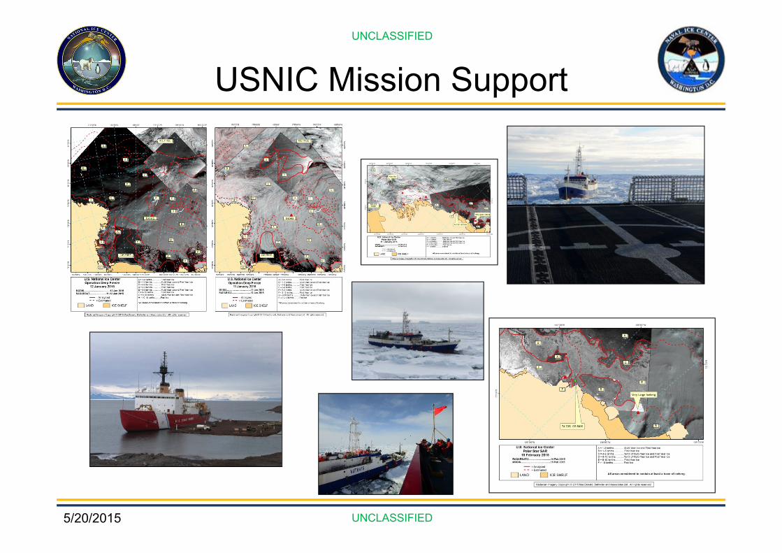
USNIC Mission Support
5/20/2015
UNCLASSIFIED
UNCLASSIFIED
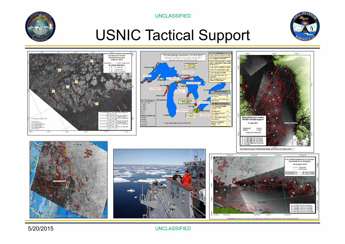
USNIC Tactical Support
5/20/2015
UNCLASSIFIED
UNCLASSIFIED
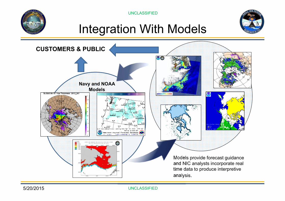
Integration With Models
Models provide forecast guidance and NIC analysts incorporate real time data to produce interpretive analysis.
CUSTOMERS & PUBLIC
Navy and NOAA Models

5/20/2015
UNCLASSIFIED
UNCLASSIFIED
ACNFS Fields-OPS
Forecasted out 7 days [t000-t168]
Surface WindsMean Sea Level PressureSurface Air Temperature
Sea Surface TemperatureSea Ice Fraction
Sea Ice ThicknessIce Drift
Lead Area Opening RateSea Surface Salinity
Compressive Strength of Sea IceFreeze/Melt Potential
Congelation Ice GrowthLateral Ice Melt
Top Ice MeltBasil Ice Melt
Surface Snow ThicknessSurface Albedo Where Sea Ice
Rainfall RateSurface Temperature Where Sea Ice
5/20/2015
UNCLASSIFIED
UNCLASSIFIED
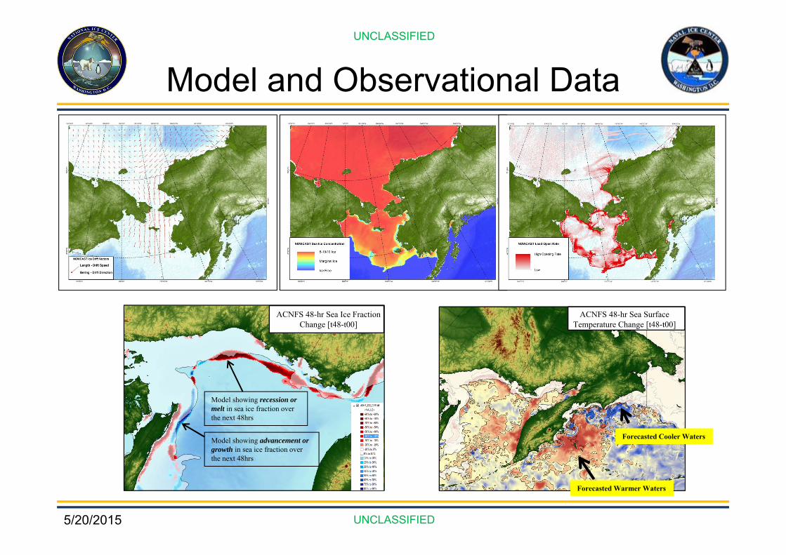
Model and Observational Data
ACNFS 48-hr Sea Ice Fraction Change [t48-t00]
Model showing recession or melt in sea ice fraction over the next 48hrs
Model showing advancement or growth in sea ice fraction over the next 48hrs
ACNFS 48-hr Sea Surface Temperature Change [t48-t00]
Forecasted Warmer Waters
Forecasted Cooler Waters
5/20/2015
UNCLASSIFIED
UNCLASSIFIED
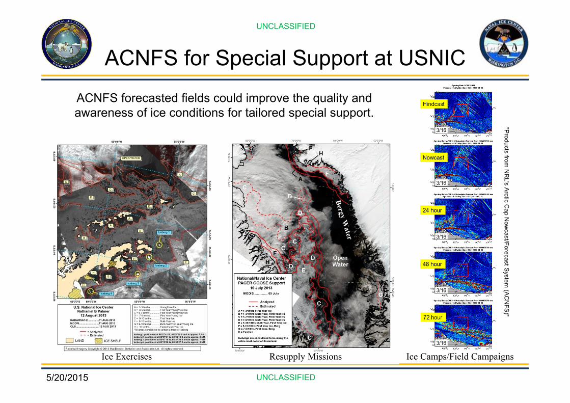
ACNFS forecasted fields could improve the quality and awareness of ice conditions for tailored special support.
Ice Exercises Resupply Missions
"Products from N
RL's Arctic C
ap Now
cast/Forecast System (AC
NFS)"
Ice Camps/Field Campaigns
ACNFS for Special Support at USNIC

5/20/2015
UNCLASSIFIED
UNCLASSIFIED
Provide location and orientation/directional information on fractures, leads, and polynyas across a given region.
ICEX fracturing event with ACFNS
Reversal in winds and ice drift was predicted 6 days out. Large-scale fracturing was predicted 48-hrs out.
Can NIC use ACNFS to provide 1-7 day FLAP Outlooks?
ACNFS
Illustration from NRL's Arctic Cap Nowcast/Forecast System (ACNFS)
Fractures, Leads, and Polynyas (FLAP)

5/20/2015
UNCLASSIFIED
UNCLASSIFIED
Ice Edge Forecasting
48-hr Forecasted Auto-Ice Edge
48-HR DRIFT VECTOR (ACNFS MODEL)
CURRENT NIC ICE EDGE (OBSERVED)
48-HR PREDICTED AUTO-ICE EDGE
Apply ACNFS forecasted drift vectors (drift velocity and bearing) to current NIC observed ice edge
* Experimental product, not currently operational
5/20/2015
UNCLASSIFIED
UNCLASSIFIED
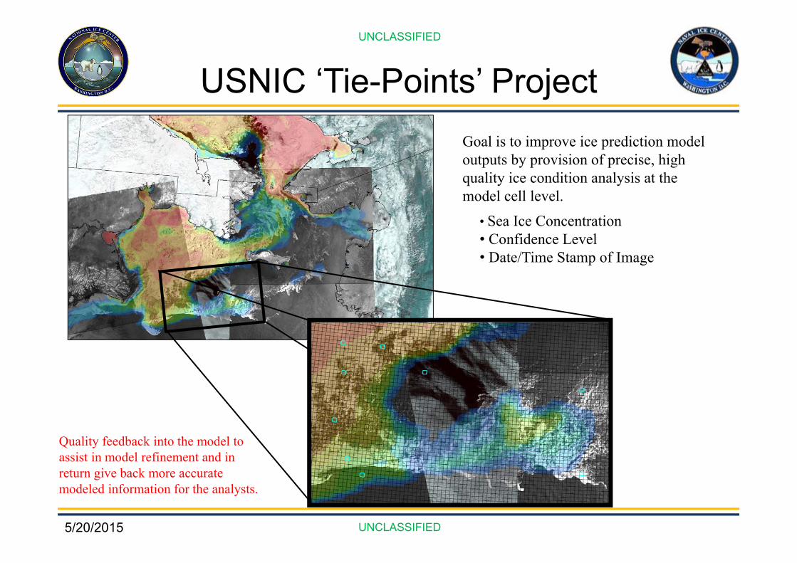
USNIC ‘Tie-Points’ ProjectGoal is to improve ice prediction model outputs by provision of precise, high quality ice condition analysis at the model cell level.
Quality feedback into the model to assist in model refinement and in return give back more accurate modeled information for the analysts.
• Sea Ice Concentration• Confidence Level• Date/Time Stamp of Image
5/20/2015
UNCLASSIFIED
UNCLASSIFIED
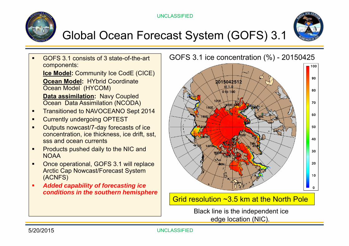
Global Ocean Forecast System (GOFS) 3.1
GOFS 3.1 consists of 3 state-of-the-art components:Ice Model: Community Ice CodE (CICE)Ocean Model: HYbrid Coordinate Ocean Model (HYCOM)Data assimilation: Navy Coupled Ocean Data Assimilation (NCODA)
Transitioned to NAVOCEANO Sept 2014 Currently undergoing OPTEST Outputs nowcast/7-day forecasts of ice
concentration, ice thickness, ice drift, sst, sss and ocean currents
Products pushed daily to the NIC and NOAA
Once operational, GOFS 3.1 will replace Arctic Cap Nowcast/Forecast System (ACNFS)
Added capability of forecasting ice conditions in the southern hemisphere
Black line is the independent ice edge location (NIC).
Grid resolution ~3.5 km at the North Pole
GOFS 3.1 ice concentration (%) - 20150425
5/20/2015
UNCLASSIFIED
UNCLASSIFIED
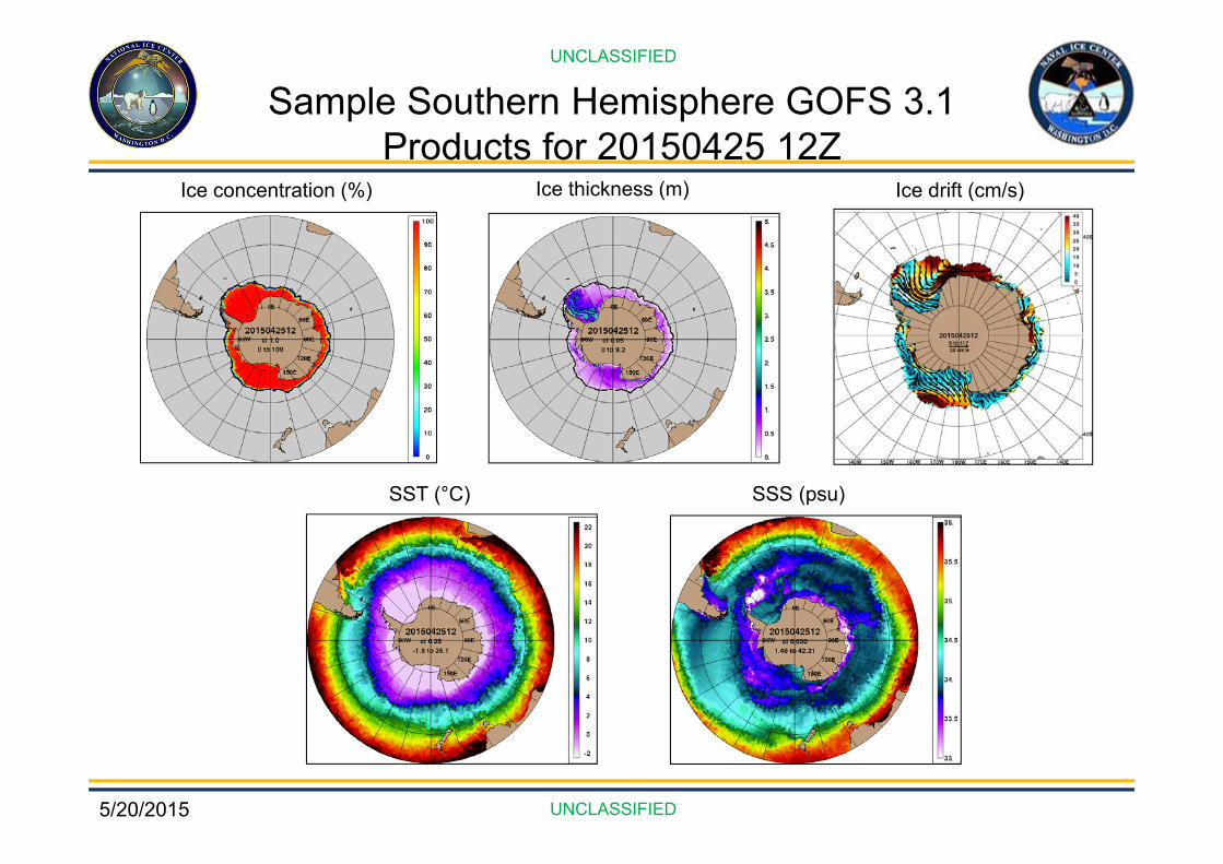
Sample Southern Hemisphere GOFS 3.1 Products for 20150425 12Z
Ice concentration (%) Ice thickness (m) Ice drift (cm/s)
SST (°C) SSS (psu)
5/20/2015
UNCLASSIFIED
UNCLASSIFIED
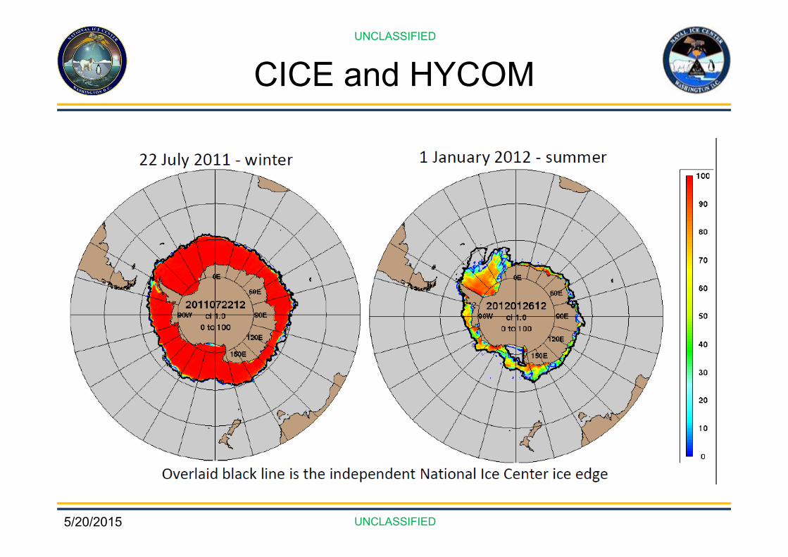
CICE and HYCOM
5/20/2015
UNCLASSIFIED
UNCLASSIFIED
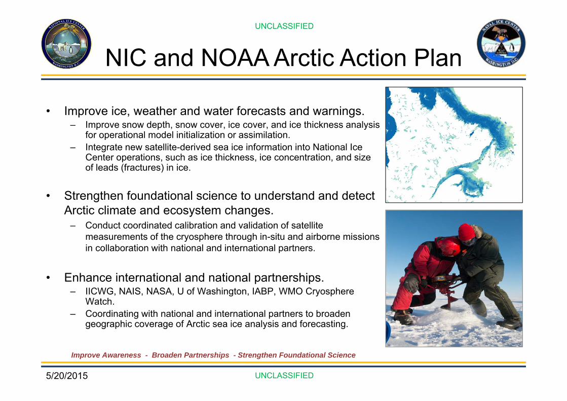
NIC and NOAA Arctic Action Plan
• Improve ice, weather and water forecasts and warnings.– Improve snow depth, snow cover, ice cover, and ice thickness analysis
for operational model initialization or assimilation.– Integrate new satellite-derived sea ice information into National Ice
Center operations, such as ice thickness, ice concentration, and size of leads (fractures) in ice.
• Strengthen foundational science to understand and detect Arctic climate and ecosystem changes.
– Conduct coordinated calibration and validation of satellite measurements of the cryosphere through in-situ and airborne missions in collaboration with national and international partners.
• Enhance international and national partnerships.– IICWG, NAIS, NASA, U of Washington, IABP, WMO Cryosphere
Watch.– Coordinating with national and international partners to broaden
geographic coverage of Arctic sea ice analysis and forecasting.
Improve Awareness - Broaden Partnerships - Strengthen Foundational Science

5/20/2015
UNCLASSIFIED
UNCLASSIFIED
Arctic Strategy/Road MapsCore Competencies
Improve AwarenessBroaden PartnershipsStrengthen Foundational Science

5/20/2015
UNCLASSIFIED
UNCLASSIFIED
Domestic Partnerships• National Snow and Ice Data Center
– Archives NIC data.– Co-generates the Multisensor Analyzed Sea Ice Extent (MASIE) with NIC.
• NASA – Goddard & Jet Propulsion Lab– Algorithm testing and development.– NIC is early adopter for NASA SMAP mission.
• Naval Research Labs– Evaluate the utility of new USN models.– Partner on projects for model development.
• Rutgers University Global Snow Lab– Climate Data Record (CDR) using NIC Blended Snow.
• Office of Naval Research– Programs to enhance understanding of ice.
• University of Washington – APL– Coordination for IABP (funding and deployment).

5/20/2015
UNCLASSIFIED
UNCLASSIFIED
International PartnershipsUNCLASSIFIED
UNCLASSIFIED
• North American Ice Service (NAIS)– Multi-agency partnership between U.S. National Ice
Center (NIC), Canadian Ice Service (CIS), and International Ice Patrol (IIP).
• International Arctic Buoy Program (IABP)– Global participants working together to maintain a
network of drifting buoys in the Arctic Ocean.
• International Ice Charting Working Group (IICWG)– Formed in October 1999 to promote cooperation between
the world’s ice centers on all matters concerning sea ice and icebergs.
• WMO Expert Team on Sea Ice (ETSI)– Formal coordination of sea ice activities on the level of
WMO/IOC that provides technical direction to the WMO Secretariat.
• WMO Global Cryosphere Watch – SnowWatch– Promotes Cooperation between the world’s snow
observing nations.
5/20/2015
UNCLASSIFIED
UNCLASSIFIED
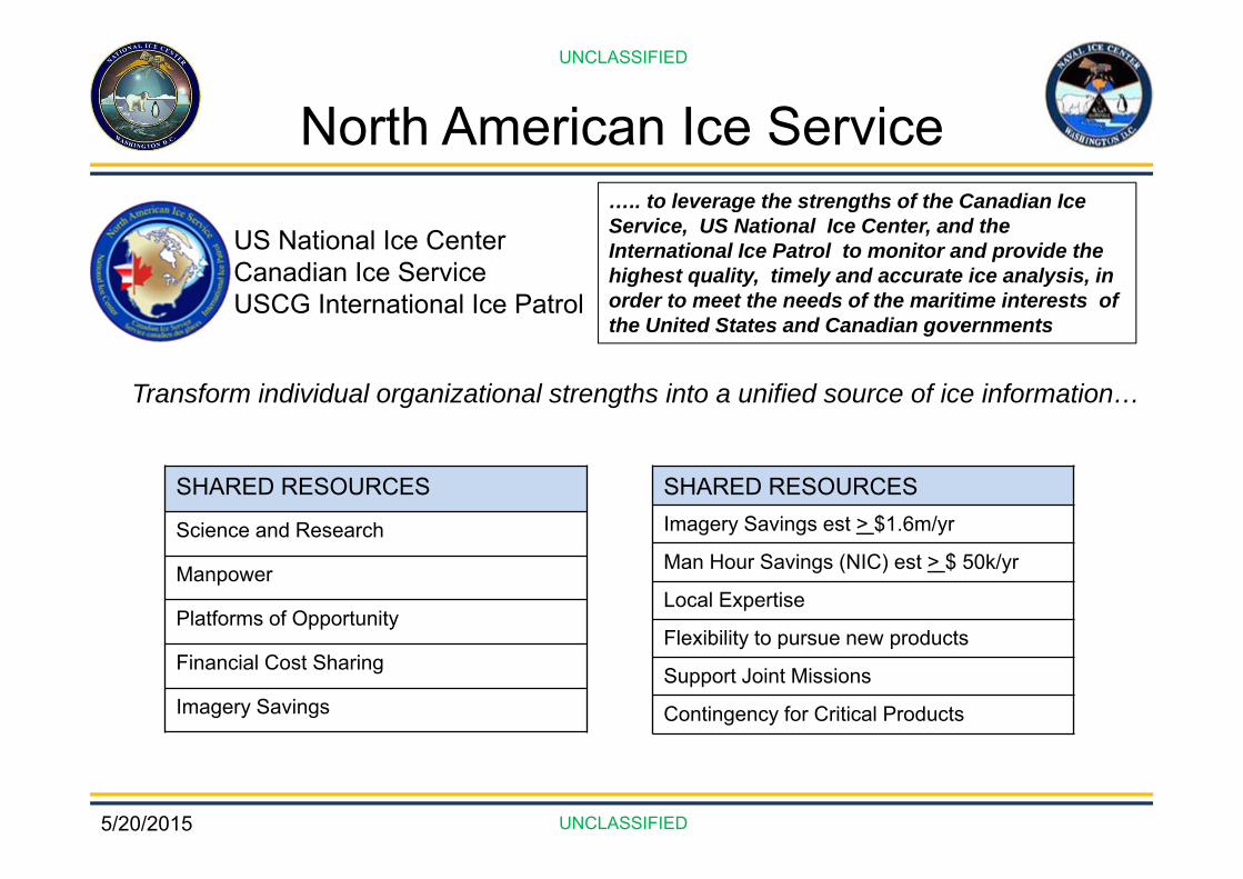
North American Ice Service
US National Ice CenterCanadian Ice ServiceUSCG International Ice Patrol
Transform individual organizational strengths into a unified source of ice information…
….. to leverage the strengths of the Canadian Ice Service, US National Ice Center, and the International Ice Patrol to monitor and provide the highest quality, timely and accurate ice analysis, in order to meet the needs of the maritime interests of the United States and Canadian governments
SHARED RESOURCES
Science and Research
Manpower
Platforms of Opportunity
Financial Cost Sharing
Imagery Savings
SHARED RESOURCESImagery Savings est > $1.6m/yr
Man Hour Savings (NIC) est > $ 50k/yr
Local Expertise
Flexibility to pursue new products
Support Joint Missions
Contingency for Critical Products
5/20/2015
UNCLASSIFIED
UNCLASSIFIED
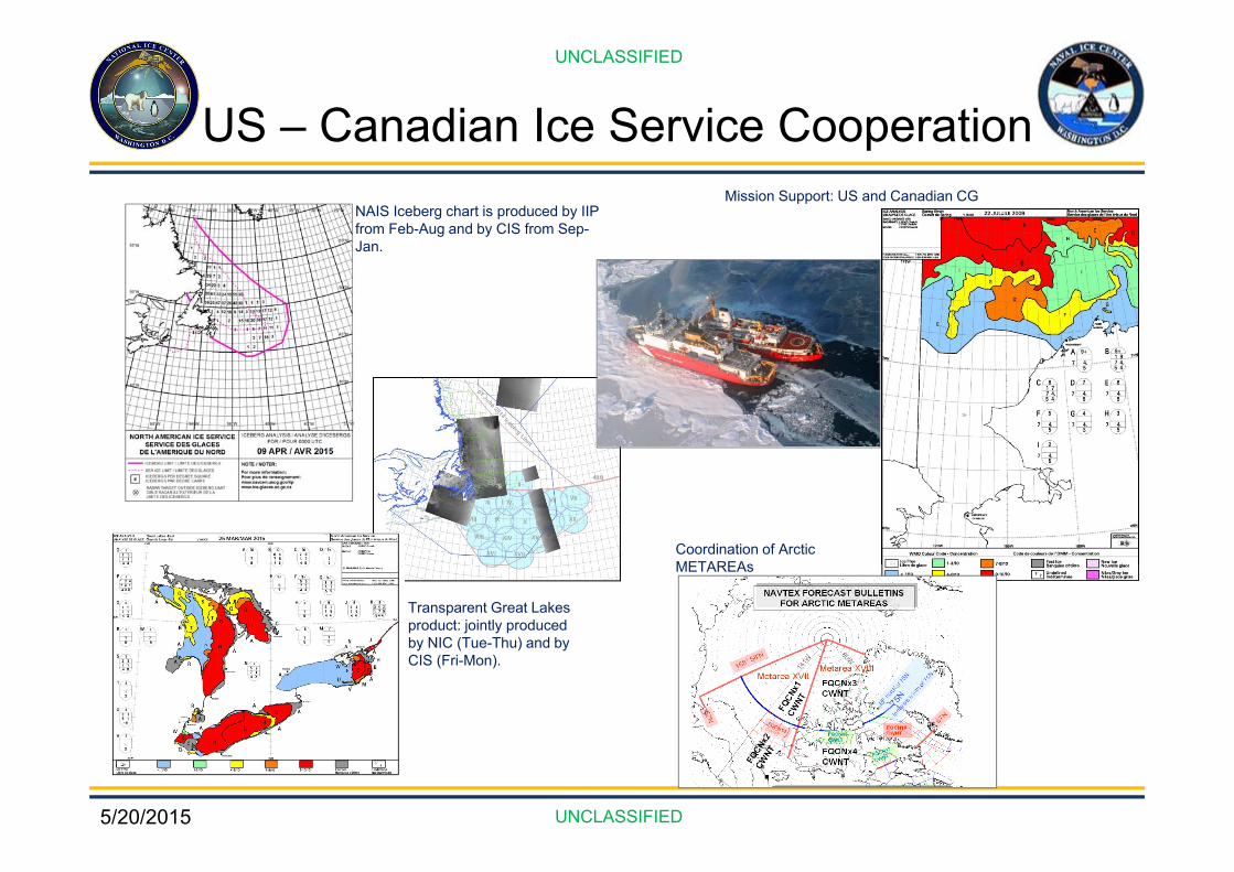
US – Canadian Ice Service CooperationNAIS Iceberg chart is produced by IIP from Feb-Aug and by CIS from Sep-Jan.
Mission Support: US and Canadian CG
Transparent Great Lakes product: jointly produced by NIC (Tue-Thu) and by CIS (Fri-Mon).
Coordination of Arctic METAREAs

5/20/2015
UNCLASSIFIED
UNCLASSIFIED
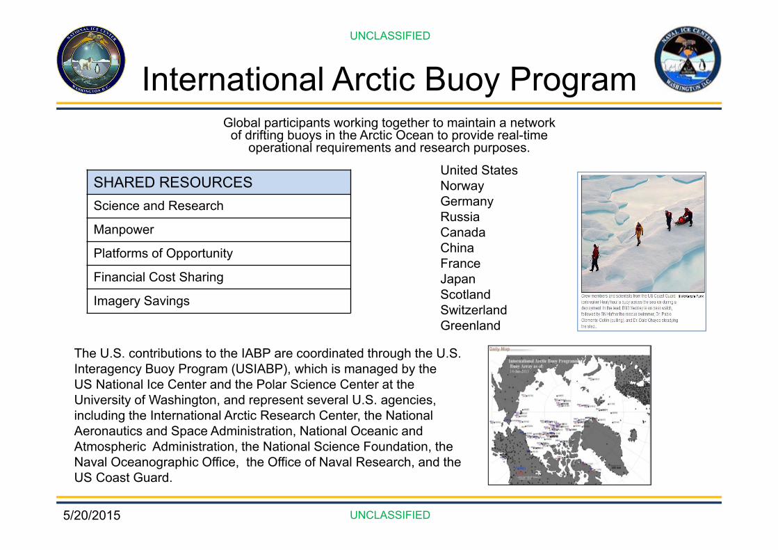
International Arctic Buoy ProgramGlobal participants working together to maintain a network
of drifting buoys in the Arctic Ocean to provide real-time operational requirements and research purposes.
United StatesNorwayGermanyRussiaCanadaChinaFranceJapanScotlandSwitzerlandGreenland
The U.S. contributions to the IABP are coordinated through the U.S. Interagency Buoy Program (USIABP), which is managed by the US National Ice Center and the Polar Science Center at the University of Washington, and represent several U.S. agencies, including the International Arctic Research Center, the National Aeronautics and Space Administration, National Oceanic and Atmospheric Administration, the National Science Foundation, the Naval Oceanographic Office, the Office of Naval Research, and the US Coast Guard.
SHARED RESOURCESScience and Research
Manpower
Platforms of Opportunity
Financial Cost Sharing
Imagery Savings
5/20/2015
UNCLASSIFIED
UNCLASSIFIED
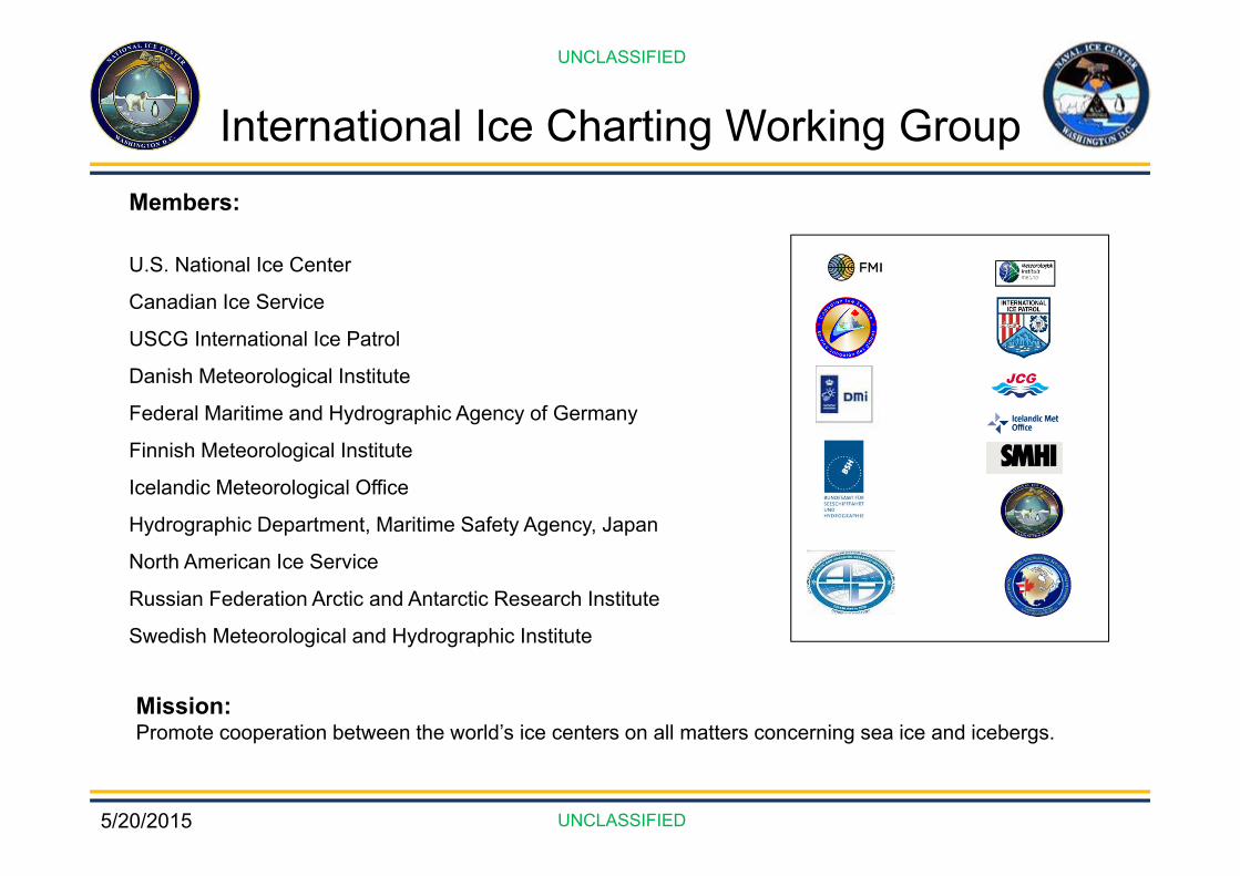
International Ice Charting Working GroupMembers:
U.S. National Ice Center
Canadian Ice Service
USCG International Ice Patrol
Danish Meteorological Institute
Federal Maritime and Hydrographic Agency of Germany
Finnish Meteorological Institute
Icelandic Meteorological Office
Hydrographic Department, Maritime Safety Agency, Japan
North American Ice Service
Russian Federation Arctic and Antarctic Research Institute
Swedish Meteorological and Hydrographic Institute
Mission:Promote cooperation between the world’s ice centers on all matters concerning sea ice and icebergs.
5/20/2015
UNCLASSIFIED
UNCLASSIFIED
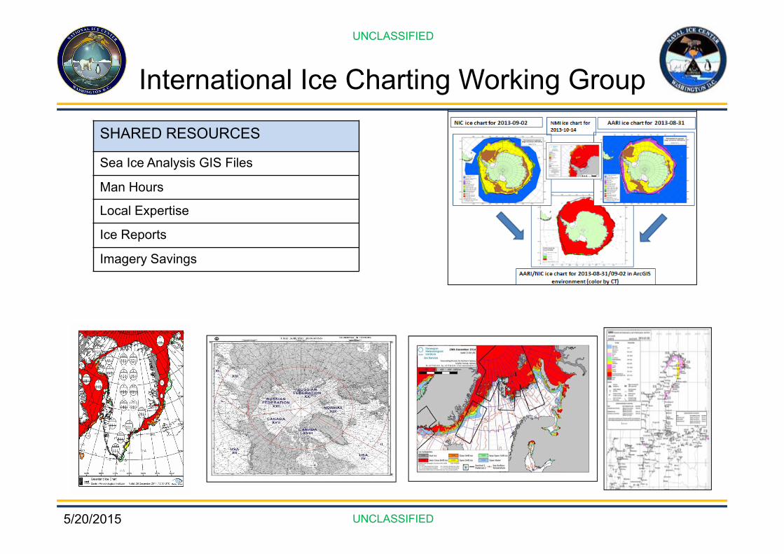
International Ice Charting Working Group
SHARED RESOURCES
Sea Ice Analysis GIS Files
Man Hours
Local Expertise
Ice Reports
Imagery Savings
5/20/2015
UNCLASSIFIED
UNCLASSIFIED
International Arctic Buoy ProgramGlobal participants working together to maintain a network
of drifting buoys in the Arctic Ocean to provide real-time operational requirements and research purposes.
United StatesNorwayGermanyRussiaCanadaChinaFranceJapanScotlandSwitzerlandGreenland
The U.S. contributions to the IABP are coordinated through the U.S. Interagency Buoy Program (USIABP), which is managed by the US National Ice Center and the Polar Science Center at the University of Washington, and represent several U.S. agencies, including the International Arctic Research Center, the National Aeronautics and Space Administration, National Oceanic and Atmospheric Administration, the National Science Foundation, the Naval Oceanographic Office, the Office of Naval Research, and the US Coast Guard.
SHARED RESOURCESScience and Research
Manpower
Platforms of Opportunity
Financial Cost Sharing
Imagery Savings
5/20/2015
UNCLASSIFIED
UNCLASSIFIED
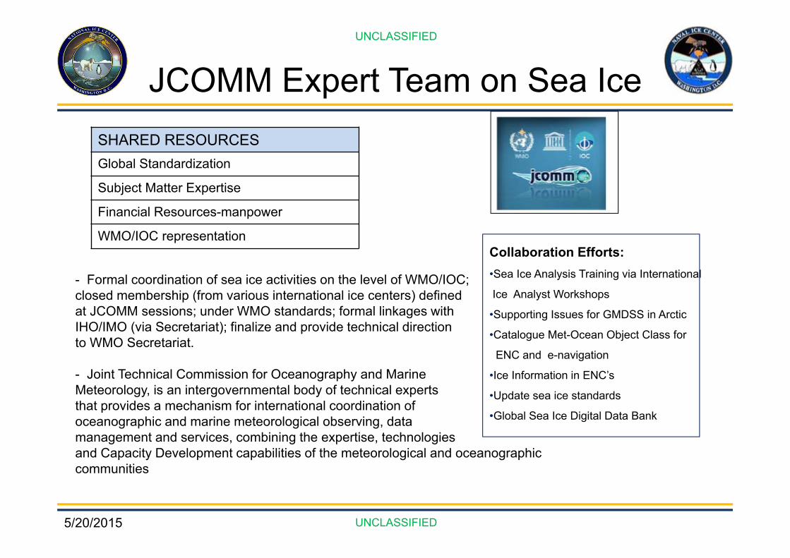
JCOMM Expert Team on Sea IceSHARED RESOURCESGlobal Standardization
Subject Matter Expertise
Financial Resources-manpower
WMO/IOC representation
- Formal coordination of sea ice activities on the level of WMO/IOC;closed membership (from various international ice centers) defined at JCOMM sessions; under WMO standards; formal linkages with IHO/IMO (via Secretariat); finalize and provide technical directionto WMO Secretariat.
- Joint Technical Commission for Oceanography and MarineMeteorology, is an intergovernmental body of technical experts that provides a mechanism for international coordination ofoceanographic and marine meteorological observing, data management and services, combining the expertise, technologiesand Capacity Development capabilities of the meteorological and oceanographic communities
Collaboration Efforts:•Sea Ice Analysis Training via International
Ice Analyst Workshops
•Supporting Issues for GMDSS in Arctic
•Catalogue Met-Ocean Object Class for
ENC and e-navigation
•Ice Information in ENC’s
•Update sea ice standards
•Global Sea Ice Digital Data Bank

5/20/2015
UNCLASSIFIED
UNCLASSIFIED
Contact Information
Command Duty Officer : 301-943-6977
UNCLAS: [email protected]
P.O.C. Caryn Panowicz (301)-817-3942
UNCLAS: [email protected]

5/20/2015
UNCLASSIFIED
UNCLASSIFIED
DiscussionUNCLASSIFIED
UNCLASSIFIED