Embed Size (px)
Citation preview

Urban growth and transport in Jeddah: DYNAMIC MODELLING AND ASSESSMENT
Mohammed Omayer Aljoufie

Examining committee: Prof.dr.ir. A. Stein University of Twente Prof.dr. A. van der Veen University of Twente Prof.dr. A.K. Bregt Wageningen University Prof.dr. A.D. May University of Leeds, UK Mevr. Ir. H. van Delden University of Adelaide, Australia ITC dissertation number 221 ITC, P.O. Box 6, 7500 AA Enschede, The Netherlands ISBN 978-90-6164-347-0 Cover designed by Job Duim Printed by ITC Printing Department Copyright © 2012 by M.O. Aljoufie
URBAN GROWTH AND TRANSPORT IN JEDDAH: DYNAMIC MODELLING AND ASSESSMENT
DISSERTATION
to obtain the degree of doctor at the University of Twente,
on the authority of the rector magnificus, prof.dr. H. Brinksma,
on account of the decision of the graduation committee, to be publicly defended
on Tuesday, December 18, 2012 at 14.45 hrs
by
Mohammed Omayer Aljoufie
born on 1 December 1979
in Saudi Arabia

This thesis is approved by: Prof.dr.ir. M.F.A.M. van Maarseveen, promoter Dr.ir. M.H.P. Zuidgeest, assistant promoter

Acknowledgements I express my sincere gratitude to Ministry of Higher Education and King Abdulaziz University, Saudi Arabia for granting the scholarship to pursue my PhD at the Faculty ITC of the University of Twente, in The Netherlands. Sincere appreciations and thanks go to my promoter Prof.dr.ir. Martin van Maarseveen for his guidance and support. It has been an honour to work with you. Utmost gratitude is extended to my co-promoter Dr. Mark Zuidgeest for his immense support, guidance, sharing scientific knowledge and endless encouragement. Thank you very much for valuable comments and suggestions, contributions and all the support that guided me through the long journey of my PhD study. I would also like to extend my utmost gratitude to Ir. Mark Brussel for his remarkable advices, critical comments and guidance which always lead me to the right track and carried this research successfully. Mark, I am very grateful for your unlimited encouragement and valuable suggestions and friendship during my study. I enjoyed working with all of you and wish to continue the same in the future. I am deeply indebted to Prof. Walid Abdulaal, Dr. Hossny Aziz Alrhman (Former Dean of Faculty of Environmental Design, King Abdulaziz University), Prof. Jamal Abdullaal, Prof. Abdulmajeed Daghistani, Prof. Abdulakader Murad, Dr. Sami Alkeredmi, Dr.Yousef Neyazi (Dean of Faculty of Environmental Design, King Abdulaziz University), Dr. Hassan Shawli and Dr. Abdulakader Algilani for their encouragement to be here at ITC, for the assistance during my fieldwork periods and their unlimited advices. I am also indebted to the staff members of Saudi Cultural Bureau in Germany for their constant help and support in my study period. I especially express gratitude to Dr. Talal Yousif, Dr. Omar Othman and Ms. Abir Abdelbari. I am grateful to the urban planning and transport officers and staff at Jeddah municipality for their valuable data and remarkable advices. Special thanks to Dr. Abdulaziz Asiri for his immense assistance and sharing of valuable transport data. I also extend my thanks to Eng. Husni Kalktawi, Eng. Maged Alharbi, and Eng. Mohammed Melibari for their assistance and the useful discussions. I am also very much grateful to King Abdul-Aziz City for Science and Technology in particular Space Research Department for providing several satellite images for Jeddah city. I owe a deepest gratitude to the staff of Research Institute for Knowledge Systems (RIKS) in Maastricht, the Netherlands. I am indebted to Prof. Hedwig van Delden for her constant support, sharing in-depth scientific knowledge and provision of the Metronamica software. I am also grateful to
ii
Dr. Jasper van Vliet for his technical assistance, critical comments, valuable suggestions and nice discussion. Profound thanks go to PGM department staff for their continuous support and encouragement, especially to Dr. Richard Sliuzas, Dr. Johannes Flacke, Ing. Frans van den Bosch, Monika Kuffer and Petra Weber. Thanks to Dr. Paul van Dijk, Loes Colenbrander, Theresa van den Boogaard, Bettine Geerdink, Marie Chantal Metz, Saskia Tempelman, Jorien Terlouw, Laura Windig, Marion Pierik, Saskia Groenendijk, Rebanna Spaan and Job Duim for their assistance and relevant information from the beginning to the end of my PhD Study. I am immensely thankful to my friends Ahmad Fallatah, Merai Alqahtani, Mohammed Dahli, Tagel, Christine, Sukhad, Talat, Alphonse, Arif, Yamini and Sriram. Thanks my friends for your support, company, nice discussions and pleasant time. Most importantly I will forever be deeply indebted to my parents for their endless love and prayers that allowed me to achieve this goal. Thanks to my brothers and sisters for their continuous support, encouragement and prayers that made me to achieve this goal. Last but not the least, heartiest gratitude to my wife and lovely sons Bandar and Wesam. Thanks for your immense love, support, encouragement during my study and hardship, and sharing my difficulties with you. This work is dedicated to you with my love.

iii
Table of Contents Acknowledgements ............................................................................. i List of figures .................................................................................... vi List of tables ................................................................................... viii 1. General introduction .................................................................... 1
1.1 Background ............................................................................ 2 1.2 Urban growth and transportation interaction ............................... 2 1.3 Research problem .................................................................... 3
1.3.1 Scientific relevance .............................................................. 4 1.3.2 Social relevance .................................................................. 6
1.4 Research objectives ................................................................. 7 1.5 Study area ............................................................................. 8 1.6 Thesis outline.......................................................................... 8
2. Spatial-temporal analysis of urban growth and transportation . 11 2.1 Introduction .......................................................................... 13 2.2 Methodology ......................................................................... 14
2.2.1 Study area ........................................................................ 14 2.2.2 Data and image processing ................................................. 15 2.2.3 Urban growth and transportation indicators .......................... 17
2.3 Results ................................................................................. 20 2.4 Discussion ............................................................................ 33 2.5 Conclusion ............................................................................ 36
3. Urban growth and transportation: understanding the spatial temporal relationship ................................................................ 39
3.1 Introduction .......................................................................... 41 3.2 Literature review ................................................................... 42 3.3 Methodology ......................................................................... 43
3.3.1 Study area ........................................................................ 43 3.3.2 Data and image processing ................................................. 43 3.3.3 Statistical analysis ............................................................. 44 3.3.4 Spatial analysis ................................................................. 47
3.4 Results and discussion ........................................................... 49 3.4.1 Statistical analysis ............................................................. 50 3.4.2 Spatial proximity analysis ................................................... 53
3.5 Conclusion ............................................................................ 55 4. Spatial statistical analysis of urban growth and transport
infrastructure expansion ........................................................... 57 4.1 Introduction .......................................................................... 59 4.2 Material and Methods ............................................................. 60
4.2.1 Study area ........................................................................ 60 4.2.2 Data and image Processing ................................................. 61 4.2.3 Variables, data disaggregation and preparation for analysis ... 63 4.2.4 Spatial statistical analysis ................................................... 64

iv
4.3 Results ................................................................................. 70 4.3.1 Spatial autocorrelation analysis ........................................... 70 4.3.2 Spatial regression analysis .................................................. 75
4.4 Discussion ............................................................................ 81 4.5 Conclusion ............................................................................ 83
5. Cellular automata based land use/ transport interaction model for Jeddah ....................................................................... 85
5.1 Introduction .......................................................................... 87 5.2 Methodology ......................................................................... 88
5.2.1 Metronamica-LUTI: an integrated Land-use/Transport Interaction model .............................................................. 88
5.2.2 Simulating urban growth in the city of Jeddah ....................... 92 5.2.3 Calibration procedure for the land use and transport
interaction model .............................................................. 93 5.3 Results and discussion ........................................................... 98
5.3.1 Calibration results.............................................................. 98 5.3.2 Independent validation results ........................................... 103 5.3.3 General discussion ............................................................ 106
5.4 Conclusion ........................................................................... 108 6. Dynamic modelling for land use and transport policy impact
assessment ............................................................................. 111 6.1 Introduction ......................................................................... 113 6.2 Methodology ........................................................................ 115
6.2.1 Study area ....................................................................... 115 6.2.2 Land use-transport interaction model .................................. 115 6.2.3 Data input preparation ...................................................... 118 6.2.3 Model calibration and validation.......................................... 118 6.2.4 Applied framework for policy impact assessment .................. 119
6.3 Results ................................................................................ 123 6.3.1 Spatial expansion and land use dynamics under the
current trends scenario ..................................................... 123 6.3.2 Spatial expansion and land use dynamics under the
excessive growth scenario ................................................. 125 6.3.3 Sprawl indicators under the current trends scenario .............. 127 6.3.4 Sprawl indicators under the excessive growth scenario .......... 129 6.3.5 Transport indicators under the current trends scenario .......... 130 6.3.6 Transport indicators under the excessive growth scenario ..... 136
6.4 Discussion ........................................................................... 139 6.5 Conclusion ........................................................................... 142
7. Synthesis ................................................................................. 143 7.1 Conclusions ......................................................................... 144
7.1.1 Objective 1 ...................................................................... 144 7.1.2 Objective 2 ...................................................................... 144 7.1.3 Objective 3 ...................................................................... 146

v
7.1.4 Objective 4 ...................................................................... 146 7.1.5 Objective 5 ...................................................................... 147
7.2 Reflection ............................................................................ 147 7.2.2 Main contributions ............................................................ 147 7.2.2 Recommendations ............................................................ 149
Bibliography ................................................................................... 151 Summary ....................................................................................... 163 Samenvatting ................................................................................. 167 Biography ...................................................................................... 171 Author’s Publications ..................................................................... 173 ITC Dissertation List ...................................................................... 175

vi
List of figures Figure 1.1: Coherence of thesis chapters and theire relathionship ............. 10 Figure 2.1: a) Geographic location of Jeddah b) Jeddah city ..................... 15 Figure 2.2: Visual interpretation method used to process various data sources .............................................................................................. 17 Figure 2.3: Jeddah spatial-temporal changes .......................................... 22 Figure 2.4: Urban spatial expansion between 1964 and 2007 ................... 23 Figure 2.5: Land use change between 1964 and 2007 ............................. 25 Figure 2.6: Population growth between 1964 and 2007 ............................ 26 Figure 2.7: Transportation infrastructure expansion between 1964 and 2007 ................................................................................... 27 Figure 2.8: Road Density Index (RDI) between 1964 and 2007 ................. 28 Figure 2.9: Road Area Density Index (RADI) between 1964 and 2007 ....... 30 Figure 2.10: Urban trip density index (UTDI) .......................................... 31 Figure 2.11: % of daily trips share of different transportation modes between 1970 and 2007 ...................................................................... 32 Figure 2.12 Modal split change index (MDCI) between 1970 and 2007 ....... 33 Figure 2.13: Relationship between transportation infrastructure and urban growth between 1964 and 2007................................................... 34 Figure 3.1: Conceptual reciprocal relationship of urban growth and transportation..................................................................................... 42 Figure 3.2: Spatial proximity analysis process ........................................ 49 Figure 3.3: Jeddah spatial-temporal changes .......................................... 51 Figure 4.1: Jeddah’s spatial-temporal changes from 1980-2007 ................ 65 Figure 4.2: Spatial configurations of districts in study area; districts 1 and 2 used for LISA results analysis ................................................... 68 Figure 4.3: Spatial autocorrelation Moran scatter plot (Ln population for 1980) ................................................................................................ 71 Figure 4.4: LISA cluster maps of urban growth variables .......................... 73 Figure 4.5: LISA cluster maps of transport infrastructure variables ............ 74 Figure 5.1: Metronamica-LUTI structure ................................................. 90 Figure 5.2: Stage-wise sequential calibration approach ............................ 94 Figure 5.3: Best fits of land use for the different calibration steps: ........... 100 Figure 5.4: Comparison of the model trip origins and destinations and data at sub-municipality level for morning and afternoon periods ............. 101 Figure 5.5 Transport model validation TAZs ........................................... 105 Figure 5.6: Transport model validation road segments ............................ 106 Figure 6.1: Growth boundaries (Jeddah strategic plan, 2009) .................. 122 Figure 6.2: Simulated urban growth and land use changes of the four policy interventions under the current trends scenario. ........................... 124 Figure 6.3: Simulated urban growth and land use changes of the four policy interventions under the excessive growth scenario ........................ 126

vii
Figure 6.4: Simulated spatial temporal urban growth and land use changes for the TI intervention under current trends scenario ................. 128 Figure 6.5: Simulated temporal change of sprawl (scattering) of different policy interventions under the current trends scenario ............................ 129 Figure 6.6: Simulated temporal change of sprawl (scattering) of different policy interventions under the excessive growth scenario ........................ 130 Figure 6.7: Simulated traffic flow (V/C) change at network level of the four policy interventions under the current trends scenario. .................... 132 Figure 6.8: Simulated traffic flow change at district level of the four policy interventions under the current trends scenario. .................................... 133 Figure 6.9: Simulated temporal increase of congestion of different policy interventions under the current trends scenario; Not congested V/C ≤ 1, Congested V/C >1.01 ......................................................................... 134 Figure 6.10: Simulated spatial temporal changes of congestion level of BAU case under the current trends scenario. ...................................... 135 Figure 6.11: Simulated traffic flow (V/C) change at network level of the four policy interventions under the excessive growth scenario ........ 137 Figure 6.12: Simulated traffic flow change at district level of the four policy interventions under the excessive growth scenario ............ 138 Figure 6.13: Simulated temporal increase of congestion of different policy interventions under the excessive growth scenario; Not congested V/C ≤ 1, Congested V/C >1.01 ....................................... 140

viii
List of tables
Table 2.1: AUSEI and spatial-temporal expansion of Jeddah from 1964 to 2007 .............................................................................. 23 Table 2.2: LUCI and land use change in Jeddah from 1964 to 2007 ........... 24 Table 2.3: PDI and population growth from 1964 to 2007 ........................ 25 Table 2.4: TIEI and spatial-temporal expansion of Jeddah transportation infrastructure from 1964 to 2007 .......................................................... 26 Table 2.5: Road density index (RDI) ...................................................... 27 Table 2.6: Road area density index (RADI) ............................................. 29 Table 2.7: Urban trip density index (UTDI) ............................................. 31 Table 2.8: Modal split change index (MSCI) ............................................ 32 Table 3.1: Spatial temporal changes ...................................................... 50 Table 3.2: Correlation between transport infrastructure and different urban growth indicators ....................................................................... 52 Table 3.3: Urban trips density (UTDI), road density (RDI) and road area density (RADI) indicators. .................................................................... 53 Table 3.4: Spatial expansion percentages in different roads buffer zones. .. 54 Table 3.5: Residential area expansion percentages in different roads buffer zones. ...................................................................................... 55 Table 4.1: Description of the defined variables’ characteristics at the aggregated level ................................................................................. 63 Table 4.2: Moran’s I statistics ............................................................... 71 Table 4.3: LISA Statistics of district 1 .................................................... 75 Table 4.4: LISA Statistics of district 2 .................................................... 75 Table 4.5: LM test results for different dependent variables ...................... 76 Table 4.6: The maximum likelihood estimation result of the spatial lag model: dependent variable – ln of population .................................... 77 Table 4.7: The maximum likelihood estimation result of the spatial lag model: dependent variable – ln spatial expansion .............................. 78 Table 4.8: The maximum likelihood estimation result of the spatial lag model: dependent variable – ln residential development ..................... 78 Table 4.9: The maximum likelihood estimation result of the spatial lag model: dependent variable – ln of Highways ..................................... 80 Table 4.10: The maximum likelihood estimation result of the spatial lag model: dependent variable – ln of Main roads ......................................... 80 Table 4.11:The maximum likelihood estimation result of the spatial lag model: dependent variable – ln of Secondary roads................................. 81 Table 5.1:Results for land use model at the various calibration stages ....... 99 Table 5.2: Moran I values for different land-use results .......................... 102 Table 5.3: Ranking of sub-municipalities based on the average accessibility for residential land uses for all locations within each sub- municipality ...... 103

ix
Table 5.4 Validation results for production and attraction on individual TAZs ................................................................................................ 104 Table 5.5: Validation results for traffic flow on individual road segments ... 104 Table 6.1: Designed scenarios and main policy interventions ................... 120 Table 6.2: Simulated land use changes and spatial expansion of the four policy interventions under the current trends scenario ............................ 125 Table 6.3: Simulated land use changes and spatial expansion of the four interventions under the excessive growth scenario ................................. 127 Table 6.4: Urban sprawl indicators (Decentralization & Scattering ) of the four policy interventions under the current trends scenario ............ 129 Table 6.5: Urban sprawl indicators (Decentralization & Scattering) of the four policy interventions under the excessive growth scenario ........ 130 Table 6.6: Simulated transportation characteristics of the four policy interventions under the current trends scenario ..................................... 136 Table 6.7: Simulated transportation characteristics of the four policy interventions under the excessive growth scenario ................................. 139


1
1. General introduction

General Introduction
2
1.1 Background In 2009, over 3.4 billion people in the world resided in urban areas as a result of rapid urban growth. This figure is estimated to increase to 6.5 billion by 2050 (United Nations, 2009). This urban growth phenomenon has raised challenges for many countries in both the developing and developed worlds. Urban growth is a complicated process involving the spatiotemporal changes of all socio-economic and physical components at different scales (Han et al., 2009). The socio-economic components of urban growth are related to urban population growth and economic growth, while physical components of urban growth are related to spatial expansion, land cover change and land use change. The interactions between these components are complex and non-linear. Several factors and forces cause these complex interactions including transportation and communication (Hall and Pfeiffer, 2000; Hart, 2001), internal and international migration (Thorns, 2002), high natural growth rates of urban populations (Henriquez et al., 2006), public policies (Carruthers, 2002) and agglomeration economies (Henriquez et al., 2006). Urban growth has positive and negative consequences. The positive effects relate to planned and orderly urban growth, while the negative effects relate to unplanned and scattered growth, which is called sprawl. Although urban growth is perceived as necessary for a sustainable economy, uncontrolled and rapid urban growth causes various problems including consumption of precious rural land resources at the urban fringe, landscape alteration, environmental pollution, traffic congestion, infrastructure pressure, and neighbourhood conflicts (Allen and Lu, 2003; Han et al., 2009; Bhatta, 2010; Thapa and Murayama, 2011). Traditional urban planning approaches in fast growing cities cannot accommodate the negative consequences of rapid urban growth. The inherent complex interactions of urban growth through physical and socio-economic components, factors and drivers necessitate a spatial and temporal analysis. Geographic information systems, remote sensing, and urban dynamic modelling techniques are effective means to spatially and temporally analyse and understand these complex interactions in order to provide new urban development, management and planning methods and approaches. This research aims to use these techniques to understand and analyse the complex interactions for the case of Jeddah City, a fast growing city in Saudi Arabia.
1.2 Urban growth and transportation interaction Urban growth affects and is influenced by different urban systems, including the land use, transport, infrastructure, environment, economic, and housing systems. Transportation plays a crucial role in urban development and

Chapter 1
3
growth. Transportation systems provide mobility for people and goods, and they influence patterns of growth as well as the level of economic activity through the accessibility that they provide to the land (Meyer and Miller, 2001). The transportation infrastructure is considered one of the main causes of urban growth (Bhatta, 2010). Several studies have demonstrated that transportation infrastructure is one of the main driving forces of urban growth, spatial expansion and land use changes (e.g., Hall and Pfeiffer, 2000; Hart, 2001, Liu et al., 2002; Handy, 2005; Xie et al., 2005; Jha et al., 2006; Ma and Xu, 2010; Müller et al., 2010). Other studies have noted the effect of the development of high-speed roads on urban expansion and population growth (Brotchie, 1991; Parker, 1995; Priemus et al., 2001). In contrast, the urban transportation system is a complex system that is influenced by various transportation, geographical, social, economic, and environmental factors (Wang, Lu, and Peng, 2010). Urban growth relates to at least two of these factors that affect the transportation system. Urban growth exhibits many patterns that reshape the urban spatial structure, which causes different changes to the transportation system. The rapid growth of cities and their populations significantly increases urban traffic (Cervero, 2003; Millot, 2004) and causes traffic congestion and infrastructure pressure (Brueckner, 2000; Allen and Lu, 2003; Bhatta, 2010). Thus, there is a strong relationship between urban growth in a city and the transportation system of the city. Complexity, causality and reciprocity are inherent characteristics of this relationship. This relationship involves complex nonlinear interactions between several physical and socio-economic components and drivers. The physical components of these interactions are related to spatial expansion, land use change and transport infrastructure expansion. The socio-economic components are related to population growth, economy growth and travel demand. Different driving forces also affect these complex interactions. Policy is one of the most influential driving forces of these interactions. This relationship encompasses various mutual interactions over different time scales and involves factors with varying degrees of certainty (Chang, 2006). It also involves changes over spatial and temporal dimensions (Shaw and Xin, 2003; Han et al., 2009; Funderburg et al., 2010).
1.3 Research problem Many cities worldwide are growing very rapidly, leaving urban and transport planners with continuous challenges in planning for liveable environments. This rapid growth causes complex interrelated urban growth and transportation issues. In these cities, a fast growing population, spatial expansion, space use, and motorisation cause significant increases in congestion and related pressures on infrastructure and the living

General Introduction
4
environment. In contrast, transportation infrastructure stimulates urban sprawl and lop-sided development and affects land use changes. Thus, understanding these mutual interactions is vital for urban planners, transport planners and policy makers. Although, several studies have been conducted to understand the urban growth phenomenon (i.e., Brueckner, 2000; Allen and Lu, 2003; Herold et al., 2003; Henriquez et al., 2006; Aguayo et al., 2007; Jat et al., 2008; Fan et al., 2009; Bhatta, 2010; Thapa and Murayama, 2011), a thorough analysis of the mutual interaction of urban growth and transportation has not yet been addressed. In fact, there is little understanding of the spatial and temporal mutual interaction of urban growth and transportation, particularly in rapidly growing and developing cities. Thus, research into the spatial and temporal mutual interaction of urban growth and transportation in rapidly growing cities would expand the knowledge and improve the understanding of the relationship between urban growth and commuting (Zhao, Lu and de Roo, 2010). An enriched understanding of this relationship is essential and crucial to mitigate the negative consequences of urban growth and to plan appropriate policy interventions.
1.3.1 Scientific relevance The urban growth phenomenon has attracted considerable attention in the urban context. Previous studies of urban growth phenomenon have focused on quantifying and measuring urban growth (i.e., Epstein et al., 2002; Herold et al., 2003; Sudhira; et al., 2004; Bhatta, 2010), analysing the patterns of urban growth (i.e., Shenghe et al., 2002; Schneider and Woodcock, 2008; Fan et al., 2009; Bohnet and Pert, 2010), monitoring urban growth (i.e., Yagoup, 2004; Henriquez et al., 2006; Jat et al., 2008; Banzhaf et al., 2009), managing urban growth (i.e., Bengston et al., 2003; Al-Hathloul and Mughal, 2004; Brueckner, 2007; Dierwechter, 2008) and modelling and predicting urban growth (i.e., Clarke et al., 1997; Liu and Phinn, 2003; Jantz et al., 2003; Han et al., 2009; Feng et al., 2011; Stanilov & Batty, 2011). These studies have provided valuable insight into the urban growth phenomenon and its consequences. Notwithstanding the significance of these studies, there are still important limitations. First, the complexity of the urban growth phenomenon is less researched in an urban context. Urban growth is a complicated process that involves spatiotemporal changes of different socio-economic and physical components at different scales (Han et al., 2009). Dynamic and mutual interactions exist in this process concurrently with different driving forces. Transportation is one of the main drivers of urban growth and is also strongly affected by urban growth. This interaction is complex and mutual. The very important

Chapter 1
5
issue, however, arising from this interaction, is the way that cities are spatially and temporally growing, i.e., the sprawl and suburbanisation and the consequential urban forms, which contribute greatly to the land use and transport problems of cities. Understanding this complex mutual interaction enriches our insights relating to the rapid urban growth consequences on land use and transport and bridges the knowledge gap underlying the urban growth phenomenon complexity. This, in turn, will provide urban planners and policy makers with new theoretical concepts. Second, Remote Sensing (RS) and Geographical Information Systems (GIS) techniques have been widely applied in urban growth studies. These techniques have provided significant insight into analysing and monitoring urban growth (Masser, 2001; Batty and Howes 2001). Various methods have been applied for mapping and quantifying urban growth using these techniques (Howarth and Boasson, 1983; Ehlers et al., 1990; Green et al., 1994; Seto et al., 2000; Schneider et al., 2008). Nevertheless, there is a general lack of research on the development of methods and indicators using these techniques to quantify and study complex the urban growth phenomenon, its drivers and their interactions. In fact, there is a considerable gap in the literature regarding the development of indicators to quantify and study urban growth (Dendoncker, Schmit, and Rounsevell, 2008; Fan, Wang, Qiu, and Wang, 2009). Concurrently, there is a lack of research on the development of indicators to quantify and analyse the spatial-temporal relationship between urban growth and transportation. The development of new indictors to study complex urban growth and its interaction with transportation using these techniques will bridge the knowledge gap in urban growth and transportation research and will provide a rich understanding of the complex interactions of the urban growth phenomenon (Herold et al., 2003; Aguayo et al., 2007; Zhao, Lu and de Roo, 2010). Third, the study of urban growth factors and driving forces requires sophisticated methods. Recent advances in spatial analysis and spatial statistics methods in conjunction with remote sensing and GIS techniques provide a rich opportunity for in-depth study of the complex urban growth process and its interaction with transportation. Newer methods of spatial analysis and spatial statistics in particular have proven relevant and useful in an urban context (Paez and Scoot, 2004). Analysis of the spatial association and spatial dependency in particular has gained attention in urban analyses (Bamount, 2004; Orford, 2004; Deng et al., 2010). However, to date, only a few studies have been conducted using spatial association analysis and spatial dependency analysis in urban studies. In particular, there is a lack of research using these methods for exploring and analysing urban growth drivers and their interaction. We can apply these methods to understand the

General Introduction
6
complex urban growth phenomenon and its interaction with transportation, which would help strengthen our understanding of the relationship between urban growth and transportation and to extend the knowledge of urban analysis. Fourth, although urban modelling approaches have offered an innovative and rich insight into the deeper understanding of the urban growth phenomenon, most of the existing urban growth models ignore the complex socio-economic (population growth and economy growth), physical components (spatial expansion and land use changes) and mutual interactions between the influential drivers and factors, such as transportation. These models focus on the physical interactions of urban systems and model land use changes based on the spatial influences of different factors. The transportation infrastructure is considered one of the main factors of land uses changes in most of the existing models (see White and Engelen, 1997; Clarke et al., 1997; Batty et al., 1999; Liu and Phinn, 2003; Al-Ahmadi et al., 2009). The transportation infrastructure influences the changes of land uses through the level of accessibility it provides, and it is incorporated in the current urban growth models in a temporal-static way. However, in most of these models, the mutual effects of land use changes and transportation are not considered. In essence, there is a lack of integrated dynamic models of urban growth (land use change) and models relating to the complex spatial and temporal mutual transportation interaction. Thus, modelling the complex mutual urban growth and transportation interaction facilitates the investigation of the complex interaction between the urban growth phenomenon and urban systems, the estimation of future impacts on land use changes and transportation, the development of existing spatial plans and policies, and the consideration of alternative planning and policy interventions to minimise the impact of the negative aspects of urban growth.
1.3.2 Social relevance Traditional urban planning approaches cannot accommodate the negative consequences of rapid urban growth, particularly the negative consequences of interrelated land use and transportation issues. To eliminate these negative consequences and to provide a better planning practice, analysis and understanding of the mutual interaction of urban growth and transportation in the case of a fast growing city can contribute to urban planning approaches in different aspects. First, the negative consequences of rapid urban growth on land use changes and transportation attract considerable attention to the urban planning and management practices in both developed and developing countries. A thorough analysis of the mutual interaction of urban growth and
Chapter 1
7
transportation for individual case studies of a fast growing city (Jeddah, Saudi Arabia, in this research) can be helpful in sharing experiences and learned lessons. Second, many cities in developing countries lack sophisticated methods for analysing the complexity of urban growth and its interaction with transportation. This research helps to develop easy-to-use measures, indicators and methods for quantification and analysis of the spatial-temporal relationship between urban growth and transportation to support the analysis and the understanding of urban growth complexity and urban dynamics in these countries. Third, the current urban planning practice of most cities lacks methods and tools for land use-transport analysis that can incorporate rapid urban growth. Dynamic modelling of the mutual interaction between land use and transportation in rapidly growing cities will provide a new planning and support tool for understanding this complex dynamic interaction. Knowledge about the process of this interaction helps to predict future negative consequences, which helps to mitigate the negative aspects of rapid urban growth on land use and transportation through policy interventions analysis. Fourth, most of the current planning practice in rapidly growing cities focuses on a separate vision relating to specific land use or transport issues and lacks the decision support tools of policy intervention analysis, scenario-building and prediction in early land use transport planning stages. Moreover, integrated land use transport planning processes and policy formulation is still absent in current planning practices. Dynamic modelling of the mutual interaction between land use and transportation can provide a step forward for appropriate policy intervention analyses and decision making support. Urban planners and policy makers usually require a simple measure to understand land use-transport policy implications. A dynamic integrated land use transportation model helps simulate the future consequences of different land use, transport and integrated land use/transport policy interventions. This, in turn, can provide a new proactive integrated land use/transportation planning approach to face land use and transportation challenges in rapidly growing cities at early planning stages.
1.4 Research objectives The main objective of this research is to analyse and understand the spatial-temporal relationship between urban growth and transportation in order to support urban and transportation planning in rapidly growing cities.

General Introduction
8
The specific objectives of this research are: 1. To develop indicators to quantify and analyse the spatial-temporal
relation between urban growth and transportation. 2. To explore spatial, statistical, and spatial-statistical methods to analyse
and explore this relation.
3. To model the reciprocal interaction between urban growth and transportation.
4. To assess the consequences of different policy interventions on future urban growth and transportation interaction.
5. To create a new proactive integrated land use and transport planning approach to manage the consequences of rapid urban growth.
1.5 Study area Jeddah City in Saudi Arabia was examined in this research to analyse and understand the relationship between urban growth and transportation. Saudi Arabia has experienced a high urban growth rate over the last six decades. The major cities in Saudi Arabia, including Jeddah, have experienced rapid urban growth (Al-Hathloul and Mughal, 2004). Jeddah City is the second largest city in Saudi Arabia. Jeddah City has witnessed a remarkably rapid urban growth rate during the past four decades. Jeddah has witnessed a dramatic increase in population primarily due to out-migration from villages and from suburbs to the city by individuals in search of jobs and better living. The strength of the economy and the growth in the population are increasingly straining the city’s transportation system. Jeddah is car-dominated, with residents using private automobiles for 93% of their travel (IBI, 2007). Jeddah experiences various haphazard and interrelated land use and transportation issues. The challenges of accelerated urban expansion, population growth and traffic congestion are currently the main issues in Jeddah, and its local government faces many challenges in managing its urban growth, land use and transportation.
1.6 Thesis outline This thesis consists of seven chapters. In addition to the introduction (1) and synthesis (7) chapters, this thesis includes five core chapters (2-6) that address the research objectives. These five chapters have been published or submitted as peer-reviewed papers in ISI journals or as book chapters in edited books. Figure 1.1 shows the coherence of the thesis chapters. The following is a brief summary of each chapter:

Chapter 1
9
Chapter 1 provides a general introduction to the thesis. First, the rationale behind this research topic and its scientific and social relevancy is introduced. Then, the research objectives, the study area and an outline of the thesis are introduced. Chapter 2 first describes the nature of the relationship between urban growth and transportation based on current literature. Then, it quantifies and analyses the spatial-temporal urban growth and transportation characteristics using remote sensing and geographic information system approaches for the case of Jeddah City in the period from 1964 to 2007. It also develops urban growth and transportation indices in order to analyse spatial-temporal urban growth and transportation changes and their relationship. Chapter 3 first presents an extensive evidence-based and scientific description of the reciprocal relationship between urban growth and transportation. Then, it analyses and explores the spatial and temporal relationship between urban growth and transportation using spatial and statistical analyses based on the urban growth and transportation characteristics that have been quantified in Chapter 2. Chapter 4 introduces a new approach to explore the reciprocal spatial-temporal effects of transport infrastructure and urban growth. It analyses and explores the spatial and temporal relationship between urban growth and transportation using spatial and statistical analyses. Chapter 5 introduces the appropriate model to study the complex urban growth and transportation reciprocal interaction. It develops a calibration and validation framework for a dynamic land use and transport interaction model that is illustrated and case-tested using the CA-based Metronamica - Land Use Transport Interaction model (Metronamica - LUTI). Chapter 6 develops an integrated planning and policy impact assessment framework to analyse the future impact of possible policy interventions using the METRONAMICA integrated land use (CA) and transportation model that was calibrated in Chapter 5 and policy-relevant land use and transport indicators. It also introduces a proactive integrated land use and transport planning approach for the case of Jeddah City. Chapter 7 provides a synthesis of the obtained results and the conclusions of chapters 2-6. A reflection on the main contributions of these chapters is provided. Then, recommendations are given for further research.

General Introduction
10
Chapter 1General Introduction
Chapter 1General Introduction
Chapter 4Spatial statistical tools
Chapter 4Spatial statistical tools
Chapter 6Policy intervention assessment
+New pro-active ILUT planning
approach
Chapter 6Policy intervention assessment
+New pro-active ILUT planning
approach
Chapter 5Model urban growth and transportation reciprocal
interaction
Chapter 5Model urban growth and transportation reciprocal
interaction
Chapter 3Spatial analysis and statistical analysis
Chapter 3Spatial analysis and statistical analysis
Chapter 2Quantify the spatial
temporal relationship
Chapter 2Quantify the spatial
temporal relationship
Chapter 8Synthesis Chapter 8Synthesis
Analyze and explore the reciprocal
relationship
Analyze and explore the reciprocal
relationship
Figure 1.1: Coherence of thesis chapters and theire relathionship

11
2. Spatial-temporal analysis of urban growth and transportation∗
∗ This chapter is based on the following paper: Aljoufie, M., Zuidgeest, M.H.P., Brussel, M.J.G., and van Maarseveen, M.F.A.M. (2012). Spatial – temporal analysis of urban growth and transportation in Jeddah City, Saudi Arabia. Cities: the international journal of urban policy and planning, IN PRESS.

Spatial-temporal analysis of urban growth and transportation
12
Abstract During the past decades the city of Jeddah in Saudi Arabia, has witnessed dramatic changes of its urban area, population and transportation. To better understand the relationship between urban growth and transportation, it is crucial to analyze urban spatial-temporal changes. This chapter aims to quantify and analyze the spatial-temporal relationship between urban growth and transportation for Jeddah using Remote Sensing (RS) and Geographic Information System (GIS) approaches. Eight urban growth and transportation indices were developed to analyze spatial-temporal urban growth and transportation changes and their relationship: 1) annual urban spatial expansion index, 2) land use change index, 3) population density index, 4) transportation infrastructure expansion index, 5) road density index, 6) road area density index, 7) urban trips density index and 8) modal split change index. The results show that Jeddah has experienced a rapid population growth, a large spatial expansion, rapidly changing land use and expanding transportation infrastructure during the past four decades (1964-2007). Transportation infrastructure expansion is found to go along with population growth. However, this expansion in infrastructure has not been able to accommodate increases in travel demand, hence causing high levels of congestion. The analysis further shows that transportation infrastructure expansion has stimulated Jeddah urban spatial expansion and residential area growth. It was also found that the enormous spatial expansion has caused large changes in the daily share of travel modes. The developed indicators bridge the knowledge gap in urban growth and transportation research and the results of this study provide a rich understanding of the relationship between urban growth and transportation in rapidly growing cities. Keywords: urban growth; transportation, spatial-temporal analysis; indicators; remote sensing; GIS.

Chapter 2
13
2.1 Introduction Currently, over 56% of the world's population resides in urban areas, and by 2050 this figure is estimated to increase to 70% (United Nations, 2008). This increase implies that urban areas will continuously witness rapid urban growth, which will impose further challenges to urban planners. Understanding urban growth, its drivers and its future impact on the urban environment is vital to deal with such challenges. A variety of social and economic factors trigger urban growth, including transportation and communication (Hall and Pfeiffer, 2000; Hart, 2001), internal and international migration (Thorns, 2002) and public policies (Carruthers, 2002). Transportation plays a crucial role in urban development. Transportation systems provide mobility for people and goods, and they influence patterns of growth as well as the level of economic activity through the accessibility they provide to land (Meyer and Miller, 2001). Transportation infrastructure is considered one of the main causes of urban growth (Bhatta, 2010). Different studies have revealed a relationship between the development of high-speed roads, urban expansion and growth in population (Brotchie, 1991; Parker, 1995; Priemus et al., 2001). Fan et al., (2009) demonstrated that transportation corridors play an important role in urban expansion. Conversely, the urban transportation system is a complex system that is influenced by various geographical, social, economical and environmental factors (Wang et al., 2010). To understand this complexity, it is crucial to study the effect of each of these factors and their interaction. Urban growth relates to at least two of these factors that affect the transportation system. Urban growth exhibits many patterns that reshape the urban spatial structure, which causes different changes to the transportation system. The rapid growth of cities and their populations significantly increases urban traffic (Cervero, 2003; Millot, 2004) and causes traffic congestion and infrastructure pressure (Brueckner 2000; Allen and Lu, 2003; Bhatta, 2010). In view of this, urban growth is strongly related to transportation with reciprocal causes and effects. Previous studies have focused only on the causes and effects of transportation and the urban growth relationship. There is a lack of research on the spatial-temporal aspects of the relation between urban growth and transportation. In essence, a proper understanding of the spatial-temporal processes of urban growth and urban dynamics is required (Bhatta, 2010; Bhatta et al., 2010; Müller et al., 2010). Thus, research into the dynamics of urban growth in rapidly growing cities in developing countries would enhance and expand our knowledge of the relationship between urban growth and commuting (Zhao et al., 2010). Indicators are an effective tool to quantify and analyze the spatial-temporal urban growth and transportation relationship. An indicator can be used as a

Spatial-temporal analysis of urban growth and transportation
14
measure for monitoring and reviewing the conditions of cities, providing benchmarks for the development of urban conditions and urban policies over space and time (UNCHS, 1995). Few indicators have been developed to quantify and analyze spatial-temporal urban growth. Examples of such indicators are the annual urban expansion index (Tian et al., 2005; Fan et al., 2009), the population growth index (UNCHS, 1995; Zhang and Guindon, 2006; Jat et al., 2008), the urban land use/land cover change index (Xie et al., 2005; Zhang and Guindon, 2006) and the urban population density change index (Zhang and Guindon, 2006; Feng, 2009). All these have been developed to quantify and analyze spatial-temporal urban growth. The proximity of growth to the transportation infrastructure index (Zhu et al., 2006; Fan et al., 2009; Müller et al., 2010) is the only index that has been developed and used repeatedly to analyze the spatial-temporal relationship between urban growth and transportation. In fact, there is a considerable gap in the literature on the development of such indicators to quantify and study urban growth (Dendoncker et al., 2008; Fan et al., 2009). Concurrently, there is a lack of research on the development of indicators to quantify and analyze the spatial-temporal relationship between urban growth and transportation. This chapter uses remote sensing (RS) and Geographical Information Systems (GIS) techniques to quantify the spatial-temporal urban growth and transportation situation and to develop and analyse a new set of indicators that signify its relationship. The analysis will be conducted for Jeddah City, Saudi Arabia. Jeddah experienced rapid urban growth, spatial expansion and transportation infrastructure expansion over the last 40 years. This growth was highly varying over space and time, hence signifying a complex urban dynamics. No systematic study is available yet on the spatial-temporal dynamics of urban growth and transportation changes in Jeddah. Such study is urgent in view of the many challenges the city faces in its short and medium term development.
2.2 Methodology
2.2.1 Study area Jeddah is the second largest city in Saudi Arabia. It is located on the west coast of the Kingdom at latitude 29.21 North and longitude 39.7 East in the middle of the Red Sea’s eastern shore (Figure 1.1). Jeddah has witnessed a dramatic increase in population primarily due to out-migration from villages and suburbs to the city in search of jobs and a better living. The strength of the economy and the growth in population are increasingly straining the city’s transportation system. Jeddah is car-

Chapter 2
15
dominated, with residents using private automobiles for 93% of their trips (IBI, 2007). The challenges of accelerated urban expansion, population growth and traffic congestion are currently the main issues in Jeddah, and its local government faces many challenges in managing its urban growth, land use and transportation.
Figure 2.1: a) Geographic location of Jeddah b) Jeddah city
2.2.2 Data and image processing This study utilizes a time series of aerial photos and satellite images to quantify the spatial-temporal urban growth and transportation system situation from 1964 to 2007. Aerial photo data of 1964, 1970 and 1980 were used for the period before 1981. After 1981, Spot satellite image data of 1993, 2004 and 2007 were used. Moreover, a variety of secondary data were collected to facilitate the spatial-temporal analysis of urban growth and transportation. These data include the following: Jeddah master plans for 1963, 1973, 1980, 1987, and 2004; Jeddah transportation studies for 1980, 1995, 2004 and 2007; census data for 1993 and 2005; an urban growth boundary study for 1986; and Jeddah topographic maps for 2000. Given the inconsistent spatial and temporal resolution of the available remote sensing data for this study and the different types of formats, a consistent method for quantifying spatial and temporal urban growth and transportation infrastructure changes was critical. A cooperative visual interpretation

Spatial-temporal analysis of urban growth and transportation
16
method (Figure 2.2) was adopted to quantify temporal urban land use and transportation infrastructure as the main drivers of urban growth and transportation in Jeddah. Cooperative interpretation is a method in which human and computer based (automatic) interpretation is combined (Liu and Chen, 2008). To prepare the base data for analysis, an image-to-image registration strategy was adopted to geo-reference the various images using a polynomial model second-order function in ERDAS IMAGINE. Subsequently, a cooperative visual interpretation method was applied. The process started with an unsupervised image classification to differentiate between urban built-up elements and non-built-up elements using the ISODATA clustering algorithm in ERDAS IMAGINE. This process shows the spatial pattern of urban built-up area in Jeddah, which facilitates a better understanding of the elements of built-up areas such as buildings, road infrastructure and green areas. In the next step, land use and transportation infrastructure reference data from master plans and transportation study reports were integrated with built-up and non-built-up images using the overlay function in ArcGIS. Ten urban land use classes were specified for extraction: residential, commercial, industrial, institutional, informal settlements, airport, port, roads, vacant lands and green areas. Thereafter, visual interpretation indicators such as pattern, shape and size were extensively used in identifying features from aerial photographs and satellite images based on field knowledge. Consequently, a cooperative visual interpretation was conducted incorporating all the aforementioned processes in ArcGIS v9.3 using on-screen digitizing, overlay tools and Area Of Interest (AOI) functionality. Accordingly, land use and transportation infrastructure maps for 1964, 1972, 1983, 1993 and 2007 were obtained. Finally, accuracy assessments were performed based on a comparison of the cooperative interpretation outputs with a set of reference data. The average overall accuracy of land use maps produced by this approach was 90%, which exceeds the minimum 85% accuracy of land use data that is mentioned by Anderson et al. (1976) as required for satisfactory land use maps.

Chapter 2
17
Figure 2.2: Visual interpretation method used to process various data sources
2.2.3 Urban growth and transportation indicators Indicators can be used as an effective tool for quantifying and analysing the spatial-temporal relationship between urban growth and transportation. Eight indicators were developed to quantify the spatial-temporal urban growth and transportation situation; these are discussed below. Annual Urban Spatial Expansion Index: The urban spatial expansion index is imperative in describing the temporal change of an urban area in terms of its annual urban growth rate and annual growth area (Tian et al., 2005; Fan et al., 2009). The annual urban spatial expansion index (AUSEI) has been adopted to discuss the temporal urban spatial growth of Jeddah and is defined as follows:
AUSEI𝑡 = (Ut−Ut−1) Ut ⁄(Nt−Nt−1)
× 100 (2.1)
where AUSEIt [%] is the annual urban spatial expansion index; 𝑈𝑡 and 𝑈𝑡−1 are the total urban areas of the study area in hectares at time 𝑡 (current year) and time 𝑡 − 1 (former year); 𝑁is the total number of years from time 𝑡 (current year) to time 𝑡 − 1 (former year).

Spatial-temporal analysis of urban growth and transportation
18
Annual Land Use Change Index: Land use change is critical, not only in spatial temporal urban growth and transport analysis, but also in different global, regional and urban analyses. It reflects the dynamics of urban areas and is one of the driving forces of urban development (Xie et al., 2005; Zhang and Guindon, 2006). Hence, a land use change index (LUCI) is considered to determine the land uses changes in Jeddah as follows:
ALUCIa,t = (LUa,t−LUa,t−1 )(Nt−Nt−1)
× 100 (2.2)
where 𝐴LUCIt [%] is the land use change index; 𝐿𝑈𝑎,𝑡 and 𝐿𝑈𝑎,𝑡−1 are the total land area of land use class 𝑎 in hectares at time 𝑡 (current year) and time 𝑡 − 1 (former year); 𝑁 is the total number of years from time 𝑡 (current year) to time 𝑡 − 1 (former year). Population Density Index: A population density index is critical in analyzing spatial temporal urban growth and transport analysis (Zhang and Guindon, 2006; Feng, 2009). It reflects the pattern and characteristics of urban growth and efficiency of the transport system. Many urban studies have calculated population density as the total urban population to the total urban area. Accordingly, here a population density index (PDI) is implemented as follows:
PDIt = PtUt
(2.3)
where PDIt [persons/ha] is the population density index; 𝑃𝑡 is the total population at time 𝑡; and 𝑈𝑡 is the total urban land in hectares at time 𝑡. Transportation Infrastructure Expansion Index: The transportation infrastructure expansion index (TIEI) is designed to investigate the spatial temporal change of the transport system in Jeddah. It is calculated in terms of lengths of transportation infrastructure in kilometers and is defined as follows:
TIEIt = TILl,t−TILl,t−1TILl,t
× 100 (2.4)
where TIEIt [%] is the transportation infrastructure expansion index; TILl,t and TILl,t−1 are the total transportation infrastructure length in kilometres at time 𝑡 (current year) and time 𝑡 − 1 (former year).

Chapter 2
19
Road Density Index (by area and per capita): The road density index reflects the densification of roads within the city, which can be compared with the total urban area and population. It also reflects the deficiencies in road infrastructure of such urban area. It can be expressed as the length of all roads per number of inhabitants and by the area of the city. The road density index (RDI) is designed to trace the change of road infrastructure over time at Jeddah and is defined as:
RDI_At = RLtUAt
(2.5)
RDI_CAPt = RLtUPt
(2.6)
where RDI_At [kilometres/ha] is the road density index per area and RDICAP[kilometres/person] is the road density index per capita; 𝑅𝐿𝑡 is the total road length in kilometres at time 𝑡 ; 𝑈𝐴𝑡 is the total urban area in hectares at time 𝑡; while 𝑈𝑃𝑡 is the total urban population in the study area at time 𝑡. Road Area Density Index (by area, per capita, and for residential land use): The road area density index is developed to investigate the spatial temporal relationship between urban growth and transport. It calculates the total area devoted to transport infrastructure in relation to the total urban area and similarly in relation to the urban population. It reflects the proportions of transport infrastructure of the total urban area and the total road space per person over time. The Road Area Density Index (RADI) is expressed as the proportion of the total road area (all road types) to the total urban area, as the total road area (all road types) to the total urban population, and as the total road area (all roads types) to the total urban residential area:
RADI_At = RAtUAt
× 100 (2.7)
RADI_CAPt = RAtUPt
(2.8)
RADI_RESt = RAtURAt
(2.9)
where RADIt [%] is the road area density index by urban area, RADI_CAPt [ha/person] is the road area density index per urban area, and RADI_RESt[ha/ha] is the road area density index per residential land use area ; 𝑅𝐴𝑡 is the total road area in hectares at time 𝑡 ; 𝑈𝐴𝑡is the total urban area in hectares at time 𝑡; 𝑈𝑃𝑡is the total urban population in the study area at time t; and 𝑈𝑅𝐴𝑡 is the total urban residential area in hectares at time 𝑡.

Spatial-temporal analysis of urban growth and transportation
20
Urban trip density index (per capita, for residential land use and for road area): The urban trip density index is developed to relate spatial temporal urban growth and transport. It is designed to trace the increase in urban trips with the growth of population and the expansion of residential area. The urban trips density index (UTDI) can be expressed as the total number of urban trips by the total urban population, the total number of urban trips by the total urban residential area, and the total number of urban trips by the amount of kilometers travelled as follows:
UTDI_CAPt = UTtUPt
(2.10)
UTDI_RESt = UTtUARt
(2.11)
UTDI_RAt = (DCTt×AVTLt )(RAt )
(2.12)
where UTDI_CAPt [trips/person] is the urban trip density index per capita, UTDI_RESt [trips/ha] is the urban trip density index per residential land use area and UTDI_RA [km travelled/m2] is the urban trip density index per unit of road area; 𝑈𝑇𝑡 is the total number of urban trips (all modes) at time 𝑡; and 𝑈𝐴𝑅𝑡 is the total urban residential area in square metres at time 𝑡; DCTt is the daily car trips at time 𝑡, AVTLt is the average trip length at time 𝑡, RAt is total road area at time 𝑡. Modal Split Change Index The modal split change index (MSCI) was developed to calculate the effect of spatial expansion on the modal split over time and is expressed as follows:
MSCIa,t = (DTa,t−DTa,t−1 )(DTa,t−1 )
× 100 (2.13)
where MSCI𝑎,𝑡 [%] is the modal split change index , DTa,t is the percentage of daily trips of transport mode a at current year, DTa,t−1 is the percentage of daily trips of transport mode a at former year.
2.3 Results Spatial-temporal expansion Jeddah witnessed a dramatic spatial expansion through the period 1964-2007 (Figure 2.3, Figure 2.4 and Table 2.1). From 1964 to 1970, Jeddah’s urban area expanded slowly, with only a 525 ha increase and a 0.4% annual growth rate. This slow growth rate coincided with the period of economic recession in Saudi Arabia after the first oil boom period from 1946 to 1956 (Abdu et al., 2002). Most of the city’s expansion in this period was caused by the annexing

Chapter 2
21
of surrounding areas. Only minor urban sprawl can be noticed in the far north section of the city along highways. Subsequently, from 1970 to 1980, Jeddah witnessed a remarkably rapid increase in both population and urban mass (Figure 2.3 and Table 2.1), which was escalated significantly by the country’s oil boom. The spatial expansion in this period was affected by the rapid increase of transportation infrastructure, the new location of the airport and topographical factors. Two patterns of development can be distinguished: outward expansion and sprawl development. From 1980 to 1993, Jeddah experienced a tremendous urban expansion that coincided with an economic slowdown (Al-Hathloul and Mughal, 1991), which is reflected in the limited population growth and spatial expansion (Figure 2.3 and Table 2.1). The pattern of the city's growth and development at this stage followed the changing rhythm of both the economy and the population. Therefore, leap-frog development, regular land subdivision and scattered development patterns have been observed (Abdu et al., 2002). From 1993 to 2002 (Figure 2.3 and Table 2.1), a significant spatial expansion occurred in the north of Jeddah with a typical infill development pattern (Figure 2.3 and Table 2.1). Conversely, sprawl and leap-frog development continued at the north and east fringes of Jeddah along with the transportation infrastructure. Lastly, from 2002 to 2007 (Figure 2.3 and Table 2.1), Jeddah witnessed a significant infill development pattern at the north and east sides of Jeddah. However, minor sprawl and leap-frog development occurred in the north and east fringes of Jeddah.

Spatial-temporal analysis of urban growth and transportation
22
Figure 2.3: Jeddah spatial-temporal changes

Chapter 2
23
Figure 2.4: Urban spatial expansion between 1964 and 2007
Table 2.1: AUSEI and spatial-temporal expansion of Jeddah from 1964 to 2007
Year Urban area (ha)
Spatial expansion (ha)
AUSEI %
1964 18,315 - -
1970 18,840 525 0.4
1980 32,500 13,660 4.2
1993 40,739 8,239 1.6
2002 49,700 8,961 2
2007 54,175 4,470 1.65
Land use change Land use in Jeddah went through remarkable changes during the period of 1964 to 2007 (Figure 2.3 and Table 2). Although all land uses changed from 1964 to 2007, five significant land use classes have rapidly and actively changed: residential, commercial, industrial, informal settlements and public places (Figure 2.5). Residential development in Jeddah city has dramatically increased (Figure 2.3, Figure 2.5 and Table 2.2), notably catalysed by the constructed transportation infrastructure, the new airport location and the government’s development policies, such as land grants and interest-free loans (Mandeli, 2008). Conversely, commercial land use changed significantly (Figure 2.3, Figure 2.5 and Table 2.2) and took place continually along highways, main roads and

Spatial-temporal analysis of urban growth and transportation
24
significant secondary road intersections. Industrial land use, in contrast, changed drastically (Figure 2.3, Figure 2.5 and Table 2.2) and followed up a planning scheme that took place in the locations that had been proposed by the master plans in 1962 and 1973. The dynamics of urban growth in Jeddah changed as the city expanded, and hence, the city expanded through the emergence of both formal and informal settlements (Mandeli, 2008). Accordingly, informal settlement land use changed drastically during this period (Figure 2.3, Figure 2.5 and Table 2.2). This land use emerged along main roads at the east of Jeddah and near the airport in the north with the sprawl pattern of development. This has affected both the spatial growth and spatial structure of Jeddah city and inflicted enormous challenges to Jeddah Municipality. Moreover, public places considerably changed (Figure 2.3, Figure 2.5 and Table 2.2) and were developed in the locations proposed by the master plans of 1962, 1973, 1981, 1987 and 2004. Table 2.2: LUCI and land use change in Jeddah from 1964 to 2007
Year
Residential Commercial Industrial Informal
Settlement Public Places
Area (ha)
LUCI %
Area (ha)
LUCI %
Area (ha)
LUCI %
Area (ha)
LUCI %
Area (ha)
LUCI %
1964 1945 - 298 - 26 - 211 - 282 -
1970 2018 0.5 302 0.18 30 1.7 224 0.8 678 8.3
1980 8724 8 569 4.8 1759 9.8 2137 9 7248 9.1
1993 17921 3.2 891 2.8 3793 4 2766 1.7 7321 0.07
2002 19318 2.5 1355 3.8 6058 4 3351 1.9 8091 1.05
2007 21365 2 1555 2.6 6976 2.6 4508 5.1 8244 0.37

Chapter 2
25
Figure 2.5: Land use change between 1964 and 2007 Population density change Jeddah’s population grew rapidly from 147,900 in 1964 to 3,247,134 in 2007; an increase of 2,195% of the total population in 1964 (Figure 2.6 and Table 2.3). This population growth was accompanied by a population density increase from 8 p/ha in 1964 to 60 p/ha in 2007. Many underlying factors have triggered population growth in Jeddah, including the following: local migration from villages and suburbs (Abdu et al., 2002), external migration (Abdu et al., 2002), rapid growth in the national economy and Jeddah’s economy (Al-Hathloul and Mughal, 1991), an increase in the number of pilgrims (Al-Hathloul and Mughal, 1991), the drop in mortality rate (Municipality of Jeddah, 2004), and the natural increase in population (Municipality of Jeddah, 2004). Table 2.3: PDI and population growth from 1964 to 2007
Year Population Population
Growth (%) Urban land (ha) PDI
(p/ha) 1964 147,900 - 18,315 8 1970 381,000 8.7 18,840 20 1980 960,000 6 32,500 30 1993 2,046,251 3.8 40,739 50 2002 2,560,000 2.2 49,700 52 2007 3,247,134 4 54,175 60

Spatial-temporal analysis of urban growth and transportation
26
Figure 2.6: Population growth between 1964 and 2007 Transportation infrastructure expansion The analysis on transport infrastructure expansion has considered three categories of transportation infrastructure: highways, primary roads and secondary roads. The results indicate that Jeddah underwent tremendous transportation infrastructure expansion from 1964 to 2007 (Figure 2.3, Figure 2.7 and Table 2.4). Transportation infrastructure increased rapidly from 136 km to 435 km in 1970 to 1980, with a change of 69% and an annual growth of 6.9% respectively (Figure 2.3, Figure 2.7 and Table 2.4). Most of the transportation infrastructure in Jeddah was constructed during this period (Al-Hathloul and Mughal, 1991; Daghistani, 1993). The transportation infrastructure was predominantly shaped by a linear grid pattern with satisfactory connectivity. Table 2.4: TIEI and spatial-temporal expansion of Jeddah transportation infrastructure from 1964 to 2007
Year
Transportation Infrastructure Length
(km) Change (km)
TIEI %
Annual growth %
1964 101 - - - 1970 136 35 26 3.7 1980 435 299 69 6.9 1993 562 127 23 1.7 2002 711 149 21 2.3 2007 826 115 14 2.8
Although road length in all road infrastructure categories (Figure 2.7) continually expanded after 1980, only the secondary road category increased

Chapter 2
27
significantly. Highways and primary roads remained steady from 1980, with only minor changes in 1993 and 2007. The results indicate that secondary roads expanded in different parts of Jeddah. Most of these secondary roads serve as main access points for residential development (Daghistani, 1993) but with good connectivity with the highways and primary roads. The secondary roads in Jeddah are predominantly laid out in a grid pattern. Notably, the transportation infrastructure expansion in Jeddah has thus followed the proposed locations by Jeddah Municipality’s master plans of 1962, 1973, 1981, 1987 and 2004.
Figure 2.7: Transportation infrastructure expansion between 1964 and 2007
Road density change The road density index elucidates the densification of transportation infrastructure as has been explained in Eq. (2.5) and Eq. (2.6) in section 2.5. Table 2.5 and Figure 2.8 show the change in road density in Jeddah from the period of 1964 to 2007. Table 2.5: Road density index (RDI)
Year Road Length
(km) Urban
area (ha) Population RDI
(km/ha) RDI
(km/person) 1964 101 18315 147,900 0.0055 0.00068 1970 136 18840 381,000 0.0072 0.00035 1980 435 32500 960,000 0.013 0.00047 1993 562 40739 2,046,251 0.014 0.00027 2002 711 49700 2,560,000 0.014 0.00027 2007 826 54175 3,247,134 0.015 0.00025

Spatial-temporal analysis of urban growth and transportation
28
The results indicate that road density in relation with the urban area changed from 0.005 km/ha in 1964 to 0.015 km/ha in 2007. The most significant changes occurred between 1970 and 1980, when the road density increased from 0.0072 km/ha in 1970 to 0.013 km/ha in 1980 (Table 2.5 and Figure 2.8). Thus, in this period greater accessibility to different land uses was provided. Conversely, the road density in comparison with the population of Jeddah was reduced from 0.00068 km/person in 1964 to 0.00025 m/person in 2007. Although it slightly increased from 0.00035 km/person in 1970 to 0.00047 km/person in 1980 due to the rapid increase in transportation infrastructure at the time, it decreased considerably to 0.00027 km/person in 1993 (Table 2.5 and Figure 2.8). This change reflects the rapid increase of Jeddah’s population growth since 1964. On the basis of this indicator we can conclude that the speed of road infrastructure provision has not coincided with population growth. In fact, during the last forty years, the population of Jeddah has grown rapidly, with a 6.3% average annual growth (Municipality of Jeddah, 2004). Accordingly, demand has increased for public services, infrastructure (including transportation) and utilities.
Figure 2.8: Road Density Index (RDI) between 1964 and 2007 Road area density index The road area density index was designed to explore the spatial-temporal relationship between urban growth and transportation (Eq. 2.7, Eq. 2.8 and Eq. 2.9). The total area of transportation infrastructure was calculated based on the length of the quantified road types and with respect to the width of each road type (MOMRA, 1980; Municipality of Jeddah, 2004b). Table 2.6 and Figure 2.9 show the change in road area density in Jeddah from the period of 1964 to 2007.

Chapter 2
29
The total area devoted to transportation infrastructure (Eq. 2.7) notably increased from 2.8% in 1964 to 7.3% in 2007. The greatest increase occurred in 1980, where the total area devoted to transportation infrastructure increased to 6.7% from 3.6% in 1970. The change in the total area devoted to transportation infrastructure coincided with the change in the total urban area of Jeddah (Table 2.6), which indicates that the spatial expansion of Jeddah has been affected by transportation infrastructure expansion. Table 2.6: Road area density index (RADI)
The road area density in relation to the total residential area (Eq. 2.8) also witnessed a dramatic change (Table 2.6 and Figure 2.9). Although the road area density increased from 0.26 ha/ha in 1964 to 0.34 ha/ha in 1980, it decreased to 0.25 ha/ha in 1980 and to 0.14 ha/ha in 1993. These figures show that, although the transportation infrastructure has increased in absolute terms, it has decreased relative to the size of the urban developed area, because of the dramatic increase in residential area, which suggests that the expansion of the residential area was stimulated by the transportation infrastructure. In contrast, the road area density in comparison to the population has reduced from 0.0034 ha/person in 1964 to 0.0012 ha/person in 2007. Although the road area density increased from 0.0018 ha/person in 1970 to 0.0023 ha/person in 1980 (because of the rapid expansion of the transportation infrastructure), it decreased considerably to 0.0013 ha/person in 1993 (Table 2.6 and Figure 2.9. These figures reflect the gap between the rapid increase of Jeddah’s population and the transportation infrastructure expansion, which reveals the increase of transportation infrastructure demand.
Year
Road area (ha)
Urban area (ha)
% of road area
Residential area (ha)
RADI (ha/ha) Population
RDI (ha/person)
1964 510 18315 2.8 1945 0.26 147,900 0.0034
1970 680 18840 3.6 2018 0.34 381,000 0.0018
1980 2175 32500 6.7 8724 0.25 960,000 0.0023
1993 2560 40739 6.3 17921 0.14 2,046,251 0.0013
2002 3375 49700 6.8 19318 0.17 2,560,000 0.0013 2007 3950 54175 7.3 21365 0.18 3,247,134 0.0012

Spatial-temporal analysis of urban growth and transportation
30
Figure 2.9: Road Area Density Index (RADI) between 1964 and 2007 Urban trip density change The urban trip density index (UTDI) was developed to investigate the relationship between spatial-temporal urban growth and transportation (Eq. 2.10, Eq. 2.11 and Eq. 2.12). Total urban trips were considered from the available Jeddah transportation studies (MOMRA, 1980; Municipality of Jeddah, 2006; IBI 2007); however, there were no available data about total urban trips for 1964 and 1993. Table 7 and Fig. 10 show the change in urban trip density in Jeddah from 1970 to 2007. The urban trip density in relation to population increased from 0.77 trips/person in 1970 to 2.29 trips/person in 2002 then decreased to 1.86 trips/person in 2007. The increase in urban trips overlaps with the population growth rates from 1970 to 1980 and from 1980 to 2002 (Table 2.7 and Figure 2.10). This result suggests a mutual relationship between urban population growth and transportation. Interestingly, the urban trip density in comparison with the residential area expansion drastically changed, declining from 0.015 trip/m2 in 1970 to 0.009 trip/m2 in 1980. These figures reveal the sprawl pattern of the development of residential areas, low travel demand and low pressure on transportation infrastructure. Afterwards, the urban trip density remarkably increased from 0.009 trip/m2 in 1980 to 0.030 trip/person in 2002 to 0.028 trip/person in 2007, which indicates the densification of residential areas and the respective increase in travel demand and transportation infrastructure.

Chapter 2
31
The urban trip density indicator was further developed (Eq. 2.12) to compare the daily km travelled by car with the road area. The daily car kilometres per m2 of roads increased drastically from 0.1 (km travelled/m2) in 1980 to 1.28 (km travelled/m2) in 2002 which indicates the dramatic increase of traffic pressure on the transportation infrastructure. Although this figure decreased to 1.23 (km travelled/m2) in 2007 due to transport infrastructure expansion from 2002 to 2007, there is still a high pressure of traffic on the transportation infrastructure. Table 2.7: Urban trip density index (UTDI)
*- no data
Figure 2.10: Urban trip density index (UTDI) Modal split change index Modal split data were considered from the available Jeddah transportation studies (MOMRA, 1980; Municipality of Jeddah, 2006; IBI 2007). Table 2.8, Figure 2.11 and Figure 2.12 show the change in modal split from 1970 to 2007. Cars increasingly dominated the share of daily trips over time (50% in
Year Trips Population
UTDI (trip/person)
Resi. area (m2)
UTDI (trip/m2)
Av. trip
length (km)
Daily car trips
UTDI (km
tr./m2)
1964 -* 147900 - 19450000 - - - -
1970 293370 381000 0.77 20180000 0.015 - - -
1980 798430 916000 0.87 87240000 0.009 4.4 510995 0.10
1993 - 204621 - 179210000 - - - -
2002 586345 256000 2.29 193180000 0.03 8.1 5341626 1.28
2007 605183 324714 1.86 213650000 0.028 8.6 5628251 1.23
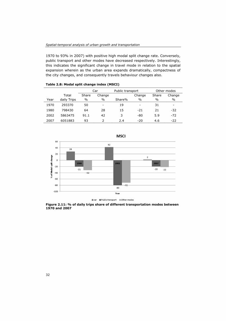
Spatial-temporal analysis of urban growth and transportation
32
1970 to 93% in 2007) with positive high modal split change rate. Conversely, public transport and other modes have decreased respectively. Interestingly, this indicates the significant change in travel mode in relation to the spatial expansion wherein as the urban area expands dramatically, compactness of the city changes, and consequently travels behaviour changes also. Table 2.8: Modal split change index (MSCI)
Figure 2.11: % of daily trips share of different transportation modes between 1970 and 2007
Year Total
daily Trips
Car Public transport Other modes Share
% Change
% Share% Change
% Share
% Change
%
1970 293370 50 - 19 - 31 -
1980 798430 64 28 15 -21 21 -32
2002 5863475 91.1 42 3 -80 5.9 -72
2007 6051883 93 2 2.4 -20 4.6 -22

Chapter 2
33
Figure 2.12 Modal split change index (MDCI) between 1970 and 2007
2.4 Discussion Spatial expansion and land use change in Jeddah seem to be catalyzed by the transportation infrastructure and population growth has affected travel demand over time. The relationship between urban growth and transportation has been further investigated by relating some urban growth and transportation development indicators (population growth, urban spatial expansion, and residential area growth and transportation infrastructure expansion) (Figure 2.13). In relating population growth and transportation infrastructure expansion, three main gaps were clearly distinguished (Figure 2.13). Initially, from the period of 1964 to 1980, the population grew rapidly and then the transportation infrastructure rapidly expanded. From 1980 to 2002, the transportation infrastructure expansion abruptly dropped in comparison with the steady decrease in population growth. In 2002, the population growth and transportation infrastructure expansion rates matched, and the population then grew significantly with minor expansion of the transportation infrastructure. Figure 2.13 also demonstrates the relationship between urban spatial expansion and transportation infrastructure expansion in Jeddah from 1964 to 2007. First, the transportation infrastructure dramatically expanded, which may have stimulated the urban spatial expansion with a sprawl pattern from 1964 to 1980. From 1980 to 1993, both the transportation infrastructure expansion and urban spatial expansion rates decreased rapidly. Then, in the

Spatial-temporal analysis of urban growth and transportation
34
period from 1993 to 2002, the transportation infrastructure expansion and urban spatial expansion steadily increased. This expansion reflects the infill pattern of urban development. After 2002, the transportation infrastructure expanded slightly and the urban spatial expansion fell again because of the continuing sprawl at the fringes, which suggests that the spatial expansion was triggered by the transportation infrastructure expansion. In addition to that, government policies of urban development have contributed significantly to the spatial expansion. Land grants policy and interest free loans policies have accelerated the spatial expansion of Jeddah. Also, lack of a planning framework and weak city institutions could not direct the growth properly which led to sprawling and lop-sided development (Al-Hathloul and Mughal, 2004). Consequently, the road network and utilities were rapidly extended with high financial outlays (Al-Hathloul and Mughal, 2004).
Figure 2.13: Relationship between transportation infrastructure and urban growth between 1964 and 2007
Similarly, Figure 2.13 shows the relationship between residential area growth and transportation infrastructure expansion in Jeddah from 1964 to 2007. The transportation infrastructure rapidly expanded and affected the dramatic growth and sprawl of residential areas from 1964 to 1980. Then, the transportation infrastructure expansion and residential area growth rates declined rapidly from 1980 to 1993, when residential areas were consolidated and adjoined with existing residential areas. However, there was a gap between the transportation infrastructure expansion and residential area growth, with the latter leading. The transportation infrastructure expansion rate declined broadly compared with the residential area growth rate. Next, in the period from 1993 to 2002, there was a gap between transportation infrastructure expansion and residential area growth. By 2002, these values

Chapter 2
35
congregated, after which the transportation infrastructure expansion rate increased and the residential area growth rate decreased. These trends reflect the minor interventions in transportation infrastructure after 2002 and the dispersed development of residential areas at the fringes. Therefore, the residential area growth was simultaneous with the transportation infrastructure expansion. Interestingly, there is a difference between changes of RDI in comparison with the urban area (km/ha) and RADI in relation to residential area (ha/ha). RDI has steadily increased wherein greater accessibility was provided to different land uses including residential areas. This greater accessibility has stimulated the growth of residential area and accordingly the RADI has dramatically decreased. As a consequence, the load of residential area, the main urban trip generators increased and catalyzed the travel demand. This reflects that policies directed at road infrastructure provision help achieve a greater accessibility to different land uses. This however will in the longer term stimulate travel demand and thus increase congestion. To avoid this effect, other transportation policies must be considered. In contrast, the urban trip density index demonstrated the relationship between urban trips, population growth, residential area expansion and roads area (Table 2.7 and Figure 2.10). Many pressures have affected the transportation infrastructure in Jeddah. The population growth affected the increase of the total number of daily trips, from 293,370 trips in 1970 to 798,430 trips in 1980 to 6,051,883 trips in 2007 (MOMRA, 1980; Municipality of Jeddah, 2004b; IBI 2007). This was accompanied by economic growth that increased the car ownership, from 50 cars per thousand persons in 1970 to 120 cars per thousand persons in 1980 (Al-Hathloul and Mughal, 1991) to 299 cars per thousand persons in 2006 (Municipality of Jeddah, 2006). Notably, the number of daily trips per person dramatically increased from 0.77 trips/person in 1970 to 2.29 trips/person in 2002 to 1.86 trips/person in 2007. This rapid increase has caused a high mobility level throughout the city and has produced a high pressure on transportation infrastructure as indicated by the urban trips density index per road area (Table 2.7), wherein the daily travelled km per m2 of road area increased noticeably. Congestion is a common occurrence on Jeddah’s streets, and the commute duration is lengthening (IBI, 2007). The average speed has been reduced on the highways and the primary roads, the average trip time has increased, traffic safety has been reduced and transportation emissions have increased (Al-Zahrani and Asiri, 2008). Thus, Jeddah Municipality implemented an urgent plan in 2009 to relieve traffic congestion in the city with high financial outlays (2.7 SAR billions) (Municipality of Jeddah, 2008). Notwithstanding the importance of this urgent plan in remedying traffic congestion, the
Spatial-temporal analysis of urban growth and transportation
36
relationship between urban growth and travel demand must be considered in the future plans. Moreover, MSCI indicated the relationship between spatial expansion and travel modes changes. Non-car modes daily trips share have decreased dramatically. Public transportation daily trips decreased, from 19% in 1970 to 15% in 1980 to 3% in 2002 to 2.3% in 2007 (MOMRA, 1980; Municipality of Jeddah, 2006; IBI 2007). The trip share of other modes, including cycling and pedestrian trips, has significantly decreased from 31% in 1970 to 21% in 1980 to 5.9% in 2002 to 4.6% in 2007 (MOMRA, 1980; Municipality of Jeddah, 2006; IBI 2007). Obviously, this is due to the enormous spatial expansion of Jeddah city. Jeddah urban area expanded dramatically in different directions, compactness of the city changed which changed the travel behavior and stimulated the daily share of car trips, that increased from 50% in 1970 to 64% in 1980 to 91.1 % in 2002 to 93% in 2007 (MOMRA, 1980; Municipality of Jeddah, 2006; IBI 2007). Notwithstanding the significance of the effects of spatial expansion on travel mode changes, we must not undermine the significance of the previous urban development and transportation policies in Jeddah that act as an incentive for car use and have caused such land subdivision throughout the city and have created an arterial gridiron pattern of street networks. In addition, the lack of policy to stimulate public transport and other non-car modes further contributed to this effect.
2.5 Conclusion Jeddah has experienced rapid population growth, spatial expansion, land use change and transportation infrastructure expansion during the past four decades (1964-2007). Different driving forces have triggered Jeddah’s spatial-temporal changes, notably economic growth, population growth, transportation infrastructure growth, government policies, topography, and master plans. Two types of urban growth can be distinguished in Jeddah’s spatial-temporal expansion: outward expansion and sprawl development. The developed indicators suggest a relationship between urban growth and transportation. It was found that transportation infrastructure expansion coincided largely with population growth. In contrast, urban spatial expansion and residential area growth have been affected by transportation infrastructure expansion. Moreover, population growth seems to have caused an increase in daily trips, travel demand and, consequently, congestion. It was also found that enormous spatial expansion has caused dramatic changes in the daily share of travel modes. The research shows that disparities have occurred in the relationship between urban growth and transport. The various development processes and policies have taken different paths in time and have not been sufficiently in tune, contributing to

Chapter 2
37
the problems mentioned. A more integrated and holistic approach on urban development and mobility is needed to address these problems. The developed indicators in this study bridge the knowledge gap on the development of easy to use measures to quantify and analyze the spatial-temporal relationship between urban growth and transportation. Moreover, the results of this study expand the knowledge and provide a rich understanding of the relationship between urban growth and transportation in rapidly growing cities. Although the developed indicators provide significant information on the spatial-temporal relationship between urban growth and transportation, they provide a limited explanation of the reciprocal relationship between urban growth and transportation. Therefore, further research should employ statistical analysis, spatial statistical analysis and dynamic modelling to study this reciprocal relationship. Furthermore, inclusion of the socioeconomic characteristics of Jeddah population must be considered in the analysis.

Spatial-temporal analysis of urban growth and transportation
38

39
3. Urban growth and transportation: understanding the spatial temporal relationship∗
∗ This chapter is based on the following book chapter: Aljoufie, M., Zuidgeest, M.H.P., Brussel, M.J.G., and van Maarseveen, M.F.A.M. (2011). Urban growth and transport understanding the spatial temporal relationship, in: Pratelli, A., Brebbia, C.A. (Eds.), Urban transport XVII: urban transport and the environment in the 21st Century. WIT press, Southampton, pp. 315-328.

Urban growth and transportation: understanding the spatial temporal relationship
40
Abstract Transportation and urban growth are strongly related. In fact, there is a reciprocal relationship between transportation and urban growth. To understand this relationship, it is necessary to analyse urban spatial temporal changes and their related causes and effects. In this paper, an extensive evidence-based and scientific description of the relationship between urban growth and transportation is presented. This relationship is specifically explored for Jeddah city, Saudi Arabia, applying spatial temporal analysis techniques from remote sensing and Geographic Information System. Spatial and statistical analyses have been used to analyse and relate urban growth and transport spatial temporal indicators. Results indicate a strong reciprocal relationship between urban growth and transport in Jeddah city. It is found that transportation infrastructure expansion strongly correlates with population growth, spatial expansion and land use change. Results also reveal that population growth has increased urban trips and the consequent travel demand, and there is imbalance between travel demand and transportation infrastructure supply which explains the increase in congestion. This study also points out a strong significant influence of transportation infrastructure on spatial temporal expansion and land use change. It is found that highways and main roads have stronger influence on spatial expansion and land use change in comparison with secondary roads. Although, this study provides significant information for transportation and urban development policies, further research is encouraged to use spatial statistical analysis and dynamic modelling to study the reciprocal relationship between urban growth and transportation. Keywords: urban growth; transportation, spatial temporal analysis; indicators; remote sensing; GIS; Jeddah city

Chapter 3
41
3.1 Introduction In 2004, over 48% of the world's population estimated in urban areas, and by 2030 this figure is predicted to increase to 61% (United Nations, 2004). Accordingly, urban areas will continually witness a rapid urban growth that will impose further challenges to urban planners. Urban growth is not emerges phenomena that can be observed directly in urban areas. In fact, variety of factors triggered urban growth: transportation and communication (Castells, 1989; Hall & Pfeiffer, 2000; Hart, 2001); internal and international migration (Thorns, 2002); public policies (Carruthers, 2002; Nelson & Duncan, 1995); and globalization of economic activities (Choe, 1998; Marcotullio, 2003). However, understanding urban growth, its drivers and the future impact on the urban environment is of prime concern to urban planners (Al-Ahmadi et al., 2009). Transportation plays a vital role in urban development. Transportation systems provide essential mobility options for people and goods and influences patterns of growth and the level of economic activity through the accessibility it provides to land Meyer and Miller (Meyer and Miller, 2001). Urban growth and transportation are strongly related issues. On the one hand, transportation infrastructure attracts urban development, on the other hand, urban growth and population cause an increase in travel demand and thereby an increase in the requirement for transportation infrastructure. Previous studies have focused mainly on the causes and effects of transportation and urban growth. In general, there is a lack of research on the mutual relationship between urban growth and transportation, while less attention has been paid to the spatial temporal aspects of this relationship. Understanding the transportation and urban dynamics increasingly becomes a necessary condition for developing urban development strategies (Priemus et al., 2001; Cheng, 2003; Han et al., 2009; Bhatta, 2010; Bhatta et al., 2010; Müller et al.,2010). To provide a better understanding of this relationship, this paper attempts to analyse this for the case of Jeddah city, Saudi Arabia. Initially, this paper provides an extensive evidence-based and scientific description of the relationship between urban growth and transportation. Thereafter, this paper strives to relate and analyse the relationship between urban growth and transportation through spatial temporal indicators using statistical and spatial analyses. These spatial temporal indicators of urban growth and transportation have been developed and quantified using remote sensing and GIS techniques.

Urban growth and transportation: understanding the spatial temporal relationship
42
3.2 Literature review Urban areas in their nature dynamic, complex structure and pertinent to the growth in different terms physical, economic and population which so called urban growth. Urban growth is a complex process that involves spatial temporal changes of urban areas socio-economic and physical components (Han et al., 2009).These changes catalyze by many drivers and underlying factors. Among these, transportation considered one of the main factors of urban growth. Advances in transportation system have reduced the cost of commuting within urban areas and encouraged urban scattering (Johnson, 1967; Jackson, 1985; Glaeser and Kahn, 2004;). Equally, transportation infrastructure expansion has stimulated urban growth and land use changes (Castells, 1989; Hall & Pfeiffer, 2000; Hart, 2001; Bhatta, 2010). At the same time, urban growth affects transportation. Urban growth patterns configure urban spatial structure and thus influence transportation. Urban growth not only increase travel demand (Cervero, 2003; Cameron et al., 2004; Millot, 2004) but also, cause infrastructure pressure and consequently traffic congestion (Brueckner 2000; Allen and Lu, 2003; Bhatta, 2010). Therefore, urban growth is strongly related to transportation with reciprocal causes and effects. Causality, reciprocal effects, and reciprocal causes are apparent characteristics of urban growth and transportation relationship. However, the relationship could be inferred at four main interacted aspects: transportation infrastructure, travel demands, population and land use change (Figure 3.1).
Transport infrastructure Travel demand
Transport
Land use Population
Urban growth
Catalyze Induce
Figure 3.1: Conceptual reciprocal relationship of urban growth and transportation
In general, previous studies have focused only on the aspects of causes and effects of transport and urban growth relationship. However, spatial temporal

Chapter 3
43
processes of this relationship have not been addressed before. To address this, quantification of the spatial temporal situation of urban growth and transport has to be carried out. Integration of remote sensing (RS) and geographic information system (GIS) techniques and the establishment of appropriate indicators provide the capacity to quantify this intrinsic relationship between urban growth and transport.
3.3 Methodology
3.3.1 Study area Jeddah is the second largest city in the Kingdom of Saudi Arabia with a population exceeding three million. Jeddah is located on the West coast of the Kingdom at the confluence of latitude 29.21 North and longitude 39.7 East, in the middle of the eastern shore of the Red Sea and surrounded by the plains of the Tahoma in the east (Figure 2.1). The city of Jeddah has witnessed a dramatic increase in population, due to out-migration from villages and suburbs to the city in search of jobs and a better living. The strength of the economy and growth in population are increasingly straining the city’s transport system. Jeddah is car dominated with residents using private automobiles for 93% of trips (IBI, 2007). The challenges of accelerated urban expansion, population growth and traffic congestion are predominant issues in Jeddah city today. The local government of Jeddah city, its transport planning department in particular, faces challenges in managing, and planning of the transport system in view of the urban expansion.
3.3.2 Data and image processing This study utilizes a time series of Aerial photos and Satellite images for quantifying the spatial-temporal urban growth and transport system situation from 1964 to 2007. Aerial photos data of 1964, 1970 and 1980 have been used for the period before 1981. After that period, Spot Satellite images data of 1993, 2004 and 2007 have been used. Moreover, a variety of secondary data were collected to facilitate spatial temporal analysis of urban growth and transport in Jeddah city. These data include: Jeddah Master plans for year 1963, 1973, 1980, 1987, and 2004; Jeddah Transport Studies for year 1980, 1995, 2004 and 2007; Census data 1993 and 2005, Urban Growth Boundaries Study 1986 and Jeddah topographic maps 2000. Firstly, image-to-image registration strategy has been adopted for geo-referencing the various images using polynomial model second order function in ERDAS IMAGINE. Subsequently, a cooperative visual interpretation method is applied to quantify temporal urban land use and transport infrastructure as the main aspects of urban growth and transport in Jeddah city. The process

Urban growth and transportation: understanding the spatial temporal relationship
44
started with unsupervised image classification to differentiate between urban built-up elements and none built-up elements using the ISODATA clustering algorithm in ERDAS IMAGINE. This process shows the spatial pattern of urban built up area in Jeddah city which facilitates a better acquaintance of the elements of built up area such as buildings, roads infrastructure and green areas. Next, land use and transport infrastructure reference data, from master plans and transport studies reports, were integrated with built up and none built images using overlay function in ArcGIS. Ten urban land use classes were specified to be extracted: residential, commercial, industrial, institutional, informal settlements, airport, port, roads, vacant lands and green areas. Thereafter, visual interpretation indicators such as pattern, shape, and size were extensively used in identifying features from aerial photographs and satellite imageries based on the field knowledge. Consequently, cooperative visual interpretation has been conducted incorporating all aforementioned process in ArcGIS v9.3 using on-screen digitizing, overlay tools and area of interest (AOI) functionality. Accordingly, land use and transport infrastructure maps of 1964, 1972, 1983, 1993 and 2007 have been obtained. Finally, accuracy assessments were performed based on a comparison of the cooperative interpretation outputs with the reference data. The average overall accuracy of land use maps produced by this approach was 90, 5 %.
3.3.3 Statistical analysis To examine the spatial temporal relationship between urban growth and transport, indicators represent the effective tool. Seven indicators have been developed to quantify the spatial temporal urban growth and transport situation as followings: Annual Urban Spatial Expansion Index: The urban spatial expansion index is imperative in describing the temporal change of an urban area in terms of its annual urban growth rate and annual growth area (Tian et al., 2005; Fan et al., 2009). The annual urban spatial expansion index (AUSEI) has been adopted to discuss the temporal urban spatial growth of Jeddah and is defined as follows:
AUSEIt = (Ut−Ut−1) Ut ⁄(Nt−Nt−1)
× 100 (3.1)
where AUSEIt [%] is the annual urban spatial expansion index; Ut and Ut−1 are the total urban areas of the study area in hectares at time t (current year) and time t − 1 (former year); Nis the total number of years from time t (current year) to time t − 1 (former year).

Chapter 3
45
Annual Land Use Change Index: Land use change is critical, not only in spatial temporal urban growth and transport analysis, but also in different global, regional and urban analyses. It reflects the dynamics of urban areas and is one of the driving forces of urban development (Xie et al., 2005; Zhang and Guindon, 2006). Hence, a land use change index (LUCI) is considered to determine the land uses changes in Jeddah as follows:
ALUCIa,t = (LUa,t−LUa,t−1 )(Nt−Nt−1)
× 100 (3.2)
where ALUCIt [%] is the land use change index; LUa,t and LUa,t−1 are the total land area of land use class a in hectares at time t (current year) and time t − 1 (former year); N is the total number of years from time t (current year) to time t − 1 (former year). Population Density Index: A population density index is critical in analyzing spatial temporal urban growth and transport analysis (Zhang and Guindon, 2006; Feng, 2009). It reflects the pattern and characteristics of urban growth and efficiency of the transport system. Many urban studies have calculated population density as the total urban population to the total urban area. Accordingly, here a population density index (PDI) is implemented as follows:
PDIt = PtUt
(3.3)
where PDIt [persons/ha] is the population density index; Pt is the total population at time t; and Ut is the total urban land in hectares at time t. Transportation Infrastructure Expansion Index: The transportation infrastructure expansion index (TIEI) is designed to investigate the spatial temporal change of the transport system in Jeddah. It is calculated in terms of lengths of transportation infrastructure in kilometers and is defined as follows:
TIEIt = TILl,t−TILl,t−1TILl,t
× 100 (3.4)
where TIEIt [%] is the transportation infrastructure expansion index; TILl,t and TILl,t−1 are the total transportation infrastructure length in kilometres at time t (current year) and time t − 1 (former year). Road Density Index (by area and per capita): The road density index reflects the densification of roads within the city, which can be compared with the total urban area and population. It also

Urban growth and transportation: understanding the spatial temporal relationship
46
reflects the deficiencies in road infrastructure of such urban area. It can be expressed as the length of all roads per number of inhabitants and by the area of the city. The road density index (RDI) is designed to trace the change of road infrastructure over time at Jeddah and is defined as:
RDI_At = RLtUAt
(3.5)
RDI_CAPt = RLtUPt
(3.6)
where RDI_At [kilometres/ha] is the road density index per area and RDICAP[kilometres/person] is the road density index per capita; RLt is the total road length in kilometres at time t ; UAt is the total urban area in hectares at time t; while UPt is the total urban population in the study area at time t. Road Area Density Index (by area, per capita, and for residential land use): The road area density index is developed to investigate the spatial temporal relationship between urban growth and transport. It calculates the total area devoted to transport infrastructure in relation to the total urban area and similarly in relation to the urban population. It reflects the proportions of transport infrastructure of the total urban area and the total road space per person over time. The Road Area Density Index (RADI) is expressed as the proportion of the total road area (all road types) to the total urban area, as the total road area (all road types) to the total urban population, and as the total road area (all roads types) to the total urban residential area: RADI_At = RAt
UAt× 100 (3.7)
RADI_CAPt = RAtUPt
(3.8)
RADI_RESt = RAtURAt
(3.9)
where RADIt [%] is the road area density index by urban area, RADI_CAPt [ha/person] is the road area density index per urban area, and RADI_RESt[ha/ha] is the road area density index per residential land use area; RAt is the total road area in hectares at time t; UAtis the total urban area in hectares at time t; UPtis the total urban population in the study area at time t; and URAt is the total urban residential area in hectares at time t.

Chapter 3
47
Urban trip density index (per capita, for residential land use and for road area): The urban trip density index is developed to relate spatial temporal urban growth and transport. It is designed to trace the increase in urban trips with the growth of population and the expansion of residential area. The urban trips density index (UTDI) can be expressed as the total number of urban trips by the total urban population, the total number of urban trips by the total urban residential area, and the total number of urban trips by the amount of kilometers travelled as follows:
UTDI_CAPt = UTtUPt
(3.10)
UTDI_RESt = UTtUARt
(3.11)
UTDI_RAt = (DCTt×AVTLt )
(RAt ) (3.12)
where UTDI_CAPt [trips/person] is the urban trip density index per capita, UTDI_RESt [trips/ha] is the urban trip density index per residential land use area and UTDI_RA [km travelled/m2] is the urban trip density index per unit of road area; UTt is the total number of urban trips (all modes) at time t; and UARt is the total urban residential area in square metres at time t; DCTt is the daily car trips at time t, AVTLt is the average trip length at time t, RAt is total road area at time t. Statistical analysis of the quantified indicators has been performed using SPSS 18 software. Pearson correlation analysis has been implemented to determine the reciprocal relationship between urban growth and transport indicators. The followings relationships have been examined: • Relationship between transport infrastructure expansion index and
various urban growth indices (population growth - spatial expansion-land use change)
• Relationship between road density index and spatial expansion. • Relationship between road area density index and urban trip density
index. • Relationship between urban trip density index and population growth.
3.3.4 Spatial analysis To derive the influence of transport infrastructure in spatial temporal urban growth, spatial proximity analysis has been considered. Buffer analysis function of GIS has been used to analyze the effects of transport infrastructure in the spatial temporal urban growth of Jeddah city from 1964

Urban growth and transportation: understanding the spatial temporal relationship
48
to 2007. The process, depicted in figure 3, starts with extracting the temporal changes of spatial expansion and land use at five periods: 1964-1970, 1970-1980, 1980-1993, 1993-2002 and 2002-2007. Conversely, buffer analysis of highways, main roads and secondary roads has been performed for the respective periods. Different buffer zones have been chronologically created as follows: 1. 400 m (highways and main roads) and 100 m (secondary roads). 2. 800 m (highways and main roads) and 200 m (secondary roads). 3. 1500 m (highways and main roads) and 300 m (secondary roads). 4. 2000 m (highways and main roads) and 400 m (secondary roads). 5. 3000 m (highways and main roads) and 500 m (secondary roads). Subsequently, temporal changes of spatial expansion and land use have masked by the created roads buffer zones. Accordingly, the percentage of spatial expansion and land use change within different roads buffer zones can be quantified.
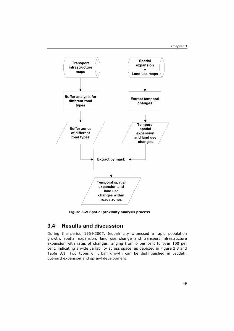
Chapter 3
49
3.4 Results and discussion During the period 1964-2007, Jeddah city witnessed a rapid population growth, spatial expansion, land use change and transport infrastructure expansion with rates of changes ranging from 0 per cent to over 100 per cent, indicating a wide variability across space, as depicted in Figure 3.3 and Table 3.1. Two types of urban growth can be distinguished in Jeddah: outward expansion and sprawl development.
Spatial expansion
+Land use maps
Transport infrastructure
maps
Extract temporal changes
Buffer analysis for different road
types
Temporal spatial
expansion and land use
changes
Buffer zones of different road types
Extract by mask
Temporal spatial expansion and
land use changes within
roads zones
Figure 3.2: Spatial proximity analysis process

Urban growth and transportation: understanding the spatial temporal relationship
50
Table 3.1: Spatial temporal changes
Year
1964
1970
1980
1993
2002
2007 Spatial expansion (ha) 18315 18840 32500 40739 49700 54175
Population growth 149,000 381,000 960,000 2,046,000 2,560,000 3,247,134
Transport infrastructure expansion (km)
101 136 435 562 711 826
Transport infrastructure area expansion (ha)
510 680 2175 2560 3375 3950
Urban trips increase -* 293,370 798,430 - 5,863,475 6,051,883
Residential growth(ha)
1945 2018 8724 14921 19318 21365
Commercial growth (ha)
298 302 569 891 1355 1555
Industrial growth(ha) 26 30 1759 3793 6058 6976
Public places growth 282 678 7248 7321 8091 8244
Informal settlements growth(ha)
211 224 2137 2766 3351 4508
-* no data
3.4.1 Statistical analysis Results indicate a strong relationship between urban growth and transport. This has been revealed by the significant positive correlation between transport infrastructure expansion and urban growth indicators, see Table (3.2). It is found that transport infrastructure and population growth have a significant positive correlation of 0.984. Similar significant positive correlation is found between transport infrastructure and spatial expansion (r = 0.997) and land uses, Table (3.2), implying that transport infrastructure expansion has promoted the various urban spatial expansion and land use change.

Chapter 3
51
Figure 3.3: Jeddah spatial-temporal changes

Urban growth and transportation: understanding the spatial temporal relationship
52
Moreover, there is a significant positive correlation (r= 0.907) between the road area density index (RADI_A equation 3.7) and spatial expansion in Jeddah city. The total area devoted to transport infrastructure notably increased from 510 ha (2.8% of the total urban areas) in 1964 to 3950 ha (7.3% of the total urban areas) in 2007, wherein spatial expansion increased dramatically from 18,315 ha in 1964 to 54,175 ha in 2007, see Table (3.1), representing an increase of 296 %. This indicates that spatial expansion of Jeddah has been triggered by road density area increase. On the other hand, the increase in road area density coincided with spatial expansion. Hence, there is a reciprocal relationship between spatial expansion and road area density increase. Table 3.2: Correlation between transport infrastructure and different urban growth indicators
Urban growth indicators Transport infrastructure expansion
Spatial expansion Pearson Correlation 0.997** Sig. (2-tailed) 0.000
Population growth Pearson Correlation 0.984** Sig. (2-tailed) 0.000
Residential Pearson Correlation 0.992** Sig. (2-tailed) 0.000 Commercial Pearson Correlation 0.970**
Sig. (2-tailed) 0.001 Industrial Pearson Correlation 0.979**
Sig. (2-tailed) 0.001 Public places Pearson Correlation 0.935**
Sig. (2-tailed) 0.006 Informal settlements Pearson Correlation 0.995** Sig. (2-tailed) 0.000
**. Correlation is significant at the 0.01 level (2-tailed). Correlation analysis also point out a significant positive relationship (r=0.972) between population growth and the number of urban trips in Jeddah city. This designates the strong relationship between population growth and travel demand. Furthermore, there is a significant negative correlation (r= - 0.951) between road density index (RDI equation 3.6) and urban trips density index (UTDI equation 11). Similarly significant negative correlation is found between the road area density index (RADI equation 3.8) and urban trips density index (UTDI equation 3.11) (r = - 0.972) .This reflects the gap between the rapid increase of urban trips (as a result of population growth) and the expansion of transport infrastructure, Table (3.3), which reveals an imbalance between travel demand and transport infrastructure supply and the consequent increase in congestion. In fact, congestion is now a common occurrence on Jeddah’s streets and the duration of congestion is lengthening (IBI, 2007).

Chapter 3
53
Table 3.3: Urban trips density (UTDI), road density (RDI) and road area density (RADI) indicators. Year UTDI (trip/m2) RDI
(km/person) RADI
(ha/person) 1964 -* 0.00068 0.0034
1970 0.015 0.00035 0.0018
1980 0.009 0.00047 0.0023
1993 - 0.00027 0.0013
2002 0.030 0.00027 0.0013
2007 0.028 0.00025 0.0012
-* no data
3.4.2 Spatial proximity analysis Results also point out the significant influence of transport infrastructure on the spatial temporal expansion and land use change. Table (3.4) shows that during the period of 1964- 2007 about 5–84% of the total spatial expansion occurred in different road buffer zones, which indicates the strong relationship between transport infrastructure and spatial expansion. It is found that highways and main roads have stronger influence on Jeddah spatial expansion in compare with secondary roads in the different periods. It is noticed that the effect of roads increased with the increase of buffer size. For instance, during the period 1980 to 1993, the percentage of spatial expansion occurred in the 400m buffer zone of highways was 16%, wherein 84% occurred in the 3000 m buffer zone of highways. The highest effect of all roads types on the spatial expansion is found in the period 1980-1993 wherein 8-84% of spatial expansion occurred on different roads buffer zones. However in this period most of Jeddah roads have been constructed (Table 3.1; Al-Hathloul and Mughal, 1991; Daghistani, 1993). Spatial proximity analysis also indicates significant relationship between transport infrastructure and residential area expansion. Table (3.5) shows that around 7-100% of residential area expansion occurred in different roads buffer zones, which designate that transport infrastructure strongly triggered residential area expansion. It is noticed that highways and main roads have stronger influence on Jeddah residential area expansion. This is also reflected by the sprawl development of residential area in Jeddah city (Al-Hathloul and Mughal, 1991; Daghistani, 1993; Abdu et al., 2002).

Urban growth and transportation: understanding the spatial temporal relationship
54
Table 3.4: Spatial expansion percentages in different roads buffer zones.
Buffer 1964-1970
%
1970-1980
%
1980-1993
%
1993-2002
%
2002-2007
% 1
400 m _Highways 6 9 16 10 12 400 m_Main Roads 7 24 24 17 5 100 m _Secondary Roads 5 6 8 12 12
2
800 m _Highways 12 19 29 20 23 800 m_Main Roads 9 25 39 30 11 200 m _Secondary Roads 7 12 17 23 25
3
1500 m _Highways 12 36 50 39 37 1500 m_Main Roads 9 60 59 41 18 300 m _Secondary Roads 7 17 25 32 37
4
2000 m _Highways 20 46 64 52 44 2000 m_Main Roads 16 65 68 44 20 400 m _Secondary Roads 77 23 33 40 48
5
3000 m _Highways 28 64 84 72 58 3000 m_Main Roads 18 70 78 47 30 500 m _Secondary Roads 78 27 40 47 57

Chapter 3
55
Table 3.5: Residential area expansion percentages in different roads buffer zones.
3.5 Conclusion Results indicate a strong reciprocal relationship between urban growth and transport in Jeddah city. It is found that transport infrastructure expansion strongly correlated with population growth, spatial expansion and land use change. On the contrary, urban spatial expansion and residential area growth are catalysed by transport infrastructure expansion. It is noted that population growth have increased urban trips and the consequent travel demand. Moreover, results reveal imbalance between travel demand and transport infrastructure supply which reflects the consequent increase in congestion. This study also point out a strong significant influence of transport infrastructure on the spatial temporal expansion and land use change. It is found that highways and main roads have stronger influence on spatial expansion and land use change in compare with secondary roads. Although statistical and spatial analyses demonstrated significant information on the spatial temporal relationship between urban growth and transport, it is provided limited explanations of the reciprocal relationship between urban
Buffer 1964-1970
%
1970-1980
%
1980-1993
%
1993-2002
%
2002-2007
% 1
400 m Highways 32 8 17 12 18
400 m_Main Roads 35 38 30 24 7
100 m _Secondary Roads
31 12 12 15 17
2
800 m _Highways 69 19 33 25 36
800 m_Main Roads 35 67 49 45 14 200 m _Secondary Roads
42 23 23 30 34
3
1500 m _Highways 69 43 56 43 60
1500 m_Main Roads 35 90 72 64 25 300 m _Secondary Roads
42 33 33 43 50
4
2000 m _Highways 96 57 67 58 70
2000 m_Main Roads 77 95 82 68 30 400 m _Secondary Roads
66 43 44 54 63
5
3000 m _Highways 100 79 86 73 82
3000 m_Main Roads 87 99 94 72 45 500 m _Secondary Roads
69 51 53 63 74

Urban growth and transportation: understanding the spatial temporal relationship
56
growth and transport. Therefore, further research is encouraged to use spatial statistical analysis and dynamic modelling to study the reciprocal relationship between urban growth and transport.
57
4. Spatial statistical analysis of urban growth and transport infrastructure expansion∗
∗ This chapter is based on the following paper: Aljoufie, M., Zuidgeest, M.H.P., Brussel, M.J.G., and van Maarseveen, M.F.A.M. (2013). Urban growth and transport infrastructure interaction in Jeddah. International Journal of Applied Earth Observation and Geoinformation, 21, 493-505.

Spatial statistical analysis of urban growth and transport infrastructure expansion
58
Abstract This chapter aims to use spatial statistical tools to explore the reciprocal spatial-temporal effects of transport infrastructure and urban growth for the case of Jeddah city; a fast developing polycentric city in Saudi Arabia. Global spatial autocorrelation (Moran’s I) and local indicators of spatial association (LISA) are first detected to analyze the spatial-temporal clustering of urban growth and transport infrastructure from 1980 to 2007. Then spatial regression analysis is conducted to investigate the mutual spatial-temporal effects of urban growth and transport infrastructure. Results indicate a significant positive global spatial autocorrelation of all defined variables between 1980 and 2007. LISA results also reveal a constant significant spatial association of transport infrastructure expansion and urban growth variables from 1980 to 2007. The results indicate a mutual spatial influence of transport infrastructure and urban growth, but also reveal that spatial clustering of transport infrastructure seems to be influenced by other factors. This chapter shows that transport infrastructure is a constant and strong spatial influencing factor of urban growth in the polycentric urban structure that Jeddah has. Overall, this chapter demonstrates that exploratory spatial data analysis and spatial regression analysis were able to detect the spatial-temporal mutual effects of transport infrastructure and urban growth. Further studies on the reciprocal relationship between urban growth and transport infrastructure using the study approach for the case of monocentric urban structure cities is necessary and encouraged. Keywords: urban growth; transportation infrastructure; spatial-temporal analysis;; Moran I; LISA; Spatial regression; remote sensing; GIS.

Chapter 4
59
4.1 Introduction Rapid urban growth is a key concern for urban planners as it has a considerable urban environmental impact (Müller, Steinmeier, and Küchler , 2010). In 2009, over 3.4 billion people in the world resided in urban areas, and this figure is estimated to increase to 6.5 billion by 2050 (United Nations, 2009).This increase implies that urban areas will continuously witness rapid urban growth, which will impose further challenges to urban planners. Understanding urban growth and its drivers is vital to deal with such challenges. New approaches to the planning and management of urban areas, such as sustainable development and smart growth, will depend upon improvements in our knowledge of causes and drivers of urban growth (Longley & Mesev, 2000; Herold et al., 2003). Moreover, spatial and temporal analysis of the factors that drive urban growth are critical to predict future changes and their potential environmental effects in order to mitigate the negative aspects of urban growth (Aguayo et al., 2007). In essence, a variety of social and economic factors trigger urban growth, including transportation and communication (Hall and Pfeiffer, 2000; Hart, 2001), internal and international migration (Thorns, 2002) and public policies (Carruthers, 2002). Transportation as such plays a crucial role in urban development through the accessibility it provides to land and activities (Meyer & Miller, 2001). Several studies have demonstrated that transportation infrastructure is one of the main driving forces of urban growth (e.g., Hall and Pfeiffer, 2000; Hart, 2001, Liu et al., 2002; Handy, 2005; Xie et al., 2005; Jha et al., 2006; Ma and Xu, 2010; Müller et al., 2010). Other studies have pointed out the effect of development of high-speed roads on urban expansion and population growth (Brotchie, 1991; Parker, 1995; Priemus et al., 2001). Moreover, most of urban models use accessibility to transport infrastructure as a main driver of growth and change (see for example Batty, 2000; Liu and Phinn, 2003; Al-Ahmadi et al. 2009; Feng et al., 2011). Nevertheless, only one previous study (Fan et al., 2009) has analysed the effects of different transportation infrastructure types on urban growth. This study used a GIS spatial proximity (buffer) analysis to evaluate the influence of different types of roads on spatial expansion of Guangzhou; a developed monocentric city in China between 1979 and 2003. Thus, there is a lack of research on the spatial and temporal effects of different types of transport infrastructure on urban growth and vice versa, particularly in the context of fast developing and polycentric cities. The study of urban growth factors and its driving forces require sophisticated methods and tools. Recent advances in remote sensing, GIS, spatial analysis and spatial statistics tools provide a rich opportunity for in-depth study of the complex urban growth process and its interaction with the transportation.

Spatial statistical analysis of urban growth and transport infrastructure expansion
60
Remote sensing, GIS and spatial analysis functionalities support the examination of geographic patterns, trends, and relationships in between urban systems (Benenson and Torrens, 2004). Newer methods of spatial analysis, spatial statistics in particular, have proven relevance and usefulness for urban analysis (Paez and Scoot, 2004). Exploratory spatial data analysis (ESDA); including global spatial autocorrelation (Moran I index) and local indicators of spatial association (LISA); and the spatial regression analysis have gained attention in urban studies. Bamount (2004) has used exploratory spatial data analysis (ESDA) to analyse the intra-urban spatial distributions of population and employment in the agglomeration of Dijon, France. Orford (2004) has identified and compared changes in the spatial concentrations of urban poverty and affluence for the case of inner London using a Moran I index and local indicators of spatial association (LISA). Deng et al., (2010) has used local indicators of spatial association (LISA) and spatial regression models to demonstrate the relationship between economic growth and the expansion of urban land for the case of Beijing in China. Nevertheless, up to now only a few studies have been conducted using exploratory spatial data analysis and spatial regression analysis in urban studies. In particular, there is a lack of research using these analyses for exploring and analysing the complex urban growth phenomenon, and its drivers and their interaction. This chapter attempts to use exploratory spatial data analysis and spatial regression analysis to explore the spatial-temporal reciprocal effects of transport infrastructure and urban growth for the case of Jeddah city; a developing, polycentric and fast growing city in Saudi Arabia. First, remote sensing (RS) and geographical information system (GIS) techniques are used to quantify and prepare the data on spatial-temporal urban growth and transport infrastructure in Jeddah city during the period 1980-2007. Next, global spatial autocorrelation (Moran’s I) and local indicators of spatial association (LISA) are detected to analyze the spatial-temporal clustering of urban growth and transport infrastructure. Finally, spatial regression analysis is conducted to investigate the reciprocal spatial-temporal effects of urban growth and transport infrastructure.
4.2 Material and Methods
4.2.1 Study area Jeddah is the second-largest city in the Kingdom of Saudi Arabia, with a population exceeding three million. Jeddah is located on the west coast of the Kingdom, at the confluence of latitude 29.21 north and longitude 39.7 east, in the middle of the eastern shore of the Red Sea, and it is surrounded by the plains of the Tahoma in the east (Figure 2.1). Saudi Arabia has experienced

Chapter 4
61
high urban growth rates over the last four decades, and the major cities in Saudi Arabia have experienced a rapid population increase (Al-Hathloul and Mughal, 2004). Compared to the total Saudi population, the urban population has increased, from 21% in 1950 to 58% in 1975 and 81% in 2005 (Al-Ahmadi et al., 2009). This huge increase has created excessive spatial expansion and demand for transportation infrastructure in the major Saudi cities, including Jeddah (Al-Hathloul and Mughal, 1991, Al-Hathloul and Mughal, 2004), and this demand imposes constant urban planning challenges. Jeddah has experienced rapid urban growth, spatial expansion and transportation infrastructure expansion over the last 40 years, with rates of change ranging from zero percent to over 100 %, indicating a wide variability across space and a complex urban dynamic (Aljoufie et al., 2011).The highest level of urban growth and transport infrastructure expansion have occurred and escalated significantly during the country’s oil boom from 1970 to 1980 (Aljoufie et al., 2012). During this period, different urban growth abrupt changes and patterns have occurred. For instance, airport and some major public places have been relocated during this period (Aljoufie et al., 2012). After 1980, Jeddah has experienced a tremendous and more homogenous gradual urban growth pattern and transport infrastructure expansion (Aljoufie et al., 2012). Jeddah’s population has grown rapidly, from 960,000 in 1980 to 3,247,134 in 2007. Jeddah’s urban mass has also expanded dramatically, from 32,500 ha in 1980 to 54,175 ha in 2007 (Aljoufie et al., 2011). The transportation infrastructure at the same time has also expanded significantly, from 435 km in 1980 to 826 km in 2007 (Aljoufie et al., 2011). As a result, the local government in Jeddah currently faces unprecedented challenges related to urban growth and transportation. However, no systematic study has been conducted on the spatial-temporal dynamics of urban growth and transportation changes and their reciprocal relationship in Jeddah.
4.2.2 Data and image Processing This study utilizes a time series of aerial photos and satellite images to quantify the spatial-temporal urban growth and transportation infrastructure situation from 1980 to 2007. Aerial photo data from 1980 and spot satellite image data from 1993, 2002 and 2007 were used. Moreover, a variety of secondary data was collected to facilitate the spatial-temporal analysis of urban growth and transportation infrastructure. These data include the following: Jeddah’s master plans for 1980, 1987, and 2004; transportation studies of Jeddah for 1980, 1995, 2004 and 2007; census data for 1993 and 2005; an urban growth boundary study for 1986; and topographic maps of Jeddah for 2000.

Spatial statistical analysis of urban growth and transport infrastructure expansion
62
Given the inconsistent spatial and temporal resolution of the available remote sensing data for this study and the different formats, a consistent method of quantifying spatial and temporal urban growth and transportation infrastructure changes was critical. Visual image interpretation continues to be extensively used even with the development of digital image processing techniques (Jensen 2000). It has been widely used in urban applications with high accuracy (Liu and Chen, 2008). Remote sensing data can be interpreted either visually by human experts or automatically by digital image processing and pattern recognition methods (Jensen 2000). Human experts can comprehensively use shape, size, colour, orientation, pattern, texture and context in their interpretations (Zhou et al., 2010). Although these characteristics are crucial for identifying urban landscape patterns, they are difficult to incorporate into conventional digital image processing techniques (Richards and Jia 2006; Shao and Wu 2008). Hence, combining of both human knowledge and computer processing will be more conducive in the extraction of information from remote sensing data. Accordingly, a cooperative visual interpretation method (Figure 2.2) was adopted to quantify temporal urban land use and transportation infrastructure as the main aspects of urban growth and transportation in Jeddah. Cooperative interpretation is a method in which people work with computers to interpret remote sensing data (Liu and Chen, 2008). This method cooperatively combines the computer automatic interpretation, reference land use and transport infrastructure data, and human experience. First, an image-to-image registration strategy was adopted to geo-reference the various images using a second-order polynomial function in ERDAS IMAGINE. Subsequently, a cooperative visual interpretation method was applied. The process started with an unsupervised image classification to differentiate between urban built-up elements and non-built-up elements using the ISODATA clustering algorithm in ERDAS IMAGINE. This process shows the spatial pattern of the urban built-up area in Jeddah, which facilitates better understanding of the elements of built-up areas, such as buildings, road infrastructure and green areas. Next, land use and transportation infrastructure reference data from master plans and transportation study reports were integrated with built-up and non-built-up images, using the overlay function in ArcGIS. Ten urban land use classes were specified for extraction: residential, commercial, industrial, institutional, informal settlements, airport, port, roads, vacant lands and green areas. Then, visual interpretation indicators, such as pattern, shape and size, were extensively used to identify features from aerial photographs and satellite images based on field knowledge of local urban planners. Consequently, a final interpretation was conducted incorporating all the aforementioned processes in ArcGIS v9.3 using on-screen digitizing, overlay tools and area of

Chapter 4
63
interest (AOI) functionality. Accordingly, land use and transportation infrastructure maps for 1983, 1993 and 2007 were obtained. Finally, accuracy assessments were performed based on a comparison of the cooperative interpretation outputs with the reference data. The average overall accuracy of land use maps produced by this approach was 90%, which exceeds the minimum 85% accuracy for land use data as required by Anderson et al. (1976) for satisfactory land use maps (Anderson et al., 1976).
4.2.3 Variables, data disaggregation and preparation for analysis Urban growth is a complex process involving spatial-temporal changes of socio-economic and physical components at different scales (Han et al., 2009). The socio-economic components of urban growth are related to urban population growth and economic growth (Black and Henderson 1999), while physical components of urban growth are related to spatial expansion, land cover change and land use change (Thapa and Murayama, 2011). In this chapter, urban growth is defined and expressed using three variables population growth, spatial expansion and residential land use expansion. In contrast, transport infrastructure expansion is expressed using three variables: highway expansion, main road expansion and secondary road expansion. Table (4.1) shows the defined variables with temporal aggregated data and their unit of measurement. Table 4.1: Description of the defined variables’ characteristics at the aggregated level
Variables
Unit 1980 1993 2002 2007
Spatial expansion Hectare 32500 40739 49700 54175
Population growth Person 960,000 2,046,000 2,560,000 3,247,134 Residential land use expansion Hectare 8724 14921 19318 21365
Highways expansion
Kilometer (length) 112 132 132 132
Main roads expansion
Kilometer (length) 155 163 163 183
Secondary roads expansion
Kilometer (length) 168 217 380 475
To fulfil the practical requirements of a spatial statistical analysis, the extracted remote sensing data (Figure 4.1) was disaggregated to district level, an urban administrative unit in the study area. Because the temporal population data were collected at the district level, other defined variables of urban growth and transportation infrastructure were disaggregated to the

Spatial statistical analysis of urban growth and transport infrastructure expansion
64
same spatial level. The spatial statistical analysis considered 117 districts that constituted Jeddah’s entire urban authority. A GIS-based approach was conducted to disaggregate the study’s defined variables (population growth, spatial expansion, residential land use expansion, highway expansion, main road expansion and secondary road expansion).
4.2.4 Spatial statistical analysis Choosing an appropriate model and analytical technique depends on the type of variable under investigation and the objective of the analysis. Accordingly, to achieve the objectives of this study, we applied spatial autocorrelation analysis and spatial regression analysis to capture the mutual spatial-temporal effects of the defined urban growth and transport infrastructure variables.

Chapter 4
65
Figure 4.1: Jeddah’s spatial-temporal changes from 1980-2007

Spatial statistical analysis of urban growth and transport infrastructure expansion
66
4.2.4.1 Spatial autocorrelation analysis To analyze the reciprocal spatial-temporal effects of urban growth and transportation, a spatial cluster analysis was conducted. A spatial autocorrelation indicator, Moran’s Index, was performed in GeoDa software to capture the global spatial autocorrelation and local spatial clustering of urban growth and transportation infrastructure variables. Spatial autocorrelation statistics have been widely used to measure the correlation among neighboring observations in a pattern and the levels of spatial clustering among neighboring districts (Boots and Getis, 1998). Moran’s Index, in particular, has been used to study urban structure, complex urban growth and the intra-urban spatial distribution of socio- economic factors (Frank, 2003; Baumont et al., 2004; Orford, 2004; Yu and Wei, 2008). To analyze the spatial distribution and capture the global spatial autocorrelation of urban growth and transportation infrastructure variables (population growth, spatial expansion, residential land use expansion, highway expansion, main road expansion and secondary road expansion), the Global Moran’s Index IM statistic, which is similar to the Pearson correlation coefficient (Moran, 1950; Cliff and Ord, 1980) and local indicators of spatial association (LISA) were calculated for the years 1980, 1993, 2002 and 2007. The Moran’s Index test statistic is given by
,)(
)()(
2)()(
)()()()(
∑∑∑
∑∑ −
−−
=
iRiR
RjRi jRiRij
i jij
MYY
YYYYW
WnI (4.1)
where ijWis the element in the spatial weights matrix corresponding to the
district pairs i, j, and iRY )( and jRY )( are the different urban growth and transportation infrastructure variables (e.g., population growth or residential
expansion) for districts i and j with the mean urban growth and
transportation variables expansion rate )(RY . Because the weights are not
row-standardized, the scaling factor ∑∑
i jijW
n
is applied. Moran’s Index indicates the strength of the spatial similarity or dissimilarity of neighboring districts. A positive Moran’s I indicates the presence and degree of spatial autocorrelation. The first step in the analysis of spatial autocorrelation is to construct a spatial weights matrix that contains information on the neighborhood structure for

Chapter 4
67
each location. The (i, j) element of the matrix W, denoted Dist ij, quantifies
the spatial dependency between district i and j. Collectively, the ijWdefines
the neighboring structure over the entire area. A first-order connectivity weight matrix was constructed. This weight matrix was selected hence the local connectivity of transport infrastructure is defines by a grid pattern, which is more compatible with the rook weight matrix. In addition, the spatial configurations of districts in the study area (Figure 4.2) support the rook weight matrix. In this approach, spatial units (districts) are defined as neighbors if they share a common boundary. Accordingly,
ijW =
Otherwise 0 boundary common share j and i districts if 1 .
Finally, a significance test against the null hypothesis of no spatial autocorrelation through a permutation procedure of 999 Monte Carlo replications was used to test for the significance of the statistic.
4.2.4.2 Spatial regression analysis When standard linear regression (i.e., ordinary least square (OLS)) models are estimated for cross-sectional data on neighboring spatial units, the presence of spatial dependency may cause serious problems with model misspecification. Spatial relationships can be modeled in a variety of ways. One way is to hypothesize that the value of the dependent variable (e.g. spatial expansion) observed at a particular location is partially determined by some function of the value of the dependent variable of its neighbors. The variable measuring these effects is typically formulated as a spatially weighted average of the neighboring values of the dependent variable, where the neighbors are specified through the use of a so-called spatial weights matrix (Anselin 1988 ). The methodologies for spatial regression consist of examining and testing for the potential presence of such misspecification and providing more appropriate modeling that incorporates the spatial dependence (Anselin et al., 1997; Varga, 1998). Spatial dependency can be incorporated into the OLS model in two distinct ways: as an additional predictor in the form of a spatially lagged dependent variable (spatial lag model) or in the error structure (spatial error model).

Spatial statistical analysis of urban growth and transport infrastructure expansion
68
Figure 4.2: Spatial configurations of districts in study area; districts 1 and 2 used for LISA results analysis Specifically, in matrix notation, the general form of the spatial lag model is given by
εβρ ++= XWY y , (4.2)
where y is the dependent variable; W is a spatial weights matrix, which specifies the neighbors used in the averaging (resulting in the spatially lagged dependent variable Wy); ρ is an autoregressive coefficient of the lag variable; X is the explanatory variables; β is a regression coefficient; and ε is

Chapter 4
69
an error term. The model is applied to measure the level of spatial dependency and to determine the effect of different groups of variables. The other method of incorporating spatial relationships is by modeling the effects through the spatial dependence that enters the relationship through the error term. When accounting for spatial dependence through the error term, the model accounts for a situation in which the errors associated with any one observation are spatially weighted (or neighborhood) averages of the errors plus a random error component. Specifically, the spatial error model in matrix form is given by
εβ += Xy where µλε += W , (4.3)
where ε is a vector of spatially auto-correlated error terms; µ is a vector of errors; and λ is a scalar parameter, known as the spatial autoregressive coefficient. Spatial dependency was used in this study to investigate the spatial patterns and to determine the factors that contribute to the spatial similarity or dissimilarity for urban growth and transportation variables. The spatial effect of transportation infrastructure on urban growth was investigated using different explanatory variables on the dependent variable, as follows: -Population growth = f (Highway expansion, Main road expansion, Secondary road expansion) (4.4)
-Spatial expansion = f (Highway expansion, Main road expansion, Secondary road expansion) (4.5)
-Residential land use expansion = f (Highway expansion, Main road expansion, Secondary road expansion). (4.6)
Conversely, the spatial influence of urban growth variables on the different transport infrastructure types was investigated as follows: -Highway expansion = f (Population growth, Spatial expansion, Residential land use expansion) (4.7)
-Main road expansion = f (Population growth, Spatial expansion, Residential land use expansion) (4.8)
-Secondary road expansion = f (Population growth, Spatial expansion, Residential land use expansion) (4.9)
Before modelling spatial dependency, the nature of spatial dependency (in terms of spatial lag or spatial error) was first determined in order to choose the most appropriate alternative model (spatial lag model or spatial error
Spatial statistical analysis of urban growth and transport infrastructure expansion
70
model). To determine this, a Lagrange Multiplier (LM) test was conducted (Anselin and Florax, 1995; Anselin et al., 1996).
4.3 Results
4.3.1 Spatial autocorrelation analysis The extent to which neighbouring values are correlated was measured using the Global Moran’s Index. A Moran’s Index analysis is conducted by generating scatter plots with the log of the different urban growth and transportation infrastructure variables. In essence, the scatter plots illustrate the Global Moran’s I (e.g., Figure 4.3), which is a commonly used test statistic for spatial autocorrelation. A significance assessment through a permutation procedure was implemented to determine the significance of the computed Moran’s Index. Table (4.2) shows the values of the Global Moran’s I statistic for all variables. Moran’s Index is positive and statistically significant (p < 0.05) for all urban growth and transportation infrastructure variables. This result indicates that nearby districts tend to have similar attributes. It is noted that the values of the Global Moran’s I change from 1980 to 2007 for all variables. The highest clustering of nearly all variables occurred in 1980. The decrease in values of population growth and spatial expansion variables from 1980 to 2002 reflects the sprawl pattern of development that occurred in Jeddah wherein development were not very concentrated in space but took place in several parts of the city at the same time. In addition, population growth and spatial expansion during this period is more auto correlated in the city centre area, whereas for the rest it is less. It is also noted that the values of the transportation infrastructure variables are lower than the urban growth variables. This result indicates that the values of transportation infrastructure variables are independently clustered with similar values. Although Moran's I for the transportation infrastructure variables show low values, the space among other factors catalysed the expansion of these variables.

Chapter 4
71
Table 4.2: Moran’s I statistics
Figure 4.3: Spatial autocorrelation Moran scatter plot (Ln population for 1980)
The results of the local indicators of spatial association (LISA) identify the local spatial clustering of urban growth and transportation infrastructure variables at the district level. Figures (4.4) and (4.5) show the temporal LISA for different urban growth and transportation infrastructure expansion variables. Districts with a significant LISA are classified by the type of spatial correlation: bright red for the high-high association, bright blue for low-low, light blue for low-high, and light red for high-low. The high-high and low-low
Variables 1980 1993 2002 2007
Population Growth 0.674 0.428 0.571 0.611
Spatial Expansion 0.700 0.448 0.759 0.621
Residential land use 0.618 0.619 0.741 0.625
Highway expansion 0.335 0.285 0.249 0.283
Main roads expansion 0.338 0.462 0.683 0.560
Secondary roads expansion
0.730 0.420 0.351 0.203

Spatial statistical analysis of urban growth and transport infrastructure expansion
72
locations suggest clustering of similar values of one variable, whereas the high-low and low-high locations indicate spatial outliers of the same variable. By comparing these figures, it is possible to identify the significant spatial clustering of urban growth and transportation infrastructure variables from 1980 to 2007. In general, this study finds that the spatial clustering of urban growth variables coincides with the spatial clustering of transportation infrastructure expansion variables. It is observed that the temporal spatial clustering of population growth is associated, to some extent, with the temporal spatial clustering of highway expansion. It is also noted that the temporal spatial clustering of the spatial expansion variable largely overlaps with the temporal spatial clustering of the variable of main road expansion. Additionally, the temporal spatial clustering of the residential land-use expansion variable largely coincides with the temporal spatial clustering of the secondary road expansion variable. In addition, Tables (4.3) and (4.4) summarize LISA’s results of each variable over time for the case of two districts in study area (Figure 4.2). These tables depict a constant high-high spatial association of transport infrastructure expansion and urban growth variables over time. This indicates that spatial influence of transportation infrastructure expansion on the clustering of population growth, spatial expansion and residential land-use expansion and is significant and constant over time and vice versa.

Chapter 4
73
Figure 4.4: LISA cluster maps of urban growth variables

Spatial statistical analysis of urban growth and transport infrastructure expansion
74
Figure 4.5: LISA cluster maps of transport infrastructure variables

Chapter 4
75
Table 4.3: LISA Statistics of district 1
Level of significance p<0.01; * level of significance p<0.05; ns:not significant Table 4.4: LISA Statistics of district 2
Level of significance p<0.01; * significance level p<0.05; ns:not significant
4.3.2 Spatial regression analysis Table (4.5) depicts the result of the Lagrange Multiplier (LM) test. Results indicate that both LM Lag and LM Error tests are significant for all dependent variables and over time. In contrast, the results also indicate that only the Robust LM Lag statistic is significant for all dependent variables and over time, while the Robust LM Error statistic is not. Following the spatial regression model selection decision rule (Anselin, 2005) we conclude that the spatial lag model is the proper alternative. Accordingly, spatial lag models have been estimated for all specified dependent variables (Eq. 4.4 - 4.9).
Variables 1980 1993 2002 2007
Population Growth HH HH HH HH
Spatial Expansion HH HH HH HH
Residential land use HH HH HH HH
Highway expansion HH* ns HH* HH*
Main roads expansion HH* HH HH HH
Secondary roads expansion
HH HH HH HH*
Variables 1980 1993 2002 2007
Population Growth HH HH HH HH
Spatial Expansion HH* HH HH HH
Residential land use HH HH HH HH
Highway expansion HH* HH HH* HH*
Main roads expansion ns HH* HH* HH*
Secondary roads expansion
HH HH HH* ns

Spatial statistical analysis of urban growth and transport infrastructure expansion
76
Table 4.5: LM test results for different dependent variables
The estimates of the coefficients produced by the spatial regression (econometric) models are presented in Table (4.6) to Table (4.11). Table 6 shows the effect of different transport infrastructure types on population growth dependent variable (Eq. 4.4). The spatial autoregressive coefficient ρ (the coefficient on the spatial lag of the dependent variable) is positive (0.732) and is highly significant at the 5 % level for the observations in 1980. Similarly, the coefficient for the observations in 1993, 2002 and 2007
is positive ( ρ 1993 = 0.485, ρ 2002 = 0.554 and ρ 2007 = 0.603) and highly significant. This result indicates the presence of spatial dependence, implying that the interaction between neighbors significantly affects the growth of Jeddah’s urban population. Furthermore, the coefficients of the highway, main road, and secondary road variables are positive and significant, and the magnitude of the coefficients increases over time. This means that the expansion of the transport infrastructure across space

Chapter 4
77
contributes to the increase in the urban population over this period. Thus, the findings reveal that the expansion of highways, main roads and secondary roads is a contributing factor for the spatial clustering of urban population growth. Table 4.6: The maximum likelihood estimation result of the spatial lag model: dependent variable – ln of population
1980 1993 2002 2007
Lag Lag Lag Lag
Ln(Highways) 0.089 (1.44)
0.192 (2.13)*
0.248 (2.66)*
0.280 (3.15)*
Ln(Main roads) 0.012 (0.154)
0.210 (1.99)*
0.320 (3.37)*
0.352 (4.07)*
Ln(Secondary roads) 0.329 (4.37)*
0.386 (3.91)*
0.174 (1.77)**
0.035 (0.34)
ρ 0.732 (13.13)*
0.485 (6.04)*
0.554 (7.52)*
0.603 (8.77)*
Adjusted R2 0.73 0.54 0.65 0.68
Notes: Absolute values of z-statistics in parentheses. * Significant at 5 per cent; ** significant at 1 per cent
Table (4.7) depicts the spatial influence of different transport infrastructure types on the spatial expansion dependent variable (Eq. 4.5). The analysis of the spatial relationship among the different urban transport infrastructures reveals that the coefficients of highways and secondary roads are significantly positive for the observations in 1980, 1993, 2002 and 2007, whereas the coefficient for main roads is only positively significant for the observations in 2002 and 2007 (Table 4.7). This result demonstrates that the spatial expansion of highways, main roads and secondary roads contributes to the increase in urban spatial expansion over the study period, which, in turn, implies that transport infrastructure expansion is a contributing factor to the spatial clustering of urban spatial expansion.
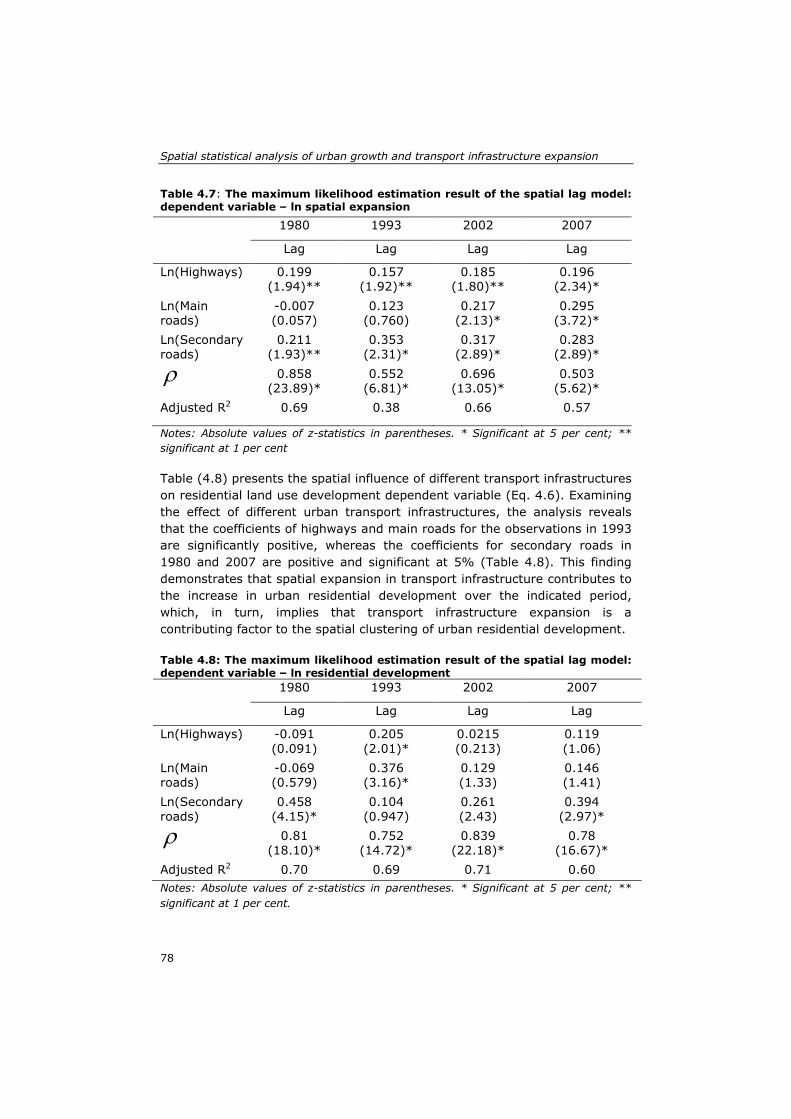
Spatial statistical analysis of urban growth and transport infrastructure expansion
78
Table 4.7: The maximum likelihood estimation result of the spatial lag model: dependent variable – ln spatial expansion
1980 1993 2002 2007
Lag Lag Lag Lag
Ln(Highways) 0.199 (1.94)**
0.157 (1.92)**
0.185 (1.80)**
0.196 (2.34)*
Ln(Main roads)
-0.007 (0.057)
0.123 (0.760)
0.217 (2.13)*
0.295 (3.72)*
Ln(Secondary roads)
0.211 (1.93)**
0.353 (2.31)*
0.317 (2.89)*
0.283 (2.89)*
ρ 0.858 (23.89)*
0.552 (6.81)*
0.696 (13.05)*
0.503 (5.62)*
Adjusted R2 0.69 0.38 0.66 0.57
Notes: Absolute values of z-statistics in parentheses. * Significant at 5 per cent; ** significant at 1 per cent Table (4.8) presents the spatial influence of different transport infrastructures on residential land use development dependent variable (Eq. 4.6). Examining the effect of different urban transport infrastructures, the analysis reveals that the coefficients of highways and main roads for the observations in 1993 are significantly positive, whereas the coefficients for secondary roads in 1980 and 2007 are positive and significant at 5% (Table 4.8). This finding demonstrates that spatial expansion in transport infrastructure contributes to the increase in urban residential development over the indicated period, which, in turn, implies that transport infrastructure expansion is a contributing factor to the spatial clustering of urban residential development. Table 4.8: The maximum likelihood estimation result of the spatial lag model: dependent variable – ln residential development 1980 1993 2002 2007
Lag Lag Lag Lag
Ln(Highways) -0.091 (0.091)
0.205 (2.01)*
0.0215 (0.213)
0.119 (1.06)
Ln(Main roads)
-0.069 (0.579)
0.376 (3.16)*
0.129 (1.33)
0.146 (1.41)
Ln(Secondary roads)
0.458 (4.15)*
0.104 (0.947)
0.261 (2.43)
0.394 (2.97)*
ρ 0.81 (18.10)*
0.752 (14.72)*
0.839 (22.18)*
0.78 (16.67)*
Adjusted R2 0.70 0.69 0.71 0.60 Notes: Absolute values of z-statistics in parentheses. * Significant at 5 per cent; ** significant at 1 per cent.

Chapter 4
79
Conversely, Table (4.9) shows the effect of urban growth variables on highway expansion dependent variable (Eq. 4.7). The coefficient of the residential development variable is negative for 1980 and 2002 and significant at 5%, and the magnitude of the coefficient increases over time, implying that the spatial expansion of residential development negatively contributes to the increase in highways over this period. In contrast, the coefficient for spatial expansion is positive and significant only for the year 2007 (Table 4.9), indicating that the increase in spatial expansion contributes positively to the increase in highways for 2007. Thus, the result reveals that population growth contributes positively to the spatial clustering of urban highway expansion, whereas residential development expansion negatively contributes to the spatial clustering in urban highway expansion. The results of the effects of urban growth variables on the main road dependent variable (Eq. 4.8) and secondary road expansion dependent variable (Eq. 4.9) are given in Tables (4.10) and (4.11) below. The spatial
autoregressive coefficient ρ for both main and secondary roads is positive and significant at the 5 % level for the observations in 1980, 1993, 2002 and 2007. This result demonstrates the existence of spatial dependence, implying a relation between urban growth and transportation infrastructure expansion. Moreover, the coefficient of the residential development variable is significantly positive for the year 1993, showing that the spatial expansion of residential development positively contributes to the increase in the main roads for 1993 (Table 4.10). In contrast, the coefficients of spatial expansion for the observations in 1993, 2002 and 2007 are positive and significant at 5% and 1% (Table 4.11), indicating that spatial expansion is a contributing factor to the spatial increase in secondary roads and highways for 2007. The analysis further indicates that the coefficient of the population for the observation in 2007 is significantly negative, implying that population growth contributes negatively to the spatial clustering of urban secondary roads (Table 4.11).

Spatial statistical analysis of urban growth and transport infrastructure expansion
80
Table 4.9: The maximum likelihood estimation result of the spatial lag model: dependent variable – ln of Highways
1980 1993 2002 2007
Lag Lag Lag Lag
Ln(Population) 0.214 (1.92)**
0.084 (0.83)
0.291 (2.71)*
0.112 (1.23)
Ln(Residential develop.)
-0.202 (2.63)*
0.01 (0.13)
-0.162 (2.00)*
-0.003 (-0.045)
Ln(Spatial expansion)
0.085 (1.47)
0.002 (0.04)
0.065 (0.99)
0.141 (1.75)**
ρ 0.722 (11.7)*
0.702 (10.6)*
0.489 (6.25)*
0.515 (5.87)*
Adjusted R2 0.38 0.25 0.42 0.33
Notes: Absolute values of z-statistics in parentheses. * Significant at 5 per cent; ** significant at 1 per cent. Table 4.10: The maximum likelihood estimation result of the spatial lag model: dependent variable – ln of Main roads
1980 1993 2002 2007
Lag Lag Lag Lag
Ln(Population) 0.016 (0.17)
0.052 (0.60)
0.108 (1.47)
0.219 (2.83)*
Ln(Residential dev.)
0.008 (0.13)
0.183 (2.72)*
-0.072 (-1.30)
-0.062 (1.03)
Ln(Spatial expansion)
-0.001 (0.022)
0.002 (0.05)
0.039 (0.87)
0.097 (1.45)
ρ 0.81 (16.6)*
0.488 (5.61)*
0.938 (49.61)*
0.645 (9.4)*
Adjusted R2 0.33 0.49 0.67 0.53
Notes: Absolute values of z-statistics in parentheses. * Significant at 5 per cent; ** significant at 1 per cent.

Chapter 4
81
Table 4.11:The maximum likelihood estimation result of the spatial lag model: dependent variable – ln of Secondary roads
1980 1993 2002 2007
Lag Lag Lag Lag
Ln(Population) 0.129 (2.04)*
0.332 (3.48)
0.099 (0.95)
-0.151 (1.90)**
Ln(Residential dev.
0.055 (1.26)
-0.072 (-1.02)*
0.006 (0.08)
0.157 (2.67)*
Ln(Spatial expansion)
-0.022 (0.687)
0.158 (1.82)**
0.121 (1.97)*
0.220 (3.19)*
ρ 0.845 (22.66)*
0.532 (6.44)*
0.348 (3.66)*
0.152 (1.58)
Adjusted R2 0.80 0.46 0.26 0.29
Notes: Absolute values of z-statistics in parentheses. * Significant at 5 per cent; ** significant at 1 per cent.
4.4 Discussion Spatial autocorrelation analysis results indicate a significant positive global spatial autocorrelation of all defined variables between 1980 and 2007. The results of the local indicators of spatial association (LISA) revealed that the spatial clustering of urban growth variables coincided with the spatial clustering of transportation infrastructure expansion variables. The results of the spatial statistical analysis reveal reciprocal spatial-temporal effects of urban growth and transport infrastructure for the city of Jeddah. Interestingly, this study indicates that the spatial influence of variables related to transportation infrastructure expansion (highway expansion, main road expansion and secondary road expansion) on the clustering of population growth and spatial expansion is constant over time. This finding reflects the significant role of the expansion of different types of transportation infrastructures on the spatial clustering of population growth and spatial expansion. In contrast, this study finds that the spatial influence of variables related to transportation infrastructure expansion on residential land use expansion changes over time (Table 4.6, Table 4.7 and Table 4.8). This finding indicates that different types of transport infrastructures have different spatial-temporal influences on the spatial clustering of residential land use expansion. It is also observed that the spatial influence of urban growth variables (population growth, spatial expansion, and residential land use expansion) on

Spatial statistical analysis of urban growth and transport infrastructure expansion
82
the clustering of transportation infrastructure expansion variables changes over time (Table 4.9, Table 4.10 and Table 4.11). This finding indicates that different urban growth variables have different spatial-temporal influences on the spatial clustering of different types of transport infrastructures. This study finds that the spatial clustering of population growth and spatial expansion stimulates the spatial clustering of urban highways expansion. Furthermore, population growth and residential land use expansion contribute to the spatial clustering of main roads, whereas spatial expansion catalyzes the spatial expansion of secondary roads in Jeddah. Although, population growth amongst other urban growth variables seems to play stronger effect on the spatial clustering of transport infrastructure in Jeddah, transportation infrastructure seems to be influenced by other factors. In essence, urban transportation systems are complex networks shaped by various geographical, social, economic, and environmental factors (Wang, Lu, and Peng, 2010). The results of this study reveal that transport infrastructure is a constantly strong spatial influencing factor of urban growth in Jeddah city. The polycentric urban structure of Jeddah city and an arterial grid pattern of transport infrastructure with high connectivity seem to support this finding. In addition, Jeddah car-oriented transport system characteristics also seem to support this finding. Other developed monocentric urban structure cities are expected to show different results. The influence of transport infrastructure on urban growth is expected be lower as compared to a polycentric urban structure like Jeddah city. This study shows that exploratory spatial data analysis and spatial regression analysis are sophisticated tools to study the mutual effects of urban growth and transportation infrastructure expansion for the case of a developing, polycentric and fast growing city. These tools were able to detect the spatial-temporal reciprocal effects of transport infrastructure and urban growth. This in turn enriches insight, strengthens the understanding of the relationship between the complex urban growth phenomenon and transportation, and extends the knowledge of urban analysis using these tools. In essence, spatial and temporal analysis of the factors that drive urban growth is critical to predict future changes and their potential environmental effects in order to mitigate the negative aspects of urban growth (Aguayo et al., 2007). This study provides urban planners and policy makers with a new methodological approach to understand the complex urban growth phenomenon in rapidly growing cities. This approach facilitates the investigation of the causes and drivers of urban growth; the complex interaction between the physical components of urban growth (spatial expansion and land use changes) and socio-economic components

Chapter 4
83
(population growth and economic growth). Enriched understanding of these issues is essential and crucial to mitigate the negative consequences of urban growth and to plan for future appropriate policies (Longley & Mesev, 2000; Herold et al., 2003).
4.5 Conclusion This chapter has explored the spatial-temporal mutual effects of transport infrastructure and urban growth using exploratory spatial data analysis and spatial regression analysis tools for the case of Jeddah city; a developing, polycentric and fast growing city in Saudi Arabia between 1980 and 2007. This paper finds a significant positive global spatial autocorrelation of all defined variables from 1980 to 2007. The local indicators of spatial association (LISA) results also find a constant significance spatial association of transport infrastructure expansion and urban growth variables from 1980 to 2007. Spatial statistical analysis results find that the spatial influence of transportation infrastructure expansion variables on the clustering of population growth and spatial expansion is constant over time and different transport infrastructure types have different spatial-temporal influences on the spatial clustering of residential land use expansion. Conversely, results find that the spatial clustering of population growth and spatial expansion influences the spatial clustering of urban highways expansion. In addition, population growth and residential land use expansion find to contribute to the spatial clustering of main roads, whereas spatial expansion finds to catalyze the spatial expansion of secondary roads. Furthermore, spatial clustering of transport infrastructure in Jeddah seems to be influenced by other factors. This study reveals that transport infrastructure is a constantly strong spatial influencing factor of urban growth. The polycentric urban structure and an arterial grid pattern of transport infrastructure with high connectivity of the study area seem to support this finding. Overall, this study demonstrates that exploratory spatial data analysis and spatial regression analysis were able detect the spatial-temporal mutual effects of transport infrastructure and urban growth. This has extends the knowledge of urban analysis using these tools. These tools provide urban planners and policy makers with new methodological approach to understand the complex urban growth phenomenon in rapidly growing cities in order to mitigate the negative consequences of urban growth and to plan the future appropriate policies. The results of this study provide several directions for further research. First, given the promising results of this study approach, further studies of the mutual relationship between urban growth and transport infrastructure using

Spatial statistical analysis of urban growth and transport infrastructure expansion
84
the presented study approach for the case of other monocentric urban structured cities is necessary. Second, given the complexity of the urban growth phenomenon, further investigation using exploratory spatial data analysis and spatial regression analysis of (1) the causes and drivers of urban growth; (2) the complex interaction between the physical components of urban growth (spatial expansion and land use changes) and socio-economic components (population growth and economic growth) is encouraged.

85
5. Cellular automata based land use/ transport interaction model for Jeddah∗
∗ This chapter is based on the following paper: Aljoufie, M., Zuidgeest, M.H.P., Brussel, M.J.G., van Vliet, J., and van Maarseveen, M.F.A.M. Cellular automata based land use/transport interaction model for Jeddah. Under review after revision at the Landscape and Urban Planning Journal.

Cellular automata based land use/transport interaction model for Jeddah
86
Abstract Understanding the interaction between urban land-use change and transport is critical for urban planning as well as for transport planning, particularly in the case of rapidly growing and motorising cities, such as Jeddah in Saudi Arabia. Dynamic land use and transport interaction models provide a good platform to study this mutual interaction. In this paper, we introduce one instance of these models, a cellular automata (CA)-based land-use/transport interaction model (LUTI), which was applied to the quickly growing metropolitan area of Jeddah. The model was calibrated using a stage-wise calibration and evaluated using an independent validation. The CA-based LUTI model outperforms a similar stand-alone CA-based model, which indicates that land use and transport interact and that models for understanding urban dynamics benefit from including the feedback between both systems. Such understanding facilitates the estimation of future dynamics of land-use change and transport in cities, and can support the development of alternative spatial plans and policies. Keywords: land use/transport interaction; calibration; validation; Cellular Automata; Jeddah

Chapter 5
87
5.1 Introduction Many cities worldwide are growing rapidly, which leaves urban planners and transport planners with a continuous challenge of planning a liveable environment. A quickly growing population, denser use of space and increased motorisation cause significantly more traffic, resulting in congestion and a wide range of other effects, such as air pollution, greenhouse gas emissions and economic losses. The transport system is one of the main drivers for urban growth, through the accessibility and economic opportunity it provides to the surrounding land and activities (Hall & Pfeiffer, 2000; Hart, 2001; Meyer & Miller, 2001). Therefore, it is crucial to better understand urban dynamics and transport, including its drivers and impacts. Land-use models, especially cellular automata (CA)-based land-use models, offer a good platform to study urban dynamics (Al-Ahmadi et al., 2009). Because accessibility is widely acknowledged as a key determinant of land-use dynamics, many of these models include accessibility as a driver of urban land-use change (for example Feng et al., 2011; Han et al., 2009; Pinto & Antunes, 2010; Reilly et al., 2009; Stanilov & Batty, 2011). In such models, accessibility is mostly modelled statically and defined as the proximity to major infrastructure elements or important destinations. The actual performance of the transport system, in terms of traffic volumes and recurrent levels of congestion on the network, is typically absent. Transport models, or travel demand models, have been used to make predictions of future changes in the usage of transport facilities for the sake of facility design, control and operation (Ortúzar & Willumsen, 2011) since the early 1960s. Changes in travel patterns can be computed from autonomous spatial developments, spatial planning policies or transport and traffic intervention; traffic forecasts can then be made from these computations. Although activity-based models have been developed recently (Bhat & Koppelman, 2003), classical four-step models are still used universally (Algers et al. 2005). Four-step models predict the number of trips between trip origins and destinations, which are represented in geographical units called Traffic Analysis Zones (TAZs), and modal traffic flows in four consecutive steps. Accordingly, the level of accessibility for each TAZ can be computed. Important inputs to this model are the land use per TAZ, and a set of behavioural and choice data. The main critique to the application of these models in practice has long been the absence of any feedback from the transport model on land use (Beimborn & Kennedy, 1996). Because land use and transport interact, several researchers have indicated that the development of an integrated approach that links land use and accessibility dynamically is a crucial step in explaining land-use dynamics

Cellular automata based land use/transport interaction model for Jeddah
88
(Benenson & Torrens, 2004; Santé et al. 2010; Torrens & Benenson 2005; Xie & Batty 2005). Some existing modelling approaches that allow for such feedbacks between the land-use and transport systems include logistic regression (Iacono & Levinson 2009), system dynamics (Pfaffenbichler & Emberger, 2010), or CA-based land-use models (RIKS, 2010). These models belong to the family of land-use/transport interaction (LUTI) models and facilitate the exploration of the mutual interaction between land-use change and transport, the estimation of future dynamics, and the development of alternative spatial plans and policies. The calibration of these LUTI models is not straightforward, mainly because the interaction between the land-use system and the transport system is reciprocal, complex and dynamic (Chang, 2006). Therefore, although it is clear that the mutual representation of land-use change and transport is a conceptual improvement, it is not immediately clear that this will improve modelling results. Hence, there is a challenge to calibrate LUTI models in a way that is theoretically sound and practically applicable (Hunt, 1994). This chapter presents a CA-based LUTI model that is applied to the rapidly growing metropolitan area of Jeddah, Saudi Arabia. The model was calibrated to reproduce historic land-use changes and traffic flows using a stage-wise procedure (Abraham & Hunt, 2000; Zhong, Hunt, & Abraham, 2007), thereby specifically looking at the feedback between land use and transport in the dynamic model to assess the added value of an integrated approach. The results of this LUTI model were compared against a baseline of a similar stand-alone land-use model. The remainder of this chapter is organised as follows: Section 2 describes the LUTI model, its application to the case study of the city of Jeddah, and the applied calibration and validation procedures. Section 3 presents and discusses the results of the calibration and independent validation. Section 4 draws conclusions about the calibration and validation framework and the case study results and discusses some directions for future research.
5.2 Methodology
5.2.1 Metronamica-LUTI: an integrated Land-use/Transport Interaction model For this study, we applied the Metronamica Land-Use/Transport Interaction model (Metronamica-LUTI), which integrates a cellular automata (CA)-based land-use model and a four-step transport model into one system. It builds on the Metronamica land-use model, which is a constrained CA land-use model (White et al., 1997). CA models typically exist on a lattice of grid cells, where the state of each grid cell represents one of a limited number of land uses.

Chapter 5
89
Land-use change is computed for discrete time steps. For each time step, the land use of a particular location can change following a set of transition rules. Transition rules include the physical suitability of a location, the accessibility to transport networks, spatial planning measures, and the neighbourhood rules, where the neighbourhood rules define the influence of the land uses in the vicinity of a location (White & Engelen, 2000). Metronamica contains 3 types of land-use classes: function land uses, feature land uses, and vacant land uses. Function land uses are actively allocated using transition rules. Generally urban land uses are represented as function land uses. Feature land uses are those land uses that do not change during a simulation, such as water bodies or infrastructure elements. Vacant land uses are assigned to all locations that are not occupied by a function or feature land use (White et al., 1997). For each time step, representing one year, function land uses are allocated to those locations that have the highest potential for this land use. Potentials are computed for each cell and for each land use based on transition rules:
𝐏𝐤,𝐢 = 𝐫𝐤,𝐢 ∙ 𝐀𝐤,𝐢 ∙ 𝐒𝐤,𝐢 ∙ 𝐙𝐤,𝐢 ∙ 𝐍𝐤,𝐢 (5.1)
where Pk,iis the potential for land-use class k in cell i, rk,i is a scalable random perturbation term for land use k in cell i, Ak,iis the accessibility for land use k in cell i, Sk,i is the physical suitability for land use k in cell i, Zk,i is the zoning status for land use k in cell i, and Nk,iis the influence of the neighbourhood rules for land use k in cell i. A more detailed explanation of the Metronamica land-use model can be found in RIKS (2010). In addition to the constrained land-use model, Metronamica-LUTI contains a four-step transport model to calculate the transport accessibility per TAZ. In the first step, production and attraction for each TAZ, i.e., the numbers of trip origins and trip destinations, are calculated based on the existing land use and behavioural parameters of the trip makers. These trips are calculated for three periods (morning peak hour, afternoon peak hour and the rest of the day) for a representative average weekday. In the second step, trip distribution, trips are distributed between origins and destinations based on travel time and costs to travel from one location to another. In the third step, mode choice, trips are further distributed over the alternative transport modes based on the service characteristics of each of the modes. Finally, in the fourth step, traffic assignment, trips per mode are assigned to the transport network, resulting in traffic volumes per road segment. A more detailed description of four-step transport models can be found in Ortúzar & Willumsen (2011).

Cellular automata based land use/transport interaction model for Jeddah
90
Because land use is a primary input in the four-step transport model and transport accessibility is an important input in the land-use model, the two can be integrated in a straightforward manner. Both models are evaluated per yearly time step; therefore, each year, the result from the land-use model feeds into the transport model and vice versa. This results in a dynamic model that includes the mutual feedback between both systems, as depicted in Figure 5.1.
Figure 5.1: Metronamica-LUTI structure
The input from the land-use model into the transport model consists of a map that indicates the current land use for each cell. The number of trip origins and trip destinations per TAZ simply follows from the number of cells per land-use type in a TAZ and the production and attraction per cell for each particular land-use type. The trip distribution, modal choice and traffic flows (including level of congestion) are then calculated based on the travel time and cost impedances between all TAZs. The results from the transport model feed back into the land-use model through the calculated level of accessibility. In fact, the accessibility used in the land-use model is composed of several accessibility factors:
𝐀𝐤,𝐢 = 𝐋𝐀𝐤,𝐢 ∙ 𝐈𝐀𝐤,𝐢 ∙ 𝐙𝐀𝐤,𝐢(𝐳) (5.2) where LAk,i is the local accessibility for land use k in cell i, IAk,i is the implicit accessibility for land use k in cell i, and ZAk,i(z) is the zonal accessibility for land use k in cell i, which equals the zonal accessibility for land use k of the TAZ wherein cell i is located. The local accessibility indicates the accessibility

Chapter 5
91
for land use k in cell i as a function of its location relative to the road network, i.e., the proximity:
𝐋𝐀𝐤,𝐢 = 𝐚𝐤,𝐫𝟏+𝐝𝐢/𝐃𝐤,𝐫
(5.3) where di is the distance from location i to the nearest cell that includes a road, Dk,r is the distance decay parameter for road type r for land use k, and ak,r is the importance for road type r for land use k. Parameters a and D are set for each road type separately in the calibration procedure. IAk,i represents the accessibility of a cell i for land use k that is implicit to its current land use l, as we assume that built-up areas include a basic infrastructure even though it might not be represented in the road network layers that are included in the model:
IAk,i = �a if l(i) ϵ built-up land usesb otherwise
(5.4)
where a and b are parameters in the range [0,1], and that are set in the calibration procedure. ZAk,i(z) expresses the zonal accessibility for land use k at location i in zone z. It expresses how well this location can be reached by all relevant land uses in all TAZs. The zonal accessibility for a land use k in cell i is thus a function of the distribution of land uses l in all other zones z′. For example, the accessibility of commercial land typically depends on the distribution of residential areas as well. The influence of any land use l in zone z′ on the accessibility of zone z is calculated as the cost-weighted summation over trip destinations z′:
ZAl,z = ∑ Al,z′ ∙ e−βl∙Cz,z′z′ (5.5) where βl is the sensitivity to cost for accessing land use l, Al,z′ the amount of land use l in destination zone z, and Cz,z′ the generalised cost to travel from zone z to z′. Based on the influences of all other land uses in all other zones, the zonal accessibility for the allocation of a particular land use k on location i, ZAk,i(z), is then computed as follows:
ZAk,i(z) = ZAlow + �1 − ZAlow� ∙ �ZAk,z
∗ −ZAkmin
ZAkmax−ZAk
min� (5.6)
ZAk,z∗ = ∑ 𝛾l,k ∙ ZAl,zl (5.7)

Cellular automata based land use/transport interaction model for Jeddah
92
ZAkmin = minz�ZAl,z
∗ � (5.8) ZAk
max = maxz�ZAl,z∗ � (5.9)
where 𝛾l,k is the sensitivity-to-cost parameter that indicates how much the
allocation of land use k depends on the distribution of land use l over all TAZs and ZAlow is the parameter that controls the influence of zonal accessibility on land-use allocation. As the most accessible zone has an accessibility of 1, ZAlow is defined between 0 and 1. As a complete description of Metronamica-LUTI is beyond the scope of this paper, we only present the equations that describe the link between the transport model and the land-use model. For the complete model description we refer again to the Metronamica-LUTI model description (RIKS, 2010).
5.2.2 Simulating urban growth in the city of Jeddah Jeddah is the second largest city in the Kingdom of Saudi Arabia. It is located on the west coast of the kingdom in the middle of the Red Sea’s eastern shore (Figure 2.1). Jeddah’s population increased dramatically from 147,900 inhabitants in 1964 to 3,247,134 inhabitants in 2007, primarily due to in-migration from villages and suburbs to the city in search for jobs and a better life. The strength of the economy and the growth in population are increasingly straining the city’s transport system. Jeddah’s transport is dominated by cars, with residents using private automobiles for 93% of their trips (IBI, 2007). Rapid urban expansion, population growth and traffic congestion are currently the main issues in Jeddah’s planning and governance. The study area for the Metronamica-LUTI application covers the entire area under the Jeddah urban authority’s rule. It is represented by a regular grid 408 cells wide by 755 cells long, using a 100 meter resolution. Land use and transport infrastructure maps were prepared using a cooperative visual interpretation method that integrates geographic information system (GIS) and remote sensing (RS) techniques. Aerial photos from 1980; Spot satellite images from 1993, 2002 and 2007; Jeddah master plans; and transport studies were used to extract ten urban land-use classes: residential, commercial, industrial, public places, informal settlements, airport, port, roads, vacant lands and green areas. Thereafter, residential land use was further categorized into three different density classes (high, medium and low) based on population per TAZ to better depict the relation between population densities and transport in Jeddah. Land-use classes were categorized into vacant (i.e., vacant lands), function (i.e., residential low density, residential medium density, residential high density, commercial and industrial) and feature (i.e., airport, port, public places, green areas, informal

Chapter 5
93
settlement, and outside the simulation area) categories as required by the model. Suitability maps for urban land uses were prepared in a GIS based on soil and slope data. In addition, zoning maps were created based on Jeddah spatial plans, other than the master plan, and known zoning policies. These plans and policies represent restrictions for the development of urban land uses. Population growth and land-use demands for different points in time were derived from census data for 1993, 2005 and 2010, Jeddah master plans for 1980, 1987, 2004 and Jeddah detailed plans for 2009. A TAZ map for the transport model, consisting of 311 zones, was obtained based on a combination of Jeddah’s existing authority sub-district boundaries and TAZ maps from previous transport studies (IBI, 2007; Municipality of Jeddah, 2006). The road maps, represented as a network with linear elements, were manually digitised for the years 1980, 1993, 2002 and 2007 using aerial photographs and satellite images. Highways and primary and secondary road classes could be distinguished as well. The road network map of 1980 was incorporated in the model as the initial road network map, while the extensions to this road network in 1993, 2002 and 2007 were mapped as incremental changes to the 1980 network. Daily trips were divided over three periods: morning rush hour (3 hours), afternoon rush hour (3 hours) and the rest of the day, while four trip purposes were distinguished: home to work, work to home, work to work and others (social, shopping and leisure). Two transport modes that dominate daily trips in Jeddah have been considered in this study: private car and public transport.
5.2.3 Calibration procedure for the land use and transport interaction model For the calibration of the Metronamica-LUTI application, a stage-wise sequential approach was adopted. In a stage-wise approach, models are first calibrated individually before the parameters that define the interaction between these models are set (Abraham & Hunt, 2000). Specifically, the Jeddah application was calibrated using the following four stages: (1) calibration of the land-use model as a stand-alone application, (2) calibration of the four-step transport model as a stand-alone application using a sequence of land-use maps, (3) calibration of the connection between both models using the complete LUTI model, and (4) independent validation of the complete LUTI model. This procedure is presented graphically in Figure 5.2 and explained in more detail in the subsequent sections. The rationale for the stage-wise approach is that it avoids circular interconnections in the initial stage and that it can close-in systematically on

Cellular automata based land use/transport interaction model for Jeddah
94
model parameters (Hunt, 1994). The order of the calibration of stand-alone models is justified by the speed with which the land-use system and the transport system react to each other’s dynamics: although the two systems interact, the land-use system is more dynamic than the transport system. Hence, the inaccuracy that is introduced by simulating land-use changes using a static accessibility to transport networks is smaller than the inaccuracy that would be introduced by simulating transport dynamics using a static land-use model.
Figure 5.2: Stage-wise sequential calibration approach

Chapter 5
95
Stage 1: Calibration of the CA-based land-use model The first stage comprises the calibration of the stand-alone application of the Metronamica land-use model. This land-use model was calibrated to simulate land-use changes in Jeddah between 1980 (t0) and 2007 (t1). However, because land-use data were available for 2002 as well, the calibration initially considered 1980-2002 and 2002-2007 separately to allow for a better understanding of temporal dynamics. The calibration was started after defining the initial value of the neighbourhood rules based on a multiple linear regression analysis of the available spatial temporal land use data for Jeddah (1980-2007). The model performance was improved by introducing suitability maps and zoning maps and by iteratively adjusting the neighbourhood rules, the random perturbation term and the parameters that define the influence of accessibility on transport networks. Hence, the influence of transport on land-use dynamics in this stand-alone application is reduced to the proximity of elements of the road network, as described by Equation 5.3, while transport dynamics or intensities were not considered here. The calibration of the land-use model used a manual procedure, and the initial results were assessed using expert knowledge and visual comparison following Ward et al. (2000) and Barredo et al. (2004). Expert knowledge was used to set the hierarchy between urban land uses, as urban dynamics are characterised by a densification of residential areas in the centre of the city, while less dense land uses are pushed outwards to the more peripheral areas. Visual comparison was used to assess the pattern and irregularity of urban land uses and the location of land-use changes. Pattern and irregularity of urban land uses is mainly influenced by the random perturbation term, while the location of land-use changes is mainly affected by the neighbourhood rules and the accessibility of transport networks. In addition to a visual assessment, the predictive accuracy of the calibrated land-use model application was also assessed by means of Kappa Simulation (van Vliet et al., 2011). Kappa Simulation expresses the agreement between the actual land-use map and the simulated land-use map, corrected for the agreement that can be expected by chance, given the amount of land-use change relative to the original land-use map. Values range from -1 to 1 and a value above zero indicates that a simulation is more accurate than can be expected by chance alone, and hence that the simulation does explain some land-use changes. Stage 2: Calibration of the four-step transport model The second stage of the calibration procedure encompasses the calibration of the four-step transport model. However, within this stage, three distinct phases are identified. First, a number of parameters that could be obtained from data or other sources were set, then the transport model was calibrated

Cellular automata based land use/transport interaction model for Jeddah
96
to reproduce the transport system in the initial year (1980), and finally, changes in the transport system over time were considered. Several parameters in the four–step model were derived from earlier transport studies in Jeddah (IBI, 2007; Municipality of Jeddah, 2006), and from another transport study for the city of Riyadh, Saudi Arabia (Municipality of Riyadh, 2006), because the latter city has characteristics very similar to that of Jeddah. These parameters include those representing vehicle occupancy, travel costs per kilometre, and travel costs per hour, as these can be observed from data or at least be compared from one model to another. As these parameters are measured or at least reasonably well estimated they were fixed and not further calibrated. Subsequently, the four-step model was calibrated to reproduce the transport system in the initial year of the simulation. In this phase, the initial land-use map was input into the model to simulate the transport system in that year. Parameters included mainly those for trip generation (production and attraction) but also include the sensitivity to costs and preferences for alternative transport modes. Because this phase includes many different parameters, calibration was essentially an iterative procedure, and all parameters were revisited several times. Finally, the changes in the transport system over time were calibrated. For this, the series of land-use maps obtained from the land-use model calibrated in stage 1 were input into the model. However, there was no feedback from the transport system to the land-use system at this stage; hence, land-use changes were included in the four-step model, but transport dynamics were not included in the land-use model. Parameters that change over time include the mobility growth (i.e. a factor that controls the development of transport over time as an exogenous trend), the costs per kilometre and the cost per hour. The fact that not only data but also model parameters representing actor behaviour can change over time adds to the realism of the model but also to the complexity of the calibration. Results of the four-step transport model were assessed by comparing model results with actual travel observations as well as with results from earlier transport studies. The latter mainly include the trip matrices of all transport periods for the initial year (1980) and the final year (2007) using data from an earlier study of transport in Jeddah (IBI, 2007). Moreover, derived statistics, such as the average trip distance and the average trip duration per transport mode, were used to compare and assess the model results.

Chapter 5
97
Stage 3: Calibration of the feedback from transport to land use In this stage, the Metronamica-LUTI was used to simultaneously model land-use and transport dynamics. Relative to the previous stage, this means that the feedback from the transport system on the allocation of land uses was included. This feedback exists through the zonal accessibility as explained in Section 2.1. Specifically, this stage includes the adjustment of the minimum zonal accessibility and the adjustment of the sensitivity of land-use allocation to transport costs to improve the allocation of observed land-use changes. However, this feedback also yields land-use dynamics different from those simulated in the first stage. Therefore, the link from the land-use system to the transport system was revisited as well. Because the feedback between the land-use and transport systems requires time to adjust, the model was calibrated using a land use map of 2007 and data on average trip lengths in 2007 from a reference transport model (IBI, 2007). Simulation results were assessed using a visual comparison method, Kappa Simulation and Moran’s I statistics. Visual comparison and Kappa Simulation were used to assess the simulated land-use pattern as explained in section 2.3.1. Moran’s I was used as a measure of spatial clustering or dispersion in a land-use pattern, so as to characterise the land-use pattern and measure the similarity between the simulated land-use pattern and the actual pattern (Li & Liu, 2006; Wu, 2002). Under conditions of statistical significance, a Moran’s I value of 1 indicates a maximum level of clustering of a land-use type, while values close to 0 indicate a near random spatial arrangement and a value of negative 1 indicates a maximum level of dispersion. Stage 4: Independent validation of the CA-based land-use/transport interaction model To rigorously test the model calibration, an independent validation was performed for the complete LUTI model. In this independent validation, land-use and transport dynamics were simulated from 2007 (t1) to 2011 (t2) using the parameters as obtained during the calibration stages. Because no land-use map was available for 2011, results were assessed based on a 2011 ground truth dataset of 250 randomly generated field points. Likewise, the transport model was validated based on available origin and destination figures and observed traffic counts for 2011. Specifically, the performance of the transport model was assessed based on trip characteristics from the reference transport studies (Dar al-handasah, 2010; IBI, 2011; Midrar, 2011) for several TAZs in Jeddah, while traffic flows generated by the transport model were validated using traffic count data for selected road segments in the study area.

Cellular automata based land use/transport interaction model for Jeddah
98
5.3 Results and discussion
5.3.1 Calibration results Table 5.1 and Figure 5.3 show the stage-wise calibration results (best-fit) of the Kappa Simulation for the land-use model in stage 1. Although the model produces a low accuracy result in the initial calibration steps, the model fit improves substantially after introducing the suitability, accessibility and zoning factors as well as upon calibration of the neighbourhood rules. Particularly, the calibration of neighbourhood rules produces the largest improvement(from 0.435 to 0.648),, as indicated by the overall Kappa simulation statistic. This reflects the central role of neighbourhood rules in accurately simulating land-use changes. Subsequently in stage 2, the modelled trip origins and destinations for the year 2007 are compared with the reference origin – destination (OD) trip data per TAZ for the same year and aggregated to the level of sub-municipalities in Figure 5.4, which represent distinct urban areas within Jeddah. The average discrepancy between modelled and reference trip origins per sub-municipality is 13.5% for the morning period and 12.3% for the afternoon period, whereas the destination best-fit rendered an average 18.2% for the morning period and 17.3% for the afternoon period. This figure also depicts the variation in the model accuracy per sub-municipality. The central urban areas produced a slightly higher accuracy in comparison with the fringe areas, which can be explained by the relatively small TAZs in the urban area that allow for more accurate trip production and trip attraction estimates, because all households within a TAZ are assumed to show similar travel behaviour. Moreover, the best model fit for the total number of trips was 92.5% of the reported total number of trips in 2007 reference study, while the best fit for modal split (i.e. the share of daily trips over available modes, i.e. for Jeddah public transport and private car) was 5.8% for public transport and 94.2% for private car compared to 6.1% and 93.9% for the reference modal split in 2007, respectively.

Chapter 5
99
Table 5.1:Results for land use model at the various calibration stages
A large part of the difference between the simulated trip origins and destinations and the total number of trips in this study and the reference study (IBI, 2007) can be explained by the data that is input to both trip generation models. The reference study uses households as input, while this study is based on land uses. Although residential land use is represented in three levels of density, the lower estimates in trip origins and destinations in the densest and most central TAZ might be the result of underestimation of the number of households in these zones. Another source of inaccuracy is the presence of mixed land uses in these central zones, mostly residential and commercial, while the land use model represents the predominant land use only. Hence the trip generation is only based on this predominant land use. Recent developments in land-use modelling that incorporate spatial agents or density levels for land-use activities (van Vliet et al., 2012) can eliminate these constraints and might provide directions for future research.
Land use model calibration steps Kappa
simulation
1.1 Neighborhood rules values based on regression analysis (Stage 1) 0.21
1.2 Calibration of random perturbation term ( Stage 1) 0.28
1.3 Introduction of suitability, accessibility and zoning factors (Stage 1) 0.435
1.4 Calibration of neighborhood rules (Stage 1) 0.648
1.5 Revisiting neighborhood rules 2002-2007 (Stage 1) 0.687
3.1 Including transport as an integrated model component (Stage 3) 0.702

Cellular automata based land use/transport interaction model for Jeddah
100
Figure 5.3: Best fits of land use for the different calibration steps: Best fits of land use for the different calibration steps under different stages: 1) Neighborhood rules values based on regression analysis (stage 1); 2) Calibration of random perturbation term (stage 1); 3) Introduction of suitability, accessibility and zoning factors (stage 1); 4) Calibration of neighborhood rules (stage 1); 5) Revisiting neighborhood rules 1980-2007 (stage 1); 6) Including transport as an integrated model component (stage 3); 7) Reference land use map of 2007

Chapter 5
101
Figure 5.4: Comparison of the model trip origins and destinations and data at sub-municipality level for morning and afternoon periods

Cellular automata based land use/transport interaction model for Jeddah
102
The results improve further after calibration of the link between the land use and transport model in stage 3. The match of the simulated land use of 2007 with the actual land use of 2007 (see Figure 5.3) has increased from 0.687 to a Kappa Simulation statistics of 0.702. The visual comparison of the actual land-use patterns of 2007 with the 2007 simulated land-use patterns after calibrating the link indicates a good visual similarity. The values of Moran’s I for the simulated land-use patterns and for the actual land-use patterns are given in Table 5. 2. These results confirm that the simulated land-use patterns after calibrating land use and transport interaction are closer to the actual land-use patterns than without the link. Table 5.2: Moran I values for different land-use results
The main differences between simulated land use when only using the land use model and when using the LUTI modecan be observed in the pattern of medium residential density, high residential density and commercial land uses. These land-use classes are located in areas close to the city centre (CBD) as well as in areas with high traffic flows and congested transport infrastructure. Table 5.3 shows two very important effects of integrating transport in the land-use model. First, the relative difference between sub-municipalities increases considerably after the two models are linked, which means that sub-municipalities that have a high level of accessibility tend to grow faster than peripheral areas. Second, the ranking of the sub-municipalities changed after the land-use and transport model were integrated. Hence, a sub-municipality that was initially less attractive (when measured from the transport network only) now becomes more attractive (due to the feedback from the transport model). Similar effects are visible on all spatial scales in the model (cell, TAZ, and sub-municipality). It should be noted that the absolute accessibility values have no intrinsic meaning; therefore, the values from the stand-alone application and the values from the LUTI application cannot be compared. Generally, the results show that maximising the influence of transport on land use by decreasing the minimum zonal accessibility and increasing the sensitivity to cost improved the model results. The generated land-use patterns fits better and is thus more realistic after adjusting the link in this direction. In addition, in the transport model, the average trip distance comes closer to reality after adding the link with the land-use model, decreasing from 8.04
Land use Moran I p-value
Simulated 2007 land-use using the land- use model 0.20 0.001
Simulated 2007 land-use using the LUTI model 0.184 0.001
Actual 2007 land-use map 0.157 0.001

Chapter 5
103
km before the link calibration to 7.76 km after link calibration, compared to the actual value of 7.6 km in 2007. Both the land use and transport results show that it is not only the transport infrastructure that stimulates land-use changes but also the congestion levels through their effect on generalised costs and, therefore, zonal accessibility. This result stresses the fact that it is crucial to consider the calibration of the full land-use/transport dynamics. Table 5.3: Ranking of sub-municipalities based on the average accessibility for residential land uses for all locations within each sub- municipality
*Acc. = Accessibility; **sub-m. =sub-municipality (as shown in Figure 5.4)
5.3.2 Independent validation results The results from the independent validation based on 250 sample points in stage 4 indicate the performance of the model in simulating the period from 2007 to 2011. These results show that the land-use model simulated land-use changes correctly for 74% of the 250 sample points, while 83% of the unfitted points are vacant lands and the other 17% are mixed between dynamic land uses. Conversely, a comparison of simulated trip productions and attractions in 2011 with the available reference travel demand data based on morning peak cordon count for 4 TAZs (Table 5.4 Figure 5.5) yields an average absolute error of 15.25% for trip production and 19.25% for trip attraction, disregarding the direction of the error. Model results at the level of road segments show an an average absolute error of 15.4%, relative to traffic account data, as shown in Table 5.5 and Figure5.6 .
Residential high
density Residential medium
density Residential low
density
Road
network only linked system
Road network
only linked system
Road network
only linked system
rank Acc.* sub-m.** Acc.
sub-m. Acc.
sub-m. Acc.
sub-m. Acc.
sub-m. Acc.
sub-m.
1 0.98 (3) 0.64 (2) 0.97 (4) 0.49 (4) 0.98 (8) 0.68 (8)
2 0.96 (2) 0.48 (3) 0.97 (6) 0.45 (6) 0.97 (6) 0.49 (6)
3 0.96 (5) 0.36 (4) 0.96 (8) 0.38 (5) 0.94 (7) 0.29 (7)
4 0.95 (1) 0.34 (5) 0.95 (2) 0.36 (8) 0.94 (5) 0.13 (4)
5 0.95 (4) 0.25 (9) 0.95 (5) 0.28 (2) 0.94 (4) 0.11 (5)
6 0.94 (6) 0.23 (1) 0.95 (7) 0.24 (7) 0.93 (9) 0.08 (9)
7 0.93 (8) 0.20 (6) 0.95 (9) 0.21 (9) 0.93 (2) 0.06 (2)
8 0.93 (9) 0.09 (8) 0.93 (3) 0.13 (3) 0.92 (3) 0.05 (10)
9 0.92 (7) 0.08 (7) 0.92 (10) 0.10 (10) 0.91 (10) 0.02 (3)
10 0.91 (10) 0.03 (10) 0.91 (1) 0.02 (1) 0.90 (1) 0.00 (1)

Cellular automata based land use/transport interaction model for Jeddah
104
Table 5.4 Validation results for production and attraction on individual TAZs
Table 5.5: Validation results for traffic flow on individual road segments
The accuracy of the simulated trip production and attraction in 2011 is of the same order of magnitude as the average absolute error in the calibration of production and attraction of 2007 in stage 2. The average absolute error of 15.25% for trip production and 19.25 % for trip attraction are quite close to the absolute errors of trip production (13.5 %) and attraction (18.2%) in stage 2. This indicates a stable error margin and a likely stable model behaviour over time
TAZ
Trip production Trip attraction
Data Model Error% Data Model Error%
1 965 928 -3 1448 1263 -12
2 1757 1122 -36 3479 2236 -35
3 939 773 -17 1584 1953 23
4 6299 5954 -5 4200 3901 -7
Average absolute error (%) 15.25 19.25
Segment Observed traffic Modelled traffic Error %
1 39902 37525 -6
2 51225 67438 32
3 84659 71214 -16
4 89261 94738 6
5 81444 76835 -6
6 62545 56268 -10
7 63332 59190 -7
8 90743 123837 36
9 67316 77819 16
10 73772 66292 -10
11 67607 50553 -25
Average absolute error 15.4

Chapter 5
105
Figure 5.5 Transport model validation TAZs

Cellular automata based land use/transport interaction model for Jeddah
106
Figure 5.6: Transport model validation road segments
Notwithstanding these effects, the independent validation results over several land-use cells, sub-districts and road segments in the study area show that the calibrated model predicts land-use changes and changes in travel patterns and traffic flows very well. This result indicates that the calibrated model is not overfitted to the specific changes that occurred in the calibration period. Instead, the results suggest that the parameters reflect the general land-use and transport dynamics that take place in Jeddah and that the calibrated application is well suited for exploring future land-use changes and alternative scenarios.
5.3.3 General discussion The results have shown that the LUTI model performs better than the stand-alone land-use model after calibration of its parameters. However, calibration of the integrated LUTI model is not straightforward. Previous studies have used a simultaneous calibration approach (Haghani et al., 2003) and the step-wise calibration approaches as proposed by Hunt (1994), Abraham & Hunt (2000), and Zhong, Hunt, & Abraham (2007) to calibrate such models.
Chapter 5
107
The simultaneous calibration approach typically adopts a trial-and-error procedure. However, this approach is cumbersome, not very systematic and, therefore, computationally expensive, which increases the chances for suboptimal calibration. In this study of Jeddah, we have therefore adopted the stage-wise calibration approach with four sequential stages, particularly focusing on the interaction between the transport component and land-use component in the model and including a validation stage. This calibration procedure has facilitated a better understanding of each of the components in the model and their interaction and provides a systematic practical calibration approach. Data quality is an important element for successful CA model application, calibration and validation (Silva & Clarke, 2002). In this study, several data sources have been used to perform the calibration and validation activities, including images, aerial photos and master plans as reference data. Given the inconsistent spatial and temporal resolution of these data, a consistent method, i.e., the cooperative visual interpretation method, has been used to extract land-use and transport infrastructure data. Using this method, a high accuracy of 90% was achieved, which exceeds the minimum 85% accuracy set for land use data by Anderson et al. (1976). Nevertheless, there will always be inherent errors in remote sensing data extraction. These errors in the source data certainly propagate through the CA simulation but are low relative to the amount of change. This low error rate is partly because errors are much reduced in the simulation due to the averaging effects of neighbourhood functions and the use of iterations in the CA (Yeh & Li 2006; Li & Liu, 2006). In this study, we have used different data sources for the independent validation, including field measurements for traffic flow and verified ground measurements for validating land-use changes. The validation results show a good match of the model with actual data. Urban growth in Jeddah is hardly constrained by biophysical properties of the landscape. This makes Jeddah an excellent case study to test a dynamic land use-transport interaction model. As land-use changes are typically a result of a combination of drivers, the absence of other such landscape properties increases the role of transport in urban growth. For similar reasons, the absence of natural or agricultural land uses in the surroundings of the city decreases the complexity of the model and increases the focus on transport as a driver for land-use change. In addition, transport system characteristics also seem to support the model calibration process. Jeddah is almost unimodal, with a car share of 94% dominating the modal split of transport. Jeddah’s landscape properties and transport characteristics seem to decrease the complexity of the model and increase the focus on transport as a driver for land-use change.

Cellular automata based land use/transport interaction model for Jeddah
108
Overall, the calibrated model seems to be a very useful tool to analyse the reciprocal interaction between urban growth and transport. The model can be used to explore the current interaction between land-use change and transport and to simulate the future interaction under alternative spatial plans and policies.
5.4 Conclusion Interactions between land use and transport take place over spatial and temporal dimensions and involve factors with varying degrees of certainty (Chang, 2006; Shaw and Xin, 2003). Consequently, modelling efforts that aim to study land-use and transport systems should acknowledge their complex interactions over space and time. This chapter presented the results of a CA-based land-use/transport interaction model, Metronamica-LUTI, to simulate land use – transport interaction in the city of Jeddah. Model results indicate that these complex interactions are handled well and that the feedback from the transport system to the land-use system by means of zonal accessibility improved the model performance. The LUTI model was applied to the rapidly growing metropolitan area of Jeddah, Saudi Arabia. Calibrating a complex model, such as this land-use/transport interaction model, is not straightforward. The application was calibrated using a stage-wise approach with three sequential stages as proposed by Hunt (1994). This approach first calibrates separate model components and subsequently calibrates the feedback between model components. A particular focus was given on the simultaneous calibration of the interaction between the model components. A fourth stage for validation has been included to assess the performance of the LUTI model over the standard land use model. This provides a systematic practical calibration procedure which reduces the complexity of the integrated land use-transport model, and facilitates a better understanding of each of the components in the model and their interaction. The calibration and independent validation results have shown that the integrated model generates good results for the land-use change as well as for the transport components. Moreover, calibration results indicate that the explicit modelling of the feedback from transport to land use improves the simulation results. This confirms the strong link between land-use change and transport and suggests that both are better studied as an integrated system rather than as separate entities. The results of this research provide several directions for further research. First, given the promising calibration and validation results, it provides a thorough basis for exploration of future urban dynamics in Jeddah. Considering the rapid population growth and the currently car-dominated society of Jeddah, this model will prove useful and necessary. Second, given

Chapter 5
109
the complexity of land-use changes and their interaction with transport, additional testing on other areas will provide further insights to the capacity of Metronamica-LUTI for simulating land use and transport interactions. Particularly, polycentric urban structures, regional applications, a larger role for other transport modes, and case studies that include a more diverse landscape, including agricultural and natural land uses, will provide useful cases.

Cellular automata based land use/transport interaction model for Jeddah
110

111
6. Dynamic modelling for land use and transport policy impact assessment ∗
∗ This chapter is based on the following paper:
Aljoufie, M., Zuidgeest, M.H.P., Brussel, M.J.G., van Delden, H. and van Maarseveen, M.F.A.M. Dynamic modelling for land use and transport policy impact assessment in Jeddah . Submitted to Journal of Policy Modelling.

Dynamic modelling for land use and transport policy impact assessment
112
Abstract Analysing the impact of urban policy interventions on urban growth, land use and transport is crucial for urban planners, transport planners and policy makers, especially in rapidly growing cities such as Jeddah, Saudi Arabia. This chapter presents a cellular automata (CA)-based land-use/transport interaction model for Jeddah that is used to analyse the impact of different proposed policy interventions under two urban growth scenarios for the period 2011-2031. Used as an integrated policy impact assessment tool, the model demonstrates a strong reciprocal relationship between land use and transport in Jeddah. By quantifying various indicators related to land use (e.g., urban sprawl, residential density, etc.) and transport (e.g., congestion, modal split, etc.), the results identify a number of notable effects for land use on transport, and they also identify notable effects over various spatial and temporal dimensions. The simulation results for the later proposed interventions demonstrate that Jeddah will experience enormous transport and urban development challenges by the year 2031 unless appropriate policy interventions are considered in time and place. Individual transport and land use interventions provide only limited improvements to the performance of the land use and transport systems, whereas a policy scenario with carefully combined land-use/transport interventions shows much more improvement in these systems. This study, therefore, shows that relevant spatial information and integrated policy impact assessment can provide rich insights into the interaction between land use and transport, the appropriate policy to consider in place and time which traditional planning practice and typical static urban models cannot do. New and proactive land use and transport planning policies can thus be derived. Keywords: urban growth; transportation; land use change; cellular automata; policy impact assessment; scenario analysis; METRONAMICA; Jeddah

Chapter 6
113
6.1 Introduction Rapid urban growth poses enormous and continued challenges to many developing and developed countries. The common effects of such growth are uncontrolled urban sprawl and congested infrastructure, resulting in environmental degradation, economic slowdown and a reduced quality of life. The key task with which urban and transport planners are confronted in these circumstances is to provide directions for spatial and infrastructure development in such a way that sustainable development objectives can best be achieved not only today but also in a more distant and uncertain future. In other words, planners need to exert control over future developments, but they are not empowered with the knowledge required for this task. A deeper understanding of the highly dynamic growth process that results from a complex nonlinear interaction between various components such as land use, transport, population, economy and urban policies (Thapa and Murayama, 2011) is needed but, unfortunately, mostly absent. In particular, the process of land-use/transport interaction that plays an important role in driving urban growth, with its various mutual interactions that take place over different temporal and spatial scales and involve several factors with varying degrees of uncertainty, is poorly understood (Chang, 2006; Shaw and Xin, 2003). Gaining such an understanding will allow for more reasoned and better targeted interventions. Moreover, the environment in which planners need to operate is often characterised by the lack of a planning framework and weak policy assessment, which causes haphazard land use and transport planning and interrelated issues, particularly in rapidly growing cities in developing and emerging economies. Traditional land use and transport planning practise tends to focus on separate sector-related urban policies that deal with only a specific land use or transport issue (Te Brommelstroet and Bertolini, 2008), rather than looking at the integrated assessment of a combination of policy options. Because the direct and indirect, as well as the short- and long-term, effects of these urban policies have to be identified and measured in a transparent way (Horridge, 1994; Spiekermann and Wegener, 2004), there is a need for integrated assessment tools (Jakeman and Letcher, 2003) of a combination of policy options that are able to handle the dynamic processes described above. In Saudi Arabia, major cities have experienced rapid urban growth over the last six decades (Al-Hathloul and Mughal, 2004). The proportion of the urban population, compared to the total Saudi population, has increased from 21% in 1950 to 58% in 1975 and 81% in 2005 (Al-Ahmadi et al., 2009). This huge increase has created an excessive demand for spatial expansion and transportation infrastructure in the major Saudi cities such as Riyadh, Jeddah

Dynamic modelling for land use and transport policy impact assessment
114
and Dammam (Al-Hathloul and Mughal, 1990; Al-Hathloul and Mughal, 2004). This growth has been especially rapid for Jeddah, the second largest city in Saudi Arabia. This has coincided with the use of conventional urban planning practices and a lack of appropriate and coordinated policy (Mandeli, 2008). Consequently, this growth has resulted in constant haphazard urban growth as well as land use and transportation issues, such as urban sprawl and congestion. These outcomes are partly caused by the lack of an integrated vision by the various municipal departments in Jeddah, resulting in land use and transport issues that are generally handled in isolation. In addition, scenario-building and demand predictions are hardly conducted in the early stages of the land use and transport planning process. Thus, urban planners in the Jeddah municipality realise that the current planning system cannot keep up with urban growth, as evidenced by rapid and uncontrolled development leading to sprawl and congestion. The various departments in Jeddah municipality have indicated a need for a more integrated land use and transport planning approach aided by the development of state-of-the-art methods and tools for integrated policy impact assessment. In 2005, a plan for the long-term structure of Jeddah was prepared based on the principles of sustainable development (Mandily, 2008). This plan, which extends to the year 2055, provided a broader spatial strategy for sustainable urban development and transport within the city’s urban area. It recommends densification, compact urban development and promotion of public transport among other urban strategies and policies. In 2009, Jeddah municipality revised this plan and prepared a draft strategic plan. The plan aims to confront growth and urban development challenges, including land use and transport issues, until 2029. This strategic plan accordingly recommends sustainable sequenced growth: a compact urban form and strong city centre; promotion of public transport; a connected transport network, including a new ring road in the eastern development spine; and increased, but decentralised, commercial and industrial development. However, as yet, the future consequences of these plans cannot be foreseen for Jeddah. In essence, predicting the possible future effects of these urban development strategies, plans and policies on the urban environment is as critical for Jeddah’s urban planning as it is for its transport planning. To help Jeddah urban planners face urban growth, land use and transport challenges and to better assess the consequences of different pathways of plans and policies, this chapter develops an integrated planning and policy impact assessment framework. The chapter combines state-of-the-art dynamic land-use/transport interaction modelling with spatial and policy-relevant land use and transport indicators to analyse the impact of proposed policies under different scenarios of land use and transport changes in Jeddah. In this context, a CA-based Metronamica Land-Use/Transport

Chapter 6
115
Interaction model (Metronamica-LUTI) that has been applied, calibrated and validated by Aljoufie et al. (2012b) is utilised. This model has shown the capabilities to replicate historical and current urban growth, land use and transport changes and their mutual interaction between the years 1980 and 2011. Different land use and transport policy interventions were designed to reflect the future potential urban growth up to 2031 based both on current trends of urban growth, as observed in the period from 1980 to 2011, and on an excessive urban growth scenario, wherein more extreme population and employment growth are considered. Accordingly, different urban growth, land use and transport indicators are used under different scenarios to assess the spatial processes and the characteristics of urban growth, land use and transport changes for Jeddah in 2031. The chapter is organised as follows: Section 2 describes the tools and methods used to conduct this study. Section 3 presents the main results of this study. Section 4 discusses these results. Section 5 draws the main conclusions and mentions directions for further research.
6.2 Methodology
6.2.1 Study area Jeddah is located on the west coast of the Kingdom of Saudi Arabia in the middle of the Red Sea’s eastern shore (Figure 2.1). Jeddah has experienced rapid urban growth, spatial expansion and transport infrastructure expansion over the last 40 years, with rates of change ranging from 0% to over 100% but greatly varying over space and time, hence signifying complex urban dynamics. Jeddah’s population grew rapidly from 147,900 in 1964 to 3,247,134 inhabitants in 2007. Jeddah’s urban mass also expanded dramatically in the same period from 18,315 ha to 54,175 ha, while transport infrastructure expanded notably from 101 km in 1964 to 826 km in 2007 (Aljoufie et al., 2012a). Jeddah’s transport infrastructure expansion has stimulated urban spatial expansion, urban sprawl and residential area growth; however, the expansion in infrastructure has not been able to accommodate increases in travel demand, hence causing high levels of congestion (Municipality of Jeddah, 2009; Aljoufie et al., 2012a). Moreover, Jeddah’s enormous spatial expansion and urban sprawl has caused large changes in the daily share of travel modes (Aljoufie et al., 2012a), with cars dominating daily trips at a high share of 93% (IBI, 2007).
6.2.2 Land use-transport interaction model Land-Use/Transport Interaction (LUTI) models have evolved to simulate and evaluate land-use and transport-system changes and their interactions using spatial and behavioural information. These models can generate quite a wide

Dynamic modelling for land use and transport policy impact assessment
116
range of outputs relevant to the assessment of urban policies and strategic plans (Simmonds, 2004), but their capacity to simulate dynamic growth has been limited until recently. With the emergence of cellular automata (CA)-based dynamic models of land use change as the land use component of LUTI models and with their dynamic coupling with the transport component, these models have integrated into more versatile urban simulations (Iacono and Levinson 2009; van Delden et al, 2008; RIKS, 2010). Because of its simplicity, flexibility, intuitiveness, and ability to incorporate the spatial and temporal dimensions of the growth processes (Santé et al., 2010), the CA approach has been extensively utilised to study the spatial and temporal processes of land-use change (i.e., White and Engelen, 1997; Clarke et al., 1997; Batty, 2000; Liu and Phinn, 2003; Al-Ahmadi et al., 2009). In addition, a CA-based land use-transport interaction model provides a new and rich platform for integrated policy impact assessment that is able to handle dynamic growth. It can be used to investigate the effects of land use on transport, as well as the effects of transport on land use, as a mutually dynamic process under different considerations of alternative planning and policy scenarios. Such a model provides promise to planners operating in dynamic environments. For this study we used the land-use/transport interaction model (Metronamica-LUTI) (van Delden, 2011), which integrates a constrained CA land use model and a four-step transport model into one system, as shown in Figure 5.1. The land use model uses 3 types of land-use classes: (1) active land uses, (2) passive land uses and (3) static land uses. Active land uses have an external demand and change as a result of changes to this demand. Passive land uses change as a result of changes to the active land uses. In the case of urban expansion, passive land uses decline. Static land uses are those land uses that do not change during a simulation, such as water bodies or infrastructure elements. They can only be changed exogenously to the model. Generally, urban land uses are represented as active land uses, while vacant lands, agriculture and natural vegetation are often classified as passive land uses. In each time step, representing one year, active land uses are allocated to those locations that have the highest potential for land use. The potential for land use change is computed for each cell and for each land use based on the transition rule Potk,i = f(Randk,i, Acck,i, Suitk,i, Zonk,i, Neighk,i) (6.1) where Potk,i is the potential for land use class k in cell i, Randk,i is a scalable random perturbation term for land use k in cell i, Acck,i is the accessibility to land use k in cell i, Suitk,i is the physical suitability for land use k in cell i,

Chapter 6
117
Zonk,i is the zoning status for land use k in cell i, and Neighk,i is the neighbourhood effect for land use k in cell i. Each simulation year, the updated land use map is used as an input into the trip generation (production and attraction) stage of the transport model. Using this information, the transport model then calculates the distribution of trips from each Transport Analysis Zone (TAZ) to every other transport zone, together with the modal split, the allocation of cars on the network and the generalised costs to travel between zones. The transport model produces zonal accessibility, which is calculated using a potential accessibility measure that quantifies for each TAZ and for each active land use the accessibility level based on the generalised costs to move from the TAZ to all other TAZs, considering the active land use types in those TAZs. This zonal accessibility is then input to the calculation of the total cell-based accessibility, which is used as one of the drivers for land use allocation in the land use model. More specifically, this overall accessibility is calculated as a function of three types of accessibility, namely: Acci = f(LAcci, IAcci, ZAcczi) (6.2) where LAcci is the local accessibility in cell i, which is a function of the distance to the nearest network element and the importance of that particular network element; IAcci is the implicit accessibility in cell i, which is a function of the land use at that specific location; and ZAcczi is the zonal accessibility of the transport zone to which cell i belongs, which is obtained directly from the transport model. These three types of accessibility are combined in a single value in the range between 0 and 1 (the highest level of accessibility being 1) for each land use and each cell, expressing the effect that transport has on the possible future occurrence of that land use in that cell. Both the land use model and transport model use yearly time-steps; therefore, each year, the result from the land use model feeds into the transport model and vice versa, creating a feedback loop between both systems. Further details of the model and equations used therein can be found in RIKS (2010) and Aljoufie et al. (2012b). The Metronamica-LUTI model generates different spatial, policy-relevant land use and transport indicators for each simulated year. These indicators include land use change, spatial expansion of the urban area, accessibility maps and the level of congestion per network link. The model also generates a set of non-spatial, policy-relevant land use and transport indicators, including land use statistics, average accessibility, total congestion hours, total number of trips, modal split, average trip distance and average trip duration.

Dynamic modelling for land use and transport policy impact assessment
118
6.2.3 Data input preparation The study area covers the entire area under the responsibility of the Jeddah urban authority, represented on a regular grid 408 × 755 cells, with each cell scaled to 100 m2. Land use and transport infrastructure maps were prepared using a visual interpretation method that integrates geographic information system (GIS) and remote sensing (RS) techniques (Aljoufie et al., 2012 a). Ten land use classes that describe the urban environment were extracted: residential, commercial, industrial, public places, informal settlements, airport, port, roads, vacant lands and green areas. Residential land use was further disaggregated into 3 different density classes (high, medium and low) based on population per TAZ to better depict the relation between population densities and transport in Jeddah. Suitability maps for urban land uses were prepared in a GIS using terrain data and slope data. In addition, zoning maps were created based on Jeddah’s spatial plans, other than the master plan, and known zoning policies. Population growth for different points in time was derived from census data for 1993, 2005 and 2010, while land use demands were derived from Jeddah’s master plans for 1980, 1987 and 2004 and from the Jeddah’s strategic plans of 2009. A TAZ map for the transport model consisting of 311 zones was obtained from a combination of Jeddah’s existing authority sub-districts’ boundaries and TAZ maps from previous transport studies (Municipality of Jeddah, 2006; IBI 2007). The road network maps were manually digitised for the years 1980, 1993, 2002 and 2007 using aerial photographs and satellite images. Highways, primary and secondary road classes could be identified in each of the road network maps. A road network map of 1980 was incorporated in the model as the initial road network map, while the extensions to this road network in 1993, 2002 and 2007 were incorporated as incremental changes to the 1980 network. Daily trips were divided into three periods: morning rush hour (3 hours), afternoon rush hour (3 hours) and the rest of the day, while four trip purposes were distinguished: home to work, work to home, work to work and others (social, shopping and leisure). Two transport modes that dominate daily trips in Jeddah have been considered in this study, namely private car and public transport.
6.2.3 Model calibration and validation The Metronamica LUTI model was calibrated for the period from 1980 to 2007 (t0 to t1) and independently validated for the period from 2007-2011 (t1 to t2) using a stage-wise sequential calibration and validation approach (Aljoufie et al., 2012b).

Chapter 6
119
The calibration and validation delivered a well-fitted dynamic land-use/transport interaction model (Aljoufie et al., 2012b). The land use model produced a high score wherein 74% of the change from 2007 to 2011 was simulated correctly by the model. The transport model gave a high score for trip generation in 2011 compared to the available data with average errors of 29.3% for trip production and 22.2% for trip attraction. The results also showed a good fit between the 2011 simulated traffic flow and the 2011 actual traffic count, with a 15.4% average error and a 19.7% root mean square error (RMSE).
6.2.4 Applied framework for policy impact assessment To assess the impact of land use and transport policy interventions in Jeddah, we built on the concepts of integrated assessment modelling (Rotmans and Van Asselt, 1996; Parker et al., 2002; Jakeman and Letcher, 2003; Sieber and Perez, 2011). A crucial component of our approach was to identify relevant policy alternatives and indicators and to ensure the modelling approach would be able to provide information on those relevant indicators as a result of selected alternatives. Based on discussions with urban planners and experts in Jeddah municipality and using the existing plans as a basis, we selected three alternative policy interventions: one is focusing on transport policies, a second focusing on spatial planning and a third focusing on a combination of both. To assess the implications of these policy interventions against the current practice, we compared them to a reference case that represents current trends and developments. In addition, to test the robustness of the various policy alternatives, we compared all three of them plus the reference case under conditions of extreme socio-economic growth. Indicators have been selected in such a way that they not only provide policy-relevant information for evaluating and understanding the land use-transport policy scenario consequences but also provide information on both the spatial developments and the transport system. Indicators are not only provided as numerical information in tables but also in maps, as maps show the differences in geographical indicators that are most helpful for planners to better grasp the internal dynamics of the different policy interventions (Te Brommelstroet and Bertolini, 2008).
6.2.4.1 Design of policy interventions and future scenarios The calibrated and validated Jeddah Metronamica-LUTI model (Aljoufie, et al., 2012b) provides tools that can be used towards integrated land use and transport planning and policy impact assessment in urban settings. Overall, this model has shown the capabilities to replicate the historical and current urban growth, land use and transport changes and their interaction between

Dynamic modelling for land use and transport policy impact assessment
120
1980 and 2011. Therefore, this model is used here to simulate the future impact of various land use and transport policy interventions under different future scenarios comprising the 20-year forecasting period between 2011 and 2031. Based on a series of meetings and discussions with Jeddah’s municipality staff and with faculty experts of King Abdul Aziz University, two growth scenarios and four policy interventions have been designed to assess the impact of future urban development and transport policy interventions. These collaborations are in line with the 2005 structure plan and 2009 strategic plan for the city. To test the robustness of policy interventions, the two growth scenarios were designed to reflect the future potential urban growth, land use change and transport situation in 2031 based on (scenario 1) current trends of urban growth from 1980 to 2011 and based on (scenario 2) excessive urban growth. The justification behind the excessive urban growth scenario is the rising economy of Saudi Arabia, which is expected to create many employment opportunities in major Saudi cities, including Jeddah. Consequently, more domestic and foreign immigrants are expected to flow into Jeddah. Moreover, Jeddah has witnessed variant population growth rates (high to moderate) over last 40 years. Therefore, it is critical to simulate the consequences of excessive population and jobs growth in Jeddah. In this scenario, different population and jobs figures are based on the highest population and jobs figures as well as the rates for the year 2031, as extrapolated from the 2005 Jeddah structure plan. The four policy interventions have been named Business As Usual (BAU), Transport Improvement (TI), Compact Growth (CG) and combined Land Use and Transport (LUT). Table 1 summarises the main policy interventions for the designated scenarios. Table 6.1: Designed scenarios and main policy interventions
Scenarios
(1) Current trends of population and Jobs
(2) Excessive growth of population and jobs
Pol
icy
inte
rven
tion
s
Business As Usual (BAU) Reference scenario Reference scenario
Transport Improvement (TI)
Promotion of public transport + Transport
infrastructure expansion
Promotion of public transport + Transport
infrastructure expansion
Compact Growth (CG)
Stringent land use zoning restriction
Stringent land use zoning restriction
Land use and Transport (LUT)
TI policy interventions + CG policy interventions
TI policy interventions + CG policy interventions

Chapter 6
121
The four policy interventions that we considered are the following: - Business As Usual (BAU). This is the reference case that reflects a continuation of current land use changes and transport trends and their interactions during the period 1980-2011. It includes land use and transport policies that are currently in place and assumes that no additional land use and transport policy interventions will be introduced in the future. All public places and green areas are protected from future urban development. - Transport Improvement (TI). This case is similar to the Business As Usual case except that it includes transport policy interventions. It aims to reflect the consequences of transport policy interventions on Jeddah’s projected urban growth, land use and transport system. The promotion of public transport is one of the main recommendations in both the 2005 Jeddah structure plan and the 2009 Jeddah strategic plan. It assumes an improvement in the quality of public transport and a rigorous restriction on private car use. It also includes an increase in travel costs for cars and targets restricting car trips and increasing public transport trips from approximately 6.4% in 2011 to 30% in 2031, as proposed by the 2005 Jeddah structure plan. In addition, the new highways, primary roads and secondary roads along Jeddah’s eastern spine, as proposed in the 2009 strategic plan, are also included, similar to what they may be in 2014. This plan aims to relieve the current transport problems and is added as an incremental network change map. It represents a 27% expansion from the current transport infrastructure of 2011. The spatial and temporal analysis of transport infrastructure expansion and residential area growth in Jeddah over the last forty years (1980-2007) revealed a number of significant relationships (Aljoufie et al., 2011; Aljoufie et al., 2012a). For example, a 1% expansion of transport infrastructure stimulates 1.24% growth of the affected residential areas (Aljoufie et al., 2012a). Accordingly, approximately 33.5% of residential land use growth has been considered in this scenario as a consequence of expansion in the transport infrastructure. - Compact Growth (CG). This policy intervention is designed to reflect the consequences of compact urban development as proposed in the 2009 Jeddah strategic plan. It includes a set of stringent land use zoning regulations. In total, 75% of residential development will be restricted to vacant land within the 1988 urban growth boundary, while 25% will be restricted within the 2014 and 2029 urban growth boundaries as proposed in the 2009 Jeddah strategic plan (Figure 3). Commercial development will be oriented to new strategic centres in the vacant land within the 1988 urban growth boundary, while industrial development will be restricted to the port zone and eastern spine. Moreover, the newly proposed highway, primary roads, and secondary roads that are planned by the Jeddah municipality in its

Dynamic modelling for land use and transport policy impact assessment
122
eastern spine, which aim to relieve the current transportation problems, are to be finished by 2014 and are considered an incremental network change.
Figure 6.1: Growth boundaries (Jeddah strategic plan, 2009)
- Combined Land use and Transport (LUT). This policy intervention combines both Compact Growth and Transport Improvement interventions.
6.2.4.2 Indicators for integrated policy assessment Indicators of land use change and spatial expansion were considered to understand land use changes and dynamics. Land use change indicators were provided directly by the Metronamica-LUTI model, while two additional sprawl-type indicators were implemented to measure the degree and dimension of urban sprawl. The decentralisation index (DI) has been used to measure the degree of urban sprawl; it is given as:

Chapter 6
123
DI = Popf−PopcPopc
(6.3)
where Popf is population at the urban fringes and Popc is population at the urban core. DI measures the proportion of people who live in decentralised urban fringes over those who live in the urban core so that a higher value will imply more sprawl (Arribas-Bel et al., 2011). In addition, a scattering index (SI) has been implemented to measure the degree to which urban development is spread across the urban fringes in different patches (Arribas-Bel et al., 2011). SI is calculated as the total number of Low-Density Residential (LDR) patches at the urban fringes, so that the higher the value, the more sprawl. Both sprawl-type indicators could be calculated using information provided by the land use model incorporated in Metronamica. Traffic flow, total number of trips, modal split, average trip duration, average trip distance and daily congestion (the main outputs of the transport model in Metronamica-LUTI) were selected as transport impact indicators. Moreover, the average congestion level per district has been calculated to show the spatial variation of congestion in different urban areas. This measurement is defined as the average congestion level of the entire transport infrastructure within the district boundaries.
6.3 Results
6.3.1 Spatial expansion and land use dynamics under the current trends scenario Land use changes and urban growth patterns differ significantly among the various policy interventions under scenario 1: current trends of urban growth. Figure 6.2 and Table 6.2 show the simulated land use changes and urban growth patterns for the four policy interventions under this scenario. The BAU case shows high spatial expansion, less densification and rapid change towards low-density residential land uses at the cost of vacant urban peripheries in the north and northeastern parts of Jeddah. To an even greater extent, TI shows a huge spatial expansion of residential land uses along the newly built roads. The stringent zoning restrictions of dynamic land use changes in the CG and LUT interventions show high densification and less spatial expansion compared to BAU and TI. Low-density residential areas are expected to decrease and are restricted to the 1988 urban growth boundaries, while medium- and high-density residential areas are expected to significantly increase in the planned zones.

Dynamic modelling for land use and transport policy impact assessment
124
Figure 6.2: Simulated urban growth and land use changes of the four policy interventions under the current trends scenario.

Chapter 6
125
Table 6.2: Simulated land use changes and spatial expansion of the four policy interventions under the current trends scenario
6.3.2 Spatial expansion and land use dynamics under the excessive growth scenario Conversely, land use changes under the excessive urban growth scenario (scenario 2) show similar behaviour compared to the current trends scenario. Figure 6.3 and Table 6.3 show the simulated land use changes and urban growth patterns of the four policy interventions. The BAU and TI interventions show a huge spatial expansion (63.1% and 72.8%, respectively) of low-density residential areas at the expense of vacant urban peripheries at the north and northeastern sides of Jeddah, which involve increased densification. In contrast, the CG and LUT interventions depict a huge densification and dominant high-density residential land use.
Land use 2011 (ha )
BAU Change
%
TI change
%
CG change
%
LUT change%
Vacant 67930 -19.9 -29.5 -13.1 -13.1
Low-Density Residential 12370 40.8 73.6 -13.6 -13.6
Medium-Density Residential 7041 71.8 95.8 75.3 75.3
High-Density Residential 3426 47.0 92.6 106.7 106.7
Commercial 3045 7.9 -18.1 1.9 1.6
Industrial 7826 20.3 20.3 20.3 20.3
Airport 9629 0 0 0 0
Port 760 0 0 0 0
Public place 8172 0 0 0 0
Green area 300 0 0 0 0
Informal settlement 4395 0 0 0 0
Spatial expansion % 56964.0 23.8 35.2 15.7 15.6

Dynamic modelling for land use and transport policy impact assessment
126
Figure 6.3: Simulated urban growth and land use changes of the four policy interventions under the excessive growth scenario

Chapter 6
127
Table 6.3: Simulated land use changes and spatial expansion of the four interventions under the excessive growth scenario
6.3.3 Sprawl indicators under the current trends scenario Table 4 depicts the results of the sprawl indicators for the four policy interventions assuming current trends of urban growth. The BAU reference intervention shows a sprawl pattern of development as reflected by the decentralisation index and scattering index. The highest sprawl pattern of development is found in the TI intervention, with high rates of population scattering and decentralisation (Table 6.4). In this case, approximately 20.5% of the population in 2031 is seen to scatter to the urban fringes with high numbers of low-density residential patches (Figure 6.3). This finding confirms that construction of new transport infrastructure stimulates a higher dispersion pattern of low-density residential areas to urban peripheries. Figure 6.4 clearly depicts the spatial and temporal dimensions of this process. In contrast, the CG and LUT interventions cause a high population concentration in the urban core (93.4 % and 92.7%, respectively) with less sprawl (Table 6.4). This finding is reflected by low rates of decentralisation of population and by scattering of low-density residential areas in Jeddah’s urban fringes (Table 6.4). Notably, however, the LUT intervention causes more sprawl than the CG intervention. This effect is clearly caused by the expansion of transport infrastructure in 2014. Nevertheless, the sprawl caused by the LUT is still considerably less severe than that produced by the BAU and TI intervention policies.
Land use
2011 (ha)
BAU Change %
TI change
%
CG Change
%
LUT change
%
Vacant 67930 -52.9 -61.1 -40.3 -40.3
Low-Density Residential 12370 97.1 140.1 18.5 18.9 Medium-Density Residential 7041 140.6 143.0 145.4 145.4
High-Density Residential 3426 135.1 137.5 187.5 187.5
Commercial 3045 14.9 14.9 13.8 13.8
Industrial 7826 114.0 114.0 102.0 102.0
Airport 9629 0 0 0 0
Port 760 0 0 0 0
Public place 8172 0 0 0 0
Green area 300 0 0 0 0
Informal settlement 4395 0 0 0 0
Spatial expansion % 56964 63.1 72.8 48.0 48.1

Dynamic modelling for land use and transport policy impact assessment
128
Figure 6.4: Simulated spatial temporal urban growth and land use changes for the TI intervention under current trends scenario

Chapter 6
129
0
20
40
60
80
100
2011 2016 2021 2026 2031
No.
low
-den
sity
rese
ntin
tial
patc
hes
BAU TI CG LUT
Table 6.4: Urban sprawl indicators (Decentralization & Scattering ) of the four policy interventions under the current trends scenario
Policy intervention
Population in urban fringes
% Population in urban
core % Decentralization
Scattering (LDR_PATCHE
S)
BAU 817,950 13.6 5,182,050 86.4 0.158 36
TI 1,228,800 20.5 4,771,200 79.5 0.249 64
CG 398,850 6.6 5,601,150 93.4 0.071 26
LUT 440,550 7.3 5,559,450 92.7 0.079 29
The results also indicate the spatial and temporal consequences of the considered policy cases. It is noteworthy that BAU case depicts more sprawls in 2016 (Figure 6.5) in which stringent urban development and growth management policies are needed. TI case depicts the highest sprawls in 2016, 2026 and 2031. Figures 6.4 and 6.5 indicate that intervention is crucial in 2016 under this case. Accordingly, urban development and growth management policies must be oriented instantly, particularly in urban peripheries at the north and northeastern parts of Jeddah.
Figure 6.5: Simulated temporal change of sprawl (scattering) of different policy interventions under the current trends scenario
6.3.4 Sprawl indicators under the excessive growth scenario On the contrary, land use changes in the excessive urban growth scenario show many more sprawl-type patterns compared to the situation with current trends of urban growth (Table 6.5). Both the BAU and TI interventions show more population decentralisation and more scattering, but the TI case demonstrates more than the other scenarios. In the CG and LUT interventions, much less sprawl is visible than in the BAU and TI scenarios.

Dynamic modelling for land use and transport policy impact assessment
130
0
50
100
150
200
250
300
2011 2016 2021 2026 2031No.
low
-den
sity
rese
ntin
tial
patc
hes
BAU TI CG LUT
However, the LUT case also exhibits more sprawl than the CG one. This is reflected by the high rates of decentralisation and scattering. Table 6.5: Urban sprawl indicators (Decentralization & Scattering) of the four policy interventions under the excessive growth scenario
Overall results indicate that urban sprawl under the excessive growth scenario is predicted to be critical in 2016 for BAU and TI cases (Figure 6.6), wherein instant urban development and growth management policies are needed. Figure 8 clearly depicts that CG and LUT cases represent the appropriated policy interventions to control urban sprawl in Jeddah. Nevertheless, further urban development and growth management policies intervention under these cases are needed in 2026 to expected urban sprawl in 2031 (Figure 8).
6.3.5 Transport indicators under the current trends scenario The transport indicator values also show a significant difference between the different policy interventions. Figure 6.7, Figure 6.8 and Table 6.6 depict the simulated patterns of traffic flow and the characteristics of Jeddah’s transport system in 2031 for all four policy interventions under the current trends scenario. The BAU intervention depicts the critical transport situation in 2031, with the highest congestion level and average trip distance.
Figure 6.6: Simulated temporal change of sprawl (scattering) of different policy interventions under the excessive growth scenario
Policy intervention
Population in urban fringes
% Population
in urban core
% Decentralization Scattering (LDR_PATCHES)
BAU 1,525,095 18.2 6,874,905 81.8 0.222 150
TI 1,987,699 23.7 6,412,301 76.3 0.307 252
CG 812,001 9.7 7,587,999 90.3 0.107 113
LUT 823,337 9.8 7,576,663 90.2 0.109 134

Chapter 6
131
The transport policy interventions in the TI case depict lesser congestion and a lower average trip duration than in the BAU, but the TI scenario clearly generates more trips. Although the newly introduced transport infrastructure in TI relieves the severe congestion in some urban areas than the BAU situation, the traffic volume and congestion levels change significantly around the newly introduced roads in the east and urban peripheries as a result of the land use changes in these areas (Figure 6.8). The TI case also shows a significant change in the modal split, with a considerable increase in the share of public transport at 31% and a considerable decrease of the share of car usage at 69%. The CG intervention exhibits less congestion than both the BAU and TI interventions. Compact development clearly causes a significant drop in the average trip distance (6.7 km in 2031). Notably, however, heavy densification in this scenario also causes a considerably higher average trip duration of 47.7 minutes for car users in the year 2031. The CG case shows no changes in the modal split compared to the BAU case. Interestingly, this indicates that compact development does not directly lead to a shift to public transport. The combined compact growth and transport improvement policy intervention LUT exhibits much more transportation improvements by 2031 than the previous three individual scenarios (Figure 6.7, Figure 6.8 and Table 6.7). This intervention depicts a considerable decrease in and change of congestion levels as a result of the transportation policy interventions. Congestion in this case is limited to the highly dense districts of urban areas only. Furthermore, it shows a very notable decrease in the average trip duration to 39.8 minutes in 2031.

Dynamic modelling for land use and transport policy impact assessment
132
Figure 6.7: Simulated traffic flow (V/C) change at network level of the four policy interventions under the current trends scenario.

Chapter 6
133
Figure 6.8: Simulated traffic flow change at district level of the four policy interventions under the current trends scenario.

Dynamic modelling for land use and transport policy impact assessment
134
Moreover, it exhibits a significant change in modal split, with a large increase in the share of public transport at 31% and a considerable decrease in the share of car usage at 69%. Figure 6.9 depicts the temporal consequence of different policy interventions on congestion. Interestingly, it points out that under BAU case, intervention is crucial in 2016. For instance, Figure 6.10 depicts the spatial temporal increase of congestion under BAU case. In 2016, intervention is crucial at the highways and main roads in the city centre and in parts southernwest of the Airport. Although, transport infrastructure intervention in 2014 under TI case eliminated congestion to certain extent, it shows critical situation after 2021 (Figure 6.9) in which more intervention is needed under this case. On the contrary, the huge densification under CG case enforces instant intervention, while LUT intervention depict exhibits constant improved situation till the targeted year (Figure 6.9).
Figure 6.9: Simulated temporal increase of congestion of different policy interventions under the current trends scenario; Not congested V/C ≤ 1, Congested V/C >1.01

Chapter 6
135
Figure 6.10: Simulated spatial temporal changes of congestion level of BAU case under the current trends scenario.

Dynamic modelling for land use and transport policy impact assessment
136
Table 6.6: Simulated transportation characteristics of the four policy interventions under the current trends scenario
6.3.6 Transport indicators under the excessive growth scenario The transport indicators also show a significant difference between the policy interventions under the excessive urban growth scenario. Figure 6.11, Figure 6.12 and Table 6.7 depict the simulated pattern of traffic flow and characteristics of Jeddah’s transport system in 2031 for the four policy interventions in this scenario. The BAU intervention shows much more congestion compared to the other interventions. Severe congestion is expected to cover most of Jeddah’s urban and fringe areas. In addition, this intervention exhibits a significant increase in average trip duration to 53 minutes in 2031. The TI case exhibits less congestion than the BAU intervention but much more than the CG and LUT cases. Under the excessive growth scenario, the CG intervention also exhibits less congestion compared to the other interventions. However, the average trip duration is expected to be comparable to the BAU case (53 minutes) and is expected to be much higher than in the TI case. This reflects a heavy densification that causes serious delays and large inconveniences to car users if the transport system remains without interventions. The combined LUT intervention, however, exhibits many more transport improvements in 2031 under excessive growth compared with the other three interventions (Figures 6.11 and 6.12 and Table 7.7). Although Figure 6.8 shows comparable congestion levels between the CG and LUT intervention policies, the CG case has a much higher intensity for severe congestion than the LUT case.
Indicator 2011 BAU 2031
TI 2031
CG 2031
LUT 2031
Total number of trips 5,752,719 10,251,583 11,676,847 10,735,431 10,748,327
Car % 92.0 87.0 69.0 86.0 69.0
Public transport % 8.0 13.0 31.0 14.0 31.0 Average trip distance (km) 7.9 8.3 8.0 6.7 6.9
Average trip duration (min.) 37.8 44.4 40.4 47.7 39.8
Daily Congestion (km) 556.0 825.0 770.0 684.0 625.0

Chapter 6
137
Figure 6.11: Simulated traffic flow (V/C) change at network level of the four policy interventions under the excessive growth scenario

Dynamic modelling for land use and transport policy impact assessment
138
Figure 6.12: Simulated traffic flow change at district level of the four policy interventions under the excessive growth scenario
Notably, the BAU and CG intervention policies show modal split changes under the excessive growth scenario comparable to those under the current trends scenario. Both interventions exhibit a change in modal split with an increase in the share of public transport at 20% and a decrease in the share of car usage at 80%. This reflects heavy congestion caused by excessive growth that leads to modal split change even without policy interventions.

Chapter 6
139
However, this is still minor compared to the modal split change through public transport promotion in the TI and LUT policy interventions. Table 6.7: Simulated transportation characteristics of the four policy interventions under the excessive growth scenario
Notwithstanding the importance of the proposed policy interventions from Jeddah municipality, excessive growth enforces further policy interventions. Figure 6.13 depicts the temporal consequence of different policy interventions on congestion under the excessive growth scenario. Under both BAU and CG cases, intervention is crucial instantly in 2012 as the congestion dramatically increased. Transport infrastructure intervention in 2014 under TI case is expected to temporarily eliminate congestion till 2016 (Figure 6.13), wherein immediate intervention is needed. Although, LUT case depict more improvement as compared to the other cases, further interventions are crucial in 2021 (Figure 6.13).
6.4 Discussion The simulation results show a strong reciprocal interaction between land use and transport in Jeddah. The city’s dramatic land use changes and expansion significantly influence the performance of the transport system. The rapid growth in the area of highly dense residential land use causes a particularly large increase in travel demand, which results in larger traffic volumes and higher traffic congestion levels. The simulated land use changes and urban expansion also show significant changes in travel patterns and behaviours. Modal split, average travel distance and average trip duration, for example, notably change as a result of these factors. In turn, the large expansion of Jeddah’s transport networks has also been shown to significantly stimulate land use changes and spatial expansion.
Indicator 2011 BAU
2031 TI
2031 CG
2031 LUT
2031
Total number of trips 5,752,719 18,114,325 18,215,634 17540945 17,670,687
Car % 92.0 80.0 65.0 80.0 68.0
Public transport % 8.0 20.0 35.0 20.0 32.0
Average trip distance (km) 7.9 8.5 8.2 7.0 7.5
Average trip duration (min.) 37.8 53.0 42.7 52.8 41.2
Daily Congestion (km) 556.0 965.0 924.0 854 796.0

Dynamic modelling for land use and transport policy impact assessment
140
Figure 6.13: Simulated temporal increase of congestion of different policy interventions under the excessive growth scenario; Not congested V/C ≤ 1, Congested V/C >1.01
Interestingly, the simulation results reveal that the effects of land use on transport, as well as the effects of transport on land use, encompass various spatial and temporal dimensions. Notably, the construction of major transport networks (i.e., highways and primary roads) stimulates immediate changes in land use for neighbouring areas of the urban core, but construction also shows gradual land use changes in areas farther away from urban peripheries. However, it should also be noted that the consequent feedback effects on transport system performance from land use changes and expansion take a longer time to produce significant changes. The rapid growth of highly dense residential land uses, on the other hand, shows faster changes in traffic conditions. The integrated policy impact assessment conducted in this chapter demonstrates that Jeddah will experience enormous transport and urban development challenges under the current trends scenario unless appropriate policy interventions are considered in time and place. These enormous land use changes are expected to negatively affect travel demand and behaviour by 2031, while transport is predicted to catalyse and relocate land uses. The TI transport policy intervention scenario indicates that transport infrastructure provision policy can mitigate the negative effects on transport of spatial expansion and land use changes; however, eventually this scenario

Chapter 6
141
will stimulate higher travel demand and thus increase the overall congestion. In either the case of no policy intervention (BAU) or transport improvement (TI), more sprawl and spatial expansion are inevitable; the TI case is especially vulnerable under both the current trends and the excessive growth scenarios. Conversely, the compact growth (CG) and combined land use and transport (LUT) interventions show a high densification and less spatial expansion. Additionally, both the BAU and CG interventions show a modal split change under the excessive growth scenario comparable to the current trends scenario. This reflects heavy congestion caused by excessive growth that leads to modal split change even without policy interventions. In the CG case, stringent urban development policies will cause controlled, compact urban growth and land use changes. However, except for shorter trip distances, the CG case shows no significant transport improvement compared with the other policy interventions. The heavy densification in the CG case causes major obstructions to the car user if no interventions are made on the transport system. This also indicates that compact development does not directly lead to a shift to public transport. The LUT intervention package displays the ideal land use changes and transport characteristics in 2031. Overall, this case shows both controlled land use changes and transport improvement in 2031. This reflects the importance of integrated land use and transport policies. However, further LUT policy interventions are still required in 2026 under the excessive growth scenario. In the evaluation of land use and transport changes, the indicators used for the measurement of effects should, in general, give a representative, measurable and theoretically based picture of the interactions between the land use and transport systems (Geurs and van Wee, 2004). The indicators developed in this framework encapsulate the relevant measurable spatial information on land use and transport changes and their interaction. The results of this framework, therefore, provide an empirical base to Jeddah’s urban planners to understand the main features of the land use-transport reciprocal interaction, its main spatial and temporal characteristics and policy implications for urban planning, land use planning and transport planning. Notably, it guides the appropriate land use and transport policy interventions in place and time. This surpasses traditional land use and transport planning practise and static urban models. Transport planning in Jeddah municipality still adopts the typical 4-step model based on master plan data and the household’s socioeconomic data. This approach cannot provide the appropriate policy interventions in place and time which is crucial or urban planners in fast growing cities such as Jeddah. The presented model (Metronamica-LUTI) not only can guide the appropriate policy interventions in place and time, but it also shows a flexible future decision support tool. The

Dynamic modelling for land use and transport policy impact assessment
142
model has timeline parameters in which it can be calibrated and validated for future years.
6.5 Conclusion This chapter has developed an integrated planning and policy impact assessment framework to assist Jeddah’s urban and transport planners in facing urban growth, land use and transport challenges and to assess the consequences of different pathways and proposed urban policies. Four policy interventions for the future development of Jeddah between 2011 and 2031 were considered by applying the Metronamica-LUTI model. Different indicators have been developed and measured to analyse the impact of proposed urban policies under different growth scenarios. The results of this study reveal a strong reciprocal relationship between land use and transport that operates across various spatial and temporal dimensions. Notably, the effects of land use on transport, as well as the effects of transport on land use, encompass various spatial and temporal dimensions. The simulation results demonstrate that Jeddah will experience enormous transport and urban development challenges in 2031 under the current trends scenario and that it will experience a very critical situation under the excessive growth scenario, unless appropriate policy interventions are considered in time and place. It is found that separate transport (TI) and land use (CG) intervention policies provide only limited land use and transport improvements. Additionally, the combined land use and transport (LUT) policies were shown to produce both controlled land use changes and transport improvements by 2031 compared to BAU. This study provides relevant and quantifiable spatial information on future land use and transport changes. The presented model enables urban planners to take an innovative and proactive approach to integrated land use and transport planning in Jeddah and to evaluate the consequences of a variety of courses of action at early planning stages. Planners from both domains (i.e., land use and transport) are still open to suggestion in these phases, and openness such as this is necessary for innovative ideas and shared concepts and visions (Te Brommelstroet and Bertolini, 2008). The dynamic modelling of land-use/transport interactions provides insight into the mechanisms and driving factors of change and provides the basis for a more informed planning process to be implemented at the local level and guide the appropriate policy interventions in place and time which traditional planning practice and typical static urban models cannot provide.

143
7. Synthesis

Synthesis
144
7.1 Conclusions The conclusions of the research findings are presented in this section as a summary of results and discussions for the specific research objectives.
7.1.1 Objective 1 The first objective was to develop indicators to quantify and analyse the spatial-temporal relation between urban growth and transportation. In chapter 2, Remote sensing (RS) and Geographical Information Systems (GIS) techniques were used to quantify the spatial-temporal urban growth and transportation situation and to develop and analyse a new set of indicators that signifies its relationship. Eight urban growth and transportation indices were developed to analyse spatial-temporal urban growth and transportation changes and their relationship: 1) annual urban spatial expansion index, 2) land use change index, 3) population density index, 4) transportation infrastructure expansion index, 5) road density index, 6) road area density index, 7) urban trips density index and 8) modal split change index. The developed indicators suggest a relationship between urban growth and transportation. It was found that transportation infrastructure expansion coincided largely with population growth. In contrast, urban spatial expansion and residential area growth have been affected by transportation infrastructure expansion. Moreover, population growth seems to have caused an increase in daily trips, travel demand and, consequently, congestion. It was also found that enormous spatial expansion has caused dramatic changes in the daily share of travel modes. The research shows that disparities have occurred in the relationship between urban growth and transport. The various development processes and policies have taken different paths in time and have not been sufficiently in tune, contributing to the problems mentioned.
7.1.2 Objective 2 The second objective was to explore spatial, statistical, and spatial-statistical methods to analyse and explore this relation. In chapter 3, spatial and statistical analyses have been performed to analyse and relate urban growth and transport spatial temporal indicators that were developed in chapter 2. Pearson correlation analysis has been implemented to determine the reciprocal relationship between urban growth and transport indicators, while spatial proximity analysis has been considered to derive the influence of transport infrastructure in spatial temporal urban growth.

Chapter 7
145
Results indicate a strong reciprocal relationship between urban growth and transport. It is found that transport infrastructure expansion strongly correlated with population growth, spatial expansion and land use change. On the contrary, urban spatial expansion and residential area growth are catalysed by transport infrastructure expansion. It is noted that population growth has increased urban trips and consequently travel demand. Moreover, the results reveal an imbalance between travel demand and transport infrastructure supply which reflects the consequent increase in congestion. The results also point out a strong significant influence of transport infrastructure on spatial temporal expansion and land use change. It is found that highways and main roads have a stronger influence on spatial expansion and land use change in comparison to secondary roads. Chapter 4 strived to use a different methodological approach to explore the reciprocal spatial-temporal effects of transport infrastructure and urban growth. In this chapter, spatial statistical tools were used to explore the reciprocal spatial-temporal effects of transport infrastructure and urban growth. Global spatial autocorrelation (Moran’s I) and local indicators of spatial association (LISA) were first developed to analyse the spatial-temporal clustering of urban growth and transport infrastructure followed by a spatial regression analysis to investigate the mutual spatial-temporal effects of urban growth and transport infrastructure. The results of this chapter indicate a significant positive global spatial autocorrelation of urban growth and transport infrastructure variables over time. The local indicators of spatial association (LISA) results also depict a constant significance in spatial association of transport infrastructure expansion and urban growth variables. Spatial statistical analysis results show that the spatial influence of transportation infrastructure expansion variables on the clustering of population growth and spatial expansion is constant over time and different transport infrastructure types have different spatial-temporal influences on the spatial clustering of residential land use expansion. Overall, this chapter reveals that transport infrastructure is a constantly strong spatial influencing factor of urban growth. The polycentric urban structure and an arterial grid pattern of transport infrastructure with high connectivity of the study area seem to support this finding. Finally, this study demonstrates that exploratory spatial data analysis and spatial regression analysis are able detect the spatial-temporal mutual effects of transport infrastructure and urban growth.

Synthesis
146
7.1.3 Objective 3 The third objective was to model the reciprocal interaction between urban growth and transportation. In chapter 5, a CA-based Land-Use/Transport model, which integrates a cellular automata (CA)-based land-use model and a four-step transport model into one system, was presented and applied to model the complex mutual interaction between land use and transport in the rapidly growing metropolitan area of Jeddah, Saudi Arabia. A Four-stage calibration approach was adopted with a particular focus on the simultaneous calibration of the interaction between the model components. The results of this chapter indicate that that the integrated model generates good results for the land-use change as well as for the transport components. The presented model handled well the complex interaction between land use and transport. It was found that the feedback from the transport system to the land-use system has improved model performance considerably. The model has shown the capabilities to replicate historical and current urban growth, land use and transport changes and their mutual interaction between the years 1980 and 2011. The calibration approach also provides a systematic practical calibration procedure which reduces the complexity of the integrated land use-transport model, and facilitates a better understanding of each of the components in the model and their interaction.
7.1.4 Objective 4 The fourth objective was to assess the consequences of different policy interventions on future urban growth and transportation interaction In chapter 6, an integrated planning and policy impact assessment framework was developed to simulate and assess four different policy interventions (Business As Usual (BAU), Transport Improvement (TI), Compact Growth (CG) and combined Land Use and Transport (LUT) for Jeddah, based on the calibrated and validated model in chapter 5, to reflect the future potential urban growth up to 2031 based on two scenarios: (i) Use of the current trends of urban growth as observed from the period 1980 to 2011 and (ii) a scenario based on excessive urban growth. Different urban growth, land use and transport indicators were used to assess the spatial process and characteristics of urban growth, land use and transport changes of Jeddah city in 2031 under each scenario. The results of this chapter reveal a strong reciprocal relationship between land use and transport, which operates across various spatial and temporal dimensions. Simulation results indicate that Jeddah will experience enormous transport and urban development challenges in the period until 2031 under the current trend scenario and a very critical situation under the excessive growth scenario, unless appropriate policy interventions are implemented. As

Chapter 7
147
a result of the analysis of the four interventions, it was found that separate intervention policies provide only limited land use and transport improvements. When various interventions were combined however, results indicated a much more controlled land use change and transport situation, even with improvements by 2031 compared to BAU. In general, the results of this chapter explicitly provide an empirical base to understand the main features of the land use and transport reciprocal interaction, its main spatial and temporal characteristics and policy implications for urban planning, land use planning and transport planning.
7.1.5 Objective 5 The fifth objective was to create a new pro-active integrated land use and transport planning approach to manage the consequences of rapid urban growth. In chapter 6, such approach was introduced for Jeddah using the calibrated and validated CA-based Land-Use/Transport model in chapter 5. The results of this chapter indicate that the consequences of different policy interventions on land use and transportation can be explicitly analysed and demonstrated by the model. The model has shown the consequences of different policy interventions in place and time. It provides insight into the mechanisms and driving factors of change and guides the appropriate policy interventions in place and time which provides the basis for a more informed planning process to be implemented at the local level. These insights based on the dynamic spatial-temporal model cannot be provided by typical static urban models that are used in traditional planning practice. New and proactive land use and transport planning policies can thus be derived and assessed, contributing to a more sustainable land use and transport future.
7.2 Reflection This section reflects on the findings and results of the study. It includes a summary of the main contributions and recommendations for further research.
7.2.2 Main contributions First, this study mainly extends the knowledge on the complexity of the urban growth phenomenon. This study provides a rich understanding of the complex mutual interaction between urban growth and transport, with a particular focus on the spatial temporal process of this interaction. As a result, this study has contributed to an in-depth insight of the consequences of rapid urban growth on land use and transport and their mutual interaction, particularly in fast growing cities.

Synthesis
148
The second major contribution of this study is the development of sophisticated methods and indicators using remote sensing and geographical information systems techniques. This study has bridged the knowledge gap on the development of easy to use measures (indicators) to quantify and analyse the spatial-temporal relationship between urban growth and transport. The third major contribution is related to the use of advances in spatial analysis and spatial statistics in conjunction with remote sensing and GIS techniques to make an in-depth study of the complex urban growth process and its interaction with transportation. This study extends current research using methods for exploring and analysing urban growth drivers and their interaction. It provides urban planners and policy makers with a new methodological approach to understand the complex urban growth phenomenon in rapidly growing cities. This approach facilitates the investigation of the causes and drivers of urban growth; the complex interaction between the physical components of urban growth (i.e. spatial expansion and land use changes) and socio-economic components (i.e. population growth and economic growth). The fourth major contribution is related to the dynamic integrated modelling approach of urban growth (land use change) and transportation. This study introduces a cellular automata (CA)-based Land-Use/Transport model which integrates a (CA)-based land-use model and a four-step transport model into one system. In addition, this study developed a systematic practical calibration approach (4-stage calibration approach) for this model with a particular focus on the simultaneous interaction between land use and transport. This study extends the knowledge of land-use/transport interaction (LUTI) models and facilitates the understanding of the complex spatial temporal interaction between land-use change and transport. The fifth contribution is related to the development of a new proactive land use transport planning approach to face land use and transportation challenges at early planning stages for fast growing cities. The developed approach facilitates exploration of future dynamics and the development of alternative spatial plans and policies, guides the appropriate policy interventions in place and time and expects to relieve the conflict of land use and transportation plans and policies and thus has the potential to contribute to a more sustainable land use and transport future. The final contribution of this study is related to the support of planning practise in Jeddah itself. This study provides an empirical base to Jeddah’s urban planners to understand the main features of the land use-transport reciprocal interaction, its main spatial and temporal characteristics and policy

Chapter 7
149
implications for urban planning, land use planning and transport planning. The calibrated model enables urban planners to take an innovative and proactive approach to integrated land use and transport planning in Jeddah and to evaluate the consequences of a variety of courses of action at early planning stages. It has the ability to guide the appropriate policy interventions in place and time which provides the basis for a more informed planning process to be implemented at the local level, which current traditional planning practice and static urban models in Jeddah municipality cannot provide. This in turn helps to mitigate the negative impacts of rapid urban growth on land use and transportation in Jeddah.
7.2.2 Recommendations This study has strived to analyse and understand the spatial temporal relationship between urban growth and transportation in order to support urban and transportation planning in fast growing cities. The following recommendations are suggested for future research: - Considering the promising results of this study approach, further studies
of the mutual relationship between urban growth and transport using the presented study approach for the case of other monocentric urban structured cities is necessary.
- Given the complexity of the urban growth phenomenon, further investigation of (1) the causes and drivers of urban growth; (2) the complex interaction between the physical components of urban growth (spatial expansion and land use changes) and socio-economic components (population growth and economic growth) is encouraged.
- Further inclusion of the socioeconomic characteristics such as income must be considered in the analysis of the interaction between urban growth and transport. This should include the effect of spatial and temporal distribution of different population groups in terms of their income or social status on the spatial patterns of household’s trips or traffic flow in the city.
- Given the complexity of land-use changes and their interaction with transport, additional testing on other areas will provide further insights to the capacity of Metronamica-LUT for simulating land use and transport interactions. Particularly, polycentric urban structures, regional applications, a larger role for other transport modes, and case studies that include a more diverse landscape, including agricultural and natural land uses, will provide useful cases.

Synthesis
150
- Further research to analyse different policy interventions to examine the capability of the new proactive land use transport planning approach to face land use and transportation challenges in other fast growing cities at developing world with mix land uses and multi transport modes system is recommended.
- In this study various sources of data with different spatial and temporal characteristics were used for quantification, modelling, calibration and validation. Further research on the data quality and consistency is recommended. Particularly, how the different data sources might have affected the land-use/transport interaction (LUTI) model calibration and validation results is needed.

151
Bibliography Abdu, M., Salagoor, J., and Al-Harigi, F. (2002). Jeddah urban growth and
development process: The underlying factors. Scientific Journal of King Faisal University (Basic and Applied Sciences), 3(1), 111–136.
Abdullah, W. (2012). Large urban developments as the new driver for land development in Jeddah. Habitat International, 36(1), 36-46.
Abraham, J.E. and Hunt, J.D. (2000). Parameter estimation strategies for large-scale urban models. Transport Research Record, 1722, 9-16.
Al-Ahmadi, K., See, L. M., Heppenstall, A. J., and Hogg, J. (2009). Calibration of a fuzzy cellular automata model of urban dynamics in Saudi Arabia. Ecological Complexity, 6(2), 80-101.
Algers, S., Eliasson, J., and Mattson, L-G. (2005). Is it time to use activity-based urban transport models? A discussion of planning needs and modelling possibilities. The Annals of Regional Science, 39 (4), 767-789.
Al-Hathloul, S. and Mughal, M. (1991). Jeddah. Cities, 8(4), 267–273.
Al-Hathloul, S.and Mughal, M. (2004). Urban growth management—The Saudi experience. Habitat International, 28, 609–623.
Aljoufie, M., Zuidgeest, M.H.P., Brussel, M.J.G., and van Maarseveen, M.F.A.M. (2011). Urban growth and transport understanding the spatial-temporal relationship, in: Pratelli, A., and Brebbia, C.A. (Eds.), Urban transport XVII : urban transport and the environment in the 21st Century. WIT press, Southampton, pp. 315-328.
Aljoufie, M., Zuidgeest, M.H.P., Brussel, M.J.G., and van Maarseveen, M.F.A.M., (2012 a). Spatial–temporal analysis of urban growth and transportation in Jeddah City, Saudi Arabia. Cities (IN PRESS) http://dx.doi.org/10.1016/j.cities.2012.04.008.
Aljoufie M., Zuidgeest, M.H.P., Brussel, M.J.G., van Vliet, J., and van Maarseveen, M.F.A.M., (2012 b). A cellular-automata based land-use and transport interaction model applied to Jeddah, Saudi Arabia. Landscape and Urban Planning, submitted for publication.
Aguayo, M., Azocar, G., Wiegand, T., Wiegand, K., and Vega, C. (2007). Revealing driving forces of mid-cities urban growth patterns using spatial modeling: A case study of Los Ángeles (Chile). Ecology and Society, 12(1).
Allen, J. and Lu, K. (2003). Modeling and prediction of future urban growth in the Charleston region of South Carolina: A GIS-based integrated approach. Conservation Ecology, 8(2), 2.
Anderson, J., Hardy , E., Roach, J.T., and Witmer, R. (1976). A land use and land cover classification system for use with remote sensor data. US Geological Survey Professional Paper 964, Washington.

Bibliography
152
Anselin , L., (1988). Lagrange Multiplier test diagnostics for spatial dependence and spatial heterogeneity. Geographical Analysis, 20, 1 – 17.
Anselin , L., Acs, Z., and Varga, A. (1997). Local Geographic Spillovers between University Research and High Technology Innovations. Journal of Urban Economics, 42, 422-448.
Anselin L. and Florax RJGM. (1995). Small sample properties of tests for spatial dependence in regression models. In Anselin L, Florax RJGM (eds) New Directions in Spatial Econometrics. Springer-Verlag, Berlin, pp 230-265
Anselin L., Bera A., Florax, R. J. G. M., and Yoon, M. (1996). Simple diagnostic tests for spatial dependence. Regional Science and Urban Economics, 26, 77-104
Anselin, L. (2005.) Exploring Spatial Data with GeoDaTM: A Workbook. Centre for Spatially Integrated Social Science.
Al-Zahrani, A. and Asiri, A. (2008). A proposed strategy for solving the transportation and traffic issues in metropolitan cities – Case of Jeddah. Symposium of traffic and transportation challenges at metropolitan cities: Current situation and future expectations, October 2008, Riyadh.
Anderson, J., Hardy, E., Roach, J. T., and Witmer, R. (1976). A land use and land cover classification system for use with remote sensor data. US Geological Survey Professional Paper 964, Washington.
Arribas-Bel, D., Nijkamp, P., and Scholten, H. (2011). Multidimensional urban sprawl in Europe: A self-organizing map approach. Computers, Environment and Urban Systems, 35(4), 263-275.
Banister, D., Watson, S., and Wood, C. (1997). Sustainable cities: Transport, energy, and urban form. Environment and Planning. B, Planning and Design, 24, 125– 143.
Banzhaf, E., Grescho, V., and Kindler, A. (2009). Monitoring urban to peri-urban development with integrated remote sensing and GIS information: a Leipzig, Germany case study. International Journal of Remote Sensing, 30 (7), 1675–1696.
Bao, S., Henry, M., Barkley, D., and Brooks, K. (1995). RAS-An Integrated Regional Analysis System with ARC/INFO. Computers, Environment, and Urban Systems, 19(1), 37-56.
Barkley,D., Henry, M., Bao, S., and Brooks, K. (1995). How Functional Are Economic Areas: Tests For Spatial Association Using GIS Based Analytic Techniques. Papers of Regional Science, 74(4), 1-19.
Barredo, J.I., Demicheli, L., Lavalle, C., Kasanko, M., and McCormick, N. (2004). Modelling future urban scenarios in developing countries: an application case study in Lagos, Nigeria. Environment and Planning B, 31, 65–84.

Bibliography
153
Batty, M. (2000). GeoComputation using cellular automata. In S. Openshaw, and R. J. Abrahart (Eds.), GeoComputation. Taylor & Francis, London, pp. 95–126.
Batty, M. and Howes, D. (2001).Predicting Temporal Pattern in Urban Development from Remote Imagery, in: Donnay, J.P. , Barnsley, M., Longley, P., (Eds.), Remote Sensing and Urban Analysis. Taylor and Francis, London, pp. 185–204.
Batty, M., Xie, Y., and Sun, Z. (1999). Modeling urban dynamics through GIS-based cellular automata. Computer Environment and Urban System. 23, 205–233.
Baumont, C., Erutr, C., and Le Gallo, J. (2004). Spatial analysis of employment and population density: the case of the agglomeration of Dijon 1999. Geographical Analysis, 36, 146–176.
Beimborn, E., and Kennedy, R. (1996). Inside the Blackbox: Making Transportation Models Work for Livable Communities. Citizens for a Better Environment and Environmental Defense Fund.
Benenson, I. and Torrens, P. M. ( 2004). Geosimulation: Automata-based Modeling of Urban Phenomena. John Wiley and Sons Ltd, Chichester.
Bengston, D., Fletcher, J., and Nelson, K. (2003). Public policies for managing urban growth and protecting open space: Policy instruments and lessons learned in the United States. Landscape and Urban Planning, 69, 271–286.
Bhat, C. and Koppelman, F. (2003). Activity-based modeling of travel demand. Handbook of Transportation Science, Part 2, pp. 39-65.
Bhatta, B. (2010). Analysis of urban growth and sprawl from remote sensing data. Heidelberg: Springer-Verlag.
Bhatta, B., Saraswati, S., and Bandyopadhyay, D. (2010). Quantifying the degree-of freedom, degree-of-sprawl, and degree-of-goodness of urban growth from remote sensing data. Applied Geography, 30(1), 96–111.
Black, D. and Henderson, V. (1999) A Theory of Urban Growth. The Journal of Political Economy, 107(2), 252-284.
Bohnet, I. C. and Pert, P. L. (2010). Patterns, drivers and impacts of urban growth-A study from Cairns, Queensland, Australia from 1952 to 2031. Landscape and Urban Planning, 97(4), 239-248.
Boots, B., and Getis, A. (1998). Point pattern analysis. Sage Publications, Newbury Park, CA.
Brotchie, J. (1991). Fast rail networks and socio economic impacts. In J. Brotchie, M. Batty, P. Hall, & P. Newton (Eds.), Cities of the 21st century: New technologies and spatial systems. New York: Longman Cheshire.
Brueckner, J. (2000). Urban sprawl: Diagnosis and remedies. International Regional Science Review, 23(2), 160–171.

Bibliography
154
Brueckner, J. (2007). Urban growth boundaries: An effective second-best remedy for unpriced traffic congestion? Journal of Housing Economics, 16(3-4): 263-273.
Cameron, T.J., Lyons, and Kenworthy J.R. (2004). Trends of vehicle kilometers of travel in world cities, 1960-1990: underlying drivers and policy responses. Transport Policy, 11 (3).
Carruthers, J. (2002). The impacts of state growth management programmes: A comparative analysis. Urban Studies, 39(11), 1959-1982.
Castells, M. (1989). The informational city: Information technology, economic restructuring and the urban-regional process. Oxford: Blackwell.
Cervero, R. (2003). Road expansion, urban growth, and induced travel: A path analysis. Journal of the American Planning Association, 69(2), 145–163.
Chang, J. (2006). Models of the relationship between transport and land-use: A review. Transport Reviews, 26, 325-350.
Cheng, J. (2003). Modelling spatial and temporal urban growth. ITC Dissertation, 99, Enschede: ITC.
Cheng, J. Q. and Masser, I. (2004). Understanding spatial and temporal processes of urban growth: cellular automata modelling. Environment and Planning B-Planning and Design, 31(2), 167-194.
Choe, S.C., (1998). Toward reform of Korea's green belt policy: issues and adjustment. Paper presented at the International Seminar on Management of Green Belt Area, October 1998, Seoul.
Clarke, K.C., Hoppen, S., and Gaydos, L., (1997). A self-modifying cellular automaton model of historical urbanization in the San Francisco Bay area. Environment and Planning B-Planning and Design, 24, 247–261.
Cliff, A. and Ord, J. (1980). Spatial processes: models and applications. London: Pion Limited.
Cressie, N., 1993. Statistics for spatial data. New York: Wiley and Sons.
Daghistani, A. (1993). A case study in planning implementation. Working Paper No. 32. University of Newcastle upon Tyne.
Dar al-handasah (2010). Qasr khozam traffic impact study, Jeddah Municipality , Saudi Arabia.
Dendoncker, N., Schmit, C., and Rounsevell, M. D. A. (2008). Exploring spatial data uncertainties in land use change scenarios. International Journal of Geographical Information Science, 22(9), 1013–1030.
Deng, X., Huang J., Rozelle, S., and Uchida, E. (2010). Economic Growth and the Expansion of Urban Land in China. Urban Studies, 47(4), 813-843.

Bibliography
155
Dierwechter, Y. (2008). Urban Growth Management and Its Discontents: Promises, Practices, and Geopolitics in US City-Regions. New York: Palgrave-Macmillan.
Ding, Y. and Fotheringham, A.S. (1992). The integration of Spatial Analysis and GIS. Computers, Environment and Urban Systems, 16, 3-19.
Ehlers, M., Jadkowski, M. A., Howard, R. R., and Brostuen, D. E. (1990). Application of SPOT data for regional growth analysis and local planning. Photogrammetric Engineering and Remote Sensing, 56, 175–180.
Epstein, J., Payne, K., and Kramer, E. (2002). Techniques for mapping suburban sprawl. Photogrammetric Engineering and Remote Sensing, 63 (9), 913–918.
Fan, F., Wang, Y., Qiu, M., and Wang, Z. (2009). Evaluating the temporal and spatial urban expansion patterns of Guangzhou from 1979 to 2003 by remote sensing and GIS methods. International Journal of Geographical Information Science, 23(11), 1371–1388.
Feng, L. (2009). Applying remote sensing and GIS on monitoring and measuring urban sprawl: A case study of China. UPC. Cátedra Unesco de Sostenibilidad.
Feng, Y. J., Liu, Y., Tong, X. H., Liu, M. L., and Deng, S. (2011). Modeling dynamic urban growth using cellular automata and particle swarm optimization rules. Landscape and Urban Planning, 102, 188-196.
Frank, A. (2003).Using Measures of Spatial Autocorrelation to Describe Socio-economic and Racial Patterns in US Urban Areas, in: Kidner, D., Higgs, G. and White, S (Eds.), Socio-Economic Applications of Geographic Information Science. Taylor and Francis, London, pp 147-162.
Funderburg, R., Nixon, H., Boarnet, M., and Ferguson, G. (2010). New Highways and Land Use Change: Results From a Quasi-Experimental Research Design. Transportation Research A, 44, 76-98.
Geurs, K.T. and van Wee, B. (2004). Land-use/transport interaction models as tools for sustainability impact assessments of transport investments: review and research directions. European Journal of Transport and Infrastructure Research, 4 (3), 333-355.
Geurs, K. T. (2006). Job accessibility impacts of intensive and multiple land-use scenarios for the Netherlands' Randstad Area. Journal of Housing and the Built Environment, 21(1), 51-67.
Green, K., Kempka, D., and Lackey, L. (1994). Using remote sensing to detect and monitor land cover and land use change. Photogrammetric Engineering and Remote Sensing, 60, 331–337.
Haghani, A., Lee, S.Y., and Byun, J.H. (2003). A system dynamics approach to land use / transport system performance modeling, part II: application. Journal of Advanced Transport, 37(1), 43–82.

Bibliography
156
Hall, P. and Pfeiffer, U. (2000). Urban Future 21: A Global Agenda for Twenty-First Century Cities. London: Spon.
Han, J., Y. Hayashi, and Imura, H. (2009). Application of an integrated system dynamics and cellular automata model for urban growth assessment: A case study of Shanghai, China. Landscape and Urban Planning, 91(3), 133-141.
Handy, S. (2005). Smart growth and the transportation-land use connection: What does the research tell us? International Regional Science Review, 28 (2), 146–167.
Hart, T. (2001). Transportation and the city, in: Paddison, R. (Eds.), Handbook of urban studies. Sage, London, pp.102-121.
Henriquez, C., G. Azócar, and Romero, H. (2006). Monitoring and modeling the urban growth of two mid-sized Chilean cities. Habitat International, 30(4), 945-964.
Herold, M., Goldstein, N. C., and Clarke, K. C. (2003). The spatio-temporal form of urban growth: measurement, analysis and modelling. Remote Sensing of Environment, 86(3), 286–302.
Horridge, J.M. (1994), A Computable General Equilibrium Model of Urban Transport Demands. Journal of Policy Modeling, 16(4), 427-457.
Howarth, P. J. and Boasson, E. (1983). Landsat digital enhancements for change detection in urban environments. Remote Sensing of Environment, 13, 149–160.
Hunt, J.D. (1994) Calibrating the Naples land-use and transport model. Environment and Planning B: Planning and Design, 21, 569-90.
IBI, G. (2007). Jeddah public transportation study. Ministry of Transportation, Saudi Arabia.
IBI, G. (2011). Jeddah old airport traffic impact study. Jeddah Municipality, Saudi Arabia.
Iacono, M. and Levinson, D. (2009). Predicting land use change: how much does transport matter? Transport Research Record, 2119, 130–36.
Jackson, K. (1985). Crabgrass Frontier: The Suburbanization of the United States. Oxford: Oxford University Press.
Jakeman, A.J. and Letcher, R.A. (2003). Integrated assessment and modelling: features, principles and examples for catchment management. Environmental Modelling and Software, 18, 491-501.
Jantz, C.A., Goetz, S.J., and Shelley, M.K. (2003). Using the SLEUTH urban growth model to simulate the impacts of future policy scenarios on urban land use in the Baltimore–Washington metropolitan area. Environment and Planning B: Planning and Design, 30, 251–271.

Bibliography
157
Jat, M. K., Garg, P. K., and Khare, D. (2008). Monitoring and modeling of urban sprawl using remote sensing and GIS techniques. International Journal of Applied Earth Observation and Geoinformation, 10(1), 26–43.
Jeddah Municipality (2004). Jeddah structure plan. Jeddah Municipality, Saudi Arabia.
Jeddah Municipality (2006). Transportation and traffic development plan. Jeddah Municipality, Saudi Arabia.
Jeddah Municipality (2008). Jeddah transportation urgent plan. Okaz Daily, Electronic version. <http://www.okaz.com.sa/okaz/osf/20080721/ Con20080721211291.htm> Accessed 05.08.11.
Jeddah Municipality (2009). Jeddah strategic plan. Jeddah Municipality, Saudi Arabia.
Jensen, J.R. (2000). Remote sensing of the environment: an earth resource perspective. Upper Saddle River: Prentice Hall.
Jha, M.K., Asce, M., and Kim, E., (2006). Highway route optimization based on accessibility, proximity, and land-use changes. Journal of Transportation Engineering, 132, 435–439.
Johnson, J. H. (1967). Urban geography: an introductory analysis. Oxford: Pergamon Press.
Li, X. and Liu, X. (2006). An extended cellular automaton using case-based reasoning for simulating urban development in a large complex region. International Journal of Geographical Information Science, 20(10), 1109-1136.
Li, X., Yang, Q., and Liu, X. (2008). Discovering and evaluating urban signatures for simulating compact development using cellular automata. Landscape and Urban Planning, 86, 177–186.
Liu, S., Sylvia, P., and LI, X. (2002). Spatial patterns of urban land use growth in Beijing. Journal of Geographical Sciences, 12(3), 266–274.
Liu, Y. and Chen, D. (2008). Cooperative interpretation of land use .The International Archives of the Photogrammetry, Remote Sensing and Spatial Information Sciences, Vol. XXXVII, Part B7, Beijing.
Liu, Y., and Phinn, S.R. (2003). Modelling urban development with cellular automata incorporating fuzzy-set approaches. Computers Environment and Urban System 27, 637–658.
Longley, P. A. and Mesev, V. (2000). On the measurement and generalization of urban form. Environment and Planning A, 32 (3), 473– 488.
Mandeli, K. N. (2008). The realities of integrating physical planning and local management into urban development: A case study of Jeddah, Saudi Arabia. Habitat International, 32(4), 512–533.

Bibliography
158
Marcotullio, P. J. (2003). Globalization, urban form and environmental conditions in Asia-Pacific cities. Urban Studies, 40(2), 219-247.
Ma, Y. and Xu, R. (2010). Remote Sensing Monitoring and Driving Force Analysis of Urban Expansion in Guangzhou City, China. Habitat International, 34(2), 228-235.
Masser, I. (2001). Managing our urban future: the role of remote sensing and geographic information systems. Habitat International, 25(4), 503-512.
Meyer, M.D. and Miller, E.J. (2001). Urban Transportation Planning: 2nd Ed. New York: McGraw Hill.
Midrar (2011). Wahat project traffic impact study. Jeddah Municiplity , Saudi Arabia.
Millot, M. (2004). Urban growth, travel practices and evolution of road safety. Journal of Transportation Geography, 12(3), 207–218.
MOMRA (1980). Jeddah action master plans: Technical report no. 5: Transportation survey (Vol. 2). Ministry of Municipal and Rural Affairs, Riyadh, Saudi Arabia.
Moran, P. (1950). Notes on continuous stochastic phenomena. Biometrika, 37, 17-23.
Müller, K., Steinmeier, C., and Küchler, M. (2010). Urban growth along motorways in Switzerland. Landscape and Urban Planning, 98(1), 3–12.
Nelson, A. C. and Duncan, J. B. (1995). Growth management principles and practices. Chicago: American Planning Association.
Ord, J. (1975). Estimation methods for models of spatial interaction. Journal of the American Statistical Association, 70, 120-126.
Orford, S. (2004). Identifying and comparing changes in the spatial concentrations of urban poverty and affluence: a case study of inner London. Computers, Environment and Urban Systems, 28 (6), 701-717.
Ortúzar, J.D. and Willumsen, L.G. (2011). Modelling transport: 4th Ed. Chichester: John Wiley & Sons Ltd.
Paez, A. and Scott, D. (2004). Spatial Statistics for Urban Analysis: A Review of Techniques with Examples. GeoJournal, 61(1),53-67.
Parker, A. (1995). Patterns of federal urban spending: central cities and their suburbs, 1983–1992. Urban Affairs Review, 31 (2), 184–205.
Parker, P., Letcher, R., Jakeman, A., Beck, M.B., Harris, G., Argent, R.M., Hare, M., PahlWostl, C., Voinov, A., Janssen, M., Sullivan, P., Scoccimarro, M., Friend, A., Sonnenshein, M., Barker, D., Matejicek, L., Odulaja, D., Deadman, P., Lim, K., Larocque, G., Tarikhi, P., Fletcher, C., Put, A., Maxwell, T., Charles, A., Breeze, H., Nakatani, N., Mudgal, S., Naito, W., Osidele, O., Eriksson, I., Kautski, U., Kautski, E., Naeslund, B., Kumblad, L., Park, R., Maltagliati, S., Girardin, P., Rizzoli, A., Mauriello,

Bibliography
159
D., Hoch, R., Pelletier, D., Reilly, J., Olafsdottir, R., and Bin, S. (2002). Progress in integrated assessment and modelling. Environmental Modelling and Software, 17, 209-217.
Pfaffenbichler, P. and Emberger, G. (2010). A system dynamics approach to land use transport interaction modelling: the strategic model MARS and its application. System Dynamics Review, 26, 262–282.
Pinto, N. and Antunes, P. (2010). A cellular automata model based on irregular cells: Application to small urban areas. Environment and Planning B: Planning and Design, 37, 1095-1114.
Priemus, H., Nijkamp, P., and Banister, D.(2001). Mobility and spatial dynamics: an uneasy relationship. Journal of Transportation Geography, 9(3), 167-171.
Reilly, M. K., O’Mara, M. P., and Seto, K. C. (2009) From Bangalore to the Bay Area: Comparing transportation accessibility as a driver of urban growth. Landscape and Urban Planning, 92, 24-33.
Richards, J.A, and Jia, X, (2006) Remote sensing digital image analysis. New York: Springer.
RIKS (2010). METRONAMICA user manual. Research Institute for Knowledge System, Maastricht, The Netherlands.
Riyadh Municipality (2006). Trip generation manual. Riyadh Municipality, Saudi Arabia.
Rotmans, J. and van Asselt, M. (1996). Integrated assessment: a growing child on its way to maturity. Climatic Change, 34, 327-336.
Santé, I.A.M., García, D., Miranda, R. and Crecente (2010). Cellular automata models for the simulation of real-world urban processes: A review and analysis. Landscape and Urban Planning, 96, 108-122.
Schneider, A. and Woodcock, C. E. (2008). Compact, dispersed, fragmented, extensive? A comparison of urban growth in twenty-five global cities using remotely sensed data, pattern metrics and census information. Urban Studies, 45(3), 659-69.
Seto, K. C., Kaufmann, R. K., and Woodcock, C. E. (2000). Landsat reveals China’s farmland reserves—but they’re vanishing fast. Nature, 406, p. 121.
Shao, G. and Wu, J. (2008). On the accuracy of landscape pattern analysis using remote sensing data. Landscape Ecology, 23, 505–511.
Shaw, S-L. and Xin, X. (2003). Integrated land use and transportation interaction: A temporal GIS exploratory data analysis approach. Journal of Transport Geography, 11(2), 103-115.
Shenghe, L., Prieler, S., and Xiubin, L. (2002). Spatial patterns of urban land use growth in Beijing. Journal of Geographic Science, 12(3), 266-274.

Bibliography
160
Sieber, S. and Perez D.I. (2011). Impact assessment of agri-food policies in Europe: methods, tools and applications (Editorial). Journal of Policy Modeling, 33 (1): 1-6.
Silva, E.A. and Clarke, K.C. (2002). Calibration of the SLEUTH urban growth model for Lisbon and Porto, Portugal. Computers, Environment and Urban Systems, 26, 525–552.
Simmonds, D.C.(2004). Assessment of UK Land-Use and Transport Strategies Using Land-Use/Transport Interaction Modelling. European Journal of Transport and Infrastructure Research, 4 (3), 273-293.
Spiekermann, K. and Wegener, M. (2004). Evaluating urban sustainability using land-use transport interaction models. European Journal of Transport and Infrastructure Research, 4 (3), 251-272.
Stanilov, K., and Batty, M. (2011). Exploring the historical determinants of urban growth patterns through Cellular Automata. Transactions in GIS, 15(3), 253 – 271.
Sudhira, H.S., Ramachandra, T.V., and Jagadish, K.S. (2004). Urban sprawl: metrics, dynamics and modelling using GIS. International Journal of Applied Earth Observation and Geoinformation, 5, 29–39.
Te Brömmelstroet, M. and Bertolini, L. (2008). Developing Land use and Transport PSS. Meaningful information through a dialogue between modelers and planners. Transport Policy, 15(4), 251-259.
Thapa, R. B. and Murayama, Y. (2011). Urban growth modeling of Kathmandu metropolitan region, Nepal. Computers, Environment and Urban Systems, 35(1), 25-34.
Thorns, D. C. (2002).The transformation of cities: Urban theory and urban life. New York: Palgrave Macmillan.
Tian, G., Liu, J., Xie, Y., Yang, Z., Zhuang, D., and Niu, Z. (2005). Analysis of spatiotemporal dynamic pattern and driving forces of urban land in China in 1990s using TM images and GIS. Cities, 22(6), 400–410. UNCHS (1995). Indicators programme: Monitoring human settlements: Urban indicators worksheet (Vol. 2). Centre for Human Settlements, United Nations.
Torrens, P.M. and Benenson, I. (2005). Geographic automata systems. International Journal of Geographic information Science, 19 (4), 385–412.
Torrens, P. M. (2006). Simulating sprawl. Annals of the Association of American Geographers, 96, 248–275.
United Nations (2004). World Urbanization Prospects: The 2003 Revision. New York: UN.
United Nations (2009). World Population Prospects, 2008 Revision, Population Database. New York: UN.

Bibliography
161
van Delden, H., Gutiérrez, E., van Vliet, J., and Hurkens, J., (2008). Xplorah, A multi-scale integrated land use model, in: Sànchez-Marrè, M., Béjar, J., Comas, J., Rizzoli, A., and Guariso, G. (Eds.), Proceedings of the iEMSs Fourth Biennial Meeting: Integrating sciences and information technology for environmental assessment and decision making. International Environmental Modelling and Software Society, Barcelona, Spain, ISBN: 978-84-7653-074-0, pp. 827-834.
van Delden, H. and Hurkens, J. (2011). A generic Integrated Spatial Decision Support System for urban and regional planning. Keynote presented at MODSIM11 International Congress on Modelling and Simulation.
van Vliet, J., Bregt, A.K., and Hagen-Zanker, A. (2011). Revisiting Kappa to account for change in the accuracy assessment of land-use change models. Ecological Modelling, 222(8), 1367-1375.
van Vliet, J., Hurkens, J., White, R., and van Delden, H. (2012). An activity based cellular automaton model to simulate land-use dynamics. Environment and Planning B: Planning and Design, 39, 198-212.
Varga, A. (1998). University Research and regional innovations: A Spatial Econometrics Analysis of Academic Technology Transfer. Boston-Massachusetts: Kluwer Academic Publishers.
Wang, J., Lu, H., and Peng, H. (2008). System dynamics model of urban transportation system and its application. Journal of Transportation Systems Engineering and Information Technology, 8(3), 83–89.
Ward, D.P., Murray, A.T., and Phinn, S.R. (2000). A stochastically constrained cellular model of urban growth. Computer, Environment and Urban Systems, 24, 539–558.
White, R., Engelen, G., and Uljee, I. (1997). The use of constrained cellular automata for high-resolution modelling of urban land-use dynamics. Environment and Planning B: Planning and Design, 24, 323–343.
White, R. and Engelen, G. (2000). High-resolution integrated modelling of the spatial dynamics of urban and regional systems. Computers, Environment and Urban Systems, 24, 383-400.
Wu, F. (2002). Calibration of stochastic cellular automata: the application to rural-urban land conversions. International Journal of Geographical Information Systems, 16 (8), 795–818.
Xie, Y. and Batty, M. (2005). Integrated urban evolutionary modeling. In: Atkinson, P., Foody, G., Darby, S., & Wu, F. (Eds.) GeoDynamics. CRC Press, Boca Raton, FL, pp.273-294.
Xie, Y., Mei, Y., Guangjin, T., and Xuerong, X. (2005). Socio-economic driving forces of arable land conversion: A case study of Wuxian City, China. Global Environmental Change, 15(3), 238–252.

Bibliography
162
Yagoub, M. (2004). Monitoring of urban urowth of a desert city through remote rensing: Al-Ain, UAE, between 1976 and 2000. International Journal of Remote Sensing, 25(6), 1063–1076.
Yeh, A.G.O. and LI, X. (2006). Errors and uncertainties in urban cellular automata. Computers, Environment and Urban Systems, 30, 10–28.
Yu, D. and Wei, Y. D. (2008). Spatial data analysis of regional development in Greater Beijing, China, in a GIS environment. Papers in Regional Science, 87(1), 97-117.
Zhang, X., Bao, S., and Wu, B. (2010). Urban and regional analysis with spatial statistics and GIS: A case study of Yangtze River Delta, China. Geoinformatics, 18th International Conference.
Zhang, Y., and Guindon, B. (2006). Using satellite remote sensing to survey transportation -related urban sustainability. Part I. Methodologies for indicator quantification. International Journal of Applied Earth Observation and Geoinformation, 8(3), 149–164.
Zhao, P., Lu, B., and de Roo, G. (2011). The impact of urban growth on commuting patterns in a restructuring city: Evidence from Beijing. Papers in Regional Science, 90(4), 735–754.
Zhong, M., Hunt, J.D. and Abraham, J.E. (2007). Design and development of a statewide land use transport model for alberta. Journal of Transport Systems Engineering and Information Technology, 7 (1), 79-91.
Zhou, W. Q., Schwarz, K., and Cadenasso, M. L. (2010). Mapping urban landscape heterogeneity: agreement between visual interpretation and digital classification approaches. Landscape Ecology, 25(1), 53-67.
Zhu, M., Xu, J. G., Jiang, N., Li, J. L., and Fan, Y. M. (2006). Impacts of road corridors on urban landscape pattern: A gradient analysis with changing grain size in Shanghai, China. Landscape Ecology, 21(5), 723–734.

163
Summary Urban growth and transportation are strongly related. On the one hand, fast growing population and spatial expansion, often in combination with increased motorization, cause significant increases in congestion and related pressures on infrastructure and the living environment. On the other hand, transportation infrastructure itself is a driving force for urban sprawl and affects land use changes. Complexity, causality and reciprocity are inherent characteristics of this relationship. Understanding this mutual relationship is vital for urban planners, transport planners and policy makers to mitigate the negative consequences of urban growth and to plan for appropriate policy interventions. Traditional urban and transportation planning practice in fast growing cities cannot adequately deal with the negative consequences of this relationship. The inherent complex interactions of the physical and socio-economic components of urban growth in combination with factors and drivers such as transportation necessitate an approach that is based on spatial and temporal analysis. Geographic information systems, remote sensing, and urban dynamic modelling techniques are potentially effective means to spatially and temporally analyse and understand these complex interactions, but also to inform new planning methods and approaches. This research aimed to analyse and understand the spatial temporal relationship between urban growth and transportation, using the above mentioned techniques in conjunction with advances in spatial analysis and spatial statistical tools, in order to support urban and transportation planning in fast growing cities. The research was conducted for the case of Jeddah, a fast growing city in Saudi Arabia. Jeddah has evolved rapidly during the last four decades. The challenges of accelerated urban expansion, population growth and traffic congestion are the main issues that are currently faced by local government. First, remote sensing and geographical information systems techniques were used to quantify the spatial-temporal urban growth and transportation situation and to develop and analyse a new set of infrastructure and trip making indicators that signify its relationship. The developed indicators provide a rich understanding of and insight into the spatial-temporal relationship between urban growth and transportation in fast growing cities. When applied to Jeddah, the indicators reveal a strong and causal relationship between urban growth and transportation. Second, spatial and statistical analyses were performed to analyse and relate urban growth and transportation through spatial temporal indicators that have been developed earlier. Pearson correlation analysis was implemented to determine the reciprocal relationship between urban growth and

Summary
164
transportation, while spatial proximity analysis was considered to derive the influence of transport infrastructure in spatial temporal urban growth. Results show that significant positive correlation exists between transport infrastructure expansion and population growth, and spatial expansion and land use change, whereas significant positive correlation exists between population growth and the number of urban trips. Results also show a strong significant influence of transport infrastructure on the spatial temporal expansion and land use change. The findings reveal a strong reciprocal relationship between urban growth and transport. Thirdly, a new approach was introduced in which spatial statistical tools were used to explore the reciprocal spatial-temporal effects of transport infrastructure and urban growth. Global spatial autocorrelation (Moran’s I) and local indicators of spatial association (LISA) were first detected to analyse the spatial-temporal clustering of urban growth and transport infrastructure, followed by a spatial regression analysis to investigate the mutual spatial-temporal effects of urban growth and transport infrastructure. Results reveal that transport infrastructure is a constantly strong spatial influencing factor of urban growth, whereas spatial clustering of transport infrastructure seems to be influenced by other factors next to urban growth. Fourth, the complex mutual interaction between urban growth and transport was modelled using a cellular automata (CA) -based Land-Use/Transport model (Metronamica), which integrates a cellular automata (CA)-based land-use model and a four-step transport model into one system. A Four-stage calibration approach was adopted with a particular focus on the simultaneous calibration of the interaction between the model components. Results reveal that the complex interaction between land use and transport was handled well by the model. The feedback from the transport system to the land-use system that was introduced in the modelling procedure has improved the model performance considerably. The model has showed the capabilities to replicate historical and current urban growth, land use and transport changes and their mutual interaction. The calibration approach also provided a systematic practical calibration procedure which reduces the complexity of the integrated land use-transport model, and facilitates a better understanding of each of the components in the model and their interaction. Finally, a pro-active integrated land use and transport planning approach was developed for Jeddah using the calibrated and validated CA-based Land-Use/Transport model. Different future land use and transport policy interventions in Jeddah were analysed and evaluated over a future period of 20 years (2011-2031). Results explicitly provided an empirical base to understand the main features of the land use and transport reciprocal interaction, its main spatial and temporal characteristics and policy

Summary
165
implications for urban planning, land use planning and transportation planning. The model provides insight into the mechanisms and driving factors of land use and transport changes and guides the appropriate policy interventions in place and time. This provides the basis for the implementation of a more informed planning process at the local level, which traditional planning practice and typical static urban models cannot provide. This PhD research provided a rich understanding of the complex mutual interaction between urban growth and transportation. It offered new quantitative methods to analyse the historical and future spatial-temporal interaction between urban growth and transportation. Its implication is that it allows urban and transport planners in fast growing cities to better assess the consequences of different plans and policies and plan the appropriate policy interventions in place and time accordingly.

Summary
166

167
Samenvatting Stedelijke groei en mobiliteit zijn sterk gerelateerd aan elkaar. Een snelle bevolkingsgroei, stedelijke expansie, veranderend ruimtegebruik en autobezit – en gebruik enerzijds dragen bij aan toenemende congestie en luchtvervuiling. Anderzijds stimuleren investeringen in infrastructuur ongelimiteerde, vaak tot sociale ongelijkheid leidende suburbanisatie en veranderingen in landgebruik. Hierdoor komt de kwaliteit van leven in stedelijke gebieden sterk onder druk te staan. Complexiteit, oorzakelijkheid en wederkerigheid zijn inherente eigenschappen van deze relatie. Een beter begrip hiervan is cruciaal voor planologen, verkeerskundigen en beleidsmakers en stelt hen in staat de negatieve effecten van stedelijke groei tegen te gaan en betere beleidsinterventies te ontwikkelen. Traditionele methodes en technieken van stedelijke- en vervoersplanning hebben in veel snel groeiende steden de negatieve gevolgen van de relatie stedelijke groei en mobiliteit niet kunnen voorkomen. De complexiteit van deze relatie, in termen van diverse fysieke – en sociaaleconomische factoren, vraagt om een gedetailleerde ruimtelijke en temporele analyse. Geografische Informatie Systemen (GIS), Remote Sensing (RS) en dynamische modellering van stedelijke processen gezamenlijk bieden een interessante en potentieel effectieve mogelijkheid om deze analyse uit te voeren en daarmee een beter begrip van de ruimtelijk-temporele aspecten van stedelijke groei, verkeer en vervoer te krijgen. In dit onderzoek worden deze modelleertechnieken gebruikt in combinatie met diverse ruimtelijke analyse technieken, inclusief ruimtelijke statistiek, met als doel stedelijke planning en mobiliteit in snel groeiende steden in betere banen te kunnen leiden. Deze modellering en analyse zijn toegepast voor Djedda (Jeddah), een snel groeiende stad in het Koninkrijk Saoedi-Arabië. Djedda heeft een enorm snelle stedelijke groei doorgemaakt gedurende de laatste vier decennia. De nationale en lokale overheden staan voor een enorme uitdaging om deze snelle stedelijke expansie, de bevolkingsgroei en toenemende congestie in toom te houden. Het in dit proefschrift beschreven onderzoek heeft in de eerste plaats RS en GIS technieken gebruikt om de ruimtelijk-temporele relatie tussen stedelijke groei en mobiliteit te kwantificeren om daarmee tot een set aan relevante indicatoren (zoals suburbanisatie, landgebruik, infrastructuur, en vervoerswijzekeuze) te komen. Daarnaast zijn ruimtelijke en ruimtelijk-statistische analyses uitgevoerd om de voornoemde relatie te kwantificeren. Er wordt aangetoond dat er in Djedda een sterk en causaal verband is tussen stedelijke groei en verkeer en vervoer. Een Pearson correlatieanalyse is bijvoorbeeld gebruikt om de causale relatie te kwantificeren, terwijl een ruimtelijke bufferanalyse is gebruikt om de invloed van infrastructuur op

Samenvatting
168
ruimtelijk-temporele groei vast te stellen. De resultaten laten zien dat er een significante, en positieve, correlatie is tussen infrastructuurontwikkeling en bevolkingsgroei, als ook tussen ruimtelijke expansie en verandering in landgebruik. Ook wordt de positieve correlatie tussen bevolkingsgroei en het aantal stedelijke verplaatsingen bevestigd. Vervolgens richt het onderzoek zich op het toetsen van de wederkerige relatie tussen stedelijke groei en verkeer en vervoer. Hiervoor wordt een (globale) ruimtelijke autocorrelatie analyse uitgevoerd om de zogenaamde Moran’s I index te bepalen. Daarnaast wordt een lokale indicator voor ruimtelijke associatie (LISA) uitgevoerd om clusters van ruimtelijke-temporele stedelijke groei en infrastructuurexpansie te onderscheiden. Hierna is een ruimtelijke regressieanalyse uitgevoerd om de causale relatie tussen stedelijke groei en infrastructuur te kwantificeren. De resultaten laten een sterke ruimtelijke factor zien, i.e. ruimtelijke groei, terwijl de clustering van infrastructuur vooral lijkt te worden beïnvloedt door andere factoren dan stedelijke groei. Als vierde is, mede op basis van de voorgaande analyses, de causale relatie tussen stedelijke groei en verkeer en vervoer gemodelleerd in een Cellular Automata (CA)-landgebruik en transport interactie model, waarin een CA-gebaseerd dynamisch landgebruik model en een vierstaps verkeersmodel gecombineerd worden in één modelleersysteem, Metronamica. Het vierstaps verkeersmodel is opgezet met het specifieke doel te kijken naar de simultane kalibratie van de interactie tussen de landgebruik - en verkeer en vervoerscomponenten. De resultaten tonen aan dat het Metronamica model voor Djedda de waargenomen complexe interactie tussen de dynamisch landgebruik en verkeer en vervoer goed representeert. De terugkoppeling van het verkeer- en vervoersysteem naar het landgebruiksysteem heeft de modelprestatie significant verbeterd. Het dynamische model lijkt prima in staat de historische en huidige stedelijke groeipatronen, landgebruik en verkeer en vervoer en hun interactie te repliceren. De gekozen kalibratieprocedure is een systematische en praktische aanpak gebleken en stelt de gebruiker in staat de complexiteit van het geïntegreerde model te reduceren, om daarmee een beter begrip van de bijdrage en de interactie van de individuele modelcomponenten te krijgen. Ten slotte is het gekalibreerde en gevalideerde dynamische model gebruikt om tot proactieve en geïntegreerde beleidsmaatregelen te komen om de snelle stedelijke expansie en toenemende congestie in Djedda in goede banen te leiden. Hiervoor zijn diverse mogelijke interventies gedefinieerd en geïmplementeerd in het model. Deze worden geanalyseerd voor het tijdvak 2011-2031. De resultaten geven een empirische basis voor een beter begrip van de belangrijkste elementen van de causale relatie tussen landgebruik en

Samenvatting
169
verkeer en vervoer, de belangrijkste ruimtelijke en temporele karakteristieken en beleidseffecten voor stedelijke planning, planning van landgebruik en verkeer – en vervoersplanning. Het model geeft inzicht in de mechanismen en sturende factoren van de groei en geeft een belangrijke input voor het ontwikkelen van bruikbare beleidsstrategieën in de ruimte en tijd. Beleidsmakers in Djedda kunnen zo tot een betere planning, en een beter geïnformeerd planningsproces komen, iets dat met de huidige planningsmethodes en modellering niet lukt. Dit proefschrift hoopt zo een beter inzicht te geven in de complexe en wederkerige interactie tussen stedelijke groei en verkeer en vervoer. Het onderzoek ontwikkelt een nieuwe en innovatieve methode om historische en toekomstige ruimtelijke-temporele interactie tussen stedelijk groei en verkeer en vervoer te modelleren en te analyseren. Hiermee kunnen stedelijke planners en verkeerskundigen in snel groeiende steden zoals Djedda alternatieve strategieën voor beleidsinterventies simuleren en zijn ze beter in staat de consequenties hiervan te beoordelen.

Samenvatting
170

171
Biography Mohammed Omayer Aljoufie was born on 01 December 1979 in Saudi Arabia. In 1998, he joined Faculty of Environmental Design, King Abdulaziz University, Jeddah, Saudi Arabia, where he received his bachelor degree in planning. In 2005, he was appointed as a demonstrator teacher in Department of Urban and Regional Planning, Faculty of Environmental Design, King Abdulaziz University, Jeddah, Saudi Arabia. In 2006 he was awarded MSc and PhD scholarship by Ministry of Higher Education and Kind Abdulaziz University, Saudi Arabia. In September 2006, he joined Department of Urban and Regional Planning and Geo-Information Management, Faculty of Geo-Information Science and Earth Observation (ITC), University of Twente, The Netherlands. In March 2008, he earned his MSc degree in Geo-information science and Earth Observation form with specialisation in urban and transportation planning. At the end of March 2008, he started his PhD at the Department of Urban and Regional Planning and Geo-Information Management, Faculty of Geo-Information Science and Earth Observation (ITC), University of Twente, The Netherlands. His research interests include geographical information systems, urban remote sensing, spatial statistics, urban transportation planning, urban growth and integrated land-use/transport dynamic interaction modelling (cellular automat approach in particular). During his PhD, he published two ISI peer reviewed paper, one book chapter and presented his research in three international conferences. This thesis is the output of his PhD research.

172

173
Author’s Publications Published ISI Journal Articles Aljoufie, M., Brussel, M.J.G., Zuidgeest, M.H.P. and van Maarseveen, M.F.A.M. (2013). Urban growth and transport infrastructure interaction in Jeddah between 1980 and 2007. International Journal of Applied Earth Observation and Geoinformation, 21, 493-505. Aljoufie, M., Zuidgeest, M.H.P., Brussel, M.J.G. and van Maarseveen, M.F.A.M. Spatial – temporal analysis of urban growth and transportation in Jeddah City, Saudi Arabia (2012). Cities: the international journal of urban policy and planning, IN PRESS. Articles under Review Aljoufie, M., Zuidgeest, M.H.P., Brussel, M.J.G., van Vliet, J., and van Maarseveen, M.F.A.M. Cellular automata based land use/transport interaction model for Jeddah. Under review after revision at the Landscape and Urban Planning Journal. Aljoufie, M., Zuidgeest, M.H.P., Brussel, M.J.G., van Delden, H. and van Maarseveen, M.F.A.M. Dynamic modelling for land use and transport policy impact assessment in Jeddah. Under review at Journal of Policy Modelling. Book Chapters Aljoufie, M., Zuidgeest, M.H.P., Brussel, M.J.G. and van Maarseveen, M.F.A.M. (2011) Urban growth and transport understanding the spatial temporal relationship. In: Urban transport XVII: urban transport and the environment in the 21st Century /ed. by A. Pratelli and C.A. Brebbia. - Southampton: WIT press, 2011. ISBN 978-1-84564-520-5. pp. 315-328. Other publications Aljoufie, M., van Maarseveen, M.F.A.M., Zuidgeest, M.H.P. and Brussel, M.J.G. (2010) Urban growth and transport: understanding the reciprocal relationship. The 1st International City Planning Conference: experiences and results, Jubail, Saudi-Arabia. Aljoufie, M., Zuidgeest, M.H.P., Brussel, M.J.G. and van Maarseveen, M.F.A.M. (2012). Integrated land use and transport planning in rapidly growing cities: case of Jeddah city, Saudi Arabia. CODATU XV Proceeding, Addis Ababa, Ethiopia.

Author’s publications
174
Conference presentation Aljoufie, M., van Maarseveen, M.F.A.M., Zuidgeest, M.H.P. and Brussel, M.J.G. (2010). Urban growth and transport : understanding the reciprocal relationship. Presented at the 1st International City Planning Conference : experiences and results, 10-12 January 2010, Jubail, Saudi-Arabia. Aljoufie, M., van Maarseveen, M.F.A.M., Zuidgeest, M.H.P. and Brussel, M.J.G. (2011). Urban growth and transport understanding the spatial temporal relationship. Presented at the seventeenth international conference on urban transport and the environment, 6-8 June 2011, Pisa, Italy. Aljoufie, M., Zuidgeest, M.H.P., Brussel, M.J.G. and van Maarseveen, M.F.A.M. (2012). Integrated land use and transport planning in Jeddah: policy assessment and simulation. Presented at CODATU XV conference, 22-25 October 2012, Addis Ababa, Ethiopia.

175
ITC Dissertation List http://www.itc.nl/Pub/research/Graduate-programme/Graduate-programme-PhD_Graduates.html