Embed Size (px)
Citation preview

April 21, 2021
beAverton loop urbAn design & trAnsportAtion project
CAC #2

2020 2021
NOV DEC JAN FEB MAR APR MAY JUN JUL AUG sEP
A. PROJECt iNitiAtiON
B. iNVENtORY & ANALYsis
C. PROJECt VisiON, GOALs & OBJECtiVEs
D. DEsiGN ALtERNAtiVEs DEVELOPMENt,REFiNEMENt, AND PLAN ADOPtiON
PLAN ADOPtiON
today
schedule

contents
drAft goAls
urbAn Context
stormwAter
open spACe & trees
zoning & development
ChArACter & identity
right-of-wAy
sidewAlks & furnishings
biCyCle system
trAnsit
on-street pArking
vehiCulAr system

drAft goAls
• Reimaginetheuseofpublicspacesandplaces
• Prioritizewalking,bikingandtransit
• Emphasizesafetyforallusers
• Supportthegrowingresidentialandbusinesscommunity
• Establishacohesivedistrictidentitywhilecelebratinguniquedifferencesandwhat’salreadythere
• Encouragefun,withplacestoseepeopleandgettogetherthroughouttheday
• Createinclusivedecision-makingprocessthatbuildscommunitycapacity

introduction
This presentation summarizes existing conditions related to streets, connectivity, open spaces and utilities that will inform the Loop Urban Design and Transportation Plan. It also includes opportunities and constraints that will be explored and addressed in the design concepts to be developed in this project.

Round
CityHall
PRCA
TransitCtr
Library
Farmer’sMarket
CityPark
BeavertonHighSchool
CanyonRoad
RR
WES
FarmingtonRoad
Beaverton Central
Old Town15-m
inu
te
w
Al
kurbAn context
• Downtown Beaverton is designated as a Regional Center, a hub of commerce and local government services with compact employment and housing development served by transit.
• The Loop is closely surrounded by key city and regional recreation, civic, and shopping destinations.
• The Loop links two distinct districts, Beaverton Central and Old Town, but crosses the major barriers of Canyon, Farmington, and the railroad.
Key
MajorStreets
Loop

1916-Asmallfarmingtownstreetgridemergesnearthejunctionoftworailroads,withtheregionalTualatinValleyRoadcrossingnearpresentdayBroadway.
1939-NewhighwaysonCanyonandFarmingtonconnecttoPortlandandothertownstowest.Hallextendssouthto5th.TheDowntownstreetgridhasfilledout.
loop history
1961-Downtowndevelopmentslowsaslowerdensity,car-dependentdevelopmentincreaseselsewhere.
1984-TheLoopextendstotheNorthandHallandWatsonmeetnearBeavertonCreek.Newcommercialandindustrialbuildingsemergeonedgesofdowntown.Hwy217isbuilt,withonrampsatCanyonandFarmington,addingtothevolumeofeast-westmovementacrosstheLoop.

Canyon
Lom
bard
East
Lom
bard
Paci�
c
Center
117t
h
Hall
Ceda
r Hills
Westgate
Farmington
HallW
ashin
gton
Shor
t
Wes
t
MainSt
ott
Tuck
er
Betts
Frank
lin
Ange
l
Wat
son
Crescent
Rose
Bigg
i
5th
Millikan
1st
Broadway
Beaverdam
4th
3rd
2nd
Filbe
rt
0 200 400100
HistoricOverlay
Old Town
RC-OT
DOWNTOWN BOUNDARY
RC-MU MIXED USE
RC-BC BEAVERTON CENTRAL
RC-OT OLD TOWN
RC-DT DOWNTOWN TRANSITION
HISTORIC OVERLAY
DOWNTOWN ZONING DISTRICTS
Beaverton Central
RC-BC
Downtown Transition
RC-DT
Mixed Use
RC-MU
downtown zoning
• Beaverton Central (RC-BC) District is intended to create a pedestrian-oriented, high-density, mixed-use district around MAX stations, with opportunities for new development to define the Downtown skyline.• 120’ max height (12 stories)
• The Old Town (RC-OT) District is intended to provide a mix of housing, jobs, and services at a scale that acknowledges and complements historic development patterns.• 65’ max height (6 stories)

OpportunitySites
Developmentunderconstruction/recently-completed
Key
SW Canyon Rd
SW Broadway St
SW Millikan Way
Rail
MAX
SW 2nd St
SW 3rd St
SW 4th St
SW 5th St
SW 1st St
Beaverton Cr
SW W
atson Ave
SW Farmington Rd
SW Hall A
ve
SW W
ashington Ave
PRCARiseCtl
Rise
Hyatt
BC2OpportunitySite
TheMaryAnn
Breakside
LoyalLegion
CommunityCenterOpportunitySite
Verso
BinaryBrewing
TheBookCornerOpportunitySite
development
• Downtown Beaverton has many new projects recently built, under construction or in planning processes, ranging from a regional cultural destination (Patricia Reser Center for the Arts) to developments for housing and businesses (Rise, The Mary Ann, Verso).
• These projects will draw more people to the streets in Downtown Beaverton and shape the character of downtown districts in coming years.

existing Active & underutilized AreAs
Considerations Opportunities ConstraintsExisting activity areas (The Round, 1st St Dining, Farmer’s Market, Library, City Park, Broadway) bring many people downtown
Underutilized land adjacent to Loop makes areas that may be less interesting or comfortable for people to walk along
• Loop can link activity areas• PRCA will bring new activity• New housing units (over 700
dwelling units built in last 5 years). New residents bring activity to Loop throughout the day
• New code will ensure active sidewalks as future redevelopment occurs (e.g. future buildings with windows, doors, and space for outdoor furniture along Loop)
• Interim edge improvements (landscape, fencing) and activation (temporary events, art)
• Potential to widen sidewalks through future redevelopment requirements (e.g. projects could ‘dedicate’ a portion of their property to build a wider sidewalk)
• Potential new pedestrian routes through large future redevelopment sites (e.g. north of Millikan)
• Physical barriers (RR, Canyon, Farmington)
• Unknown future building(s) use and timing
Relevant Goals: • Supportthegrowingresidentialand
businesscommunity• Establishacohesivedistrictidentity
whilecelebratinguniquedifferencesandwhat’salreadythere
• Encouragefun,withplacestoseepeopleandgettogetherthroughouttheday

SW Canyon Rd
SW Broadway St
KEyTRANSiTiONZONE
SW Millikan Way
Rail
SW 2nd St
SW 3rd St
SW 4th St
SW 5th St
SW 1st St
SW W
atson Ave
SW Hall A
ve
SW W
ashington Ave
MAX
Beaverton Cr
SW Farmington Rd
NorthCharacterArea
CentralCharacterArea
SouthCharacterAreaSmaller scale development, street furnishings, and on-street parking
Mix of land uses and street conditions from North and South
Auto-oriented development, lower interest for pedestrians
chArActer AreAs
• The major streets of Canyon and Farmington divide the Loop into 3 character areas defined by the street width and scale and type of adjacent development.
• A key transition zone is located between the Central and South character areas along Watson, where ‘kinks’ in the street grid create complicated interactions between pedestrians, bicyclists, trains and vehicles as well as interesting views of the Cady Building from the North.
LoopCharacterAreas
Key

identity
Considerations Opportunities ConstraintsLack of clear identity in parts of the Loop
• Ensure downtown Beaverton feels welcoming to people of different identities (race, abilities, sexual orientation)
• Coordinate with Downtown Equity Strategy
• Create gateways or markers at key intersections and north/south book-ends of the Loop
• Available areas for new landscape and public art
• Potential bridge reconstruction over Beaverton Creek with gateway markers and art
• Build on strong sense of Old Town identity from architecture, street tree canopy, and furnishings
• Upcoming major redevelopment in Beaverton Central and Old Town can help set identity there
• Clutter of signals and roadway signage
• Funding and engineering challenges of new bridge, with longer-term timeline
• Surface parking lots along the Loop do not frame the street and define the edge
Relevant Goal: • Establishacohesivedistrictidentity
whilecelebratinguniquedifferencesandwhat’salreadythere

BeavertonCreek
BeavertonCreek
HallCreek
Wesse
ngerCr
El210’
El175’
EricksonCreek
stormwAter
• Stormwater is rainfall flowing over paved surfaces where water cannot soak into the ground. Most stormwater flows north via gravity, over 30’ of elevation drop, to Beaverton Creek, via a new underground vault on Watson.
• North of Farmington, soils are not suitable for stormwater infiltration on the surface via swales and planters.
• Opportunity to regionally treat and detain stormwater to help restore Beaverton Creek.
TreatmentArea
RegionalStormwaterTreatmentFacility(vault)
Key

Programmed / Designed Habitat
Supportive
Programmed / Designed
Intermittent Other
The Round
Planting and seating at Hall and Farmington
Library/City Park
1st Street Dining Commons
Beaverton Creek
Private open space north of Masonic Lodge
open spAce types

SW Canyon Rd
SW Broadway St
SupportiveOpenSpaces/Plazas
OtherOpenSpace
RecreationDeficientAreas without recreation owned by THPRD within walking distance (1/2 mi radius)
land predicted to flood during a 100-yr storm, which has a 1% chance of occurring in a given year
100-yearfloodplain
SW Millikan Way
Rail
SW 2nd St
SW 3rd St
SW 4th St
SW 5th StCityPark
BeavertonHS
ToVeteransPark
MasonicLodge
1stStDiningCommons
FarmersMarket
PRCA
TheRound
LibraryPark
SW 1st St
SW W
atson Ave
SW Hall A
ve
SW W
ashington Ave Sources: Tualatin Hills Park & Recreation District (THPRD) Park Functional Plan 2019, Walkable Access to All Recreation
MAX
Beaverton Cr
SW Farmington Rd
ToGriffithPark
open spAce
• Central and north parts of the Loop have little walkable access to THPRD recreation sites, but do include habitat, open spaces, and small plazas (near Broadway).
• The southern Loop is bracketed by open spaces to the east, south, and west, like City Park, but could benefit from more small open spaces between 3rd and Farmington.
ViewsofMtHood
Key
Programmed/DesignedOpenSpace
Habitat/NaturalOpenSpace
intermittentOpenSpace

SW Canyon Rd
SW Broadway St
ExistingStreetTrees
StreetTreeGap
Photolocation,seenextpage
Key
SW Millikan Way
Rail
SW 2nd St
SW 3rd St
SW 4th St
SW 5th St
SW 1st St
SW W
atson Ave
SW Hall A
ve
SW W
ashington Ave
B
A
MAX
Beaverton Cr
SW Farmington Rd
tree cAnopy
A
• Watson has very consistent street tree canopy.
• Hall has very consistent street tree canopy in the south and central sections, with large gaps north of Canyon.
• Street tree planting conditions vary and create frequent narrow walking space in the South and some sidewalk damage from roots.
The North Loop features some large specimen trees, good canopy on Watson, and few trees on Hall. Tree canopy is inconsistent in the central section.
The South Loop has a robust tree canopy. City Park’s formal tree plantings and mature conifers contribute to streetscape.
C

sidewAlk & tree conditions
Considerations Opportunities ConstraintsUneven and heaving sidewalks, narrowed by tree wells (e.g. Old Town).
Numerous curb cuts across sidewalks.
• Urban tree canopy improves pedestrian comfort, provides ecological benefits, and adds value to adjacent properties
• Planting and soil adjustments will improve accessibility and tree health
• Replace cobbles around trees with grates for easier walking
• Redevelopment of parking lots will remove curb cuts (e.g. at Loyal Legion)
• Some tree replacement may be necessary
Relevant Goals: • Prioritizewalking,bikingandtransit• Emphasizesafetyforallusers
A
B
C

• The right-of-way is the area between private property that is used for the movement of people walking, rolling, biking, driving, taking transit. It also includes areas adjacent to sidewalks for planting, trees, utilities and street furniture like trash cans, benches, lights. The right-of-way is the area the Loop Urban Design and Transportation Plan will focus on for design concepts.
• 60’ ROW is typical in Old Town
• Pinch points occur in all segments of the loop (<60’ ROW) as well as wider segments
Key
right-of-wAy (row)
SW Canyon Rd
SW Broadway St
SW Millikan Way
Rail
SW 2nd St
SW 3rd St
SW 4th St
SW 5th St
SW 1st St
SW W
atson Ave
SW Hall A
ve
68’
53’
69’
65’
83’
65’57’
67’
60’
60’
60’
60’60’
60’
60’
58’
67’
67’
60’
60’
60’
SW W
ashington Ave
MAX
Beaverton Cr
SW Farmington Rd
SW M
ain St
ROW
65’ROW
60’ROW
53’ROW
ROWWidth
A
A
C
C
B
B

sidewAlks
>8ftfromedgeofplantertobuildingWatson, west side at Round Watson, east sideHall, west side at Library
Watson, west side between Canyon and Farmington Watson, east side north of Canyon
5-8ft
<5ftfromlightpoletobackofsidewalk,frombrickplanterstocurb
Sidewalkgap
• Loop is within a Pedestrian District, as defined by the Active Transportation Plan.
• These are areas within the City of Beaverton that currently have or are planned to have a mix of land uses that support a high level of pedestrian activity.
• Loop is also considered a Pedestrian Parkway.
• Despite such policy directives emphasizing pedestrian safety and comfort, Loop still features wide range of sidewalk conditions, from very wide and urban, to non-existent sidewalks only one block away on the Loop.

loop street furnishings
Uniquefeatures-timecapsule Cornerbollards Cornerplazasandseating
Lightingblockssidewalk Pedestrian-unfriendlyplacement Remnantsofpreviousstreetscape
Goodpieces,inconsistentplacement
Multiplestreetlightingstandards(publicandprivate)
Sidewalksignageclutter

pedestriAn through zone
Theclearareaofthesidewalkforpedestriantravel.Measuredfrombackofsidewalktocurborobstruction(e.g.utilitypole,sign,furnishings,streettreeplanter)

SWWatsonAv
e
SWHallAve
SW Canyon Rd
SW Millikan Way
SignsorUtilityPoles
WidestsidewalksontheLoop(18+ft)
SW Crescent Way
MAX
Beaverton Cr
pedestriAn through zone - north
Sources: City of Beaverton 2020 Survey, Note: does not include obstruction from furnishings, not in survey
>8ft
The area of the sidewalk for pedestrian travel. Measured from back of sidewalk to curb or obstruction (utility pole, sign, street tree planter)
PedestrianThroughZoneWidth
Key
5-8ft
<5ft
SidewalkGap
UnmarkedCrosswalk
• In this segment of the Loop, most sidewalks are adequately or generously sized for pedestrian travel with some utility poles creating narrower points.
• There is a lack of sidewalks and marked crosswalks on the East side of Watson from Canyon to north of Millikan.

pedestriAn through zone - centrAl
SWWatsonA
ve
SWHallA
ve
SW Canyon Rd
SW Broadway St
SW Farmington Rd
Sources: City of Beaverton 2020 Survey Note: does not include obstruction from furnishings, not in survey
>8ft
PedestrianThroughZoneWidth
Key
5-8ft
<5ft
SidewalkGap
UnmarkedCrosswalk
• Pedestrian through zones are generally standard width (5’-8’), with some constraints along Watson due to placement of utilities and planters.
• On Watson, the pedestrian path across the railroad is generously sized but veers away from the curb to cross the tracks.
Planters,SeatingandUtilityPoles
The area of the sidewalk for pedestrian travel. Measured from back of sidewalk to curb or obstruction (utility pole, sign, street tree planter)

Sources: City of Beaverton 2020 Survey Note: does not include obstruction from furnishings, not in survey
>8ft
PedestrianThroughZoneWidth
Key
5-8ft
<5ft
SidewalkGap
UnmarkedCrosswalk
• On Watson, pedestrian through zones are primarily standard widths interrupted regularly by the placement of street trees.
• On Hall, there is more variation in the width, with generous sections by the Library and narrower segments closer to Farmington.
SWWatsonA
ve
SW W
ashington Ave
SWHallA
ve
SW 4th St
SW 3rd St
SW 2nd St
SW 1st St
SW 5th St
SW Farmington Rd
StreetTrees
GenerouspedestrianconnectionsthroughCityParktothelibrary
The area of the sidewalk for pedestrian travel. Measured from back of sidewalk to curb or obstruction (utility pole, sign, street tree planter)
pedestriAn through zone - south
sidewAlk width
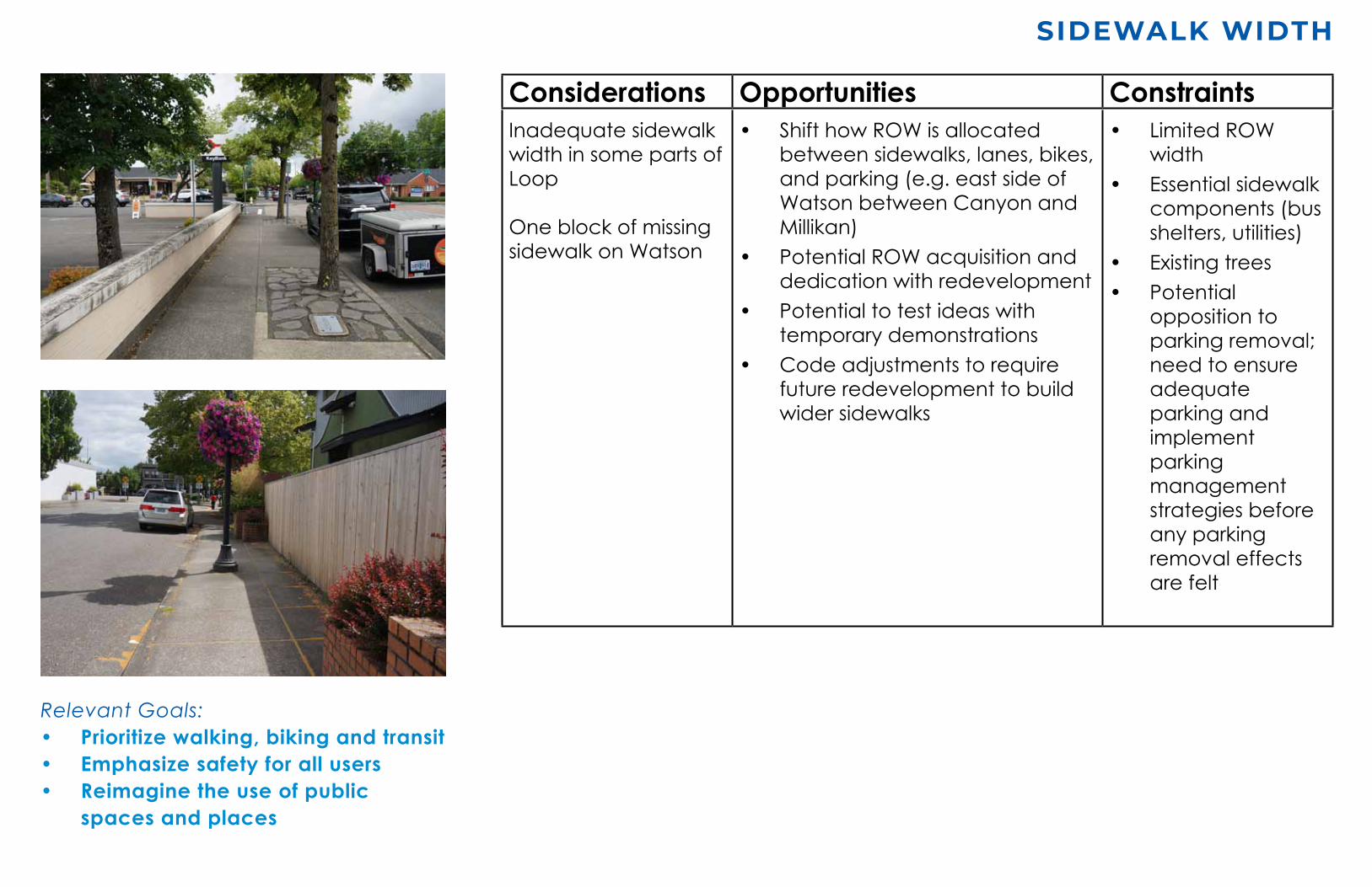
Considerations Opportunities ConstraintsInadequate sidewalk width in some parts of Loop
One block of missing sidewalk on Watson
• Shift how ROW is allocated between sidewalks, lanes, bikes, and parking (e.g. east side of Watson between Canyon and Millikan)
• Potential ROW acquisition and dedication with redevelopment
• Potential to test ideas with temporary demonstrations
• Code adjustments to require future redevelopment to build wider sidewalks
• Limited ROW width
• Essential sidewalk components (bus shelters, utilities)
• Existing trees• Potential
opposition to parking removal; need to ensure adequate parking and implement parking management strategies before any parking removal effects are felt
Relevant Goals: • Prioritizewalking,bikingandtransit• Emphasizesafetyforallusers• Reimaginetheuseofpublic
spacesandplaces

SW Canyon Rd
SW Broadway St
OffStreetBikePath
Bikelanes(5’)
Key
SW Millikan Way
Rail
SW 2nd StSW 3rd St
SW 4th St
MainSt
SW 5th St
SW 1st St
SWWatsonA
ve
SWHallA
veSW
Washington A
ve
A
B
MAX
Beaverton Cr
SW Farmington Rd
bicycle system
Source: Beaverton Active Transportation Plan, City of Beaverton Survey, Nearmap
• Complete bike lane system on Watson and Hall south of Farmington, but minimum width (5’).
• Major gap in bike facilities north of Farmington and unsafe intersection conditions.
• Lane exists on part of the higher-speed stretch of Hall, which connects to Crescent Connection Trail, with future extensions east and west.
Crescent Connection Trail
Gap in bike lane, on-street parking space on both sides could be reallocated to bike lanes
Gap in bike lane, with potential conflicts with slip lane at right of photo
Hall, south of Canyon
A Watson, north of Broadway
B

bicycle network fAcilities & gAps
Considerations Opportunities ConstraintsGaps in bicycle lane network (e.g. Watson north of Farmington) and insufficient bike lane width
• ROW available to reallocate• Potential ROW acquisition• City policy supports connected
and safe bike network • Closing gaps can improve
accessibility to regional transit and Crescent Connection
• Current use of available space for on-street parking
• Traffic impacts from lane reallocation (to be studied)
• Bike improvements should coordinate with system-wide improvements
Relevant Goals: • Prioritizesafetyforallusers• Prioritizewalking,bikingandtransit

SW Canyon Rd*Note: future Bus Rapid Transit (57)
SW Broadway St
BusStops
MAXandWESstations
BusRoutes
SW Millikan Way
Rail
SW 2nd St
SW 3rd St
SW 4th St
SW 5th St
SW 1st St
BeavertonTransitCenter
BeavertonCentralStation
SW W
atson Ave
SW Hall A
veSW
Washington A
ve
MAX
Beaverton Cr
SW Farmington Rd
WES
15-m
inu
te
wA
lk
• The Loop is located approximately 1/4 mile west of Beaverton Transit Center, the busiest transit center in the system.
• The TC provides regional connectivity through the MAX Red and Blue Lines, and WES Commuter Line, as well as additional bus lines, secure bike parking and LIFT service.
• Future Red Line extension will add service to Beaverton Central and increase frequency of MAX trains west of the Transit Center
• Bus stops for 3 TriMet bus lines are located along the Loop: the 76 on Hall/Watson, 57 on Canyon, and the 52 on Farmington.
Key
trAnsit

SW Canyon Rd
SW Broadway St
SW Millikan Way
Rail
SW 2nd St
SW 3rd St
SW 4th St
SW 5th St
SW 1st St
SW W
atson Ave
SW Hall A
veSW
Washington A
ve
MAX
Beaverton Cr
SW Farmington Rd
Sources: City of Beaverton 2018, Nearmap 2021
on-street pArking
15min
LoadingZonesBusZones
Parking
1hr2hrs3hrsNotimelimit
• Most street parking along the Loop is located south of Farmington with little time restriction (2 hours or no time limit). There is no street parking on Hall north of 1st.
• Coordinate with Downtown Parking Strategy (2021)
Key

• On Watson, there are 2 travel lanes with the exception of the segment between Millikan and Canyon. The closely-spaced signalized intersections with Broadway, rail, and Farmington pose challenges.
• On Hall, the number of travel lanes generally increases from the South to North. Additional turn lanes at Farmington and Canyon have the potential for conflicts with bikes and pedestrians (see next slide).
• Speed limits of 30 mph will be consistently reduced to 20 mph through Loop.
Signalizedintersections
Key
SW Canyon Rd
SW Broadway St
SW Millikan Way
Rail
SW 2nd St
SW 3rd St
SW 4th St
SW 1st St
SW W
atson Ave SW
Hall Ave
TrafficDirection&NumberofTravelLanes
MAXBeaverton Cr
SW Farmington Rd
#
vehiculAr system

SW Canyon Rd
SW Broadway St
SW Millikan Way
Rail
MAX
SW 2nd StSW 3rd St
SW 4th St
SW 5th St
SW 1st St
Beaverton Cr
SW Farmington Rd
Crescent Connection Trail
CRASH LOCATIONS
Key__________________________________
Low Number of Crashes
High Number of CrashesConsiderations Opportunities ConstraintsIntersections have safety challenges for people walking, biking, driving
Railroad, Canyon and Farmington are perceived as a barrier for pedestrians, crossings feel long / unsafe
• Potential geometric adjustments to certain intersections to improve traffic and pedestrian safety (e.g. Farmington/Watson). Geometric refers to the dimensions and visible features of the roadway, e.g. pavement widths, slopes, intersections.
• Targeted removal of parking spaces to improve pedestrian visibility at crosswalks
• Improvements for bike safety possible at 5th and Hall/Watson intersections (e.g. bike boxes)
• Increase illumination at intersections
City owns/manages FarmingtonRange of possible improvements:• High visibility crosswalks• Flashing yellow turn arrow• ‘Countdown’ ped signal• Public spaces at corners to
provide comfort and decrease perception of wait/distance
• Landscape medians• New vertical development which
will reduce perceived scale/width of Canyon
• Improved ADA ramps
• ODOT control of Canyon, requires negotiation and coordination
• Changes also require ODOT Rail permission
• Traffic signal timing needs further study for system-wide effects
• Site-specific challenges (e.g. topography at Farmington and Watson)
pedestriAn bArriers & sAfety issues
Relevant Goals: • Prioritizesafetyforallusers• Prioritizewalking,bikingandtransit

April 21, 2021
beAverton loop urbAn design & trAnsportAtion project
CAC #2