Embed Size (px)
Citation preview

UNIVERSITY POLITECNICO DI MILANO
SCHOOL OF ARCHITECTURE URBAN PLANNING CONSTRUCTION ENGINEERING
DEPARTMENT OF ARCHITECTURE
MASTER THESIS
CONSERVATION AND REVITALIZATION OF SAN GIOVANNI FORTRESS
Student:
Brkanovic Andrija
Supervisor:
Prof. Del Curto Davide
A/Y 2016/2017

INDEX OF TOPICS:
ABSTRACT
INTRODUCTION
1. KOTOR: FROM MILITARY CENTER TO HERITAGE SITE
1.1. Location and strategic position
1.2. Kotor in war: from Roman period to XX century
1.3. Kotor in peace: transformation to cultural heritage site
2. UNESCO STATUS OF KOTOR AND ITS UNIVERSAL VALUES
2.1. “Natural and Cultural-Historical Region of Kotor”
2.2. “The Venetian Works of Defense between XVI and XVII centuries
3. ABOUT THE MILITARY ARCHITECTURE OF FORTIFIED KOTOR AND ITS SURROUNDINGS
3.1.1. The basic fortification typology of the bay
3.1.2. Remains of Kotor’s medieval fortifications
3.1.3. Transformation of fortifications during the Venetian protectorate
3.1.3.1. Fortification system protecting the urban area
3.1.3.2. Fortification system of San Giovanni hill
4. CONSERVATION AND REVITALIZATION OF SAN GIOVANNI FORTRESS
4.1. General issues, state of conservation and factors affecting the property
4.1.1. Fortifications of San Giovanni hill
4.1.2. San Giovanni fortress
4.1.3. Conclusions
4.2. Conservation and revitalization project
4.2.1. Project objectives
4.2.2. Project description
4.2.3. Case studies
4.2.4. Conclusion
5. Bibliography
6. Other sources

“Understanding change is as important as understanding original intent”
Daniel Bluestone
Architectural historian

ABSTRACT
Main goal of the master thesis is to establish the basic ground for sustainable revitalization of San
Giovanni fortress, its inclusion into the touristic offer of the city and preservation of its cultural-
historical values.
San Giovanni fortress presents one of the main defensive positions within the fortification system of
Kotor. For this reason, first chapter of the thesis analyses the historical development of the fortified
town in relation to its strategic position and different historical circumstances.
In order to better understand present status of the town, special part of the thesis is dedicated to its
transformation from a military center to a heritage site protected by law.
After analyzing the transformation of the city fortification system during the venetian protectorate
and getting known its main typological characteristics, the focus of the thesis is being narrowed to the
San Giovanni fortress and fortification system of San Giovanni hill above Kotor. Various levels of
conservation, accessibility and safety issues as well as inadequate presentation of the heritage are
being recognized as the main factors affecting that are presenting limitations for the further
sustainable development of the site.
Final result of the thesis is mostly reflected through the solutions presented by the revitalization
project which concept is based on proposing the small-scale interventions aimed at improving and
facilitating access to the San Giovanni fortress while offering design solutions for conservation and
restoration of its components. In its final form, project aims to create conditions for an adequate
cultural and touristic exploitation of the fortress through the sustainable revitalization approach that
maximizes its material, historical and social values.

1. KOTOR: FROM MILITARY CENTER TO HERITAGE SITE
1.1 LOCATION AND STRATEGIC POSITION
Geographical position as well as geo-morphological characteristics of the terrain defined the Bay of
Kotor as one of the best natural harbor’s in Europe.
The bay is positioned on the eastern part of the Adriatic Sea, in the immediate vicinity of the Otranto
passage and at the crossroads of waterways connecting the Adriatic and Mediterranean Sea.
The bay begins at cove Oštro where the sea penetrates 15 miles deep into the mainland until it
reaches the fortified town of Kotor which lies at the very bottom of the bay. Straits of Kumbor and
Verige, heavily fortified in the past, divide the bay into three smaller basins, named after the
respective cities of Herceg Novi, Tivat and Kotor.
Kotor, the capital city lies at the eastern part of the bay under the foot of San Giovanni hill, on a
strategic convenient alluvial field between the river Skurda, the sea, and Gurdid spring.
From a military and strategic point of view, controlling Bay of Kotor meant controlling the entrance to
the Adriatic Sea and the power over commercial and military waterways. At the same time the entire
control of the bay was impossible without taking power of fortified city of Kotor.
1.2 KOTOR IN WAR: FROM ROMAN PERIOD TO XX CENTURY
As already mentioned, geographical and strategic position of the bay have defined its destiny full of
constant presence of various conquers and turmoil through the centuries.
Roman-Illyrian wars
In their effort to conquer Illyrian lands Romans took three campaigns, in history known as Illyrian Wars
that lasted from 229 B.C to 219 B.C.
Beginning of the first Roman campaign against Illyrian queen Teuta stationed in Risan (antic Risnium)
marks the beginning of the Roman presence on Balkan peninsula and long struggle of Illyrian tribes to
resist. After the third war Romans conquered Illyrian’s and made their land Roman province in 168.
B.C. The establishment of Roman domination brings changes in life, reflected in the urban organization
of settlements, architecture and culture of local residences.
Risnium (today Risan) was the main Roman city and until XII century the whole area of was called Bay
of Risan
In this form, rule of the Roman empire lasted until its division in 476 A.D. 1
Byzantine period (476 – 1185)
-Byzantine rule over the region of Kotor starts after downfall of West Roman Empire and lasts until the
independence of state od Duklja (Doclea) under the dynasty of Vojisavljević (year 1042). Doclean and
Byantine power over Kotor were shifting without any major consequences because the town had
strong autonomous power on the foundations of roman municipality order following administrational,
1 Rastoder Š, Andrijašević Ž 2006, Istorijski Leksikon Crne Gore, Daily Press-Vijesti, Podgorica, Montenegro

economic, political and religious organization. Kotor formed municipal regulation of Mediterranean
type that sustained stable despite of frequent changes of rulers.
The arrival of Slav population was a slow process that started in X century. Slavs have created parishes
with tribal social system.
Kotor within the Serbian State Raška (1185 – 1371)
In his empire conquest, Serbian king Nemanja destroyed all towns of Doclea, both continental and
coastal, but spared Kotor. With its urbanized structure of residents, nobility, commoners, artisan’s and
merchants as well as powerful religious organization (catholic), Kotor becomes main port of Raska in
the period between 1185 and 1371. In fact, Kotor was mostly holding in charge of caravan trade, while
maritime transport was under control of Dubrovnik, Venice and naval merchants from other coastal
cities such as Zadar etc.
Kotor’s noble families where respected representatives among Serbian dynasty as diplomats in charge
for the western politics, finance executives, judges and customs officials, thereby creating contacts
and enriching themselves as traders.
Being in charge of caravan trading routes enabled Kotor’s nobility to develop colonies along the routes
they held under control, mostly in sector of mining, silver, lead and cooper export in XIV century
(Brskovo, Rudnik, Trepca, Novo Brdo). In that period Kotor became main transit port between
continental Balkan, Apennine peninsula and Mediterranean. This period presents peak of its economic
power, today reflected in rich culture-historical heritage.
Such position enabled economic power, social influence and development of architecture, crafts and
arts. Kotor architectural school had a big influence on monumental and sacral architecture of Serbia as
it provided education for Serbian builders among which the most famous was fra Vita the builder of
Decani monastery. Influence of Kotor’s architecture school is reflected on some of the most significant
Nemanjic dynasty heritage such as monastery’s Moraca, Banjska, Saint Archangel in Prizren and
others.
After the end of Serbian rule, Balsic dynasty which was in charge of Zeta state where unsuccessfully
trying to take over Kotor. In the period between 1371 – 1384 Kotor was under the Kingdom of
Hungary protectorate and until 1391 under the protectorate of Bosnian king Tvrtko I. Unable to
guaranty adequate protection, both Hungarian and Bosnian protectorate where just temporary
solutions in rising danger of Ottoman Empire conquest of Balkan peninsula.2
Period of autonomy (1391-1420)
Autonomy of Kotor followed by difficulties and compromises as towns was managing to sustain
influence of surrounding dynasties Balsic, Crnojevic, and Sandal Hljanic realizing that their protection
would not be enough to guaranty economic development under the rising Ottoman danger.
2 Rastoder Š, Andrijašević Ž 2006, Istorijski Leksikon Crne Gore, Daily Press-Vijesti, Podgorica, Montenegro

Republic of Venice protectorate (1420-1797)
In 1482 Ottoman Empire occupied the cities of Herceg Novi and Risan, together with the land between
them. To constant presence of Turks in Bay of Kotor was marked by frequent clashes with Venetian’s
which were not always analogous with global Venetian – Ottoman relations.
During the Morean war (1684-1699, sixth Ottoman – Venetian war) in the period between 1684 and
1687 Venetian’s expelled Turks form the towns of Risan and Herceg Novi, therefore complete
northern part of the bay. By the provisions of Treaty of Karlowitz (Sremski Karlovci, Serbia) signed to
end the Morean War in 1699, the Ottoman Empire officially gave up the lands in Bay of Kotor. After
the treaty came the period of large economic prosperity for Bay of Kotor. The exceptional historical
value of the area in this period is reflected in its strategic character. Specifically, in case of fall of Kotor
the Ottoman Empire would rule complete Bay of Kotor. From such natural harbor, Turks could
jeopardize the Venetian trade to the extent that no ship would be able to pass Otranto, which would
mean the fall of the Republic of Venice. In order to save this area in its own possession, Venetian’s
realized many objects of today’s cultural heritage: churches, palaces, and mostly important
fortification system belonging to important architectural achievement in the wider area.
First Austrian Empire rule (1797 – 1806)
Treaty in Campo Formio (17.10.1797) marks the end of first Napoleon conquers in which Venetian
republic ceased to exist. By the provisions of peace agreement Austrian Empire inherited the Bay of
Kotor, Istria and Dalmatia, the former Venetian ‘’Stato di Mare’’* territory. In short period Austria
establishes power in obtained areas in preparation for a new war against Napoleon. The locals
accepted the new government, however, at the same time the cooperation with Montenegrin bishop
Petar I Petrovic Njegos was initiated, whose affinity to merge Bay of Kotor with his country was
supported by Imperial Russia. Idea of uniting with Montenegro was backed by some portion of local
inhabitants, as the demographic situation of the area was changed after the Morean War when large
number of Orthodox population immigrated from the territories of Montenegro and Hercegovina. By
supporting affinities of Petar I Petrovic Njegos, Imperial Russia was actually planning to strengthen its
influence in the Balkans and control potential advancement of European forces towards the east.3
Russian Empire and French Republic occupations (1806-1807) (1807-1813)
Treaty of Pressburg (todays’s Bratislava) was signed on 26.12.1805 as an consequence of the French
victories over the Austrians at battles of Ulm and Austerlitz. As a defeated party, Austria was forced to
hand over all the territories obtained by the Treaty of Campo Formio in 1797. Together with Venice,
Istria and Dalmatia, Bay of Kotor becomes part of French Republic and later established Illyrian
Province.
In March 1806., despite of decisions of peace in Pressburg, Imperial Russian fleet sails into the bay and
establishes authority in order to prevent Napoleon advance towards the east. Next period is marked
by allied fighting of locals, Montenegrins, and Russians against the French army which was advancing
from the direction of Dubrovnik. Russian support to the resistance was ended after the Treaty of Tilsit
(7-9.7.1807) which was signed between Napoleon I and Tsar Alexander I as aftermath of the battle at
Friedland. The agreement guaranteed French – Russian alliance, and Napoleon made a commitment
3 Rastoder Š, Andrijašević Ž 2006, Istorijski Leksikon Crne Gore, Daily Press-Vijesti, Podgorica, Montenegro

that he would not prosecute Montenegrins because of their struggle against France. In August of 1807
French army enters the bay and Petar I Petrovic Njegos was forced to postpone his plans for more
favorable period.
First unity of Montenegro and Bay of Kotor (1813 – 1814)
Another opportunity for Montenegrin Bishop came in 1813 during the strained French power,
weakened by the losses on European battlefield. Supported by the British squadron under General
Host, which was anchored in the waters in front of Herceg Novi, Montenegrin army starts the
operation of freeing Bay of Kotor which ended by the agreement of unity of the two regions signed on
August 1813.4
Second Austrian Empire rule (1815 – 1918)
As a result of Vienna Congress (November 1814-June1815) Montenegro was forced to surrender Bay
of Kotor to Austrian army and withdraw within the previous borders of the hinterland. By the decisions
of Berlin Congress, Bay of Kotor as well as part of Montenegrin coastline until the town of Bar were
given to Austrian Empire. This event marks the beginning of the second Austrian rule over Bay of Kotor
which lasted until 1918 and the end of World War I.
Berlin congress (13.6.1878)
-Replaced Treaty of San Stefano signed three months earlier between Russia and Ottoman Empire,
driven by Russian spheres of interest to enlarge influence on Balkan by creating Great Bulgaria, its own
satellite country on the expense of Serbian territories.
-Main goal of Berlin Congress was to minimize Russian influence on the Balkan Peninsula by the
Austrian Hungarian Monarchy and Great Britain. Russia was forced to give up of San Stefano treaty
under strong international pressure.
-By the new agreement Romania, Serbia, and Montenegro became internationally recognized
independent countries. Bulgaria becomes autonomous province under Ottoman control and
Macedonia remains completely under Ottoman rule. Bosnia and Hercegovina becomes part of
Austrian Monarchy (1878 – occupation, 1908 – annexation).
-Berlin treaty weakened Ottoman positions in Europe. Russian influence in Balkan peninsula was
minimized on Austrian gain which provoked new tensions between two empires.
-Because of the diplomatic power of Austrian Hungarian Monarchy and plan to control complete
Adriatic coastline, newly independent Kingdom of Montenegro is reduced to continental area with
narrow access to the sea in the Austrian supervised town of Bar. Also, division of its borders with
Ottoman Empire was conducted on such way to leave space for future conflicts, which would be in
favor of Austria.
4 Rastoder Š, Andrijašević Ž 2006, Istorijski Leksikon Crne Gore, Daily Press-Vijesti, Podgorica, Montenegro

BALKAN WARS 1912-1913
The Balkan Wars consisted of two conflicts that took place in the Balkan Peninsula in 1912 and 1913.
Four Balkan states (Serbia, Montenegro, Bulgaria and Greece) defeated the Ottoman Empire and
completely expelled it from Balkan Peninsula. Ottoman Empire lost the bulk of its territory in Europe.
Austria-Hungary, although not combatant, became relatively weaker as a much enlarged Serbia
pushed for union of South Slavic people. The war set stage for Balkan crisis of 1914 and thus served as
a prelude to the First World War.5
WORLD WAR’S
The period of the First World War the bay met under the rule of Austrian Hngarian empire. During the
previous period the bay was firmly fortified with two fortification belts. The coastal belt protected the
naval approach while the fortifications distributed along the hinterland have guarded the borders
toward Kingdom of Montenegro and territory of Bosnia. 6
1.3 KOTOR IN PEACE: TRANSFORMATION TO CULTURAL HERITAGE SITE
The end of the World War I marks the beginning of the new geo-political chapter in the history of
Kotor and its region. After the collapse of Austria-Hungary Monarchy, Bay of Kotor becomes the part
of newly formed Kingdom of Serbs, Croats and Slovenes, later called Kingdom of Yugoslavia. For the
first time in history walls of Kotor have lost their defensive role. During the previous war Austrian
Monarchy have heavily fortified complete Bay and the role of Kotor’s walls was to control the border
towards Kingdom of Montenegro in the hinterland. From the moment when this border was
abolished, the defensive role of Kotor’s ramparts came to an end. This event presents the milestone in
the way of how the Kotor was valued, both from the state and society.
In the period between two wars situation in the country was such that very few individuals though
about the protection of Kotor’s cultural-historic values. This situation was most of all reflected on the
town’s fortification system that was left exposed to the anthropological and environmental influences.
Many important artefacts were destroyed due to human negligence, among which the loss of
numerous military emblems present irreparable damage.
During the World War II Montenegro was occupied by Italian army and the region of Bay of Kotor
shared the same destiny. The fortifications of Kotor did not play any important military role as the
defensive strategy of Italian army was more concentrated on controlling fortifications on the bay’s
hinterland. After the liberation in 1944 Bay of Kotor enters the territory of Socialist Federative
Republic of Yugoslavia as an integral part of Republic of Montenegro. In these new conditions, as
many times before, the region changed its social and political order but for the first time in history old
town of Kotor was recognized as a cultural-historical heritage protected by law. This occurred in 1949
when the first law on the protection of cultural heritage was passed by the National Assembly of
Montenegro.
5 Balkanski ratovi: 1912-1913, Savremena istorija, viewed 04.12.2017, <http://savremenaistorija.com/?p=1152> 6 Lalosevic, I 2013, “Fortifikacioni sistem Boke kotorske austrougarskog perioda”, “Boka 33”,pages : 8-15

Although protected in 1949, Kotor had to wait 30 years for the first conservation steps. In order to
understand this void, it is necessary to revise the forces that where shaping cultural policy in post war
Republic of Montenegro.
As an integral part of Yugoslavia the Republic of Montenegro was under the rule of Communist Party
of Yugoslavia and social-economic model of the country was based on the ‘’socialist self-
management’’. From all the republics of the federation, Montenegro was the least economically
developed. Demographically, most of the population was living in rural areas (75%) while 60% of
population was illiterate. In this kind of the political-economic environment, the cultural policy was
based on the zeal and awareness of necessity to create institutions that will help Montenegro to get
out of backwardness and provide its citizens the equality with citizens of other Yugoslav republics. In
order to achieve this task, it is concluded that the national ideology formula has to be based on three
postulates: economic equality, affirmation of culture as a development component and construction
of socialist republic as self-management community. 7
Although the development of culture was one of the main postulates of national ideology, up until
70’s there was no official conception of cultural policy. Milestone moment represents the adoption of
‘’Platform on Questions about Montenegrin culture’’ in 1970. In addition to the decisions on the
establishment of University, Academies and Montenegrin Encyclopedia, platform was firmly oriented
towards combating the influences of nationalism in culture. Reasons for such orientation was the
present dilemmas in the political substructure of society, the Montenegrin national being and
Montenegrin national culture. It is also important to mention that all the decisions in the field of
cultural policy where adopted by the Department for culture and ideology of the Central Committee of
the Communist Party of Montenegro.
Up until 1970’s the cultural development was under the shadow of economic uplift of society.
Development of working class as the main pillar of the socialist state was reflected in intense post war
industrializations and infrastructural works. Region of Kotor shared the same destiny, therefore the
works on conservation of its old town as of the cultural heritage remained in the background of the
mentioned venture. This practice was evident on the example of the suburb village of Škaljari, today
one of the largest settlements of Kotor. Industrialization of this feudal rural area started in 1930’s and
continues until the 1979 resulting in complete transformation of the settlement both from
demographic and physical point of view. Although the old town of Kotor was already protected as a
cultural-historic heritage, this example clearly illustrates the lack of balance between the economic
and the cultural policy. This issue was evident shortly after the inscription of Kotor on the World
Heritage List by UNESCO in 1979 when the removal of industrial buildings was initiated as the area of
Škaljari was defined as the buffer zone of the old town.
Until the period of inscription on the World Heritage List, there were few interventions aimed at
conservation of the heritage values of the town. This was no surprise considering the cultural policies
and lack of the institutional power able to implement such projects. However, some projects were still
conducted of which it is worth mentioning the construction of summer theatre on bastions Riva and
Bembo, transformation of orient portion of northern wall into pedestrian path, removal of concrete
bunkers built by Austrian army and transformation of Venetian Hospital into city theater. Some
projects, such as construction performed on Bembo bastion occurred in absence of any conservation
regulations which illustrates the absence of institutions in charge of heritage protection.
7 Sekulić S n.d, Kulturna politika u Crnoj Gori poslije drugog svjetskog rata “Cultural politics in Montenegro after WW II”, < http://www.montenegrina.net/pages/pages1/politika/kulturna_politika_u_cg_poslije_2svj_rata.htm>

One of the interventions still discussed between the different stakeholders occurred shortly after the
partisans liberated the city. In 1945, driven by communist ideology, the symbols of Venetian Republic
and Austro Hungarian Monarchy where removed from ‘’Porta Marina’’, the main city gate, and
replaced by Yugoslavian coat of arms. Original label ‘’IUSTITIA REGNORUM FUNDAMENTUM’’ (JUSTICE
IS THE FOUNDATION OF STATE) was replaced by ‘’ THEIRS WE DON’T WANT, OURS WE DON’T GIVE’’
which was a common slogan of Yugoslavia, often attributed to Josip Broz Tito.
The fact that this event is still discussed today confirms the multilayered character of heritage as it
embodies different values experienced by different stakeholders and illustrates the side effects of
reckless, ideology driven, actions towards cultural heritage
The recent history of Montenegro, and therefore of Kotor, was permeated by many turbulent events.
In addition to constantly present geo-political turmoil, one of the events that marked the end of 20th
century was a natural disaster that struck Montenegro in 1979. In the early morning of the 15th April,
an earthquake measuring 9.5 degrees Mercalli scale hit the coastal region of the country. 1/3 of the
Republic felt the shockwave which caused tragic loss of life, leaving more than 100 000 citizens
homeless. The ancient coastal cities, holding more than 70% of the country’s cultural heritage,
suffered the most. The old towns of Herceg Novi, Kotor, Budva, Bar and Ulcinj were so badly damaged
that they were completely evacuated and their entire artistic content had to be rescued and stored
somewhere else. In numbers, more than 1 600 cultural monuments suffered partial or complete
destruction, together with 30 000 works of art and valuable collections such as: icons, paintings, rare
books, illuminated manuscripts, delicate fabrics and embroideries, sacred gold and silver works,
ancient jewelry, church vestments, wood carvings, sculptures and other pieces of rich movable
cultural heritage.
The enormous destructive power of this event had initiated unprecedented endeavor oriented
towards salvation of endangered cultural-historical heritage of Montenegro. In the first days after the
disaster, the key role in the mitigation of the consequences was performed by Republic Institute for
Protection of Cultural Monuments of Montenegro from Cetinje. Immediately after the earthquake,
devoted professionals of the institute started the action of initial safeguarding measures, which
included the evacuation of movable heritage properties and marking of all buildings classified as
historic heritage. This measure proved especially effective as it prevented any destruction or negligent
cleaning up the rubble by rescue services, even in cases of emergency when the formal approval of
the institute had to be obtained. Meantime, beside the help from other Yugoslav republics,
international campaign in mitigating the consequences was initiated by the authorities. At the
invitation of Federal Yugoslav Government, the Director-General of UNESCO Amadu Mahtar M’Bowa
went to the scene of the disaster some days after the earthquake. After witnessing the scope of the
damage he issued a world appeal: “…The size of the task to be carried out to save the damaged
cultural heritage and rebuild schools and research institute is beyond the resources of the Federal
Republic of Yugoslavia on its own, and calls for an international effort…”. Following his call, the full
capacities of UNESCO were involved in assisting the Montenegro’s institution for protection of
monuments by providing financial, material and knowledge help. The service of expert conservators
was given for the period of three years to assist the conservation and restoration projects, while the
training of deficit personnel was organized by UNESCO and ICCROM8 through seminars and
fellowships for young architects, conservators, art historians and chemists in leading European
Universities. Paradoxically destruction that this disaster has caused, immense experience gained by
8 ICCROM-The International Centre for Study of the Preservation and the Restoration of Cultural Property

exchange of knowledge between domestic professionals and UNESCO experts built better conditions
for institutional protection and management of cultural-historical heritage of Montenegro.
Although the initiative for nomination existed before the earthquake, it was in October of 1979 that
World Heritage Committee of UNESCO decided to list the “Natural and Cultural Historical Region of
Kotor” in the “World Heritage List” thanks to the presence of high natural, cultural and historical
values. Due to the exceptional concentration of monuments and a large degree of devastation (70% of
the buildings), the old town of Kotor was inscribed in the “List of World Heritage in Danger”. By
accepting the obligations under the provisions of the Convention on the protection of the world
cultural and historical heritage (Paris, 1972), in 1980 the Municipal Assembly of Kotor formed the
Municipal institute for protection of cultural monuments which soon grew into a Regional institute for
protection of cultural monuments for the municipalities of Kotor, Herceg Novi and Tivat. Although the
Republic institute for protection of monuments remained the supreme body, the establishment of
municipal institutions allowed greater local autonomy in decision-making processes and the
management of numerous conservation and restoration projects that followed after the earthquake.
Detailed guidelines and commitments of UNESCO protection privilege have set the solid foundation
for further development of the Kotor as a cultural-historical monument. In addition to expert
assistance in restoration projects, UNESCO experiences were useful during the decision making
process regarding the concepts of restoration. These decisions were related to the idea of the future
development of the old town as a sustainable touristic destination. As more than 4, 000 residents
were evacuated from the old town, the first phase of restoration implied the restauration of damaged
housing stock and ensuring sanitary conditions for the return of the residents. As it was assumed that
some portion of former inhabitants may choose not to return, preferring to live in the modern
apartment blocks that were going to be provided, second phase of works implied adaptation of vacant
buildings for new, mostly tourism oriented, purposes (restaurants, hotels, museums and etc.). The
main idea behind such revitalization concept was to avoid that Kotor becomes museum ghost-town
where the bustle of people working, relating and trading has been lost. Parallel to this process,
restoration of the city’s most important monuments such as churches, cathedrals, palaces and city
fortification was conducted. During the next 10 years, after the completion of more than 290
restoration projects and salvation of numerous works of arts, Kotor recovered and continued to live,
from that moment on, as a cultural monument of immense universal value.

2.0 UNESCO STATUS OF KOTOR AND ITS UNIVERSAL VALUES
2.1 “Natural and Cultural-Historical Region of Kotor”
The Natural and Cultural-Historical Region of Kotor is located in the Boka Kotorska Bay, on the Adriatic
coast of Montenegro. The property encompasses the best preserved part of the bay covering its inner
south-eastern portion. The inscribed property comprises 14,600 ha with a landscape composed of two
interrelated bays surrounded by mountains rising rapidly to nearly 1,500 metres. The property is
linked to the rest of the Boka Kotorska Bay through a narrow channel forming the principal visual
central axis of the area.
The Outstanding Universal Value of the Culturo-Historical Region of Kotor is embodied in the quality of
the architecture in its fortified and open cities, settlements, palaces and monastic ensembles, and
their harmonious integration to the cultivated terraced landscape on the slopes of high rocky hills. The
Natural and Cultural-Historical Region of Kotor bears unique testimony to the exceptionally important
role that it played over centuries in the spreading of Mediterranean cultures into the Balkans.
Criterion (i): It is the gathering on the gulf coast of the monuments of the cities, their harmony with
the landscape, and their insertion in town planning of great value that contributes to the Outstanding
Universal Value of the property.
Criterion (ii): As the main bridge-heads of Venice on the South coast of the Adriatic, the aristocratic cities of captains and ship-owners of Kotor and its neighbours were the heart of the region's creative movement for many centuries. Its art, goldsmith and architecture schools had a profound and durable influence on the arts of the Adriatic coast. Criterion (iii): The successful harmonization of these cities with the Gulf, their quantity, quality and diversity of the monuments and cultural properties, and especially the exceptional authenticity of their conservation, mean that the property can effectively be considered as unique. Criterion (iv): Kotor and Perast are highly characteristic and authentically preserved small cities enhanced by architecture of great quality. Their town-planning is well adapted to and integrated in the landscape. Integrity The property maintains the overall integrity of the historical layout of the land and seascape with its cities and settlements of distinctive town planning that developed along the coast of the bay, separated by green and cultivated areas framed by steep rocky hills, and a narrow area of urbanized coast connected by the sea. The network of paths and roads connecting coastal settlements with each other and with the inland, and the coastline with pontas and mandrachi, is preserved, which testifies to the important role of the sea. However, the conditions of integrity are endangered by development and urbanisation caused by ongoing transformation processes in the socio-economic structure of the area. Current developments, including new tourism centres, roads, and buildings on the coast itself, threaten to lead to the gradual yet irreversible transformation of the coastline as well as the abandonment of the traditional terraced structures. Management of the property and its defined buffer zone will be crucial to maintain the property and its integrity as a unique cultural landscape and an entity in geographical, historical, and cultural terms.

Enforcement of regulatory measures for the buffer zone and the development of an integrated approach to conservation, planning and management of the area as a unity will also be required. Authenticity Although seriously damaged by the 1979 earthquake, the principal monuments and historic urban areas have been carefully restored and reconstructed under the auspices of UNESCO, and have retained their architectural, urban, and historical authenticity. However, the ability of the overall landscape to reflect its value is being compromised by the gradual erosion of traditional practices and ways of life and of the harmony between the buildings, planning and landscape.9
2.2 “The Venetian Works of Defence between XVI and XVII centuries”
The Venetian Works of Defence between the 16th and 17th centuries: Stato da Terra – western Stato da Marconsists of six components located in Italy, Croatia and Montenegro and spanning more than 1000 km between the Lombard region of Italy and the eastern Adriatic Coast. Together, they represent the defensive works of the Serenissima between the 16th and 17th centuries, the most significant period of the longer history of the Venetian Republic; and demonstrate the designs, adaptations and operations of alla moderna defences, which were to feature throughout Europe. The introduction of gunpowder led to significant shifts in military techniques and architecture that are reflected in the design of fortifications – termed alla moderna. The organisation and defences of the Stato da Terra (protecting the Republic from other European powers to the northwest) and the Stato da Mar (protecting the sea routes and ports in the Adriatic Sea to the Levant) were needed to sustain the expansion and power of the Republic of Venice. The expansive territory of the Serenessima was indisputably the near-exclusive setting of the genesis of the alla moderna or bastioned system during the Renaissance; and the extensive and innovative defensive networks established by the Republic of Venice are of exceptional historical, architectural and technological significance. The attributes of the Outstanding Universal Value include earthworks and structures of fortification and defence from the Venetian Republic in the 16th and 17th centuries. Strongly contributory to these are the landscape settings, and which strengthen the visual qualities of the six components, as well as urban and defensive structures from both earlier (Medieval) and more recent periods of history (such as the Napoleonic and Ottoman period modifications and additions) that allow the serial components to be truthfully presented and the tactical coherence of each military site in its final state to be recognised. Criterion (iii): The Venetian Works of Defence provide an exceptional testimony of the alla moderna military culture, which evolved within the Republic of Venice in the 16th and 17th centuries, involving vast territories and interactions. Together the components demonstrate a defensive network or system for the Stato da Terra and the western Stato da Mar centred in the Adriatic Sea or Golfo di Venezia, which had civil, military, urban dimensions that extended further, traversing the Mediterranean region to the Levant. Criterion (iv): The Venetian Works of Defence present the characteristics of the alla moderna fortified system (bastioned system) built by the Republic of Venice following changes that were introduced following the increased use of firearms. Together the six components demonstrate in an exceptional way the characteristics of the alla moderna system including its technical and logistic abilities, modern fighting strategies and new architectural requirements within the Stato da Terra and the western
9 Natural and Culturo-Historical region of Kotor, UNESCO
< http://whc.unesco.org/en/list/125>

portions of the Stato da Mar. Integrity Together, the six components of Venetian Works of Defence within Stato da Terra and the western portions of the Stato da Mar exhibit the needed attributes of Outstanding Universal Value of this transnational heritage, including their typological variety, visual integrity and state of conservation. This serial property leaves open the potential for a future nomination of examples that can represent in an exceptional and complementary way, the applications of the alla moderna technologies through the extent of the Venetian Republic in this period of history in the eastern or Levante Stato da Mar. The state of conservation of the individual components is generally good, although their integrity is variable, and in some cases vulnerable, due to past and present development and tourism pressures. Although some further expansions could be made to the buffer zones (particularly for the components in Zadar and Kotor), the boundaries of the six components are appropriate. Authenticity The Venetian Works of Defence within Stato da Terra and the western portions of the Stato da Mar and the phenomenon of alla moderna military architecture have been extensively studied, supported by extensive archival materials, documents, architectural drawings, maps and models. Because of their purposes and locations, many changes have occurred to the selected components, including damage through different periods of conflict from the Napoleonic, Austrian and Ottoman periods and the 20th century.10
10 Venetian Works of Defence between the 16th and 17th Centuries: Stato da Terra – Western Stato da Mar,
UNESCO
< http://whc.unesco.org/en/list/1533>

3. VENETIAN MILITARY ARCHITECTURE OF KOTOR AND ITS SURROUNDINGS
3.1 THE BASIC FORTIFICATION TYPOLOGY OF THE BAY
Fortified cities
The first, and the most significant group of fortification architecture, are the large fortified cities of
Kotor and Herceg Novi. The entire city area is a fortified city surrounded by a continuous fortification
system, a city rampart, which is reinforced by towers and bastions. The shape of the city base is
irregular and adapted to the ground. The gates are in places suitable for communication and where
they can be well-controlled and defended.
The fortification-urban complex of these cities does not differ much from others on the eastern coast
of Adriatic. 11
Cities protected by separate fortification
The second group is made up of smaller towns Perast and Risan which are protected by isolated
fortification points. These towns did not manage to develop a continual fortification system during the
history. Their defense system is based on isolated fortresses, in a dominant location above the city,
which protected the perimeter and could host the local population in case of need. 12
Outposts protecting fortified cities
Special fortifications have been formed in approximate distance from the fortified towns of Kotor and
Herceg Novi. These are the fortresses Spanjola (Above Herceg Novi) and Trojica (near Kotor). Their
role was to control the approach to the city and keep the enemy away from the city fortification itself.
In venetian fortification system, this principle was accepted in various scales. For example, Perast was
outpost of Kotor while Verige where the outpost of Perast. In larger scale Kotor, Zadar and Sibenik
where the outpost of Venice. 13
Isolated fortification points
The next group of fortification is represented by isolated fortification points, which are built at
significant locations in the bay, on maritime roads, near the ports, at the accesses to the cities. These
are the fortresses of Vrbanj, Verige and Stradioti. 14
11 Lalošević, I 2016, 45-4
12 Lalošević, I 2016, 48-49
13 Lalošević, I 2016, 50 14 Lalošević, I 2016, 51

3.2 ABOUT THE MILITARY ARCHITECTURE OF FORTIFIED KOTOR
3.2.1 Remains of the medieval fortifications
Today “in situ” remains of the medieval fortification walls are visible in few positions, especially when
it comes to the outside face of the fortified city. Original medieval wall, although slightly modified by
venetians, is preserved on the position of northern city gate and by the so called “portella” (ital. small
door) for garbage disposal. Also, remains of the medieval wall can be seen in several locations along
the fortified system of San Giovanni hill.
The medieval walls were built vertically and relatively rough, especially when compared to venetian
period. Original medieval wall contained merlons and was constructed for the cold-weapon warfare.
The venetian adaptation for the use of modern firearms considered the reduction of its height and
replacement of merlons with loopholes. In order to receive the ballistic force of cannon fire, but in the
same time to prevent it from tilting, wall was reinforced with angled “escarpa” (ital.) On some
positions, problem of tilting was solved by constructing of buttress. On the inside reinforcement
included the addition of a new belt, while the space between the new and the old wall was filled with
soil, so called “terrapien” (ital. terra, earth; pieno, full or fill).
It is quite certain that the routes of medieval walls largely correspond with the current fortified
perimeter of the city. 15
3.2.2 Venetian works on transforming the fortification system
The immediate Ottoman danger forced the Venetian Republic to begin with extensive and long-lasting
works on the improvement of the Kotor defense system. As already mentioned, the fall of the town
under Turkish rule and the presence of the large fleet in the bay would jeopardize the maritime trade
routes of the republic. As the maritime trade represented the main economic branch of the republic,
such a scenario would inevitably lead to fall of the republic. For this reason, Kotor, often called
“fortrezza chiave” (ital. key fortress) becomes an important military center while gradually losing its
economic and trading power earned during the medieval period.
It is not reliably established what was the state of fortification system inherited form the medieval
period but on the basis of numerous documents it can be concluded that the Venetian Republic
immediately started their reinforcement and adaptation for modern warfare. Transformation has
progressed gradually over all three centuries of Venetian protectorate and was intensified in periods
of war danger. 16
3.2.2.1 Fortification system protecting the urban area
A defense system that protects the city’s urban area consists of the ramparts along the Škurda river
and ramparts along the sea and its characterized by a system of bastions interconnected by firm walls
(ital. cortina-curtain). The city is being entered through three well protected gates. The system was
build during the Venetian protectorate but above the already present medieval base. Bastions and
reinforced medieval walls were built according to the principles of the Venetian modern style (“alla
moderna”) The earliest bastions built in XV century (Citadella, Gurdić) are semicircular. Bastions built
15 Lalošević, I 2016, 63-67 16 Lalošević, I 2016, 68

during XVI and XVII century (Riva, Bembo, Valier, Corner) are constructed with trapezoidal basis and
have better defensive characteristics. 17
3.2.2.2 Fortification system of San Giovanni hill
The artillery platforms towers and auxiliary buildings, interconnected with the ramparts and
communication roads, constitute a unique fortification system that extends along the northern and
southern slopes of the San Giovanni hill. Build based on the Venetian system “a cavalliere”, every
position covers and protects its lower predecessor.
San Giovanni fortress is located on the highest point of the hill, controls the bay and represents the
last line of defense in case the city falls into the enemy hands. In addition to this, there are two more
defensive belts. First belt is defined by a high wall that separates the hill from the urban area. If enemy
takes over the city, army withdraws within this position, consolidates and planes the counter attack. In
case of failure, army withdraws in Soranzo fortress which represents second line of defense. A
developed system of communications and auxiliary military facilities, such as weapons and food
storages, barracks and gun powder magazines serve as a support system for the gradual withdrawal.
17 Lalošević, I 2016, 78-92

4. CONSERVATION AND REVITALIZATION OF SAN GIOVANNI FORTRESS
4.2 GENERAL ISSUES, STATE OF CONSERVATION AND FACTORS AFFECTING THE PROPERTY
4.2.1 FORTIFICATIONS OF SAN GIOVANNI HILL
With the fall of the Austrian Empire and the complete end of military functions after the WWI, the city
fortification system is exposed to constant degradation due to natural and anthropogenic influence.
During the seventies of the twentieth century, especially after receiving UNESCO world heritage
status, starts the new role of city fortifications, this time as an indispensable part of the towns touristic
offer.
So far, measures for protection and conservation were mainly focused on the ramparts and bastions
along the sea and Skurda river. This part of Kotor fortifications, founded on low-quality alluvial soil,
demanded immediate consolidation measures, especially after the 1979 earthquake. Protection of the
fortifications on the Saint John hill is largely restricted to sporadic maintenance measures and urgent
reconstructions, often carried out unprofessionally.
The ramparts along the hill are founded on high-quality rocky ground and do not show evidences of subsidence and tilting, even in the case of the oldest medieval walls from XIII century.
The protection and revitalization of the fortifications on the hill remains in many ways to be defined. In fact, this area of the fort is almost inaccessible and, unlike the coastal part, in recent years has not accepted any function, even temporary Although exceptionally strong,
fortifications on the hill are in poor state of conservation. Some remains of the fortifications were lost, as well as some military infrastructure, such as gunpowder magazines, the barracks and auxiliary buildings. The remaining parts of the walls are in different conditions: some of them are ruins, other are entirely and well conserved. It is particularly difficult to reach some elements, because the ground is disconnected, so the paths are more dangerous. However, it is required to pay an entrance to see this part of the high city.18
Paradoxically to the non-existent protection measures, this part of city fortress is to the greatest
extent exploited for tourism purposes
.
18 UNESCO WHL Nomination Format, The Venetian Works of Defense Between 15th and 17th Centuries, 383 – 386.

PROPERTY COMPONENTS:
ARTILLERY PLATFORMS AND DEFENSIVE POSITIONS
Bataglia, Renier, Soranzo, San Marco, San Hierolimus, Loredan, Priuli, Peregrino, Pedochio,
San Stefano, San Francesco
Chronologically, articulated artillery positions were built in different periods, but always solid with high
quality of foundations constructed on a stable rock base. Well-built foundations are responsible for
high degree of preservation off all mentioned positions which for centuries have not shown sings of
structural instability. At all positions, high eastern walls intended for refusing the artillery attacks from
the direction of Njegusi, are very well preserved with little or no traces of serious damages. The
defects and sings of decay are mostly occurring in the upper zones of the walls and on the inner,
western, side of the platforms where we can notice the damage caused by natural factors, human
neglect and poor maintenance. The separation of stones and larger parts of masonry in these zones
most often occurs as a consequence of seismic activity and vegetation pressure.
Rampart walking path that extends from the inside of the platforms, along the walls with loopholes, is
in very bad state of conservation and almost impassable which presents a loss of significant, and for
visitors very attractive, segment of fortification architecture. Also, in many situations, there is an
increased risk visitor’s safety due to missing parapet walls on the exposed positions.
1 Bataglia platform, eastern elevation

2 Bataglia platform, missing parapet wall and inaccessible walking path
3 San Hierolimus, west side of the platform
4 Priuli platform, vegetation pressure

DEFENSIVE TOWERS
Contarini and Loredan
Apart from the artillery platforms, which are representing main defensive points, the fortification
system of San Giovanni hill consists out of two medieval defensive towers. As they were built primarily
for the “cold weapons” warfare, most of them are destroyed during the Venetian modernization
venture. From numerous towers that once stood along the San Giovanni hill, to date, only two
remained. Loeradan and Contarini towers are representing valuable remains of Kotor’s medieval
fortification architecture. Despite this, towers are now completely abandoned and located in the part
inaccessible for visitors.
Both towers are located in the immediate vicinity and with similar degree of preservation. It seems
that there are still no sings of structural vulnerability, again thanks to the high quality of the
foundation zone. However, there is a noticeable level of decay of the walls that could endanger their
structural stability in the future. In both buildings, the original roof made of wood and covered with
tiles have completely disappeared.
Contarini tower is especially interesting because it protects Eastern City Gate, also known as the
Spiljari gate, named after the village of Spiljari, located nearby. Contarini tower and Eastern City Gate
make a valuable architectural and ambient whole inaccessible and forbidden for tourist visits, again
due to the safety reasons.

5. Contarini Tower and Eastern City Gate, seen from San Marco platform
6. Contarini tower and Eastern City Gate
7. San Hierolimus, Contarini Tower and Eastern City Gate; eastern view
8. Loredan Tower, view from the east

RAMPARTS ALONG THE HILL
San Giovanni ramparts stretch along the northern and southern hillsides and by connecting important
defensive positions they constitute an almost impenetrable fortification system.
Chronologically, ramparts on the hill, as well as of the entire town perimeter, originate from the
Medieval period when they where considerably higher with merlons as a protection for the soldiers.
Venetian works of adaptation for the modern warfare meant lowering of the wall height, removal of
merlons and construction of protection walls with loopholes together with corresponding walking
paths for soldiers. In order to make the ramparts more resistant to a cannon attack, horizontal wall
was reinforced with angled “scarpa”19 up the height of the cordon crown. Despite the modernization
works, original medieval walls are preserved in several locations but without original merlons which
are replaced by loopholes walls.
In general, the ramparts along the hill are characterized by solid construction quality and strong
foundation zone, so they are structurally very well preserved, even in the case of the oldest medieval
walls. Due to the absence of conservation works and regular maintenance program, significant
damage was caused by growing vegetation, atmospherics and seismic activity. Vegetation that grows
inside of the decayed joints is often causing separation of stones. In some zones, even the joints are
still very well preserved so that the presence of vegetation is minimized.
The most frequent damage occurs on the upper zones of the ramparts, more precisely on the walls
with loopholes, where we can notice separated or missing parts of masonry. Rampart walking paths
are in very poor state of preservation and almost inaccessible. Protection stone rail is missing in most
of the cases while the stone steps are heavily damaged. Although very dangerous, the movement
along these walking paths is not prohibited, so tourists often use them. In this way, their own safety,
as well as the safety of other visitors who use regular paths passing under the ramparts is also
jeopardized.
9. Rampart walking path 10. Compromised visitors safety
19 Scarpa- wall reinforcement in the form of angled wall constructed on the outside of the rampart for absorbing the artillery impact.

11. End of rampart path at Bataglia position
12. Path connecting Bataglia with Renier position
13. Path connecting Renier and Soranzo position

14. Medieval wall at connecting Renier and Soranzo
15. Walking path at San Hierolimus platform
16. Medieval wall between Renier and Soranzo

17. Rempart wall below Precipizio position
18. Medieval rampart walking path at Loredan position

SYSTEM OF COMMUNICATION ROADS AND PATHS
The fortified San Giovanni hill is infrastructurally connected with series of communication trails, access
points and paths of various profiles and uses. They were designed to ensure the interconnectedness of
all defensive positions within the hill, as well as to enable gradual withdrawal towards San Giovanni
fortress in case of the fall of the “lower town”.
Today, the components of the communication system are in various degrees of preservation that
determines their potential to be used by the visitors. In most cases, the degree of preservation is
closely related to the level of safety. We can classify the communication system as follows:
Route #1: San Rocco; Saint Triphon – San Marco – San Giovanni fortress
The most commonly used, walkable, mostly safe.
Route #2: San Francesco – San Giovanni fortress
Rarely used, partially passable, access allowed but dangerous.
Route #3: Pedochio – San Marco
Impassable, access forbidden.
Route #4: Tabacina – Spiljari village – Spiljari gate or Bataglia platform
Commonly used, walkable, mostly safe.
Route #1 starts at the Northern City Gate of Kotor and climbs towards San Giovanni fortress passing by
the Our Lady of Health church, San Marco, Soranzo, Renier and Bataglia positions. This route
represents the main communication road used in the past for transportation of heavy cargo, usually
cannons and supplies, to the San Giovanni fortress and other positions within the hill. Ramps used for
transportation are stretching along the whole road.
Today this road is structurally well preserved. From the bottom to the top there are some 1800 stone
stairs that are in some cases damaged or completely missing. Situation is similar when it comes to the
stone rails walls that are protecting exposed sides of the road from bottom to the top. Transportation
ramps are in some portions well preserved and in some damaged or completely missing. It can be
noticed that the most serious damages are caused by landslides occurring after heavy rains. This
problem presents risk for the visitor’s safety as the landslides were already occurring when the
presence of visitors on the roads was high.

19 Main communication road and old town of Kotor
20 Main communication road and transportation ramp
21 Main communication road and transportation ramp

22 Example of missing stone rail
23 Example of repair intervention

Access to the Route#2 is also permitted, although it is much less used when compared to the
previously analyzed Route#1. Reason for this primarily lies in non-existing signalization and low level of
maintenance, so the pathway is largely covered with vegetation which increases the risk of snake
bites, falling and similar injuries.
Communication path generally in poor state of conservation. Large portions of stone railing wall are
missing. In some portions path was secured with iron fence which was most likely stolen by the
residents. Absence of railing presents a problem considering that in some portions path is passing
along very high cliffs. As already mentioned, the pressure of vegetation is very high. The problem of
unstable rock mass is particularly high in this part of the ramparts. In recent years frequent landslides
have significantly damaged parts of fortification structures, retaining walls, communication roads, but
also jeopardized residential buildings located at the foot of the hill. It was exactly during the last case
of landslide that the initial part of the path, at the position of Gurdic bastion, was completely
destroyed and cut off, so today the path is also impassable.
24 Path connecting Gurdic bastion and San Giovanni fortress
25 Profile of the path with defensive positions seen in background

26 Maintenance and deterioration issues
27 Damage caused by landslides

Access to the Route#3 is completely banned, but not prevented, so it is mostly used by adventurous
visitors as it is attractive but in a same time very dangerous. The route begins with a path separating
from one of the Route #1 serpentines. In one part it descends to the Pedochio position, and in the
other part it continues to climb towards the San Marco platform where it re-connects to the Route#1.
Trail connecting starting point with Priuli position is covered with vegetation and protected by high
wall with loopholes. From the Priuli position down to the Pedochio and up towards Loredan the trail is
steep with damaged stairs and mostly covered with lush vegetation. Railing walls are damaged or
completely missing. From Loredan’s position towards Spiljari Gate, trails partially transforms to a
rampart walking path and crosses over the steep cliffs. In this zone, a narrow walking path is quite
exposed, damaged, without railing and covered with lush vegetation. After passing the Spiljari Gate
and Contarini tower, the path leads further towards the San Hierolimus artillery platform where the
route divides in two levels. Higher level is actually an rampart walking path passing along the firewall
and leading over the San Marco platform towards Soranzo position. It is inaccessible, damaged and
danger. At a lower level, less dangerous path is leading from Sain Hierolimus to the San Marco
platform where it re-connects with Route#1
28 Rampart walking path, view from Contarini tower
29 Medieval rampart walking path, Loredan position

30 Neglect and bad maintenance example
31 Example of exposed walking paths

Route #4 presents the connection with former Kingdom of Montenegro, whose border was stretching
along the hills above Kotor. This communication route begins in the settlement of Tabacina , from
which a wide road intended for transportation climbs towards Montenegrin settlement Njegusi while
passing through Spiljari village located below the eastern side of San Giovanni hill. Road was
constructed during the first Austrian Empire rule and it is build solid with strong supporting walls.
From the Spiljari village getting to San Giovanni hill is possible in two ways. The first, currently
passable, is and embedded earthen path that leads along the sloped terrain towards the Bataglia
position whose artillery opening serves as improvised passage through which it is possible to pass and
re-connect with the Route#1. This path is used often, mostly by visitors who want to visit Spiljari
village while descending from San Giovanni fortress. The second path separates from the main road
considerably lower than the first one. It is partially interrupted by private lands and leads towards the
closed Eastern City Gate (Spiljari Gate) where it connects with impassable Route #3. Path is covered
with vegetation, poorly marked and rarely used.
32 Old Austrian road connecting Kotor and its hinterland

33 Path connecting Spiljari and Eastern City Gate
34 Path connecting Spiljari village and Bataglia bastion
35 Artillery opening used as entrance

AUXILLARY BUILDINGS
A number of supporting buildings, such as gun powder magazines, barracks for soldiers, food and
material storages are strategically arranged around the fortified San Giovanni hill as a support to
important defensive positions.
Some of these buildings have been irretrievably lost, while most those which survived are in very low
level of preservation. Only the Loredan and San Francesco gun powder magazines have been
preserved to a larger extent, with original roof standing even today. Other military buildings such as
barracks magazines and guard points are in very bad state of conservation with only peripheral walls
still preserved. All the buildings are structurally endangered, covered with lush vegetation and
inaccessible.


4.2.2 SAN GIOVANNI FORTRESS
San Giovanni represents one of the oldest fortification points within the town’s defense system, most
likely originating back to the ancient times. If not counting small scale Austrian additions, the fortress
remained unchanged compared to the XV century when Venetian republic finished its construction.
Saint John fortress played its last military role during the World War I when it was used by Austrian-
Hungarian army for controlling the border towards Kingdom of Montenegro. Military purpose of the
fortress ceased to exist with the abolition of this border in 1918. In the following decades situation in
the country was such that hardly anyone thought about protection of the towns historical heritage.
Devastating earthquake from 1979 marks the beginning of large reconstruction and conservation
undertake for saving endangered cultural-historical heritage of Kotor. When it comes to the towns
fortifications, attention was focused mainly on the system around the old town. Inaccessibility of the
terrain and relatively firm quality of founding resulted in the fortress bad position on the preservation
priorities list. In fact, such status remained unchanged until present day resulting in bad state of
conservation, constant degradation and absence of basic infrastructure. At the same time, fortress
represents a highly visited touristic site.
Property components:
Curtain walls
Although it is believed that the fortress was functional by the end of the XV century, construction of its
curtain walls lasted until mid-sixteenth century.
Venetian curtain walls were built firmly with local stone coming from nearby mines and the Saint John
hill. Mortar was made of surrounding red soil (Mne: “crvenica”, Ital: “terra rossa”) and used both for
the wall and the foundation zone. The wall consists of exterior and interior layers, and the space
between them is filled with small stones, soil and mortar. The foundations where built well, and do not
show evidences of subsidence and tilting. 20
Today, curtain walls are in poor state of conservation mostly due to the seismic and atmospheric
influences, combined with bad or non – existing maintenance. Zones with detached and missing
stones can be noticed at several positions. In some portions such damage can lead to structural
problems causing partial or complete collapse. Any kind of future interventions on this part of the
fortress would present complex undertake mainly because of the terrain inaccessibility. (figure 1 - 2)
20 Ilija D. Lalosevic, Fortifikacijaska Arhitektura Boke Kotorske Venecijanskog perioda (XV-XVIII vijek), 196 – 199.

Figure 1. Venetian curtain wall; decay example Figure 2. Courtyard wall, decay example
Original Venetian gate
In poor state of conservation. Deterioration process is continuous and caused by seismic activity,
vegetation, atmospheric and anthropogenic influence which can be evident by comparing available
photos from 2006 and 2017. Non – existing maintenance problem remains, even on the positions that
are relatively easy to reach.
Figure 3. Venetian gate

Platform with cistern
(figure 4)
Floor:
Original paving is well preserved, partially replaced with layer of concrete.
The process of subsidence is evident in some parts of the floor.
Presence of vegetation on the joints and on the contact zone of the floor and the pavement.
Tiles on the free ends of the platform are unstable, separated from the base and missing in several
areas. Due to the human influence these tiles are often falling off from the platform causing further
damages and danger for visitors.
Two openings, one for the cistern and other for the casemate, are well secured with iron covering.
Lower wall with staircase:
Appears to be in good condition without signs of structural problems.
Presence of decays caused by vegetation, atmospherics and anthropogenic influence.
Separation of the stones is evident on the crown of the wall, causing damage and danger for the
visitors.
Staircase is in poor state of conservation with partially fractured and missing step tiles. This damage is
mainly caused by the impact of the stones that falls from the upper levels.
Staircase is missing the rail.
Upper walls with loopholes:
Various stages of constructions, additions and reconstructions are evident together with different
masonry techniques applied.
Mortar is well preserved on most of the wall, except on the upper additions constructed with less
quality and care.
Crown of the wall is unstable, subject to decay and separation of the stones causing further damages
and danger for visitors.
Large crack, jeopardizing the structural stability, is evident on the corner of the eastern and northern
wall.
Loopholes are sealed up with trash.
Austrian guardhouse is neglected and without any function, as well as all the other buildings within
the fortress.
Water cistern is still functional.

Figure 4. Platform with cistern
Barrack and military magazine
(figures 5 – 7)
Western wall:
Torn down to the level of first floor slab in unknown period.
Built firmly with mortar still well preserved.
Presence of decays caused by vegetation, atmospherics and anthropogenic influence.
Two large structural cracks are evident, one on the corner and the other in the middle of the wall.
Various stages of constructions, additions and reconstructions are evident together with
heterogenous materials and construction techniques applied.
Crown of the wall is unstable, subject to decay and separation of the stones, causing further damages
and danger for visitors.
Eastern wall:
Preserved in its original height with traces of various stages of constructions, materials and techniques
applied.
Various deterioration processes are evident resulting in bad level of conservation.
Some decays may also cause the danger for the visitors.
Military magazines:
Neglected, without functions.
Reinforced concrete slab appears to be in good structural condition. Steel panels and beams are
decaying due to corrosion.
Staircase: In poor state of conservation. Large parts of the steps are missing.
Demands urgent measures.

Figure 5. Barrack and military magazines
Figure 6. Military magazines Figure 7. Staircase; example of decay
South and north artillery platforms
Deterioration of artillery positions and protection walls due to natural and human influence.
Non-existing presentation of the platforms original function.
Visually, historically and aesthetically inadequate new fence. (figure 8)
“Correction house” (“Casa di correzione”)
The remains of the building below the Northern artillery platform.
Remaining walls with window openings are in the process of deterioration.
Archaeological studies have never been carried out. (figure 9)
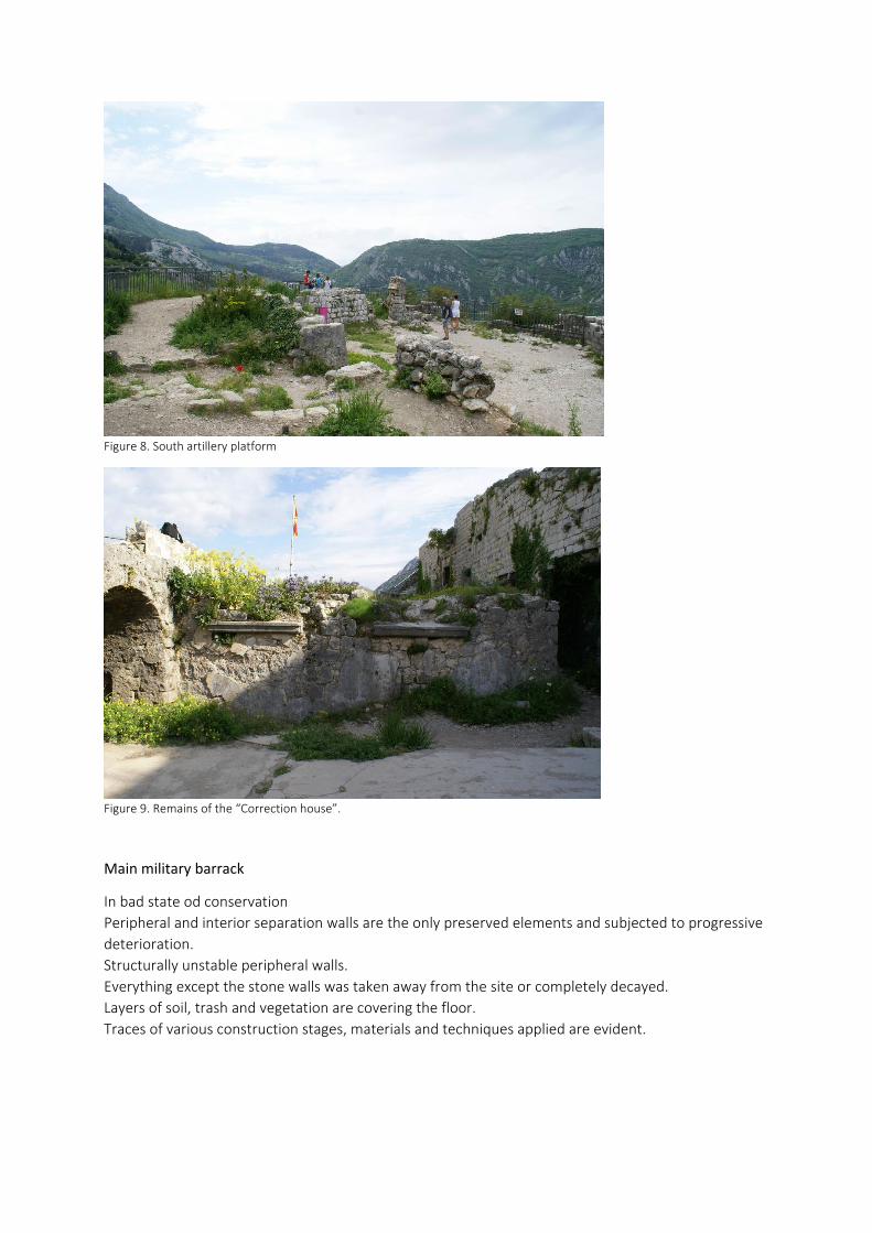
Figure 8. South artillery platform
Figure 9. Remains of the “Correction house”.
Main military barrack
In bad state od conservation
Peripheral and interior separation walls are the only preserved elements and subjected to progressive
deterioration.
Structurally unstable peripheral walls.
Everything except the stone walls was taken away from the site or completely decayed.
Layers of soil, trash and vegetation are covering the floor.
Traces of various construction stages, materials and techniques applied are evident.

Figure 10. Main military barrack; western elevation
Casemate
In very bad condition, neglected and without any functions.
Moisture and water penetration are the main problems causing progressive deterioration.
Figure 11. Casemate
Artillery building
In solid state of conservation.
Missing any kind of functions, even temporary.
Walls are in good condition and do not show traces of decay, except partial collapse on a few
positions.
Reinforced slab steel elements have corroded but do not show evidences of structural vulnerability.
Original pavement is partially preserved.

Doors and windows have been removed allowing layers of soil and water to enter from outside during
heavy rains.
Figure 12. Artillery building Figure 13. Artillery building; interior
Saint John church and gunpowder magazine
In very bad condition.
Progressive deterioration caused by natural and human influence.
Both buildings are structurally jeopardized and in demand urgent interventions.
Problem of moisture and water penetration is evident.
Figure 14. Saint John church and powder magazine Figure 15. Saint John church interior
New entrance building
In bad state of conservation.
Evident large amount of decays, mainly caused by natural and human influence.
Structural damage of the walls could lead to collapse in case of seismic activity.
Structural stability of the reinforced concrete slab at the first level is questionable, and could present
danger for the visitors.
Problem of moisture and water penetration is evident.
Finishing layers of the interior walls are damaged, mostly by human activity.
Former drawbridge is not functional. Present bridge is damaged and inadequate.
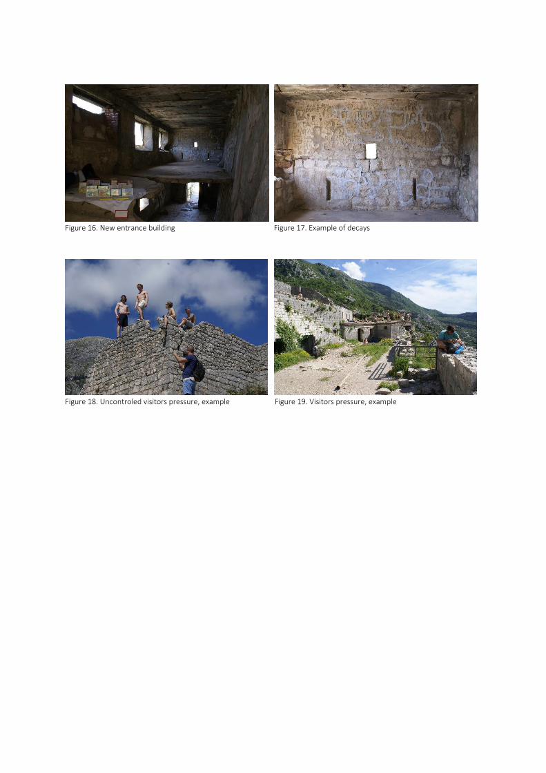
Figure 16. New entrance building Figure 17. Example of decays
Figure 18. Uncontroled visitors pressure, example Figure 19. Visitors pressure, example

6.2.3 CONCLUSIONS
The main goal of the previously conducted analysis was to create an overall insight of the current
preservation level and of the main problems present at the complete fortification system of San
Giovanni hill together with the fortress on its top.
To better understand the overall situation, components of the system are divided based on the
fortification typology and analyzed separately.
Conducted analysis enabled the classification of the main factors which are, to a greater of lesser
extent, affecting all the components constituting the fortification system of San Giovanni hill:
1.Progressive decay of property components
As already mentioned, the last major repairs and reconstruction works, for exclusively military
purposes, were carried out in XVIII century by Venetian Governor Renier. During these works, several
new defensive positions were constructed while the existing ones are repaired and modernized.
Interventions carried out by Austrian army were reduced to sporadic repairs, additions and
adaptations of the already existing fortification system. After the end of WWI and the complete loss of
military function the ramparts of Kotor, especially the ones of San Giovanni hill, are subject to
constant decay and deterioration due to the non-existing preservation program. It is only the quality
of construction and solid foundation zone that have led to the present level of conservation. Beside
the process of unstoppable aging, natural and anthropogenic influences have significantly affected the
present state of the property.
In brief, most common causes of decay in material and structure are:
Seismic activity
Montenegro, especially it south region, is a country of high seismic risk. During the history Kotor have
suffered number of devastating earthquakes. Last such event occurred in 1979 resulting in
catastrophic consequences for town’s historical heritage as well as for the lives of its citizens.
It can be concluded that the seismic activity of the area presents the greatest risk for the fortification
architecture of San Giovanni hill. Despite the quality of construction, many components in this part of
Kotor fortification are structurally unstable and may suffer partial or complete collapse in case of
seismic activity. Beside the irreversible loos of heritage, potential seismic activity could lead to
catastrophic consequences when it comes to the safety of visitors, especially during the touristic
season when the daily number of visitors is high.
Therefore, structural consolidation is considered as one of the primary tasks of future interventions on
the San Giovanni fortification system and the fortress itself.
Due to the high seismic risk, all the objects that are being built or reconstructed have to be designed in
accordance with the Law on Construction and Spatial Planning, which prescribes the design and
construction of buildings in the areas of seismic risk, for the magnitude of an earthquake of 9 degrees
on the MCS, or 6.9 on the Richter scale.
Decays caused by environmental factors
The presence of lush vegetation is one of the most obvious factors affecting almost all components of
the site. The damage caused by the growth of weeds inside wall surfaces, caused by cracks and/or
cavities where spores and seeds settle, is prevalent and serious. This process is also encouraged by

rainfall and exposure to sunlight. The roots of weeds are very dangerous in that, if not tackled in
proper time, they can cause parts of walls to detach and collapse. The absence of adequate
maintenance programs as well as the conditions for such programs to be realized, which will be
discussed in later chapter, further increases the problem.
Due to the humid winters with high rain precipitation presence of water, in any of its various forms,
causes or accelerates the decay of the property components. The access of water to porous masonry
material is mostly caused by direct or indirect rainfall, capillary action, condensation etc.
Different components of the property are suffering different type of decays caused by the presence of
water. Fault disposal of rain water, due to the non-existing or jammed drainage systems, is frequent
cause of deterioration of the masonry. Although the water absorption capacity of stone is small, water
can penetrate through cracks and cause internal damage to the material21. Lime joints are also
vulnerable to the effects of water and moisture penetration.
Landslides and unstable terrain
Another natural pressure caused by heavy and long rains are the frequently occurring landslides that
are causing serious damages to the property components and endangering the safety of visitors.
Decays caused by human influence
Theft of material (stone and iron) and vandalism are common human behaviors that have left
significant negative impact on the heritage. In addition, the high number of visitors puts pressure on
the property, particularly during the summer season. The average time of stay is short, but the
intensity of the visits is great and there are no regulations that would restrict maximum number of
visits for a certain time. Simultaneously, there are no prescribed rules of conduct, as well as services
that would control and sanction undesirable behavior.
2. Accessibility issue
The inaccessibility of the San Giovanni fortification system with the highest point standing 270 meters
above sea level presents one of its main characteristics closely related to numerous challenges and
issues that define this part of the town’s fortifications.
Once being one of its main advantages, today it presents main obstacle to the realization of
maintenance and conservation program’s that would include transport of the equipment, material
and workforce to the site.
When it comes to the visitor’s access, currently there are only two accessible routes that are relatively
safe but demand large effort to overcome. In the same time number of components which are
presenting valuable historic heritage are almost impossible to reach.
It Is important to note that elderly people, with limited physical fitness and ability to move, present
high percentage of visitors that are trying to reach the top of the hill during the summer touristic
season when the temperatures are extremely high. In addition to the unsafe nature of the paths itself
(detailed described in chapter 6.2.1) we can conclude that the safety of the visitors is compromised
from many points of view.
It can be concluded that improvement of accessibility presents one of main preconditions for the long-
term and sustainable revitalization of San Giovanni fortification system. It should also be noticed that
there have been initiatives to solve the problem by constructing cable car that would connect old
21 Feilden, Bernard M. Conservation of Historic Buildings. Architecture Press, Kidlington, Third Edition 2004

town of Kotor with San Giovanni fortress on the top the hill but more detailed analysis have shown
that these kind of interventions would not be sustainable.
3. Inadequate presentation of the heritage
Another problem closely related to difficult access is impossibility to present valuable components of
cultural-historical heritage such as rampart walking paths for soldiers, medieval towers, artillery
positions and similar. However, even in places available to tourist there are no basic information’s that
would adequately present cultural and historical heritage. For this reason, visitors are deprived
information’s necessary to understand essential nature of the visited site.

4.3 CONSERVATION AND REVITALIZATION PROJECT
4.3.1 Project objectives
Based on preliminary analyzes regarding the main factors affecting the property, main objectives of
the project are defined as following:
• Conservation of the property components
• Improving accessibility
• Achieving adequate presentation of the heritage
The stated objectives are approached in three different scales:
Large scale
Analysis of the Venetian fortification architecture of Kotor and it’s region in relation to the historical,
strategical and topography context.
Medium scale
Medium scale of the project provides design proposal for a
Detailed scale
Detailed scale of the project provides design proposal for adequate conservation of San Giovanni
fortress and creation of conditions for its adequate cultural and touristic exploitation.
4.3.2 Project description
The main objective of the project is to define an approach to the conservation of San Giovanni fortress
in order to preserve its cultural and socio-economic values as well as to create conditions for its
adequate touristic exploitation. The fortress was not observed as an isolated building but as a part of
entire fortification system of Kotor and San Giovanni hill.
Part of the fortification system stretching from Renier artillery platform to San Giovanni fortress was
selected as a case study for approaching the issue of accessibility and safety of the visitors trying to
reach the San Giovanni fortress. The selected portion contains most of the military architecture
components that are, to a greater or lesser extent, present along the entire system of fortified San
Giovanni hill such as artillery platforms, rampart walls and communication roads.
The improvised entrance to the Renier artillery position which is used as a connection with the Sipljari
village was selected as the first intervention of the project. The offered solution is designed in the
form of a steel platform with staircases for overcoming the altitude difference between the foot of the
path and artillery opening used as an entrance. The next characteristic point of the project is the
Bataglia artillery position at which the new proposal enables visitors to reach upper parts of the
platform and walk along the fire wall with loopholes. The connection of stone and stainless steel in
order to prevent the stone decay caused by corrosion. Safety fences are foreseen in all exposed areas.
Both positions are conceived as places of rest connotated by panoramic views of the bay.

When it comes to the San Giovanni fortress, the proposed concept includes series of individual
interventions that together make a route passing through all components of the fortress, adequately
presents them while simultaneously enhances existing and opens new points of landscape perception.
Every need for static consolidation of buildings has been transformed into an architectural project.
Steel floor constructions and pathways in this case become elements of seismic reinforcement. Steel
was chosen as the materialization for all new additions due to its timeless character. Steel, in its
various form of application was present both in Venetian and Austrian historical phases of
construction. All new constructions are completely reversible.
All the components of the fortress are, to the largest extent possible, preserved in their current state.
Existing materialization of walls, floors and celling’s are planned to be saved in order to preserve the
existing character of the buildings. In this context, some of the damage caused by human and natural
factors are observed and preserved as a new historical layer of the property. In the case of Austrian
entrance building layers of wall finishing mortar containing carved signatures, some dating back to the
beginning of 20th century, are not considered as a damage but as a evidence of the human presence
and passage of time. Non-invasive layer of vegetation growing on vaults of the Saint Giovanni church
was retained as an integral element of the building and in the same time used as a soft capping for the
top of the wall.
San Giovanni fortress is being deprived of any new program’s and functions. New proposal strikes at
preserving the public character of the site and appreciates its close relationship with the landscape as
its greatest intangible value.

4.3.2 Case studies
RESTORATION OF DORIA CASTLE
Project location: Dolceaqua, Italy
Project year: 2010-2012
Construction: 2012-2015
Author/s: LD+SR
Client: Municipality of Dolceaqua
Program: Museum, public space, view point
Publication: PREMIO DOMUS 2016, PAESAGGIO URBANO 2.2016
Restoration of Doria castle was selected as a case study that can serve as a positive example from
various points of view. One of the main similarities with San Giovanni fortress is the relationship of the
castle with its surroundings and acceptance of this feature as one of main “values” of the site.
Similar as San Giovanni, Doria Castel situated in a dominant position overlooking the urban area below
is in extreme point of advantage to control the Valley of the river of the Nervia Valley. After
widespread interventions of restoration undertaken since the early 90 's, 2012-2015 covered the
restoration and consolidation of certain portions of the main external walls of the Castle (sailing North,
Savoy bastion, bastion minor), the recovery of the main open spaces that surround it in diffuse form
the complex, the establishment of a system of trails that leads the visitor to discover different points
of perception of landscapes that surround the monument. The project seeks to enhance the strategic
position, making visitors to travel to the different stages of completion of the building, discover
enclosed elements and various land control points.
Any need for structural reinforcement or static improvement was turned into an architectural project.
Iron parts, depending on the requirement, have become paths, passages, elements of reconstruction
of portions of walls missing or being completely detached. New construction, always in iron, is
perceived as temporary, reversible and always side by side with the existing tissue.
The museum hosted within the castle can even be perceived as a secondary function, while the
project emphasizes the public character of the site which becomes the place of leisure, enjoyment and
admiration of the surrounding landscape.
Decisions to maintain the public character of the Doria Castel, enhancing the views and converting
structural into architectural elements are accepted as main guidelines when approaching the
revitalization of San Giovanni fortress.

REORGANIZATION OF POMBALL’S CASTEL HILL
Project location: Pombal Municipality, Portugal
Project year: 2011
Architecture: Comoco, Luís Miguel Correia, Nelson Mota, Susana Constantino
Landscape architecture: Luís Guedes de Carvalho, Luís Miguel Correia, Nelson Mota e Susana
Constantino.
Client: Pombal Municipality
Cost: 3,000,000 EUR
Area: 48650.0 sqm
Interesting case study of reorganization of Pombal Castel hill comes as result of municipality’s
intention to encourage design that would help fostering the use of that historic area both by residents
and tourist. In the period before the intervention Pombal Castel and its surroundings have been
doomed to seclusion from the core of the city at its feet. For the ordinary city user, the Castel was only
a background for the everyday, a mere identity reference that resonated with the history of the city
more than with an actual experience of it.
The basic character of the intervention is an attempt to deliver an approach were the new design
elements should be clearly defined against the background of both the natural and the built pre-
existing elements. The Pombal project defines three areas, each of which with a different approach. In
the first area, the south and west slopes of the hill, the approach was focused in the idea of flow. This
idea was thus developed creating and highlighting connections between the urban areas at the
bottom if the Castel’s hill, pathways along the slopes and gazebos to provide shelter and foster diverse
experiences in the contact with the landscape. In the second area, in the surroundings of the
cemetery, the approach was concerned with the idea of a topographical design of the infrastructure.
Both parking area and the adjacent facilities were designed as topographical elements. Finally, the
third area, surrounding the walled precinct, aims to enhance the Castel as the main built element of
the area. The west access to the Castle was redesigned, including the platform at its bottom. The
surrounding area of Santa Maria’s Church was also redesigned to provide a public space that could
foster its appropriation as a privileged stage for performances and other cultural activities.
Certain parallels can be drawn between the mentioned case study and proposed project for improving
the accessibility of San Giovanni hill. Although in different ambient, both project promote similar idea
of connecting two entities by implementing serious of medium and small-scale projects. Pombal Castel
project proves that facilities such as car parking, comfortable and safe pathways, resting and
contemplation areas and cafeterias can increase attractiveness of the site while in the same time help
connecting two separated entities, a town and its castle. Observing the project accessing San Giovanni
fortress through the prism of the Pombal Castel case study provides justification for the proposed
intervention as an approach that not only fosters the use of historic site by residents and visitors but in
the same time improves articulation with the cultural heritage in order to preserve its importance for
the population’s shared identity.

4.3.3 Conclusion
Research conducted regarding the historical development of the Kotor military architecture, its
heritage values and current state of conservation resulted in list of specific challenges that need to be
meet when approaching the revitalization and conservation of San Giovanni fortress.
The safety of visitors, accessibility issue and decay of the property are the key problems identified
during the research. The need for their solution is therefore set as a key goal of the project.
The conclusion of the thesis is mostly reflected through the solutions presented by the revitalization
project which concept is based on proposing the small-scale interventions aimed at improving and
facilitating access to the San Giovanni fortress while offering design solutions for conservation and
restoration of its components. In the final form, project aims to create conditions for an adequate
cultural and touristic exploitation of the fortress through the sustainable revitalization approach that
maximizes its material, historical and social values.

BIBLIOGRAPHY
1. Avrami E. Mason R. & De La Torre M. (2000). Values and Heritage Conservation, Research Report. Los
Angeles: Getty Conservation Institute
2. Djurovic V. (1956). O zidinama grada Kotora, Zbornik izvještaja o istraživanjima Boke Kotorske II, SAN
Spomenik CV (Issue of ramparts of town of Kotor, Annual of reports of researches of Bay of Kotor No. II,
SAN Spomenik CV), Belgrade, Serbia: SAN
3. Feilden B.M. (2004). Conservation of Historic Buildings. Kiklington,UK: Architecture Press
4. Lalošević, I. (2016); Fortifikacijska Arhitektura Boke Kotorske Venecijanskog Perioda (XV-XVIII vijek),
“Venetian Fortification Architecture of Bay of Kotor between XV and XVIII
5. Lalosevic, I (2013), “Fortifikacioni sistem Boke kotorske austrougarskog perioda”, “Boka 33 (a collection
of works in science, culture and art). Herceg Novi, Montenegro: JU Gradska Biblioteka I citaonica Herceg
Novi
6. L’architetettura militare di Venezia in terraferma e in Adriatico fra XVI e XVII secolo; Atti del convegno
internazionale di studi Palmanova 2013; A cura di Francesco Paolo Fiore. Palmanova,
7. Management Plan of Natural and Cultural – Historical Region of Kotor. (2011). Cetinje: Ministry of
Culture of Montenegro
8. Medieval Town of Rhodes, Restoration Works (1985-2000). Rhodes: Ministry of Culture
9. Photogrametrical recordings done during 1984, 1985 and 1986 by Polish Mining and Geodesy Academy
from Krakow and Company for Mining and Geodesy from Szczecin, Poland, Documentation of the
Institute for the Protection of Cultural Heritage Kotor.
10. Rastoder Š. & Andrijašević Ž. (2006). Istorijski Leksikon Crne Gore; '' A Historical Lexicon of Montenegro“
Podgorica, Montenegro:Daily Press-Vijesti
11. The Venetian works of defense between 15th and 17th centuries. (n.d.) UNESCO WHL nomination format.
century”,Podgorica,Montenegro: University of Montenegro
12. Vučenović S. (2012). Graditeljstvo Kotora ;”Building heritage of Kotor” Kotor, Montenegro: Maritime
museum of Kotor

OTHER SOURCES:
1. Balkanski ratovi: 1912-1913, Savremena istorija, viewed 04.12.2017,
http://savremenaistorija.com/?p=1152
2. Natural and Culturo-Historical region of Kotor, UNESCO
< http://whc.unesco.org/en/list/125>
3. Sekulić S n.d, Kulturna politika u Crnoj Gori poslije drugog svjetskog rata, “Cultural politics in
Montenegro after WW II”,
http://www.montenegrina.net/pages/pages1/politika/kulturna_politika_u_cg_poslije_2svj_rata.htm
4. Venetian Works of Defence between the 16th and 17th Centuries: Stato da Terra – Western Stato da
Mar, UNESCO
< http://whc.unesco.org/en/list/1533>