Embed Size (px)
Citation preview

Tropical Storms and HurricanesTropical Storms and Hurricanes

Motivation
Super HurricanesSuper Hurricaneshttp://www.youtube.com/watch?v=ZXMj1yHgfPE&NR=1&feature=fvwp

This material was partially provided by the following sources:
Prof. Jennifer Collins (Florida State University), Aguado and Burt: Understanding Weather and
ClimateComet educational program - UCAR (see websites in
the last slide) Mr. Forest Cannon (graduate student Dept.
Geography)

Tropical Cyclones and Hurricanes Tropical Cyclones and Hurricanes
1.1. Tropical cyclone and hurricane development, Tropical cyclone and hurricane development, structure, and movementstructure, and movement
2.2. Hurricane damages, warning systems, and naming Hurricane damages, warning systems, and naming conventionsconventions

Extremely strong tropical storms go by a number of different names, depending on where they occur.
Over the Atlantic and eastern Pacific they are hurricanes.
Those over the extreme western Pacific are called typhoons; those over the Indian Ocean and Australia are cyclones.
They are all considered tropical cyclones
Regional Names

Hurricanes, Typhoons and tropical Cyclones around the globe.
Seasonal Variability and local names
TyphoonsTyphoons
CyclonesCyclonesCyclonesCyclones
HurricanesHurricanes
HurricanesHurricanes
CyclonesCyclones

Hurricanes have sustained wind speeds of 120 km/hr (74 mph)
and are typically about 600 kilometers (350 mi) wide.
Sea level pressure near the center of a typical hurricane
is around 950 mb, but pressures as low as 870 mb
have been observed for extremely powerful hurricanes.
Some of the main characteristics of a HurricaneSome of the main characteristics of a Hurricane

Hurricanes obtain most of their energy from the latent heat released by condensation and are most
common where a deep layer of warm water fuels them.
August and September are the prime hurricane monthsin the Northern Hemisphere, while January to March
is the main season in the Southern Hemisphere.


Hurricane numbers vary considerable each year with a maximum number in the North Atlantic ever recorded in a single year of 15. This of course occurred recently in the infamous 2005 season. A minimum number of 2 occurred in 1982 which was an El Nino year. There is a mean number of hurricanes in this basin of just under 6 a year.
Did you know…

Important questions:• Why do hurricanes form?
• What causes their interannual variability? That is, why sometimes they are so frequent (as in 2005 – 15 hurricanes) and other times so rare (as in 1982 – 2 hurricanes – El Nino year)

Gray’s factors for tropical cyclone formation
Geographic
• Coriolis Force sufficient to give initial cyclonic spin
Dynamic
• Low vertical wind shear (shear is the vertical variation of the wind either in speed or direction)
Thermodynamic
• High values of relative humidity
• Sea Surface Temperatures > 26-27 oC (~79-81oF) to a depth of 60 m (~200 ft)
• An unstable atmosphere

Coriolis effect and hurricanes
Top view
No Coriolis Effects With Coriolis Effects
(Northern Hemisphere example)
Low Low

Internal Dynamics
L
Horizontal Pressure Gradient
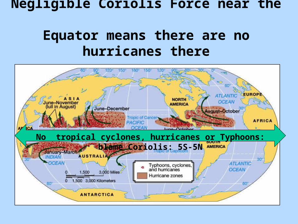
Negligible Coriolis Force near the Equator means there are no hurricanes there
No tropical cyclones, hurricanes or Typhoons: blame Coriolis: 5S-5N

2nd Inhibiting factor: wind shear
Speed ShearDirection Shear

Heat and moisture spread out over a larger area
Heat and moisture focused over a small area
The effect of Shear on the organization of the storm
More efficient in organizing tropical cyclones

Let’s look at December climatology of the zonal wind profile with height between 20S-30N and 100W-30W
EasterliesEasterlies
WesterliesWesterlies

Example of the mean zonal winds between 100W and 30 W during December El Nino 1997
Example of the mean zonal winds between 100W and 30 W during December La Nina1988
Easterlies
Westerlies
Easterlies
Westerlies

Westerliesintensified
Easterly anomalies
Westerliesweaker
Easterlies weaker Easterlies
near normal
Example of the mean zonal winds between 100W and 30 W during December El Nino 1997
Example of the mean zonal winds between 100W and 30 W during December La Nina1988
Increase in the vertical wind shear during El Nino years

High relative humidity required: one of the most important ingredients to form hurricanes is the release
of latent heat to the atmosphere
oLatent heat released due to condensation warms the atmosphere and cause the decrease of pressure at surface
Low pressure
oAs sea level pressure decreases, more air converges at the center of the storm, more latent heat is released and the storm becomes stronger and more powerful, with increasing winds

Warm water through depth required: water vapor is the fuel of tropical storms
Sea Surface
Dep
thT
emp
erature (°C
)
28
26
24

NEGLIGIBLE CORIOLIS
Cyclogenesis

APPROXIMATE AREA OF WARM SST
Cyclogenesis: origin of cyclones

Ocean Temperature
IKEIKE
Deadly Hurricaneshttp://www.youtube.com/watch?v=ZXMj1yHgfPE&NR=1&feature=fvwp

Hurricanes often originate as Tropical Disturbances
Tropical disturbances are disorganized groups of thunderstorms having weak pressure gradients and
little or no rotation.
Most tropical disturbances that enter the western Atlanticand become hurricanes originate in easterly waves, large undulations or ripples in the normal trade wind pattern.
Where do Hurricanes originate

Easterly waves have surface convergence and cloud covereast of the axis and divergence to the west.
The importance of monitoring wave activity over west Africa

Tropical Weather & WavesTropical Weather & WavesTropical winds Tropical winds typically blow typically blow from the east, from the east, and when they and when they encounter a encounter a slow moving slow moving trough of low trough of low pressure, pressure, called a called a tropical wave, tropical wave, the winds the winds initially initially converge and converge and lift to produce lift to produce showers and showers and thunderstorms.thunderstorms.

Pre-Existing Disturbance
BILLBILLFREDFRED
For a tropical cyclone to form, a disturbance must already be present. The convergence at this low pressure system is what initiates the cyclonic development.

Wind Shear
NCEP Reanalysis and TC data for composites: 1950-2003.
EASTERLIES
DOLDRUMS
WESTERLIES
IDEAL FOR CYCLONES ORIGIN OF
CYCLOGENESIS

When a tropical disturbance develops to the point thatthere is at least one closed isobar on a weather map,the disturbance is classified as a tropical
depression.
If the depression intensifies further and maintains windspeeds above 60 km/hr, it becomes a tropical storm.
A further increase in sustained wind speedsto 120 km/hr creates a true hurricane.
PHASES OF DEVELOPMENTPHASES OF DEVELOPMENT

Hurricane Lifecycle

A cross section of a typical hurricane.

Internal Dynamics

The hurricane eye is a region of relatively clear skies,slowly descending air, and light winds.
Along the margin of the eye lies the eye wall,the zone of most intense storm activity with
the strongest winds, thickest cloud cover, andmost intense precipitation of the entire hurricane.

Structure of a HurricaneStructure of a Hurricane
In this image of In this image of Hurricane Elena, the Hurricane Elena, the central area of broken central area of broken clouds is the eye, clouds is the eye, surrounded by an eye surrounded by an eye wall cloud and spiral wall cloud and spiral rain bands, with a rain bands, with a total diameter nearing total diameter nearing 500 kilometers.500 kilometers.

http://www.nasa.gov/mission_pages/station/multimedia/hurr_ike091008.html
Hurricane Ike (September 10/2008): downlinked by the crew of the International Space Station, flying 220 statute miles above Earth. The center of the hurricane was near 23.8 degrees north latitude and 85.3 degrees west longitude, moving 300 degrees at 7 nautical miles per hour. The sustained winds were 80 nautical miles per hour with gusts to 100 nautical miles per hour and forecast to intensify. Photo Credit: NASA

IKE, September 9/2008

Cross-section of a hurricane showing cloud patterns and air flows (a), rainfall intensities (b), pressure distributions (c), and wind speed (d).

Hot towers (above) are embedded in some eye walls and last between 30 minutes and 2 hours. Hot towers are localized portions of eye walls
that rise to greater heights (up to 12 km, or 7 mi) than the rest of the eyewall and may indicate that the hurricane will intensify within 6 hours.

A hypothetical hurricane moves northward at 50 km/hr. Along theright-hand side, the 200 km/hr winds are in the same direction as themovement of the storm, so there is a net-wind speed of 250 km/hr.
On the left side, the net winds are southward at 150 km/hr.

Hurricanes and tropical storms have a tendency to move north ornortheast out of the tropics along the southeast coast of North America
and often move in wildly erratic ways. After making landfall,a tropical storm may die out completely within a few days.

Sources of destruction from a hurricane
• Winds• Flooding
– Rain
– Storm Surge
• Waves• Tornado• Down-drafts

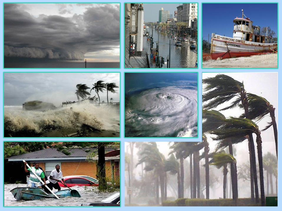
Effects of Tropical Cyclones
Storm SurgeWind and Rain
Hurricanes are among nature’s most destructive events and annually account for unparalleled environmental destruction and loss of life.
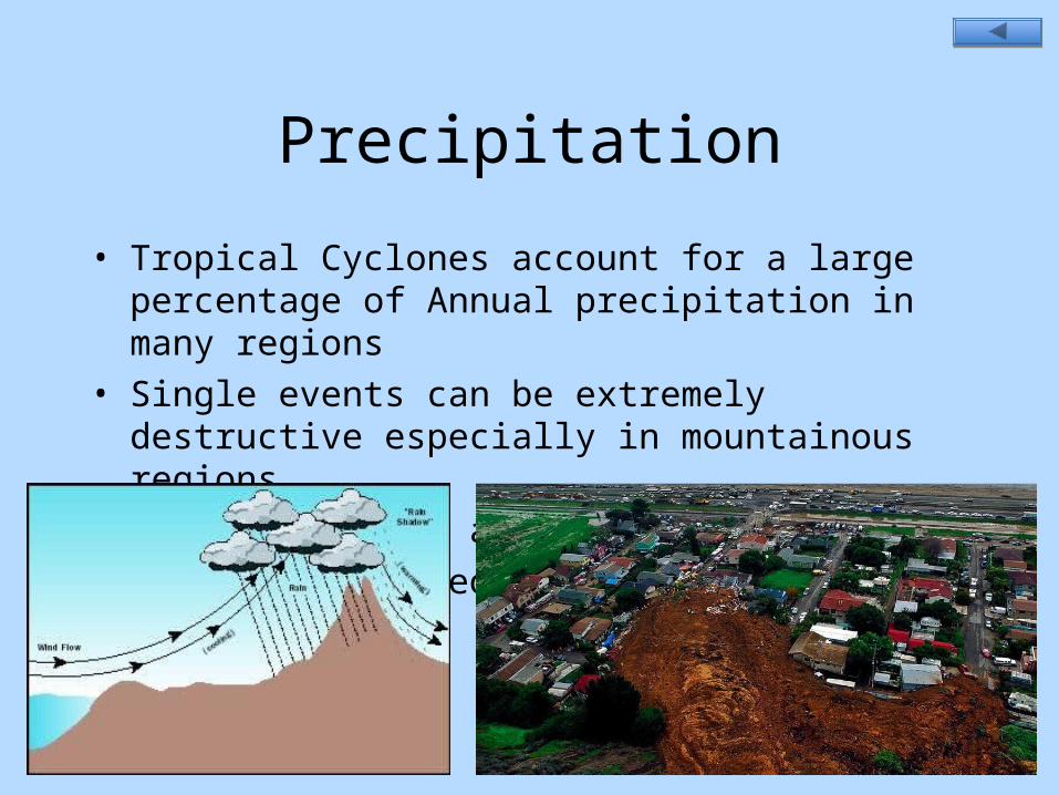
Precipitation
• Tropical Cyclones account for a large percentage of Annual precipitation in many regions
• Single events can be extremely destructive especially in mountainous regions
• Create Flooding and Landslides
• Influenced by geography

Storm Surge• Created by barometric low in hurricane center as well as
wind driven piling up of water• Elevated sea level follows storm• For every milibar of pressure decrease, the water level rises
1 cm.• When cyclone makes landfall water surges inland• When associated with high tide can be up to 25 feet• Most destructive part of tropical cyclones• Flooding can last for extended periods of time destroying
local infrastructure (New Orleans, Bangladesh)

More on the hurricanes
• Revision of concepts: (second movie)• http://www.youtube.com/watch?v=ZXMj1yHgfPE&NR=1&feature=fvwp
• Movie showing storm surges and impacts on coastal areas
• http://www.youtube.com/watch?v=HJydFJORWf4&feature=related

Comparison of hurricanes and mid-latitude cyclones
Similarities:• Type of low pressure system• Wind direction
Differences:• Energy derivation• Strongest winds• Surface charts

Can you tell if they are tropical or extratropical cyclones?

Locations of hurricane landfalls from 1950 through 2004.

When forecasters predict that an approaching hurricanewill reach land in more than 24 hours, they issue ahurricane watch. If it is expected to make landfall
over the United States within 24 hours,they issue a hurricane warning.
http://www.nhc.noaa.gov/
NOAA Official link for hurricane watch

Hurricane Watch & WarningHurricane Watch & Warning
The National Hurricane Center in Florida issues a The National Hurricane Center in Florida issues a hurricane watch 24 to hurricane watch 24 to 4848 hours before a threatening storm arrives, and hours before a threatening storm arrives, and if it appears that the storm will strike within 24 hours, a hurricane warning is issued., a hurricane warning is issued.While some consider the warning area too large, causing unneeded While some consider the warning area too large, causing unneeded evacuation, such evacuations have saved many lives.evacuation, such evacuations have saved many lives.Hurricane Hugo, with peak winds near 174 knots, caused tremendous Hurricane Hugo, with peak winds near 174 knots, caused tremendous damage.damage.

The Saffir-Simpson scale classifies hurricanes into five categories,with increasing numbers corresponding to lower central pressures,
greater wind speeds, and larger storm surges.

Hurricane Names and CostHurricane Names and Cost
Category 5 Hurricane Category 5 Hurricane Andrew (1992) was the Andrew (1992) was the costliest US storm costliest US storm (prior to 2005 season!), (prior to 2005 season!), but it ranks as less but it ranks as less intense than 1935 and intense than 1935 and 1969 hurricanes.1969 hurricanes.
Hurricane names are Hurricane names are chosen from an chosen from an alphabetical list of alphabetical list of male and female names male and female names for the Atlantic and for the Atlantic and Pacific, some of which Pacific, some of which are retired if the storm are retired if the storm was especially was especially damaging.damaging.

2009 2010 2011 2012 2013 2014AnaBillClaudetteDannyErikaFredGraceHenriIdaJoaquinKateLarryMindyNicholasOdettePeterRoseSamTeresaVictorWanda
AlexBonnieColinDanielleEarlFionaGastonHermineIgorJuliaKarlLisaMatthewNicoleOttoPaulaRichardSharyTomasVirginieWalter
ArleneBretCindyDonEmilyFranklinGertHarveyIreneJoseKatiaLeeMariaNateOpheliaPhilippeRinaSeanTammyVinceWhitney
AlbertoBerylChrisDebbyErnestoFlorenceGordonHeleneIsaacJoyceKirkLeslieMichaelNadineOscarPattyRafaelSandyTonyValerieWilliam
AndreaBarryChantalDorianErinFernandGabrielleHumbertoIngridJerryKarenLorenzoMelissaNestorOlgaPabloRebekahSebastienTanyaVanWendy
ArthurBerthaCristobalDollyEdouardFayGonzaloHannaIsaiasJosephineKyleLauraMarcoNanaOmarPauletteReneSallyTeddyVickyWilfred
Tropical Cyclones names for the Atlantic sector
http://www.nhc.noaa.gov/aboutnames.shtmlhttp://www.nhc.noaa.gov/aboutnames.shtml

Hurricane Andrew
Figure 5.41

Hurricane Andrew Devastation in Homestead, Florida Hurricane Andrew Devastation in Homestead, Florida August 24, 1992August 24, 1992

The number of Atlantic tropical storms (purple), hurricanes (orange), and Category 3–5 hurricanes (green) by year, 1851–2004.
Rita9/23/05
Katrina8/28/05
Wilma10/21/05
Emily7/21/05

What was the deadliest hurricane in the USA history?

At the turn of the last century Galveston, Texas was a sophisticated seaport of 38,000 people, a city prosperous from the cotton trade and richer in millionaires than even Newport, R.I. It was the first city in Texas with phones and electricity, and its residents enjoyed a grand lifestyle: an opera house, 50 miles of streetcar track and foreign consulates for 19 countries.
On Friday evening, Sept. 7, 1900, many of the residents of Galveston were settling down to dinner, few if any of them concerned about the steady 15 mph northerly wind rattling their windows. Within 48 hours, at least 8,000 of the townspeople --almost one in five Galvestonians -- would be dead, victims of the single worst natural disaster in U.S. history.
The tragedy killed more Americans than the legendary Johnstown Flood, the San Francisco Earthquake, the 1938 New England Hurricane and the Great Chicago Fire combined.

http://www.wunderground.com/hurricane/deadly.asp?MR=1Rank: Name / Areas of Largest Loss: Dates: Deaths:
1."Great Hurricane" Martinique, Barbados, St. Eustatius
10-16 Oct 1780 22000
2. Great Galveston Hurricane 8 Sep 1900 8000-12000
3. Mitch: Honduras, Nicaragua 10/22 - 11/5 1998 9086
4. Fifi: Honduras 14-19 Sep 1974 8000-10000
5. Dominican Republic 1-6 Sep 1930 8000
6. Flora: Haiti, Cuba 9/30-10/8 1963 8000
7. Pointe-a-Pitre Bay, Guatemala 6 Sep 1776 6000
8. Newfoundland Banks 9-12 Sep 1775 4000
9. Puerto Rico, Carolinas 8-19 Aug 1899 3433
10. FL, PR, Martinique, Guadeloupe, Turks 12-17 Sep 1928 3411
11. Cuba, Cayman Islands, Jamaica 4-10 Nov 1932 3107
12.Jeanne: Haiti, Dominican Republic, Bahamas, Florida
13-29 Sep 2004 3000
13. Central Atlantic 16-17 Sep 1782 300014. Martinique Aug 1813 3000
15. El Salvador, Honduras 4-8 Jun 1934 3000
The 15 deadliest Atlantic Hurricanes in history : 1742-2009

Video of Tropical Cyclone Ingrid (2005) making landfall in Australia:
Hurricane intensity scale:
*Very interesting material for consultation: (comet/ucar website)
Access comet websiteEmail: [email protected]: victory
http://www.ranker.com/list/10-biggest--deadliest--most-destructive-hurricane_s-ever--/jeff419

Work in groups:• Summarize what you have learned regarding: • 1) tropical cyclones names• 2) tropical cyclones formation, development, propagation• 3) Characteristics (rain, winds, pressure)• 4) Inhibiting factors• 5) Damages• 6) Warning and watch• 7) Role of El Nino/La Nina phenomenon for the frequency of
hurricanes

Interpret the information provided in the next slide