Embed Size (px)
Citation preview
1
Transportation Corridors in Pacific Asian Urban Regions Jean-Paul Rodrigue Department of Geography Centre for Research on Transportation East Asian Studies Centre Université de Montréal C.P. 6128, Succ. A Montréal, Québec CANADA, H3C 3J7 Note: the above affiliation is no longer valid. Published in D.A. Hensher and J. King (1996) (eds) Proceedings of the 7th World Conference on Transport Research, Sydney: Pergamon. Introduction: Asian Corridors of Urbanization
Over the numerous dimensions of Asian urbanization, notably economic restructuring (shifts in
employment and production) and land use transition (from rural to urban/desakota), the spatial
structure of urban regions remains one of the most complex and less understood. It places emphasis
on the form, the distribution and the regulation of territories. Obviously, Asian urban regions are not
emerging over a territorial vacuum and are the result of a process of spatial accumulation shaped by
their economic and transportation systems. Over this, the transportation system is an expression of
spatial structures and also has a form, distribution and regulation. Wherever economic activities are
distributed in space, they create transactions supported by distribution systems. This is central to the
concept of spatial interactions. Also, wherever the economy is developing, the transactional demand
grows. In a global transactional environment, several urban and industrial structures face a
redefinition of their territories1.
Asian territories, like any territorial structures, can be considered from heterogeneous and
homogeneous perspectives in regards of urbanization. The transformations of East and Southeast
Asian economies occur over different geographic, economic, political and social landscapes.
Browsing from Indonesia, Thailand, through the coastal plains of China, South Korea and Japan, we
2
acknowledge that landscapes are indeed heterogeneous and are subject to different interpretations
and representations. In view of this, there is a conceptual need to understand complex territorial
structures through the development of an unifying approach to Asian urbanization. It would try to
assess a common ground for Asian urbanization and their new spatial regions. What are the
similarities behind urbanization processes?
The first aspect that comes to mind is the regionalization of urbanization. Among different
landscapes spatial regions provide a similar framework to urbanization. Over this, several urban
region models have been brought forward since the seminal work of Gottman (1961). The Extended
Metropolitan Region (EMR) is a well-accepted definition and representation of regional
urbanization structures and is applicable to diverse Asian landscapes (Ginsburg, Koppel and McGee,
1991). The second, is the globalization of capitalism where the comparative advantages of space are
more efficiently exploited. Several regions, which would have very little in common, are being
integrated in the division of production. The third aspect is the space/time collapse supporting a
regional distribution of economic activities, from extractive rural to transactional metropolitan areas.
It underscores distribution systems of freight, people and even information where transportation is of
prime importance (Rodrigue, 1994). The structure and regulation of the transportation system are
likely to be influenced by the spatial structure of the territory, but this remains to be furthermore
investigated through the concept of corridors.
Corridors underline a new dimension in the study of urbanization over an extended territory.
Although they have been considered as the structure behind the development of several urban
systems (Hoyle, 1973; Whebell, 1969), corridors must also be considered as the structure behind the
territorial development of urban regions. Transportation corridors link a set of EMRs in a cohesive
regional structure. They are more than an axe supporting interactions between places, they are places
of spatial accumulation. Conceptually, corridors provide a tentativeness of territorial homogeneity
over a heterogeneous landscape. This is particularly the case in East and Southeast Asia where
regional economic cohesion is growing, along with international trade. The objective of this chapter
is thus to bring an introductory discourse on urbanization corridors through two points: (1) The
structure of corridors; (2) The regulation of corridors. Our contribution is in part theoretical and in
3
part applied and aims to set up the scene of new spatial regions in Asia. Empirical evidence is drawn
upon an overview of the emerging East and Southeast Asian corridors, notably for Shanghai-
Nanjing.
The Structure of Corridors It is of conventional wisdom in development theories to consider inequalities as a structural
factor of spatial accumulation (Dwyer, 1990). Transportation � among other factors � reinforces
spatial inequality by linking a priori the most productive places. Large cities, as highly productive
entities, are fundamental structures of global and regional spatial accumulation, and thus represent
strong incentives to be bonded by an efficient transportation network. When a set of large cities are
interacting at the regional level, they reinforce the regional spatial inequality of accessibility by their
corridors of interaction; transportation corridors. From an economic perspective, transportation
corridors provide two fundamental attributes for territorial development: lower distribution costs and
land supply for diverse activities. Since spatial accumulation tends to occur at productive places
where there are adequate land supply and accessibility, corridors are in that context an efficient
regional urbanization structure. The emergence of transportation corridors, as a process, is the
overlay in time and space of diverse transportation modes where they (the corridors) become the
structure of urban regions. We can no longer speak of a set of interacting cities, but of a regional
transactional space composed of diverse - more or less linked - specialized economic functions; a
new spatial region.
Geographical and historical conditions create a basic set of regional inequalities in accessibility
that the subsequent economic, demographic and transport developments strengthen. Contemporary
urban regions have their anchor points along a fluvial axe, a coastal plain, a natural harbour, or any
geographical feature providing accessibility, notably an efficient maritime / land interface. This by
no means implies similar landscapes, nor similar economic conditions and processes of spatial
accumulation. We suggest here that corridors are the structure behind the emergence of most urban
regions where transportation supports transactions and spatial accumulation along a privileged axe.
By privileged, we entail an axe being serviced by different types of infrastructure, where one mode
may be more present than another. Corridors can be classified in four modal structures; maritime,
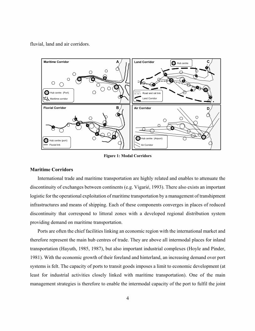
4
fluvial, land and air corridors.
Maritime Corridor Land Corridor
Air Corridor
Hub centre (Port)
Maritime corridor
Road and rail link
Land Corridor
Hub centre (Airport)
Air Corridor
Fluvial Corridor
Fluvial link
Hub centre (port)
Hub centreA
B
C
D
Figure 1: Modal Corridors
Maritime Corridors
International trade and maritime transportation are highly related and enables to attenuate the
discontinuity of exchanges between continents (e.g. VigariJ, 1993). There also exists an important
logistic for the operational exploitation of maritime transportation by a management of transhipment
infrastructures and means of shipping. Each of these components converges in places of reduced
discontinuity that correspond to littoral zones with a developed regional distribution system
providing demand on maritime transportation.
Ports are often the chief facilities linking an economic region with the international market and
therefore represent the main hub centres of trade. They are above all intermodal places for inland
transportation (Hayuth, 1985, 1987), but also important industrial complexes (Hoyle and Pinder,
1981). With the economic growth of their foreland and hinterland, an increasing demand over port
systems is felt. The capacity of ports to transit goods imposes a limit to economic development (at
least for industrial activities closely linked with maritime transportation). One of the main
management strategies is therefore to enable the intermodal capacity of the port to fulfil the joint
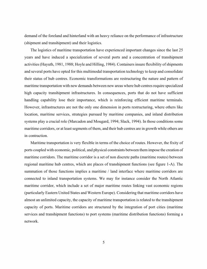
5
demand of the foreland and hinterland with an heavy reliance on the performance of infrastructure
(shipment and transhipment) and their logistics.
The logistics of maritime transportation have experienced important changes since the last 25
years and have induced a specialization of several ports and a concentration of transhipment
activities (Hayuth, 1981, 1988; Hoyle and Hilling, 1984). Containers insure flexibility of shipments
and several ports have opted for this multimodal transportation technology to keep and consolidate
their status of hub centres. Economic transformations are restructuring the nature and pattern of
maritime transportation with new demands between new areas where hub centres require specialized
high capacity transhipment infrastructures. In consequences, ports that do not have sufficient
handling capability lose their importance, which is reinforcing efficient maritime terminals.
However, infrastructures are not the only one dimension in ports restructuring, where others like
location, maritime services, strategies pursued by maritime companies, and inland distribution
systems play a crucial role (Marcadon and Mougard, 1994; Slack, 1994). In those conditions some
maritime corridors, or at least segments of them, and their hub centres are in growth while others are
in contraction.
Maritime transportation is very flexible in terms of the choice of routes. However, the fixity of
ports coupled with economic, political, and physical constraints between them impose the creation of
maritime corridors. The maritime corridor is a set of non discrete paths (maritime routes) between
regional maritime hub centres, which are places of transhipment functions (see figure 1-A). The
summation of those functions implies a maritime / land interface where maritime corridors are
connected to inland transportation systems. We may for instance consider the North Atlantic
maritime corridor, which include a set of major maritime routes linking vast economic regions
(particularly Eastern United States and Western Europe). Considering that maritime corridors have
almost an unlimited capacity, the capacity of maritime transportation is related to the transhipment
capacity of ports. Maritime corridors are structured by the integration of port cities (maritime
services and transhipment functions) to port systems (maritime distribution functions) forming a
network.
6
Fluvial Corridors
Fluvial transportation, even if slow and inflexible, proffers a high capacity and a continuous
flow. Small and medium-sized ports perform the role of hub centres by providing fluvial / land and
fluvial / maritime interfaces. The fluvial / land interface often relies less on transhipment
infrastructures and is thus more permissive for the location of dependent activities. Ports are less
relevant to fluvial transportation but fluvial hub centres experiences a growing integration with
maritime and land transportation, notably since the emergence of containers. The degree of
integration for fluvial transportation varies from totally isolated distribution systems to well
integrated ones (Lasserre, 1992). In urban regions well supplied by hydrographic networks, fluvial
transportation can be a privileged mode of shipment between economic activities. In fact, several
industrial regions have emerged in along major fluvial axes, particularly in England (Aldcroft and
Freeman, 1983). More recently, river-sea navigation is also providing a new dimension to fluvial
transportation by establishing a direct interface between fluvial and maritime systems (Rissoan,
1994).
The places of convergence of fluvial transportation correspond to important waterways having
access to port infrastructures and industrial regions. This reinforces investments in fluvial
infrastructures and modes of shipping. The fluvial corridor is an overlay of canals, waterways and
fluvial ports along an axe corresponding to a natural penetration corridor like a major river or a set
of interlinked coastal cities (see figure 1-B). Fluvial corridors are a mixture of discrete and non
discrete paths, depending if we consider canals, rivers and seacoasts individually.
Land Corridors
Land transportation is the foundation of a regional transactional space and provides a support to
land movements through discrete paths (see figure 1-C). Land transportation corridors can be
divided in two modes having separate logistics (often integrated); road and rail.
(1) Road. Road transportation is by far the most flexible land transportation mode. Its importance
has increased with the fragmentation of economic systems over vast territories and the growth of
the light industrial sector. It can handle small shipments between several points of origin and
7
destination. No other transportation mode has more induced the specialization of space than road
transportation. It requires few logistics, except for important land transportation enterprises
managing a fleet (trucking) and providing transhipment with other modes (warehousing). At a
regional level, this favours the convergence of movements along important road axes between
urban centres where converges lower capacity roads aiming to access subcentres. Thus, even if
road infrastructure services vast territories, the traffic reflecting transport demand is still
predominantly concentrated along major axes.
The corridor associated to road transportation is not limited to places adjacent to major road
axes, but within a peripheral buffer zone induced by the "blurring" of industrial location by this
mode. The impacts of road transportation are at its hub centres and along corridors between
those points. Road hub centres are crossroads where locate warehouses, truckyards and any land
transportation structures. However, integration with other modes favours the convergence of
regional road transportation towards hub centres of other modes, notably ports and railyards.
(2) Rail. Rail transportation offers simultaneously speed, high capacity and flow, but at the expense
of flexibility. It offers an efficient interface between maritime and land transportation systems.
This is even truer with the appearance of containers and the impacts of intermodal transportation
over inland rail distribution systems (Slack, 1990). Containerization has given rail transportation
a new dimension of territorial penetration, notably with land bridges (Marcadon and Mougard,
1994). Rail logistics are highly complex and imply network management strategies under several
constraints of capacity, schedule, nature of shipments, origins and destinations.
Like road, rail transportation superposes itself over the urban system. In urban regions, rail
infrastructure only link major industrial and urban centres in densely populated areas. It is under
those conditions that the notion of a rail corridor is applied. A railway line is a transit place and
it is only at intermodal points that rail transportation has an impact over the territory. However,
areas along rail corridors have a potential of integration by building connection lines and
transhipment infrastructures. The emergence of high speed rail passenger transportation
reinforces the emergence of corridors by emphasizing the linkages between major urban centres.
8
This had notable impacts on the European urban system (Wolkowitsch, 1987).
Since land transportation infrastructures are the reflection of the territorial structure of a region,
land corridors emerge between major hub centres. They are notably the regional extension of a
maritime / land interface where ports cities have access to their hinterland.
Air Corridors
The growth of international trade and the international division of the production is concomitant
to the growth of air transportation. A fragmented transactional-related economic system generates
movements of freight but also of people, particularly for services and management activities.
Transactions often require face-to-face contacts where negotiations are undertaken and trade
relations strengthened. At the scale of an urban region, air transportation offers a fast and efficient
way to link major urban centres. The creation of new air corridors inside an urban region is very rare
(Figure 1-D). The strategy of existing airports is to consolidate regional links, create new national
and international services (for passengers and freight), raise their capacity, and make land
transportation systems to converge towards them. If an airport succeeds in positioning itself
according to those factors, it will be a point of convergence and interface at the regional and
international levels; an air transportation hub centre (Hansen and Kanafani, 1988).
Following the discussion on the structure of transportation corridors, road transportation is
obviously the main infrastructure behind the emergence of urbanization corridors. By itself, road
transportation partially answers the needs for local and regional distribution, even less for national
and international scales. Depending on the economic structure and linkages within the corridor, the
needs of integration of road transportation with other modes vary. Furthermore, the extension of
land-based corridors (road, rail and fluvial transportation systems) is forwarded by a synergy resting
on the transformation of other transportation corridors (maritime and air). Figure 1 indicates a
common point of interface between all modal corridors, which may only correspond to a major city.
What are the relationships between modes in corridors, notably between land-based and other
9
modes?
The Regulation of Corridors The regulation of corridors underlines how transactional spaces are affected by the interactions
between modal corridors. Transportation systems are the support of transactions where multimodal
and intermodal transportation consider the relationships between modes. Our initial approach to
regulation processes of transportation corridors aims to assess the role of multimodal transportation.
Multimodal Transportation
The importance of multimodal and intermodal transportation is well established. For instance,
the usage of containers shows the complementarity between freight transportation modes by offering
a higher fluidity to movements and a standardization of loads (Mahoney, 1985). Intermodality
enables economies of scale within a transportation system where modes are used in the most
productive manner. Travel time and costs take a fundamental importance in the globalization of
trade and consequently in transportation. This is even more reinforced by "just-in-time" production
and "door-to-door" services2 that require low inventory levels and movements between several
points of origin and destination. Facing those changes, industrial and transportation firms review
their strategies for freight and passenger transportation. Obviously, those strategies must consider of
all modes and all possible transfers between modes.
10
Land corridor
Regional hub centre
Local hub centre
Intermodal function
Modal function
Articulation point
Maritime/land interface
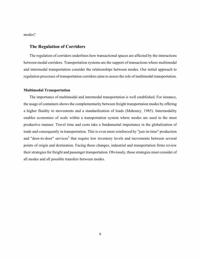
Figure 2 Multimodal Transportation in Corridors
With the development of new modal and intermodal infrastructure, urban regions have a growing
accessibility to the international market; several parameters of regional transportation are
transformed, or at least significantly modified. Figure 2 presents the regulation of movements of a
corridor within a multimodal transportation system composed of a set of competing hub centres
where converge regional and local transportation networks. A hub centre can simultaneously have a
modal and intermodal convergence of functions; particularly if it is the interface between several
modal corridors (see Figure 1). Its modal function indicates the service area while its intermodal
function indicates the level of service. The regional multimodal network converges at major hub
centres allowing linkages with the international transportation system through a maritime / land
interface. Port cities are the main agent of that function.
Multimodal transportation reveals few things about the relationships of hub centres with their
transactional space. It does not consider interactions, only their logistical support. Economic
linkages between hub centres, multimodal transportation and territories must be assessed in a more
comprehensive manner.
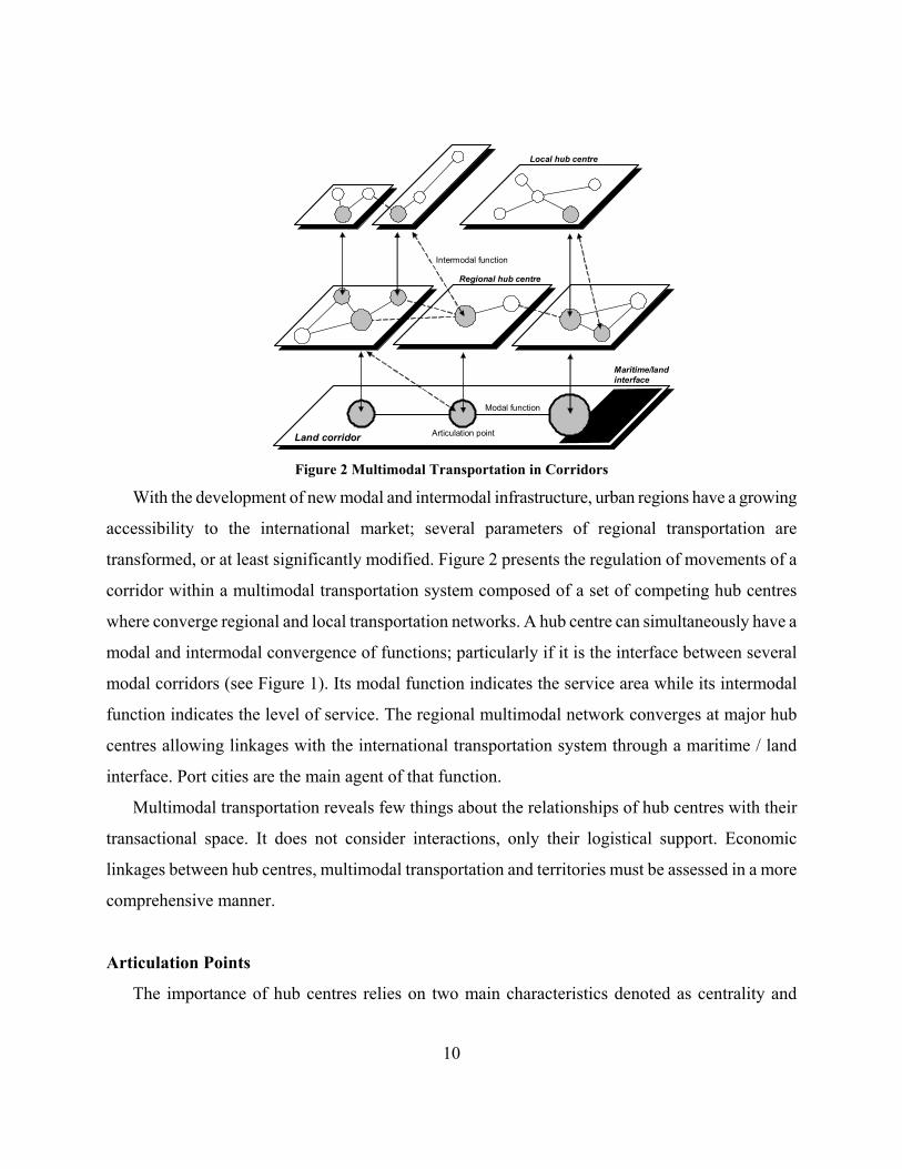
Articulation Points
The importance of hub centres relies on two main characteristics denoted as centrality and
11
intermediacy, which jointly defines their location in a transport system (Fleming and Hayuth, 1994).
To extend further that definition, we bring forward the concept of articulation points, which are the
regional/international conjunction of multimodal infrastructure, logistics and areas of influence in a
transactional/hub centre.
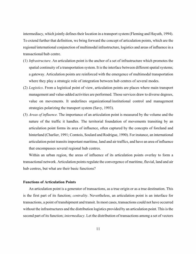
(1) Infrastructure. An articulation point is the anchor of a set of infrastructure which promotes the
spatial continuity of a transportation system. It is the interface between different spatial systems;
a gateway. Articulation points are reinforced with the emergence of multimodal transportation
where they play a strategic role of integration between hub centres of several modes.
(2) Logistics. From a logistical point of view, articulation points are places where main transport
management and value-added activities are performed. Those services draw to diverse degrees,
value on movements. It underlines organizational/institutional control and management
strategies polarizing the transport system (Savy, 1993).
(3) Areas of influence. The importance of an articulation point is measured by the volume and the
nature of the traffic it handles. The territorial foundation of movements transiting by an
articulation point forms its area of influence, often captured by the concepts of foreland and
hinterland (Charlier, 1991; Comtois, Soulard and Rodrigue, 1990). For instance, an international
articulation point transits important maritime, land and air traffics, and have an area of influence
that encompasses several regional hub centres.
Within an urban region, the areas of influence of its articulation points overlay to form a
transactional network. Articulation points regulate the convergence of maritime, fluvial, land and air
hub centres, but what are their basic functions?
Functions of Articulation Points
An articulation point is a generator of transactions, as a true origin or as a true destination. This
is the first part of its function; centrality. Nevertheless, an articulation point is an interface for
transactions, a point of transhipment and transit. In most cases, transactions could not have occurred
without the infrastructures and the distribution logistics provided by an articulation point. This is the
second part of its function; intermediacy. Let the distribution of transactions among a set of vectors

12
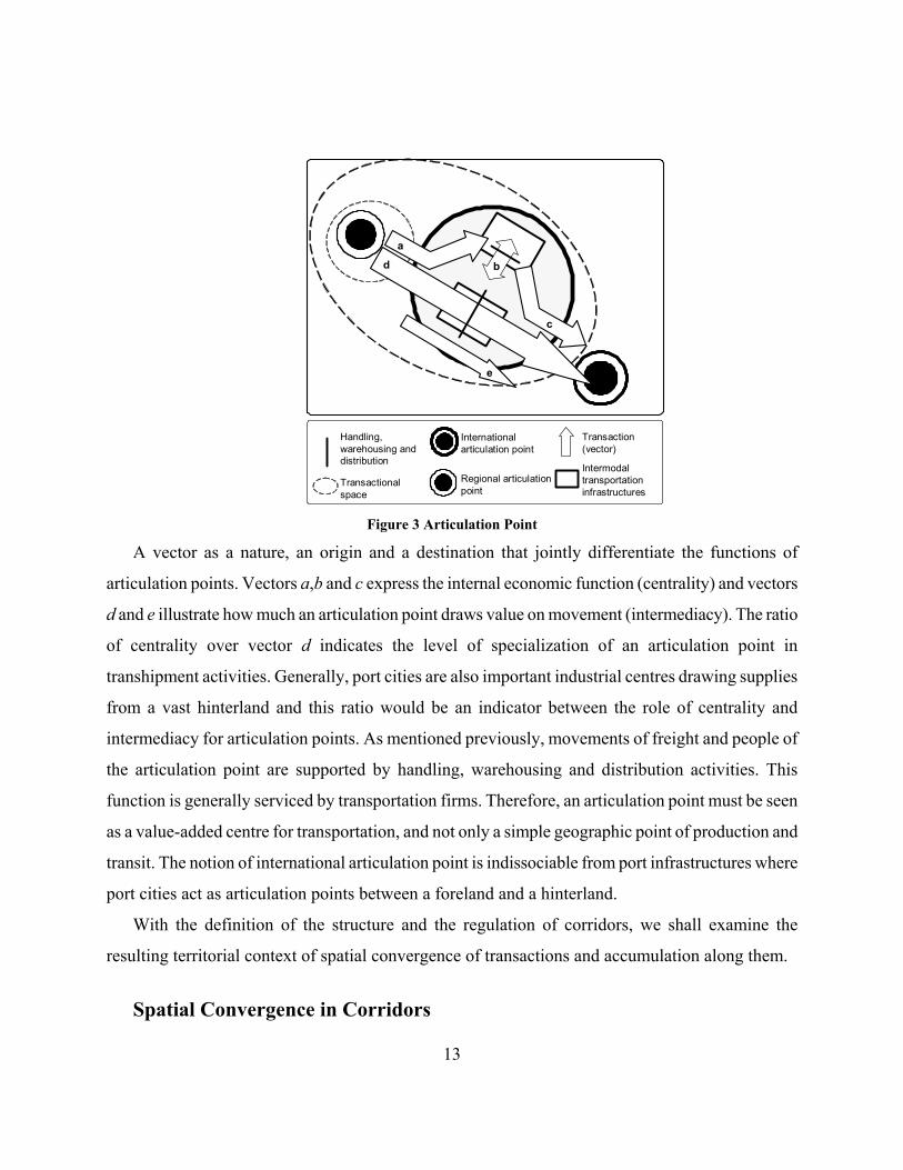
define the functions of articulation points (see figure 3):
(a) The first function of an articulation point, consumption/attractivity, illustrates the inputs of its
economic activities with their role as a true destination for transactions. Inputs can be of varied
nature (freight, people and information) and must transit through intermodal infrastructure.
Vector a is relative to the level of spatial accumulation and to the economic structure of an
articulation point. The more structured and developed a market is, the more likely its
consumption/attractivity function will be important.
(b) The nature and the structure of economic activities are related to the types of exchanges shown
by vector b, the processing function. It illustrates the extent of value added activities in the
economic sector, notably industrial. By itself, processing is not a transaction, but the
transformation of a commodity in another one, whatever its form. For instance it may entail the
manufacturing of a product, from the conversion of resources by work (with different labour
components) to the conversion in capital when it is sold.
(c) The third function, production/emissivity, is the output of the economic activities of an
articulation point (vector c). The articulation point acts as the true origin of transactions. It can
be movements related to the distribution network of the articulation point, or movements related
to economic activities of another articulation point.
(d) The main importance of an articulation point rests on movements that are requiring intermodal
infrastructures (vector d), its transhipment function. The location of the hub centre in regards of
other hub centres and the performance of its intermodal transportation infrastructure is for a
great deal in the importance of vector d where an articulation point draws value on transactions.
(e) Vector e, the transit function, represents movements that circulate through the articulation point,
but are not requiring any handling, warehousing or distribution activities. It emphasises the role
of an articulation point as a geographic point of transit with few economic returns (the traffic is
just passing by).
13
Transactional space
Intermodaltransportation infrastructures
Handling, warehousing and distribution
Transaction (vector)
a
b
c
d
e
International articulation point
Regional articulation point
Figure 3 Articulation Point
A vector as a nature, an origin and a destination that jointly differentiate the functions of
articulation points. Vectors a,b and c express the internal economic function (centrality) and vectors
d and e illustrate how much an articulation point draws value on movement (intermediacy). The ratio
of centrality over vector d indicates the level of specialization of an articulation point in
transhipment activities. Generally, port cities are also important industrial centres drawing supplies
from a vast hinterland and this ratio would be an indicator between the role of centrality and
intermediacy for articulation points. As mentioned previously, movements of freight and people of
the articulation point are supported by handling, warehousing and distribution activities. This
function is generally serviced by transportation firms. Therefore, an articulation point must be seen
as a value-added centre for transportation, and not only a simple geographic point of production and
transit. The notion of international articulation point is indissociable from port infrastructures where
port cities act as articulation points between a foreland and a hinterland.
With the definition of the structure and the regulation of corridors, we shall examine the
resulting territorial context of spatial convergence of transactions and accumulation along them.
Spatial Convergence in Corridors
14
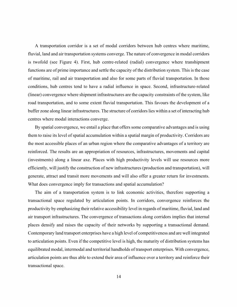
A transportation corridor is a set of modal corridors between hub centres where maritime,
fluvial, land and air transportation systems converge. The nature of convergence in modal corridors
is twofold (see Figure 4). First, hub centre-related (radial) convergence where transhipment
functions are of prime importance and settle the capacity of the distribution system. This is the case
of maritime, rail and air transportation and also for some parts of fluvial transportation. In those
conditions, hub centres tend to have a radial influence in space. Second, infrastructure-related
(linear) convergence where shipment infrastructures are the capacity constraints of the system, like
road transportation, and to some extent fluvial transportation. This favours the development of a
buffer zone along linear infrastructures. The structure of corridors lies within a set of interacting hub
centres where modal interactions converge.
By spatial convergence, we entail a place that offers some comparative advantages and is using
them to raise its level of spatial accumulation within a spatial margin of productivity. Corridors are
the most accessible places of an urban region where the comparative advantages of a territory are
reinforced. The results are an appropriation of resources, infrastructures, movements and capital
(investments) along a linear axe. Places with high productivity levels will use resources more
efficiently, will justify the construction of new infrastructures (production and transportation), will
generate, attract and transit more movements and will also offer a greater return for investments.
What does convergence imply for transactions and spatial accumulation?
The aim of a transportation system is to link economic activities, therefore supporting a
transactional space regulated by articulation points. In corridors, convergence reinforces the
productivity by emphasizing their relative accessibility level in regards of maritime, fluvial, land and
air transport infrastructures. The convergence of transactions along corridors implies that internal
places densify and raises the capacity of their networks by supporting a transactional demand.
Contemporary land transport enterprises have a high level of competitiveness and are well integrated
to articulation points. Even if the competitive level is high, the maturity of distribution systems has
equilibrated modal, intermodal and territorial handholds of transport enterprises. With convergence,
articulation points are thus able to extend their area of influence over a territory and reinforce their
transactional space.
15
Considering that a fragmented production system enables to better exploit comparative
advantages of places while keeping equivalent distribution costs, it is logical to assume that spatial
accumulation converges along transportation corridors. The convergence of spatial accumulation in
corridors thus reflects a tentativeness of minimum entropy in a situation that could extend activities
over a wider territory. Economies of agglomeration can be exploited in a linear fashion instead of the
more conventional punctual forces of agglomeration. Accessibility, by itself does not guarantee
spatial accumulation, nor it is the sole factor for convergence. However, raising accessibility levels
favours the territorial convergence of spatial accumulation because accessibility rarely comes alone,
but is often the reflection of a developed transactional space (vast markets, structured distribution
systems, diversified economic production, etc.).
Contemporary dynamics of industrial production mainly aim on using the advantages of labour
and resources to lower production costs, a strategy widely pursued by transnational firms. This has
implied a fragmentation of productive forces in a new production system3. The corridor then offers
an accessible penetration axe for fragmented production systems over a territory. Outputs of that
new production system are for the regional and international markets, but considering that the
regional market of emerging corridors is in full expansion, industrial strategies rather aim to supply
that growing market than try to penetrate an already heavily competitive international market.
Articulation points - as gateways - play a fundamental role in the regional economic system, but
more importantly as centres for regional distribution. They consequently regulate the conditions and
the location of spatial accumulation.
The tendency for articulation point is to develop and reinforce their transhipment functions while
relocating production and processing functions along the corridor. For peripheral zones of the
corridor, convergence implies their integration to various extents by changes in their economic
functions, depending on their comparative advantages. Even within the margin of productivity, the
objective is not necessary to cover the territory, but to link the most important centres of the corridor
in a productive regional transactional network. The structure and regulation of transactions and
spatial accumulation are likely to be homogeneous among different corridors while the resulting
landscapes are heterogeneous. East and Southeast Asian urban regions are a notable context where
16
transactions and spatial accumulation converge along corridors. The next section will try to assess a
preliminary overview of that situation.
Main zone of convergence
Peripheral zone in integration
Seasho
reExtension of convergence
Main Articulation point
Main transactional network
Figure 4 Convergence of Transactions and Spatial Accumulation in a Land Corridor
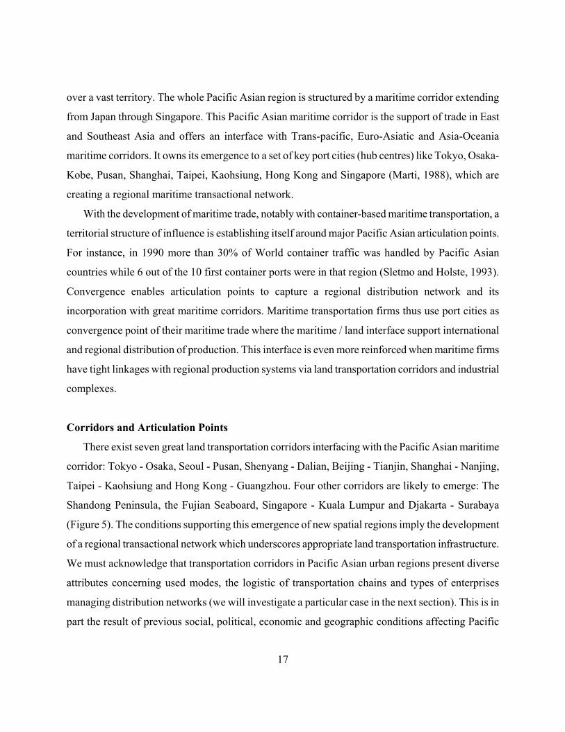
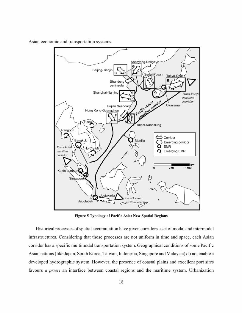
East and Southeast Asian corridors As East and Southeast Asian nations redefine their position in the global economy, they also do
the same in regards of their status as regional entities. Economic development and growth in
regional trade brought several scholars towards the concept of Pacific Asia (Drakakis-Smith, 1991).
To further extend this concept, we look upon its urban regions and their corridors are a major
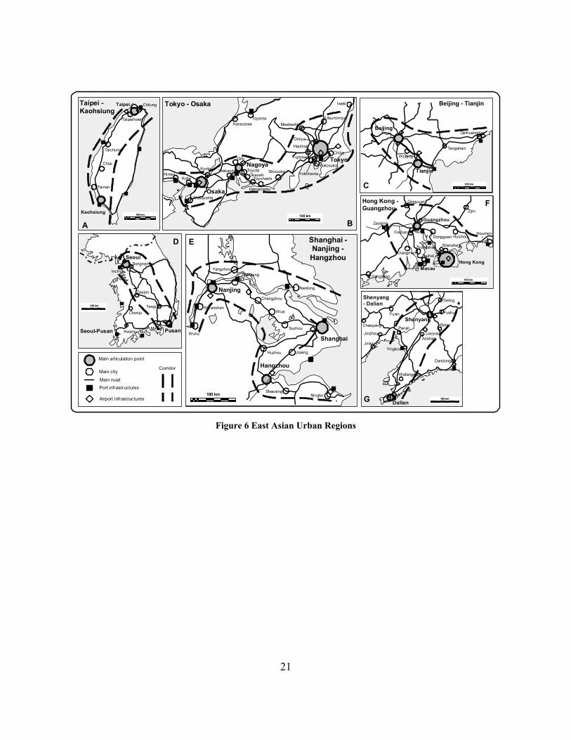
economic constituent. A typological analysis of Pacific Asian urban regions places them in two main
categories of spatial regions; EMRs and their superset, corridors (figure 5). While Southeast Asian
urban regions are mostly single EMRs, East Asian urban regions structure themselves along
corridors linking more than one EMR (Figure 6). A preliminary explanation rests on the fact that
East Asian nations have a more dense and developed urban system than their Southeast Asian
counterparts; the results of a historical process of spatial accumulation in productive rural activities
17
over a vast territory. The whole Pacific Asian region is structured by a maritime corridor extending
from Japan through Singapore. This Pacific Asian maritime corridor is the support of trade in East
and Southeast Asia and offers an interface with Trans-pacific, Euro-Asiatic and Asia-Oceania
maritime corridors. It owns its emergence to a set of key port cities (hub centres) like Tokyo, Osaka-
Kobe, Pusan, Shanghai, Taipei, Kaohsiung, Hong Kong and Singapore (Marti, 1988), which are
creating a regional maritime transactional network.
With the development of maritime trade, notably with container-based maritime transportation, a
territorial structure of influence is establishing itself around major Pacific Asian articulation points.
For instance, in 1990 more than 30% of World container traffic was handled by Pacific Asian
countries while 6 out of the 10 first container ports were in that region (Sletmo and Holste, 1993).
Convergence enables articulation points to capture a regional distribution network and its
incorporation with great maritime corridors. Maritime transportation firms thus use port cities as
convergence point of their maritime trade where the maritime / land interface support international
and regional distribution of production. This interface is even more reinforced when maritime firms
have tight linkages with regional production systems via land transportation corridors and industrial
complexes.
Corridors and Articulation Points
There exist seven great land transportation corridors interfacing with the Pacific Asian maritime
corridor: Tokyo - Osaka, Seoul - Pusan, Shenyang - Dalian, Beijing - Tianjin, Shanghai - Nanjing,
Taipei - Kaohsiung and Hong Kong - Guangzhou. Four other corridors are likely to emerge: The
Shandong Peninsula, the Fujian Seaboard, Singapore - Kuala Lumpur and Djakarta - Surabaya
(Figure 5). The conditions supporting this emergence of new spatial regions imply the development
of a regional transactional network which underscores appropriate land transportation infrastructure.
We must acknowledge that transportation corridors in Pacific Asian urban regions present diverse
attributes concerning used modes, the logistic of transportation chains and types of enterprises
managing distribution networks (we will investigate a particular case in the next section). This is in
part the result of previous social, political, economic and geographic conditions affecting Pacific
18
Asian economic and transportation systems.
Tokyo-OsakaSeoul-Pusan
Shenyang-Dalian
Beijing-Tianjin
Shanghai-Nanjing
Taipei-Kaohsiung
Manilla
Hong Kong-Guangzhou
Ho Chi Minh
Bangkok
Jabotabek
Singapore
15007500km
15007500km
Jogjakarta
Kuala Lumpur
Shandong peninsula
Pacific-A
sian
maritime c
orridor
Hanoi
CorridorEmerging corridorEMREmerging EMR
Rangoon
A
B
C
D
E
F
G
Euro-Asiatic maritime corridor
Trans-Pacific maritime corridor
Asia-Oceania maritime corridor
OkayamaFujian Seaboard
Figure 5 Typology of Pacific Asia: New Spatial Regions
Historical processes of spatial accumulation have given corridors a set of modal and intermodal
infrastructures. Considering that those processes are not uniform in time and space, each Asian
corridor has a specific multimodal transportation system. Geographical conditions of some Pacific
Asian nations (like Japan, South Korea, Taiwan, Indonesia, Singapore and Malaysia) do not enable a
developed hydrographic system. However, the presence of coastal plains and excellent port sites
favours a priori an interface between coastal regions and the maritime system. Urbanization
19
corridors thus take an orientation along seacoasts. The low importance of fluvial transportation is
compensated by high capacity rail and road networks, notably in Japan with its high speed train
system.
The geographical conditions of Chinese coastal regions have their urbanization corridors initially
oriented along fluvial corridors, notably the Zhujiang and the Changjiang. Maritime / land interface
occurs generally downstream (i.e. Shanghai, Hong Kong and Tianjin) and favours corridors
perpendicular to coasts where fluvial transportation offers an essential support to movements. The
development of subsequent land transportation infrastructures only underline the existing fluvial axe
by allowing the support of a new transportation logistics. Another emerging fluvial corridor is the
Mekong, which plays a growing role in the developing economies of continental Southeast Asia
(Vietnam, Kampuchea, Thailand, Laos and Burma). It could offer a fluvial gateway of populous
southern China provinces (like Sichuan and Yunnan) to the Pacific Ocean without using the
congested transport system of Guangdong province. However, no significant point of maritime /
fluvial interface currently exists, but Ho Chi Minh City could eventually play this role for the
Mekong fluvial corridor.
Modes and the relationships between them impose different logistics in urbanization corridors of
Pacific Asia. In an economy leaning on heavy industries, port cities take a significant importance in
regards of the limited capacity to convey ponderous and bulk goods towards the hinterland. For
instance, Japanese, Taiwanese and South Korean ports are important heavy industrial complexes
leaning on steel, naval construction and petrochemical activities. However, transformations within
production systems over the last 20 years mainly rest upon the light industrial sector. This sector
with a maritime / road logistic enables to better exploit the territorial advantages of corridors since it
is less limited in space. The development of containers supports efficiently this logistic. Japan, South
Korea, Hong Kong, Singapore and Taiwan, by developing a maritime expertise, were initiators of
this multimodal logistic within Asia and play an important role as articulation points. Air
transportation also reflects the emergence of a new transactional space. Major Pacific Asian hubs,
such as Tokyo, Seoul, Hong Kong, Taipei and Singapore perform important financial functions,
airline hubbing, and transit (Hansen and Kanafani, 1990; Sletmo and Holste, 1993).
20
The transactional functions of articulation points and corridors are difficult to capture,
particularly since the development of hinterlands and the fragmentation of economic systems in
specialized functions. To illustrate this, an example that looks simple may prove to involve several
transactions. Take for instance an enterprise looking for a way to manufacture some labour intensive
parts of a product in order to reduce production costs in a competitive global environment. It may
negotiate a business agreement with a conglomerate in Hong Kong (maybe through a strategic
alliance), while the production will be performed by a Chinese enterprise in Shenzhen (a joint
venture in part owned by the former) that draws resources and may even subcontract from several
mainland China enterprises. Another Hong Kong enterprise will transport and tranship the
production (in cooperation with a state-owned Chinese transport firm), which may be assembled and
sold elsewhere (product management and marketing). In this multiplicity of actors involved what is
kept relatively constant is the regulation and the convergence of transactions in Hong Kong. Thus,
transactions may be more important to investigate than industrial production if we are to capture
urbanization processes in Pacific Asia, or in any other region.
Figure 7 gives a preliminary overview of the functions of two major articulation points in Pacific
Asia: Singapore and Hong Kong4. Those articulation points have a similar function of convergence
of transactions (vector a), but it appears that Hong Kong has a more important function of regional
convergence than Singapore. In both cases this function is very important and growing. 15.5% of the
exports of Singapore are based upon transhipment functions while this value reaches 32.3% for
Hong Kong (vector d). Several factors can be linked to this situation, like the better integration of
Hong Kong with its regional transactional network, notably Mainland China (Hsia, 1984; Rimmer,
1992). Over this, fluvial transportation plays a significant role in Hong Kong as 12.7% of
commercial cargo involved that mode in 1991. Obviously, there is no transit function (vector e) for
those articulation points.
21
Hong Kong
Guangzhou
Shenzhen
Dongguan Huizhou
Zijin
Qingyuan
Zaoqing
Foshan
JiangmenZhongshan
Zhuhai
MacauYangjiang
Houmen
Hong Kong -Guangzhou
100 km100 km
F
Pusan
Seoul
Taejon
Chonju
KwanjuMasan
Taegu
Songnam-si
Inch'on
Seoul-Pusan
Dalian
Wafangdian
Dandong
YingkouJinxin
JinzhouPanjinChaoyang
Fuxin
AnshanLiaoyang
BenxiShenyang
Fushun
TielingShenyang- Dalian
Qinhuangdao
Tangshan
Wuqing
Beijing
Tianjin
Beijing - Tianjin
Shanghai
Hangzhou
Nanjing
NingboShaoxing
JiaxingHuzhou
Suzhou
Wuxi
Changzhou
Nantong
ZhenjiangYangzhou
Ma'anshan
Wuhu
100 km100 km
Shanghai -Nanjing -
Hangzhou
Taipei Chilung
Taipeihsien
Taichung
Chiai
Tainan
Kaohsiung
Taipei -Kaohsiung
Tokyo
Tokyo - Osaka
Nagoya
Osaka
Iwaki
Utsunomiya
Chiba
Omiya
Yokohama
Yokosuka
Fujisawa
Hachioji
MaebashiToyama
Kanazawa
Gifu
Shizuoka
ToyohashiOkazaki
Hamamatsu
ToyotaYokkaichiKyoto
Wakayama
KobeHimeji
Port infrastructures
Airport infrastructures
Main articulation point
Main city
Main road
100 km100 km100 km100 km
100 km100 km
100 km100 km
100 km100 km
Corridor
A B
C
D E
G
Figure 6 East Asian Urban Regions
22
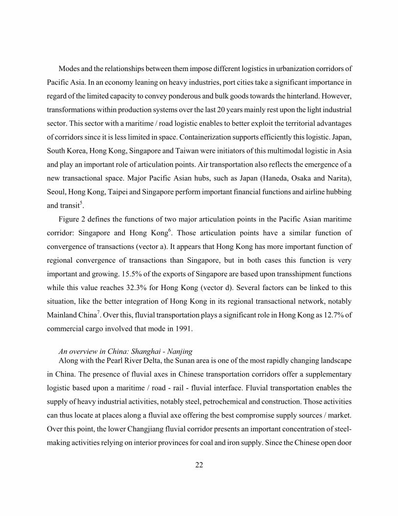
Modes and the relationships between them impose different logistics in urbanization corridors of
Pacific Asia. In an economy leaning on heavy industries, port cities take a significant importance in
regard of the limited capacity to convey ponderous and bulk goods towards the hinterland. However,
transformations within production systems over the last 20 years mainly rest upon the light industrial
sector. This sector with a maritime / road logistic enables to better exploit the territorial advantages
of corridors since it is less limited in space. Containerization supports efficiently this logistic. Japan,
South Korea, Hong Kong, Singapore and Taiwan were initiators of this multimodal logistic in Asia
and play an important role of articulation points. Air transportation also reflects the emergence of a
new transactional space. Major Pacific Asian hubs, such as Japan (Haneda, Osaka and Narita),
Seoul, Hong Kong, Taipei and Singapore perform important financial functions and airline hubbing
and transit5.
Figure 2 defines the functions of two major articulation points in the Pacific Asian maritime
corridor: Singapore and Hong Kong6. Those articulation points have a similar function of
convergence of transactions (vector a). It appears that Hong Kong has more important function of
regional convergence of transactions than Singapore, but in both cases this function is very
important and growing. 15.5% of the exports of Singapore are based upon transshipment functions
while this value reaches 32.3% for Hong Kong (vector d). Several factors can be linked to this
situation, like the better integration of Hong Kong in its regional transactional network, notably
Mainland China7. Over this, fluvial transportation plays a significant role in Hong Kong as 12.7% of
commercial cargo involved that mode in 1991.
An overview in China: Shanghai - Nanjing Along with the Pearl River Delta, the Sunan area is one of the most rapidly changing landscape
in China. The presence of fluvial axes in Chinese transportation corridors offer a supplementary
logistic based upon a maritime / road - rail - fluvial interface. Fluvial transportation enables the
supply of heavy industrial activities, notably steel, petrochemical and construction. Those activities
can thus locate at places along a fluvial axe offering the best compromise supply sources / market.
Over this point, the lower Changjiang fluvial corridor presents an important concentration of steel-
making activities relying on interior provinces for coal and iron supply. Since the Chinese open door
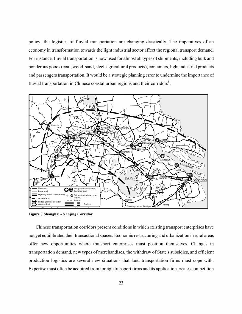
23
policy, the logistics of fluvial transportation are changing drastically. The imperatives of an
economy in transformation towards the light industrial sector affect the regional transport demand.
For instance, fluvial transportation is now used for almost all types of shipments, including bulk and
ponderous goods (coal, wood, sand, steel, agricultural products), containers, light industrial products
and passengers transportation. It would be a strategic planning error to undermine the importance of
fluvial transportation in Chinese coastal urban regions and their corridors8.
Shanghai
Luijia
NantongZhangjiagang
Jiangyin
Changshu
Zhenjiang
Yangzhou Gaogang
Nanjing
Ma'anshan
WuhuKunshanSuzhou
Jiaxing
Huzhou
Wuxi
Changzhou
Danyang
Chuzhou
Main roadLocal road
Highway (under construction)
Bridge (planned or under construction)
Port (under construction)Container port
Rail station (rail station and railyard)
Basemap: Martin Rodrigue
Railroad
Corridor
Grand Canal
Tai Hu
Changjiang
Figure 7 Shanghai - Nanjing Corridor
Chinese transportation corridors present conditions in which existing transport enterprises have
not yet equilibrated their transactional spaces. Economic restructuring and urbanization in rural areas
offer new opportunities where transport enterprises must position themselves. Changes in
transportation demand, new types of merchandises, the withdraw of State's subsidies, and efficient
production logistics are several new situations that land transportation firms must cope with.
Expertise must often be acquired from foreign transport firms and its application creates competition
24
over existing distribution systems in addition to new modes and infrastructure. Figure 8 and 9
present the Shanghai - Nanjing corridor from three modal perspectives:
(1) Maritime. The maritime corridor sees the addition of new articulation points redefining the
transactional spaces of existing ports and their maritime / land interface. The emergence of small
and medium sized ports is a tendency in the Changjiang delta favoured by local government
initiatives. Since the introduction of market mechanisms, small and medium ports tend to
diversify their activities, to offer new services, and to raise their catchment area. Some ports are
already specialized in containers transhipment (notably Zhangjiagang) while others see
containers taking a growing part of their maritime / land interface function (Shanghai and
Nanjing). The convergence of industrial functions inland shifts the functions of the main port
city (Shanghai) towards transhipment while creating demands on emerging ports along the
Changjiang. However, the maritime traffic is limited to 50,000 tons vessels at the river's entrance
near Shanghai.
(2) Fluvial. The Grand Canal and the Changjiang are the main fluvial transportation axes for the
corridor. One of the main strategies for inland transportation is to use the Changjiang for high
capacity barges, break the shipments and then use the Grand Canal (and its numerous
subsidiaries) for local distribution. Jiangyin and Zhenjiang ports are the main transhipment
centres to perform that function while Suzhou, Wuxi and Changzhou are major inland fluvial
ports and articulation points. In fact, a waterway between Jiangyin and Wuxi is the most heavily
used in China, but can only convey barges of less than 300 tonnes. Facing the congestion of the
rail system and the limited capacity of the road system, fluvial transportation serves as a major
freight transportation mode in the Shanghai - Nanjing corridor, notably for coal. Perspectives for
the development of fluvial transportation in the corridor are numerous since fluvial
transportation has a more extensive spatial coverage than road transportation in several parts of
the Jiangsu province.
(3) Land. The road transportation system favours a local convergence towards important urban
centres, like Suzhou, Wuxi and Changzhou. Regional movements are not helped by this type of
network aiming on a uniform accessibility that converges at road articulation points. This well
25
reflects the Chinese urban hierarchy where a city have control over a set of counties. The
construction of a regional highway will link those local articulation points along a linear
corridor. Improving the interactions between the two banks of the Changjiang is also of strategic
importance for land transportation in the delta. They (north and south banks) basically form two
separate land corridors. The only existing bridge (Nanjing) is congested by the overlay of intra-
urban and regional traffics9. This north-south land interface will be improved by bridges at
Jiangyin (under construction) and Zhenjiang (planned). Industrial activities of the southern bank
will have a greater access to the land, labour and resources of the northern bank.
One of the important logistical problem of rail transportation is the congestion of transhipment
infrastructures. Over the last decade, growth of the rail system did not follow the growth of the
economy. The overlay of freight (mostly coal) and passenger rail transportation imposes
supplementary constraints leaning on logistical incompatibilities between the two modes; the
needs of segregation between passenger and freight traffic are very important in the Shanghai -
Nanjing corridor, as it is in China. Also, the handhold of state enterprises over the priority of
transhipment does not favour a rationalization of the rail freight distribution systems. Projects of
high speed trains between Shanghai and Nanjing are considered and will underline, once
established, main inland articulation points.
The Shanghai - Nanjing corridor is affected by a strong process of convergence of transactions and spatial accumulation in a linear buffer zone along the Changjiang. Existing transportation development strategies underline the emergence of new articulation points and the redefinition of the functions of existing ones. Conclusion: Asian Corridors and Divergence Conventional approaches to urbanization have tended to split the territorial functions of
economic systems from the distribution functions of the transport system. We have proposed that
corridors provide integration between those functions. They reinforce the convergence of
transactions and spatial accumulation. The structure and regulation of corridors put the emphasis on
major articulation points where transactional functions are performed. Their maritime / land
interface supports transhipment functions between vast forelands and hinterlands. Convergence
26
spatially implies an uneven distribution of economic activities along a corridor, because territories
present inequalities in comparative advantages and thus of productivity. As an ongoing process of
spatial accumulation, convergence raises the question wether if it can eventually bring divergence.
Divergence is a set of processes that are initiated by drops of productivity in some sectors of the
economy. At a level of convergence, problems of congestion and inflation are likely to appear,
which maybe had seen as deseconomies of agglomeration and deseconomies of scale. Congestion
implies higher distribution costs and even unreliance of supply. This can force the usage of new
alternatives and new logistics and also it may change the regional - if not international - importance
of several articulation points. Inflation implies supplementary costs over labour, resources and
production. With spatial accumulation, a proportional inflational process occurs. At a certain point,
comparative advantages of some economic sectors may not be furthermore justified. High inflation
rates in China (around 20% for 1993 and 1994) already bring forward this dimension, but
technological improvements in production and distribution systems limit prospective attempts.
Along Pacific Asia, the structures, forms and levels of spatial accumulation are heterogeneous,
but we have seen that corridors offer a homogeneous structure for regional spatial accumulation.
Well structured corridors like Tokyo-Osaka, Seoul-Pusan and Taipei-Kaohsiung are affected by a
divergence of several labour/space-intensive activities and the convergence of knowledge-intensive
ones. This is also the case for the advanced economies of Hong Kong and Singapore, articulation
points of emerging corridors. New spatial regions, like Shanghai - Nanjing, Hong Kong -
Guangzhou (Pearl River Delta) and Shenyang - Dalian experience convergence to diverse degrees of
economic activities (mostly, but not entirely, labour intensive). It must be pointed out that areas in
fast development are also under strong inflational and congestion growth like Beijing, Shanghai,
Guangzhou and Bangkok EMRs. Already, several activities recently implemented face drops in
productivity that tends to extend corridors further inland. Convergence and divergence are thus
highly related as a part of the spatial distribution of economic activities within a transactional space.
As long as an economic system requires the distribution in space of goods, people and
information, transportation and communication will play a role in the structure and regulation of
territories and their transactional networks. Over this, an investigation in the role of port cities as
27
articulation points between forelands and hinterlands would reveal a lot of information about their
functions within transportation corridors. We have brought here an overview of this situation.
BIBLIOGRAPHY Aldcroft, D. and M. Freeman (eds) (1983) Transport in the Industrial Revolution, Manchester:
Manchester University Press. Charlier, J. (1991) "L'arriPre-pays national du port du Havre", L'Espace GJographique, No. 4, pp.
325-334. Comtois, C., F. Soulard and J-P Rodrigue (1990) "The Canadian Foreland of Chinese Ports",
Journal of Oriental Studies, Vol. 28, No. 2, pp. 167-187. Drakakis-Smith, D. (1991) Pacific Asia, London: Rouledge. Dwyer, D.J. (ed) (1990) Southeast Asian Development: Geographical Perspectives, Esses, England:
Longman. Fleming, D.K. and Y. Hayuth (1994) "Spatial Characteristics of Transportation Hubs: Centrality and
Intermediacy", Transport Geography, Vol. 2, No. 1, pp. 3-18. Ginsburg, N., B. Koppel and T.G. McGee (1991) The Extended Metropolis: Settlement Transition in
Asia, Honolulu: University of Hawaii Press. Hansen, M. and A. Kanafani (1990) "Airline Hubbing and Airport Economics in the Pacific
Market", Transportation Research A, Vol. 3, pp. 217-230. Hansen, M. and A. Kanafani (1988) "International Airline Hubbing in a Competitive Environment",
Transportation Planning and Technology, Vol. 13, pp. 3-18. Hayuth, Y. (1988) "Rationalization and Deconcentration of the U.S. Container Port System", The
Professional Geographer, Vol. 40, No. 3, pp. 279-288. Hayuth, Y. (1987) Intermodality: Concept and Practice, Essex, England: Lloys's and London Press. Hayuth, Y. (1984) "Port Development in Light of Intermodal Transport" in New Challenges for
Shipping and Ports, Haifa: Israel Shipping and Aviation Research Institute, pp. 126-133. Hayuth, Y. (1981) "Containerization and the Load Center Concept", Economic Geography, Vol. 57,
28
pp. 160-175. Hoyle, B.S. and D. Hilling (eds) (1984) Seaport Systems and Spatial Change: Technology, Industry
and Development Strategies, Chichester, NY: Willey. Hoyle, B.S. (ed) (1973) Transport and Development, London: Macmillan. Hsia, R. (1984) The Entrepot Trade of Hong Kong with Special Reference to Taiwan and the
Chinese Mainland, Taipei: Chung-Hua Institution for Economic Research, Mainland China Economic Series no. 2.
Lasserre, J-C (1992) "Typologie du transport fluvial dans le monde et de son r^le dans les chaTnes de
transport", paper presented at The 6th World Conference on Transport Research, Lyon, France. Mahoney, J.H. (1985) Intermodal Freight Transportation, Westport, CT: Eno Foundation for
Transportation. Marcadon, J. and J-F Mougard (1994) "L'intermodalisme et la compJtition portuaire sur la c^te
Ouest des Itats-Unis", Norois, Vol. 41, No. 161, pp. 19-32. Marti, B. (1988) "The Evolution of Pacific Basin Load Centres", Maritime Policy and Management,
Vol. 15, No. 1, pp. 57-66. Rimmer, P.J. (1992) Hong Kong's Future as a Regional Transport Hub, Camberra: Strategic and
Defence Studies Centre. Rissoan, J.P. (1994) "River-sea Navigation in Europe", Transport Geography, Vol. 2, No. 2, pp.
131-142. Rodrigue, J-P (1994) "Transportation and Territorial Development in the Singapore Extended
Metropolitan Region", Singapore Journal of Tropical Geography, Vol. 15, No. 1, pp. 56-74. Savy, M. (1993) "Logistique et territoire", L'Espace GJographique, No. 3, pp. 210-218. Slack, B. (1990) "Intermodal Transportation in North America and the Development of Inland Load
Centers", The Professional Geographer, Vol. 42, No. 1, pp. 72-83. Slack, B. (1994) "Pawns in the Game: Ports in a Global Transportation System", Growth and
Change, Vol. 24, pp. 587-598. Sletmo, G.K. and S. Holste (1993) "Pacific Transportation Services", in Pacific Enterprises and
Pacific Cooperation, Boulder: Westview Press, pp. 107-140.
29
VigariJ, A. (1993) Ichanges et transports internationaux depuis 1945, Paris: Iditions Dalloz. Whebell, C.F.J. (1969) "Corridors: A Theory of Urban Systems", Annals of the Association of
American Geographers, Vol. 59, No. 1, pp. 1-26. Wolkowitsch, M. (1987) "Le dJveloppement du rJseau mondial des lignes B grande vitesse:
rJalisations et projets", Annales de GJographie, No. 535, pp. 273-291. NOTES This research was supported by a grant from the Social Sciences and Humanities Research Council of Canada.
NOTES
1. Perspectives on the international division of labour and production are discussed for instance in Frobel, F., J. Heinrichs and O. Kreye (1980) The New International Division of Labour, Cambridge: Cambridge University Press, in Scott, A.J. and M. Storper (eds) (1986) Production, Work, and Territory: The Geographical Anatomy of Industrial Capitalism, Boston: Allen & Unwin, in Knox, P. and J. Agnew (1989) The Geography of the World Economy, London: Edward Arnold, in Smith, M.P. and J.R. Feagin (eds) (1987) The Capitalist City: Global Restructuring and Community Politics, Oxford and New York: Basil Blackwell, and in Scott, A.J. (1986) "Industrialization and Urbanization: A Geographical Agenda", Annals of the Association of American Geographers, Vol. 76, No. 1, pp. 25-37.
2. We may argue that this logistic is more "around-time" and "in-the-neighbourhood", notably in the context of congested Asian urban regions. True "just-in-time" logistics requires very high productivity levels.
3. For a discussion on emerging industrial production systems in a post-Fordist environment, see Amin, A. (ed) (1994) Post-Fordism: A Reader, Oxford: Blackwell.
4. Sources: Singapore (1990) Singapore Yearbook, Singapore: Department of Statistics; and Hong Kong (1992) Annual Digest of Statistics, Census and Statistics Department.
5. Hansen, M. and A. Kanafani (1990) "Airline Hubbing and Airport Economics in the Pacific Market", Transportation Research A, Vol. 3, pp. 217-230.
6. Sources: Singapore (1990) Singapore Yearbook, Singapore: Department of Statistics; and Hong Kong (1992) Annual Digest of Statistics, Census and Statistics Department.
7. Hsia, R. (1984) The Entrepot Trade of Hong Kong with Special Reference to Taiwan and the Chinese Mainland,
30
Taipei: Chung-Hua Institution for Economic Research, Mainland China Economic Series no. 2.
8. Much research remain to be undertaken on this relatively neglected transportation mode.
9. Industrial development plans of the Nanjing municipality on the northern bank of the Changjiang will create supplementary demands, which undermine an already congested bridge.