Embed Size (px)
Citation preview
TOWN OF GANDER
MUNICIPAL PLAN
2009-2019
Gazetted: April 23, 2010
Consolidation Date: n/a
Amendments: To see if there were any amendments to this document
since it came into effect, please refer to:
List of Amendments
Town of Gander
Municipal Plan
2009 – 2019
In Effect: April 23, 2010
(Date published in NL Gazette) Please refer to list of Municipal Plan Amendments for changes to this document
Prepared by:
ADI Limited
and
Newfoundland and Labrador
Consulting Engineers Ltd.
April 2009
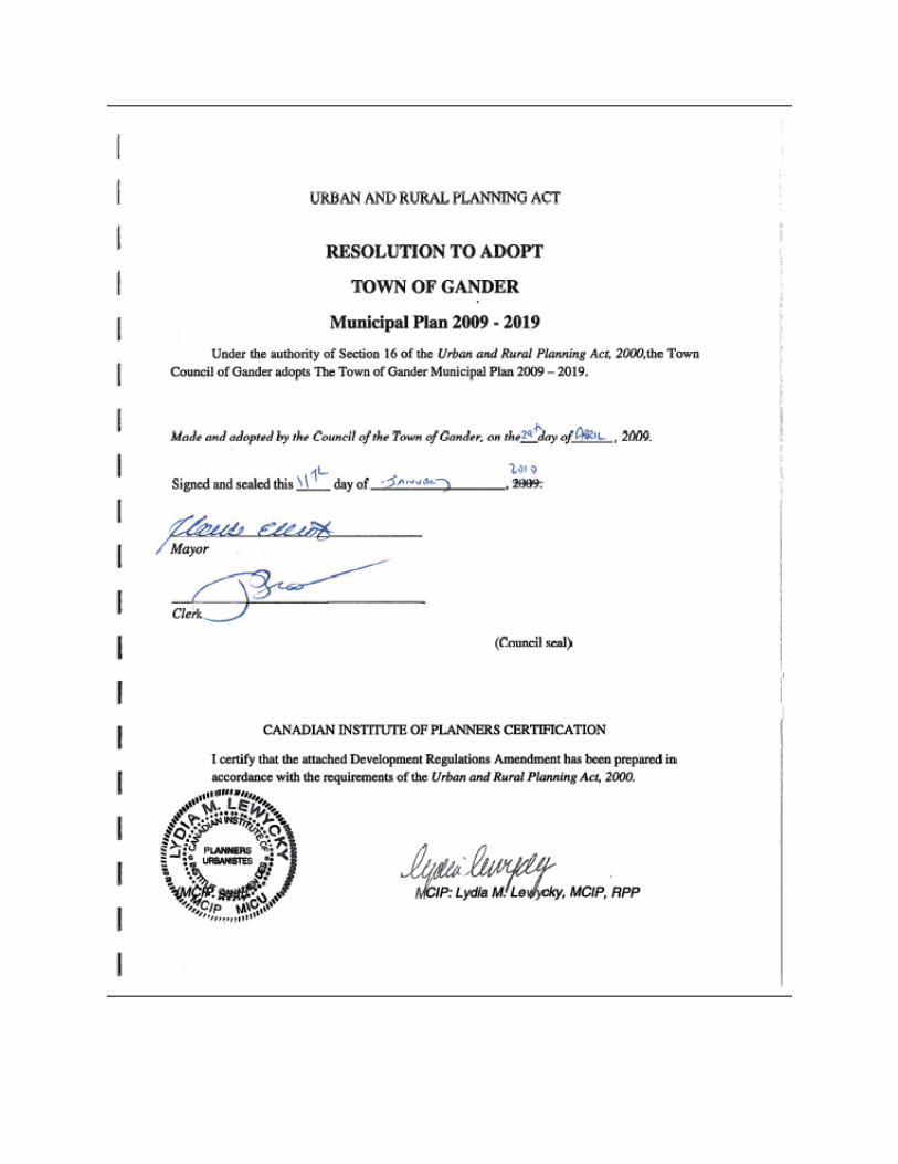
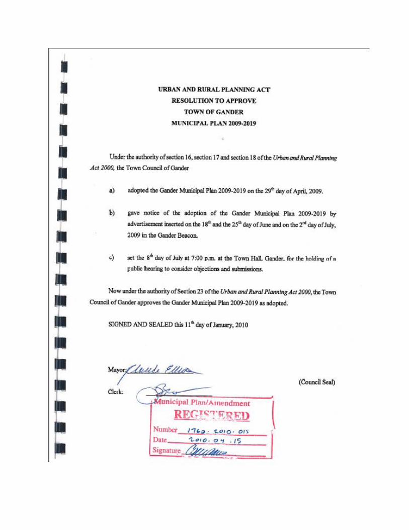
URBAN AND RURAL PLANNING ACT
RESOLUTION TO APPROVE
TOWN OF GANDER
MUNICIPAL PLAN 2009-2019
Uoderthe authority of section 16, section 17 aod section 18 of the UrbanandRuro/ Planning
Act 2()()(), the Town Couocil of Gaoder
a) adopto<I the Oaru1er Municipal Plan 2009-2019 OD the 29"' day of April, 2009.
lb) gave ootice of the adoption of the Garnier Municipal Plan 2009-2019 by
advertisement inserted oo tbc 18~ aod the 25"' day of June and oo the 2"' day of July,
2009 in tbc Ollllder 5*oo.
e) set the s• day of July at 7:00 p.m. at the Town Hall Gander. for the holding ofa
public bcariog to consider objections and submissions.
Now under the authority of Section 23 of the Urban and Rural PlaMing Act 20()(), lb: Town
Council of Gander appro""' the Gaod<t Municipal Plan 2009-2019 as adopted.
SIONED AND SEALED this 116 day of JllllWII)', 2010
Mayor/,'.U,u/, f//~
I (Council Seal)
Clerk:
.__.....,,..unicipal Pl:utl Arnendment
TABLE OF CONTENTS
1.0 INTRODUCTION ............................................................................................................... 1
1.1 Purpose of the Plan ........................................................................................................... 1
2.0 GOALS AND OBJECTIVES .............................................................................................. 3
2.1 Community Structure and Character ................................................................................ 3
2.2 Economic Development ................................................................................................... 4
2.3 Commercial and Industrial Development ........................................................................ 5
2.4 Housing ............................................................................................................................ 6
2.5 Culture, Recreation and Open Space................................................................................ 7
2.6 Municipal Services ........................................................................................................... 8
2.7 Transportation .................................................................................................................. 9
2.8 Environment ................................................................................................................... 10
2.9 Municipal Finances ........................................................................................................ 11
2.10 Municipal Plan Administration ...................................................................................... 12
3.0 LAND USE POLICIES ..................................................................................................... 13
3.1 Introduction .................................................................................................................... 13
3.2 General Development Policies ....................................................................................... 13
3.3 General Land Use ........................................................................................................... 15
3.3.1 Land Use Designations ........................................................................................... 15
3.3.2 Non-Conforming Uses ............................................................................................ 16
3.3.3 Subdivision Policies ................................................................................................ 17
3.4 Residential Development Policies .................................................................................. 19
3.4.1 Multiple Dwelling Units ......................................................................................... 21
3.4.2 Mobile Homes ......................................................................................................... 22
3.4.3 Special Housing ...................................................................................................... 22
3.4.4 Commercial Uses in Apartment Buildings ............................................................. 22
3.4.5 Non-Residential Uses.............................................................................................. 23
3.4.6 Home Based Businesses ......................................................................................... 23
3.4.7 Neighbourhood Commercial Uses in Residential Zones ........................................ 23
3.4.8 Rural Residential Development .............................................................................. 24
3.5 Commercial Development Policies ................................................................................ 24
3.5.1 Commercial General ............................................................................................... 26
3.5.2 Commercial Downtown .......................................................................................... 27
3.5.3 Commercial Shopping Centre ...................................................................................... 29
3.5.4 Commercial Highway .................................................................................................. 29
3.5.5 Commercial Local ........................................................................................................ 31
3.6 Industrial Uses ................................................................................................................ 32
3.6.1 Commercial/Light Industrial ................................................................................... 33
3.6.2 Industrial General.................................................................................................... 34
3.7 Airport Uses ................................................................................................................... 36
3.8 Rural Resource Areas ..................................................................................................... 36
3.9 Public/Institutional ......................................................................................................... 39
3.9.1 Public Uses in the Downtown ................................................................................. 40
3.9.2 Re-Use of Public Lands and Buildings ................................................................... 40
3.9.3 Education Facilities ................................................................................................. 40
3.9.4 Health Care Facilities .............................................................................................. 41
3.10 Open Space ..................................................................................................................... 41
3.10.1 Open Space Recreation ........................................................................................... 42
3.10.2 Park Hierarchy ........................................................................................................ 42
3.10.3 Open Space Conservation ....................................................................................... 45
3.11 Tourism and Recreation ................................................................................................. 46
3.11.1 Tourism ................................................................................................................... 47
3.11.2 Recreation ............................................................................................................... 48
3. 12 Comprehensive Development Areas (CDAs) ............................................................. 50
3.12.1 Gander Lake Shore Area (CDA 1).......................................................................... 50
3.12.2 Comprehensive Development Area [CDA 2] ......................................................... 53
3.12.3 Comprehensive Development Area [CDA 3] ......................................................... 54
3.13 Transportation Uses........................................................................................................ 55
3.13.1 Street and Road Hierarchy ...................................................................................... 55
3.13.2 Arterials................................................................................................................... 56
3.13.3 Trans Canada Highway Realignment ..................................................................... 57
3.13.4 Collectors ................................................................................................................ 58
3.13.5 Local Streets............................................................................................................ 59
3.13.6 Public Walkways .................................................................................................... 60
4.0 IMPLEMENTATION ........................................................................................................ 61
4.1 General ........................................................................................................................... 61
4.2 Administration of the Plan ............................................................................................. 61
4.2.1 Plan Review and Amendment ................................................................................. 62
4.2.2 Future Land Use Map and Zoning Map Updates.................................................... 62
4.2.3 Public Participation ................................................................................................. 63
4.3 Regulations ..................................................................................................................... 63
4.3.1 Development Regulations - Land Use Zoning, Subdivision and Advertisement
Regulations ............................................................................................................................ 64
4.3.2 Home Based Businesses Regulation ....................................................................... 65
4.4 Development Schemes ................................................................................................... 65
4.5 Public Works Program ................................................................................................... 66
4.5.1 Additional Studies ..................................................................................................... 66
ADI Quality System Checks
Project No.: (55) 3941-028.1 Date: 2009-April-15
Issue Status: FINAL Revision No.: 1
Prepared By: Lydia Lewycky
Reviewed By: Andrew Steeves
This report was prepared by ADI Limited for
the account of the Town of Gander.
Any use which a third party makes of this
report, or any reliance on or decisions to be
made based on it, are the responsibility of such
third parties. ADI Limited accepts no
responsibility for damages, if any, suffered by
any third party as a result of decisions made or
actions based on this report.

Canadian Institute of Planners Certification
I certify that this Municipal Plan/Development Regulation has
been prepared in accordance with the Urban and Rural Planning
Act, 2000.
____________________________
MCIP seal Lydia M. Lewycky,MCIP,RPP Date
Gander Municipal Plan 1
2009 - 2019
(55) 3941-028.1
1.0 INTRODUCTION
1.1 Purpose of the Plan
The Gander Municipal Plan has been prepared to provide Town Council with a
comprehensive policy document to manage of growth within the municipal planning area
over the ten-year planning period 2009-2019. The Plan repeals and replaces the Gander
Municipal Plan 2000 - 2010. This document has been prepared in compliance with the
Urban and Rural Planning Act, 2000; and on the basis of the Background Report -2008
and the Town’s five-year capital budget.
The Plan has been drafted following a comprehensive review of the 2000 - 2010
Municipal Plan and Background Report and other land use planning documents
pertaining to the Town. All relevant planning issues have been reviewed, as required
under the Urban and Rural Planning Act, 2000, including a survey and study of land use,
population growth, economic base of the planning area, transportation, communication,
and public services. The results of the work conducted for the review are presented in a
report titled Gander Municipal Plan Review: Background Report, 2008.
The Plan contains goals, objectives and policies of Council regarding development of the
municipal planning area for the next ten years. It is Council’s aim, through the Municipal
Plan, to promote the social and economic well-being of the community; use land, water
and other resources efficiently and responsibly; in a sustainable and environmentally
conscientious manner.
This Municipal Plan provides the basis for changes to the Town of Gander Development
Regulations and the Land Use Zoning, Subdivision and Advertisement Regulations.
Schedules A through D have also been reviewed and amended as required. Although the
Municipal Plan does not commit the Town of Gander or the Province of Newfoundland
and Labrador to undertake any of the proposals contained therein, it does prevent the
undertaking of any development that is in contravention of any policy or proposal stated
in the Municipal Plan.
2 Gander Municipal Plan
2009 - 2019
(55) 3941-028.1
The Planning Area governed by the Municipal Plan is that shown on the Future Land Use
Map (FLU-1). Generalized future land uses are show on Future Land Use Map (FLU-2).
The designation of land use zones is shown on the Land Use Zoning Map (LUZ-2).
In addition to this Chapter, the Municipal Plan contains:
Chapter 2 - Goals and Objectives
Chapter 3 - Land Use Policies
Chapter 4 - Implementation
Chapter 2 - Goals and Objectives: This section outlines the Council’s planning goals
and objectives that will be pursued in the 2009 to 2019 planning period. It also suggests
specific objectives that will enable Council to achieve these long term goals.
A goal is a visionary statement that reflects long term ideals related to specific areas of
concern or interest. An objective is a short term step posed towards achieving the goal.
An objective is an action oriented step that should be realistic and attainable.
Chapter 3 - Land Use Policies: A “policy” is described as an overall goal of the council
for the growth, development and planning of the community. A policy is not highly
detailed – but rather more “visionary” in nature. A policy is binding on the municipality
and supersedes a proposal and zoning provision. Simply stated policies may be
considered as “what are the right things to do.”
Thus Chapter 3 contains policies that relate specifically to land use, growth and
development. These policies are meant to guide development in a meaningful, organized
and consistent manner. Policies are also provided for culture, leisure and recreation,
community services, transportation, tourism, facilities and servicing.
Chapter 4 - Implementation: describes the steps required to implement the Municipal
Plan including administration, development regulations, development schemes and a
five-year capital works program.
Gander Municipal Plan 3
2009 - 2019
(55) 3941-028.1
2.0 GOALS AND OBJECTIVES
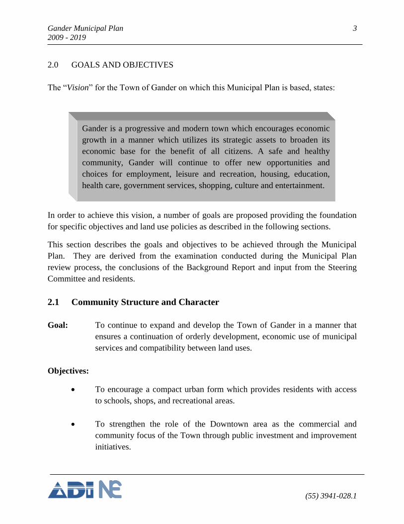
The “Vision” for the Town of Gander on which this Municipal Plan is based, states:
In order to achieve this vision, a number of goals are proposed providing the foundation
for specific objectives and land use policies as described in the following sections.
This section describes the goals and objectives to be achieved through the Municipal
Plan. They are derived from the examination conducted during the Municipal Plan
review process, the conclusions of the Background Report and input from the Steering
Committee and residents.
2.1 Community Structure and Character
Goal: To continue to expand and develop the Town of Gander in a manner that
ensures a continuation of orderly development, economic use of municipal
services and compatibility between land uses.
Objectives:
To encourage a compact urban form which provides residents with access
to schools, shops, and recreational areas.
To strengthen the role of the Downtown area as the commercial and
community focus of the Town through public investment and improvement
initiatives.
Gander is a progressive and modern town which encourages economic
growth in a manner which utilizes its strategic assets to broaden its
economic base for the benefit of all citizens. A safe and healthy
community, Gander will continue to offer new opportunities and
choices for employment, leisure and recreation, housing, education,
health care, government services, shopping, culture and entertainment.
4 Gander Municipal Plan
2009 - 2019
(55) 3941-028.1
To adopt and implement the principles of the Town of Gander Downtown
Redevelopment Study, 2006 [Tract Consulting Inc.].
To encourage the provision of safe and accessible pedestrian access routes
and pathways throughout the Downtown area and to link residential areas
to the Downtown.
To preserve and enhancement appropriate areas of open space and lands for
passive recreation to support the fabric of the urban environment.
2.2 Economic Development
Goal: To create an environment which encourages diversified and balanced
economic growth and development in Gander and promotes the growth of
employment opportunities.
Objectives:
To support the continued viability of the Gander International Airport
Authority as a major generator of commerce and industry in the Town.
To encourage diversification of the local economy through the attraction of
new businesses, industries, and the support of local entrepreneurship.
To encourage the continued growth and development of Gander as a strong
commercial and service centre for the region.
To promote the Town as a communications and convention centre, drawing
on its Airport and accommodations infrastructure and on its central location
within the province.
To promote the attractiveness of the Town as a place to live, drawing upon
its mix of residential opportunities, services, facilities and geographical
location.
Gander Municipal Plan 5
2009 - 2019
(55) 3941-028.1
2.3 Commercial and Industrial Development
Goals: To strengthen commercial activity in the Town by encouraging an
appropriate mix of retail, office and service activities that will serve the
Town and surrounding Region.
To encourage the development of appropriate facilities in which retail,
office and service activities may occur.
To maintain and encourage the industrial base of the Town.
Objectives:
To encourage a mix of retail, office and public uses in the downtown which
strengthens its role as the community core.
To ensure an adequate supply and variety of land in appropriate locations
for various commercial activities.
To encourage “big box” retail development to locate in areas appropriate to
this use.
To allow a range of compatible retail and services uses within
neighbourhood commercial areas.
To encourage the distribution of local convenience stores and personal
services activities within reasonable walking distances of residential areas
and in a manner compatible to the residential environment.
To provide specific areas for highway service oriented commercial uses and
discourage strip development and sprawl along major traffic routes.
To ensure sufficient land is available to facilitate rural resource and
industrial activities such as agriculture, forestry and mineral workings.
6 Gander Municipal Plan
2009 - 2019
(55) 3941-028.1
2.4 Housing
Goals: To encourage the provision of adequate quality, quantity and mix of
housing that serves the needs of the population.
Objectives:
To maintain the present high standard of housing in the community.
To maintain a proactive role in facilitating the development of new
residential subdivisions.
To encourage the improvement of sub-standard dwellings and require
removal of houses which cannot economically be improved.
To encourage a mix of housing types in new developments, and through
redevelopment of older housing stock.
To encourage a mix of housing types within the municipality to meet the
needs of senior citizens.
To encourage the supply and development of good, affordable housing that
meets the needs of economically disadvantaged resident groups such as
families, single persons and seniors.
To provide opportunities to enhance the attractiveness and viability of
multiple-unit rental accommodations in residential and commercial areas.
To provide opportunities for the development of innovative or specialized
forms of housing; particularly housing for seniors.
To provide appropriate buffering between residential and non-residential
uses and prevent the establishment of incompatible uses within residential
areas.
Gander Municipal Plan 7
2009 - 2019
(55) 3941-028.1
2.5 Culture, Recreation and Open Space
Goals: To enhance the personal and physical well-being of the community’s
residents.
To provide a range of leisure and recreation facilities that address the needs
of all residents of Gander regardless of age, ability or economic position,
and that are within the Town’s financial capabilities.
To support the provision of cultural services and facilities that are
accessible to all residents of Gander regardless of age, ability or economic
position.
To promote the principles of healthy, active living for all residents of
Gander.
Objectives:
To ensure that sufficient space, facilities and programs are provided to meet
the year round recreational and leisure needs of the Town of Gander
residents.
To provide leisure and recreation facilities in the commercial downtown
area that build upon and enhance an already established critical mass.
To encourage and facilitate the provision of cultural opportunities in the
downtown area.
To encourage and facilitate the provision of leisure and recreation programs
by community based groups that are responsive, accessible and affordable
to all residents of Gander.
To preserve areas of natural, environmental, cultural and historic
significance.
8 Gander Municipal Plan
2009 - 2019
(55) 3941-028.1
To maintain the integrity of Cobb’s Pond Rotary Park and enhance its
natural attractions through compatible development and interpretation
programs.
To continue to develop and integrate a system of parks, linear parkways
and trails, open spaces and natural areas throughout the Town.
To continue to develop and maintain a Town-wide interconnecting network
of trails to provide valuable recreation and transportation opportunities.
To provide for the clearing of snow along pedestrian routes and trails
thereby promoting winter activity.
To support the development of a safe system of pedestrian walkways which
link residential areas to the downtown, to schools, parks and playgrounds
throughout the Town.
To determine a schedule for maintenance of recreation facilities, parks and
open spaces based on the community’s priorities.
To monitor leisure and recreation trends and the needs of a changing
demographic in Gander, through opportunities for resident input.
To change the name of the recreation department to the Department of
Recreation and Leisure Services recognizing a change in mandate.
2.6 Municipal Services
Goal: To maintain a safe and healthy community through the provision of a range
of municipal services in the most economic manner and to give priority to
items outlined in the Capital Works Program.
Gander Municipal Plan 9
2009 - 2019
(55) 3941-028.1
Objectives:
To provide fire protection to all residences and commercial buildings
through the provision of adequate residential fire flows.
To extend services in the most economical fashion that are developed to
environmentally acceptable standards.
To ensure that adequate institutional, educational, health care, and social
services are provided at suitable locations to meet the needs of residents.
To examine the capacity, function and efficiency of the Town’s existing
sewage treatment plants [Beaverwood and Magee] to determine their
viability and propose a long term solution.
To close the current waste disposal site, when the Town of Gander begins
sending its solid waste to the new Central Newfoundland Waste
Management Site in Norris Arm North.
2.7 Transportation
Goal: To provide a safe and efficient transportation network that serves the
residents of Gander.
Objectives:
To provide safe access to all commercial and industrial areas.
To maintain existing roads through a regular maintenance and improvement
program.
To ensure that new development facilitates safe and efficient pedestrian and
vehicular mobility.
10 Gander Municipal Plan
2009 - 2019
(55) 3941-028.1
To improve accessibility for all residents of Gander and especially those
with disabilities through the appropriate design of streets and sidewalks and
public parking lots.
To ensure safe circulation by providing sidewalks, where fiscally possible,
primarily along collector streets and local streets, and secondly in other
areas of high pedestrian usage.
To develop a road system that minimizes adverse impact on the
environment and aesthetic character of the Town.
To re-examine major arterials within the Town, when traffic volumes and
conditions warrant it to determine if signalized intersections are required.
To communicate with the Department of Transportation and Works to
determine the Department’s priorities for the timing and development of the
proposed Trans Canada Highway realignment.
2.8 Environment
Goals: To encourage a community philosophy that values and protects its natural
environment.
To apply the principles of environmental stewardship to the use of land and
human activity; to maintain and enhance a pleasant and safe environment in
which to live, work and play for all Gander residents.
To protect Gander Lake, the source of the drinking water supply for the
residents of the Town of Gander, Appleton and Glenwood.
Objectives:
To identify and protect those areas of significant scenic, environmental and
wildlife habitat value.
Gander Municipal Plan 11
2009 - 2019
(55) 3941-028.1
To sustain or enhance, where possible, the quality of the environment
within the Town as it relates to urban development and human activity.
To ensure environmental protection through participation in programs of
recycling, the use of environmental protection policies and protection of
environmentally sensitive areas.
To enhance and promote the continued improvement of the general
physical appearance of the Town through participation in programs such as
the Tidy Towns program.
To support the Gander Lake Watershed Management Committee in the
protection and safeguarding of Gander Lake Watershed and the Gander
Lake Protected Water Supply Area.
To manage and protect the Gander Stewardship Zone which includes
wetlands and surrounding uplands in the western and northern portions of
the municipal planning area as well as Benton Lagoon.
To support and protect Soulis Pond, Cobbs Pond, and Home Pond; three
ecologically sensitive water systems and management units within the
Gander Stewardship Zone.
To recognize existing natural constraints to development and protect land
unsuitable for development in its natural state.
To support the development of a regional solid waste management facility
and participate in solid waste management including recycling programs in
the Town.
2.9 Municipal Finances
Goal: To manage municipal expenditures and revenues so as to provide necessary
municipal services and facilities within a framework of long term financial
stability.
12 Gander Municipal Plan
2009 - 2019
(55) 3941-028.1
Objectives:
To develop a Five Year Capital Works Program based on realistic funding
available.
To manage the Municipal Public Works Program to ensure the Town is
provided with adequate services throughout the planning period.
To encourage compact, phased development which ensures effective use of
the Town’s financial resources.
To continue to manage and reduce the municipal debt load considering the
Town's ability to meet its expenditures over the long-term.
2.10 Municipal Plan Administration
Goal: To ensure that future development is carried out within the general intent of
the policies of the Municipal Plan and to provide a management structure
that responds effectively to the needs of the residents of Gander.
Objectives:
To adopt and enforce development regulations, land use zoning,
subdivision, and advertisement regulations to ensure development conforms
to the policies contained within the Municipal Plan.
To recognize the legitimate development goals of landowners where they
do not conflict with goals, objectives and general intent of this Municipal
Plan.
To take advantage of opportunities to educate and involve the public in
matters pertaining to planning.
Gander Municipal Plan 13
2009 - 2019
(55) 3941-028.1
3.0 LAND USE POLICIES
3.1 Introduction
The following policies with accompany in Future Land Use Maps constitute the land use
component of the Gander Municipal Plan, 2009-2019. They have been prepared within
the context of the Goals and Objectives outlined in Chapter 2.
The policies stated in this Municipal Plan have been prepared to ensure that the physical
development of Gander takes place in an efficient and cost effective manner during the
ten-year planning period. Socio-economic and environmental considerations have also
been taken into account when preparing the policies and proposals surrounding land use,
community facilities, transportation, and municipal services.
3.2 General Development Policies
The following policies are general in scope in that they can be applied to more than one
land use designation and to different areas within the Municipality.
1) Future Land Use - Growth and development shall be directed in
accordance with the Future Land Use Map (FLU- 2), as amended from time
to time, and in accordance with the policies of this Plan.
2) Capital Works - Expenditures to service land, build roads, upgrade utilities
or otherwise provide for growth and development shall be included in an
approved 5 year budget which shall be reviewed by Council on an annual
basis.
3) Fire Protection - Fire Fighting and fire safety criteria shall be taken into
account when evaluating proposals for development.
4) Downtown Redevelopment - Council shall promote redevelopment
projects in the downtown as an initiative in attracting new businesses,
improving the visual appearance of the area and making use of existing
lands for buildings, vehicular and pedestrian access.
14 Gander Municipal Plan
2009 - 2019
(55) 3941-028.1
5) Building Design and Character - Council shall consider the aesthetic
character of site and building design in the approval of site plans within all
land use designations.
6) Home Based Businesses - Through the Town of Gander Home Based
Business Regulation, February 2008, Council shall encourage business
development through home-based business startups, where such businesses
will not have a negative impact on the character of the neighbourhood, by
virtue of increased traffic, noise, lighting or signage.
7) Airport Noise - Residential subdivision developments proposed for areas
within the 30 Noise Exposure Forecast contour (NEF) as defined by
Transport Canada for the Gander International Airport Authority and
illustrated on the Land Use Zoning Map (FLU-1), shall be considered in
consultation with Transport Canada. The use of soundproofing materials
may be required for building construction.
8) Building Height Constraints - The height of buildings in the vicinity of
the Gander International Airport may be restricted in accordance with
requirements set out by Transport Canada. (These requirements remain
unchanged from those presented and approved in the 2000-2010 Municipal
Plan.)
9) Municipal (Wetland) Stewardship Agreement Area- Any development
to be carried out in areas which are part of the Municipal (Wetland)
Stewardship Agreement Area shall comply with all conditions as set out in
the Stewardship Agreement of 1999 and revised in 2007, between the Town
of Gander and the Department of Environment and Conservation, Wildlife
Division.
10) Signage - Council shall adopt and implement a policy to regulate the size,
placement, design and nature of signs throughout the community.
11) Preservation of Trees -Mature trees in the built up area of the Town shall
be identified, preserved or replaced where necessary. Such trees shall be
Gander Municipal Plan 15
2009 - 2019
(55) 3941-028.1
removed only if they become dangerous because of age, disease or
proximity to a building; if they are overcrowded, and unduly inhibit light
and air circulation for landscape purposes and building occupancy, or if
they will unduly inhibit construction.
12) Access for Persons with Disabilities - It is the policy of Council to ensure
that the development of buildings and facilities, including parks and
public walkways which are accessible to the general public, be designed to
facilitate easy access and mobility for persons with disabilities.
13) Mineral Exploration - Mineral exploration activities may be permitted
throughout the planning area provided such activities do not cause undue
noise, ground disturbance or risks to the safety of residents of Gander.
14) Waste Disposal Site Buffer - Proposed development within 1600 m of the
Gander Waste Disposal Site will be referred to the Department of
Government Services and Lands for review and recommendations.
3.3 General Land Use
3.3.1 Land Use Designations
Policy:
1. It shall be a policy of Council to manage the land uses of the Town of Gander in
accordance with the land use plan designated Schedule A, Future Land Use Map-
FLU-2; and the policies described herein. The land use designations include:
Residential
Commercial
Industrial
Airport
Rural Resource Area(s)
Public/Institutional
Open Space
16 Gander Municipal Plan
2009 - 2019
(55) 3941-028.1
Recreation/ Tourism
Comprehensive Development Area(s)
Transportation
The specific policies that apply to each of these land use designations are
described in the sections that follow. Additional sub-categories of land use
designations are discussed in greater detail as warranted with respect to approval
considerations.
3.3.2 Non-Conforming Uses
Policies:
1. In accordance with Section 108 of the Urban and Rural Planning Act, 2000, it
shall be a policy of Council than any land use already in existence at the time of
approval of this Municipal Plan, that does not conform to the land use designations
shown on the Future Land Use Map (FLU-2) (and described herein), will be
permitted to continue. However, the resumption of a discontinued non-conforming
use of land may not exceed 6 months after that discontinuance, unless otherwise
provided by regulation under the Act or otherwise determined by Council.
2. The Act gives specific direction regarding non-conforming uses such that a
building, structure or development that does not conform to the Municipal Plan
and the Development Regulations shall be permitted to:
a. Continue so long as it is not internally or externally varied, extended or
expanded without the approval of Council; and may not be structurally
modified except as required for the safety of the building, structure or
development;
b. Not be reconstructed or repaired for use in the same non-conforming
manner where 50% or more of the value of that building, structure or
development has been destroyed;
c. Have the existing use varied by permission of Council, to a use that is, in its
opinion, more compatible with a plan and regulations applicable to it;
Gander Municipal Plan 17
2009 - 2019
(55) 3941-028.1
d. Have the existing building extended by permission of Council, where, in
Council’s opinion that extension is not more than 50% of the existing
building;
e. Where the non-conformance is with respect to standards included in the
Development Regulations, not be expanded if the expansion would increase
the non-conformity; and
f. Where the building or structure is primarily zoned and used for residential
purposes, be repaired or rebuilt where 50% or more of the value of that
building or structure is destroyed.
3.3.3 Subdivision Policies
Policies:
1. All proposed subdivision of lands for residential, commercial and industrial
development shall be subjected to a comprehensive evaluation by Council. The
content of this evaluation will be detailed in the Development Regulations and will
include:
a. An investigation of all physical features of the site including but not limited
to: vegetation, topography, drainage and soils; and the identification of
opportunities and constraints for development. Where possible, the layout
of proposed lots and roads should conform to the topography, and retain
existing vegetation;
b. A demonstration of how the proposed subdivision relates to existing
development and roads on adjacent lands, and provides for future access to
undeveloped lands in the area;
c. An examination of compatibility between the subdivision and surrounding
land uses, both existing and future;
d. An assessment of proposed municipal services and the public costs of
providing and maintaining these services in the long-term; and
e. provisions for neighbourhood mail services, school bus stops and open
space.
18 Gander Municipal Plan
2009 - 2019
(55) 3941-028.1
2. Subdivision Agreement
As a condition of approval, Council shall require the developer to enter into a
subdivision agreement with the Municipality.
3. Phased Development
Development will be phased such that areas serviced with water and sewer are
substantially developed before extension of services is carried out.
4. Easements and Emergency Access
Where land is required for utility easements or emergency access, such land may
be obtained for the appropriate agency (eg. power, electrical and etc.) in the course
of approving subdivision or other development applications.
5. Soils and Drainage
Development shall be permitted only on lands having soil and drainage conditions
that are suitable to permit the proper siting and development of the proposed uses.
6. Alterations to the Natural Environment
Development proposals shall include plans for grading, ditching, and landscaping.
Significant alterations to the natural environment (such as changing the drainage
pattern or removing vegetation) will be considered during the evaluation of
development proposals. Alterations which will adversely affect adjacent property
or watercourses shall not be permitted. Topsoil or sods shall not be removed
except with the approval of Council.
7. Protection of Watercourses and Fish Habitat
Rivers, streams, ponds, and shorelines shall be protected from pollution. No
development shall be permitted within a minimum 15 metres buffer, of any body
of water or wetland without approval from the Department of Environment and
Gander Municipal Plan 19
2009 - 2019
(55) 3941-028.1
Conservation, Water Resources Management Division, and if fish habitat is
affected, from Fisheries and Oceans Canada.
8. Building Setback
Adequate building setbacks from roads shall be required in order to preserve rights-
of-way appropriate to the specific function of each street. Where sub-standard road
widths exist, setbacks will be sufficient to allow future widening and landscaping,
and to permit the parking and movement of vehicles on private property, clear of
any road allowance.
9. Access to a Public Street
All development shall front on a publicly maintained street, unless otherwise
specified in this Plan.
10. Infill Development
Council shall monitor all infill development and other small-scale proposals
during the Planning Period to ensure that appropriate standards are maintained
with respect to road widening, alignments, the installation of municipal services,
and any other matter concerning current or future public works.
3.4 Residential Development Policies
General Intent
Land is designated Residential throughout the Town to provide for a mix of
developments and housing types in order to respond to the needs of residents of all ages,
abilities and socio-economic backgrounds.
Housing developments should respond to the needs of the their target markets, such that
housing for young families will includes the provision of open space and play lots in
accordance with the Town of Gander Design Standards for Streets and Subdivisions,
20 Gander Municipal Plan
2009 - 2019
(55) 3941-028.1
while housing for seniors considers adjacent landscape qualities and proximity to
services.
Permitted uses include detached and semi-detached housing and multiple housing
dwelling units such as townhouses and apartment buildings and mobile (mini) homes.
Criteria for the location and establishment of residential uses are outlined in the policies
of this Plan and in the Development Regulations - Use Zone Tables, Schedule C.
Non-residential uses that are compatible with residential neighbourhoods may be
permitted within the Residential designation.
Policies:
1. It shall be a policy of Council to encourage and support a mix of housing types
within designated residential areas.
2. It shall be a policy of Council to encourage and support the design and
development of high quality and innovative forms of housing.
3. It shall be a policy of Council to encourage and support the development of
affordable housing and to recognize and support the programs of the
Newfoundland and Labrador Housing Corporation (NLHC).
4. Within the area designated as Residential on the Future Land Use Map, areas shall
be further categorized on the Zoning Map into the following zoning designations:
a. Residential Low Density (RLD)
b. Residential Medium Density (RMD)
c. Residential High Density-1 (RHD-1)
d. Residential High Density-2 (RHD-2)
e. Residential Mobile Home (RMH)
f. Rural Residential (RR)
Gander Municipal Plan 21
2009 - 2019
(55) 3941-028.1
3.4.1 Multiple Dwelling Units
Policies:
1. Semi-detached houses and townhouses shall be integrated with single-detached
housing rather than erected in separate locations.
2. Grouped dwellings defined as two or more dwelling units which are contained
within two or more buildings located on a lot, may be permitted in the residential
designation in the form of two unit dwellings, townhouse units, multiple unit
dwellings (or any combination of these) in the form of condominiums, non-profit
housing co-operatives and housing developments for senior citizens or other
groups with special housing needs.
3. Multiple unit apartment buildings and other high density residential developments
shall be appropriately located, and may be permitted in low density residential and
the commercial downtown areas subject to the following conditions:
a. that they be located close to major or local commercial areas, and if
possible near schools and recreational facilities;
b. that the development be located on, or adjacent to an arterial or collector
street, so that higher volumes of traffic generated will not pass through
lower density residential streets;
c. that they be compatible with surrounding land uses;
d. that sufficient parking is provided on site to accommodate tenants and
visitors;
e. that landscaped buffer areas be provided on the lot periphery to screen the
buildings and parking areas from adjacent lower density residential
developments;
f. that adequate municipal services are available on the proposed site to
accommodate the needs of the development;
g. that a landscaping plan be submitted which shows the placement of lawns,
trees, shrubs, and pedestrian pathways.
22 Gander Municipal Plan
2009 - 2019
(55) 3941-028.1
3.4.2 Mobile Homes
Policy:
1. Mobile homes (mini homes) shall be permitted only in appropriately zoned
Residential-Mobile Home areas and shall be subject to the following criteria:
a. a site plan agreement will be required for each mobile home park
development;
b. any mobile home park shall not be located closer than one kilometre from
another such development.
3.4.3 Special Housing
Policies:
1. It shall be a policy of Council to review special housing needs to accommodate the
growing number of people of retirement age; and the need for affordable housing
to accommodate people with low or fixed incomes.
2. It shall be a policy of Council to encourage and support the development of
assisted living and long term care developments for aging seniors.
3.4.4 Commercial Uses in Apartment Buildings
Policy:
1. It shall be a policy of Council to permit commercial uses in multiple unit
apartment buildings subject to the following conditions:
a. the proposed uses are located on the ground floor of the apartment building;
b. the uses will not detract from the residential character of the area by virtue
of generating excessive traffic, lighting, signage or noise.
Gander Municipal Plan 23
2009 - 2019
(55) 3941-028.1
3.4.5 Non-Residential Uses
Policy:
1. It shall be a policy of Council that, subject to the discretion of Council, compatible
parks, open space, recreation and uses such as churches, daycare centres, clinics,
public and institutional uses, private or public educational uses and utilities shall
be permitted within the Residential designations provided that:
a. non-residential uses shall be developed in a manner that is compatible with
adjoining residential properties and preserves the character of the
residential neighbourhood;
b. the dominant use within the area continues to be residential;
c. non-residential uses shall have sufficient off-street parking and properly
located vehicular access points;
d. non-residential uses shall provide adequate landscaping and buffering
between adjacent residential properties; and
e. any other conditions are adhered to which may be required by Council or
the Development Regulations.
3.4.6 Home Based Businesses
Policy:
1. It shall be a policy of Council that Home Based Businesses are a permitted use in
residential areas in accordance with the provisions of the Town of Gander Home
Based Businesses Regulations, 2008, and any provisions of the Development
Regulations that may apply.
3.4.7 Neighbourhood Commercial Uses in Residential Zones
Policy:
1. Local convenience stores and other local commercial uses which serve local
neighbourhood needs, may be permitted in the Residential areas provided that the
24 Gander Municipal Plan
2009 - 2019
(55) 3941-028.1
commercial uses are clearly subsidiary to the residential uses and subject to the
Land Use Zoning and Subdivision Regulations, and to the conditions outlined in
the Commercial policies of this Plan (Section 3.5.5).
3.4.8 Rural Residential Development
Policy:
1. Large lot, rural residential development shall be permitted on unserviced lots
which front on the Gander Bay Road, north of Rowsell Boulevard. Commercial
uses, as specified in the Development Regulations which legally exist at the time
this Plan comes into effect shall be considered permitted uses. Home based
businesses which do not detract from the rural - residential nature of the area may
also be permitted in accordance with the Town of Gander Home Based Businesses
Regulations, 2008; and any provisions of the Development Regulations that may
apply.
3.5 Commercial Development Policies
General Intent
During its history, Gander has prospered as a regional service and retail centre for the
Kittiwake Region. The last planning period has witnessed strong growth in the retail and
service sectors. The completion of the Cooper Boulevard extension has allowed further
development in the area of Roe Avenue. The introduction of “Big Box Stores”
particularly large national [and international] chain stores generates both opportunities
and challenges. Developments such as Wal-Mart locate where the economy is strong and
growth is projected and their appearance inspires the influx of other national chains.
Commercial uses will continue to be attracted to this area in the planning period, due to
its proximity to the Trans Canada Highway, ample parking and attractive mix of retail
businesses.
However, the location of “big box stores” and their proximity to Gander’s downtown
creates pressure for more large scale development that detracts from the focus of
downtown in terms of its design, aesthetic, pedestrian scale and sense of place. The retail
Gander Municipal Plan 25
2009 - 2019
(55) 3941-028.1
area considered Gander’s downtown centre, is located primarily along Airport Boulevard
between Cooper Boulevard and Elizabeth Drive and includes the Elizabeth Drive
Shopping Centre and Town Square, and Armstrong Boulevard. Gander’s downtown core
has grown around a number of retail malls and large scale commercial operations such as
car dealerships, national grocery and hardware store chains that are not traditional
downtown activities. Much of Gander’s downtown has the scale and function of highway
commercial developments and shopping centres. The recent introduction of “big box
stores” has further detracted from the nature and purpose of “downtown.”
In 2006 Council approved the preparation of a study that would offer solutions to
redevelop Gander’s downtown resulting in a “more welcoming and pedestrian-friendly
shopping district.” The Town of Gander Downtown Redevelopment Study (by Tract
Consulting Inc.) makes recommendations for the enhancement and revitalization of the
downtown. Gander Town Council adopted the report in 2007, and a Steering Committee
made up of the Chamber of Commerce, Town staff, and local business people was
instructed to begin implementing the recommendations.
Recommendations to refine current land use designations in order to address the land
uses that have been permitted in the planning period and to encourage like uses to be
located in the most appropriate locations in the future will encourage and build upon
existing critical mass.
The nature of Highway Commercial uses are also subject to change during the Planning
Period should plans of the Department of Transportation and Works to realign the Trans
Canada Highway come to fruition.
Policies:
1. Within the area designated as Commercial on Future Land Use Map (FLU-2) it
shall be a policy of Council to encourage and support commercial development,
improvement and intensification.
Plans, policies and implementation procedures shall give consideration to the
following:
26 Gander Municipal Plan
2009 - 2019
(55) 3941-028.1
a. Aesthetic improvements to sidewalks, parking areas, building facades,
signage, street furniture and areas of landscaping including buffers; and
b. The improvement of traffic flow and pedestrian safety.
2. Within the area designated as Commercial on the Future Land Use Map, areas
shall be further categorized on the Zoning Map into the following zoning
designations:
a. Commercial General (CG)
b. Commercial Downtown (CD)
c. Commercial Shopping Centre (CSC)
d. Commercial Highway (CH)
e. Commercial Local (CL)
3.5.1 Commercial General
General Intent
Areas designated for Commercial General uses are meant to accommodate a range of
uses which are not suited to a location in the Commercial Downtown area. Such uses
include service oriented uses such as retail outlets and showrooms, building supply and
automotive parts and repair outlets. Light industrial/commercial uses may also be
permitted where such uses require warehouse space in association with a retail, office or
service outlet. Other uses which may be permitted include public uses and buildings,
utilities, light industry, offices and recreational open space. The location of Commercial
General uses within the Commercial land use designation will be established in the
Development Regulations.
Policy:
1. Within the area designated Commercial General (CG) on the Zoning Map, it shall
be the policy of Council to encourage and support continued commercial
development, improvement and intensification within the zone.
Gander Municipal Plan 27
2009 - 2019
(55) 3941-028.1
3.5.2 Commercial Downtown
General Intent
The Commercial Downtown area represents the highest order of Gander's hierarchy of
retail centres. Council recognizes the importance of this area to Gander's role as a
regional service centre. The Town wishes to create a vibrant and sustainable downtown
commercial core which encourages uses that attract people to the area for business,
shopping, dining, entertainment and cultural and recreational experiences.
Policy:
1. Within the area designated Commercial Downtown (CD), it shall be the policy of
Council to enhance and strengthen the Downtown by encouraging major new
commercial and public uses to locate in the area.
2. It shall be a policy of Council to endorse and implement, as possible, the
recommendations of the Town of Gander Downtown Redevelopment Study (by
Tract Consulting Inc.), 2006.
3. Plans, policies and implementation procedures may consider the following:
a. A range of retail and service businesses, offices, and public, assembly and
recreational uses shall be permitted in the Commercial Downtown area.
b. Complementary uses permitted include cultural, recreational, entertainment,
and open space uses as well as accommodations facilities and apartment
buildings. Residential uses in the downtown area may also be considered
where such uses are complementary to surrounding commercial uses.
Residential and office uses above commercial uses may also be permitted
as a means of encouraging the revitalization of the downtown core.
c. Pedestrian Access shall have a high priority in future development of the
Downtown which includes building design and landscaping, including the
clear separation of pedestrian and vehicular movement. This shall be done
28 Gander Municipal Plan
2009 - 2019
(55) 3941-028.1
by encouraging infilling and greater consolidation of future development
and redevelopment of existing properties.
d. Through the elements of design and aesthetics, Council shall ensure that a
high standard of building design, appearance and landscaping is maintained
for downtown commercial, public and other properties. To achieve a
revitalized and improved downtown, Council may:
i. implement the design and revitalization recommendations of the
Downtown Redevelopment Study, 2006, which will provide a plan
for street-scaping, urban design guidelines (for store fronts),
improvements to parking and pedestrian safety and movement,
public spaces, landscaping, and guidelines for improving the visual
appeal of the downtown area;
ii. Work with the Gander Chamber of Commerce and business owners
in the Commercial Downtown area to implement redevelopment and
public improvement initiatives; and
iii. Support the beautification and tree planting initiatives of the Civic
Enhancement Committee.
e. Open space uses will be encouraged in the Commercial Downtown land use
designation. The open space system is an important planning tool as it
provides a structural framework for urban growth and development. As a
framework it also provides continuity in the urban context by binding
together otherwise disconnected and unrelated development areas, creating
a sense of identity for the Town. Open space areas within Commercial
Downtown will be linked to the integrated trail/walkway system. Council
will consider the open space system as part of the overall plan for
redevelopment of the Commercial Downtown area.
Gander Municipal Plan 29
2009 - 2019
(55) 3941-028.1
3.5.3 Commercial Shopping Centre
General Intent
The lands designated for Commercial Shopping Centre uses have been identified in
several locations. The first area includes existing uses of “big box stores;” east of
Cooper Boulevard and north of Roe Avenue; the second area includes existing uses in
the area west of Cooper Boulevard and south of Airport Boulevard.
Areas designated for Commercial Shopping Centre uses are meant to accommodate a
range of uses which are suited to large shopping centre developments including “big box
stores.” Such uses include service oriented uses such as retail outlets, professional
medical offices, personal and general services outlets, and restaurants.
Discretionary uses which may be permitted include Light industrial/commercial uses
where such uses require warehouse space in association with a retail, office or service
outlet; automotive sales and showrooms, utilities, light industry, offices and recreational
open space. The location of Commercial Shopping Centre uses within the Commercial
land use designation will be established in the Development Regulations.
Policy:
1. Within the area designated as Commercial Shopping Centre (CSC) on the Zoning
Map, it shall be a policy of Council to encourage and support continued
commercial shopping centre development, and improvement and intensification
within this zone.
3.5.4 Commercial Highway
General Intent
Lands designated for Commercial Highway uses have been identified at several locations
along the north side of the Trans Canada Highway. The first area includes existing uses
between Cobham Street and the Gander Bay Road, the second, an area to the west of
Gander Bay Road beyond the built up area of the Town; and a third area to the south of
30 Gander Municipal Plan
2009 - 2019
(55) 3941-028.1
the Trans Canada Highway between the James Paton Memorial Hospital and the Gander
Tourism Chalet.
Policy:
1. Within the area designated as Commercial Highway (CH) on the Zoning Map, it
shall be a policy of Council to encourage and support continued commercial
highway development, improvement and intensification within this zone.
Commercial Highway development shall be limited to those uses which:
a. Serve the travelling public;
b. Require sites along arterial roads affording visual exposure and good
vehicular access; and
c. Rely on business from the travelling public.
Discretionary uses in the Commercial Highway zone, may be allowed at the
discretion of Council, where appropriate and may include limited high density
residential uses; and select commercial uses which are “subsidiary” to the existing
approved use.
2. In considering development or building applications, it shall be a policy of Council
to ensure that the following conditions are addressed:
a. Access points and off-street parking must be provided to the satisfaction of
Council;
b. Where possible, shared accesses may be permitted to reduce the number of
new accesses to the Trans Canada Highway;
c. The use of common or shared parking lots shall be encouraged; and
d. In recognition of existing adjacent residential uses, where any new
commercial highway use abuts existing residential uses, the design shall
incorporate buffer areas of planting or fencing on the periphery adjacent to
the residential use.
Gander Municipal Plan 31
2009 - 2019
(55) 3941-028.1
3.5.5 Commercial Local
General Intent
Local commercial operations are a convenience to residential neighbourhoods. Lands
within the Commercial land use designation may be used to accommodate Commercial
Local (CL) uses. Site Selection Criteria for Local Commercial uses will be identified in
the Development Regulations.
Policies:
1. It shall be a policy of Council to allow local commercial uses in residential areas.
Such uses include small shopping centres or individual outlets primarily for the
purpose of providing convenience goods and services to Town residents, including
convenience stores, shops, take-out restaurants and video outlets.
2. It shall be a policy of Council to permit Commercial Local uses in both the
residential and commercial land use designations. Commercial Local use areas
will be identified in the Development Regulations.
In addition to the provisions of the Development Regulations, Council shall
consider the following conditions to minimize any adverse effects on surrounding
residential or commercial areas:
a. They are located with direct access to an arterial or primary collector road,
preferably at an intersection;
b. The use minimizes the impact of traffic, noise, signs, and lighting on
adjacent residential properties;
c. The area is appropriately zoned to accommodate the development;
d. The provision of adequate buffering or landscaping of the use from adjacent
commercial or residential uses;
e. The provision of adequate off-street parking as required under Schedule D
of the Development Regulations;
f. Controls on the type, size, location and illumination of signs; and
32 Gander Municipal Plan
2009 - 2019
(55) 3941-028.1
g. The provision for a public hearing so that any objections form adjacent
owners may be considered.
3. It shall be the policy of Council to permit Commercial Local uses in apartment
buildings provided that the use is carried out on the ground floor of the apartment
building and is in accordance with policies set out in Section 3.4.5 Commercial
Uses in Apartment Buildings.
3.6 Industrial Uses
General Intent
The Future Land Use Map (FLU-2) identifies three areas for industrial use. The first is
the McCurdy Drive and Carr Crescent area. Although existing development has largely
reached the limit of available lands some opportunities for in-fill exist.
The second is the Gander Business Park located north of the Airport, and includes Baird
Place industrial park. Due to a slow down of industrial development activity, a portion of
Baird Place was re-zoned in the last planning period to Commercial Light Industrial; with
the remaining lots retaining the Industrial General designation.
No permits for the construction or renovation of industrial developments have been
issued in the past two decades. This trend is likely to continue in Gander in the near
future.
To promote development on the serviced lots of Baird Place to Garrett Drive, land north
of the Open Space Recreation (OSR) 20 metre buffer, will be designated Commercial
General (CG). The intent is to guide future commercial development to this area before
committing to infrastructure improvements on other lands for commercial general
purposes. An area of land bounded by Baird Place; land designated Open Space
Recreation (OSR); Public Institutional (PI); and Industrial General (IG) is designated
Commercial Light Industrial (CLI) and will provide a reasonable transition from one use
designation to another. Land north of Baird Place and the Commercial General (CG)
designation is for Industrial General (IG) land uses. The intent is to create a hierarchy of
land uses each representing a more intensive activity.
Gander Municipal Plan 33
2009 - 2019
(55) 3941-028.1
A third area along Airport Boulevard east of the Cooper Boulevard intersection is also
designated for industrial development. This land is located on airport property currently
administered by the Gander International Airport Authority. Additional lands have also
been designated for commercial and industrial uses on the airport property under the
Airport Master Plan prepared and administered by the Gander International Airport
Authority.
Should the need for land for industrial uses materialize in the planning period, industrial
uses may be accommodated in the area of McCurdy Drive/Carr Crescent or the lands
administered by the Gander Airport Authority and designated industrial.
Policy:
1. Within the area designated as Commercial on the Future Land Use Map (FLU-2),
areas shall be further categorized on the Zoning Map into the following zoning
designations:
a. Commercial General (CG)
b. Commercial Light Industrial (CLI)
c. Industrial General (IG)
2. It is a policy of Council to provide areas primarily for less intensive industrial use
and activity normally associated with previously prepared materials and with
minimal levels of noise, dust, odour, vibration or smoke, and to preclude
encroachment of land uses such as residential uses that could be adversely affected
by the industrial and manufacturing environment. General industry may be
permitted, subject to considerations regarding noise, traffic volume and safety, and
aesthetic appearance.
3.6.1 Commercial/Light Industrial
General Intent
The purpose of this land use designation is to accommodate a mix of commercial and
industrial uses which cater to the general public but are not compatible with typical
34 Gander Municipal Plan
2009 - 2019
(55) 3941-028.1
downtown or shopping centre businesses. Such uses require large lots and floor areas
with good access for vehicular traffic. Commercial uses include building supply and
furniture dealers, repair and rental shops. Light industrial uses such as wholesale and
warehouse establishments, transport companies, recycling depots and industrial-oriented
service uses such as industrial incubators, custom workshops or laboratories, equipment
and parts dealers, safety supply dealers, etc. would also be permitted in this land use
designation.
Policies:
1. It is a policy of Council to limit development, on lands designated Industrial, to
uses that do not directly compete with the Downtown Commercial area.
2. It is the policy of Council that complementary uses may be permitted in the
Commercial Light Industrial area provided they do not interfere with the intended
function of this area. These shall be limited to office uses, service stations, public
buildings and utilities, institutional uses, catering, recreation, and open space.
3. It is the policy of Council to a limit manufacturing uses to those that are not
required to be registered under the provincial Environmental Assessment Act.
(These uses are listed in Schedule A of the Act.)4. Lands designated for
industrial use along Airport Boulevard shall be limited to light industrial uses
subject to the following conditions:
a. the natural open space appearance of Airport Boulevard shall be maintained
through sufficient set back off the street, and with the addition of large,
landscaped front yards; and
b. driveway accesses will be shared where possible.
3.6.2 Industrial General
General Intent
Lands designated for Industrial General (IG) uses will ensure that an adequate supply of
serviced land is available to meet the requirements of industries locating in Gander.
Gander Municipal Plan 35
2009 - 2019
(55) 3941-028.1
Policies:
1. Within areas designated Industrial General, the predominant use of land shall be
for the following:
a. Industrial uses including the manufacturing, fabricating, processing,
assembly, and packaging of goods, foods and raw materials;
b. Warehousing and bulk storage of goods;
c. Transportation terminals;
d. Contractors yards;
e. Wood products industries (eg. sawmills);
f. Automobile scrap yards; and
g. Complementary uses that do not detract from and are compatible with the
operation of industrial uses within this designation; such as offices
associated with the permitted industrial use, open space and recreation
facilities, garages and restaurants.
2. Recycling uses shall be permitted within the Industrial General land use
designation. Recycling activities including: scrap metal yards, recycling of glass,
paper and other products, may be permitted provided subject to the following
conditions:
a. They do not result in unsightly premises;
b. They do not create an environmental health hazard, or other negative
environmental impacts; and
c. Scrapyards and similar uses shall be kept at the rear of buildings and
screened rom view of the road by high solid fences.
3. It shall be a policy of Council to permit retail commercial uses in the Industrial
General designation on McCurdy Drive and Carr Crescent provided that, in the
opinion of Council, the use is compatible with surrounding industrial uses. Retail
commercial uses may also be permitted in the Industrial General designation
where they directly service the industrial uses or their employees or, they are
accessory to the industrial use (ie. a factory sales outlet).
36 Gander Municipal Plan
2009 - 2019
(55) 3941-028.1
3.7 Airport Uses
General Intent
Lands administered and managed by the Gander International Airport Authority are
designated Airport to accommodate facilities and operations of the Gander International
Airport.
Policies:
1. A full range of airport and related industrial and commercial uses, as well as
military operations, shall be permitted within this designation. Decisions
concerning the acceptability of development will be made according to the 1999
Airport Master Plan prepared by Transport Canada to guide development of
airport lands for aviation, industrial and commercial uses on Transport Canada
property which is administered and managed by the Gander International Airport
Authority.
2. While the Town of Gander is unable to exert direct control over land uses on
airport property, it shall work with the Gander International Airport Authority to
ensure that development is compatible with the quality and character of present
land uses and in accordance with the general intent of this Municipal Plan and the
Town's Development Regulations.
3.8 Rural Resource Areas
General Intent
Rural lands located outside the built-up area of the Town to the north and west of the
Trans Canada Highway, are designated Rural (R) for rural resource uses. The intent of
this designation is that the lands affected remain undeveloped or used for traditional rural
based purposes.
Gander Municipal Plan 37
2009 - 2019
(55) 3941-028.1
Policies:
1. Within the area designated Rural (R) on the Land Use Zoning Map (LUZ -2),
permitted uses in this land use designation shall include forestry, agriculture,
recreational open space and conservation.
2. Uses that shall be permitted at the discretion of Council include wood harvesting,
aggregate extraction and mineral exploration, and industrial uses associated with
the resource base, particularly those that need to be located close to raw material
supplies or for some other reason cannot be located close to built-up areas.
3. While the Town of Gander is unable to exert direct control over forest
management within the Planning Area, except on land it owns, it shall work with
the Department of Forest Resources and Agrifoods to ensure that forestry
activities are conducted in accordance with good management practices. The
following policies of this plan shall also apply:
a. Logging activities within the Planning Area shall be in compliance with the
Town's objectives for the protection of aesthetic areas, recreational areas,
environmentally sensitive areas, and protection of the Gander Lake
watershed;
b. Forest harvesters shall be encouraged to submit to Council forest
management plans for lands within the Planning Area, and inform Council
of proposed forest harvesting activities;
c. Timber harvesting shall be conducted in a manner which is consistent with
guidelines of the Department of Forest Resources and Agrifoods and
Fisheries and Oceans;
d. Forestry practices such as the removal of dead and dying trees, thinning of
overcrowded stands, and tree-planting shall be encouraged and carried out
on an ongoing basis within the Planning Area; and
e. Clear cutting of large forested areas south of the Trans Canada Highway
hall be discouraged in order to protect the Gander Lake watershed.
38 Gander Municipal Plan
2009 - 2019
(55) 3941-028.1
4. Aggregate resource areas within the Planning Area shall be protected from
conflicting land uses. Protective buffer areas of at least 300 metres shall be
maintained around resource areas and active and abandoned quarries.
5. In order to protect the Gander Lake watershed, aggregate extraction and quarry
areas shall be permitted only south of the Trans Canada Highway with the
approval of the Town of Gander, the Water Resources Division of the Department
of Environment and Lands, the Department of Mines and Energy, and the Gander
Lake Watershed Management Committee.
6. The Gander Municipal Waste Disposal Site designated as Waste Disposal (WD);
shall be closed to municipal solid waste, when the Central Newfoundland Waste
Management Authority opens a new facility in Norris Arm North at the end of
2009. The Gander Municipal Waste Disposal Site shall be used for disposing of
municipal solid waste material until that time. Recycling uses such as waste
storage and sorting, and contaminated soils treatment facilities may be permitted
in this area provided they do not interfere with the operation and maintenance of
the waste disposal site.
7. Water Course Protection, especially ecologically sensitive waterway systems shall
be protected from environmentally hazardous rural resource uses such as forest
cutting, resource road construction, aggregate extraction, agricultural operations or
industrial uses associated with the resource base.
No development shall be permitted in the Rural Resource land use designation:
a. Within 15 metres of rivers or streams; and
b. Within 30 metres of the shoreline of any lake or pond.
8. Local Service District of Benton Protected Water Supply Watershed - All
applications for development within the Benton Protected Water Supply
Watershed shall be forwarded to the Department of Environment and Labour for
review and recommendation.
Gander Municipal Plan 39
2009 - 2019
(55) 3941-028.1
9. Municipal Stewardship Agreement Area - All lands within the Municipal
Stewardship Area shall be managed in accordance with the terms of the agreement
and any management plan prepared for this area.
3.9 Public/Institutional
General Intent
Lands designated Public/Institutional (PI) shall be used for purposes that serve the
general public.
Policies:
1. Within areas designated Public/Institutional, permitted uses of land shall include:
schools, churches, hospitals, social and cultural facilities, correctional centres,
libraries and utilities. Complementary uses may be permitted, provided that they
shall not conflict with the satisfactory operation and development of land for
institutional purposes. Such complementary uses may include day care centres,
open space and recreational uses and facilities.
2. In establishing new areas for public/institutional uses, it shall be a policy of
Council to permit public uses in all land use designations subject to the following
conditions:
a. The site is located adjacent to arterial or collector streets;
b. The proposed development is compatible with surrounding land uses, and
the protection of adjacent residential uses through controls on signage as
well provision of for landscaping and buffering if required; and
c. The proposed area can be connected to the existing municipal water and
sewer system.
40 Gander Municipal Plan
2009 - 2019
(55) 3941-028.1
3.9.1 Public Uses in the Downtown
Council has embraced a mandate to promote Gander’s Downtown as the community
focus of the Town and to promote an attractive mix of commercial, institutional,
entertainment, cultural, and recreational uses.
Policy:
1. It shall be a policy of Council to support and encourage public/institutional uses
such as cultural facilities, government buildings, libraries, and museums to locate
in the Commercial Downtown area.
3.9.2 Re-Use of Public Lands and Buildings
Lands and buildings which are no longer required for public uses may be used for other
purposes, such as residential or commercial uses, provided the land and buildings in
question are re-zoned to an appropriate use consistent with the land use designation in
which they are located.
Policy:
1. Where public lands or buildings have a Public/Institutional designation, an
amendment to this Plan shall be required before they can be used for any
commercial, residential or industrial use.
3.9.3 Education Facilities
Given the stable enrolment levels in Gander’s schools, it is not anticipated that any
significant changes will occur with existing schools in the planning period.
Proposal:
1. It shall be a proposal of Council to encourage the continued community use of
school facilities such as gymnasia, sports fields, auditoria, as well as classroom
Gander Municipal Plan 41
2009 - 2019
(55) 3941-028.1
and other facilities that are currently used for adult education courses and indoor
community leisure and recreation pursuits.
3.9.4 Health Care Facilities
As Gander’s population ages, the Town may require additional health care services and
supports meet the needs of its citizens.
Policy:
1. It shall be a policy of Council to support the provision of quality health care
services for all Gander residents. This includes hospital and ambulance services,
as well as the provision for additional nursing homes and other facilities that meet
the needs of an aging population.
3.10 Open Space
Introduction
Gander has an abundance of open spaces and parks developed in neighbourhoods as well
in the rural areas within the planning boundary. Within the built up town limit, the open
space system is linked by a series of walkways and walking trails, including the
T’Railway, which runs through the Town and connects Cobb’s Pond in the west and
Gander Townsite in the east.
Within the various neighbourhoods of Gander, open spaces provide lands for small
playgrounds, for walking, and act as buffers between residential areas and other
potentially conflicting uses. They also provide habitat for wildlife. Outside the built-up
areas, several areas of open space have been developed as nature reserves and parks.
Lands designated Open Space shall be used for purposes that serve several functions
including the provision of opportunities for active and unstructured recreation; the
separation of incompatible uses; and the protection of sensitive natural areas and wildlife
habitats.
42 Gander Municipal Plan
2009 - 2019
(55) 3941-028.1
Lands that are unsuitable for urban development due to steep slopes, or which are
necessary to protect sensitive waterways, wetlands and wildlife habitat are identified for
conservation.
Two categories of open space uses are distinguished: Open Space Recreation (OSR) and
Open Space Conservation (OSC).
3.10.1 Open Space Recreation
General Intent
Lands designated Open Space Recreation (OSR) shall serve to accommodate the active
and unstructured outdoor recreational needs of the residents and visitors to Gander.
Policies:
1. Within areas designated Open Space Recreation (OSR), permitted uses of land
shall include: recreational facilities, parklands, golf courses, playgrounds, linear
trail systems and pathways to serve pedestrians, cyclists, cross-country skiers and
snowmobilers (in some locations). Daycare centres, retail outlets, and food
services may be permitted in recreational facilities to support the primary
recreational use.
3.10.2 Park Hierarchy
General Intent
Land classified as open space recreation may be grouped according to a hierarchy of park
types that respond to different community needs as follows:
Neighbourhood Parks: land to accommodate the needs of local or neighbourhood
residents and include parkettes, tot-lots, playgrounds, sitting areas and small sports fields.
The standard for provision of neighbourhood parks is 1.0 hectare per 1000 population
with a catchment area of 0.8 kilometre radius.
Gander Municipal Plan 43
2009 - 2019
(55) 3941-028.1
Policies:
1. Council shall ensure adequate neighbourhood parks are planned and provided in
all new residential subdivisions. Council shall consider the following criteria in
the development of neighbourhood open space recreation areas:
a. That they are located within walking distance of the neighbourhood
residences to be served; or with a catchment area of 0.8 kilometres;
b. That they are linked to other open space areas, schools, amenities and
neighbourhoods
c. That they include a mix of parks, playgrounds, sports and playing fields,
trails and natural areas.
Community Parks: land to accommodate the active and unstructured recreation needs of
a community, or more than one neighbourhood; and may include sports activities at the
intermediate or major level, recreational facilities and structures, and cultural or natural
areas such as linear parks. The standard for provision of community parks is 1.5 hectares
per 1000 population with a catchment area is 3.0 kilometre radius.
Regional Parks: Land to accommodate the active and unstructured recreation needs and
specialized pursuits of the residents of a municipality as well as the region; and may
include watercourses and systems, golf courses, large areas of park land. These are
intended to be large areas retained largely in a natural state and not necessarily located in
the community. A regional park is often a tourist attraction. The standard for the
provision of regional parks is 3.0 hectares per 1000 population.
Policies:
2. Council shall consider the following criteria in the development of regional open
space recreation areas:
a. That the site provide for a wide mix of outdoor active and unstructured
activities;
b. That the site incorporates areas of natural interest, corridors, vistas and
physical features where feasible;

44 Gander Municipal Plan
2009 - 2019
(55) 3941-028.1
c. That the site be easily accessible from arterial streets or highways; and
d. That the site contains sufficient parking for visitors.
3. T’Railway Park - The provincial T’Railway Park forms an important component
of the open space system of the Town and can be used to link recreational areas in
the west of the Town at Cobb’s Pond with those in the east at the Gander
Townsite. No development other than that associated with the T’Railway Park
shall be permitted within the T’Railway Park right-of-way, and in the Rural Land
Use designation, no commercial or domestic cutting shall be permitted within 100
m of the T’Railway.
4. Integrated Trail System - The Town shall continue to develop and integrate a trails
system that makes use of on-road and off-road opportunities and that provides
pedestrian and bicycle linkages to a variety of destination points throughout the
Town including the downtown commercial area, local neighbourhoods,
developing residential subdivisions, and physical features such as Cobbs Pond,
Whitman’s Pond and Peyton Pond. Trails will be designed in order to provide
connectivity from one area to another. Maintenance and upgrading of walkways
will remain a priority over the development of new trails or walkways.
5. Cobbs Pond Rotary Park - Cobbs Pond Rotary Park will continue to be the main
regional park within the Town. Development of the Park will include areas for
active recreation, nature interpretation and conservation of sensitive waterfowl
habitat. Development will be consistent with the terms of the Municipal
Stewardship Agreement and any management plan prepared as part of that
agreement.
6. Beautification - Beautification initiatives make the local environment more
visually attractive, provide enjoyment and comfort for residents and foster a sense
of community pride. Gander’s parks and open space system can serve to enhance
the image and character of the Town. To this end the Gander Civic Enhancement
Committee has set out several beautification goals to improve and enhance the
image of Gander. As a priority the Committee has determined 10 gateways to
Gander that direct residents and tourists into the centre of Town. These gateways
Gander Municipal Plan 45
2009 - 2019
(55) 3941-028.1
require enhancement or refurbishment. The Committee has planted 200 trees with
the goal of continuing this tree planting program in following years.
It shall be a policy of Council to encourage and support the work of the Civic
Enhancement Committee to promote a more livable community.
7. Tree Planting and Maintenance - A program for the management of street trees
and park trees will be conducted. This will include the planting of trees and the
preservation and maintenance of existing trees both in established neighbourhoods
and new development areas.
8. Playgrounds - the Town will continue a program of maintaining and upgrading
existing playgrounds and tot-lots, and developing new facilities as required, which
will be outlined in the Five Year Recreation Budget. Tot lots and playgrounds
may be removed when no longer deemed necessary or fall into unacceptable
disrepair. Other recreational policies are described below for the Open Space
Recreation designation:
a. It shall be a policy of Council to ensure that in all future subdivision
developments, a ten percent public dedication is enforced in accordance
with the Town of Gander Design Standards for Streets and Subdivisions.
In this manner Council will ensure that sufficient land (or cash in lieu of
land) for recreational purposes is allocated in conjunction with growth of
the Town.
b. Consideration should be given to creative playground equipment when
either developing new areas or replacing existing equipment.
3.10.3 Open Space Conservation
General Intent
Lands designated Open Space Conservation (OSC) shall serve to protect areas that are
environmentally sensitive; or for other reasons are not conducive to development for
active recreational uses.
46 Gander Municipal Plan
2009 - 2019
(55) 3941-028.1
Policies:
1. Within areas designated Open Space Conservation (OSC), permitted uses of land
shall be limited to conservation uses with discretionary uses including the
development of unstructured recreation facilities such as walking or nature trails,
boardwalks, in association with interpretation programs; and cemeteries, provided
they will not have an adverse impact on the environment of the site.
2. Areas that present severe physical constraints for development shall be avoided,
such as steep slopes or poor drainage due to low, wet or marshy conditions. It
would be expensive to service or develop these areas for urban types of uses.
Disturbance of such lands can destroy valuable habitat, such as in the case of
wetlands, and result in excessive erosion in the case of steep slopes. Open Space
Conservation areas may also be designated as buffer areas between incompatible
lands uses.
3.11 Tourism and Recreation
Introduction
The Town of Gander through its Department of Parks, Recreation and Tourism has a
mandate to encourage more tourist activity and to attract conventions, tournaments, trade
shows and special events to the Town; and to facilitate and co-ordinate the provision of
recreation and leisure services that stimulate personal growth, healthy lifestyles, increase
civic pride and improve the quality of life of the residents of Gander.
Within the regional tourism industry, Gander has an important role to play as an entry
point and staging area for tourists to the region and the province. In addition to having a
good supply of quality hotel accommodations, amenities and services, Gander has a good
supply of recreational facilities and tourist attractions. These attributes make Gander a
choice location for regional, provincial and national meetings, conferences and sporting
events.
Over the past decades various facilities have been developed in Gander and programs
initiated for the purposes of providing residents with a good mix of reaction and leisure
Gander Municipal Plan 47
2009 - 2019
(55) 3941-028.1
opportunities. Gander is in the enviable position of having a significant recreational
infrastructure. Numerous groups provide a multitude of leisure and recreation programs
for all ages groups in Gander.
3.11.1 Tourism
General Intent
The Town of Gander has developed a number of tourism attractions and facilities, many
of which are located in the area overlooking Gander Lake. This area has been identified
as an area for future tourism and recreational development. In addition a number of
organizations have emerged who play a role in the encouragement and development of
the tourism industry.
Policies:
1. Recognizing the impact tourism has for the local economy, and that the potential
exists to improve its role as a tourism destination, it shall be the policy of Council
to support the efforts of tourism development endeavors in the region.
2. In an effort to increase tourism expenditures in the Town, it shall be the intent of
Council to:
a. promote the history and protect the heritage of Gander; and
b. encourage and support local events, festivals and celebrations.
3. Within areas designated Tourism Recreation (R/T), permitted uses of land shall be
limited to conservation uses and open space recreation, with discretionary uses
including accommodations facilities, restaurants, camping/trailer parks,
amusement parks, outdoor theatres and recreational facilities, provided they will
be compatible with the natural character and environment of the site.
4. Development within the Tourism/Recreation land use designation shall meet the
following criteria:
48 Gander Municipal Plan
2009 - 2019
(55) 3941-028.1
a. Sites for commercial accommodations facilities and attractions shall have
good vehicular access and parking;
b. Compatibility of adjacent land uses will be considered in evaluating
development proposals in this area. Conflicting land uses shall be separated
by a third land use or a buffer strip;
c. Adequate municipal services shall be available at proposed sites to meet the
needs of each development.
3.11.2 Recreation
Introduction
The 21st century poses challenges for adapting and designing sports and recreation
facilities and providing recreation and leisure programs that respond to constantly
evolving community needs due to an aging population. Facility design, availability,
quality and location will determine programming options and ultimately influence
participation rates of the Town’s residents.
General Intent
The provision of recreation facilities is a huge financial undertaking that may create a
financial burden for years to come. The municipality needs to assess the capital
investment risk prior to embarking on the development of new buildings and structures.
Investing in multi-purpose facilities that meet the needs of a broad spectrum of users of
all ages, abilities and program types has merit as the population of the Town is aging.
Recent changes to the Department of Parks, Recreation and Tourism’s function and the
emergence of Destination Gander as the primary tourism driver, provides an opportunity
for the Department to streamline its mandate and concentrate on the provision of
recreation and leisure services. To this end, the image and name of the Department
should reflect its primary purpose in serving the community’s recreation and leisure
needs.
Gander Municipal Plan 49
2009 - 2019
(55) 3941-028.1
In order to provide the citizens of Gander with a wide array of recreation and leisure
opportunities and facilities that will enhance overall health and well being of the
community, several policies are required.
Policies:
1. Recognizing the importance of the provision of recreation and leisure services to
the residents of the Town of Gander, it shall be a policy of Council to adopt the
Recreational Infrastructure Needs Assessment, 2008; (ADI Ltd. and NLCEL Ltd.).
2. It shall be a policy of Council to change the name of the Department to the
Department of Parks and Leisure Services.
3. It shall be a policy of Council to continue to develop, enhance and deliver high
quality recreation and leisure services, programs, facilities and opportunities for
the benefit and enjoyment of all Gander residents.
4. It shall be a policy of Council to investigate further the development of a
multipurpose facility that responds to the recreation, leisure and tourism needs of
the community and that is located in proximity to the existing recreation and
cultural complex in order to support and enhance this existing critical mass.
5. It shall be a policy of Council to strive to provide ample and sufficiently varied
and dispersed year round recreation opportunities for the residents of Gander.
6. It shall be a policy of Council to ensure that all municipal parks, open spaces and
recreation facilities are adequately maintained.
7. It shall be a policy of Council to monitor demographic trends and leisure needs
both at the municipal and neighbourhood level to endeavour to accommodate
changing user needs by:
a. redesigning open spaces when and where required;
b. tailoring recreation programs and opportunities to the user requirements of
the intended area served;
50 Gander Municipal Plan
2009 - 2019
(55) 3941-028.1
c. developing new community facilities that are flexible in function to ensure
adaptability to changing needs of the community.
3. 12 Comprehensive Development Areas (CDAs)
General Intent
Comprehensive development areas are set aside to ensure availability of land for specific
land uses that will enable future growth and expansion.
Policy:
1. Comprehensive Development Area zones have been designated as three areas of
the Town as shown on the Land Use Zoning map. These are as follows.
3.12.1 Gander Lake Shore Area (CDA 1)
In 1986, the Gander Town Council amended the Municipal Plan to create a
Comprehensive Development Area for lands south of the Trans Canada Highway. The
intent was for the area to be developed as a tourist and recreation area to take advantage
of its natural rural characteristics and scenic views. In 1988, the Gander Lake Shore
Development Scheme was prepared and was incorporated into the Municipal Plan.
In 2007/08, discussions in regard to the Municipal Plan Review, with Council, the
Steering Committee, staff, developers, the Chamber of Commerce and residents, reveal
changing goals and ideals for this development area. Though there is commitment to the
development of this area according to some of the goals and objectives of the original
scheme - to take maximum advantage of its potential for year-round tourism and
recreation use, as well as implementing measures to ensure the protection of its natural
character, environment, and scenic vistas; a goal to allow the development of housing has
also been endorsed through the Municipal Plan Review.
Gander Municipal Plan 51
2009 - 2019
(55) 3941-028.1
Environmental Protection
As Gander Lake is the source of the Town’s drinking water, this development area is
within the Gander Lake Protected Public Water Supply Area. Any development of these
lands must adhere to the Water Resources Act and all proposed developments activities
within a protected public water supply area must require prior approval under Section 39
of the Water Resources Act. An environmental buffer with a minimum depth of 15
metres is stipulated by the Water Resources Act, and any development within that buffer
must be approved under Section 48.
Furthermore the Watershed Management Plan (1996) stipulates a 150 metre buffer from
the high water mark of Gander Lake must be incorporated into any development plans
and those plans must be approved by the Gander Lake Watershed Management
Committee. It is proposed that a 300 metre buffer be established between the high water
of Gander Lake and any proposed development and that no development be allowed in
the buffer. To this end, the buffer should be designated Open Space Conservation. In
addition, a buffer of 60 metres is proposed between the Trans Canada Highway
realignment and any land use development. This buffer should be designated Open
Space Recreation to allow trail linkages to the Tourist Chalet and Aviation Museum; and
Gander Golf Club to the west and the Thomas Howe Demonstration Forest to the east.
Access
The realignment of the Trans Canada Highway proposed by the Department of
Transportation and Works in 1997 has not yet been initiated. Providing safe and efficient
vehicular and pedestrian access to the area, especially in regards to the Trans Canada
Highway, is of paramount concern; and will be a costly endeavour. Therefore it is
recommended that the realignment of the Trans Canada Highway and its timing be
resolved with the Provincial Government prior to commencing development of this
Comprehensive Development Area.
52 Gander Municipal Plan
2009 - 2019
(55) 3941-028.1
Development Objectives
The objectives for the development of the area are as follows:
a. To provide optimal locations for residential; and tourism/recreational; and
open space recreational/conservation uses;
b. To protect environmentally sensitive areas and the Gander Lake water
supply by designating areas for conservation uses;
c. To ensure compatibility of new land uses with each other, with existing
uses, and with the natural character of this area;
d. To ensure safe and efficient vehicular and pedestrian access to the area,
particularly across the Trans Canada Highway;
e. To develop land use policies and guide development of this area according
to the principles of sustainable planning and incorporating, where possible
and appropriate criteria of LEED Neighbourhood Development (LEED
ND).
Policies:
1. It is the policy of this Plan that existing and currently approved uses in the
Development Area shall be permitted to continue in accordance with the specific
land-use designations in this Plan.
2. Environmental Impact - When reviewing development proposals for this area, the
conservation of environmentally sensitive areas, such as the Gander Lake
watershed, will remain the highest priority of Council, and shall take precedence
over all other proposed uses. All applications for development shall be forwarded
to the Gander Lake Watershed Management Committee for review and
recommendation.
3. Preservation of Tree Cover - Recognizing the environmental and aesthetic
importance of protecting tree cover in this area, it is the policy of this Plan to
require a forest/vegetation management plan to be submitted with all development
proposals for the area.
Gander Municipal Plan 53
2009 - 2019
(55) 3941-028.1
4. Planning and Design Guidelines - In order to ensure that future development
complements the rural image of this development area, this Plan establishes the
following criteria, which will be used by Council to assess development proposals
for the Lake Shore Development Area (CDA 1):
a. Site design should be sensitively related to the features of the existing
landscape, including topography, vegetation, and scenic resources of the
area.
b. Points of visual interest should be retained and accentuated.
c. Natural vegetation and habitat should be retained. Trees and natural
landforms should be protected during construction activity.
d. Recreation areas should be intermingled with commercial accommodations
facilities to provide guests with maximum opportunities for participation.
e. Storm drainage shall be managed in a manner which minimizes any impact
on Gander Lake.
3.12.2 Comprehensive Development Area [CDA 2]
Comprehensive Development Area 2 is located on land east of Cooper Boulevard and
north of the Old Navy site. Before the Town can develop residential uses on these
properties, ownership transfers must be arranged between the Town and the Transport
Canada and the Department of National Defense, who have considerable land holdings in
the vicinity.
Policies:
1. It is the policy of this Plan that CDA 2 be reserved for the long-term residential
growth of Gander.
2. It shall be a policy of Council to enter into negotiations with the relevant
Government Departments to transfer the ownership of land in CDA 2 to
accommodate future residential expansion in the Town.
54 Gander Municipal Plan
2009 - 2019
(55) 3941-028.1
3. Boundaries of CDA 2 shall be set out more precisely when a Development Plan is
to be prepared. In particular, precise boundaries to the northern and eastern limits
of the area need to be determined.
4. Permitted land uses in CDA 2 generally include those that are permitted within the
Rural Resource designation (See Section 3.8). However, permanent facilities that
will prejudice the future development of the area for the Town’s intended purposes
shall not be permitted.
5. The preparation of a Comprehensive Development Scheme shall be required
before any development is permitted in this area. Such a scheme must make
allowances for the preservation and protection of wetland areas included in the
Municipal (Wetland) Stewardship Agreement.
3.12.3 Comprehensive Development Area [CDA 3]
Comprehensive Development Area 3 is located on land west of Cooper Boulevard and
east of Magee Road. In the next 10 or 20 year planning period, another collector road
may be required to provide additional access from Magee Road to Cooper Boulevard. It
is proposed that this collector intersect with the existing Rowsell Boulevard at Magee.
The land below the proposed collector is therefore designated CDA 3 to provide future
lands for residential uses.
Policies:
1. It is the policy of this Plan that CDA 3 be reserved for the long-term residential
growth of Gander.
2. Boundaries of CDA 3 shall be set out more precisely when a Development Plan is
to be prepared. In particular, precise boundaries to the northern and eastern limits
of the area need to be determined.
3. Permitted land uses in CDA 3 generally include those that are permitted within the
Rural Resource designation (See Section 3.8). However, permanent facilities that
Gander Municipal Plan 55
2009 - 2019
(55) 3941-028.1
will prejudice the future development of the area for the Town’s intended purposes
shall not be permitted.
4. The preparation of a Comprehensive Development Scheme shall be required
before any development is permitted in this area. Such a scheme must make
allowances for the preservation and protection of wetland areas included in the
Municipal (Wetland) Stewardship Agreement.
3.13 Transportation Uses
Introduction
Gander’s road network consists of major and minor arterials, collectors and local streets.
Within the last planning period, the Department of Transportation and Works, extended
Cooper Boulevard to intersect the Gander Bay Road. The extension of Cooper Boulevard
relieves the Town of some through-traffic pressures in addition to reducing westbound
traffic flow on the Trans Canada Highway to the Gander Bay Road/Magee Road
intersection. Cooper Boulevard and Gander Bay Road (Route 330) are designated
provincial routes but are maintained by the Town.
3.13.1 Street and Road Hierarchy
General Intent
The urban street classification for Gander includes Arterials that are classified major and
minor; and Collectors that are classified residential and industrial/commercial. All other
roads in Gander are considered local roads and provide access to residential, light
industrial and commercial uses.
Policy:
1. It shall be a policy of Council to adopt the street and road hierarchy: Arterials,
Collectors and Local Streets for the purposes of planning fiscal expenditures and
the accommodation of certain land uses.
56 Gander Municipal Plan
2009 - 2019
(55) 3941-028.1
3.13.2 Arterials
General Intent
Arterial streets are classified into two categories: Major Arterials, which includes the
Trans Canada Highway, Cooper Boulevard and Gander Bay Road; and Minor Arterials,
which includes Magee Road.
Purpose - The primary purpose of arterials is to provide safe, efficient traffic flow for
vehicles travelling within or through the Planning Area.
Access - Individual accesses onto arterials are meant to be limited in order that their
efficiency is preserved for the long-term. They should be limited where possible to public
road intersections.
Policies:
1. It is the policy of this Plan to that future access point(s) on Cooper Boulevard
north of the Memorial Drive intersection shall be planned as part of the conceptual
planning for residential uses associated with the area referred to as the Old Navy
site; and that development of this site will ensure that an internal road network is
designed for residential use of the land within the area.
2. It is the policy of this plan to permit Rural Residential uses on the Gander Bay
Road north of Raynham Boulevard provided these uses shall be limited to one
access point each onto Route 330.
3. It is the policy of this plan to limit motorist-related highway commercial services
on the Trans Canada Highway outside of the Town's built-up area. Such uses shall
meet site and design requirements of the Town, and shall be in compliance with
regulations of the Departments of Health, Environment and Transportation and the
Town's Development Regulations.
Gander Municipal Plan 57
2009 - 2019
(55) 3941-028.1
3.13.3 Trans Canada Highway Realignment
Introduction
A 1997 study by Sheppard Green Engineering Limited, to review options for the
upgrading of the Trans Canada Highway through Gander proposed three options. The
option preferred by the Department of Transportation and Works proposes the
construction of a new section to bypass the Town to the south between the existing route
and Gander Lake.
The Department of Transportation and Works has indicated it plans to proceed with the
construction of a new route alignment for the TCH to bypass Gander within an estimated
8 to 10 years or approximately in 2016 to 2018 or within the planning period.
The proposed realignment of the TCH requires that an access ramp be built from Cooper
Boulevard, that would provide access to the land south of the TCH; the Gander Lake
Shore development area. Another ramp is proposed at the west end of the TCH, within
the Town limit, in the vicinity of Magee Road. This development area south of the Trans
Canada Highway is approximately 52 ha of land that will be difficult to develop until
appropriate access can be provided and the realignment of the Trans Canada Highway
confirmed.
Although the Department of Transportation and Works continues to support the
realignment scheme, no definitive time frame for construction has been established. As
11+ years have elapsed since the realignment scheme was suggested and a report
investigating traffic volumes and engineering issues commissioned, it may be prudent for
Council and the representatives from the Department to revisit the issue. An updated
traffic engineering study should be conducted. It may be prudent to forestall any
proposals to develop the Gander Lake Shore Development Area (CDA 1) until such time
as the issue of the Trans Canada Highway realignment is resolved.
General Intent
The Trans Canada Highway is a critical lifeline that continues to support the growth of
the Town of Gander and its role as a regional service centre. In its current location and
58 Gander Municipal Plan
2009 - 2019
(55) 3941-028.1
configuration the Trans Canada Highway effectively services the residents and businesses
of Gander. The Trans Canada Highway provides unobstructed thoroughfare allowing for
the efficient transit of highway travelers while maximizing the exposure and accessibility
to local Gander businesses.
However, Council recognizes that at some point in the future, Department of
Transportation and Works may initiate improvements to the Trans Canada Highway.
Policies:
1. Until agreement is reached on the timing and nature of TCH improvements
Council shall ensure that:
a. An adequate reservation is maintained between the existing Trans Canada
Highway corridor and new development south of the highway to permit its
possible expansion to a four-lane highway and the construction of
associated access and exit ramps and overpasses; and
b. Development within the Gander Lake Shore Development Area does not
inhibit future development of a bypass route for the Trans Canada
Highway.
3.13.4 Collectors
General Intent
Collectors are categorized as Residential or Industrial/Commercial. Residential collectors
include: Edinburgh, Byrd, Raynham, Morgan, Bennett, and Ogilvie and Rowsell in the
future. Industrial/commercial collectors include: Elizabeth, Airport /James, Memorial,
McCurdy and Roe.
Purpose - Collectors are streets that distribute traffic within different parts of the built-up
town and to major arterial roads.
Access - Access to abutting properties on collectors should not be restricted but should be
properly planned.
Gander Municipal Plan 59
2009 - 2019
(55) 3941-028.1
Policies:
1. It shall be a policy of this Plan to complete the extension of Raynham Avenue to
Cooper Boulevard; ensuring the alignment with the access road on the east side of
Cooper Boulevard to the proposed development of the Old Navy site.
2. It shall be a policy of this Council to investigate the need for another residential
collector north of Raynham in order to diffuse potential traffic volumes coming
from Spruce Court Subdivision. An alternate residential collector can intersect
with Rowsell Boulevard and Magee Road and provide access through lands
designated CDA 3, to Cooper Boulevard.
3. It shall be a policy of this Plan to extend Ogilvie Street to McCurdy Drive via Carr
Crescent providing a means of access to the Freedom Village Development and
allowing the continued development of this area for residential purposes. This will
provide a viable and safer means of access and an alternate to the Trans Canada
Highway access.
4. It shall be a policy that Collector roads require at least one sidewalk and in special
cases two.
3.13.5 Local Streets
General Intent
All other public roads in the planning area are considered local roads.
Purpose - The purpose of local streets is to serve abutting properties. They are not
generally used by traffic except to approach abutting properties or adjoining local streets.
Sidewalks - Sidewalks may be required on local streets where unusually high traffic
exists.
60 Gander Municipal Plan
2009 - 2019
(55) 3941-028.1
3.13.6 Public Walkways
Policy:
1. It is the policy of this Plan to require developers to pave public walkways that are
intended to provide pedestrian access between streets or to recreational and other
public use areas.
2. It is the policy of this Plan to require developers to erect fencing between such
walkways and adjoining properties as deemed necessary.
Gander Municipal Plan 61
2009 - 2019
(55) 3941-028.1
4.0 IMPLEMENTATION
4.1 General
The Municipal Plan will be implemented over the next ten years through decisions of
Council and government agencies who have responsibility for various aspects of
development that affect the Town. The successful implementation of the Plan involves:
Administration of the Plan;
Adoption of Development Regulations: land use zoning, subdivision and
advertisement regulations;
Preparation and adoption of development schemes; and
Adoption of capital works budgets,
4.2 Administration of the Plan
All development approved within the planning area must conform to the policies of this
Plan. Council will ensure that all development proposals are given a comprehensive
review, including circulation to affected public departments and agencies.
All persons wishing to develop land for any purpose within the Gander Municipal
Planning Area shall apply to Council for permission through the established procedure.
Council may refuse or approve applications, with or without conditions. Decisions of
Council made according to the provisions of this Plan and the accompanying
Development Regulations may be appealed to the appropriate Appeal Board as
established under Section 40 of the Urban and Rural Planning Act, 2000.
Council shall require that a Development Agreement for major land developments within
the Planning Area be agreed to and signed by the developer and Council. This agreement
shall establish the conditions under which development may proceed and shall be binding
on both parties.
Nothing in this Plan shall affect the continuance of land uses which are lawfully
established on the date that the Plan comes into effect.
62 Gander Municipal Plan
2009 - 2019
(55) 3941-028.1
4.2.1 Plan Review and Amendment
The administration and implementation of a Municipal Plan is a continuous process. As
assumptions change due to emerging trends, changing technologies and shifting
community needs, conditions in the Town may change during the planning period. It will
be necessary to reflect these changes in the Municipal Plan. Amendments to the
Municipal Plan may be initiated by Council from time to time. Any such amendment will
be read with and form part of this Plan. After five years from the date on which this Plan
comes into effect, Council shall review the Plan and revise it if necessary. Any revision
should take account of development which can be foreseen during the following ten
years. Amendment and review of the Plan shall be carried out in the same manner as this
Plan was brought into effect.
Policy:
1. It shall be a policy of Council to conduct a review of the Municipal Plan every five
years as required by Section 28 of the Urban and Rural Planning Act, 2000, to
determine the need for amendments to the Municipal Plan.
4.2.2 Future Land Use Map and Zoning Map Updates
For the purposes of administering this Plan, the Future Land Use Map(s) shall be read
only in conjunction with the Goals and Objectives and Policies outlined in this document.
The boundaries of land use designations shown on the Future Land Use Map are based on
available mapping data and their accuracy is contingent on the accuracy of the base maps.
Every effort was made to verify their accuracy. The boundaries of land use designations
shown on the Future Land Use Map(s) are to be interpreted as “general” except where
they coincide with roads or other prominent physical features are they intended to define
the exact limits. It is intended that no amendment of this plan shall be required to permit
minor adjustments to these boundaries.
The Future Land Use Map and Land Use Zoning Map form a land use database that
requires continual update in order to facilitate the processing of development
applications, decision-making and ongoing planning.
Gander Municipal Plan 63
2009 - 2019
(55) 3941-028.1
Policy:
1. It shall be a policy of Council to ensure and facilitate the updating of the Future
Land Use Map and the Land Use Zoning Map and their base layers to add new
data as available through the issuance of building permits and approval of zoning
amendments.
4.2.3 Public Participation
The Municipal Plan is an expression of the goals and aspirations of the citizens of the
Town of Gander, therefore, the periodic review of the Plan provides the opportunity for
public participation and input, and can be an invaluable tool for the successful
implementation of planning.
Policy:
1. It shall be a policy of Council to take advantage of opportunities to involve the
public in the planning and decision-making process with respect to future planning
and development of the community.
4.3 Regulations
General Intent
Once this Municipal Plan has been adopted, Council will proceed to adopt Development
Regulations pursuant to Section 36 of the Urban and Rural Planning Act, 2000. The
Development Regulations will implement the goals, objectives and policies of the
Municipal Plan.
All land within the municipal planning area will be covered by land use zones which
provide detailed requirements such as lot size, frontage, building setbacks, and parking
standards.
64 Gander Municipal Plan
2009 - 2019
(55) 3941-028.1
Policy:
1. It shall be a policy of Council to adopt the following regulations to ensure the
implementation of the Municipal Plan.
4.3.1 Development Regulations - Land Use Zoning, Subdivision and Advertisement
Regulations
The existing Development Regulations have been modified in accordance with Section
35 of the Urban and Rural Planning Act, 2000, to incorporate the changes required by
this Municipal Plan.
The purposes of zoning are to protect existing uses from potential injurious effects of
incompatible development; and to guide and direct growth and development to
appropriate locations as provided by the tenets of the Municipal Plan. Amendments to
zoning instruments may need to be preceded by amendments to the Municipal Plan.
Policy:
1. In addition to the criteria set out in the policies of this Municipal Plan, Council
shall give regard to the following matters when considering amendments to the
Development Regulations:
a. That the proposal conforms to the intent of this Plan and with the
requirement of all other pertinent municipal by-laws;
b. That the amendment proposed gives due consideration to:
i. the financial capability of the Town to absorb and costs relating to
the amendment;
ii. the adequacy of water and sewer services to accommodate the
proposed development or, if in an unserviced area, the adequacy of
the physical site conditions for private on-site water and sewer
systems;
Gander Municipal Plan 65
2009 - 2019
(55) 3941-028.1
iii. the adequacy and proximity of school, recreation and other
community facilities;
iv. the adequacy of street networks in or adjacent to the development;
v. the potential for contamination of watercourses or the creation of
erosion or sedimentation;
c. Controls placed on the proposed development so as to reduce conflicts with
any adjacent uses;
d. Suitability of the proposed site in terms of soils, topography, geology,
location of watercourses and wetlands, and proximity to nuisance factors;
e. Provision for buffering, landscaping, screening, signing and access control
to reduce potential incompatibility with adjacent land uses or traffic
networks.
4.3.2 Home Based Businesses Regulation
A new Home Based Businesses Regulation was adopted by Council in 2008, which
prescribes policies and standards for the conduct of a home based business. The
Regulation states the uses permitted as a home based business and outlines the terms and
conditions under which they may operate.
4.4 Development Schemes
Another means by which this Plan will be implemented is through the adoption of
development schemes. The areas for which schemes are to be prepared are shown on the
Future Land Use Map (FLU-2). The issues to be addressed are outlined in the Municipal
Plan and Background Report.
Development schemes are brought into effect in the same way as a Municipal Plan, as
established in Section 30 of the Urban and Rural Planning Act, 2000. Once adopted by
Council and approved by the Minister, a development scheme becomes part of the
Municipal Plan.
66 Gander Municipal Plan
2009 - 2019
(55) 3941-028.1
4.5 Public Works Program
General Intent
In the coming planning period, the Public Works Program of the Town of Gander will
concentrate on the maintenance and upgrading of existing infrastructure including streets,
sidewalks, water and sewer infrastructure, town buildings and equipment.
The public works program will be adopted annually and implemented by Council. This
will include a five-year program of work to be undertaken as required by the
Municipalities Act.
In addition, funds have been allocated in the five year Public Works Program to allow the
design and construction of a new Fire Station. Proposals to investigate replacing existing
sewage treatment facilities and investigate the development of additional recreation
infrastructure are not yet included in the 5 year public works program.
The following projects are seen as necessary to be undertaken during the Planning Period.
These projects consist of road improvements, water and sewer services, and construction
of the new Fire Station. Projects are listed in the chart below by year.
The Town uses a Pavement Management Plan to monitor and plan for street
improvements. This Plan is reviewed and adjusted annually. Capital works projects for
parks and recreation are expected to concentrate on the maintenance and upgrading of
existing facilities. A recreation facilities maintenance plan will be prepared and
implemented over the planning period.
4.5.1 Additional Studies
Development-related studies which Council may undertake during the planning period
include:
A Seniors Housing Market Study
A Review of Residents’ Needs for Affordable Housing

Gander Municipal Plan 67
2009 - 2019
(55) 3941-028.1
Comprehensive Development Scheme for the Gander Lake Shore
Comprehensive Development Area
TOWN OF GANDER - Five Year Capital Works Program
YEAR CATEGORY PROJECT ESTIMATED
COST
2008 ROADS Bishop St - curb, sidewalk & paving $315,500
Lindbergh Road - curb, sidewalk & paving $240,000
Airport Blvd - resurface $375,000
Raynham Ave - repairs $91,000
TOWN
BUILDINGS
New Fire Hall - Engineering $305,000
OTHER Miscellaneous (vehicles; maintenance; upgrading) $500,000
Total 2008 $1,826,500
2009 ROADS Magee Rd. - sidewalk and paving $375,000
Byrd Ave - repair $162,000
Fraser Road - curb, sidewalk & resurfacing $580,000
WATER/SEWER Sewage Treatment Plant/ (4) pumping stations $240,000
TOWN
BUILDINGS
Town Hall -Renovations $185,000
New Fire Hall - Construction $3,249,695
OTHER Miscellaneous $440,000
Total 2009 $5,231,695
2010 ROADS Airport Blvd - resurfacing $425,000
Johnson Crescent - repair $87,000
WATER/SEWER Water Reservoir -painting $425,000
OTHER Miscellaneous $680,000
Total 2010 $1,617,000
2011 ROADS Airport Blvd - resurfacing $410,000
OTHER Miscellaneous $1,950,000
Total 2011 $2,360,000
2012 ROADS Magee Road $620,000
Memorial Drive $500,000
Rickenbecker Rd - resurfacing $220,000
WATER/SEWER Elizabeth Drive -storm sewer relining $225,000
OTHER Miscellaneous $270,000
Total 2012 $1,835,000
5 YEAR TOTAL $13,220,195
* does not include allocation for Downtown Redevelopment Project or new large scale recreation facility