Embed Size (px)
Citation preview
M I S S I O N T O P L A N E T E A R T H
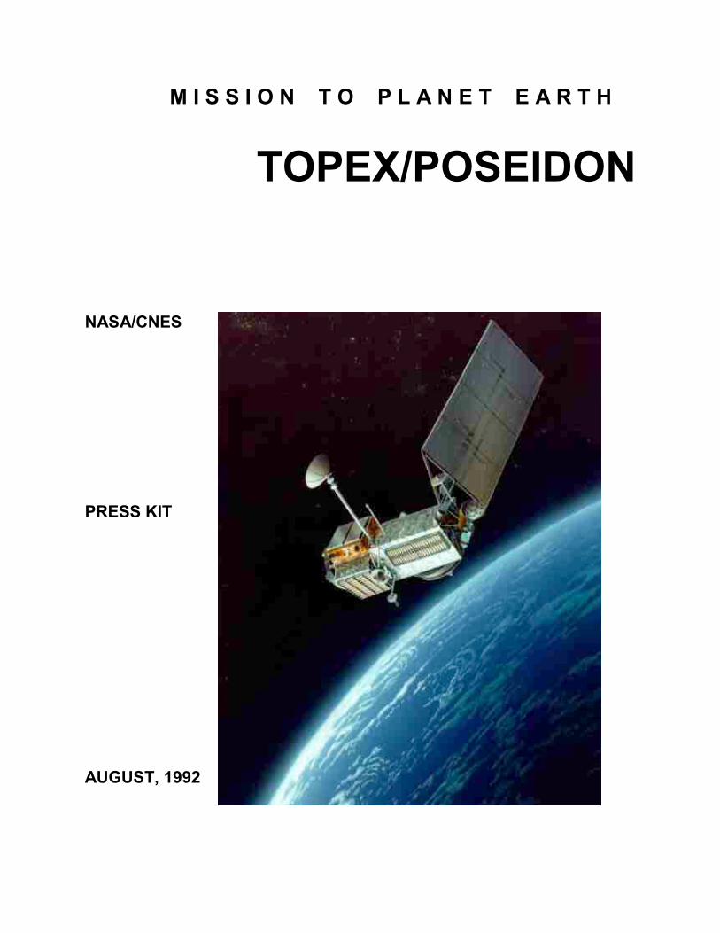
TOPEX/POSEIDON
NASA/CNES PRESS KIT AUGUST, 1992
PUBLIC AFFAIRS CONTACTS
Brian Dunbar
Headquarters, Washington, D.C. (Phone: 202/358-0873)
Mary Hardin Jet Propulsion Laboratory, Pasadena, Calif.
(Phone: 818/354-5011)
CONTENTS
General Release.......................................………………………......................1 Mission Overview And Science Objectives...…………..................................3 Satellite Tracking.....................................…………………………..………..4 TOPEX/POSEIDON Satellite.....…………………….………………...........5 Science Instruments And Spacecraft......................……..…………..............6 Mission Phases......................................…………………………………......8 Mission Timeline....................................……………………………….......9 Spacecraft Specifics..................................……………………….……….10 U.S.-French Cooperation...................………………………..…...............10 Mission Management.................................………………………….........11
1
RELEASE 92-126 U.S., FRANCE SATELLITE TO STUDY OCEANS AND CLIMATE On Aug. 10, the United States and France will undertake a mission to help provide a new understanding of Earth's environment by determining how the global system of the Earth's oceanic currents influence climate. The means to this end is the TOPEX/POSEIDON satellite, a joint mission of NASA and France’s space agency, the Centre National dUEtudes Spatiales (CNES). "TOPEX/POSEIDON is an investment in our future," said NASA's Program Scientist Dr. William Patzert. "Without TOPEX/POSEIDON, there is no possibility of meaningful long-term climate forecasts." "TOPEX/POSEIDON sets a precedent for international studies of global change," said Patzert. "In a future of limited resources, it is imperative that all nations work together to study our atmosphere and oceans. We will have to share our understanding to develop common solutions. Climate knows no national boundaries." Ocean Topography TOPEX/POSEIDON will use the global perspective available only from space to develop maps of ocean topography showing the barely perceptible hills and valleys of the sea surface. This effort will significantly expand the knowledge developed from shipboard research which was limited to specific locations. From the TOPEX/POSEIDON data, scientists will calculate the speed and direction of ocean currents worldwide to better understand how the oceans transport heat from the Earth's equatorial region toward the poles, thus regulating global climate. The spacecraft's six scientific instruments are designed to function for 3 to 5 years. The resulting database will help scientists develop more precise long-term climate forecasts, understand and predict the timing of the El Nino phenomenon and better comprehend the ocean's role in regulating overall global climate.
2
TOPEX/POSEIDON will be launched from the Guiana Space Center in Kourou, French Guiana, aboard an Ariane 42P expendable launch vehicle. The satellite will be placed into an orbit 830 miles (1,336 km) above the Earth, inclined 66 degrees to the Earth's equator. Launch is scheduled for 7:08 p.m. EDT. The launch window is 44 minutes in duration. International Cooperation The TOPEX/POSEIDON launch will help commemorate 1992 as the International Space Year. The joint science team includes 38 principal investigators from nine countries including the United States, France, Australia, South Africa, Germany, Norway, Japan, the Netherlands and the United Kingdom. Data from TOPEX/POSEIDON eventually will be made available to global change researchers around the world for their analysis. TOPEX/POSEIDON is the second major satellite in NASA's Mission to Planet Earth, a coordinated, long-term program to study the Earth as a complete environmental system. Mission to Planet Earth began in September 1991 with the launch of the Upper Atmosphere Research Satellite and continued last March with the ATLAS-1 Space Shuttle mission. The next element of Mission to Planet Earth is the Italian-built LAGEOS II satellite, scheduled for launch aboard the Space Shuttle Columbia in October. LAGEOS II will be used to study the dynamics of the Earth's crust. The U.S. portion of the TOPEX/POSEIDON project is managed by NASA's Jet Propulsion Laboratory, Pasadena, Calif., for the agency's Office of Space Science and Applications. The French portion of TOPEX/POSEIDON is managed by CNES' Toulouse Space Center, Toulouse, France.
- end -
3
MISSION OVERVIEW TOPEX/POSEIDON will be launched by the European Ariane 42P rocket from Kourou, French Guiana. The spacecraft will be placed in a nearly circular orbit with an altitude of 830 miles (1,336 kilometers), inclined 66 degrees from the equator. This relatively high altitude will minimize atmospheric drag on the spacecraft, reduce the effects of gravity field variations and simplify maneuvers needed to maintain the orbit. The satellite's orbital period is 112 minutes. TOPEX/POSEIDON will repeat the same ground track every 10 days (127 revolutions), allowing scientists to measure changes in the sea surface topography using a sampling technique that matches changes in the global ocean currents. This mission builds upon the knowledge gained from three previous ocean-observing satellites GEOS-3 in 1975, Seasat in 1978 and Geosat in 1985 which demonstrated that altimetry could measure ocean circulation. Like these prior missions, the primary instrument on-board the TOPEX/POSEIDON satellite is a radar altimeter. The altimeter is similar to aircraft radar, but the satellite altitude and the required height precision are many times greater. The TOPEX/POSEIDON altimeter bounces radar pulses off the sea surface and measures the time it takes the signals to return to the satellite. A microwave radiometer will correct for any errors in the time delay that is caused by water vapor in the path through the atmosphere. The adjusted round-trip travel time is used to calculate the distance between the spacecraft and the sea surface. When this distance is combined with the measurements of the satellites exact location in space, scientists will first determine the height of the sea surface relative to the Earth's center and then calculate fluctuations in currents and tides.
SCIENCE OBJECTIVES The primary objective of the TOPEX/POSEIDON project is to make precise and accurate global observations of the sea level for several years, substantially increasing understanding of global ocean dynamics. Members of the TOPEX/POSEIDON science team will share their data with scientists working with the World Ocean Circulation Experiment (WOCE). Together they will be able to determine the general circulation of the ocean and its variability. The satellite also will increase understanding of how heat is transported in the ocean. The ocean absorbs the sun's heat and redistributes it. Active currents such as the Gulf Stream carry warm water from the tropics to the poles where it cools and sinks into the deep ocean.
4
Without this circulation, the difference in temperature between equatorial and polar waters would be much greater than it is today. How the water circulates in the ocean determines the speed at which the heat is transported and how the exchange of energy regulates the world's climate. El Nino Another short-term climate change influenced by the ocean is the phenomenon known as El Nino. Every 3 to 7 years, usually beginning around Christmas time, there is a dramatic rise in the sea surface temperatures in the eastern Pacific Ocean. At the same time, atmospheric patterns shift, causing severe environmental consequences around the globe. The El Nino event of 1982-83 was the worst so far this century. Massive flooding and landslides killed hundreds of people in Ecuador and Peru and caused millions of dollars in damage along the Southern California coast. Cyclones left 25,000 people homeless in Tahiti and severe droughts plagued the southern hemisphere, especially Australia, Indonesia, the Philippines and South Africa. TOPEX/POSEIDON will improve our knowledge of upper-ocean circulation in the tropical Pacific, which is essential for reliable prediction of these El Nino events. The ocean also is influenced by gravity and the Earth's rotation. If the Earth did not rotate, the shape of the resting ocean would conform to the Earth's gravity, a condition scientists refer to as the geoid. But the Earth is not still, and ocean currents raise or lower sea level from the geoid. The elevation of sea level relative to the geoid is called ocean topography. Sea currents contribute to the low hills and shallow valleys in the ocean which are similar to the high and low pressure systems that occur in the atmosphere. Sea water flows around these hills and valleys just as winds blow around the highs and lows of atmospheric surface pressure. TOPEX/POSEIDON will measure these changes in ocean topography, and scientists will calculate the speed and direction of ocean surface currents.
SATELLITE TRACKING TOPEX/POSEIDON is equipped with instruments that enable scientists to accurately pinpoint the satellite's location. Precise orbit determination is crucial because errors in locating the spacecraft would distort the sea level measurement calculated from the altimeter readings. TOPEX/POSEIDON will measure the distance from the satellite to the sea surface within 1.2 inches (3 cm). Three independent tracking systems will
5
determine the position of the spacecraft within 4 inches (10 cm). The first, the NASA laser retroreflector array (LRA) will reflect laser beams from a network of 10 to 15 ground-based laser ranging stations under clear skies. The second, for all-weather, global tracking, will be provided by the CNES Doppler Orbitography and Radiopositioning Integrated by Satellite tracking system receiver (DORIS). This device uses microwave doppler techniques (changes in radio frequency corresponding to relative velocity) to track the spacecraft. DORIS consists of an on-board receiver and a global network of 40 to 50 ground-based transmitting stations. The third system utilizes an on-board experimental Global Positioning System (GPS) demonstration receiver to precisely determine the satellite's position continuously by analyzing the signals received from the U.S Air Force's GPS constellation of Earth orbiting satellites. TOPEX/POSEIDON also will fly over two verification sites so that scientists can compare data taken on the ground to the readings obtained from the satellite. These sites are located on the Texaco Harvest Oil Platform off Point Conception, Calif., (the NASA site) and near Lampedusa Island in the Mediterranean Sea (the CNES site). Throughout the mission, comparisons of the information collected at these sites will ensure that the satellite's instruments are calibrated very precisely.
THE SATELLITE
The TOPEX/POSEIDON spacecraft is based on the existing Multimission Modular Satellite (MMS) bus, modified to meet the needs of this mission. Built by Fairchild Space, the satellite is comprised of the MMS and an instrument module which houses the sensors. The MMS command and data handling subsystem contains the main computer on-board TOPEX/POSEIDON. It interprets and executes commands and receives data from all subsystems and sensors for transmission to the ground. The command and data handling subsystem houses three tape recorders used for engineering telemetry and science data storage. Each tape recorder will record for about four revolutions or 8 hours of data before playback. This subsystem also provides telecommunications using a steerable high-gain antenna dish and two omni antennas. During normal operations, the satellite communicates with the ground via the Tracking and Data Relay Satellite System (TDRSS). This link handles all commands, science data, engineering telemetry and the operational orbit tracking for navigation and mission planning. The attitude determination and control subsystem maintains the proper spacecraft attitude during mission operations and points and stabilizes the

6
satellite during all orbit adjustments. It also will automatically "take charge" to put the satellite into a "safing" mode if it detects a problem with its own performance or if it does not receive the periodic "I'm OK" signal from the on-board computer. The spacecraft's electrical power subsystem contains the solar array and three batteries. The solar array is the main power source and the first item to be deployed, 2 minutes after separation from the launch vehicle. After deployment, the on-board controller rotates the array so that the panels face the sun. The batteries provide power from about 10 minutes before launch until the solar array takes over. The batteries also are used to keep the instruments operating while the spacecraft is orbiting the night side of the Earth.
SCIENCE INSTRUMENTS
TOPEX/POSEIDON carries five scientific instruments. Three are provided by NASA and two by CNES. The Dual-Frequency TOPEX Radar Altimeter (ALT) The primary instrument onboard the satellite is the dual-frequency NASA radar altimeter (ALT). Provided by NASA and managed by the Goddard Spaceflight Center, the altimeter was built by the John Hopkins University's Applied Physics Laboratory. The instrument is designed to measure the height of the satellite above the sea at two frequency channels, 13.6 GHz and 5.30 GHz. This is the first altimeter to use two channels to correct for measurement errors caused by free electrons above the Earth's atmosphere.
The TOPEX/POSEIDON SPACECRAFT
7
TOPEX Microwave Radiometer (TMR) The companion TOPEX microwave radiometer, developed by NASA's Jet Propulsion Laboratory, Pasadena, Calif., operates at three frequencies (18 GHz, 21 GHz and 37 GHz). The radiometer measures water vapor, which can delay the return of the radar pulse to the spacecraft, along the path viewed by the altimeter and corrects the altimeter data. The 21 GHz channel is the primary channel for water vapor measurement. The 18 GHz and 37 Ghz channels are used to remove the effects of wind speed and cloud cover, respectively, in the water vapor measurement. Single-Frequency Poseidon Altimeter (SSALT) SSALT is an experimental precision altimeter designed by CNES and built by Alcatel Espace. This instrument is being flown as an experiment to validate improved solid-state technology, which results in smaller, lower- power and lower-weight altimeters for future missions. SSAlt uses the same antenna as the NASA altimeter but operates at a single frequency of 13.6 GHz. During the first 6-month verification phase, the SSALT will operate about 12 percent of the time to assess its performance. For the remainder of the mission, NASA and CNES will determine an antenna sharing plan to optimize data collection. Doppler Orbitography and Radiopositioning Integrated by Satellite (DORIS) The DORIS tracking system will provide important tracking data for precision orbit determination using microwave Doppler techniques. This is a proven system manufactured by the French aerospace firms, Dassault, CEPE and STAREC, and was first flown by CNES on the SPOT-2 satellite. The system is made up of an on-board receiver and a network of 40 to 50 ground transmitter stations. Operating in all weather conditions, DORIS receives signals at two frequencies (401.25 MHz and 2036.25 MHz) which allows the total electron content of the ionosphere to be estimated. This allows the removal of SSALT altitude errors introduced by traveling through the ionosphere. Global Positioning System Demonstration Receiver (GPSDR) The GPSDR is an experimental receiver developed by JPL and manufactured by Motorola to provide a unique tracking data type for continuous precision orbit determination. This new technique simultaneously measures the satellite's position relative to the U.S. Air Force's Global Positioning System and ground stations. By adding the ground stations, the exact locations of which have been precisely measured, the new system promises to revolutionize
8
orbit determination by providing continuous satellite tracking with a potential accuracy of 4 inches (10 cm) or better. The GPS receiver operates at 1227.6 MHz and 1575.4 MHz.
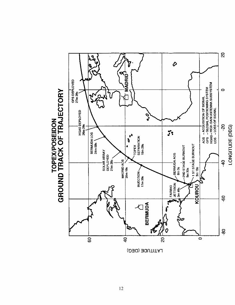
MISSION PHASES The French-provided Ariane 42P launch vehicle, manufactured by Arianespace, is a three-stage, liquid-propelled rocket, approximately 215 feet (60 meters) long, with two strap-on first-stage solid propellant motors. The first two stages of the core vehicle are powered by hydrazine and nitrogen tetroxide. Stage three contains cryogenic liquid oxygen and hydrogen. The vehicle equipment bay is located between the third stage and the payload compartment, and its inertial reference system and computer conduct the ascent attitude control, guidance and sequencing. The spacecraft arrived at the Centre Spatial Guyanais in Kourou, French Guiana, on June 23 to undergo a series of performance tests prior to launch. Five days before launch, the encapsulated satellite will be mated to the launch vehicle. After that, the satellite will continue functional testing and battery charging cycles in preparation for flight. Final configuring for the launch is achieved 90 minutes before liftoff, with the exception of the tape recorders and transmitters. Transmitter A is turned on 2 hours before launch. Two tape recorders are commanded to record at launch minus 20 minutes. At launch minus 10 minutes, the satellite is switched to internal battery power and the umbilical disconnect process, which takes about 40 seconds, begins a minute later. After the umbilical is disconnected, real-time monitoring of the satellite's functions will be conducted through the satellite's telemetry transmitter. Tracking During Launch Launch vehicle telemetry is coordinated primarily through the Guiana tracking facilities at Kourou. After injection (which occurs approximately 17 minutes after launch), real-time satellite telemetry is available through the NASA tracking station at Bermuda. Telemetry also is recorded on two satellite tape recorders for later playback. Several critical events, including injection, the orientation maneuver, satellite separation and solar array deployment occur while the Bermuda station is tracking the satellite.
9
Madrid is the first Deep Space Network (DSN) station to track the satellite after launch. This pass starts 20 minutes after launch (approximately 1 minute after separation) and continues for 12 minutes. The DSN 26-meter antennas are the primary method of communicating during the first day. Beyond that, the DSN only will be used as an emergency method of communicating. For the balance of the mission, the primary method of communicating between the satellite and the ground will be via the Tracking and Data Relay Satellite System (TDRSS). The first TDRSS contact is established approximately 1 hour after launch.
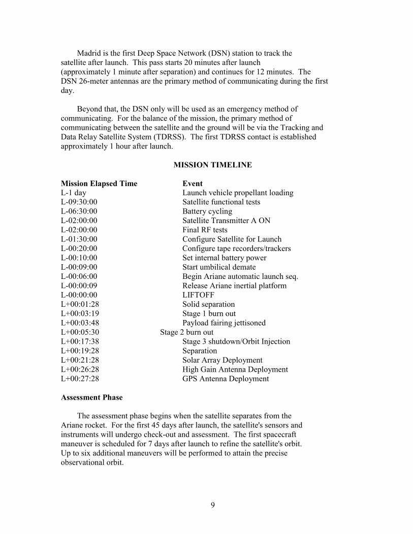
MISSION TIMELINE
Mission Elapsed Time Event L-1 day Launch vehicle propellant loading L-09:30:00 Satellite functional tests L-06:30:00 Battery cycling L-02:00:00 Satellite Transmitter A ON L-02:00:00 Final RF tests L-01:30:00 Configure Satellite for Launch L-00:20:00 Configure tape recorders/trackers L-00:10:00 Set internal battery power L-00:09:00 Start umbilical demate L-00:06:00 Begin Ariane automatic launch seq. L-00:00:09 Release Ariane inertial platform L-00:00:00 LIFTOFF L+00:01:28 Solid separation L+00:03:19 Stage 1 burn out L+00:03:48 Payload fairing jettisoned L+00:05:30 Stage 2 burn out L+00:17:38 Stage 3 shutdown/Orbit Injection L+00:19:28 Separation L+00:21:28 Solar Array Deployment L+00:26:28 High Gain Antenna Deployment L+00:27:28 GPS Antenna Deployment Assessment Phase The assessment phase begins when the satellite separates from the Ariane rocket. For the first 45 days after launch, the satellite's sensors and instruments will undergo check-out and assessment. The first spacecraft maneuver is scheduled for 7 days after launch to refine the satellite's orbit. Up to six additional maneuvers will be performed to attain the precise observational orbit.

10
Initial Verification Phase This phase occurs after the assessment phase and gives the project team time to calibrate the instruments against ground data they are receiving from the two laser verification sites. This phase lasts about 6 months. Observational Phase The key objective of the observational phase is the production and distribution of the Geophysical Data Records which contains sea surface height, sensor corrections and geophysical information. The science data team is responsible for distributing and archiving these sensor and geophysical data products.
SPACECRAFT SPECIFICS Design lifetime: 3 years prime; 2 years extended mission Length: 18 feet (5.5m) Width: 9.2 feet (2.8m) Solar panel: 28.5 feet x 10.8 feet (8.7m x 3.3m) Power: 2,100 Watts Mass: 5,500 pounds (2,500kg)
U.S.-FRENCH COOPERATION TOPEX/POSEIDON is only one area in which the U.S. and French space programs are cooperating. French scientists are principal investigators or co-investigators on NASA's Galileo and Wind spacecraft and the Upper Atmosphere Research Satellite. There has been substantial collaboration on several Spacelab missions, including Space Life Sciences-1 in 1991 and the ATLAS-1 and International Microgravity Laboratory-1 missions in 1992. There has been substantial collaboration on several Spacelab missions, including Space Life Sciences-1 in 1991 and the ATLAS-1 and International Microgravity Laboratory-1 missions in 1992. The agencies are cooperating in development of the Visual and Infrared Mapping Spectrometer to fly on NASA's Cassini mission to Saturn in 1997. U.S.-French cooperation extends back to joint solar studies in the 1960s. In 1978, CNES provided the ARGOS data collection system that flew on the TIROS-N satellite and subsequent satellite search-and-rescue equipment based on ARGOS technology. In 1985, French payload specialist Patrick Baudry flew on Space Shuttle mission 51-G, which deployed three satellites.
11
MISSION MANAGEMENT NASA Headquarters Daniel Goldin Administrator Aaron Cohen Acting Deputy Administrator Dr. L.A. Fisk Associate Administrator, Office of Space Science and Applications Alphonso V. Diaz Deputy Associate Administrator Office of Space Science and Applications Dr. Shelby G. Tilford Director, Earth Science and Applications Division Dr. W. Linwood Jones Program Manager Dr. William Patzert Program Scientist Centre Nationale d'Etudes Spatiales Dr. Jean-Louis Fellous Program Manager Michel Dorrer Project Manager Dr. Alain Ratier Program Scientist Dr. Michel Lefebvre Project Scientist Jet Propulsion Laboratory Charles Yamarone Jr. Project Manager Dr. Lee-Lueng Fu Project Scientist
12