Embed Size (px)
Citation preview

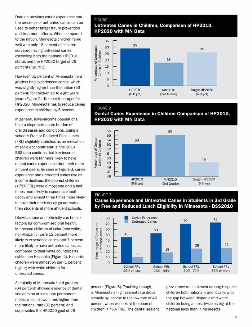
TIRAMISU : FP7-Project for an integrated toolbox in Humanitarian Demining
Y.Yvinec (RMA), Y.Baudoin (RMA), G.De Cubber (RMA), M.Armada (CSIC), L/Marques (ISR-UC), Jean-Marc Desaulniers (JMDThèque), M.Bajic (CTDT)
And TIRAMISU consortium (www.fp7-tiramisu.eu)
Abstract
The TIRAMISU project aims at providing the foundation for a global toolbox that will cover the main mine action activities, from the survey of large areas to the actual disposal of explosive hazards, including mine risk education and training tools. After a short description of some tools, particular emphasis will be given to the two topics proposed by the GICHD Technology Workshop, namely the methodology adopted by the explosion of an ammunition storage and the possible use of UAV (or UGV/UAV) in Technical survey and/or Close-in-Detection
1. Introduction
The modular toolbox is described on www.fp7-tiramisu.eu while the following (non exhaustive) table gives a short description of the Technical Survey and Close-in-Detection tools
TID Product Name (partners a.o.)
Current TRL
Expected TRL
Description Notes
T3
Ground Penetrating Radar Array (IDS) Ground Penetrating Radar Array: Signal processing module for classification (NOVELTIS)
4
6-7
Within the TIRAMISU project, IDS will build a modular, densely sampled, GPR imaging array with real time software for fully automatic detection of mines. The dense sampling and relatively large scanning width (1-2 m) of the GPR array will allow imaging capabilities, which through suitable advanced signal and image processing algorithms will be crucial for discriminating real mines, especially shallower and smaller AP mines, from metal fragments, rocks, roots or other soil heterogeneities (generally termed as clutter), thus reducing the usually high false alarm rate (FAR) of GPR. Could be combined with the tool T17 and mounted on a UGV
T4
Medium stand-off Synthetic Aperture Radar (DLR)
2-3 5-6
In this project DLR HR-AS will develop a vehicle-based side-looking imaging sensor (TIRAMI-SAR) based on the synthetic aperture radar (SAR) principle for the medium range detection of mines (5-15 m). This innovative solution can in fact solve critical problems encountered by previous attempts with SAR (very large distances from hundreds of meters to kilometres) while avoiding the criticalities of the forward looking scheme. Contrary to the military requirement, a humanitarian demining tool can be used to scan a long 5-7 m wide strip on its side from a safe lane in order to provide indication of suspected items for other tools to investigate further. In this way the system will serve as a very fast area reduction tool reducing hundreds of square meters of suspected land to a few spots requiring accurate close-in checks. It should be noted that SAR imaging requires a stand-off side-looking geometry, being completely different from normal close-to-ground GPR measurements. Consequently the use of the same vehicle in parallel for SAR and GPR is not possible

T7 Chemical sensor (USTAN)
2,3 6
To complement the well-established sensor technologies, we are developing novel polymer-based sensors for detecting explosive vapours from landmines. These sensors work by detecting a change in the light emission from a semiconducting polymer film [Thomas2007]. When exposed to very dilute vapours of TNT-like compounds, the explosive molecules adhere to the film and obstruct the light emission. Fluorescence sensing has previously been studied in laboratory conditions and in the field as the Fido sensor from Flir Systems. It was recently discovered that greater sensitivity is possible using laser light from the polymer instead of fluorescence to detect explosives [Rose2005]. Most research on light-emitting polymer chemical sensors has been laboratory-based and materials oriented. The research in TIRAMISU plans to advance the use of polymer laser sensors to minefield detection conditions for the first time, and will aim to establish the feasibility for new modes of application of laser and fluorescence array sensors including Technical Surveys of suspected mine fields.
T8
Remotely controlled Inspection Platforms (ISR-CSIC-RMA+)
4-6 7-8 UGV-UAV, Stand-Off UXO Sensor’s carriers; read further chapter 2
T12
Low-cost agricultural derived assistance (DIMEC-PIERRE)
5 9
TIRAMISU intends to research breakthrough solutions for Technical Surveys based on agricultural technology, a complex of landmine absence verification assets and a new systematic methodology for the tracking and monitoring of the survey operations and for their planning. The implementation of a low-scale GIS system to collect real data on the trajectories of the assets and the area covered is a fundamental element that will complete an effective monitoring of operations and constitutes the basis for an informed land release planning.
T16 Intelligent Prodder (UNICT)
3 4 ,7
This device will be based on piezo- electric touch sensors with a simple yet effective methodology for feature selection and elaboration. Moreover, another advance will also be the integration of the prodder with other sensors such as force sensors and sensitive and highly directional electric field and magnetic field sensors. Therefore a multisensory data fusion technique will be implemented to improve the reliability of the system
T17 Innovative Metal detector Array (VALLON)
5 9
This research project focuses on a versatile and innovative multi-channel metal detector. The goal is to unify the advantages of a hand held detector (high detection performance, flexible adaption to terrain, various discrimination functions to enhance the detection capabilities by reducing the false alarm rate while keeping the probability of detection high) with the advantages of vehicle mounted multi-channel systems (large detection footprint, high search speed). This multi-channel metal detector is highly user configurable in terms of coil number, data interfaces and integration into multi sensor systems (with GPR, chemical sensors, etc

2. UGV
2.1 Introduction
The idea of using robotics for humanitarian demining and/or advanced light-weight modular low-cost robots for technical survey and/or close-in-detection has been proposed by numerous authors [Baudoin, 1999]. Even though none of the current robotics platform seem to have reached production on a larger scale (except for military EOD/IEDD tasks), many lessons may be learned from several projects and experiences. Robotics solutions properly sized with suitable modularized structure and well adapted to local conditions of dangerous unstructured areas can greatly improve the safety of personnel as well as the work efficiency, productivity and flexibility. In this sense, mobile systems equipped with manipulators for detecting and locating antipersonnel landmines are considered of most importance towards autonomous/semi-autonomous mine location in a proficient, reliable, safer and effective way. Conventional vehicle-mounted mine detector systems employ an array of sensor devices to achieve a detection swath typically 2~4m wide. Some systems employ more than one type of sensor technology. These systems, while being very useful are often expensive, unsafe, complex and inflexible [Ishikawa, 2005]. Nevertheless, several IARP (International Advanced Robotics Programme – http://iarp.isir.upmc.fr ) workshops [Armada, 2005] [Fukushima, 2005] [Fukuda, 2005],[Fernández, 2011 have on the contrary shown that the use of Robotics Systems could improve the safety and the clearance efficiency and that they may be considered as promising tools. One goal of the TIRAMISU project is to develop an advanced lightweight detecting system for humanitarian demining purposes consisting of an integration of three different sensors, a MD, a GPR and an explosives vapour detector (EVD). The final prototype (tool) would consist of a manned or unmanned vehicle-based system capable of detecting explosive devices (ED) with a higher clearance rate than that of the current level of technology. 2.2 Current R&D and Experiences of the TIRAMISU partners
2.2.1. ROBUDEM – TEODOR (RMA) [De Cubber, 2012]
Autonomous robotic systems operating in unstructured outdoor environments need to estimate the traversability of the terrain in order to navigate safely. Traversability estimation is a challenging problem, as the traversability is a complex function of both the terrain characteristics, such as slopes, vegetation, rocks, etc. and the robot mobility characteristics, i.e. locomotion method, wheels, etc. It is thus required to analyze in real-time the 3D characteristics of the terrain and pair this data to the robot capabilities. To our knowledge, time-of-flight cameras have until now not been used for these kind of applications, simply because there were no sensors capable of coping with outdoor conditions, especially due to the interference of solar irradiation. This situation is changing now, with the advent of outdoor-capable sensors. Therefore, we now focus on an approach for outdoor terrain traversability which mixes 2D and 3D information for terrain classification. Figure 1 shows the Robudem platform which is used as a testbed for the developed algorithms. It is a heavy outdoor robot equipped with a PMDTec CamCube time-of-flight sensor (on top) and a Point Grey Bumblebee stereo camera (in the middle). The time-off-flight camera is mounted in a tilted angle to avoid typical signal modulation problems. The top right image shows the amplitude input image, whereas the bottom left image shows the terrain classification result. Obstacles are red, well traversable terrain is green and "suspicious" areas (not enough data) are blue. It can be noticed that the classification is correct, as the obstacle (the tree) is well-detected. In the upper left corner, there are some problems with foliage giving erroneous reflections (blue area), which is due to the sensor

2.2.2. LADERO – ISR-TT Robot
LADERO is an advanced multi-sensor demining robot designed and developed in ISR-UC Coimbra [Marquez,2002],[Rachkov,2005]. The robot can transport demining equipment up to 100 kg across rough and sloped terrains using its improved payload possibilities due to the robust design and pneumatic drive system. Robot pedipulators are adaptive to obstacles and terrain unevenness, so it can keep the working position of the mine detection block while searching for mines. The design of the transport module of the robot consists of 200 mm stroke longitudinal pneumatic cylinders and latitudinal pneumatic cylinders whose bodies are connected symmetrically to cover maximum mine size in one stroke. Each pneumatic transport cylinder has two pedipulators that are fixed at ends of its piston rods. The pedipulator consists of 150 mm stroke lifting cylinder able to overcome stone obstacles of that magnitude and a foot with toothed contact surface to improve robot’s climbing possibilities. The detection block consists of a metal detector and VIS+IR detector [Larionova,2005 ]. This block is connected to the front part of the robot. A linear position sensor of longitudinal motion is placed on the body of the longitudinal cylinder. The linear position sensor of latitudinal motion and the detection block is placed on the body of the latitudinal cylinder. DGPS and IMU sensors provide self-localisation and an array of sonars provides obstacle detection around the robot. The robot is controlled by an on-board processing unit and by an operator remote station in an interactive mode. Experimental results of the transport, control, and detection systems show effectiveness of their functioning. Due to the relatively low cost design, the robot application can potentially reduce demining costs. The robot motion and mine sensing are controlled by means of a distributed control system. This system provides remote control from a safe distance in an automatic mode or in a teleoperated mode by an operator. One of the main limitations of this platform is the requirement of air pressure supply through an umbilical tube, limiting the mobility of the platform to few tens of meters from the air supply.

Figure.2. LADERO
The ISR-TT robot is an all-terrain 4 wheel drive mobile robot. Each wheel has independent direction and independent active and passive suspensions. The wheels are brushless DC (BLDC) in-wheel motors with 900W each. A total of 8 linear actuators composed by DC motors with position feedback are used for the direction and active suspension systems. This allows the 1m long robot to easily traverse rough terrain by shifting its body or by adopting diagonal trajectories. The robot can also perform in-place rotations. The high versatility of the ISR-TT robot translates into a wide range of terrains. The total of 12 actuators are controlled by custom made intelligent DC and BLDC drivers that support CANopen communication. A CAN bus distributed across the whole robot, allows easy installation of new CAN-based sensors and actuators. The ISR-TT robot is integrated into the ROS framework, making it easy to add or change sensors and actuators. The robot is equipped with a PointGrey Stereo System for obstacle avoidance and visual odometry. An Xsens MTi-G IMU provides global positioning (GPS) and data about the pose of the robot. Data from the IMU is also being fused with the visual odometry for generating more robust odometry estimation. The ISR-TT robot can carry heavy payloads (at least 100kg) and can thus be equipped with a wide range of sensors for different missions.
Figure.3 ISR-TT all terrain robot for stand-off and close-in detection of ED (under construction).
2.2.3. DYLEMA (CSIC) [Armada, 2005] [Gonzalez de Santos, 2007]
The idea of using legged mechanisms for humanitarian demining has been under development for at least the last ten years, and some prototypes have been already tested. The Centre for Automation and Robotics – CAR (CSIC-UPM) holds experience in the design, development and control of walking robots, gait generation, terrain adaptation, robot teleoperation, collaborative control and other related fields. All these technologies were mature enough to be merged in order to produce efficient robotic systems, like the SILO6, a six-legged walking robot developed at CAR within the DYLEMA project (DPI2004-05824), specially designed for Humanitarian Demining. The DYLEMA whole system has been configured with the aim of putting together different subsystems (see Figure 2): Sensor head, configured to detect potential alarms but also to allow the controller to maintain the sensor head at a given height over the ground using range sensors. It employs a standard metal detector for mine sensing. Scanning manipulator, being basically the sensor-head a specialised stand-alone multi-sensor system, it is required to use a robotic arm to manoeuvre it through the desired space (3D position plus orientation), as well as to adapt it to terrain irregularities and to avoid obstacles. Locator, the information provided by DGPS (Differential Global Positioning System) and electronic compass on board SILO6 is used after detecting a suspicious object to calculate and record their exact location in a database for subsequent analysis and decision-making. Mobile robot, based on a six-legged walking robot, SILO6. A mobile platform to carry on the different subsystems across mine infected fields is of vital importance for thorough demining. The following characteristics are provided: hexapod configuration, enough lightweight to be handled by two adults, autonomous from the energy point of view, tethers are avoided, semi-autonomous from the control point of view, with a remote operator in the loop, power consumption, mobility and stability were balanced through detailed design. Controller, the overall control system is distributed into two main computers, the onboard computer and the operator station. The operator station is a remote computer in charge of defining the mobile robot’s main task and managing the potential-alarm database.
Figure 4. SILO6 Humanitarian Demining Walking Robot with Five Degrees of Freedom Scanning Arm.
3. UAV
3.1. Introduction
The Micro-mini UAV (MAV) and Rotary Wings seem to be good candidates for Technical Survey and, possibly, Close-in-detection in Humanitarian Demining while the MALE (Medium Altitude Large Endurance) and SR (Short Range) or MR (Medium Range) could be envisaged for the Non-Technical survey The small size of MAVs has several implications on their performance capabilities. First and foremost, they have limited payload capacity (size, weight, and power) and are therefore unable to carry significant computational resources or sensors of the highest accuracy and capability. Second, their small size and relatively low flight speeds make them susceptible to degraded performance caused by high winds and wind gusts. These challenges, imposed by the small size of MAVs, must be overcome for MAVs to be utilized successfully. Future advancements in miniaturization and performance of sensors and computers will enable increased success. However, efforts must also be made to utilize existing sensor and computer capabilities in novel and innovative ways to enhance the utility of MAV systems in the immediate future [Gerard ten Buuren, 2011] The ability to land a MAV accurately on a designated landing point is useful for several applications including the safe recovery of the MAV in risky conditions (a.o. minefields) Several challenges make precision landing/strike difficult for small UAVs. The disturbance imposed by wind is always an issue with MAVs, and for the present, sensor errors such as those common in the measurement of attitude and altitude cause difficulties. For precision landing, the most critical information is to know the location of the MAV relative to the desired landing location. Developing reliable methods for measuring this information is central to the success of a precision landing approach. The value of target (Explosive Device) tracking and localization from a small MAV platform is obvious and significant. this capability is attractive, but presents challenges. The most significant challenges associated with accurate target localization stem from the lack of precise attitude estimates for the MAV platform. Pitch and roll are difficult to estimate with a high degree of accuracy with the Micro-electromechanical systems (MEMS) sensors typically used for MAV control. Measurements of heading are not available – heading is often approximated by the course of the MAV which is estimated from successive GPS measurements. In high-wind conditions (relative to the desired airspeed), the course is often a poor approximation of the heading. The ability to operate in constrained environments is of great importance for MAV that must be able to fly amidst natural and man-made obstacle Air-to-ground detection systems could provide an interesting contribution to the technical survey as well as to the close-in-detection aims for so far technical and operational improvements are precisely defined. Both the aerial platform (a sensor’s carrier) and the Remote Pilot Station have to be considered, both in the context of evolving legal (national, European and/or international) regulations.
3.2 Experiences
3.2.1. ROBOVOLC (UNICT) (sample gathering)
The project ROBOVOLC is a project lead by the University of Catania in cooperation with the INGV (Italian Institute on Geophysics and Volcanology) since 1998. The project has been initially funded by the European Commission within the 5th Framework Programme. The main purpose was to develop a robotic system for measurements and explorations in a volcanic environment [Guccione, 2000]. The final system developed is a six-wheeled robot with an articulated chassis and a five degrees of freedom manipulator arm, used to collect rock samples and to perform gas measurements [Muscato, 2012].
Figure 5. ROBOVOLC in action on Mt. Etna.
Figure 6. The U-Go Robot.
Several science sensors are mounted on ROBOVOLC and comprises a pan-tilt turret, a manipulator, and a gas sampling system. Mounted on the pan-tilt turret, is a video-camera with recorder, a high resolution still-image camera, another video-camera for teleoperations, an infrared camera for thermal measurements, and a Doppler radar for lava and gas-jet speed measurements. The ROBOVOLC is usually teleoperated, but in some situations is fundamental to move it autonomously. So a navigation system has been also installed including a stereo camera (Videre, STH-MDCS3-VAR), an Attitude and Heading Reference System (X-Sens MTi), a Laser range finder (SICK LMS200), US-Sonars (Devantech SRF08), a Global Navigation Satellite System receiver RTK-DGPS (Ashtech ZXtreme) and Encoders on each wheel. Recently another platform has been developed for volcanic exploration and agricultural applications. This new robot named U-go, has a simpler mechanical structure using two independent tracks, but adopt the same navigation architecture developed for the ROBOVOLC [Bonaccorso, 2011]. At University of Catania a research line for the development of UAVs for volcanic inspections was also started. In particular the Volcan Project was initiated in cooperation with INGV, with the aim of building a series of autonomous flying system to perform gas analysis and sampling and visual monitoring of volcanic areas [Astuti, 2009]. Due to weight and space limitations, UAV cannot have on board precise DGPS or other big or heavy sensors. On the other side UAV are very useful to give a wide map of the interested environment that could be really useful to plan a mission. Consequently we developed some SLAM algorithms that could merge precise localization information from the UGV with aerial information of the UAV [Bruno, 2008].
Figure 7. UAV/UGV cooperation.

3.2.2. ROBOT FLEETS FOR HIGHLY EFFECTIVE AGRICULTURE AND FORESTRY MANAGEMENT [González de Santos, 2011] The DUAL use aspects of the TIRAMISU toolbox has been underlined in the so-called ‘restoration of the environment, promoting a sustainable economic and social development’. Agricultural technologies are largely available everywhere and at different levels. Where they are not already available, their presence might be desirable to increase the capability to produce food by farm mechanization. In this context, synergy with other FP7 projects of the TIRAMISU partners will serve our aims. RHEA project “Robot fleets for highly effective agriculture and forestry management” (FP7-NMP2-LA-2010-245986), co-ordinated by CSIC [González de Santos, 2011], is focused on the design, development, and testing of a new generation of automatic and robotic systems for both chemical and physical (mechanical and thermal) effective weed management. This focuses on both agriculture and forestry and covers a large variety of European products. A fleet of small, heterogeneous ground and aerial robots are used, equipped with advanced sensors, enhanced end effectors and improved decision control algorithms (See Fig. 1). RHEA can be considered a cooperative robotic system, falling within an emerging area of research and technology with a large number of applications. One of the RHEA scientific and technical objectives is focused on advanced systems and algorithms for weed mapping based on computer vision in two modes: remote sensing (information gathered by means of aircrafts or UAVs) and ground sensing (information collected from ground robotic platforms, as it is illustrated in Figure. XX. Remote sensed imagery acquired with mini aerial vehicles, in conjunction with GIS technology enable a meticulous analysis from surveyed agricultural sites [Valente, 2011].
Figure 8. RHEA fleet concept
3.2.3. The DIVA Airship
The DIVA project focused on the establishment of technologies required to substantiate autonomous operation of unmanned robotic airships for environmental monitoring and aerial inspection missions. This includes developing a prototype and its sensing and processing infrastructures, control and guidance capabilities, and the ability to perform mission, navigation, and sensor deployment planning and execution. [Mouthino, 2008],[Mirisola, 2008-2009] The DIVA remotely controlled non-rigid airship has a helium filled envelope with 18m3 volume. It is 9.4m long, with 1.9m diameter. Its maximum speed is around 70km/h and the maximum height during remotely piloted flights is 200m above the ground, corresponding to an altitude of approximately 300m.

The airship is propelled by two internal combustion motors with propellers, and controlled by standard aero-model equipment. Servo motors are used as actuators, to control the motors acceleration and steer the airship with the flaps mounted in the back of the envelope. A human pilot with a radio control unit sends commands to an on-board radio control receiver to control the servo motors. The combustion motors and electronic equipment are mounted on a gondola, below the envelope, which may have a maximum weight of 13.5kg. Thus discounting the weight of the mechanical structure of the gondola, motors and aero-model equipment, the payload available for electronic equipment and sensors is about 7kg. The blimp carries a digital camera, rigidly mounted with an AHRS, and a GPS receiver, among other sensors, plus an embedded CPU with flash memory storage to read and store sensor data and images, and radio Ethernet equipment to communicate with the ground. A ground station, consisting of a laptop connected to a wireless Ethernet access point with a 7dB antenna, receives telemetry data during the flight, and displays it to the operator, who is able to check the operation of all sensors before taking off and monitor the telemetry data during the flight.
Figure 9. DIVA airship with details of some of its elements.

FIG. I – Gyropendulum Concept FIG. III – Gyropendulum MineMarking Platform
FIG. II – Gyropendulum Mobile Probe Platform Concept with Exosqueletton and Umbilical Cable
FIG. IV – Very first prototype of Gyropendulum MineMarking Platform 220v AC with Umbilical Cable
3.2.4. The Gyropendulum – Minemarking project [JM Desaulnier, 2012]
The Gyropendulum MineMarking Platform (dimension 1.5m x 1.5m - weight range 12kg-24kg) is a Multi-Modal Multi-Media Craft Platform, supporting the Gyropendulum Concept (see FIG. I), that provides the ability to evolve into harsh environment with higher stability than standard platform. Its design authorizes the adjunction of different applicative payloads (weight of 1kg up to 2 kg) that may be fitted into a cylindrical cavity of variable size (diameter of 30mm up to 100mm) according to the targeted application, located within the central body of the Gyropendulum Craft Platform. It operates as a high endurance manual or semi-autonomous platform, radio-controlled by a local pilot over a range of action or search cell determined by an ultra light / high efficiency umbilical power cable (length of 20m up to 100m) that provides redundant secured single phase 220v AC 32 amps. It is built around a rugged carbon fiber central body (height 1.5 meter) that may handle substantial shocks and vibrations. The six propulsors (three on lower and upper propulsion groups) with static or dynamic tilt adjustment are composed of axial 220v AC motorizations with speed reducers and high resistance tri-blade propellers. Such platform may be equipped with various sensors types (optical, acoustic, X-Ray,…) with peripheral or facing ground configuration in order to assess the 3D characteristics of the terrain,
Figure 10. The Gyropendulum of JMDThèque
obstacles and targeted objects. For MineMarking application the platform is equipped with a pressured paint reservoir and injector enabling spot generation (diameter from 3cm up to 50cm) by spraying “normal” above the targeted area/surface (distance of 20cm up to 1m). A specific manipulator (i.e. light robotic arm, low or high precision hexapod,…) may be adapted to the side (radial configuration) of the lower plate or below it (axial configuration). An optional autonomous multicopter power cable lifting/guiding unit (see FIG. II N°367) may be added to the Gyropendulum MineMarking Platform. The 220v AC 32 amps power source may be static or mobile, i.e. installed on a six wheel vehicle with or without pilot or a dedicated UGV. The semi-autonomous mode provides in-built stability/locomotion feature (Steady-NAVTM) and obstacle detection with auto avoidance/rerouting in-built mechanism. It may support pre-loaded or on-the-fly GPS coordinate trajectory planning/processing as a flight/detection assistance feature requiring pilot confirmation on a per command basis when critical/unknown situation occurs.

Steady-NAVTM, is responsible for computing in real-time resultant forces, couples/torques/moments, radius of gyration, according to its center of gravity and mass distribution, to be applied to the Gyropendulum Craft Platform. Umbilical Cable, is a flexible semi-rigid pvc annular isolated component supporting high current that provides partial self-supported feature in order to avoid multiple knots, overstress due to bad flexion (radius of curvature that would be too low) or excessive torsion, as well as thermal dissipation/regulation feature. The resilience / weight ratio is specific on a per application basis. It requires multiple high grade copper or aluminium conductor with a weight characteristic that should be within the range of 850-1200gr per 25m section. Typically, one umbilical cable involves three up to six conductors according to the configuration (total platform current consumption range of 32amp up to 64amp). Power System 220v AC 32amp, is responsible for providing a clean stable 220v AC sinusoidal waveform with high rate varying alternative current from 12amp up to 32amp. Propulsion Group Modularity, enables the Gyropendulum Craft Platform to be equipped with motorizations ranging from 500 watts up to 2400 watts and typically with the following tri-blade propellers configurations (32cm-18cm, 36cm-18cm, 40cm-20cm) according to the required thrust per propulsor within each propulsion group (upper and lower) on a per application basis. Each propulsion group may involve from three up to six propulsors. Craft Platform Squeletton, is design and built on a per application basis with a mix of layered carbon fiber and aluminium according to the sustainable severity of the environment/weather (wind force/rate/pattern according to terrain topography, rock walls, buildings, infrastructures, trees, bushes, and other fixed or mobile obstacles), as well as the targeted achievable flight domain (from low to high translation/rotation/inclination transition rate defined by thrust/roll/pitch/yaw commands/ actuations associated to a specific trajectory spline). Locomotion, is provided through real-time pulsed modulation of each propulsor associated to static or dynamic actuators that may re-orient each vortex separately according to initial configuration, in order to impulse a specific discrete translation/rotation/inclination to the Gyropendulum Craft Platform.
4. Airborne hyperspectral and the multisensor assessment of the unexploded ordnance litter at and around the ammunition storage after the accidents The large quantities of ammunition that are surplus or have exceeded their design life, should be safely disposed or destroyed, although the undesired accidents, explosion of ammunition storages happen very often [GIHCD, 2002], [UNDAC, 2008]. The frequency of the storage explosions increases due to other reasons too (e.g. Libya, Syria) and the new technical solutions are needed to advance the current practice, in which dominates visual search supported by metal detectors for assessment of the contamination distribution, marking, manual displacement and destroyment. One important need is the wide area general assessment of the impact of the undesired ammunition storage explosion on the citizen’s security and environment. The natural approach is to consider the aerial remote sensing, but there is no available the operational technology. The overview of the public references shows that there are no direct solutions for the considered problem. There are several general references about the status of the afflicted area after the undesired explosion, e.g. [GICHD, 2002], [UNDAC, 2008]. The wide area assessment of military test ranges for training of airborne bombing, for testing the artillery, mortars, missiles and other weapons is mature technology, which is mainly based on the magnetometers (ground based – towed, and airborne). The airborne techniques for detection of unexploded ordnance and particularly the detection by means of the hyper spectral remote sensing, is considered in [Doll et al. 1999], [Foley 2007]. Note once again, that the mentioned technologies are suited for test ranges and not for scattered unexploded ordnance after the undesired explosion of the ammunition storage.
This problem was recognized and one task was included in EU FP7 project TIRAMISU (www.fp7-tiramisu.eu). This task was driven by the undesired explosion 13.09.2011 of the ammunition storage Padjene, Croatia, which serves in TIRAMISU as the case study area. The afflicted region after the explosion covers area 38,5 km2, this is the ammunition storage and the area inside of circle with radius 3.5 km. The initially estimated density distribution of the UXO litter, measuring from the center of the ammunition storage is: inside radius 800 m – 70 %, from 800 to 1000 m – 20 %, from 1000 to 2000 m – 6 %, from 2000 to 3000 m – 3 %, from 3000 to 5000 m – 1 %. The success of the application of the airborne multisensor system for the needs of the humanitarian demining [Bajić 2010], is a strong reference which enabled to derive proposal for the inclusion of an improved task in TIRAMISU.
A B
Figure 11. Ammunition storage Padjene a) 29.03.2006, before the explosion (Google Earth), b) aerial photography 13.10.2011, after the explosion 13.09.2011.
a b Figure 12. Airborne system for the hyper spectral and multisensory imaging [Bajić M., 2010]. a) Sensors are in the pod, bellow the fuselage of the helicopter Mi-8. b) The hyper spectral imaging provides 95 images of the
imaged area after the correction of the atmospheric influence, parametric geocoding and matching to the spectral samples of the targets collected on the ground.
In the case of the humanitarian demining the targets are remains of the war at the mine suspected area (trenches, shelters, bunkers, etc.), while in the case of ammunition storage explosion are different types of UXO, propellant, packing. These targets are mostly smaller and there is a main problem how detect them, recognize and describe with needed probability.
The Johnson’s criteria [Holst, G.C., 1996] can serve as a guide for definition of needed spatial resolution for required probability of detection, recognition and description. The opposite problem is how to enable coverage of a wide area with needed spatial resolution of the sensors on the aerial platform. Whatever aerial platform is used, the blurring the images due to the vibration is unavoidable. We have derived very efficient compensation of the vibration with passive dumping vibrations of the helicopter Mi-8. Next problem is how to discriminate litter of UXO, propellant, packing on the terrain around the exploded storage. The difference of the spectral response between the targets (aerial bombs, cluster ammunition bombs, shells, mortar mines, missiles, their litter, propellant) and the soil, the vegetation increases probability of detection, recognizing and the description of these targets. The samples of the coefficient of reflection of considered targets have been collected on the ground (end members), Fig. 13, and the hyperspectral aerial images have been collected by system shown at Fig.12. The other sensors in the airborne system acquire images in the same flight and conditions like the hyper spectral imaging sensor. The dimensions of the smallest target determine altitude above terrain which provides needed
Figure 13. Measurement of the coefficient of reflection by line scanner. Different types of UXO have been
measured. spatial resolution and enables required probability of the detection, recognizing and technical description. The fusion of the hyper spectral and multisensory imagery provides more information then the simple sum of the results provided by each sensor separately. The acquisition phase was finished in June and July 2012 and now follow processing and interpretation.
5. Acknowledgment
The research leading to these information and results has partially received funding from the European Community's Seventh Framework Programme (FP7/2007-2013) under grant agreement n° 284747. Other FP5, FP6 and FP7 projects have been mentioned by the authors of this paper, members of the FP7 Security TIRAMISU and/or ICARUS projects.
6. References
[Astuti, 2009] G. Astuti, G. Giudice, D. Longo, C. D. Melita, G. Muscato, A. Orlando, “An overview of the “Volcan Project”: an UAS for exploration of volcanic environments”, Journal of Intelligent and Robotic systems, Springer, Vol.54, pp.471-494, (published online 21/07/2008 DOI : 10.1007/s10846-008-9275-9 ), March 2009. [Armada, 2005] M. A. Armada, J. Cobano, E. Garcia and P. Gonzalez de Santos Configuration of a legged robot for humanitarian de-mining activities.Proc.of the IARP International Workshop on Robotics and Mechanical Assistance in Humanitarian Demining (HUDEM2005), pp. 131-135. [Bajić, 2010] Bajić, M., The advanced intelligence decision support system for the assessment of mine suspected areas, Journal of ERW and Mine Action, James Madison University, Issue 14.3, Fall 2010, Available: 1.03.2011, URL: http://maic.jmu.edu/journal/14.3/r_d/bajic/bajic.htm [Baudoin, 1999] Y. Baudoin, et al.: EC Brite/Euram TN on Climbing and Walking Robots, including the Support Technologies for Mobile Robotic Machines, (CLAWAR), Year 2 Report: TASK 9, Humanitarian demining, 1999. [Bonaccorso, 2011] F. Bonaccorso, L. Cantelli, D. Longo, D. Melita, G. Muscato, M. Prestifilippo, “The U-Go Robot, a multifunction rough terrain outdoor tracked vehicle for R&D on autonomous navigation algorithms”, Proceedings of the 5th IARP Workshop on Robots for Risky Interventions and Environmental Surveillance-Maintenance, Leuven (B), 20-22 June 2011. [Bruno, 2008] C.Bruno, D. Longo, D. Melita, G. Muscato, S. Sessa, G. Spampinato, “ Heterogeneous robot cooperation for intervention in risky environments”, Proceedings of the 7th IARP Workshop Robotics and Mechanical assistance in humanitarian demining and similar risky interventions HUDEM 2008, Cairo, Egypt, 28-30 March 2008. [De Cubber, 2012] , G.De Cubber, D Doroftei, H. Sahli, Y.Baudoin: Outdoor Terrain Traversability Analysis for Robot Navigation using a Time-Of-Flight Camera [Desaulnier, 2012], Technology WS GICHD, 2012, IARP RISE’2012, Warsaw, 13-14 Sep 2012, FP7-Security- ICARUS Project [Doll et al. 1999] Doll W.E., Hamlett P., Smyre J., Bell D., Nyquist J., T. J. Gamey T.J, Holladay J.S., A field evaluation of airborne techniques for detection of unexploded ordnance, ORNL/CP-101923, Oak Ridge National Laboratory, MS 6038, P O Box 2008, Oak Ridge, TN, 3.03.1999. [Fernández, 2011] Roemi Fernández, Carlota Salinas, Héctor Montes, Manuel Armada. Omnidirectional stereo tracking system for humanitarian demining training. International Symposium Humanitarian Demining 2011, Šibenik, Croatia, pp. 113-116. [Foley, 2007] Foley J., Patterson C., Demonstration of Airborne Wide Area Assessment Technologies at Pueblo Precision Bombing Ranges, Colorado – Hyperspectral Imaging, Final Report , Project No. 200416, Prepared by Sky Research, Inc. 445 Dead Indian Memorial Road Ashland, OR 97520, September 27, 2007, Final v. 2.0 [Gerad ten Buuren, 2011] Small UAS for Law Enforcement (Netherlands Police Agency KLPD), UAS Global Perspective 2011/2012 – www.uvs-info.com [GICHD, 2002] GICHD, Explosive Remnants of War (ERW) Undesired Explosive Events in Ammunition Storage Areas, Geneva International Centre for Humanitarian Demining, Geneva November 2002. ISBN 2-88487-006-7. [Fukuda, 2005] T. Fukuda, et al. Environment-Adaptive Antipersonnel Mine Detection System – Advanced Mine Sweeper’, IARP WS HUDEM’2005, Tokyo, June 2005, pp. 33-38. [Fukushima, 2005] E. Fukushima, et al. Teleoperated Buggy Vehicle and Weight Balanced Arm for Mechanization of Mine Detection and Clearance Tasks, IARP WS HUDEM’2005, Tokyo, June 2005, pp. 58-63. [Gonzalez de Santos, 2007]Gonzalez de Santos P, Cobano J, Garcia E, Estremera J, Armada M. A six-legged robot-based system for humanitarian demining missions. Mechatronics 2007;17:417–30.
[González-de-Santos, 2011] P. González-de-Santos and G. Rabatel (Ed.) Proc. 1st Int. Workshop on robotics and associated high technologies and equipment for agriculture (RHEA-2011). PGM, Madrid, 2011. http://www.rhea-project.eu/ [Ishikawa, 2005] J. Ishikawa et al., Evaluation of Test Results of GPR-based Anti-personnel Landmine Detection Systems Mounted on Robotic Vehicles, IARP WS HUDEM’2005, Tokyo, June 2005 [S. Larionova,2005], L. Marques, A.T. de Almeida, “Features Selection for Sensor Fusion in a Demining Robot”, IEEE International Conference on Robotics and Automation (ICRA), 2005 [L. Marques,2002] , M. Rachkov and A.T. de Almeida, “Mobile pneumatic robot for demining”, in Proc. IEEE Int. Conf. On Robotics and Automation (ICRA 2002), pp. 3508-3513, Washington DC, May 11-15, 2002 [Mirisola,2009], Luiz G. B. and Dias, Jorge; "Exploiting Attitude Sensing in Vision-Based Navigation for an Airship", Journal of Robotics, volume 2009, Hindawi Publishers, NY, USA. [Mirisola,2008] L. G. B., Dias, J. “Tracking a Moving Target from a Moving Camera with Rotation-Compensated Imagery” In “Intelligent Aerial Vehicles ”, I-Tech Publishing, Vienna, Austria, 2008 [Moutinho,2008], A, Mirisola, L. G. B., Azinheira, J., Dias, J. “Project DIVA: Guidance and Vision Surveillance Techniques for an Autonomous Airship” In “Research Trends in Robotics”, NOVA Publishers, 2008. [Muscato, 2012] G. Muscato, F. Bonaccorso, L. Cantelli, D. Longo and C.D. Melita, “Volcanic environments: Robots for Exploration and Measurement”, IEEE Robotics & Automation Magazine, Vol.19, No.1, March 2012, pp.40-49, DOI: 10.1109/MRA.2011.2181683. [M.Y. Rachkov,2005], L. Marques, A. de Almeida, “Multisensor demining robot” Autonomous robots, 18 (3), 275-291, 2005 [UNDAC, 2008] UNDAC, Assessment and recommendations following the Gerdec Explosions , Albania 20 March – 3 April, 2008, United Nations Disaster Assessment & Coordination, Report 8 April 2008. [Valente, 2011] J. Valente, D. Sanz, J. del Cerro, C. Rossi, M. Garzón, J. D. Hernández, A. Barrientos. Techniques for Area Discretization and Coverage in Aerial Photography for Precision Agriculture employing mini quad-rotors. Proc. 1st Int. Workshop on robotics and associated high technologies and equipment for agriculture (RHEA-2011), 2011, pp. 85-97.
.