Embed Size (px)
Citation preview
I ARCHEOLOGY, CULTURAL RESOURCE MANAGEMENT
I .. THUNDERBIRD ARCHEOLOGICAL 126 EAST HIGH STREET WOODSTOCK, VIRGINIA 22664
I ASSOCIATES, INCORPORATED , (540) 459-4017 FAX: (540) 459-4018
EMAIL: [email protected]
I 'I
I I I I I I I I I I I I I I
PHASEI-III ARCHEOLOGICAL' INVESTIGATIONS AT 118 KING STREET, ALEXANDRIA, VIRGINIA
By
William M. Gardner, Gwen J. Hurst and Kimberly A. Snyder
May 2001
Prepared by: Thunderbird Archeological Associates, Inc. 126 East High Street Woodstock, Virginia 22664
Prepared for: Starwood Urban Investments, Inc. 1320 19th Street, N.W. Suite 800 Washington, D.C. 20036
I I I I 1 1 1 1 I I 1 I I I I I"
1 1 1
ABSTRACT
Phase I-III archeological investigations were undertaken at 118 King Street which is also known as Alexandria Town Lot 50. These investigations uncovered an Ab horizon containing artifacts dating from the late 18th century to the early 19th century. Above the Ab horizon lay a number of fill zones which were roughly contemporaneous and below lay the natural bay deposits. The site was underwater as late as 1763 and was later filled-in to create land on which buildings were constructed. By 1789, John Fitzgerald is in possession of Lot 50 as well as other pieces of property in the sUlTounding area as, for instance, Lots 51 and 52. On a 1789 map, a wharf is shown on the project area suggesting that the area was on the shoreline at this time.
After creating the new land, businesses developed almost immediately. In the period of concern, 1780-1800, which is most related to the artifacts recovered, wharfs and warehouses were among the first commercial activities to develop. By 1796, the 100 block of King Street, was fully developed. The functions of the various buildings changed through time.
The artifacts recovered have a wide range of functions. Unfortunately, however, there is little with which to provide a context. The smiace below the lowest buried horizon which dates from the late 18th to early 19th century, is very sandy with water marks indicating a wash deposition. This suggests that at this juncture, nothing was built on the property, or at least where the excavations took place. The artifacts, then were derived from the surrounding environs. The artifact assemblage is not typical of refuse deposits solely from residential occupations.

I I I I I I I I I I I I I I' I I I I I
I I I I I I I I I I I I I I I I I I I
TABLE OF CONTENTS
Abstract ........................................................................................ . Table of Contents .............................................................................. 111
List of Figures' ................................................................................. IV
List of Plates ............... ..................................... ............................... V
Introduction ............................ ............. ...... ....... ... ... ....... ................. 1 Environmental Setting . .... ........... ..... ....... ....................... ............ ......... 1 Paleoenvironmental Background ............................................................ 4 Cultural Historical Background ............................................................. 4
Prehistoric Overview ................................................................ 4 Historic Overview· ................................................................... 8 118 King Street ......................................................... ............. 11
Methodology ................................................... ,. ......... .................... 33 Phase I Investigation ................................................................ 33 Phase II/III Investigation ........................................................... 33 Laboratory Analysis ................................................................. 36 Conservation .......................................................................... 36
Results of the Field Investigations .......... ................................................ 36 Phase I Investigation ................................................................. 36 Phase II/III Investigation ............................................................ 44 Site Discussion ....................................................................... 46
Summary and Conclusions .................................................................. 49 References Cited .......... .... .... ... ...... ......... ........................................... 50 Plates .... ................. ................ ........ ........ ......... ..... ........ ..... ........... 55 Appendix I - Chain of Title ................................................................... 73 Appendix II - Artifact Inventory................. .......... .................................. 79 Appendix III - Conservation Summary and Sketches ..................................... 95
111
Figure 1
Figure 2
Figure 3
Figure 4 ..
Figure 5
Figure 6
Figure 7
Figure 8
Figure 9
Figure 10
Figure 11 /
FigU{e 12
Figure 13
Figure 14
Figure 15
Figure 16
Figure 17
Figure 18
Fig!lre 19
Figure 20 Figure 21 Figure 22
LIST OF FIGURES
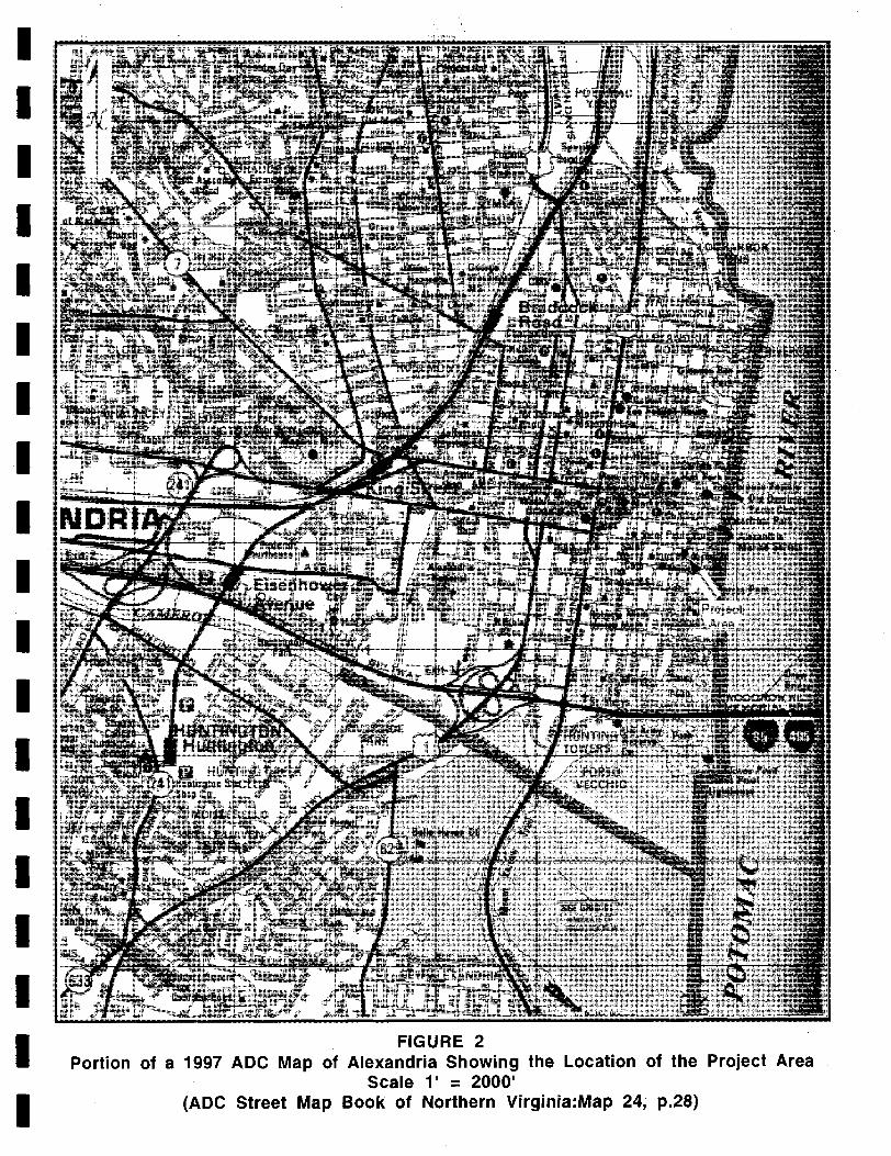
Portion of U.S.G.S. 1965 Alexandria, V A.-D.C.-MD . . 7.5' Quadrangle Showing the Location of the Project Area .............. 2 Portion of a 1997 ADC Map of Alexandria Showing the Location of the Project Area ............ .................... .......... .............. ..... 3 Joseph Berry's 1741 Survey of Howsing's 6,000 Acre Patent Showing Philip Alexander's 500 Acre Parcel Located North of Hunting Creek ................................................................. 10 Portion of John West's 1749 Survey of the Town of Alexandria "now Belhaven" Showing the Location of the Project Area Within the Potomac River ............................................................. 12 Portion of George West's 1763 Survey of Additional Town Lots in Alexandria Showing the Location of the Project Area Within the Potomac River and an Unchanged Shoreline .............................. 13 Portion of a 1789 Plat Map Showing the Project Area Located Within the Western Portion of Valentine Peer's Property........................ 15 Portion of Hopkins' 1877 Index Plate to the City Atlas of Alexandr~ Showing the General Location of the Project Area ....................... 19 Portion of Hopkins' 1877 City Atlas of Alexandria, Wards 1 and 2 Showing a Portion of the Project Area as a Vacant Lot Adjoined by a "Coal Yard" ................................................................. 20 Portion of 1885 Sanborn Insurance Map Showing Two Buildings Located within the Project Area ............................................. 21 Portion of 1891 Sanborn-Perris Fire Insurance Map Showing a Two Story "Machine Shop", Two Lumber Piles and Lumberyard Located Within the Project Area ........ .................................... ........... 24 Portion of 1896 Sanborn-Perris Fire Insurance Map Showing the Projecf Area ................................................................... 25 Portion of 1902 Sanborn Fire Insurance Map Showing the Project Area ................................................................... 26 Portion of 1907 Sanborn Fire Insurance Map Showing the ·Project Area ................................................................... 27 Portion of 1912 Sanborn Fire Insurance Map Showing the Project Area ................................................................... 28 Portion of 1921 Sanborn Fire Insurance Map Showing the Project Area· ................................................................... 29 Portion of 1941 Sanborn Fire Insurance MapShowing a One-Story Garage Located Within the Project Area ................................... 31 Portion of 1959 Sanborn Fire Insurance Map Showing a One..:Story Garage Located Within the Project Area ............................ ....... 32 Plan Map of the Project Area Provided by Alexandria Archaeology Showing the Proposed Scope of Work .................. '................... 34 Project Map Provided by Alexandria Archaeology Showing the Position of the Phase I, II and III Excavations Conducted Within the Project Area . ..................................... ................. ........ 35 Representative Soil Profile of Trench 1 .. .......................... ........ 38 Representative Soil Profile of Trench 2 .................................... 40 Representative Soil Profile of Trench 3 .................................... 42
lV
I I I I I I I I I I I I I I I I I I I
I I LIST OF PLATES
I Plate 1 Plate 2
General View of Excavations ............................................... 57 View of Trench 2, Test Unit 2, South Wall Profile ...................... 57
Plate 3 View of Trench 2, Test Unit 1, North Wall Profile ...................... 59
I Plate 4 Plate 5 Plate 6
View of Block 1, Test Unit 3, Soil Profile ................................ 61 View of Leather Strap, Block 1, Test Unit 3 ............................. 63 View of Leather Strap, Block 1, Test Unit 3 ............................. 63
I Plate 7 Plate 8 Plate 9
View of Leather Strap, Block 1, Test Unit 3 ............................. 65 View of Soil Profile, Block 2, Test Unit 4 ............................... 65 View. of Block 2, Test Unit 4 .............................................. 67
Plate 10 View of Boards, Block 2, Test Unit 4 .................................... 67
I Plate 11 Plate 12
View of Boards, Block 2, Test Unit 4 .................................... 69 View of Soil Profile, Block 3, Test Unit 5 ............................... 71
I I I I I I I I I I I I I
v
1 1 1 1 1 1 1 1 1 1 ,I
·1 I I I 1 1 1 1
INTRODUCTION
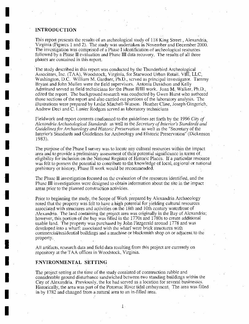
This report presents the results of an archeological study of 118 King Street, Alexandria, Virginia (Figures 1 and 2). The study was undertaken in November and December 2000. The investigation was comprised of a Phase I identification of archeological resources followed by a Phase II evaluation and J.:>hase III data recovery. The results of all three phases are contained in this report.
The study described in this report was conducted by the Thunderbird Archeological Associates, Inc. (TAA), Woodstock, Virginia, for Starwood Urban Retail. VIII, LLC, Washington, D.C. William M. Gardner, Ph.D., served as principal investigator. Tammy Bryant and John Mullen were the field supervisors. Antonia Davidson and Kelly Adrriirand served as field technicians for the Phase IIIIII work. Joan M. Walker, Ph.D., edited the report. The background research was conqucted by Gwen Hurst who authored those sections of the report and also carried out portions of the laboratory analysis. The illustrations were prepared by Leslie Mitchell-Watson. Heather Cline, Joseph Gingerich, Andrew Deci and C. Lanier Rodgers served as laboratory technicians .
Fieldwork and report contents conformed to the guidelines set forth by the 1996 City of . Alexandria Archaeological Standards as well as the Secretary of Interior's Standards and Guidelines for Archaeology and Historic Preservation as well as the "Secretary of the Interior's Standards and Guidelines for Archeology and Historic Preservation" (Dickenson 1983). .
The purPose of the Phase I survey was to locate any cultural resources within the impact area and to provide a preliminary assessment of their potential significance in terms of. eligibility for inclusion on the National Register of Historic Places. If a particular resource was felt to possess the potential to contribute to the knowledge of local, regional or national prehistory or history, Phas~ II work would be recommended.
The Phase II investigation focused on the evaluation of the resources identified, and the Phase III investigations were designed to obtain information about the site in the impact areas prior to the planned construction activities.
Prior to beginning the study, the Scope of Work prepared by Alexandria Archaeology noted that the property was felt to have a high potential for yielding cultural resources associated with structures and activities on the 18th and 10th century waterfront of Alexandria. The land containing the project area was originally in the Bay of Alexandria; however, this portion of the bay was filled in the 1770s and 1780s to create additional usable land. The property was purchased by John Fitzgerald around 1778 and was developed into a wharf; associated with the wharf were bri~k structures with corrimerciallresidential buildings and a machine or blacksmith shop on or adjacent to the property.
All artifacts, research data and,fielddata resulting from this project are currently on repository at the T AA offices in Woodstock, Virginia.
ENVIRONMENTAL SETTING
The project setting at the dme of the study consisted of construction rubble and considerable ground disturbance sandwiched between two standing buildings within the City of Alexandria. Previously, the lot had served as a location for several businesses. Historically, the area was part of the Potomac River tidal embayment. The area was filled in by 1782 and changed from a natural area to an in-filled area.
1
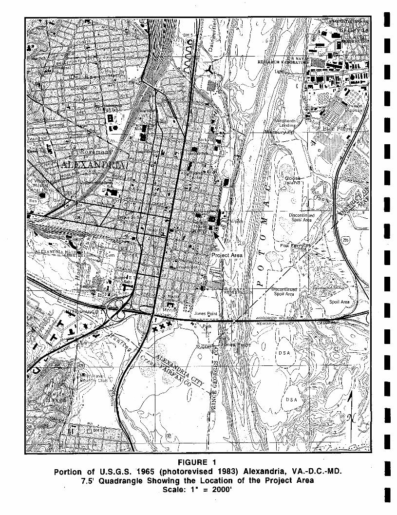
FIGURE 1 Portion of U.S.G.S.1965 (photorevised 1983) Alexandria, VA.-D.C.-MD.
7.5' Quadrangle Showing the Location of the Project Area Scale: 1" = 2000'
I I I I I I I I I I I I I I I I I I I
I I I I I I I I I I I I I I I I I I I
FIGURE 2 Portion of a 1997 ADC Map of Alexandria Showing the Location of the Project Area
Scale l' = 2000' (ADC Street Map Book of Northern Virginia:Map 24, p.28)
PALEOENVIRONMENTAL BACKGROUND
Little paleoenvironmental work has taken place in the project area. Generalizing from discussions by Carbone (1976), Delcourt and Delcourt (1986), Gardner (1982, 1987) and Johnson (1986), although the project area was never directly affected by the Pleistocene glaciation, the climatic change was severe enough to alter the floral and faunal communities. At the time for which the first human artifacts can be documented for the region, circa 9500-9000 B.C., the floral communities were in a rapid state of transition, shifting from an open conifer dominated parkland dotted with mosaics of coniferous and deciduous communities to a deciduous domination accompanied by a reduction of open and edge areas. The continued warming during the Holocene led initially to a deciduous domination in the uplands, particularly that of an oak-hickory forest. By the hot and dry Xerothermic of circa 4000-2000 B.C., a mixed southern hardwood-conifer community had developed in the area. Following the return to cooler and wetter conditions (with various short term perturbations), the interfingering of the oak-hickory and southeastern oak-pine community became characteristic. In terms of the faunal communities, extinctions and extirpations marked the end of the Pleistocene, while changes in the structure and distribution of communities characterize the Holocene.
During the peak of the last Wisconsin maximum, the Potomac in front of Alexandria was a deeply incised fast flowing and non-tidal stream. Beginning ca. 18,000 years before present (ybp), sea level began to rise rapidly with the influx of water from the melting glaciers. This rise continued to be rapid until circa 3000 B.C. resulting in the inundation of the Susquehanna River channel and the creation of the Chesapeake Bay as well as drowning the Potomac to Little Falls. Sea level rise continues to the present day with continuing drowning and erosion of the shoreline ..
Euroamerican utilization of the area, which began in the first quarter to the middle of the 18th century, centered on widespread deforestation and cultivation, resulting in the subsequent erosion of the top soil, much of which would have worked its way into the streams as the uplands deflated. During the 19th century, the continued land abuse, with the on-going logging and cultivation practices, would have perpetuated this cycle. While erosion and deflation continues to varying degrees as modern-day construction projects . proceed, large developments have provided a certain stability to the landscape as land use patterns have shifted from agricultural to residential and maintained parkland flourishes.
Early in the historic period of the project area, it was underwater and surrounded by wharves. As noted, the area was filled in during the last quarter of the 19th century.
CULTURAL HISTORICAL BACKGROUND
Prehistoric Overview
The following presents an overview of the prehistoric cultural history of the area. Johnson (1986) divides the prehistoric chronology and adaptive patterns for the general area into the following (modified here slightly from the original):
Paleo indians or First Virginians Hunter -Gatherer I Hunter -Gatherer II Hunter-Gatherer III
Foraging Foraging Foraging Foraging Collecting Hunter-Gatherer IV
Early Agriculturalist Collecting-Gardening
4
circa 9500-8000 B.C. circa 8000-6500 B.C. circa 6500-4000 B.C. circa 4000-3000 B.C. circa 3000 B.C.-A.D. 800 circa A.D. 800-150011600
I I I I I I I I I I I I I I I I I I I
I I I I I I I I I I I I I I I I I I I
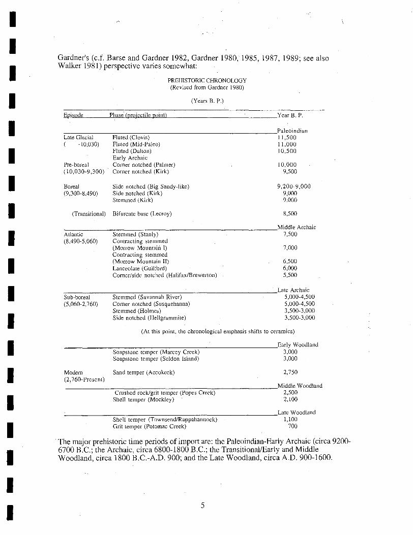
Gardner's (c.f. Barse and Gardner 1982, Gardner 1980, 1985, 1987, 1989; see also Walker 1981) perspective varies somewhat:
PREHISTORIC CHRONOLOGY (Revised from Gardner 1980)
(Years B. P.)
~E~pi~so~d~e~ __ ~Puh~a~se~'(~pwr04j~ec~tiwle~p~owinwtL) __________ ~ ___ YearB.P.
___________________________ Paleoindian
Late Glacial Fluted (Clovis) 11,500 ( -10,030) Fluted (Mid-Paleo) 11,000
Pre-boreal ( 10,030-9,300)
Boreal (9,300-8,490)
(Transitional)
Fluted (Dalton) 10,500 Early Archaic Corner notched (Palmer) Corner notched (Kirk)
Side notched (Big Sandy-like) Side notched (Kirk) Stemmed (Kirk)
Bifurcate base (Lecroy)
10,000 9,500
9,200-9,000 9,000 9,000
8,500
____________________________ Middle Archaic
Atlantic (8,490-5,060)
Stemmed (Stanly) Contracting stemmed (Morrow Mountain I) Contracting stemmed (Morrow Mountain II) Lanceolate (Guilford) Corner/side notched (Halifax/Brewerton)
7,500
7,000
6,500 6,000 5,500
____________________________ Late Archaic
Sub-boreal (5,060-2,760)
Stemmed (Savannah River) Corner notched (Susquehanna) Stemmed (Holmes) Side notched (Hellgrammite)
5,000-4,500 5,000-4,500 3,500-3,000 3,500-3,000
(At this point, the chronological emphasis shifts to ceramics)
____________________________ Early Woodland
Soapstone temper (Marcey Creek) Soapstone temper (Seldon Island)
3,000 3,000
Modern Sand temper (Accokeek) 2,750 (2?760-Present) ___________________________ Middle Woodland
Crushed rock/grit temper (Popes Creek) 2,500 Shell temper (Mockley) 2,100
____________________________ Late Woodland
Shell temper (Townsend/Rappahannock) Grit temper (Potomac Creek)
1,100 700
. The major prehistoric time periods of import are: the Paleoindian-Early Archaic (circa 9200-6700 B.C.; the Archaic, circa 6800-1800 B.C.; the TransitionallEarly and Middle Woodland, circa 1800 B.C.-A.D. 900; and the Late Woodland, circa A.D. 900-1600.
5
The first of these represents the period of initial human occupation of the region. Sporadic Paleoindian finds are reported on the Potomac, particularly around Bennings, just above the junction of the Anacostia and the Potomac, and along the Accotink and the Occoquan, but, overall, spearpoints of this time are uncommon in the local area (Gardner 1985). Early Archaic components show a slight increase in numbers, but it is during the Middle Archaic (Morrow Mountain and later) that prehistoric ~human presence becomes relatively widespread (Gardner various; Johnson 1986; Weiss-Bromberg 1987). Whereas the earlier groups appear to be more oriented toward hunting and restricted to a limited range of landscapes, Middle Archaic populations move in and out and across the various habitats on a seasonal basis. Diagnostic artifacts from upland surveys along and near the Potomac show a significant jump during the terminal Middle Archaic (e.g. Halifax) and beginning Late Archaic (Savannah River).
The most intense utilization of the region begins circa 1800 B.C. with the advent of the Transitional Period and the Savannah River Broadspear derivatives, which include the Holmes and other related poiI)ts. In models presented by Gardner, this is linked with the arrival of large numbers of anadromous fish. These sites tend to be concentrated along the shorelines near accessible fishing areas which are up the tributaries to points above where these tributaries begin to constrict. The adjacent interior and upland zones become rather extensively utilized as adjuncts to these fishing base camps. The pattern of using seasonal camps continues. The same essential settlement pattern continues throughout the Early and Middle Woodland. The post-A.D. 900 Late Woodland change is precipitated by the advent of agriculture and, between A.D. 1350 and 1600, scattered agricultural hamlets coalesce into larger sites such as that at Accokeek Creek (Stephenson et a11963) and at Potomac Creek (Schmitt 1965).
The cultural diagnostics listed in the table above are simplified. For instance, Early Archaic side notched points are more common in the westerrt part of the Middle Atlantic. There is also a formal overlap between terminal Middle Archaic side notched forms such as Brewerton and Halifax and the Early Archaic Side notched types. The possibility also exists of overlap between either of these, particularly HalifaxlBrewerton, and the presumed Early Woodland Vernon Side Notched. Indeed, it is not even clear if the latter exists. Projectile point types certainly become more diverse in the Late Archaic. For instance,the large Savannah River Stemmed point can have an expanding stem, a straight stem, or a contracting stem. The same holds true for the derivative and later Holmes or small Savannah River Stemmed. By this latter period, circa post-1800-1200 B.C., the Fall Line of the Potomac appears to be a stylistic divide between the Piedmont oriented Susquehanna-Dry Brook-Fishtail-Vernon (?) sequence and the Savannah River StemmedHolmes-Calvert evolution.
Another mis-identification can occur between smaller versions of the contracting stem Morrow Mountain point and the Early Woodland RossvillelPiscataway. A similar error in identification can happen between the contracting stem large Savannah River (which seems to be post-1800 B.C.) and Morrow Mountain.
Ceramics present less of a complex scene. The earliest ceramic series in the Piedmont and Upper Potomac Coastal Plain are the steatite tempered Marcey Creek Plain followed by Seldon Island Cordmarked, which is also tempered with steatite particles. The third phase of the Early Woodland is marked by the sand tempered Accokeek ware. Point styles vary, but include the Holmes point and other stemmed variants descending from Savannah River Stemmed, as well as Orient Fishtail and Hellgrammite which develop out of the Susquehanna Broadspears. The previous stylistic boundary in projectile points at the Fall
6
I I I I I I I I I I I I I I I I I I I
I I I I I I I I I I I I I I I I I I I
Zone seems to continue although all of the ceramics cross this boundary. Shell middens become evident by Early Woodland III in the Lower Potomac Coastal Plain where the water was of sufficient salinity to support oyster populations.
The period after 500 B.C. is marked by the appearance of Albemarle Net Marked in Potomac Piedmont and Ridge and Valley and the related Popes Creek Net Impressed in the Coastal Plain. Shell tempered Mockley ware marks the Coastal Plain circa AD. 200. The Potomac Piedmont may have been all but abandoned at this juncture. Point styles associated with the earlier ceramic phases are in the Rossville-Piscataway contracting stemmed genre. These are succeeded by small stemmed and notched points.
By A.D. 900, refined crushed rock tempered ceramics in the Albemarle/Shephard ware category show up in the Potomac Piedmont. In the latter part of the Early Agriculturalist period, limestone tempered and shell tempered (Keyser series) pottery successively dominate the areas along the Potomac from the Ridge and Valley through to the mouth of the Monocacy and the Fall Zone. In the Upper Potomac Coastal Plain, the Townsend/Rappahannock series evolves out of the Mockley series to be replaced circa AD. l350 by Potomac Creek. The groups associated with the Potomac Creek ceramic series appear to have evolved out of the Montgomery Focus in the Piedmont, only to have been pushed out by expansionist groups in the interior. Triangular points are the norm for the entire Early Agriculturalist period. These groups appear to have been full time residents practicing agriculture. Village and hamlet locations were around the mouths of creeks, contiguous with broad floodplain locations; in this area at the mouths of streams with good agricultural soil along the Potomac. The non-riverine or non-estuarine Woodland sites were short term occupations related to general foraging components of the subsistence system (c.f. Gardner 1982, 1985, Weiss-Bromberg 1987, Cissna 1990).
In early historic times, Indians were no longer resident, even along the Potomac, in most of the area at the time of Euroamerican settlement, although they were present in the area for the period up to circa AD. 1700. The Dogue, who were related to the Piscataway, are generally considered to be the indigenous occupants of the region. The Potomac Piedmont may well have been vacant--a kind of no-man's land.
Most of the functional categories of sites away from major drainages are those of small ." ';' base camps, transient camps, limited purpose camps and quarries. Site frequency and size '. vary according to a number of factors, e.g. proximity to major river or streams, distribution of readily available surface water, and the presence of lithic raw materials (Gardner 1987). (, The pattern of seasonally shifting use of the landscape begins circa 7000 B.C., when 'j
seasonal variation in resources first becomes marked. By 1800 B. c., runs' of anadromous . fish occur and the Indians spent longer periods of time along the estuarine Potomac (Gardner 1982, 1987). It is possible that some horticulture or intensive use of local resources appears between 1200-500 B.C. for, at this time, the seasonal movement pattern is reduced somewhat (Gardner 1982). However, even at this time and during the post~ A.D. 900 agriculture era, extension of the exploitative arm into the upland and inter-riverine areas through hunting, fishing and gathering remained a necessity.
7
Historic Overview
Introduction
The project area is located on the south side of the 100 block of King Street, between Lee Street (formerly Water Street) and Union Street in the City of Alexandria, Virginia. The project property is within the Old Town Historic District of Alexandria placed on the National Register of Historic Places in 1966. Historically, this area of the Alexandria waterfront was under the Potomac River until the early 1780s when the waterfront was filled in, and as such did not exist as real estate.
Under the Virginia Company of London, chartered by King James I in 1606 to settle that part of the New World on the Chesapeake Bay, three ships--the Susan Constant, the Godspeed, and the Discovery --under the command of Captains Newport, Gosnold, and' John Smith sailed from England shortly after Christmas in 1606 (Kelso 1995:6). Reaching Cape Henry in the lower Chesapeake Bay on 26 April 1607, and receiving a hostile reception from the native inhabitants, the ships sent out exploring parties further north of Cape Henry on the 28th of April (Weinert and Arthur 1989:1-3). After exploring further up the James River, the selected location for the colony was on Jamestown Island, 60 miles up the James River from Fort Monroe (Kelso 1995:7).
Four parishes: James City, Charles City; I-:Ienrico and Kikotan were established in the colony in 1617. The original parishes were later changed and divided into eight counties. The area.lying between the Rappahannock and the Potomac Rivers was formerly known as the Indian District of Chicacoan. This area between the two rivers later became known as the Northern Neck of Virginia. Northumberland County, created from the Indian District of Chicacoan in 1645 is the parent county of the City of Alexandria. Beginning with Northumberland County in 1645 the ancestor counties of Alexandria were: Northumberland County (1645-1651), Lancaster County (1651-1653), Westmoreland County (1653-1664), Stafford County (1664-1730/31), Prince William County (1730/31-1742), and Fairfax County 1742-1791. The City of Alexandria became part of the District of Columbia, the newly created seat of government in 1791. Subsequently, Alexandria was detached from the District of Columbia in 1846 when this part of the District of Columbia on the west side of the Potomac River was returned to the Commonwealth of Virginia (Hiden 80:1, 3,10-12;' Hening 1820:303; Hening 1819:207-208; Barry 1982:5).
Prior to 1692, most lands in Virginia Colony were granted by the Governor of the colony, and are known as Virginia Land Grants. The Northern Neck of Virginia, located between the Rappahannock and Potomac Rivers, was given in 1649 by King Charles II to seven , loyal supporters during his exile, and prior to his being crowned King of England in 1660. The'original Northern Neck grant was to expire in the year of 1690. During the period of 1660-1690, little attention to the Northern Neck grant was given'by King Charles' supporters, or their descendants. By marriage, Thomas, 5th LC?rd Fairfax, gained sole ownership of the Northern Neck in 1690; this was confirmed by the Privy Council on 15 December 1692. Under the Fairfax proprietorships, agents were appointed to rent the Northern Neck lands for nominal quit rents, usually 2 shillings sterling per acre (Kilmer and Sweig 1975:1-2,7,9). The original land grant to the King Street property,however, was obtained by a Virginia Land Grant in 1669.
8
I I I I I I I I I I I I I I I I I I I
1 I I 1 1 1 1 1 1 1 1 1 I 1 I 1 1 1 I,
Sir William Berkeley, then the Governor of Virginia, granted to Robert Howson 6,000 acres of land in the freshes of the Potomac River on 21 October 1669 for the transportation of one hundred and twenty persons into the Colony. The survey notes for the Virginia Land Grant to Robert Howson (How sing) describes the property as being in the freshes of the Potomack River "on the west side above the dividing branch beginning at a red Oak standing by a small branch or run of water next opposite to a small Island commonly called and known by the name of my Lords Island ... " (Virginia Land Patents 6:262). Approximately three weeks later, Robert Howson of Stafford County, Virginia, transferred the 6,000 acres to John Alexander, also of Stafford County, for the consideration of 6000 pounds of tobacco (Prince William County, Virginia Land Causes 1789-1793:220).
John Alexander of Stafford County died testate (with a will) in 1677, leaving all of his estate, except 700 acres given to his daughter, Elizabeth Holmes, to his two sons Robert and Philip Alexander to be equally divided (Prince William County, Virginia Land Causes 1789-1793:221). By an agreement dated 6 February 1690, Robert Alexander confirmed one-half of the 6,000 acres on Little Hunting Creek (except the 700 acres), to his brother Philip Alexander (Stafford County, Virginia Order Book 1692-1693:193a-194a). On 19 February 1693/94, Philip Alexander assigned his share of the estate, excepting 500 acres reserved for his own use, back to his brother Robert Alexander (Prince William County, Virginia Land Causes 1789-1793:217).
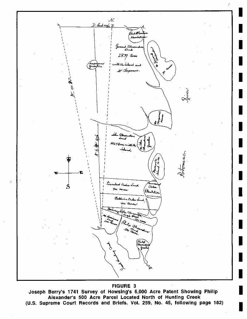
Philip Alexander died in Stafford County, Virginia, in 1705, leaving his estate to his son Philip Alexander II (Stafford County, Virginia Wills Z:269-272). Joseph Berry's survey of Howsing's patent for 6,000 acres in 1741 (Figure 3) shows Philip Alexander's 500 acre parcel situated on the north side of Great Hunting Creek, now the location of the City of Alexandria, with his quarters located on Jones Point.
The beginning of Alexandria, originally known as the tobacco warehouse at "Bel Haven," was created by an Act of the Virginia Assembly in 1730. To "prevent frauds in his Majesties Customs" in the staple tobacco trade, the Virginia Assembly appointed Inspectors for the public tobacco warehouses to be located at waterfront ports in the various counties. Under one inspection, two tobacco warehouses were appointed in Prince William'County, one at Quantico on Robert Brent's land, and other at Great Hunting Creek on Broadwater's land (Hening 1820:268). During the following session of the Virginia Council, Francis Awbry, Benjamin Strother, and Cadwallad Dade [sic] were appointed inspectors at Quantico and Hunting Creek (McIlwaine 1930:236,239).
By an Act of the General Assembly in 1748, a town at Hunting Creek warehouse on the Potomac River was established on 60 acres of land owned by Philip Alexander, John Alexander, and Hugh West, both to benefit trade and navigation and to be to the advantage of the "frontier inhabitants". The sixty acres of land were directed to be taken above the mouth of Great Hunting Creek and laid out by the surveyor to the first branch above the warehouses, and extend down the meanders of the Potomac to Middle Point (Jones Point). The lots of the town were directed to be laid out along streets "not exceeding half an acre of ground in each lot setting apart portions of land for a market place and public landing, to be sold by public sale or auction, the proceeds of which were to be paid to Philip Alexander, John Alexander and Hugh West". Purchasers of each lot were required to erect one house of brick, stone, or wood, "well framed," with a brick or stone chimney, in the dimensions of twenty feet square, "or proportionably thereto" if the purchaser had two contiguous lots (Winfree 1971:443-446).
9
\ \ \
\ \
\ \ \
\ \ \ \ \ \ \
\
\ \
\ \
\
\
\ \ \
\
\
I
I J
I I
. I I I I I I
; 2F?5J ~ I I w4i. tJ.. ~ ce.v.J I
...#~~.
FIGURE 3 Joseph Berry's 1741 Survey of Howsing's 6,000 Acre Patent Showing Philip
Alexander's 500 Acre Parcel Located North of Hunting Creek (U.S. Supreme Court Records and Briefs. Vol. 259, No. 45, following page 182)
1 I 1 1 1 1 1 I 1 1 1 I 1 1 I 1 1 1 ,I
I I I I I I I I I I I I I I I I I I I
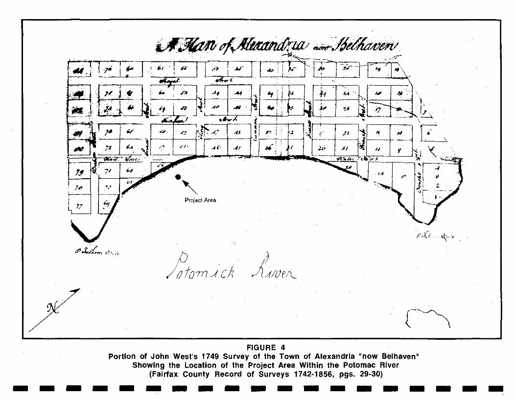
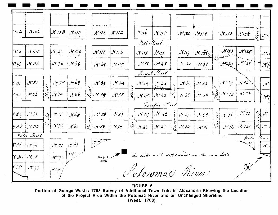
A survey of the town of Alexandria "now Belhaven" was undertaken by John West in 1749 (Figure 4). The shoreline in this portion of Alexandria in 1749 extended to Water Street, and the project area was under water in the Potomac River at this time. A subsequent map, surveyed and drawn by George West in 1763 for a,dditional town lots, shows no changes in the shoreline (Figure 5).
·118 King Street
The project area is located on the south side of King Street between Union and Water Streets. Water Street was renamed Lee Street following the Civil War in the 1860s. As noted on the surveys of Alexandria Town lots in 1749 and 1763, this portion of the Alexandria waterfront was underwater and did not become real estate until about 1782. Alexandria Town Lots 51 and 52, then comprising the waterfront of Alexandria at the end of King Street, were purchased by John Fitzgerald and Valentine Peers from Susanna Patterson, widow of John Patterson, on 25 April 1778 (Fairfax County, Virginia Deeds D4: 196-198). A Chain-of-Title for the property is presented below and in Appendix 1.
John Fitzgerald and Valentine Peers, both Irish immigrants, first appear in the Alexandria records in December 1774 when they purchased, along with two other merchants, two lots on the south side of Lots 94 and 95 in the town of Alexandria. Lots 94 and 95 were situated on the Wolfe Street waterfront (Fairfax County, Virginia Deeds X:384-387). At the same time in December 1774, were setting up shop, the ship Hope arrived at the port of Alexandria carrying a cargo of Irish linens consigned to John Fitzgerald and V alen tine Peers (Richardson 1976:7).
During the Revolutionary War, Captain John Fitzgerald organized the Alexandria Minute Regiment in 1775, and he served as an Aide-de-Camp to General Washington from 1776 until he was wounded at the Battle of Monmouth on 28 June 1778. John Fitzgerald resigned from the military in July 1778 (Gwathmey 1979:275). His partner, Valentine Peers, enlisted in the Minute Regiment and has a distinguished Revolutionary War record, advancing in rank from 1st Sergeant to Quartermaster and Adjutant within a year of his enlistment. In June 1776 he was commissioned by the Committee of Safety as Captain of the Marines. Valentine Peers resigned in November 1777 having attained the military rank of Brigade Major (Gwathmey 1979:275; Richardson 1976:9-13).
By an Act of the Virginia Assembly in May 1782, Union Street at its intersection with King Street (located approximately 120 feet east of the project area) was authorized to be filled in and extended to the northern and southern limits of the town of Alexandria (Hening 1823:44-45). In conjunction with the Virginia Assembly authorization, the block on King Street within which the project area is located was deeded by the Trustees of Alexandria to John Fitzgerald and Valentine Peers as joint tenants in common. This specific deed was recorded in Fairfax County Deed Book N page 309, which is a missing Fairfax County deed book covering the period of 1778 through 1783. At this time, John Fitzgerald and Valentine Peers owned all of the Alexandria town lots situated between King and Prince Street, and from Fairfax Street east to the Potomac River waterfront:
"By permission of the Town Trustees those persons owning water-side lots were permitted to extend their property into the Potomac by filling with dirt. Valentine and Fitzgerald were among those water front property owners who extended their property one and a half city squares, creating a Union Street east of Water Street, and building warehouses and wharfs on the east, or river side, of Union Street" (Richardson 1976: 14-15).
11
Project Area
Ii,if. . ~ .•.•
FIGURE 4 Portion of John West's 1749 Survey of the Town of Alexandria "now Belhaven"
Showing the Location of the Project Area Within the Potomac River (Fairfax County Record of Surveys 1742-1856, pgs. 29-30) -------------------
-----------.-------------+-----4
1 ~I -n '/c1& Jr/o/J .}('/odl !'o'!Y'/lO !
, J '--- !
'JO 3 I ,,\4/CJ' I
. I,
t--i __ -+i~_---4
r
iX/It 1
1.h'1I4
Jn/J
r : , r---I, I i t--_---.;.---_---.ji ,
J I V~/; ~---~--4 • .
I !
I
~rlldl I "-- ----I.----~
/~.If cAu~
JY/iJ
~ t Ilf ~'rl'l I
FIGURE 5 Portion of George West's 1763 Survey of Additional Town Lots in Alexandria Showing the Location
of the Project Area Within the Potomac River and an Unchanged Shoreline (West, 1763)
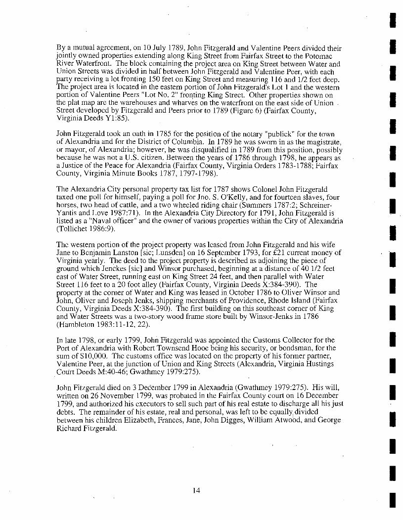
By a mutual agreement, on 10 July 1789, John Fitzgerald and Valentine Peers divided their jointly owned properties extending along King Street from Fairfax Street to the Potomac River Waterfront. The block containing the project area on King Street between Water and Union Streets was divided in half between John Fitzgerald and Valentine Peer, with each party receiving a lot fronting 150 feet on King Street and measuring 116 and 112 feet deep. The project area is located in the eastern portion of John Fitzgerald's Lot 1 and the western portion of Valentine Peers "Lot No.2" froqting King Street. Other properties shown on the plat map are the warehouses and wharves on the waterfront on the east side of Union Street developed by Fitzgerald and Peers prior to 1789 (Figure 6) (Fairfax County, . Virginia Deeds Y1:85).
John Fitzgerald took an oath in 1785 for the position of the notary "publick" for the town of Alexandria and for the District of Columbia. In 1789 he was sworn in as the magistrate, or mayor, of Alexandria; however, he was disqualified in 1789 from this position, possibly because he was not a U.S. citizen. Between the years of 1786 through 1798, he appears as a Justice of the Peace for Alexandria (Fairfax County, Virginia Orders 1783-1788; Fairfax County, Virginia Minute Books 1787, 1797-1798).
The Alexandria City personal property tax list for 1787 shows Colonel John Fitzgerald taxed one poll for himself, paying a poll for Jno. S. O'Kelly, and for fourteen slaves, four horses, two head of cattle, and a two wheeled riding chair (Summers 1787:2; SchreinerYantis and Love 1987 :71). In the Alexandria City Directory for 1791, John Fitzgerald is listed as a "Naval officer" and the owner of various properties within the City of Alexandria (Tollichet 1986:9).
The western portion of the project property was leased from John Fitzgerald and his wife Jane to Benjamin Lanston [sic; Lunsden] on 16 September 1793, for £21 current money of Virginia yearly. The deed to the project property is described as adjoining the piece of ground which Jenckes [sic] and Winsor purchased, beginning at a distance of 40112 feet east of Water Street, running east on King Street 24 feet, and then parallel with Water Street 116 feet to a 20 foot alley (Fairfax County, Virginia Deeds X:384-390). The property at the corner of Water and King was leased in. October 1786 to Oliver Winsor and John, Oliver and Joseph Jenks, shipping merchants of Providence, Rhode Island (Fairfax County, Virginia Deeds X:384-390). The first building on this southeast corner of King and Water Streets was a two-story wood frame store built by Winsor-Jenks in 1786 (Hambleton 1983:11-12,22).
In late 1798, or early 1799, John Fitzgerald was appointed the Customs Collector for the Port of Alexandria with Robert Townsend Hooe being his security, or bondsman, for the sum of $10,000. The customs office was located on the property of his former partner, Valentine Peer, at the junction of Union and King Streets (Alexandria, Virginia Hustings
. COlirt Deeds M:40-46; Gwathmey 1979:275).
John Fitzgerald died on 3 December 1799 in Alexandria (Gwathmey 1979:275). His will, written on 26 November 1799, was probated in the Fairfax County court on 16 December 1799, and authorized his executors to sell such part of his real estate to discharge all his just debts. The remainder of his estate, real and personal, was left to be equallYI divided between his children Elizabeth, Frances, Jane, John Digges, William Atwood, and George Richard Fitzgerald. .
14
I I I I I I I
I I I I I I I I I
1.11.
FIGURE 6
(O);}., / '" -/,.1)" If/.
Portion of a 1789 Plat Map Showing the Project Area Located Within the Western Portion of Valentine Peers' Property
(Fairfax County Deeds Y1 :85)
"Not knowing what may be the Situation of my Estate when Some claims against it are Satisfied I cannot direct a specific provision for my Loving wife Jane, Least by such provision, I should her Injustice. I am therefore Constrained to Leave her to that provision which the Laws of the County provide" (Fairfax County, Virginia Wills HI :56-58).
The estate of John Fitzgerald was not settled until 1826 (Fairfax County, Virginia Wills 0:178-184), and it is unknown when John Fitzgerald's portion of the project area was sold. Kinsey Griffith, an Alexandria gunsmith, was the owner of both John Fitzgerald's and Valentine Peer's portions of the project property at the time of his death in 1846.
Robert Richardson, the biographer of Valentine Peers, states that Valentine Peers was born in Ireland in 1756 and his first wife was Margaret McCarty of Fairfax County, Virginia. Margaret McCarty-Peers died in February 1786 and Valentine Peers married Eleanor (Nell) Orr, daughter of John Orr of Newgate (Centreville), Loudoun County, Virginia (Richardson 1976:16,23,233-234).
Unlike his long-time partner, John Fitzgerald, who lived in, and was involved in the city government of Alexandria, Valentine Peers appears not to have resided in the town of Alexandria for any period of time. Between 1784 and 1789, Valentine Peers and his brother, Nicholas Peers, were residing in Port Tobacco, Maryland, where they were tobacco merchants. In 1784, Valentine and Nicholas Peers opened a general store at the town of Colchester on the Occoquan River in Fairfax County, Virginia. Between 1791 and 1797, following Valentine's marriage to Nell Orr, they resided in Prince William County, Virginia. In 1803, Valentine Peers moved his wife and family to the State of Kentucky (Sprouse 1975:181; Richardson 1976:15,23,36; Fairfax County, Virginia Deeds Z:403-405).
The 100 block of King Street appears to have been fully developed and occupied by buildings, or buildings in progress, by the year of 1796. East of the current project area were four buildings extending from the project area to the comer of King and Union Streets. Three of the buildings were described as "lumberhouses" and extended up King Street from the comer of King and Union Streets; these were owned by Thomas Patton. In the fire insurance records the buildings were each described as 24 feet fronting King Street and 40 feet deep, three stories high, the "walls built of Brick and covered with Wood." Adjacent to, or on the immediate east side of the project area, was Joseph Dyson's "wooden lumberhouse" (Mutual Assurance Policy 1796 No.3).
Joseph Dyson's wooden lumberhouse parcel was sold by Valentine Peers to his relative, John Dalrymple Orr, and was reconveyed by John Orr in 1794 to Richard M. Scott of Dumfries, Prince William County, Virginia. This property was initially leased by Richard Scott to Matthew Bowne and Thomas Hamilton in 1795 for 126 silver dollars annually. This parcel was reassigned toJoseph Dyson in 1795 with a lease option of purchasing the property for £400 within five years. Joseph Dyson in tum assigned the rent to John Lunsden and Daniel McLeod for £100 and the annual rent in 1796. The transfer from Dyson to Lunsden and McLeod included" one half of the frame now standing on the ground and of stone and scantling lying thereon" (Alexandria Hustings Court Deeds F:349-351; G:157-163; H:84-85; Fairfax County, Virginia Deeds X:630-632).
16
I I I I I I I I I I I I I I I I I I I
I I I I I I I I I I I I I I I I I I I
On 31 March 1797, Valentine and Eleanor Peers, then living in Prince William County, Virginia, deeded the project property to Alexander Gordon for £450. The survey description for this parcel began on the south side of King Street and ran 120 feet 3 inches' west of the intersection of King and Union Streets, fronted King Street for 29 feet 9 inches, and ran south for 116 feet to the 20 foot alley (Fairfax County, Virginia Deeds Z:403-405). Alexander Gordon is listed in the 1791 Alexandria City Directory as a merchant and shopkeeper near King Street, indicating that Alexander Gordon may have been a tenant of Valentine Peers at this location for a number of years (Tollichet 1986: 10).
Approximately three months later, on 9 June 1797, Alexander Gordon and his wife Mary, deeded the property to Samuel McClaud [sic; McLeod] for £360. The substantial loss of £90 is not explained in the deed from Gordon to McLeod (Alexandria Hustings Court Deeds 1: 137 -140). Samuel McLeod subsequently rented the parcel on 1 September 1797 to his son Daniel McLeod for £18 or "sixty Spanish Milled Dollars", or any combination of gold and silver coins equal to £18 ($120.00) (Alexandria County, Virginia Hustings Court Deeds K:62-65).
According to the 1808 "census" for Alexandria, Daniel McLean [sic] was an Alexandria merchant (Miller 1992:339). In the 1819 Alexandria City Land and Personal Property Tax Books (Ward 2, page 1), Daniel McLeod was taxed for a lot and a building of four stories extending from King Street to the alley. This building, appraised at $5,000.00, was occupied in 1819 by Daniel McLeod (who was the owner) and Jeremiah Price, William Ward and Thomas Curry. The occupation of Daniel McLeod was not found in the Alexandria County documents. Daniel McCleod, who held a "good and perfect estate of inheritance in fee simple" to the property, and his wife Mary Ann, conveyed the property' on 19 July 1820 to their kinsman, Kinzey Griffith for $1,650.00 (Alexandria County, D. C. Circuit Court Deeds K2:322-324).
Kinsey Griffith, who appears in the 1834 Directory of Alexandria, D. C. (page 5), as a gunsmith located on King Street, married Elizabeth McLeod on 4 September 1817 in Washington, D.C. His wife, Elizabeth, died on 1 September 1829 at the age of 41. Kinsey Griffith then married his second wife, Mary Ann McLeod, on 21 March 1832, also in Washington, D.C. (Pippenger 1994:249; Miller 19892:434). .
The Alexandria City Land and Personal Property Book for 1822 assessed Kinsey Griffith $5,000.00 for the project property occupied by Kinsey Griffith, Daniel McLeod, George Painter and Samuel Buntin. Two other buildings were taxed in 1822 and are listed from the intersection of King and Union Street westward to the project area; the United States Custom House at the corner of king and Union was assessed at $7,000.00, and a building owned by Margaret Lundson and occupied by Augustus Butts and William Shaw was appraised at $2,200.00. West of the project area were an empty house, owned by Maurice Hurley, appraised at $600.00 and a vacant lot, owned by Wallace Johnson, appraised at $1,600.00 (Ward 2, page 1).-
In about 1835 the town of Alexandria was described as:
" ... very handsomely situated., The streets are laid out on the plan of Philadelphia, crossing each other at right angles, and are generally well paved ... The [Potomac] river opposite to the town [of Alexandria] is a mile in breadth, and varies from 34 to 52 feet in depth, in the ship channel, which here washes the shore - of course the harbor is naturally very fine, and it has been much improved by the erection of large and commodious wharves" (Martin 1836:478).
17
Kinsey Griffith died at the age of 59 on 27 May 1846 in Alexandria (Miller 1992:435), leaving his wife, Mary Ann; all his estate during her widowhood or lifetime for the education and maintenance of their four youngest children. By terms of his will, the Griffith estate was then to be divided into two equal parts, one part going to their four oldest children named as John Henry, Kinsey, Edward and Daniel McLeod Griffith. The remaining half of the estate was left to the two youngest sons Henry Clay and Greenbury Griffith to be equally divided (Alexandria County, D.C. Orphans Court Wills 4:424-426).
Kinsey Griffith was buried in the Methodist Episcopal Church Cemetery (Trinity Methodist Church), on upper Wilkes Street, next to his first wife, Elizabeth McLeod, and their son William Smith Griffith, who died at the age of 20 on 21 July 1840. Reportedly, Kinsey Griffith, Jr., son of Kinsey and his second wife, Mary Ann McLeod, died at the age of 23 (unknown date), and was buried next to his father (Miller 1992:435).
The Alexandria City Land and Personal Property Tax Books for the years of 1845 and 1847, the two years prior to and following Kinsey Griffith's death, shows that Kinsey Griffith was the sole owner and occupier of two buildings on the project area assessed at a total value of $1,400.00. The Griffith residence on Union Street was assessed at $700.00 (Ward 2, page 1).
Mary A. Griffith, widow of Kinsey Griffith, was enumerated at the age of 55 in the 1850 U.S. Population Census for Alexandria (Households 641-642). Living in her household were her four youngest sons, Edward (age 22) and Daniel W. Griffith (age 21), both of who are identified as gunsmiths, and Henry C. (age 14), and Greenbury age 12. Residing next door to Mary Griffith, was her son, Kinsey Griffith [Jr.] age 28 whose occupation is also listed as a gunsmith (households 641 and 642). Mary Ann Griffith, widow of Kinsey Griffith, Sr., died on 12 September 1872 in-Alexandria (Lloyd House Staff 1987:131); however, the project property continued to belong to the heirs of Kinsey Griffith until 1887.
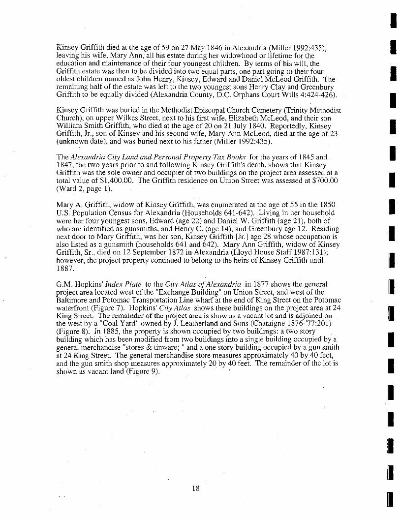
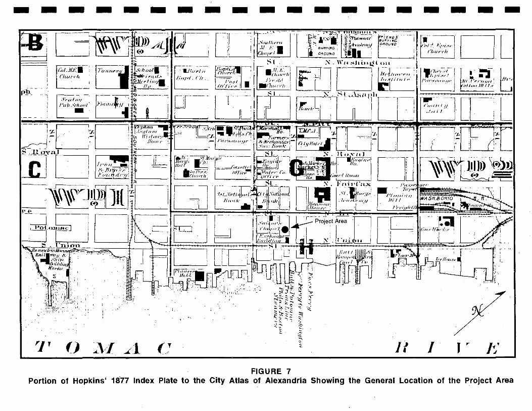
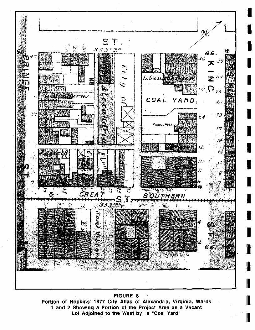
G.M. Hopkins' Index Plate to the City Atlas of Alexandria in 1877 shows the general project area located west of the "Exchange Building" on Union Street, and west of the Baltimore and Potomac Transportation Line wharf at the end of King Street on the Potomac waterfront (Figure 7). Hopkins' City Atlas shows three buildings on the project area at 24 King Street. The remainder of the project area is show as a vacant lot and is adjoined on the west by a "Coal Yard" owned by J. Leatherland and Sons (Chataigne 1876-'77:201) (Figure 8). In 1885, the property is shown occupied by two buildings: a two story building which has been modified from two buildings into a single building occupied by a general merchandise "stores & tinware; " and a one story building occupied by a gun smith at 24 King Street. The general merchandise store measures approximately 40 by 40 feet, and the gun smith shop measures approximately 20 by 40 feet. The remainder of the lot is shown as vacant land (Figure 9). .
18
I I I I I I I I I I I I I I I I I I I
- -,
it-----J ------,
"
7 ,
- -{<-,I, JLt.~. Cillu-rll
.~·r(llo;1 FII/J,.>',ho(J/ ' -
()
1 ! ,
~'/l
- -- - -- -
, ':., ",-
_ .. /1
:i,
(}
--1.1;" "/ (( , 1:",,1, ('II _'
" ,
.... ':-~..;S ~
~.....; .... ~ ~ ;..,~;"",..,., " :::;, '" ~ "-..., ~:;-..::: ~
~?= ~'; ::::: ..: ~ ~ ~ ';;:'
:.:~ ~ ,-" -."
~
FIGURE 7
- -- -
~ ~-
~
If
- - --• 'pI :.', r./.Ji.\·(·
('/ili,-,-II
',{'i/~:i.:'i---j '}~'I J" ,01(' " !
I',If',O("II"I,,· (I - I
j
I
DL
J
.-.-' ... ' .fll.''''''-"oll f
'(lII~)1I JIIII.~:
,.. Jj'
t:
Portion of Hopkins' 18'77 Index Plate to the City Atlas of Alexandria Showing the General L.ocation of the Project Area
COAL
Project Area
FIGURE 8 Portion of Hopkins' 1877 City Atlas of Alexandria, Virginia, Wards
1 and 2 Showing a Portion of the Project Area as a Vacant Lot Adjoine.d to the West by a "Coal Yard"
L I I I I I I I I I I I I I I I I I I I
I I I I I I I I I I I I I I I I I I I
~ '~
,. "
---.--......... -"""1/ 0
-
Project Area
SH££TK1NG ,
-
---"'"=!~::-.==-=.....r---------,-,i II II II II II III II 1-,.:.'_.....l,;;;;;.... ....... ~IWIIil~ ..... iiioIiIii.oiollo
I X SHED
" 7 SA'/.£ORS ~ CHRP£L ~
70 ~x __________ ~ ________________________ -----4
o
47 GO}: 603 (/11 6'1,2, (/13
PRINCE
FIGURE 9 Portion of 1885 Sanborn Insurance Map Showing Two
Buildings Located Within the Project Area
On 13 February 1880, Charles B. Griffith of Washington, D.C., son of John H. Griffith (deceased), deeded all his interest in the land of his grandfather, Kinzey Griffith, located on the south side of King Street between Union and Lee Streets (formerly Water Street) to his uncle, Henry C. Griffith, also of Washington, D.C. for $100.00 (Alexandria County, Virginia Corporate Court Deeds 8:449-450). In a decree between Daniel W. Griffith and others Vs. Kinsey Griffith and others issued by the Corporation Court of Alexandria in September of 1880, the property of Kinzey Griffith (deceased), located on the "south side of King Street between Lee and Union Streets ... beginning on the south side of King Street 64 feet 6 inches east of Lee Street" measuring 116 feet by 62 feet 6 inches, was ordered to be sold at public auction. The project property was sold to the highest bidder, Julia K. Griffith of Washington, D.C., on 12 November 1887. Less than a year later, Julia Griffith deeded the property to John T. Hill and James S. Adams of Alexandria for $550.00 (Alexandria County, Virginia Corporate Court Deeds 19:485-487; 20:431-432).
John T. Hill died testate (with a will) in 1890. The will of John Hill, transcribed below, is as spelled in the document:
"My will maid this day the 20 of December 1882, being my 33 anniversery of my wedin to Elvirah Marriott of Anarundel County, Mearland, i John T. Hill do leave to Elvirah Hill all of my real estate and personal property after by dets have bein paid except, except the house No. 98 South Lee Str. no ockupide by me this instrument is to the house at the death of Mrs. Hill is to go to daughter Mary E. Hill with the furnature during her life and at her death to bea sold for the benefit of my children, Bearing my intention by this will that Mrs. Hill has power to sel iney or all of the property if neaded for her sepoarte except the house 98 South Lee Street & furnature whitch is hear provided for. Wherein i fix my hand and seal this twenty seckond day of December 1882"
John T. Hill (Seal)
John T. Hill's will was probated on 21 April 1890 (Alexandria County, Virginia Corporate Court Wills 1:552).
On the day following the probate of John Hill's will, on 22 April 1890, James S. Adams and his wife Sarah, and Elvira Hill, widow of John Hill, deeded the property to John Perry. John Perry had previously paid a $400.00 down payment on the property, being one-half of the total selling price of $800.00.
"Whereas John T. Hill, and the said James S. Adams did heretofore agree to sell to the said John Perry, a lot of ground in the said City of Alexandria, situated on the South side of King Street, between Lee and Union streets ... since the date of said agreement, the said John T. Hill has departed this life, having first made his last will, whereby he devised to his wife, Elvira Hill, all his estate." (Alexandlia County, Virginia Corporation Court Deeds 23:328-329).
John Perry's will, written on 20 May 1890, and probated on 8 December 1893, left his son, Milton D. Perry, three lots of land recently purchased from James Adams and Elvira Hill, William Bryant, and (illegible) Kinzie: "and now being used as a Lumber Yard by my self and the said Milton Perry trading as partners under the firm name of Perry & Son with all buildings thereon, and all appertunaces to the same belonging ... ". John Perry also left his son, Milton: "my half of any and all money due to the late firm of Smoot and Perry, Perry Stuart, and Rector Smoot & Perry" (Alexandria Corporate Court Wills 2:61-63).
22
I I I I I I I I I I I I I I I I I I I
I I I I I I I I I I I I I I I I I I I
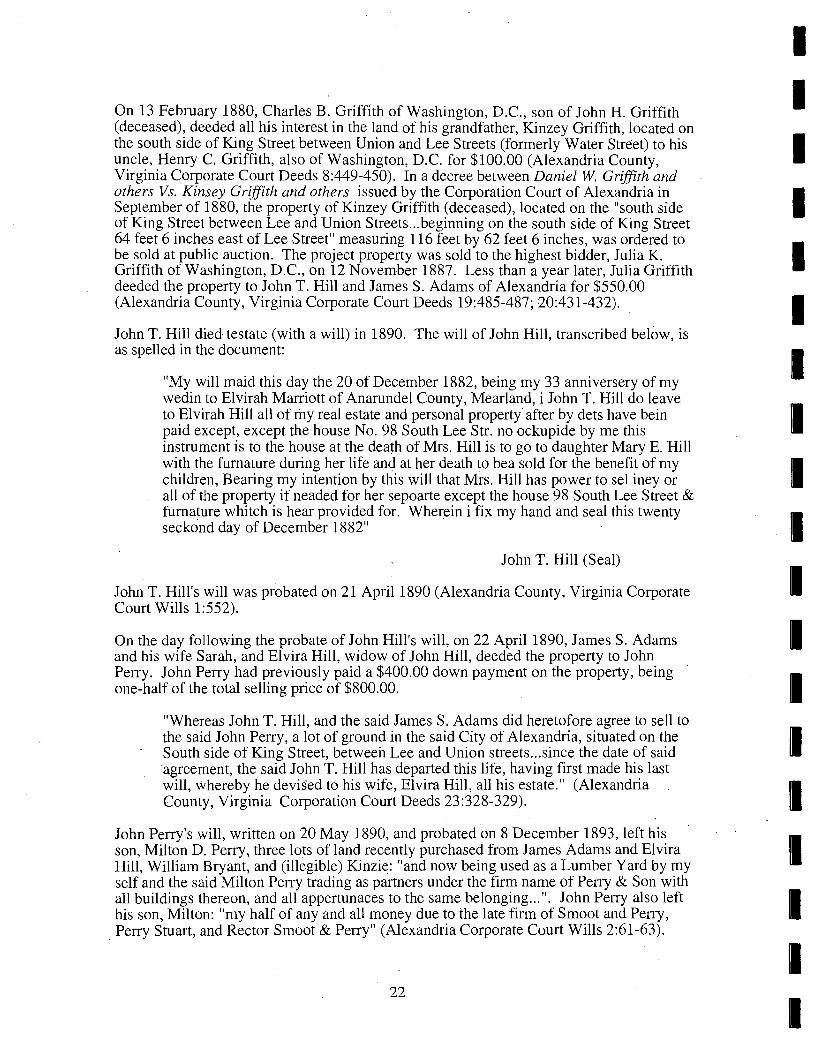
The Sanborn-Perris fire insurance map for 1891 shows the two former buildings on the project area demolished, and a two story "machine shop" building with a one story back addition (covered with asbestos), erected in the place of the general merchandise store at 116 King Street. The remainder of the property is occupied by two piles of lumber and a lumberyard owned by Perry and Son (Figure 10). Milton Perry, and his wife Lillian deeded this property to De Wilton Aitcheson for $1,500.00 on 22 August 1895 (Alexandria County, Virginia Corporation Court Deeds 34:369-372).
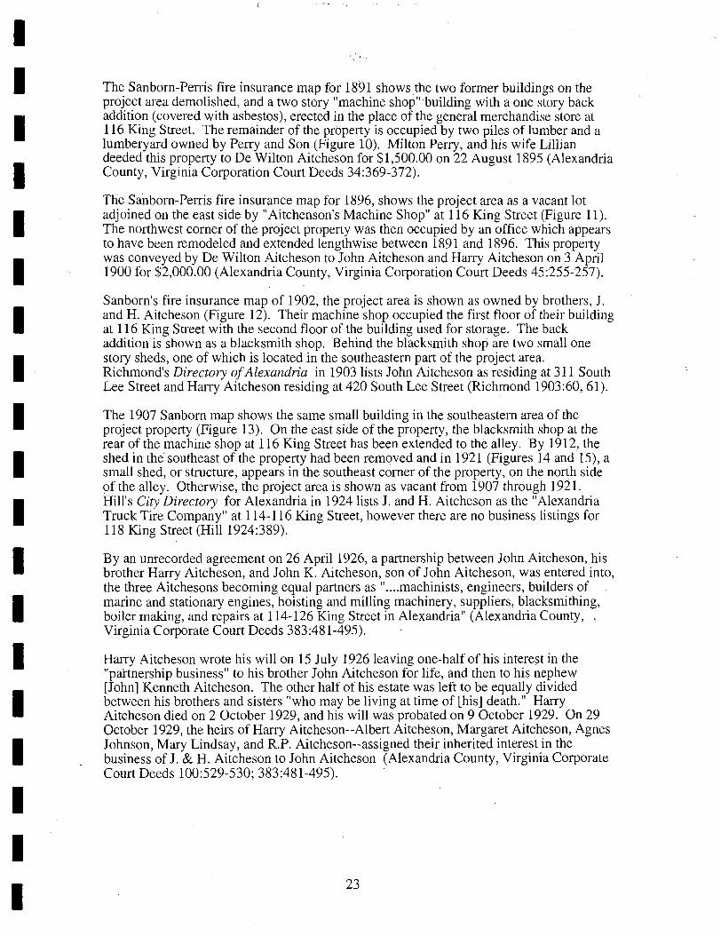
The Sanborn-Perris fire insurance map for 1896, shows the project area as a vacant lot adjoined on the east side by "Aitchenson's Machine Shop" at 116 King Street (Figure 11). The northwest corner of the project property was then occupied by an office which appears to have been remodeled and extended lengthwise between 1891 and 1896. This property was conveyed by De Wilton Aitcheson to John Aitcheson and Harry Aitcheson on 3 April 1900 for $2,000.00 (Alexandria County, Virginia Corporation Court Deeds 45:255-257).
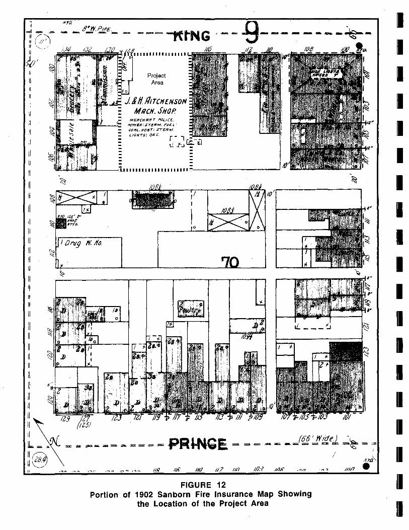
Sanborn's fire insurance map of 1902, the project area is shown as owned by brothers, 1. and H. Aitcheson (Figure 12). Their machine shop occupied the first floor of their building at 116 King Street with the second floor of the building used for storage. The back addition is shown as a blacksmith shop. Behind the blac~smith shop are two small one story sheds, one of which is located in the southeastern part of the project area. Richmond's Directory of Alexandria in 1903 lists John Aitcheson as residing at 311 South Lee Street and Harry Aitcheson residing at 420 South Lee Street (Richmond 1903:60,61).
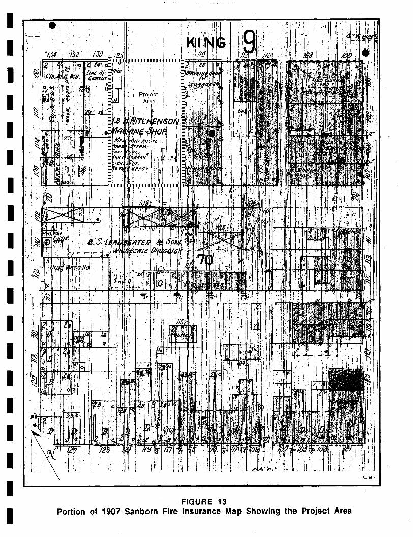
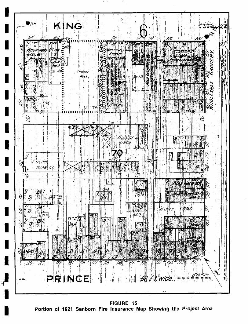
The 1907 Sanborn map shows the same small building in the southeastern area of the project property (Figure 13). On the east side of the property, the blacksmith shop at the rear of the machine shop at 116 King Street has been extended to the alley. By 1912, the shed in the" southeast of the property had been removed and in 1921 (Figures 14 and 15), a small shed, or structure, appears in the southeast corner of the property, on the north side of the alley. Otherwise, the project area is shown as vacant from 1907 through 1921. Hill's City Directory for Alexandria in 1924 lists 1. and H. Aitcheson as the "Alexandria Truck Tire Company" at 114-116 King Street, however there are no business listings for 118 King Street (Hill 1924:389).
By an unrecorded agreement on 26 April 1926, a partnership between John Aitcheson, his brother Harry Aitcheson, and John K. Aitcheson, son of John Aitcheson, was entered into, the three Aitchesons becoming equal partners as " .... machinists, engineers, builders of marine and stationary engines, hoisting and milling machinery, suppliers, blacksmithing, boiler making, and repairs at 114-126 King Street in Alexandria" (Alexandria County, Virginia Corporate Court Deeds 383:481-495).
Harry Aitcheson wrote his will on 15 July 1926 leaving one-half of his interest in the "partnership business" to his brother John Aitcheson for life, and then to his nephew [John] Kenneth Aitcheson. The other half of his estate was left to be equally divided between his brothers and sisters "who may be living at time of [his] death." Harry Aitcheson died on 2 October 1929, and his will was probated on 9 October 1929. On 29 October 1929, the heirs of Harry Aitcheson--Albert Aitcheson, Margaret Aitcheson, Agnes Johnson, Mary Lindsay, and R.P. Aitcheson--assigned their inherited interest in the business of J. & H. Aitcheson to John Aitcheson (Alexandria County, Virginia Corporate Court Deeds 100:529-530; 383:481-495).
23
I I J I ! I I . ~
I f I '!
SHEET /u" W P . - -- -~-KtNG---
/J() /ZB J 1/'7 . ..If 0 F~ijOij;;;;;;;;;;~~F.ii~;;"'~.I. U .. ll~.I.UJ.l -" ... - 'I- --
z-- X:: 11\ e ~ '- ~ ~§..i~ ~ =1 1 ~ ~ ::- 1,1 ~.. 0.: :: \0 t Q;)
~. : ~ I ~ I : ~ I -<::l
1,0 ~~~II~I,t _ c::; : "-J "-J :
V) :: I I I Project: ,
~ I I I Area ~ ,y 7, ' ~ w.:;_;"'~:--_-_-_-_-:""I_-----sCl"T-111 Ii I r II I j III II 1IIIIIIlr_~ __ .-L-.:.zo:-· ---+--~.:;....;j'-;"~~'
- - - -- ~ --. -- ~. ---~-:~ crJ
- - ....: - - - - - - - _. __ . II
, ~
~ . :~Sl(ll'clst ~
ct '.
~u/I Q:"r L 1./1716 el' P;'/es, 4.J:
j/8RILORS Cl 70 CHI1P£L .
1x ~ ~------~~-----------------~---~/~X
~ :0, o
'\:l Z ~ D,,'"
2 )l.
I ,. ... J 2 0
J
~ l I ~
Pni,I;'17
~2~~~3~D.~,~o~·~2~~D7'~~~~~~=-=~~~~~~"~~"~~~~-=~~ /21 /26- It,) 12/ /(/&
~+ -=-- ------ --- .... PRINCE '~
FIGURE 10 Portion of 1891 Sanborn-Perris Fire Insurance Map Showing a Two-story "Machine
Shop", Two Lumber Piles and Lumberyard Located Within the Project Area
I I I I I I I I I I I I I I I I I I I
I I I I I I I I I I I I I
I I I I I
/tin n: ,"-: ~ ~ = == :;. =- =- ;; ~ ... ~ -= li::. :=; :;:., ~ ~ ~ =.. ~__ '*' ~ :;
t;;\ \::!....J /. /3 2 d' 1-30 ""IY,?
'?-- '2 :tri~1' I I I I I I I I I I I I I I
-, & ff41. 6i -~:: ~ ~ ',i • ro. ~ ~§ I
:[J.", it ~-:0-" , r~; ~, '-l: ~ r, e. ------
/ 0------------
Project Area
----- -'1.1 I II 1111111111 II 1II,llj ____ -'--____ ~__L __ __.J
( SRtt.ORS N CHRP£l.
~ 70 x ____ --+--~ ____ ~,-.. ______ __I
FIGURE 11
II II
--- ...... "" .... =~ . ,. • II II
II
• 1/ ~ II
" II 1/ II P n ~ D
~~ .. ~~~~. ~ I
• II II
" II II II II II /I ~ J 11
" )I
II
-~ M 1/ U
" " II II II 1/ II II II
M N l
Q,:R
~II • II '}/I
II II
, U
II
II 1/ I
II
Portion of 1896 Sanborn-Perris Fire Insurance Map Showing the Project Area
" Ii ~ ...... .:a.
I~ (~,~ 11,-- ..' II
>{;, II
1\
II II 1/
II
/I II
81';r.PIPE. ~ "'ff). .g ---
- ~ - - -. ==- ......... =-KtNG ----"""' . --------+--
-
11111111111111111
Project Area
J I H flITCHE.NSON MilCH. SHOP.
MEIfCHNffT !'Quet. """"Elf: ST£RM. rile L . CO"L. /reliT: $T~RM. LlliHTS: ORS.
--11
·1IIIL"""IU~ __ :..a...._~i_111111111111111111111 ~,. _________ ..J
II
II Ii II II II !I 1/
II 'I II 1/
11
II II II II II
1\
II II II 1/
II II
16==-11(9 I/v
= ... =- -= ... == = = PRI-M~E
IIR IIii' 1/11 II?
FIGURE 12 Portion of 1902 Sanborn Fire Insurance Map Showing
the Location of the Project Area
I I I I I I I I I I I I I I
I I I I
I I )
I I I I I I I I I I I I I I I I I
" ,
I 1/1
'i Project Area
i .: !
,FIGURE,13 Portion of 1907 Sanborn Fire Insurance Map Showing the Project Area
us ~
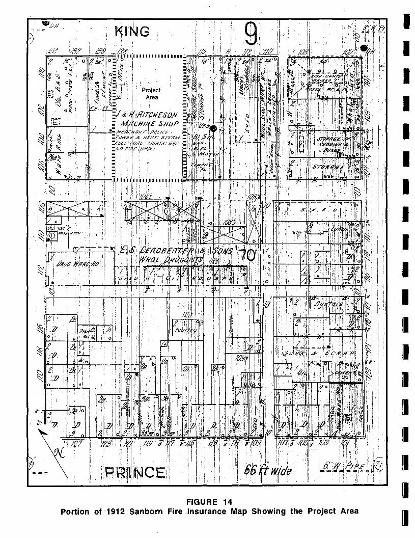
FIGURE 14 Portion of'1912 Sanborn Fire Insurance Map Showing the Project Area
I I I I I I I I I I I I I I I I I I I
I I I I I I I I I I I I I I I I
1 •
, ' [ .' i .
Project Area i I 'I
\ I
'1 _
FIGURE 15 Portion of 1921 Sanborn Fire Insurance Map Showing the Project Area
)"
. ,'~
John Aitcheson died on 17 January 1939, leaving one-third of his estate to his wife Caroline for life, and then to their son, John K. Aitcheson, and their three daughters, Nannie, Mary, and Jessie Aitcheson. A sum of $1,200.00 was left to his executors as trustees for his son David Aitcheson and David's two children, David and Caroline Aitcheson. The remainder of his estate and his residence at 311 South Lee Street was left to his wife Caroline (Alexandria County, Virginia Corporate Court Wills 11:31-32; Alexandria County, Virginia Corporate Court Deeds 383:481-495).
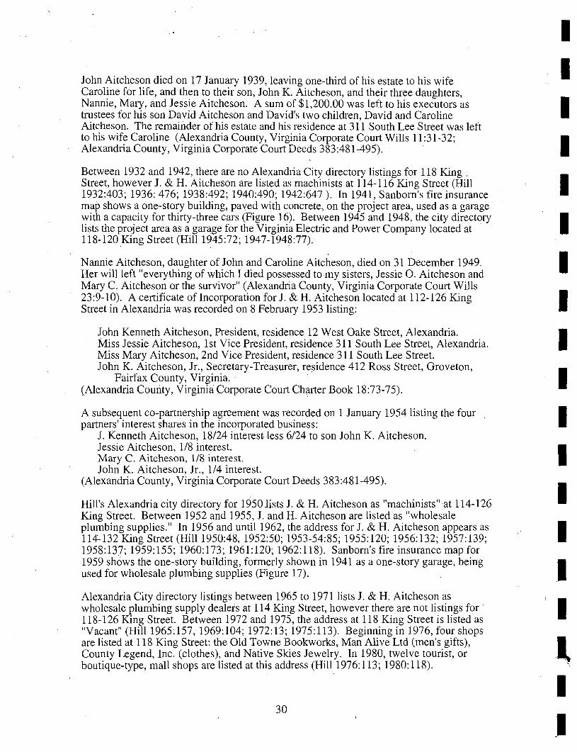
Between 1932 and 1942, there are no Alexandria City directory listings for 118 King, Street, however J. & H. Aitcheson are listed as machinists at 114-116 King Street (Hill 1932:403; 1936: 476; 1938:492; 1940:490; 1942:647). In 1941, Sanborn's fire insurance map shows a one-story building, paved with concrete, on the project area, used as a garage with a capacity for thirty-three cars (Figure 16). Between 1945 and 1948, the city directory lists the project area as a garage for the Virginia Electric and Power Company located at 118-120 King Street (Hill 1945:72; 1947-1948:77).
Nannie Aitcheson, daughter of John and Caroline Aitcheson, died on 31 December 1949. Her will left "everything of which I died possessed to my sisters, Jessie O. Aitcheson and Mary C. Aitcheson or the survivor" (Alexandria County, Virginia Corporate Court Wills 23 :9-10). A certificate ofIncorporation for 1. & H. Aitcheson located at 112-126 King Street in Alexandria was recorded on 8 February 1953 listing:
John Kenneth Aitcheson, President, residence 12 West Oake Street, Alexandria. Miss Jessie Aitcheson, 1st Vice President, residence 311 South Lee Street, Alexandria. Miss Mary Aitcheson, 2nd Vice President, residence 311 South Lee Street. John K. Aitcheson, Jr., Secretary-Treasurer, residence 412 Ross Street, Groveton,
Fairfax County, Virginia. (Alexandria Comity, Virginia Corporate Court Charter Book 18:73-75).
A subsequent co-partnership agreement was recorded on 1 January 1954 listing the four partners' interest shares in the incorporated business:
1. Kenneth Aitcheson, 18/24 interest less 6/24 to son John K. Aitcheson. Jessie Aitcheson, 1/8 interest. Mary C. Aitcheson, 1/8 interest. John K. Aitcheson, Jr., 114 interest.
(Alexandria County, Virginia Corporate Court Deeds 383 :481-495).
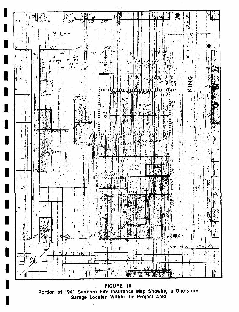
Hill's Alexandria city directory for 19501ists J. & H. Aitcheson as "machinists" at 114-126 King Street. Between 1952 and 1955,1. and H. Aitcheson are listed as "wholesale plumbing supplies." In 1956 and until 1962, the address for J. & H. Aitcheson appears as 114-132 King Street (Hill 1950:48, 1952:50; 1953-54:85; 1955:120; 1956:132; 1957:139; 1958:137; 1959:155; 1960:173; 1961:120; 1962:118). Sanborn's fire insurance map for 1959 shows the one-story building, formerly shown in 1941 as a one-story garage, being used for wholesale plumbing supplies (Figure 17).
Alexandria City directory listings between 1965 to 1971 lists 1. & H. Aitcheson as wholesale plumbing supply dealers at 114 King Street, however there are not listings for 118-126 King Street. Between 1972 and 1975, the address at 118 King Street is listed as "Vacant" (Hill 1965:157, 1969:104; 1972:13; 1975:113). Beginning in 1976, four shops are listed at 118 King Street: the Old Towne Bookworks, Man Alive Ltd (men's gifts), County Legend, Inc. (clothes), and Native Skies Jewelry. In 1980, twelve tourist, or boutique-type, mall shops are listed at this address (Hill 1976:113; 1980:118).
30
I I I I I I I I I I I I I I I
I I I I I I I I I I I I I I I I I I I
\l i t .
---.Ii
ml.
-,e.
"'" '\:I
" . ,.: i
, ; ;
I i :. ~
Tl~L_ \ I I .!' ' \ , I
FIGURE 16 Portion of 1941 Sanborn Fire Insurance Map Showing a One-story
Garage Located Within the Project Area
·i··~UL ' ... \ I . I " " " I'
. i r • .'
:1 : I, :
FIGURE 17 Portion of 1959 Sanborn Fire Insurance Map Showing a One-story
Building Located Within the Project Area
I I I I I I I I I I I I I I I I I I I
I I I I I I I I I I I I I I I I I I I
Virginia C. Aitcheson, widow of John K. Aitcheson, Sr., left one-half of her estate at her death in 1987, to her son John K. Aitcheson, Jr., and the remaining half to her daughter Nancy A. Taylor (Alexandria County, Virginia Wills 191:569-571). Mary C. Aitcheson, one-eighth owner of J. & H. Aitcheson by right of inheritance from her father John
. Aitcheson, likewise left her share in the business at her death in 1989 to be equally divided between her nephew John K. Aitcheson, Jr., and her niece, Nancy Aitcheson Taylor (Alexandria County, Virginia Wills 210: 14-20).
METHODOLOGY
Phase I Investigation
The Phase I archeological investigations consisted of a documentary study and field investigations. The documentary study included an examination of historic maps, preparation of a chain of title, an examination of U.S. Census and tax records and other sources which provided information directed towards identifying the property owners and the uses of the subject property.
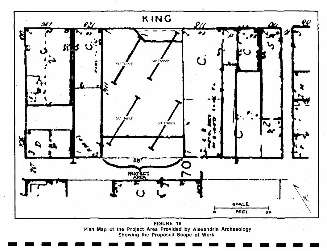
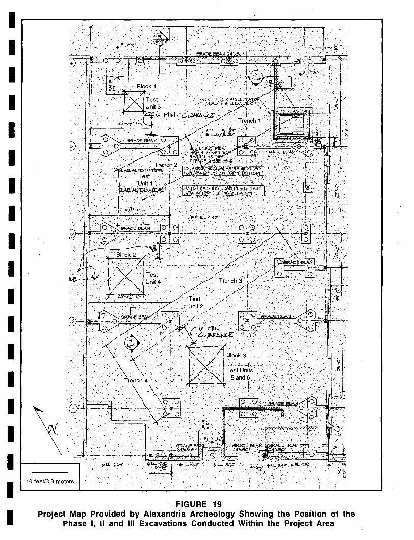
The Phase I archeological fieldwork consisted of the excavation of four circa 50 foot long mechanically dug trenches which were placed at specific locations in accordance with a map provided by Alexandria Archaeology with the Scope of Work (Figure 18). The field situation dictated a slightly different approach (Figure 19) as there were impediments (such as a buried storage tank) that prohibited excavation in certain areas. The trenches were to be excavated to the maximum depth possible, giving consideration to the potential for wall slump and a possible high water table. The purpose of these trenches was to determine if intact archeological deposits or features were present and to examine the soil stratigraphy.
Soil from the trenches was not screened, but artifacts were collected from different levels within the trenches if they were felt to be from intact cultural deposits.
The Scope of Work also required the excavation of at least one, but a maximum 'of four, 3 by 3 foot test units adjacent to ot within the trenches if pre-20th century artifact bearing levels were encountered. Two 3 by 3 foot test units were excavated in areas of archeological deposits--one in Trench 2 and a second in Trench 3. The soil from these test units was screened.
Phase II and III Investigation
Additional background or documentary study was conducted during the Phase II and III investigation.
The Phase II and III excavations focused on specific locations where the Phase I had determined the soil strata contained artifacts in context; these were dated during the Phase I to the 18th century. Three areas were opened with a backhoe and excavated to the appropriate soil levels; that is the strata containing the 18th century artifacts. The area excavated was the equivalent of five 5 by 5-footsquares.
Soils, when screened, were dry screened through 114-inch mesh hardware cloth. Excavations were within soil horizons.
33
. -.~ • •
If! ' .. ~,
KING - -
• 4..
50'Trench
I
50'Trench I 50'Trench
u
FIGURE 18
•
L>
--• --
• o
-. ". • •
Plan Map of the Project Area Provided by Alexandria Archaeology Showing the Proposed Scope of Work
-------------------
1 1 1 1 I. 1 I 1 I I 1 I I I 1 I I 1 I
10 feetl3.3 meters
FIGURE 19 Project Map Provided by Alexandria Archeology Showing the Position of the
Phase I, II and III Excavations Conducted Within the Project Area
Laboratory Analysis
All artifacts were cleaned, inventoried, and curated. Historic artifacts were separated into four basic categories: glass, metal, ceramics, and miscellaneous. The ceramics were identified as to ware type, method of decoration, and separated into established types, following South 1977, Miller 1992 and Magid 1990. All glass was examined for color, method of manufacture, function, etc., and dated primarily on the basis of method of manufacture when the method could be determined (Hurst 1990). Metal and miscellaneous artifacts were generally described; the determination of a beginning date is sometimes possible, as in the case of nails.
The prehistoric artifacts were classified by cultural historical and functional types and lithic material. In addition, the debitage was specifically studied for the presence of striking platforms and cortex, wholeness, quantity of flaking scars, signs of thermal alteration, size, and presence or absence of use. Chunks are fragments of lithic debitage which, although they are culturally modified, do not exhibit clear flake or core morphology.
Conservation
Conservation of 26 leather artifacts was undertaken by Joan S. Gardner. The conservation consisted of bringing the artifacts from a wet to a dry state followed by a recognized conservation treatment incorporating polyethylene glycol, distilled water and fungicide.
Since the artifacts derived from three separate proveniences, they were treated in separate containers so that the contextual integrity was maintained. Each artifact was measured and traced or sketched prior to the treatment. In general, the artifacts were fragile, incomplete, worn and had numerous rips, tears and losses. The artifacts were then either placed on fiberglass screening or had protective screening sewn around them. The screening was utilized to protect the artifacts and reduce the damage from handling as the artifacts were inverted every three days. The artifacts were immersed in distilled water in which isopropanol (rubbing alcohol) was used as a fungicide.
The artifacts were then immersed in 10% Carbowax 400 for two weeks. After this period, the artifacts were immersed in 20% Carbowax for one week and then into 30% for one-two weeks. Extra time was allotted to some of the artifacts.
All artifacts were then dried slowly at room temperature over several days to prevent warpage. Only two items had noticeable shrinkage.
RESULTS OF THE FIELD INVESTIGATIONS
The following describes the results of the Phase I-III field investigations, beginning with the Phase I and concluding with the Phase II and III. The archeological work was necessitated by the construction of a commercial building in the lot at 118 King Street. The structure within the lot had been demolished and the concrete slab foundations removed prior to the field investigations.
Phase I Investigation
As previously stated, the Scope of Work required that four circa 50 foot long trenches be excavated by a backhoe with a flat lipped bucket (Plate 1). The depth of the trenches was not specifically stated in the Scope; however, they were to be excavated to the greatest depth possible, considering the possibility of side wall slumping and a high water table.
36
I I I I I I I I I I I I I I I I I I I
I I I I I I I I I I I I I I I I I I I
If pre-20th century artifact bearing strata 'were encountered, the Scope called for the excavation of at least one 3 by 3 foot square test unit within or adjacent to each trench.
Figure 19 presents a map of the Phase I and Phase IIIIn excavations. As can be seen from this illustration, four trenches of varying size were excavated during this phase of investigation. Two 3 by'3 foot test units were excavated within Trenches 2 and 3 during the Phase I. Close consultation was maintained with Alexandria Archaeology personnel during the excavations. The artifacts are summarized in the discussion below. A full inventory is presented in Appendix II.
Trench 1 is located in the northeastern portion of the project area. The soil profile in this unit was as follows (Figure 20):
Fill 1 horizon: 0-.5 feet (0-.15 meter) below surface - dark brown unconsolidated sand
Fill 2 horizon: .5-1 foot (.15-.3 meter) below surface-Fill 3 horizon: 1-1.8 feet (.3-.55 meter) below surface - yellowish brown sandy
clay fill Fill 4 horizon: 1.8-2.5 feet (.55-.76 meter) below surface - orange sand with brick
bats Fill 5 horizon: 2.5-2.8 feet (.76-.85 meter) below surface - compact olive brown
clay with wood Fill 6 horizon: 2.8-3.8 feet (.85-1.2 meters) below surface - compact light grayish
brown sand Fill 7 horizon: 3.8-6.3 feet (.85-1.9 meters) - no notes Ab horizon: 6.3-??? feet (1.9-?? meters) below surface - clay layer mixed with
broken cobbles and bricks C horizon: ????- 9 feet (7?-2.7 meters) below - sandy horizon
Various fill zones were present above a buried land surface which was designated an Ab horizon. Below this were sands and clays associated with lagoonal deposits.
Trench 1 was excavated to a depth of nine feet (2.7 meters) below the present ground surface. A kaolin pipe stem fragments and a leather fragment were recovered from the trench at a depth of 33.6-45.6 inches below the surface.
At 6.3 feet (75.6 inches/1.9 meters) below the surface, a pearlware sherd (1780-1830), a creamware sherd (1762-1820), a white salt glazed stoneware sherd (1720-1805), a pre-1864 windowpane sherd, an unidentified windowpane sherd, an unidentified glass sherd, mortar fragments and a quartzite cobble fragment with cortex were recovered. These artifacts were felt to derive from a buried Ab horizon or buried land surface.
Shoe fragments were recovered from depths of six and eight feet below surface in the trench.
Trench 2 was excavated across an area of disturbance but parallel to Trench 1. The disturbed area was the former location of an underground storage tank. Trench 2 was excavated in two parts; the northern portion of the trench was fully machine excavated to examine the soils in this location and to determine if intact, artifact bearing horizons were present.
37
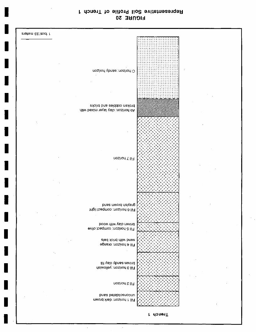
• •
~ 4:luaJJ. JO alIJOJd 1I0S aAneJuasaJdau O~ 3Un~l.:I
UOZpolllipues : uozpoll :)
s)jopq pue selqqoo ue)jOJq lll!M peX!W Jelielliep :UOZPOll qV
UOZpoll L 1I!:l
pues UMOJq llS!lieJ6 l1l6!1 pedwoo :UOZP01l9 II!:l
POOM lll!M liep UMOJq e"!lo pedwoo :UOZP01l9//!:l
sleq )jopq lll!M pues e6ueJO :UOzpoll V II!:l
II!~ liep lipues UMOJq llS!Molleli :uozpoll 8 II!:l
UOZpoll ~ 1I!:l
pues pelep!l0suooun UMOJq )jJep :UOzpoll ~ II!:l
. ..................... . ............. ......... . ....................... .... .................. . .......... ............ . .......... .......... .. . ... ............. ...... . •••• 0 •••••••••••••••••• .......... ...... ...... . ............ .......... . ..... ................. . ......... ......... .... . ....................... ............. .... ..... . ................. ..... . ........ ....... ....... . .... .................. . ......................
, , , , , , , , , , / / / / / / / / / / , , , , , , , , , , / / / / / / / / / / , , , , , , , , , , / / / / / / / / / / , , , , , , , , , , / / / / / / / / / / , , , , , , , , , , / / / / / / / / / / , , , , , , , , , , / / / / / / / / / / , , , , , , , , , , / / / / / / / / / / , , , , , , , , , , / / /"/ / / / / / / , , , , , , , , , , / / / / / / / / / / , , , , , , , , , , / / / / / / / / / / , , , ~ , , , , , , / / / / / / / / / / , , , , , , , , , , / / / / / / / / / / , , , , , , , , , , / / / / / / / / / / , , , , , , , , , , / / / / / / / / / / , , , , , , , , , , / / / / / / / / / / , , , , , , , , , , , / / / / / / / / / / , , , , , , , , , , , / / / / / / / / / / , , , , , , , , , , , / / / / / / / / / / , , , , , , , , , , , / / / / / / / / / / , , , , , , , , , , / / / / / / / / / / , , , , , , , , , ,
/ / / /
~ 1I0UaJ.l
I I I I I I I I I I I I I I I I I I I
· .11" f·.··.
The soils within the northern portion of Trench 2 ccnlsisted ofa series of fill horizons which overlie a buried ground surface and C horizons. The profile is shown on Figure 21 and presented below:
Fill 1 horizon: 0-1.4 feet (0-.43 meter) below surface - loose cobble fill with brown sandy clay
Fill 2 horizon: 1.4-2.3 feet (.43-.70 meter) below surface - orange clay Fill 3 horizon: 2.3-2.4 feet (.70-.73 meter) below surface - dark grayish brown
, sandy clay with wood Fill 4 horizon: 2.4-2.7 feet (.73-.82 meter) below surface - light brown compact
fine silty clay Fill 5 horizon: 2.7(3.4 feet (.82-1 meter) below sUlfac~ - brown sandy clay loam Fill 6 horizon: 3.4-4.l feet 0-1.2 meter) below surface - very fine wet grayish
brown sand Fill 7 horizon: 4.1-4.85 feet 0.2-1.5 meters) below surface - compact sandy clay
with large brick rubble fragments Ab horizon: 4.85-5.3 feet 0.5-1.6 meters) below surface - very dark grayish
brown clay loam CI horizon: 5.3-6.2 feet'0.6-1.9 meters) below surface - compact sandy clay
mixed with thin wash deposits, brick and oyster shell C2 horizon: 6.2-7.5 feet (1.9-2.3 meters) below surface -light brown sandy clay
with light gray mottles
Artifacts from the late 18th and early 19th were present in the Ab horizon which extended across the trench although it varied in thickness. A C horizon lay below this buried surface. The C horizon consisted of wash or erosion deposits which no doubt relate to historic land clearing in the area. Below these erosional deposits were lagoonal deposits.
The surface of Trench 2 yielded a refined red ware sherd and a brass fragment which may be part of a handle. The Ab horizon contained a pearl ware sherd (1780-1830), a worn liquor bottle sherd, seven spirits bottle sherds dating from 1788-1798, six spirits bottle sherds dating from 1761-1798, four spirits bottle sherds dating from 1783-1798, six pre-1860 bottle sherds, ten post-1750 tumbler sherds, 14 pre-1853 windowpane sherds, 31 pre-1864 windowpane sherds, mortar fragments, wood fragments, oyster shell fragments, a shoe sole, leather fragments, a nut hull fragment and brick fragments. A large oval handled wash pan was recovered from the Ab horizon as was a flaked shale tool which may be part of an ax.
A white salt glazed stoneware sherd 0720-1805) and a cream ware sherd were recovered from the top of the C 1 horizon.
Because intact horizons were felt to be present at a depth of 4.85 feet, the machine was used to remove only the upper fill zones above the Ab horizon in the southern portion of Trench 2. Once the Ab horizon was reached, a 3 by 3 foot test unit (Test Unit 1) was excavated within the Ab horizon.
39
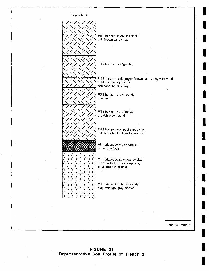
Trench 2
Fill 2 horizon: orange clay
Fill 3 horizon: dark grayish brown sandy clay with wood Fill 4 horizon: light brown
~~:':":"4~~'-::'-~~ compact fine silty clay
· ........... . · .......... . · ........... . · .......... . · ........... . · .......... . · ........... . · .......... . · ........... . · .......... . · ........... . · .......... . · ........... . · .......... . · ........... . · .......... . · ........... . · .......... . · ........... . · .......... . · ........... . · .......... . · ........... . · .......... . · ........... . · .......... . · ........... . · ........... . · .......... . · ........... . · .......... . · ........... . · .......... . · ........... . · .......... . · ........... . · .......... . · ........... . · .......... . · ........... . · .......... . · ........... . · .......... . · ........... . · .......... . · ........... . · .......... . · ........... . · .......... . · ........... . · .......... . · ........... . · .......... . · ........... . · .......... . · ........... . · .......... . · ........... .
FillS horizon: brown sandy clay loam
Fill 6 horizon: very fine wet grayish brown sand
Fill 7 horizon: compact sandy clay with large brick rubble fragments
Ab horizon: very dark grayish brown clay loam
C1 horizon: compact sandy clay mixed with thin wash deposits, brick and oyster shell
C2 horizon: light brown sandy clay with light gray mottles
FIGURE 21 Representative Soil Profile of Trench 2
1 foot/.33 meters
I I I I I I I
I I I I
I I I I I I
I I I I I I I I I I I I I I I I I I I
The Ab horizon in Test Unit 1 was excavated as a unit and yielded a burned refined white earthenware sherd, a creamware sherd (1762-1820), a pearlware sherd 0780-1830), a Spilits bottle sherd dating from 1770-1798, two unidentified liquor bottle sherds, SO pre-1864 windowpane sherds, a possible ferrous metal pot rim, a wrought nail, four bone fragments, two tooth fragments and brick fragments. A rounded refined white earthenware sherd which may be a gaming stone was also recovered from Levell. These gaming stones are believed to be associated with the West African game of mancala and are believed to indicate an enslaved African American presence.
A black silty sand lens lay below the Ab horizon and an artifact bearing horizon lay below the lens. The second artifact bearing horizon was underlain by the lagoonal deposits. The aI1ifact bearing horizon was excavated as Level 2.
Artifact counts were reduced considerably in Level 2 which yielded a wood fragment, three bone fragments, mortar fragments and a quartzite flake.
Trench 3 was excavated to the west of Trench 2. The western end of the trench was fully excavated by machine and the eastern portion was partially machine excavated. The soil profile within the western portion of Trench 3 was as follows (Figure 22):
Fill 1 horizon: 0-1.S feet (0-.46 meter) below surface - loose unconsolidated brown smd '
Fill 2 horizon: 1.S-2.S feet (.46-.76 meter) below surface - compact orange clay Fill 3 horizon: 2.S-3 feet (.76-.91 meter) below surface - light brown clay Fill 4 horizon: 3-3.2 feet (.91-.97 meter) below surface - brown clay with brick
fragments FillS horizon: 3.2-4.2 feet (.97-1.3 meters) below surface - olive brown clay Fill 6 horizon: 4.2-4.5 feet (1.3-1.4 meters) below surface - darker grayish brown
sandy clay with brick fragments Ab1 horizon: 4.S-S feet O.4-1.S meters) below surface - olive brown sandy clay Ab2 horizon: S-S.S feet 0.S-1.7 meters) below surface - darker grayish brown
sandy clay with wood fragments C1 horizon: S.S-6 feet 0.7-1.8 meters) below surface - compact orange clay with
light gray mottles C2 horizon: 6-6.7 feet (1.8-2 meters) below surface - grayish brown fine sandy
loam with olive brown wash layers C3 horizon: 6.7-7.S feet (2-2.3 meters) below surface - wet brown sand with
pockets of gray clay
The excavations within Trench 3 terminated at 11.0 feet (3.3S meters) below the ground surface.
Two kaolin pipe fragments, five burned refined white earthenware sherds, three burned creamware (7) sherds, a burned pearl ware (7) sherd, two porcelain sherds, a coarse stoneware sherd, two red ware sherds, an unidentified bottle sherd, a pre-1830 flask sherd, a pre-1860 tumbler sherd and a bone fragment were recovered from the Fill 3 horizon. The Fill 4 horizon yielded a kaolin pipe stem fragment, two burned refined white earthenware sherds, a burned creamware (7) sherd, three pearl ware sherds 0780-1830), a turtle shell fragment, a bone fragment, oyster shell fragments and a slate fragment.
41
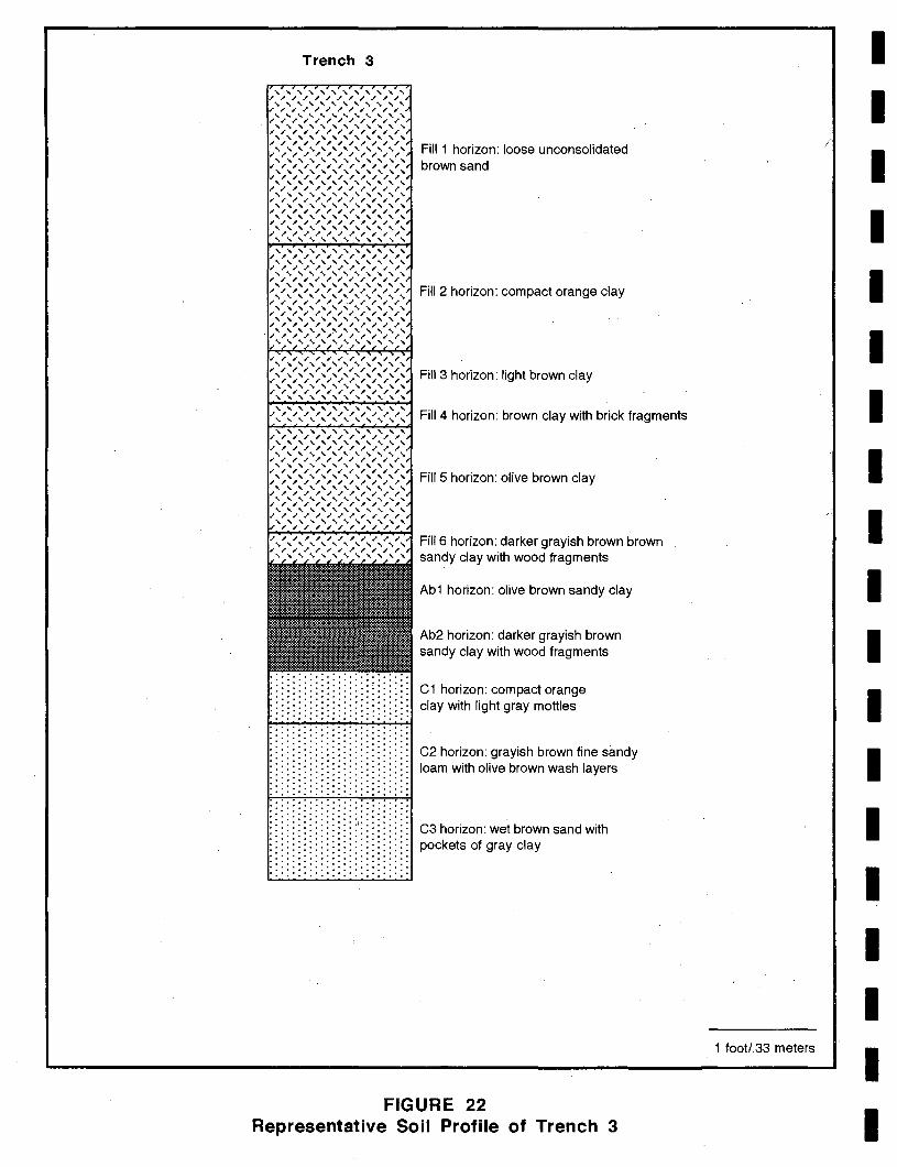
Trench 3
· .......... . · .......... . · .......... . · .......... . · .......... . · .......... . · .......... . · .......... . · .......... . · .......... . · .......... . · .......... . · .......... . · .......... . · .......... . · .......... . · .......... . · .......... . · .......... . · .......... . · .......... . · .......... . · .......... . · .......... . :::::::::::::::\::::::::: · .......... . · .......... . · .......... . · .......... . · .......... . · .......... . · .......... . · .......... . · .......... . · .......... . · .......... . · .......... . · .......... . · .......... . · .......... .
Fill 2 horizon: compact orange clay
Fill 3 horizon: light brown clay
Fill 4 horizon: brown clay with brick fragments
Fill 5 horizon: olive brown clay
Fill 6 horizon: darker grayish brown brown sandy clay with wood fragments
Ab1 horizon: olive brown sandy clay
Ab2 horizon: darker grayish brown sandy clay with wood fragments
C1 horizon: compact orange clay with light gray mottles
C2 horizon: grayish brown fine sandy loam with olive brown wash layers
C3 horizon: wet brown sand with pockets of gray clay
FIGURE 22 Representative Soil Profile of Trench 3
1 footl.33 meters
I I
/
I I I I I I I I I I I I I I I I I
I I I I I I I I I I I I I I I I I I I
The Ab1 horizon contained three burned refined white earthenware sherds, a burned redware (?) sherd, two burned pearlware (?) sherds, two creamware sherds (1762-1820), four redware sherds, two 1761-1798 spirits bottle sherds, two post-1788 spirits bottle sherds, two pre-1860 liquor bottle sherds, two pre-1864 windowpane sherds, five bone fragments, wood fragments and oyster shell fragments. .
The second Ab horizon yielded a redware sherd, an unidentified burned sherd, and a bone fragment.
A test unit was then excavated within the central portion of Trench 3 (Figure 19). This unit was designated Test Unit 2. The profile in this unit was similar to that seen in Trench 2, with the artifact bearing ground smiaces (Ab horizons) at a depth of circa five feet below the ground surface (Plates 2 and 3).
The Ab horizon in Test Unit 2 was excavated in two levels; Levell yielded five burned refined white earthenware sherds, eight burned creamware (?) sherds, three burned pearl ware (?) sherds, seven Pitkin type flask sherds dating from 1783-1830, five pre-1864 windowpane sherds, an unidentified ferrous metal fragment, two wood fragments, oyster shell fragments and mortar fragments. Level 2 of the Ab horizon contained eighteen unidentified burned ceramic sherds, 21 burned creamware (?) sherds, two burned pearlware (?) sherds, a white salt glazed stoneware sherd (1720-1805), two redware sherds, seven Pitkin type flask sherds dating from 1783-1830, a pre-1860 bottle sherd, four pre-1864 windowpane sherds, a wrought nail, two post-1790 cut nails, a bone handle fragment, a fish scale, a coal fragment, three bone fragments, mortar fragments and oyster shell fragments. A black English flint spall was also recovered from this level. The flint spall may have been transported to this location as ballast.
The Ab2 horizon yielded six burned ceramic sherds, a possible creamware sherd, two possible pearlware sherds, a redware sherd, two pre-1860 flask sherds, four unidentified bottle sherds, an unidentified glass sherd, a strap iron fragment, a unidentified nail, a wood fragment, two tooth fragments, a bone fragment, a peach pit, 12 slag fragments and an English flint fragment.
Trench 4 was opened perpendicular to and at the north end of Trench 3. This trench was opened to determine how far the Ab horizon extended in this direction. The Ab horizon was determined to extend at least 20 feet (6.1 meters) in this direction.
Summary and Recommendations
The Phase I investigations revealed that a buried ground surface was present within the western portion of the project area. This Ab horizon lay at a depth of 4.5-5.0 feet within the trenches. The overlying deposits above the Ab in all of the trenches consisted of fill horizons and the Ab was underlain by C horizons. 'The C horizons are all wash, typical of upland erosion being deposited in varve-like deposits in an embayment.
The artifacts within the Ab horizon were generally domestic and date to the 18th century. Creamware, pearlware and redware sherds, late 18th century bottle sherds, windowpane sherds and faunal remains were recovered from the buried ground surface. A possible gaming stone associated with enslaved African Americans and English flint spalls were also recovered from the intact deposits.
Alexandria Archaeology personnel concluded that the Ab horizons and associated artifacts were significant and that Phase WIn excavations were necessary.
43
The eastern half was not felt to have archeological potential as the southeastern portion was disturbed and no archeological deposits were found within the northeastern portion.
Phase II/III Investigations
The proposed construction within the area which contained the intact deposits consisted of support piles for the proposed building. Because archeological excavations would destroy the degree of soil compactness necessary for the piles, the following Scope of Work was delineated by Alexandria Archaeology. After the piles had been driven and the grade beams placed, test units would be hand excavated in locations which were at least six feet away from the pile clusters. A maximum of five 5 by 5 foot units were to be excavated within three locations within the project area. The overlying fill deposits were to be removed by machine, followed by the hand excavation of the intact slllfaces.
Following the Scope of Work, the three areas which were to contain the excavation units were designated Blocks 1 through 3. A total of four test units were actually excavatedone in Block 1, one in Block 2 and two test units in Block 3.
Figure 19 shows the location of the Phase IIIIlI test units. As can be seen from the figure, Block 1 was opened to the east of Phase I Trench 2 and Test Unit 1. The machine excavations within this location consisted of the removal of soil from a five by five foot (1.5 by 1.5 meter) area to a depth of circa 4.2 feet (1.3 meters). The five by five foot unit was Test Unit 3. The upper soils within the unit consisted of fill horizons and, although the soils were not screened, artifacts were collected when noted. Plate 4 presents a view of the soils.
The artifacts from the fill horizons included a kaolin pipe bowl fragment, a stoneware drain pipe (7) sherd, a white salt glazed stoneware sherd (1720-1805), a refined white earthenware sherd, five creamware sherds (1762-1820), 11 pearl ware sherds (1780-1830), a porcelain sherd, a lackfield sherd (1740-1780), a refined redware sherd (1800-1840),three redware sherds, a stoneware sherd which may be Rhenish stoneware, two unidentified bottle sherds, a pre-1860 bottle sherd, 16 unidentified glass sherds, six pre-1853 windowpane sherds, 383 pre-1864 windowpane fragments, one cut nail (post-1830), eight bone fragments, 29 wood fragments, five peach pits, oyster shell fragments, brick fragments and mortar fragments. A black English flint spall was also found.
This revealed a [2.5Y 311] very dark gray loam which was initially thought to be the Ab horizon. The dark level was underlain by a lighter sandy level which was also screened initially. Although artifacts were recovered from the lighter layer, this did not appear to be the Ab horizon so an exploratory hole was excavated within a comer of the unit. This revealed a darker layer below the light fill layer and the remainder of the light fill was discarded without screening. The artifacts recovered from the lighter fill include a redware sherd, a possible stoneware sherd, four pre-1860 bottle sherds, 33 pre-1864 windowpane sherds, an unidentified glass sherd, three coal fragments, a bone fragment, three peach pits, burned oyster shell fragments, brick fragments and mortar fragments. An examination of the soil horizons revealed that the first dark level and the lighter level were fill horizons which overlay the buried ground surface.
44
I I I I I I I I I I I I I I I I I I I
I I I I I I I I I I I I I I I I I I I
The Ab horizon began at 4.8 feet (1.5 meters) below the ground surface in the unit. All of the soils from this horizon were screened. The artifacts from the Ab included two kaolin pipe fragments, a porcelain sherd, a white salt glazed stoneware sherd (1720-1805), a creamware sherd 0762-1820), two pearl ware sherds 0780-1830), a redware sherd, 283 pre-1864 windowpane sherds, five pre-1853 windowpane sherds, two wood fragments, brick fragments, plaster fragments and mortar fragments. The faunal remains included clam shell fragments, a bone fragment, oyster shell fragments, a black walnut hull and two peach seeds. A leather strap and a bundle of what appeared to be shoe parts secured by a leather strap were recovered from this horizon (Plates 5-7).
Much of the recovered windowpane glass from Test Unit 3 stood vertically within the soil horizon; the artifacts appear to represent refuse which was discarded within a wet area in this location.
Below the Ab horizon lay a hard, compact sandy layer with a number of lenses. This may represent the bottom of the embayed area which was filled in the late 18th century. A portion of this level was screened in the west half of the unit; no artifacts were recovered. An exploratory probe was then excavated in the northeast comer of the unit at the bottom of the sandy layer to determine the soil horizons. This revealed gleyed clays and the unit was abandoned.
The second excavation block (Block 2) was opened between Phase I Trench 2ffest Unit 1 and Trench 3/Test Unit 2. This block measured 10 by 10 feet (3 by 3 meters). The soils within the block area were mechanically removed down to a depth of 4.5 feet 0.4 meters) to expose the Ab horizon seen in the Phase I trenches. Shortly after opening, the unit filled with four feet of water and had to be pumped twice. Test Unit 4, a five by five foot (1.5 by 1.5 meter) unit, was excavated in the southwestern comer of the block which was slightly higher than the rest of the excavation block. Plates 8 and 9 present views of the . unit.
The excavations revealed a loose, very wet, very dark black soil which was interpreted as a fill. The fill horizon was screened and yielded a number of artifacts. The artifacts included .... a kaolin pipe fragment, 39 creamware sherds (1762-1820), four pearlware sherds (1780-1830), a possible whiteware sherd, a stoneware sherd, seven redware sherds, four sheet iron fragments, four wrought nails, three cinders, eight bone fragments, three slate fragments, a peach pit, nine wood fragments, oyster shell fragments and brick fragments. A shoe sole and other shoe parts were found in the backfill of Test Unit 4.
Below this fill horizon lay a series of clay pockets and sand pockets which were initially screened. No artifacts were recovered from the pockets and the remaining soils were not screened. A number of board planks which lay askew were within the pockets; the layers containing the planks alternated with thick sandy deposits and clay deposits and appeared to represent the bottom of the embayment (Plates 10 and 11). The boards may be collapsed or demolished piers.
Block 3 measured 10 by 10 feet (3 by 3 meters) and was excavated south of Trench 3ffest Unit 2. Two units, Test Units 5 and 6, were excavated within the block. The soils within the block were machine excavated to a depth of 4.5 feet 0.4 meters) and were not screened. This was believed to represent the top of the Ab horizons and screening began at this level.
45
Test Unit 5 measured five by five feet (1.5 by 1.5 meters) and was located within the southwestern corner of the block. The two Ab horizons present within Trench 3 appeared to be present within the unit; however, the unit was wet and the colors were slightly different (see Plate 12). .
The artifacts from the Ab 1 horizon included two refined white earthenware sherds, two creamware sherds (1762-1820), three pearlware sherds (1780-1830), three porcelain sherds, six redware sherds, two pre-1860 bottle sherds, three bottle sherds which may date to the late 1700s, two unidentified bottle sherds, three pre-1864 windowpane sherds, an unidentified ferrous metal fragment, two wrought nails, two brass straight pins, seven bone fragments, oyster shell fragments, mortar fragments and brick fragments.
The second Ab horizon yielded 12 refined white earthenware sherds, seven creamware sherds (1762-1820), 16 pearlware sherds (1780-1830), three redware sherds, a lackfield sherd (1740-1780), 15 unidentified bottle sherds, five pre-1860 flask sherds, four pre-1864 windowpane sherds, a ferrous metal can fragment, a brass sheet fragment, five wrought nails, two coal fragments, 12 bone fragments, oyster shell fragments and a peach seed.
The Ab2 horizon contained 11 refined white earthenware sherds, two creamware sherds (1762-1820), five pearlware sherds 0780-1830), two porcelain sherds, three redware sherds, two redwarelbrick spalls, a coarse stoneware sherd, two white salt glazed stoneware sherds 0720-1805), nine unidentified bottle sherds, three pre-1853 windowpane sherds, an unidentified glass sherd, seven wrought nails, two cinders, five bone fragments, seven wood fragments, two leather shoe sole fragments, four leather fragments, oyster shell fragments and brick fragments.
The soils below the Ab horizons consisted of a sand layer with a number of lenses which represents the bottom of the embayment.
Test Unit 6 was excavated in the northeast corner of Block 3 and measured 5 by 3 feet 0.5 by .91 meters). The upper Ab horizon in this unit had been removed at some time in the past and only the Ab2 horizon was present.
The artifacts from the Ab2 horizon consisted of three refined white earthenware sherds, five pearlware sherds (1780-1830), seven unidentified bottle sherds, three pre-1864 windowpane sherds, three wrought nails, a bone fragment, clam shell fragments, oyster shell fragments and brick fragments. An English flint spall was also recovered.
Site Discussion
Phase I-III archeological investigations at 118 King Street revealed the presence of deep fill zones to approximately 4.5 feet in most of the project area. The fill zones overlay an Ab horizon in most of the trenches and units.
As late as 1763, the project area was underwater in the bay and, although some infilling may have occurred, a 1798 map shows the project area as a dock on the Alexandria shoreline. It is likely that the fill horizons which overlie the Ab horizon in this location. represent infilling of the project area during the late 18th/very early 19th century to provide a surface on which buildings could be constructed. Although the fill zones were generally not screened, an examination of the aItifacts which were recovered indicates that they are
46
I I I I I I I I
I , I I I I I I I
I I I I I I I I I I I I I I I, I I, I I
generally late 18th/early 19th century and contemporaneous with the Ab horizon. This would indicate infilling within a short time as few differences were observed in the various fill zones and the Ab horizon.
The Ab horizon likely represents the original land surface located within the tidal marshes adjacent to the wharf/pier in this area. This surface is dark and many of the artifacts were stained as if they had spent long periods of time in this type of environment. Given the fact that much of the window glass was standing on end, or vertically, within the sediments, it is probable that this material was dropped into mud or wet sediments. A few later artifacts, such as a whiteware sherd were recovered from within the Ab horizon, but these are felt to be intrusive as other artifacts which could be expected to occur in association with the whiteware, such as contact mold bottle sherds dating from 1810-1880, are conspicuous by their absence. Two post-1790 cut nails were found within the Ab horizon; it is unclear if these were intrusive. The Ab horizon was underlain by deposits which obviously represent river sediments.
The artifacts within the Ab horizon may indic~te refuse discard from commercial or residential establishments near the wharf or pier areas. They may also represent activities which occurred on the dock or a combination of refuse discard and wharf activities. Three English flint fragments, which likely derived from ballast, were found within the Ab horizon.
If found in a tight context, the general tone of the assemblage within the Ab horizon would suggest a residence; however, a careful examination of the types of artifacts found indicates a number of anomalies. Since the fill zones were not screened and they are not in situ contexts, calculations were not conducted.
When separating the artifacts into functional groups following South 1977, the fOllowing percentages are de11ved:
Kitchen - 39.61 % Architectural - 59.70% Furniture - 0 Arms - 0 Clothing - .28% Personal - 0 Tobacco Pipe - .28% Activities - .14%
The relative percentages of the kitchen and architectural groups would initially appear to indicate rapid building or structural demolition because of the high percentage of architectural remains. For normal domestic deposits and for other more specialized deposits such as taverns, the kitchen group would be considerably higher. However, an examination of the nails and windowpane sherds which make up the architectural group indicate that 94.47% of the architectural 'artifacts are windowpane sherds. Only 24 nails were found, with 21 of these being wrought, two cut and one unidentified. Other architectural items include 4,498.8 grams of brick, 65.3 grams of plaster and 5.7 grams of mortar. The high percentage of windowpane sherds is not the norm as windowpane sherds usually make up no more than 50 % of the architectural group and frequently less. The reason for this is unclear. Broken windowpane, however, is something which likely would be removed quickly for safety reasons.
47
Within the kitchen group, the following ware type breakdowns were obtained for the 180 ceramic sherds found:
Whiteware (1820-1900+) Creamware (1762-1820)
. Pearlware (1780-1830) White Salt Glazed Stoneware (1720-1805) J ackfield (1740-1780) Unidentified Refined White Earthenware Coarse Stoneware Redware Porcelain ' Unidentified Ware Type
.56% (n=1) 8.33% (n=15)
20.00% (n=36) 2.78% (n=5)
.56% (n=l) 21.67% (n=39)
.56% (n=l) 10.56% (n=19)
3.33% (n=6) 31.67% (n=57)
As previously stated, because of the absence of artifact types which are normally associated with the post-1820 period such as contact mold bottles, the whiteware is considered to be intrusive. The ceramics make up 62.25% of the kitchen group. A Mean Ceramic Date of 1795.82 (South 1977) was obtained for the Ab horizon, excluding the whiteware sherd. The sample consisted only of 56 sherds, however.
Bottle glass made up 37.15% of the kitchen group. This is a relatively high percentage and all identifiable bottle glass falls into the flask, liquor, and/or spirits category indicating a considerable amount of alcohol consumption. Not an inconsiderable amount of this was poured into tumblers. The alcohol consumption could reflect either the presence of a tavern or inn or consumption of alcohol by dock workers or passersby. The high percentage of tumblers would tend to suggest a nearby tavern or inn.
Only 47 bones and four teeth were recovered from the Ab horizon. Some of the bone had been cut or sawed. This is unusually low both for a residential deposit or a deposit derived from an inn or tavern. A single fish scale, four peach pits and a walnut hull were also recovered.
Oyster shell fragments were relatively prevalent, consisting of 1787.2 grams and 19.6 grams of clam shell were found.
No artifacts from the furniture, arms or personal groups were found. Clothing group artifacts made up only .28% of the artifacts for which a function could be ascribed. These were two straight pins. This would be unusually low for a residential deposit in which a number of buttons would be expected to occur.
The tobacco group was also low (.28%). Significantly higher percentages would be expected if an inn of tavern lay in the vicinity.
The activities group was represented only by a single possible gaming stone, which would suggest the presence of a slave from where the trash was derived if this sherd is indeed a mancala piece.
48
I I I I I I I I I I I I I I I I I I I
I I I I I I I I I I I I I I I I I I I
SUMMARY AND CONCLUSIONS
Phase I-III excavations at 118 King St., also known as Alexandria Town Lot 50, uncovered an Ab horizon containing artifacts dating from the late 18th century to the early 19th century. Above the Ab horizon lay a number of fill zones which were roughly contemporaneous and below this lay the natural bay deposits. The site was underwater as late as 1763 and was later filled-in to create land on which buildings were constructed. By 1789, John Fitzgerald is in possession of Lot 50 as well as other pieces of property in the surrounding area as, for instance, Lots 51 and 52. On a 1789 map, a wharf is shown on the project area suggesting that the area was on the shoreline at this time.
After creating the new land, businesses developed almost immediately. In the period of concern, 1780-1800, which is most related to the artifacts recovered, wharfs and warehouses were among the first commercial activities to develop. By 1796, the 100 block of King Street, was fully developed. The functions of the various buildings changed through time.
The artifacts recovered have a wide range of functions. Unfortunately, however, there is little with which to provide a context. Windowpane sherds standing vertically in the current indicate wet, muddy conditions. The surface below the lowest buried horizon which dates fromthe late 18th to early 19th century is very sandy with water marks indicating a wash deposition. This suggests that at this juncture nothing was built on the property, or at least where the excavations took place. The artifacts, then, were derived from the surrounding environs--perhaps an inn or tavern or perhaps even several different places. The artifact assemblage is not typical of refuse deposits solely from residential occupations. .
49
REFERENCES CITED
Barry, Warren E. 1982 Official Records Of The Colonial Period In Fairfax County, Virginia. Fairfax
County Circuit Court, Fairfax, Virginia.
Barse, William P. and William M. Gardner 1982 A Prehistoric Cultural Resources Reconnaissance of Neabsco and Powells Creeks,
Prince William County, Virginia. Report prepared for Prince William County.
Bazuin, John B. Jr. 1983 Upland Prehistoric Sites in West-Central Louisa County, Virginia. In
Piedmont Archaeology, J. Mark Wittkofski and Lyle E. Browning, eds. Archeological Society of Virginia Special Publication No. 10.
Carbone, Victor A. 1976 Environment and Prehistory in the Shenandoah Valley. Unpublished Ph.D.
Dissertation, The Catholic University of America, Washington, D.C.
Chataigne, J. H. 1876-'77 Chataigne's Alexandria City Directory. J. H. Chataigne (no location).
Chataigne, J. H. 1888-'89 Chataigne's Directory of Alexandria and Fredericksburg. J. H. Chataigne,
Richmond, Virginia.
Cissna, Paul B. 1990 Historical and Archaeological Study of the George Washington Memorial
Parkway from the Theodore Roosevelt Bridge to the Lorcom Lane Turnabout on Spout Run Parkway, Arlington, Virginia.. Occasional Report # 4, Regional Archeology Program, National Capital Region, National Park Service, Washington, D.C.
Delacourt, Hazel R. and Paul A. Delacourt 1986 Late Quaternary Vegetational Change in the Central Atlantic States .. In The
Quaternary of Virginia - A Symposium Volume. Edited by J.N. McDonald and S.O. Bird. Department of Mines, Minerals and Energy, Division of
Mineral Resources, Charlottesville, Virginia.
Erickson, Commander Philip M. 1988 Alexandria Water Company Permits. The First 1000 "Pipers." Alexandria
Archaeology, Office of historic Alexandria, Alexandria, Virginia.
Gardner, William M. 1977 Excavations at 18PR141, 18PRJ42 and 18PRJ43 near Piscataway, Maryland.
Report submitted to the Washington Suburban Sanitary Commission. 1980 The Archaic.' An Overview. Proceedings ofthe 10th Middle Atlantic Archeological
Conference. 1982 Early and Middle Woodland in the Middle Atlantic.' An Overview. In
Practicing Environmental Archeology: Methods and Interpretations.' Roger W. Moeller, Editor. Occasional Paper Number 3, American Indian Archeological Institute, Washington, Connecticut.
50
I I I I I I I I I I I I I I I I I I I
I I I I I I I I I I I I I I I I I I I
1985 Prehistoric Site Distribution in the Greater Washington, D. C. Area .. Paper presented at the Annual Meeting of the American Anthropological Society, Washington, D.C.
1987 Comparison of Ridge and Valley, Blue Ridge, Piedmont and Coastal Plain Archaic Period Site Distribution: An Idealized Transect .. Journal of the Middle Atlantic Archeological Society, Vol. 3. Archaeological Services, Bethlehem, Ct.
1989 An Examination of Cultural Change in the Late Pleistocene and Early Holocene (circa 9200 to 6800 B. C.). In Paleoindian Research in Virginia: A Synthesis. Special Publication No. 19 of the Archeological Society of Virginia. Dietz Press, Richmond.
Gardner, William M., Vincent Birdsong and Joan Walker 1992 44Pa199, A Late Archaic Biface Reduction Station: The Shenandoah Outfitters Site
Revisited, Page County, Virginia; Phase II Extended. Report prepared for the George Washington National Forest, Harrisonburg, Virginia.
Gwathmey, John H. 1979 Historical Register Of Virginians In The Revolution: Genealogical Publishing
Company, Baltimore, Maryland.
Hambleton, Elizabeth 1983 "Olney Winsor, Merchant" in Alexandria History. The Alexandria Historical
Society, Alexandria, Virginia.
Hening, William Waller 1819 The Statutes at Large; Being A Collection Of All The Laws Of Virginia, From The
First Session Of The Legislature, In The Year 1619. Franklin Press, Richmond, Virginia.
1820 ibid.
. Hiden, Martha W. 1980 How Justice Grew. Virginia Counties. An Abstract of Their Formation.
University Press of Virginia. Charlottesville, Virginia.
Hill Directory Company 1924-1980 Hill's Alexandria (Virginia) City Directory. Hill Directory Company,
Richmond, Virginia.
Holmes, W. H. 1890 A Quarry Work Shop of Flaked Stone Implement Makers in the District of
Columbia. American Anthropologist 3 (1).
Hurst, Gwen J. 1990 U.S. Bottle Chronology. B.P. Bishop Museum, Honolulu, Hawaii.
Johnson, Michael F. 1983 The Evolution of the Bifurcate Hunting System in the Interior Piedmont of
Fairfax County, Virginia. In Piedmont Archaeology, J. Mark Wittkofski and Lyle E. Browning, eds. Archeological Society of Virginia Special Publication No. 10.
1986 The Prehistory of Fairfax County: An Overview. Heritage Resources Branch, Office of Comprehensive Planning, Falls Church, Virginia.
51
Kelso, William M. 1995 Jamestown Rediscovery I: Search for 1607 James Fort. Association for the
Preservation Of Virginia Antiquities, Jamestown, Virginia.
Kilmer, Kenton and Donald Sweig 1975 The Fairfax Family in Fairfax County. Fairfax County Office of Comprehensive
Planning, Fairfax County, Virginia.
Lloyd House Staff, Alexandria Library 1987 Obituary Notices From The Alexandria Gazette 1784-1915. Heritage Books,
Bowie, Maryland.
Magid, Barbara H., editor 1990 Alexandria Archaeology Artifact Code Books. Alexandria Archaeology
Publications Number 11. Alexandria Archaeology Office of Historic Alexandria, City of Alexandria, Virginia. .
Martin, Joseph 1836 A New And Comprehensive Gazetteer of Virginia, And The District Of Columbia:
Containing A Copious Collection Of Biographical, Statistical, Political, Commercial, Religious, Moral, And Miscellaneous Infonnation, Collected And Compiled From The Most Respectable, And Chiefly From Original Sources. Moseley & Tompkins, Charlottesville, Virginia.
McIlwaine, H. R. [editor] 1930 Executive Journals Of The Council of Colonial Virginia. Vol. IV (October 25,
1721-0ctober 28, 1739). The Virginia State Library, Richmond, Virginia.
Miller, George 1992 "Refinement of South's Types and Median Dates". Manuscript in University of
Delaware Center for Archeological Research, Newark.
Miller, T. Michael 1987 Pen Portraits of Alexandria, Virginia, 1739-1900. Heritage Books, Bowie,
Maryland. 1991 Artisans and Merchants Of Alexandria, Virginia 1784-1820. Volume 1. Heritage
Books, Bowie, Maryland.
Moore, Larry E. 1991 A Little History of the Doeg. Quarterly Bulletin of the Archaeological Society of
Virginia 46 (2):77-85.
Mouer, Daniel 1991 The Formative Tradition in Virginia. In Late Archaic and Early Woodland Research
in Virginia: A Synthesis. Edited by Theodore R. Reinhart and Mary Ellen N. Hodges. Special Publication 23, The Archeological Society ·of Virginia. Dietz Press, Virginia.
Pippenger, Wesley E. 1994 District Of Columbia Marriage Licenses Register 1. 1811-1858. Family Line
Publications, Westminster, Maryland.
52
I I I I I I I I I I I I I I I I I I I
I I I I I I I I I I I I I I I I I I I
Richardson, Robert N. 1976 Valentine Peers. D. Russell Lee Joint Vocational School, Hamilton: Ohio.
Schmitt, Karl, Jr. 1965 Patawomeke: An Historic Algonkian Site. QUaI1erly Bulletin of the
Archeological Society of Virginia 20(1 ):36
Schreiner-Yants, Netti and Florene Love 1987 The 1787 Census of Virginia. Volume I. Genealogical Books in Print,
Springfield, Virginia.
South, Stanley 1977 Method and Theory in Historical Archeology. University of Illinois Press, Urbana.
Sprouse, Edith Moore 1975 Colchester. Colonial Port On The Potomac. Fairfax County Office of
Comprehensive Planning, Fairfax, Virginia.
Stephenson, R.L., Alice L. Ferguson and Henry G. Ferguson 1963 The Accokeek Creek Site: A Middle Atlantic Seaboard Cultural Sequence.
Anthropological Papers No. 20. Museum of Anthropology, University of Michigan. }
Summers, William 1787 Tax Book For 1787. Lloyd House Archives, Alexandria, Virginia.
Tollichet, Marjorie D. 1986 Alexandria City Directory 1791. Heritage Books, Bowie, Maryland.
Walker, Joan M. 1981 The Prehistory of Prince William County. Report prepared for Prince William
County, Virginia.
Weiss-Bromberg, Francine 1987 Site Distribution in the Coastal Plain and Fall Zone of the Potomac Valley from
circa 6500 B. C. to A.D. 1400. Masters Thesis, Department of Anthropology, The Catholic University of America, Washington, D.C.
Winfree, Waverly K. 1971 The Laws Of Virginia Being A Supplement To Hening's The Statutes At Large
1770-1750. The Virginia State Library, Richmond, Virginia.
Public Records
1820 Alexandria County, D. C. Circuit Court Deeds. 1846 Alexandria County, D. C. Orphans Court Wills.
1953 Alexandria County, Virginia Corporation Com1 Charter Book. 1880-1954 Alexandria County, Virginia Corporation Court Deeds. 1882-1989 Alexandria County, Virginia Corporate Court Wills., 1797 -1798 Alexandria County, Virginia Hustings Court Deeds.
53
1749-1789 Fairfax County, Virginia Deeds. 1783-1788 Fairfax County, Virginia Orders. 1787, 1797-1798 Fairfax County, Virginia Minute Books. 1799-1826 Fairfax County, Virginia Wills.
1789-1793 Prince William County, Virginia Land Causes.
1692-1693 Stafford Co., Virginia Record Book.
1669 Virginia Land Patents.
MAPS
Berry, Joseph 1741 Joseph Berry's Survey of Howsing's Patent for 6000 Acres. Fairfax County,
Virginia [old] Record of Surveys.
Hopkins, C. M. 1877 City Atlas of Alexandria, Virginia. Wards 1 and 2. Plate H. C. M. Hopkins,
Philadelphia, Pennsylvania.
Sanborn Map and Publishing Company 1885 Alexandria. Virginia. Sanborn Map and Publishing Company, New York, New
York. .
Sanborn Map Company 1902 Insurance Maps of Alexandria, Virginia. Sanborn Map Company, New York,
New York. 1907 ibid. 1912 ibid. 1921 ibid. 1941 ibid. 1959 ibid.
Sanborn-Perris Map Company 1891 Alexandria, Virginia. Sanborn-Perris Map Company, New York, New York.
Sanborn-Penis Map Company 1896 Insurance Maps of Alexandria, Virginia. Sanborn-Perris Map Company, New
York, New York.
West, George 1763 Alexandria. Alexandria City Trustees, Alexandria, Virginia.
West, John 1749 A Plan of Alexandria and Belhaven. Fairfax County Record of Surveys, Fairfax,
Virginia.
54
I I
I I I I I I I I I I I I I I I I
I-I I I I PLATES
I I I I I I
"
I I I I I I I I
55

I I I I I I I I I I I I I I I I I I I
I I I I I I I I I I I I I I I I I I I
PLATE 1 General View of Excavations
PLATE 2 View of Trench 2, Test Unit 2, South Wall Profile

I I I I I I I I I I I I I I I I I I I
I I I I I I I I I I I I I I I I I I I
PLATE 3 View of Trench 2, Test Unit 1, North Profile

I I I I I I I I I I I I I I I I I I I
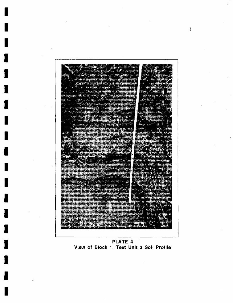
I I I I I I I I I I I I I I I I I I I
PLATE 4 View of Block 1, Test Unit.3 Soil Profile

I I I I I I I I I I;
I I I I I I I I I
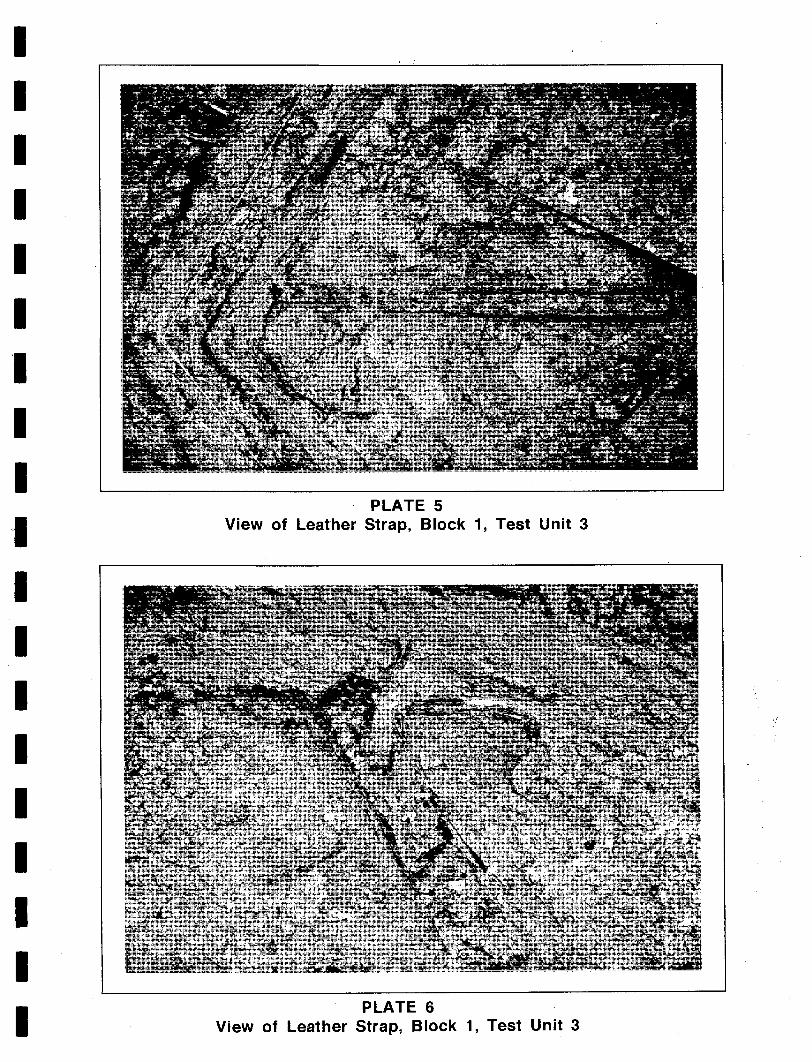
I I I I I I 'I I I ,I
I I I I I I I I I
PLATE 5 View of Leather Strap, Block 1, Test Unit 3
PLATE 6 View of Leather Strap, Block 1, Test Unit 3

I I I I I I I I I I I I I I I I I I I
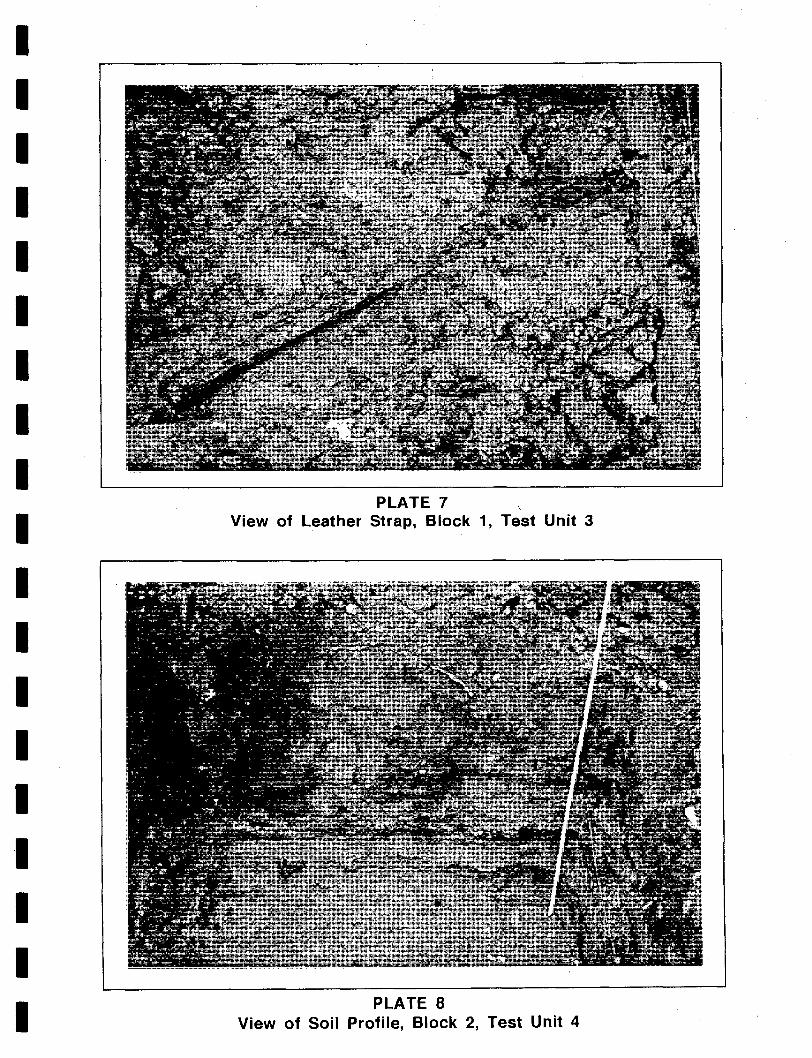
I I I I I I I I I I I I I I I I I I I
PLATE 7 , View of Leather Strap, Block 1, Test Unit 3
PLATE 8 View of Soil Profile, Block 2, Test Unit 4

I I I I I I I I I I I I I I I I I I I
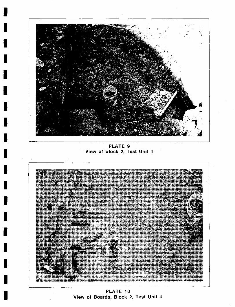
I I I I I I I I I I I I I I I I I I I
, , . .,.-,-.... ~/
PLATE 9 View of Block 2, Test Unit 4
PLATE 10 View of Boards, Block 2, Test Unit 4
/

I I I I I I I I I I I I I I I I I I I
I I I I I I I I I~
I I I I I I I I I I
PLATE 11 View of Boards, Block 2, Test Unit 4

I I I I I I I I I I I I I I I I I I I
I I I I I I I I I I I I I I I I I I I
PLATE 12 View of Soil Profile, Block 3, Test Unit 5

I I I I I I I I I I I I I I I I I I I
I I I I I
APPENDIX I CHAIN OF TITLE
I I I I I I I I I I I I I
73
I

'-'
I I I I I I I I I I I I I I I I I I I
I I I I I I I I I I I I I I I I I I
1669,21 October
Town of Alexandria Chain-of-Title
Sir William Berkeley Robert Howson (Virginia Land Patents 6:262).
1669, 13 November
Land Grant 6000· acres
Transfer Robert Howson John Alexander 6000 acres 6000# tobacco (Fairfax County, Virginia Land Causes 1789-1793:220).
1677, 25 October John Alexander Robert Alexander
Philip Alexander (Fairfax County, Virginia Land Causes 1789-1793 :221).
1690,6 February Robert Alexander Philip Alexander (Stafford County, Virginia Record Book 193a-194a).
5300 acres
2,650 acres 2,650 acres
1693/94, 19 February Deed Philip Alexander Robert Alexander 2,150 acres (Failfax County, Virginia Land Causes 1789-1793:217-219).
Will
Partition
1705, 17 May Intestate Philip Alexander (I) Philip Alexander (II) (Stafford County Wills Z:269-272).
1748 Philip Alexander John Alexander Hugh West (Winfree 1971 :443-446).
1778-1783
Virginia
118 King Street Chain of Title
Trustees of AlexandriaJohn Fitzgerald Valentine Peers
(Fairfax County, Virginia, Missing Deed Book N).
1789, 10 July
Act of Virginia Assembly 60 acres
Deed
Partition John Fitzgerald Valentine Peers 116'6" x 150' Lot
'(Fairfax County, Virginia Deeds Y1:85-88).
1793, 16 September John & Jane Fitzgerald Benjamin Lanston 24 x 116' Lot (Fairfax County, Virginia Deeds X:384-390).
75
Lease £21
1797,31 March Valentine & Eleanor Peers Alexander Gordon 29'9" x 116' Lot (Fairfax County, Virginia Deeds Z:403-405).
1797, 9 June Alexander & Mary Gordon Samuel McLeod 29'9" x 116' Lot (Alexandria Hustings Court Deeds 1:137-140).
Deed £450
Deed £360
1797, 1 September Lease Samuel McLeod Daniel McLeod 29'9" x 116' Lot £18.0.0
"sixty Spanish Milled Dollars" (Alexandria County, Virginia Hustings Court Deeds K:62-65).
1799, 16 December John Fitzgerald Jane Fitzgerald
Elizabeth Fitzgerald Frances Fitzgerald Jane Fitzgerald John Digges Fitzgerald William Atwood Fitzgerald George Richard Fitzgerald
(Fairfax County, Virginia Wills Hl:56-58).
<1820 Samuel McLeod, Daniel McLeod (Alexandria County, D.C. Circuit Court Deeds K2:322-324).
1820, 19 July . Daniel & Mary McCleod Kinzey Griffith 29'9" x 116' Lot
(Alexandria County, D.C. Circuit Court Deeds K2:322-324).
1846,15 May Kinsey Griffith Mary Ann Griffith
(John Henry Griffith) (Kinsey Griffith) (Edward Griffith) (Daniel McLeod Griffith) (Henry Clay Griffith) (Greenbury Griffith)
(Alexandria County, D.C. Orphans Court Wills 4:424-426).
<1880 John H. Griffith "Charles B. Griffith (Alexandria County, Virginia Corporate Court Deeds 8:449-450).
1880, 13 February Charles B. Griffith Henry C. Griffith Lot SS King Street (son of John Griffith, deceased) (Alexandria County, Virginia Corporate Court Deeds 8:449-450).
76
Will
Estate
Deed $1,650.00
Will
Estate
Deed $100.00
I I I I I I I I I I I I I I I I I I I
I I I I I I I I I I I I I I I I I ·1
I
~\
1888,6 March Charles E. Stuart commissioner
Julia K. Griffith Deed
116'x 62" 6" Lot
(Alexandria County, Virginia Corporate Court Deeds 19:485-487) ..
1888, 19 September Julia K. Griffith John T. Hill
James S. Adams 116'x62'6" Lot (Alexandria County, Virginia Corporation Court Deeds 20:431-432).
1890,21 April Will John HilL Elvirah Hill (Alexandria County, Virginia Corporate Court Wills 1:552).
1890,22 April Deed James S. & Sarah Adams John Perry 116'x24' Lot Elvira Hill (Alexandria County, Virginia Corporation Court Deeds 23:328-329).
1893 John Perry Milton D. Perry Three Lots (Alexandria Corporate Court Wills 2:61-63).
1895, 22 August Milton & Lillian Perry De Wilton Aitcheson. 116'x 62'6" Lot (Alexandria County, Virginia Corporation Court Deeds 34:369-372).
1900,3 April De Wilton Aitcheson John Aitcheson 116'x62'6" Lot (Alexandria County, Virginia Corporation Court Deeds 45:255-257).
1929,9 October Harry Aitcheson John Aitcheson
(1. Kenneth Aitcheson) Albert Aitcheson Margaret Aitcheson Agnes Johnson Mary Lindsay R. P. Aitcheson
(Alexandria County, Virginia Corporate Court Deeds 383:481-495).
$1,075.00
Deed
$550.00
$800.00
Will
Deed $1,500.00,
Deed $2,000.00
Will
1929, 29 October Release of Interest Albert Aitcheson .. John Aitcheson Margaret Aitcheson Agnes Johnson Mary Lindsay R. P. Aitcheson (Alexandria County, Virginia Corporate Court Deeds 100:529~530).
77
1939, 27 January John Aitcheson Caroline Aitcheson
(John K. Aitcheson) (Nannie Aitcheson) (Mary Aitcheson) (Jessie Aitcheson
(Alexandria County, Virginia Corporate Court Wills 11:31-32).
1950, 8 January Nannie Aitcheson Jessie O. Aitcheson
Mary C. Aitcheson (Alexandria County, Virginia Corporate Court Deeds 383:481-495).
1954, 1 January John K. & Virginia Aitcheson Parcel A Jessie O. Aitcheson Mary C. Aitcheson John K. Aitcheson, Jr. & Helen Aitcheson (Alexandria County, Virginia Corporate Court Deeds 383:481-495).
1987,12 May Virginia C. Aitcheson Mary Clarke Winslow.
John K. Aitcheson, Jr.,. Nancy A. Taylor
(Alexandria County, Virginia Wills 191:569-571).
1989, 17 April Mary C. Aitcheson Nancy Aitcheson Taylor
John K. Aitcheson, Jr. (Alexandria County, Virginia Wills 210:14-20).
78
Will
Will
Deed of Incorporation
116'x29.9" Lot 116'x24' Lot
Will
Will
I I I I I I I I I I I I I I I I I I I
I I I I I APPENDIX II
Artifact Inventory
I I I I I I I I I I I I .1 I
79

I I I I I I I I I I I I I I I I I I I
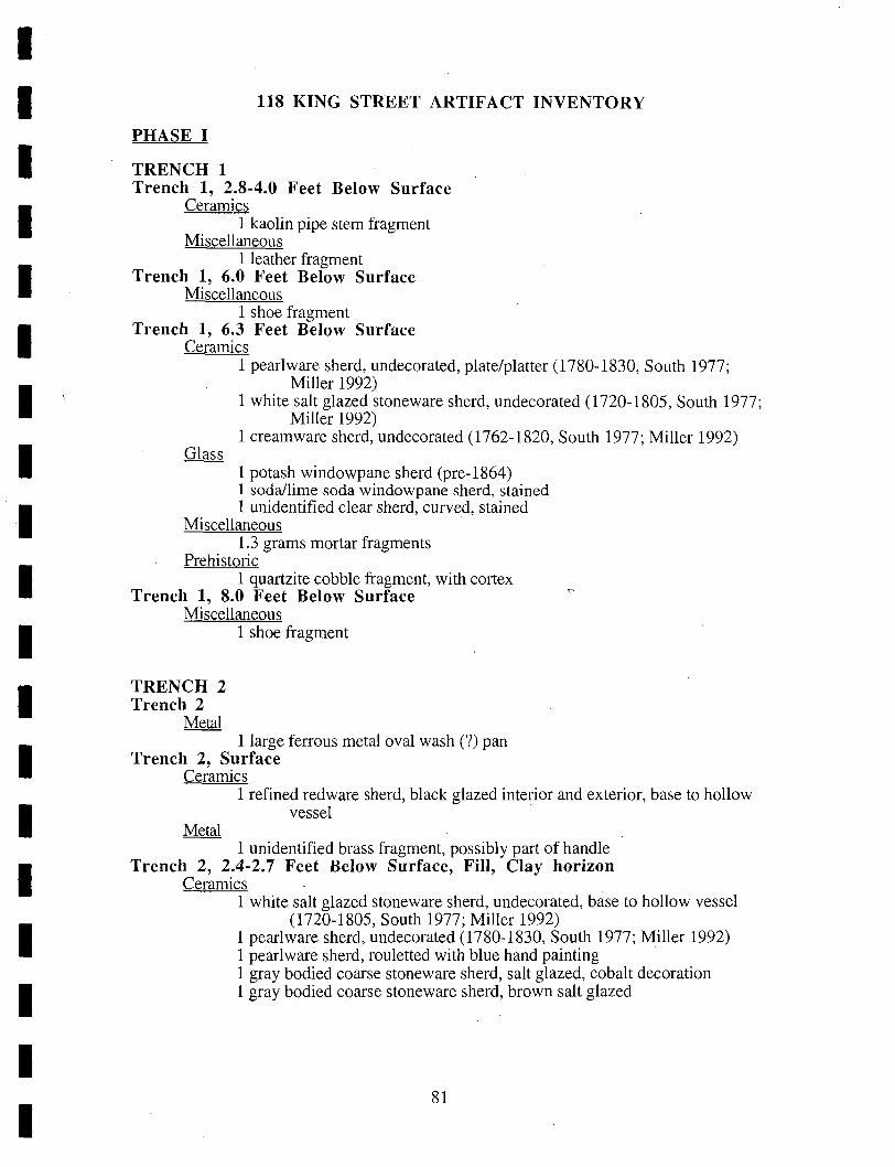
I I I I I I I I I I I I I I I I I I I
PHASE I
TRENCH 1
118 KING STREET ARTIFACT INVENTORY
Trench 1, 2.8-4.0 Feet Below Surface Ceramics
1 kaolin pipe stem fragment Miscellaneous
1 leather fragment Trench 1, 6.0 Feet Below Surface
Miscellaneous 1 shoe fragment
Trench 1, 6.3 Feet Below Surface Ceramics
1 pearlware sherd, undecorated, plate/platter (1780-1830, South 1977; Miller 1992) .
1 white salt glazed stoneware sherd, undecorated (1720-1805, South 1977; Miller 1992)
1 creamware sherd, undecorated (1762-1820, South 1977; Miller 1992)
1 potash windowpane sherd (pre-1864) 1 soda/lime soda windowpane sherd, stained 1 unidentified clear sherd, curved, stained
Miscellaneous l.3 grams mortar fragments
Prehistoric 1 quartzite cobble fragment, with cortex
Trench 1, 8.0 Feet Below Surface Miscellaneous
TRENCH 2 Trench 2
Metal
1 shoe fragment
1 large ferrous metal oval wash (?) pan Trench 2, Surface
Ceramics 1 refined red ware sherd, black glazed interior and exterior, base to hollow
vessel
1 unidentified brass fragment, possibly part of handle Trench 2, 2.4-2.7 Feet Below Surface, Fill, Clay horizon
Ceramics 1 white salt glazed stoneware sherd, undecorated, base to hollow vessel
(1720-1805, South 1977; Miller 1992) 1 pearlware sherd, undecorated (1780-1830, South 1977; Miller 1992) 1 pearlware sherd, rouletted with blue hand painting 1 gray bodied coarse stoneware sherd, salt glazed, cobalt decoration 1 gray bodied coarse stoneware sherd, brown salt glazed
81
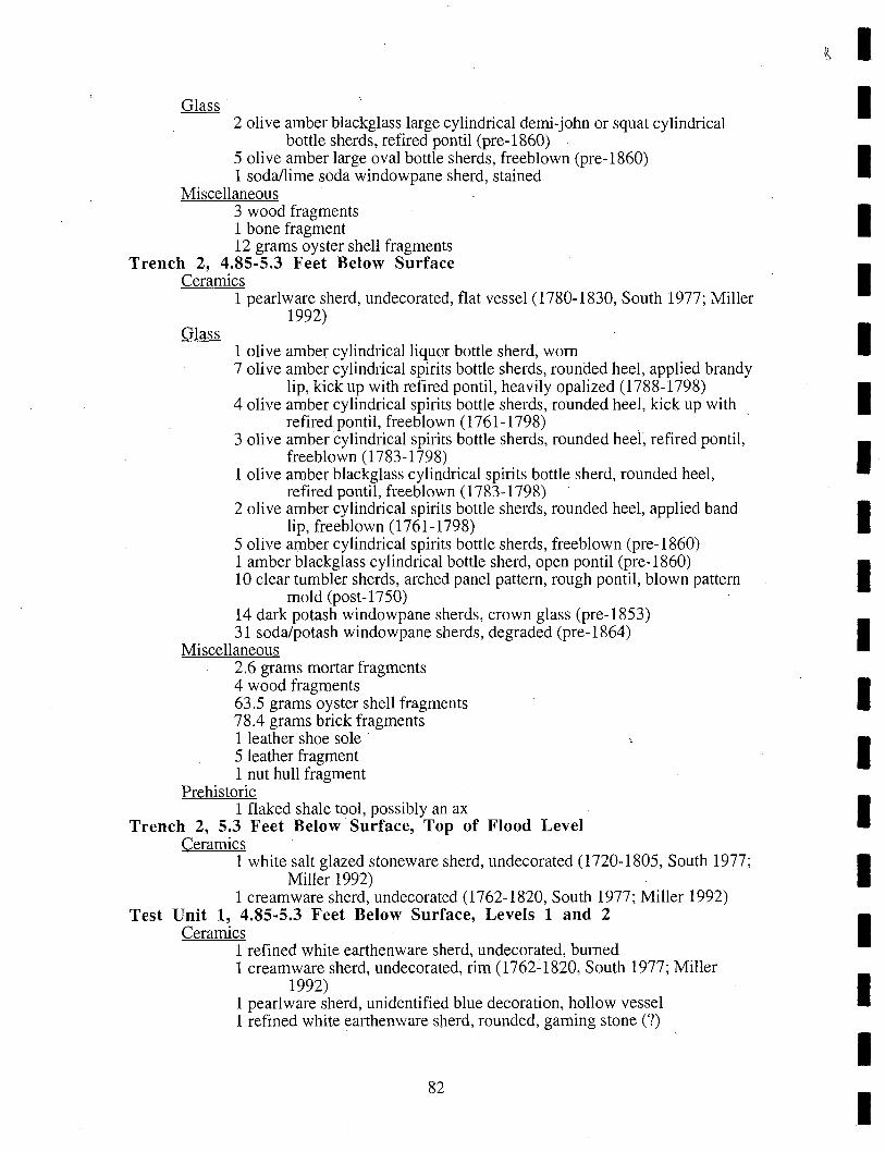
2 olive amber blackglass large cylindrical derni-john or squat cylindrical bott.1e sherds, refired pontil (pre-1860)
5 olive amber large oval bottle sherds, freeblown (pre-1860) 1 soda/lime soda windowpane sherd, stained
Miscellaneous 3 wood fragments 1 bone fragment 12 grams oyster shell fragments
Trench 2, 4.85-5.3 Feet Below Surface Ceramics
1 pearlware sherd, undecorated, flat vessel (1780-1830, South 1977; Miller 1992)
1 olive amber cylindrical liquor bottle sherd, worn 7 olive amber cylindrical spirits bottle sherds, rounded heel, applied brandy
lip, kick up with refired pontil, heavily opalized (1788-1798) 4 olive amber cylindrical spirits bottle sherds, rounded heel, kick up with
refired pontil, freeblown (1761-1798) 3 olive amber cylindrical spirits bottle sherds, rounded heel; refired pontil,
freeblown (1783-1798) 1 olive amber blackglass cylindrical spirits bottle sherd, rounded heel,
refired pontil, freeblown (1783-1798) 2 olive amber cylindrical spirits bottle sherds, rounded heel, applied band
lip, freeblown (1761-1798) 5 olive amber cylindrical spirits bottle sherds, freeblown (pre-1860) 1 amber blackglass cylindrical bottle sherd, open pontil (pre-1860) 10 clear tumbler sherds, arched panel pattern, rough pontil, blown pattern
mold (post-1750) 14 dark potash windowpane sherds, crown glass (pre-1853) 31 soda/potash windowpane sherds, degraded (pre-1864)
Miscellaneous 2.6 grams mortar fragments 4 wood fragments 63.5 grams oyster shell fragments 78.4 grams brick fragments 1 leather shoe sale 5 leather fragment 1 nut hull fragment
Prehistoric 1 flaked shale tool, possibly an ax
Trench 2, 5.3 Feet Below Surface, Top of Flood Level Ceramics
1 white salt glazed stoneware sherd, undecorated (1720-1805, South 1977; Miller 1992)
1 creamware sherd, undecorated (1762-1820, South 1977; Miller 1992) Test Unit 1, 4.85-5.3 Feet Below Surface, Levels 1 and 2
Ceramics 1 refined white earthenware sherd, undecorated, burned 1 creamware sherd, undecorated, rim (1762~1820, South 1977; Miller
1992) 1 pearlware sherd, unidentified blue decoration, hollow vessel 1 refined white earthenware sherd, rounded, gaming stone (?)
82
I I I I I I I I I I I I I I I I I I I
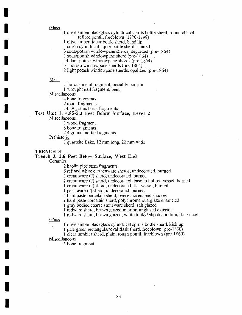
I I I I I I I I I I I I I I I I I I I
1 olive amber blackglass cylindrical spirits bottle sherd, rounded heel, refired pontil, freeblown (1770-1798)
1 olive amber liquor bottle sherd, band lip 1 citron cylindrical liquor bottle sherd, stained 3 soda/potash windowpane sherds, degraded (pre-1864) 1 soda/potash windowpane sherd (pre-1864) 14 dark potash windowpane sherds (pre-1864) 31 potash windowpane sherds (pre-1864) 2 light potash windowpane sherds, opalized (pre-1864)
1 felTous metal fragment, possibly pot rim 1 wrought nail fragment, bent
Miscellaneous 4 bone fragments 2 tooth fragments 145.9 grams brick fragments
Test Unit 1, 4.85-5.3 Feet Below Surface, Level 2 Miscellaneous
1 wood fragment 3 bone fragments 2.4 grams mortar fragments
Prehistoric 1 quartzite flake, 12 mm long, 20 mm wide
TRENCH 3 Trench 3, 2.6 Feet Below Surface, West End
Ceramics 2 kaolin pipe stem fragments 5 refined white earthenware sherds, undecorated, burned 1 cream ware (7) sherd, undecorated, burned 1 cream ware (7) sherd, undecorated, base to hollow vessel, burned 1 cream ware (7) sherd, undecorated, flat vessel, burned 1 pearlware (7) sherd, undecorated, burned 1 hard paste porcelain sherd, overglaze enamel shadow 1 hard paste porcelain sherd, polychrome overglaze enameled 1 gray bodied coarse stoneware sherd, salt glazed 1 red ware sherd, brown glazed interior, unglazed exterior 1 red ware sherd, brown glazed, white trailed slip decoration, flat vessel
1 olive amber blackglass cylindrical spirits bottle sherd, kick up 1 pale green rectangular/oval flask sherd, freeblown (pre-1830) 1 clear tumbler sherd, plain, rough pontil, freeblown (pre-1860)
Miscellaneous 1 bone fragment
83
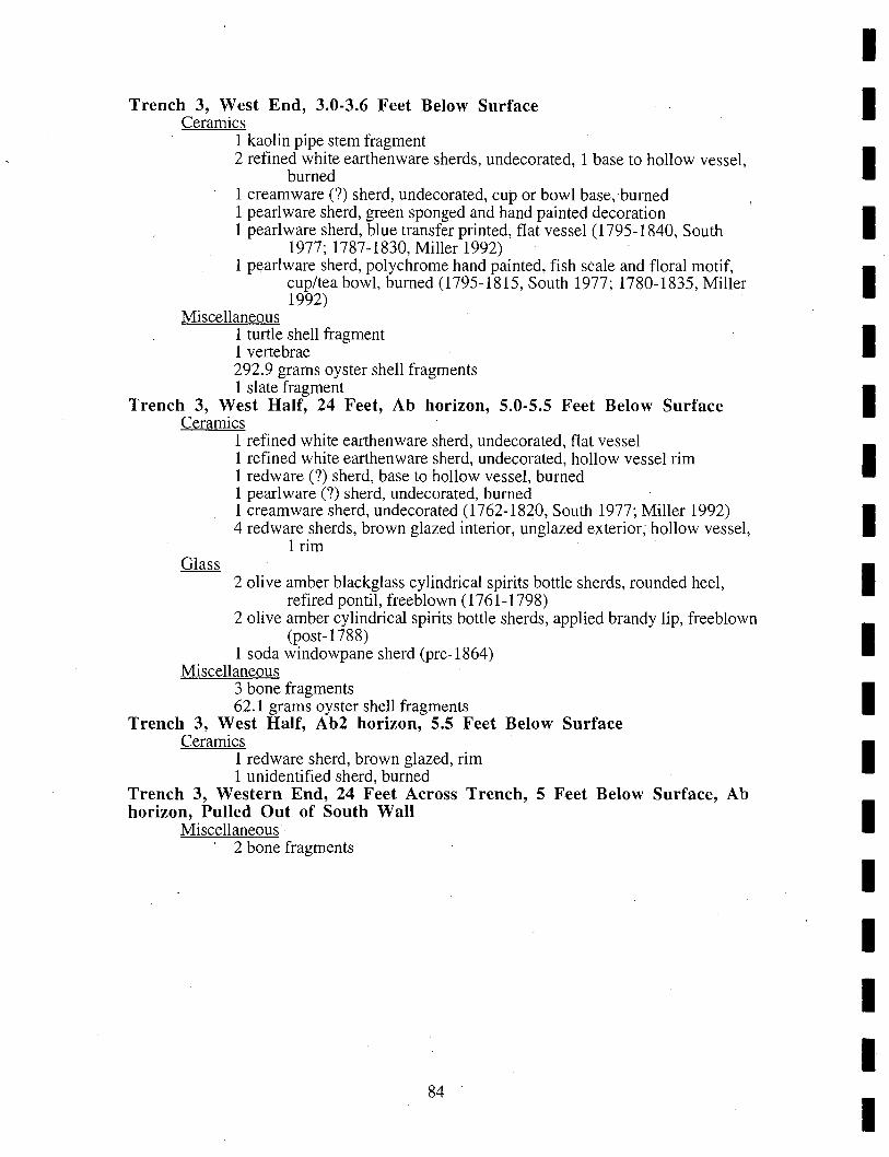
Trench 3, West End, 3.0-3.6 Feet Below Surface Ceramics
1 kaolin pipe stem fragment 2 refined white earthenware sherds, undecorated, 1 base to hollow vessel,
burned 1 creamware (?) sherd, undecorated, cup or bowl base,burned 1 pearlware sherd, green sponged and hand painted decoration 1 pearl ware sherd, blue transfer printed, flat vessel (1795-1840, South
1977; 1787-1830, Miller 1992) 1 pearl ware sherd, polychrome hand painted, fish scale and floral motif,
cup/tea bowl, burned (1795-1815, South 1977; 1780-1835, Miller 1992)
Miscellaneous 1 turtle shell fragment 1 vertebrae 292.9 grams oyster shell fragments 1 slate fragment
Trench 3, West Half, 24 Feet, Ab horizon, 5.0-5.5 Feet Below Surface Ceramics
1 refined white earthenware sherd, undecorated, flat vessel 1 refined white earthenware sherd, undecorated, hollow vessel rim 1 redware (?) sherd, base to hollow vessel, burned 1 pearl ware (?) sherd, undecorated, burned 1 creamware sherd, undecorated (1762-1820, South 1977; Miller 1992) 4 redware sherds, brown glazed interior, unglazed exterior; hollow vessel,
1 rim
2 olive amber blackglass cylindrical spirits bottle sherds, rounded heel, refired pontil, freeblown (1761-1798)
2 olive amber cylindrical spirits bottle sherds, applied brandy lip, freeblown (post-1788)
1 soda windowpane sherd (pre-1864) Miscellaneous
3 bone fragments 62.1 grams oyster shell fragments
Trench 3, West Half, Ab2 horizon, 5.5 Feet Below Surface Ceramics
1 redware sherd, brown glazed, rim 1 unidentified sherd, burned
Trench 3, Western End, 24 Feet Across Trench, 5 Feet Below Surface, Ab horizon, Pulled Out of South Wall
Miscellaneous , 2 bone fragments
84
I I I I I I I I I I I I I I I I I I I
I I I I I I I I I I I I I I I I I I I
Trench 3, Western End, 24 Feet Across Trench Floor, 5 Feet Below Surface
Ceramics 1 pearl ware (?) sherd, unidentified blue decoration, handle fragment,
burned 1 creamware sherd, undecorated (1762-1820, South 1977; Miller 1992)
2 olive amber cylindrical liquor bottle sherds, freeblown (pre-1860) 1 soda windowpane sherd (pre-1864)
Miscellaneous 70.4 grams oyster shell fragments 3 wood fragments
Trench 3, East End, 0-24 Feet, 5.0 Feet Below Surface Ceramics
1 unidentified sherd, scalloped shell edge, no color, plate, burned Trench 3, East End, 0-24 Feet, 5.5 Feet Below Surface
Miscellaneous . 1 bone fragment
Test Unit 2, West Wall Miscellaneous
1 bone fragment Test Unit 2, Apbl horizon, Level 1
Ceramics 5 refined white earthenware sherds, undecorated, burned 4 creamware (?) sherds, undecorated, burned 4 cream ware (?) sherds, undecorated, base to hollow vessel, burned 3 pearl ware (?) sherds, underglaze blue hand painted, burned
7 green oval flask sherds, Pitkin type swirl pattern, sheared lip, German half post base, fr~eblown (1783-1830)
1 potash windowpane sherd (pre-1864) 4 soda/potash windowpane sherds, degraded (pre-1864)
1 unidentified ferrous metal fragment Miscellaneous
2 wood fragments .6 grams oyster shell fragments 2.8 grams mortar fragments
Test Unit 2, Apbl horizon, Level 2 Ceramics
7 unidentified sherds, burned 10 refined white emthenware sherds, undecorated, burned 21 creamware (?) sherds, polychrome overglaze enameled, broad floral
motif, burned 2 pearlware (?) sherds, underglaze blue hand painted, burned 1 white salt glazed stoneware sherd, undecorated, base to hollow vessel
(1720-1805, South 1977; Miller 1992) 2 red ware sherds, brown glazed interior, unglazed exterior 1 unidentified sherd, brown glazed interior and exterior, burned
85
7 green oval flask sherds, Pitkin type swirl pattern, German half post base, freeblown (1783-1830)
1 aqua bottle sherd, flared lip, freeblown (pre-1860) 3 soda/potash windowpane sherds (pre-1864) 1 sod windowpane sherd (pre-1864)
1 wrought 4 1I2d nail, T head 2 cut nail fragments, unidentified heads (post-1790)
Miscellaneous 1 bone handle fragment 1 fish scale 1 coal fragment 3 bone fragments 110.7 grams oyster shell fragments 4.5 grams mortar fragments 1 black English flint spall
Test Unit 2, Apbl, b horizon, South Profile Wall Ceramics
1 redware sherd, brown glazed interior, unglazed exterior, base to hollow vessel
Test Unit 2, Apb2 horizon Ceramics
6 refined white earthenware sherds, undecorated, burned 1 creamware (?) sherd, undecorated, burned 2 pearlware (7) sherds, underglaze blue hand painted, burned 1 redware sherd, brown glazed interior and exterior
1 olive amber cylindrical liquor bottle sherd, worn 2 olive amber cylindrical liquor bottle sherds, worn 1 light green cylindrical bottle sherd, worn 1 unidentified Clear sherd
1 strap iron fragment 1 unidentified nail fragment
Miscellaneous 1 wood fragment 2 tooth fragments 1 peach pit (2 halves) 12 slag fragments, non-magnetic 1 black English flint rounded fragment with cortex
Test Unit 2, Bottom of Apb2 horizon, Out of West Wall Glass
2 dark aqua oval flask sherds, freeblown (pre-1860) Miscellaneous
1 bone fragment
86
I I I I I I I I I I I I I I I I I I I
I I I I I I I I I I I I I I I I I I I
PHASE 111111
NO PROVENIENCE - mends with Block 2, 4.2 Feet Below Ground Surface, Black Soil
Ceramics
BLOCK 1
2 redware sherds, combed decoration, rouletted edge, plate/pie plate, burned
9 creamware sherds, Royal pattern plate, burned (1762-1820, South 1977; Miller 1992)
1 pearlware sherd, brown hand painted, base to hollow vessel
Test Unit 3, Clay Level above 4.0 Feet Below Ground Surface Ceramics
1 kaolin pipe bowl fragment 1 buff bodied coarse stoneware sherd, brown glazed interior and exterior,
drain pipe (?) 1 white salt glazed stoneware sherd, undecorated (1720-1805, South 1977;
Miller 1992) 1 refined white earthenware sherd, undecorated, stained 1 creamware sherd, undecorated (1762-1820, South 1977; Miller 1992) 1 pearlware sherd, undecorated (1780-1830, South 1977; Miller 1992) 1 pearlware sherd, molded decoration (1780-1830, South 1977; Miller
1992) 2 pearlware sherds, underglaze blue hand painted (1780-1820, South 1977;
1780-1830, Miller 1992) 1 pearlware sherd, polychrome hand painted (1795-1815, South 1977;
1780-1835, Miller 1992) 1 gray bodied stoneware sherd, cobalt decoration, probably Rhenish
stonewarelW esterwald
1 unidentified lead strip fragment 1 wrought 6d nail 1 wrought 7 d nail 1 wrought 3d nail
Miscellaneous 5 bone fragments 89 grams oyster shell fragments 952 grams brick fragments 84.5 grams mortar fragments 15 wood fragments
Test Unit 3, Clay Level at 4.0 Feet Below Ground Surface Ceramics
4 creamware sherds, undecorated (1762-1820, South 1977; Miller 1992) 5 pearlware sherds, undecorated (1780-1830, South 1977; Miller 1992) 1 pearlware sherd, blue scalloped shell edge (1780-1830, South 1977;
Miller 1992) 1 hard paste porcelain sherd, underglaze blue hand painted 1 lackfield sherd, undecorated (1740-1780, South 1977; Miller 1992) 1 refined redware sherd, clear glazed (1800-1840, Magid 1990) 1 redware sherd, brown glazed interior, unglazed exterior 2 redware (?) sherds, brown glazed
87
2 olive amber cylindrical liquor bottle sherd, stained 1 green oval (?) bottle sherd, freeblown (pre-1860) 2 clear bottle or tableware sherd, curved, stained 248 soda/potash windowpane sherds (pre-l 864 ) 6 soda/potash windowpane sherds, crown glass (pre-1853) 60 soda windowpane sherds, opalized/stained (pre-1864) 46 light potash windowpane sherds, opalized (pre-1864) 29 medium potash windowpane sherds (pre-1864) 14 green sheet glass sherds, windowpane or bottle, opalized
1 ferrous metal round stock fragment, 5/16 by 5" 1 wrought 40d spike 2 wrought 6d nails, rosehead 2 wrought 2d nails, rosehead 1 cut nail fragment, machine headed (post-1830)
Miscellaneous 14 wood fragments, 1 burned 3 bone fragments 86.2 grams oyster shell fragments 223.9 grams brick fragments 9.4 grams mortar fragments 5 peach seeds
Prehistoric 1 black English flint spall
Test Unit 3, Level 2 Glass
2 olive amber cylindrical liquor bottle sherds, freeblown (pre-1860)
1 unidentified ferrous metal fragment Test Unit 3, Level 2, 4.3 Feet Below Ground Surface; Sandy Above Dark Level at 4.8 Feet Below Ground Surface
Ceramics 1 redware sherd, black glazed interior and exterior 1 buff bodied stoneware (?) sherd, brown glazed interior and exterior
2 olive amber cylindrical liquor bottle sherds, freeblown (pre-1860) 1 soda windowpane sherd, stained (pre-1864) 4 medium potash windowpane sherds, opalized (pre-1864) 8 light potash windowpane sherds, opalized (pre-1864) 20 soda/potash windowpane sherds, stained/opalized (pre-1864) 1 green sheet glass sherd, windowpane or bottle, opalized
Miscellaneous 3 coal fragments 1 bone fragment 4.9 grams oyster shell fragments, burned 152.5 grams brick fragments 21.2 grams mortar fragments 3 peach seeds
88
I I I I I I I I I I I I I I I I I I I
I I I I I I I I I I I I I I I I I I I
Test Unit 3, 4.8 Feet Below Ground Surface, Dark Level Ceramics
2 kaolin pipe stem fragments 1 hard paste porcelain sherd, undecorated 1 white salt glazed stoneware sherd, undecorated (172-1805, South 1977;
Miller 1992) 1 creamware sherd, undecorated (1762-1820, South 1977; Miller 1992) 1 pearlware sherd, undecorated (1780-1830, South 1977; Miller 1992) 1 pearlware sherd, undecorated, handled vessel (1780-1830, South 1977;
Miller 1992) 1 red ware sherd, brown glazed interior, unglazed exterior
Glass 283 soda/potash windowpane sherds (pre-1864) 5 soda/potash windowpane sherds, crown glass (pre-1853)
Miscellaneous 2 wood fragments 4060 grams brick fragments 65.3 grams plaster fragments 40.7 grams mortar fragments 3.4 grams clam shell fragments 1 bone fragment 97.9 grams oyster shell fragments 1 black walnut hull 2 peach seeds 4 leather strap fragments 5 leather fragments 1 bundle of shoe parts (?) bound with a leather strap
Test Unit 3, 4.8 Feet Below Ground Surface, BoUle Level Miscellaneous
4 small wood chips
BLOCK 2 Test Unit 4, Backfill
Miscellaneous 1 leather shoe sole 4 leather shoe parts 2 leather fragments
Test Unit 4, Black Fill horizon Ceramics
1 kaolin pipe bowl fragment, burned 22 creamware sherds, undecorated, 2 burned (1762-1820, South 1977;
Miller 1992) 4 creamware sherds, flat vessel (1762-1820, South 1977; Miller 1992) 7 creamware sherds, Royal pattern plate, 2 burned (1762-1820, South
1977; Miller 1992) . 1 cream ware sherd, undecorated, bowl (7) 1(1762-1820, South 1977; Miller
1992) 5 creamware sherds, undecorated, hollow vessel, 2 burned (1762-1820,
South 1977; Miller 1992) 3 pearlware sherds, undecorated (1780-1830, South 1977; Miller 1992) 1 pearlware sherd, polychrome hand painted, hollow vessel (1795-1815,
South 1966; 1780-1835, Miller 1992) 1 whiteware (?) sherd, unidentified blue decoration, hollow vessel 1 buff bodied coarse stoneware sherd, salt glazed, burned
89
1 redware spall, very crude . 1 redware sherd, unglazed exterior, base, very crude 2 redware sherds, brown glazed interior and exterior 1 red ware sherd, black glazed interior and exterior, base to hollow vessel
4 sheet iron fragments 1 wrought 10d nail, rosehead, bent 1 wrought 8d nail, rosehead, bent 2 wrought nail fragments, 1 rosehead
Miscellaneous 3 cinders 8 bone fragments 588 grams oyster shell fragments 7 A grams ,brick fragments 3 slate fragments 1 peach seed fragment 8 wood fragments, 5 milled 1 circular wood fragment, sawed
Block 2, 4.2 Feet Below Ground Surface, Black Soil Ceramics
BLOCK 3
2 redware sherds (mend), combed decoration, rouletted edge, plate/pie plate, burned
Block 3, Collection from Backhoe Dirt, Ab horizon Ceramics
1 refined white earthenware sherd, undecorated, burned/stained 1 refined white earthenware sherd, unidentified brown· decoration,
burned! stained 1 refined white earthenware sherd, unidentified blue decoration,
burned!stained 1 whiteware sherd, blue transfer printed (1820-1900+, South 1977; 1830-
1865+, Miller 1992) 1 pearlware sherd, underglaze blue hand painted, burned/stained (1780-
1820, South 1977; 1780-1830, Miller 1992) 1 pearlware sherd, polychrome hand painted, hollow vessel (1795-1815,
South 1977; 1780-1835, Miller 1992) 1 grey bodied coarse stoneware sherd, salt glazed, base
1 olive amber blackglass cylindrical spirits bottle sherd, rounded heel, refired pontil, freeblown (1788-1798)
1 olive amber cylindrical bottle sherd, heavily opalized Miscellaneous
5.4 grams clam shell fragments 4 bone fragments 68.2 grams oyster shell fragments
Test Unit 5, Abl horizon Ceramics
2 refined white earthenware sherds, undecorated, burned/stained 2 creamware sherds, undecorated, 1 plate base, burned/stained 1 pearlware sherd, undecorated, burned/stained (1780-1830, South 1977;
Miller 1992) 1 pearl ware sherd, unidentified green edge decoration, burned/stained
90
I I I I I I I I I I I I I I I I I I I
I I I I I I I I
Test
I I I I I I I I I I I
1 pearlware sherd, green scalloped shell edge, plate, burned/stained (1780-1830, South 1977; 1800-1830, Miller 1992)
3 hard paste porcelain sherds, black overglaze enameled, plate 6 redware sherds, black glazed interior and exterior, 1 base
1 olive amber cylindrical liquor bottle sherd, freeblown (pre-1860) 2 mottled brown blackglass oval flask (?) sherds, rough pontil (late 1700s?) 1 mottled clear and brown oval (?) bottle sherd, open ponti I (late 1700s?) 1 light amber cylindrical bottle sherd, worn 1 aqua cylindrical bottle sherd 1 dark aqua small cylindrical bottle sherd, freeblown (pre-1860) 3 soda/potash windowpane sherds, stained (pre-1864)
1 unidentified ferrous metal fragment 1 wrought 16d nail, rosehead, bent 1 wrought nail fragment 2 brass straight pins, ball headed
Miscellaneous 336 grams oyster shell fragments 7 bone fragments 2.7 grams mortar fragments 23 grams brick fragments
Unit 5, Ab2 horizon Ceramics
10 refined white earthenware sherds, burned/stained 1 refined white earthenware sherd, unidentified blue decoration,
burned/stained 1 refined white earthenware sherd, undecorated 1 creamware sherd, undecorated, hollow vessel (1762-1820, South 1977;
Miller 1992) 5 creamware sherds, undecorated, 4 burned/stained (1762-1820, South
1977; Miller 1992) 1 creamware (?) sherd, polychrome overglaze enameled 6 pearl ware sherds, undecorated, 4 burned/stained (1780-1830, South
1977; Miller 1992) 4 pearl ware sherds, undecorated, flat vessel, burned/stained (1780-1830,
South 1977; Miller 1992) 3 pearlware sherds, green scalloped shell edge, burned/stained (1780-1830,
South 1977; 1800-1830, Miller 1992) 3 pearl ware sherds, underglaze blue hand painted, hollow vessel, 2
burned/stained (1780-1820, South 1977; 1780-1830, Miller 1992) 3 redware sherds, black glazed interior and exterior, 1 base 1 lackfield sherd, undecorated, hollow vessel (1740-1780, South 1977;
Miller 1992)
3 olive amber blackglass cylindrical liquor bottle sherds, worn 1 amber blackglass cylindrical liquor bottle sherd, worn
,4 mottled brown blackglass bottle sherds 5 mottled clear and brown cylindrical bottle sherds I olive green square/rectangular bottle sherd 1 green square/rectangular bottle sherd, worn 5 aqua oval flask sherds, rough pontil, freeblown (pre-1860) 4 potash windowpane sherds (pre-1864)
91
1 ferrous metal can fragment . 1 brass sheet fragment 5 wrought nail fragments, 3 rosehead
Miscellaneous 2 coal fragments 12 bone fragments 560 grams oyster shell fragments 1 peach seed
Test Unit 5, A2 horizon, Level 2 Ceramics
11 refined white earthenware sherds, burned/stained 2 creamware sherds, undecorated, 1 burned/stained (1762-1820, South
1977; Miller 1992) 5 pearlware sherds, undecorated, burned/stained (1780-1830, South 1977;
Miller 1992) 2 hard paste porcelain sherds, black overglaze enameled 2 red ware sherds, black glazed interior and exterior 1 red ware sherd, brown glazed, burned/stained 2 redwarelbrick spalls 1 gray bodied coarse stoneware sherd, engine turned, salt glazed exterior,
brown glazed interior, hollow vessel 2 white salt glazed stoneware sherds, undecorated (1720-11805, South 1977;
Miller 1992)
3 olive amber blackglass cylindrical liquor bottle sherds, worn 5 olive amber cylindrical liquor bottle sherds, worn 1 mottled clear and brown cylindrical bottle sherd 3 soda/potash windowpane sherd, crown glass (pre-1853) 1 unidentified clear sherd
1 wrought 3d nail, rosehead 6 wrought nail fragments, 2 rosehead
Miscellaneous 2 cinders 5 bone fragments 392 grams oyster shell fragments 89.6 grams brick fragments 7 wood fragments 2 leather shoe sole fragments 4 leather fragments
Test Unit 6, Ab2 horizon Ceramics
3 refined white earthenware sherds, undecorated, 2 burned/stained 4 pearlware sherds, underglaze blue hand painted, flat vessel,
burned/stained (1780-1820, South 1977; 1780-1830, Miller 1992) 1 pearlware sherd, polychrome hand painted (1795-1815, South 1977;
1780-1835, Miller 1992)
6 olive amber blackglass cylindrical liquor bottle sherds, stained/worn 1 aqua bottle sherd 3 soda/potash windowpane sherds, stained (pre-1864)
92
I I I I I I I I I I I I I I I I I I I
I I I I I I I I I I I I I I I I I I I
1 wrought 6d nail, rosehead, bent 2 wrought nail fragments, 1 rosehead, 1 bent
Miscellaneous 10.8 grams clam shell fragments 1 bone fragment 25.8 grams oyster shell fragments, burned/stained 101.9 grams brick fragments
Prehistoric . 1 black English flint fragment/chunk
93

I I I I I I I I I I I I I I I I I I I
I I I I I
APPENDIX III CONSERV ATION SUMMARY AND SKETCHES
I. I I I I I I I I I I I I I
95

I I I I I I I I I I I I I I I I I I I
-Conservation Treatment Summary-
Conservation treatment for waterlogged leather and leather composite (leather, iron) artifacts from 118 King street, Alexandria, Virginia. The artifacts were excavated in November and December, 2000, and date to circa 1760.
Bringing the 26 artifact fragments (none is a complete object) from a wet to a dry state involved recognized conservation treatment incorporating polyethylene glycol, distilled water, and a fungicide. The project took two months.
CONSERVATION THEORY: Impregnation of waterlogged leather with Carbowax 40a (polyethylene glycol) has proven very successful in stabilizing the leather and minimizing shrinkage and warping of the leather upon drying. In theory, the Carbowax 400 replaces the leather components leached out during long immersion in water. Different thicknesses, different uses, different cuts, and wear-andtear also influence appearance when the artifact is dry.
A summary of the procedure used is presented below.
-- Each artifact was measured and traced or sketched before treatment. In general, these leather items were fragile, incomplete, worn, and had numerous rips and tears and losses.
-- The artifacts were either placed on fiberglass screening or had protective screening sewn around them (to reduce the damage from handling, as they were inverted every three days), and immersed in distilled water. Isopropanol (rubbing alcohol) was used as a fungicide. This immersion insured complete waterlogging. NOTE: The artifacts from the three different excavati~n locations were treated in separate containers so their locational integrity was maintained. -- Treatment procedure commenced, and all artifacts were immersed in 10% Carbowax 400 for two weeks, then into 20% for one week, and finally in 30% for one-to-two weeks. The composite leather trace was placed in a final solution of 35% Carbowax and its treatment extended due to its thickness. This extra time~~lso allotted to the mass of shoe bottoms?? tied together with a leather thong. These extensions allowed time for better penetration of the Carbowax. -- All items were dried slowly at room temperature over a period of several days to help prevent warpage. Only two items had noticeable shrinkage.
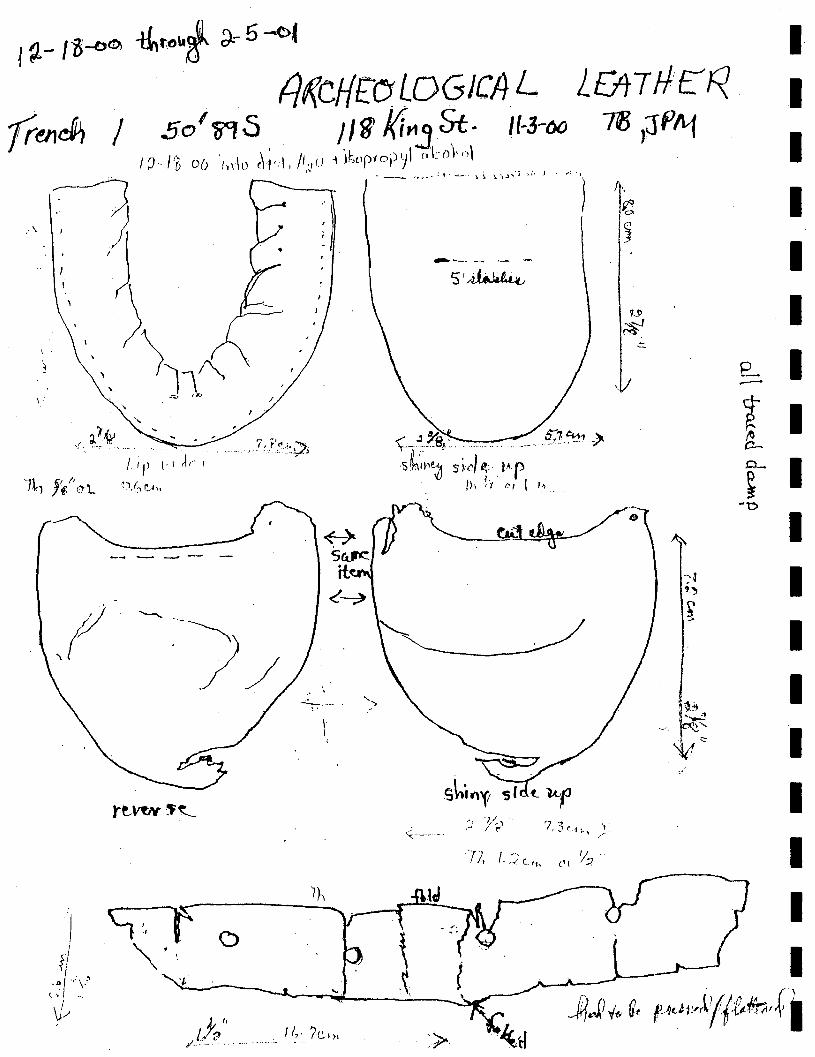
j :1- I Z ~o, -ttto"l ;)- 5 -(>1
. fi~cHrCfLOGJC!}L lOt1ft'E:t:< (renJ1 / So'~.s , II~ l{it1j St. 1/-3-00 -rn I~PIl1
I ,I
/~',1'8 D() 'h,ln (\'1',1, II'J!) i }SOPfC);),)\ c,iJ))''-'\ . " __ .. ,~.~; •. ....;"., .. ~ i ':., ').J,'j ,;. J
I I I I
,. I I,
I
" ) :, , \Il~
\ " r..;, rIO
------
rJ'~ ,( .-~) '/
--. -- '- -S'/~
p--- I
\-"~~B:' ',... , _." _ ,5;? ~1,,,, s Ih'1I1~ S ;,,:~I t . t~r
Ih"t (~I I h,
r 0-
I P- I ~
)
'<:-'---'''- .
'fl, l,:)c,,,
-0
I I I I I I I I I
J?Jl -t. g. t Jdl"Jllf.{ib,.r.
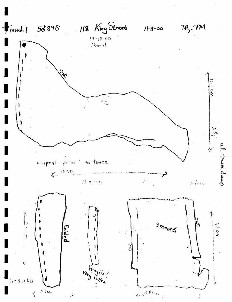
I -J;.~r I I I I I I I I I I I I I I I
, , I
1 I i I
1
l'
. ,
. , • • • • , . '
•
/1 'if, /<l..j Str~ },'J-/i?-OO
r !-rlrr. (/
'"' , ..... CO '.Jr· ...... ,.->._. ",
I-j ;
"
,.
11-3-00
i:' .
\ ", ,-
/
I I . ·1- ), !-. .
\ ,.-'
-'0
I
i I • !
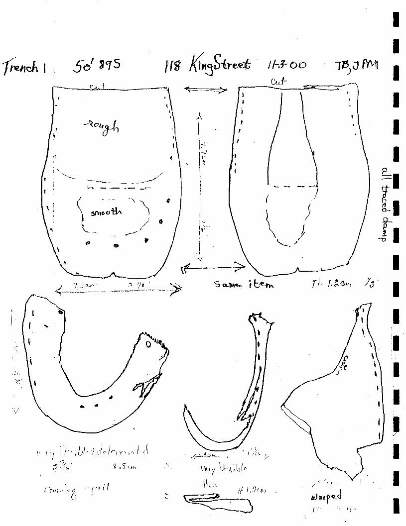
wl'
, i"
"'---
, , : ,
,-. ,
, \'
~o~
~
--'---'_- _ .. ----. _//' -- --- ,-- ---
l~~~~'~ //
~ -- ~ tp p
•
It
~
\-
"', ... ,
-,
\f'
t -~
~
i
i , I ~~. -q1 , -
I . !
'-Ji
, I
, t
i f
,
J/-J-bo
Cut-
(
) \ ) '-. ,J
I
I I
WJfY\1 ) I
I I I
~ • [. I.
/..1) -" 0(
I I I 'I , , '
I I
J I I I
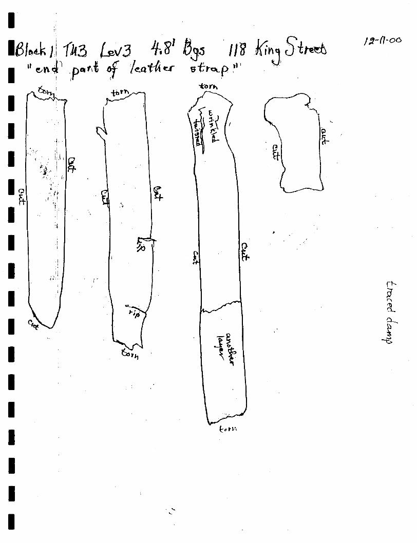
1-
1 1
1 I 1 1 1 1 1 1 1 1 1
Ii .".1
'f-~ !. . ~ ;
. '. ,.
/ :1-fl-oo
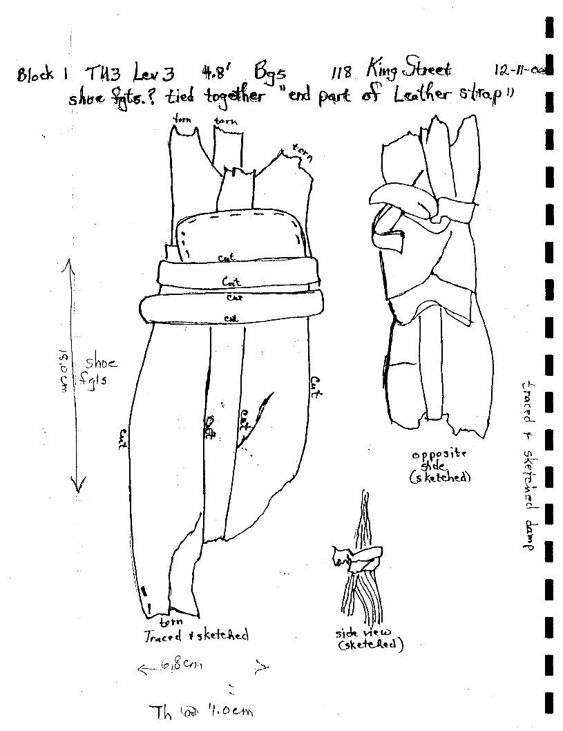
I f,1,,<k I ~nt? k 3 t.g'. 6.:Js m f(;t1j ~~ ,a.-II-d
sAI1«- %i5. ~ -ueJ ~~@f" .. aJ p.vl ~ L«-i.{~ 5Vo.p I) I "
-1-.", ~rlo\
", ",
I I I I I I I
'" I !J)
II Tl
~I B-~ I
I I I I
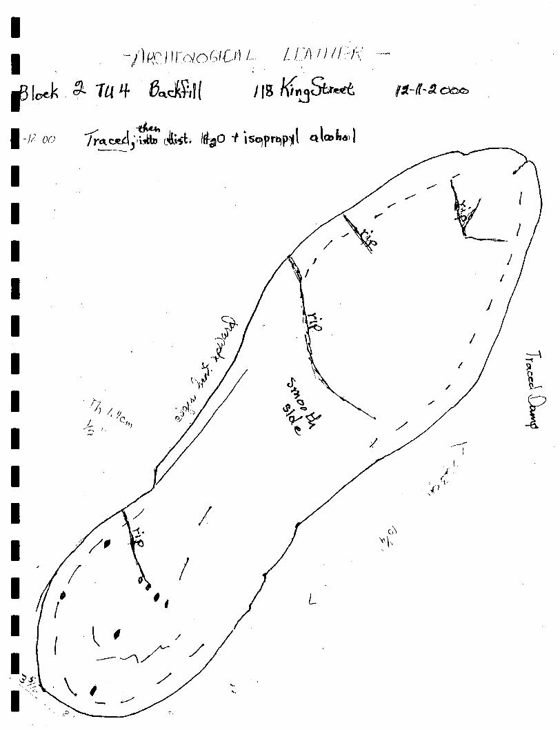
I I -/) 1<,(' I Wd 0 (,{ UJ L U-/) 1 II //,:'--
fJloek . g).. 1U If BQ.J~,II J ,S t(;'!jSt.r~ 11.-1t-9. 0=
I-II 00 7r~~,~ Lt~; IfI-~o -I is..,"I"Ili'~1 "1\001.4',
I /'
,.,-
I I
,.,- I r
~ I / --=--
J
I I
J
I I I I
l), } ! Ij
/ ' 'C t .,~ f, ...... , I.
'"
~ .--~ /
'-Y~ ~ Yo l' sa
", ~J
~ ~--\ )~
Q /' f ~~ 'r~ ./ ~
/ ----, I I
I !.
j , (v
.{1 ,
I I I ;
I f
I (
. ~.s~ .\ .<'. "
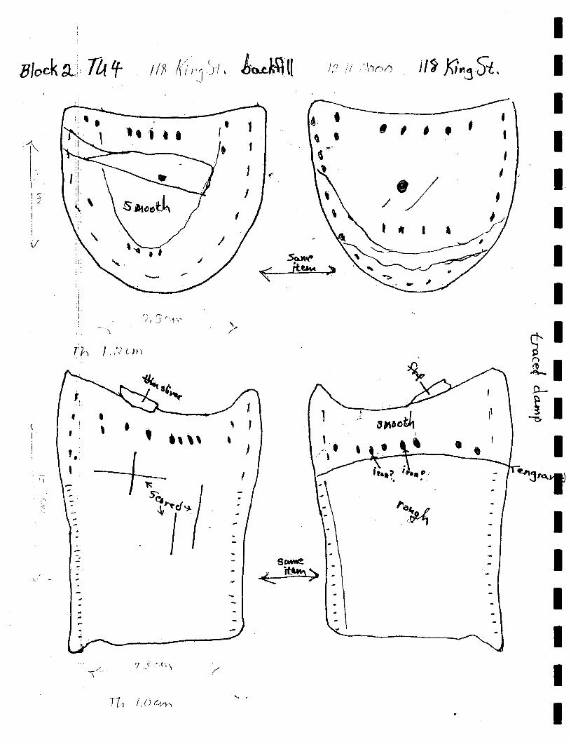
r(! I '5 r· •.. ~ ... .,.,
\
, '11', ), :''/ C 1> \
, • , • , ., '\ , -+: ,
. ' .... ,
'I
!.;' S'~
~7~ , -. --, -
... , .
\ - -, . -~ ~ ..
\-<.
, ,
"" .
~, . , , ,... ,
, , , . ;
!. ...1 .,' 3,,11091
\
.--'-~--T-'--' ,
• , ,
I I I I I I I I
t I .ll .0-
-11 I
I I I I I I
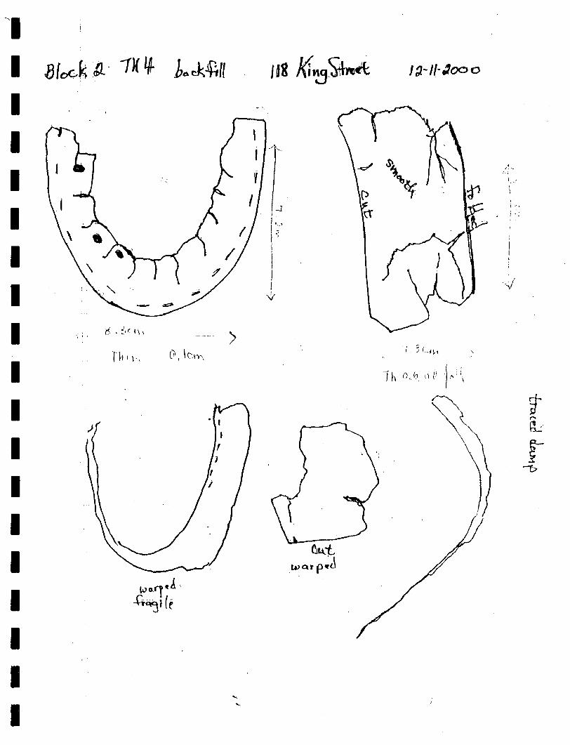
-~I
I 8[ckK .lL· 1K 'A- ba~f,ll
I I I I I I I I I I I I I I I I I
. ~ • ::. r I ~ \ -; I't
r~ll \, ._. >
"', ....
J ~-II· .1000
. ./ r ~.
-1 . j
1 : .. ,
l! :;
.'
I '-l
. i·: I
,
I ) I
/ '\'
~(