Embed Size (px)
Citation preview
1Hillfort studies and the
Wessex Project by Andrew Payne
The Wessex Hillforts Project was initiated in 1996 to answer a need for more wide-ranging data on hillfort interiors for the purposes of placing their future management on a sounder footing and enhancing knowledge of the internal character of the various hill-fort types represented in Wessex. It was hoped that the combined results of the project would considerably extend academic understanding of the socio-economic role of hillforts in southern England during the 1st millennium BC, thereby allowing a greater level of interpretation to be offered to visitors at those sites with public access.
The primary methodology employed by the project was geophysical survey supplemented by examination of aerial photographic evidence, documentary research and selective digital modelling of site micro-topography. The examination of each hillfort was to be as comprehensive as possible without resorting to more costly and unnecessarily destructive intrusive techniques.
The context of the study Hillforts have attracted archaeological interest for much of the last century and debate on their function and significance continues to be central to the academic study of the later Bronze Age and Iron Age (broadly the 1st millennium BC). Although some hillforts have been damaged by development or levelled through ploughing, those that remain are some of the most impressive ancient monuments still visible in the countryside today. Such prominent landmarks naturally attracted the interest of antiquaries and pioneers in archaeology from earliest times, an interest that has continued with the development of scientific field techniques and modern methods of excavation. Writing on social organisation in Iron Age Wessex, Haselgrove (1994, 1) concluded, ‘there can be little doubting the significance of Iron Age hillforts, given the labour invested in their construction, so understanding their role is clearly vital’. While it is clear from the scale of these sites that great
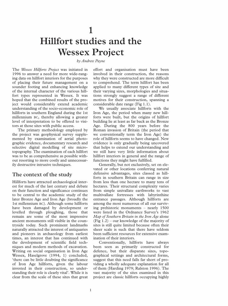
effort and organisation must have been involved in their construction, the reasons why they were constructed are more difficult to comprehend. The term hillfort has been applied to many different types of site and their varying sizes, morphologies and situations strongly suggest a range of different motives for their construction, spanning a considerable date range (Fig 1.1).
We usually associate hillforts with the Iron Age, the period when many new hill-forts were built, but the origins of hillfort building lie at least as far back as the Bronze Age. During the 800 years before the Roman invasion of Britain (the period that we conventionally term the Iron Age) the role of hillforts seems to have changed. New evidence is only gradually being uncovered that helps to extend our understanding and we still have very little information about hillfort interiors in general and the range of functions they might have fulfilled.
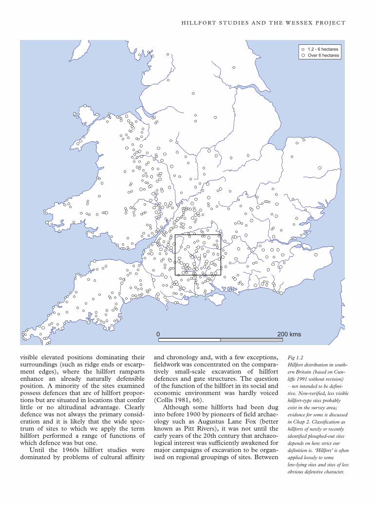
Generally, but not exclusively, set on elevated or other locations conferring natural defensive advantages, sites classed as hill-forts in southern Britain can range in size from less than one hectare to many tens of hectares. Their structural complexity varies from simple univallate earthworks to vast multivallate fortresses with labyrinthine entrance passages. Although hillforts are among the most numerous of all our surviving prehistoric monuments – nearly 1500 were listed in the Ordnance Survey’s 1962 Map of Southern Britain in the Iron Age alone (Fig 1.2) – our knowledge of the majority of sites is still quite limited because often their sheer scale is such that there have seldom been sufficient resources for extensive examination of their interiors.
Conventionally, hillforts have always been seen as primarily constructed for defence, but their disparate sizes, topographical settings and architectural forms, suggest that this need falls far short of providing a wholly adequate explanation for all of them (Harding 1979; Ralston 1996). The vast majority of the sites examined in this project are classic hillforts occupying highly
1

Fig
1.1
1. L
AR
GE
HIL
LTO
P E
NC
LOS
UR
ES
T
he m
ajor
cat
egor
ies
of h
illfo
rt ty
pes
repr
esen
ted
in S
outh
ern
Bri
tain
illu
stra
ting
the
broa
d th
ree-
phas
ed
deve
lopm
ent o
f hill
fort
form
s w
ithin
the
regi
on o
f Wes
sex
(fro
m C
unlif
fe 1
991
and
Sha
rple
s 19
94).
2. E
AR
LY IR
ON
AG
E H
ILLF
OR
TS
3. D
EV
ELO
PE
D H
ILLF
OR
TS
B
ased
on
Sha
rple
s 19
94, F
igur
e 26
.2
Bas
ed o
n D
arvi
ll 19
87, F
igur
e 80
.
N
Bas
ed o
n C
unlif
fe 1
991,
Fig
ure
14.2
4
G
H
I
J K
L
M
N
O
P
Q
A
B
C
D
E
F
R
ram
part
A B
atha
mpt
on D
own,
Avo
n B
Bal
ksbu
ry C
amp,
Ham
pshi
re
C M
artin
sell
Hill
Cam
p, W
iltsh
ire
G Q
uarle
y H
ill, H
amps
hire
K
Dan
ebur
y, H
amps
hire
O
Sou
th C
adbu
ry C
astle
, Som
erse
t D
Nor
bury
Cam
p, G
louc
este
rshi
re
H Y
arnb
ury
Cas
tle, W
iltsh
ire
L T
he T
rund
le, W
Sus
sex
P M
aide
n C
astle
, Dor
set
ALL
PLA
NS
TO
SC
ALE
E W
albu
ry C
amp,
Ber
kshi
re
I C
halb
ury,
Dor
set
M M
aide
n C
astle
, Dor
set
Q H
od H
ill, D
orse
t 0
500
1000
m
F
Boz
edow
n C
amp,
Oxf
ords
hire
J
Fig
sbur
y R
ings
, Wilt
shire
N
Ble
wbu
rton
Hill
, Oxf
ords
hire
R
Ham
bled
on H
ill, D
orse
t
H I L L F O RT S T U D I E S A N D T H E W E S S E X P R O J E C T
1.2 - 6 hectares Over 6 hectares
0 200 kms
visible elevated positions dominating their surroundings (such as ridge ends or escarpment edges), where the hillfort ramparts enhance an already naturally defensible position. A minority of the sites examined possess defences that are of hillfort proportions but are situated in locations that confer little or no altitudinal advantage. Clearly defence was not always the primary consideration and it is likely that the wide spectrum of sites to which we apply the term hillfort performed a range of functions of which defence was but one.
Until the 1960s hillfort studies were dominated by problems of cultural affinity
and chronology and, with a few exceptions, fieldwork was concentrated on the comparatively small-scale excavation of hillfort defences and gate structures. The question of the function of the hillfort in its social and economic environment was hardly voiced (Collis 1981, 66).
Although some hillforts had been dug into before 1900 by pioneers of field archaeology such as Augustus Lane Fox (better known as Pitt Rivers), it was not until the early years of the 20th century that archaeological interest was sufficiently awakened for major campaigns of excavation to be organised on regional groupings of sites. Between
Fig 1.2 Hillfort distribution in southern Britain (based on Cunliffe 1991 without revision) – not intended to be definitive. Non-verified, less visible hillfort-type sites probably exist in the survey area; evidence for some is discussed in Chap 2. Classification as hillforts of newly or recently identified ploughed-out sites depends on how strict our definition is. ‘Hillfort’ is often applied loosely to some low-lying sites and sites of less obvious defensive character.
T H E W E S S E X H I L L F O RT S P R O J E C T
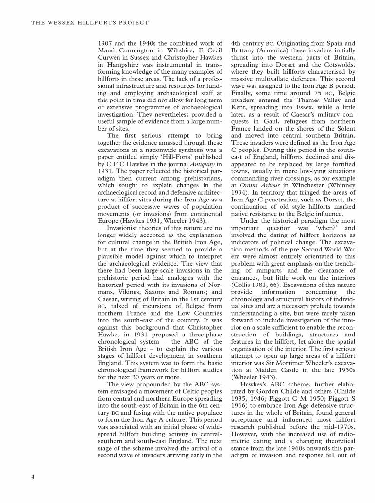
1907 and the 1940s the combined work of Maud Cunnington in Wiltshire, E Cecil Curwen in Sussex and Christopher Hawkes in Hampshire was instrumental in transforming knowledge of the many examples of hillforts in these areas. The lack of a professional infrastructure and resources for funding and employing archaeological staff at this point in time did not allow for long term or extensive programmes of archaeological investigation. They nevertheless provided a useful sample of evidence from a large number of sites.
The first serious attempt to bring together the evidence amassed through these excavations in a nationwide synthesis was a paper entitled simply ‘Hill-Forts’ published by C F C Hawkes in the journal Antiquity in 1931. The paper reflected the historical paradigm then current among prehistorians, which sought to explain changes in the archaeological record and defensive architecture at hillfort sites during the Iron Age as a product of successive waves of population movements (or invasions) from continental Europe (Hawkes 1931; Wheeler 1943).
Invasionist theories of this nature are no longer widely accepted as the explanation for cultural change in the British Iron Age, but at the time they seemed to provide a plausible model against which to interpret the archaeological evidence. The view that there had been large-scale invasions in the prehistoric period had analogies with the historical period with its invasions of Normans, Vikings, Saxons and Romans; and Caesar, writing of Britain in the 1st century BC, talked of incursions of Belgae from northern France and the Low Countries into the south-east of the country. It was against this background that Christopher Hawkes in 1931 proposed a three-phase chronological system – the ABC of the British Iron Age – to explain the various stages of hillfort development in southern England. This system was to form the basic chronological framework for hillfort studies for the next 30 years or more.
The view propounded by the ABC system envisaged a movement of Celtic peoples from central and northern Europe spreading into the south-east of Britain in the 6th century BC and fusing with the native populace to form the Iron Age A culture. This period was associated with an initial phase of widespread hillfort building activity in central-southern and south-east England. The next stage of the scheme involved the arrival of a second wave of invaders arriving early in the
4th century BC. Originating from Spain and Brittany (Armorica) these invaders initially thrust into the western parts of Britain, spreading into Dorset and the Cotswolds, where they built hillforts characterised by massive multivallate defences. This second wave was assigned to the Iron Age B period. Finally, some time around 75 BC, Belgic invaders entered the Thames Valley and Kent, spreading into Essex, while a little later, as a result of Caesar’s military conquests in Gaul, refugees from northern France landed on the shores of the Solent and moved into central southern Britain. These invaders were defined as the Iron Age C peoples. During this period in the southeast of England, hillforts declined and disappeared to be replaced by large fortified towns, usually in more low-lying situations commanding river crossings, as for example at Orams Arbour in Winchester (Whinney 1994). In territory that fringed the areas of Iron Age C penetration, such as Dorset, the continuation of old style hillforts marked native resistance to the Belgic influence.
Under the historical paradigm the most important question was ‘when?’ and involved the dating of hillfort horizons as indicators of political change. The excavation methods of the pre-Second World War era were almost entirely orientated to this problem with great emphasis on the trenching of ramparts and the clearance of entrances, but little work on the interiors (Collis 1981, 66). Excavations of this nature provide information concerning the chronology and structural history of individual sites and are a necessary prelude towards understanding a site, but were rarely taken forward to include investigation of the interior on a scale sufficient to enable the reconstruction of buildings, structures and features in the hillfort, let alone the spatial organisation of the interior. The first serious attempt to open up large areas of a hillfort interior was Sir Mortimer Wheeler’s excavation at Maiden Castle in the late 1930s (Wheeler 1943).
Hawkes’s ABC scheme, further elaborated by Gordon Childe and others (Childe 1935, 1946; Piggott C M 1950; Piggott S 1966) to embrace Iron Age defensive structures in the whole of Britain, found general acceptance and influenced most hillfort research published before the mid-1970s. However, with the increased use of radiometric dating and a changing theoretical stance from the late 1960s onwards this paradigm of invasion and response fell out of
4
H I L L F O RT S T U D I E S A N D T H E W E S S E X P R O J E C T
favour. Regional developments are now generally agreed to have been more influential on the growth of hillforts, including the demonstration of prestige or status on the part of the hillfort builders – or more particularly the decision makers who controlled their activities – as well as the wish to give physical definition to the limits of jurisdictions (social, ritual, economic or political) (Ralston 1996).
Since the collapse of the historical paradigm, a new chronological framework has only slowly begun to be developed. Unlike Hawkes’s system and those tied to it, there is now no single chronological scheme that can be applied to hillfort development over the whole of Britain and currently we only have a detailed comprehension of the chronology of hillfort development in certain regions of Britain where sufficient research has been carried out. Prior to the use of radiometric dating, earlier pre-war dating saw hillforts as a relatively late development after 600 BC; most were not built until after 300–250 BC
and multivallate forts not until after 50 BC. These dates are now known to be wrong, with radiocarbon evidence linked to changes in pottery form and decoration. It is evident that some hillforts were occupied as early as the Late Bronze Age and many more date from as early as the 7th or 6th centuries BC. At the same time it has become clear that many, if not most, hillforts in southern England were abandoned round about 100 BC
(Atrebatic area) or shortly thereafter (Durotrigian area). This dramatic shift in possible time-span has superseded the chronologies in many older excavation reports, adding considerable confusion to an already complex picture.
From the 1960s onwards, following the abandonment of the Hawkes ABC system of culture change, an increasing concern with the definition of hillforts led to the appearance of a number of proposals for their classification. These rested mainly on the structure and placement of the ramparts, siting (for example cliff-edge forts) and the size of area enclosed (see, for example, Avery 1976). Closer consideration of such evidence suggests, however, that any typology based on shape and situation will be an oblique record of the local topography and may carry little archaeological significance. Much of the discussion on hillforts still focuses on the form of construction of the hillfort ramparts and less on internal character, which is generally more elusive without resort to excavation.
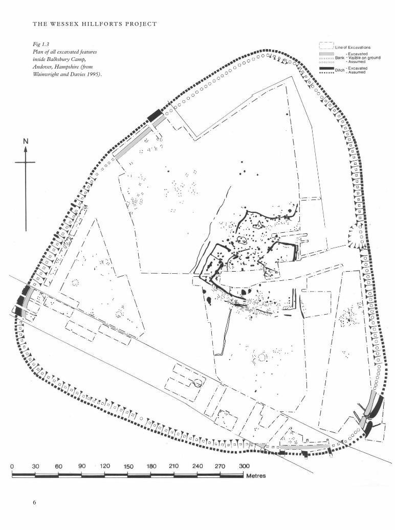
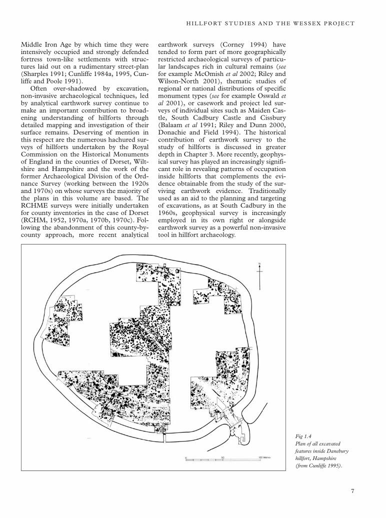
The post-war period saw the emergence of open area excavation and a growing interest in both the form of occupation within hillforts and in the economic and social stimuli that led to their development. In the 1960s and 70s, the realisation that the social and economic functions of hillforts could only be addressed through an understanding of their internal layout led to the large scale excavation of a number of hillfort interiors including South Cadbury in Somerset (Alcock 1968a, 1968b, 1969, 1970, 1980; Barrett et al 2000); Crickley Hill in Gloucestershire (Dixon 1976, 1994); Croft Ambrey, Credenhill and Midsummer Hill in the Welsh Marches (Stanford 1967, 1974; Stanford 1971; Stanford 1981); and Balksbury, Winklebury and Danebury in Hampshire (Wainwright and Davies 1995; Smith 1977, 1979; Cunliffe 1984a, 1995, Cunliffe and Poole 1991). Despite the increased attention given to hillfort interiors since the 1960s, only a very small proportion nationally have yet been investigated on anything approaching a reasonable scale. The problem has been accentuated by the general lack of success of aerial photography at revealing features inside hillforts, even when they are regularly ploughed and cultivated, often in contrast to their surrounding landscapes. This continuing lack of extensive data is reflected in the most recent comprehensive survey of hillfort studies (Cunliffe 1991) where much of the discussion of the available evidence continues to revolve around the morphology of hillfort defences. Within the small sample of hillforts that have been examined on a sufficient scale for the nature and density of their internal features to be adequately characterised, there is considerable variation in the complexity of internal characteristics and intensity of occupation. Some sites reveal evidence of free-standing buildings within their enclosed areas while others contain few traces of occupation. The latter group are believed to have served a variety of purposes including a range of agricultural uses (such as coralling of livestock), settings for ritual or display and as temporary refuges (Ralston 1996). Some of the earliest known Wessex hillfort sites such as Balksbury in Hampshire (Wainwright and Davies 1995; Cunliffe 2000) contained very few internal features (Fig 1.3). This suggests that they performed a very different function from the later hill-forts, such as Danebury (Fig 1.4) and Maiden Castle, that developed in the early Iron Age but continued in use into the
5
T H E W E S S E X H I L L F O RT S P R O J E C T
Fig 1.3 Plan of all excavated features inside Balksbury Camp, Andover, Hampshire (from Wainwright and Davies 1995).
6
H I L L F O RT S T U D I E S A N D T H E W E S S E X P R O J E C T
Middle Iron Age by which time they were intensively occupied and strongly defended fortress town-like settlements with structures laid out on a rudimentary street-plan (Sharples 1991; Cunliffe 1984a, 1995, Cunliffe and Poole 1991).
Often over-shadowed by excavation, non-invasive archaeological techniques, led by analytical earthwork survey continue to make an important contribution to broadening understanding of hillforts through detailed mapping and investigation of their surface remains. Deserving of mention in this respect are the numerous hachured surveys of hillforts undertaken by the Royal Commission on the Historical Monuments of England in the counties of Dorset, Wiltshire and Hampshire and the work of the former Archaeological Division of the Ordnance Survey (working between the 1920s and 1970s) on whose surveys the majority of the plans in this volume are based. The RCHME surveys were initially undertaken for county inventories in the case of Dorset (RCHM, 1952, 1970a, 1970b, 1970c). Following the abandonment of this county-bycounty approach, more recent analytical
earthwork surveys (Corney 1994) have tended to form part of more geographically restricted archaeological surveys of particular landscapes rich in cultural remains (see for example McOmish et al 2002; Riley and Wilson-North 2001), thematic studies of regional or national distributions of specific monument types (see for example Oswald et al 2001), or casework and project led surveys of individual sites such as Maiden Castle, South Cadbury Castle and Cissbury (Balaam et al 1991; Riley and Dunn 2000, Donachie and Field 1994). The historical contribution of earthwork survey to the study of hillforts is discussed in greater depth in Chapter 3. More recently, geophysical survey has played an increasingly significant role in revealing patterns of occupation inside hillforts that complements the evidence obtainable from the study of the surviving earthwork evidence. Traditionally used as an aid to the planning and targeting of excavations, as at South Cadbury in the 1960s, geophysical survey is increasingly employed in its own right or alongside earthwork survey as a powerful non-invasive tool in hillfort archaeology.
Fig 1.4 Plan of all excavated features inside Danebury hillfort, Hampshire (from Cunliffe 1995).
7
T H E W E S S E X H I L L F O RT S P R O J E C T
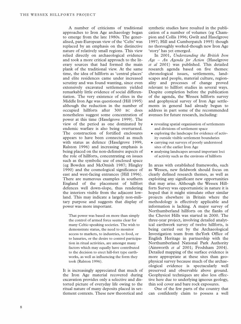
A number of criticisms of traditional approaches to Iron Age archaeology began to emerge from the late 1980s. The generalised, pan-European view of the ‘Celts’ was replaced by an emphasis on the distinctive nature of relatively small regions. This view relied directly on archaeological evidence and took a more critical approach to the literary sources that had formed the main plank of the traditional view. At the same time, the idea of hillforts as ‘central places’ and elite residences came under increased scrutiny and was found wanting, since even extensively excavated settlements yielded remarkably little evidence of social differentiation. The very existence of elites in the Middle Iron Age was questioned (Hill 1995) although the reduction in the number of occupied hillforts after 300 BC does nonetheless suggest some concentration of power at this time (Haselgrove 1999). The view of the period as one dominated by endemic warfare is also being overturned. The construction of fortified enclosures appears to have been connected as much with status as defence (Haselgrove 1999, Ralston 1996) and increasing emphasis is being placed on the non-defensive aspects of the role of hillforts, concentrating on issues such as the symbolic use of enclosed space (eg Bowden and McOmish 1987; Hingley 1990) and the cosmological significance of east and west-facing entrances (Hill 1996). There are numerous examples in southern England of the placement of hillfort defences well down-slope, thus rendering the interiors visible from the adjacent lowland. This may indicate a largely non-military purpose and suggests that display of power was more important.
That power was based on more than simply the control of armed force seems clear for many Celtic-speaking societies. The wish to demonstrate status, the need to monitor access to markets, to industries, to food, or to luxuries, or the desire to control participation in ritual activities, are amongst many factors which may equally have contributed to the decision to erect hill-fort type earthworks, as well as influencing the form they took (Ralston 1996).
It is increasingly appreciated that much of the Iron Age material recovered during excavation provides only a selective and distorted picture of everyday life owing to the ritual nature of many deposits placed in settlement contexts. These new theoretical and
synthetic studies have resulted in the publication of a number of volumes (eg Champion and Collis 1996; Gwilt and Haselgrove 1997; Hill and Cumberpatch 1995) though no thoroughly worked-though new Iron Age ‘story’ has yet emerged.
In 2001, Understanding the British Iron Age – An Agenda for Action (Haselgrove et al 2001) was published. This detailed research agenda based on five themes: chronological issues, settlements, landscapes and people, material culture, regionality and processes of change proved relevant to hillfort studies in several ways. Despite completion before the publication of the agenda, the Wessex hillforts survey and geophysical survey of Iron Age settlements in general had already begun to address in part some of the recommended avenues for future research, including:
• revealing spatial organisation of settlements and divisions of settlement space
• exploring the landscape for evidence of activity outside visible settlement boundaries
• carrying out surveys of poorly understoodsites of the earlier Iron Age
• analysing landscapes around important loci of activity such as the environs of hillforts
In areas with established frameworks, such as Wessex, new fieldwork should focus on clearly defined research themes, as well as exploiting any significant new opportunities that may arise. Although the Wessex Hill-forts Survey was opportunistic in nature it is hoped that it might stimulate other similar projects elsewhere in Britain where the methodology is effectively applicable and information is lacking. A major survey of Northumberland hillforts on the flanks of the Cheviot Hills was started in 2000. The three-year project, involving detailed analytical earthwork survey of twelve hillforts, is being carried out by the Archaeological Investigation team from theYork Office of English Heritage in partnership with the Northumberland National Park Authority (Ainsworth et al 2001; Frodsham 2004). Detailed mapping of the surface evidence is more appropriate at these sites than geophysical survey because much of the archaeological evidence is spectacularly well preserved and observable above ground. Geophysical techniques are also less effective here due to underlying igneous geology, thin soil cover and bare rock exposures.
One of the few parts of the country that can confidently claim to possess a well
8
H I L L F O RT S T U D I E S A N D T H E W E S S E X P R O J E C T
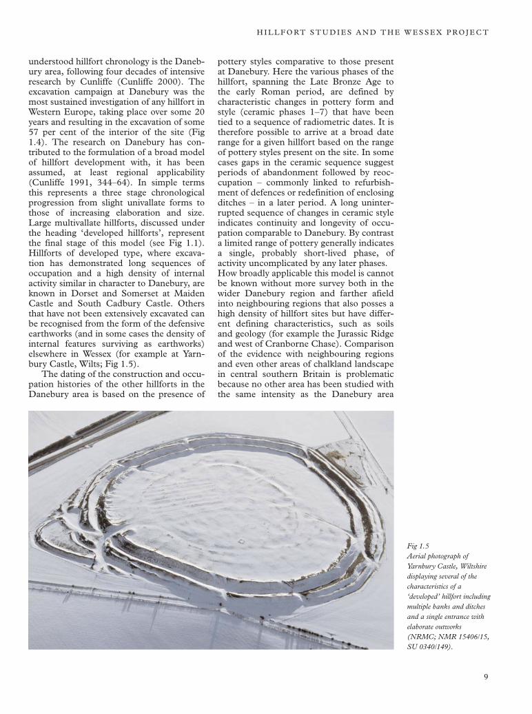
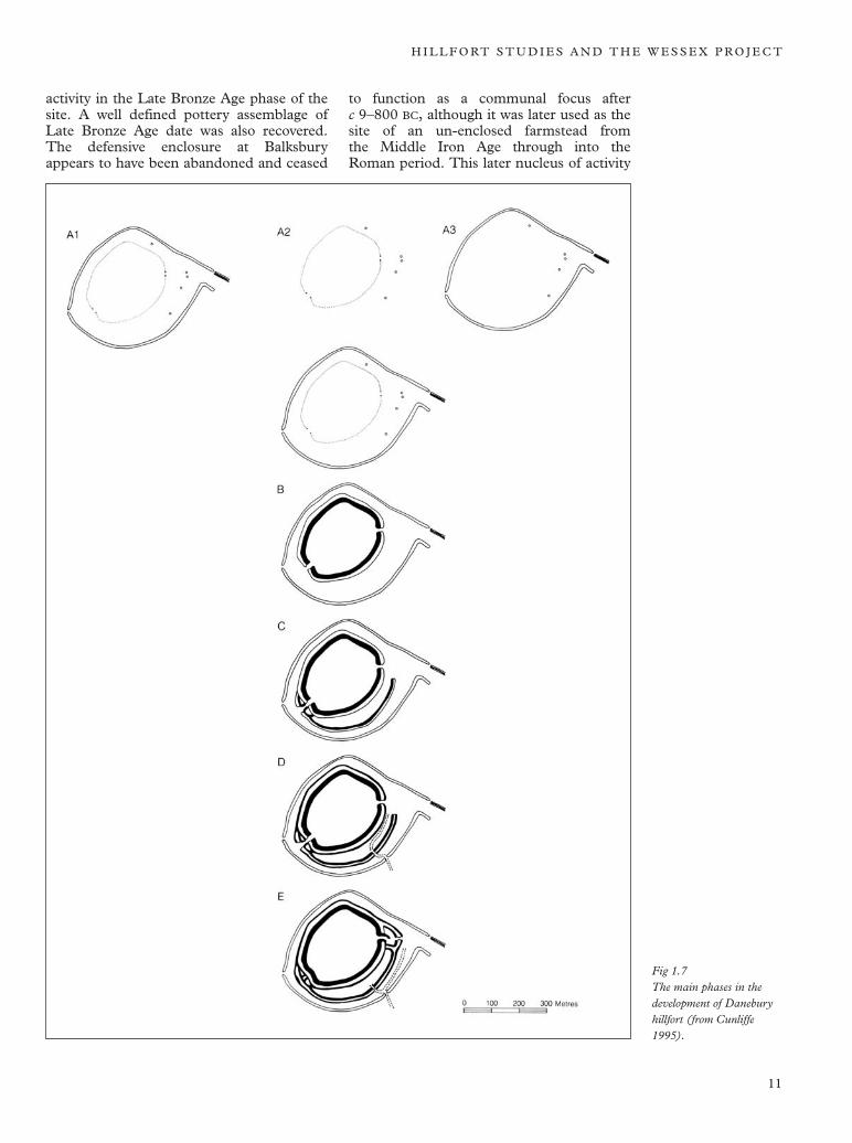
understood hillfort chronology is the Danebury area, following four decades of intensive research by Cunliffe (Cunliffe 2000). The excavation campaign at Danebury was the most sustained investigation of any hillfort in Western Europe, taking place over some 20 years and resulting in the excavation of some 57 per cent of the interior of the site (Fig 1.4). The research on Danebury has contributed to the formulation of a broad model of hillfort development with, it has been assumed, at least regional applicability (Cunliffe 1991, 344–64). In simple terms this represents a three stage chronological progression from slight univallate forms to those of increasing elaboration and size. Large multivallate hillforts, discussed under the heading ‘developed hillforts’, represent the final stage of this model (see Fig 1.1). Hillforts of developed type, where excavation has demonstrated long sequences of occupation and a high density of internal activity similar in character to Danebury, are known in Dorset and Somerset at Maiden Castle and South Cadbury Castle. Others that have not been extensively excavated can be recognised from the form of the defensive earthworks (and in some cases the density of internal features surviving as earthworks) elsewhere in Wessex (for example at Yarn-bury Castle, Wilts; Fig 1.5).
The dating of the construction and occupation histories of the other hillforts in the Danebury area is based on the presence of
pottery styles comparative to those present at Danebury. Here the various phases of the hillfort, spanning the Late Bronze Age to the early Roman period, are defined by characteristic changes in pottery form and style (ceramic phases 1–7) that have been tied to a sequence of radiometric dates. It is therefore possible to arrive at a broad date range for a given hillfort based on the range of pottery styles present on the site. In some cases gaps in the ceramic sequence suggest periods of abandonment followed by reoccupation – commonly linked to refurbishment of defences or redefinition of enclosing ditches – in a later period. A long uninterrupted sequence of changes in ceramic style indicates continuity and longevity of occupation comparable to Danebury. By contrast a limited range of pottery generally indicates a single, probably short-lived phase, of activity uncomplicated by any later phases. How broadly applicable this model is cannot be known without more survey both in the wider Danebury region and farther afield into neighbouring regions that also posses a high density of hillfort sites but have different defining characteristics, such as soils and geology (for example the Jurassic Ridge and west of Cranborne Chase). Comparison of the evidence with neighbouring regions and even other areas of chalkland landscape in central southern Britain is problematic because no other area has been studied with the same intensity as the Danebury area
Fig 1.5 Aerial photograph of Yarnbury Castle, Wiltshire displaying several of the characteristics of a ‘developed’ hillfort including multiple banks and ditches and a single entrance with elaborate outworks (NRMC; NMR 15406/15, SU 0340/149).
9
T H E W E S S E X H I L L F O RT S P R O J E C T
Fig 1.6 Hillfort sites and other Iron Age enclosed settlements investigated by The Danebury Environs Project in Hampshire from 1989–96 (from Cunliffe 2000).
(28 seasons of intensive research excavation). Partly as a result of environmental factors, Iron Age sites in northern England generally produce far less ceramic material with little variation in form over time, rendering the construction of detailed chronologies in these areas far more difficult in comparison to Wessex (Haselgrove 1999, 114).
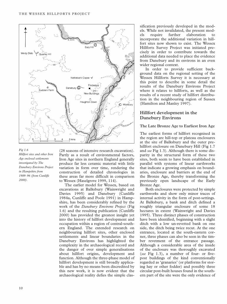
The earlier model for Wessex, based on excavations at Balksbury (Wainwright and Davies 1995) and Danebury (Cunliffe 1984a, Cunliffe and Poole 1991) in Hampshire, has been considerably refined by the work of the Danebury Environs Project (Fig 1.6) and the resulting publication (Cunliffe 2000) has provided the greatest insight yet into the history of hillfort development and occupation within a region of central-southern England. The extended research on neighbouring hillfort sites, other enclosed settlements and linear boundaries in the Danebury Environs has highlighted the complexity in the archaeological record and the danger of over simple generalisations about hillfort origins, development and function. Although the three-phase model of hillfort development is still broadly applicable and has by no means been discredited by this new work, it is now evident that the archaeological reality defies the simple clas
sification previously developed in the models. While not invalidated, the present models require further elaboration to incorporate the additional variation in hill-fort sites now shown to exist. The Wessex Hillforts Survey Project was initiated precisely in order to contribute towards the additional data needed to place the evidence from Danebury and its environs in an even wider regional context.
In order to provide sufficient background data on the regional setting of the Wessex Hillforts Survey it is necessary at this point to describe in some detail the results of the Danebury Environs Project where it relates to hillforts, as well as the results of a recent study of hillfort distribution in the neighbouring region of Sussex (Hamilton and Manley 1997).
Hillfort development in the Danebury Environs
The Late Bronze Age to Earliest Iron Age
The earliest forms of hillfort recognised in the region are hill-top or plateau enclosures at the site of Balksbury and the outer prehillfort enclosure on Danebury Hill (Fig 1.7 and see Fig 1.3). Although there is some disparity in the structural form of these two sites, both seem to have been established in parallel with systems of linear earthworks that indicate a growing emphasis on boundaries, enclosure and barriers at the end of the Bronze Age, thereby transforming the previously open landscape of the Early Bronze Age.
Both enclosures were protected by simple earthworks and show only minor traces of internal activity in the form of post-settings. At Balksbury, a bank and ditch defined a roughly triangular enclosure of some 18 hectares in extent (Wainwright and Davies 1995). Three distinct phases of construction have been identified, beginning with a slight ditch with a low un-revetted bank on one side, the ditch being twice recut. At the one entrance, located at the south-eastern corner, three phases can also be seen in the timber revetment of the entrance passage. Although a considerable area of the inside of the enclosure was thoroughly excavated (see Fig 1.3), a number of four- or five-post buildings of the kind conventionally regarded as ‘granaries’ (or platforms for storing hay or other fodder) and possibly three circular post-built houses found in the southern part of the site were the only evidence of
10
H I L L F O RT S T U D I E S A N D T H E W E S S E X P R O J E C T
activity in the Late Bronze Age phase of the site. A well defined pottery assemblage of Late Bronze Age date was also recovered. The defensive enclosure at Balksbury appears to have been abandoned and ceased
to function as a communal focus after c 9–800 BC, although it was later used as the site of an un-enclosed farmstead from the Middle Iron Age through into the Roman period. This later nucleus of activity
Fig 1.7 The main phases in the development of Danebury hillfort (from Cunliffe 1995).
11
T H E W E S S E X H I L L F O RT S P R O J E C T
within the abandoned former defences was concentrated in a comparatively restricted area of the old enclosure.
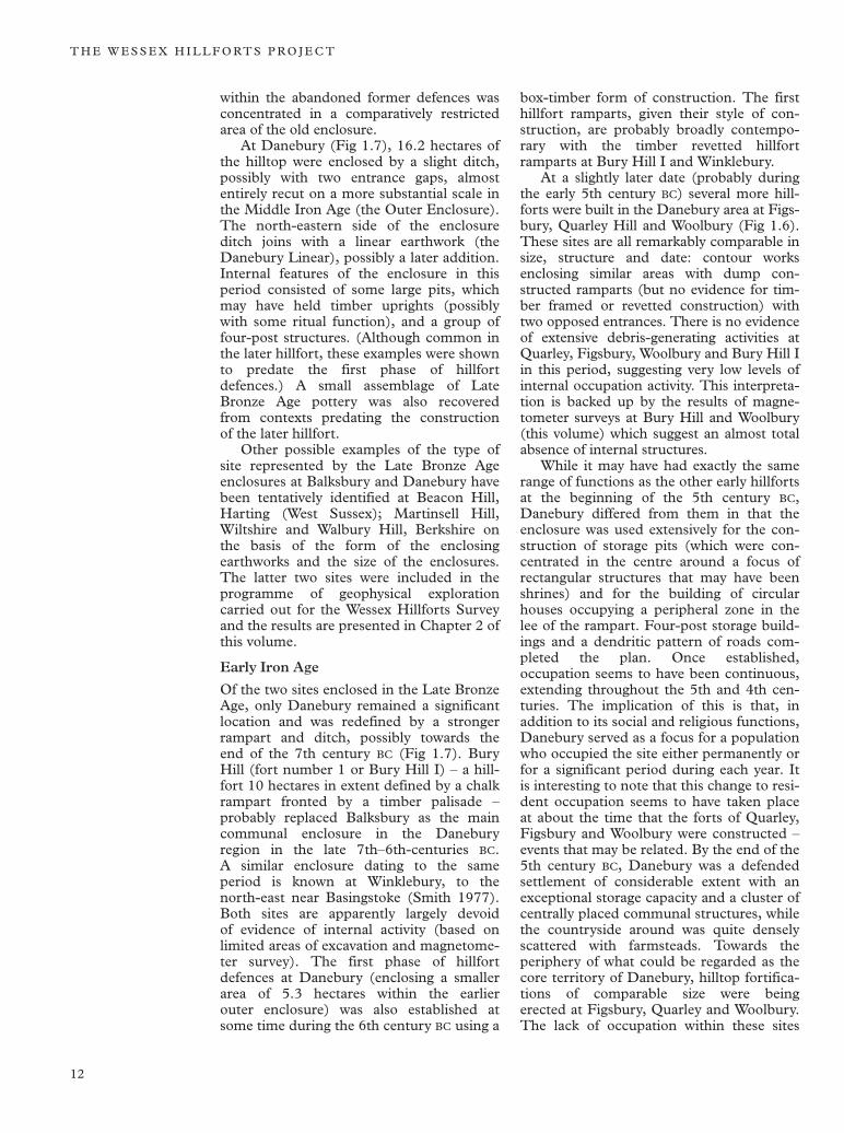
At Danebury (Fig 1.7), 16.2 hectares of the hilltop were enclosed by a slight ditch, possibly with two entrance gaps, almost entirely recut on a more substantial scale in the Middle Iron Age (the Outer Enclosure). The north-eastern side of the enclosure ditch joins with a linear earthwork (the Danebury Linear), possibly a later addition. Internal features of the enclosure in this period consisted of some large pits, which may have held timber uprights (possibly with some ritual function), and a group of four-post structures. (Although common in the later hillfort, these examples were shown to predate the first phase of hillfort defences.) A small assemblage of Late Bronze Age pottery was also recovered from contexts predating the construction of the later hillfort.
Other possible examples of the type of site represented by the Late Bronze Age enclosures at Balksbury and Danebury have been tentatively identified at Beacon Hill, Harting (West Sussex); Martinsell Hill, Wiltshire and Walbury Hill, Berkshire on the basis of the form of the enclosing earthworks and the size of the enclosures. The latter two sites were included in the programme of geophysical exploration carried out for the Wessex Hillforts Survey and the results are presented in Chapter 2 of this volume.
Early Iron Age
Of the two sites enclosed in the Late Bronze Age, only Danebury remained a significant location and was redefined by a stronger rampart and ditch, possibly towards the end of the 7th century BC (Fig 1.7). Bury Hill (fort number 1 or Bury Hill I) – a hill-fort 10 hectares in extent defined by a chalk rampart fronted by a timber palisade – probably replaced Balksbury as the main communal enclosure in the Danebury region in the late 7th–6th-centuries BC. A similar enclosure dating to the same period is known at Winklebury, to the north-east near Basingstoke (Smith 1977). Both sites are apparently largely devoid of evidence of internal activity (based on limited areas of excavation and magnetometer survey). The first phase of hillfort defences at Danebury (enclosing a smaller area of 5.3 hectares within the earlier outer enclosure) was also established at some time during the 6th century BC using a
box-timber form of construction. The first hillfort ramparts, given their style of construction, are probably broadly contemporary with the timber revetted hillfort ramparts at Bury Hill I and Winklebury.
At a slightly later date (probably during the early 5th century BC) several more hill-forts were built in the Danebury area at Figs-bury, Quarley Hill and Woolbury (Fig 1.6). These sites are all remarkably comparable in size, structure and date: contour works enclosing similar areas with dump constructed ramparts (but no evidence for timber framed or revetted construction) with two opposed entrances. There is no evidence of extensive debris-generating activities at Quarley, Figsbury, Woolbury and Bury Hill I in this period, suggesting very low levels of internal occupation activity. This interpretation is backed up by the results of magnetometer surveys at Bury Hill and Woolbury (this volume) which suggest an almost total absence of internal structures.
While it may have had exactly the same range of functions as the other early hillforts at the beginning of the 5th century BC, Danebury differed from them in that the enclosure was used extensively for the construction of storage pits (which were concentrated in the centre around a focus of rectangular structures that may have been shrines) and for the building of circular houses occupying a peripheral zone in the lee of the rampart. Four-post storage buildings and a dendritic pattern of roads completed the plan. Once established, occupation seems to have been continuous, extending throughout the 5th and 4th centuries. The implication of this is that, in addition to its social and religious functions, Danebury served as a focus for a population who occupied the site either permanently or for a significant period during each year. It is interesting to note that this change to resident occupation seems to have taken place at about the time that the forts of Quarley, Figsbury and Woolbury were constructed – events that may be related. By the end of the 5th century BC, Danebury was a defended settlement of considerable extent with an exceptional storage capacity and a cluster of centrally placed communal structures, while the countryside around was quite densely scattered with farmsteads. Towards the periphery of what could be regarded as the core territory of Danebury, hilltop fortifications of comparable size were being erected at Figsbury, Quarley and Woolbury. The lack of occupation within these sites
12
H I L L F O RT S T U D I E S A N D T H E W E S S E X P R O J E C T
suggests that they may have been created as strategic points to command the perceived boundaries of a territory centred upon Danebury.
Developments from the end of the 4th century bc (300–100 bc – The Middle Iron Age)
On the basis of the distribution of pottery styles in the region, it seems likely that the political geography of Wessex changed in the early 3rd century BC. It was at this time, after a diminished level of use, that Danebury underwent a major phase of reconstruction and took on many of the defining characteristics of a developed type of hillfort (see Fig 1.7). The south-west gate was blocked and the rampart was augmented with material from internal quarries immediately inside the rampart. Finally a corridor approach and projecting hornworks were added to the single remaining entrance. For the next 200 years or so the interior was heavily utilised. A massive storage capacity in the form of rectangular post structures and below-ground silos was maintained; close packed circular houses in the lee of the rampart were rebuilt every 20–30 years and a religious focus continued to develop towards the centre of the fort. The intensity of activity measured in terms of material discarded was greatly increased from earlier periods. While the contrast to the earlier period is dramatic it is one of intensity rather than range. The layout and the structures were not significantly different, but the quantity and variety of material deposited in the later period is strongly suggestive of a greatly increased level of activity (or different attitudes to the disposal of material) and also a greater range of functions (including a centre of craft production and a place where exchange systems were articulated).
There is no evidence that the neighbouring hillforts in the area (Figsbury, Quarley and Woolbury), established in the Early Iron Age, were still in use after the end of the 4th century BC. All retained their simple entrances of undeveloped form. The situation at Bury Hill was quite different. Here the early, long abandoned hillfort was refortified, though the area enclosed was reduced. The new defences (Bury Hill, fort number 2 or Bury Hill II) differed from the traditional form of Middle Iron Age defences in that they were composed of two massive concentric ramparts with a single ditch in between and are therefore multivallate in form. It is clear from the excavated
sample of Bury Hill II that although the new defences had enclosed a settlement, the duration of the associated occupation was relatively short (limited to the period defined by ceramic phase 7 at Danebury). In chronological terms this could well have been restricted to the early part of the 1st century BC, placing Bury Hill II in the Late Iron Age.
In summary, the evidence from the hill-forts in the region supports the view that during the 3rd and 2nd centuries only Danebury remained in use and with a greatly enhanced level of activity, until the construction of a new hillfort at Bury Hill late in the occupation history of Danebury. Occupation within the newly constructed hillfort ran parallel with the last stages of occupation at Danebury.
The Late (immediately pre-Roman) Iron Age (100 bc–ad 50) The hillforts at Danebury and Bury Hill II (both in active occupation at the turn of the century (100 BC)), were abandoned by the end of the first half of the 1st century BC. The end of the occupation at Danebury may be linked to the firing of the gate structure; once this occurred only a very low level of occupation persisted into the period following 50 BC. By the very end of the Iron Age, some of the site was being put to agrarian use (comparable with Cissbury in West Sussex). Once the hillforts were finally abandoned other enclosed settlement sites in the region re-emerged, such as Suddern Farm and Houghton Down (Cunliffe and Poole 2000c, 2000e), which continued in occupation into the Roman period (see Fig 1.6). A number of the earlier disused hillfort sites, such as Woolbury, were also reoccupied by farming communities (often defined by small paddocks and enclosures) at this time, again continuing into the Roman period.
The overall pattern
In the Danebury area, the desire for hilltop enclosure began with the construction of Balksbury and the Outer Enclosure at Danebury and continued throughout the 1st millennium BC, culminating in a spate of hillfort building in the 5th and 4th centuries BC. Thereafter the dominance of Danebury suggests that some unified authority had emerged only to be challenged some two centuries later by a polity setting up fortifications at Bury Hill. After a period of transition in the early 1st century BC, the emergence of new ditched enclosures – no
13
T H E W E S S E X H I L L F O RT S P R O J E C T
longer on dominant hilltops – points to a new socio-political grouping, but one that still adhered to the massive enclosing ditch as a symbol of authority.
Cunliffe identifies Sidbury and Yarnbury in Wiltshire (18km and 28km from Danebury respectively) as possible candidates for developed hillforts functioning in a similar way to Danebury during the 3rd and 2nd centuries and controlling neighbouring territories. No dating evidence has been obtained from Sidbury, but the form of the earthworks suggests it is of the developed variety. Other excavated hillforts farther afield in Wessex that conform with the developed model (defined by such characteristics as elaborate defensive earthworks and entrance approaches and occupied intensively over long periods of the Iron Age) are Maiden Castle in Dorset and South Cadbury Castle in Somerset.
The growth of Danebury, after its major phase of re-defence in c 270 BC, when the hillfort became a major focus of intense activity, was directly related to the abandonment of all other sites within a radius of up to 10km (based on the absence of ceramic phase 7 pottery from settlements in the environs of the hillfort). A similar situation has been noted around the hillfort of Maiden Castle at this time (Sharples 1991, 260).
Table 1 Summary of the sequence of hillfort development in the Danebury Environs from 800 BC–AD 50
1. Large Late Bronze Age hill-top/plateau enclosures (Danebury and Balksbury).
2. Simple univallate hillforts initially with timber framed or revetted ramparts succeeded by later univallate hillforts defined by dump ramparts frequently built at focal points on the system of earlier linear boundaries. With the exception of Danebury none of these new forts show evidence of significant internal occupation and the upkeep of the defences is generally short-lived. One interpretation of these sites is that they are peripheral markers of a territory centred upon Danebury, explaining the low level of use in comparison to Danebury.
3. The defences at Danebury are continuously augmented and the site develops into a major centre of population with evidence of intensive occupation from the 5th century until the late 2nd/early 1st century bc.
4. The latest hillfort development in the
region takes place at Bury Hill II with the construction of multivallate fortifications on the site of the earlier abandoned hillfort. This development possibly represents the emergence of a rival polity challenging the territorial control of Danebury.
5. Abandonment of the remaining two hillforts in the region at Bury Hill II and Danebury to be replaced by other forms of settlement including banjo enclosures, Suddern Farm-type enclosures bounded by impressive ditches and clustered enclosure settlements. Areas within some earlier hillforts continue to be occupied by small farming communities from the Late Iron Age into the Roman period.
Taken together, the evidence from the three hillforts and others in the Danebury region has enabled the construction of a coherent picture, showing for the first time something of the complexity of the situation at this level in the settlement hierarchy. It is now clear – from the Danebury region at least – that many hillforts should be seen as successors of earlier hillforts. The settlement pattern is constantly shifting from one location to the next and the distribution pattern of hillforts that we see in the landscape today is therefore the culmination of a series of developments over a considerable period of time and does not represent a group of sites all in contemporary use. The result is considerable complexity in the surviving archaeological record – borne out by the work in the Danebury Environs.
The pattern in neighbouring regions
The hillforts of Sussex
Hamilton and Manley (1997) have recently attempted analysis on a regional scale of the pattern of hillfort distribution in the two counties of Sussex (Fig 1.8). Three main groupings have emerged, reflecting three main phases of hillfort development in successive periods. A striking aspect of the reanalysis of the dating of later prehistoric enclosures is that the greatest proportion of the sites belongs to the Late Bronze Age. A particular emphasis of the paper in Sussex Archaeological Collections is to consider how a greater appreciation of the topographical position of the sites might enlighten our interpretation of them.
The Sussex hillfort sites are classified simply into three divisions by period (based on available dating evidence, which is often
14
H I L L F O RT S T U D I E S A N D T H E W E S S E X P R O J E C T
Promontory Contour Other (? uncertain dating)
KEY TO SITES REFERRED TO IN THE TEXT
1. Torberry 2. Harting Beacon 3. The Trundle 4. Cissbury
Alluvium
Chalk
Coastal Plain
Greensand Ridge
High Weald Low Weald
N
0 10 20
Km
1. 2.
3.
4.
?
?
limited), and hillforts of several different forms, size and type are present in each of the periods. Under this scheme there is no distinction made between large hilltop enclosure type sites and smaller univallate forms of hillfort in the Late Bronze Age to Early Iron Age. Distinct geographical patternings of hillfort distribution can apparently be observed in each of the three periods and, like Wessex in the middle period (corresponding to the Middle Iron Age), hillforts seem to be fewer in number but exhibit intensification of internal activity.
Discussion on the function of the sites revolves around their topographical position and the tendency for them to favour particular topographical positions at different periods. This leads the authors to suggest that they may have functioned differently in each of the three phases identified. They believe it is inappropriate to explain sites in terms of continuums of development, such as increasing socio-economic centralisation and developing hierarchies (models that have been applied in the past to Danebury), and that the successive phases of hillfort construction are linked more to position in the landscape, reflecting aspects of symbolism and territoriality.
By far the largest number of sites belong in the first phase, spanning the
Late Bronze Age and Early Iron Age periods, including small forts 1–2 hectares in area (for example Chanctonbury, Hollingbury, Thundersbarrow and Wolstonbury) plus some large forts comparable to hilltop enclosures in Wessex (Harting Beacon and Bell Tout). There is a tendency for these sites to occupy peripheral down-land locations (possibly to observe outwards the landscape and people in the surrounding area). The enclosures in this period, being sited on the boundaries between different geological and environmental zones, are also suitably placed to access a varied range of natural resources both downland and river valley. The enclosing earthworks consist of a mixture of timber-revetted and dump-style rampart construction similar to the techniques employed in the Danebury Environs and on the Ridgeway Hillforts (Chapter 2, this volume). Evidence of domestic use of the sites is generally lacking. Few if any of the sites are known to contain internal features, such as pits, and associated artefact finds are normally few in number. Despite a reasonably large area excavation of the interior at Chanctonbury Ring, very few features were uncovered, suggesting that the site was not primarily used for occupation (Bedwin 1980). Harting Beacon is known to
Fig 1.8 Distribution of hillforts in Sussex related to geological zones (based on Hamilton and Manley 1997).
15
T H E W E S S E X H I L L F O RT S P R O J E C T
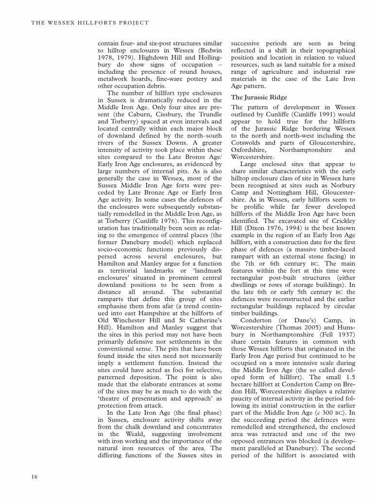
contain four- and six-post structures similar to hilltop enclosures in Wessex (Bedwin 1978, 1979). Highdown Hill and Hollingbury do show signs of occupation – including the presence of round houses, metalwork hoards, fine-ware pottery and other occupation debris.
The number of hillfort type enclosures in Sussex is dramatically reduced in the Middle Iron Age. Only four sites are present (the Caburn, Cissbury, the Trundle and Torberry) spaced at even intervals and located centrally within each major block of downland defined by the north–south rivers of the Sussex Downs. A greater intensity of activity took place within these sites compared to the Late Bronze Age/ Early Iron Age enclosures, as evidenced by large numbers of internal pits. As is also generally the case in Wessex, most of the Sussex Middle Iron Age forts were preceded by Late Bronze Age or Early Iron Age activity. In some cases the defences of the enclosures were subsequently substantially remodelled in the Middle Iron Age, as at Torberry (Cunliffe 1976). This reconfiguration has traditionally been seen as relating to the emergence of central places (the former Danebury model) which replaced socio-economic functions previously dispersed across several enclosures, but Hamilton and Manley argue for a function as territorial landmarks or ‘landmark enclosures’ situated in prominent central downland positions to be seen from a distance all around. The substantial ramparts that define this group of sites emphasise them from afar (a trend continued into east Hampshire at the hillforts of Old Winchester Hill and St Catherine’s Hill). Hamilton and Manley suggest that the sites in this period may not have been primarily defensive nor settlements in the conventional sense. The pits that have been found inside the sites need not necessarily imply a settlement function. Instead the sites could have acted as foci for selective, patterned deposition. The point is also made that the elaborate entrances at some of the sites may be as much to do with the ‘theatre of presentation and approach’ as protection from attack.
In the Late Iron Age (the final phase) in Sussex, enclosure activity shifts away from the chalk downland and concentrates in the Weald, suggesting involvement with iron working and the importance of the natural iron resources of the area. The differing functions of the Sussex sites in
successive periods are seen as being reflected in a shift in their topographical position and location in relation to valued resources, such as land suitable for a mixed range of agriculture and industrial raw materials in the case of the Late Iron Age pattern.
The Jurassic Ridge
The pattern of development in Wessex outlined by Cunliffe (Cunliffe 1991) would appear to hold true for the hillforts of the Jurassic Ridge bordering Wessex to the north and north-west including the Cotswolds and parts of Gloucestershire, Oxfordshire, Northamptonshire and Worcestershire.
Large enclosed sites that appear to share similar characteristics with the early hilltop enclosure class of site in Wessex have been recognised at sites such as Norbury Camp and Nottingham Hill, Gloucestershire. As in Wessex, early hillforts seem to be prolific while far fewer developed hillforts of the Middle Iron Age have been identified. The excavated site of Crickley Hill (Dixon 1976, 1994) is the best known example in the region of an Early Iron Age hillfort, with a construction date for the first phase of defences (a massive timber-laced rampart with an external stone facing) in the 7th or 6th century BC. The main features within the fort at this time were rectangular post-built structures (either dwellings or rows of storage buildings). In the late 6th or early 5th century BC the defences were reconstructed and the earlier rectangular buildings replaced by circular timber buildings.
Conderton (or Dane’s) Camp, in Worcestershire (Thomas 2005) and Huns-bury in Northamptonshire (Fell 1937) share certain features in common with those Wessex hillforts that originated in the Early Iron Age period but continued to be occupied on a more intensive scale during the Middle Iron Age (the so called developed form of hillfort). The small 1.5 hectare hillfort at Conderton Camp on Bredon Hill, Worcestershire displays a relative paucity of internal activity in the period following its initial construction in the earlier part of the Middle Iron Age (c 300 BC). In the succeeding period the defences were remodelled and strengthened, the enclosed area was retracted and one of the two opposed entrances was blocked (a development paralleled at Danebury). The second period of the hillfort is associated with
16
H I L L F O RT S T U D I E S A N D T H E W E S S E X P R O J E C T
dense internal occupation activity suggested by a row of tightly packed circular houses (possibly with several successive phases of construction) in the eastern half of the fort and an area given over to a very dense grouping of as many as 100 storage pits in the western half. This interpretation of the site is based on limited excavation carried out at the end of the 1950s and more recent geophysical survey (see Thomas forthcoming). Artefacts recovered from the interior, such as iron currency bars, are also indicative of the developed status of the site.
The multivallate hillfort at Hunsbury near Northampton (Fell 1937), possessing evidence of intensive occupation in the Middle Iron Age and a range of finds suggesting craft and exchange functions, is another possible contender for developed hillfort status in the region.
Prospecting techniques in hillfort archaeology
Hillforts in the landscape
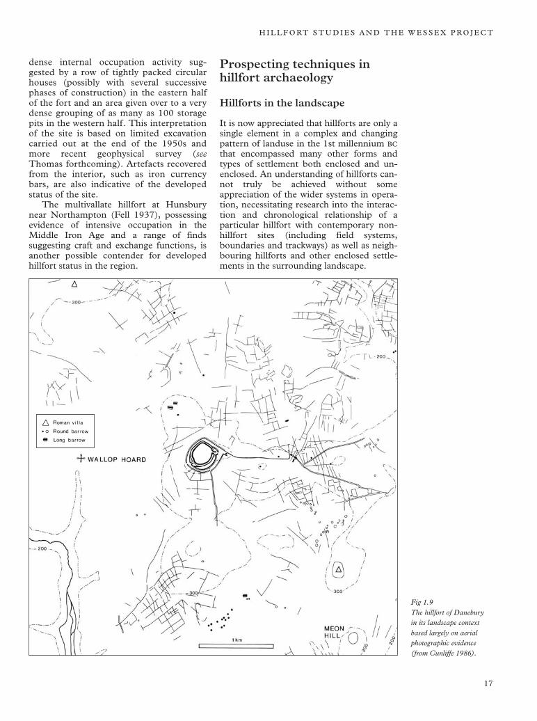
It is now appreciated that hillforts are only a single element in a complex and changing pattern of landuse in the 1st millennium BC
that encompassed many other forms and types of settlement both enclosed and unenclosed. An understanding of hillforts cannot truly be achieved without some appreciation of the wider systems in operation, necessitating research into the interaction and chronological relationship of a particular hillfort with contemporary nonhillfort sites (including field systems, boundaries and trackways) as well as neighbouring hillforts and other enclosed settlements in the surrounding landscape.
Fig 1.9 The hillfort of Danebury in its landscape context based largely on aerial photographic evidence (from Cunliffe 1986).
17
T H E W E S S E X H I L L F O RT S P R O J E C T
To understand the role of a hillfort in society it is necessary to understand how it relates to the surrounding settlement pattern. Intensified activity within a hillfort at a given point in time may be reflected in the simultaneous abandonment and depopulation of settlements in the surrounding landscape. This might be interpreted as the consequence of a time of crisis or the hillfort taking on the role of a semi-urban central place (Danebury and Maiden Castle).
The Maiden Castle Project in Dorset (Sharples 1991) and the Danebury Environs Project in Hampshire (Cunliffe 2000) are notable examples of projects that have in recent decades attempted to achieve this greater understanding using the systems approach. The theme of studying the hillfort in its chronological and landscape context has been continued in recent years by the South Cadbury Environs Project in Somerset centred on the hillfort of South Cadbury Castle (Coles et al 1999; Leach and Tabor 1997; Tabor and Johnson 2000) and at Castle Hill, Wittenham Clumps, Oxfordshire (Oxford Archaeology 2003, Payne 2002b, 2002c). Aerial photography was used to great effect in the 1980s to provide detailed evidence of archaeological sites in the environs of Danebury hill-fort (Fig 1.9; Palmer 1984), but in more recent years the use of ground-based archaeological prospecting has proved to be as important in studies of this nature, particularly in areas such as the South Cadbury Environs where the value of aerial photography is restricted due to both predominantly pastoral land use and a limited archive of available aerial photographic material. Recently, magnetometer survey has begun to provide a rich archaeological context for the hillfort of South Cadbury of similar quality to the results achieved from aerial reconnaissance in the mainly arable landscape (favourable to the formation of crop and soil marks over archaeological sites) around Danebury in Hampshire (Fig 1.9). A programme of aerial reconnaissance undertaken by the National Mapping Programme (Bewley 2001) has recently begun to provide evidence of the contemporary landscape setting of the ‘Ridgeway Hillforts’ (Segsbury, Uffington Castle and Alfred’s Castle) on the North Berkshire (or Lambourn) Downs, although most of this data has yet to be published.
The role of geophysical survey
The original excavations at South Cadbury in the 1960s (Alcock 1968a, 1968b, 1969, 1970, 1971) were some of the first
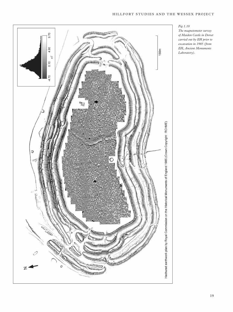
archaeological projects to employ geophysical methods on an ambitious scale not only as a predictive method to assist targeting of excavation but also to provide a wider context within which to interpret the excavations (Musson 1968; Tite 1972). Similar, equally successful, exercises linked to sample excavation were carried out during this period at Conderton Camp, Worcestershire and Rainsborough Camp, Northamptonshire (Aitken and Tite 1962; Tite 1972). These projects were a successful early demonstration of the effectiveness of magnetometry for exploring hillfort interiors and characterising the relative density of occupation features they contained. What was lacking was the ability to collect sufficiently high resolution data-sets, due to the slow mode of operation of the instruments, and the means to manipulate the data subsequently to produce easily interpretable visual representations. The approach first pioneered in the experiments of the 1960s at sites such as South Cadbury was not repeated until the early 1980s at Maiden Castle in Dorset, by which time geophysical techniques in archaeology were coming of age with the arrival of routine digital data recording and computerised plotting of the data. The complete magnetometer survey of Maiden Castle, undertaken by the Ancient Monuments Laboratory (AML) between 1984 and 1985 (Balaam et al 1991, Payne 1996) was a striking reaffirmation of the benefits of linking large scale overall geophysical coverage with smaller targeted research excavation of hillfort interiors (Fig 1.10). Digital capture of the data from Maiden Castle on portable field computers heralded the routine use of this method with resulting improvements in data presentation. The computer-plotted halftone or greyscale plots that became the norm in archaeological geophysics from the late 1980s onwards, coupled with the development of increasingly powerful information technology, allowed the results of geophysical surveys to be seen in much greater clarity than ever before and enabled the recognition of even the weakest anomalies from features such as ring-gullies. As the number of geophysical surveys of hillfort sites increased during the 1990s it gradually became apparent that, largely due to the technological improvements of the preceding decade, archaeological geophysics had the power to contribute much to our understanding of hillfort interiors.
18
H I L L F O RT S T U D I E S A N D T H E W E S S E X P R O J E C T
Fig 1.10 The magnetometer survey of Maiden Castle in Dorset carried out by EH prior to excavation in 1985 (from EH, Ancient Monuments Laboratory).
19
T H E W E S S E X H I L L F O RT S P R O J E C T
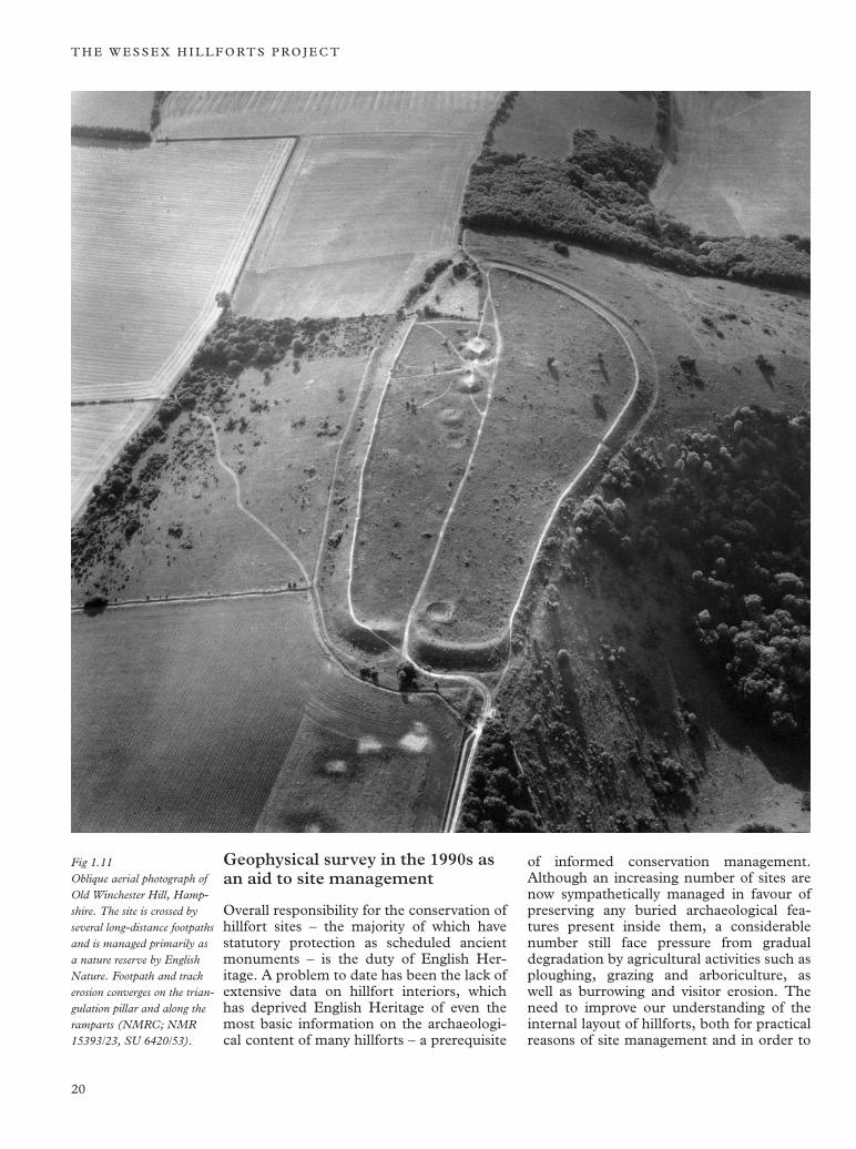
Fig 1.11 Oblique aerial photograph of Old Winchester Hill, Hampshire. The site is crossed by several long-distance footpaths and is managed primarily as a nature reserve by English Nature. Footpath and track erosion converges on the triangulation pillar and along the ramparts (NMRC; NMR 15393/23, SU 6420/53).
Geophysical survey in the 1990s as an aid to site management
Overall responsibility for the conservation of hillfort sites – the majority of which have statutory protection as scheduled ancient monuments – is the duty of English Heritage. A problem to date has been the lack of extensive data on hillfort interiors, which has deprived English Heritage of even the most basic information on the archaeological content of many hillforts – a prerequisite
of informed conservation management. Although an increasing number of sites are now sympathetically managed in favour of preserving any buried archaeological features present inside them, a considerable number still face pressure from gradual degradation by agricultural activities such as ploughing, grazing and arboriculture, as well as burrowing and visitor erosion. The need to improve our understanding of the internal layout of hillforts, both for practical reasons of site management and in order to
20
H I L L F O RT S T U D I E S A N D T H E W E S S E X P R O J E C T
640 642 643
-3.20 -0.23 2.73 5.70 nT
Linear greyscale - data enhanced by 1m Gaussian low-pass filter
Crown copyright, RCHME
655
656
657
N
641 0 30 90m
Scale
continue to improve our academic comprehension of the role and functions of this class of monument without resorting to costly and undesirable ground disturbance, were the two main underpinning reasons for the development of the programme of largely geophysical survey-based research described in this volume.
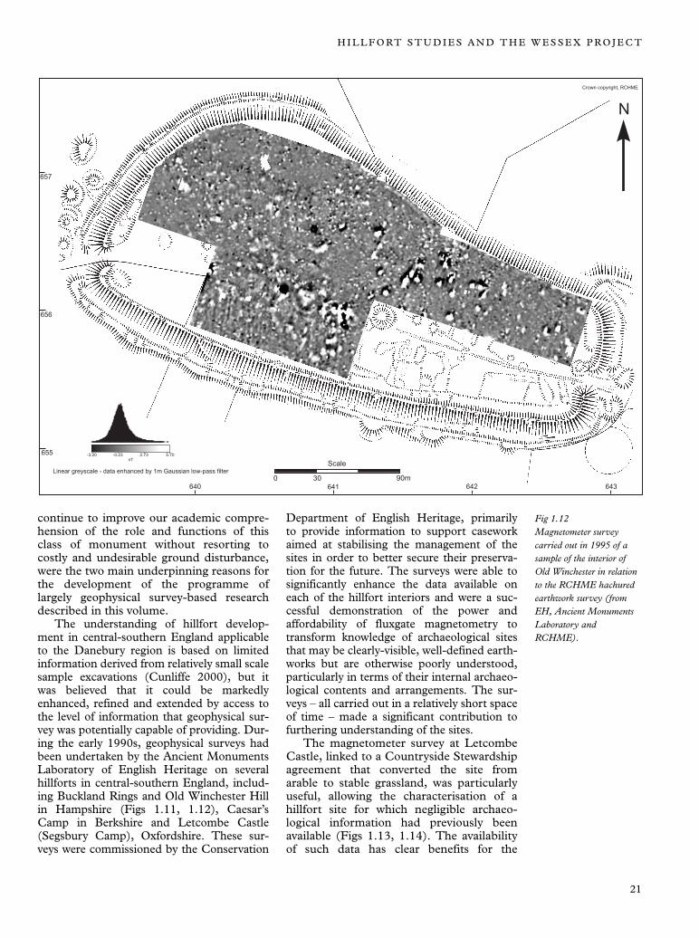
The understanding of hillfort development in central-southern England applicable to the Danebury region is based on limited information derived from relatively small scale sample excavations (Cunliffe 2000), but it was believed that it could be markedly enhanced, refined and extended by access to the level of information that geophysical survey was potentially capable of providing. During the early 1990s, geophysical surveys had been undertaken by the Ancient Monuments Laboratory of English Heritage on several hillforts in central-southern England, including Buckland Rings and Old Winchester Hill in Hampshire (Figs 1.11, 1.12), Caesar’s Camp in Berkshire and Letcombe Castle (Segsbury Camp), Oxfordshire. These surveys were commissioned by the Conservation
Department of English Heritage, primarily to provide information to support casework aimed at stabilising the management of the sites in order to better secure their preservation for the future. The surveys were able to significantly enhance the data available on each of the hillfort interiors and were a successful demonstration of the power and affordability of fluxgate magnetometry to transform knowledge of archaeological sites that may be clearly-visible, well-defined earthworks but are otherwise poorly understood, particularly in terms of their internal archaeological contents and arrangements. The surveys – all carried out in a relatively short space of time – made a significant contribution to furthering understanding of the sites.
The magnetometer survey at Letcombe Castle, linked to a Countryside Stewardship agreement that converted the site from arable to stable grassland, was particularly useful, allowing the characterisation of a hillfort site for which negligible archaeological information had previously been available (Figs 1.13, 1.14). The availability of such data has clear benefits for the
Fig 1.12 Magnetometer survey carried out in 1995 of a sample of the interior of Old Winchester in relation to the RCHME hachured earthwork survey (from EH, Ancient Monuments Laboratory and RCHME).
21
T H E W E S S E X H I L L F O RT S P R O J E C T
management of the site: for example, the information provided by the survey is of practical use for determining if a zone that is suffering from erosion due to burrowing or heavy footpath wear also contains vulnerable archaeological features. Mitigation measures can then be taken to decrease the threat of erosion in the vulnerable area (for example by re-routing foot-paths). Other ground disturbance such as the erection of fences and sign-posts can be avoided in areas where the survey has indicated the presence of archaeological features. In addition to the surveys carried out for management purposes, the ability of geophysical methods to help address substantial archaeological questions related to hillforts was also emphatically demonstrated by a succession of surveys in support of the Danebury Environs and Uffington White Horse Hill Projects between 1989 and 1991 (Cunliffe 2000, Miles et al 2003).
Because of the degree of overlap, it is necessary at this point to provide a brief review of geophysical survey of hillfort sites in southern England that led up to the development of the Wessex Hillforts Survey programme. These surveys, carried out between 1989 and 1995, were a major influence on the design of the subsequent project carried out between 1996–8.
The hillforts of the Lambourn and Marlborough Downs (or the Ridgeway group)
The survey at Segsbury Camp (or Letcombe Castle) carried out from 1993–5, provided the clearest illustration of the considerable academic potential of geophysical methods in hillfort research (Fig 1.14). Letcombe is one of the grouping often referred to as the Ridgeway Hillforts which, with the exception of Uffington Castle, had been subject to very limited investigation before 1993 (some excavation by the Hillforts of
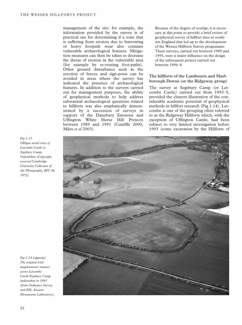
Fig 1.13 Oblique aerial view of Letcombe Castle or Segsbury Camp, Oxfordshire (Copyright reserved Cambridge University Collection of Air Photographs, BIT 36, 1972).
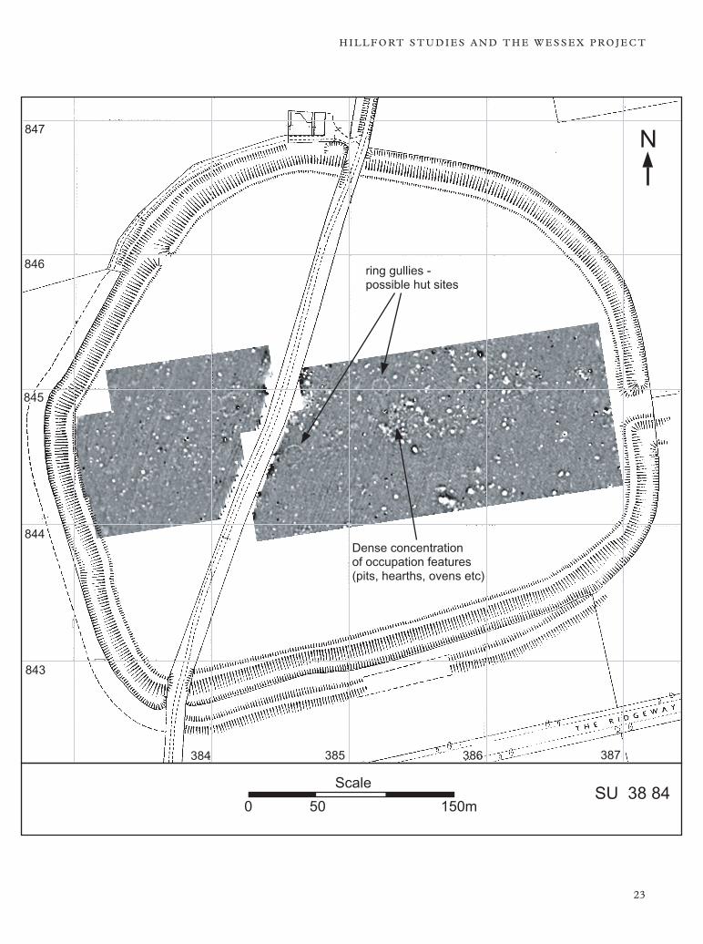
Fig 1.14 (opposite) The original trial magnetometer transect across Letcombe Castle/Segsbury Camp undertaken in 1993 (from Ordnance Survey and EH, Ancient Monuments Laboratory).
22
H I L L F O RT S T U D I E S A N D T H E W E S S E X P R O J E C T
847 N
846 ring gullies possible hut sites
845
844 Dense concentration of occupation features (pits, hearths, ovens etc)
843
384 385 386 387
0 50 150m
Scale SU 38 84
23
T H E W E S S E X H I L L F O RT S P R O J E C T
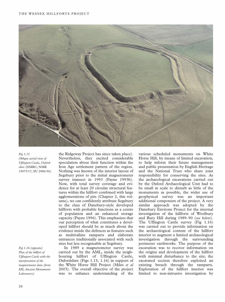
Fig 1.15 Oblique aerial view of Uffington Castle, Oxfordshire (NMRC; NMR 15073/17, SU 2986/30).
Fig 1.16 (opposite) Plan of the hillfort of Uffington Castle with the interpretation of the magnetometer data (from EH, Ancient Monuments Laboratory).
the Ridgeway Project has since taken place). Nevertheless, they excited considerable speculation about their function within the Iron Age settlement pattern of the region. Nothing was known of the interior layout of Segsbury prior to the initial magnetometer survey transect in 1993 (Payne 1993b). Now, with total survey coverage and evidence for at least 20 circular structural features within the hillfort combined with large agglomerations of pits (Chapter 2, this volume), we can confidently attribute Segsbury to the class of Danebury-style developed hillforts with probable functions as a centre of population and an enhanced storage capacity (Payne 1996). This emphasises that our perception of what constitutes a developed hillfort should be as much about the evidence inside the defences as features such as multivallate ramparts and elaborate entrances traditionally associated with such sites but less recognisable at Segsbury.
In 1989 a magnetometer survey was carried out by the AML, inside the neighbouring hillfort of Uffington Castle, Oxfordshire (Figs 1.15, 1.16) in support of the White Horse Hill Project (Miles et al 2003). The overall objective of the project was to enhance understanding of the
various scheduled monuments on White Horse Hill, by means of limited excavation, to help inform their future management and public presentation by English Heritage and the National Trust who share joint responsibility for conserving the sites. As the archaeological excavations carried out by the Oxford Archaeological Unit had to be small in scale to disturb as little of the monuments as possible, the wider use of geophysical survey was an important additional component of the project. A very similar approach was adopted by the Danebury Environs Project for the internal investigation of the hillforts of Woolbury and Bury Hill during 1989–90 (see below). The Uffington Castle survey (Fig 1.16) was carried out to provide information on the archaeological content of the hillfort interior to augment a limited archaeological investigation through the surrounding perimeter earthworks. The purpose of the excavation was to recover information on the origins and development of the hillfort with minimal disturbance to the site; the excavated section therefore exploited an existing breach through the ramparts. Exploration of the hillfort interior was limited to non-intrusive investigation by
24

T H E R I D
G E WA Y
H I L L F O RT S T U D I E S A N D T H E W E S S E X P R O J E C T
White HorseN
866
Prehistoric and Roman burial mound
Bronze Age round-barrow
865
864
863
AREAS OF ANOMALOUS MAGNETIC ACTIVITY
862 1. ?ferrous material
2. ?geological
LINEAR/CURVI-LINEAR ANOMALIES N linear anomalies alongside ramparts
former cultivation patterns
tentative anomalies
298
Scale DISCRETE ANOMALIES
0 30 90m occupation features
299 300 301
861
25
T H E W E S S E X H I L L F O RT S P R O J E C T
magnetometer survey (see Payne 2003a). Despite the availability of numerous aerial photographs of the site, few of them had revealed any detail of archaeological features within the hillfort except for traces of Medieval or Post Medieval strip cultivation. Magnetometer survey, therefore, had an important role in mapping the density and layout of any buried archaeological features present underneath the relatively blank physical topography of the hillfort interior. The pattern of discrete magnetic anomalies mapped by the survey (Fig 1.16) suggests that the site contains a moderate density of pits dispersed fairly evenly across the interior, with some loose clusters of pits and closely paired pits in places but otherwise few indications of any other forms of occupation (such as ring gullies).
Subsequently during 1994–5 some small-scale excavation took place inside Uffington Castle as part of the Hillforts of the Ridge-way research project undertaken by the Oxford University Department of Continuing Education (Miles et al 2003). The areas of the hillfort interior that were opened up were carefully positioned to investigate areas containing geophysical anomalies mapped by the earlier 1989 survey. Of the sample of magnetic anomalies investigated by excavation, ten were shown to represent pits with fills containing Iron Age and Romano-British material and another one was found to be an oven of Romano-British date. The availability of the geophysical data was crucial for enabling the precise targeting of small excavation areas (strictly limited in extent by the terms of the Scheduled Monument Consent to excavate) onto features of interest, thus avoiding unnecessary ground disturbance and wasted effort on opening up unrewarding trenches. The relative paucity of features inside Uffington Castle (see below) compared to other hillforts with long sequences of habitation (such as Danebury and Maiden Castle) presented the very real danger of opening up blank areas and missing the archaeological features that were being sought to provide material evidence for the occupation history of the site. The magnetometer survey and subsequent excavation at Uffington demonstrated that large and medium sized pits were easily detectable with a traverse separation of 1.0m and a reading interval of 0.25m along traverses (1.0 × 0.25), but smaller post-hole type features generally failed to register appreciable anomalies, even when the traverse interval was reduced to 0.5m (Payne 1996).
The conclusion drawn from the geophysical results from Uffington (based on the density and range of features mapped within the hillfort) was that it had only been occupied for a relatively short period of time during the earlier Iron Age. Excavation has now demonstrated further activity on the site during the Roman period that resulted in the incorporation of material of Roman date in the partially filled up earlier Iron Age pits. In this respect the site parallels other hill-forts in the region, such as Woolbury, which after a period of disuse when the defences were no longer maintained (often lasting many centuries) were reoccupied by farming communities from the Late Iron Age into the Roman period. Liddington Castle, sited in a similar position to Uffington above the northern scarp of the Marlborough–Lambourn Downs, probably also had a similar history of occupation, as suggested by finds of early Iron Age and Roman material (Bowden 2000; Hirst and Rahtz 1996).
Hampshire hillforts
Although no large scale geophysical survey took place at Danebury itself, during the early 1990s the Ancient Monuments Laboratory (AML) took part in the subsequent research on the Danebury Environs (see Fig 1.6), providing a series of fluxgate magnetometer surveys on several of the neighbouring hillfort sites to Danebury (Cunliffe 2000). The aim of the Danebury Environs Project was to arrive at a broader understanding of the interaction of the hillfort with its contemporary environment by studying the development of settlement and contemporary systems of land allotment in its locality from the end of the Bronze Age to the beginning of the Roman period. The eventual objective was to understand the role of the hillfort in the context of the changing social and economic systems in the wider Danebury area during the 1st millennium BC.
As a first step in the study it was clearly crucial to examine the several other hillforts in the immediately surrounding area to assess their development relative to Danebury (addressing questions such as: when they were established, how long they were occupied for, how many phases of occupation were represented and when did they go out of use?). Magnetometer surveys played an integral part in this process.
The nearest hillfort to Danebury, located 4 miles (6.4km) to the south-east, is at Woolbury near Stockbridge, Hampshire
26
H I L L F O RT S T U D I E S A N D T H E W E S S E X P R O J E C T
(see Fig 1.6 and Fig 2.30). Woolbury appeared, on the basis of the surviving earthwork remains, to represent an example of a simple, Early Iron Age hillfort, constructed at about the same time as the first phase of hillfort defences at Danebury (in the 5th century BC). The straightforward construction of the ramparts suggested however, that, unlike Danebury, it was potentially unencumbered by Middle Iron Age occupation. The results of the fluxgate magnetometer survey carried out by the AML between 1989 and 1990 clearly indicated a low level of magnetic activity inside the hillfort, suggesting that settlement activity within Wool-bury was of a much lower intensity than at Danebury. This interpretation was subsequently confirmed by excavation, which revealed that, unlike Danebury, Woolbury did not develop as a major focal point of habitation (Cunliffe and Poole 2000a). The magnetometer survey also confirmed the location of the missing eastern section of the hillfort ditch, which later excavation showed had been gradually infilled and levelled by cultivation during the late Iron Age and Roman period, when a small farming community was established in the abandoned hillfort. This farmstead, which consisted of a series of enclosures defined by narrow ditches, was detected by the magnetometer as a group of linear anomalies in the eastern part of the survey area.
In 1990, the second year of the Danebury Environs Project, at Bury Hill (4 miles (6.4km) north of Danebury on the outskirts of Andover), it was again critical to define the status and development of the hillfort in relation to the neighbouring forts in the area at Balksbury, Danebury and Woolbury (see Fig 1.6). Bury Hill (see Fig 2.13) had been interpreted as the remains of two hillforts (Hawkes 1940) – a smaller, strongly fortified bivallate enclosure (Bury Hill II) superimposed on a larger, more lightly defended fort with a single rampart (Bury Hill I). The earthworks of Bury Hill I are now understood (Cunliffe and Poole 2000b) to represent the remains of an Early Iron Age hillfort which, after a long period of disuse, was succeeded by the fortification of Bury Hill II. In 1990 the AML carried out flux-gate magnetometer surveys in each of the forts, covering 47 % of the area enclosed by the inner fort (Bury Hill II) and a more limited area of the remaining part of the earlier outer enclosure (Bury Hill I). It was hoped that magnetometer survey would be able to demonstrate the relative intensity of occupa
tion in each fort by surveying sufficiently large areas to show contrasting or recurring patterns of activity. The results suggested that the early fort was largely devoid of significant features, in sharp contrast with the later fort, which appeared to contain a moderately high density of pits of various sizes scattered evenly across the area surveyed. Following the survey, excavation in the two forts showed that Bury Hill I was probably never used intensively, whereas there was plentiful evidence of high status activity (of the Late–Middle Iron Age) within the defences of Bury Hill II (Cunliffe and Poole 2000b), fully confirming the initial expectations based on the magnetic data.
Magnetometer survey of a sample of the interior of Old Winchester Hill hillfort (see Figs 1.11, 1.12) carried out by the AML in 1995 – again for the purposes of improving management and presentation of the site (in a publicly accessible nature reserve) to visitors – produced very similar results to those obtained from the hillfort of Woolbury. On the evidence of the magnetic data, Old Winchester appears to contain only thin scatters of pits interspersed with empty areas, although features associated with a linear group of round barrows occupying a central position within the later fort were also detected.
Off-chalk sites
The results of magnetometer surveys at Buck-land Rings (Hampshire) and Caesar’s Camp (Berkshire) in 1993 and 1995 (Payne 1993a; Linford 1995) were less informative than those obtained from hillforts on chalk geology or chalk plateau drift, possibly reflecting less than optimal geology for magnetic prospection. Buckland Rings (NGR SZ 31 96) lies off the chalk on a spur of Pleistocene plateau and river terrace gravels deposited over Tertiary sands of the Bagshot Beds on the south-east edge of the New Forest near the coastal town of Lymington. Caesar’s Camp in Windsor Forest (NGR SU 864 657) is situated on similar geology consisting of plateau gravel over sands of the Barton Beds.
The results of the magnetometer survey at Buckland Rings were poor by comparison with some of the forts surveyed in the years previously on the Hampshire chalkland to the north. With the exception of sections of the defences, the position of the entrance-way plus evidence for a former archaeological intervention detected along the eastern degraded side of the fort (Hawkes 1936), anomalies that could relate to archaeological
27

T H E W E S S E X H I L L F O RT S P R O J E C T
Fig 1.17 (opposite) The location of the Wessex Hillforts Survey area indicating the sites included in the project and other main hillfort sites in central Southern England.
features in the interior were all but absent. Magnetic susceptibility (MS) values from the topsoil were low, suggesting geological conditions unfavourable to the detection of features such as pit fills. The apparent absence of magnetic anomalies indicative of archaeological features inside the hillfort could therefore reflect the local geology rather than a genuine lack of internal activity. Despite the uncertainty over the internal character of the hillfort, the survey still provided valuable information for informing the future management of the site, in particular by identifying the position and form of the main eastern entrance through the defences into the hillfort along part of the defensive circuit where the earthworks are poorly preserved.
In 1995, a survey of a sample of Caesar’s Camp carried out by the AML (Linford 1995), succeeded in detecting an internal quarry ditch inside the line of the inner rampart and a thin scatter of possible pits together with an aggregate of pits in the interior. Magnetic susceptibility (MS) was highest in the vicinity of the ramparts (suggestive of occupation concentrated in the area close to them) but MS values recorded over the rest of the site were very low (suggesting a lack of iron rich minerals in the topsoil developed over the site). Assuming that the magnetic evidence is a reliable indication of the buried features present within the fort, the results from Caesar’s Camp suggest a relatively sparse degree of activity within the area sampled and provide little evidence for sustained occupation or a wealth of interior structures. However, as was the case at Buckland Rings, it was thought that the identification of subtle magnetic anomalies would be unlikely on a site with such extremely low topsoil and subsoil MS values.
Although in the first half of the 1990s geophysical survey on hillfort sites in southern England was targeted on a largely piecemeal basis according to management priorities, magnetometer survey in particular proved capable of making a substantial contribution towards the study of hillfort sites. In the majority of cases, geophysical survey provided the means of assessing the distribution and intensity of settlement activity within the interior of a particular hillfort, thus providing an insight into the length of occupation of the site, how space was organised and where different activities were carried out in the enclosed space. There clearly was, then, scope to
undertake a strategic programme of geophysical survey, in order to extend the potential shown by the earlier surveys to explore the diversity of hillfort settlement patterns at a regional level.
The development of the Wessex hillforts survey programme In the wake of all the relatively unstructured activity described above, came the realisation that non-destructive geophysical survey techniques could make a wider contribution to broadening knowledge of hillfort origins, function and development in central-southern England. The result was a proposal for a more ordered and wide-ranging thematic survey project on hillforts focusing on the chalk downland of Wessex (Fig 1.17), where a sound database of knowledge of Iron Age archaeology was already in existence, acquired over many years through the research by Cunliffe on Danebury and its environs and earlier archaeologists such as Hawkes and Cunnington. This programme of survey was christened the Wessex Hillforts Project or Wessex Hillforts Survey. Unlike most earlier hillfort related projects in southern England, the study was designed to be more ambitious in scale, investigating hillforts spread across a wide region but at a relatively coarse level of detail, rather than examining groups of sites in a smaller locality in some considerable detail as had already been done by the Danebury Environs Project. Although magnetometry is only capable of providing a relatively coarse level of detail of the buried archaeological features present in a given hill-fort, compared to what can be achieved by intrusive means, a large number of sites can be covered economically and in a short space of time. The project was designed to bridge the gap between these two levels of investigation and extend the study of hillforts into the areas immediately beyond the Danebury Environs, drawing upon the backdrop of previous detailed research to provide a context within which to interpret the results from the new sites. One of the principals of the project was to include as many different types of hill-fort (in terms of size of area enclosed and the form of the defences) as possible, in order to obtain a representative sample of the diverse range of hillfort sites present in the area (see Fig 1.1). This was a particularly important aspect of the project, designed to enable the possible interrelationship of hillfort form and function to be examined. The fact that the project was based entirely on non-invasive
28
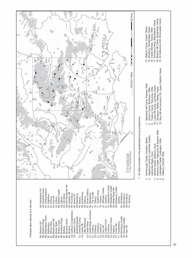
Ul
Prin
cipa
l site
s re
ferr
ed to
in th
e te
xt :
Ca
Hd U
cR
h 2.
B
w
3.
Bn
Ban
bury
Hill
Hb
Ham
bled
on H
ill1.
5.
B
d B
adbu
ry R
ings
Hd
Har
dwel
l Cam
p4.
B
s B
h B
atha
mpt
on D
own
Ht
Har
ting
Bea
con
6.
Gm
B
t B
attle
sbur
yH
i H
ighd
own
Fo
Bi
Bilb
ury
Rin
gH
l H
olbu
ryC
g 8.
C
b C
s
Bw
Ble
wbu
rton
Hill
Ho
Hod
Hill
Wo
Bh
Ry
7.
13.
Bo
Bow
ry W
alls
Ld
Lidb
ury
Br
Bra
tton
Cam
pM
c M
aide
n C
astle
9.
18.
Ld
Bk
Buc
klan
d R
ings
Og
Ogb
ury
Br
Sd
10.
Wi
Bl
Bul
bury
Os
Old
Sar
umC
c
Bs
Bus
sock
Woo
dO
w O
ld W
inch
este
r H
illB
t S
b B
o B
z B
uzbu
ryQ
u Q
uarle
y H
ill12
/16.
T
d C
g C
adbu
ry C
ongr
essb
ury
Pd
Pou
ndbu
ryC
hC
d Y
n V
s Q
u O
g11
. C
s C
aesa
r’s
Cam
p,
Rh
Ram
s H
ill17
.(E
asth
amps
tead
)R
w R
awls
bury
Ws
Bi
Gv
Os
Fg
14.
Cc
Cas
terle
y C
amp
Ry
Ryb
ury
Ca
Cas
tle H
ill,
Sb
Scr
atch
bury
Littl
e W
itten
ham
Sd
Sid
bury
Sc
15.
Ci
19.
Cp
Cas
tle P
iece
Sc
Sou
th C
adbu
ryC
r C
e D
n C
r C
astle
Rin
gs, D
onhe
adS
p S
petti
sbur
yH
h W
h T
t H
l O
w
Tb
Cl
Cha
lbur
yT
r T
he T
rund
leH
t
Cb
Chi
sbur
yT
d T
idbu
ryH
b F
r C
i C
hise
lbur
yT
t To
othi
ll C
amp
Bn
Ho
Cp
Tr
Ce
Cle
arbu
ryT
b To
rber
ryR
w
Bz
Ch
Cle
y H
illU
c U
ffing
ton
Cas
tleH
i B
d C
d C
odfo
rd C
ircle
Ul
Ule
ybur
yS
p D
d D
d D
udsb
ury
Vs
Ves
pasi
an’s
Cam
pW
b W
dB
k D
n D
unw
ood
Cam
pW
b W
eath
erby
Cas
tleP
d B
l F
g F
igsb
ury
Ws
Whi
te S
heet
Hill
Fo
For
est H
IllW
h W
hits
bury
Cas
tleM
c
Fr
Fra
nken
bury
Ditc
hes
Gm
Grim
sbur
y C
astle
Wi
Win
kleb
ury
Cl
Gv
Gro
vele
y C
astle
Wd
Woo
dbur
yH
h H
am H
ill
Wo
Wor
lebu
ryO
ver
6 he
ctar
es e
nclo
sed
Yn
Yar
nbur
y1.
2 -
6 he
ctar
es e
nclo
sed
Und
er 1
.2 h
ecta
res
encl
osed
P
RO
JEC
T A
RE
A
0 50
Km
s
1 -
19 S
ites
incl
uded
in th
e ge
ophy
sica
l sur
vey
prog
ram
me
:
1.
Per
boro
ugh
Cas
tle, C
ompt
on. B
erks
7.
Mar
tinse
ll H
ill C
amp,
Pew
sey,
Wilt
s13
. W
albu
ry C
amp,
Inkp
en, B
erks
2.
Seg
sbur
y C
amp
(or
Letc
ombe
Cas
tle),
8.
Oliv
er’s
Cam
p, B
rom
ham
, Wilt
s14
. W
oolb
ury,
Sto
ckbr
idge
, Han
tsLe
tcom
be R
egis
, Oxo
n9.
F
osbu
ry C
amp,
Tid
com
be, W
ilts
15.
Cas
tle D
itche
s, T
isbu
ry, W
ilts
3.
Alfr
ed’s
Cas
tle, A
shbu
ry, O
xon
10.
Ladl
e H
ill C
amp,
Litc
hfie
ld, H
ants
17.
Nor
sebu
ry R
ing,
Mic
held
ever
, Han
ts4.
B
arbu
ry C
astle
, Ogb
ourn
e S
t And
rew
, Wilt
s11
. D
aneb
ury,
Net
her
Wal
lop,
Han
ts18
. B
eaco
n H
ill C
amp,
Bur
ghcl
ere,
Han
ts5.
Li
ddin
gton
Cas
tle, L
iddi
ngto
n, W
ilts
12.
Bur
y H
ill a
nd e
nviro
ns (
16),
Upp
er C
latfo
rd, H
ants
19
. S
t Cat
herin
e’s
Hill
, Win
ches
ter,
Han
ts
6.
Old
bury
, Che
rhill
, Wilt
s
29
T H E W E S S E X H I L L F O RT S P R O J E C T
methods was another element in its favour, and the project represented a rare opportunity to demonstrate that geophysical fieldwork was capable in its own right of making a contribution to solving substantive archaeological problems without the need for any disturbance to the sites.
Broad issues that it was hoped geophysical survey would potentially be able to resolve included such questions as:
• Are all large, slightly defended early Iron Age enclosures actually largely devoid of settlement activity – as the few excavatedexamples suggest?
• Which hillforts appear to exhibit comparable densities of occupation to developed hillforts such as Danebury and Maiden Castle?
• Where a series of hillforts have been postulated as the largely contemporary centres of adjacent territorial blocks (such as those on the Ridgeway and the South Downs), do they exhibit a similar density and character of occupation?
• Where two or more hillforts are in unusually close proximity, do they exhibit similar densities of occupation? or does one appear to be more intensively occupied?
• Does occupation commonly occur outsidehillforts?
In addition, site-specific issues could be examined, for example: Does the frequently referenced ‘unfinished’ hillfort at Ladle Hill actually contain a settlement?
The survey area The area chosen for the study was the eastern half of Wessex, comprising three main blocks of undulating chalk downland broken by river systems, including the Hampshire Downs, the North Berkshire Downs and the eastern part of Salisbury Plain (see Fig 1.17). The area contains at least two major groupings of hillforts: those of the Danebury region studied by the Danebury Environs Project and the ‘Ridgeway hillforts’ of the Marlborough and Lambourn Downs on the edge of the chalk escarpment overlooking the Vale of the White Horse to the north. The area is bounded by the Upper Jurassic geology of the Vale of the White Horse and the Thames Valley to the north and the Tertiary deposits of the Hampshire Basin to the south. In contrast to the northern and southern limits of the project area, the eastern and western boundaries are not
defined by any natural physical features such as geological boundaries or major river valleys. The eastern boundary follows a north–south line across chalk downland approximately parallel with and just to the east of the A34 main trunk road from Winchester to Newbury as far as the Goring Gap. This line places the Tertiary deposits of London Clay and Bagshot Beds east of Basingstoke and Newbury largely outside the eastern boundary of the project. The south-east corner of the study area coincides approximately with the city of Winchester. The western edge of the project area runs in a north–south line through the middle of Salisbury Plain, 10km east of the towns of Shaftsbury and Warminster up to Devizes in the north-west corner of the study area. In total the study area covers approximately 6,000 sq km and includes parts of the counties of Berkshire, Hampshire, Oxfordshire and Wiltshire.
Collis (1994) has recently stressed the pre-eminence of Wessex for British Iron Age studies, and it was clearly important that a pilot project involving the large scale geophysical survey of hillforts should take place against as comprehensive a backdrop of interpretative data as possible. In addition, the efficacy of geophysical techniques on chalk substrates has been amply demonstrated (David and Payne 1997, Payne 2000a) and the selection of primarily chalkland sites was a deliberate attempt to maximise the probability of achieving successful results.
The diversity of hillfort sites in the area would allow the study of hillfort interiors relative to the area enclosed and the complexity of the defences, enabling possible relationships between site form and internal layout to be recognised. Although a wide range of hillfort types are represented in the area (see Fig 1.1), few have yet been excavated on any scale and therefore the internal characteristics of the majority of the sites, and the variation in these between sites, largely remained a mystery.
The area also possesses the potential for integrating geophysical survey with access and management schemes in association with a number of countryside and environmental agencies such as The National Trust, English Nature, local authorities and the Countryside Commission who own or are involved with the management of several hillfort sites in the region, with scope for informing the public about the archaeological significance of the sites. Hitherto the lack of data has prevented these agencies
30
H I L L F O RT S T U D I E S A N D T H E W E S S E X P R O J E C T
from doing this at more than a very basic level. Furthermore, there was a pressing need to identify sites with high archaeological potential presently in unsympathetic management in order to help prioritise and target conservation initiatives aimed at securing the preservation of sites where archaeological information was potentially being gradually degraded over time through lack of intervention.
The sites included in the project and selection criteria The sites selected for survey make up a representative sample of the various hillfort types identified in the region. For reasons of cost and because of practical considerations such as tree cover on some sites, it was not possible to attempt a systematic and exhaustive study of all the hillforts in the project area. Two hillforts in close proximity to one another just north of Newbury at Bussock Wood and Grimsbury Castle had to be omitted from the sample because both are currently in wooded areas. Other hillforts close to expanding towns such as Andover, Basingstoke and Southampton had not escaped being built over by housing and road development. Because of the constraints of such land use on the effective application of geophysical methods an initial selection process was operated whereby a short-list of the most suitable sites for survey was prepared from English Heritage management sources. The selection of sites also reflected management priorities based on perceived threats to the sites such as pressures arising from cultivation and other forms of erosion. The short-list of sites included in the survey programme (see Fig 1.17, Sites 1–19) was arrived at by the following means:
1. Surface conditions were required to be suitable for survey with minimal surface obstruction from vegetation or modern ferrous contamination.
2. The underlying geology should be favourable for magnetometer survey and reasonably consistent across the total sample (chalk, greensand or clay-with-flints).
3. Where sites were under grassland, priority was to be given to sites in public management (such as Barbury Castle) or with extensive public access.
4. Sites with existing adequate geophysical survey coverage (such as Uffington Castle) were excluded.
Surveys could only be carried out with the full consent of the landowners and in one case (Tidbury Ring, Hampshire) permission was not forthcoming requiring the substitution of an alternative site (Fosbury, Wiltshire).
The resultant list of sites was then considered in terms of its methodological and academic integrity. In methodological terms it was important that the sample contained a balance of sites with surviving earthwork remains in the interior (for example Beacon Hill) and sites under permanent cultivation with largely plough flattened interiors (for example Norsebury Ring). In addition it was proposed to survey an unexcavated area inside Danebury to provide a control method for assessing how representative geophysical data is of the full archaeological content of a hillfort where it is known from excavation.
In academic terms the sample was checked and, where necessary, augmented to ensure that it included the following:
1. Examples of recognised hillfort types such as large hilltop enclosures, eg Walbury, Martinsell; univallate contour hillforts, eg Liddington Castle, St Catherine’s Hill; multivallate hillforts, eg Barbury Castle, Castle Ditches; and small hillforts, eg Oliver’s Camp, Alfred’s Castle
2. Examples from previously suggested ‘groupings’ of hillforts, eg the ‘Ridgeway forts’ (Barbury Castle, Liddington Castle, Uffington Castle and Letcombe Castle (Segsbury Camp))
3. Examples from the Danebury Environs (Bury Hill and Woolbury)
4. Examples of hillforts in unusually close proximity (eg Danebury and Woolbury; Beacon Hill and Ladle Hill)
5. Examples of special interest (eg the ‘unfinished’ hillfort at Ladle Hill).
After this procedure was carried out, the total internal area of all the sites selected was calculated and an attempt made to match the amount of survey coverage required to the budget available. The shortlist was finally adjusted to include the widest possible range of hillfort types including some of the larger examples, such as Walbury Hill Camp in Berkshire, within the budgetary constraints. This allowed a total of 18 sites to be included in the project with an additional external survey area at Bury Hill in Hampshire.
Of the 18 hillfort sites selected for study by the project, excavation had only
31
T H E W E S S E X H I L L F O RT S P R O J E C T
previously been carried out inside five (excluding Danebury): Bury Hill and Woolbury for the Danebury Environs Project (Cunliffe 2000); earlier work by C F C Hawkes at Bury Hill and St Catherine’s Hill (Hawkes 1940 and 1976); Liddington Castle in 1976 (Hirst and Rahtz 1996) and an excavation at Oliver’s Camp near Devizes by M E Cunnington, published in 1908. All of these documented interventions were small-scale and based on a single season of excavation.
Seven out of the 18 sites selected for survey under the project possessed scope for improved interpretation in their management as public open spaces.
Wherever practical, 100% samples of the interior of each hillfort were surveyed. In some cases this was not possible due to partial tree cover or other unsuitable terrain such as quarried areas.
The aims and objectives of the project In his 1976 introduction to Hillforts: Later Prehistoric Earthworks in Britain and Ireland, Avery writes:
We need the exploration of the interiors of both major and minor forts, and also the exploration of nearby settlement sites, on a scale large enough to throw light on the population, social structure and economy of these sites. Just as no two sites reflect identical approaches to tactical defence, so all sites will vary in social structure and economy. The task of the next 40 years must be to create sound data, and a sound chronology, as the basis for an understanding of these aspects.
The Wessex Hillforts Project was initiated in an attempt to contribute to this long process of broadening understanding. To date our knowledge of hillforts in general has been reliant on a limited number of intensively studied sites such as Danebury, while the bulk of sites remained poorly understood. The Wessex Hillforts Project was designed to help right this imbalance, therefore allowing a more synthetic approach to hillfort study.
In a recent collection of papers entitled Science in Archaeology: an agenda for the future (Bayley 1998; Gaffney et al 1998) the Wessex Hillforts Project is described as an example of a site-based project that employed geophysics as the prime methodology (as
opposed to more traditional and costly intrusive techniques) for the investigation of hill-fort interiors. Using a planned sampling strategy (involving a selection of representative hillfort types), the project attempted to rectify not only the historic excavation bias towards hillfort defences, but also combined investigations into the nature of early and developed hillforts, spatial differentiation of function, regionally and at an intra-site level. Also included in the research design (Trow et al 1996) was the exploratory assessment of a number of methods including magnetic susceptibility and digital terrain modelling, for rapid characterisation of hillfort interiors and settlement intensity. This approach represented a measured response to archaeological problems that might otherwise have demanded a massive investment in traditional excavation, but without being directly threatened by development the sites included in the project were unlikely to see such an investment in the foreseeable future. The project was designed to solve substantive archaeological problems explicitly using geophysical data and data from other noninvasive sources.
The over-arching aims of the project were to provide data for improved management and interpretation as well as widening academic comprehension of the diverse hill-fort types in Wessex, particularly in terms of their relative socio-economic function and varying occupation histories as reflected in their internal layout.
The specific objectives of the project as set out in the 1996 Project Design (Trow et al 1996) were designed to address the following research questions and academic issues relating to hillfort sites in southern England:
i) To support English Heritage casework relating to the conservation and management of hillforts in the South East and South West Regions by providing high quality, wide-ranging and detailed data on the internal archaeological content of hillforts to assist the putting in place of appropriate management measures at each of the sites starting from an informed basis. This aim stemmed from the premise that it is difficult to effectively protect a site if you are largely ignorant of the range of archaeological features that are preserved within it.
ii) To obtain information on the internal arrangements of hillforts that might otherwise be gradually lost over time as a result of agricultural erosion. Obtaining such
32
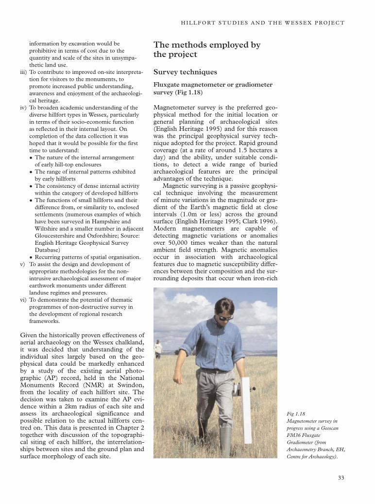
H I L L F O RT S T U D I E S A N D T H E W E S S E X P R O J E C T
information by excavation would be prohibitive in terms of cost due to the quantity and scale of the sites in unsympathetic land use.
iii) To contribute to improved on-site interpretation for visitors to the monuments, to promote increased public understanding, awareness and enjoyment of the archaeological heritage.
iv) To broaden academic understanding of the diverse hillfort types in Wessex, particularly in terms of their socio-economic function as reflected in their internal layout. On completion of the data collection it was hoped that it would be possible for the first time to understand:
• The nature of the internal arrangement of early hill-top enclosures
• The range of internal patterns exhibited by early hillforts
• The consistency of dense internal activity within the category of developed hillforts
• The functions of small hillforts and their difference from, or similarity to, enclosed settlements (numerous examples of which have been surveyed in Hampshire and Wiltshire and a smaller number in adjacent Gloucestershire and Oxfordshire; Source: English Heritage Geophysical Survey Database)
• Recurring patterns of spatial organisation. v) To assist the design and development of
appropriate methodologies for the non-intrusive archaeological assessment of major earthwork monuments under different landuse regimes and pressures.
vi) To demonstrate the potential of thematic programmes of non-destructive survey in the development of regional research frameworks.
Given the historically proven effectiveness of aerial archaeology on the Wessex chalkland, it was decided that understanding of the individual sites largely based on the geophysical data could be markedly enhanced by a study of the existing aerial photographic (AP) record, held in the National Monuments Record (NMR) at Swindon, from the locality of each hillfort site. The decision was taken to examine the AP evidence within a 2km radius of each site and assess its archaeological significance and possible relation to the actual hillforts centred on. This data is presented in Chapter 2 together with discussion of the topographical siting of each hillfort, the interrelationships between sites and the ground plan and surface morphology of each site.
The methods employed by the project
Survey techniques
Fluxgate magnetometer or gradiometer survey (Fig 1.18)
Magnetometer survey is the preferred geophysical method for the initial location or general planning of archaeological sites (English Heritage 1995) and for this reason was the principal geophysical survey technique adopted for the project. Rapid ground coverage (at a rate of around 1.5 hectares a day) and the ability, under suitable conditions, to detect a wide range of buried archaeological features are the principal advantages of the technique.
Magnetic surveying is a passive geophysical technique involving the measurement of minute variations in the magnitude or gradient of the Earth’s magnetic field at close intervals (1.0m or less) across the ground surface (English Heritage 1995; Clark 1996). Modern magnetometers are capable of detecting magnetic variations or anomalies over 50,000 times weaker than the natural ambient field strength. Magnetic anomalies occur in association with archaeological features due to magnetic susceptibility differences between their composition and the surrounding deposits that occur when iron-rich
Fig 1.18 Magnetometer survey in progress using a Geoscan FM36 Fluxgate Gradiometer (from Archaeometry Branch, EH, Centre for Archaeology).
33
T H E W E S S E X H I L L F O RT S P R O J E C T
minerals in the soil form more strongly ferromagnetic materials such as magnetite or magheamite. This magnetic enhancement is usually related to burning, although more subtle inorganic and bacterially controlled mechanisms may also play a part under suitable soil conditions. Such conditions occur naturally in most topsoils, providing a source of magnetically enhanced material that becomes incorporated in archaeological features and so produces almost indelible magnetic signatures, even where features have been all but erased by intensive agriculture. Magnetometers also respond to the strongly magnetic signals produced by heavily fired structures that have become permanently magnetised as a result of intense heating. This permanent thermo-remanent magnetism is found in domestic and industrial features containing fired clay such as hearths, kilns, furnaces and ovens, and in some cases burnt stone structures (Aitken 1974, 141–7).
Magnetometry, coupled with aerial photography, has been recognised for many years on the Wessex chalkland as a powerful method for planning prehistoric settlements and landscapes. The series of surveys carried out for the Danebury Environs Project from 1989–96 (Payne 2000a) demonstrated that the technique is particularly effective on the chalk and chalk plateau drift of this region, where anomalies, caused by higher magnetic susceptibility of the soil concentrated in buried archaeological features (primarily the infilling of features cut into the chalk such as ditches and pits), stand out clearly against the relatively much lower magnetic background from the surrounding natural substrates.
All of the magnetometer surveys carried out for the Wessex Hillforts Project employed Geoscan FM36 Fluxgate Gradiometer type instruments with built-in data-logging facilities enabling digital data capture of about 16,000 readings in a two hour survey session. The instruments are sensitive to changes in magnetic flux density of a tenth of a nanotesla (nT). In all cases the data were collected on a 30m grid, at 0.25m intervals, along traverses spaced 1.0m apart. This represents a compromise, by which larger area coverage was achieved at the expense of possibly missing smaller archaeological features that might have been detected by narrower instrument traverses (halving the separation between traverses from 1.0m to 0.5m, for example). Data processing involved the initial elimination of the effects of thermally induced instrument drift,
showing as bunching or striping of alternate lines of data (by equalising the mean of each line of readings). In some instances the data were also smoothed slightly, to improve the definition of archaeological anomalies greater than a metre in width, by the use of a Gaussian low-pass filter with a radius of 1.0m (Scollar et al 1990).
The range of archaeological features generally detectable by magnetometry at hillfort sites of Bronze Age and Iron Age date on chalkland geology includes: infilled ditches defining internal enclosures or divisions and other earth-filled features including silo and rubbish pits, irregular quarries or scoops, and shallow ‘working hollows’. Annular gullies defining the former positions of round houses of Iron Age date were detected at Segsbury Camp and subsequently confirmed by excavation. Numerous other examples exist at hillfort sites both in Wessex and farther afield, including South Cadbury Castle, Somerset and Conderton Camp, Worcestershire. Ovens, furnaces and hearths, both of industrial and domestic type, would also be expected to register appreciable magnetic anomalies. One noteworthy example of a large oven of key-hole shaped plan, detected by magnetometry and subsequently confirmed by excavation, occurred at Uffington Castle (Payne 2003a).
It would be misleading to suggest that magnetometry can provide a complete picture of all the activity and occupation within a hill-fort. Some important categories of features can be missed. This applies in particular to some smaller, shallow and less substantial features such as gullies and post-holes (especially where truncated by ploughing), and also some pits and graves, which may only offer a poor magnetic contrast between their fill and the surrounding natural chalk (for example a pit filled with chalk rubble).
Comparison of the geophysical data from the excavated samples of Uffington Castle and the inner camp at Bury Hill provides a clear example of these limitations (Payne 2000a, 2000c, 2003a). Generally only the larger pit-type features (and in the case of Uffington, the oven) were represented in the magnetic data, while the majority of the smaller features recorded during excavation were not visible. The application of more sensitive caesium magnetometers in recent years is now improving the detection rate of narrow circular gullies and slots and posthole structures within Iron Age settlement complexes (Payne 2004).
34
H I L L F O RT S T U D I E S A N D T H E W E S S E X P R O J E C T
General experience of magnetic prospecting on chalk in southern England using fluxgate gradiometers has shown that they are rarely equal to the task of locating smaller post-holes (typically 0.3m in diameter and 0.3m deep), regardless of the sampling interval being used (see Payne 1996). Therefore, remains of stake-built structures (such as some common forms of Iron Age round house) are unlikely to be detectable except where associated features such as hearths, surrounding gullies or deposits of burnt daub are present.
This was shown to be the case at an Early Iron Age enclosed settlement at Houghton Down near Danebury, surveyed in 1994 in advance of excavation (Payne 2000a, 2000d). Here, the round houses associated with the earliest Iron Age phase of the site, discovered in the process of excavation, were invisible in the magnetometer data. If generally applicable, this situation would unfortunately result in important categories of activity at Iron Age sites being under-represented in standard fluxgate magnetometer surveys – a limitation that should always be borne in mind in the interpretation of the data. Larger than average post-holes (such as those constructed to retain the doorframe posts of timber houses or the foundation sockets of large four-post structures) are comparable to small pits and therefore more easily detectable even at standard 1.0m × 0.25m sample intervals. A few isolated examples of possible four-post structures detected by magnetometer survey have tentatively been identified at Uffington Castle and Perborough Castle in Oxfordshire (Chapter 2 this volume) and at Conderton Camp in Worcestershire (Chapter 3 this volume and Payne 2005. The latter site is situated on particularly favourable geology for magnetic prospection (Middle Jurassic Inferior Oolite) and in these conditions post-hole type structures would be expected to be easier to resolve than similar features on chalk.
In areas of predominantly chalk geology, features of geomorphological origin may sometimes register in a magnetometer survey, particularly in areas where the superficial geology is variable, or has been influenced by periglacial conditions. The influence of scoring and fissuring of the surface of the chalk has been noted in magnetometer surveys of several sites in the Danebury environs, including Bury Hill and New Buildings. The fluxgate gradiometer is sensitive only to localised soil changes, so a
response to larger-scale variation in solid or drift geology (for example an area of plateau drift as on the hill occupied by the hillfort of Woolbury) does not normally occur. However, the partially clay-capped hill occupied by Woolbury hillfort shows a more confused magnetic background compared to those sites where the geology is more uniform (Payne 2000b). The problem would appear to be particularly severe in the case of Walbury Hill on the northern scarp of the Hampshire Downs and at the highest point of the chalk geology in southern England. Purely natural pockets of clay-with-flints are known to occur within the chalk at the hill-forts of Segsbury and Uffington Castle and produce anomalies similar to those associated with man-made features such as pits and quarries. There is therefore a potential danger of misinterpreting natural features of the geology as archaeological features. Geological features might be expected to exhibit more irregular form and more random patterning than archaeological features, but experience shows that it is not always possible to differentiate reliably between the two.
Magnetic susceptibility survey (Fig 1.19)
Detailed magnetic susceptibility (MS) surveys were carried out at two of the hillforts with ploughed interiors – Norsebury Ring and Castle Ditches – where the results of the magnetometer surveys proved particularly interesting. The magnetic susceptibility surveys were designed to provide additional information to support the interpretation of the magnetometer surveys.
Different materials become variably magnetised in the presence of the Earth’s magnetic field. The degree to which soils become magnetised in the presence of this external induced magnetic field is known as the magnetic susceptibility (MS) and depends on the concentration of naturally occurring iron oxides they contain, and the extent to which these have been modified to more magnetic forms by various mechanisms. These are not as yet wholly understood but seem to be linked with a past human presence on a site (Tite and Mullins 1971; Clark 1996, chapter 4). Concentrations of soils that have become artificially magnetically enhanced (increasing their MS) as a product of human occupation can be defined by topsoil magnetic susceptibility measurement. A susceptibility survey may, therefore, supplement and confirm the findings of a magnetometer survey by indicating the areas within a hillfort where features and debris of domestic and possibly industrial
35
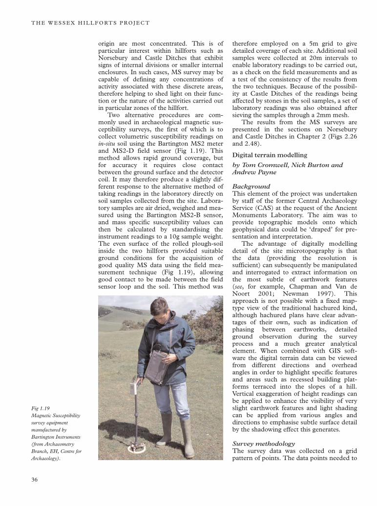
T H E W E S S E X H I L L F O RT S P R O J E C T
Fig 1.19 Magnetic Susceptibility survey equipment manufactured by Bartington Instruments (from Archaeometry Branch, EH, Centre for Archaeology).
origin are most concentrated. This is of particular interest within hillforts such as Norsebury and Castle Ditches that exhibit signs of internal divisions or smaller internal enclosures. In such cases, MS survey may be capable of defining any concentrations of activity associated with these discrete areas, therefore helping to shed light on their function or the nature of the activities carried out in particular zones of the hillfort.
Two alternative procedures are commonly used in archaeological magnetic susceptibility surveys, the first of which is to collect volumetric susceptibility readings on in-situ soil using the Bartington MS2 meter and MS2-D field sensor (Fig 1.19). This method allows rapid ground coverage, but for accuracy it requires close contact between the ground surface and the detector coil. It may therefore produce a slightly different response to the alternative method of taking readings in the laboratory directly on soil samples collected from the site. Laboratory samples are air dried, weighed and measured using the Bartington MS2-B sensor, and mass specific susceptibility values can then be calculated by standardising the instrument readings to a 10g sample weight. The even surface of the rolled plough-soil inside the two hillforts provided suitable ground conditions for the acquisition of good quality MS data using the field measurement technique (Fig 1.19), allowing good contact to be made between the field sensor loop and the soil. This method was
therefore employed on a 5m grid to give detailed coverage of each site. Additional soil samples were collected at 20m intervals to enable laboratory readings to be carried out, as a check on the field measurements and as a test of the consistency of the results from the two techniques. Because of the possibility at Castle Ditches of the readings being affected by stones in the soil samples, a set of laboratory readings was also obtained after sieving the samples through a 2mm mesh.
The results from the MS surveys are presented in the sections on Norsebury and Castle Ditches in Chapter 2 (Figs 2.26 and 2.48).
Digital terrain modelling
by Tom Cromwell, Nick Burton and Andrew Payne
Background This element of the project was undertaken by staff of the former Central Archaeology Service (CAS) at the request of the Ancient Monuments Laboratory. The aim was to provide topographic models onto which geophysical data could be ‘draped’ for presentation and interpretation.
The advantage of digitally modelling detail of the site microtopography is that the data (providing the resolution is sufficient) can subsequently be manipulated and interrogated to extract information on the most subtle of earthwork features (see, for example, Chapman and Van de Noort 2001; Newman 1997). This approach is not possible with a fixed map-type view of the traditional hachured kind, although hachured plans have clear advantages of their own, such as indication of phasing between earthworks, detailed ground observation during the survey process and a much greater analytical element. When combined with GIS software the digital terrain data can be viewed from different directions and overhead angles in order to highlight specific features and areas such as recessed building platforms terraced into the slopes of a hill. Vertical exaggeration of height readings can be applied to enhance the visibility of very slight earthwork features and light shading can be applied from various angles and directions to emphasise subtle surface detail by the shadowing effect this generates.
Survey methodology The survey data was collected on a grid pattern of points. The data points needed to
36
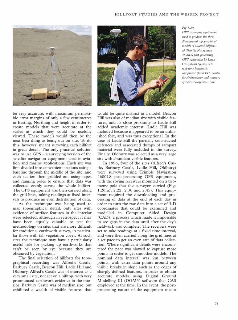
H I L L F O RT S T U D I E S A N D T H E W E S S E X P R O J E C T
Fig 1.20 GPS surveying equipment used to produce the three dimensional topographical models of selected hillforts. a) Trimble Navigation 4600LS post-processing GPS equipment b) Leica Geosystems System 530 real-time kinematic equipment (from EH, Centre for Archaeology and courtesy of Leica Geosystems Ltd).
be very accurate, with maximum permissible error margins of only a few centimetres in Easting, Northing and height in order to create models that were accurate at the scales at which they could be usefully viewed. These models would then be the next best thing to being out on site. To do this, however, meant surveying each hillfort in great detail. The only practical solution was to use GPS – a surveying version of the satellite navigation equipment used in aviation and marine applications. Each site was first divided into convenient sections using a baseline through the middle of the site, and each section then gridded-out using tapes and ranging poles to ensure that data was collected evenly across the whole hillfort. The GPS equipment was then carried along the grid lines, taking readings at fixed intervals to produce an even distribution of data.
As the technique was being used to map topographical detail, only sites with evidence of surface features in the interior were selected, although in retrospect it may have been equally valuable to test the methodology on sites that are more difficult for traditional earthwork survey, in particular those with tall vegetation cover. At such sites the technique may have a particularly useful role for picking up earthworks that can’t be seen by eye because they are obscured by vegetation.
The final selection of hillforts for topographical recording was Alfred’s Castle, Barbury Castle, Beacon Hill, Ladle Hill and Oldbury. Alfred’s Castle was of interest as a very small site, not set on a hilltop, with very pronounced earthwork evidence in the interior. Barbury Castle was of median size, but exhibited a wealth of visible features that
would be quite distinct in a model. Beacon Hill was also of median size with visible features, and its close proximity to Ladle Hill added academic interest. Ladle Hill was included because it appeared to be an unfinished fort, and was thus exceptional. In the case of Ladle Hill the partially constructed defences and associated dumps of rampart material were fully included in the survey. Finally, Oldbury was selected as a very large site with abundant visible features.
In 1996, four of the sites (Alfred’s Castle, Barbury Castle, Ladle Hill, Oldbury) were surveyed using Trimble Navigation 4600LS post-processing GPS equipment, with the roving receivers mounted on a two-metre pole that the surveyor carried (Figs 1.20(a), 2.22, 2.36 and 2.45). This equipment required the downloading and processing of data at the end of each day in order to turn the raw data into a set of 3-D coordinates that could be examined and modelled in Computer Aided Design (CAD), a process which made it impossible to see gaps in the data until after the day’s fieldwork was complete. The receivers were set to take readings at a fixed time interval, and were then carried along the grid lines at a set pace to get an even rate of data collection. Where significant details were encountered the pace was slowed to capture more points in order to get smoother models. The nominal data interval was 2m between points, with extra data points around any visible breaks in slope such as the edges of sharply defined features, in order to obtain accurate models using Digital Ground Modelling III (DGM3) software that CAS employed at the time. In the event, the postprocessing nature of the equipment meant
37
T H E W E S S E X H I L L F O RT S P R O J E C T
that point intervals averaged closer to 3m in most cases. Beacon Hill, by comparison, was surveyed in 1999 using Leica Geosystems System 530 real-time kinematic equipment (Fig 1.20(b)), which eliminated post-processing by giving Ordnance Survey coordinates instantly through the use of onboard radios and processors. Experience with pole-mounted equipment indicated that height data would not be compromised by a backpack-mounted system, so the backpack-mounted antenna was used and the pole was discarded. Beacon Hill was surveyed at an interval of 1m by setting the receivers to capture data every time they moved more than 1m from the previous reading. The equipment also kept track of the grid lines to be walked, guiding the surveyor along each line without the need for tapes or ranging poles. The results (see Figs 2.11 and 2.12) were faster, and more accurate than the previous surveys, with little wasted time. It should be noted that Trimble Navigation also offers a real-time kinematic system (the 4800 model) with these same benefits.
All of the surveys were plotted relative to the Ordnance Survey grid (OSGB36). For the early sites, this was accomplished by surveying the sites on an arbitrary grid with pegs to mark the baseline, followed by a control survey to tie the pegs into OSGB36 by surveying them relative to a series of local trig pillars. In the case of Beacon Hill, however, there was a trig pillar within the site so the survey grid was established on OSGB36 at the start.
From the outset the project was aimed at modelling the internal ‘living space’ of each hillfort, corresponding to the area surveyed by geophysics. For practical reasons the topographic surveys were carried up to the top of the ramparts, thus modelling the inner slopes of the defences.
Data processing All of the point data were imported into AutoCAD for editing and modelling, at which point they could be separated into items such as boundaries and paths. The files were divided into appropriate layers. The first four sites were then modelled in DGM3 to create contour maps and gridded triangular mesh surfaces, but these were subsequently remodelled using Key Terra Firma IV (KTF4) to produce Triangular Irregular Networks (TINs) and contour plots. The fifth site (Beacon Hill) was also modelled in KTF4, and a contour plot cre
ated. Once the raw data was checked through CAD modelling, the points were exported to ARCINFO or GEOSOFT OASIS MONTAJ to be modelled and draped with the geophysics plots.
The results of the GPS surveys are presented and discussed in the relevant section in Chapter 2.
Documentary research and aerial photographic analysis
The final stage of the project, following the completion of the internal mapping of the subsurface and surface evidence for activity in the hillforts, was devoted to researching the immediate landscape setting and the broader regional context of the sites included in the survey. The first step in this process was to assemble and interrogate existing published sources of archaeological information on each of the sites, and any records of artefactual material they may have produced, in order to attempt to gain some insight (however limited) into relative dates of occupation.
This phase of analysis also involved the study of the morphology of the hillfort and the preparation of a description of the main visible surface characteristics of each of the sites included in the project (including rampart form, entrances and any visible earthwork features in the interior).
In addition, the relationship of each site to the broader pattern of hillfort distribution in Wessex was considered together with location, aspect, relationships with geology and soils, known land allotment patterns in the immediate vicinity and evidence for extra-mural settlement – enclosed and open. The latter component was addressed largely by examination of aerial photographical records. The aerial photographic material from a 2km radius around each site was examined for the presence of other forms of settlement in the vicinity of the hillfort and evidence for field systems, tracks and linear boundary ditches in an attempt to recognise any possible relationships between these various features that would suggest a developmental sequence for the site in question.
The analysis of the surface and documentary evidence relating to each of the sites and their landscape setting is presented under the heading ‘morphology and setting’ in Chapter 2 followed by discussion of the geophysical evidence from each hillfort. This format was chosen in order to present all the information on each site together in a single unified entry.
38