Embed Size (px)
Citation preview
Urban Ecosystems, 6: 21–41, 2002c© 2003 Kluwer Academic Publishers. Manufactured in The Netherlands.
The urban-rural interface: Urbanizationand tropical forest cover change
JOHN O. BROWDER [email protected], Urban and Regional Planning, Virginia Polytechnic Institute and State University,Blacksburg, VA 24061, USA
Received July 23, 2001; Revised June 20, 2003; Accepted June 20, 2003
Abstract. A considerable body of empirical and theoretical literature on the causes of tropical deforestation hasemerged over the last twenty years. Recognizing that small-farmers in the Amazon Basin are a key agent in theprocess of primary forest conversion, a growing genre of studies at the household level have attempted to quantifythe influence of various factors on small-farmer land-use decisions. Many of these studies have acknowledged theseeming importance of urban centers as hubs of propulsive activity and information, yet none have comprehensivelycaptured the “urbanization factor” in rural land use decisions. I argue that this methodological shortcoming inempirical work to-date reflects an inadequate conceptualization of the range of urban-based networks and theirinter-relationships. In an effort to overcome this roadblock to further empirical discovery, I review several leadingschools of thought that might be pressed into service in developing a framework for interpreting the urban influenceson rural landscapes. I call this construct the “Urban-Rural Interface.” This is not a complete theoretical model ora unique methodology, but rather an initial effort to develop a general framework from which more sophisticatedformulations might proceed.
Keywords: urban-rural interface, Amazonia, tropical deforestation, urbanization, social networks
Introduction
The research literature on the causes of tropical deforestation has grown so rapidly overthe last 20 years that it has itself become the subject of critical research (LEEC, 1992;Kummer and Sham, n.d).1 Much of this social science research has focused on macro-level “drivers” of land cover change (e.g., population growth, public policies, structuraladjustment, monetary policies, etc.). In contrast, a small, but growing number of micro-level studies have focused on rural producers (small farmers and ranchers) as the primaryagents of land cover change. Of course, the great challenge ahead is to merge researchat these two vastly scale-disparate levels of analysis. Getting there requires finding somemissing pieces to the puzzle. An entire stream of missing pieces to this curvilinear jigsawof causality, pertain to the role of urban centers in rural landscape change. And that takesus back to rural producers, in whose hands the fate of much of the Amazon Basin resides.
For the most part, these rural producers have been widely conceptualized as relativelyautonomous economic agents basing their land use decisions on production factors internalto the household and in rational response to exogenous market prices for the commoditiesthey produce. However, rural producers are embedded in larger social and spatial contextsand participate in various economic, social, economic and political networks, and their land
22 BROWDER
use decisions are often not so easily derived from economic rationality alone. Our recentresearch (Browder and Godfrey, 1997) suggests that the urbanization of the Amazon duringthe last 30 years has profoundly changed the social and economic contexts defining how ruralproducers use land. Our study found significant differences in land use patterns betweenurban-based farm owners and rural-based farmers. And, we found that increasing numbersof rural properties are ending up in urban resident ownership, suggesting that rural propertyownership and land use are becoming part of complex urban-based household strategies.
Recognition of the importance of urban-rural linkages is not new. In 1970, E.A.J. Johnson,in his benchmark work noted that “it is incorrect to assume that urban entrepreneurialdecisions are wholly discrete and separable from rural decisions and choices” (Johnson,1970:183). Could it also be said that important rural entrepreneurial decisions (i.e. land usedecisions) are related to the urban influences in some significant ways? Despite the apparentimportance of the urban-rural relationship in explaining tropical forest cover change, verylittle has been written about the subject either conceptually or empirically. In this paper, Ipropose a modest schematic framework for conceptualizing the seemingly daunting chal-lenges of integrating complex urbanization factors into rural landscape change outcomesas determined by rural landowners.
This paper briefly reviews a sample of empirical (household level) studies that seek toexplain rural land use change in Amazonia to illustrate, in part, the difficulty that researchershave had in conceptualizing the relationship between urbanization and rural land use. In thesecond section several conceptual frameworks that might contribute to a new understandingof urban-rural linkages are considered. Finally, I outline a hybrid theoretical construct, whichI call the “urban-rural interface”, that might provide a general framework for more specificmodels that could be used in future empirical work interrogating the relationship betweenurbanization and tropical forest cover change.
Recent empirical studies of rural land use change in Amazonia
Although urbanization of the Brazilian Amazon frontier has proceeded at a breath-takingpace since 1980, very few of the recent studies on land cover change in the region haveexplicitly taken into account the influence of urbanization on rural land use. This is so, Ibelieve, because those “urban factors” have not been adequately conceptualized. Severalexcellent studies have been published recently that seek to explain rural land use changein Amazonia. This emergent research literature has been largely framed by three differ-ent theoretical traditions: neoclassical economics (Scatena et al., 1996; Vosti et al., 1998;Caviglia and Kahn, 2001), demography and human ecology (McCracken et al., 1999; Perz,2000; Moran et al., 2001; Pan et al., 2001), and political ecology (Collins, 1986; Ozoriode Almeida, 1992; Stonich, 1993). Other scholars have adopted hybrid conceptual frame-works for interpreting why farmers deforest and shift land uses over time (Fearnside, 1985;Pinchon, 1996, 1997; Angelsen and Kaimowitz, 1999). A diverse compendium of recentinternational case studies exploring various issues associated with the urban-rural divideare found in Tacoli (1998).
The neoclassical economic literature tends to privilege the utility maximization assump-tion about farmer land use behavior. The results of economic studies tend to support two
THE URBAN-RURAL INTERFACE 23
conclusions concerning land use change in the tropics: First, empirical land use research hassuccessfully identified several diverse drivers of landscape change, including: agriculturalprices (for both inputs and outputs) and more broadly commodity markets; credit use (es-pecially the use of government subsidized, crop-targeted credit program); natural resourceendowments and rent capture (e.g., timber sales); and accessibility (distance to market andinput suppliers). Macroeconomic factors such as national income and economic liberal-ization also appear as underlying drivers of landscape change. Second, our understandingis much clearer of the factors influencing deforestation than of those influencing subse-quent land use. While many of the variables seen by economists as determining land useare directly and indirectly linked to urbanization, economists working from a neoclassicaleconomics perspective have yet to formulate an analytical model that accurately representsthe structure of urbanization forces and the relative influences of specific urban factors onthe rural landscape change.
The demographic and human ecological research on tropical forest landscape change em-anates from the tradition of Chayanov (Thorner et al., 1986). Such research seeks to explainland use change in the Amazon based on household level demographic variables set withina “domestic life cycle” framework. Three general conclusions emerge from this researchliterature. First, while most of the models tested include three different types of indepen-dent variables (demographic, farm site characteristics, and socioeconomic/institutional),the low correlation and regression coefficients resulting from these studies suggest thatother unspecified non-demographic factors play a large role in explaining the variation inobserved land uses, a fact that many demographers acknowledge. Second, the models tendto focus on the household scale, in which the farm family unit and associated plot is thebasic unit of analysis. Economic and institutional factors exogenous to the household ema-nating from regional, national, and global scales (e.g., commodity prices, interests rates, taxpolicies, and urbanization effects) virtually escape treatment in most of these demographicstudies. Third, the very nature of the prevailing demographic framework, the “householdlifecycle,” implicitly lends itself to a linear, evolutionary, stages approach to conceptual-izing the dynamic relationships between land owners and land use. While this approachmay provide a useful overarching background, the studies to date do not address decisiveperturbations in this linear transitional process that might arise expectedly from exogenousforces. Undoubtedly, some of the unexplained variation in these studies arises from the dif-ficulty in conceptualizing and measuring these “non-linear” influences on household landuse decision-making, such as those that might be associated with urbanization.
Finally, political ecology approaches to landscape change in Amazonia have drawnlargely from neo-Marxist interpretations of the global division of labor, unequal exchangeand surplus extraction. Most political ecology approaches situate the local dynamics ofland use change in the larger context of the global expansion of capitalism (e.g., Blaikie,1985). In the Brazilian frontier context, for example, landless farmers are pushed into theAmazon, applying their labor value to the land by clearing forest and planting short-termsubsistence crops. This initial stage of frontier settlement paves the way for subsequent“penetration/incorporation” by agribusiness and other social elites who appropriate the la-bor value “congealed” in the landscape, and push the peasantry off the land once again ina perpetual cycle forest destruction and social expulsion and itinerancy. Landscape change

24 BROWDER
Table 1. Summary of selected land use studies in Amazonia
1∗ 2∗ 3∗ 4∗ 5∗∗
Dependent variable:
Land use (all types)∗
Sustainable land use∗∗
Independent variables:
Soil quality + + +Farm size + +Adult farm labor + 0 + +Household education + + 0 0
Farming background 0 +Land tenure security + + + +Distance from market – – – –
Duration of farm 0 0 + + +Off-farm income – – – –
Urban link 0
Forest product extraction –
On-farm wage labor + + +/−Social participation +/− +Initial capital (wealth) + –
Use of credit +Technical knowledge 0 +N 419 150 762 261 196
R2 ..30–.52 n.a. .21–.6 .25–.44 .34
Note: “+” denotes increase in area in production (all land use types), “–” denotes decreasein area in production, “0” signifies no statistically significant impact on land use.∗Land use of all types, p < .10.∗∗Sustainable land use, p < .10.
1. Pinchon, 1997a2. Vosti et al., 19983. Pan et al., 20014. Perz, 20005. Caviglia and Kahn, 2001
is a predictable outcome of this inexorable process of capitalist expansion. With the ex-ception of a small number of structuralist geographers, not expressly political ecologists(e.g., Armstrong and McGee, 1985; Torres, 1988; Becker, 1985), the urbanization questionhas alluded critical analysis in the political ecology literature. As much can be said for thestudies arising from the demographic and economic traditions as well (Table 1). In only oneof these studies (Vosti et al., 1998) is urbanization explicitly considered, and, given hownarrowly the urban factor is defined in this study (using a distance surrogate), its influenceon rural land use was found not to be statistically significant.
THE URBAN-RURAL INTERFACE 25
It would appear that the disjuncture between scholars engaged in rural land use changeresearch, on the one hand, and urbanization, on the other, emanates from the shared assump-tion that these are intrinsically distinctive and unrelated processes. Yet a fuller understandingof the dynamics of both processes will likely necessitate some conceptual “bridge-building”between them.
Given the contemporary urgency of the tropical deforestation problem and the rapidurbanization occurring in tandem in most tropical countries, it is perhaps surprising thatso little has been written on urban-rural linkages of late. For the most part, the existingliterature is framed by gravity-type models, in which urban population size and distancefactors determine land use. Accepting the general validity of that approach, however, doesnot preclude systematic consideration of other approaches to conceptualizing what I callthe “Urban-Rural Interface” (URI): That tapestry of multiple, interacting networks linkingurban and rural areas that mediate the processes of rural landscape change. To initiate thisdiscussion it is useful to briefly consider the contributions of several conceptual frameworks.
Theories of urbanization and rural land cover change
Recent interest in the impacts of urbanization on rural landscapes has largely focused onurban sprawl and farmland conversion (Furuseth and Pierce, 1982; Walker, 2001), agricul-tural intensification (Rondinelli, 1986; Bhadra et al., 1993), and rural settlement patterns(Bunce, 1982). These interests provide a foundation for empirical research of rural landcover change in developing regions and are informed by several leading theories. Amongthe most influential of these conceptual frameworks is the work of Johan Heinrich vonThunen (Hall, 1966).
Thunian models and market rationality
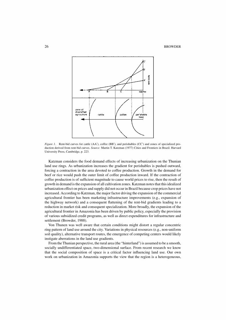
Contemporary economic theories of regional development tend to view landscape or envi-ronmental change as a function of the growth of towns and cities in a regional settlementsystem and have spawned a genre of probabilistic models and deterministic theories ofland use change based on principles of market rationality. Starting from Von Thunen’sclassic “concentric zones” model, landscape change is seen as a response to changes ineconomic land rents associated with increasing transportation costs from a central marketplace (Bryant et al., 1982). Von Thunen’s contribution to the geographical interpretation oflandscape change has been considerable and warrants more detailed review than I give ithere. Katzman (1977) adapted a Thunian approach to Brazilian agricultural land use thatillustrates the general principles of this approach (figure 1).
Three zones of commercial cultivation occur. In the zone immediately surrounding themarket center a “greenbelt of perishables” appears consisting of truck farms producing low-value, high yield vegetables for local market consumption. The second zone is dedicated tothe medium-value cash crop coffee. In the frontier zone, high-value, low-yield cattle, rice,or soy bean crops are produced. Beyond the commercial frontier lies a zone of diversifiedsubsistence farming (p. 222).
26 BROWDER
Figure 1. Rent-bid curves for cattle (AA′), coffee (BB′), and perishables (CC′) and zones of specialized pro-duction derived from rent-bid curves. Source: Martin T. Katzman (1977) Cities and Frontiers in Brazil. HarvardUniversity Press, Cambridge, p. 223.
Katzman considers the food demand effects of increasing urbanization on the Thunianland use rings. As urbanization increases the gradient for perishables is pushed outward,forcing a contraction in the area devoted to coffee production. Growth in the demand forbeef or rice would push the outer limit of coffee production inward. If the contraction ofcoffee production is of sufficient magnitude to cause world prices to rise, then the result ofgrowth in demand is the expansion of all cultivation zones. Katzman notes that this idealizedurbanization effect on prices and supply did not occur in Brazil because crop prices have notincreased. According to Katzman, the major factor driving the expansion of the commercialagricultural frontier has been marketing infrastructure improvements (e.g., expansion ofthe highway network) and a consequent flattening of the rent-bid gradients leading to areduction in market risk and consequent specialization. More broadly, the expansion of theagricultural frontier in Amazonia has been driven by public policy, especially the provisionof various subsidized credit programs, as well as direct expenditures for infrastructure andsettlement (Browder, 1988).
Von Thunen was well aware that certain conditions might distort a regular concentricring pattern of land use around the city. Variations in physical resources (e.g., non-uniformsoil quality), alternative transport routes, the emergence of competing centers would likelyinstigate aberrations in the land use gradients.
From the Thunian perspective, the rural area (the “hinterland”) is assumed to be a smooth,socially undifferentiated space, two-dimensional surface. From recent research we knowthat the social composition of space is a critical factor influencing land use. Our ownwork on urbanization in Amazonia supports the view that the region is a heterogeneous,
THE URBAN-RURAL INTERFACE 27
“disarticulated” social space. “The confluence of different social groups originating fromprocesses occurring at different socio-spatial levels of the global economy during over-lapping historical periods renders the Amazonian landscape a ‘mosaic within mosaics,’something that is incomprehensible through the optic of any single conceptual lens ormaster principle” (Browder and Godfrey, 1997:362).
One might say that a priori the Thunian framework is of limited applicability to thequestion at hand of conceptualizing the relationship between urbanization and deforestationsince the latter typically occurs beyond the outer limit of commercial agriculture in the vastundifferentiated zone Katzman refers to as “diversified agriculture”. Whether the Thunianmodel could be extended to accurately identify additional zones of rural land use beyondthe periphery remains an open question.
Growth pole models
Another group of studies of urban-rural linkages, or core-periphery dynamics, has drawnfrom the “Growth Pole” concept of Francois Perroux (1950), such as Nichols (1969),Parr (1973) and Hansen (1975), among others. Although intended to provide a frameworkfor understanding the process of structural economic change in an urban system, and notthe affects of urban centers on rural land use, growth pole theory gave credence to thenotion of economic space as a “field of forces” and hence to the possibility of urban-basedeconomic networks as “drivers” of structural change (including rural landscape change)in the periphery. A major analytical challenge presented by growth pole economics ishow to measure the hypothesized “spillover” effects of investment in the “propulsive”manufacturing sectors of the urban center upon its rural (economic) hinterland. This questioncontinues to be of interest to regional geographers. While several studies have attempted toevaluate the “spread” and “backwash” effects of urban growth upon its periphery using intra-regional input-output models, the findings of this research remain empirically inconclusivewith vague implications for rural land use (e.g., Hughes and Holland, 1994; Barkley et al.,1996). Nonetheless, the notion that intra-regional economic development in the core (urbannodes) produces a complex set of dynamic spatial processes in its periphery (rural hinterland)constitutes a major legacy of growth pole research.
Innovation diffusion models
Interest in the propagation and diffusion of innovations as a spatial process also might enrichthe analysis of urban influences on tropical deforestation (Hagerstrand, 1952, and subse-quent applied studies, e.g., Shannon, 1970; Johansen, 1971; Misra, 1969; Bowden, 1965;Brown, 1981, arguably provides the most complete review). Hagerstrand conceptualizeddiffusion as the outcome of a learning process within a network of social communications,given the presence of barriers which impede communications. Brown (1981:19–22) de-scribes three developments (“strands of coalescence”) in diffusion research two of whichhave implications for landscape evolution. One development is found in the works of Pred(1973) and Robson (1973) on urban systems evolution. These works tend to emphasizethe importance of population and distance in explaining patterns of diffusion of technical
28 BROWDER
innovations, and may be regarded as derivative of the Thunian framework. By contrast,Brown and Malecki (1977) suggest that decisions leading to diffusion that affect landscapeevolution have an organizational context that defies explanation by simple gravity models.A second development focuses on the mediation of diffusion through “activity systems”(systems of social, economic and personal resources characterizing the milieu of potentialadopters) (Carlstein, 1978). Both developments, supported by various applied empiricalstudies, broaden the range of variables that might be considered pertinent to the questionof urban influences on rural landscapes.
Regional planning flow models
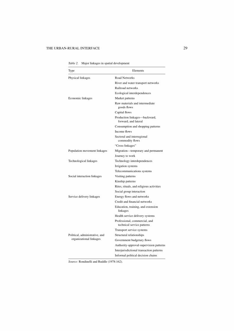
Other researchers have focused on urban functions in promoting rural development andthe types of linkages and flows between urban and rural places. For example, Rondinelliand Ruddle (1978) developed a framework and methodology for what they called “inte-grated spatial development planning” noting that “a complex set of linkages transforms andintegrates urban and rural areas in developing nations” (p. 161) (Table 2).
A complex set of linkages transforms and integrates urban and rural areas in developingnations. Physical, economic, technological, and social linkages and population move-ment, service delivery, and political, administrative, and organizational patterns playpotentially important roles in the transformation of poorly articulated spatial systems”(Rondinelli and Ruddle, 1978:161).
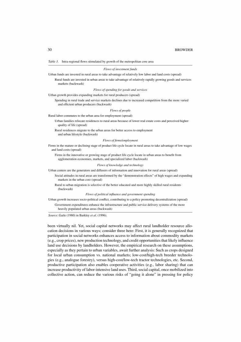
Gaile (1980) also outlined some of those urban-rural linkage processes as intra-regionalflows induced by metropolitan area growth (Table 3).
Social capital theory
Recent interest in “social capital” (see Dasgupta and Serageldin, 2000; Lin et al., 2001)expands the field of conceptual possibilities for exploring rural-urban linkages in landscapechange. James Coleman is credited with having coined the term “social capital,” definingit broadly as “social structures that facilitate certain actions of actors within the structure”(Coleman, 1988:S.98). Robert Putnam refers to social capital as “a set of horizontal asso-ciations among people who have an effect on the productivity of the community” (Putnam1993 cited in Serageldin and Groutaaert, 2000:45). Nan Lin considers social capital to be“resources embedded in a social structure which are accessed and/or mobilized in purposiveactions” (Lin et al., 2001:12). Social capital is not just an input into a production functionlike physical capital (produced assets) and natural capital, but rather, like technology, itbecomes a “shift factor” (or exponent) of production. Recent research by the World Bank(1997) indicates that human and social capital equals or exceeds natural capital and pro-duced assets (constituting 60% of total wealth) in 192 countries. Although an emergent andgrowing literature (e.g., Narayan and Pritchett, 2000; Robalino, 2000), research on the roleof social capital networks in mediating urbanization impacts on surrounding landscapes has
THE URBAN-RURAL INTERFACE 29
Table 2. Major linkages in spatial development
Type Elements
Physical linkages Road Networks
River and water transport networks
Railroad networks
Ecological interdependences
Economic linkages Market patterns
Raw materials and intermediategoods flows
Capital flows
Production linkages—backward,forward, and lateral
Consumption and shopping patterns
Income flows
Sectoral and interregionalcommodity flows
“Cross linkages”
Population movement linkages Migration—temporary and permanent
Journey to work
Technological linkages Technology interdependences
Irrigation systems
Telecommunications systems
Social interaction linkages Visiting patterns
Kinship patterns
Rites, rituals, and religious activities
Social group interaction
Service delivery linkages Energy flows and networks
Credit and financial networks
Education, training, and extensionlinkages
Health service delivery systems
Professional, commercial, andtechnical service patterns
Transport service systems
Political, administrative, andorganizational linkages
Structural relationships
Government budgetary flows
Authority-approval-supervision patterns
Interjurisdictional transaction patterns
Informal political decision chains
Source: Rondinelli and Ruddle (1978:162).
30 BROWDER
Table 3. Intra-regional flows stimulated by growth of the metropolitan core area
Flows of investment funds
Urban funds are invested in rural areas to take advantage of relatively low labor and land costs (spread)
Rural funds are invested in urban areas to take advantage of relatively rapidly growing goods and servicesmarkets (backwash)
Flows of spending for goods and services
Urban growth provides expanding markets for rural producers (spread)
Spending in rural trade and service markets declines due to increased competition from the more variedand efficient urban producers (backwash)
Flows of people
Rural labor commutes to the urban area for employment (spread)
Urban families relocate residences to rural areas because of lower real estate costs and perceived higherquality of life (spread)
Rural residences migrate to the urban areas for better access to employmentand urban lifestyle (backwash)
Flows of firms/employment
Firms in the mature or declining stage of product life cycle locate in rural areas to take advantage of low wagesand land costs (spread)
Firms in the innovative or growing stage of product life cycle locate in urban areas to benefit fromagglomeration economies, markets, and specialized labor (backwash)
Flows of knowledge and technology
Urban centers are the generators and diffusers of information and innovation for rural areas (spread)
Social attitudes in rural areas are transformed by the “demonstration effects” of high wages and expandingmarkets in the urban core (spread)
Rural to urban migration is selective of the better educated and more highly skilled rural residents(backwash)
Flows of political influence and government spending
Urban growth increases socio-political conflict, contributing to a policy promoting decentralization (spread)
Government expenditures enhance the infrastructure and public service delivery systems of the moreheavily populated urban areas (backwash)
Source: Gaile (1980) in Barkley et al. (1996).
been virtually nil. Yet, social capital networks may affect rural landholder resource allo-cation decisions in various ways; consider three here: First, it is generally recognized thatparticipation in social networks enhances access to information about commodity markets(e.g., crop prices), new production technology, and credit opportunities that likely influenceland use decisions by landholders. However, the empirical research on these assumptions,especially as they pertain to urban variables, await further analysis: Such as crops designedfor local urban consumption vs. national markets; low-cost/high-tech breeder technolo-gies (e.g., analogue forestry), versus high-cost/low-tech tractor technologies, etc. Second,productive participation also enables cooperative activities (e.g., labor sharing) that canincrease productivity of labor-intensive land uses. Third, social capital, once mobilized intocollective action, can reduce the various risks of “going it alone” in pressing for policy
THE URBAN-RURAL INTERFACE 31
reforms or concessions from government institutions that have land use implications (e.g.the Landless Rural Workers movement—Sem Terra—in Brazil). Urban centers are oftenthe spatial hubs of social capital networks that extend far beyond the geographic limitsof the urban built environment. In other words, successful productive associations, maylead to dynamic political missions.
Three analytical challenges follow: First, how do we accurately conceptualize the natureof the causal relationships between landholder participation in social capital networks anddistinct land use actions (e.g., direct vs. indirect, linear vs. non-linear, deterministic vs.probabilistic). Social capital networks are often spatially mobile and fluid. Land is fixed inspace. What, then, are the spatial attributes of social capital networks?
Second, we presently lack an analytical definition of the essential components of theparticipative processes of social capital formation. Do all such processes share certaincommon characteristics that can be replicated in multiple geographic settings? If not, thenany general model based on social capital theory would have constrained applicability.Finally, the main methodological problem for potential applications concerns the design ofa methodology that will produce reliable quantifiable indicators of social capital impactson discrete land use decisions. Perhaps, some of these challenges might be overcome byconsidering the potential applications of network theory.
Network exchange theory (NET)
Another stream of ideas that may fruitfully contribute to the conceptualization of a modelof urban influences on rural landscapes derives from the work of sociologists interestedin network exchange theory or NET (Willer, 1999; Friedkin, 1993; Emerson, 1976; Cookand Yamnagishi, 1992). We might adapt neoclassical economic theory (not to be confusedwith NET) to posit that land use decisions by individual agents (e.g., landowners) areinfluenced by social relationships that constitute structures of interaction among agents. Inexchange networks, agents interact with each other seeking favorable resource outcomesand their success is conditioned by the type of connections between their own and others’positions within a network (Willer, 1999:196). Although initially NET began as a discourseon the construction of power relationships in organizations, several concepts from NETmay be usefully applied to the analysis of urban influences on hinterlands. First, NETprovides a structural framework (i.e., networks) to help explain human agent behavior.Those networks may be relatively simple (linear or stem) networks or evolve into morecomplex probability decision tree networks. The assumption here is that interactions amongagents in a network influence land use decisions and, therefore, the nature of those networksand the relative strength of specific connections will likely effectuate distinctive land useoutcomes. Of course networks are not isolated in space or fixed in time which suggestsa second important concept, that of “network domains,” the independent sub-networksin which exchange positions (or agents) are embedded. Some agents may be confined tosingle domain networks, while others are embedded in multi-domain networks (Willer,1999:99). Third, the concept of “expected value probability” reflects a systematic effort toquantify and measure the likelihood of certain outcomes arising from network interactions.For example, the probability that active participation in a religious organization (network
32 BROWDER
domain) has a predetermined influence on land use decisions may be conditioned by anagent’s participation in a political organization (network or domain) that draws membersfrom that specific faith community.
The empirical challenge facing NET is in the matter of model specification. As a be-havioral (rather than purely probabilistic) model, an analytical approach and method fordefining and measuring probability factors for specific causal pathways remains somewhatelusive.
The urban-rural interface
Conceptually, the urban-rural interface (URI) is not simply understood in spatial terms, asa “peri-urban” zone or geographic interstice between the urban built environment and therural landscape, but rather more broadly as an array of networks connecting urban agentsand rural producers. I would distinguish this idea from Bradley’s (1984) conception of the“urban/forest interface” (a largely spatial concept), by suggesting that social networks playa key role in defining the decision environment for rural producers who effectuate rural landcover change outcomes. Rural producers, for example, participate in productive economicnetworks, in part constituted by urban agents through whom they sell their products andobtain credits. They participate in political networks involving urban-based political par-ties and movements. Rural producers are also involved in various social capital networks(religious, civic, and filial) that connect them to urban centers. These various networksprovide the scaffolding of the URI and are the conduits for various types of flows betweenurban and rural places: financial capital, social capital, labor, technology, and informationflows. It is the interaction of these flows with each other and with endogenous factors atthe household level (e.g., family labor, financial assets, property size, etc.) and exogenousforces (public policies, macroeconomic conditions, etc.) that I speculate will provide a morerobust understanding of the processes leading to tropical deforestation and distinct land usepatterns. The Urban-Rural Interface might also be defined as the land use “decision space”of rural producers, a 3-dimensional matrix or probability function within which differentsets of land use decisions might be identified and ranked.
To illustrate how the URI mediates the process of rural land-use decision-making, a sim-plified 3-dimensional decision space schematic might be considered (figure 2). Plane/axis“X” represents a range of endogenous variables characterizing the household as a produc-tive rural land-owning unit (e.g., household size, soil quality). Plane “Z” consists of factorsthat are exogenous to the URI but presumed to be influential in rural land use decisions(e.g., commodity prices, interest rate). And Plane “Y” is an array of elements associatedwith urban-based networks. Other networks that cut across the land use decision space(the urban-rural interface) might be superimposed on these axes (e.g., political networks,legal-institutional networks, information networks).
For the most part, the networks on plane “Y” are based in urban centers to provide anaccessible, centralized location for interaction among network members and clients as wellas provide opportunities for interaction with other urban-based networks (consistent withThunian and gravity-based interpretations). Accordingly, they constitute the urban side ofthe urban-rural interface. However, these networks are not necessarily restricted to urban
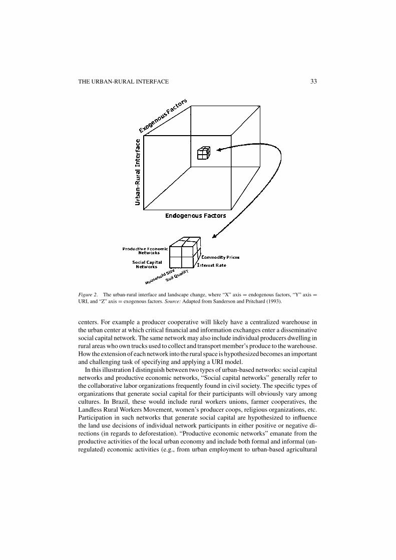
THE URBAN-RURAL INTERFACE 33
Figure 2. The urban-rural interface and landscape change, where “X” axis = endogenous factors, “Y” axis =URI, and “Z” axis = exogenous factors. Source: Adapted from Sanderson and Pritchard (1993).
centers. For example a producer cooperative will likely have a centralized warehouse inthe urban center at which critical financial and information exchanges enter a disseminativesocial capital network. The same network may also include individual producers dwelling inrural areas who own trucks used to collect and transport member’s produce to the warehouse.How the extension of each network into the rural space is hypothesized becomes an importantand challenging task of specifying and applying a URI model.
In this illustration I distinguish between two types of urban-based networks: social capitalnetworks and productive economic networks, “Social capital networks” generally refer tothe collaborative labor organizations frequently found in civil society. The specific types oforganizations that generate social capital for their participants will obviously vary amongcultures. In Brazil, these would include rural workers unions, farmer cooperatives, theLandless Rural Workers Movement, women’s producer coops, religious organizations, etc.Participation in such networks that generate social capital are hypothesized to influencethe land use decisions of individual network participants in either positive or negative di-rections (in regards to deforestation). “Productive economic networks” emanate from theproductive activities of the local urban economy and include both formal and informal (un-regulated) economic activities (e.g., from urban employment to urban-based agricultural
34 BROWDER
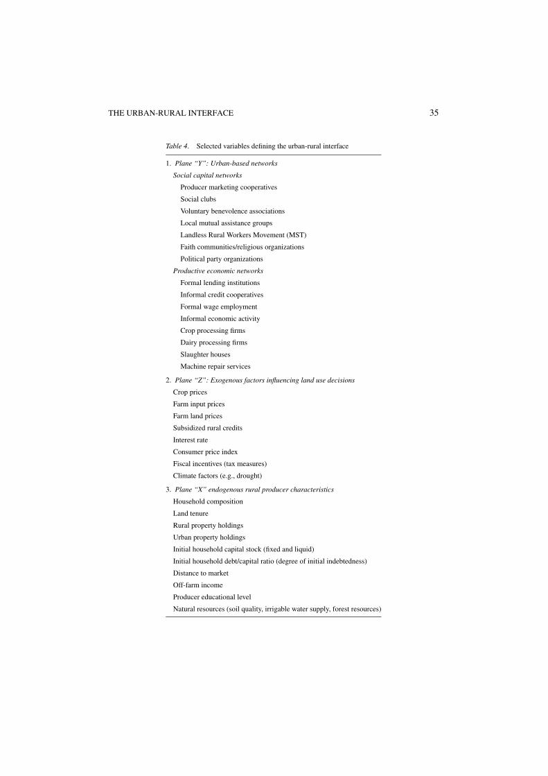
service enterprises). Access to and participation in both types of urban-rural networks arelikely to influence rural land-use decisions but will be influenced by both the endogenouscharacteristics of the rural producer household and exogenous forces originating from out-side the URI as outlined in Table 4.2
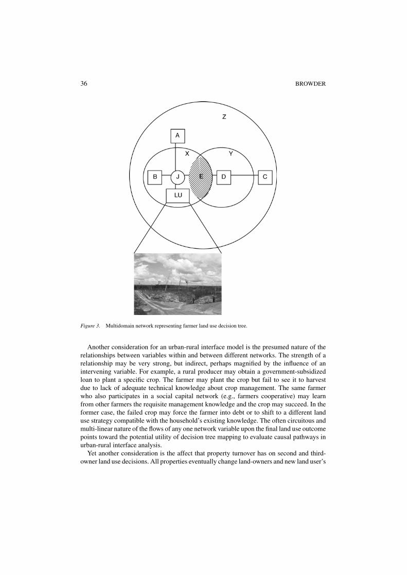
While this simple 3-dimensional schematic may help us to visualize the general URIscaffold, the causal linkages between independent decision variables (situated in differentsocial capital and productive economic network domains) and distinct land use outcomesremains to be specified. These linkages can be graphically represented within a networksystem (figure 3).
In this particular illustration, a multi-domain network system is represented. Exogenousdomain variable “A” (declining corn prices, rising beef prices, for example) may directlyinfluence farmer J’s decision to convert his annual crop field into pasture. Endogenousdomain variable “B” (e.g., increasing household size due to the arrival of new familymembers) might moderate the influence of the AJ signal toward pasture to maintain domesticfood stocks for internal household consumption. However, a government sponsored creditprogram to promote rice production (“C”) is channeled through a local urban bank (“D”)that makes low-interest loans to qualified farmers who participate in an urban-based farmercooperative (“E”). Farmer “J” is a member of this cooperative (situated in the inter-domainset of the Urban-Rural Interface and qualifies for this subsidized loan. His decision then toconvert his corn-field to a rice-field rather than to pasture would not be accurately predictedfrom an analysis of the “A-J” dyad alone, which appears “economically rational”. Nor wouldthis land-use outcome be accurately predicted by the intra-domain dyad, “B-J” which,considered alone, would point toward a “demographically rational” corn-field land useoption. Nor would the existence of a credit program for rice producers (“C-D”) necessarilyeventuate in a land use decision by farmer “J” to plant rice. Only when we consider themediating influence of the farmer cooperative, in which “J” belongs, situated in Urban-RuralInterface, is the rice land use outcome (convert from beans to rice or clear new land forrice) plausible. Given the “situational rationality” of farmer “J” the switch from a corn torice-based is logical. Rice can help supplement “J’s” household’s food needs, the productionof which can be subsidized by a credit program. It is a rational utilitarian decision in theend, but only if the analyst considers the social network function provided through the URI.
While the urban-rural interface framework focuses on the interaction of urban-basednetworks with rural producer households having specific internal characteristics, an addi-tional consideration is the influence that previous land use decisions have on current andfuture land use decisions. Any efficacious URI model, therefore, must be a dynamic it-erative multivariate model with a temporal dimension that accounts for the accumulatedeffects of historic land use decisions. At this point it would be useful to regard “land use”as a sequential temporal process beginning with the decision of a rural producer to con-vert a forest area into one or more productive uses (plots). As the physical conditions ofeach plot for a chosen use changes over time, the rural producer may bring into produc-tion additional forest areas, abandoning the original plots to fallow. The challenge for themodeler is to estimate the probability that at any given time a specific configuration ofnetwork and household factors will generate particular land uses, a daunting challengeindeed.
THE URBAN-RURAL INTERFACE 35
Table 4. Selected variables defining the urban-rural interface
1. Plane “Y”: Urban-based networks
Social capital networks
Producer marketing cooperatives
Social clubs
Voluntary benevolence associations
Local mutual assistance groups
Landless Rural Workers Movement (MST)
Faith communities/religious organizations
Political party organizations
Productive economic networks
Formal lending institutions
Informal credit cooperatives
Formal wage employment
Informal economic activity
Crop processing firms
Dairy processing firms
Slaughter houses
Machine repair services
2. Plane “Z”: Exogenous factors influencing land use decisions
Crop prices
Farm input prices
Farm land prices
Subsidized rural credits
Interest rate
Consumer price index
Fiscal incentives (tax measures)
Climate factors (e.g., drought)
3. Plane “X” endogenous rural producer characteristics
Household composition
Land tenure
Rural property holdings
Urban property holdings
Initial household capital stock (fixed and liquid)
Initial household debt/capital ratio (degree of initial indebtedness)
Distance to market
Off-farm income
Producer educational level
Natural resources (soil quality, irrigable water supply, forest resources)
36 BROWDER
Figure 3. Multidomain network representing farmer land use decision tree.
Another consideration for an urban-rural interface model is the presumed nature of therelationships between variables within and between different networks. The strength of arelationship may be very strong, but indirect, perhaps magnified by the influence of anintervening variable. For example, a rural producer may obtain a government-subsidizedloan to plant a specific crop. The farmer may plant the crop but fail to see it to harvestdue to lack of adequate technical knowledge about crop management. The same farmerwho also participates in a social capital network (e.g., farmers cooperative) may learnfrom other farmers the requisite management knowledge and the crop may succeed. In theformer case, the failed crop may force the farmer into debt or to shift to a different landuse strategy compatible with the household’s existing knowledge. The often circuitous andmulti-linear nature of the flows of any one network variable upon the final land use outcomepoints toward the potential utility of decision tree mapping to evaluate causal pathways inurban-rural interface analysis.
Yet another consideration is the affect that property turnover has on second and third-owner land use decisions. All properties eventually change land-owners and new land user’s
THE URBAN-RURAL INTERFACE 37
arrive bringing with them a range of different values and different situational rationalitiesfrom the preceding land users. Incorporating this demographic dynamic into predictive landcover change models will be a critical component in determining their accuracy.
Finally, three principles should be considered in URI applied research. First, the influenceof cities on their hinterlands will differ depending on the function of those cities in the largerregional, national and global systems of cities. Case study research focusing on one isolatedcity will doubtlessly fail to capture the range of influences emanating from different citiesin the same or different city systems. For example, we found vastly different types of citysystems in the “populist” frontier of Rondonia from the “corporatist” frontier of southernPara, with somewhat different associated rural landscapes (Browder and Godfrey, 1997).
Second, the range of URI variables that might influence rural land use surroundingany given city system (and these may differ among city systems) are likely to be highlyendo-interactive, requiring methodological controls for the effects of multi-colinearity. Sim-ply inserting a discrete independent variable (e.g., farm distance to nearest urban center)into a linear regression model will likely fail to either produce any statistically signifi-cant result and certainly will underestimate the actual affects of urban factors on rurallandscapes.
Third, advances in consumer-level communication technologies (satellite-based telecom-munications systems) have widely spread to rural Amazonia, perhaps off-setting some ofthe distance-based (friction) effects impeding spatial interaction between urban and rurallocations. Farmers can now directly observe commodity prices changes on the Chicagostock exchange over the internet and their satellite-linked television sets.
Conclusion
In this paper I raise the question of how we might understand and articulate the influences ofurban centers on tropical deforestation and subsequent land use. This paper reviewed the en-during legacy of Von Thunen’s concentric zones framework of agricultural land use and sum-marized the later contributions of growth pole theory and innovation diffusion research. Mostof these works propose deterministic models building on the Thunian framework, and few in-clude specific urbanization effects or disaggregate “urban influences” into discrete variables.Meanwhile, economists, demographers and political ecologists have attempted, from theirrespective perspectives, to explain the process of land use change without explicitly factoringthe urbanization influences on rural land users, with generally disappointing results. Hereinlies the challenge that this essay has sought to address through the rubric of the Urban-RuralInterface concept. The URI is seen as a field of interacting forces, some emanating fromsources exogenous to the rural producer (e.g., commodity prices, interest rates, institutionalrents), others emerging as constraints or characteristics internal to the rural property and itsowners (e.g., household labor, soil quality). Many of the most important determinants oflandscape change proceed through pathways mediated by the intervening urban-based net-works in which rural producers participate. Several different networks could be identified;for illustrative simplicity I have selected two: economic productive networks and socialcapital networks. Having proposed a general conceptual framework here—the Urban-RuralInterface—I leave the task of formulating and testing such a model to another paper.
38 BROWDER
Notes
1. Kummer and Sham’s analysis questions the findings of 7 other studies that emphasize the importance ofpopulation pressure as the dominant driving force of tropical forest decline. Those studies are: Allen andBarnes (1985), Grainger (1986), Lugo et al. (1981), Palo et al. (1987), Panayotou and Sungsuwan (1989), Reisand Margulis (1990), and Rudel (1989). Sambrook et al. (1999) also emphasize the importance of populationgrowth. Other studies, however, suggest that other variables play a significant role in explaining deforestation:Kyle and Cunha (1992) stress macroeconomic factors, especially the role of national factor markets. Chomitzand Gray (1996) found market access, land quality and tenure status to be key determinants of agriculturalland use. Browder (1985, 1988), Mahar (1989), Binswanger (1989), and Pfaff (1994) all focus public policies,development projects, and deforestation. Leonard (1989) and Deininger and Minten (1996) emphasize theconnection between rural poverty and deforestation.
2. By “rural producer household” I do not intend to imply a nuclear farm family sharing a single dwelling. Rather,by household I refer to the owners of a given rural property who make decisions about its uses. Such occupantsmay constitute extended filial units, nuclear filial units, or non-related persons communally managing theproperty and they may be reside on or off-the property in question.
References
Allen, J.C. and Barnes, D.F. (1985) The causes of deforestation in developing countries. Annals of the Associationof American Geographers 75(2), 163–184.
Angelsen, A. and Kaimowitz, D. (1999) Rethinking the causes of deforestation: lessons from economic models.The World Bank Research Observer 14(1), 73–98.
Armstrong, W. and McGee, T.G. (1985) Theatres of Accumulation: Studies in Asian and Latin American Urban-ization. Methuen, London and New York.
Barkley, D.L., Henry, M.S. and Shuming, B. (1996) Identifying “spread” versus “backwash” effects in regionaleconomic areas: a density functions approach. Land Economics 72(3), 336–357.
Becker, B.K. (1985) Fronteira e urbanizacao repensadas. Revista Brasileira de Geografia 47(3/4), 357–371.Bhadra, D., Salazar, A. and Brandao, P. (1993) Urbanization, Agricultural Development, and Land Allocation.
World Bank Discussion Paper 201. Washington, DC: World Bank.Binswanger, H.P. (1989) Brazilian policies that encourage deforestation in the Amazon. World Development 9(7),
821–829.Blaikie, P. (1985) The Political Economy of Soil Erosion in Developing Countries. Longman Group Ltd., New
York.Bowden L.W. (1965) Diffusion of the Decision to Irrigate. University of Chicago, Department of Geography,
Research Paper Series, Chicago.Bradley, G.A. (ed.) (1984) Land Use and Forest Resources in a Changing Environment: The Urban/Forest Interface.
University of Washington Press, Seattle and London.Browder, J.O. (1985) Subsidies, deforestation and the forest sector in the Brazilian Amazon. Contracted report to
the World Resources Institute, Washington, DC.Browder, J.O. (1988) Public policy and deforestation in the Brazilian Amazon. In Public Policies and the Misuse
of Forest Resources (R. Repetto and M.Gillis, eds.), pp. 364–377. Cambridge University Press, Cambridge andNew York.
Browder, J.O. and Godfrey, B.J. (1997) Rainforest Cities: Urbanization, Development and Globalization on theBrazilian Amazon. Columbia University Press, New York.
Brown, L.A. (1981) Innovation Diffusion: A New Perspective. Methuen, London and New York.Brown, L.A. and Malecki, E.J. (1977) Comments on landscape evolution and diffusion processes. Regional Studies
11, 211–223.Bryant, C.R., Russwurm, L.H. and McLellan, A.G. (1982) The City’s Countryside: Land and its Management in
the Rural-Urban Fringe. Longman, London and New York.Bunce, M. (1982). Rural Settlement in an Urban World. St. Martins Press, New York.

THE URBAN-RURAL INTERFACE 39
Carlstein, T. (1978). Innovation, time allocation and time-space packing. In Human Activity in Time Geography(T. Carlstein, D. Parkes, and N. Thrift, eds.). Edward Arnold, London.
Caviglia, J.L. and Kahn, JR. (2001). Diffusion of sustainable agriculture in the Brazilian tropical rain forest: adiscrete choice analysis. Economic Development and Cultural Change 49(2), 311–333.
Chomitz, K.M. and Gray, D.A. (1996) Roads, land use and deforestation: a spatial model applied to Belize.Unpublished manuscript, Policy Research Department, The World Bank, Washington, D.C.
Coleman, J.S. (1988) Social capital in the creation of human capital. American Journal of Sociology 94(Suppl.),S95–S120.
Collins, J. (1986) Smallholder settlement of tropical South America: the social causes of ecological destruction.Human Organization 45(1), 1–10.
Cook, K.S. and Toshio, Y. (1992) Power in exchange networks: a power-dependence formulation. Social Networks14, 245-266.
Dasgupta, P. and Serageldin, I.S. (eds.) (2000) Social Capital: A Multifaceted Perspective. The World Bank,Washington, DC
Deininger, K. and Minten, B. (1996) Poverty, policies, and deforestation: the case of Mexico. Unpublished paperprepared for the World Bank, Social and Environmental Consequences of Growth-Oriented Policies Project,Washington, DC.
Emerson, R.M. (1976) Social exchange theory. Annual Review of Sociology 2, 335–361.Fearnside, P.M. (1985) The causes of deforestation in the Brazilian Amazon. Paper presented at the United
Nations University International Conference on Climatic, Biotic and Human Interactions in the Humid Tropics:Vegetation and Climate Interactions in Amazonia. Feb. 25–March 1. Sao Jose dos Campos, Sao Paulo.
Friedkin, N. (1993) Structural bases of interpersonal influence in groups. American Sociological Review 58,861–872.
Furuseth, O.J. and Pierce, J.T. (1982) Agricultural Land in an Urban Society. Association of American Geogra-phers, Washington, DC.
Gaile, G.L. (1980) The spread-backwash concept. Regional Studies 14(1), 15–25.Grainger, A. (1986) The future role of the tropical rain forests in the world forest economy. Ph.D. dissertation,
Oxford University.Hagerstrand, T. (1952) The Propagation of Innovation Waves. Lund Studies in Geography, Lund, Gleerup.Hagerstrand, T. (1953) Innovationsforloppet ur Korologisk Synpunkt. Lund, Gleerup. translated by A. Pred as
Innovation Diffusion as a Spatial Process. Chicago University Press, Chicago.Hall, P. (ed). (1966) Von Thunen’s Isolated State (English translation by Carla M. Wartenberg, with an introduction
by the editor), Pergamon Press.Haggett, P. (1966) Locational Analysis in Human Geography. St. Martins Press, New York.Hansen, N.M. (1975) Criteria for a growth centre policy. In Regional Policy Readings in Theory and Applications
(J. Friedmann and W. Alonso, eds.), MIT Press, Cambridge.Hughes, D.W. and Holland, D.W. (1994) Core-periphery economic linkage: a measure of spread and possible
backwash effects for the Washington economy. Land Economics 70, 364–379.Johansen, H.E. (1971) Diffusion of strip cropping in southwestern Wisconsin. Annals of the Association of Amer-
ican Geographers 61, 671–683.Johnson, E.A.J. (1970) The Organization of Space in Developing Countries. Oxford University Press, London.Katzman, M.T. (1977) Cities and Frontiers in Brazil. Harvard University Press, Cambridge.Kummer, D.M. and Chi, H.S. The causes of tropical deforestation: a Quantitative analysis. Unpublished
manuscript.Kyle, S.C. and Cunha, A.S. (1992) National factor markets and the macroeconomic context for environmental
destruction in the Brazilian Amazon. Development and Change 23, 7–33.Lin, N., Cook, K. and Burt, R.S. (eds.) (2001) Social Capital: Theory and Research. Aldine de Gruyter, New York.Leonard, H.J. (ed.) (1989) Environment and the Poor: Development Strategies for a Common Agenda. Transaction
Books, New Brunswick and Oxford.LLEC (London Environmental Economics Center) (1992) The economics of tropical forest land use options:
a preliminary review of the literature. Unpublished monograph. International Institute for Environment andDevelopment, London, UK.
Lugo, A.E., Schmidt, R. and Brown, S. (1981) Tropical forests in the Caribbean. Ambio 10(6), 318–324.
40 BROWDER
Mahar, D. (1989) Government policies and deforestation in Brazil’s Amazon region. World Bank monograph,Washington, D.C.
McCracken, S.D., Brondizio, E.S., Nelson, D., Moran, E.F., Siqueira, A.D. and Rodriguez-Pedraza, C. (1999)Remote sensing and GIS at farm property level: demography and deforestation in the Brazilian Amazon.Photogrammetric Engineering and Remote Sensing 65(11), 1311–1320.
Millikan, B.H. (1988) The dialectics of devastation: tropical deforestation, land degrdation, and society in Ron-donia. Brazil. Unpublished masters thesis. Department of Geography, University of California, Berkeley.
Misra, R.P. (1969) Monte carlo simulation of spatial diffusion: rationale and application to the Indian condition.In Regional Planning (R.P. Misra, ed.), University of Mysore Press, Mysore, India.
Moran, E., McCracken, S. and Brondizio, E. (2001) The developmental cycle of domestic groups and its impacton deforestation rates in the Amazon. Conference paper. Indiana University, Bloomington.
Narayan, D. and Pritchett, L. (2000) Social capital: evidence and implications. In Social Capital: A MultifacetedPerspective (P. Dasgupta and I. Serageldin, eds.), pp. 269–296. The World Bank, Washington, DC.
Nichols, V. (1969) Growth poles: an evaluation of their propulsive effect. Environment and Planning 1, 193–208.Ozorio de Almeida, A.L. (1992) The Colonization of the Amazon. University of Texas Press, Austin.Palo, M., Salmi, J. and Mery, G. (1987) Deforestation in the tropics: pilot scenarios based on quantitative analysis.
In Deforestation or Development in the Third World (P. Matti and J. Salmi, eds.). Finnish Forest ResearchInstitute, Helsinki.
Pan, W., Murphy, L., Sullivan, R. and Bilsborrow, R. (2001) Population and land use in Ecuador’s northern Amazonin 1999. Intensification and growth in the frontier. Unpublished manuscript. University of North Carolina.
Panayotou, T. and Sungsuwan, S. (1989) An econometric study of the causes of tropical deforestation: The caseof northeast Thailand. Harvard Institute of International Development, Discussion Paper, Cambridge, MA.
Parr, John B. (1989) Growth poles, regional development and central place theory. Papers of the Regional ScienceAssociation 31, 173–212.
Perroux, F. (1950). Economic space: theory and Applications. Quarterly Journal of Economics 64, 89–104.Perz, S.G. (2000) Household demographic factors and life cycle determinants of land use in the Amazon. Paper
presented at the Congress of the Latin American Studies Association, March 16–18, Miami, Florida.Pinchon, F.J. (1996) Land-use strategies in the Amazon frontier: farm evidence from Ecuador. Human Organization
55(4), 416–424.Pinchon, F.J. (1997) Settler households and land-use patterns in the Amazon frontier: farm-level evidence from
Ecuador. World Development 25(1), 67–91.Pfaff, A. (1994) What drives deforestation in the Brazilian Amazon? Evidence from satellite and socioeconomic
data. Unpublished manuscript, Department of Economics, Columbia University.Pred, A.R. (1973) Urbanization, domestic planning problems and Swedish geographical research. In Progress in
Geography (C. Board, R.J. Chorley, P. Haggett, and D.R. Stoddart, eds.), vol. 5. Edward Arnold, London.Putnam, R.D. (1993) The prosperous community: social capital and public life. The American Prospect 13, 35–
42.Reis, E.J. and Margulis, S. (1990) Economic perspectives on deforestation in Brazilian Amazon. Paper presented
at the Project Link Conference, manila, Philippines, November 5–9.Robalino, D.A. (2000) Social Capital, Technology Diffusion and Sustainable Growth in the Developing World.
Ph.D. dissertation, RAND Graduate School of Policy Studies.Robson, B.T. (1973) Urban Growth: An Approach. Methuen, London and New York.Rondinelli, D. (1986) The urban transition and agricultural development: implications for international assistance
policy. Development and Change 17, 231–263.Rondinelli, D.A. and Ruddle, K. (1978) Urbanization and Rural Development: A Spatial Policy for Equitable
Growth. Praeger, New York.Rudel, T.K. (1989) Population, development and tropical deforestation: a cross-national study. Rural Sociology
54(3), 327–338.Sambrook, R.A., Pigozzi, B.W. and Thomas, R.N. (1999) Population pressure, deforestation, and land degradation:
a case study from the Dominican Republic. Professional Geographer 5(1), 25–40.Sanderson, S. and Pritchard, L. (1993) The human dynamics of land use and cover change in comparative per-
spective. Paper prepared for the IGBP/HDP Core Project Planning Committee Meeting of the Global Land Useand Cover Change Project (LUCC), New York, NY. July 29–August 1.
THE URBAN-RURAL INTERFACE 41
Scatena, F.N., Walker, R.T. , Homma, A.K.O., Conto, A.J., Ferreira, C.A.P., Amorim Carvalho, R., Neves da Rocha,A.C.P., Moreira dos Santos, A.I. and Mourao de Oliveira, P. (1996) Cropping and fallowing sequences of smallfarms in the terra firme landscape of the Brazilian Amazon: a case study from Santarem, Para. EcologicalEconomics 18, 29–40.
Serageldin, I. and Grootaert, C. (2000) Defining social capital: an integrating view. In Social Capital: A MultifacetedPerspective (P. Dasgupta, and I. Serageldin, eds.), pp. 40–59. The World Bank, Washington, DC.
Shannon, G.W. (1970) Spatial diffusion of an innovative health care plan. Monograph. University of Michigan,Department of Geography, Ann Arbor.
Stonich, S. (1993) “I am Destroying the Land!”: The Political Ecology of Poverty and Environmental Destructionin Honduras. Westview Press, Boulder, CO.
Tacoli, C. (1998) Beyond the rural-urban divide. Environment and Urbanization, 10(1, April 1998).Thorner, D., Kerplay, B. and Smith, R.E.F. (eds.) (1986) A. V. Chayanov on the Theory of Peasant Economy.
University of Wisconsin Press, Madison.Torres, H. (1988) A urbanizacao e o migrante de origem uyrbana na Amazonia. Instituto de Sociedade, Populacao,
e Natureza, Brasilia.Vosti, S., Witcover, J. and Carpentier, C. (1998) Arresting deforestation and resource degradation in the forest
margins of the humid tropics: policy, technology, and institutional options for western Brazil. Final Report tothe Interamerican Development Bank under the Alternatives to Slash and Burn Program. International FoodPolicy Research Institute, Washington, DC.
Walker, R. (2001) Urban spawl and natural areas encroachment: linking land cover change and economic devel-opment in the Florida Everglades. Ecological Economics 37(3), 357–369.
Willer, D. (ed.) (1999) Network Exchange Theory. Praeger, Westport and London.World Bank. (1997) Expanding the Measure of Wealth: Indicators of Environmentally Sustainable Development.
Washington, DC.