Embed Size (px)
Citation preview
- 1 –Teme Pilot Management Plan final
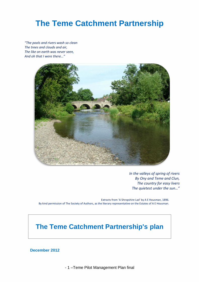
The Teme Catchment Partnership
“The pools and rivers wash so clean The trees and clouds and air, The like on earth was never seen, And oh that I were there…”
In the valleys of spring of rivers By Ony and Teme and Clun,
The country for easy livers The quietest under the sun…”
Extracts from ‘A Shropshire Lad’ by A E Housman, 1896.
By kind permission of The Society of Authors, as the literary representative on the Estates of A E Housman.
The Teme Catchment Partnership's plan
December 2012
- 2 –Teme Pilot Management Plan final
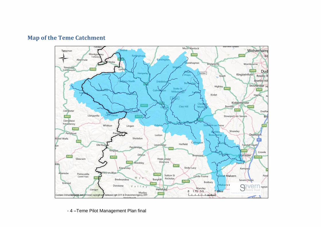
Foreword The River Teme is the second largest tributary of the River Severn. It rises in the Kerry Hills in Mid-Wales from a small spring on Cilfaesty Hill. The Teme is a rural river, passing through the market towns of Knighton, Ludlow and Tenbury before it joins the River Severn, just south of Worcester, some 122 kilometres further on. The 1,648 square kilometres of the Teme Catchment cover part of the counties of Shropshire, Herefordshire, Worcestershire and Powys. Tributaries include the rivers Clun, Onny, Corve and Rea, and larger brooks, such as the Ledwyche, Kyre, Sapey, Leigh and Laughern. The Teme Catchment landscape is characterised by rolling hills and attractive valleys, with the sheep-grazed Welsh border uplands in the west giving way to the softer, more fertile countryside of the English Midlands in the east. The unspoilt countryside is widely regarded as some of the most attractive in Britain, with the river flowing through Areas of Outstanding Natural Beauty, the Shropshire Hills and Malvern Hills. The rural nature of the area is reflected by high quality rivers supporting high-class fisheries and providing a variety of habitats for a wide range of flora and fauna. It is a river of national importance, a Site of Special Scientific Interest (SSSI) because of the rare, precious plants and animals that live in the river and on its banks. Part of the River Clun is of international importance, a Special Area of Conservation (SAC) due to a very rare and special population of Fresh water pearl mussels. The Teme is locally renowned for its beauty and history, which have been the inspiration of many stories passed down through generations. Over one hundred years have passed since Housman was so inspired by the River Teme that he wrote those well-known lines. However, in recent times, pollution has taken its toll and pressures exist that are in danger of impacting on those magical qualities of the river and streams in the Teme Catchment. The Teme Catchment Partnership is working to bring a wide range of partners together to try to solve some of the problems. A lot of work is already being done to try to improve water quality and wildlife habitats in and around the river and we now want you to get involved to help us identify what needs to be done and to help to make a difference. This draft plan sets out what some of the issues are, what is already happening and what more could be done. This plan is just the start of a process to involve individuals, communities, organisations, companies and farmers in working together to improve the river. We want you to join the partnership and to help in any way to make:
‘The Teme teeming with wildlife, The river running clean,
Everyone working closely, Enjoying the rivers and streams. ‘
We want to hear your views, opinions and suggestions to help make the Teme Catchment a better healthier place to live. For more information please contact Emma Buckingham at [email protected].
- 3 –Teme Pilot Management Plan final
CONTENTS
MAP OF THE TEME CATCHMENT ..........................................................4
OUR VISION ........................................................................................5
OUR STARTING POINTS .......................................................................6
WATER FRAMEWORK DIRECTIVE ................................................................... 6 THE PILOT CATCHMENT APPROACH ............................................................... 7 THE TEME CATCHMENT PARTNERSHIP ............................................................ 7
Purpose ............................................................................................. 8
WATER MANAGEMENT .......................................................................9
Flooding and high water events ........................................................ 9 Case Study: The importance of the Clun uplands ............................. 10 Enough water? ................................................................................ 11
CURRENT WORK ..................................................................................... 11
WATER QUALITY ............................................................................... 13
Diffuse water pollution from agricultural sources............................ 13 Phosphates, Sediment and Pesticides .............................................. 13 Point Source Pollution and Wastewater .......................................... 14
CURRENT WORK ..................................................................................... 15 Case Study: Working together with the community to help collect data on water quality ...................................................................... 15
LAND USE.......................................................................................... 17
Farming ........................................................................................... 17 Trees, Woodland and Forestry ......................................................... 18 Case Study: Helping the Farming Community .................................. 18 Recreation ....................................................................................... 19
CURRENT ACTIVITY ................................................................................... 20
WILDLIFE ........................................................................................... 22
Case Study: Community Wildlife Groups and Dipper Project ........... 23 WHAT ARE THE PROBLEMS? ....................................................................... 24 CURRENT ACTIVITY ................................................................................... 24
THE FUTURE ...................................................................................... 26
APPENDICES ...................................................................................... 27
WATER FRAMEWORK DIRECTIVE: TEME CATCHMENT STATUS ............................ 30 GLOSSARY .............................................................................................. 27
- 4 –Teme Pilot Management Plan final
Map of the Teme Catchment
- 5 –Teme Pilot Management Plan final
Our vision
The Teme Catchment Partnership Vision is for:
“Healthy functioning rivers flowing through a balanced living landscape, cherished by all
in the Teme Catchment”
Key manifestations of this vision include:
Water bodies with high ecological status
A healthy and recruiting population of Freshwater pearl mussels
Wildlife returning to the river and the catchment, including rare fish, such as shad and formerly common birds such as the cuckoo.
Healthy alder trees
River sediment reduced to natural levels through improved practices, such as sustainable urban and rural drainage and good buffer strips along river banks on cultivated land and fewer livestock accessing the river.
Abundance of water in the streams and rivers
No need for pesticide removal from drinking water Our vision will only be realised if all kinds of users of the Teme area work together. The Teme Catchment Partnership will work with everyone who wants to help realise this vision. This includes individuals, land managers, local communities, businesses, voluntary bodies, local authorities, and government agencies. By working together towards common goals, we will all understand the importance of the river to life and our wellbeing and aspire to the Teme Catchment having a balance of productive but sustainable farming and healthy ecosystems side by side.
A healthy river means that we have a healthy environment!
- 6 –Teme Pilot Management Plan final
Our starting points
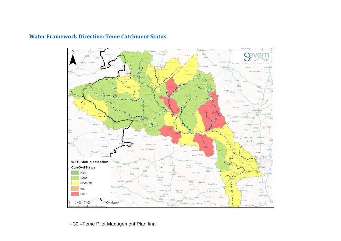
Water Framework Directive The Water Framework Directive is the most substantial piece of European legislation ever produced concerning our waters and will provide the major driver for achieving sustainable management of water in the UK for many years to come. It requires that all inland and coastal waters within defined river basin districts must reach at least good status by 2027 and defines how this should be achieved through the establishment of environmental objectives and ecological targets for surface waters. The result will be a healthy water environment achieved by taking due account of environmental, economic and social considerations. The Environment Agency has assessed all rivers in England and Wales for fish, plants, insects, algae and other indicators, including phosphate and oxygen levels, to support the implementation of the Water Framework Directive. This characterises our rivers in terms of ecology and water quality. There are five gradings for a river’s ecological status: High, Good, Moderate, Poor or Bad. Only rivers reaching 'Good' status or above are said to be meeting the required Water Framework Directive standards. A waterbody that is at High status is considered to be in almost natural condition. The findings of the first assessment in 2009 showed us that many stretches of the River Teme and its tributaries are not in good health and are failing to meet the required standard. Nearly 42% of the rivers and streams in the Teme Catchment have either been classified as poor or moderate (See Appendix Map). The current status of Teme and its tributaries is:
• Good ‐ 28 water bodies, 58%
• Moderate ‐ 12 water bodies, 25%
• Poor ‐ 8 water bodies, 17%
In many cases, classifications have been set using little or no data and are the subject of much debate. As new data becomes available there may be re-classifications that could either improve or reduce the status of waterbodies. Measured data will always be limited, so the knowledge of people living, working and recreating in the catchment can plug important gaps
What we do know is there are potentially many reasons for the failures. Significant progress has been made in tackling issues such as sewage, but the problems that remain are difficult to tackle including diffuse pollution and poor habitat. For example, data tells us that diffuse pollution comes from many sources, including septic tanks, agriculture, industry, roads, developments and the misconnection of drainage systems. These are preventing water environments in the Teme area achieve legally required standards. It will be difficult to solve all of these problems and the solutions will require us all to work together to bring about lasting change.
Some of the issues facing the Teme are: • High levels of nutrients, particularly phosphate. • Significant amounts of sediment in the river affecting spawning gravels for fish. • Depleted river habitat • Diffuse pollution from other chemicals and sources
- 7 –Teme Pilot Management Plan final
The Teme needs to be improved and put back into good order. We must ensure that now, and into the future, our river provides us with a healthy and useful resource and our native wildlife with a place to live and thrive. Measures to improve freshwater ecosystems in the Teme catchment can draw upon best practice from elsewhere in Europe; The Rivers Trust are one of ten partners in the Interreg funded TRAP project that identifies a number of measures to improve WFD status. These include innovative approaches to ensure fish migration, water friendly farming and the restoration of aquatic habitat.
The Pilot Catchment Approach Following the assessment of rivers in England and Wales, the UK Government has asked organisations to work in partnership to investigate concerns and issues, to work out local actions to improve our failing rivers and to tackle wider issues within their catchments. This led to the launch of a Pilot Catchment approach in 2011, incorporating wider environmental and social benefits within the river network and its landscape. The River Teme was chosen as one of the Pilot Catchments. On World Water Day, 22 March 2011, Richard Benyon, Minister for Natural Environment and Fisheries, announced that these pilots should: ‘… provide a clear understanding of the issues in the catchment, involve local communities in decision making by sharing evidence, listening to their ideas, working out priorities for action and seeking to deliver integrated actions that address local issues in a cost effective way and protect local resources’.
In his announcement the Minister recognised that tackling land management and water issues effectively cannot be solely undertaken by, or the responsibility of, one organisation but requires many actors to work in conjunction.
The Teme Catchment Partnership To achieve this aim, the Teme Catchment Partnership was established at the beginning of 2012 with support from a number of organisations. The Partnership will develop over time and comprise a broad membership of organisations and individuals representing a range of interests throughout the Teme catchment. We are currently in the early stages of establishing ways of working and have already identified a number of outcomes which we all want to achieve and are beginning to develop ways in which we might collectively achieve them. We think that the best way to improve the health and resource of the Teme is to work together at local levels to make improvements and we want to work with a wide range of organisations and people to shape these. The partnership is chaired and supported by the Severn Rivers Trust. As well as the Trust, the steering group currently includes representatives from:
• Shropshire Hills and Malvern Hills AONB Partnership • Shropshire and Worcestershire Wildlife Trusts • Herefordshire Nature Trust • Woodland Trust • Land, Life and Livelihoods Community Initiative • Forestry Commission

- 8 –Teme Pilot Management Plan final
• Severn Trent Water • Natural England • Environment Agency • Catchment Sensitive Farming • Teme Fisheries Association
Working with other organisations will help us get a collective understanding of the problems faced by the water environment and associated habitats. We want to share data, information and resources to identify what causes these problems, plan how to tackle them and develop a shared long-term plan for future action. Other partnership projects have achieved great results for the environment in the Teme area. We hope to learn from and build on these successes. We want everyone to value and enjoy the Teme, its brooks and streams and to understand their importance as a resource to people, farmers, business and wildlife in the Teme catchment. Participation from communities and local interest groups is crucial. You will play a significant role in helping to improve your water environments. Our Project Officer will be visiting communities and groups in the Teme Catchment. We want you to tell us what you know about the river and what we should do for the Teme.
Purpose The purpose of our Partnership is to:
• Provide a clear understanding of the issues that affect the Teme Catchment; • Collate information for the catchment to allow us to identify the issues that affect water
quality and the action already in progress. • Reach a shared understanding of the catchment’s priorities.
• Identify a range of actions to achieve environmental benefits for the catchment.
• Strengthen collaborative working to action implementation.
• Deliver these improvements in a joined‐up and cost‐effective way. • Monitor projects and progress to make sure they keep working effectively to improve the
river and local resources. • Enthuse local communities, groups, businesses and organisations and involve them in
decision‐making and activities to help them improve, enjoy and understand their river and environment.
• Identify best practice components that can be replicated in similar projects.
• Share information, evidence and ideas. • Create a framework to ensure works complement existing habitats, wildlife and food
production.
This draft improvement plan, written by the partnership, highlights examples of projects that are currently being carried out by Teme Catchment partners and the proposed work planned for the future to improve the health of the rivers. This will grow to capture people's ideas and aspirations for the river and show how we all can help to realise them.
- 9 –Teme Pilot Management Plan final
WATER MANAGEMENT: Setting the scene
Water is a crucial resource for us to live and we need to manage the natural environment and our water resources sustainably to protect the Teme Catchment. Climate change is the
biggest long term issue affecting the catchment and it may already be having some impact. The UK Climate Impacts Programme projections suggest that the Severn River Basin District in the 2050s could increase in winter mean temperature by 2.2ºC. This increase in temperature could have profound implications on the environment of the Teme. With changes in the climate, such as drier winters, drought conditions could result in low river flows and periodic drying up of the River Teme and its tributaries. This will affect businesses and communities through water restrictions and could be potentially damaging for rivers habitats and other water-dependent habitats such as, wet woodland and the species dependent upon them.
• The Teme Catchment is already subject to water stresses, highlighted in 2011 when an extremely dry winter resulted in water restrictions being put place, limiting agriculture and business abstraction. Restrictions could likely increase as the demand for water increases.
• Predictions of agricultural irrigation use could increase by around 20% by the 2020s. This is not sustainable in a catchment identified as having ‘no water available’ without causing environmental damage1.
• The environment will also feel the effects of increased drought conditions with lesser dilution for downstream pollutants in summer and low flow levels affecting oxygen levels and habitats of fish and freshwater pearl mussels.
Through climate change, annual rainfall could increase significantly, along with dramatic storm events and flooding. In September 2012, the Teme Catchment saw more than a month of rain fall in less than 24 hours and flood alerts placed on the River Teme, Onny, Rea and Corve. More extreme rainfall patterns will affect flow regimes, impacting communities and businesses through increased risk of flooding, also damaging habitats and infrastructure for invertebrates and fish, with knock-on impacts to the wider environment. Measures have to be put in place now to counteract the upcoming changes, to protect water for our use and the environment.
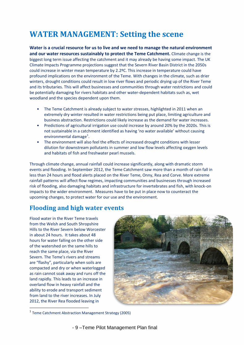
Flooding and high water events
Flood water in the River Teme travels from the Welsh and South Shropshire Hills to the River Severn below Worcester in about 24 hours. It takes about 48 hours for water falling on the other side of the watershed on the same hills to reach the same place, via the River Severn. The Teme’s rivers and streams are “flashy”, particularly when soils are compacted and dry or when waterlogged as rain cannot soak away and runs off the land rapidly. This leads to an increase in overland flow in heavy rainfall and the ability to erode and transport sediment from land to the river increases. In July 2012, the River Rea flooded leaving in
1 Teme Catchment Abstraction Management Strategy (2005)
- 10 –Teme Pilot Management Plan final
places inches of sediment on banks and roads after the flood waters had retreated. Whilst extreme weather conditions are a contributory factor, variations in water flows are also a result of a significantly modified catchment hydrology. Natural features, such as meanders, floodplain meadows, woodland and in-river deadwood all help slow the movement of water helping to retain the natural hydromorphology of the catchment. Over many years the catchment has dramatically changed through land use and management, affecting its ability to store water and increasing the rate of rainfall run off in to the rivers and streams. The catchments ability to store water has been affected by changes in land use; for example:
• Large reductions in the area of upland moors and wetlands; significant areas of floodplain have been lost due to embankments or built upon and historical and modern land drainage have affected run-off.
• Since the Second World War changes in agriculture have generally increased stocking levels on grassland, whilst arable cultivation has increased and been undertaken in ever increasing field sizes, using larger and heavier machinery. Ground compaction on both land types has thus become greater, leading to increased speed of run-off.
• Additionally, the increase in road run-off is of very serious concern as increasing rates of surface water run-off with sediment, potentially having a detrimental effect on river water quality. Surface water run-off from roads can contain a wide range of pollutants, for example, oil, organic matter and toxic metals.
As climate change becomes a reality, the increased intensity of rainfall onto improved farm land results in increased ‘flashiness’ of river flows. The environmental impact of surface water run-off can be minimised by good design and practice. Best farming practises, for example increased aeration and buffer strips can slow the potential run off and limit the extent of soil erosion. Management and minimisation of urban run-off and increased adoption of sustainable urban and rural drainage design and techniques can prevent storm water flooding, improve water quality and offer the opportunity for the creation of wetland habitats.
Case Study: The importance of the Clun uplands The Clun uplands in the Teme Catchment were once extensive heathlands, moors and rough pasture, with some peat in addition to mineral soils. Good quality upland areas are extremely beneficial in water management, peatlands in particular hold enormous amounts of water (90% water, 10% carbon). Since the 1950s, the cumulative effects of improved farming, has led to the drainage of the uplands for agriculture and forestry, with a corresponding reduction in the area of wetlands. Historically, drains were cut to dry out the ground improving it to for grazing. These drains intercept surface water and quicken the loss to streams and rivers, consequently lowering the water table. This is not only bad for biodiversity but it can increase sediment and colour released into streams and rivers through the loss of organic carbon from the peat. It also means that wetlands have no capacity for storing water during heavy rainfall events as many natural mosses have been lost, potentially adding to downstream flooding problems. In these uplands, water quality is generally higher than in the lowlands and therefore more at risk from pollution. Upland “rewetting” would increase carbon sequestration capacity to help mitigate against climate change and crucially, would protect headwaters by re-establishing natural stream hydrology, in turn leading to an improvement of river environments and aquatic ecology.

- 11 –Teme Pilot Management Plan final
Enough water? Water is used for a number of different purposes within the catchment, with the main uses of water for public water supply and agriculture. Unlike the River Severn, flows in the River Teme are not supported by releases from a reservoir and under the Catchment Abstraction Management Strategy (CAMS, 2005) the Teme has been identified as a catchment having ‘No Water Available’, without causing environmental damage. This restriction limits the potential for widespread spray irrigation in the catchment, though in recent decades, pressures have increased on water resources due to the increase in arable land and the change in the variety of crops grown, increasing the need for spray irrigation and heightening the potential for diffuse pollution. The River Teme often experiences low flows in summer, but in more recent times this has been occurring in the winter too. Water resources during dry months can be scarce and can potentially affect water supply causing restrictions to people and business. Declining flow, water levels and ponding of water in the Teme threaten the survival of the wildlife in the river, such as fish and the freshwater pearl mussel. There is a legal requirement to protect designated sites including the River Clun SAC and the River Teme SSSI, both dependent on “natural” flows to maintain their ecological value and therefore, there is a need to limit the volume of water abstracted during periods of low flows. The Environment Agency limit the volume of water abstracted and impose flow restriction conditions so abstraction must reduce or cease during low flow periods. But to alleviate the necessity for restriction - we want to help, educate and provide information on how best to use water, store and collect rainwater to reduce the overall demand for summer abstraction and encourage best practices to reduce soil compaction and increase infiltration.
Current Work
Many factors affect water quantity and flows in the Teme’s rivers and streams. We recognise the need that we must manage our water appropriately and use it sensitively to provide long term protection for the environment. We believe that by working with landowners, communities and businesses we can show how small changes in behaviour can make a real difference to the river and its tributaries. The supply of water is limited, so we need to make sure that it is managed and used effectively to meet the needs of people and the natural environment. Below are useful links from the Environment Agency to help provide you with all you need to know about how best to use the water available:
• Water abstraction: http://www.environment-
agency.gov.uk/business/topics/water/32020.aspx
• Water restriction: http://www.environment-
agency.gov.uk/homeandleisure/drought/131105.aspx
• A great leaflet advising on how best to use water more sustainably and pointing to other
sources of funding and information available:
http://www.ukia.org/eabooklets/EA%20Reservoir%20booklet_final.pdf
• Water use on Dairy Farms by Dairy Co: http://www.dairyco.org.uk/technical-
information/environment/water-use/
The Severn Rivers Trust has secured limited funds through the Catchment Restoration Fund for the River Rea Restoration catchment project. A Project Officer will be helping farmers, landowners and
- 12 –Teme Pilot Management Plan final
local communities through support, guidance and advice with potential for investment in simple resource protection measures such as coppicing, fencing and cattle drinkers in priority areas. This builds on works already completed in the catchment upstream of Tenbury in improving the riparian habitats. The riparian buffer strips will help to slow water runoff, maintenance and coppicing will not only rejuvenate the Alder trees, it will also reduce the blockages in the river from excess of woody debris, reduce the amount of sediment entering the river from erosion and fencing will limit poaching of the banksides.
http://www.riverrea.com/
- 13 –Teme Pilot Management Plan final
WATER QUALITY: Setting the scene
The Teme Catchment provides many resources which we often do not consider but need to safeguard for ourselves and future generations. These include our drinking water, water for
livestock and our food crops that grow beside it, enjoyment through activities like fishing and a home for the wildlife which lives within and around it. The quality of the water in our rivers and streams affects all of these things and poor water quality can be detrimental in its use and damaging to our wildlife and fisheries.
The Environment Agency carries out routine monitoring of the river. Many parameters are assessed and these define the health of the river. Whilst the majority of the rivers and streams in the Teme Catchment are of Good chemical and biological quality (called “Good ecological status” by the Water Framework Directive), there are many stretches not achieving ‘Good’ status and some that are failing the framework. There are a number of reasons that lead to failing watercourses including low fish numbers, the lack of presence of certain fish species and levels of phosphorous in the water. Investigations carried out by the Environment Agency and other partners such as the Severn Rivers Trust and Catchment Sensitive Farming suggest the main impacts potentially affecting these stretches of water and the water quality in the catchment arise from sediment, nutrients and pesticides. These enter watercourses from many different sources (e.g. run‐off from fields, roads, land management practices, developed land and septic tanks). It is also exacerbated by pollutants from point sources such as sewage treatment works and industrial sites, which are usually controlled through formal discharge consents.
Diffuse water pollution from agricultural sources
By its very nature identifying sources of diffuse pollution can be very difficult. Agricultural land management and farm holdings are believed to be the largest contributor to diffuse pollution in this largely rural catchment with the key pollutants being nitrates, phosphate, pesticides and sediment. On its own, each source of diffuse pollution may be of little significance. However, when they occur together, they can create significant problems.
Nitrates, Phosphates, Sediment and Pesticides
Farming is not the sole cause of these problems, but nationally it does contribute approximately 60% of nitrates, 25% of phosphorus and 75% of sediment entering our waters. Since the 1950’s farming has increasingly used chemical fertilisers to increase plant yields and pesticides for insect and weed control. Increased use of chemicals results in more loss to the water environment and can increase nitrate and phosphate levels in surface water and groundwater. The levels of phosphate in the Teme are a definite cause for concern. Elevated phosphate levels can cause excessive plant growth, in turn reducing flows and removing oxygen from the water reducing the capacity of the river to support animals, such as fish. Phosphates enter the river through riverbank erosion, surface and subsurface flow and identifying the sources of phosphate at the catchment scale can be difficult. Already a great deal has been done to reduce phosphate inputs into the river by treating water at sewage treatment works and changing farming activities. However, improvements to water quality are now slowing and the levels of phosphate are still too high. To help tackle this problem, schemes such as Defra’s Catchment Sensitive Farming initiative are being implemented in the catchment. The
- 14 –Teme Pilot Management Plan final
aim is to raise awareness and encourage farmers to adopt management techniques that minimise the impact of farming practices on water quality and in turn can provide a financial benefit to the farm. The Partnership is particularly concerned about sediment levels in the rivers as this can cause harm by clogging up river gravels, preventing fish from spawning and reducing the viability of their eggs. Suspended sediment also reduces light penetration, inhibiting photosynthesis by water plants and restricting animal movement. Once in the water, fine sediments are very hard to remove. They settle on the bed slowly, releasing the chemicals they hold over many years. As well as natural soil erosion, changes in land use, cultivation practices on arable land, poaching by livestock on riverbanks and land drainage can all release sediment into the river. Sediment is also washed off roads into highway drains and natural processes of bank erosion have been exacerbated by the loss of stabilising riverbank alder trees due to a disease called Phytophthora.
Over recent decades farming has increasingly used fertilisers and pesticides to improve plant yield and control pest diseases. Increased use of these chemicals has resulted in more contaminants entering the water environment. These contaminants can adversely affect groundwater used for water supply and lead to long term effects on biological quality of watercourses. The loss of pesticides to the water environment is on average 5% of the application. If rainfall occurs shortly after application losses can be significantly higher and can result in fish kills in water bodies receiving run-off. There may also be long-term effects on the biological quality of the water body. Drinking water standards have very low tolerance limits for pesticides. At certain times of year, the Teme may experience raised concentrations of metaldehyde, a pesticide found in slug pellets used on farms and in gardens. Current water treatment processes are inefficient at removing this particular pesticide and as such, compliance with drinking water standards is at risk. A number of herbicides have also been detected at concentrations that, at times, require treatment by water companies, including carbetamide, chlorotoluron, 2,4-D, glyphosate, mecoprop, metazachlor and propyzamide. Pesticide removal is expensive and energy intensive. The Catchment Sensitive Farming initiative has identified the Teme as a priority catchment with regard to pesticides, for targeting of training and advice. This includes promoting measures from “The Voluntary Initiative” an industry led group promoting good practice to prevent pesticides entering water. (http://www.voluntaryinitiative.org.uk/)
Point Source Pollution and Wastewater
Other sources of pollution include products used in the home, sewer misconnections and run-off from roads. Most villages have wastewater treatment plants (WWTPs); any discharges should meet consent levels set by the Environment Agency. However, smaller treatment works are unlikely to have phosphorus removal plant and may still contribute significant amounts of nitrogen and phosphorus to the aquatic environment. Given the largely rural nature of the catchment, there is also likely to be a significant number of properties not connected to mains sewage and are using septic tanks for water treatment. A recent survey undertaken by Shropshire Hills AONB Partnership suggests there is little householder understanding of septic tanks, with many domestic systems being old and underserviced; their installation likely to predate the modern regulations that now control such installations. Phosphates in detergents and products derived from domestic laundry and cleaning materials enter the waste water stream due to ineffective treatment. Phosphates will be banned from laundry products in 2015, though other products used in dishwashers, bathrooms
and car cleaning products still contain phosphates. We need to understand more about these
contributions, though the combined impact of these systems should not be underestimated and
- 15 –Teme Pilot Management Plan final
evidence from other catchments suggests that both WWTPs and septic tanks can be a significant contributor to the annual nutrient budget of rivers.
Current Work Embedded within all of our work is the understanding that we need to collect more data and evidence to help us identify where and what within the catchment is affecting the rivers and streams. We need to be able to target at the heart of the problem if we want to affectively improve water quality. We can only achieve what is within our limits, but with joined up, collaborative working and with the help of the community of the catchment, we can all strive to improve our own environment affectively. The case study below shows an example of this type of project happening in the Teme Catchment.
Within some of the sub catchments of the Teme, such as the Clun and Rea we have already made good progress including establishing priorities, starting to provide information and advice, publishing a promotional leaflet and developing proposals to help improve water quality. In the Clun catchment, Shropshire Hills AONB Partnership are running a public awareness campaign on septic tanks, and also beginning feasibility work with the Council Highways department on reducing sediment in run-off from roads. A Catchment Sensitive Farming Officer works with farmers with land in priority areas within the Clun and Rea sub catchments. CSF provides advice to farmers to help them implement changes in farming that reduce the risk of water pollution, and reduce the risk of regulation being applied to farming to achieve required water quality standards. This includes farm audits to assess and identify any
Case Study: Working together with the community to help collect data on water quality
We do not know very much about how the flows of water vary in many of the tributary rivers and streams in the River Teme catchment, or whether the quality of the water and the river as a whole is as it should be. This is especially true for the upper reaches. To address some of the gaps in our understanding whilst at the same time trying to connect local people with their river, the Shropshire Hills AONB and a community led initiative, Land, Life and Livelihoods have started an experiment in “citizen science”. Volunteers in the upper Clun area have received some training, courtesy of the Environment Agency and are undertaking a programme of measuring flows in the river channel and sampling and identifying invertebrate species in the river bed. The biological sampling will tell us more about the overall health of the river, whilst the flow monitoring will help build up a better picture of the way the flow varies seasonally and in response to rainfall. In addition the volunteers are taking soil and sediment samples from fields, river banks and road verges in the surrounding catchment to help us to trace the origin of the silt that is considered to be a major problem to the river bed. ADAS are generously collaborating with this initiative in processing the sediment samples and the overall data analysis. In due course the Land Life and Livelihoods initiative hopes to set up a “Community Observatory” to manage all such information collection, collation and dissemination with and within the Upper Clun catchment community, as well as with external organisations and professionals.
- 16 –Teme Pilot Management Plan final
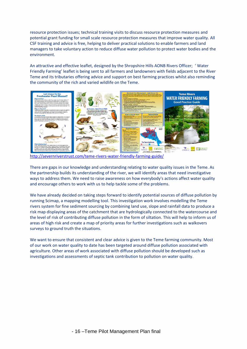
resource protection issues; technical training visits to discuss resource protection measures and potential grant funding for small scale resource protection measures that improve water quality. All CSF training and advice is free, helping to deliver practical solutions to enable farmers and land managers to take voluntary action to reduce diffuse water pollution to protect water bodies and the environment. An attractive and effective leaflet, designed by the Shropshire Hills AONB Rivers Officer; ‘ Water Friendly Farming’ leaflet is being sent to all farmers and landowners with fields adjacent to the River Teme and its tributaries offering advice and support on best farming practices whilst also reminding the community of the rich and varied wildlife on the Teme.
http://severnriverstrust.com/teme-rivers-water-friendly-farming-guide/ There are gaps in our knowledge and understanding relating to water quality issues in the Teme. As the partnership builds its understanding of the river, we will identify areas that need investigative ways to address them. We need to raise awareness on how everybody's actions affect water quality and encourage others to work with us to help tackle some of the problems. We have already decided on taking steps forward to identify potential sources of diffuse pollution by running Scimap, a mapping modelling tool. This investigation work involves modelling the Teme rivers system for fine sediment sourcing by combining land use, slope and rainfall data to produce a risk map displaying areas of the catchment that are hydrologically connected to the watercourse and the level of risk of contributing diffuse pollution in the form of siltation. This will help to inform us of areas of high risk and create a map of priority areas for further investigations such as walkovers surveys to ground truth the situations. We want to ensure that consistent and clear advice is given to the Teme farming community. Most of our work on water quality to date has been targeted around diffuse pollution associated with agriculture. Other areas of work associated with diffuse pollution should be developed such as investigations and assessments of septic tank contribution to pollution on water quality.

- 17 –Teme Pilot Management Plan final
LAND USE: Setting the scene
Farming
The high landscape value of the catchment is largely shaped by its past farming practices, however, this process is not static and farming continues to shape the landscape today. Following the post war boom, our rural landscape has changed dramatically and we are now seeing how this is affecting rivers and wider environment. Since the Second World War farming practices have become increasingly intensive - field size has increased, there are high levels of chemical inputs including fertiliser and pesticides in some areas, and there has been a move to specialisation with farms concentrating on either livestock or crop production. In pursuit of more productive land we have ploughed, drained and fertilised our wilder areas. Rising demand for cereal crops, potatoes and animal feed, has increased cultivation and intensive practices in the catchment and whilst food production is critically important this has come at the cost of a dramatic reduction in landscape diversity and environmental quality. The unintended consequences have been the fragmentation of our best wildlife habitats, with a decline in wetland and river corridor habitats, deterioration of carbon and water storage and a decline in water quality. We need to better balance the demand for land and water resources with the needs of the environment as they are closely linked. Within the Teme Catchment, farming underlies the entire rural economy and is a major factor in environmental protection and enhancement. The favourable climate and land quality of the Teme Catchment means that the area is suited to a wide range of cropping activities and almost all types of farming are represented in the catchment. Sheep are the main farming activity, followed by beef, dairy, pigs and poultry. Arable is a significant activity in the lower catchment, and in parts of the uplands there is cultivation, mainly for potatoes. Upland pasture and rough grassland account for about a third of the catchment and lies mainly to the west and the north of the Teme catchment. The richer land in the floodplain is a mixture of grazing and arable with the lower catchment increasingly dominated by arable and cereal production. Maintaining a sustainable and thriving farming sector is vital for the economy with land management practices having the greatest potential for improving the quality of the environment, water quality, habitats and ecology of the River Teme and its tributaries. To achieve this, the Partnership recognises, not only that the rural nature of the area poses its own risks in terms of pollution potential from agricultural practices, but to support the local economy there is a need for rural diversification and to support the farming community to make the transition to more sustainable methods of land management. The main problems associated with land use in agriculture on watercourses include:
Livestock using the river course for water - The impact of livestock along the water course includes excrement deposition in or near the water course, soil and bank erosion from animals drinking at the river, leading to increased silt in the water course.
- 18 –Teme Pilot Management Plan final
Intensive arable farming – Over the last 15 years CAP subsidies and improved economics of arable farming has had the impact of increasing the land area put into arable production. This has resulted in some farmers switching from permanent pasture to arable and potato production, involving ploughing and planting up to the edge of the water course, increasing the likelihood of runoff (sediment and agri-chemicals from pesticides and fertilisers) and soil erosion.
Infrastructure of farmyards – with the rapid expansion and lack of investment returned into farms, services are ageing and there is often inadequate livestock and/or manure storage.
Trees, Woodland and Forestry
Woodland is one of our richest habitats and can play a vital role in regulating our climate, reducing the risk of flooding, helping to stabilize soils and controlling both water quality and quantity. There are several large forested areas within the catchment, particularly in the
upland region around Ludlow and Clun, and at the headwaters of the catchment. The Forestry Commission owns woodlands in the Teme valley at Bucknell, Mortimer forest and Kinsley at Knighton. Areas of particular importance within the catchment are the Downton Gorge woodlands, a relic of the ancient Royal Chase of Bringe wood. Ancient and semi-natural woodland is a significant feature of the area and associated with the steep slopes and scarps above the river. Before
Case Study: Helping the Farming Community Given the reliance on farming within the local economy the immediate economic viability and survival of farms is critical. The state of the agricultural industry in the UK is continually changing with an increasing emphasis towards cross-compliance and agri-environment measures. There is an increasing need for farmers to be more efficient and reduce variable input costs, which often means that size dominates to the detriment of smaller hill farms. Legislation, grants and the increased availability of specialist advice have all been important factors in reducing the impact of farming on the environment and will continue to play a central role in this process contributing to overcoming pollution problems. Agri-Environment Schemes are likely to hold the key to the future protection and improvement of the area’s biodiversity, but their future is uncertain. These schemes offer tiered financial incentives for landowners to manage their land more sympathetically for landscape, biodiversity and the historic environment, but there is concern about the uptake and targeting of Higher Level Stewardship (HLS) and potential reduction in conservation activity as Environmentally Sensitive Areas (ESA) agreements finish and the scheme is wound up. It has supported farm incomes by ensuring a guaranteed return for wildlife conservation and landscape protection measures which otherwise would not be delivered in times of low farm incomes. However, many local farmers are unsure of ESA successor schemes such as the Entry Level, Organic Entry Level and Higher Level Stewardships. HLS is not available to everyone and its priorities remain unclear to many (From findings of Land, Life and Livelihoods Key People Event, held 4th Nov 2010.). A successor scheme has yet to be developed and its scope will depend on the current round of CAP negotiations. We realise it is key that we need to make available to all farmers and landowners better joined up advice and provide additional help in making the right choice.
- 19 –Teme Pilot Management Plan final
woodland clearance, wet valley woods would have been extensive along the rivers and streams. There are remnants in flushed areas, at stream-sides along valley bottoms, and as small isolated copses. Many consist of alder but can also be diverse with hazel, willow, holly, guelder rose and greater tussock sedge, meadow sweet and marsh marigold being found as ground flora. Dumbleton Dingle is an important example of a ravine woodland with large-leaved lime and wild service tree and also features, ramsons male fern, buckler fern, and opposite leaved golden saxifrage. The wild service tree and small-leaved lime are characteristic of woods and hedgerows in the Teme valley. Traditional standard orchards are characteristic of the sloping valleys and lower hillsides of the Teme corridor. Many have been lost recently but there is still a concentration between Tenbury Wells and Bromyard. Abundant mistletoe is a characteristic feature of many of these orchards. The Teme corridor was particularly noted for cherry orchards, although many have been lost, some remain. Well managed forestry, woodland and new woodland creation in appropriate areas can deliver significant benefits for water flow and quality, with minimal impact, at the same time offering wide opportunities for landscape, wildlife, recreation, farming and the local economy. However, in certain circumstances inappropriate forestry management can cause problems, especially during felling. Poor management can result in siltation of surface waters, risk of increased flooding and damage to wildlife habitats. Woodland expansion provides benefits in sustainable flood management, tackling diffuse pollution by acting as a barrier and reducing the risk of runoff from agriculture land and helps to trap and retain nutrients and sediment. There are a significant number of Plantations on Ancient Woodland Sites (PAWS: where the native trees have been removed and the site replanted with non-native species, chiefly conifers), with opportunities for sensitive restoration back to native broadleaves, potentially delivering benefits for water quality and flow. Expansion of wet woodland can assist in helping to meet Biodiversity Action Plan targets and riparian and floodplain woodland benefit by protecting the river and help in cooling streams and rivers through shade and improving habitats for fish and other wildlife, mitigating the effects of climate change. Further consideration to climate change and tree species choice should be considered as health issues and bio-security are important when managing existing trees like Alders suffering from Phytophthora. ‘Woodland for Water’ publication is a useful study by the Forestry Commission to help understand how woodland can be used to improve water quality and water management. (http://www.forestry.gov.uk/pdf/FRMG004_Woodland4Water.pdf/$file/FRMG004_Woodland4Water.pdf)
Recreation The Teme and its tributary rivers are very important as part of the overall landscape which is valued by both local people and visitors. The area is used for a range of recreational and amenity activities particularly as much of the Shropshire Hills AONB and part of the Malvern Hills AONB lie within the Teme area. Both are very popular with visitors and provide a range of recreational opportunities, such as walking, horse riding and cycling. A relatively small proportion of riverbanks are publicly accessible by rights of way or other means, but those which are tend to be well used and highly valued. Many sections especially of the lower river are used for fishing through controlled private rights. There is a modest level of use of the lower Teme for canoeing. There are a range of opinions from different users on improving public access. Conservation and enhancement of the historic environment in places such as the towns along the River Teme has helped to improve access to the river for recreational users. However, we need to help people to understand the important role the river plays, and help them to appreciate it as an asset that underpins recreation, tourism, quality of life and related economic benefits for the towns and communities along the Teme. Protecting and restoring the historic weirs on Ludlow is important to the town’s residents and visitors with their
- 20 –Teme Pilot Management Plan final
iconic views. By working together to improve these structures there can be a wider benefit for sightseers and anglers alike. Watching salmon leaping has become a visitor attraction in its own right in towns such as Ludlow and by improving fish migration across the protected structures there will be benefits to the wider river environment. There is some funding available to support physical regeneration in towns in the Teme catchment, as well as for marketing the wider attractions of the area, such as walking and fishing. Through close partnership working with a variety of organisations this funding could be closely targeted at the river and the opportunities that exist along its banks. The towns of Tenbury and Ludlow could become a local centre for these activities and offer huge potential for river based tourism, recreation and angling.
Current Activity Land management practices have the greatest influence on the quality of the environment, fisheries and water quality on the River Teme and its tributaries. Changes in adjoining land use including rural and urban, all have the potential to impact on the natural environment and further the decline in wetland and river corridor habitats. If managed properly these changes could bring about real improvements. The vast majority of the land is managed for agriculture, therefore this has the biggest role in looking after and improving the quality of catchment waters. To achieve this we need to think in a more integrated way in how the catchment is managed and provide the advice and guidance needed to help achieve this. We need greater integration of activity across the catchment and to join up links between regulatory and grant mechanisms, pro-active projects and community involvement.
There are a range of current activities and initiatives relating to land management in the Teme catchment.
Shropshire Hills AONB Partnership o Rivers Project: riparian tree coppicing and buffers trips have been created over the
last 10 years in the Clun Sub Catchment. Recently activity has focussed more broadly on integrated catchment management and in particular seeking to achieve favourable condition for the River Clun SAC and its threatened population of Fresh Water Pearl Mussels. www.shropshirehillsaonb.co.uk/looking-after/projects/rivers/
o Clun Catchment Partnership: From 2012 a new Partnership group has been formed to co-ordinate and raise the profile of activity related to the river and catchment management. www.shropshirehillsaonb.co.uk/looking-after/area-initiatives/clun-catchment/
Catchment Sensitive Farming o Aims to improve water quality in the Teme and enhance associated river corridor
habitats by supporting sustainable land use within the catchment, minimising the impact of agricultural practices on the environment and advising ‘Best Farming Practices’ that benefit the farmer and the environment.
Entry Level Stewardship Scheme, Organic Entry Level Stewardship and Upland Entry Level Stewardship
o These are the basic stewardship schemes open to all farmers and land managers in England. It provides a straightforward approach to supporting the good stewardship of the countryside.
o Natural England funds free farm visits to assist farmers with their applications and provide advice on the most appropriate options for the farm. Advisers will encourage the uptake of priority options which will help to tackle the sources of
- 21 –Teme Pilot Management Plan final
diffuse pollution, slow the pathway and protect watercourses. Farmers are also encouraged to take up options which will improve habitat for farmland birds and for wildlife species such as dormice.
Higher Level Stewardship Scheme o This involves more complex types of management and agreements are tailored to
local circumstances. The scheme is targeted and competitive. Within the catchment protection of water resources, farmland birds, biodiversity and historic sites are all priorities. Natural England has been pro-actively seeking out agreements which are likely to fulfill multiple objectives and is working closely with partners to ensure that these agreements provide as many environmental benefits as possible
- 22 –Teme Pilot Management Plan final
WILDLIFE: Setting the scene
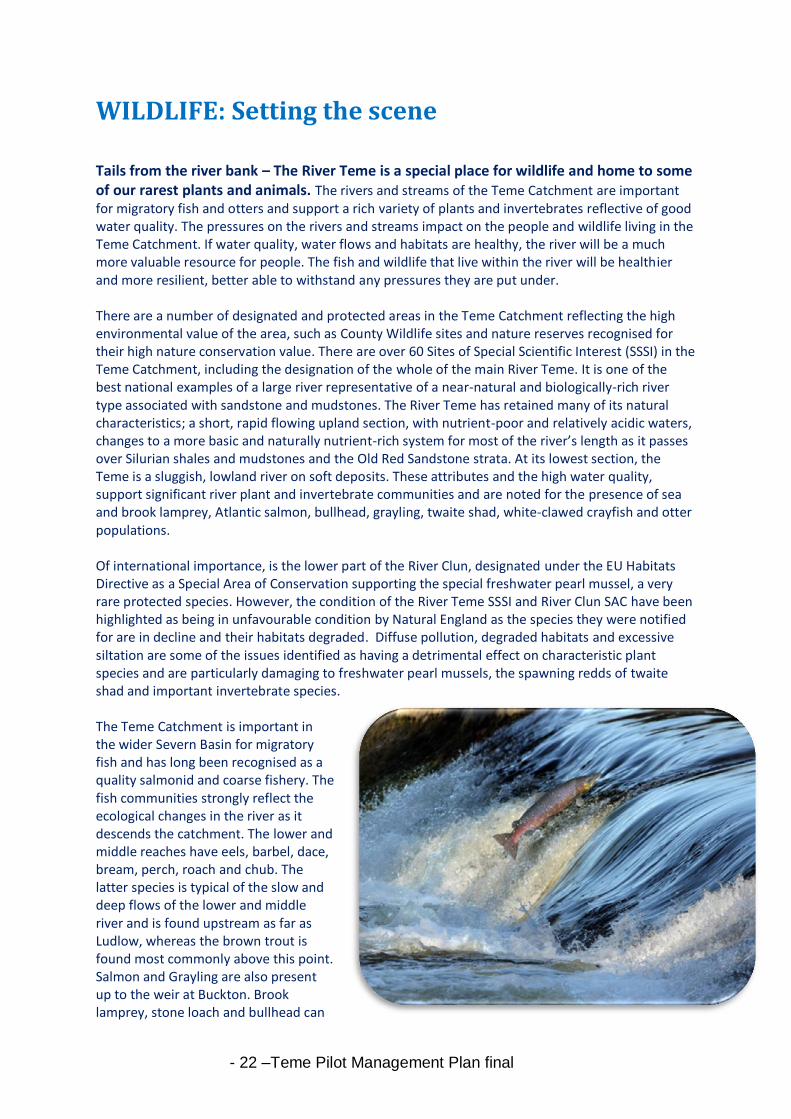
Tails from the river bank – The River Teme is a special place for wildlife and home to some of our rarest plants and animals. The rivers and streams of the Teme Catchment are important for migratory fish and otters and support a rich variety of plants and invertebrates reflective of good water quality. The pressures on the rivers and streams impact on the people and wildlife living in the Teme Catchment. If water quality, water flows and habitats are healthy, the river will be a much more valuable resource for people. The fish and wildlife that live within the river will be healthier and more resilient, better able to withstand any pressures they are put under. There are a number of designated and protected areas in the Teme Catchment reflecting the high environmental value of the area, such as County Wildlife sites and nature reserves recognised for their high nature conservation value. There are over 60 Sites of Special Scientific Interest (SSSI) in the Teme Catchment, including the designation of the whole of the main River Teme. It is one of the best national examples of a large river representative of a near-natural and biologically-rich river type associated with sandstone and mudstones. The River Teme has retained many of its natural characteristics; a short, rapid flowing upland section, with nutrient-poor and relatively acidic waters, changes to a more basic and naturally nutrient-rich system for most of the river’s length as it passes over Silurian shales and mudstones and the Old Red Sandstone strata. At its lowest section, the Teme is a sluggish, lowland river on soft deposits. These attributes and the high water quality, support significant river plant and invertebrate communities and are noted for the presence of sea and brook lamprey, Atlantic salmon, bullhead, grayling, twaite shad, white-clawed crayfish and otter populations. Of international importance, is the lower part of the River Clun, designated under the EU Habitats Directive as a Special Area of Conservation supporting the special freshwater pearl mussel, a very rare protected species. However, the condition of the River Teme SSSI and River Clun SAC have been highlighted as being in unfavourable condition by Natural England as the species they were notified for are in decline and their habitats degraded. Diffuse pollution, degraded habitats and excessive siltation are some of the issues identified as having a detrimental effect on characteristic plant species and are particularly damaging to freshwater pearl mussels, the spawning redds of twaite shad and important invertebrate species. The Teme Catchment is important in the wider Severn Basin for migratory fish and has long been recognised as a quality salmonid and coarse fishery. The fish communities strongly reflect the ecological changes in the river as it descends the catchment. The lower and middle reaches have eels, barbel, dace, bream, perch, roach and chub. The latter species is typical of the slow and deep flows of the lower and middle river and is found upstream as far as Ludlow, whereas the brown trout is found most commonly above this point. Salmon and Grayling are also present up to the weir at Buckton. Brook lamprey, stone loach and bullhead can
- 23 –Teme Pilot Management Plan final
be found in the fast and rocky stretches, though bullhead and stone loach do occur low down the river at Knightwick. Bullheads occur even in the very shallow and fast flows on the open hill near the source. Sea lamprey has been recorded on the lower reaches of the Teme. Of particular conservation interest are the records of the very rare twaite shad in the very lowest reaches of the Teme. This may represent an extension of the spawning ground from the Severn, which is one of only four confirmed breeding sites in the UK. The River Teme is one of the best fisheries in England and Wales, but in recent years the quality of angling is perceived to have declined. Salmon catches in the River Teme are declining and native brown Trout populations are nationally threatened. Eel stocks are also known to have declined in rivers throughout Europe in recent years, and the River Teme is no exception in this respect.
The Teme and its tributaries offer a variety of aquatic habitat types, which have good populations of bird species. Both kingfishers and sand martins readily utilise the eroding earth banks which the river produces as it meanders. The dipper is to be found within the Teme on rocky sections together with the grey wagtail, though the latter species is equally at home on the silt banks of the lower reaches. Red Grouse can be found on the Long Mynd and the Stiperstones, though their numbers have declined to about 50 pairs, it is hoped that more favourable management will encourage an increase in these birds. Wading birds such as Lapwing, Curlew, Snipe and Redshank are regionally important upland birds, but have declined at an alarming rate as breeding birds in the catchment. Habitat changes, predation, reduction in food, declining water quality and siltation on gravels are all key factors effecting the survival of these bird populations.
Case Study: Community Wildlife Groups and Dipper Project The Upper Onny, Upper Clun and Kemp Valley Wildlife Group have been monitoring Lapwing and Curlew since 2004 and cover well over 300 km2, all in the Teme Catchment. These species are all nationally and locally in decline, primarily as a result of habitat loss spread over many years. A general lowering of the water table through draining of wetlands, much of it completed many years ago, is the main underlying cause. Rewetting on a large scale will help to reverse the decline of these ground-nesting and wetland birds in the long term and would bring many other benefits for biodiversity and flood management. The Dipper population in the River Teme catchment was monitored extensively in the late 1980s up until 2000. Concern about the apparent recent decline led to a reinstatement of this monitoring, together with action to improve breeding success through a nest box scheme, initially through the Upper Onny Wildlife Group, and subsequently through the other Community Wildlife Groups. Through funding the project now operates outside the Community Wildlife Group areas, and also covers the lower Onny, the lower Clun and the Redlake. Dippers are restricted to, and dependent on, food from the river and the average size of the territory, breeding success and survival rate are all good indicators of the water quality. Research results suggests the decline occurred primarily due to habitat loss and silting up of the rivers. Though the population has recovered as a result of the Community Wildlife groups nest box scheme, there are still fewer breeding pairs than there were.
- 24 –Teme Pilot Management Plan final
What are the Problems?
Much of the wildlife of the Teme catchment is related to the quality of the rivers and streams found within it and can act as indicators to the health of waters. Poor water quality,
particularly nutrient enrichment, habitat removal and poor land management could threaten much of the wildlife. The largely rural nature of the catchment leads to diffuse pollution from agriculture, especially increased sedimentation from overgrazing and soil erosion being a major threat. In addition, increased siltation from road runoff contributes to the deterioration of river habitats affecting all of the Teme’s wildlife. Issues affecting the wildlife include:
Diffuse pollution and siltation;
Agricultural run-off and pollution from pesticides;
Earlier land drainage has exacerbated the “flashy” nature of the river which can increase bank erosion, destroy habitats and can ‘wash away’ young fish;
Overgrown bankside vegetation and trees which reduces light and invertebrate life;
Low water resources and levels, especially in summer months;
Many kilometres of potentially high quality spawning and nursery rivers remain inaccessible to salmon and other fish species because of obstacles, both natural and man-made, for example weirs.
Riverside trees are being damaged by over-grazing, whilst the spread of Phytophthora is killing alders along many watercourses
Non-native species found within the Teme Catchment are affecting habitats and wildlife.
Invasive plants such as Japanese Knotweed, Giant Hogweed and Himalayan Balsam continue to increase along watercourses, which leads to a reduction in riverside biodiversity and increased bank erosion.
American Mink (introduced to the UK in the 1929) are present throughout the catchment and have had a serious impact on the already fragmented water vole population as well as ground nesting birds.
The North American Signal crayfish (introduced in the UK in the 1970s) represent a significant risk to the native white clawed crayfish, now classified as globally endangered by the International Union for Conservation of Nature (IUCN). Due to competition from the signal crayfish and the spread of a disease which is carried by them, white-clawed crayfish numbers have decreased dramatically.
Current activity
As a Partnership, projects are already underway helping to improve the River Teme in terms of water quality, habitat and water quantity. These schemes will benefit fish, plants, insects and other wildlife and will help to meet our obligations under the Water Framework Directive. River Teme Site of Special Scientific Interest Restoration Plan Natural England, the Environment Agency and Countryside Council for Wales are working with local non-governmental groups, such as the Severn Rivers Trust and individual landowners to improve the condition of the River Teme SSSI. As part of this work, a river restoration plan will identify potential restoration opportunities on the River Teme SSSI to improve the physical habitat. The plan will act as a document used to seek funds to take restoration actions forward. The plan will outline restoration options and identify priorities for actions. Designs and projects will then be developed through detailed discussions with partners including landowners and fishing clubs. Restoration will also help the river be more resilient to climate change (improved connection to floodplain contributing to

- 25 –Teme Pilot Management Plan final
reduced flashiness) and excessive siltation, implemented over many years, working with landowners and managers in partnership.
- 26 –Teme Pilot Management Plan final
The Future
Much has already been achieved for the Teme but there is still a great deal more to do if we are to reverse the continuing decline in river quality and habitat. We will consider and investigate other issues as the Partnership progresses, looking at the entire catchment and focussing on the SSSI, SAC and other conservation sites.
The Partnership has agreed a series of desired outcomes from this Plan: 1. Reduction in nutrient levels (especially phosphates) and diffuse pollution (rural & urban) 2. Reduction in pesticide levels 3. Reduction in flood risk 4. Better management of water usage 5. Reduction in river siltation levels 6. Improvement in the quality and range of habitats (Teme SSSI) 7. Recruitment of freshwater pearl mussels 8. Improvement to the quality and quantity of native woodlands and trees 9. Increase public awareness and participation in environmental improvements 10. Ultimately achieve good ecological status in all water bodies by 2027 (WFD)
Following publication of this plan in the New Year there will be an opportunity for public comments; the Partnership will then develop and seek to implement an action plan. The action plan will be a structured and prioritised work programme; it will investigate collecting data, implement projects to achieve our vision and use campaign and education initiatives to help promote our message with and through others. This plan does, however, represent just a snapshot in time and should be viewed as a ‘living document’ that will be reviewed and modified throughout its life span. We want to ensure local people are involved in decision making and help us to consider and plan the work that we do. In November 2012, we held 3 catchment community meetings in Ludlow, Cleobury Mortimer and with the Teme Fisheries Association in Hundred House. Over 80 people attended, showing the interest around the community in the project and their river. Our aim was to raise awareness and to find out what concerns people have about the river. The results of these meetings have informed this plan and future actions we take as a partnership. The concerns raised in each meeting reflected that the communities as well as the water courses are different in each area. There was strong support for the Partnership’s vision but concern about how it would be funded. The challenge is to find resources to organise, facilitate and coordinate public meetings. Without further funding from Defra there are real concerns that certain actions to improve the Catchment won’t go ahead and the advantage of the new Partnership’s coordination and strategic overview will be diluted and eventually lost. Our work will cost money. It is essential for us to identify and tap into funding streams to ensure that valuable projects are supported effectively. The web site set up by the Severn Rivers Trust; www.temecatchment.com provides a focused place to see progress and find information. There is also a facebook site for the Teme Catchment Partnership, which already has over 100 people who ‘like’ it! We want to encourage you to help us to improve and enhance the Teme and its brooks and streams. We want to ensure that the Teme Catchment is well managed into the future and beyond the timeframe set out for the Pilot Catchment initiative.

- 27 –Teme Pilot Management Plan final
Appendices
Glossary
Abstraction Drawing water out of a river or catchment for industrial or irrigation purposes (includes public water supply)
Aeration The process of exposing to air (so as to purify); "the aeration of the soil" Agri-environment Scheme Government-funded support mechanisms for sustainable agricultural activity with targeted benefits for the environment
Algae Microscopic plants which occur naturally in fresh water. Blue-green algae are of particular concern as they can produce toxins
Bank Stabilisation Prevention of river bank erosion by increasing of the bank by natural materials or by engineering
Biodiversity The total range of the variety of life forms on earth or any given part of it, the ecological roles they perform, and the genetic diversity the y contain
Biodiversity Action Plan A Biodiversity Action Plan (BAP) is an internationally recognized program addressing threatened species and habitats and is designed to protect and restore biological systems. Buffer strip An area of vegetated land separating a watercourse (or body of water) from intensively managed land, normally established or managed to conserve or enhance water quality and which may also benefit habitat and species diversity Catchment A discrete geographical unit within which all water drains to the same end-point or outflow. NB Groundwater catchments do not necessarily coincide with surface water catchments.
Carbon Sequestration The uptake and storage of carbon. Trees and plants, for example, absorb carbon dioxide, release the oxygen and store the carbon Catchment Management A process whereby all activities within a river catchment are considered in relation to their impact on each other and on the quality and quantity of surface and groundwater
Diffuse pollution Sources of pollution having no clearly definable point of origin, e.g. supply of pollutant, sediment or nutrients from a wide area, for example agricultural land, as opposed to a point source such as a stream or sewage outfall. Ecosystem A community of interdependent organisms and the environment which they inhabit
- 28 –Teme Pilot Management Plan final
Ecological Status An expression of the structure and functioning of aquatic ecosystems associated with surface waters. Such waters are classified as being of good ecological status when they meet the requirements of the WFD.
Erosion The process by which sediments are mobilised and transported by rivers
Eutrophication * nutrient enrichment of river waters, often as a result of enhanced inputs from agricultural activities, industrial or sewage effluents
Fertilisers A chemical or natural substance added to soil or land to increase its fertility Flashy river A river which responds very quickly to rainfall, the flow of water rising rapidly to a high peak before receding similarly. Typical of small, steep, upland catchments. Floodplain The floor of a river valley which is inundated by water when a river floods Groundwater Water contained in underground strata, which fills voids in soils and permeable geological formations
Good Status A general term meaning the status achieved by a surface water body when both the ecological status and its chemical status are at least good or, for groundwater, and when both its quantitative status and chemical status are at least good
Herbicides A substance that kills plants. Herbicides are used in agriculture, horticulture and gardening to control unwanted plants. Herbicides can be selective (kill selected species) or non-selective (broad spectrum - kill all plants).
Hydrology The study of all waters in and upon the earth, including underground water, surface water and rainfall.
Hydromorphology Relating to the character of water flow, energy etc, and the physical character of rivers shaped by the movement of water through the catchment.
Invertebrate Lacking a backbone or spinal column; "insects are an example of invertebrate animals"
Irrigation Irrigation is an artificial application of water to the soil. It is used to assist in the growing of agricultural crops, maintenance of landscapes, and revegetation of disturbed soils in dry areas and during periods of inadequate rainfall Metaldehyde A form of insecticide used to kill slugs.
Nutrients Chemical substances required for growth by organisms (including plants, crops and algae), e.g. phosphorous and nitrogen
Over-grazing Condition where livestock (wild and domestic) numbers are high, resulting in reduced vegetation cover and increasing susceptibility of soils to erosion

- 29 –Teme Pilot Management Plan final
Pesticides A substance used for destroying insects or other organisms harmful to cultivated plants or to animals Phosphorous A nutrient essential in the life cycle of all living organisms, present in all animal and vegetable matter
Photosynthesis By which green plants and some other organisms use sunlight to synthesize foods from carbon dioxide and water. Point source pollution Pollution which is traceable to a specific source with a clearly identifiable point of origin. Usually from a pipe or other well defined outfall.
Riparian Pertaining to land bordering a river or stream
Run-off Rainwater draining from an area of land capable of transporting nutrients, fertilisers, sediment etc SAC Special Area of Conservation. A site designated under the European Community Habitats Directive, to protect internationally important wildlife habitats.
Scarp A very steep bank or slope; an escarpment Sediments The unconsolidated (loose) material transported by a river, a mixture of particles ranging from fine sediments, usually less than 2mm in diameter (sands, silts and clays), to coarser sediments like pebbles, stones and boulders
Septic tank Tank receiving and treating sewage by bacteria where effluent overflows
SSSI A Site of Special Scientific Interest (SSSI) is a conservation designation denoting a protected area in the United Kingdom
Substrate Mineral and/or organic material that forms the bed of a stream. Includes clays, silts, sands, gravels, cobbles, boulders and bedrock.
Suspended Sediment portion of the sediment load of a river that moves in suspension.
Sustainable Contemporary use and management of a resource that does not compromise its management and use in the future
Tributary A smaller brook or stream flowing into a larger river channel
Turbidity Amount of fight scattered or absorbed by a fluid as a result of its content of suspended particles and dissolved load.
Watershed An area or region drained by a river, river system, or other body of water
- 30 –Teme Pilot Management Plan final
Water Framework Directive: Teme Catchment Status