Embed Size (px)
Citation preview
247
Revista de la Sociedad Geológica de España, 20(3-4), 2007
THE TECTONIC STRUCTURE OF THE ALBORAN MARGIN OFMOROCCO
A. Ammar1, A. Mauffret2, C. Gorini2,3 and H. Jabour 4
1 Département de Géologie, Université Mohammed V, Faculté des Sciences, avenue Ibn-Batouta, B. P. 1014, Rabat, [email protected]
2 Lab. Tectonique, UMR 7072 Case 129, Univ. P. et M. Curie, 4 Place Jussieu 75252 Paris Cedex 5, [email protected]
3 Lab. Sédimentologie et Géodynamique, Univ. Lille 1-SN5 F-59655, Villeneuve d’Ascq, France4 Office National des Hydrocarbures et des Mines, P. O. Box 80 30 NU, 34, Rue Al Fadila 10050, Rabat, Maroc.
Abstract: We utilized a very dense seismic survey mainly performed by the oil companies completedby academic data to perform a depth to basement map of the Morocco margin of the Alboran Sea. Theeastern area is characterized by several volcanic edifices that are related to the late Miocene Alboranarc. However, the volcanism persisted after the Messinian in the Gourougou volcano and the ChafarinesIsland. The Tortonian to Messinian activity of the Nekor fault system is characterized by normalfaulting with a NE-SW trend. A tilt of the Messinian surface suggests a 1.5 km uplift of the coast since5.33 Ma. In the Al Hoceima offshore region we identify the major left-lateral El Idrissi fault zone thatprobably crosses the Alboran Sea. The Xauen Bank is formed by the early Miocene sedimentarylayers of the West Alboran Basin uplifted by compression with an estimated shortening of 3.5 kmsince the Messinian (0.65 mm/yr). The Jebha Fault was mainly active during the early Miocene. Thetomography, the magmatism, and the tectonics suggest that the Alboran Arc collided with the IberianPlate during the late Tortonian, followed by a clockwise rotation of the central Alboran basin. Althoughthe Alboran basin is clearly affected by E-W motions we think that the eastwards subduction zone isdead since the late Miocene.
Key Words: Alboran Sea, active tectonics, structural map
Resumen: Hemos utilizado una densa malla de líneas sísmicas procedentes de compañías petroleras,completada con perfiles sísmicos académicos para construir un mapa de profundidad del basamentoen el margen marroquí del Mar de Alborán. El sector oriental de este margen está caracterizado por lapresencia de varios edificios volcánicos relacionados con el Arco de Alborán durante el Miocenosuperior. Sin embargo, el volcanismo ha persistido hasta después del Messiniense en el volcán deGourougou y las islas Chafarinas. La actividad del sistemas de fallas de Nekor desde el Tortoniense alMessiniense se caracteriza por fallas normales de dirección NE-SW. La superficie Messiniense seencuentra basculada, indicando un levantamiento de la costa de 1,5 km durante los últimos 5,33 Ma.En la región marina de Al Hoceima hemos identificado el sistema de falla de Al Idrissi queprobablemente atraviesa el Mar de Alborán. El Banco de Xauen está formado por las secuenciassedimentarias del Mioceno inferior de la Cuenca Oeste de Alborán, que se encuentran levantadas porla compresión, estimándose un acortamiento de 3,5 km desde el Messiniense (0,65 mm/a). La falla deJebha fue activa principalmente durante el Mioceno inferior. Los datos tomográficos, el magmatismoy la tectónica indican que el Arco de Alborán colisionó con la placa Ibérica durante el Tortoniensesuperior, estando seguida por una rotación horaria de la cuenca central de Alborán. Aunque la cuencade Alborán está claramente afectada por movimientos E-W, creemos que la subducción hacia el Estecesó en el Mioceno superior.
Palabras Clave: Mar de Alborán, tectónica activa, mapa estructural
Ammar, A., Mauffret, A., Gorini, C. and Jabour, H. (2007): The tectonic structure of the AlboranMargin of Morocco. Revista de la Sociedad Geológica de España, 20 (3-4): 247-271.
The Alboran Sea is one of the marine areas of theMediterranean Sea that has been the most studiedbecause it is the best illustration of the structuralcomplexity of the Mediterranean Region. The centralpart has a thinned crust whereas the surroundingemerged lands have a thickened crust beneath the Beticsin Spain and slightly thickened below the Rif inMorocco. These two cordilleras result from Miocene
compressional deformation more or less coeval to thethinning by extension of the Alboran Sea (Comas et al.,1999). Moreover, the Alboran Sea, located presentlybetween the Eurasia and Nubia (Africa) convergentplates, should be a compressional zone. However, theseismicity and the GPS measurements suggest an E-Wextension and strike-slip motions (Stich et al., 2006;Serpelloni et al., 2007). Several hypotheses have been
248
Revista de la Sociedad Geológica de España, 20(3-4), 2007
A. Ammar, A. Mauffret, C. Gorini and H. Jabour
proposed to explain the structure of the Alboran Sea:extensional collapse of thickened continental lithosphere(Platt et al., 2003), delamination process (García-Dueñaset al., 1992; Calvert et al., 2000), and retreatingsubduction towards the west (Lonergan and White, 1997;Rosenbaum and Lister, 2004). In order to constrain thegeological and geophysical framework amultidisciplinary approach has been performed byseveral groups: gravimetric, magnetic, and seismicsurveys ( Willet, 1991; Comas et al., 1992; Watts et al.,1993) and ODP Leg 161 (Comas et al., 1999). Thetomographic studies show a probable (cold) slab dippingtoward the east (Gutscher et al., 2002; Faccenna et al.,2004; Spakman and Wortel, 2004). The present tectonicsituation in the Alboran sea is mainly illustrated by theseismicity (Stich et al., 2003a; Buforn et al., 2004;Akoglu et al., 2006; Biggs et al., 2006; Cakir et al.,2006), the GPS observations (Fadil et al., 2006; Stich etal., 2006; Serpelloni et al., 2007) and the seafloormultibeam map (Gràcia et al., 2006; Ballesteros et al.,2008). The present study is based on a very dense seismicgrid on the Morocco and Spanish margins. At thedifference of the others papers that utilized a small partof these data (Bourgois et al., 1992; Morley, 1993;Chalouan et al., 1997) we contoured the depth toacoustic basement in the general tectonic framework ofthe Alboran Sea and we use the CMT determinations ofthe earthquake focal mechanisms that enlighten thepresent tectonics of this complex region. This study isan expanded version of a paper published in 2007(Mauffret et al., 2007) with several additions of seismicdata on the Spanish margin provided by the InstitutoGeológico y Minero de España (IGME) in a very niceweb site (http://www.igme.es/internet/sigeof/).
Physiographic setting
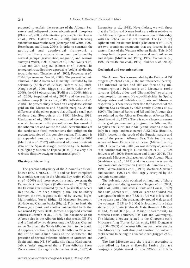
The general bathymetry of the Alboran Sea is wellknown (IOC-UNESCO, 1981) and has been completedby a multibeam map in the Almería Bay region (Gràciaet al., 2006) and more recently a map covering theEconomic Zone of Spain (Ballesteros et al., 2008). Tothe East this area is limited by the Algerian Basin wherelies the 2600 m deep bathyal plain. The boundarybetween the two regions is dotted by several highs:Maimonides, Yusuf Ridge, El Mansour Seamount,Alidade and Cabliers banks (Fig. 1). This last bank, theProvençaux Bank and another unidentified bank thatwe named Pytheas Bank, formed a supposed volcaniccaldera (Gierman et al., 1967). The backbone of theAlboran Sea is the Alboran Ridge that trends NE-SWand is flanked by two depressions: the Alboran Channelto the North and the South Alboran Basin to the South.An apparent continuity between the Alboran Ridge andthe Tofino and Xauen banks to the southwest, thepresence of several volcanic edifices in Morocco andSpain and large NE-SW strike-slip faults (Carboneras,Jebha faults) suggested that a Trans-Alboran ShearZone crossed the region (Hernandez et al., 1987; de
Larouzière et al., 1988). Nevertheless, we will showthat the Tofino and Xauen banks are offset relative tothe Alboran Ridge and that the connection of this ridgewith the Jebha Fault is not evident. The (Ville de)Djibouti and Ibn Batouta banks (Chalouan et al., 1997)are two prominent seamounts that are located in theeastern flank of the Western Alboran Basin. This 1400m deep basin is protruded by several mud volcanoesand diapirs (Mulder and Parry, 1977; Comas et al.,1992; Pérez-Belzuz et al., 1997; Talukder et al., 2003).
Geological and tectonic settings
The Alboran Sea is surrounded by the Betic and Riforogens (Michard et al., 2002 and references therein).The internal Betics and Rif are formed by un-metamorphosed Palaeozoic and Mesozoic rocksterranes (Malaguides and Ghomarides) overlyingmetamorphic terranes: Nevado-Filabrides in Spain,Alpujarrides and Sebtides in Spain and Moroccorespectively. These rocks form also the basement of theAlboran Sea as shown by ODP results (Comas et al.,1999). The Internal Betics and Rif and the Alboran Seaare referred as the Alboran Domain or Alboran Plate(Andrieux et al., 1971). There is now a large consensusin the geologic community to group the Alboran, theKabylias, the Peloritans in Sicily and Calabria in SouthItaly in a large landmass named AlKaPeCa (Bouillin,1986), located in the south of the Eurasia margin andeast of the present Alboran Sea. This feature wasseparated from Eurasia by an ocean (Michard et al.,2002; Guerrera et al., 2005) or was directly adjacent tothat continental margin (Rosenbaum et al., 2002;Jolivet et al., 2003; Rosenbaum and Lister, 2004). Thewestwards Miocene displacement of the Alboran Plate(Andrieux et al., 1971) and the coeval westwardscompressional deformation (Frizon de Lamotte et al.,1991; García-Dueñas et al., 1992; Martínez-Martínezand Azañón, 1997) are also largely accepted by thegeologic community.
The volcanic rocks obtained on land and offshoreby dredging and diving surveys (Duggen et al., 2004;Gill et al., 2004), industrial (Jurado and Comas, 1992)and ODP (Comas et al., 1999) wells can be divided intotwo types: the oldest one (33.6 to 17.4 Ma) is located inthe western part of the area, mainly around Malaga, andthe youngest (11.8 to 6.6 Ma) is localized in a largestripe from Spain (Cabo de Gata through AlboranIsland, Yusuf Ridge, El Mansour Seamount) toMorocco (Trois Fourches, Ras Tarf and Gourougou).The Malaga dikes are related to the Oligocene-earlyMiocene rifting (Torres-Roldán et al., 1986; Duggen etal., 2004, 2005) of the West Alboran Basin whereas thelate Miocene calc-alkaline and shoshonitic volcanicrocks seems to belong to a volcanic arc (Duggen et al.,2004).
The late Miocene and the present tectonics iscont ro l led by la rge s t r ike-s l ip fau l t s tha t a reconjugate (right-lateral for the NW-SE and left-
249
Revista de la Sociedad Geológica de España, 20(3-4), 2007
STRUCTURE OF THE ALBORAN MARGIN OF MOROCCO
Figure 1.- General setting of the Alboran Sea. Upper scheme: compilation of the bathymetric map of theInternational Bathymetric Chart (IOC-Intergovernmental Oceanographic Commission, 1981) and onshoregeological setting (Comas et al., 1999, Frizon de Lamotte, 2004; Crespo-Blanc and Frizon de Lamotte, 2006).Offshore tectonic map from Comas et al. (1999) and the present study. Inset map, on the centre: generalframework around the Alboran Sea. Inset map, on the right: track map of the seismic profiles used in this study.Lower scheme: depth to basement map of the Alboran Sea from seismic study. Contour interval 500 m. Thepresent tectonic situation in the Alboran sea is mainly illustrated by the seismicity (Stich et al., 2003a; Bufornet al., 2004; Akoglu et al., 2006; Biggs et al., 2006; Cakir et al., 2006), the present motions of the tectonic platesare compiled from the GPS observations (Stich et al., 2006; Serpelloni et al., 2007).
250
Revista de la Sociedad Geológica de España, 20(3-4), 2007
lateral for the NE-SW faults) and governed by aNW-SE compression related to the convergencebetween Nubia (Africa) and Eurasian plates (Calaiset al., 2003; McClusky et al., 2003; Stich et al.,2006; Serpelloni et al., 2007) although the stresstensor deduced from the focal mechanism analysisis NNW-SSE in the Alboran Sea (Stich et al., 2006;Serpelloni et al., 2007) (see later). To the East, theright-lateral Aguilas and the left-lateral Palomaresfaults may form an arc indenter (Coppier et al.,1989). However, the Alpujarras Fault may have aseaward extension in the Palomares Canyon (Fig. 1)and cut the Palomares Fault. The dextral strike-slipAlpujarras Fault could be a transfer fault betweentwo extensional basins (Martínez-Martínez et al.,2006). This fault and the sinistral Carboneras Faultmay be also the boundary of a triangular blockescaping towards the West (Martínez-Díaz andHernández-Enrile, 2004). The present activity ofthe Carboneras Fault is clearly recorded on the seafloor by a multibeam survey (Gràcia et al., 2006).We will suggest a possible connection between theCarboneras Fault and a large fault zone named hereEl Idrissi fault (Fig. 1) that offset the AlboranRidge. The Yusuf Fault is a right-lateral strike-slipfault (Mauffret et al., 1987; Álvarez-Marrón, 1999)that is conjugate of the left-lateral CarbonerasFaul t . The Alboran Ridge i s a compress iona lstructure flanked by two reverse faults (Bourgois etal ., 1992; Woodside and Maldonado, 1992). Aseismic profile crossing the northwest scarp of theridge did not show any evidence of compression anddisplayed normal faults in the sedimentary layersthat infill the Alboran Channel (Watts et al., 1993;Ballesteros et al. , 2008). However, this profilecrossed the northwest extension of the Yusuf faultthat cut the northwest tip of the Alboran Ridge andthe normal faulting that is active at Present isattributed to a horsetail of the Yusuf Fault (Willet,1991) although it crosses the Alboran Channel andoffse t the nor th-western f lank of the channel(Ballesteros et al., 2008).
Geophysical setting
The Alboran Sea has been surveyed with severalgeophysical techniques: refraction (Hatzfeld, 1978),magnetic (Galdeano et al. , 1974; Willet, 1991),gravimetric (Willet, 1991; Galindo-Zaldívar et al.,1998; Torné et al., 2000), heat flow (Polyak et al.,1996), seismic (Mulder and Parry, 1977; Gensous etal., 1986; Willet, 1991; Bourgois et al., 1992; Comaset al., 1992; Morley, 1993; Watts et al., 1993; Calvertet al., 1997; Chalouan et al., 1997), geoid anomaly(Ful lea Urchulu tegui e t a l . , 2006) , genera ltomography (Calvert et al., 2000; Piromallo andMorelli, 2003; Faccenna et al., 2004; Spakman andWortel, 2004) and local tomography (Morales et al.,1999; Gurría and Mezcua, 2000; Serrano et al., 2003).
The refraction (Hatzfeld, 1978) and the gravitymodelling (Torné et al., 2000) suggest that the crust iscontinental and approximately 18-20 km thick. Thethinnest crust (15-17 km) of the Alboran Sea is locatedin the Alboran Channel (Willet, 1991). However, therefraction studies are old and imprecise (D. Hatfeld,oral communication) and the crust maybe thinner than20 km beneath the West Alboran Basin where a recentseismic survey shows that the sedimentary cover is asthick as 12.5 km. The crust thins towards the east andis oceanic beneath the Algerian Basin (Comas et al.,1997; Booth-Rea et al., 2007).
A la rge magnet ic anomaly (more than 500nannoteslas peak to peak) on the aeromagnetic map(Galdeano and Rossignol, 1977) that trends NE-SW,is located in the centre of the Alboran Sea. It isrelated to the seamounts that flank the AlboranChannel to the northwest (Willet, 1991; Galindo-Zaldívar et al., 1998) and not to the Alboran Ridge.A s imi lar magnet ic anomaly but offse t to thesouthwest relat ive to the previously describedanomaly is located above the Ibn Batouta seamounts.
The heat flow data show (Polyak et al., 1996) ageneral increase of the thermal regime from west toeast and the data in the Algerian Basin confirm theoceanic nature of the crust.
The tomography (Calvert et al., 2000; Piromalloand Morelli, 2003; Faccenna et al., 2004; Spakmanand Wortel, 2004) shows a low velocity (warmmaterial) in the upper mantle beneath the AlboranSea but a high velocity (cold body) in deeper levels,up to 600 km. The geoid (Fullea Urchulutegui et al.,2006) and the gravity modelling (Torné et al., 2000)suggest a thin lithosphere (60-90 km) beneath theAlboran Sea and a lithosphere as thick as 130-160km under the Gibraltar Strait (Iribarren et al . ,2007).
Description of the Moroccan margin
We will progress in our description of the southernmargin of the Alboran Sea from East to West. We usethe term Messinian for the prominent reflector that is
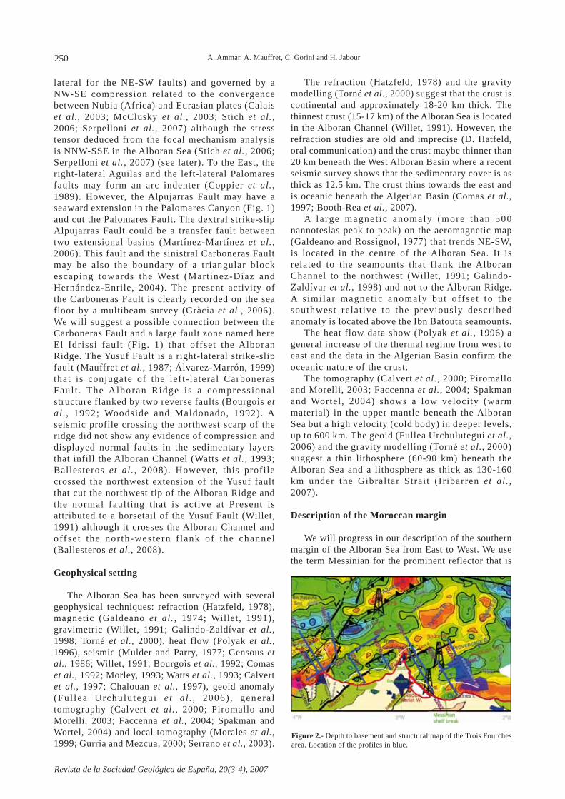
Figure 2.- Depth to basement and structural map of the Trois Fourchesarea. Location of the profiles in blue.
A. Ammar, A. Mauffret, C. Gorini and H. Jabour
251
Revista de la Sociedad Geológica de España, 20(3-4), 2007
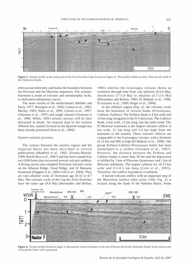
Figure 3.- Seismic profile in the eastern part of the Trois Fourches Cape (location in figure 2). This profile exhibits an intra- Pliocene sill, north ofthe Chafarines Islands.
Figure 4.- Seismic profile located in figure 2, showing the western boundary of the intra Pliocene sill off the Chafarines Island. In the western endof the profile Nador well is projected.
often an unconformity and marks the boundary betweenthe Pliocene and the Miocene sequences. The acousticbasement is made of volcanic and metamorphic rocks,or deformed sedimentary layers.
The main results of the multichannel (Mulder andParry, 1977; Bourgois et al., 1992; Comas et al., 1992;Morley, 1993; Watts et al., 1993; Calvert et al., 1997;Chalouan et al., 1997) and single channel (Gensous etal., 1986; Willet, 1991) seismic surveys will be laterdiscussed in detail. An isopach map of the westernAlboran Sea, mainly focused on the Spanish margin hasbeen already presented (Soto et al., 1996).
Eastern volcanic province
The contact between the eastern region and theAlger ian Basin has been descr ibed in severalpublications (Mauffret et al., 1992; Álvarez-Marrón,1999; Booth-Rea et al., 2007) and has been sampled bytwo ODP holes that recovered several volcanic pebbles.A diving survey also sampled Tortonian volcanic rockson the Alboran Ridge, Yusuf Ridge, and Al MansourSeamount (Duggen et al., 2004; Gill et al., 2004). Theyare calc-alkaline rocks of Tortonian age (9.32 to 8.7Ma). The volcanic rocks of the Cap des Trois Fourcheshave the same age (9.8 Ma) (Hernandez and Bellon,
1985) whereas the Gourougou volcano shows anevolution through time from calc-alkaline (9-6.6 Ma),shoshonitic (7-5.4 Ma) to alkaline (4.7-2.6 Ma)(Hernandez and Bellon, 1985; El Bakkali et al., 1998;El Azzouzi et al., 1999; Roger et al., 2000).
In the offshore region (Fig. 2), the volcanic rocksform the basement of several banks (Provençaux,Cabliers, Pytheas). The Pytheas Bank is 4 km wide and15 km long elongated in the N-S direction. The CabliersBank, 6 km wide, 12 km long, has the same trend. TheEl Mansour seamount is the largest volcanic edifice: 8km wide, 21 km long and 3.4 km high from thebasement to the summit. These volcanic edifices arecomparable to the Gourougou volcano, with a diameterof 12 km and 900 m high (El Bakkali et al., 1998). Thegroup Pytheas-Cabliers-Provençaux banks has beenassimilated to a caldera (Gierman et al., 1967).However, the distance between the Pytheas andCabliers banks is more than 30 km and the depressionis infilled by 1 km of Pliocene-Quaternary and 1 km ofMiocene sediments. The largest calderas are 10-15 kmwide and 0.3-0.5 km deep (Cole et al ., 2005).Therefore, the caldera hypothesis is unlikely.
A buried volcanic edifice with an important step ofthe Messinian surface (shot point 1200, Fig. 3) islocated along the flank of the Habibas Basin. Some
STRUCTURE OF THE ALBORAN MARGIN OF MOROCCO
252
Revista de la Sociedad Geológica de España, 20(3-4), 2007
volcanic pinnacles may protrude the sea floor where itis deeper than 150 m (Fig. 3) but the top of the banksare flat under water depths shallower than 150 mbecause they are eroded by the waves. The basement isoverlain by a sedimentary layer that presents aprogradation beneath the Messinian erosional surfacethat looks like a continental platform with a shelf breakon the Provençaux Bank (Fig. 3). Therefore, thesedimentary layer looks like the Messinian-Tortoniancarbonate platform described in the Melilla region
(Cornée et al., 2006). The volcanic basement hasprobably the same age. However, south of theProvençaux Bank, a volcanic sill lies in the Plioceneabove the Messinian surface (Fig. 3). The sill is evidentin figure 4 where the deformations in the sedimentarylayers and the sea floor are caused maybe by fluids andgas related to this sill. The complete seismic grid of thisarea allows us to trace the surface covered by this sillthat is probably related to the Chafarines Island as isshown by the extension of the sill on the continental
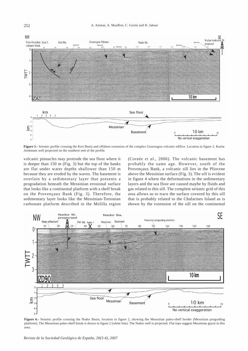
Figure 5.- Seismic profile crossing the Kert Basin and offshore extension of the complex Gourougou volcanic edifice. Location in figure 2. KariatArekmam well projected on the southern end of the profile.
A. Ammar, A. Mauffret, C. Gorini and H. Jabour
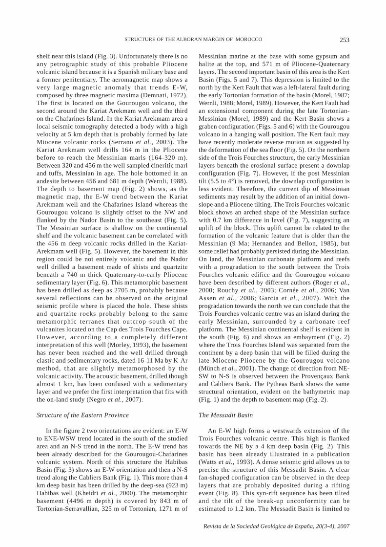
Figure 6.- Seismic profile crossing the Nador Basin, location in figure 2, showing the Messinian paleo-shelf border (Messinian progradingplatform). The Messinian paleo-shelf break is drawn in figure 2 (white line). The Nador well is projected. Flat tops suggest Messinian guyot in thisarea.
253
Revista de la Sociedad Geológica de España, 20(3-4), 2007
shelf near this island (Fig. 3). Unfortunately there is noany petrographic study of this probable Pliocenevolcanic island because it is a Spanish military base anda former penitentiary. The aeromagnetic map shows avery large magnetic anomaly that t rends E-W,composed by three magnetic maxima (Demnati, 1972).The first is located on the Gourougou volcano, thesecond around the Kariat Arekmam well and the thirdon the Chafarines Island. In the Kariat Arekmam area alocal seismic tomography detected a body with a highvelocity at 5 km depth that is probably formed by lateMiocene volcanic rocks (Serrano et al., 2003). TheKariat Arekmam well drills 164 m in the Pliocenebefore to reach the Messinian marls (164-320 m).Between 320 and 456 m the well sampled cineritic marland tuffs, Messinian in age. The hole bottomed in anandesite between 456 and 681 m depth (Wernli, 1988).The depth to basement map (Fig. 2) shows, as themagnetic map, the E-W trend between the KariatArekmam well and the Chafarines Island whereas theGourougou volcano is slightly offset to the NW andflanked by the Nador Basin to the southeast (Fig. 5).The Messinian surface is shallow on the continentalshelf and the volcanic basement can be correlated withthe 456 m deep volcanic rocks drilled in the Kariat-Arekmam well (Fig. 5). However, the basement in thisregion could be not entirely volcanic and the Nadorwell drilled a basement made of shists and quartzitebeneath a 740 m thick Quaternary-to-early Pliocenesedimentary layer (Fig. 6). This metamorphic basementhas been drilled as deep as 2705 m, probably becauseseveral reflections can be observed on the originalseismic profile where is placed the hole. These shistsand quartzite rocks probably belong to the samemetamorphic terranes that outcrop south of thevulcanites located on the Cap des Trois Fourches Cape.However, according to a completely differentinterpretation of this well (Morley, 1993), the basementhas never been reached and the well drilled throughclastic and sedimentary rocks, dated 16-11 Ma by K-Armethod, that are slightly metamorphosed by thevolcanic activity. The acoustic basement, drilled thoughalmost 1 km, has been confused with a sedimentarylayer and we prefer the first interpretation that fits withthe on-land study (Negro et al., 2007).
Structure of the Eastern Province
In the figure 2 two orientations are evident: an E-Wto ENE-WSW trend located in the south of the studiedarea and an N-S trend in the north. The E-W trend hasbeen already described for the Gourougou-Chafarinesvolcanic system. North of this structure the HabibasBasin (Fig. 3) shows an E-W orientation and then a N-Strend along the Cabliers Bank (Fig. 1). This more than 4km deep basin has been drilled by the deep-sea (923 m)Habibas well (Kheidri et al., 2000). The metamorphicbasement (4496 m depth) is covered by 843 m ofTortonian-Serravallian, 325 m of Tortonian, 1271 m of
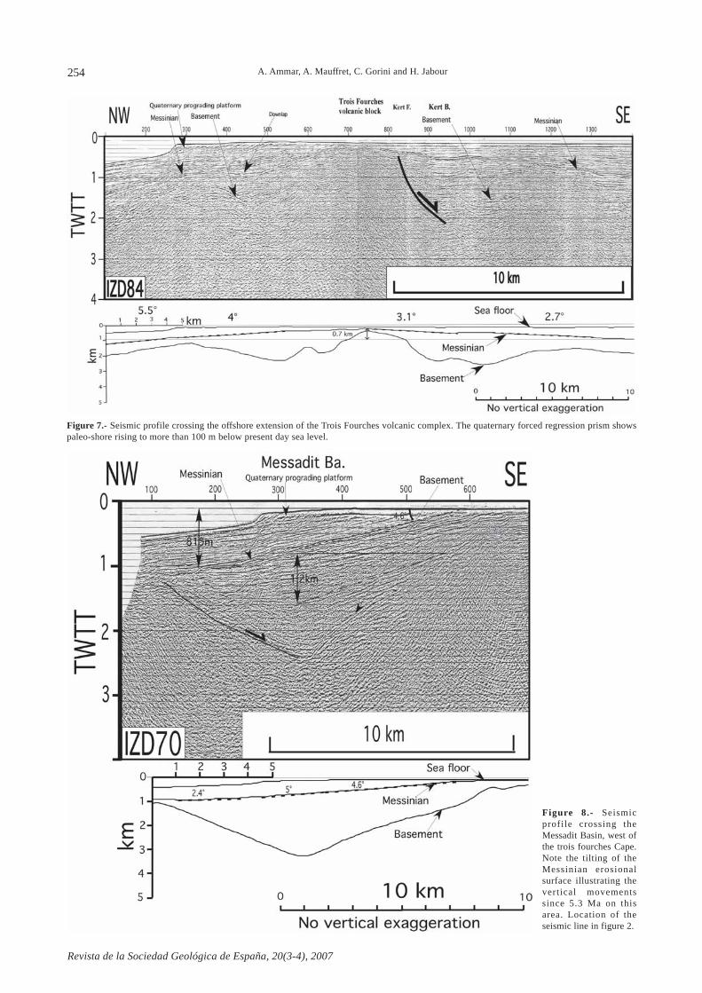
Messinian marine at the base with some gypsum andhalite at the top, and 571 m of Pliocene-Quaternarylayers. The second important basin of this area is the KertBasin (Figs. 5 and 7). This depression is limited to thenorth by the Kert Fault that was a left-lateral fault duringthe early Tortonian formation of the basin (Morel, 1987;Wernli, 1988; Morel, 1989). However, the Kert Fault hadan extensional component during the late Tortonian-Messinian (Morel, 1989) and the Kert Basin shows agraben configuration (Figs. 5 and 6) with the Gourougouvolcano in a hanging wall position. The Kert fault mayhave recently moderate reverse motion as suggested bythe deformation of the sea floor (Fig. 5). On the northernside of the Trois Fourches structure, the early Messinianlayers beneath the erosional surface present a downlapconfiguration (Fig. 7). However, if the post Messiniantilt (5.5 to 4°) is removed, the downlap configuration isless evident. Therefore, the current dip of Messiniansediments may result by the addition of an initial down-slope and a Pliocene tilting. The Trois Fourches volcanicblock shows an arched shape of the Messinian surfacewith 0.7 km difference in level (Fig. 7), suggesting anuplift of the block. This uplift cannot be related to theformation of the volcanic feature that is older than theMessinian (9 Ma; Hernandez and Bellon, 1985), butsome relief had probably persisted during the Messinian.On land, the Messinian carbonate platform and reefswith a progradation to the south between the TroisFourches volcanic edifice and the Gourougou volcanohave been described by different authors (Roger et al.,2000; Rouchy et al., 2003; Cornée et al., 2006; VanAssen et al., 2006; Garcia et al., 2007). With theprogradation towards the north we can conclude that theTrois Fourches volcanic centre was an island during theearly Messinian, surrounded by a carbonate reefplatform. The Messinian continental shelf is evident inthe south (Fig. 6) and shows an embayment (Fig. 2)where the Trois Fourches Island was separated from thecontinent by a deep basin that will be filled during thelate Miocene-Pliocene by the Gourougou volcano(Münch et al., 2001). The change of direction from NE-SW to N-S is observed between the Provençaux Bankand Cabliers Bank. The Pytheas Bank shows the samestructural orientation, evident on the bathymetric map(Fig. 1) and the depth to basement map (Fig. 2).
The Messadit Basin
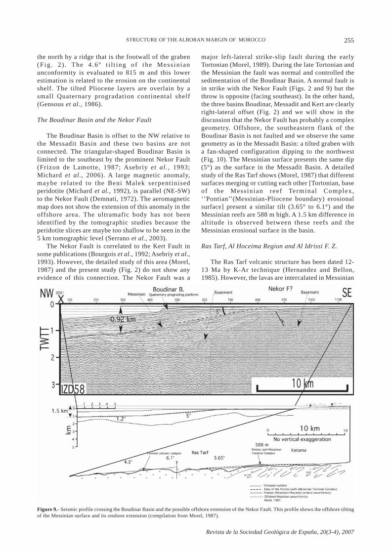
An E-W high forms a westwards extension of theTrois Fourches volcanic centre. This high is flankedtowards the NE by a 4 km deep basin (Fig. 2). Thisbasin has been already illustrated in a publication(Watts et al., 1993). A dense seismic grid allows us toprecise the structure of this Messadit Basin. A clearfan-shaped configuration can be observed in the deeplayers that are probably deposited during a riftingevent (Fig. 8). This syn-rift sequence has been tiltedand the tilt of the break-up unconformity can beestimated to 1.2 km. The Messadit Basin is limited to
STRUCTURE OF THE ALBORAN MARGIN OF MOROCCO
254
Revista de la Sociedad Geológica de España, 20(3-4), 2007
Figure 8.- Seismicprofile crossing theMessadit Basin, west ofthe trois fourches Cape.Note the tilting of theMessinian erosionalsurface illustrating thevertical movementssince 5.3 Ma on thisarea. Location of theseismic line in figure 2.
A. Ammar, A. Mauffret, C. Gorini and H. Jabour
Figure 7.- Seismic profile crossing the offshore extension of the Trois Fourches volcanic complex. The quaternary forced regression prism showspaleo-shore rising to more than 100 m below present day sea level.
255
Revista de la Sociedad Geológica de España, 20(3-4), 2007
the north by a ridge that is the footwall of the graben(Fig . 2 ) . The 4 .6 º t i l t ing of the Mess in ianunconformity is evaluated to 815 m and this lowerestimation is related to the erosion on the continentalshelf. The tilted Pliocene layers are overlain by asmall Quaternary progradation continental shelf(Gensous et al., 1986).
The Boudinar Basin and the Nekor Fault
The Boudinar Basin is offset to the NW relative tothe Messadit Basin and these two basins are notconnected. The triangular-shaped Boudinar Basin islimited to the southeast by the prominent Nekor Fault(Frizon de Lamotte, 1987; Asebriy et al. , 1993;Michard et al., 2006). A large magnetic anomaly,maybe related to the Beni Malek serpentinisedperidotite (Michard et al., 1992), is parallel (NE-SW)to the Nekor Fault (Demnati, 1972). The aeromagneticmap does not show the extension of this anomaly in theoffshore area. The ultramafic body has not beenidentified by the tomographic studies because theperidotite slices are maybe too shallow to be seen in the5 km tomographic level (Serrano et al., 2003).
The Nekor Fault is correlated to the Kert Fault insome publications (Bourgois et al., 1992; Asebriy et al.,1993). However, the detailed study of this area (Morel,1987) and the present study (Fig. 2) do not show anyevidence of this connection. The Nekor Fault was a
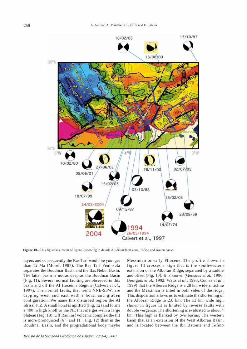
major left-lateral strike-slip fault during the earlyTortonian (Morel, 1989). During the late Tortonian andthe Messinian the fault was normal and controlled thesedimentation of the Boudinar Basin. A normal fault isin strike with the Nekor Fault (Figs. 2 and 9) but thethrow is opposite (facing southeast). In the other hand,the three basins Boudinar, Messadit and Kert are clearlyright-lateral offset (Fig. 2) and we will show in thediscussion that the Nekor Fault has probably a complexgeometry. Offshore, the southeastern flank of theBoudinar Basin is not faulted and we observe the samegeometry as in the Messadit Basin: a tilted graben witha fan-shaped configuration dipping to the northwest(Fig. 10). The Messinian surface presents the same dip(5°) as the surface in the Messadit Basin. A detailedstudy of the Ras Tarf shows (Morel, 1987) that differentsurfaces merging or cutting each other [Tortonian, baseof the Messinian reef Terminal Complex,‘’Pontian’’(Messinian-Pliocene boundary) erosionalsurface] present a similar tilt (3.65° to 6.1°) and theMessinian reefs are 588 m high. A 1.5 km difference inaltitude is observed between these reefs and theMessinian erosional surface in the basin.
Ras Tarf, Al Hoceima Region and Al Idrissi F. Z.
The Ras Tarf volcanic structure has been dated 12-13 Ma by K-Ar technique (Hernandez and Bellon,1985). However, the lavas are intercalated in Messinian
Figure 9.- Seismic profile crossing the Boudinar Basin and the possible offshore extension of the Nekor Fault. This profile shows the offshore tiltingof the Messinian surface and its onshore extension (compilation from Morel, 1987).
STRUCTURE OF THE ALBORAN MARGIN OF MOROCCO
256
Revista de la Sociedad Geológica de España, 20(3-4), 2007
Figure 10.- This figure is a zoom of figure 2 showing in details Al Idrissi fault zone, Tofino and Xauen banks.
A. Ammar, A. Mauffret, C. Gorini and H. Jabour
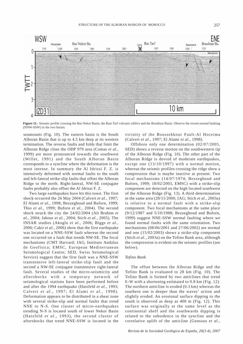
layers and consequently the Ras Tarf would be youngerthan 12 Ma (Morel, 1987). The Ras Tarf Peninsulaseparates the Boudinar Basin and the Bas Nekor Basin.The latter basin is not as deep as the Boudinar Basin(Fig. 11). Several normal faulting are observed in thisbasin and off the Al Hoceima Region (Calvert et al.,1997). The normal faults, that trend NNE-SSW, aredipping west and east with a horst and grabenconfiguration. We name this disturbed region the AlIdrissi F. Z. A small horst is uplifted (Fig. 12) and formsa 400 m high knoll to the NE that merges with a largeplateau (Fig. 13). Off Ras Tarf volcanic complex the tiltis more pronounced (6 ° and 11°, Fig. 12) than in theBoudinar Basin, and the progradational body maybe
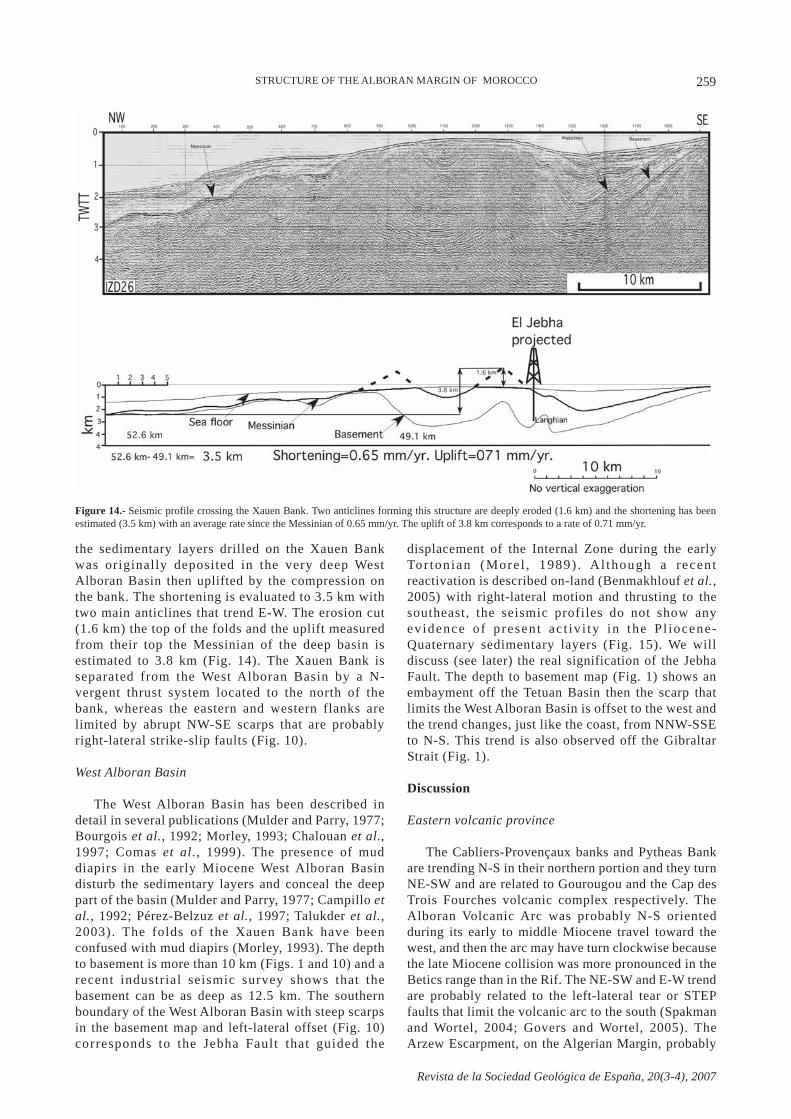
Messinian or early Pliocene. The profile shown infigure 13 crosses a high that is the southwesternextension of the Alboran Ridge, separated by a saddleand offset (Fig. 10). It is known (Gensous et al., 1986;Bourgois et al., 1992; Watts et al., 1993; Comas et al.,1999) that the Alboran Ridge is a 28 km wide anticlineand the Messinian is tilted in both sides of the ridge.This disposition allows us to estimate the shortening ofthe Alboran Ridge to 2.8 km. The 13 km wide highshown in figure 13 is limited by reverse faults withdouble vergence. The shortening is evaluated to about 4km. This high is flanked by two basins. The westernbasin that is an extension of the West Alboran Basin,and is located between the Ibn Batouta and Tofino
257
Revista de la Sociedad Geológica de España, 20(3-4), 2007
seamounts (Fig. 10). The eastern basin is the SouthAlboran Basin that is up to 4.5 km deep at its westerntermination. The reverse faults and folds that limit theAlboran Ridge close the ODP 979 area (Comas et al.,1999) are more pronounced towards the southwest(Wil le t , 1991) and the South Alboran Basincorresponds to a syncline where the deformation is themost intense. In summary the Al Idrissi F. Z. isintensively deformed with normal faults to the southand left-lateral strike-slip faults that offset the AlboranRidge to the north. Right-lateral, NW-SE conjugatefaults probably also offset the Al Idrissi F. Z.
Two large earthquakes have hit this town. The firstshock occurred the 26 May 2004 (Calvert et al., 1997;El Alami et al., 1998; Bezzeghoud and Buforn, 1999;Thio et al., 1999; Buforn et al., 2004). The secondshock struck the city the 24/02/2004 (Aït Brahim etal., 2004; Jabour et al., 2004; Stich et al., 2005). TheINSAR studies (Akoglu et al., 2006; Biggs et al.,2006; Cakir et al., 2006) show that the first earthquakewas located on a NNE-SSW fault whereas the secondone occurred on a fault that trends NW-SE. The focalmechanisms (CMT Harvard; IAG, Instituto Andaluzde Geofísica; EMSC, European MediterraneanSeismological Centre; SED, Swiss SeismologicalService) suggest that the first fault was a NNE-SSWtranstensive left-lateral strike-slip fault and thesecond a NW-SE conjugate transtensive right-lateralfault. Several studies of the micro-seismicity andaf te rshocks wi th a temporary ne twork ofseismological stations have been performed beforeand after the 1994 earthquake (Hatzfeld et al., 1993;Calver t e t a l . , 1997; El Alami e t a l . , 1998) .Deformation appears to be distributed in a shear zonewith several strike-slip and normal faults that trendNNE to N-S. One cluster of micro-earthquakestrending N-S is located south of lower Nekor Basin(Hatzfe ld et a l . , 1993) , the second c lus ter ofaftershocks that trend NNE-SSW is located in the
vicini ty of the Boussekkour Fault-Al Hoceima(Calvert et al., 1997; El Alami et al., 1998).
Offshore only one determination (02/07/2005,SED) shows a reverse motion on the southwestern tipof the Alboran Ridge (Fig. 10). The other part of theAlboran Ridge is devoid of moderate earthquakes,except one (13/10/1997) with a normal motion,whereas the seismic profiles crossing the ridge show acompression that is maybe inactive at present. Twofocal mechanisms (14/07/1974; Bezzeghoud andBuforn, 1999; 18/02/2003, EMSC) with a strike-slipcomponent are detected on the high located southwestof the Alboran Ridge (Fig. 13). A third determinationin the same area (28/11/2000, IAG; Stich et al., 2003a)is relat ive to a normal fault with a s tr ike-sl ipcomponent. Two focal mechanisms at the same place(9/12/1987 and 5/10/1988; Bezzeghoud and Buforn,1999) suggest NNE-SSW normal faulting where wefound normal faults with the same orientation. Twomechanisms (08/06/2001 and 27/06/2002) are normaland one (15/02/2003) shows a strike-slip component(Stich et al., 2003a) on the Tofino Bank area, althoughthe compression is evident on the seismic profiles (seebelow).
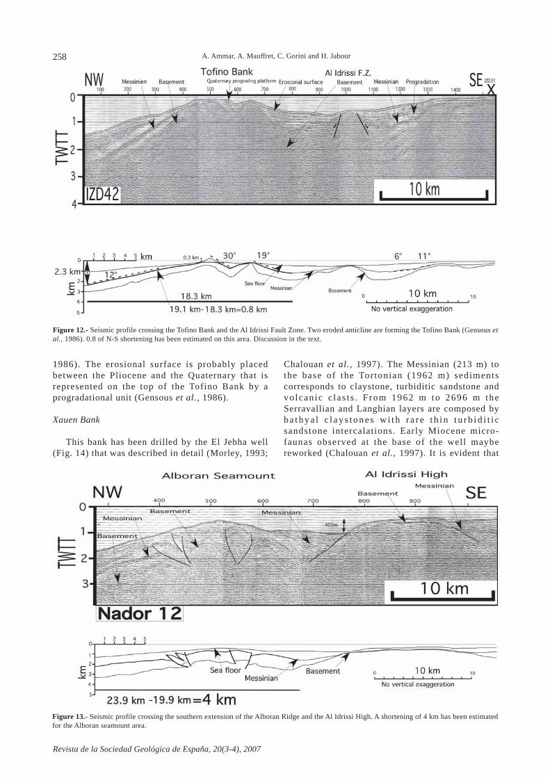
Tofino Bank
The offset between the Alboran Ridge and theTofino Bank is evaluated to 28 km (Fig. 10). TheTofino Bank is formed by two anticlines that trendE-W with a shortening estimated to 0.8 km (Fig. 12).The northern anticline is eroded (0.3 km) whereas thesouthern one is deeper than the waves’ action andslightly eroded. An erosional surface dipping to thesouth is observed as deep as 400 m (Fig. 12). Thissurface was originally at the same level as thecontinental shelf and the southwards dipping isrelated to the subsidence in the syncline and thecorrelative uplift of the anticline (Gensous et al.,
Figure 11.- Seismic profile crossing the Bas Nekor Basin, the Rast Tarf volcanic edifice and the Boudinar Basin. Observe the recent normal faulting(NNW-SSW) in the two basins.
STRUCTURE OF THE ALBORAN MARGIN OF MOROCCO
258
Revista de la Sociedad Geológica de España, 20(3-4), 2007
1986). The erosional surface is probably placedbetween the Pliocene and the Quaternary that isrepresented on the top of the Tofino Bank by aprogradational unit (Gensous et al., 1986).
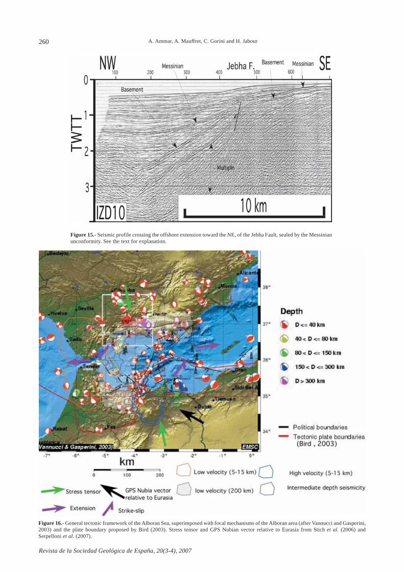
Xauen Bank
This bank has been drilled by the El Jebha well(Fig. 14) that was described in detail (Morley, 1993;
Chalouan et al., 1997). The Messinian (213 m) tothe base of the Tortonian (1962 m) sedimentscorresponds to claystone, turbiditic sandstone andvolcan ic c las t s . F rom 1962 m to 2696 m theSerravallian and Langhian layers are composed byb a t h y a l c l a y s t o n e s w i t h r a r e t h i n t u r b i d i t i csandstone intercalations. Early Miocene micro-faunas observed at the base of the well maybereworked (Chalouan et al., 1997). It is evident that
Figure 12.- Seismic profile crossing the Tofino Bank and the Al Idrissi Fault Zone. Two eroded anticline are forming the Tofino Bank (Gensous etal., 1986). 0.8 of N-S shortening has been estimated on this area. Discussion in the text.
Figure 13.- Seismic profile crossing the southern extension of the Alboran Ridge and the Al Idrissi High. A shortening of 4 km has been estimatedfor the Alboran seamount area.
A. Ammar, A. Mauffret, C. Gorini and H. Jabour
259
Revista de la Sociedad Geológica de España, 20(3-4), 2007
the sedimentary layers drilled on the Xauen Bankwas originally deposited in the very deep WestAlboran Basin then uplifted by the compression onthe bank. The shortening is evaluated to 3.5 km withtwo main anticlines that trend E-W. The erosion cut(1.6 km) the top of the folds and the uplift measuredfrom their top the Messinian of the deep basin isestimated to 3.8 km (Fig. 14). The Xauen Bank isseparated from the West Alboran Basin by a N-vergent thrust system located to the north of thebank, whereas the eastern and western flanks arelimited by abrupt NW-SE scarps that are probablyright-lateral strike-slip faults (Fig. 10).
West Alboran Basin
The West Alboran Basin has been described indetail in several publications (Mulder and Parry, 1977;Bourgois et al., 1992; Morley, 1993; Chalouan et al.,1997; Comas et al., 1999). The presence of muddiapirs in the early Miocene West Alboran Basindisturb the sedimentary layers and conceal the deeppart of the basin (Mulder and Parry, 1977; Campillo etal., 1992; Pérez-Belzuz et al., 1997; Talukder et al.,2003). The folds of the Xauen Bank have beenconfused with mud diapirs (Morley, 1993). The depthto basement is more than 10 km (Figs. 1 and 10) and arecent industrial seismic survey shows that thebasement can be as deep as 12.5 km. The southernboundary of the West Alboran Basin with steep scarpsin the basement map and left-lateral offset (Fig. 10)corresponds to the Jebha Fault that guided the
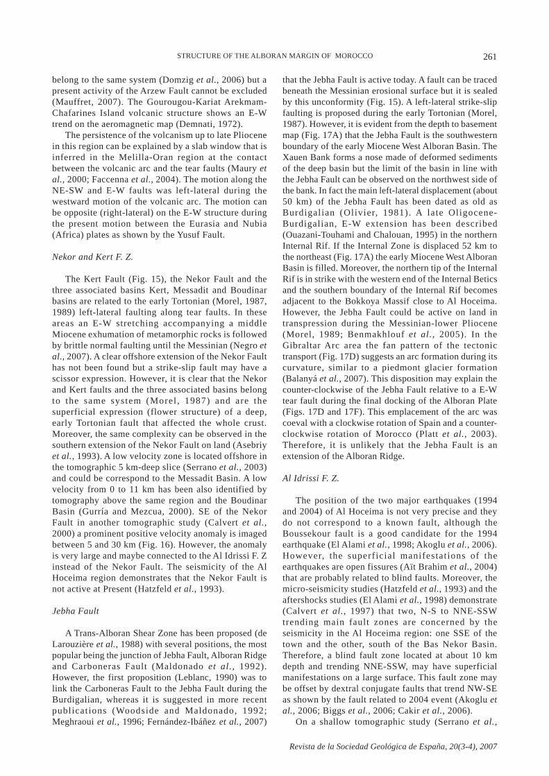
displacement of the Internal Zone during the earlyTor tonian (More l , 1989) . Al though a recentreactivation is described on-land (Benmakhlouf et al.,2005) with right-lateral motion and thrusting to thesoutheast, the seismic profiles do not show anyevidence of p resen t ac t iv i ty in the P l iocene-Quaternary sedimentary layers (Fig. 15). We willdiscuss (see later) the real signification of the JebhaFault. The depth to basement map (Fig. 1) shows anembayment off the Tetuan Basin then the scarp thatlimits the West Alboran Basin is offset to the west andthe trend changes, just like the coast, from NNW-SSEto N-S. This trend is also observed off the GibraltarStrait (Fig. 1).
Discussion
Eastern volcanic province
The Cabliers-Provençaux banks and Pytheas Bankare trending N-S in their northern portion and they turnNE-SW and are related to Gourougou and the Cap desTrois Fourches volcanic complex respectively. TheAlboran Volcanic Arc was probably N-S orientedduring its early to middle Miocene travel toward thewest, and then the arc may have turn clockwise becausethe late Miocene collision was more pronounced in theBetics range than in the Rif. The NE-SW and E-W trendare probably related to the left-lateral tear or STEPfaults that limit the volcanic arc to the south (Spakmanand Wortel, 2004; Govers and Wortel, 2005). TheArzew Escarpment, on the Algerian Margin, probably
Figure 14.- Seismic profile crossing the Xauen Bank. Two anticlines forming this structure are deeply eroded (1.6 km) and the shortening has beenestimated (3.5 km) with an average rate since the Messinian of 0.65 mm/yr. The uplift of 3.8 km corresponds to a rate of 0.71 mm/yr.
STRUCTURE OF THE ALBORAN MARGIN OF MOROCCO
260
Revista de la Sociedad Geológica de España, 20(3-4), 2007
Figure 15.- Seismic profile crossing the offshore extension toward the NE, of the Jebha Fault, sealed by the Messinianunconformity. See the text for explanation.
Figure 16.- General tectonic framework of the Alboran Sea, superimposed with focal mechanisms of the Alboran area (after Vannucci and Gasperini,2003) and the plate boundary proposed by Bird (2003). Stress tensor and GPS Nubian vector relative to Eurasia from Stich et al. (2006) andSerpelloni et al. (2007).
A. Ammar, A. Mauffret, C. Gorini and H. Jabour
261
Revista de la Sociedad Geológica de España, 20(3-4), 2007
STRUCTURE OF THE ALBORAN MARGIN OF MOROCCO
belong to the same system (Domzig et al., 2006) but apresent activity of the Arzew Fault cannot be excluded(Mauffret, 2007). The Gourougou-Kariat Arekmam-Chafarines Island volcanic structure shows an E-Wtrend on the aeromagnetic map (Demnati, 1972).
The persistence of the volcanism up to late Pliocenein this region can be explained by a slab window that isinferred in the Melilla-Oran region at the contactbetween the volcanic arc and the tear faults (Maury etal., 2000; Faccenna et al., 2004). The motion along theNE-SW and E-W faults was left-lateral during thewestward motion of the volcanic arc. The motion canbe opposite (right-lateral) on the E-W structure duringthe present motion between the Eurasia and Nubia(Africa) plates as shown by the Yusuf Fault.
Nekor and Kert F. Z.
The Kert Fault (Fig. 15), the Nekor Fault and thethree associated basins Kert, Messadit and Boudinarbasins are related to the early Tortonian (Morel, 1987,1989) left-lateral faulting along tear faults. In theseareas an E-W stretching accompanying a middleMiocene exhumation of metamorphic rocks is followedby brittle normal faulting until the Messinian (Negro etal., 2007). A clear offshore extension of the Nekor Faulthas not been found but a strike-slip fault may have ascissor expression. However, it is clear that the Nekorand Kert faults and the three associated basins belongto the same system (Morel , 1987) and are thesuperficial expression (flower structure) of a deep,early Tortonian fault that affected the whole crust.Moreover, the same complexity can be observed in thesouthern extension of the Nekor Fault on land (Asebriyet al., 1993). A low velocity zone is located offshore inthe tomographic 5 km-deep slice (Serrano et al., 2003)and could be correspond to the Messadit Basin. A lowvelocity from 0 to 11 km has been also identified bytomography above the same region and the BoudinarBasin (Gurría and Mezcua, 2000). SE of the NekorFault in another tomographic study (Calvert et al.,2000) a prominent positive velocity anomaly is imagedbetween 5 and 30 km (Fig. 16). However, the anomalyis very large and maybe connected to the Al Idrissi F. Zinstead of the Nekor Fault. The seismicity of the AlHoceima region demonstrates that the Nekor Fault isnot active at Present (Hatzfeld et al., 1993).
Jebha Fault
A Trans-Alboran Shear Zone has been proposed (deLarouzière et al., 1988) with several positions, the mostpopular being the junction of Jebha Fault, Alboran Ridgeand Carboneras Fault (Maldonado et al., 1992).However, the first proposition (Leblanc, 1990) was tolink the Carboneras Fault to the Jebha Fault during theBurdigalian, whereas it is suggested in more recentpublications (Woodside and Maldonado, 1992;Meghraoui et al., 1996; Fernández-Ibáñez et al., 2007)
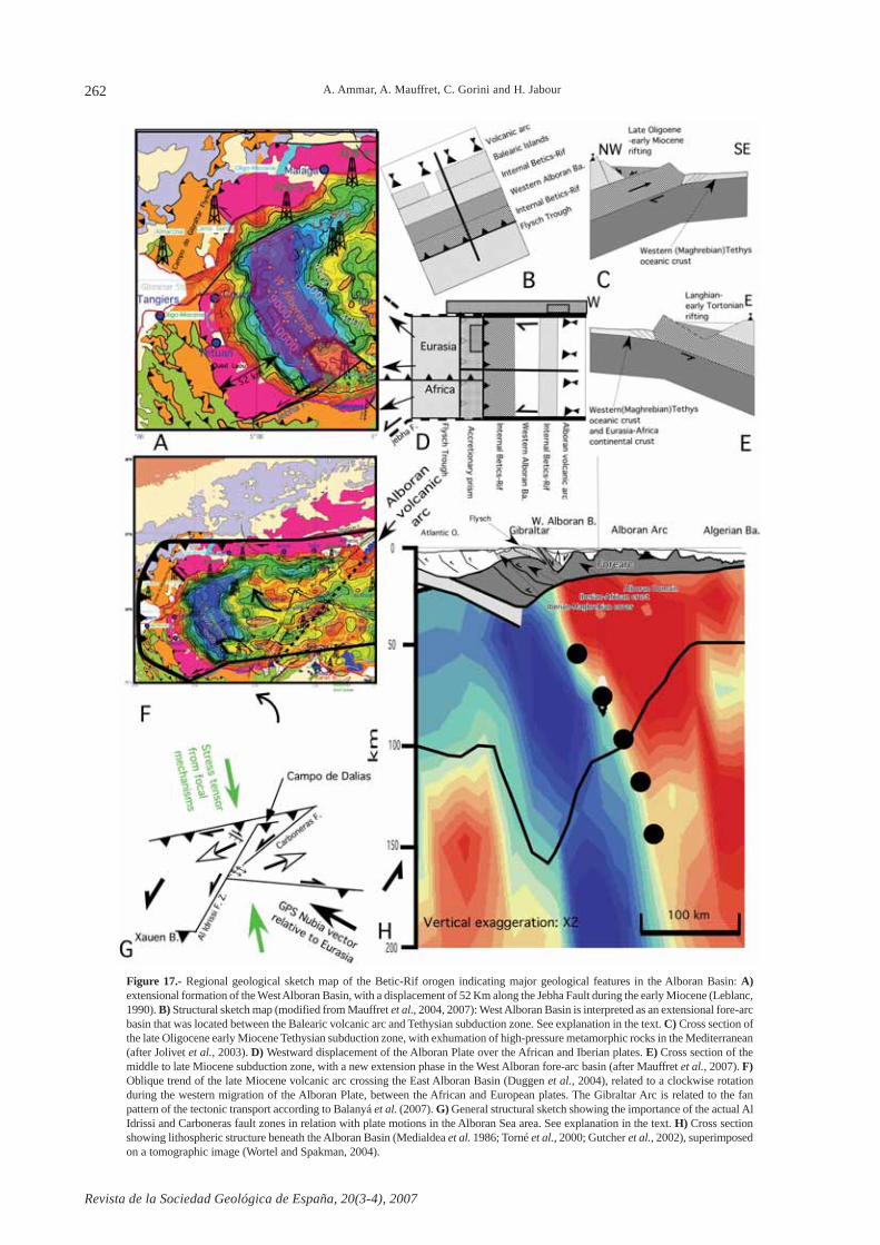
that the Jebha Fault is active today. A fault can be tracedbeneath the Messinian erosional surface but it is sealedby this unconformity (Fig. 15). A left-lateral strike-slipfaulting is proposed during the early Tortonian (Morel,1987). However, it is evident from the depth to basementmap (Fig. 17A) that the Jebha Fault is the southwesternboundary of the early Miocene West Alboran Basin. TheXauen Bank forms a nose made of deformed sedimentsof the deep basin but the limit of the basin in line withthe Jebha Fault can be observed on the northwest side ofthe bank. In fact the main left-lateral displacement (about50 km) of the Jebha Fault has been dated as old asBurdigalian (Olivier, 1981). A late Oligocene-Burdigalian, E-W extension has been described(Ouazani-Touhami and Chalouan, 1995) in the northernInternal Rif. If the Internal Zone is displaced 52 km tothe northeast (Fig. 17A) the early Miocene West AlboranBasin is filled. Moreover, the northern tip of the InternalRif is in strike with the western end of the Internal Beticsand the southern boundary of the Internal Rif becomesadjacent to the Bokkoya Massif close to Al Hoceima.However, the Jebha Fault could be active on land intranspression during the Messinian-lower Pliocene(Morel, 1989; Benmakhlouf et al., 2005). In theGibraltar Arc area the fan pattern of the tectonictransport (Fig. 17D) suggests an arc formation during itscurvature, similar to a piedmont glacier formation(Balanyá et al., 2007). This disposition may explain thecounter-clockwise of the Jebha Fault relative to a E-Wtear fault during the final docking of the Alboran Plate(Figs. 17D and 17F). This emplacement of the arc wascoeval with a clockwise rotation of Spain and a counter-clockwise rotation of Morocco (Platt et al., 2003).Therefore, it is unlikely that the Jebha Fault is anextension of the Alboran Ridge.
Al Idrissi F. Z.
The position of the two major earthquakes (1994and 2004) of Al Hoceima is not very precise and theydo not correspond to a known fault, although theBoussekour fault is a good candidate for the 1994earthquake (El Alami et al., 1998; Akoglu et al., 2006).However, the superficial manifestat ions of theearthquakes are open fissures (Aït Brahim et al., 2004)that are probably related to blind faults. Moreover, themicro-seismicity studies (Hatzfeld et al., 1993) and theaftershocks studies (El Alami et al., 1998) demonstrate(Calvert et al., 1997) that two, N-S to NNE-SSWtrending main fault zones are concerned by theseismicity in the Al Hoceima region: one SSE of thetown and the other, south of the Bas Nekor Basin.Therefore, a blind fault zone located at about 10 kmdepth and trending NNE-SSW, may have superficialmanifestations on a large surface. This fault zone maybe offset by dextral conjugate faults that trend NW-SEas shown by the fault related to 2004 event (Akoglu etal., 2006; Biggs et al., 2006; Cakir et al., 2006).
On a shallow tomographic study (Serrano et al.,
262
Revista de la Sociedad Geológica de España, 20(3-4), 2007
Figure 17.- Regional geological sketch map of the Betic-Rif orogen indicating major geological features in the Alboran Basin: A)extensional formation of the West Alboran Basin, with a displacement of 52 Km along the Jebha Fault during the early Miocene (Leblanc,1990). B) Structural sketch map (modified from Mauffret et al., 2004, 2007): West Alboran Basin is interpreted as an extensional fore-arcbasin that was located between the Balearic volcanic arc and Tethysian subduction zone. See explanation in the text. C) Cross section ofthe late Oligocene early Miocene Tethysian subduction zone, with exhumation of high-pressure metamorphic rocks in the Mediterranean(after Jolivet et al., 2003). D) Westward displacement of the Alboran Plate over the African and Iberian plates. E) Cross section of themiddle to late Miocene subduction zone, with a new extension phase in the West Alboran fore-arc basin (after Mauffret et al., 2007). F)Oblique trend of the late Miocene volcanic arc crossing the East Alboran Basin (Duggen et al., 2004), related to a clockwise rotationduring the western migration of the Alboran Plate, between the African and European plates. The Gibraltar Arc is related to the fanpattern of the tectonic transport according to Balanyá et al. (2007). G) General structural sketch showing the importance of the actual AlIdrissi and Carboneras fault zones in relation with plate motions in the Alboran Sea area. See explanation in the text. H) Cross sectionshowing lithospheric structure beneath the Alboran Basin (Medialdea et al. 1986; Torné et al., 2000; Gutcher et al., 2002), superimposedon a tomographic image (Wortel and Spakman, 2004).
A. Ammar, A. Mauffret, C. Gorini and H. Jabour
263
Revista de la Sociedad Geológica de España, 20(3-4), 2007
2003) a positive velocity anomaly is located on thehigh, north of Ras Tarf, corresponding to the Al IdrissiF. Z. The cluster of Al Hoceima earthquakes is locatedin the transition between fast and slow anomalies(Serrano et al., 2003). The cluster is not only located inthe Al Hoceima area but extends offshore (Figs. 10 and16). The focal mechanisms are mainly related to strike-slip and normal faulting and the cluster include theareas where the reverse faulting is demonstrated by theseismic profiles (Tofino Bank, Fig. 12).
This bank is 28 km left-laterally offset from themain Alboran Ridge (Fig. 10). A prominent magneticanomaly can be correlated to the Ibn Batouta Seamount.A similar anomaly but offset to the northeast with thesame 28 km displacement , is observed on theseamounts that flank the Alboran Channel to the NW(Willet, 1991; Galindo-Zaldívar et al., 1998).
In a first hypothesis it is suggested that the El IdrissiFault Zone belongs to the plate boundary proposed(Bird, 2003) between Eurasia and Nubia (Africa) plates(Fig. 16) and is interrupted by the Alboran Ridge thatmay be the northern boundary of the Nubia (Africa)Plate. A southward displacement of a Rif Block inMorocco with respect to the Nubia plate is inferredfrom GPS observations (Fadil et al., 2006) and a left-lateral motion of this Rif Block along the Al Idrissi F. Zmaybe proposed. This block may belong to the EurasiaPlate (Fig. 16) (Bird, 2003; Vannucci and Gasperini,2003). However, the present motion in this area is notwell constraint by the GPS data and if a southwardmotion is suggested (Fadil et al., 2006; Serpelloni etal., 2007), a westward displacement is also proposed(Fernandes et al., 2007). A clear boundary of theEurasia and Nubia (Africa) plates is not well definedand a diffuse zone is yet preferred. Moreover, the offsetof the Ibn Batouta Seamount and the seamounts thatlimit the Alboran channel to the northwest suggest thatthe fault has a northern extension and crosses thechannel. Therefore, the first hypothesis is unlikely anda second hypothesis will be examined.
It is suggested that the Al Idrissi F. Z. has a northernextension. Two focal mechanisms in the AlboranChannel (13/08/00 and 18/02/03; Fig.10) show purestrike-slip and strike-slip with a normal componentrespectively. These two earthquakes have a NW-SE,left-lateral nodal plane compatible with the N30E AlIdrissi F. Z. The southwestern boundary of the DjiboutiBank is limited by a prominent fault (Pérez-Belzuz,1999) that is in strike with Al Idrissi F. Z. A recentmultibeam survey enlightens (Ballesteros et al., 2008)this area. The Al Idrissi F. Z. is interrupted by a NW-SEprominent fault that shows strike-slip and reversecomponents (Pérez-Belzuz, 1999). This fault is anorthwest extension (Ballesteros et al., 2008) of theNW-SE Yusuf Fault that crosses the Alboran Channel.The southeast side of the Carboneras fault is occupiedby short en echelon structures (Fig. 17G) that trendnorthwest-southeast. These structures are probablyfolds related to the left-lateral Carboneras fault or to a
blind fault associated to the main fault (Gràcia et al.,2006). This blind strike-slip fault can be related to theAl Idrissi F. Z. trough a restraining bend. North of theYusuf Fault, graben and normal faults trend NE-SW(Ballesteros et al., 2008). The Campo de Dalías-Adraarea (Fig. 17G) presents many similarities with the AlHoceima region, with NW-SE normal and right-lateralstrike-slip faulting (Rodríguez-Fernández and Martín-Penela, 1993; Stich et al., 2001, 2003b; Martínez-Díazand Hernández-Enrile, 2004; Marín-Lechado et al.,2005, 2007). The NNW-SSE compression and the E-Wextension are coeval and the blocks between the mainfaults (Alpujarras, Carboneras, Al Idrissi, Yusuf)undergo a tectonic escape (Mart ínez-Díaz andHernández-Enrile, 2004; Martínez-Martínez et al.,2006) towards the west but also to the east and theAlboran Island area is the centre where all the largefaults are converging.
The diffuse SW-NE band of strike-slip earthquakesthat crosses the Alboran Sea (evident on the figure 3 ofFernández-Ibáñez et al., 2007 and in figure 16) mayrepresent an embryonic fault (Negredo et al., 2002),although a careful analysis shows that the stripe is notso diffuse and the fault is active and not nascent. In factwe reactivate a fault already suspected a long time ago(Dillon et al., 1980; El Alami et al., 1998). However,the trace of this fault was based on few seismic profileswhereas several multichannel lines, focal mechanismsand multibeam surveys are now available.
In summary the Al Idrissi F. Z. is a left-lateralstrike-slip zone that crosses the Alboran Ridge and theAlboran Channel. This fault can be followed up to thenorthwest extension of the Yusuf Fault. To the north theAl Idrissi F. Z. maybe connected to the CarbonerasFault through a restraining bend or/and a blind faultthat may extend up to the Campo de Dalías-Adra region(Fig. 17G).
Tofino and Xauen Banks
Three tectonic compressional pulses have beendefined in this area (Chalouan et al., 1997). The twofirst events, with a NNE compression, late Tortonianand early Pliocene in age, affect the north and west ofthe Xauen Bank. The third is between the Quaternaryand the Pliocene, with a compressional stress N150 Eto N-S, affects the northern margin of Morocco withthe formation of a syncline south of the banks and theuplift of the banks with a northern vergence of the foldsand thrusts that limit the banks to the north. It issuggested (Chalouan et al., 1997) that the E-W to ESE-WNW folds are controlled by a deep Jebha Faultlocated beneath the bank. However, it is unlikely, aspreviously discussed, that the Jebha Fault is connectedwith the Alboran Ridge. 3.5 km of post-Messinianshortening have been calculated on the eroded twoanticlines that form the Xauen Bank and the synclinethat separates the bank from the land. With a 5 mm/yrof convergence between the Nubia (Africa) and Eurasia
STRUCTURE OF THE ALBORAN MARGIN OF MOROCCO
264
Revista de la Sociedad Geológica de España, 20(3-4), 2007
plates, 26.5 km of shortening can be expected since theMessinian (5.3 Ma). Thus the compression is dispersedbetween the Betics, the Spanish margin, the XauenBank where about 13% of the compression is absorbed,and in the Rif and Atlas in Morocco. Therefore, a smallpart of the 28 km of displacement of Tofino Bank withrespect to the Alboran Ridge along the Al Idrissi F. Z. isabsorbed by the banks, but a deep decollement, about10 km deep or even at the Moho level, may dipsouthward beneath the banks whereas the formernormal fault that dipping north from the continent actsas a backstop between the coast and the banks(Chalouan et al., 1997). A 10 km-deep decollement isalso observed along the Spanish margin (Marín-Lechado et al., 2005) and this decollement maybecontinuous and transmit the compression from Spain tothe Atlas (Frizon de Lamotte et al., 2004). The TofinoBank and the Xauen Bank have not the samecomposition. The core of the first bank is volcanicwhereas the second is mainly made of deformedsedimentary layers as demonstrated by the El Jebhawell (Morley, 1993). Moreover, this bank is not visibleon the free-air gravity map (Willet, 1991) at thedifference of the Tofino Bank.
Uplift of the land
A prominent tilting occurred at the Pliocene-Quaternary boundary with a deepening of the marginsbasinward and uplift of the margins onshore (Gensous etal., 1986; Docherty and Banda, 1995). The Quaternaryprograding platform is related to the forced regressionduring the glaciations (Gensous et al., 1986). We can see(Fig. 6) a 0.7 km high Messinian arch on the TroisFourches Block. However, it is difficult to differentiatebetween the initial slope of the Messinian level towardsthe basin and the late Pliocene tilting. In the MessaditBasin (Fig. 8) the difference of the Messinian from theshelf to the basin is 0.8 km. The Messadit Basin is agraben that has been tilted during the late Pliocene event.The top of the syn-rift infill was probably horizontal andthe tilt is about the same as the Messinian. We compare(Fig. 9) the tilt of the Messinian surface and thepolyphased surface of the Ras Tarf (Morel, 1987). ThePorites reef that belongs to the Messinian TerminalComplex is uplifted to 588 m and the tilt varies from 3.6°to 6.1°. Offshore the tilt is 4.6° (Figs. 8) and 5° (Fig. 9).A difference of 1.5 km is observed between the deepbasin and the top of the Messinian Reef Complex (588m, Fig. 9). This difference is the conjunction of an initialslope, an uplift of the coast and a deepening of the basin.The same tilting is observed on the Alboran Ridge, theTofino and Xauen banks. On the Xauen Bank 1.6 km oferosion has been estimated on the top of an anticline(Fig. 14) and the top of this eroded anticline is 3.8 kmhigher than the Messinian surface in the deep basin. TheXauen Bank is probably part of the West Alboran Basinuplifted by compression and the top of the bank mayhave been during the Messinian as the same level as the
basin. An uplift of 0.71 mm/yr is calculated since theMessinian that is similar to the 0.6 mm/yr of upliftproposed by Chalouan et al. (1997). However an upliftof 1.2 km seems to be appropriate for the whole regionand the corresponding rate is 0.2 mm/yr. The upliftedQuaternary terraces in Morocco and Algeria suggest arate of 0.11-0.26 mm/yr (Meghraoui et al., 1996; Moreland Meghraoui, 1996). In Spain, a Quaternary rate of 0.2mm/yr has been calculated in the Gibraltar area (Zazo etal., 1999) whereas a rate of 0.2-0.28 mm/yr is estimatedfor the uplift of the Betic Cordillera (Braga et al., 2003).The tilting and the uplift of the upper margin and thedeepening of the basins imply a deepening of theAlboran Sea from coast to coast since the late Miocene.On the eastern Morocco, east of the Trois Fourches Capethe Messinian shelf break is located 1 km south of thepresent shelf break. West of the cape the Messiniancontinental shelf has been eroded after the tilting.
Tectonics and deep structure of the Alboran Sea
A zoom of the West Alboran Basin is shown infigure 17A. This basin is infilled by late Oligocene-early Miocene syn-rift sediments as thick as 5 km(Comas et al., 1992, 1999; Mauffret et al., 2007).The early Miocene basin is limited to the south bythe extension of the Jebha Fault and to the north itextends along the Spanish coast up to the MotrilBasin (Soto et al., 1996; Comas et al., 1999). In factall the tectonic features in this area: the GibraltarArc, the Miocene West Alboran Basin, and theDSDP 121-ODP 976-Ibn Batouta High present ahorseshoe shape that can be explained by theformation of the arc limited by two mean tear faults.The 60 km-wide West Alboran Basin is almostundeformed on the Moroccan side except someOligocene-Miocene syn-rift sediments south ofGibraltar Strait (Feinberg et al., 1990), whereas theequivalent Spanish basins (Malaga and Motri lbasins) which trend E-W, are much narrower thanthe West Alboran Basin, a large part being upliftedand integrated to the continent.
A rifting of the West Alboran Basin in a fore-arcposition south of the Balearic Islands has beenproposed (Mauffret et al., 2007). This rifting may occur(Figs. 17B and 17C) during exhumation in a subductionchannel of the HP-metamorphosed Sebtides andAlpujarrides (Bouybaouene et al., 1995; Michard et al.,2002; Jolivet et al., 2003; Chalouan and Michard,2004).
After the Burdigalian collision of the Kabylias withAfrica occurred, the arc reoriented its rollback towardsthe west (Faccenna et al., 2004) above an E-W tongueof oceanic Tethys crust located between Eurasia andAfrica (Spakman and Wortel, 2004; Mauffret et al.,2007). This tongue was narrow and maybe alreadypartly closed by the approaching Eurasia and Africaplates (Faccenna et al., 2004). In such environment theaccretionary prism may have included large pieces of
A. Ammar, A. Mauffret, C. Gorini and H. Jabour
265
Revista de la Sociedad Geológica de España, 20(3-4), 2007
continental fragments in the Flysch Trough main unitdeformed in the accretionary prism (Fig. 17D).Conversely, some pieces of the Alboran Plate may havebeen dragged and abandoned to the adjacent plate. Thistectonic scenario shows many similarities with thepresent situation of the Caribbean Plate, relative to theNorth and South America plates, where the slowconvergence is almost normal (E-W) to the LesserAntilles subduction zone (N-S) and partly hiddenbeneath the Barbados accretionary prism (Müller et al.,1999).
The Maghrebian Flysch tectonic wedge, includinglarge pieces of continental rocks, may have beenpushed towards the west during the roll-back and mayform the 30 km thick crust (Medialdea et al., 1986;Torné et al., 2000) that is located in the Gibraltar Straitarea. The Gibraltar Strait maybe compared to theBarbados Island where old series (Eocene) are locatedon top of the Lesser Antilles prism (Mascle et al.,1985). A low velocity layer, 10 km thick, has beenattributed to the Campo de Gibraltar Flysch (Medialdeaet al., 1986). This low velocity is confirmed between 0and 11 km and 11-24 km by a local tomographic study(Gurría and Mezcua, 2000). However, the well CerroGordo reaches the Cretaceous limestone attributed tothe Subbetic Domain as shallow as 1266 m beneath theAljibe Maghrebian Flysch (Lanaja, 1987; Crespo-Blancand Frizon de Lamotte, 2006). Nevertheless, this wellis located northwest of the Gibraltar Strait and theFlysch may thicken just beneath the strait area. In thissouthern region the well Almarchal drilled 3465 m ofEocene-Oligocene (Maghrebian Flysch) with a lateCretaceous tectonic slice (Subbetic), sandwichedbetween 810 and 880 m Flysch (Lanaja, 1987).Therefore, the 30 km thick crust of the Gibraltar areamay have been thickened by repetition of Flysch seriesand thrusts into the Iberian-African crust. A 30 km thickcrust is observed also beneath the northern Moroccodirectly south of Gibraltar (Tadili et al., 1986).
A thick crust and a thick lithosphere (130 km)beneath the Gibraltar Strait is confirmed by all thegeophysical methods: tomography (Calvert et al.,2000), gravi ty (Torné et al . , 2000), refract ion(Medialdea et al., 1986), geoid (Fullea Urchulutegui etal., 2006). However, the tomographic cross section ofthe Gibraltar Strait (Spakman and Wortel, 2004)suggests (Fig. 17H) that the thick lithosphere with alow velocity may represents a cold and old oceaniclithosphere of the Atlantic Ocean dipping beneath thehot and young Alboran Domain (Thiebot and Gutscher,2006). A westwards retreat of the Alboran subductionzone is corroborated by several independent methodsand well illustrated by the tomography (Faccenna et al.,2004; Spakman and Wortel, 2004). However, thegeneral tomography is blind between 0 and 50 km andthe intermediate depth seismicity is active between 50and 150 km but does not show (Fig. 17H) an evidentcorrelation with the shallow seismicity (Buforn et al.,1997, 2004). Therefore, the slab is probably detached
since the late Miocene and an active subduction atPresent (Gutscher et al., 2002; Thiebot and Gutscher,2006) is unlikely.
The sketches D and E in figure 17 show the E-Wtravel of the Alboran Plate (Andrieux et al., 1971).During this journey, from the Langhian to the earlyTortonian, a second rifting occurred with an E-Wextension in the West Alboran fore-arc basin (Mauffretet al., 2007). The normal faults may have the same N-Strend as the Alboran Volcanic Arc that has been definedby Duggen et al. (2004). The Alboran Plate wasseparated from the Eurasia and Africa by tear or STEPfaults (Spakman and Wortel, 2004; Govers and Wortel,2005). Along the STEP faults a clockwise rotation isobserved in Spain and a counter-clockwise rotation inMorocco (Platzman et al., 1993; Saddiqui et al., 1995;Feinberg et al., 1996; Platt et al., 2003). However, theserotations were mainly active before the late Tortonianduring the westwards motion of the Alboran Plate andthe late Miocene to Recent rotations in Spain aremainly related to strike-slip faulting (Mattei et al.,2006).
A low velocity zone located at 200 km depthaccording to a general tomography study (Spakman andWortel, 2004) shows a crescent shape with a N-Sorientation beneath the Alboran Sea that turns to NE-SW beneath the Betics in southern Spain (Fig. 16).The collision of the westwards migrating AlboranPlate and the Eurasia (Iberia) probably occurred in theEastern Betics with a stalling of rollback and theformation of the Betic orogen that is much larger thanthe Rif orogen and the westwards motion slow downalong the northern boundary (Spakman and Wortel,2004) whereas it is yet fast along the southernboundary. Consequently a clockwise rotation of theAlboran Volcanic Arc (Cabo de Gata-Ras Tarf) mayoccur with a coeval integration to the continent of thenorthern part of the West Alboran Basin [Oligo-Miocene syn-rift series (Durand-Delga et al., 2003)and the Oligocene-early Miocene dikes in the Malagaregion (Torres-Roldán et al., 1986; Duggen et al.,2004)].
In addition a N-S stripe of intermediate depthseismicity (50-150 km) (Buforn et al., 1997; López-Casado et al., 2001; Buforn et al., 2004) shows also acurve towards the east in the vicinity of Malaga. Thisboomerang shape (Figs. 16 and 17F) may explain thecomplex geometry of the intermediate depth seismicitywith a main eastwards almost vertical dip (Buforn etal., 1997) and a southern dipping interpreted as acontinental subduction of the Iberia beneath the Beticsand the Alboran Sea (Morales et al., 1999) that isprobably related to the present collision in the Malagaregion. The clockwise rotation of the Alboran Domainmaybe also related to a drag (Stich et al., 2006) due tothe Nubia (Africa) counter-clockwise rotation relativeto Eurasia with coeval E-W extension (Fig. 17F). Thisclockwise rotation in the Al Hoceima region and thecentral domain of the Alboran Sea is corroborated by a
STRUCTURE OF THE ALBORAN MARGIN OF MOROCCO
266
Revista de la Sociedad Geológica de España, 20(3-4), 2007
recent study of the stress field (Fernández-Ibáñez et al.,2007).
On a map (Fig. 16) from EMSC of the focalmechanisms in the Alboran area (Vannucci andGasperini, 2003) the general tectonic framework of theAlboran Sea is superimposed with the low and highvelocity areas deduced from tomography (Calvert etal., 2000; Spakman and Wortel, 2004). In addition it isdrawn the Nubia vector relative to Eurasia observed onGPS measurements (4.8 mm/yr in a WNW-ESEdirection) and the stress tensor with a NNW-SSEcompression (2.3 mm/yr of shortening), W-E extension(2.1 mm/yr) and NE-SW left-lateral strike-slip (Stich etal., 2006; Fernández-Ibáñez et al., 2007; Serpelloni etal., 2007). The sketch (Fig. 17G) shows that tectonicframework of the Alboran area is governed by the stresstensor derived from focal mechanisms and stress field(Fernández-Ibáñez et al. , 2007) and not by theconvergence motion of Nubia (Africa) Plate relative tothe Eurasia Plate.
Conclusions
The Morocco margin is less involved than SouthSpain in the collisional process between the Eurasiaand Nubia (Africa) plates. Consequently, severaltectonic features are undeformed, in particularly thesouthern West Alboran Basin whereas the samestructures are highly deformed and integrated to thecontinent compared to the northern part of the AlboranSea. A clockwise rotation of the Alboran Domain isproposed with a free southern boundary and aboomerang shape of the northern collisional boundary.However, the Morocco Margin undergoes an upliftrelated to the compression although mountain buildingis less developed than in Southern Spain. All thegeophysical and geological studies suggest a westwardsmigrat ion of the Alboran Domain al though al lconsequences of such motion are not totally integratedin the models. Extensional collapse of thickenedcontinental lithosphere or delamination process are notneeded if the extension occurred during the Miocene inan eastern area not surrounded by thickened crust butin a fore-arc behind a subduction zone that can roll-back towards a free face. The Nekor and Jebha faultsare probably inactive since the late Miocene and theydo not belong to a Trans-Alboran Shear Zone.However, a left-lateral fault zone crosses the AlboranSea from Al Hoceima to Adra and is maybe connectedto Carboneras Fault. The Alboran Sea looks like acomplex pull-apart that forms a zigzag relay between anorthwestern boundary (Gulf of Cadiz) and asoutheastern boundary (Algeria) and a diffuse boundaryin the Alboran Sea between the Nubia (Africa) andEurasia is yet preferred. The thick lithosphere beneaththe Gibraltar Strait may have been confused with a coldoceanic lithosphere dipping eastwards slab althoughalmost vertical. However, the westwards rollback of theAlboran subduction zone probably died in the late
Miocene and a continental collision is now occurring.The Alboran region is a buffer area between theconverging Eurasia and Nubia (Africa) plates. It is inthe way to be integrated to the Eurasia Plate.
Acknowledgements
We thank M. C. Comas who provided several seismic lines.The manuscript was greatly improved by the helpfulsuggestions of one anonymous reviewer who knowsparticularly well the Moroccan geology. J. Soto is thanked forhis kind suggestions. J. Navas and J. Martin help us a lot todownload the SIGEOF seismic data. F. Zanon and J. M. Massetfrom TOTAL kindly provided several seismic lines. This workhas been supported by the University of Rabat and ONYM fromMorocco; the CNRS-INSU and the University of Paris 6(UPMC) (France).
References
Aït Brahim, L., Nakhcha, C., Tadili, B.A., El Mrabet, A. andJabour, N. (2004): Structural analysis and interpretation ofthe surface deformations of the February 24 2004 AlHoceima earthquake. Newletters, 21: 10-12.
Akoglu, A.M., Cakir, Z., Meghraoui, M., Belabbes, S., ElAlami, S.O., Ergintav, S. and Akyüz, H.S. (2006): The 1994-2004 Al Hoceima (Morocco) earthquake sequence:conjugate fault ruptures deduced from InSAR. Earth andPlanetary Science Letters, 252: 467-480.
Álvarez-Marrón, J. (1999): Pliocene to Holocene structure ofthe eastern Alboran Sea (western Mediterranean). In:Proceedings of the Ocean Drilling Program, ScientificResults (Zahn, R., Comas, M.C. and Klaus, A., Eds.), 161:345-355.
Andrieux, J., Fontboté, J.M. and Mattauer, M. (1971): Sur unmodèle explicatif de l’arc de Gibraltar. Earth and PlanetaryScience Letters, 12: 191-198.
Asebriy, L., Bourgois, J., Cherkaoui, T.E. and Azdimousa, A.(1993): Evolution tectonique récente de la zone de faille duNékor: importance paléogégraphique et structurale dans leRif externe, Maroc. Journal of African Earth Sciences, 17:65-74.
Balanyá, J.C., Crespo-Blanc, A., Díaz Azpiroz, M., Expósito,I. and Luján, M. (2007): Structural trend line pattern andstrain partitioning around the Gibraltar Arc accretionarywedge: insights as the mode of orogenic building. Tectonics,26: 1-19.
Ballesteros, M., Rivera, J., Muñoz, A., Muñoz-Martín, A.,Acosta, J., Carbó, A. and Uchupi, E. (2008): Alboran basin,Southern Spain. Part II: Neogene tectonics implications forthe orogenic float model. Marine and Petroleum Geology,25: 75-101.
Benmakhlouf, M., Galindo-Zaldívar, J., Chalouan, A., Sanz deGaldeano, C., Ahmamou, M. and López Garrido, A.C.(2005): Cinemática y paleoesfuerzos en la zona de fallatranscurrente de Jebha-Chrafate (Rif septentrional, Marrue-cos). Geogaceta, 38: 71-74.
Bezzeghoud, M. and Buforn, E. (1999): Source parameters ofthe 1992 Melilla (Spain, Mw=4.8), 1994 Alhoceima(Morocco, Mw=5.8) and 1994 Mascara (Algeria, Mw=5.7)earthquakes and seismotectonic implications. Bulletin of theSeismological Society of America, 89: 359-372.
Biggs, J., Bergman, E., Emmerson, B., Funning, G.J., Jackson,
A. Ammar, A. Mauffret, C. Gorini and H. Jabour
267
Revista de la Sociedad Geológica de España, 20(3-4), 2007
J., Parsons, B. and Wright, T.J. (2006): Fault identificationfor buried strike-slip earthquakes using InSAR: the 1994 and2004 Al Hoceima, Morocco earthquakes. GeophysicalJournal International, 166: 1347-1362, doi: 10.1111/j. 1365-246X.2006.03071.x.
Bird, P. (2003): An updated digital model of plate boundaries.Geochemistry, Geophysics, Geosystems, 4: doi: 10.1029/2001GC000252.
Booth-Rea, G., Ranero, C.R., Martínez-Martínez, J.M. andGrevemeyer, I. (2007): Crustal types and Tertiary tectonicevolution of the Alborán sea, western Mediterranean.Gechemistry Geophysics Geosystems, 8: doi, 10.1029/2007GC001639.
Bouillin, J.P. (1986): Le bassin Maghrébin: une ancienne limi-te entre l’Europe et l’Afrique à l’ouest des Alpes. Bulletin dela Société Géologique de France, 8: 547-558.
Bourgois, J., Mauffret, A., Ammar, A. and Demnati, A. (1992):Multichannel seismic data imaging of inversion tectonics ofthe Alboran Ridge (western Mediterranean Sea). Geo-Marine Letters, 12: 117-122.
Bouybaouene, M.L., Goffé, B. and Michard, A. (1995): High-pressure, low-temperature metamorphism in the Sebtidesnappes, northern Rif, Morroco. Geogaceta, 17: 117-119.
Braga, J.C., Martín, J.M. and Quesada, C. (2003): Patterns andaverage rates of late Neogene-Recent uplift of the Betic Cor-dillera, SE Spain. Geomorphology, 50: 3-26.
Buforn, E., Coca, P., Udías, A. and Lasa, C. (1997): Sourcemechanism of intermediate and deep earthquakes in southernSpain. Journal of Seismology, 1: 113-130.
Buforn, E., Bezzeghoud, M., Udías, A y Pro, C. (2004):Seismic sources in the Iberia-African plate boundary andtheir tectonic implications. Pure and Applied Geophysics,161: 623-646.
Cakir, Z., Meghraoui, M., Akoglu, A.M., Jabour, N., Belabbes,S. and Aït Brahim, L. (2006): Surface deformationassociated with the M 6.4 24 February 2004 Al Hoceima ,Morocco, earthquake deduced from InSAR: implications forthe active tectonics along North Africa. Bulletin of theSeismological Society of America, 96: 1-10.
Calais, E., DeMets, C. and Nocquet, J.M. (2003): Evidence fora post 3.16 Ma change in Nubia-Eurasia-North Americaplate motions. Earth and Planetary Science Letters, 216: 81-92.
Calvert, A., Gomez, F., Seber, D., Barazangi, M., Jabour, N.,Ibenbrahim, A. and Demnati, A. (1997): An integratedgeophysical investigation of recent seismicity in the Al-Hoceima region of North Morocco. Bulletin of theSeismological Society of America, 87: 637-651.
Calvert, A., Sandvol, E., Seber, D., Barazangi, M., Roeker, S.,Mourabit, T., Vidal, F., Alguacil, G. and Jabour, N. (2000):Geodynamic evolution of the lithosphere and upper mantlebeneath the Alboran region of the western Mediterranean:constraints from travel time tomography. Journal ofGeophysical Research, 105: 10871-10898.
Campillo, A.C., Maldonado, A. and Mauffret, A. (1992):Stratigraphic and tectonic evolution of the western Alboransea: late Miocene to Present. Geo-Marine Letters, 12: 165-172.
Chalouan, A. and Michard, A. (2004): The Alpine Rif belt(Morocco): a case of mountain building in a subduction-subduction-transform fault triple junction. Pure and AppliedGeophysics, 16: 489-519.
Chalouan, A., Saji, R., Michard, A. and Bally, A.W. (1997):Neogene tectonic evolution of the Southwestern Alboran
Basin as inferred from seismic data off Morocco. AmericanAssociation of Petroleum Geologists Bulletin, 81: 1161-1184.
Cole, J.W., Milner, D.M. and Spinks, K.D. (2005): Caldera andcaldera structures: a review. Earth-Science Reviews, 69: 1-26.
Comas, M.C., García-Dueñas, V. and Jurado, M.J. (1992):Neogene tectonic evolution of the Alboran Sea from MCSdata. Geo-Marine Letters, 12: 157-164.
Comas, M.C., Dañobeitia, J.L., Álvarez-Marrón, J. and Soto,J.I. (1997): Crustal reflections and structure in the Alboranbasin: preliminary results of the ESCI-Alboran survey. Re-vista de la Sociedad Geológica de España, 8: 529-542.
Comas, M.C., Platt, J.P., Soto, J.I and Watts, A.B. (1999): Theorigin and tectonic history of the Alboran Basin: insightsfrom Leg 161 results. In: Proceedings of the Ocean DrillingProgram, Scientific Results (Zahn, R., Comas, M.C. andKlaus, A., Eds.), 161: 555-580.
Coppier, G., Griveaud, P., de Larouziere, F.D., Montenat, C.and Ott dEstevou, P. (1989): Example of Neogene tectonicindentation in the eastern Betic Cordillera: the Arc of Agui-las (southeastern Spain). Geodinamica Acta, 3: 37-51.
Cornée, J.J., Ferrandini, M., Saint Martin, J.P., Münch, P.,Moullade, M., Ribaud-Laurentini, A., Roger, S., SaintMartin, S. and Ferrandini, J. (2006): The late Messinianerosional surface and the subsequent reflooding in theMediterranean: new insights from the Mellila-Nador basin(Morocco). Paleogeography, Paleoclimatology,Paleoecology, 230: 129-154.
Crespo-Blanc A. and Frizon de Lamotte, D. (2006) Structuralevolution of the external zones derived from the FlyschTrough and the South Iberian and Maghrebian paleomarginsaround the Gibraltar Arc: A comparative study. Bulletin de laSociété géologique de France, 177: 267-282.
de Larouzière, F.D., Bolze, J., Bordet, P., Hernandez, J.,Montenat, C. and ott d’Estevou, P. (1988): The Beticsegment of the lithospheric Trans-Alboran Shear Zoneduring the late Miocene. Tectonophysics, 152: 41-52.
Demnati, A. (1972): Krustenstruktur im Rif-Bereich von nord-Marokko aus gravimetrischen und aeromagnetischenregionalmessungen. Bollettino di Geofisica Teorica edApplicata, 14: 203-236.
Dillon, W.P., Robb, J.M., Greene, H.G. and Lucena, J.C.(1980): Evolution of the continental margin of southernSpain and the Alboran Sea. Marine Geology, 36: 205-226.
Docherty, C. and Banda, E. (1995): Basin wide seismicinterpretation of the Alboran Sea. In: The Tertiary basins ofSpain (Friend, P. and Dietrich, D., Eds.), CambridgeUniversity Press, 392-398.
Domzig, A., Yelles, K., Le Roy, C., Déverchère, J., Bouillin,J.P., Bracène, R., Mercier de Lépinay, B., Le Roy, P., Calais,E., Kherroubi, A., Gaullier, V., Savoye, B. and Pauc, H.(2006): Searching for the Africa-Eurasia Miocene boundaryoffshore western Algeria (MARADJA 03 cruise). Comptes-Rendus de l’Académie des Sciences de Paris, Earth andPlanetary Sciences, 338: 80-91.
Duggen, S., Hoernie, K., Van den Bogaard, P. and Harris, C.(2004): Magmatic evolution of the Alboran region: the roleof subduction in forming the western Mediterranean andcausing the Messinian Salinity Crisis. Earth and PlanetaryScience Letters, 218: 91-108.
Duggen, S., Hoernie, K., Van den Bogaard, P. and Garbe-Shônberg, D. (2005): Post-collional transition fromsubduction to intraplate-type magmatism in the Westernmost
STRUCTURE OF THE ALBORAN MARGIN OF MOROCCO
268
Revista de la Sociedad Geológica de España, 20(3-4), 2007
A. Ammar, A. Mauffret, C. Gorini and H. Jabour
Mediterranean: evidence for continental-edge delaminationof subcontinental lithosphere. Journal of Petrology, 46:1155-1201.
Durand-Delga, M., Feinberg, H., Magné, J., Olivier, P. andAnglada, R. (2003): Les formations oligo-miocènesdiscordantes sur les Malaguides et les Alpujarrides et leursimplications dans l’évolution géodynamique des Cordillèresbétiques (Espagne) et de la Méditerranée d’Alboran.Comptes-Rendus de l’Académie des Sciences de Paris,Earth and Planetary Sciences, 317: 679-687.
El Alami, S.O., Tadili, B.A., Cherkaoui, T.E., Medina, F.,Ramdani, M., Aït Brahim, L. and Harnaff, M. (1998): The AlHoceima earthquake of May 26 1994 and its aftershocks: aseismotectonic study. Annali di Geofisica, 41: 519-537.
El Azzouzi, M., Griffith, J.B., Bellon, H., Maury, R., Piqué, A.,Fourcade, S., Cotten, J. and Hernandez, J. (1999): Evolutiondes sources du volcanisme marocain au cours du Néogène.Comptes-Rendus de l’Académie des Sciences de Paris,Earth and Planetary Sciences, 329: 95-102.
El Bakkali, S., Gourgaud, A., Bourdier, J.L., Bellon, H. andGundogdu, N. (1998): Post-collision Neogene volcanism ofthe eastern Rif (Morocco): magmatic evolution throughtime. Lithos, 45: 523-543.
Faccenna, C., Piromallo, C., Crespo-Blanc, A., Jolivet, L. andRossetti, F. (2004): Lateral slab deformation and the originof the western Mediterranean arcs. Tectonics, 23: TC1012,doi: 10.1029/2002TC001488.
Fadil, A., Vermant, P., McClusky, S., Reilinger, R., Gomez, F.,Ben Sari, D., Mourabit, T., Feigl, K. and Barazangi, M.(2006): Active tectonics of the western Mediterranean:geodetic evidence for rollback of a delaminatedsubcontinental lithosphere slab beneath the Rif Mountains,Morocco. Geology, 34: 529-532.
Feinberg, H., Maaté, A., Boudhadi, S., Durand-Delga, M.,Maaté, M., Magné, J. and Olivier, P. (1990): Significationdes dépôts de l’Oligocène supérieur-Miocène inférieur duRif interne (Maroc), dans l’évolution géodynamique del’Arc de Gibraltar. Comptes-Rendus de l’Académie desSciences de Paris, Earth and Planetary Sciences, 310: 1487-1495.
Feinberg, H., Saddiqui, O. and Michard, A. (1996): Newconstraints on the bending of the Gibraltar Arc frompaleomagnetism of the Ronda peridotite (Betic Cordilleras,Spain). In: Paleomagnetism and tectonics of theMediterranean region (Morris, A. and Tarling, D.H., Eds.),Geological Society of London, Special Publications, 105:43-52.
Fernandes, R.M.S., Miranda, J.M., Meijninger, B.M.L., Bos,M.S., Noomen, R., Bastos, L., Ambrosius, B.A.C. and Riva,R.E.M. (2007): Surface velocity field of the Ibero-Magrhrebian segment of the Eurasia-Nubia plate boundary.Geophysical Journal International, 169: 315-324.
Fernández-Ibáñez, F., Soto, J.I., Zoback, M.D. and Morales, J.(2007): Present-day stress field in the Gibraltar Arc (WesternMediterranean). Journal of Geophysical Research, 112,BO84404, doi: 10.1029:2006JB004683.
Frizon de Lamotte, D. (1987): La structure du Rif externe(Maroc): mise au point sur le rôle des décrochements,chevauchements et des glissement gravitaires. Journal ofAfrican Earth Sciences, 6: 755-766.
Frizon de Lamotte, D., Andrieux, J. and Guézou, J.C. (1991):Cinématique des chevauchements néogènes dans l’arcbetico-rifain: discussions sur les modèles géodynamiques.Bulletin de la Société géologique de France, 162: 611-626.
Frizon de Lamotte, D., Crespo-Blanc, A., Saint-Bezar, B., Co-mas, M.C., Fernandez, M., Zeyen, H., Ayarza, P., Robert-Charrue, C., Chalouan, A., Zizi, M., Teixell, A., Arboleya,M.L., Álvarez-Lobato, F., Julivert, M. and Michard, A.(2004): TRASNSMED-transect I [Betics, Alboran Sea, Rif,Moroccan Meseta, High Atlas, Jbel Saghro, Tindouf basin].In: The TRANSMED Atlas- the Mediterranean region fromCrust to Mantle (Cavazza, W., Roure, F., Spakman, W.W.,Stampfli, G.M. and Ziegler, P.A., Eds.), Springer-Verlag.
Fullea Urchulutegui, J.F., Fernandez, M. and Zeyen, H. (2006):Lithospheric structure in the Atlantic-Mediterraneantransition zone (southern Spain, northern Morocco): a sim-ple approach from regional elevation and geoid data.Comptes-Rendus de l’Académie des Sciences de Paris,Earth and Planetary Sciences, 338: 140-151.
Galdeano, A., Courtillot, V., Leborgne, E., Le Mouel, J.L. andRossignol, J.C. (1974): An aeromagnetic survey of thesouthwest of the western Mediterranean: description andtectonic implications. Earth and Planetary Science Letters,23: 323-336.
Galdeano, A. and Rossignol, J.C. (1977): Assemblage àaltitude constante de cartes d’anomalies magnétiquescouvrant l’ensemble du bassin occidental de laMéditerranée. Bulletin de la Société géologique de France,7: 461-468.
Galindo-Zaldívar, J., González-Lodeiro, F., Jabaloy, A.,Maldonado, A. and Schreider, A.A. (1998): Model ofmagnetic and Bouguer gravity anomalies for the deepstructure of the central Alboran Sea basin. Geo-MarineLetters, 18: 10-18.
Garcia, F., Conesa, G., Münch, P., Cornée, J.J., Saint Martin,J.P. and André, J.P. (2007): Evolution des environnementslittoraux du bassin de Melilla-Nador (Nord-Est Maroc) auMessinien supérieur entre 6 et 5.77 Ma. Geobios, 37: 33-36.
García-Dueñas, V., Balanyá, L.C. and Martínez-Martínez, J.M.(1992): Miocene extensional detachments in the outcropingbasement of the Northern Alboran Basin (Betics) and theirtectonic implications. Geo-Marine Letters, 12: 88-95.
Gensous, B., Tesson, M. and Winnock, E. (1986): La margemeridionale de la mer d’Alboran: caractères structuro-sédimentaires et évolution récente. Marine Geology, 72:341-370.
Gierman, G., Pfannenstiel, M. and Wimmemauer, W. (1967):Relation entre morphologie, tectonique et volcanisme en merd’Alboran (Méditerranée occidentale). Résultatspréliminaires de la campagne J. Charcot (1967). Comptes-rendus sommaire des séances de la Société Gêologique deFrance, 4: 116-118.
Gill, R.C.O., Aparricio, A., El Azzouzi, M., Hernandez, J.,Thirlwall, M.F., Bourgois, J. and Marriner, G.F. (2004):Depleted arc volcanism in the Alboran Sea and shoshoniticvolcanism in Morocco: geochemical and isotopic constraintson the Neogene tectonic processes. Lithos, 78: 363-388.
Govers, R. and Wortel, M.J.R. (2005): Lithospheric tearing atSTEP faults: response to edges of subduction zones. Earthand Planetary Science Letters, 236: 505-523.
Gràcia, E., Pallàs, R., Soto, J.I., Comas, M.C., Moreno, X.,Masana, E., Santanach, P., Diez, S., García, M. andDañobeitia, J. (2006): Active faulting offshore SE Spain,(Alboran Sea): Implications for earthquake hazardassessment in the southern Iberian Margin. Earth andPlanetary Science Letters, 241: 734-749.
Guerrera, F., Martín-Martín, M., Perrone, V. and Tramontana,M. (2005): Tectono-sedimentary evolution of the southern
269
Revista de la Sociedad Geológica de España, 20(3-4), 2007
STRUCTURE OF THE ALBORAN MARGIN OF MOROCCO
branch of the Western Tethys (Maghrebian Flysh Basin andLucanian Ocean): consequence for Western Mediterraneangeodynamics. Terra Nova, 17: 358-367.
Gurría, E. and Mezcua, J. (2000): Seismic tomography of thecrust and lithospheric mantle in the Betic Cordillera andAlboran Sea. Tectonophysics, 329: 99-119.
Gutscher, M.A., Malod, J., Rehault, J.P., Contrucci, I.,Klingelhorfer, F., Mendes-Victor, L. and Spakman, W.(2002): Evidence for active subduction beneath Gibraltar.Geology, 30: 1071-1074.
Hatzfeld, D. (1978): Etude sismotectonique de la zone decollision Ibéro-Maghrébine. Ph. D. Thesis, Univ. Grenoble,281 p.
Hatzfeld, D., Caillot, V., Cherkaoui, T.E., Jebli, H. and Medina,F. (1993): Microearthquake seismicity and fault planesolutions around the Nekor strike-slip fault, Morocco. Earthand Planetary Science Letters, 120: 31-41.
Hernandez, J. and Bellon, H. (1985): Chronologie K-Ar duvolcanisme miocène du Rif oriental (Maroc): implicationstectoniques et magmatologiques. Revue de GéologieDynamique et de Géographie Physique, 26: 85-94.
Hernandez, J., de Larouzière, F.D., de Bolze, J. and Bordet, P.(1987): Le magmatisme néogène bético-rifain et le couloirde décrochement «trans-Alboran». Bulletin de la Sociétégéologique de France, 3: 257-267.
IOC-UNESCO (1981): International bathymetric chart of theMediterranean Sea, Monaco.
Iribarren, L., Vergés, J., Camurri, F., Fullea, J. and Fernàndez,M. (2007): The structure of the Atlantic-Mediterraneantransition zone from the Alboran Sea to the HorseshoeAbyssal Plain (Iberia-Africa plate boundary). MarineGeology, 243: 97-119.
Jabour, N., Kasmi, M., Menzhi, M., Birouk, A., Hni, L.,Hahou, Y., Timoulali, Y. and Badrane, S. (2004): TheFebruary 24 2004 Al Hoceima earthquake. Newletters, 21:7-10.
Jolivet, L., Faccena, C., Goffé, B., Burov, E. and Agard, P.(2003): Subduction tectonics and exhumation of highpressure metamorphic rocks in the Mediterranean orogens.American Journal of Science, 303: 353-409.
Jurado, M.J. and Comas, M.C. (1992): Well log interpretationand seismic character of the Cenozoic sequence in thenorthern Alboran Sea. Geo-Marine Letters, 12: 129-136.
Kheidri, L.H., Benabdelmounen, M.S. and Zazoun, R.S.(2000): Evolution structurale de la partie orientale du bassind’Alboran au cours du Neogène (ofshore occidental,Algerie). In: African Continental Margin of theMediterranean Sea (Briand, F., Ed.), CIESM Workshop Se-ries, 40-43.
Lanaja, J.M. (1987): Contribución de la exploración petrolífe-ra al conocimiento de la geología de España. IGME, Servi-cio de Publicaciones del Ministerio de Industria y Energía,465 p.
Leblanc, D. (1990): Tectonic adaptation of the external zonesaround the curved core of an orogen: the Gibraltar Arc.Journal of Structural Geology, 12: 1013-1018.
Lonergan, L. and White, N. (1997): Origin of the Betic-Rifmountain belt. Tectonics, 16: 504-522.
López Casado, C., Sanz de Galdeano, C., Molina, P., S. andHenares Romero, J. (2001): The structure of the AlboranSea: an interpretation from seismological and geologicaldata. Tectonophysics, 338: 79-95.
Maldonado, A., Campillo, A.C., Mauffret, A., Alonso, B.,Woodside, J. and Campos, J. (1992): Alboran sea Late
Cenozoic tectonic and stratigraphic evolution. Geo-MarineLetters, 12: 179-186.
Marín-Lechado, C., Galindo-Zaldívar, J., Rodríguez-Fernández, L.R., Serrano, I. and Pedrera, A. (2005): Activefaults, seismicity and stresses in an internal boundary of atectonic arc (Campo de Dalias and Níjar, southeastern BeticCordilleras, Spain). Tectonophysics, 396: 81-96.
Marín-Lechado, C., Galindo-Zaldívar, J., Rodríguez-Fernández, L.R. and Pedrera, A. (2007): Mountain frontdevelopment by folding and crustal thickening in theInternal zone of the Betic Cordillera-Alboran sea boundary.Pure and Applied Geophysics, 164: 1-21.
Martínez-Díaz, J.J. and Hernández-Enrile, J.L. (2004):Neotectonics and morphotectonics of the southern Almeriaregion (Betic Cordillera, Spain) kinematics implications.International Journal of Earth Sciences, 93: 189-206.
Martínez-Martínez, J.M. and Azañón, J.M. (1997): Mode ofextensional tectonics in the southeastern Betics (SE Spain):implications for the tectonic evolution of the peri-Alboranorogenic system. Tectonics, 16: 205-225.
Martínez-Martínez, J., Booth-Rea, G., Azañon, J.M. andTorcal, F. (2006): Active transfer faults zone linking asegmented extensional system (Betics, southern Spain):insight into heterogeneous extension driven by edgedelamination. Tectonophysics, 422: 159-173.
Mascle, A., Cazes, M. and Le Quellec, P. (1985): Structure desmarges et bassins caraïbes: une revue. In: Symposium sur lagéodynamique des Caraïbes (Mascle, A., Ed.), EditionsTechnip, 1-20.
Mattei, M., Cifelli, F., Marin Rojas, I., Crespo-Blanc, A., Co-mas, M.C., Faccena, C. and Porreca, M. (2006): Neogenetectonic evolution of the Gibraltar Arc: New plaleomagneticconstrains from the Betic chain. Earth and PlanetaryScience Letters, 250: 522-540.
Mauffret, A. (2007): The Northwestern (Maghreb) boundaryof the Nubia (Africa) Plate. Tectonophysics, 429: 21-44.
Mauffret, A., El-Robrini, M. and Gennesseaux, M. (1987): In-dice de la compression récente en mer Méditerranée: unbassin losangique sur la marge nord-algérienne. Bulletin dela Société géologique de France, 3: 1195-1206.
Mauffret, A., Maldonado, A. and Campillo, A. (1992): Tectonicframework of the eastern Alboran and western Algerianbasins (Western Mediterranean). Geo-Marine Letters, 12:104-110.
Mauffret, A., Ammar, A., Gorini, C. and Jabour, H. (2007): TheAlboran Sea (Western Mediterranean) revisited with a viewfrom the Moroccan Margin. Terra Nova, 19: 195-203.
Maury, R., Fourcade, S., Coulon, C., Azzouzi, M., Bellon, H.,Coutelle, A., Ouabadi, A., Semroud, B., Megarsi, M., Cotten,J., Belanteur, O., Louni-Hacini, A., Piqué, A., Capdevila, R.,Hernandez, J. and Rehault, J.P. (2000): Post-collisionalNeogene magmatism of the Mediterranean Maghreb margin:a consequence of slab breakoff. Comptes-Rendus del’Académie des Sciences de Paris, Earth and PlanetarySciences, 331: 159-173.
McClusky, S., Reilinger, R., Mahmoud, S., Ben Sari, D. andTealeb, A. (2003): GPS constraints on Africa (Nubia) andArabia plate motions. Geophysical Journal International,155: 126-138.
Medialdea, T., Suriñach, E., Vegas, R., Banda, E. and Ansorge,J. (1986): Crustal structure under the western end of theBetic cordillera (Spain). Annales Geophysicae, 4: 457-464.
Meghraoui, M., Morel, J.L., Andrieux, J. and Dahmani, M.(1996): Tectonique plio-quaternaire de la chaîne tello-rifaine
270
Revista de la Sociedad Geológica de España, 20(3-4), 2007
A. Ammar, A. Mauffret, C. Gorini and H. Jabour
et de la mer d’Alboran. Une zone complexe de convergencecontinent-continent. Bulletin de la Société géologique deFrance, 167: 141-157.
Michard, A., Feinberg, H., El-Azzab, D., Bouybaouene, M.and Saddiqui, O. (1992): A serpentinite ridge in a collisionalpaelomargin setting: the Beni Malek massif, External Rif,Morocco. Earth and Planetary Science Letters, 113: 435-442.
Michard, A., Chalouan, A., Feinberg, H., Goffé, B. andMontigny, R. (2002): How does the Alpine belt end betweenSpain and Morocco. Bulletin de la Société géologique deFrance, 173: 3-15.
Michard, A., Negro, F., Saddiqui, O., Bouybaouene, M.L.,Chalouan, A., Montigny, R. and Goffé, B. (2006): Pressure-temperature-time constraints on the Maghrebide mountainbuilding: evidence from the Rif-Betic transect (Morocco,Spain), Algerian correlations and geodynamic implications.Comptes-Rendus de l’Académie des Sciences de Paris,Earth and Planetary Sciences, 338: 92-114.
Morales, J., Serrano, I., Jabaloy, A., Galindo-Zaldívar, J., Zhao,D., Torcal, F., Vidal, F. and González-Lodeiro, F. (1999): Ac-tive continental subduction beneath the Betic Cordillera andthe Alboran sea. Geology, 27: 735-738.
Morel, J.L. (1987): Evolution récente de l’orogène rifain et deson avant pays depuis la fin de la mise en place des nappes(Rif, Maroc). Thèse d’Etat, Univ. Orsay, 584 p.
Morel, J.L. (1989): Etats de contrainte et cinématique de lachaîne rifaine (Maroc) du Tortonien à l’actuel. GeodynamicaActa, 3: 283-294.
Morel, J.L. and Meghraoui, M. (1996): Goringe-Alboran-Telltectonic zone: a transpression system along the Africa-Eurasia plate boundary. Geology, 24: 755-758.
Morley, C. (1993): Discussion of origins of hinterland basinsto the Rif-Betic Cordillera and Carpathians. Tectonophysics,226: 359-376.
Mulder, C.J. and Parry, G.R. (1977): Late Tertiary evolution ofthe Alboran Sea at the eastern entrance of the Strait of Gi-braltar. In: Structural Evolution of the Mediterranean Basins(Biju-Duval, B. and Montadert, L., Eds.), Editions Technip,401-410.
Müller, D.R., Royer, J.Y., Cande, S.C., Roest, W.R. andMaschenkov, S. (1999): New constraints on the LateCretaceous/Tertiary plate tectonic evolution of theCaribbean. In: Sedimentary basins of the World. Caribbeanbasins (Mann, P., Ed.), Elsevier Science, 4: 33-59.
Münch, P., Roger, S., Cornée, J.J., Saint Martin, J.P., Féraud,G. and Ben Moussa, A. (2001): Restriction descommunications entre l’Atlantique et la Méditerranée auMessinien: apport de la téphrachronologie dans la plate-for-me carbonatée et le bassin de Mellila-Nador (Rif nord-orien-tal, Maroc). Comptes-Rendus de l’Académie des Sciences deParis, Earth and Planetary Sciences, 332: 569-576.
Negredo, A.M., Bird, P., Sanz de Galdeano, C. and Buforn, E.(2002): Neotectonic modeling of the Ibero-Maghrebianregion. Journal of Geophysical Research, 107: doi:10.1029/2001JB000743.
Negro, F., Agard, P., Goffé, B. and Saddiqui, O. (2007):Tectonic and metamorphic evolution of the Temsame units,External Rif (northern Morocco). Implications for theevolution of the Rif and the Betic-Rif arc. Journal of theGeological Society London, 164: 1-15.
Olivier, P. (1981): L’accident de Jebha-Chrafate (Rif, Maroc).Revue de Géologie Dynamique et de Géographie Physique,23: 97-106.
Ouazani-Touhami, A. and Chalouan, A. (1995): La distensionde l’Oligocène-early Burdigalian extensional stages in theGhomarides nappes (internal Rif), Maroc. Geogaceta, 17:113-116.
Pérez-Belzuz, F. (1999): Geología del margen y cuenca delMar de Alboran. Ph.D. thesis, Univ. Barcelona, 538 p.
Pérez-Belzuz, F., Alonso, B. and Ercilla, G. (1997): History ofmud diapirism and trigger mechanisms in the WesternAlboran Sea. Tectonophysics, 282: 399-422.
Piromallo, C. and Morelli, A. (2003): P wave tomography ofthe mantle under the Alpine-Mediterranean area. Journal ofGeophysical Research, 108: 10.1029:2002JB001757.
Platt, J.P., Allerton, S., Kirker, A., Mandeville, C., Mayfield,A. and Platzman, E.S. (2003): The ultimate arc: Differentialdisplacement, oroclinal bending, and vertical axis rotationine External Betic-Rif arc. Tectonics, 22: doi:10.1029/2001TC001321.
Platzman, E.S., Platt, J.P. and Olivier, P. (1993): Paleomagneticrotations and faults kinematics in the Rif Arc of Morocco.Journal of the Geological Society of London, 17: 707-718.
Polyak, B.G., Fernàndez, M., Khutorskoy, M.D., Soto, J.I.,Basov, I.A., Comas, M.C., Khain, V.Y., Alonso, B., Agapova,G.V., Mazurova, I.S., Negredfo, A., Tochitsky, V.O., De laLinde, J., Bogadanov, N.A. and Banda, E. (1996): Heat flowin the Alboran Sea, western Mediterranean. Tectonophysics,263: 191-218.
Rodríguez-Fernández, J. and Martín-Penela, J. (1993):Neogene evolution of the Campo de Dalias and thesurrounding offshore areas (Norheastern Alboran Sea).Geodynamica Acta, 6: 255-270.
Roger, S., Münch, P., Cornée, J.J., Saint Martin, J.P., Féraud,G., Pesrea, S., Conesa, G. and Ben Moussa, A. (2000): 40Ar/39Ar of the pre-evaporitic Messinian marine sequence of theMelilla basin (Morocco): a proposal for somebiosedimentary events as isochrons around the Alboran Sea.Earth and Planetary Science Letters, 179: 101-113.
Rosenbaum, G. and Lister, G.S. (2004): Formation of arcuateorogenic belts in the western Mediterranean region. In:Orogenic curvature (Sussman, A. and Weil, A., Eds.),Geological Society of America Special Paper, 383: 41-56.
Rosenbaum, G., Lister, G.S. and Duboz, C. (2002):Reconstruction of the tectonic evolution of the westernMediterranean since the Oligocene. Journal of VirtualExplorer, 8: 107-126.
Rouchy, J.M., Pierre, C., Et-Touhami, M., Kerzazi, K., Caruso,A. and Blanc-Valleron, M.M. (2003): Late Messinian toearly Pliocene paleo-environmental changes in the MelillaBasin (NE Morocco) and their relation to Mediterraneanevolution. Sedimentary Geology, 163: 1-27.
Saddiqui, O., Feinberg, H., Elazzab, D. and Michard, A.(1995): Paleomagnétisme des péridotites des Beni Bousera(Rif interne, Maroc): conséquences pour l’évolutionmiocène de l’arc de Gibraltar. Comptes-Rendus del’Académie des Sciences de Paris, Earth and PlanetarySciences, 321: 361-368.
Serpelloni, E., Vannucci, G., Pondrelli, S., Argnani, A., Casula,G., Anzidei, M., Baldi, P. and Gasperini, P. (2007):Kinematics of the Western Africa-Eurasia plates boundaryfrom focal mechanisms and GPS data. Geophysical JournalInternational, 169: 1180-1200.
Serrano, I., Zhao, D., Morales, J. and Tiorcal, F. (2003):Seismic tomography from local crustal earthquakes beneatheastern Rif Mountain of Morocco. Tectonophysics, 367: 187-201.
271
Revista de la Sociedad Geológica de España, 20(3-4), 2007
STRUCTURE OF THE ALBORAN MARGIN OF MOROCCO
Soto, J.I., Comas, M.C. and de la Linde, J. (1996): Espesor desedimentos en la cuenca de Alborán mediante una conver-sión sísmica corregida. Geogaceta, 20: 382-385.
Spakman, W. and Wortel, R. (2004). A tomographic view onWestern Mediterranean Geodynamics. In: The TRANSMEDAtlas: the Mediterranean region from Crust to Mantle(Cavazza, W., Roure, F., Spakman, W.W., Stampfli, G.M. andZiegler, P.A., Eds.), Springer-Verlag, 31-52.
Stich, D., Alguacil, G. and Morales, J. (2001): The relativelocations of multiplets in the vicinity of the Western Almeria(southern Spain) earthquake series of 1993-1994.Geophysical Journal International, 146: 801-812.
Stich, D., Ammon, C.J. and Morales, J. (2003a): Momenttensor solution for small and moderate earthquakes in theIbero-Maghreb region. Journal of Geophysical Research,108: doi: 10.029/2002JB002057.
Stich, D., Batlló, J., Morales, J., Macià, R. and Dineva, S.(2003b): Source parameters of the M 6.1 1910 Adraearthquake (southern Spain). Geophysical JournalInternational, 155: 539-546.
Stich, D., Mancilla, F., Baumont, D. and Morales, J. (2005):Source analysis of the M 6.3 2004 Al Hoceima earthaquake(Morocco) using regional apparent source time functions.Journal of Geophysical Research, 110: B06306, doi:10.1029/2004JB003366.
Stich, D., Serpelloni, E., Mancilla, F. and Morales, J. (2006):Kinematics of the Iberia-Maghreb plate contact from seismicmoment tensors and GPS observations. Tectonophysics, 426:295-317.
Tadili, B.A., Ramdani, M., Ben Sari, D., Chapochikov, K. andBellot, A. (1986): Structure de la croûte dans le nord duMaroc. Annales Geophysicae, 4: 99-104.
Talukder, A.R., Comas, M.C. and Soto, J.I. (2003): Pliocene toRecent mud diapirism and related mud volcanoes in theAlboran Sea (Western Mediterranean). In: Subsurfacesediment mobilization (Van Rensebergen, P., Hillis, R.R.,Maltman, A.J. and Morley, C.K., Eds.), Geological Societyof London, Special Publications, 216: 443-459.
Thiebot, E. and Gutscher, M.A. (2006): The Gibraltar Arcseismogenic zone (part 1): constraints on a shallow eastdipping fault plane source for the 1755 Lisbon earthquakeprovided by seismic data, gravity and thermal modeling.Tectonophysics, 426: 135-152.
Thio, H.K., Song, X., Saika, C.K., Helmberger, D.V. andWoods, B.B. (1999): Seismic source and structure estimationin the western Mediterranean using a sparse broadbandnetwork. Journal of Geophysical Research, 104: 845-861.
Torné, M., Fernàndez, M., Comas, M.C. and Soto, J.I. (2000):Lithospheric structure beneath the Alboran Basin: resultsfrom 3D gravity modeling and tectonic relevance. Journalof Geophysical Research, 105: 3209-3228.
Torres-Roldán, R.L., Poli, G. and Peccerillo, A. (1986): AnManuscrito recibido el 30 de octubre de 2007
Aceptado el manuscrito revisado el 21 de mayo de 2008
early Miocene arc-tholeiitic magmatic dike event from theAlboran Sea. Evidence for precollisional subduction andback-arc crustal extension in the westernmostMediterranean. Geologische Rundschau, 75: 219-234.
Van Assen, E., Kuiper, K.F., Barhoun, N., Krigsman, W. andSierro, F.J. (2006): Messinian astrochronology of the MellilaBasin: stepwise restriction of the Mediterranean-Atlanticxconnection trough Morocco. Paleogeography,Paleoclimatology, Paleoecology, 238: 15-31.
Vannucci, G. and Gasperini, P. (2003): A database of revisedfault plane solutions for Italy and surrounding regions.Computers & Geosciences, 29: 903-909.
Watts, A.B., Platt, J.P. and Buhl, P. (1993): Tectonic evolutionof the Alboran Basin. Basin Research, 5: 153-177.
Wernli, R. (1988): Micropaléontologie du Néogène post-nappes du Maroc septentrional et description systématiquedes foraminifères planctoniques. Editions du ServiceGéologique du Maroc, 331: 122-141.
Willet, A. (1991): Marine geophysical investigations of theAlboran Sea. Ph.D. thesis, Oxford Univ., 160 p.
Woodside, J.M. and Maldonado, A. (1992): Styles ofcompressional neotectonics in the eastern Alboran Sea. Geo-Marine Letters, 12: 111-116.
Zazo, C., Silva, P.G., Goy, J.L., Hillaire-Marcel, C., Ghaleb,B., Lario, J., Bardají, T. and González, A. (1999): Coastaluplift in continental collision plate boundaries: data from theLast Interglacial marine terraces of the Gibraltar Strait area(south Spain). Tectonophysics, 301: 95-109.

272
Revista de la Sociedad Geológica de España, 20(3-4), 2007
![Tectonic evolution of the European margin and …...[7], Sava-Vardar zone [5] or Sava zone [1]. Long lasting and complex tectonic and depositional evolution of the suture so far has](https://img.dokumen.tips/doc/110x75/5e90133fb4fc555e894b5540/tectonic-evolution-of-the-european-margin-and-7-sava-vardar-zone-5-or-sava.jpg)