Embed Size (px)
Citation preview

© 2018 Author(s) This is an open access article distributed under
the Creative Commons Attribution-NonCommercial-NoDerivs license
QUAESTIONES GEOGRAPHICAE 37(3) • 2018
THE SOCIOECONOMIC VULNERABILITY OF COASTAL COMMUNITIES TO ABRASION IN SAMAS, BANTUL REGENCY,
INDONESIA
Audi KArinA ChoirunnisA, sri rum GiyArsih
Department of Environmental Geography, Universitas Gadjah Mada, Yogyakarta, Indonesia
Manuscript received: November 29, 2017Revised version: August 3, 2018
ChoirunnisA A.K., GiyArsih s.r., 2018. The socioeconomic vulnerability of coastal communities to abrasion in Samas, Bantul Regency, Indonesia. Quaestiones Geographicae 37(3), Bogucki Wydawnictwo Naukowe, Poznań, pp. 115–126. 4 figs, 5 tables.
AbstrACt: This research was conducted in Srigading and Gadingsari Villages, Samas District, Bantul Regency, the Special Region of Yogyakarta. Both of these villages were selected as the study area because of their high vulnerability to coastal erosion. This research aimed to analyse the physical, social, and economic vulnerability and the capacity of communities in both villages to deal with erosion in Samas Coast using primary and secondary database. According to the results of the physical and socioeconomic scenarios, Srigading has a high vulnerability level, whereas Gadingsari has a low vulnerability level. Meanwhile, the equal scenario results in the same spatial distribution of vulnerability as the aforementioned scenarios. This research also finds that the capacity, which was based on knowledge of coastal erosion and its risk reduction measures, is categorized as medium. This capacity level is shaped by the constantly im-proved preparedness as communities experience coastal erosions directly.
Key words: coastal erosion, physical vulnerabilities, social vulnerabilities, economic vulnerabilities, SMCE method, Samas Coast
Corresponding author: Giyarsih S.R., [email protected]
Introduction
Climate change is a global issue that signifi-cantly affects archipelagic countries (Hereher 2016, Schmutter et al. 2017, Senapati, Gupta 2017,). This issue also applies to the biggest ar-chipelago in the world, Indonesia. It consists of 13,466 islands with 81,000 km long shoreline and seas as wide as 3.1 million km2 or 62% of its ter-ritorial area (UNCLOS 1982). According to the Climate Conference in Warsaw, the coastal re-gions in Indonesia are inhabited by 42 million people and predicted to experience the negative impact of climate change (Duckers et al. 2015, Neale, Weir 2015, Taylor, Peace 2015, Ullah et al. 2015). The impact is felt particularly in Java Island because 65% of its population lives in
coastal regions and grows by 2.2% per year, which is higher than the national average growth rate (Miladan 2009). Setiyono (1996) states that erosion is the process of coastal material remov-al by the destructive force of sea waves and cur-rents. Similar phenomena are also explained by Mahapatra (2015), Fitton et al. (2016), Merlotto et al. (2016), Ghosh (2017), Yankson et al. (2017), Bevacqua et al. (2018), Chang et al. (2018), and Onat et al. (2018). Breaking waves are also able to transport or move loose materials on the shore-line into the sea, generating an abrasion pro-cess (Sutikno 1999, Marfai et al. 2008, Wesli et al. 2013, Widianto, Damen 2014). From strategic point of view, the impact of abrasion is a decline in land surface; while from environmental point of view, it is the loss of habitats in an ecosystem
Audi KArinA ChoirunnisA, sri rum GiyArsih
doi: 10.2478/ quageo-2018-0029ISSN 0137-477X, eISSN 2081-6383

116 AUDI KARInA CHoIRUnnISA, SRI RUM GIYARSIH
(Ongkosongo 2011). Marfai (2011) explains that coastal erosion has serious negative impact, such as damaged public facilities and settlements as well as deforestation, which are argued to be the triggers for the widespread negative impact of coastal erosion.
Coastal erosion is a significant implication of sea level rise on sandy or muddy beach that in-duces shoreline change as a form of equilibrium beach profile (Marfai, King 2008, Numberi 2009). According to the Regional Disaster Management Agency of Bantul Regency, the coastal regions in the southern area experience large waves and coastal erosions every year. Coastal erosion wears away most of the land along the beach and causes harm to the society (BnBD Kabupaten Bantul, 2016). Among the other coasts in South Bantul, Samas Coast suffers from the severest erosion. This condition is due to sands blocking the mouth of opak River, which cause a lagoon to form and prevent the river water from flow-ing into the sea. The Office of Marine Affairs and Fisheries of Bantul Regency states that the lagoon has potentials for marine tourism and that it can improve regional economy and local welfare (DKP Kabupaten Bantul 2016). Therefore, phys-ical infrastructures and facilities become neces-sary to support it as a tourist attraction (Sidik 2013). However, intensive erosion will remain a threat to the sustainability of its development if the problems induced by coastal erosion are not solved immediately.
The extent of coastal erosion impact is strongly influenced by the capacity or the vulnerability of at-risk elements. Van Westen and Soeters (2006) defines at-risk elements as all objects, humans, animals, and activities or processes, including buildings, public facilities, population, economic activities, and environments, that are affected by a disaster event in an area either directly or indi-rectly. Meanwhile, capacity is depicted as ability, i.e. the combination of all of the strengths of a so-ciety, a social community, or an organization that can reduce the impact of risks or hazards. It is formed through various economic, social, or in-stitutional ways, individual or communal skills, as well as organizations or leaderships that result in the reduction of risk or hazard level. In terms of disaster risk reduction, capacity is influenced by, for example, the functions of available re-sources in an area (UNISDR 2004).
Vulnerability is the exposure level of at-risk elements (humans and things) to threats (Maarif et al. 2014, Islam et al. 2016, Nur, Shrestha 2017, Raufirad et al. 2017, Yadav, Barve 2017, Jurjonas, Seekamp 2018). It represents the condition of a society or a community that shapes their ina-bility to deal with and minimize the impact of hazards, which will lead to damages and dis-ruptions if disaster attacks (Sutikno 2002, UNDP 2004, Bakornas PB 2007, Sakijege 2013, Rijanta et al. 2014, Zorn, Shamseldin 2015, Figerio, Amicis 2016, Fatemi et al. 2017, De Silva et al. 2018). In disaster management context, this condition is determined by physical, social, economic, and environmental factors or processes (UnISDR 2009) that control the ability to prevent, mitigate, prepare, and respond to the impact of hazards.
The spatial presentation of disaster informa-tion is essential for risk reduction particularly in providing data that can be utilized directly by the society to familiarize themselves with the condition of their environment (Setyaningrum, Giyarsih 2012, Rachmawati, Budiarti 2016). Therefore, the extent of coastal erosion impact can be minimized by initially providing disas-ter information. Based on the authors’ knowl-edge, no research has specifically documented the socioeconomic vulnerability of the popula-tion to coastal erosion and the community ca-pacity in Samas Coast to deal with coastal ero-sion. Referring to this background, this research becomes necessary. This research applied this mitigation measure by aiming to (1) analyse the physical, social, and economic vulnerability level in Samas Coast and (2) analyse the capacity of the local communities to deal with coastal erosion in the study area.
Research method
This research was conducted in Srigading and Gadingsari Villages, Samas District, Bantul Regency with survey method. In order to achieve the first objective, i.e. to analyse the physical, so-cial, and economic vulnerability, this research applied the Spatial Multi Criteria Evaluation (SMCE) method. In this case, the SMCE em-ployed a weighting method using pairwise com-parison. Meanwhile, in order to achieve the sec-ond objective, i.e., to analyse the capacity level

THE SOCIOECONOMIC VULNERABILITY OF COASTAL COMMUNITIES TO ABRASION IN SAMAS, BANTUL REGENCY 117
of the local population, it used scoring technique and statistical data analysis on the result of the structured interview. SMCE is a vulnerability as-sessment method that uses both spatial and sta-tistical data as an input to produce a map with composite index. In this research, the spatial vari-able (i.e. physical parameter) was combined with the quantitative data (i.e. socioeconomic param-eter) producing a composite map with spatial information and statistical attributes. The output of this method can assist in planning and deci-sion making for development policy more spe-cifically compared to statistic data presentation like graph, table, picture, chart, and calculation (Rahmat 2015).
The analysis unit was village, especially the villages located in highly vulnerable areas to coastal erosion. The variables of vulnerability in this research are presented in Table 1. The SMCE method for vulnerability assessment consisted of four steps, namely structuring the problem into criteria tree, standardization, weighting, and se-lecting scenario. The output of this method is a vulnerability map with spatial information and statistical attributes.
In order to assess the capacity level of the communities, the households were selected us-ing multistage random sampling technique. Based on the Harry King’s Nomogram (Fig. 1), a
90% confidence level requires a sample size of 5% of the total population. Gadingsari and Srigading Village have 395 and 713 households, respective-ly. Therefore, a 90% confidence level over a total population of 1,108 households requires the fol-lowing sample size:
Table 1. Research variables.objectives Factors Variables Descriptions
Vulnerability Physical number of houses The higher, the more vulnerableDistance to shoreline The closer to shoreline, the more vulnerableHouse types non-permanent house is more vulnerable than the perma-
nent oneSocial Population size The higher, the more vulnerable
Sex Women are more vulnerable than menAge Elderly and children cause more vulnerabilityEducation The higher, the less vulnerablenumber of disabled people The higher, the more vulnerable
Economic Job People with professional jobs are less vulnerableUnemployment The higher, the more vulnerablenumber of poor household The higher, the more vulnerableEconomic facilities The higher, the more vulnerable
Community capacity
Knowledge of abrasion
Abrasion The more the knowledge, the less vulnerableThe cause of abrasion The more the knowledge, the less vulnerableThe impact of abrasion The more the knowledge, the less vulnerableThe countermeasures of abrasion
The more the knowledge, the less vulnerable
Abrasion risk reduction measures
The more the knowledge, the less vulnerable
Fig. 1. Harry King’s nomogram acc. to Setyaningrum, Giyarsih (2012).

118 AUDI KARInA CHoIRUnnISA, SRI RUM GIYARSIH
Gadingsari Village: 395 / 1,108 × 56 = 20 households,Srigading Village: 713 / 1,108 × 56 = 36 households, Total = 56 households.
Meanwhile, the capacity level was obtained using Likert (1932) scaling on the information provided by the respondents. It was divided into three classes, namely low, medium, and high (Table 2).
Results and discussion
Susceptibility to coastal erosion
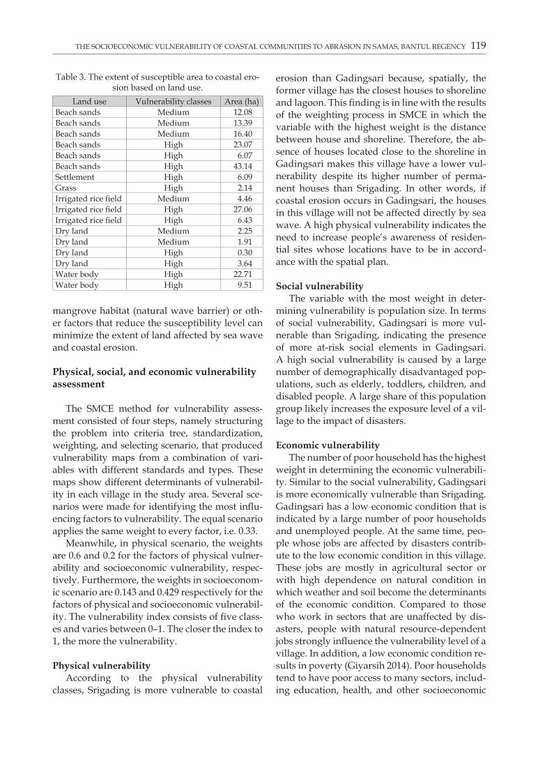
The susceptibility of coastal areas to erosion is determined by wave height, the composition of beach substrate, beach form, shoreline devel-opment, mangrove habitat, and residential site. These factors, also the variables of susceptibil-ity in this research, consisted of several criteria whose scores represented their levels of influence on coastal erosion event. The higher the score of a variable, the stronger its influence to determining the susceptibility level. The susceptibility map provides information on different levels of sus-ceptibility, namely low, medium, and high (see Fig. 2). More than half of the coastal riparian area in Samas, i.e. 74.83%, is highly susceptible espe-cially the one with a residential area of more than 6.09 ha (see Table 3). On the contrary, coasts with
Table 2. The classification of capacity levels.Classes Total scores Descriptions
Low 6–13 Lack of capacity to implement disaster risk reduction
Medium 14–22 Adequate capacity to imple-ment disaster risk reduction
High 23–30 High capacity to implement disaster risk reduction
Fig. 2. The erosion susceptibility map of Samas Coast by Choirunnisa (2016).
THE SOCIOECONOMIC VULNERABILITY OF COASTAL COMMUNITIES TO ABRASION IN SAMAS, BANTUL REGENCY 119
mangrove habitat (natural wave barrier) or oth-er factors that reduce the susceptibility level can minimize the extent of land affected by sea wave and coastal erosion.
Physical, social, and economic vulnerability assessment
The SMCE method for vulnerability assess-ment consisted of four steps, namely structuring the problem into criteria tree, standardization, weighting, and selecting scenario, that produced vulnerability maps from a combination of vari-ables with different standards and types. These maps show different determinants of vulnerabil-ity in each village in the study area. Several sce-narios were made for identifying the most influ-encing factors to vulnerability. The equal scenario applies the same weight to every factor, i.e. 0.33.
Meanwhile, in physical scenario, the weights are 0.6 and 0.2 for the factors of physical vulner-ability and socioeconomic vulnerability, respec-tively. Furthermore, the weights in socioeconom-ic scenario are 0.143 and 0.429 respectively for the factors of physical and socioeconomic vulnerabil-ity. The vulnerability index consists of five class-es and varies between 0–1. The closer the index to 1, the more the vulnerability.
Physical vulnerabilityAccording to the physical vulnerability
classes, Srigading is more vulnerable to coastal
erosion than Gadingsari because, spatially, the former village has the closest houses to shoreline and lagoon. This finding is in line with the results of the weighting process in SMCE in which the variable with the highest weight is the distance between house and shoreline. Therefore, the ab-sence of houses located close to the shoreline in Gadingsari makes this village have a lower vul-nerability despite its higher number of perma-nent houses than Srigading. In other words, if coastal erosion occurs in Gadingsari, the houses in this village will not be affected directly by sea wave. A high physical vulnerability indicates the need to increase people’s awareness of residen-tial sites whose locations have to be in accord-ance with the spatial plan.
Social vulnerabilityThe variable with the most weight in deter-
mining vulnerability is population size. In terms of social vulnerability, Gadingsari is more vul-nerable than Srigading, indicating the presence of more at-risk social elements in Gadingsari. A high social vulnerability is caused by a large number of demographically disadvantaged pop-ulations, such as elderly, toddlers, children, and disabled people. A large share of this population group likely increases the exposure level of a vil-lage to the impact of disasters.
Economic vulnerabilityThe number of poor household has the highest
weight in determining the economic vulnerabili-ty. Similar to the social vulnerability, Gadingsari is more economically vulnerable than Srigading. Gadingsari has a low economic condition that is indicated by a large number of poor households and unemployed people. At the same time, peo-ple whose jobs are affected by disasters contrib-ute to the low economic condition in this village. These jobs are mostly in agricultural sector or with high dependence on natural condition in which weather and soil become the determinants of the economic condition. Compared to those who work in sectors that are unaffected by dis-asters, people with natural resource-dependent jobs strongly influence the vulnerability level of a village. In addition, a low economic condition re-sults in poverty (Giyarsih 2014). Poor households tend to have poor access to many sectors, includ-ing education, health, and other socioeconomic
Table 3. The extent of susceptible area to coastal ero-sion based on land use.
Land use Vulnerability classes Area (ha)Beach sands Medium 12.08Beach sands Medium 13.39Beach sands Medium 16.40Beach sands High 23.07Beach sands High 6.07Beach sands High 43.14Settlement High 6.09Grass High 2.14Irrigated rice field Medium 4.46Irrigated rice field High 27.06Irrigated rice field High 6.43Dry land Medium 2.25Dry land Medium 1.91Dry land High 0.30Dry land High 3.64Water body High 22.71Water body High 9.51

120 AUDI KARInA CHoIRUnnISA, SRI RUM GIYARSIH
Fig. 3. Maps of physical, social, and economic vulnerability by Choirunnisa (2016).

THE SOCIOECONOMIC VULNERABILITY OF COASTAL COMMUNITIES TO ABRASION IN SAMAS, BANTUL REGENCY 121
Fig. 4. Maps of total vulnerability with physical, socioeconomic, and equal scenarios by Choirunnisa (2016).

122 AUDI KARInA CHoIRUnnISA, SRI RUM GIYARSIH
services. This condition economically exposes many people in Gedangsari to disasters. After the wake of disasters, villages with high econom-ic vulnerability require a long recovery time.
Total vulnerabilityTotal vulnerability is the analysis result of
three vulnerability values, namely physical vul-nerability, social vulnerability, and economic vulnerability. These three vulnerabilities are weighted based on the scenarios proposed in this research, i.e. physical scenario, socioeconomic scenario, and equal scenario. Each scenario rep-resents the level of influence of each factor in shaping vulnerability.
Physical scenarioBased on the results of the physical scenario,
Srigading is more vulnerable than Gadingsari because it has several buildings that are located closer to lagoon and shoreline than the buildings in Gadingsari. Therefore, the distance factor is very influential in increasing the vulnerability level. This finding is in line with Rahmat (2015) and Rizal (2015), which state that the distance be-tween hamlets and Putih River contributes to the high physical vulnerability to lahar from Merapi Volcano. However, this finding is different from Armaya (2015) and Sauri (2016), which state that villages with a large number of buildings are more vulnerable than the ones with few build-ings. Even though the total number of settlement in Gadingsari is higher than in Srigading, the res-idential sites are located far from the shoreline and outside of the coastal riparian area. On the contrary, Srigading has fewer residential sites that are located very close to the lagoon and shoreline, i.e. approximately 45 m. Therefore, Srigading has a higher proneness to the impact of coastal erosion.
Socioeconomic scenarioBased on the socioeconomic scenario, Srigading
is more vulnerable than Gadingsari. The pop-ulation size of Gadingsari is slightly larger than Srigading, while the economic conditions of both villages are similarly low. Therefore, the socioec-onomic vulnerability levels of the two villages are equally high. However, the results of slicing into three classes show that Srigading is more vulner-able due to its physical factors. Despite the low
weight of physical parameter in the socioeconom-ic scenario, it still plays a role in creating a higher vulnerability in Srigading. The influential physi-cal parameter is the distance between settlement blocks and shoreline. In this case, the distance is only 45 m. This finding is in line with Rahmat (2015), which states that a high vulnerability in socioeconomic scenario is not only influenced by population size and the number of poor house-hold but also the distance between hamlets and Putih River, i.e. a river through which the lahar of Merapi Volcano traverses.
Equal scenarioEqual scenario applies the same weight to
physical, social, and economic factors. In other words, each of these factors has the same influ-ence on vulnerability level. Based on the total vul-nerability map obtained from the equal scenario, Srigading is more vulnerable than Gadingsari. This finding is in line with Sauri (2016), which states that villages with high vulnerability are the ones located close to or within the source of dis-aster. Spatially, Srigading is closer to the lagoon and some of its settlement blocks are closer to the shoreline. In addition, due to its large number of population, poor households, and houses, it is more vulnerable than Gadingsari.
The results of these three vulnerability sce-narios can assist in the making of disaster mit-igation policy as a measure of risk reduction to coastal erosion. The maps of physical, social, and economic vulnerability are presented in Figure 3, while the maps of total vulnerability from phys-ical, socioeconomic, and equal scenarios are pre-sented in Figure 4.
Community capacity
The capacity of the communities in both vil-lages was assessed using cross table analysis on the relationship of two variables: 1) the distance between houses and shoreline and 2) knowledge of coastal erosion. These variables were selected in consideration of their inversely proportional relationship. The closer the distance between the houses and shoreline, the wider people’s knowl-edge of coastal erosion is. According to the con-tingency coefficients presented in Table 4, the significance value is 0.180. Since it is < 0.5, there is a close or mutually influential relationship

THE SOCIOECONOMIC VULNERABILITY OF COASTAL COMMUNITIES TO ABRASION IN SAMAS, BANTUL REGENCY 123
between the distance of houses from shoreline and people’s knowledge of coastal erosion.
Based on the interviews with the local com-munities in Srigading, people living close to the shoreline have more comprehension on the proneness of their settlements to coastal erosion. This comprehension is obtained from experienc-es and stories passed down from their parents. nevertheless, they cannot do anything except saving their belongings and leaving their hous-es when indications of severe coastal erosion ap-pear because, on one side, they perceive coastal erosion as a natural and unavoidable phenome-non. On the other side, they perceive the coast as their livelihood. Meanwhile, the closest dis-tance between the houses in Gadingsari and the shoreline is > 300 m. Even though these houses are outside of the coastal riparian area, the peo-ple living there understand the proneness of their settlements to coastal erosion, which are similar to those living in Srigading.
Most of the people in Srigading and Gadingsari who live either close to or far from the shoreline chose the options “agree” and “highly agree” re-garding the oral or written information and pub-lic dissemination on the threats of coastal erosion that they had received from the government and other institutions. Information on the threats of coastal erosion is generally obtained from expe-riences, stories passed down by the parents, and chains of information between the villagers. In addition, information provided by the govern-ment of each village influences the level of peo-ple’s awareness in anticipating possible threats
from coastal erosion. It is usually disseminated prior to raised alert status, at evacuation drills, and during village meetings.
Disaster management is necessary to min-imize the risks posed by coastal erosion. Based on the results of the interviews, the people in Srigading gave various responses to the questions regarding the existence of disaster management. Meanwhile, 55% of the people in Gadingsari stat-ed that Samas Coast lacked mitigation measures against abrasion as well as coastal erosion man-agement from the government, other institutions, and local communities. On the contrary, accord-ing to the Head of Regional Disaster Management Agency (BPBD), the government has established various preventive measures like planting beach she-oaks (Casuarina equisetifolia) and providing sand-filled plastic bags. However, these meas-ures are considered less successful in reducing the risks of coastal erosion because the character-istics of sea wave and beach morphology in the study area make the impact of coastal erosion ex-ceed the capacity of such measures. Furthermore, several members of the local communities have been implementing preventive measures based on their first-hand experiences on coastal erosion.
Most of the people in Srigading and Gadingsari who live either close to or far from the shoreline understand the general idea of how to prevent coastal erosion. Such comprehension is shown by their agreement to the implementation of local wisdom into preventive measures, e.g. suitable land utilization in Samas Coast, indicating that the local communities have invented their own ways to deal with the threats posed by coastal erosion.
The capacity level of the people in Srigading and Gadingsari is categorized as low. In Srigading, 25% and 63.89% of its people have respective-ly high and medium capacity. Meanwhile, in Gadingsari, 35% and 65% of its people have re-spectively high and medium capacity (see Table
Table 5. Number of respondents in Srigading and Gadingsari based on capacity level and distance between houses and shoreline.
Capacity levelsDistance between Houses and Shoreline
Srigading Gadingsarinear Moderate Far Total % near Moderate Far Total %
Low 0 1 3 4 11.11 0 0 0 0 0Medium 4 10 9 23 63.89 0 0 13 13 65High 6 3 0 9 25.00 0 0 7 7 35
Table 4. Contingency coefficients.Symmetric Measuresc Value Approx. Sig.
nominal by nominal
Phi 0.335 0.180Cramer’s V 0.237 0.180Contingency coefficient 0.317 0.180
n of valid cases 56

124 AUDI KARInA CHoIRUnnISA, SRI RUM GIYARSIH
5). Due to first-hand experiences on coastal ero-sion, most of the people in these two villages try to reduce the possible loss caused by recur-ring coastal erosion. The government officials of Srigading and Gadingsari have appealed for the development of settlements far from the shore-line. Nowadays, the houses along the shore-line are abandoned in order to prevent fatalities whenever coastal erosion attacks.
The Relationship between vulnerability and community capacity
In general, based on the three scenarios of total vulnerability, Srigading has a higher vulnerabil-ity level than Gadingsari. In addition, the results of the interviews show that the capacities of the people in Srigading and Gadingsari are classified as medium to high. These two statements postu-late a directly proportional relationship between the vulnerability and the community capacity in the study area. The higher the vulnerability level, the higher the community capacity to deal with coastal erosion.
Despite the long distance between the houses and the shoreline (i.e. 1 km) as well as the lack of first-hand experience on coastal erosion, the people in Gadingsari have adequate knowledge of coastal erosion and its countermeasures. On the other hand, the people in Srigading, par-ticularly those who live close to or less than 300 m from the shoreline, have a wide knowledge of coastal erosion, which increases their abili-ty to deal with its negative effects. In general, because they have experienced coastal erosion directly, they understand its characteristics and become adept at dealing with it. When high vulnerability meets low capacity, high disaster risk emerges. Thereby, community capacity en-hancement has to be implemented by various parties in order to avoid significant losses when disaster strikes.
Conclusion
Based on the results of the physical, social, and economic vulnerability assessments using the SMCE method, this research decided to com-pare three scenarios of total vulnerability, name-ly physical scenario, socioeconomic scenario, and
equal scenario. The physical and socioeconomic scenarios show that Srigading has a high vul-nerability level, whereas Gadingsari has a low vulnerability level. In addition, the spatial distri-bution of the total vulnerability produced from equal scenario is the same as that of physical and socioeconomic scenarios. As a conclusion, both physical and socioeconomic scenarios produce relevant outputs because they give the same re-sult and distribution as the equal scenario.
Furthermore, in terms of physical parameter, Srigading is more vulnerable than Gadingsari because its settlement is located close to the shoreline that receives direct impact from coastal erosion. Meanwhile, based on the social and eco-nomic parameters, Gadingsari is more vulnerable than Srigading because it has higher population number as well as a higher share of demograph-ically disadvantaged people (i.e. women, tod-dlers, children, elderly, and disabled people). Because many social variables are vulnerable or exposed to coastal erosion risk, Gadingsari has a high social vulnerability. Moreover, a large num-ber of poor households, unemployed people, as well as people whose jobs are affected by coastal erosion lead to the more presence of at-risk eco-nomic elements in this village.
The paucity of economic facilities shows that both Srigading and Gadingsari have low economic condition, which influences the com-munity capacity in terms of disaster mitigation and post-disaster recovery. Based on the knowl-edge of coastal erosion and its risk reductions, the capacities of the people in both villages are categorized as medium. This level of capacity is influenced by first-hand experiences on coastal erosion that increase the awareness of the local communities, particularly those who live close to shoreline.
Acknowledgments
We would like to express our gratitude to the Faculty of Geography, Universitas Gadjah Mada for the financial support through the scheme of Lecturer Research Grant, Faculty of Geography, Universitas Gadjah Mada in 2016. We would also like to thank Dr. Sukamdi, M.Sc for his in-valuable input to this article. We would like to acknowledge Ajeng Larasati, M.Sc. for her lin-guistic assistance.
THE SOCIOECONOMIC VULNERABILITY OF COASTAL COMMUNITIES TO ABRASION IN SAMAS, BANTUL REGENCY 125
References
Armaya D.A.B., 2015. Penaksiran Tingkat Kerentanan Sosial Terhadap Bahaya Banjir Lahar Pasca Erupsi Gunungapi Mer-api. MS. Faculty of Geography, Universitas Gadjah Mada.
BAKORNAS PB., 2007. Panduan Pengenalan Karakteristik Ben-cana dan Upaya Mitigasinya di Indonesia. Jakarta, BAKO-RNAS PB.
Bevacqua A., Yu D., Zhang Y., 2018. Coastal Vulnerability: Evolving Concepts in Understanding Vulnerable People and Place. Environmental Science and Policy 82: 19–29.
BNPB Kabupaten Bantul., 2016. Annual Report. Regional Dis-aster Management Agency of Bantul Regency. Yogyakar-ta, BNPB.
Chang S.E.,Yip J.Z.K., Conger T., Oulahen G., Marteleira M., 2018. Community Vulnerability to Coastal Hazards: Developing A Typology for Disaster Risk Reduction. Ap-plied Geography 91: 81–88.
Choirunnisa A.K., 2016. Kajian Kerentanan Fisik, Sosial, dan Ekonomi Pesisir Samas Kabupaten Bantul Terhadap Erosi Pantai. MS. Fakultas Geografi UGM.
De Silva M.M.G.T., Kawasaki A., 2018. Socioeconomic Vul-nerability to Disaster Risk : A Case Study of Flood and Drought Impact in A Rural Sri Lankan Community. Eco-logical Economics 152: 131–140.
DKP Kabupaten Bantul, 2016. Annual Report. Office of Ma-rine Affairs and Fisheries of Bantul Regency. Yogyakarta, DKP Kab. Bantul.
Duckers M., Frerks G., Birkmann J., 2015. Exploring the Plex-us of Context and Consequences: An Empirical Test of A Theory of Disaster Vulnerability. International Journal of Disaster Risk Reduction 13: 85–95.
Fatemi F., Ardalan A., Aguirre B., Mansouri N., Mohammad-fam I., 2017. Social Vulnerability Indicaors in Disasters: Findings From A Systematic Review. International Journal of Risk Reduction 22: 219–227.
Ferrol-Schulte D., Gorris P., Baitoningsih W., Adhuri D.S., Ferse S.C.A. 2015. Coastal livelihood vulnerability to ma-rine resource degradation: A review of the Indonesian national coastal and marine policy framework. Marine Policy 52: 163–171.
Figerio I., Amicis M.D., 2016. Mapping Social Vulnerability To natural Hazards in Italy: A Suitable Tool for Risk Mitigation Strategies. Environmental Science & Policy 63: 187–196.
Fitton J., Hansom J.D., Rennie A.F., 2016. A National Coast-al Erosion Susceptibility Model for Scotland. Ocean and Coastal Management 132: 80–89.
Ghosh A., 2017. Quantitative Approach on Erosion Hazard, Vulnerability and Risk Assessment: Case Study of Muri-gangga-Saptamukhi Interfluve, Sundarban, India. Natu-ral Hazards 87: 1709–1729.
Giyarsih S.R., 2014. Pengentasan Kemiskinan Yang Kompre-hensif di Bagian Wilayah Terluar Indonesia, Studi Kasus Kabupaten Nunukan Provinsi Kalimantan Utara. Jurnal Manusia dan Lingkungan 21(2): 230–246.
Hererher M.E., 2016. Vulnerability Assessment of the Saudi Arabian Red Sea Coast to Climate Change. Environmental Earth Sciences 75: 30.
Islam M.A., Mitra D., Dewan A., Akhter S.H., 2016. Coastal Multi-Hazard Vulnerability Assessment Along the Gan-ges Deltaic Coast of Bangladesh-A Geospatial Approach. Ocean & Coastal Management 27: 1–15.
Jurjonas M., Seekamp E., 2018. Rural Coastal Community Re-silience: Assessing A Framework in Easter North Caroli-na. Ocean and Coastal Management 162: 137–150.
Likert R., 1932. A Technique for The Measurement of Atti-tudes. New York. New York University.
Maarif S., Damayanti F., Suryanti E.D., Wicaksono A.P., 2014. Initiation of Desa Tangguh Bencana Through Stim-ulus-Response Method. Indonesian Journal of Geography 44(2): 173–182.
Mahapatra M., Ramakrishman R., Rajawat S.S., 2015. Coastal Vulnerability Assessment Using Analytical Hierarchical Process for Sout Gujarat Coast, India. Natural Hazard 76: 139–159.
Marfai M.A., King L., 2008. Potential Vulnerability Implica-tion of Coastal Inundation Due to Sea Level Rise for the Coastal Zone of Semarang City, Indonesia. Environmental Geology 54: 1235–1245.
Marfai M.A., King L., Sartohadi J., Sudrajat Budiani S.R., Yulianto F., 2008. The Impact of Tidal Flooding on a Coastal Community in Semarang, Indonesia. Environ-mentalist 28: 237–248.
Marfai M.A., 2011. The Hazard of Coastal Erosion in Central Java Indonesia: An Overview. Geografia Online 3: 1–9.
Merlotto A.,Bertoal G.R., Piccolo M.C., 2016. Hazard, Vulner-ability and Coastal Erosion Risk Assessment in necochea Municipality, Buenos Aires Province, Argentina. Journal of Coastal Conservation 20: 351–362.
Miladan N., 2009. Kajian Kerentanan Wilayah Pesisir Kota Se-marang Terhadap Perubahan Iklim. MS. Magister Teknik Pembangunan Wilayah dan Kota Universitas Dipone-goro.
Neale T., Weir J.K., 2015. Navigating Scientific Uncertain-ty in Wildfire and Flood Risk Mitigation: A Qualitative Review. International Journal of Disaster Risk Reduction 13: 255–267.
Numberi F., 2009. Perubahan Iklim: Implikasinya terhadap Ke-hidupan Laut, Pesisir dan Pulau-Pulau Kecil. Jakarta, Fortu-na Prima Makmur.
Nur I., Shrestha K.K., 2017. An Integrative Perspective on Community Vulnerability to Flooding in Cities of Devel-oping Countries. Procesia Engineering 198: 958–967.
Onat Y.,Francis O.P., Kim K., 2018. Vulnerability Assessment and Adaption to Sea Level Rise in High-Wave Environ-ments: A Case Study on O’ahu, Hawai’i. Ocean and Coast-al Management 157: 147–159.
Ongkosongo O.S.R., 2011. Strategi Menghadapi Risiko Bencana Di Wilayah Pesisir Akibat Pemanasan Global dan Perubahan Iklim Global. Jakarta, Pusat Penelitian Oseanografi, Lem-baga Ilmu Pengetahuan Indonesia.
Rachmawati R., Budiarti C.V., 2016. Use of Space the Need For Planning in the Disaster-Prone Area of Code River, Yogyakarta, Indonesia. Indonesian Journal of Geography 48(2): 178–190.
Rahmat P.N., 2015. Penilaian Kerentanan Fisik, Sosial, dan Ekonomi Dusun-Dusun di Sekitar Kali Putih Terhadap Banjir Lahar Gunungapi Merapi. MS. Faculty of Geogra-phy, Universitas Gadjah Mada.
Raufirad V., Heidari Q., Hunter R., Ghorbani J., 2018. Rela-tionship Beween Socioeconomic Vulnerability and Eco-logical Sustainability: The Case of Aran-V-Bidgol’s Rang-lands, Iran. Ecological Indicators 85: 613–623.
Rijanta R., Hizbaron D.R., Baiquni M., 2014. Modal Sosial da-lam Manajemen Bencana. Yogyakarta, Gadjah Mada Uni-versity Press.

126 AUDI KARInA CHoIRUnnISA, SRI RUM GIYARSIH
Rizal M.A., 2015. Analisis Kerentanan Fisik Bahaya Lahar di Desa Sekitar Kali Putih Kabupaten Magelang. Bachelor Thesis. Faculty of Geography, Universitas Gadjah Mada.
Sakijege T., 2013. Managing Flood Risks: Lessons From Keko Machungwa Informal Settlement in Dares Salaam, Tan-zania. Indonesian Journal of Geography 45(1): 1–14.
Sauri S., 2016. Penilaian Tingkat Kerentanan Menggunakan Spatial Multi Criteria Evaluation di Sebagian Daerah Rawan Longsor Kabupaten Bogor. MS. Faculty of Geography, Uni-versitas Gadjah Mada.
Schmutter K., Nash M., Dovey L., 2017. Ocean Acidification: Assesing The Vulnerability of Socioeconomic System in Small Island Developing States. Regional Environmental Change 17(4): 973–987.
Senapati S., Gupta V., 2017. Socio-economic Vulnerability Due To Climate Change: Deriving Indicators for Fishing Comunities in Mumbai. Marine Policy 76: 90–97.
Setiyono H., 1996. Kamus Oseanografi. Yogyakarta, Gadjah Mada University Press.
Setyaningrum P,. Giyarsih S.R., 2012. Identifikasi Tingkat Kerentanan Sosial Ekonomi Penduduk Bantaran Sungai Code Kota Yogyakarta Terhadap Bencana Lahar Merapi. Jurnal Bumi Indonesia 7(1): 56–69.
Sidik H., 2013. Bantul terjunkan tim tangani abrasi Pantai Samas. Antara Jogja. Online: jogja.antaranews.com/ber-ita/315406/bantul-terjunkan-tim-tangani-abrasi-pan-tai-samas (accessed in May 20, 2016).
Sutikno, 1999. Karakteristik Bentuk Pantai Materi Perkulia-han Geografi Pesisir Dan Kelautan. Research Report. Yo-gyakarta, Universitas Gadjah Mada.
Sutikno, 2002. Konsep Dasar Geografi. Jakarta, Direktorat PLP.Taylor H., Peace R., 2015. Children and Cultural Influence
in A Natural Disaster, Flood Response in Surakarta, In-donesia. International Journal of Disaster Risk Reduction 13: 76–84.
Ullah R., Shivakoti G.P., Ali G., 2015. Factors Affecting Farm-ers’Risk Attitude and Risk Prception: The Case of Khyber Pakhtunkhwa, Pakistan. International Journal of Disaster Risk Reduction 13: 151–157.
UNCLOS, 1982. United Nations Convention on the Law of the Sea. Online: www.un.org/depts/los/convention_agree-ments/texts/unclos/unclos_e.pdf (accessed in July 12, 2016).
UNDP, 2004. Reducing Disaster Risk. A Challenge for Devel-opment. A Global Report, UNDP-Bureau for 109 Crisis Prevention and Recovery (BRCP). New York, United Nations.
UNISDR, 2004. Living with Risk: A Global View of Disaster Re-duction Initiatives. Geneva, UN International Strategy for Disaster Reduction.
UNISDR, 2009. Terminology on Disaster Risk Reduction. Jene-wa, United Nations.
Van Westen C.J., Soeters R., 2006. Landslide Hazard and Risk Zonation – Why is it still so difficult? Bulletin of Engineer-ing Geology and the Environment 6(2): 167–184.
Wesli, Sirojuzilam, Matondang A.R., Lubis S., 2013. The Ef-fect of Land Use and Community Participation on Flood Control at North Aceh District. Indonesian Journal of Geog-raphy 45 (2): 171–186.
Widianto A., Damen M., 2014. Determination on Coastal Belt in the Disaster-Prone Area: A Case Study in the Coastal Area of Bantul Regency, Yogyakarta, Indonesia. Indone-sian Journal of Geography 46(2): 125–137.
Yadav D.K., Barve A., 2017. Analysis of Socioeconomic Vul-nerability for Cyclone-Affected Communities in Coastal Odisha, India. International Journal of Disaster Risk Reduc-tion 22: 387–396.
Yankson P.W.K., Owusu, A.B., Owusu G., Danquah, J.B., Tet-teh J.D., 2017. Assessment of Coastal Communities’ Vul-nerability to Floods Using Indicator-Based Approach: A Case Study of Greater Accra Metropolitan Area, Ghana. Natural Hazards 89: 661–689.
Zorn C.R., Shamseldin A.Y., 2015. Post-Disaster Infrastruc-ture Restoration: A Comparison of Events for Future Planning. International Journal of Disaster Risk Reduction 13: 158–166.


