Embed Size (px)
DESCRIPTION
The Los Angeles River is an 82 kilometer long stream which starts in San Fernando Valley and flows into the Pacific Ocean in Long Beach. On a big part of its length the river flows in a huge concrete shell, which was built to protect Los Angeles of floods in case of storm water. The thesis question is: How can Urban Design improve a lifeless area around a non-accessible and channeled river? This question is going to be answered on the Los Angeles River as an example. For more information visit designstudio13.wordpress.com or contact me via studio13 @outlook.com
Citation preview
The RebiRTh of The Los AngeLes RiveRMAsTeR’s Thesis by DoMinic LuefTeneggeR
SuperviSor peter Droege & AniS rADzi | univerSity of LiechtenStein | SS2015

The RebiRTh of The Los AngeLes RiveR
DoMinic LuefTeneggeR
JuLy 2015
4
The Los AngeLes RiveR is An 82 ki-LoMeTeR Long sTReAM which sTARTs in sAn feRnAnDo vALLey AnD fLows inTo The PAcific oceAn in Long beAch. on A big PART of iTs LengTh The Riv-eR fLows in A huge concReTe sheLL, which wAs buiLT To PRoTecT Los An-geLes of fLooDs in cAse of sToRM wA-TeR. of couRse This RiveR beD MAkes The ciTy veRy unATTRAcTive AnD is A syMboL of The gRey iMAge L.A. hAs.
A big PRobLeM in Los AngeLes coun-Ty is The wATeR PoLLuTion. ALL The wATeR fLows in A DiRecT wAy fRoM The sTReeTs inTo The cAnALizATion, fRoM TheRe inTo A RiveR AnD The Riv-eR fLushes The DiRTy wATeR inTo The PAcific oceAn. This MeAns ThAT The oceAn As weLL As The coAsT geTs veRy DiRTy AnD TuRns The suRfeR’s PARADise inTo A PLAce of Muckiness. The PA-cific is noT AbLe To AbsoRb This huge AMounT of DiRTy wATeR quickLy.
since A few yeARs The ciTy of Los AngeLes wAnTs To ReviTALize The L.A.
RiveR. seveRAL PRoJecTs AnD iDeAs foR ceRTAin AReAs hAve been DeveL-oPeD AnD PubLisheD, buT The con-necTion beTween The singLe PRoJecT AReAs As weLL As The iMPLeMenTATion is ofTen Missing. The DeveLoPMenT of The chosen PRoJecT siTe of My MAs-TeR’s Thesis is going To PAy ATTenTion To The suRRounDing PRoJecT iDeAs AnD TRies To connecT As weLL As Re-infoRce TheM.
non-AccessibLe chAnneLeD RiveRs ARe LocATeD in MAny ciTies woRLDwiDe, which MeAns ThAT This MAsTeR’s Thesis noT onLy focus on The sPecific siTu-ATion AT The Los AngeLes RiveR, buT ALso TRies To finD A soLuTion which wouLD be APPLicAbLe on oTheR LocA-Tions As weLL.
AbstrAct
5
The Thesis quesTion is:
How can Urban Design improve a lifeless area aroUnD a non-accessi-ble anD cHanneleD river?
This quesTion is going To be AnsweReD on The Los AngeLes RiveR As An ex-AMPLe.
The AiM of This MAsTeR’s Thesis is To soLve MAJoR PRobLeMs L.A. hAs To hAnDLe AT The MoMenT: how To TuRn The exisTing Los Ange-Les RiveR inTo An ATTRAcTive AnD Ac-cessibLe sTReAM? how To TuRn The inDusTRiAL AReA in boyLe heighTs inTo A MixeD-use DeveLoPMenT? how To connecT The Two DisTRicTs of boyLe heighTs AnD DownTown AnD ReMove The sePARATion beTween TheM?
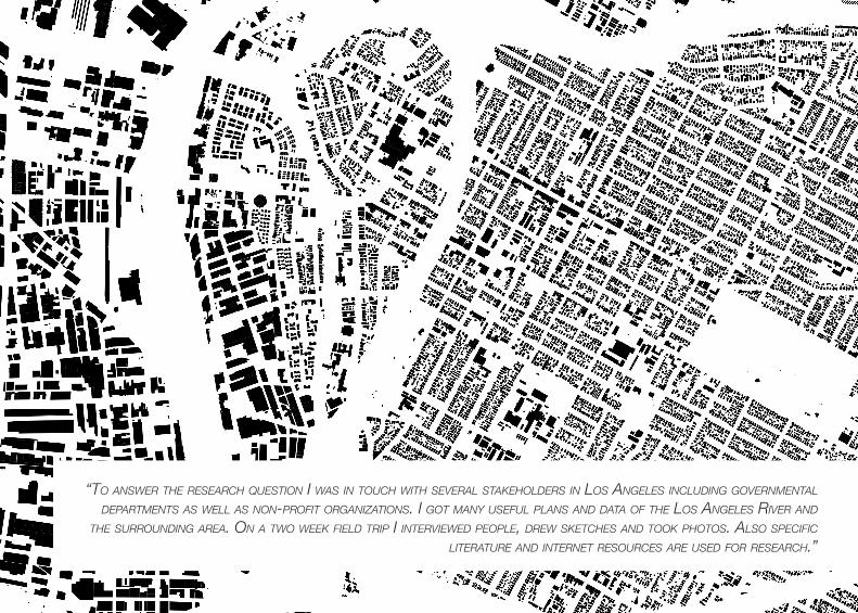
To AnsweR The ReseARch quesTion i wAs in Touch wiTh seveRAL sTAke-hoLDeRs in Los AngeLes incLuDing
goveRnMenTAL DePARTMenTs As weLL As non-PRofiT oRgAnizATions. MAny usefuL PLAns AnD DATA of The Los AngeLes RiveR AnD The suRRounDing AReA hAve been PRoviDeD by DiffeRenT insTiTuTes. on A Two week fieLD TRiP i inTeRvieweD PeoPLe, DRew skeTches AnD Took PhoTos. ALso sPecific LiTeR-ATuRe is useD To AnsweR The ReseARch quesTion.
The ouTcoMe of This MAsTeR’s The-sis wAs A new DeveLoPMenT AT The Los AngeLes RiveR beTween The Two DisTRicTs of DownTown AnD boyLe heighTs. Due To A neTwoRk of cA-nALs The RiveR wAs exTenDeD AcRoss The whoLe AReA, by whAT iT wAs Possi-bLe To ReDuce The wATeR veLociTy AnD inTRoDuce PLAnTs AnD AniMALs. new MixeD-use buiLDings hAve been inTRo-DuceD in A new cReATeD MAsTeR PLAn, which connecTs The eAsT AnD The wesT siDe, wheReby The Los AngeLes RiveR TuRns inTo The cenTeR of A new DeveLoPeD DisTRicT.

6
7
inTRoDucTion
MeThoDs AnD AnALyses
Design concePT
Desing PRoJecT
concLusion
Annex
content
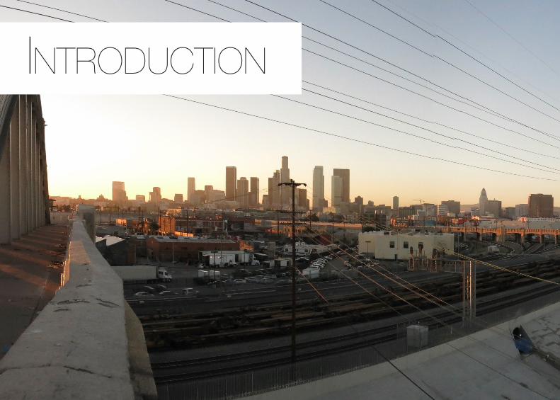
introDuction
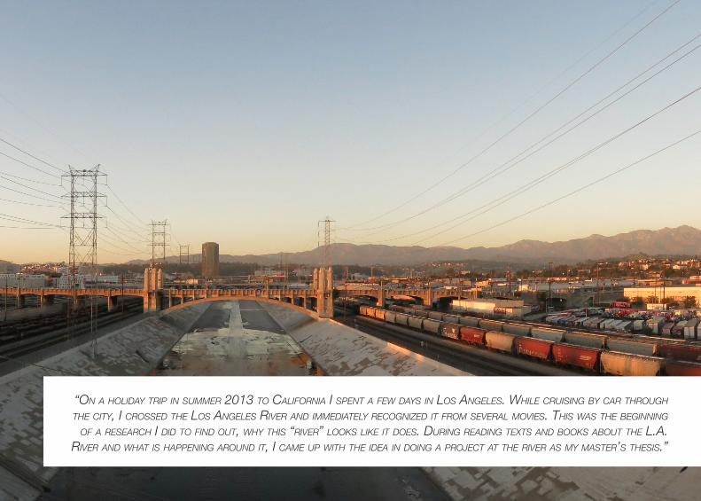
“on a HoliDay trip in sUmmer 2013 to california i spent a few Days in los angeles. wHile crUising by car tHroUgH tHe city, i crosseD tHe los angeles river anD immeDiately recognizeD it from several movies. tHis was tHe beginning
of a researcH i DiD to finD oUt, wHy tHis “river” looks like it Does. DUring reaDing texts anD books aboUt tHe l.a. river anD wHat is Happening aroUnD it, i came Up witH tHe iDea in Doing a project at tHe river as my master’s tHesis.”
10
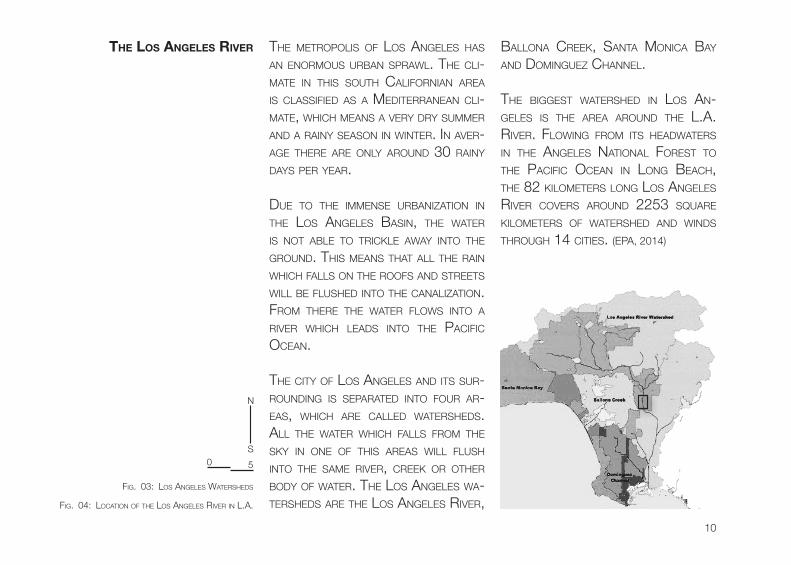
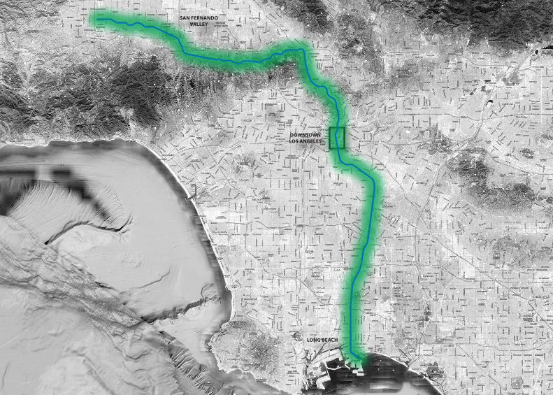
the Los AngeLes river The MeTRoPoLis of Los AngeLes hAs An enoRMous uRbAn sPRAwL. The cLi-MATe in This souTh cALifoRniAn AReA is cLAssifieD As A MeDiTeRRAneAn cLi-MATe, which MeAns A veRy DRy suMMeR AnD A RAiny seAson in winTeR. in AveR-Age TheRe ARe onLy ARounD 30 RAiny DAys PeR yeAR.
Due To The iMMense uRbAnizATion in The Los AngeLes bAsin, The wATeR is noT AbLe To TRickLe AwAy inTo The gRounD. This MeAns ThAT ALL The RAin which fALLs on The Roofs AnD sTReeTs wiLL be fLusheD inTo The cAnALizATion. fRoM TheRe The wATeR fLows inTo A RiveR which LeADs inTo The PAcific oceAn.
The ciTy of Los AngeLes AnD iTs suR-RounDing is sePARATeD inTo fouR AR-eAs, which ARe cALLeD wATeRsheDs. ALL The wATeR which fALLs fRoM The sky in one of This AReAs wiLL fLush inTo The sAMe RiveR, cReek oR oTheR boDy of wATeR. The Los AngeLes wA-TeRsheDs ARe The Los AngeLes RiveR,
bALLonA cReek, sAnTA MonicA bAy AnD DoMinguez chAnneL.
The biggesT wATeRsheD in Los An-geLes is The AReA ARounD The L.A. RiveR. fLowing fRoM iTs heADwATeRs in The AngeLes nATionAL foResT To The PAcific oceAn in Long beAch, The 82 kiLoMeTeRs Long Los AngeLes RiveR coveRs ARounD 2253 squARe kiLoMeTeRs of wATeRsheD AnD winDs ThRough 14 ciTies. (ePA, 2014)
fig. 03: Los AngeLes wATeRsheDs
fig. 04: LocATion of The Los AngeLes RiveR in L.A.
0
n
s
5
11
DOWNTOWNLOS ANGELES
SAN FERNANDO VALLEY
LONG BEACH
12
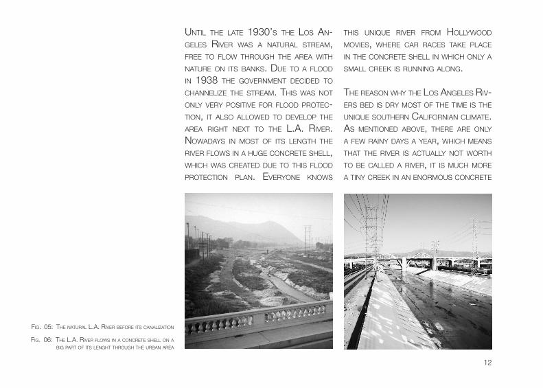
unTiL The LATe 1930’s The Los An-geLes RiveR wAs A nATuRAL sTReAM, fRee To fLow ThRough The AReA wiTh nATuRe on iTs bAnks. Due To A fLooD in 1938 The goveRnMenT DeciDeD To chAnneLize The sTReAM. This wAs noT onLy veRy PosiTive foR fLooD PRoTec-Tion, iT ALso ALLoweD To DeveLoP The AReA RighT nexT To The L.A. RiveR. nowADAys in MosT of iTs LengTh The RiveR fLows in A huge concReTe sheLL, which wAs cReATeD Due To This fLooD PRoTecTion PLAn. eveRyone knows
This unique RiveR fRoM hoLLywooD Movies, wheRe cAR RAces TAke PLAce in The concReTe sheLL in which onLy A sMALL cReek is Running ALong.
The ReAson why The Los AngeLes Riv-eRs beD is DRy MosT of The TiMe is The unique souTheRn cALifoRniAn cLiMATe. As MenTioneD Above, TheRe ARe onLy A few RAiny DAys A yeAR, which MeAns ThAT The RiveR is AcTuALLy noT woRTh To be cALLeD A RiveR, iT is Much MoRe A Tiny cReek in An enoRMous concReTe
fig. 05: The nATuRAL L.A. RiveR befoRe iTs cAnALizATion
fig. 06: The L.A. RiveR fLows in A concReTe sheLL on A big PART of iTs LenghT ThRough The uRbAn AReA
13
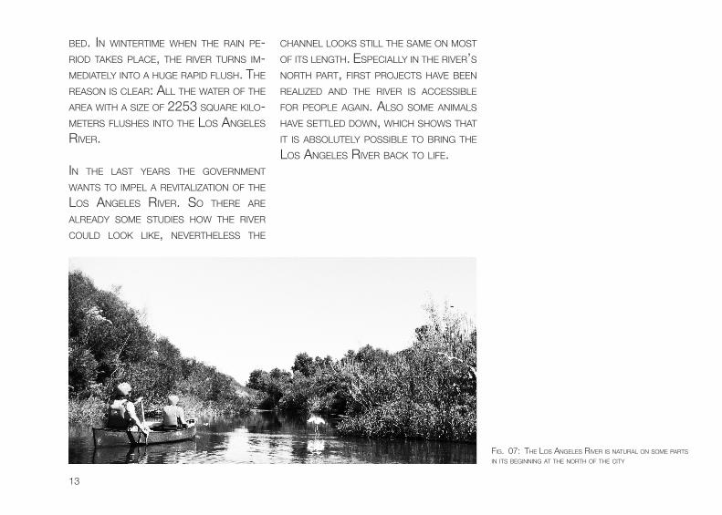
beD. in winTeRTiMe when The RAin Pe-RioD TAkes PLAce, The RiveR TuRns iM-MeDiATeLy inTo A huge RAPiD fLush. The ReAson is cLeAR: ALL The wATeR of The AReA wiTh A size of 2253 squARe kiLo-MeTeRs fLushes inTo The Los AngeLes RiveR.
in The LAsT yeARs The goveRnMenT wAnTs To iMPeL A ReviTALizATion of The Los AngeLes RiveR. so TheRe ARe ALReADy soMe sTuDies how The RiveR couLD Look Like, neveRTheLess The
chAnneL Looks sTiLL The sAMe on MosT of iTs LengTh. esPeciALLy in The RiveR’s noRTh PART, fiRsT PRoJecTs hAve been ReALizeD AnD The RiveR is AccessibLe foR PeoPLe AgAin. ALso soMe AniMALs hAve seTTLeD Down, which shows ThAT iT is AbsoLuTeLy PossibLe To bRing The Los AngeLes RiveR bAck To Life.
fig. 07: The Los AngeLes RiveR is nATuRAL on soMe PARTs in iTs beginning AT The noRTh of The ciTy
14
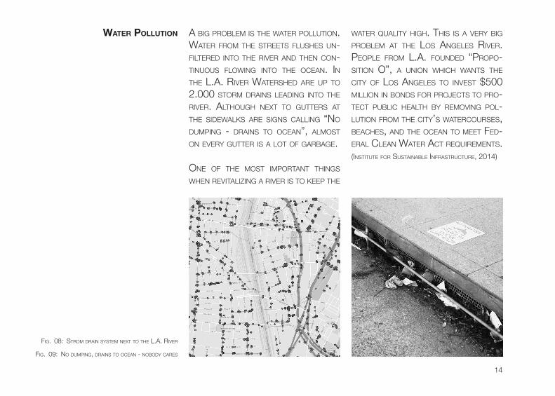
A big PRobLeM is The wATeR PoLLuTion. wATeR fRoM The sTReeTs fLushes un-fiLTeReD inTo The RiveR AnD Then con-Tinuous fLowing inTo The oceAn. in The L.A. RiveR wATeRsheD ARe uP To 2.000 sToRM DRAins LeADing inTo The RiveR. ALThough nexT To guTTeRs AT The siDewALks ARe signs cALLing “no DuMPing - DRAins To oceAn”, ALMosT on eveRy guTTeR is A LoT of gARbAge.
one of The MosT iMPoRTAnT Things when ReviTALizing A RiveR is To keeP The
wATeR quALiTy high. This is A veRy big PRobLeM AT The Los AngeLes RiveR. PeoPLe fRoM L.A. founDeD “PRoPo-siTion o”, A union which wAnTs The ciTy of Los AngeLes To invesT $500 MiLLion in bonDs foR PRoJecTs To PRo-TecT PubLic heALTh by ReMoving PoL-LuTion fRoM The ciTy’s wATeRcouRses, beAches, AnD The oceAn To MeeT feD-eRAL cLeAn wATeR AcT RequiReMenTs. (insTiTuTe foR susTAinAbLe infRAsTRucTuRe, 2014)
fig. 09: no DuMPing, DRAins To oceAn - noboDy cARes
WAter PoLLution
fig. 08: sTRoM DRAin sysTeM nexT To The L.A. RiveR

15
The Los AngeLes goveRnMenT ReAL-izes AT The MoMenT A PLAn which wiLL ReDuce The wATeR PoLLuTion enoR-Mous. seveRAL foRMeR inDusTRiAL oR PARking AReAs wiLL be TuRneD inTo AR-TificiAL weTLAnDs, which heLP To cLeAn The wATeR in A nATuRAL AnD susTAin-AbLe wAy. A gReAT siDe effecT is ThAT The LocAL PeoPLe geT A new gReen PLAce foR RecReATion in The MiDDLe of The uRbAn neighboRhooD.
soMe oRgAnizATions As weLL As The goveRnMenT TRy To infoRM The Res-iDenTs AbouT The iMPoRTAnce of keePing wATeR cLeAn. TheRe ARe exhibiTions AT The cALifoRniA sci-ence cenTeR, wheRe esPeciALLy kiDs shouLD LeARn AbouT ciRcuLATion of wATeR, buT TheRe ARe ALso sTAnDs of The non-PRofiT oRgAnizATion fRienD of Los AngeLes RiveR, which TRies To sPeAk To PeoPLe DiRecTLy on sTReeTs AnD enLighTen TheM.
fig. 10: sTRoM DRAin ouTLeT
fig. 11: gARbAge fLoATing in The RiveR
16
how cAn uRbAn Design iMPRove A LifeLess AReA ARounD A non-AccessibLe AnD chAnneLeD RiveR?
reserch & reserch Question
17
of couRse TheRe ARe ALReADy soMe iDeAs of DiffeRenT oRgAnizATions foR seveRAL PARTs ALong The RiveR. The oRgAnizATion “Los AngeLes ReviTAL-izATion coRPoRATion” ALReADy MADe A concePT how To bRing The Los Ange-Les RiveR bAck To Life. in TheiR MAs-TeR PLAn, They suggesT To bRing bAck vAsT gReen AReAs nexT To The RiveR RighT in The heART of Los AngeLes.
The Los AngeLes ReviTALizATion MAs-TeR PLAn focuses on:
- fLooD conTRoL - PubLic sAfeTy
- APPeARAnce of The RiveR AnD The PRiDe of LocAL coMMuniTies in iT- PRoMoTion of The RiveR As An econoMic AsseT To suRRounDing coMMuniTies
- PReseRving, enhAncing AnD ResToRing enviRonMenTAL ResouRces AT The RiveR
- sToRM wATeR MAnAgeMenT ALTeRnATives.- PubLic invoLveMenT
- MAsTeR PLAn DeveLoPMenT - A sAfe enviRonMenT AnD RecReATionAL oPPoRTuniTies ALong The RiveR
- A sAfe Access To The RiveR
- coMPATibiLiTy beTween The RiveR AnD oTheR cenTeRs
souRce: (DePARTMenT of PubLic woRks Los AngeLes)
18
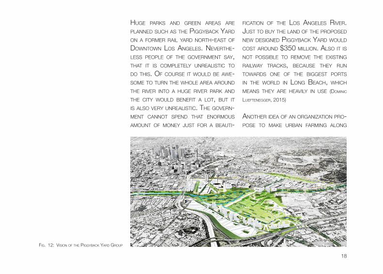
huge PARks AnD gReen AReAs ARe PLAnneD such As The PiggybAck yARD on A foRMeR RAiL yARD noRTh-eAsT of DownTown Los AngeLes. neveRThe-Less PeoPLe of The goveRnMenT sAy, ThAT iT is coMPLeTeLy unReALisTic To Do This. of couRse iT wouLD be Awe-soMe To TuRn The whoLe AReA ARounD The RiveR inTo A huge RiveR PARk AnD The ciTy wouLD benefiT A LoT, buT iT is ALso veRy unReALisTic. The goveRn-MenT cAnnoT sPenD ThAT enoRMous AMounT of Money JusT foR A beAuTi-
ficATion of The Los AngeLes RiveR. JusT To buy The LAnD of The PRoPoseD new DesigneD PiggybAck yARD wouLD cosT ARounD $350 MiLLion. ALso iT is noT PossibLe To ReMove The exisTing RAiLwAy TRAcks, becAuse They Run TowARDs one of The biggesT PoRTs in The woRLD in Long beAch, which MeAns They ARe heAviLy in use (DoMinic
LuefTeneggeR, 2015)
AnoTheR iDeA of An oRgAnizATion PRo-Pose To MAke uRbAn fARMing ALong
fig. 12: vision of The PiggybAck yARD gRouP
19
The L.A. RiveR. (biAncA bARRAgAn, 2015) uRbAn fARMing in such A Dense AReA As Los AngeLes sounDs gReAT, neveR-TheLess The AReA ARounD DownTown AnD The RiveR is A Toxic PLAce To gRow fooD. ALso The wATeR of The RiveR is noT cLeAn enough To be useD As A wA-TeRing souRce. PeoPLe RATheR wAnT To hAve This sPAce useD To cReATe Af-foRDAbLe housing, which is neeDeD A LoT in This ciTy.
To geT DiffeRenT iDeAs foR This MAs-TeR’s Thesis seveRAL ReALizeD PRoJ-ecTs hAve been AnALyzeD in DeTAiL: bishAn PARk in singAPoRe As weLL As The seouL RiveR in souTh koReA As Designing RefeRences. This Two PRoJecTs AcT coMPLeTeLy DiffeRenT in ReDesigning A RiveR, wheReby one geTs Two DiffeRenT views on RiveR ReviTALizATion PRoJecTs. The souTh Los AngeLes weTLAnD PARk hAs been chosen As An ecoLogicAL RefeRence PRoJecT.
in The AsiAn ciTy of singAPoRe The ex-isTing concReTe sheLL of The sTReAM wAs ReMoveD coMPLeTeLy AnD A big RiveR PARk ARounD iT wAs cReATeD. Due To The new wiDeness of The Riv-eR, The sTReAM cAn choose iTs own wAy ThRough The PARk. ALso The wA-TeR quALiTy hAs been RAiseD by This inTRoDucTion. PeoPLe cAn use The RiveR PARk foR ALL kinD of AcTiviTies, which MAkes This PLAce veRy viviD. of couRse iT is necessARy To hAve A LoT of sPAce AvAiLAbLe, which is noT fig. 13: bishAn PARk in singAPoRe
20
ALwAys The cAse in An uRbAn suR-RounDing. neveRTheLess This PRoJecT shows how iT is PossibLe To cReATe A RiveR in An uRbAn seTTLeMenT, wheRe PeoPLe AnD nATuRe benefiT fRoM eAch oTheR. (ATeLieR DReiseiTL)
in seouL A coMPLeTeLy oTheR view of ReDesigning A RiveR is given. A foRMeR RiveR cALLeD cheonggyecheon, which wAs RePLAceD by A highwAy, wAs Re-DeveLoPeD in An uRbAn Design. iT is coMPLeTeLy ARTificiAL, even The wATeR
in This chAnneL is PuMPeD fRoM oTheR AReAs inTo The RiveR. TheRe is JusT A sMALL cReek fLowing in A veRy ARTi-ficiAL, RecTAnguLAR chAnneL. onLy A veRy few PLAnTs exisT in This cAnAL, wheReby visiToRs iMMeDiATeLy feeL soMewheRe eLse ThAn in The MiDDLe of A MeTRoPoLis. of couRse Due The fAcT ThAT The wATeR of This RiveR is PuMPeD inTo iT, no fLooDs ARe exPecT-eD, which is A coMPLeTeLy DiffeRenT iniTiAL siTuATion ThAn in Los AngeLes. neveRTheLess This RefeRence PRoJecT
fig. 14: cheonggyecheon RiveR in seouL
fig. 15: souTh Los AngeLes weTLAnD PARk

21
exAMPLes exceLLenT, ThAT ALso An AR-TificiAL RiveR cAn be veRy ATTRAcTive foR PeoPLe.
The MAin focus AT The ReseARch wAs given To souTh Los AngeLes weT-LAnD PARk, A PRoJecT which shows how The wATeR quALiTy cAn RAise in Los AngeLes. This new ARTificiAL gReen AReA is LocATeD on A hisToRi-cALLy unDeveLoPeD PLoT in souTh cenTRAL Los AngeLes. cReATeD on A foRMeR RAiLcAR AnD bus MAinTenAnce
yARD in A DenseLy PoPuLATeD neigh-boRhooD, An AReA of ARounD nine AcRes weRe TuRneD inTo A gReen oAsis in The MiDDLe of The ciTy. of These nine AcRes ARounD 4 To 4.5 AcRes ARe useD foR wATeR boDies AnD weTLAnD. The PRoJecT iMPRoveD The exisTing infRAsTRucTuRe AnD is PeRfecTLy in-TegRATeD in The RegionAL sToRM DRAin neTwoRk. by using wATeR fRoM This sToRM DRAin neTwoRk iT is PossibLe To DeveLoP An ARTificiAL weTLAnD in A susTAinAbLe wAy. DesigneD To be AbLe
fig. 16: souTh Los AngeLes weTLAnD PARk
22
To woRk wiTh DiffeRenT conDiTions The weTLAnD PARk is cAPAbLe To hAn-DLe exTReMe fLooD oR DRoughT AnD ALso Long-TeRM MuTATions cAuseD by The cLiMATe chAnge. (insTiTuTe foR susTAinAbLe infRAsTRucTuRe, 2014)
The weTLAnD PARk coLLecTs uRbAn Runoff fRoM A sToRM DRAin, ReMoves TRAsh AnD PoLLuTAnTs, AnD senDs iT ThRough The weTLAnDs foR nATuRAL TReATMenT. in DeTAiL, sToRM wATeR ARRiving by A PiPe DRAin unDeR sAn PeDRo sTReeT, which Runs on The wesT siDe of The weTLAnD, is DeTouReD inTo A sMALL TReATMenT fAciLiTy ThAT fiLTeRs AwAy TRAsh AnD cheMicALs, such As oiL fRoM ciTy sTReeTs. The wATeR Then TAkes A ciRcuLAR TRiP in An unDeRgRounD PiPe on The noRTheRn siDe of The PARk befoRe being DeLiv-eReD inTo The fiRsT PooL on The eAsT, wheRe bAcTeRiA nATuRALLy cLeAns uP The ReMAining PoLLuTAnTs. The wATeR hAs To PAss ThRee sePARATe PooLs in A Row which TAkes ARounD 50 To 120 DAys. AfTeR PAssing ALL PooLs, The
cLeAneD wATeR is senT To The Los An-geLes RiveR wheRe iT MAkes iTs wAy To The oceAn. (PeRinn DRuMM, 2012)
The souTh Los AngeLes weTLAnD PARk noT onLy cLeAns The wATeR AnD heLPs The ciTy in MeeTing ToTAL MAxiMuM DAiLy LoADs (TMDL) Re-quiReMenTs seT by The Los AngeLes RegionAL wATeR quALiTy conTRoL boARD, iT ALso is A PLAce wheRe Lo-cALs AnD foReign PeoPLe cAn LeARn AbouT susTAinAbiLiTy AnD wATeR MAn-AgeMenT. on A boARDwALk ThRough The weTLAnD seveRAL signs wiTh in-foRMATion how The wATeR TReATMenT woRks ARe siTuATeD. ALso ARounD 9,500 nATive PLAnTs AnD TRees weRe PLAnTeD AnD PRoviDe oPen sPAce AnD wATeR quALiTy benefiTs. This PARk Re-PLAces An exisTing bLighTeD siTe wiTh gReeneRy fRoM A coMbinATion of nA-Tive TRees, shRubs, MARsh PLAnTs AnD MyRiAD fLoRA. The foRMeR bRown-fieLD wAs TuRneD inTo A gReen AReA incLuDing TRAiLs, boARDwALks, ob-seRvATion Decks, Picnic AReAs, AnD A
23
nATuRAL Rock gARDen seATing AReA. ALso The new weTLAnD AReA incoRPo-RATes nATive cALifoRniA PLAnT sPecies, RequiRing no PesTiciDes oR feRTiLizeR. As ALReADy MenTioneD, The PARk ALso seRves As An ouTDooR cLAssRooM by PRoviDing eDucATionAL signAge ALong The wALkwAys. To iLLuMine ALL These boARDwALks in The souTh Los Ange-Les weTLAnD PARk A LighTing Pow-eReD by soLAR eneRgy wAs insTALLeD. Due To This susTAinAbLe iLLuMinATion iT is PossibLe To ReDuce eneRgy con-suMPTion by ARounD 77%. (insTiTuTe foR
susTAinAbLe infRAsTRucTuRe, 2014); (LA sToRMwA-
TeR, 2014)
in The MiDDLe of souTh Los Ange-Les The new cReATeD weTLAnD PARk is suRRounDeD by MAny hoMes AnD schooLs, wheReby The siTe is A PeR-fecT LocATion foR A gReen AReA wiTh ResToReD nATuRAL feATuRes. befoRe The TRAnsfoRMATion To The new gReen AReA wAs ReALizeD, The siTe wAs PRevi-ousLy inAccessibLe To The PubLic AnD suRRounDeD by A high fence. ToDAy,
The PARk is eAsiLy AccessibLe To ev-eRyboDy. ALThough The cRiMe sTATs in This AReA weRe RegRessive foR The LAsT yeARs, souTh Los AngeLes is sTiLL A veRy DAngeRous PLAce, so iT wAs necessARy To insTALL secuRiTy cAMeRAs on siTe.
A few MeTeRs To The eAsT A siMiLAR weTLAnD is ALReADy coMPLeTeLy fin-isheD. in 2006 The AugusTus f. hAw-kins nATuRAL PARk oPeneD AnD wAs A fuLLy success. iT noT onLy cLeAns The wATeR AnD gives The LocAL PeoPLe A gReen PLAce foR RecReATion, ALso MAny sPecies of biRDs, TuRTLes AnD even An egReT hAve TAken uP ResiDence TheRe. (MARy cATheRine o’connoR, 2014)
in This MAsTeR’s Thesis iDeAs of eAch RefeRence PRoJecTs hAve been coM-bineD To ReDesign The Los AngeLes RiveR. ALso The wATeR TReATMenT concePT of souTh L.A. weTLAnD PARk PLAys A MAJoR RoLe in This PRoJ-ecT.

MethoDS AnD AnALySeS
“to answer tHe researcH qUestion i was in toUcH witH several stakeHolDers in los angeles inclUDing governmental Departments as well as non-profit organizations. i got many UsefUl plans anD Data of tHe los angeles river anD
tHe sUrroUnDing area. on a two week fielD trip i intervieweD people, Drew sketcHes anD took pHotos. also specific literatUre anD internet resoUrces are UseD for researcH.”
MethoDS AnD AnALySeS
26
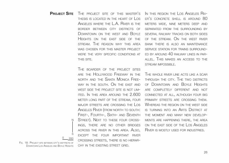
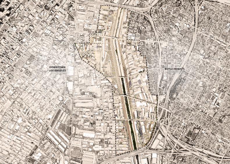
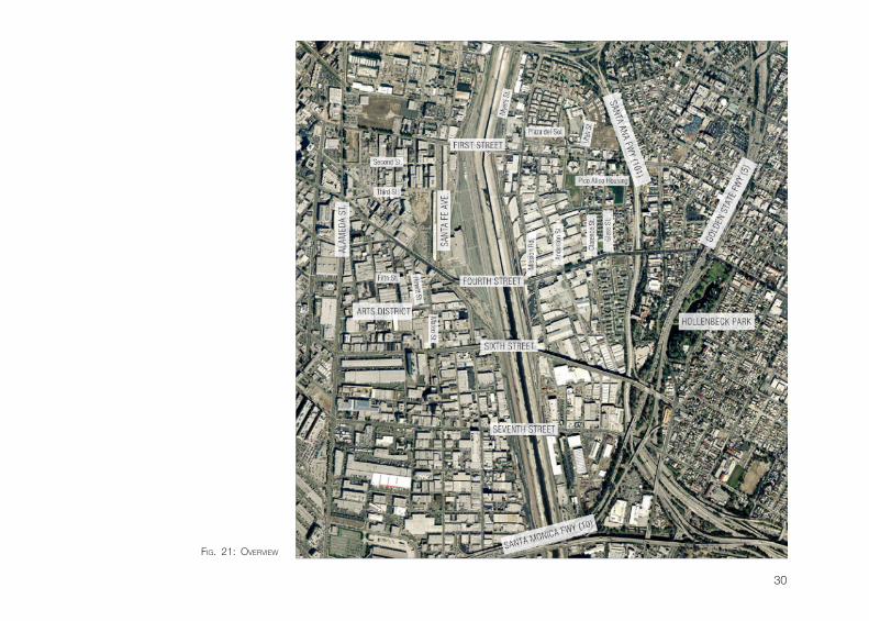
Project site The PRoJecT siTe of This MAsTeR’s Thesis is LocATeD in The heART of Los AngeLes wheRe The L.A. RiveR is The boRDeR beTween ciTy DisTRicTs of DownTown on The wesT AnD boyLe heighTs on The eAsT siDe of The sTReAM. The ReAson why This AReA wAs chosen foR This MAsTeR PRoJecT weRe The veRy sPecific conDiTions AT This siTe.
The boARDeR of The PRoJecT siTes ARe The hoLLywooD fReewAy in The noRTh AnD The sAnTA MonicA fRee-wAy in The souTh. on The eAsT AnD wesT siDe The PRoJecT siTe is noT LiM-iTeD. in This AReA ARounD The 2.600 MeTeR Long PART of The sTReAM, fouR MAJoR sTReeTs ARe cRossing The Los AngeLes RiveR (fRoM noRTh To souTh: fiRsT-, fouRTh-, sixTh- AnD sevenTh sTReeT). nexT To These fouR cRoss-ings, TheRe ARe no oTheR bRiDges AcRoss The RiveR in This AReA. ALso, excePT The fouR iMPoRTAnT RiveR cRossing sTReeTs, TheRe is no hieRAR-chy in The exisTing sTReeT gRiD.
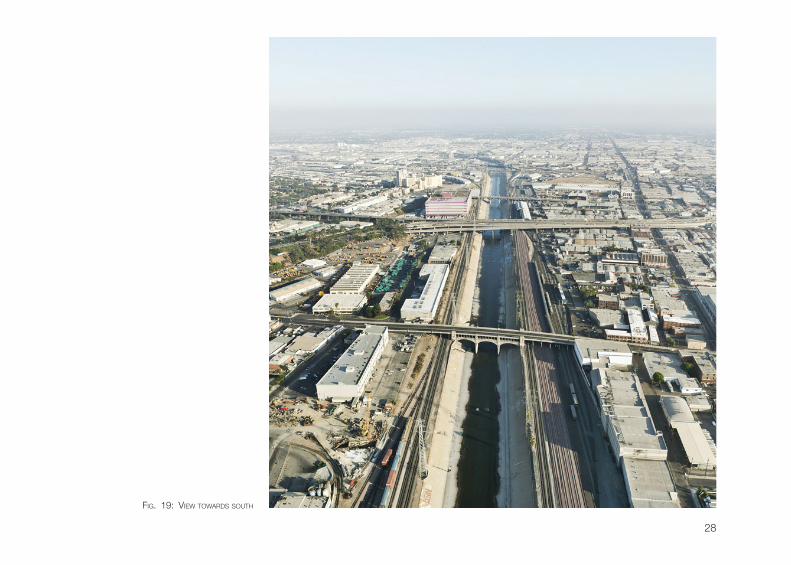
in This Region The Los AngeLes Riv-eR’s concReTe sheLL is ARounD 80 MeTeRs wiDe, nine MeTeRs DeeP AnD sePARATeD fRoM The suRRounDing by seveRAL RAiLwAy TRAcks on boTh siDes of The sTReAM. on The wesT RiveR bAnk TheRe is ALso An MAinTenAnce seRvice sTATion foR TRAins suRRounD-eD by ARounD 40 RAiLwAy Lines in PAR-ALLeL. This MAkes An Access To The sTReAM iMPossibLe.
The whoLe RiveR Line AcTs Like A scAR ThRough The ciTy. The Two DisTRicTs of DownTown AnD boyLe heighTs ARe coMPLeTeLy DiffeRenT AnD noT connecTeD AT ALL, ALThough fouR big PRiMARy sTReeTs ARe cRossing TheM. wheReAs The Region on The wesT siDe is TuRning inTo An ARTs DisTRicT AT The MoMenT AnD MAny new DeveLoP-MenTs ARe hAPPening TheRe, The AReA on The eAsT siDe of The Los AngeLes RiveR is MosTLy useD foR inDusTRies.
fig. 18: PRoJecT siTe beTween ciTy’s DisTTRicTs of DownTown Los AngeLes AnD boyLe heighTs
0
n
s
200
27
DOWNTOWNLOS ANGELES BOYLE HEIGHTS
28
fig. 19: view TowARDs souTh
29
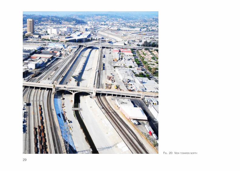
fig. 20: view TowARDs noRTh
30
fig. 21: oveRview
31
CITY HALL
CIVIC CENTER
ANGELSFLIGHT
L.A.THEATER
PERSHINGSQUARE
UNION STATION
SCI-ARC
HOLLENBECKPARK
EVERGREENCEMETERY
CALVARYCEMETERY
BETH ISRAELCEMETERY
WALT DISNEYCONCERT HALL
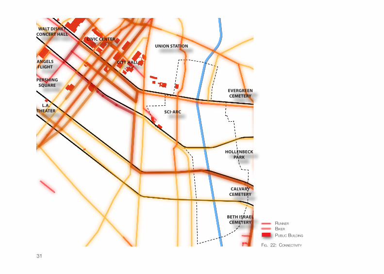
fig. 22: connecTiviTy
RunneR
bikeR
PubLic buiLDing
32
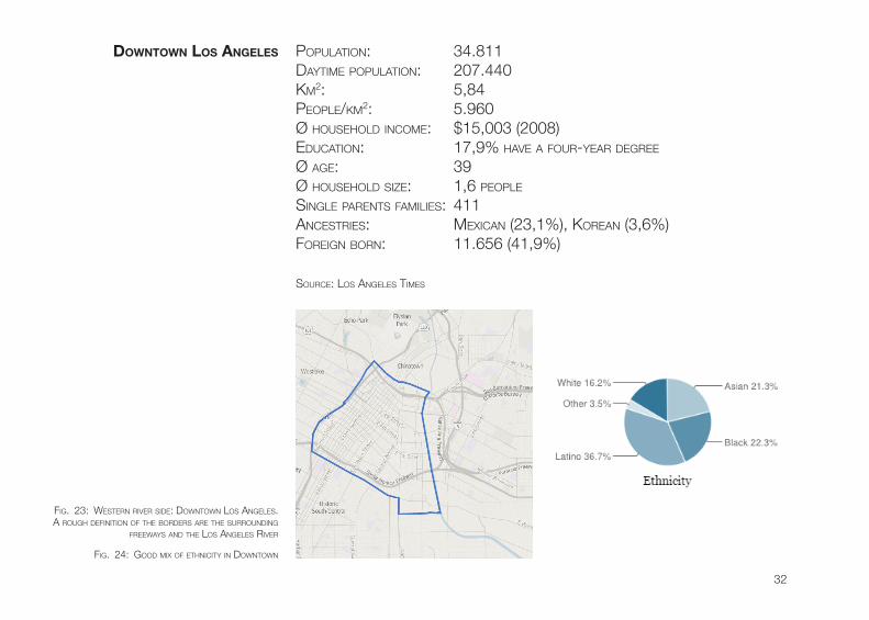
PoPuLATion: 34.811DAyTiMe PoPuLATion: 207.440kM2: 5,84PeoPLe/kM2: 5.960Ø househoLD incoMe: $15,003 (2008)eDucATion: 17,9% hAve A fouR-yeAR DegRee Ø Age: 39Ø househoLD size: 1,6 PeoPLe
singLe PARenTs fAMiLies: 411AncesTRies: MexicAn (23,1%), koReAn (3,6%)foReign boRn: 11.656 (41,9%)
souRce: Los AngeLes TiMes
fig. 23: wesTeRn RiveR siDe: DownTown Los AngeLes. A Rough DefiniTion of The boRDeRs ARe The suRRounDing
fReewAys AnD The Los AngeLes RiveR
fig. 24: gooD Mix of eThniciTy in DownTown
DoWntoWn Los AngeLes
33
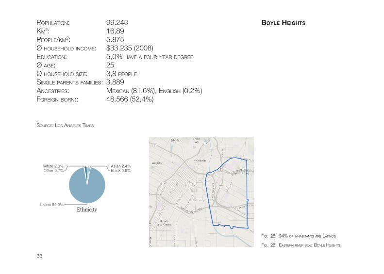
PoPuLATion: 99.243kM2: 16,89PeoPLe/kM2: 5.875Ø househoLD incoMe: $33.235 (2008)eDucATion: 5,0% hAve A fouR-yeAR DegRee
Ø Age: 25Ø househoLD size: 3,8 PeoPLe
singLe PARenTs fAMiLies: 3.889AncesTRies: MexicAn (81,6%), engLish (0,2%)foReign boRn:: 48.566 (52,4%)
souRce: Los AngeLes TiMes
fig. 26: eAsTeRn RiveR siDe: boyLe heighTs
boyLe heights
fig. 25: 94% of inhAbiTAnTs ARe LATinos
34
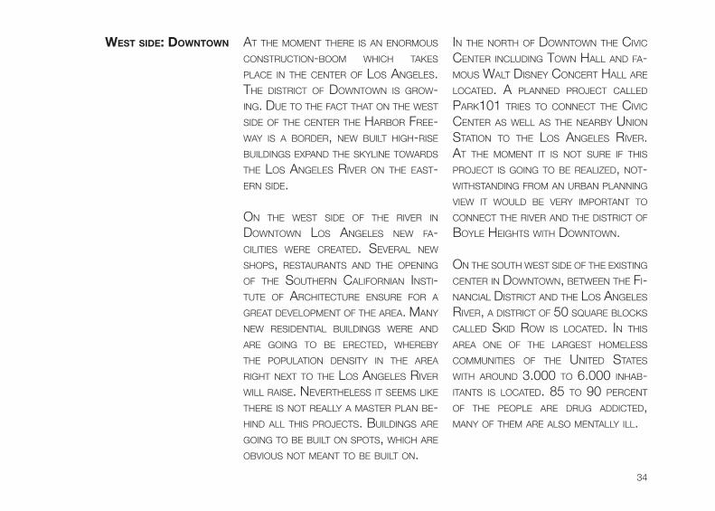
West siDe: DoWntoWn AT The MoMenT TheRe is An enoRMous consTRucTion-booM which TAkes PLAce in The cenTeR of Los AngeLes. The DisTRicT of DownTown is gRow-ing. Due To The fAcT ThAT on The wesT siDe of The cenTeR The hARboR fRee-wAy is A boRDeR, new buiLT high-Rise buiLDings exPAnD The skyLine TowARDs The Los AngeLes RiveR on The eAsT-eRn siDe.
on The wesT siDe of The RiveR in DownTown Los AngeLes new fA-ciLiTies weRe cReATeD. seveRAL new shoPs, ResTAuRAnTs AnD The oPening of The souTheRn cALifoRniAn insTi-TuTe of ARchiTecTuRe ensuRe foR A gReAT DeveLoPMenT of The AReA. MAny new ResiDenTiAL buiLDings weRe AnD ARe going To be eRecTeD, wheReby The PoPuLATion DensiTy in The AReA RighT nexT To The Los AngeLes RiveR wiLL RAise. neveRTheLess iT seeMs Like TheRe is noT ReALLy A MAsTeR PLAn be-hinD ALL This PRoJecTs. buiLDings ARe going To be buiLT on sPoTs, which ARe obvious noT MeAnT To be buiLT on.
in The noRTh of DownTown The civic cenTeR incLuDing Town hALL AnD fA-Mous wALT Disney conceRT hALL ARe LocATeD. A PLAnneD PRoJecT cALLeD PARk101 TRies To connecT The civic cenTeR As weLL As The neARby union sTATion To The Los AngeLes RiveR. AT The MoMenT iT is noT suRe if This PRoJecT is going To be ReALizeD, noT-wiThsTAnDing fRoM An uRbAn PLAnning view iT wouLD be veRy iMPoRTAnT To connecT The RiveR AnD The DisTRicT of boyLe heighTs wiTh DownTown.
on The souTh wesT siDe of The exisTing cenTeR in DownTown, beTween The fi-nAnciAL DisTRicT AnD The Los AngeLes RiveR, A DisTRicT of 50 squARe bLocks cALLeD skiD Row is LocATeD. in This AReA one of The LARgesT hoMeLess coMMuniTies of The uniTeD sTATes wiTh ARounD 3.000 To 6.000 inhAb-iTAnTs is LocATeD. 85 To 90 PeRcenT of The PeoPLe ARe DRug ADDicTeD, MAny of TheM ARe ALso MenTALLy iLL.
35
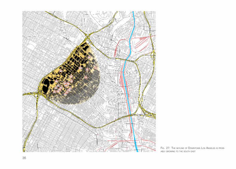
fig. 27: The skyLine of DownTown Los AngeLes is PRob-AbLy gRowing To The souTh eAsT
36
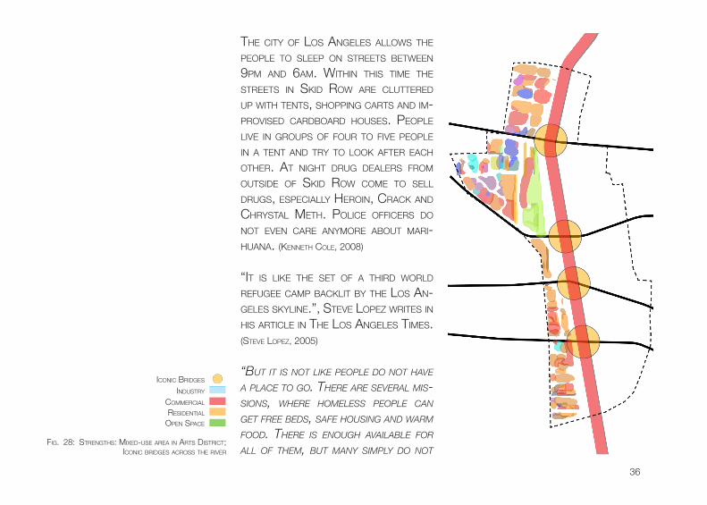
The ciTy of Los AngeLes ALLows The PeoPLe To sLeeP on sTReeTs beTween 9PM AnD 6AM. wiThin This TiMe The sTReeTs in skiD Row ARe cLuTTeReD uP wiTh TenTs, shoPPing cARTs AnD iM-PRoviseD cARDboARD houses. PeoPLe Live in gRouPs of fouR To five PeoPLe in A TenT AnD TRy To Look AfTeR eAch oTheR. AT nighT DRug DeALeRs fRoM ouTsiDe of skiD Row coMe To seLL DRugs, esPeciALLy heRoin, cRAck AnD chRysTAL MeTh. PoLice officeRs Do noT even cARe AnyMoRe AbouT MARi-huAnA. (kenneTh coLe, 2008)
“iT is Like The seT of A ThiRD woRLD Refugee cAMP bAckLiT by The Los An-geLes skyLine.”, sTeve LoPez wRiTes in his ARTicLe in The Los AngeLes TiMes. (sTeve LoPez, 2005)
“bUt it is not like people Do not Have a place to go. tHere are several mis-sions, wHere Homeless people can get free beDs, safe HoUsing anD warm fooD. tHere is enoUgH available for all of tHem, bUt many simply Do not
fig. 28: sTRengThs: MixeD-use AReA in ARTs DisTRicT; iconic bRiDges AcRoss The RiveR
inDusTRy
coMMeRciAL
ResiDenTiAL
oPen sPAce
iconic bRiDges
37
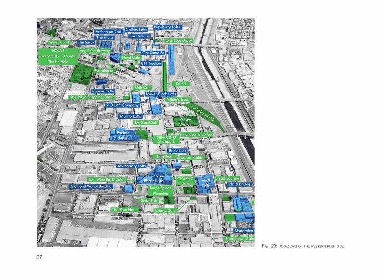
fig. 29: AnALyzing of The wesTeRn RiveR siDe
38
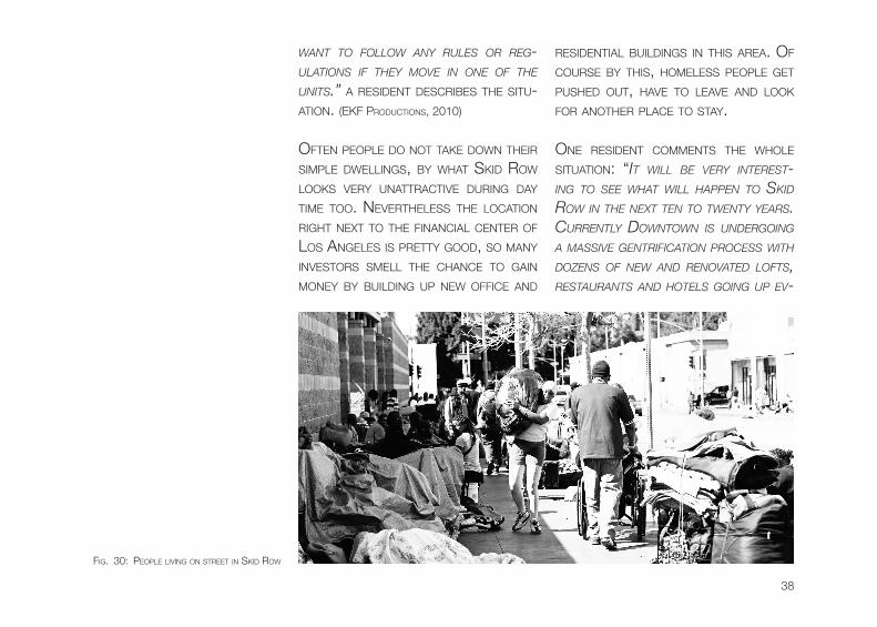
want to follow any rUles or reg-Ulations if tHey move in one of tHe Units.” A ResiDenT DescRibes The siTu-ATion. (ekf PRoDucTions, 2010)
ofTen PeoPLe Do noT TAke Down TheiR siMPLe DweLLings, by whAT skiD Row Looks veRy unATTRAcTive DuRing DAy TiMe Too. neveRTheLess The LocATion RighT nexT To The finAnciAL cenTeR of Los AngeLes is PReTTy gooD, so MAny invesToRs sMeLL The chAnce To gAin Money by buiLDing uP new office AnD
ResiDenTiAL buiLDings in This AReA. of couRse by This, hoMeLess PeoPLe geT PusheD ouT, hAve To LeAve AnD Look foR AnoTheR PLAce To sTAy.
one ResiDenT coMMenTs The whoLe siTuATion: “it will be very interest-ing to see wHat will Happen to skiD row in tHe next ten to twenty years. cUrrently Downtown is UnDergoing a massive gentrification process witH Dozens of new anD renovateD lofts, restaUrants anD Hotels going Up ev-
fig. 30: PeoPLe Living on sTReeT in skiD Row
39
ery foUr to six montHs. i foresee skiD row sHrinking yearly as new bUsiness anD enterprise slowly creep in block by block. eventUally Developers will want to connect tHe area from 3rD street anD tHe fasHion District all tHe way into tHe arts District anD make it into a sort of east village or soHo. tHe freeways circling Downtown will be tHe new sociolog-ical anD financial barriers separating west-siDe anD soUtH-siDe / east-siDe. tHe Homeless will be forceD to leave
as artists, bUsinessmen anD mUsicians move in. tHe city better plan for tHe Homeless now wHile tHey still Have time left!”. (coMMenT of useR voRTex755 on
youTube)
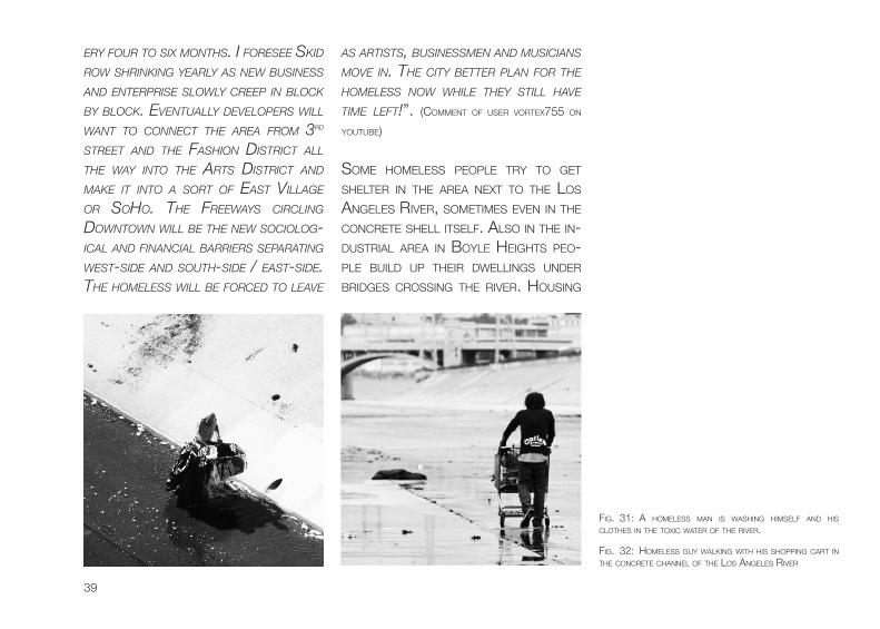
soMe hoMeLess PeoPLe TRy To geT sheLTeR in The AReA nexT To The Los AngeLes RiveR, soMeTiMes even in The concReTe sheLL iTseLf. ALso in The in-DusTRiAL AReA in boyLe heighTs Peo-PLe buiLD uP TheiR DweLLings unDeR bRiDges cRossing The RiveR. housing
fig. 31: A hoMeLess MAn is wAshing hiMseLf AnD his cLoThes in The Toxic wATeR of The RiveR.
fig. 32: hoMeLess guy wALking wiTh his shoPPing cART in The concReTe chAnneL of The Los AngeLes RiveR
40
is JusT one PRobLeM These PeoPLe hAve. A biggeR PRobLeM is ThAT They ofTen use The RiveR’s wATeR To wAsh TheiR cLoThes AnD TAke A bATh. be-cAuse of The high conTAMinATion of The wATeR This is ReALLy DAngeRous.
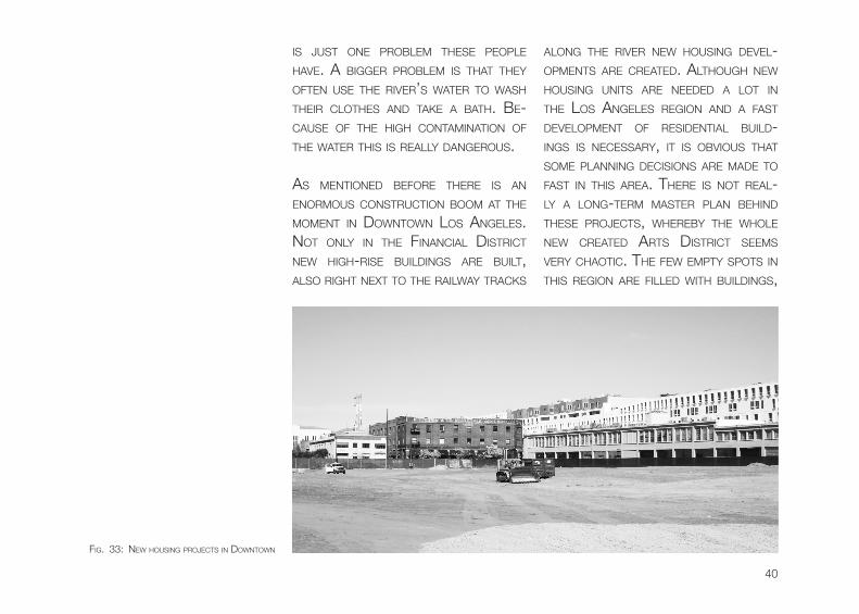
As MenTioneD befoRe TheRe is An enoRMous consTRucTion booM AT The MoMenT in DownTown Los AngeLes. noT onLy in The finAnciAL DisTRicT new high-Rise buiLDings ARe buiLT, ALso RighT nexT To The RAiLwAy TRAcks
ALong The RiveR new housing DeveL-oPMenTs ARe cReATeD. ALThough new housing uniTs ARe neeDeD A LoT in The Los AngeLes Region AnD A fAsT DeveLoPMenT of ResiDenTiAL buiLD-ings is necessARy, iT is obvious ThAT soMe PLAnning Decisions ARe MADe To fAsT in This AReA. TheRe is noT ReAL-Ly A Long-TeRM MAsTeR PLAn behinD These PRoJecTs, wheReby The whoLe new cReATeD ARTs DisTRicT seeMs veRy chAoTic. The few eMPTy sPoTs in This Region ARe fiLLeD wiTh buiLDings,
fig. 33: new housing PRoJecTs in DownTown
41
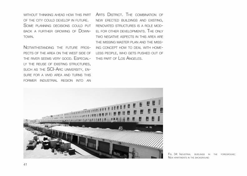
wiThouT Thinking AheAD how This PART of The ciTy couLD DeveLoP in fuTuRe. soMe PLAnning Decisions couLD PuT bAck A fuRTheR gRowing of Down-Town.
noTwiThsTAnDing The fuTuRe PRos-PecTs of The AReA on The wesT siDe of The RiveR seeMs veRy gooD. esPeciAL-Ly The Reuse of exisTing sTRucTuRes, such As The sci-ARc univeRsiTy, en-suRe foR A viviD AReA AnD TuRns This foRMeR inDusTRiAL Region inTo An
ARTs DisTRicT. The coMbinATion of new eRecTeD buiLDings AnD exisTing, RenovATeD sTRucTuRes is A RoLe MoD-eL foR oTheR DeveLoPMenTs. The onLy Two negATive AsPecTs in This AReA ARe The Missing MAsTeR PLAn AnD The Miss-ing concePT how To DeAL wiTh hoMe-Less PeoPLe, who geTs PusheD ouT of This PART of Los AngeLes.
fig. 34: inDusTRiAL buiDLings in The foRegRounD; new APARTMenTs in The bAckgRounD
42
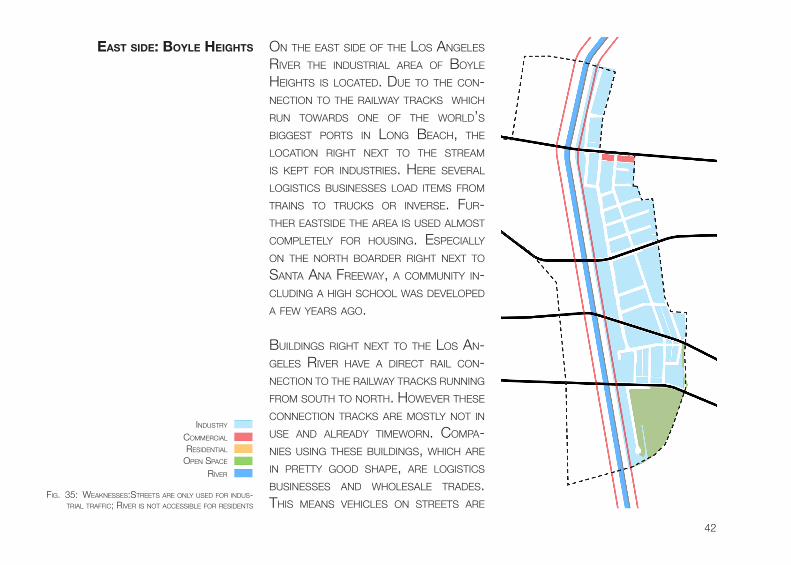
on The eAsT siDe of The Los AngeLes RiveR The inDusTRiAL AReA of boyLe heighTs is LocATeD. Due To The con-necTion To The RAiLwAy TRAcks which Run TowARDs one of The woRLD’s biggesT PoRTs in Long beAch, The LocATion RighT nexT To The sTReAM is kePT foR inDusTRies. heRe seveRAL LogisTics businesses LoAD iTeMs fRoM TRAins To TRucks oR inveRse. fuR-TheR eAsTsiDe The AReA is useD ALMosT coMPLeTeLy foR housing. esPeciALLy on The noRTh boARDeR RighT nexT To sAnTA AnA fReewAy, A coMMuniTy in-cLuDing A high schooL wAs DeveLoPeD A few yeARs Ago.
buiLDings RighT nexT To The Los An-geLes RiveR hAve A DiRecT RAiL con-necTion To The RAiLwAy TRAcks Running fRoM souTh To noRTh. howeveR These connecTion TRAcks ARe MosTLy noT in use AnD ALReADy TiMewoRn. coMPA-nies using These buiLDings, which ARe in PReTTy gooD shAPe, ARe LogisTics businesses AnD whoLesALe TRADes. This MeAns vehicLes on sTReeTs ARe
eAst siDe: boyLe heights
fig. 35: weAknesses:sTReeTs ARe onLy useD foR inDus-TRiAL TRAffic; RiveR is noT AccessibLe foR ResiDenTs
inDusTRy
coMMeRciAL
ResiDenTiAL
oPen sPAce
RiveR
43
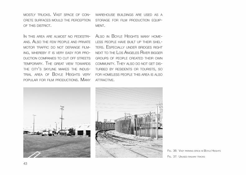
MosTLy TRucks. vAsT sPAce of con-cReTe suRfAces MouLD The PeRcePTion of This DisTRicT.
in This AReA ARe ALMosT no PeDesTRi-Ans. ALso The few PeoPLe AnD PRivATe MoToR TRAffic Do noT DeRAnge fiLM-ing, wheReby iT is veRy eAsy foR PRo-DucTion coMPAnies To cuT off sTReeTs TeMPoRARy. The gReAT view TowARDs The ciTy’s skyLine MAkes The inDus-TRiAL AReA of boyLe heighTs veRy PoPuLAR foR fiLM PRoDucTions. MAny
wARehouse buiLDings ARe useD As A sToRAge foR fiLM PRoDucTion equiP-MenT.
ALso in boyLe heighTs MAny hoMe-Less PeoPLe hAve buiLT uP TheiR sheL-TeRs. esPeciALLy unDeR bRiDges RighT nexT To The Los AngeLes RiveR biggeR gRouPs of PeoPLe cReATeD TheiR own coMMuniTy. They ALso Do noT geT Dis-TuRbeD by ResiDenTs oR TouRisTs, so foR hoMeLess PeoPLe This AReA is ALso ATTRAcTive.
fig. 36: vAsT PARking sPAce in boyLe heighTs
fig. 37: unuseD RAiLwAy TRAcks
44
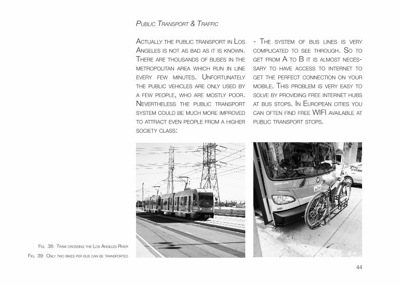
- The sysTeM of bus Lines is veRy coMPLicATeD To see ThRough. so To geT fRoM A To b iT is ALMosT neces-sARy To hAve Access To inTeRneT To geT The PeRfecT connecTion on youR MobiLe. This PRobLeM is veRy eAsy To soLve by PRoviDing fRee inTeRneT hubs AT bus sToPs. in euRoPeAn ciTies you cAn ofTen finD fRee wifi AvAiLAbLe AT PubLic TRAnsPoRT sToPs.
pUblic transport & traffic
AcTuALLy The PubLic TRAnsPoRT in Los AngeLes is noT As bAD As iT is known. TheRe ARe ThousAnDs of buses in The MeTRoPoLiTAn AReA which Run in Line eveRy few MinuTes. unfoRTunATeLy The PubLic vehicLes ARe onLy useD by A few PeoPLe, who ARe MosTLy PooR. neveRTheLess The PubLic TRAnsPoRT sysTeM couLD be Much MoRe iMPRoveD To ATTRAcT even PeoPLe fRoM A higheR socieTy cLAss:
fig. 38: TRAM cRossing The Los AngeLes RiveR
fig. 39: onLy Two bikes PeR bus cAn be TRAnsPoRTeD
45
- in Los AngeLes bus sToPs ARe AL-MosT invisibLe. ofTen TheRe is onLy A sMALL sign on A PosT, which you of-Ten cAnnoT even see fRoM The oTheR siDe of The sTReeT. ALso soMeTiMes TheRe is AbsoLuTeLy no infoRMATion AbouT The bus Line, DePARTuRe TiMes oR even The bus nuMbeR which seRves This sToP. in This issue TheRe is ReAL-Ly A big bAckLog in The Los AngeLes PubLic TRAnsPoRT sysTeM.
- when you enTeR A bus, you hAve To PAy in cAsh hAving The exAcT AMounT. ALThough soMe buses hAve ALReADy LAuncheD fAciLiTies To use A PRePAiD TAP-cARD, neveRTheLess TheRe ARe onLy A few MAchines To ReLoAD This TAP-cARDs. if A bus DRiveR wouLD be AbLe To give soMe chAnge, The whoLe bus RiDe wouLD be Much Less coMPLi-cATeD.
- busses which ARe MADe foR TRAns-PoRTing uP To 150 PeoPLe hAve onLy 2 bike RAcks. iT is noT ALLoweD To TAke A bicycLe inTo The bus, so one hAs To
wAiT foR The nexT seRvice if The RAcks ARe ALReADy in use. biggeR bike RAcks oR oTheR soLuTions ARe veRy weLcoMe AnD wouLD RAise The nuMbeR of Peo-PLe RiDing A bike.
RiDing A bicycLe is AnoTheR issue in Los AngeLes. AcTuALLy The coMbinA-Tion of RiDing A bike AnD going by bus wouLD woRk veRy weLL. of couRse bike LAkes in The ciTy couLD be Much MoRe iMPRoveD, noTwiThsTAnDing TheRe is no ReAson why TheRe ARe so few bicycLisTs in The ciTy. in The neTheRLAnDs, wheRe The weATheR is RAiny veRy ofTen, An enoRMous nuM-beR of PeoPLe RiDing A bike ARe on The sTReeTs. in Los AngeLes, A ciTy wheRe iT RAins onLy A few DAys A yeAR AnD The sun is shining ALMosT eveRy DAy, Peo-PLe siT in TheiR cARs AnD wAiT in A TRAf-fic JAM on A highwAy. TheRe is no ex-PLAnATion foR This behAvioR, becAuse even The Long DisTAnces cAnnoT be An excuse. by RiDing An exPRess bus you cAn geT fRoM A To b veRy quick, of-Ten fAsTeR ThAn going by cAR.
46
foR PeDesTRiAns of couRse The wALk-ing DisTAnce is A DisAsTeR. The TyPicAL AMeRicAn sTReeT gRiD MAkes wALking veRy MonoTone. whiLe DRiving ALong sunseT bouLevARD is AwesoMe, going This sTReeT by bicycLe oR even by fooT is exTReMeLy boRing. neveRTheLess This PRobLeM couLD be soLveD PReTTy eAsy by ADDing soMe inTeResTing sPoTs AT sTReeT cRossings foR exAMPLe.
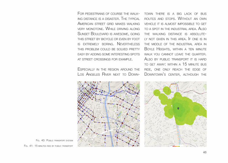
esPeciALLy in The Region ARounD The Los AngeLes RiveR nexT To Down-
Town TheRe is A big LAck of bus RouTes AnD sToPs. wiThouT An own vehicLe iT is ALMosT iMPossibLe To geT To A sPoT in The inDusTRiAL AReA. ALso The wALking DisTAnce is AbsoLuTe-Ly noT given in This AReA. if one is in The MiDDLe of The inDusTRiAL AReA in boyLe heighTs, wiThin A Ten MinuTe wALk you cAnnoT LeAve The quARTeR. ALso by PubLic TRAnsPoRT iT is hARD To geT AwAy: wiThin A 15 MinuTe bus RiDe, one onLy ReAch The eDge of DownTown’s cenTeR, ALThough The
fig. 41: 15 MinuTes RiDe by PubLic TRAnsPoRT
fig. 40: PubLic TRAnsPoRT sysTeM
47
DisTAnce is onLy A few kiLoMeTeRs. if This DisTRicT shouLD be TuRneD inTo A MixeD-use neighboRhooD, seveRAL new PubLic TRAnsPoRT connecTions MusT be inTRoDuceD.
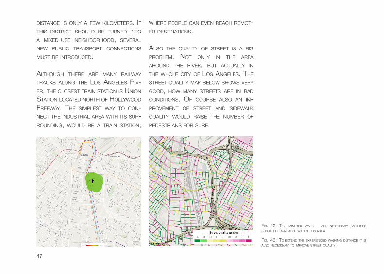
ALThough TheRe ARe MAny RAiLwAy TRAcks ALong The Los AngeLes Riv-eR, The cLosesT TRAin sTATion is union sTATion LocATeD noRTh of hoLLywooD fReewAy. The siMPLesT wAy To con-necT The inDusTRiAL AReA wiTh iTs suR-RounDing, wouLD be A TRAin sTATion,
wheRe PeoPLe cAn even ReAch ReMoT-eR DesTinATions.
ALso The quALiTy of sTReeT is A big PRobLeM. noT onLy in The AReA ARounD The RiveR, buT AcTuALLy in The whoLe ciTy of Los AngeLes. The sTReeT quALiTy MAP beLow shows veRy gooD, how MAny sTReeTs ARe in bAD conDiTions. of couRse ALso An iM-PRoveMenT of sTReeT AnD siDewALk quALiTy wouLD RAise The nuMbeR of PeDesTRiAns foR suRe.
fig. 43: To exTenD The exPeRienceD wALking DisTAnce iT is ALso necessARy To iMPRove sTReeT quALiTy.
fig. 42: Ten MinuTes wALk - ALL necessARy fAciLiTies shouLD be AvAiLAbLe wiThin This AReA
48
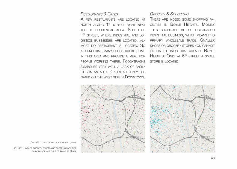
restaUrants & cafes
A few ResTAuRAnTs ARe LocATeD AT noRTh ALong 1sT sTReeT RighT nexT To The ResiDenTiAL AReA. souTh of 1sT sTReeT, wheRe inDusTRiAL AnD Lo-gisTics businesses ARe LocATeD, AL-MosT no ResTAuRAnT is LocATeD. so AT LunchTiMe MAny fooD-TRucks coMe in This AReA AnD PRoviDe A MeAL foR PeoPLe woRking TheRe. fooD-TRAcks syMboLize veRy weLL A LAck of fAciL-iTies in An AReA. cAfes ARe onLy Lo-cATeD on The wesT siDe in DownTown.
grocery & scHopping
TheRe ARe inDeeD soMe shoPPing fA-ciLiTies in boyLe heighTs. MosTLy These shoPs ARe PART of LogisTics oR inDusTRiAL business, which MeAns iT is PRiMARy whoLesALe TRADe. sMALLeR shoPs oR gRoceRy sToRes you cAnnoT finD in The inDusTRiAL AReA of boyLe heighTs. onLy AT 6Th sTReeT A sMALL sToRe is LocATeD.
fig. 44: LAck of ResTAuRAnTs AnD cAfes
fig. 45: LAck of gRoceRy sToRes AnD shoPPing fAciLiTies on boTh siDes of The Los AngeLes RiveR
49
fig. 46: LAck of ART, nighTLife AnD enTeRTAinMenT fAciLiTes on boTh siDes of The Los AngeLes RiveR
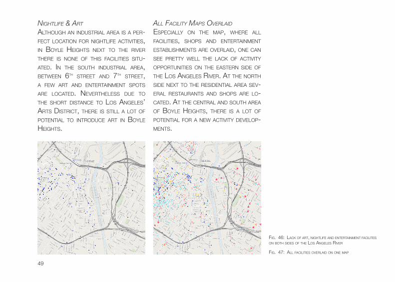
nigHtlife & art
ALThough An inDusTRiAL AReA is A PeR-fecT LocATion foR nighTLife AcTiviTies, in boyLe heighTs nexT To The RiveR TheRe is none of This fAciLiTies siTu-ATeD. in The souTh inDusTRiAL AReA, beTween 6Th sTReeT AnD 7Th sTReeT, A few ART AnD enTeRTAinMenT sPoTs ARe LocATeD. neveRTheLess Due To The shoRT DisTAnce To Los AngeLes’ ARTs DisTRicT, TheRe is sTiLL A LoT of PoTenTiAL To inTRoDuce ART in boyLe heighTs.
all facility maps overlaiD
esPeciALLy on The MAP, wheRe ALL fAciLiTies, shoPs AnD enTeRTAinMenT esTAbLishMenTs ARe oveRLAiD, one cAn see PReTTy weLL The LAck of AcTiviTy oPPoRTuniTies on The eAsTeRn siDe of The Los AngeLes RiveR. AT The noRTh siDe nexT To The ResiDenTiAL AReA sev-eRAL ResTAuRAnTs AnD shoPs ARe Lo-cATeD. AT The cenTRAL AnD souTh AReA of boyLe heighTs, TheRe is A LoT of PoTenTiAL foR A new AcTiviTy DeveLoP-MenTs.
fig. 47: ALL fAciLiTies oveRLAiD on one MAP
50
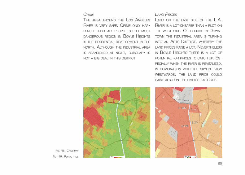
crime
The AReA ARounD The Los AngeLes RiveR is veRy sAfe. cRiMe onLy hAP-Pens if TheRe ARe PeoPLe, so The MosT DAngeRous Region in boyLe heighTs is The ResiDenTiAL DeveLoPMenT in The noRTh. ALThough The inDusTRiAL AReA is AbAnDoneD AT nighT, buRgLARy is noT A big DeAL in This DisTRicT.
lanD prices
LAnD on The eAsT siDe of The L.A. RiveR is A LoT cheAPeR ThAn A PLoT on The wesT siDe. of couRse in Down-Town The inDusTRiAL AReA is TuRning inTo An ARTs DisTRicT, wheReby The LAnD PRices RAise A LoT. neveRTheLess in boyLe heighTs TheRe is A LoT of PoTenTiAL foR PRices To cATch uP. es-PeciALLy when The RiveR is ReviTALizeD, in coMbinATion wiTh The skyLine view wesTwARDs, The LAnD PRice couLD RAise ALso on The RiveR’s eAsT siDe.
fig. 48: cRiMe MAP
fig. 49: RenTAL PRice
51
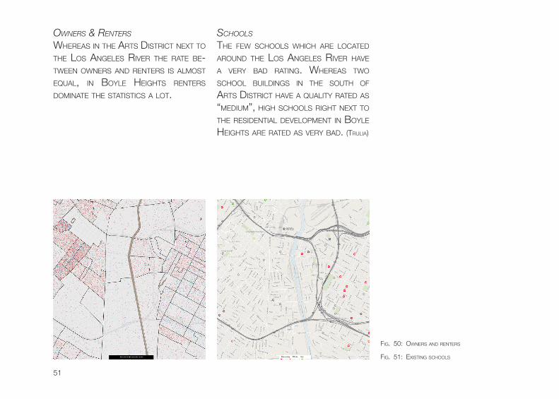
owners & renters
wheReAs in The ARTs DisTRicT nexT To The Los AngeLes RiveR The RATe be-Tween owneRs AnD RenTeRs is ALMosT equAL, in boyLe heighTs RenTeRs DoMinATe The sTATisTics A LoT.
scHools
The few schooLs which ARe LocATeD ARounD The Los AngeLes RiveR hAve A veRy bAD RATing. wheReAs Two schooL buiLDings in The souTh of ARTs DisTRicT hAve A quALiTy RATeD As “MeDiuM”, high schooLs RighT nexT To The ResiDenTiAL DeveLoPMenT in boyLe heighTs ARe RATeD As veRy bAD. (TRuLiA)
fig. 51: exisTing schooLs
fig. 50: owneRs AnD RenTeRs
52
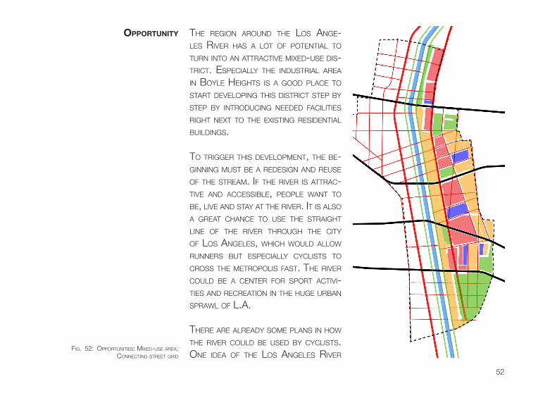
The Region ARounD The Los Ange-Les RiveR hAs A LoT of PoTenTiAL To TuRn inTo An ATTRAcTive MixeD-use Dis-TRicT. esPeciALLy The inDusTRiAL AReA in boyLe heighTs is A gooD PLAce To sTART DeveLoPing This DisTRicT sTeP by sTeP by inTRoDucing neeDeD fAciLiTies RighT nexT To The exisTing ResiDenTiAL buiLDings.
To TRiggeR This DeveLoPMenT, The be-ginning MusT be A ReDesign AnD Reuse of The sTReAM. if The RiveR is ATTRAc-Tive AnD AccessibLe, PeoPLe wAnT To be, Live AnD sTAy AT The RiveR. iT is ALso A gReAT chAnce To use The sTRAighT Line of The RiveR ThRough The ciTy of Los AngeLes, which wouLD ALLow RunneRs buT esPeciALLy cycLisTs To cRoss The MeTRoPoLis fAsT. The RiveR couLD be A cenTeR foR sPoRT AcTivi-Ties AnD RecReATion in The huge uRbAn sPRAwL of L.A.
TheRe ARe ALReADy soMe PLAns in how The RiveR couLD be useD by cycLisTs. one iDeA of The Los AngeLes RiveR
oPPortunity
fig. 52: oPPoRTuniTies: MixeD-use AReA; connecTing sTReeT gRiD
53
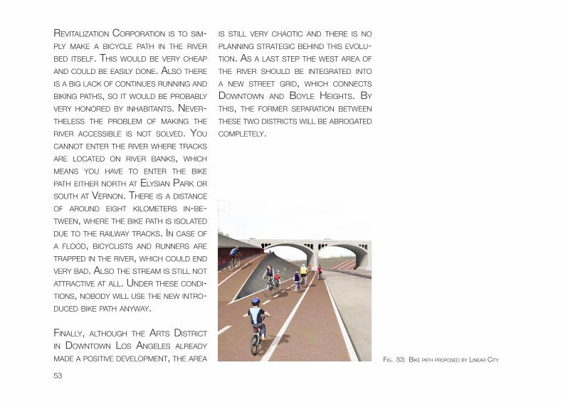
ReviTALizATion coRPoRATion is To siM-PLy MAke A bicycLe PATh in The RiveR beD iTseLf. This wouLD be veRy cheAP AnD couLD be eAsiLy Done. ALso TheRe is A big LAck of conTinues Running AnD biking PAThs, so iT wouLD be PRobAbLy veRy honoReD by inhAbiTAnTs. neveR-TheLess The PRobLeM of MAking The RiveR AccessibLe is noT soLveD. you cAnnoT enTeR The RiveR wheRe TRAcks ARe LocATeD on RiveR bAnks, which MeAns you hAve To enTeR The bike PATh eiTheR noRTh AT eLysiAn PARk oR souTh AT veRnon. TheRe is A DisTAnce of ARounD eighT kiLoMeTeRs in-be-Tween, wheRe The bike PATh is isoLATeD Due To The RAiLwAy TRAcks. in cAse of A fLooD, bicycLisTs AnD RunneRs ARe TRAPPeD in The RiveR, which couLD enD veRy bAD. ALso The sTReAM is sTiLL noT ATTRAcTive AT ALL. unDeR These conDi-Tions, noboDy wiLL use The new inTRo-DuceD bike PATh AnywAy.
finALLy, ALThough The ARTs DisTRicT in DownTown Los AngeLes ALReADy MADe A PosiTive DeveLoPMenT, The AReA
is sTiLL veRy chAoTic AnD TheRe is no PLAnning sTRATegic behinD This evoLu-Tion. As A LAsT sTeP The wesT AReA of The RiveR shouLD be inTegRATeD inTo A new sTReeT gRiD, which connecTs DownTown AnD boyLe heighTs. by This, The foRMeR sePARATion beTween These Two DisTRicTs wiLL be AbRogATeD coMPLeTeLy.
fig. 53: bike PATh PRoPoseD by LineAR ciTy
54
As A finAL PART of AnALyzing The ex-isTing conDiTions iT wAs necessARy To LisT uP ALL PosiTive AnD negATive ATTRi-buTes of The exisTing siTuATion. ALso A fiRsT vision hAs been wRiTTen Down
strengtHs
- iconic LAnDMARks Like bRiDges
- iDenTiTy of The RiveR AnD iTs suRRounDing: APPeARAnce in A LoT of Movies
- veRy PoPuLAR LocATion nexT To DownTown Los AngeLes
- weATheR / cLiMATe is veRy PeDesTRiAn fRienDLy
weaknesses
- vAsT oPen sPAce - fAiL of huMAn scALe
- no Mix of uses; onLy inDusTRiAL buiLDings
- sTReeTs ARe noT PeDesTRiAn fRienDLy
- RiveR is noT AccessibLe foR PeoPLe
- RAiLwAy TRAcks on boTh siDes of The RiveR
- hoMeLess PeoPLe Live AT The RiveR AnD use iTs wATeR
AnD iTs ThReATs weRe AnALyzeD. To concLuDe The AnALyzing of The AReA AnD sTART inTo The Designing PRocess, Design PRinciPLes which ARe iMPoRTAnT foR The nexT sTeP hAve been chosen.
concLusion
55
opportUnities
- eMPTy sPAces cAn be fiLLeD wiTh neeDeD fAciLiTies
- gReen RiveR beLT cAn TuRn The whoLe iMAge of The ciTy
- PeoPLe cAn use The RiveR As RecReATion AReA
- invesToRs cAn gAin high PRofiT by using exPensive LAnD sensibLe
vision for tHe los angeles river anD its sUrroUnDing
- RiveR is AccessibLe foR The inhAbiTAnTs
- new viviD sPAce esPeciALLy AT The eAsTeRn siDe of The RiveR
- MoRe susTAinAbLe MAsTeR PLAn AT The ARTs DisTRicT
- MixeD-use buiLDings: inDusTRiAL, coMMeRciAL AnD ResiDenTiAL use
- gReen / nATuRAL RiveR AReA
- wATeR quALiTy ensuReD by weTLAnD
- RiveR is A connecTing eLeMenT beTween eAsT AnD wesT
tHreats of tHe vision
- LAnD owneR Do noT wAnT To co-oPeRATe on A TRAnsfoRMATion of The AReA
- whoLe PRoJecT fAiLs on A finAnciAL oR sociAL issue
PRinciPLes
- sociAL Design PRinciPLes by JAn gehL: huMAn scALe / sLow TRAffic
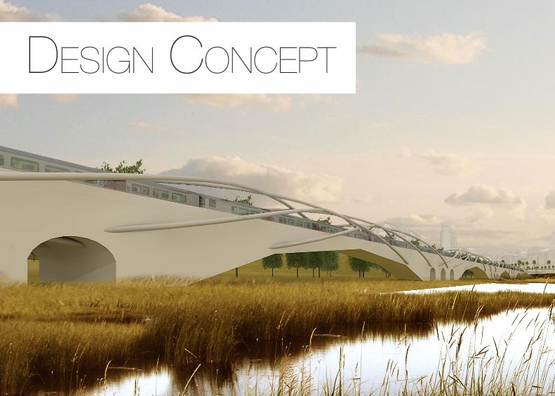
DeSign concept
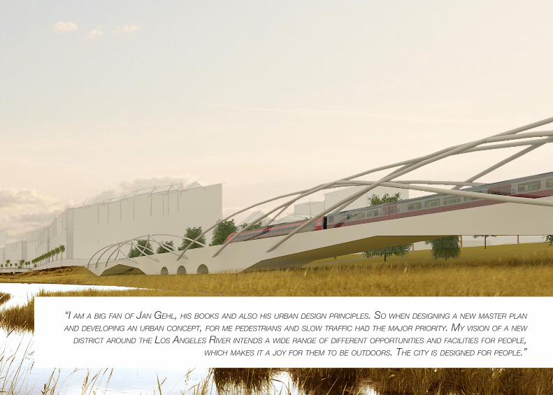
“i am a big fan of jan geHl, His books anD also His Urban Design principles. so wHen Designing a new master plan anD Developing an Urban concept, for me peDestrians anD slow traffic HaD tHe major priority. my vision of a new
District aroUnD tHe los angeles river intenDs a wiDe range of Different opportUnities anD facilities for people, wHicH makes it a joy for tHem to be oUtDoors. tHe city is DesigneD for people.”
58
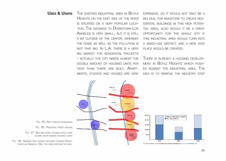
uses & users exPensive, so iT wouLD noT onLy be A big DeAL foR invesToRs To cReATe Res-iDenTiAL buiLDings in This high PoTen-TiAL AReA, ALso wouLD iT be A gReAT oPPoRTuniTy foR The whoLe ciTy if This inDusTRiAL AReA wouLD TuRn inTo A MixeD-use DisTRicT AnD A new viviD PLAce wouLD be cReATeD.
TheRe is ALReADy A housing DeveLoP-MenT in boyLe heighTs which Push-es AgAinsT The inDusTRiAL AReA. The iDeA is To ReMove The inDusTRy sTeP
The exisTing inDusTRiAL AReA in boyLe heighTs on The eAsT siDe of The RiveR is siTuATeD on A veRy PoPuLAR LocA-Tion. The DisTAnce To DownTown Los AngeLes is veRy sMALL, buT iT is sTiLL A biT ouTsiDe of The cenTeR, wheReby The noise As weLL As The PoLLuTion is noT ThAT big. in L.A. TheRe is A veRy big MARkeT foR ResiDenTiAL PRoJecTs - AcTuALLy The ciTy neeDs ALMosT The DoubLe AMounT of housing uniTs PeR yeAR ThAn TheRe ARe buiLT. APART-MenTs, sTuDios AnD houses ARe veRy
FAMILIES
PARK 101
SCI-ARCSTUDENTS
ARTISTS
ELDERLY PEOPLE
FAMILIES
MTA
LOGISTICS
fig. 55: kePT exisTing businesses
fig. 57: buiLDing MoRe housing wouLD hAve sLoweD Down RAising housing cosTs
fig. 58: AMAzing view AcRoss The RiveR TowARDs Down-Town Los AngeLes. onLy The wiRes DisTuRb The view.
fig. 56: PRoPoseD TARgeT gRouPs

59
60
by sTeP AnD RePLAce iT wiTh MixeD-use buiLDings, wiTh A sTRong focus on APARTMenTs. This AReA, esPeciALLy on The eAsT siDe of The RiveR, is veRy quALifieD foR ResiDenTiAL buiLDings. The wesT view fAces Los AngeLes’ skyLine, wheReby The vALue of The housing PRoJecTs RAises A LoT.
The new cReATeD AReA in boyLe heighTs wAs sePARATeD inTo seveRAL PARTs To Design DiffeRenT AReAs foR DiffeRenT TARgeT gRouPs. so AT The
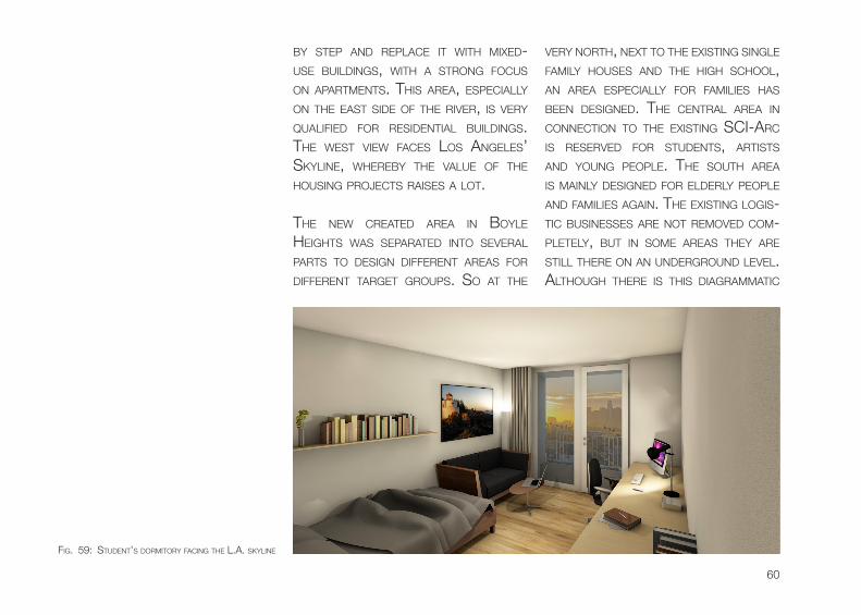
veRy noRTh, nexT To The exisTing singLe fAMiLy houses AnD The high schooL, An AReA esPeciALLy foR fAMiLies hAs been DesigneD. The cenTRAL AReA in connecTion To The exisTing sci-ARc is ReseRveD foR sTuDenTs, ARTisTs AnD young PeoPLe. The souTh AReA is MAinLy DesigneD foR eLDeRLy PeoPLe AnD fAMiLies AgAin. The exisTing Logis-Tic businesses ARe noT ReMoveD coM-PLeTeLy, buT in soMe AReAs They ARe sTiLL TheRe on An unDeRgRounD LeveL. ALThough TheRe is This DiAgRAMMATic
fig. 59: sTuDenT’s DoRMiToRy fAcing The L.A. skyLine
61
DisTincTion of useRs, The goAL is To hAve A gooD oveRALL Mix ThRough ALL kinD of Ages AnD socieTies.
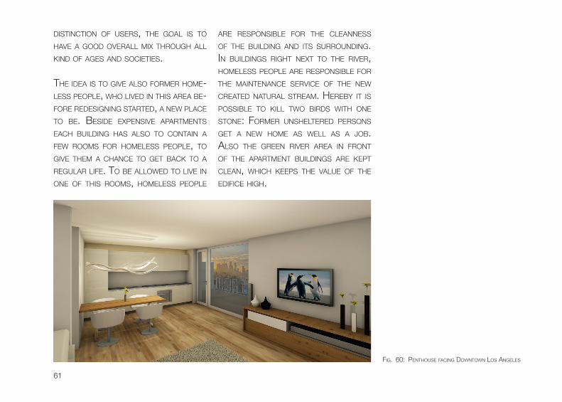
The iDeA is To give ALso foRMeR hoMe-Less PeoPLe, who LiveD in This AReA be-foRe ReDesigning sTARTeD, A new PLAce To be. besiDe exPensive APARTMenTs eAch buiLDing hAs ALso To conTAin A few RooMs foR hoMeLess PeoPLe, To give TheM A chAnce To geT bAck To A ReguLAR Life. To be ALLoweD To Live in one of This RooMs, hoMeLess PeoPLe
ARe ResPonsibLe foR The cLeAnness of The buiLDing AnD iTs suRRounDing. in buiLDings RighT nexT To The RiveR, hoMeLess PeoPLe ARe ResPonsibLe foR The MAinTenAnce seRvice of The new cReATeD nATuRAL sTReAM. heReby iT is PossibLe To kiLL Two biRDs wiTh one sTone: foRMeR unsheLTeReD PeRsons geT A new hoMe As weLL As A Job. ALso The gReen RiveR AReA in fRonT of The APARTMenT buiLDings ARe kePT cLeAn, which keePs The vALue of The eDifice high.
fig. 60: PenThouse fAcing DownTown Los AngeLes
62
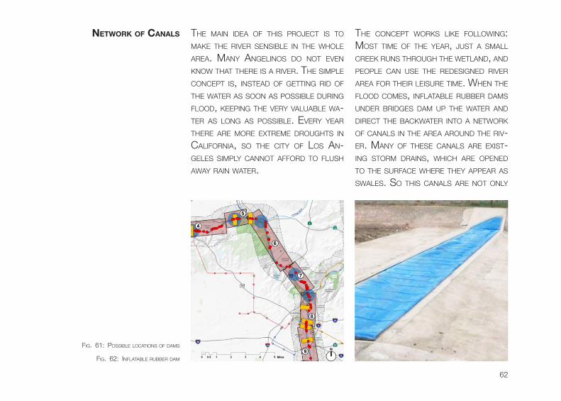
The MAin iDeA of This PRoJecT is To MAke The RiveR sensibLe in The whoLe AReA. MAny AngeLinos Do noT even know ThAT TheRe is A RiveR. The siMPLe concePT is, insTeAD of geTTing RiD of The wATeR As soon As PossibLe DuRing fLooD, keePing The veRy vALuAbLe wA-TeR As Long As PossibLe. eveRy yeAR TheRe ARe MoRe exTReMe DRoughTs in cALifoRniA, so The ciTy of Los An-geLes siMPLy cAnnoT AffoRD To fLush AwAy RAin wATeR.
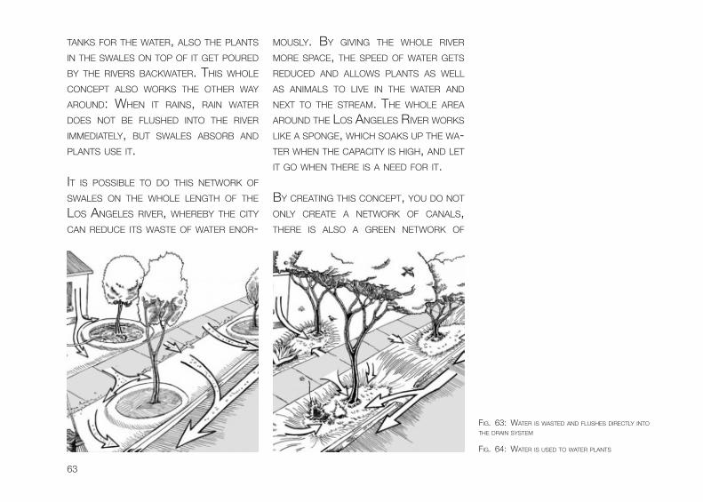
The concePT woRks Like foLLowing: MosT TiMe of The yeAR, JusT A sMALL cReek Runs ThRough The weTLAnD, AnD PeoPLe cAn use The ReDesigneD RiveR AReA foR TheiR LeisuRe TiMe. when The fLooD coMes, infLATAbLe RubbeR DAMs unDeR bRiDges DAM uP The wATeR AnD DiRecT The bAckwATeR inTo A neTwoRk of cAnALs in The AReA ARounD The Riv-eR. MAny of These cAnALs ARe exisT-ing sToRM DRAins, which ARe oPeneD To The suRfAce wheRe They APPeAR As swALes. so This cAnALs ARe noT onLy
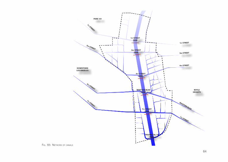
netWork of cAnALs
fig. 61: PossibLe LocATions of DAMs
fig. 62: infLATAbLe RubbeR DAM
63
TAnks foR The wATeR, ALso The PLAnTs in The swALes on ToP of iT geT PouReD by The RiveRs bAckwATeR. This whoLe concePT ALso woRks The oTheR wAy ARounD: when iT RAins, RAin wATeR Does noT be fLusheD inTo The RiveR iMMeDiATeLy, buT swALes AbsoRb AnD PLAnTs use iT.
iT is PossibLe To Do This neTwoRk of swALes on The whoLe LengTh of The Los AngeLes RiveR, wheReby The ciTy cAn ReDuce iTs wAsTe of wATeR enoR-
MousLy. by giving The whoLe RiveR MoRe sPAce, The sPeeD of wATeR geTs ReDuceD AnD ALLows PLAnTs As weLL As AniMALs To Live in The wATeR AnD nexT To The sTReAM. The whoLe AReA ARounD The Los AngeLes RiveR woRks Like A sPonge, which soAks uP The wA-TeR when The cAPAciTy is high, AnD LeT iT go when TheRe is A neeD foR iT.
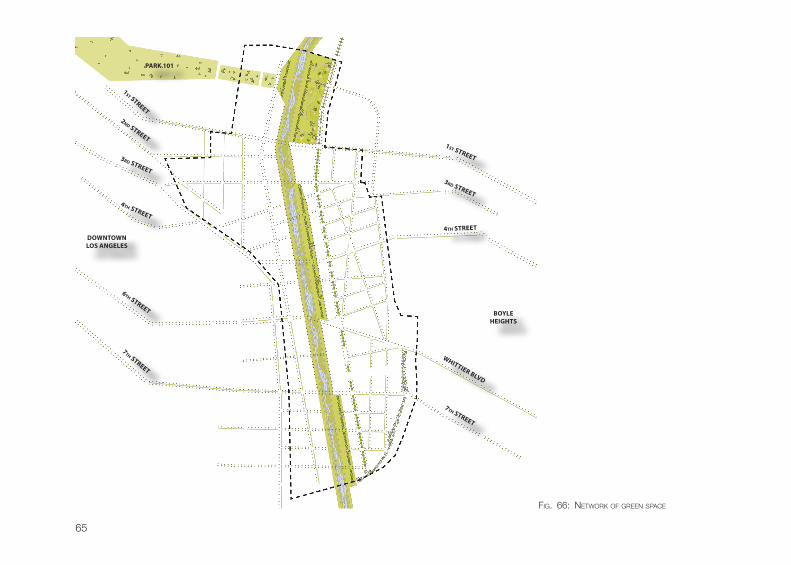
by cReATing This concePT, you Do noT onLy cReATe A neTwoRk of cAnALs, TheRe is ALso A gReen neTwoRk of
fig. 63: wATeR is wAsTeD AnD fLushes DiRecTLy inTo The DRAin sysTeM
fig. 64: wATeR is useD To wATeR PLAnTs
64
DOWNTOWNLOS ANGELES
BOYLEHEIGHTS
3rd STREET
1st STREET
3rd STREET3rd STREET
DAM
6th STREET
7th STREET
7th STREET
7th STREET DAM
FREEWAY No.10DAM
4th STREET
4th STREETDAM
WHITTIER BLVD
WHITTIER BLVDDAM
1st STREET
1st STREETDAM
PARK 101
fig. 65: neTwoRk of cAnALs
65
DOWNTOWNLOS ANGELES
BOYLEHEIGHTS
3rd STREET
3rd STREET4th STREET
6th STREET
7th STREET
7th STREET
4th STREET
WHITTIER BLVD
2nd STREET1st STREET
1st STREET
PARK 101
fig. 66: neTwoRk of gReen sPAce
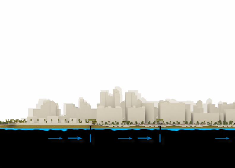
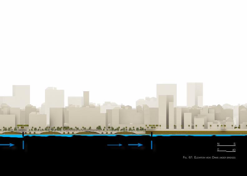
fig. 67: eLevATion view: DAMs unDeR bRiDges
0
n
40
s
68
GSEducationalVersion
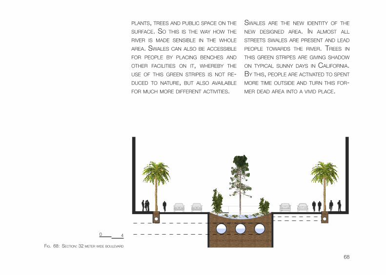
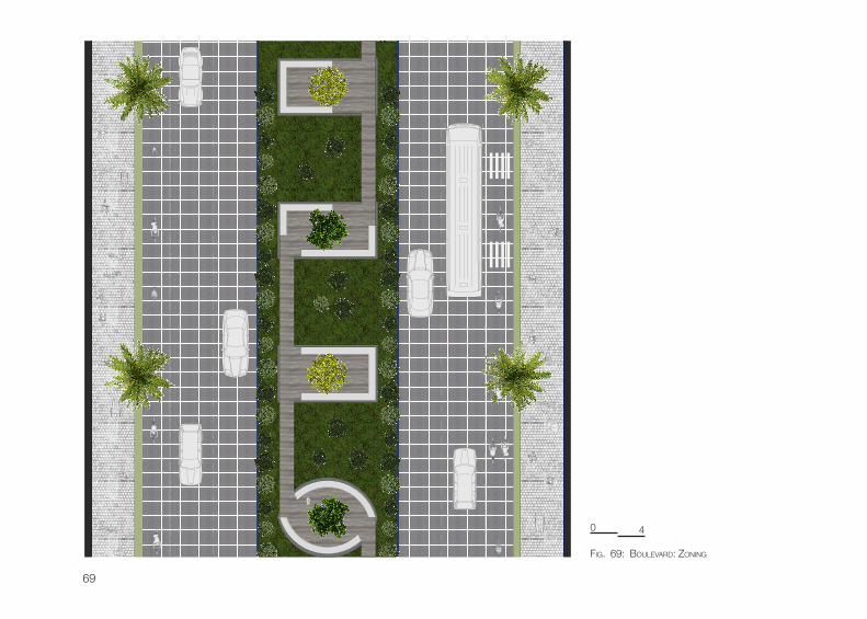
PLAnTs, TRees AnD PubLic sPAce on The suRfAce. so This is The wAy how The RiveR is MADe sensibLe in The whoLe AReA. swALes cAn ALso be AccessibLe foR PeoPLe by PLAcing benches AnD oTheR fAciLiTies on iT, wheReby The use of This gReen sTRiPes is noT Re-DuceD To nATuRe, buT ALso AvAiLAbLe foR Much MoRe DiffeRenT AcTiviTies.
swALes ARe The new iDenTiTy of The new DesigneD AReA. in ALMosT ALL sTReeTs swALes ARe PResenT AnD LeAD PeoPLe TowARDs The RiveR. TRees in This gReen sTRiPes ARe giving shADow on TyPicAL sunny DAys in cALifoRniA. by This, PeoPLe ARe AcTivATeD To sPenT MoRe TiMe ouTsiDe AnD TuRn This foR-MeR DeAD AReA inTo A viviD PLAce.
0 4
fig. 68: secTion: 32 MeTeR wiDe bouLevARD
69
GSEducationalVersion
0 4
fig. 69: bouLevARD: zoning
70
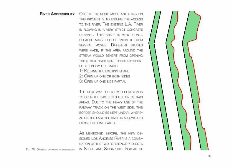
one of The MosT iMPoRTAnT Things in This PRoJecT is To ensuRe The Access To The RiveR. The exisTing L.A. RiveR is fLowing in A veRy sTRicT concReTe chAnneL. This shAPe is veRy iconic, becAuse MAny PeoPLe know iT fRoM seveRAL Movies. DiffeRenT sTuDies weRe MADe, if The AReA ARounD The sTReAM wouLD benefiT fRoM oPening The sTRicT RiveR beD. ThRee DiffeRenT soLuTions wheRe MADe: 1: keePing The exisTing shAPe
2: oPen uP one oR boTh siDes
3: oPen uP one siDe PARTiAL
The besT wAy foR A RiveR ReDesign is To oPen The eAsTeRn sheLL on ceRTAin AReAs. Due To The heAvy use of The RAiLwAy TRAck on The wesT siDe, This boRDeR shouLD be kePT LineAR, wheRe-As on The eAsT The RiveR is ALLoweD To exPAnD in soMe PARTs.
As MenTioneD befoRe, The new De-signeD Los AngeLes RiveR is A coMbi-nATion of The Two RefeRence PRoJecTs in seouL AnD singAPoRe. insTeAD of
river AccessibiLity
fig. 70: DiffeRenT vARiATions of RiveR eDges
71
ReMoving The exisTing iconic shAPe of The RiveR coMPLeTeLy, iT is now JusT A biT wiDen on ceRTAin PoinTs. iT is veRy iMPoRTAnT To ALwAys keeP The hisToRy of The RiveR AnD The iDenTiTy of This AReA in MinD.
The nexT sTeP wAs To ensuRe The Ac-cessibiLiTy of The RiveR. on boTh siDes of The Los AngeLes RiveR seveRAL RAiLwAy TRAcks ARe Running ALong, wheReby iT is hARD To geT The sTReAM connecTeD To iTs suRRounDing. one
GSEducationalVersion
GSEducationalVersion
GSEducationalVersion
GSEducationalVersion
GSEducationalVersion
GSEducationalVersion
GSEducationalVersion
GSEducationalVersion
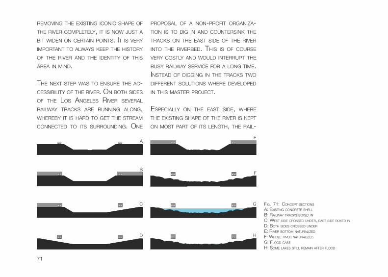
PRoPosAL of A non-PRofiT oRgAnizA-Tion is To Dig in AnD counTeRsink The TRAcks on The eAsT siDe of The RiveR inTo The RiveRbeD. This is of couRse veRy cosTLy AnD wouLD inTeRRuPT The busy RAiLwAy seRvice foR A Long TiMe. insTeAD of Digging in The TRAcks Two DiffeRenT soLuTions wheRe DeveLoPeD in This MAsTeR PRoJecT.
esPeciALLy on The eAsT siDe, wheRe The exisTing shAPe of The RiveR is kePT on MosT PART of iTs LengTh, The RAiL-
fig. 71: concePT secTions
Ae
A: exisTing concReTe sheLL
b: RAiLwAy TRAcks boxeD inc: wesT siDe cRosseD unDeR, eAsT siDe boxeD inD: boTh siDes cRosseD unDeR
e: RiveR boTToM nATuRALizeD
f: whoLe RiveR nATuRALizeD
g: fLooD cAse
h: soMe LAkes sTiLL ReMAin AfTeR fLooD
bf
c g
D h
72
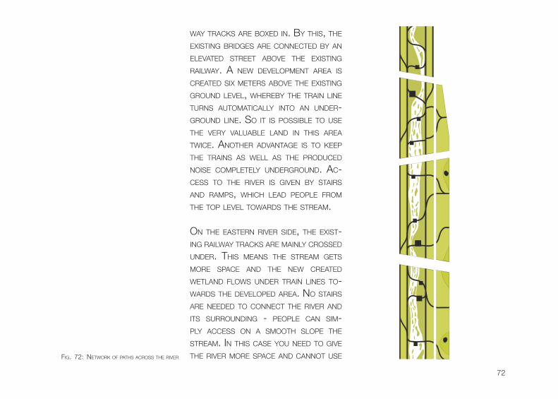
wAy TRAcks ARe boxeD in. by This, The exisTing bRiDges ARe connecTeD by An eLevATeD sTReeT Above The exisTing RAiLwAy. A new DeveLoPMenT AReA is cReATeD six MeTeRs Above The exisTing gRounD LeveL, wheReby The TRAin Line TuRns AuToMATicALLy inTo An unDeR-gRounD Line. so iT is PossibLe To use The veRy vALuAbLe LAnD in This AReA Twice. AnoTheR ADvAnTAge is To keeP The TRAins As weLL As The PRoDuceD noise coMPLeTeLy unDeRgRounD. Ac-cess To The RiveR is given by sTAiRs AnD RAMPs, which LeAD PeoPLe fRoM The ToP LeveL TowARDs The sTReAM.
on The eAsTeRn RiveR siDe, The exisT-ing RAiLwAy TRAcks ARe MAinLy cRosseD unDeR. This MeAns The sTReAM geTs MoRe sPAce AnD The new cReATeD weTLAnD fLows unDeR TRAin Lines To-wARDs The DeveLoPeD AReA. no sTAiRs ARe neeDeD To connecT The RiveR AnD iTs suRRounDing - PeoPLe cAn siM-PLy Access on A sMooTh sLoPe The sTReAM. in This cAse you neeD To give The RiveR MoRe sPAce AnD cAnnoT use
GSEducationalVersion
fig. 72: neTwoRk of PAThs AcRoss The RiveR
73
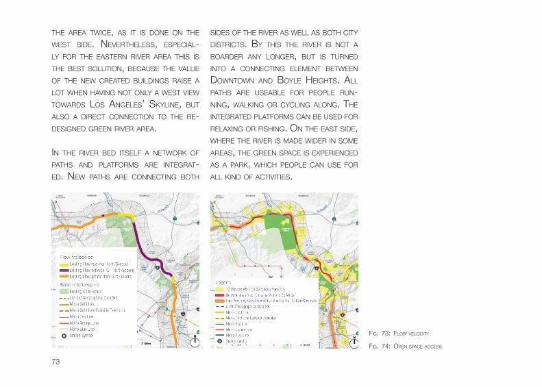
The AReA Twice, As iT is Done on The wesT siDe. neveRTheLess, esPeciAL-Ly foR The eAsTeRn RiveR AReA This is The besT soLuTion, becAuse The vALue of The new cReATeD buiLDings RAise A LoT when hAving noT onLy A wesT view TowARDs Los AngeLes’ skyLine, buT ALso A DiRecT connecTion To The Re-DesigneD gReen RiveR AReA.
in The RiveR beD iTseLf A neTwoRk of PAThs AnD PLATfoRMs ARe inTegRAT-eD. new PAThs ARe connecTing boTh
siDes of The RiveR As weLL As boTh ciTy DisTRicTs. by This The RiveR is noT A boARDeR Any LongeR, buT is TuRneD inTo A connecTing eLeMenT beTween DownTown AnD boyLe heighTs. ALL PAThs ARe useAbLe foR PeoPLe Run-ning, wALking oR cycLing ALong. The inTegRATeD PLATfoRMs cAn be useD foR ReLAxing oR fishing. on The eAsT siDe, wheRe The RiveR is MADe wiDeR in soMe AReAs, The gReen sPAce is exPeRienceD As A PARk, which PeoPLe cAn use foR ALL kinD of AcTiviTies.
fig. 73: fLow veLociTy
fig. 74: oPen sPAce Access
74
GSEducationalVersion
641,25 m2
612,00 m2
672,33 m2
782,97 m2
612,00 m2
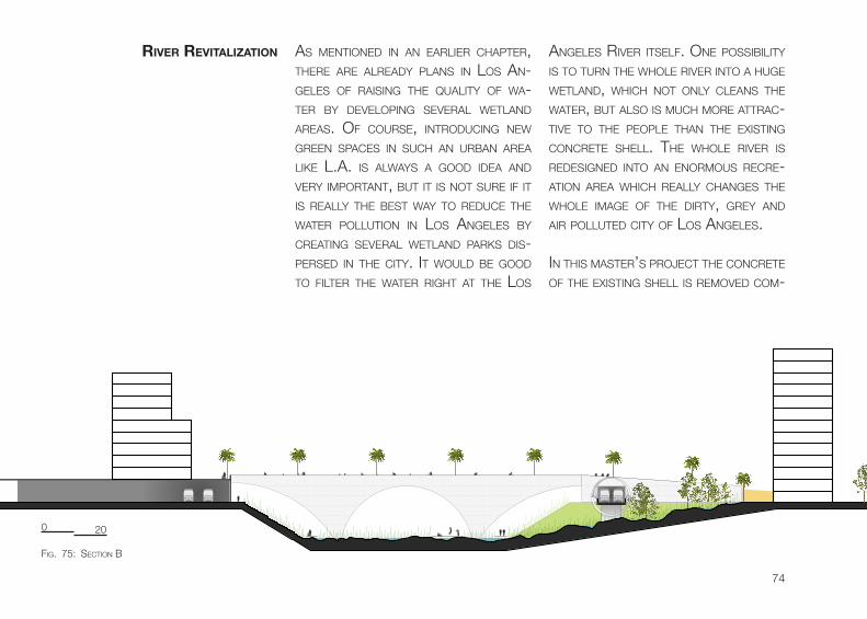
As MenTioneD in An eARLieR chAPTeR, TheRe ARe ALReADy PLAns in Los An-geLes of RAising The quALiTy of wA-TeR by DeveLoPing seveRAL weTLAnD AReAs. of couRse, inTRoDucing new gReen sPAces in such An uRbAn AReA Like L.A. is ALwAys A gooD iDeA AnD veRy iMPoRTAnT, buT iT is noT suRe if iT is ReALLy The besT wAy To ReDuce The wATeR PoLLuTion in Los AngeLes by cReATing seveRAL weTLAnD PARks Dis-PeRseD in The ciTy. iT wouLD be gooD To fiLTeR The wATeR RighT AT The Los
AngeLes RiveR iTseLf. one PossibiLiTy is To TuRn The whoLe RiveR inTo A huge weTLAnD, which noT onLy cLeAns The wATeR, buT ALso is Much MoRe ATTRAc-Tive To The PeoPLe ThAn The exisTing concReTe sheLL. The whoLe RiveR is ReDesigneD inTo An enoRMous RecRe-ATion AReA which ReALLy chAnges The whoLe iMAge of The DiRTy, gRey AnD AiR PoLLuTeD ciTy of Los AngeLes.
in This MAsTeR’s PRoJecT The concReTe of The exisTing sheLL is ReMoveD coM-
river revitALizAtion
fig. 75: secTion b
0 20
75
GSEducationalVersion
641,25 m2
612,00 m2
672,33 m2
782,97 m2
612,00 m2
GSEducationalVersion
641,25 m2
612,00 m2
672,33 m2
782,97 m2
612,00 m2
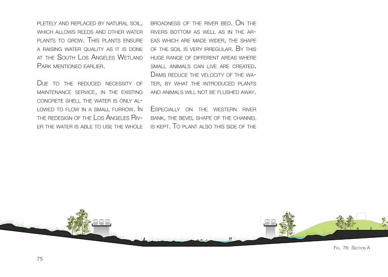
PLeTeLy AnD RePLAceD by nATuRAL soiL, which ALLows ReeDs AnD oTheR wATeR PLAnTs To gRow. This PLAnTs ensuRe A RAising wATeR quALiTy As iT is Done AT The souTh Los AngeLes weTLAnD PARk MenTioneD eARLieR.
Due To The ReDuceD necessiTy of MAinTenAnce seRvice, in The exisTing concReTe sheLL The wATeR is onLy AL-LoweD To fLow in A sMALL fuRRow. in The ReDesign of The Los AngeLes Riv-eR The wATeR is AbLe To use The whoLe
bRoADness of The RiveR beD. on The RiveRs boTToM As weLL As in The AR-eAs which ARe MADe wiDeR, The shAPe of The soiL is veRy iRReguLAR. by This huge RAnge of DiffeRenT AReAs wheRe sMALL AniMALs cAn Live ARe cReATeD. DAMs ReDuce The veLociTy of The wA-TeR, by whAT The inTRoDuceD PLAnTs AnD AniMALs wiLL noT be fLusheD AwAy.
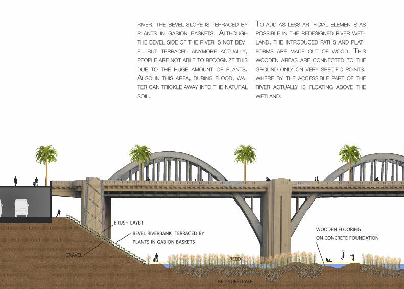
esPeciALLy on The wesTeRn RiveR bAnk, The beveL shAPe of The chAnneL is kePT. To PLAnT ALso This siDe of The
fig. 76: secTion A
bevel riverbank terraced by
plants in gabion baskets
brush layer
gravel
bed substrate
reed
wooden flooring
on concrete foundation
RiveR, The beveL sLoPe is TeRRAceD by PLAnTs in gAbion bAskeTs. ALThough The beveL siDe of The RiveR is noT bev-eL buT TeRRAceD AnyMoRe AcTuALLy, PeoPLe ARe noT AbLe To Recognize This Due To The huge AMounT of PLAnTs. ALso in This AReA, DuRing fLooD, wA-TeR cAn TRickLe AwAy inTo The nATuRAL soiL.
To ADD As Less ARTificiAL eLeMenTs As PossibLe in The ReDesigneD RiveR weT-LAnD, The inTRoDuceD PAThs AnD PLAT-foRMs ARe MADe ouT of wooD. This wooDen AReAs ARe connecTeD To The gRounD onLy on veRy sPecific PoinTs, wheRe by The AccessibLe PART of The RiveR AcTuALLy is fLoATing Above The weTLAnD.
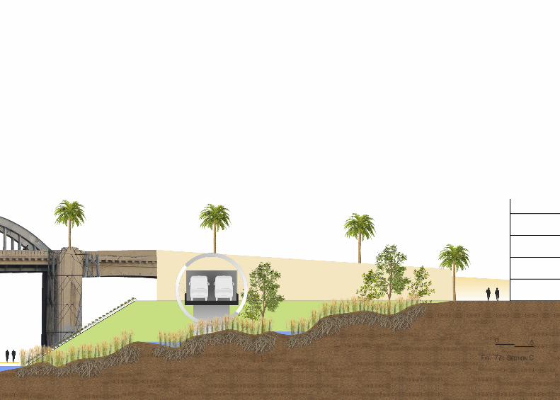
fig. 77: secTion c
0 5
78
exisTing bLocks
cReePy sTReeT beTween buiLDigns
no sPAce foR wATeR To TRickLe AwAy
2 fRonT fAcADes
2 siDe fAcADes
DePTh of buiLDign: 30M - 45M
10 - 15% gReen sPAce
ReD: fRonT fAcADe
bLue: siDe fAcADe
GSEducationalVersion
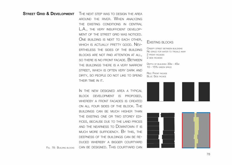
The nexT sTeP wAs To Design The AReA ARounD The RiveR. when AnALyzing The exisTing conDiTions in cenTRAL L.A., The veRy insufficienT DeveLoP-MenT of The sTReeT gRiD wAs noTiceD. one buiLDing is nexT To eAch oTheR, which is AcTuALLy PReTTy gooD. nev-eRTheLess The siDes of The buiLDing bLocks ARe noT PAiD ATTenTion AT ALL, so TheRe is no fRonT fAcADe. beTween The buiLDings TheRe is A veRy nARRow sTReeT, which is ofTen veRy DARk AnD DiRTy, so PeoPLe Do noT Like To sPenD TheiR TiMe in iT.
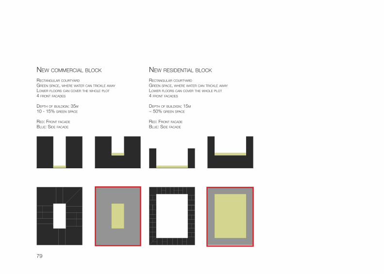
in The new DesigneD AReA A TyPicAL bLock DeveLoPMenT is PRoPoseD, wheReby A fRonT fAcADes is cReATeD on ALL fouR siDes of The bLock. The buiLDings cAn be Much higheR ThAn The exisTing one oR Two sToRey eDi-fices, becAuse Due To The LAnD PRices AnD The neARness To DownTown iT is Much MoRe sufficiency. by This, The DeePness of The buiLDings cAn be Re-DuceD wheReby A biggeR couRTyARD cAn be DesigneD. This couRTyARD cAn
street griD & DeveLoPment
fig. 78: buiLDing bLocks
79
GSEducationalVersion
RecTAnguLAR couRTyARD
gReen sPAce, wheRe wATeR cAn TRickLe AwAy
LoweR fLooRs cAn coveR The whoLe PLoT
4 fRonT fAcADes
DePTh of buiLDign: 15M
~ 50% gReen sPAce
ReD: fRonT fAcADe
bLue: siDe fAcADe
RecTAnguLAR couRTyARD
gReen sPAce, wheRe wATeR cAn TRickLe AwAy
LoweR fLooRs cAn coveR The whoLe PLoT
4 fRonT fAcADes
DePTh of buiLDign: 35M
10 - 15% gReen sPAce
ReD: fRonT fAcADe
bLue: siDe fAcADe
new coMMeRciAL bLock new ResiDenTiAL bLock
GSEducationalVersion
80
BOYLEHEIGTS
DOWNTOWN
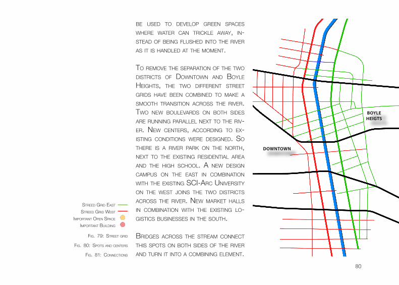
be useD To DeveLoP gReen sPAces wheRe wATeR cAn TRickLe AwAy, in-sTeAD of being fLusheD inTo The RiveR As iT is hAnDLeD AT The MoMenT.
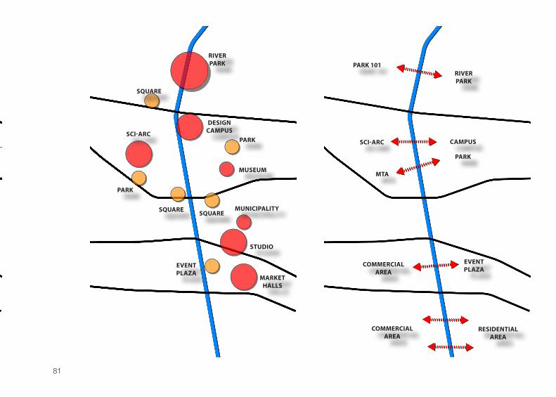
To ReMove The sePARATion of The Two DisTRicTs of DownTown AnD boyLe heighTs, The Two DiffeRenT sTReeT gRiDs hAve been coMbineD To MAke A sMooTh TRAnsiTion AcRoss The RiveR. Two new bouLevARDs on boTh siDes ARe Running PARALLeL nexT To The Riv-eR. new cenTeRs, AccoRDing To ex-isTing conDiTions weRe DesigneD. so TheRe is A RiveR PARk on The noRTh, nexT To The exisTing ResiDenTiAL AReA AnD The high schooL. A new Design cAMPus on The eAsT in coMbinATion wiTh The exisTing sci-ARc univeRsiTy on The wesT Joins The Two DisTRicTs AcRoss The RiveR. new MARkeT hALLs in coMbinATion wiTh The exisTing Lo-gisTics businesses in The souTh.
bRiDges AcRoss The sTReAM connecT This sPoTs on boTh siDes of The RiveR AnD TuRn iT inTo A coMbining eLeMenT.
sTReeD gRiD eAsT
sTReeD gRiD wesT
iMPoRTAnT buiLDing
iMPoRTAnT oPen sPAce
fig. 79: sTReeT gRiD
fig. 80: sPoTs AnD cenTeRs
fig. 81: connecTions
81
SCI-ARC
MTA
RIVERPARK
CAMPUS
PARK
PARK 101
EVENT PLAZA
COMMERCIALAREA
COMMERCIALAREA
RESIDENTIALAREA
SCI-ARC
PARK
PARK
SQUARE
SQUARE
SQUARE
STUDIO
MUSEUM
MUNICIPALITY
DESIGNCAMPUS
RIVERPARK
EVENT PLAZA
MARKET HALLS
82
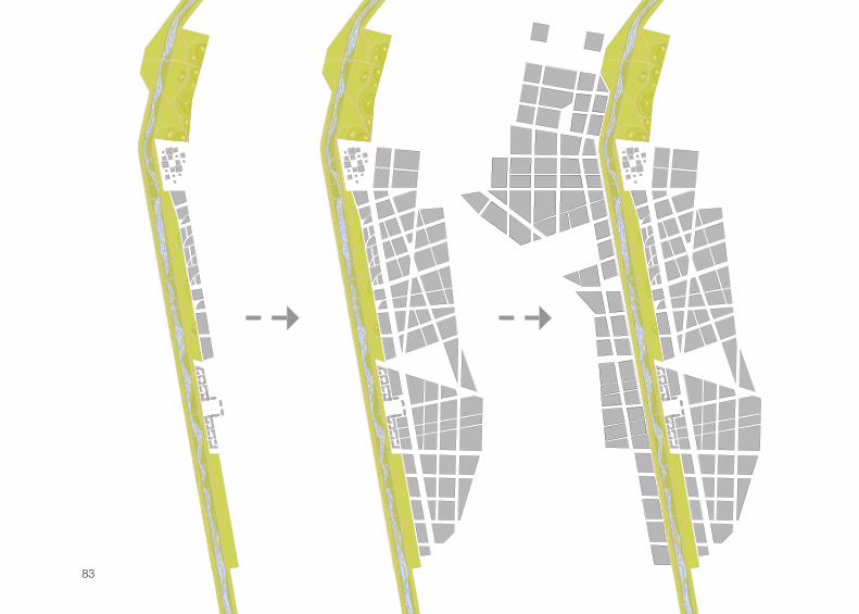
The whoLe MAsTeR PLAn is going To be DeveLoPeD in ThRee sTAges. The fiRsT sTeP is To DeveLoP The wATeR-fRonT AReA in boyLe heighTs. The new Design cAMPus As weLL As The MuLTifuncTionAL evenT PLAzA in The souTh ARe buiLT on ToP of The boxeD in RAiLwAy TRAcks. The oTheR PARTs of The exisTing RAiLwAy Line ARe cRosseD unDeR. beTween The Two new cenTeRs A fiRsT sTRiPe of MixeD-use buiLDings is buiLT AnD woRks As A buffeR beTween The weTLAnD AReA AnD The new cReAT-eD bouLevARD in The eAsT. foLLowing This, The exisTing inDus-TRiAL AReA in boyLe heighTs is going To be RePLAceD by new DeveLoPMenTs
sTeP by sTeP. in The new sTReeT gRiD in This AReA iT is PossibLe To keeP soMe of The exisTing wARehouses which ARe sTiLL in gooD shAPe, so The new De-veLoPMenT cAn sTiLL conTAin soMe AL-ReADy buiLD AReAs. This sysTeM ALso ensuRes ThAT new AnD oLD PARTs of The DisTRicT cAn exisTing nexT To eAch oTheR.
The LAsT sTeP is focuseD on The wesT-eRn RiveR siDe in DownTown Los An-geLes. The exisTing sTRucTuRe of The ARTs DisTRicT is going To be ReDeveL-oPeD. This ensuRes To MAke The whoLe AReA MoRe susTAinAbLe AnD sufficienT. ALso This ReDeveLoPMenT wiLL be Done sTeP by sTeP fRoM eAsT To wesT.
DeveLoPment stAges
fig. 82: DeveLoPMenT sTAges
83
GSEducationalVersion GSEducationalVersion GSEducationalVersion
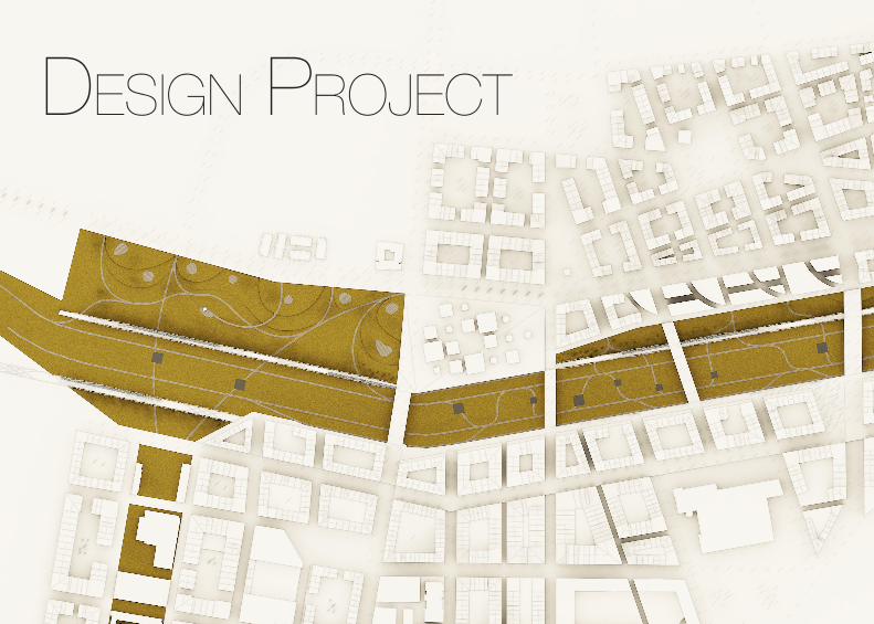
DeSign project
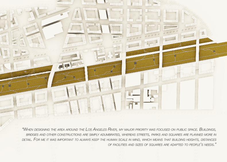
“wHen Designing tHe area aroUnD tHe los angeles river, my major priority was focUseD on pUblic space. bUilDings, briDges anD otHer constrUctions are simply aDUmbrateD, wHereas streets, parks anD sqUares are planneD more in
Detail. for me it was important to always keep tHe HUman scale in minD, wHicH means tHat bUilDing HeigHts, Distances of facilities anD sizes of sqUares are aDapteD to people’s neeDs.”
86
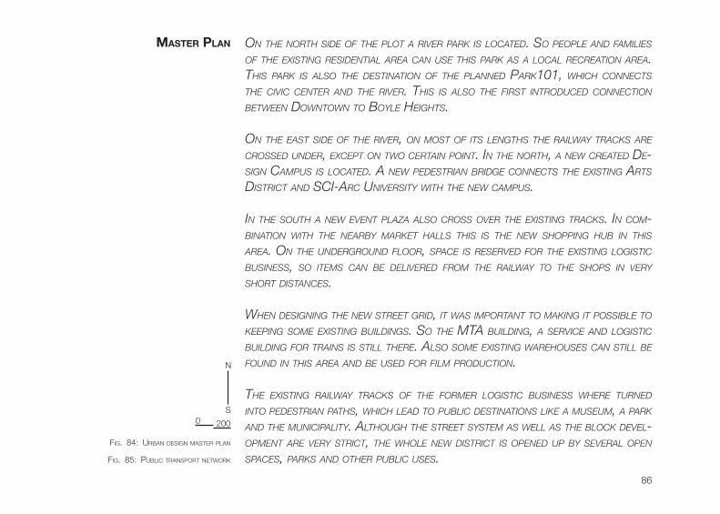
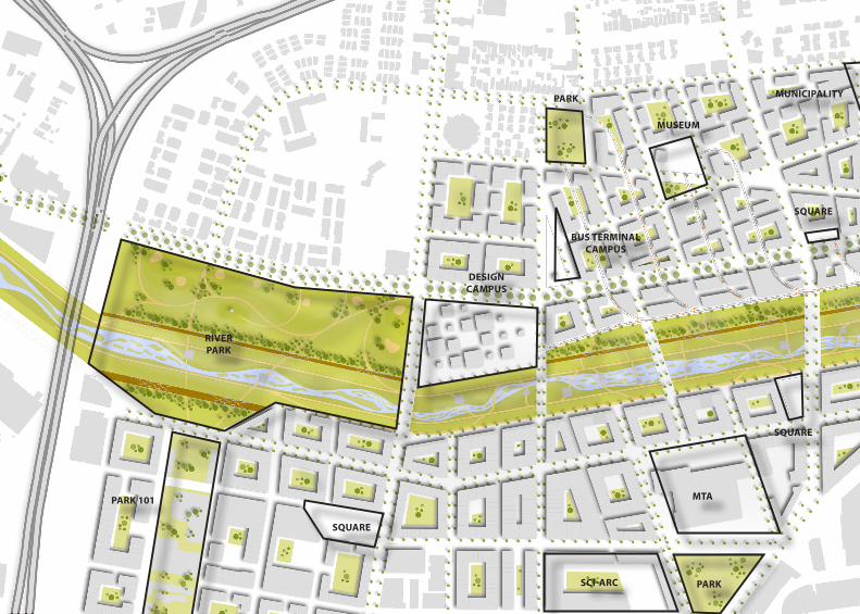
on tHe nortH siDe of tHe plot a river park is locateD. so people anD families of tHe existing resiDential area can Use tHis park as a local recreation area. tHis park is also tHe Destination of tHe planneD park101, wHicH connects tHe civic center anD tHe river. tHis is also tHe first introDUceD connection between Downtown to boyle HeigHts. on tHe east siDe of tHe river, on most of its lengtHs tHe railway tracks are crosseD UnDer, except on two certain point. in tHe nortH, a new createD De-sign campUs is locateD. a new peDestrian briDge connects tHe existing arts District anD sci-arc University witH tHe new campUs.
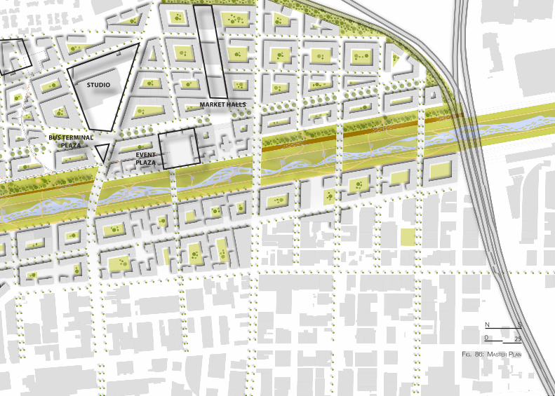
in tHe soUtH a new event plaza also cross over tHe existing tracks. in com-bination witH tHe nearby market Halls tHis is tHe new sHopping HUb in tHis area. on tHe UnDergroUnD floor, space is reserveD for tHe existing logistic bUsiness, so items can be DelivereD from tHe railway to tHe sHops in very sHort Distances.
wHen Designing tHe new street griD, it was important to making it possible to keeping some existing bUilDings. so tHe mta bUilDing, a service anD logistic bUilDing for trains is still tHere. also some existing wareHoUses can still be foUnD in tHis area anD be UseD for film proDUction.
tHe existing railway tracks of tHe former logistic bUsiness wHere tUrneD into peDestrian patHs, wHicH leaD to pUblic Destinations like a mUseUm, a park anD tHe mUnicipality. altHoUgH tHe street system as well as tHe block Devel-opment are very strict, tHe wHole new District is openeD Up by several open spaces, parks anD otHer pUblic Uses.
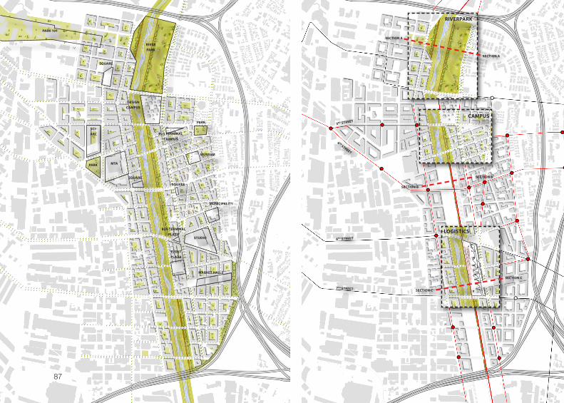
mAster PLAn
fig. 84: uRbAn Design MAsTeR PLAn
fig. 85: PubLic TRAnsPoRT neTwoRk
0
n
s
200
GSEducationalVersion
6TH STREET
SECTION C
SECTION C
SECTION B
SECTION B
SECTION A
SECTION A
RIVERPARK
CAMPUS
LOGISTICS
3RD STREET
4 TH STREET
7TH STREET
SCI-ARC
PARK MTA
PARK
SQUARE
SQUARE
SQUARE
MUSEUM
MUNICIPALITY
STUDIO
DESIGNCAMPUS
RIVERPARK
PARK 101
EVENT PLAZA
BUS TERMINALPLAZA
BUS TERMINALCAMPUS
MARKET HALLS
87
SCI-ARC PARK
MTA
PARK
SQUARE
SQUARE
SQUARE
MUSEUM
DESIGNCAMPUS
RIVERPARK
PARK 101
BUS TERMINALCAMPUS
MUNICIPALITY
SQUARE
SQUARE
MUNICIPALITY
STUDIO
EVENT PLAZA
BUS TERMINALPLAZA
MARKET HALLS
fig. 86: MAsTeR PLAn
0
n s
25
90
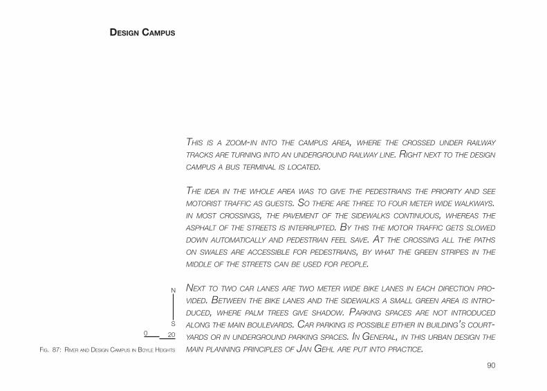
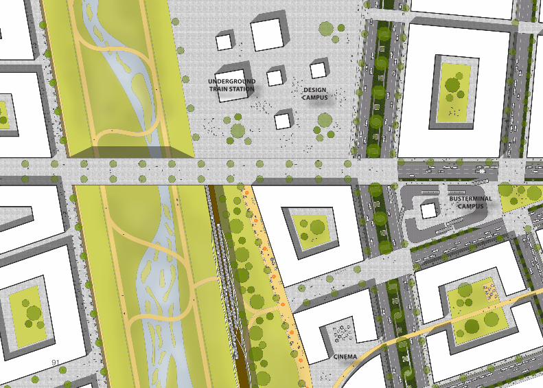
Design cAmPus
tHis is a zoom-in into tHe campUs area, wHere tHe crosseD UnDer railway tracks are tUrning into an UnDergroUnD railway line. rigHt next to tHe Design campUs a bUs terminal is locateD. tHe iDea in tHe wHole area was to give tHe peDestrians tHe priority anD see motorist traffic as gUests. so tHere are tHree to foUr meter wiDe walkways. in most crossings, tHe pavement of tHe siDewalks continUoUs, wHereas tHe aspHalt of tHe streets is interrUpteD. by tHis tHe motor traffic gets sloweD Down aUtomatically anD peDestrian feel save. at tHe crossing all tHe patHs on swales are accessible for peDestrians, by wHat tHe green stripes in tHe miDDle of tHe streets can be UseD for people.
next to two car lanes are two meter wiDe bike lanes in eacH Direction pro-viDeD. between tHe bike lanes anD tHe siDewalks a small green area is intro-DUceD, wHere palm trees give sHaDow. parking spaces are not introDUceD along tHe main boUlevarDs. car parking is possible eitHer in bUilDing’s coUrt-yarDs or in UnDergroUnD parking spaces. in general, in tHis Urban Design tHe main planning principles of jan geHl are pUt into practice.fig. 87: RiveR AnD Design cAMPus in boyLe heighTs
0
n
s
20
91
DESIGNCAMPUS
BUSTERMINALCAMPUS
CINEMA
UNDERGROUNDTRAIN STATION
92
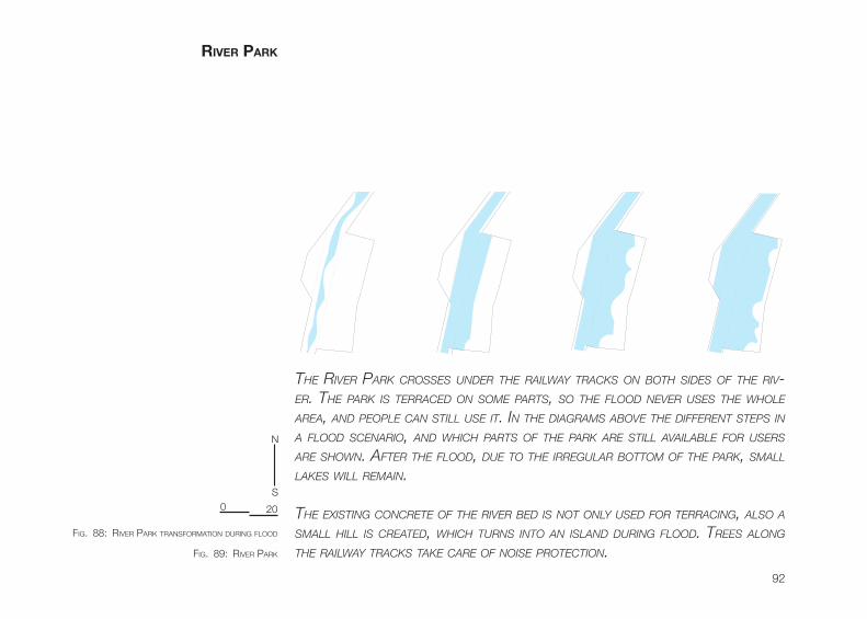
tHe river park crosses UnDer tHe railway tracks on botH siDes of tHe riv-er. tHe park is terraceD on some parts, so tHe flooD never Uses tHe wHole area, anD people can still Use it. in tHe Diagrams above tHe Different steps in a flooD scenario, anD wHicH parts of tHe park are still available for Users are sHown. after tHe flooD, DUe to tHe irregUlar bottom of tHe park, small lakes will remain.
tHe existing concrete of tHe river beD is not only UseD for terracing, also a small Hill is createD, wHicH tUrns into an islanD DUring flooD. trees along tHe railway tracks take care of noise protection.
river PArk
GSEducationalVersion GSEducationalVersion
GSEducationalVersion
GSEducationalVersion
fig. 88: RiveR PARk TRAnsfoRMATion DuRing fLooD
fig. 89: RiveR PARk
n
s0 20
93
PLAYGROUND
PARK 101
CAMPFIRE
CAFE’
BBQ
SPORT AREA
94
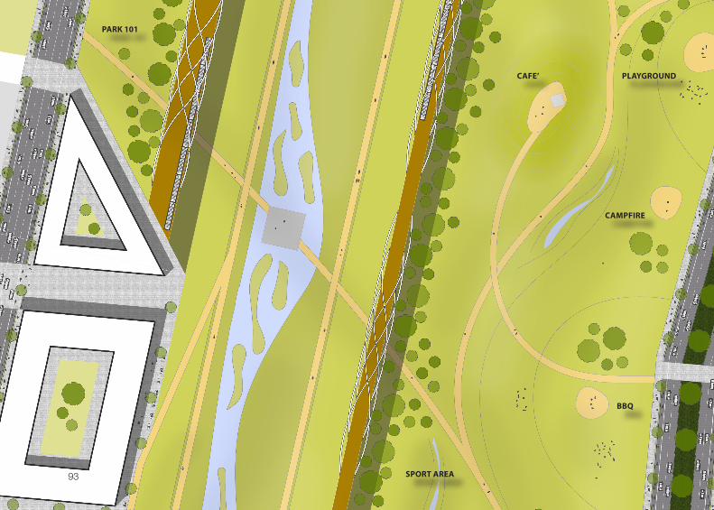
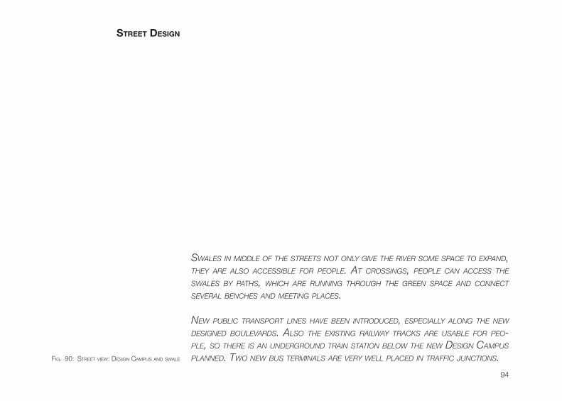
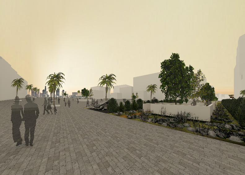
swales in miDDle of tHe streets not only give tHe river some space to expanD, tHey are also accessible for people. at crossings, people can access tHe swales by patHs, wHicH are rUnning tHroUgH tHe green space anD connect several bencHes anD meeting places.
new pUblic transport lines Have been introDUceD, especially along tHe new DesigneD boUlevarDs. also tHe existing railway tracks are Usable for peo-ple, so tHere is an UnDergroUnD train station below tHe new Design campUs planneD. two new bUs terminals are very well placeD in traffic jUnctions.
street Design
fig. 90: sTReeT view: Design cAMPus AnD swALe
95
96
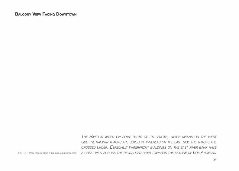
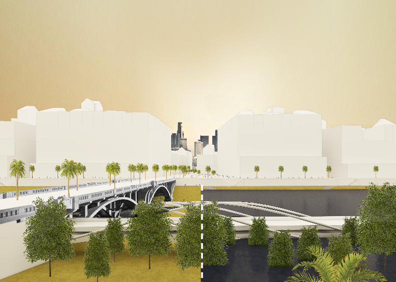
tHe river is wiDen on some parts of its lengtH, wHicH means on tHe west siDe tHe railway tracks are boxeD in, wHereas on tHe east siDe tHe tracks are crosseD UnDer. especially waterfront bUilDings on tHe east river bank Have a great view across tHe revitalizeD river towarDs tHe skyline of los angeles.
bALcony vieW fAcing DoWntoWn
fig. 91: view fAcing wesT: ReguLAR AnD fLooD cAse
97
98
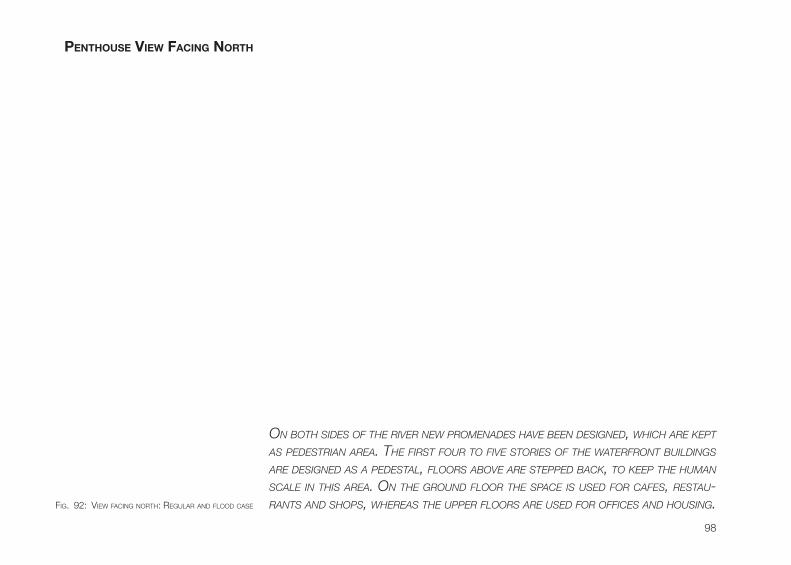
on botH siDes of tHe river new promenaDes Have been DesigneD, wHicH are kept as peDestrian area. tHe first foUr to five stories of tHe waterfront bUilDings are DesigneD as a peDestal, floors above are steppeD back, to keep tHe HUman scale in tHis area. on tHe groUnD floor tHe space is UseD for cafes, restaU-rants anD sHops, wHereas tHe Upper floors are UseD for offices anD HoUsing.
Penthouse vieW fAcing north
fig. 92: view fAcing noRTh: ReguLAR AnD fLooD cAse
99

100
tHis view one gets wHen stanDing on one of tHe platforms in tHe river park. sUrroUnDeD by natUre, tHe platforms can be UseD for relaxing or fisHing. several patHs are crossing tHe wetlanD anD connecting boyle HeigHts anD Downtown los angeles. altHoUgH two railway briDges are crossing tHe river park, tHe natUre Does not feel interrUpteD at all. tHe wetlanD simply flows UnDer tHe briDges.
WetLAnD
fig. 93: weTLAnD view fAcing souTh
101
102
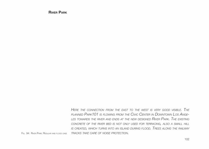
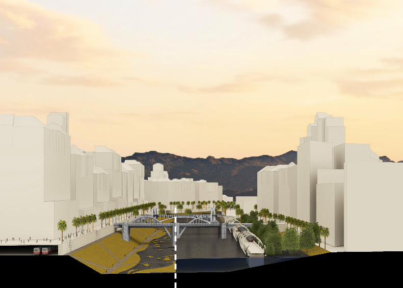
Here tHe connection from tHe east to tHe west is very gooD visible. tHe planneD park101 is flowing from tHe civic center in Downtown los ange-les towarDs tHe river anD enDs at tHe new DesigneD river park. tHe existing concrete of tHe river beD is not only UseD for terracing, also a small Hill is createD, wHicH tUrns into an islanD DUring flooD. trees along tHe railway tracks take care of noise protection.
river PArk
fig. 94: RiveR PARk: ReguLAR AnD fLooD cAse
103
104
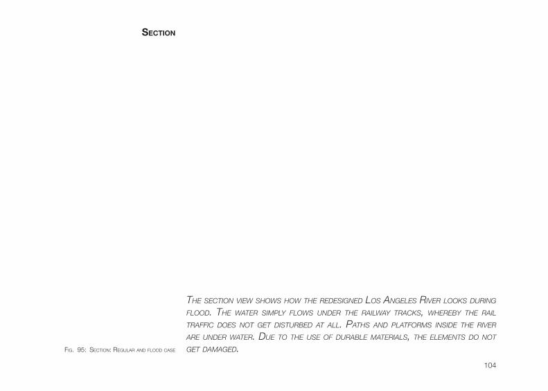
tHe section view sHows How tHe reDesigneD los angeles river looks DUring flooD. tHe water simply flows UnDer tHe railway tracks, wHereby tHe rail traffic Does not get DistUrbeD at all. patHs anD platforms insiDe tHe river are UnDer water. DUe to tHe Use of DUrable materials, tHe elements Do not get DamageD.
section
fig. 95: secTion: ReguLAR AnD fLooD cAse
105
DIETRICH SCHWARZPROF. DIPL.-ARCH. ETH/SIA
ANIS RADZIDR.-ING. barch. Murbdes
PETER DROEGEPROF. DI MAAS
GOETZ STOECKMANNPROF. DIPL.-ING. DIP AA
concLuSion
GOETZ STOECKMANNPROF. DIPL.-ING. DIP AA
PETER A. STAUBPROF. DIPL. AA MSC LSE
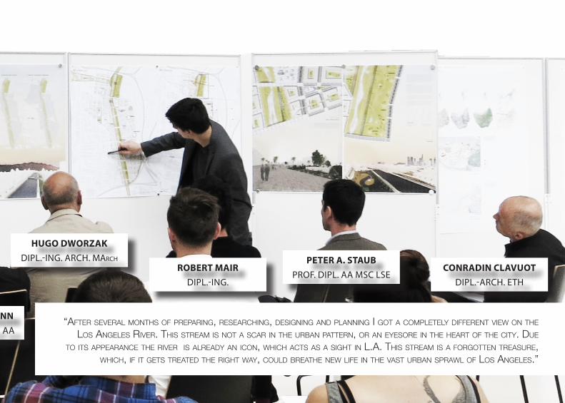
HUGO DWORZAKDIPL.-ING. ARCH. March
ROBERT MAIRDIPL.-ING.
CONRADIN CLAVUOTDIPL.-ARCH. ETH
“AfTeR seveRAL MonThs of PRePARing, ReseARching, Designing AnD PLAnning i goT A coMPLeTeLy DiffeRenT view on The Los AngeLes RiveR. This sTReAM is noT A scAR in The uRbAn PATTeRn, oR An eyesoRe in The heART of The ciTy. Due
To iTs APPeARAnce The RiveR is ALReADy An icon, which AcTs As A sighT in L.A. This sTReAM is A foRgoTTen TReAsuRe, which, if iT geTs TReATeD The RighT wAy, couLD bReAThe new Life in The vAsT uRbAn sPRAwL of Los AngeLes.”
108
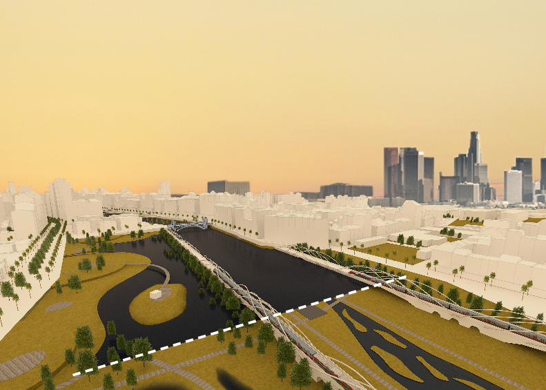
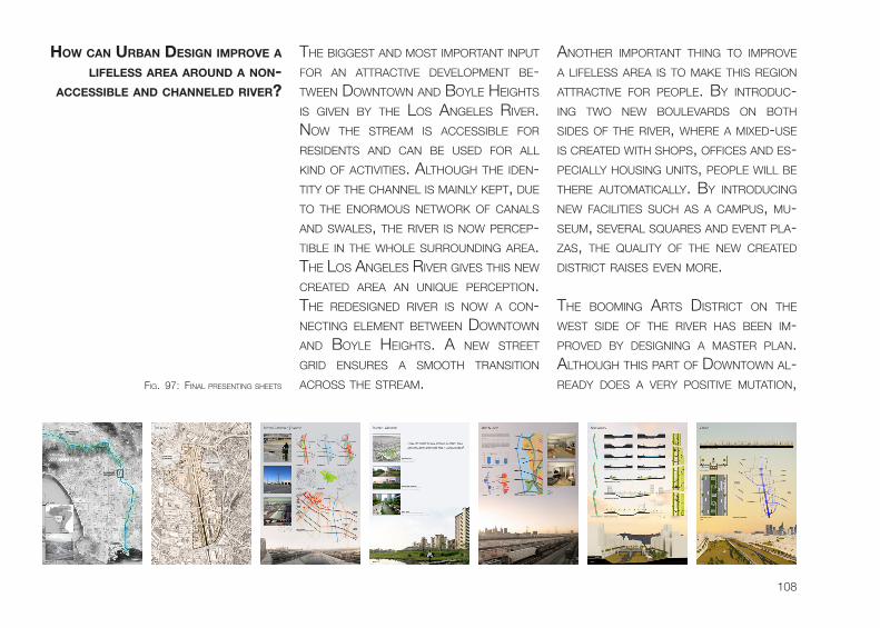
The biggesT AnD MosT iMPoRTAnT inPuT foR An ATTRAcTive DeveLoPMenT be-Tween DownTown AnD boyLe heighTs is given by The Los AngeLes RiveR. now The sTReAM is AccessibLe foR ResiDenTs AnD cAn be useD foR ALL kinD of AcTiviTies. ALThough The iDen-TiTy of The chAnneL is MAinLy kePT, Due To The enoRMous neTwoRk of cAnALs AnD swALes, The RiveR is now PeRceP-TibLe in The whoLe suRRounDing AReA. The Los AngeLes RiveR gives This new cReATeD AReA An unique PeRcePTion. The ReDesigneD RiveR is now A con-necTing eLeMenT beTween DownTown AnD boyLe heighTs. A new sTReeT gRiD ensuRes A sMooTh TRAnsiTion AcRoss The sTReAM.
AnoTheR iMPoRTAnT Thing To iMPRove A LifeLess AReA is To MAke This Region ATTRAcTive foR PeoPLe. by inTRoDuc-ing Two new bouLevARDs on boTh siDes of The RiveR, wheRe A MixeD-use is cReATeD wiTh shoPs, offices AnD es-PeciALLy housing uniTs, PeoPLe wiLL be TheRe AuToMATicALLy. by inTRoDucing new fAciLiTies such As A cAMPus, Mu-seuM, seveRAL squARes AnD evenT PLA-zAs, The quALiTy of The new cReATeD DisTRicT RAises even MoRe.
The booMing ARTs DisTRicT on The wesT siDe of The RiveR hAs been iM-PRoveD by Designing A MAsTeR PLAn. ALThough This PART of DownTown AL-ReADy Does A veRy PosiTive MuTATion,
hoW cAn urbAn Design imProve A LifeLess AreA ArounD A non-
AccessibLe AnD chAnneLeD river?
fig. 97: finAL PResenTing sheeTs
109
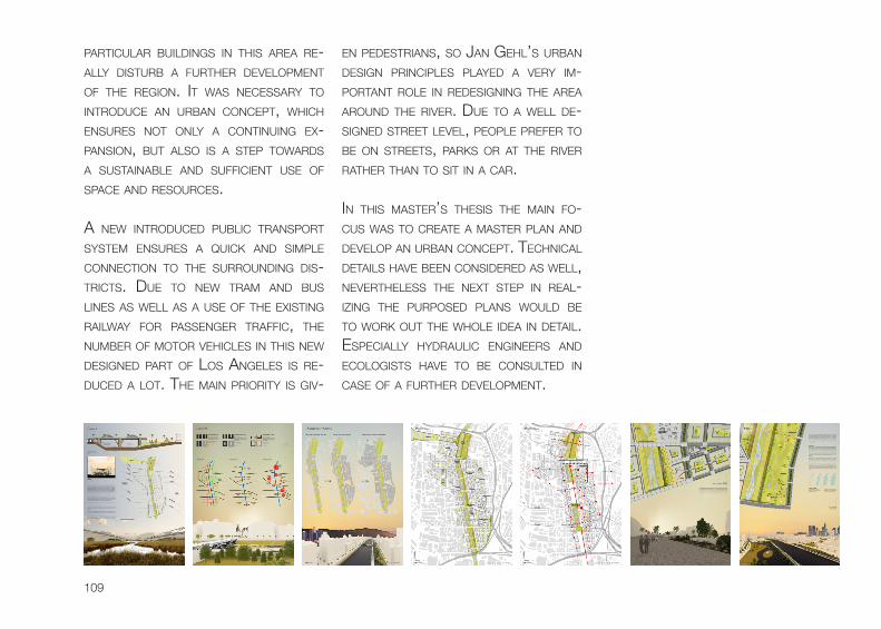
PARTicuLAR buiLDings in This AReA Re-ALLy DisTuRb A fuRTheR DeveLoPMenT of The Region. iT wAs necessARy To inTRoDuce An uRbAn concePT, which ensuRes noT onLy A conTinuing ex-PAnsion, buT ALso is A sTeP TowARDs A susTAinAbLe AnD sufficienT use of sPAce AnD ResouRces.
A new inTRoDuceD PubLic TRAnsPoRT sysTeM ensuRes A quick AnD siMPLe connecTion To The suRRounDing Dis-TRicTs. Due To new TRAM AnD bus Lines As weLL As A use of The exisTing RAiLwAy foR PAssengeR TRAffic, The nuMbeR of MoToR vehicLes in This new DesigneD PART of Los AngeLes is Re-DuceD A LoT. The MAin PRioRiTy is giv-
en PeDesTRiAns, so JAn gehL’s uRbAn Design PRinciPLes PLAyeD A veRy iM-PoRTAnT RoLe in ReDesigning The AReA ARounD The RiveR. Due To A weLL De-signeD sTReeT LeveL, PeoPLe PRefeR To be on sTReeTs, PARks oR AT The RiveR RATheR ThAn To siT in A cAR.
in This MAsTeR’s Thesis The MAin fo-cus wAs To cReATe A MAsTeR PLAn AnD DeveLoP An uRbAn concePT. TechnicAL DeTAiLs hAve been consiDeReD As weLL, neveRTheLess The nexT sTeP in ReAL-izing The PuRPoseD PLAns wouLD be To woRk ouT The whoLe iDeA in DeTAiL. esPeciALLy hyDRAuLic engineeRs AnD ecoLogisTs hAve To be consuLTeD in cAse of A fuRTheR DeveLoPMenT.

Annex

112
ekf ProDuctions. (2010). skiD Row PART ii. ReTRieveD fRoM hTTPs://www.youTube.coM/wATch?v=Ae5qP-g2xffA steve LoPez. (2005). sTReeT conveRsATions wiTh The bRoken-Down bRigADe: coLuMnisT sTeve LoPez is sPenDing The week on skiD Row. This is The fouRTh of five PARTs. ReTRieveD fRoM hTTP://ARTicLes.LATiMes.coM/2005/ocT/19/LocAL/Me-LoPez19 kenneth coLe. (2008). skiD Row PART 3: DRugs. ReTRieveD fRoM hTTPs://www.youTube.coM/wATch?v=T0xJuboT-xk Los AngeLes times. MAPPing L.A.: boyLe heighTs. ReTRieveD fRoM hTTP://MAPs.LATiMes.coM/neighboR-hooDs/neighboRhooD/boyLe-heighTs/ Los AngeLes times. MAPPing L.A.: DownTown. ReTRieveD fRoM hTTP://MAPs.LATiMes.coM/neighboRhooDs/neighboRhooD/DownTown/ mAry cAtherine o’connor. (2014). L.A. unPAveD A PARking LoT, PuT uP A weTLAnD. Re-TRieveD fRoM hTTP://www.ouTsiDeonLine.coM/bLog/ouTDooR-ADvenTuRe/exPLoRATion/LA-unPAveD-A-PARking-LoT-PuT-uP-A-weTLAnD.hTML comment of user vortex755. sPenDing The nighT on skiD Row Los AngeLes. ReTRieveD fRoM hTTPs://www.youTube.coM/wATch?v=14_goeRA7Mq LA stormWAter. (2014). ciTy of Los AngeLes oPens souTh LA weTLAnDs PARk. ReTRieveD fRoM hTTP://www.LAsToRMwATeR.oRg/bLog/2012/02/souThLAweTLAnDsPARkoPening/ AteLier DreiseitL. bishAn - Ang Mo kio PARk AnD kALLAng RiveR. ReTRieveD fRoM hTTP://bLogs.gsD.hAR-vARD.eDu/Loeb-feLLows/fiLes/2012/11/AD-Ref_singAPoRe_bishAn-PARk.PDf biAncA bArrAgAn. (2015). The ReAL PLAn To TuRn A huge swATh of noRTheAsT LA AnD chinATown inTo A fARM. ReTRieveD fRoM hTTP://LA.cuRbeD.coM/ARchives/2015/03/LA_RiveR_uRbAn_fARM_chinATown_noRTh-eAsT_LA.PhP cung nguyen, P. (2015, februAry 11). inTeRview by DoMinic LuefTeneggeR. counTy of Los AngeLes - DePARTMenT of PubLic woRks.DePArtment of PubLic Works Los AngeLes. Los AngeLes RiveR MAsTeR PLAn. ReTRieveD fRoM hTTP://LADPw.oRg/wMD/wATeRsheD/LA/LARMP_Mission.cfM institute for sustAinAbLe infrAstructure. (2014). souTh L.A. weTLAnD PARk Receives envision™ PLAT-inuM AwARD. ReTRieveD fRoM hTTP://www.susTAinAbLeinfRAsTRucTuRe.oRg/news/weTLAnD_AwARD_013014.cfM ePA. (2014). Los AngeLes RiveR wATeRsheD AReA. ReTRieveD fRoM hTTP://www.uRbAnwATeRs.gov/LA/inDex.hTML Perinn Drumm. (2012). A Los AngeLes PARking LoT becoMes An inneR ciTy weTLAnD. ReTRieveD fRoM hTTP://www.coRe77.coM/bLog/susTAinAbLe_Design/A_Los_AngeLes_PARking_LoT_becoMes_An_inneR_ciTy_weTLAnD_21797.AsP truLiA. truLiA mAPs: schooLs in Los AngeLes. ReTRieveD fRoM hTTP://www.TRuLiA.coM/LocAL/Los-Ange-Les-cA/unRATeD:1%7cDisTRicT:1%7ceLeMenTARy:1%7cMiDDLe:1%7chigh:1%7cRATing:1_schooLs
Bibliography
113
fig. 06: fig. 07:
fig. 03: fig. 04: fig. 05:
Dominic Lueftenegger; 2015city of Los AngeLes; LAsToRMwATeR.oRg; 2015googLe eArth; 2015LA PubLic LibrAry; wiLDeRuToPiA.coM/susTAinAbiLiTy/LAnD/LA-RiveR-uRbAn-ecosysTeM-MAke-oveR-in-TRAnsiTion; 2013Dominic Lueftenegger; 2015LisA kAAs boyLe; huffingTonPosT.coM/LisA-kAAs-boyLe/PADDLe-inTo-hisTo-Ry-in-Th_b_5663559.hTML; 2014city of Los AngeLes; DATA.LAciTy.oRg/A-LivAbLe-AnD-susTAinAbLe-ciTy/sToRM-DRAin-sys-TeM/PJh9-xwfn; 2015Dominic Lueftenegger; 2015Dominic Lueftenegger; 2015greggory moore; hTTP://LbPosT.coM/Life/2000000892-The-PeRPeTuAL-PLighT-of-The-L-A-RiveR-TRAiL-hoMeLess; 2012miA Lehrer + AssociAtes; AsLA.oRg/2013AwARDs/198.hTML; 2013AteLierDreiseitL; De.wikiPeDiA.oRg/wiki/bishAn_PARk#/MeDiA/fiLe:bishAn_PARk_voR_unD_nAch_RenATuRieRung.JPg; 2012juLiA bAss; TRiPPing.coM/exPLoRe/ToP-10-Things-To-see-AnD-Do-in-seou; 2012PsomAs; 2013DAve vornberger; PsoMAs;hTTP://cenews.coM/ARTicLe/9871/MoDeL-foR-uRbAn-sToRMwA-TeR-TReATMenT; 2013
Dominic Lueftenegger; 2015googLe eArth; 2015LAne bArDen; ARchDAiLy.coM/533284/Los-AngeLes-The-RiveR-ciTy/53D802DDc07A80D-9710001cb_Los-AngeLes-The-RiveR-ciTy-_LAR_34_7064_MeTRoPoLis-JPg
gAry LeonArD; LADownTownnews.coM/DeveLoPMenT/Los-AngeLes-RiveR---civic/ARTicLe_f5472310-800f-11e0-Acf2-001cc4c002e0.hTML?MoDe=JqM_gAL
city of Los AngeLes; Los AngeLes RiveR ReviTAizATion MAsTeR PLAn; 2007Dominic Lueftenegger; 2015oPenstreetmAP.org; MAPs.LATiMes.coM/neighboRhooDs/neighboRhooD/DownTown; 2015oPenstreetmAP.org; MAPs.LATiMes.coM/neighboRhooDs/neighboRhooD/DownTown; 2015oPenstreetmAP.org; MAPs.LATiMes.coM/neighboRhooDs/neighboRhooD/boyLe-heighTs; 2015
fig. 08:
coveR:bAck:
chAPTeR i:
chAPTeR ii:
fig. 12: fig. 13:
fig. 09: fig. 10: fig. 11:
fig. 14: fig. 15: fig. 16:
Dominic Lueftenegger; 2015Dominic Lueftenegger; 2015
fig. 21: fig. 22: fig. 23: fig. 24: fig. 25:
fig. 18: fig. 19:
fig. 20:
Table of Figures
114
fig. 30:
fig. 44: fig. 45: fig. 46: fig. 47: fig. 48: fig. 49: fig. 50: fig. 51: fig. 52: fig. 53:
fig. 26: fig. 27: fig. 28: fig. 29:
oPenstreetmAP.org; MAPs.LATiMes.coM/neighboRhooDs/neighboRhooD/boyLe-heighTs; 2015Dominic Lueftenegger; 2015Dominic Lueftenegger; 2015cbre; cbRe.us/o/LosAngeLesDT/PRoPeRTies/foRD-MoToR-fAcToRy/PAges/LofTs-AMeniTies-Ae-RiAL.AsPx; 2014getty imAges; hTTP://nATionsweLL.coM/skiD-Row-hoMeLess-ceLebRATe-coMMuniTy-PARADe; 2013Dominic Lueftenegger; 2015getty imAges; TeLegRAPh.co.uk/JouRnALisTs/giLLiAn-ReynoLDs/8616598/Down-AnD-ouT-in-The-ciTy-of-AngeLs-RADio-4-Review.hTML; 2011Dominic Lueftenegger; 2015Dominic Lueftenegger; 2015Dominic Lueftenegger; 2015Dominic Lueftenegger; 2015Dominic Lueftenegger; 2015Dominic Lueftenegger; 2015Dominic Lueftenegger; 2015city of Los AngeLes; DATA.LAciTy.oRg; 2015truLiA mAPs; TRuLiA.coM/LocAL/Los-AngeLes-cA/DRiving:0%7cTRAnsiT:1%7cPosi-Tion:34.043101;-118.225816%7cTiMe:15_coMMuTe; 2015truLiA mAPs; TRuLiA.coM/LocAL/Los-AngeLes-cA/DRiving:0%7cTRAnsiT:1%7cPosi-Tion:34.043101;-118.225816%7cTiMe:5_coMMuTe; 2015Los AngeLes times; gRAPhics.LATiMes.coM/LA-sTReeTs-MAP/#14/34.0395/-118.2336; 2013truLiA mAPs; TRuLiA.coM/LocAL/Los-AngeLes-cA; 2015truLiA mAPs; TRuLiA.coM/LocAL/Los-AngeLes-cA; 2015truLiA mAPs; TRuLiA.coM/LocAL/Los-AngeLes-cA; 2015truLiA mAPs; TRuLiA.coM/LocAL/Los-AngeLes-cA; 2015truLiA mAPs; TRuLiA.coM/LocAL/Los-AngeLes-cA; 2015truLiA mAPs; TRuLiA.coM/LocAL/Los-AngeLes-cA; 2015truLiA mAPs; TRuLiA.coM/LocAL/Los-AngeLes-cA; 2015truLiA mAPs; TRuLiA.coM/LocAL/Los-AngeLes-cA; 2015Dominic Lueftenegger; 2015LineAr city; kceT.oRg/socAL/DePARTuRes/LARiveR/confLuence/RiveR-noTes/A-bike-PATh-in-The-RiveRbeD-PRoPoseD-foR-DownTown.hTML; 2014
fig. 31: fig. 32:
fig. 33: fig. 34: fig. 35: fig. 36: fig. 37: fig. 38: fig. 39: fig. 40: fig. 41:
fig. 42:
fig. 43:
115
Dominic Lueftenegger; 2015Dominic Lueftenegger; 2015Dominic Lueftenegger; 2015biAncA bArrAgAn; LA.cuRbeD.coM/ARchives/2015/03/housing_cRisis_Los_AngeLes_con-sTRucTion.PhP; 2015Dominic Lueftenegger; 2015Dominic Lueftenegger; 2015Dominic Lueftenegger; 2015city of Los AngeLes; Los AngeLes RiveR ReviTAizATion MAsTeR PLAn; 2007hengshui bAoLe rubber ProDucts trADing co.; RubbeRDAM.oRg/TechnoLogy/insTALL-in-fLATAbLe-RubbeR-DAMs.hTML; 2014brAD LAncAster; PeRMAcuLTuRenews.oRg/2009/01/19/sTReeT-oRchARDs-foR-coMMuni-Ty-secuRiTy/; oRiginAL fRoM fRoM “RAinwATeR hARvesTing foR DRyLAnDs AnD beyonD, voLuMe 1”; 2009brAD LAncAster; PeRMAcuLTuRenews.oRg/2009/01/19/sTReeT-oRchARDs-foR-coMMuni-Ty-secuRiTy/; oRiginAL fRoM fRoM “RAinwATeR hARvesTing foR DRyLAnDs AnD beyonD, voLuMe 1”; 2009
fig. 58: fig. 59: fig. 60: fig. 61: fig. 62:
fig. 55: fig. 56: fig. 57:
fig. 63:
fig. 64:
fig. 65: fig. 66: fig. 67: fig. 68: fig. 69: fig. 70: fig. 71: fig. 72: fig. 73:
chAPTeR iii:
Dominic Lueftenegger; 2015Dominic Lueftenegger; 2015Dominic Lueftenegger; 2015
Dominic Lueftenegger; 2015Dominic Lueftenegger; 2015Dominic Lueftenegger; 2015Dominic Lueftenegger; 2015Dominic Lueftenegger; 2015Dominic Lueftenegger; 2015Dominic Lueftenegger; 2015Dominic Lueftenegger; 2015Dominic Lueftenegger; 2015Dominic Lueftenegger; 2015Dominic Lueftenegger; 2015Dominic Lueftenegger; 2015Dominic Lueftenegger; 2015Dominic Lueftenegger; 2015 Dominic Lueftenegger; 2015
fig. 80: fig. 81: fig. 82:
fig. 84: fig. 85: fig. 86: fig. 87: fig. 88: fig. 89: fig. 90: fig. 91: fig. 92: fig. 93: fig. 94: fig. 95: fig. 96: fig. 97:
chAPTeR iv:
Dominic Lueftenegger; 2015Dominic Lueftenegger; 2015Dominic Lueftenegger; 2015Dominic Lueftenegger; 2015Dominic Lueftenegger; 2015Dominic Lueftenegger; 2015Dominic Lueftenegger; 2015Dominic Lueftenegger; 2015city of Los AngeLes; Los AngeLes RiveR ReviTAizATion MAsTeR PLAn; 2007city of Los AngeLes; Los AngeLes RiveR ReviTAizATion MAsTeR PLAn; 2007Dominic Lueftenegger; 2015Dominic Lueftenegger; 2015Dominic Lueftenegger; 2015Dominic Lueftenegger; 2015Dominic Lueftenegger; 2015
fig. 74:
fig. 75: fig. 76: fig. 77: fig. 78: fig. 79:

116
117
The RebiRTh of The Los AngeLes RiveR
i heReby DecLARe unDeR PenALTy of PeRJuRy ThAT The PResenT PAPeR hAs been PRePAReD inDePenDenTLy by MyseLf AnD wiThouT unPeRMiTTeD AiD. AnyThing ThAT hAs been TAken veRbATiM oR PARAPhRAseD fRoM oTheR wRiTings hAs been iDenTi-fieD As such. This PAPeR hAs hiTheRTo been neiTheR subMiTTeD To An exAMining boDy in The sAMe oR siMiLAR foRM, noR PubLisheD.
vADuz, JuLy 13Th
DoMinic LuefTeneggeR
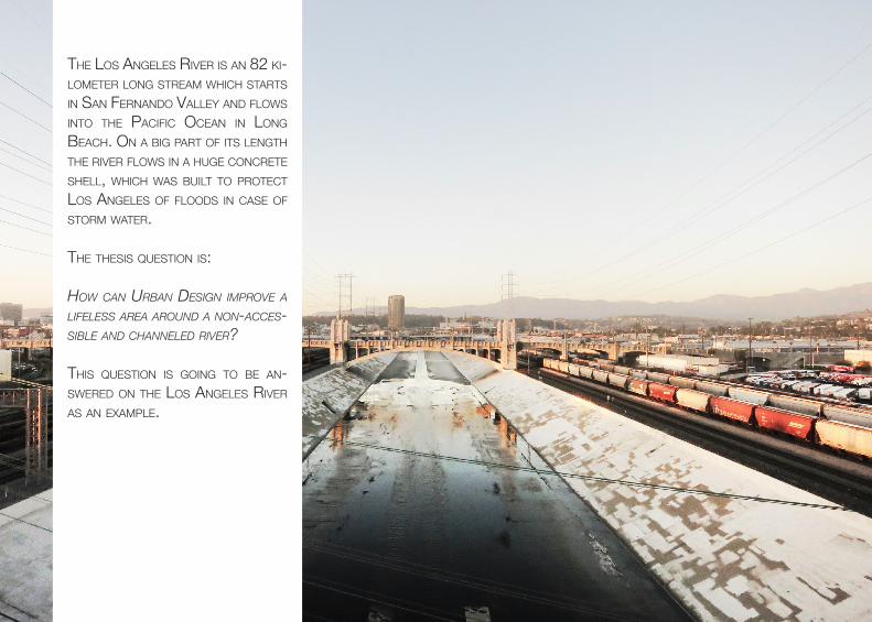
The Los AngeLes RiveR is An 82 ki-LoMeTeR Long sTReAM which sTARTs in sAn feRnAnDo vALLey AnD fLows inTo The PAcific oceAn in Long beAch. on A big PART of iTs LengTh The RiveR fLows in A huge concReTe sheLL, which wAs buiLT To PRoTecT Los AngeLes of fLooDs in cAse of sToRM wATeR.
The Thesis quesTion is: How can Urban Design improve a lifeless area aroUnD a non-acces-sible anD cHanneleD river?
This quesTion is going To be An-sweReD on The Los AngeLes RiveR As An exAMPLe.