Embed Size (px)
Citation preview
The Pas - Saskatchewan River Delta CCP Page 1 of 1
COMMUNITY
CONSERVATION PLAN
for the
The Pas - Saskatchewan River Delta IMPORTANT BIRD AREA
Cory Lindgren Manitoba IBA Program Oak Hammock Marsh
Box 1160, Stonewall, Manitoba R0E 2Z0
For Manitoba Naturalist Society
10/03/01
The Pas - Saskatchewan River Delta CCP Page 2 of 2
Table of Contents
1.0 The IBA Program...................................................................................................... 6 1.1 IBA Manitoba................................................................................................................................ 7
2.0 Introduction................................................................................................................... 7 3.0 IBA Site Information .................................................................................................... 8
3.1 Carrot River Triangle........................................................................................................................ 9 3.2 Tom Lamb WMA ............................................................................................................................. 9 3.3 Saskeram Area................................................................................................................................ 11 3.4 Summerberry Marshes.................................................................................................................... 11 3.5 Grand Rapids Hydro Development ................................................................................................ 11
Figure 1. Summerberry Marsh.......................................................................................... 12 Figure 2. General Map of The Pas - Saskatchewan River Delta IBA.............................. 13 4.0 IBA Species Information ............................................................................................ 14
4.1 Waterfowl ....................................................................................................................................... 14 4.2 Sandhill Crane ................................................................................................................................ 15 4.3 Eared Grebe .................................................................................................................................... 17 4.4 Bald Eagle ...................................................................................................................................... 18
5.0 Other Elements of High Conservation Value ............................................................. 20 5.1 Forest Birds .................................................................................................................................... 20 5.2 Colonial Nesting Waterbirds .......................................................................................................... 20 5.3 Geese .............................................................................................................................................. 20 5.4 The Rosie Mayne Nochemek Trail................................................................................................. 21 5.5 Moose ............................................................................................................................................. 21 5.6 Woodland Caribou.......................................................................................................................... 21
6.0 Land Ownership and Use............................................................................................ 21 6.1 First Nations ................................................................................................................................... 21 6.2 Hunting........................................................................................................................................... 22 6.3 Trapping ......................................................................................................................................... 22 6.4 Commercial and Sustenance Fishing.............................................................................................. 22 6.5 Agriculture...................................................................................................................................... 23 6.6 Land Use in Tom Lamb WMA....................................................................................................... 23 6.7 Pasquia Land Settlement Project .................................................................................................... 23 6.8 Forestry........................................................................................................................................... 24
7.0 Conservation Management Achieved at the IBA Site ................................................ 24 7.1 Saskeram WMA ............................................................................................................................. 24 7.2 Tom Lamb WMA ........................................................................................................................... 25 7.3 The Summerberry Marshes ............................................................................................................ 27 7.4 Candidate Ramsar Site.................................................................................................................... 27 7.5 The Pas Special Area...................................................................................................................... 28 7.6 Cumberland Marshes Important Bird Area .................................................................................... 28
8.0 IBA Stakeholder Group Activity ................................................................................ 28 8.1 Ducks Unlimited Canada................................................................................................................ 28 8.2 Manitoba Conservation................................................................................................................... 29 8.3 Western Boreal Forest Initiative (WBFI) ....................................................................................... 29 8.4 Waterfowl Surveys ......................................................................................................................... 30 8.5 Lure Crops ...................................................................................................................................... 30
9.0 Opportunities............................................................................................................... 30 9.1 Ecotourism...................................................................................................................................... 30 9.2 Kelsey Community College Ecotourism Course ............................................................................ 31 9.3 Clearwater Lake Provincial Park .................................................................................................... 31 9.4 Traditional Ecological Knowledge ................................................................................................. 31 9.5 Proposed Grace Lake Interpretive Birding Trail ............................................................................ 32
10/03/01
The Pas - Saskatchewan River Delta CCP Page 3 of 3
9.6 Recreation....................................................................................................................................... 32 10.0 Threats....................................................................................................................... 33
10.1 Habitat Loss.................................................................................................................................. 33 10.2 Agriculture.................................................................................................................................... 33 10.3 Exotic Invasive Weeds ................................................................................................................. 33 10.4 Pesticides and Environmental Pollutants ...................................................................................... 34 10.5 Forestry......................................................................................................................................... 34
11.0 Conservation Goals and Objectives .......................................................................... 35 11.1 Educational - Tourism .................................................................................................................. 36
12.0 Evaluating Success.................................................................................................... 37 Acknowledgements........................................................................................................... 37 References......................................................................................................................... 38 Appendix I: Community Contacts .................................................................................... 41 Appendix II: Bird Collection at the Sam Waller Museum ............................................... 42 Appendix III: Bird List - Prepared by Ducks Unlimited Canada ..................................... 45 Appendix IV: Historical Bird Numbers............................................................................ 47 Appendix V: Waterfowl Surveys...................................................................................... 48 Appendix VI: Proposed Grace Lake IBA Interpretive Trail............................................ 49 Appendix VII: Sandhill Crane Staging and Nesting Areas .............................................. 50 Appendix VIX: IBA Population Thresholds.................................................................... 51 Citation. Lindgren, C.J. 2001. Community Conservation Plan for The Pas - Saskatchewan River Delta. Prepared for the Canadian Nature Federation, Bird Studies Canada, BirdLife International and the Manitoba Naturalists Society. Winnipeg. Manitoba. 51 pp. Preamble. This document is not intended to be static. It is hoped that the community stakeholders groups involved with use this CCP to guide their conservation efforts and continue to add and develop sections of this document over time. The local community contact for the plan will be Sean Sexsmith, manager, Kelsey Conservation District.
10/03/01
The Pas - Saskatchewan River Delta CCP Page 4 of 4
Executive Summary The Pas Important Bird Area
The Important Bird Area Program The Canadian Important Bird Areas Program (IBA) was established by the Canadian Birdlife Partners, the Canadian Nature Federation and Bird Studies Canada, as part of an international effort to identify and conserve sites important to all bird species worldwide. In Manitoba, the IBA program is being delivered and administered by the Manitoba Naturalists Society. Goals of the Canadian IBA Program The goals of the IBA program are to (1) identify a network of sites that conserve the natural diversity of Canadian bird species and are critical to the long-term viability of naturally occurring bird populations (2) to determine the type of protection or stewardship required for each site, and (3) to ensure the conservation of each site through partnerships with local stakeholder groups who develop and implement an on-the-ground community conservation plan. The Pas - Saskatchewan River Delta IBA No other area of Manitoba offers wildlife habitat equal to the Saskatchewan River Delta either is its natural state or with development. Straddling the Manitoba-Saskatchewan border, it is considered to be one of the most important wetland areas in Manitoba. The area is largely comprised
of the Tom Lamb and Saskeram Wildlife Management areas and the Carrot River Triangle. The Manitoba portion is bordered to the west by the Saskatchewan border although the delta proper does extend into Saskatchewan. Major rivers in the IBA are the Saskatchewan, Carrot and Pasquia Rivers. River deltas such as the Saskatchewan River Delta, are among the most productive life-support ecosystems in the world. Significant Bird Numbers
The Pas - Saskatchewan River Delta is recognized as a Canadian IBA of global significance based upon numbers of waterfowl and Canvasbacks. Numbers of Eared Grebes and Sandhill Cranes almost certainly meet IBA population criteria however population information is lacking for the entire IBA. For example, recent observations in June 2000, found as many as 700 breeding pairs of Eared Grebes forming one breeding colony on Reader Lake alone. If we include numbers of Eared Grebes in other areas of the IBA they would meet IBA congregatory thresholds. As many as 2,000 Sandhill Cranes were observed in the fall of 1972 in the Pasquia Valley.
The wetland areas surrounding The Pas are considered to contain the most important wetlands in Manitoba for breeding waterfowl. However, the area is such a complex of channels and dense vegetation that it is extremely difficult to
10/03/01
The Pas - Saskatchewan River Delta CCP Page 5 of 5
estimate the number of some breeding bird species.
Species that breed in the IBA include Bonaparte's Gull, Franklin's Gulls and Common Terns. Sandhill Cranes, Bald Eagles and Osprey also nest in the area, along with colonial waterbirds such as Common Terns, Black Terns, and Franklin’s Gulls. Several extralimital breeding records of American Avocets have been documented for the area. White-fronted Geese formerly concentrated here in large numbers during fall migration, but are rarely seen now due to the artificial flooding of the gravel bars and islands that they used to stage on. This IBA also holds a wide variety of southern boreal region breeding birds.
Threats
Threats to the habitat and bird species include loss of habitat to agriculture, forestry, exotic alien species, and chemical pollutants. Significant habitat was lost to the Grand Rapids hydro project which removed 32% of the original delta from wildlife production.
Past Conservation Initiatives Areas of the IBA are protected by the Tom Lamb Wildlife Management Area (WMA) and Saskeram WMA. Manitoba Conservation employs a marsh manager who is responsible for both of these WMA's. Ducks Unlimited Canada has been active in the area since 1937 and manages portions of the area for waterfowl and other wildlife. Ducks Unlimited Canada has been involved in the development and management of The Pas - Saskatchewan River Delta marshes in co-operation with the Manitoba Government since 1939.
Conservation Goals Because of the great size of this IBA, conservation efforts will focus on small, achievable initiatives. Educational and awareness activities will focus on the development of an IBA birding trail around Grace Lake near The Pas. Efforts will be made to compile traditional ecological knowledge as it relates to the birds in the area. Efforts will also focus on increasing ecotourism and awareness of the unique collection of bird study skins available at the Sam Waller Museum in The Pas. The Kelsey Conservation District will act as the lead community contact and champion conservation efforts. Contacts • Manitoba Important Bird Areas
Community Conservation Planner Cory Lindgren - 204.467.3269 • Kelsey Conservation District Sean Sexsmith - 204.632.3353 • Ducks Unlimited Canada Chris Smith - 204.627-7814 • OCN Resource Committee Robert McGilivary - 204.632.5493 • Local Naturalist Murray Harvey - 204.623.5503 • The Pas Game and Fish Ed Tomchak - 204.623.7385 • Tolko Inc Doug Hunt - [email protected] • Swampy Cree Tribal Council Geoff Sarenchuk - 204.623.3423 • Tourim - The Pas Laura Finlay - 204.627.2157 • Sam Waller Museum Annet Milot - 204.623.3802 • Past WMA Marsh Manager Bob Uchtmann • Manitoba Conservation - WMA Marsh
Manager - Dale Cross
10/03/01
The Pas - Saskatchewan River Delta CCP Page 6 of 6
1.0 The IBA Program
The IBA program is an international initiative coordinated by BirdLife International, a global partnership of over 100 countries seeking to identify and protect sites important to the conservation of bird species worldwide. Through the protection of birds and habitats, IBA’s also promote the conservation of the world’s biodiversity. IBA programs are currently in place in Europe, Africa, the Middle East, Asia, and the Americas.
The Canadian IBA Program was
initiated in 1996 by two Canadian environmental non-government organizations - Bird Studies Canada (BSC) and the Canadian Nature Federation (CNF). The Canadian IBA program forms part of the Americas IBA program which includes the United States, Mexico, and 17 countries in Central and South America.
The goals of the Canadian IBA
program are to:
• identify a network of sites that illustrate and conserve the natural diversity of Canadian bird species and are critical to the long-term viability of naturally occurring bird populations;
• determine the type of protection or
stewardship required for each site, and ensure the conservation of sites through partnerships between local stakeholder groups who develop and implement appropriate on-the-ground conservation plans; and
• establish ongoing local involvement
in site protection and monitoring.
IBA Site Identification & Criteria
IBA sites are identified by the presence of birds falling under one or more of the following internationally agreed-upon categories:
1) Sites regularly holding significant
numbers of an endangered; threatened, or vulnerable species,
2) Sites regularly holding an endemic species, or species with restricted-ranges;
3) Sites regularly holding an assemblage of species largely restricted to biome; and
4) Sites where birds congregate in significant numbers when breeding, in winter, or during migration.
Important Bird Areas Funding
In October 1998, the Government of Canada announced funding for the Natural Legacy 2000 project, a major initiative under the Canadian Millennium Partnership Program (CMPP). In total, $10 million CDN were awarded to a consortium of four of Canada's largest nature conservation organizations - Canadian Nature Federation, World Wildlife Fund Canada, the Nature Conservancy of Canada and Ducks Unlimited Canada. A portion of the grant, $1.25 million was awarded to the Canadian Nature Federation for the Canadian Birdlife International Partners to conduct the Important Bird Areas Program in Canada. In Manitoba funding has been received from the Murphy Foundation (December 1999) and the Manitoba Sustainable Development Innovations Fund (March 2001).
10/03/01

The Pas - Saskatchewan River Delta CCP Page 7 of 7
For further information on the
IBA Program contact: www.ibacanada.com
1.1 IBA Manitoba
The Manitoba Naturalists Society (MNS) is cooperating with the Canadian Nature Federation and Bird Studies Canada to deliver the conservation planning component of the Manitoba IBA program. The MNS is a non-profit organization made up of individuals who share a common concern for the well-being of Manitoba's nature. It was founded in 1920 for the popular and scientific study of nature.
The MNS believes that the
chance to experience an undamaged environment in peace and tranquillity is a joy and a privilege. It also believes in the importance of sound stewardship, the wise use of our natural resources, fostering an awareness and appreciation of the natural environment and an understanding of humanity's place therein. The objectives of the MNS include:
• providing an association and a voice
for those interested in natural history and the outdoors,
• to cooperate with individuals and organizations with similar objectives,
• to arrange educational and recreational programs and field trips to promote an understanding of the natural environment,
• to stimulate research and to record and preserve data and material in natural history and allied subjects,
• and to work for the preservation of our natural environment.
In 1996, a number of Manitoba
birders gathered to begin identification of potential Manitoba IBA's. By 1999, over 100 locations were nominated for IBA status in Manitoba. In August of 1999, the MNS began IBA community conservation planning with the hiring of a conservation biologist. Shortly after, strategy meetings were held to further identify Manitoba IBA's with local community interest. Advice was solicited from groups including the Manitoba Naturalists Society (Avian Research Committee), Canadian Wildlife Service, Ducks Unlimited Canada, Manitoba Conservation, The Nature Conservancy of Canada, Manitoba Habitat Heritage Corporation and local birders.
2.0 Introduction
No other areas in Manitoba offer wildlife habitat equal to the Saskatchewan River Delta either in a natural state or with development (Uchtmann 1983). Only three other similar delta areas with significant wetland wildlife habitat remain unspoiled on the North American continent - the Yukon-Kuskokwim, and the Mckenzie and Athabaska River Deltas (Uchtmann 1983). The marshes around The Pas are unique because of the high fertility of the deltaic soils deposited by the Saskatchewan River (Ducks Unlimited Canada, ND).
The Saskatchewan River Delta is one of the world’s largest freshwater deltas. It serves as a critical habitat for a diversity of both breeding and staging
10/03/01
The Pas - Saskatchewan River Delta CCP Page 8 of 8
avifauna and is considered to be one of the most important wetland complexes in Manitoba.
What is a delta? A delta is
characterized by a flat low lying plain at the mouth of a river and is usually composed of mud, sand, small rocks, and other materials. Deltas are usually shaped like a rough triangle or fan and can have very rich farming soil. River deltas such as the Saskatchewan River Delta, are among the most productive life-support ecosystems in the world.
Prior to anthropogenic changes,
there were typically two peaks of water in the Saskatchewan River Delta - during June from prairie runoff and again in July from mountain snowmelt. These resulted in overflooded banks and wetlands filled with water. Manmade changes upstream have eliminated the July peak and flattened the spring peak. Hydrologically, the area is formed by both the North and South Saskatchewan Rivers which originate in the Rocky Mountains and carry runoff from Alaska and Saskatchewan (Don Sexton, personal communication, March 2001).
The marshes are an important refuge for drought displaced birds from the prairies at times (Sexton 1982). The lower portion of the Delta, where about 600 square miles was inundated by the Cedar Lake Reservoir created by a dam on the Saskatchewan River at Grand Rapids, was probably the most productive part of the Delta (Harper 1975). Sexton (1982) remarked that prior to flooding the lower delta received extensive use by migrant geese in the fall. Grand Rapids hydro-electric dam drastically impacted area damaging wildlife habitat. Marshes have seen a
reduction in emergent plants and associated upland meadows flooded, which are important food sources for waterfowl and moose.
3.0 IBA Site Information Name: The Pas - Saskatchewan River Delta IBA IBA site number: CAMB055G Coordinates: 53° 47' N, 101°15' W
The town of The Pas is the local
community with an estimated population of 10,000 residents. European explorers including Samuel Ikavne and the Lavenenayes passed through the area in the 1700's and 1800's. The Pas was first known as Devon Mission after Devon, England. It is believed it is named after the Cree paskevac or pasquia, meaning "narrows between wooded banks" (Ham 1980). The town was known as Les Pas for many years. It is located at the junction of the Saskatchewan and Pasquia Rivers. The Pas came into prominence with the development of mining.
Historically it was known as a
trading center and an important location on the fur trade routes (Ham 1980). The CNR reached The Pas in 1907. The Hudson Bay Route Railway began from The Pas in 1910 and reached the port of
Churchill in 1931 (Ham 1980).
The Pas is one of the oldest settlements in northern Manitoba. It originally started as a trading post during a time when the Europeans were focused on furs to feed the fashion houses of Europe. Forestry and transportation in the late 1800s and early 1900s fostered
10/03/01
The Pas - Saskatchewan River Delta CCP Page 9 of 9
the growth of The Pas and directly led to the incorporation of the Town of The Pas in 1912. Today's The Pas is characterized by a stable and diversified economic base with forestry, agriculture, service and transportation being the major industrial pillars of the regional economy (The Pas 2001).
The Pas - Saskatchewan River
Delta IBA straddles the Saskatchewan-Manitoba border. It includes the town of The Pas, as well as the Tom Lamb WMA and Saskeram WMA. It contains many lakes including Saskeram, Birch, Root and Reader Lakes to the west of The Pas. To the east the significant lakes include Grace, Kelsey, Landry and Moose Lake. The major rivers in the IBA are the Saskatchewan River, Pasquia River, Carrot River, and Summerbury River. The IBA does not include Cedar Lake.
3.1 Carrot River Triangle
The Carrot River Triangle is a portion of the Saskatchewan River Delta located between the Carrot River on the south, Saskatchewan River on the east and north, and the Manitoba-Saskatchewan boundary on the west (see Figure 2). It encompasses about 150,000 acres of shallow lakes, marshes, grass meadows, fen and forest (Ould and Clay 1978). The area is primarily used for agriculture (haying and grazing), wildlife management, trapping and hunting. Agricultural activities are concentrated along the south boundary of the triangle in the Saskeram area (Ould and Clay 1978).
The Carrot River rises from a group of small lakes and wetlands near
Wakaw, Saskatchewan, flowing northwest parallel to the Saskatchewan River eventually joining a stream near The Pas (Water Resources 1965). The Carrot River Drainage Basin is narrow, 200 miles long, never more that 50 miles wide, and extends from Wakaw to The Pas.
The rich black soils which are
characteristic of the basin are highly productive when cleared and developed for agricultural purposes and where there is adequate drainage (Water Resources 1965). The natural tendency for flood waters to spread out over the flat and marshy lands in this area has been diverted or pumped to selected lakes and wetlands and by the protection of adjacent agricultural lands by dykes (Water Resources 1965) (see section 6.7).
3.2 Tom Lamb WMA
Formerly called the Mawdesley WMA, the area is flat with several limestone ridges and river levees providing relief. Deep organic soils ranging from silts to peaty organics characterize the area. There are some zones of discontinuous permafrost. Aspen, Jack Pine, and Black Spruce grow on the ridges while Poplar, Willow, Manitoba Maple and Green Ash are associated with the levees. The WMA is a major breeding and staging area for waterfowl and provides habitat for furbearers, moose, wolves and black bears. Bald Eagles use the WMA for feeding, staging, and nesting.
The Tom Lamb WMA is located east of The Pas and north of the Saskatchewan and Summerberry Rivers
10/03/01

The Pas - Saskatchewan River Delta CCP Page 10 of 10
(see Figure 2). In 1970 the name of the region was changed to Tom Lamb to recognize Mr. Lamb's contribution to conservation in the area. It is bounded on the north by the Canadian National Rail line, east by Moose Lake and south and west by the Saskatchewan and Summerberry Rivers. It contains Landry, Mawdesley, Opuskow, Red Earth and L61 Lakes. The area includes Little Frog Creek and Muddy Creek. The WMA is included in the Manitoba Lowlands section of the boreal forest region. A highway to Moose Lake settlement and the North Arm Control Structure was constructed in the late 1970's. Uchtmann (1985) described the area soils as chiefly deltaic deposits of clay, silt and fine sand. The following describes the general habitat/vegetation in the Tom Lamb WMA (a more detailed discussion of the Tom Lamb WMA occurs in section 7.2).
Sexton (1982) described the
vegetation on poorly drained sites as mostly Black Spruce (Picea marina) and Tamarack (Larix laricina) Shrub species may consist of Willows (Salix spp), Alder (Alnus rugosa) and Bog Birch (Betula glandulosa). Along levees and streams or rivers Paper Birch (B. papyrifera), Aspen (Populus tremuloides), Balsam Poplar (P. balsmifera), Green Ash (Fraxinus pennsylvanica) and White Elm (Ulmus americana) can be found. White Spruce (P. glauca) and Jackjpine (Pinus banksinia) are present on dry ridgetops.
Submergent plants are abundant and include Sago Pondweed (Potamogeton pectinatus), Frie's Pondweed (P. friesii), Duckweeds (Lemna minor, L. trisulca), Big sheath Pondweed (P. vainatus), Flatstem
Pondweed (P. zosteriformis), Coontail (Ceratophyllum demersum), Stonewort (Chara spp.), Canada Water Weed (Elodea canadensis), Milfoil (Myriophyllum spp.) and Yellow Water Lilly (Nupar luteum). Sexton (1982) reported the dominant emergent plants for the Tom Lamb WMA were Burreed (Sparganium eurycarpum), Cattail (Typha glauca), Hardstem Bulrush (Scirpus acutus) with lesser amounts of Softstem Bulrush (S. validus), Horsetail (Equisetum palustre) and Sedges (Carex spp.). Up to 30% of the uplands around basins were classed as sedge or grass fen with the dominant species being sedges (Carex spp.), Whitetop (Scholochloa festucacea) and Bluejoint (Calamagrostis canadensis).
The climate type is characterized
by short, warm summers and long, cold winters. The breakup on the Saskatchewan River takes place in late April or early May and freeze-up in mid-November. The WMA lies within the Manitoba Lowlands Forest Zone of the Boreal Forest Region of Canada.
Higher water levels and
interrupted drainage as a result of the Grand Rapids Hydro project are gradually changing the vegetation as woody vegetation along stream levees have been killed and many marshes have become open lakes (Uchtmann 1985). Poor internal drainage and high water levels at the Cedar Lake Forebay has resulted in flooding. The deleterious impacts of flooding on the local wildlife have caused much concern among local residents at Cormorant and Moose Lakes.
In 1937, portions of the area
were designated as a fur bearing animal refuge and in 1942 referred to as the
10/03/01
The Pas - Saskatchewan River Delta CCP Page 11 of 11
Summerbury Fur Rehabilitation Block. The later designation resulted in the Federal and Provincial Governments constructing dykes, canals and controls to manage water levels for muskrat production. Ducks Unlimited became involve in 1965 and by 1967 had constructed additional protective works aimed at offsetting the impact of Cedar Lake Forebay. In 1967 the Provincial Government and Ducks Unlimited entered into an agreement regarding management of the area for waterfowl (Ducks Unlimited 1986).
3.3 Saskeram Area The Saskeram area forms a
portion of the upper delta of the Saskatchewan River composed of numerous shallow lakes connected by small creeks (Harper 1975) (see Figure 2). Only the river or creek levees and scattered limestone outcrops rise above this system of wetlands. The marshes are managed in cooperation with Ducks Unlimited Canada. Prior to man made hydrological changes, the rivers and creeks periodically flooded the area maintaining the lakes and native grasslands of the delta. A more detailed discussion of the Saskeram WMA occurs in section 7.1.
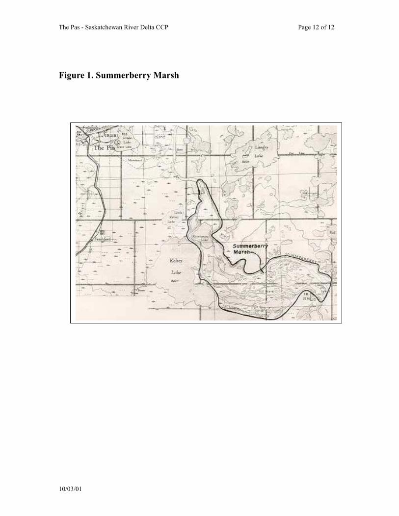
3.4 Summerberry Marshes
The Summerberry Marshes are 15-miles southeast of The Pas between the Summerberry and Saskatchewan River and just east of Kelsey Lake. The area encompasses about 35,000 acres of which 17,463 arces are marsh (see Figure 1). Between 1979 and 1981 Ducks Unlimited Canada constructed
water control structures providing the capability to control water levels of the marshes in the area (Ducks Unlimited 1984). The primary purpose is to improve waterfowl productivity.
3.5 Grand Rapids Hydro Development
The Grand Rapids Hydro development project completed in 1964 has had deleterious impacts on the delta area. Natural drainage has been curtailed because of forebay waters (Uchtmann 1985). Marshes within the IBA have become "open" lacking vegetation, upland nesting sites have been flooded and moose habitat has been destroyed as a result of excessive water and the habitat damage is still continuing (Uchtmann 1985).
About 430-square miles of the
lower delta within the Summerberry Fur Rehabilitation Block were completely inundated and an additional 750-square miles of wildlife habitat were flooded by forebay levels (Uchtmann 1983). Uchtmann (1998) noted that some marsh habitat has deteriorated and some totally destroyed since the hydro project however, unless continental duck populations greatly increase the IBA provides sufficient habitat to meet breeding requirements. The varied impacts of the Grand Rapids dam and forebay is discussed throughout this document.
The lower portion of the
Saskatchewan River Delta, where about 600 square miles was inundated by the Cedar Lake Reservoir created by a dam on the Saskatchewan River at Grand Rapids, was probably the most productive part of the Delta (Harper 1975).
10/03/01
The Pas - Saskatchewan River Delta CCP Page 12 of 12
Figure 1. Summerberry Marsh
10/03
/01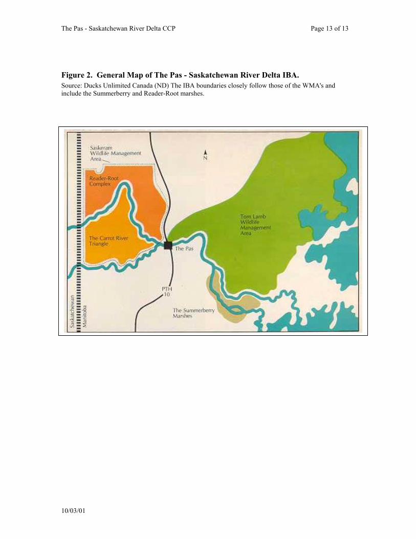
The Pas - Saskatchewan River Delta CCP Page 13 of 13
Figure 2. General Map of The Pas - Saskatchewan River Delta IBA. Source: Ducks Unlimited Canada (ND) The IBA boundaries closely follow those of the WMA's and include the Summerberry and Reader-Root marshes.
10/03/01
The Pas - Saskatchewan River Delta CCP Page 14 of 14
4.0 IBA Species Information
The Pas - Saskatchewan River Delta is recognized as a Canadian IBA of global significance based upon numbers of waterfowl and Canvasbacks. Numbers of Eared Grebes and Sandhill Cranes almost certainly meet IBA population criteria when population information from the entire IBA is considered. Numerous bird species are known to use the IBA however population data is nonexistent.
4.1 Waterfowl
The Pas - Saskatchewan River Delta IBA is an important waterfowl production region and is of major importance in its annual production in terms of North American waterfowl populations (Harper 1975). Uchtmann (1983) estimated the potential waterfowl production in the Saskeram WMA along to be 36,000 ducks. The area is less susceptible to droughts than southern prairie marshes and continues to produce waterfowl during periods of droughts in the prairie pothole region (Harper 1975). In years of drought on the Canadian prairie pothole area waterfowl over-fly the potholes and use areas such as the Saskeram WMA (Uchtmann 1983).
Shallow marshes and grassy
stream channels with upland meadows along the shorelines of Saskram and Wateskwatapi Lake, Little Frog Lake and the Birch River provide breeding habitat for Mallards, Blue-winged Teals and American Widgeon. (Harper 1975). Root and Reader Lakes that have narrow fringes of emergent vegetation are used by diving ducks including Lesser Scaup,
Goldeneye, Canvasback and Redheads (Harper 1975). Leitch (1995) notes that the number of diving ducks using specific lakes are influenced by water levels. When water levels are high waterfowl use is greatly reduced. Leitch (1995) suggested that when water levels are high, food production in the marshes is reduced.
Numerous Lakes are important
fall staging areas including Lake 15, Lake 19, Lake 6N and Saskeram, Birch, Watseskwatapi, Root, Reader, Pasquia, Big and Ravensnest lakes. Areas including, Kelsey, and Mawdesley Lakes produce limited waterfowl but are important as migratory staging areas (Harper 1975). Uchtmann (1983) notes that the Saskeram WMA is the first major staging area for waterfowl migrating south from the numerous small breeding areas in the precambrian shield to the north.
Wood Ducks (Aix sponsa) have
been found to nest as far north as the The Pas - Saskatchewan River Delta IBA. A brood of Wood ducks were observed on the Carrot River near The Pas on June 15, 1977 (Bellrose and Holm 1994).
Counts on numbers of Canada
and White-fronted Geese staging in the area have dropped considerably since 1967 coinciding with the completion of the Grand Rapids Dam and Bracken Dam (Harper 1975). The Grand Rapids Dam inundated about 12% of the delta which formerly held large numbers of migrating geese. The completion of the Bracken Dam stabilized water levels in Saskram Lake and may have increased waterfowl production but it also limited the formation of large mudflats attractive
10/03/01
The Pas - Saskatchewan River Delta CCP Page 15 of 15
to migration waterfowl in the fall (Harper 1975) and likely attractive to shorebirds.
Canvasback The Canvasback (Aythya valisineria) is a fast-flying diving duck about the size of a Mallard. The Canvasback's distinctive head shape includes a wedge-shaped bill and head, on a long and stout neck. Males in breeding plumage can be spotted from large distances, where their dark grey back shows off against a cinnamon-brown head and chest. The biology of this species in relation to management has been summarized by Bellrose (1976). The Canvasback is most at home breeding in the parklands bordering the northern Great Plains, but can be found from South Dakota to Alaska. Canvasbacks leave their Canadian Parkland nesting area gradually in early September-November. Migration proceeds southward in a broad front, but two major corridors guide birds to the Chesapeake Bay area of the Atlantic, and the mid-California region of the Pacific Coast. While most wintering Canvasbacks can be found on the coast, one prominent inland wintering area lies in the central Mexican highlands. Which route is used can vary over years, and brood mates can be found in very different migration corridors. Most Canvasbacks return to their Parkland nesting grounds in April, with a strong propensity to return to previously-used nesting areas. Canvasbacks tend to use large deep water bodies for feeding, resting and courting, but use smaller and
shallower sites for nesting on the prairies. Nests are rarely on land, but are over cattails. The 8-10 eggs are incubated for approximately 24 days in May/June. Canvasback nests are often parasitized by the ecologically similar Redhead, who adds its eggs to a Canvasback's clutch. Once incubation has started, male Canvasbacks form gradually larger flocks, and moult as early as June. Some females join these moulting flocks, sometimes leaving their two-third grown young to fend for themselves, and others remain on smaller waters. Females do not moult until late July, and become flightless in August for 3-4 weeks. In an early study of food habits in the 1930s, stomach contents revealed 80% plants, and 20% animal matter. Sago pondweed alone formed 30% of the food mass. In southern Saskatchewan, Canvasbacks arrive early, in mid-April, shortly after Pintails and Mallards (Roy 1996) Depending on wetland availability, a relatively dry Parkland can encourage Canvasbacks to move to ponds on the grasslands (Smith 1996). Of a sample of 17 Canvasbacks banded in Saskatchewan, some were recovered in the province again and some also in 10 states of the U.S., including Atlantic and Pacific Coast states (Roy 1996).
4.2 Sandhill Crane Grus canadensis
Sandhill Cranes are large birds
which walk on the ground with stately tread, and fly with their long necks and legs fully extended, often giving a wild
10/03/01

The Pas - Saskatchewan River Delta CCP Page 16 of 16
guttural bugling in flight. Sandhill Cranes were once abundant on the prairies and were hunted for food and recreation (Harper 1975). Their numbers continually declined and in 1918 they were placed under protection by the Migratory Birds Convention until hunting seasons were established in Alaska, Saskatchewan and Manitoba in 1964 (Harper 1975).
Migration. Sandhill Cranes travel in flocks, pausing at traditional stopover points such as the Whitewater Lake IBA on their way to breeding areas in The Pas -Saskatchewan River IBA.
Habitat. Sandhill Cranes
usually nests around marshes or bogs, either in open grassland or surrounded by forest. Northernmost birds nest on marshy tundra. In migration and winter they are often found around open prairie, agricultural fields, river valleys. Sedge fens with the water table very close or at the surface are the preferred habitat during the breeding season in The Pas region (Harper 1975).
Feeding. Sandhill Cranes are
omnivorous and food items include insects, roots of aquatic plants, rodents, snails, frogs, lizards, snakes, nestling birds, berries, and seeds. Cranes may eat large quantities of cultivated grains when available. Birds forages by probing in soil with bill, and by taking items from surface. Except in breeding season, Sandhill Cranes forages in flocks.
Breeding. Sandhill Cranes return
to Manitoba around the 3rd week of April. The start of the breeding season is marked by spectacular courtship displays, in which members of a pair face each other, then leap into the air
with wings extended and feet thrown forward. The pair then bows to each other and repeats the ritual. They construct their nest in undisturbed marshy areas, or on open tundra near water. The nest consists of a large mound of marsh vegetation, 1 - 1 ½ m across and up to 45 cm high with a slight central depression. The female lays 2 eggs, olive-buff in color, spotted with brown, which both sexes incubate for about 30 days. The young are downy at hatching, and leave the nest soon afterward. They are tended by both parents, and can feed themselves by their second week. Although they can fly at about 70 days, they remain with the adults until the following year (Source: Manitoba Museum of Man and Nature Birds of Manitoba On Line Http://www.chin.gc.ca/~anana/MMMN/English/index.html.)
Nest. Nest sites are among marsh vegetation in shallow water (sometimes up to 3' deep), sometimes on dry ground close to water. The nest (built by both sexes) is a mound of plant material pulled up from around site. Sandhill Cranes lay usually 2 eggs, sometimes 1, and rarely 3 that are pale olive to buff in color and marked with brown or gray. Incubation is by both sexes, 29-32 days. Female does more of incubating typically all night.
Young. The young leave the nest within a day after hatching follow parents in marsh. Both parents feed young at first, but young gradually learn to feed themselves. Age at first flight about 65-75 days. Young remain with parents for 9-10 months accompanying them in migration.
10/03/01
The Pas - Saskatchewan River Delta CCP Page 17 of 17
Population Status. Sandhill Cranes congregate in the farming portion of the Pasquia Area every spring and fall (Harper 1975). Hildebrand (1974) reported observing 350 Sandhill Cranes in the Pasquia Valley on May 17, 1972, and about 2,000 cranes again on August 21, 1972. Lure crops designed to attract waterfowl in the Pasquia Valley have attracted as many as 1,000 Sandhill Cranes (Harper 1975).
Surveys revealed cranes were
sparsely distributed throughout most of The Pas - Saskatchewan River IBA during the summer with the highest densities in the boggy area south of Kelsey Lake (Harper 1975). Family groups have also been observed in the Saskeram and Tom Lamb WMA’s, the Pasquia Area and southwest of Morrison Lake (see Appendix VII).
In general, global populations
now stable or increasing slightly, but still vulnerable to loss of habitat. Degradation of habitat at major stopover points for migrants could have serious impact on species.
4.3 Eared Grebe Podiceps nigricollis
Life history information for the Eared Grebe, unless otherwise referenced, was taken from Cullen et al. (1999). The Eared Grebe breeds through the western interior of the U.S. and Canada and is the most abundant member of its family in North America. It is highly social and its colonies may number into the 1000's. The Eared Grebe is highly distinctive and ranks among the most remarkable members of the North American avifauna.
The Eared Grebe is a small grebe
and the sexes are similar in all plumages. Eared Grebes may only be distinguished from the Horned Grebe by the reddish-brown neck and ear tufts which are larger and higher on the side of the head. Eared Grebes breed in southwestern Manitoba north to Shoal Lake. The wintering range is fairly restricted and the vast majority of the population winter around the islands in the north and central Gulf of California. The Canadian range includes the southern parts of the prairie pothole region from Manitoba's Red River Valley to interior British Columbia.
Migration. Migration is entirely
nocturnal and most birds move directly from breeding grounds to wintering areas. Fall migration begins immediately after the breeding season when the vast majority of adult undergo a molt migration to hypersaline lakes (Salton Sea, Great Salt Lake) in the Great Basin of the western U.S. The migration to molting/staging areas is evident by late July and continues into October.
Habitat. Breeding habitats are
shallow lakes and ponds with emergent vegetation and highly productive macroinvertebrate communities. Use of specific wetlands unpredictable partially because of effects of seasonal and annual changes in water levels. Main food items include a wide variety of aquatic prey, principally invertebrates including small crustaceans, insects, small fish, mollusks and amphibians.
Breeding. Courtship consists of
a series of elaborate displays similar to those described in other species of
10/03/01
The Pas - Saskatchewan River Delta CCP Page 18 of 18
Podiceps. Most birds are thought to pair on the breeding lakes in the first few weeks after arrival. Pairs select the nest site together and colony formation occurs as other pairs establish platforms in the same area. Nests are usually in thinly spaced emergent vegetation (e.g., Scirpus, Carex, Typha), in areas of shallow water that allows free swimming. Nesting colonies distance from shore varies proportionally with the size of the wetland.
Mean clutch size is 2.95 eggs.
Newly laid eggs are light blue changing to white and then finally a stained brown color. Both male and female share in incubation and the incubation period is about 22 days. Young are born precocial and semi-nidifugous.
Population Status. Koonz and
Rakowski (1985) consider Eared Grebe populations to be in decline in Manitoba. In there 1979 survey Koonz and Rakowski (1985) found 12 Eared Grebe colonies totaling 1,340 nests in the southern marshes west of Lake Winnipeg (The Pas region was not surveyed). The North American population is estimated at 4.1 million in the fall of 1997. Prior to aerial censusing at staging areas no valid way existed to estimate populations. There have been no demonstrable trends in size or distribution of the North American population in recent decade.
On June 23, 2000, an Eared
Grebe colony was found at the north-end of South Reader Lake. It was comprised of a loose "cluster" of 3 colonies with estimated numbers approximately 200, 300 and 200 respectively totaling approximately 700 nests or at least 1,400 birds. Nests were built of submerged
plants in about 50 cm of open water interspersed with Hardstem Bulrush (Chris Smith, personal communication, March 2001). The number of Eared Grebes observed in this one colony alone are close to meeting IBA congregatory thresholds for national importance (1,600 birds), suggesting that when the entire Saskatchewan River Delta is considered, threshold criteria will be surpassed (see Appendix VIX).
Threats. In-flight collisions with conspecifics when departing staging areas are an regular event. Loss of habitat resulting from wetland drainage, drought, conversion for agriculture, use of water for irrigation threatens both breeding and wintering areas. It is important to maintain an abundance of wetlands with emergent vegetation because colony locations change frequently. Human activities deters grebes from using disturbed areas and colony locations.
Koonz and Rakowski (1985) also
concluded drainage of marshes and shallow lakes threatens Eared Grebes which are intolerant of water-level changes. They added that the use of herbicides and pesticides and penetration into remote marshes by humans have also contributed to declines of Eared Grebes in Manitoba.
4.4 Bald Eagle Haliaeetus leucocephalus
Unless otherwise referenced, life history information is taken from Buehler (2000). The Bald Eagle is one of the largest birds of prey second only to the California Condor (Gymnogyps californianus). It has a characteristic white head and white tail with a yellow
10/03/01
The Pas - Saskatchewan River Delta CCP Page 19 of 19
iris, beak and legs. Juvenile birds do not attain the distinctive coloration until 4.5 to 5.5 years of age.
Breeding. The breeding range is
associated with aquatic habitats including coastal areas, rivers, lakes and reservoirs with forested shorelines or cliffs in North America. Bald Eagles are a common nesting species in The Pas-Saskatchewan River Delta IBA. Birds winter in the lower 48 USA and coastal Canada and Alaska.
Bald Eagles typically nest in
forested areas adjacent to large bodies of water. Nests occur in mature and old growth forest with some habitat edge. Birds usually have a diurnal perch habitat on a tall easily accessible tree along a shoreline used for foraging. Bald Eagles are opportunistic feeders usually preferring fish and terrestrial mammals. Bald Eagles will frequent traditional waterfowl hunting areas where hunter-induced mortality and cripples can be scavenged. Will steal food from other avian species.
Bald Eagles are thought to be
monogamous and mate for life unless 1 mate dies. Nests are often reused year after year. Bald Eagles build nests on the hydroelectric towers in The Pas-Saskatchewan River Delta area. Pairs have only 1 brood a season. Two eggs are usually laid with the incubation period about 35 days. Both sexes hunt and feed the young. Birds are known to life as long as 28 years.
Population Status. Populations
in the 1990s have increased from the 1980s estimates of 70,000 North American birds. There were estimated to be 100,000 Bald Eagles in 1999 with
concentrations in British Columbia and Alaska.
Bald Eagles are common in The
Pas-Saskatchewan River Delta IBA. The highest concentrations of Bald Eagles is found in the Saskatchewan River Delta area (west of The Pas) with the majority of nests located along the shorelines (Harper 1975).
Threats. Humans represent the
most significant source of mortality for Bald Eagles. Bald Eagles have been shot by settlers, farmers, ranchers, and trapped because of perceived threat to livestock and game. Birds have experienced decreased reproduction and survival as a result of pesticides and other environmental contaminants.
Loss of shoreline nesting,
perching, roosting and aquatic foraging habitats to human development considered a significant threat to Bald Eagles. Bald Eagles will avoid areas with human development. Hydroelectric projects generally decrease habitat availability. Logging practices such as clear-cutting has resulted in decreased nesting densities (see section 10.5).
Protection. Bald Eagles are
protected in the USA and Alaska under the Bald Eagle Protection Act of 1940 (now the Bald Eagle and Golden Eagle Protection Act). Bald Eagles are protected under the Migratory Birds Convention Act and Manitoba Wildlife Act (Harper 1975).
10/03/01
The Pas - Saskatchewan River Delta CCP Page 20 of 20
5.0 Other Elements of High Conservation Value
5.1 Forest Birds
Forest Songbirds. The Canadian Boreal Forest supports many insect-eating songbirds. Many of these species winter in central and South America where forests too are under threat. The boreal habitats within this IBA support a diverse songbird community. Species that are characteristic and depend upon mature coniferous forest include the Barred Owl, Three-toed Woodpecker, Black-backed Woodpecker, Winter Wren, Golden-crowned Kinglet, Cap May Warbler, Blackburnian Warbler, Bay-breated Warbler and Western Tanager. With increasing forest harvest within this area of Manitoba it is important to conserve songbird habitat within the Canadian Boreal Forest.
5.2 Colonial Nesting Waterbirds Colonial nesting waterbirds are
significant not only on a local level but in terms of total provincial populations (Harper 1975). The following information on colonial nesting waterbirds found throughout The Pas Special Area site, which includes The Pas - Saskatchewan River Delta IBA, was provided by Harper (1975).
• American White Pelicans nest on
Moose Lake to the east of The Pas. Ring-billed, Herring and Bonaparte's gulls are common in the area with nesting colonies on rocky areas on Moose Lake and Rocky Lake.
• Franklin and Bonaparte's Gulls nest on Saskeram Lake, Lake 6N and Reader Lake. Caspian, Common, and Black Terns also occur in large numbers.
• Black Terns frequent the marshes of
the Saskeram WMA often with Franklin and Bonaparte Gulls.
• Black-crowned Night-Herons are
found in the upper portion of the Cedar Lake forebay and downstream from Elbow Lake.
• A Bonaparte's Gull Colony (about 12
birds) was observed in June of 2000 on the east shore of No Name Lake (south of Montreal Lake, southeast of The Pas) (Chris Smith, personal communication, March 2001)
Harper (1975) indicates that man's activities such as the Grand Rapids forebay has altered and destroyed nesting habitat for herons and pelicans. Environmental pollutants such as mercury have adversely affected reproductive rates of some species. Although these waterbirds are protected by Federal and Provincial legislation there is a shortage of enforcement personnel to protect birds from human disturbance during the breeding season (Harper 1975).
5.3 Geese
Canada Geese are distributed throughout the IBA area. Fall waterfowl surveys have been conducted in the Saskatchewan River Delta since 1961 (Hildebrand 1974). Historically, Canada Geese, Snow Geese, and White-fronted Geese have used the delta areas. Based upon aerial census data provided by
10/03/01
The Pas - Saskatchewan River Delta CCP Page 21 of 21
Hildebrand (1974), the highest number of Snow Geese, White-fronted Geese and Canada Geese between 1961 and 1973 was in September of 1961 when 12,170 birds were counted. The highest number of Snow Geese recorded was in September of 1961 at 90 birds. The highest number of White-fronted Geese were in September of 1961 with 8,520 and highs for Canada Geese were in September of 1962 with 4,664 birds found (Hildebrand 1974).
While geese populations on the
whole are generally on the increase, counts of geese in the IBA has decreased. Hildebrand (1974) suggests the reduction in numbers are the result of shifts in migration patterns due to the stabilization of water levels which prevent occurrence of large mud flats.
5.4 The Rosie Mayne Nochemek Trail
It is a self-guided interpretive trail developed by the Atikameg Forest Centre and Manitoba Hydro's Forest Enhancement Program. The trial is located within the town limits of The Pas and is accessible year-round. The 2.7 km trail allows those who travel it to learn and to understand and respect the forest.
5.5 Moose
The Moose (Alces alces) is the most common and most sought after big game in the region. The Saskatchewan River Delta and Red Deer Lake areas contains some of the highest densities of Moose in Manitoba (Harper 1975). Moose provide wildlife viewing and hunting opportunities which contribute to the area’s economic diversification.
5.6 Woodland Caribou
Decreases in Woodland Caribou (Rangifer tarandus caribou) populations during the 1950's and 1960's precipitated efforts to determine the causes of declines. Caribou are known to occur in "The Bog" area south of The Pas along the Overflowing River, in the area north of Grand Rapids, and in the area north of Cormorant Lake from Farewell Lake to Elbow Lake (Harper 1975). They are occasionally seen crossing #10 highway north of The Pas around Reader and Root Lakes (Don Sexton, personal communication, March 2001). Harper (1975) reported that many of the areas used by the caribou in winter contain merchantable timber stands that will probably be logged in the future.
6.0 Land Ownership and Use
6.1 First Nations
There are five First Nation groups in Manitoba. These are the Cree, Ojibway, Dakota, Ojibway-Cree, and Dene. The five groups have distinct territories. The Cree are in the northern part of Manitoba and the Ojibway are in the southern area. The Dakota are primarily in the southwestern region and the Dene are in the northwestern region while the Ojibway-Cree are situated in the northeastern section of Manitoba. First nations have traditionally used land within The Pas - Saskatchewan River Delta IBA for hunting, fishing and trapping. First Nation people have a long
10/03/01
The Pas - Saskatchewan River Delta CCP Page 22 of 22
traditional association with the lands with the IBA. Ham (1980) lists numerous land parcels that are owned by First Nations in the Moose Lake area (31A, 31B, 31C, 31D, 31E and 31F) and surrounding The Pas (21A through 21P).
The Opaskwayak Cree Nation
(OCN) is a Swampy Cree community of 3,000 across the Saskatchewan River from the northern Manitoba paper mill town of The Pas. The community has long been recognized as a model for self-government. One of seven member First Nations of the Swampy Cree Tribal Council, Opaskwayak was the first band in Canada to be recognized as a municipality (The Pas 2001).
6.2 Hunting
The Pas area is an important hunting area for non-resident and resident waterfowl hunters. Waterfowl hunting by non-residents has provided considerable economic benefit to lodges and operators prior to the decline of waterfowl habitat resulting from the Grand Rapids Hydro project (Uchtmann 1985). Toderan (1986) reported a large portion of nonresident hunters came from Wisconsin, Minnesota, and Illinois. Areas such as the Carrot River Valley and Root, Reader and Kelsey Lakes are popular (Toderan 1986). Waterfowl (and big game) hunting supports the local economy as well as the numerous lodges and outfitters in the area. Hunter bag checks revealed that Lesser Scaup (Aythya affinis) (42%) and Mallard (Anas playyhrynchos) (24%) formed the largest portion of species composition (Toderan 1986).
People from The Pas, Moose
Lake, Cormorant, Chemawawin and
Grand Rapids have traditionally lived off wildlife resources in the IBA (Uchtmann 1983). Sustenance hunting of Moose and waterfowl by natives contributes significantly to their well-being (Uchtmann 1985). Prior to the 1970's moose hunting in the Tom Lamb WMA was significant, however declining moose populations since that time have resulted in a decline in moose hunting activity (Uchtmann 1985).
6.3 Trapping
Trapping’s importance has diminished over the years with the change in world fashions. However, it still accounts for over $250,000 in income with Beaver, Muskrat, Mink, Otter, Ermine, Fisher, Lynx, Fox, and Wolf all represented (The Pas 2001). The trapping season generally runs from the middle of November to the middle of May (Harper 1975). Uchtmann (1985) reported that trapping in the Tom Lamb WMA from 1974 to 1984 produced an annual average of $73,261 worth of fur with an average of 59 trappers participating in the harvest. Muskrats, Mink and Beaver are the major furbearers (Uchtmann 1985). Furbearers include ermine, otter, Red Squirrel, Skunk, Coyote, Fox, Fisher, Lynx, Grey Wolves, Marten, Raccoon and Wolverine. The large numbers of Muskrats in the Saskeram WMA has also contributed greatly to the local economy over the years.
6.4 Commercial and Sustenance Fishing
The region acts as a packing center for much of Northern Manitoba’s
10/03/01
The Pas - Saskatchewan River Delta CCP Page 23 of 23
fish catch, with 1.4 million pounds packed per year. Key species include Walleye, Northern Pike, and Whitefish (The Pas 2001). Nearly all major lakes and the Saskatchewan River are commercially fished between June and October and then again between November and April. The commercial fishing industry is the economic mainstay of the settlements of Moose Lake, ( as well as Easterville and Grand Rapids to the east) (Harper 1975).
6.5 Agriculture
The very first grain grown in western Canada was seeded in the Carrot River Valley in 1735. Today, the rich soils of the Saskatchewan River Delta comprise approximately 75,000 acres – producing, on average, 800,000 bushels of grain and more than $11 million in total revenues. Mixed farms are also common, with cattle, sheep, hogs, and goats all raised in the valley – approximately 7,000 head in total annually (The Pas, 2001).
6.6 Land Use in Tom Lamb WMA
Historically, hay cutting was carried out in the north end of the WMA and abandoned equipment can be found along Frog, Little Frog and Little Muddy creeks. Homesteads existed until at least the 1940's along the creek levees in the area. The Canada Land Inventory agricultural map indicates the area has limited potential for conventional agriculture (Ducks Unlimited 1986). A Prairie Farm Rehabilitation Administration (PFRA) proposal produced a concept for dyking and drainage of the WMA. Trapping remains
an important land use as well as hunting for waterfowl and moose. Some sport fishing does occur on Frog Creek and Landry Lake (Ducks Unlimited 1986). Landry Lake was commercially fished for Walleye at one time. Some stands of merchantable pulp wood are present along Moose Lake (Sexton 1982).
The area is all specially
designated Crown Land. As such, it is reserved for wildlife and recreational use. No agricultural activities take place in the area (Ducks Unlimited 1986). Trapping remains an important land use in the area. Parts of the WMA were formerly managed for muskrat harvest as part of the Summerberry Fur Rehabilitation Block.
6.7 Pasquia Land Settlement Project
The following information was taken from Harper (1975). The Pasquia Land Settlement Project is located west of The Pas and is bordered on the north by the Carrot River, on the south by the Pasquia River and on the west by the Saskatchewan border. The area is about 142,720 acres. Interest in land settlement began in the early 1900s as river lots were developed north and south of the Carrot River. During the 1930’s a large portion of marsh between the Carrot and Pasquia rivers was dry and used for hay and pasture by settlers. Some of this land was cultivated for grain production. The land was later survey by the Prairie Farm Reclamation Administration (PFRA) which led to the Canada-Manitoba Agreement of 1953 authorizing the construction of dykes, canals and other engineering works. These included the diversion of the Pasquia River into the Carrot River,
10/03/01
The Pas - Saskatchewan River Delta CCP Page 24 of 24
construction of drainage canals, roads, and two pumping stations within the project area.
6.8 Forestry
Forestry in northern Manitoba became prominent with the arrival of the Canadian Northern Railway in The Pas in 1910. In 1966 the Manitoba Government signed an agreement with CFI which gave the company timber cutting rights to large forested acres in northern Manitoba (Harper 1975). With the construction of the CFI facilities in 1967 came jobs and an subsequent increase in the population of The Pas. In 1974 the company was taken into receivership by the Manitoba Government and became a Crown corporation.
Currently, one in ten people in The Pas is employed in forestry by Tolko Industries Ltd.. Tolko is a producer of lumber, and pulp and paper. It employs 750 people at the mill site and an additional 350 under contract in woodland operations. The annual payroll of Tolko exceeds $50 million. Tolko was introduced to The Pas in the late 90s when they purchased Repap Manitoba Inc. and expanded the lumber division. Before the acquisition, Repap had just upgraded to improve and enhance the production of the world’s highest performance kraft paper (The Pas 2001). Tolko does not carrying out any bird surveys in their cutting areas (Doug Hunt, personal communication, April 2001).
7.0 Conservation Management Achieved at the IBA Site
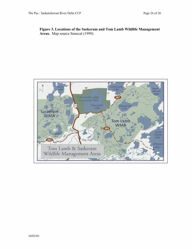
7.1 Saskeram WMA
The Saskeram WMA was
established in 1962 as mitigation for habitat losses resulting from the flooding from the Grand Rapids hydro project (Ducks Unlimited Canada ND). The Saskeram WMS is accessible by boat in the summer and snowmobile in the winter (Senecal 1999). The Wildlife Management Area (WMA) encompasses a large portion of the Saskatchewan River delta and floodplain, a significant breeding and staging area for waterfowl. The Saskeram WMA covers 95,871 ha (Senecal 1999). The area also provides excellent habitat for moose, wolves, black bears and furbearers. (Brochure: Land For Wildlife and People Manitoba's Wildlife Management Areas, Manitoba Natural Resources, ND).
Manitoba Conservation (2001)
recognized Saskeram Marsh as a Manitoba WMA based upon the following information.
• Includes both the Carrot River Triangle and Reader-Root complexes. Encompasses an area of 95,812 hectares of Crown land along the Saskatchewan River Delta.
• Designated as a Wildlife Management Area in 1963 as partial mitigation for the loss of wildlife habitat due to the Grand Rapids Dam forebay.
• A traditional hunting and trapping area for local native bands and an important source of
10/03/01
The Pas - Saskatchewan River Delta CCP Page 25 of 25
trapping income. A wide diversity of habitat zones provide for a variety of wildlife species.
• Serves as a refuge for waterfowl during drought years on the prairies.
• Provides habitat for Bonaparte's Gull and Franklin's Gull colonies.
• Contains moose and woodland caribou habitat.
• Major migration stop for Bald Eagles, Golden Eagles, and Tundra Swans. Large numbers if Great Gray Owls in the winter.
7.2 Tom Lamb WMA
The 513,000-acre (or 214,459-ha) Tom Lamb WMA was established by the Manitoba Government in 1965. In 1965, it was named the Mawdesley WMA in honor of Squadron Leader Mawdesley, Superintendent of the Cormorant Air Force Base, who in 1920's or early 1930's was forced to land in poor weather on what later was called Mawdesley Lake (Uchtmann 1985). In 1970 the name was changed to Tom Lamb WMA however in memory of Squadron Leader Mawdesley, Lake Mawdesley within the WMA retained his name. The WMA was established in partial mitigation for losses suffered in the lower reaches of the Saskatchewan River Delta as a result of the Grand Rapids Hydro project. This area of the delta was least affected by the Grand Rapids Forebay (Uchtmann 1985). See section 3.2 for site description and 6.6 for land use information.
10/03/01
The Pas - Saskatchewan River Delta CCP Page 26 of 26
Figure 3. Locations of the Saskeram and Tom Lamb Wildlife Management Areas. Map source Senecal (1999).
10/03
/01
The Pas - Saskatchewan River Delta CCP Page 27 of 27
Ducks Unlimited became involved in the area in 1965 and by 1967 had constructed additional protective works aimed at offsetting the impact of the Cedar Lake Forebay. In 1965 the southeastern section of the WMA at the mouth of the Saskatchewan and Summerberry Rivers was flooded by the Cedar Lake forebay used to store water for the Grand Rapids Hydroelectric Project (Sexton 1982). Many of the controls and dykes built as part of the fur block work in the 1940's and 1950's by the Provincial Government were inundated and destroyed when the hydro reservoir was filled. In 1967 the Provincial Government and Ducks Unlimited entered into an agreement regarding management of the area for waterfowl (Ducks Unlimited 1986.)
Despite the construction of dykes
and control structures by Ducks Unlimited, and the Moose Lake Dam (The North Arm Dam) built by Manitoba Hydro, excessive water or flooding of many areas remains a problem impacting aquatic and upland vegetation and the areas ability to produce and sustain populations of waterfowl, Muskrats, and Moose (Sexton 1982). Marshes have had emergent plant beds reduced in distribution and density such that some basins have become open and lake-like (Ducks Unlimited 1986). Willow stands have also been degraded caused a decline in moose habitat.
7.3 The Summerberry Marshes
The Summerberry Marshes are east of The Pas and about 35,000 acres in size (see Figure 1). Ducks Unlimited
Canada and the Manitoba Government have been involved in management of the area. Past conservation initiatives have included water control structures within the Summerbury Marshes built by the Manitoba Government during the 1930's primarily for Muskrat management.
7.4 Candidate Ramsar Site
Designating the area as a Ramsar
Site represents a potential conservation action. Ducks Unlimited Canada has an interest in identifying the Saskatchewan River Delta as a Canadian Ramsar Site (Don Sexton, personal communication, Feb. 2001).
What is a Ramar Site? In 1971,
at the invitation of the Iranian government, representatives of eighteen countries and several international organizations concerned over the alarming extent of wetland losses throughout the world, met in the town of Ramsar to draft the Convention on Wetlands of International Importance Especially as Waterfowl Habitat. The need to protect waterfowl habitat remains the key reason for the Ramsar Convention.
One major objective of the convention was to stem the progressive encroachment on the loss of wetlands, now and in the future. The convention, which has become known as the Ramsar Convention, came into force on December 21, 1975 (Gillespie et al. 1991). As of 1991, Canada had 30 Ramsar Sites from coast to coast.
10/03/01
The Pas - Saskatchewan River Delta CCP Page 28 of 28
7.5 The Pas Special Area
The following description was taken from Harper (1975) ver batim. The Pas Special Area was so designated through a Federal-Provincial ARDA Agreement. This area was selected because of present and potential resource utilization conflicts. The Pas Special Area has a reasonably large number of Indian, Metis, and other groups of people, whose income position and income opportunity is presently limited. The main source of employment in this region over the past number of years has been associated with the development of mining, some forestry, wildlife, recreation, and the associated service industries.
The Federal Department of Environment, Lands Directorate, offered the Provinces funds to initiate Pilot Land Use Projects. One of the Federal requirements was that a pilot project be established in areas where Canada Land Inventory (CLI) data was available wholly or in part so that the CLI data could be used and evaluated. In Manitoba a Federal-Provincial Agreement was signed designating The Pas Special Area as a Pilot Land Use Planning (PLUP) area. Information compiled by the PLUP report is referenced throughout this CCP as Harper (1975).
The Pas Special Area consists of
about 10,000 square miles with the northern boundary being the edge of the Precambrian Shield near Cranberry Portage and Athapapuskow Lake. The western boundary is the border between Saskatchewan and Manitoba while the southern boundary includes portions of Lake Winnipegosis, Cedar Lake and Easterville.
7.6 Cumberland Marshes Important Bird Area
The Cumberland Marshes are in east-central Saskatchewan, west of the Manitoba border, and north of the Carrot River. The Cumberland Marshes form the upper portion of the Saskatchewan River Delta. The Cumberland Marshes or Upper Saskatchewan Delta are recognized as a Canadian Important Bird Area of global significance based upon numbers of Tundra Swans, Mallards, Ring-necked Ducks, Common Goldeneyes, Redheads, and Canvasbacks (Schmutz 2000). Both the Cumberland Marshes IBA and The Pas-Saskatchewan River IBA are in the eastern portion of the large Saskatchewan River Drainage Basin. These two IBA's share common species, habitats, rivers, and threats. Looking beyond provincial borders these two IBA's could be viewed as one as conservation efforts in one IBA would surely impact the next.
8.0 IBA Stakeholder Group Activity
8.1 Ducks Unlimited Canada
Ducks Unlimited Canada has a long history in The Pas and the Saskatchewan River Delta. It has been involved in the development and management of The Pas marshes in co-operation with the Manitoba Government since 1939. The land on which Ducks Unlimited projects have been developed remains the property of the Crown and Ducks Unlimited works under terms spelled out in agreements with the Manitoba Government (Ducks
10/03/01
The Pas - Saskatchewan River Delta CCP Page 29 of 29
Unlimited Canada ND). Founded in 1938, Ducks Unlimited Canada is a private, non-profit organization dedicated to the conservation of wetlands for the benefit of North America's waterfowl, wildlife and people.
Ducks Unlimited Canada has been
involved in the Saskeram WMA which involved two separate developments - the 115,000-acre Carrot River Triangle and the 120,000-acre Reader Root complex (Ducks Unlimited Canada ND). Activities have included construction of dams, dykes and control as well as water level management. Ducks Unlimited Canada was granted a 21 year Crown Agreement (extended 10 years in 1983) in the Saskeram WMA to regulate water levels in an effort to improve waterfowl habitat (Toderan 1986). Through a provincial agreement the Root/Reader Lake area also has been set aside for Ducks Unlimited to manage/regulate water levels for waterfowl (Toderan 1986). These water level management activities have as a priority objective using sustainable management principles and artificial (engineered) works to try and restore a more natural marsh cycle in a highly impacted hydrological system (Don Sexton, personal communication, March 2001).
Ducks Unlimited Canada's
involvement in the Summerberry Marshes east of The Pas was initiated in 1979 under a cost-share agreement with the Manitoba Government to expand an existing water management system and allow more intensive wildlife management within the area (Ducks Unlimited Canada ND). Ducks Unlimited's activities have involved adding 19 water controls, 43 artificial
nesting islands, installing floating loafing stations and 80,000 feet of level ditching (Ducks Unlimited Canada ND).
8.2 Manitoba Conservation The Manitoba Government
employees a Marsh Manager for the entire Saskatchewan River Delta including the Tom Lamb and Saskeram WMA's to ensure the Wildlife Branch is fully involved in all decisions related to the Saskatchewan River Delta (Uchtmann 1985). (note: R.H. Uchtmann served as the Marsh Manager for several years).
The mandate of the Wildlife
Branch is to protect wildlife resources in a manner consistent with the conservation of species and ecosystems for the benefit of Manitobans. This responsibility is carried out under the authority of The Wildlife Act, The Endangered Species Act, and The Conservation Agreements Act of Manitoba, and by applying the principles of sustainable development. The Wildlife Branch develops programs, policies and legislation for hunting and trapping, biodiversity conservation, and habitat and land management on Crown and private land. The Branch also represents Manitoba in numerous provincial, national, and international initiatives.
8.3 Western Boreal Forest Initiative (WBFI)
Ducks Unlimited Canada's Western Boreal Forest Initiative (WBFI) was launched in the summer of 1997. The Western Boreal Forest ranks third of
10/03/01

The Pas - Saskatchewan River Delta CCP Page 30 of 30
the 25 most important and threatened waterfowl habitats areas on the continent. Ducks Unlimited is interested in finding the most productive wetlands in the boreal forest, which for the most part are those located off the Canadian Shield. Ducks Unlimited Canada has three priorities in this initiative (1) find out what kind of wetlands exist in the boreal forest, (2) find out which wildlife species are using the various wetlands and (3) researching the effects of the numerous impacts on these key boreal wetland systems.
The WBFI will conduct bird
survey starting in the spring of 2001. These fixed-wing and helicopter surveys will include pair, brood, moulting and staging surveys of the area including areas in Saskatchewan.
8.4 Waterfowl Surveys
Aerial waterfowl surveys have been conducted on fall staging areas annually since 1967 (Harper 1975). Leitch (1995) reported that the first waterfowl surveys occurred in 1935 then again in 1939, 1940 and 1941. These were canceled after a shortage of aviation fuel and due to the war, until 1946 (Leitch 1995). The Canadian Wildlife Service and U.S. Fish and Wildlife Service conduct aerial brood and pond count surveys in the area known as stratum 25. In this area there are no ground surveys conducted. Appendix V provides some estimates of past waterfowl breeding populations for stratum 25.
8.5 Lure Crops
Joint Federal-Provincial efforts have focused on alleviating waterfowl damage. Lure crops were established in the Pasquia Valley in 1969. Lure Crops in conjunction with scaring devices such as acetylene bangers, scarecrows and cracker shells as well as hunting pressure have all contributed to reduce grain damage (Harper 1975). Lure crops are also used by Sandhill Cranes.
Waterfowl and blackbird
depredation of crops has been extensive in the past as waterfowl fly into the Pasquia area from the Saskeram WMA and from Pasquia and Big Lakes (Harper 1975).
9.0 Opportunities
9.1 Ecotourism Scarce et al. (1992) defined
ecotourism as: "Ecotourism is an enlightening nature travel experience that contributes to conservation of the ecosystem while respecting the integrity of host communities".
Ecotourism is a significant
component of the largest growth industry on Earth - tourism (Scarce et al. 1992). Tourism worldwide is a $250 billion dollar per year industry and growing dramatically (Scarce et al. 1992), bird watching in Point Pelee National Park in Ontario generates $6 million annually. Ecotourism can provide the economic justification to conserve areas that might otherwise not be protected. Bird watching is a significant component of ecotourism.
10/03/01
The Pas - Saskatchewan River Delta CCP Page 31 of 31
Bird watching is conservatively estimated to be worth more than $20 billion each year in North America. Manitoba ecotour operators reported that wildlife viewing is a major part of their operation (Weaver et al. 1995). Operators listed birds more often than mammals as major organisms for viewing with waterfowl, birds of prey, shorebirds, eagles and owls being of primary interest (Weaver et al. 1995).
There is a need to further market
ecotourism opportunities to benefit The Pas and surrounding ecotour opportunities. Ecotourism can create jobs. The willingness of individuals to "pay substantially" for ecotourism opportunities is high, as evident in the fees charged for 13-day trips from Winnipeg (as high as $2,500 USD).
"Ecotourism can generate badly needed revenue for local and regional economies, heightened local awareness of the importance of conservation, and create new incentives for governments and dwellers in and around appealing natural areas to preserve them" Scarce et al. (1992, p. 11)."
Efforts to foster greater
community awareness and profile The Pas - Saskatchewan River Delta IBA will result in economic benefits to The Pas. One simple method maybe by placing birding and ecotourism information on an The Pas - IBA website. Efforts should be made to promote the area into foreign markets as foreigners were found to constitute over 50% of customer base for Manitoba ecotour operators (Weaver et al. 1995). Also see opportunities in section 9.3.
9.2 Kelsey Community College Ecotourism Course http://www.keewatincc.mb.ca/
There is opportunity to partner
with the local community college to promote birding, conservation, and ecotourism. The Keewatin Community College (KCC) has a campus in The Pas. The College defines Ecotourism as "tourism that entails an enlightening nature-based, or cultural, travel experience, that conserves the ecosystem and respects local cultures and traditions". Increased understanding of the natural world in which we live and its inhabitants, including local Aboriginal and Northern peoples, is a primary objective of ecotourism program at the colleges.
Students enrolled in the
ecotourism course could be asked to develop promote and market the IBA and develop and maintain a birding website or add pages to the existing web site for The Pas (www.ThePasArea.com).
9.3 Clearwater Lake Provincial Park
Clearwater Lake is north of The Pas - Saskatchewan River Delta IBA and is a popular recreational area. Birding opportunities in the IBA could be promoted to visitors of Clearwater Lake in an effort to increase awareness of the significant birding opportunities available.
9.4 Traditional Ecological Knowledge
There is opportunity to partner with First Nations people and compile indigenous knowledge as it relates to
10/03/01

The Pas - Saskatchewan River Delta CCP Page 32 of 32
birds and wildlife conservation in the area. Traditional Ecological Knowledge (TEK) recognizes that indigenous people have their own "scientific" way of thinking which is different than the western philosophy of thought, but equally important and often overlooked. Many Native cultures embrace the awareness that all of life on the planet is woven together in a complex web of inter-relatedness. To promote the use of indigenous knowledge in the community, ways of documenting the knowledge of community elders and making it locally available should be encouraged. Work in this area is particularly urgent, since so much knowledge is being lost so rapidly.
Documenting and preserving the use of indigenous knowledge at the community level and using this knowledge to address resource management issues are complex undertakings. A variety of methods (reports, videos, or photographs to document TEK for the cultural record) should be used to capture TEK. TEK should be documented and, with community approval, made readily accessible to the scientific community so that it may be referenced and properly cited. In this way, the holders of TEK can be given full recognition and the information will not be regarded as anecdotal data or as a "new discovery" when scientists use it. TEK should be considered an important part of the
knowledge base and not a token. For more detailed information visit http://www.inusiaat.com/tek.htm.
TEK could be used to describe
the history of the IBA as it relates to the significant bird species, traditional uses of these birds and traditional hunting of the avifauna.
9.5 Proposed Grace Lake Interpretive Birding Trail
There is opportunity to develop a birding trail near The Pas. The project would incorporate an existing dyke into an interpretive trail around Grace Lake (see Appendix VI). The trail would have several features that will provide viewing opportunities for waterfowl as well as a diversity of birds. Features would include a boardwalk, observation platforms, and interpretive posts, nesting boxes and nesting tunnels.
9.6 Recreation
Uchtmann (1985) notes that the area has considerable recreational and educational opportunities through canoeing, camping, bird watching, and nature tours and that these opportunities are generally not taken advantage of except incidentally by hunters.
10/03/01
The Pas - Saskatchewan River Delta CCP Page 33 of 33
10.0 Threats
10.1 Habitat Loss
Habitat loss and wetland habitat loss has historically been the predominant threat to The Pas - Saskatchewan River Delta IBA. Drainage for agricultural purposes and the Grand Rapids hydro project have had perhaps immeasurable, deleterious impacts on the habitat. Uchtmann (1983) reported that a total of 32% of the original delta area has been removed from wildlife production, 12% drained for agricultural purposes and 20% flooded by the Grand Rapids Hydro project.
Uchtmann (1998) notes that
while the major loss of or damage to habitat has occurred, the area continues to suffer habitat loss. Wetland habitat is slowly receding as wave action levels off the old levees and vegetation is lost. Upland habitat is being degraded by high water levels killing off woody vegetation (Uchtmann 1998).
Designating the area as a
Canadian Important Bird Area and as a Ramsar Site may foster awareness leading to conservation actions towards eliminating habitat loss.
10.2 Agriculture Ould and Clay (1978) report that
considerable pressure was being applied by agricultural interests to extend grazing and haying leases deeper into sections of the Carrot River Triangle which is under a Crown agreement to
Ducks Unlimited Canada for habitat management.
The PFRA Pasquia Reclamation
Project drained the southern part of the Saskeram Fur Rehabilitation Block through the construction of drainage ditches, dykes and pumps (Uchtmann 1983). Marsh drainage in the Pasquia portion of the Saskatchewan River Delta commenced in 1955 and was completed in 1960. Conversion of marshland to agricultural lands in the lower reaches of the basin (south of the Carrot River) in Manitoba has been carried out by the Prairie Farm Rehabilitation Administration (PFRA).
10.3 Exotic Invasive Weeds
Invasive alien species are the greatest threat to the biological diversity of natural ecosystems second only to habitat loss. Globalization has resulted in an accelerated rate of biota transfer between continents. Many of these alien introductions have had economic and ecological consequences. For example, the large-scale introduction of Eurasian plant species into North America has had negative effects on grassland bird populations (Robbins and Dale 1999). Alien invasive species which pose a potential threat to the IBA include Canada Thistle (Cirsium arvense), Purple Loosestrife (Lythrum salicaria), Flowering Rush (Butomus umbellatus), Leafy Spurge (Euphorbia esula), Salt Cedar (Tamarix species), Eurasian Water-milfoil (Myriophyllum spicatum L.) (which was found in North Dakota along the Sheyenne River in 1996) and Salt Cedar (Tamarix ramosissima).
10/03/01
The Pas - Saskatchewan River Delta CCP Page 34 of 34
Purple Loosestrife. Purple Loosestrife was originally introduced to North America in the 1800’s, probably as a contaminant of ship ballast. Purple Loosestrife aggressively invades wetland habitats. In Manitoba, Purple Loosestrife has Noxious Weed Status and can be found throughout southern Manitoba. Purple Loosestrife has been found in the general vicinity of the garbage dump near The Pas. Efforts to prevent an invasion of Purple Loosestrife should target awareness activities and prompt removal of any plants.
10.4 Pesticides and Environmental Pollutants
The deleterious impacts of chemicals on avifauna have been documented. Houston and Schmutz (1999) reported that after the widespread use of DDT, the Peregrine Falcon (Falco peregrinus) has disappeared from southern Alberta and that Merlin (Falco columbarius) populations declined with the extensive use of Dieldrin in the late 1950s and early 1960s. The deleterious effects of the insecticide Carbofuran on Burrowing Owls is also well documented.
Buehler (2000) reported on the impacts of numerous chemicals on Bald Eagle populations. DDT and Dieldrin contributed to population declines in the 1950s. Eggshell thinning data indicate improvements shin the ban of DDT in 1972. PCB’s may also effect reproduction rates. Organochlorine pesticides were responsible for some mortality from the 1960s to 1981. Carbofuran in granulated form became a threat in the 1970s and 1980s causing
significant wildlife mortality. Mercury continues to be threat in several regions. Oil spills threaten Bald Eagles in coastal areas. Lead poisoning from lead pellets and bullets is considered a significant cause of mortality. Incidences of lead poisoning have declined with the ban of lead shot used by waterfowl hunters in 1991.
Pesticide runoff from agricultural
fields in the Pasquia Land Settlement Project is identified as a threat to IBA. Fertilizer and pesticides from both surface and subsurface flow is also a threat. It is unknown if any agency is monitoring pesticide levels in the delta area. The potential for the herbicides to drift through the air and contaminate the numerous wetlands is also a concern.
10.5 Forestry Logging practices such as clear-
cutting has resulted in decreased nesting densities for species such as Bald Eagles. Harper (1975) reported that Bald Eagles are threatened in the IBA area by the expanding forest industry. Treed buffer zones are generally maintained along riparian areas with recreational potential, however, in areas with no recreational potential trees are harvested to the shorelines (Harper 1975).
10/03/01
The Pas - Saskatchewan River Delta CCP Page 35 of 35
11.0 Conservation Goals and Objectives
Vision: The Pas - Saskatchewan River Delta Important Bird Area will be conserved in perpetuity for its importance to the conservation of resident and migratory bird species that provide economic, ecological and educational benefits to the residents of The Pas and the First Nations. Overall Goal: By developing an IBA birding trail around Grace Lake and increasing awareness of The Pas - Saskatchewan River Delta conservation of the area will be fostered. The IBA has a high degree of biodiversity which is evident by the numerous bird species found and the ecological significance of the Saskatchewan River Delta and Boreal Forest ecosystems within the IBA. It is critical that The Pas - Saskatchewan River Delta IBA be maintained as a naturally occurring bird habitat. Many of the identified threats such as pesticides, habitat loss to agriculture, exotic species, will not be addressed in this document and may be addressed by the working group in the future. The primarily goal of the working group is the develop the Grace Lake IBA Birding Trail.
10/03/01
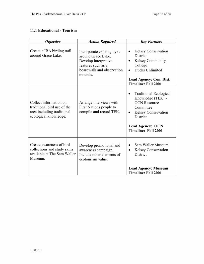
The Pas - Saskatchewan River Delta CCP Page 36 of 36
11.1 Educational - Tourism
Objective Action Required Key Partners Create a IBA birding trail around Grace Lake.
Incorporate existing dyke around Grace Lake. Develop interpretive features such as a boardwalk and observation mounds.
• Kelsey Conservation
District • Kelsey Community
College • Ducks Unlimited Lead Agency: Con. Dist. Timeline: Fall 2001
Collect information on traditional bird use of the area including traditional ecological knowledge.
Arrange interviews with First Nations people to compile and record TEK.
• Traditional Ecological
Knowledge (TEK) - OCN Resource Committee
• Kelsey Conservation District
Lead Agency: OCN Timeline: Fall 2001
Create awareness of bird collections and study skins available at The Sam Waller Museum.
Develop promotional and awareness campaign. Include other elements of ecotourism value.
• Sam Waller Museum • Kelsey Conservation
District Lead Agency: Museum Timeline: Fall 2001
10/03/01
The Pas - Saskatchewan River Delta CCP Page 37 of 37
12.0 Evaluating Success
The lead community contact or champion of the plan is The Kelsey Conservation District. The Kelsey Conservation District will be responsible for arranging stakeholder group meetings, setting up and distributing meeting agendas and taking meeting minutes. The Pas - Saskatchewan River Delta IBA community conservation plan will be reviewed on an annual basis by the present working group comprised of community stakeholder groups (see Appendix I).
Acknowledgements I thank Don Sexton for reviewing and commenting on this document. I thank the
Murphy Foundation and the Sustainable Development Innovations Fund for project funding. I thank Ducks Unlimited Canada for office space and in-kind support. The IBA program is part of the Natural Legacy 2000 program, a nationwide initiative to conserve wildlife habitats on private and public lands. We gratefully acknowledge the financial support of the Government of Canada's Millennium Partnership Program.
10/03/01
The Pas - Saskatchewan River Delta CCP Page 38 of 38
References Adams, G.D. and R.C. Hutchison. 1971. Land capability for wildlife-waterfowl. 63F,
63K mapsheets, Canada Land Inventory. Beacham, T.D. and R.K. Brace. 1975. An analysis of waterfowl fall census flights
in Manitoba in 1972, 1973, and 1974 in relation to crop depredation, waterfowl censusing techniques and survey design. Canadian Wildlife staging data unpublished report.
Bellrose, F.C. and D.J. Holm. 1994. Ecology and Management of the Wood Duck.
Illinois Natural History Survey. Stakepole Books, Mechanicsburg, Pennsylvania. 588 pp.
Bellrose, F. C. 1976. Ducks, geese and swans of North America. Wildlife Management Institute, Stackpole Books, Harrisburg, PA, U.S.A.
Buehler, D.A. 2000. Bald Eagle (Haliaeetus leucocephalus). In The Birds of North
America, No. 506 (A. Poole and F. Gill, eds.). The Birds of North America, Inc., Philadephilia, PA.
Burger, J. and M. Gochfeld. 1994. Franklin's Gull (Larus pipixcan). In The Birds of
North America, No 116 (A. Poole and F. Gill, Editors). Philadelphia: The Academy of Natural Sciences: Washington, D.C.: The American Ornithologists' Union.
Cullen, S.A., J.R. Jehl Jr., and G.L. Nuechterlein. 1999. Eared Grebe (Podiceps
nigricollis). In The Birds of North America, No. 433 (A. Poole and F. Gill, eds.). The Birds of North America, Inc., Philadelphia, PA.
Ducks Unlimited Canada. ND. The Pas past, present and future. Ducks Unlimited
Canada brochure. Ducks Unlimited Canada. 1984. Summerberry Marshes Operating Guide.
Unpublished Report. Ducks Unlimited. 1986. Manitoba Major Marsh Status. Ducks Unlimited Canada Manitoba Office. Ferguson, ,R.S., and S.G. Sealy, 1983. Breeding ecology of the Horned Grebe,
Podiceps auritus, in southwestern Manitoba. Can. Field-Nat. 97:401-408. Gillespie, D.I, H. Boyd, and P. Logan. 1991. Wetlands for the World: Canada's Ramsar
10/03/01
The Pas - Saskatchewan River Delta CCP Page 39 of 39
Sites. Canadian Wildlife Service. Minister of Supply and Services Canada.
Harper, W.K., coordinator. 1975. Pilot Land Use Planning (P.L.U.P.) Project. The Pas Special Area, Manitoba. Canada Land Inventory Lands Directorate, Environment Canada. 101 pp.
Ham, S. 1980. Place Names of Manitoba. Western Producer Prairie Books, Saskatoon, Saskatchewan. 155 pp.
Hildebrand, P.R. 1974. Sandhill crane investigations in the Pilot Land Use Planning area. Manitoba Dept. of Mines, Resources and Environmental Manage., Pilot Land Use Planning Project Report. 38 pp.
Houston, C.S and JK. Schmutz. 1999. Changes in Bird Populations on Canadian Grasslands. Studies in Avian Biology 19:78-94.
Koonz, W.H. and P.W. Rakowski. 1985. Status of Colonial Waterbirds Nesting in Southern Manitoba. Canadian Field Naturalist 99(1):19-29.
Kopachena, J. G. and R. Evans. 1990. Flock recruitment in Franklin's Gulls. Colonial Waterbirds 13(2):92-95.
Leitch, W.G. 1995. Some important diving duck mounting and staging areas in northern Manitoba, Saskatchewan and Alberta (Canvasback, Redhead, and Scaup). Ducks Unlimited Report. Limbert, R.J. and S.L. Earnst. 1994. Tundra Swan (Cygnus columbianus). In The
Birds of North America, No. 89 (A. Poole and F. Gill, Eds.). Philadelphia: The Academy of Natural Sciences; Washington, D.C.: The American Ornithologists' Union.
Manitoba Conservation. 2001. Designated Manitoba Heritage Marshes. Available on
the World Wide Web: www.gov.mb.ca/natres/wildlife/managing/heritage_marshes. March 2001.
Ould, P. and B. Clay. 1978. The Carrot River Triangle Waterfowl Production Potential
and Management. Unpublished Ducks Unlimited Canada Report. 103 pp.
Roy, J. F. 1996. Birds of the Elbow. Special Publication No. 21, Nature Saskatchewan, Regina, SK.
Scarce, R.C., E. Grifone, and R. Usher. 1992. Ecotourism in Canada. Canadian
Environmental Advisory Council. Hull, Quebec.
Schmutz, J.K. 2000. Community Conservation Plan for the Cumberland Marshes
10/03/01
The Pas - Saskatchewan River Delta CCP Page 40 of 40
Important Bird Areas (Draft Copy). Prepared for the Canadian Nature Federation, BirdLife International, Bird Studies Canada and Nature Saskatchewan. Saskatoon, Saskatchewan. 44 pp.
Senecal, C. 1999. Pelicans to Polar Bears Watching Wildlife in Manitoba. Heatland
Publications, Winnipeg, Manitoba. 256 pp. Sexton, D. 1982. Report on Reconnaissance of Selected Wetlands within the Tom Lamb
Wildlife Management Area, Manitoba. Ducks Unlimited Canada. Stedman, S.J. 2000. Horned Grebe (Podiceps auritus). In The Birds of North America,
No. 505 (A. Poole and F. Gill, eds.). The Birds of North America, Inc., Philadelphia, PA.
The Pas. 2001. Available on the World Wide Web www.ThePasArea.com. Viewed April 25 2001.
Toderan, W.T. 1985. Investigations into the migratory game bird season in The Pas area,
Manitoba. Department of Natural Resources, Wildlife Biological Services MS Report No. 86-02. 24 pp.
Uchtmann, R.H. 1983. Summary of Resource Use in the Saskatchewan River Delta
System. Manitoba Natural Resources Report. January 1983. 15 pp. Uchtmann, R.H. 1985. Plan for the Management of the Tom Lamb Wildlife
Management Area. Department of Natural Resources. April 1985. 22 pp.
Uchtmann. R.H. 1998. An evaluation of the impacts of the Grand Rapids Hydro Electric project upon wildlife in the Saskatchewan River Delta. Department of Natural Resources Regional Operations. 53 pp.
Water Resources. 1965. Flood of 1957 in the Carrot River Basin. Water Resources Paper No. 121F. Department of Northern Affairs and National Resources, Water Resources Branch. Ottawa, Canada. 63 pp. Weaver, D.B., C.L. Glenn and R.C. Rounds. 1995. Ecotourism in Manitoba. Prepared
and funded by Manitoba Rural Development and The Rural Development Instituted Brandon University 1995. RDI Report Series 1995-5. 49 pp.
10/03/01
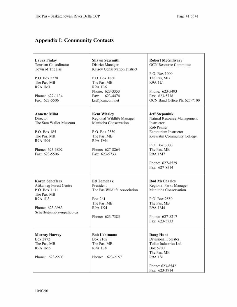
The Pas - Saskatchewan River Delta CCP Page 41 of 41
Appendix I: Community Contacts Laura Finlay Tourism Co-ordinator Town of The Pas P.O. Box 2278 The Pas, MB R9A 1M1 Phone: 627-1134 Fax: 623-5506
Shawn Sexsmith District Manager Kelsey Conservation District P.O. Box 1860 The Pas, MB R9A 1L6 Phone: 623-3353 Fax: 623-4474 [email protected]
Robert McGillivary OCN Resource Committee P.O. Box 1000 The Pas, MB R9A 1L1 Phone: 623-5493 Fax: 623-5738 OCN Band Office Ph: 627-7100
Annette Milot Director The Sam Waller Museum P.O. Box 185 The Pas, MB R9A 1K4 Phone: 623-3802 Fax: 623-5506
Kent Whaley Regional Wildlife Manager Manitoba Conservation P.O. Box 2550 The Pas, MB R9A 1M4 Phone: 627-8264 Fax: 623-5733
Jeff Stepaniuk Natural Resource Management Instructor Rob Penner Ecotourism Instructor Keewatin Community College P.O. Box 3000 The Pas, MB R9A 1M7 Phone: 627-8529 Fax: 627-8514
Karen Scheffers Atikameg Forest Centre P.O. Box 1131 The Pas, MB R9A 1L3 Phone: 623-3983 [email protected]
Ed Tomchak President The Pas Wildlife Association Box 261 The Pas, MB R9A 1K4 Phone: 623-7385
Rod McCharles Regional Parks Manager Manitoba Conservation P.O. Box 2550 The Pas, MB R9A 1M4 Phone: 627-8217 Fax: 623-5733
Murray Harvey Box 2872 The Pas, MB R9A 1M6 Phone: 623-5503
Bob Uchtmann Box 2162 The Pas, MB R9A 1L8 Phone: 623-2157
Doug Hunt Divisional Forester Tolko Industries Ltd. Box 5200 The Pas, MB R9A 1S1 Phone: 623-8542 Fax: 623-3914
10/03/01
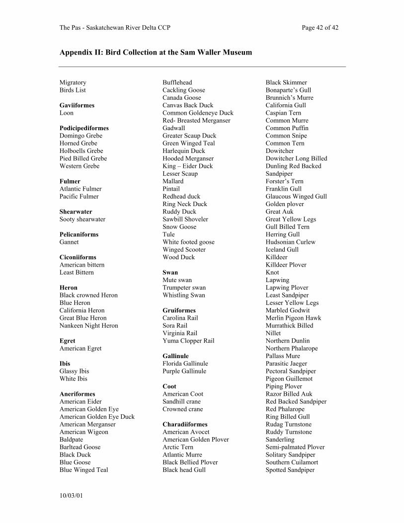
The Pas - Saskatchewan River Delta CCP Page 42 of 42
Appendix II: Bird Collection at the Sam Waller Museum
Migratory Birds List Gaviiformes Loon Podicipediformes Domingo Grebe Horned Grebe Holboells Grebe Pied Billed Grebe Western Grebe Fulmer Atlantic Fulmer Pacific Fulmer Shearwater Sooty shearwater Pelicaniforms Gannet Ciconiiforms American bittern Least Bittern Heron Black crowned Heron Blue Heron California Heron Great Blue Heron Nankeen Night Heron Egret American Egret Ibis Glassy Ibis White Ibis Aneriformes American Eider American Golden Eye American Golden Eye Duck American Merganser American Wigeon Baldpate Barltead Goose Black Duck Blue Goose Blue Winged Teal
Bufflehead Cackling Goose Canada Goose Canvas Back Duck Common Goldeneye Duck Red- Breasted Merganser Gadwall Greater Scaup Duck Green Winged Teal Harlequin Duck Hooded Merganser King – Eider Duck Lesser Scaup Mallard Pintail Redhead duck Ring Neck Duck Ruddy Duck Sawbill Shoveler Snow Goose Tule White footed goose Winged Scooter Wood Duck Swan Mute swan Trumpeter swan Whistling Swan Gruiformes Carolina Rail Sora Rail Virginia Rail Yuma Clopper Rail Gallinule Florida Gallinule Purple Gallinule Coot American Coot Sandhill crane Crowned crane Charadiiformes American Avocet American Golden Plover Arctic Tern Atlantic Murre Black Bellied Plover Black head Gull
Black Skimmer Bonaparte’s Gull Brunnich’s Murre California Gull Caspian Tern Common Murre Common Puffin Common Snipe Common Tern Dowitcher Dowitcher Long Billed Dunling Red Backed Sandpiper Forster’s Tern Franklin Gull Glaucous Winged Gull Golden plover Great Auk Great Yellow Legs Gull Billed Tern Herring Gull Hudsonian Curlew Iceland Gull Killdeer Killdeer Plover Knot Lapwing Lapwing Plover Least Sandpiper Lesser Yellow Legs Marbled Godwit Merlin Pigeon Hawk Murrathick Billed Nillet Northern Dunlin Northern Phalarope Pallass Mure Parasitic Jaeger Pectoral Sandpiper Pigeon Guillemot Piping Plover Razor Billed Auk Red Backed Sandpiper Red Phalarope Ring Billed Gull Rudag Turnstone Ruddy Turnstone Sanderling Semi-palmated Plover Solitary Sandpiper Southern Cuilamort Spotted Sandpiper
10/03/01
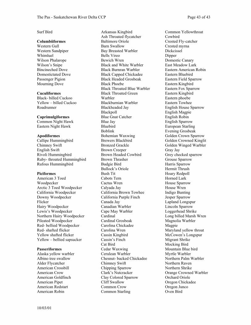
The Pas - Saskatchewan River Delta CCP Page 43 of 43
Surf Bird Columbiiformes Western Gull Western Sandpiper Whimluel Wilson Phalarope Wilson’s Snipe Bincineched Dove Domestictated Dove Passenger Pigion Mourning Dove Cuculiformes Black- billed Cuckoo Yellow – billed Cuckoo Roadrunner Caprimulgiformes Common Night Hawk Eastern Night Hawk Apodiformes Callipe Hummingbird Chimney Swift English Swift Rivoli Hummingbird Ruby- throated Hummingbird Rufous Hummingbird Piciformes American 3 Toed Woodpecker Arctic 3 Toed Woodpecker California Woodpecker Downy Woodpecker Flicker Hairy Woodpecker Lewis’s Woodpecker Northern Hairy Woodpecker Pileated Woodpecker Red- bellied Woodpecker Red- shafted flicker Yellow shafted flicker Yellow – bellied sapsucker Passeriformes Alaska yellow warbler Albino tree swallow Alder Flycatcher American Crossbill American Crow American Goldfinch American Pipet American Redstart American Robin
Arkansas Kingbird Ash Throated flycatcher Baltimore Oriole Barn Swallow Bay Breasted Warbler Bells Vireo Bewich Wren Black and White Warbler Black Burnran Warbler Black Capped Chickadee Black Headed Grosbeak Black Phoebe Black Throated Blue Warbler Black Throated Green Warbler Blackburnian Warbler Blackheaded Jay Blackpoll Blue Gnat Catcher Blue Jay Bluebird Boblink Bohemian Waxwing Brewers Blackbird Bronzed Grackle Brown Creeper Brown Headed Cowbird Brown Thrasher Budgie Bird Bullock’s Oriole Bush Tit Cabots Tern Cactus Wren Calyada Jay California Brown Towhee California Purple Finch Canada Jay Canadian Warbler Cape May Warbler Cardinal Cardinal Grosbeak Carolina Chickadee Carolina Wren Cassin Kingbird Cassin’s Finch Cat Bird Cedar Waxwing Cerulean Warbler Chesnut- backed Chickadee Chimney Swift Chipping Sparrow Clark’s Nutcracker Clay Colored Sparrow Cliff Swallow Common Crow Common Starling
Common Yellowthroat Cowbird Crested Fly-catcher Crested myrna Dickcissel Dipper Domestic Canary East Meadow Lark Eastern American Robin Eastern Bluebird Eastern Field Sparrow Eastern Kingbird Eastern Fox Sparrow Eastern Kingbird Eastern phoebe Eastern Towhee English House Sparrow English Magpie English Robin English Sparrow European Starling Evening Grosbeak Golden Crown Sparrow Golden Crowned Kinglit Golden Winged Warbler Gray Jay Grey checked sparrow Grouse Sparrow Harris Sparrow Hermit Thrush Hoary Redpoll Horned Lark House Sparrow House Wren Indigo Bunting Jesper Sparrow Lapland Longspur Lincoln Sparrow Loggerhead Shrike Long billed Marsh Wren Magnolia Warbler Magpie Maryland yellow throat McCowen’s Longspur Migrant Shrike Mocking Bird Mountain Blue bird Myrtle Warbler Northern Palm Warbler Northern Raven Northern Shrike Orange Crowned Warbler Orchard Oriole Oregon Chickadee Oregon Junco Oven Bird
10/03/01
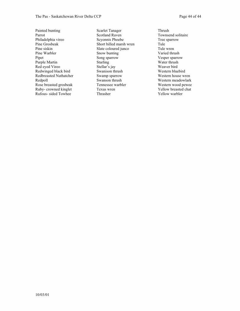
The Pas - Saskatchewan River Delta CCP Page 44 of 44
Painted bunting Parrot Philadelphia vireo Pine Grosbeak Pine siskin Pine Warbler Pipet Purple Martin Red eyed Vireo Redwinged black bird Redbreasted Nuthatcher Redpoll Rose breasted grosbeak Ruby- crowned kinglet Rufous- sided Towhee
Scarlet Tanager Scotland Raven Scyonnis Phoebe Short billed marsh wren Slate coloured junco Snow bunting Song sparrow Starling Stellar’s jay Swanison thrush Swamp sparrow Swanson thrush Tennessee warbler Texus wren Thrasher
Thrush Townsend solitaire Tree sparrow Tule Tule wren Varied thrush Vesper sparrow Water thrush Weaver bird Western bluebird Western house wren Western meadowlark Western wood pewee Yellow breasted chat Yellow warbler
10/03/01
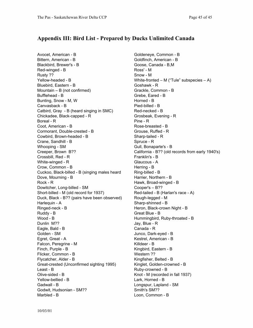
The Pas - Saskatchewan River Delta CCP Page 45 of 45
Appendix III: Bird List - Prepared by Ducks Unlimited Canada Avocet, American - B Bittern, American - B Blackbird, Brewer's - B Red-winged - B Rusty ?? Yellow-headed - B Bluebird, Eastern - B Mountain – B (not confirmed) Bufflehead - B Bunting, Snow - M, W Canvasback - B Catbird, Gray - B (heard singing in SMC) Chickadee, Black-capped - R Boreal - R Coot, American - B Cormorant, Double-crested - B Cowbird, Brown-headed - B Crane, Sandhill - B Whooping - SM Creeper, Brown B?? Crossbill, Red - R White-winged - R Crow, Common - B Cuckoo, Black-billed - B (singing males heard Dove, Mourning - B Rock - R Dowitcher, Long-billed - SM Short-billed - M (old record for 1937) Duck, Black - B?? (pairs have been observed) Harlequin - A Ringed-neck - B Ruddy - B Wood - B Dunlin M?? Eagle, Bald - B Golden - SM Egret, Great - A Falcon, Peregrine - M Finch, Purple - B Flicker, Common - B Flycatcher, Alder - B Great-crested (Unconfirmed sighting 1995) Least - B Olive-sided - B Yellow-bellied - B Gadwall - B Godwit, Hudsonian - SM?? Marbled - B
Goldeneye, Common - B Goldfinch, American - B Goose, Canada - B,M Ross' - M Snow - M White-fronted – M (“Tule” subspecies – A) Goshawk - R Grackle, Common - B Grebe, Eared - B Horned - B Pied-billed - B Red-necked - B Grosbeak, Evening - R Pine - R Rose-breasted - B Grouse, Ruffed - R Sharp-tailed - R Spruce - R Gull, Bonaparte's - B California - B?? (old records from early 1940's) Franklin's - B Glaucous - A Herring - B Ring-billed - B Harrier, Northern - B Hawk, Broad-winged - B Cooper's – B?? Red-tailed - B (Harlan's race - A) Rough-legged - M Sharp-shinned - B Heron, Black-crown Night - B Great Blue - B Hummingbird, Ruby-throated - B Jay, Blue - R Canada - R Junco, Dark-eyed - B Kestrel, American - B Killdeer - B Kingbird, Eastern - B Western ?? Kingfisher, Belted - B Kinglet, Golden-crowned - B Ruby-crowned - B Knot - M (recorded in fall 1937) Lark, Horned - B Longspur, Lapland - SM Smith's SM?? Loon, Common - B
10/03/01
The Pas - Saskatchewan River Delta CCP Page 46 of 46
Magpie, Black-billed - R Mallard - B Meadowlark, Western - B Merganser, Common - B Hooded - B Red-breasted - B Merlin - B Nighthawk, Common - B Nuthatch, Red-breasted - R White-breasted - R Oriole, Northern - B Osprey - B Ovenbird - B Owl, Barred - R Boreal - R Great Gray - R Great Horned - R Northern Hawk - R Long-eared - B Saw-whet - R Screech B?? Short-eared – B?? (observed in 1998) Snowy - M,W Pelican, White - B Phalarope, Red-necked - M?? Wilson's - B Phoebe, Eastern - B Pintail, Northern - B
10/03/01
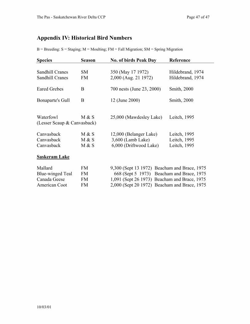
The Pas - Saskatchewan River Delta CCP Page 47 of 47
Appendix IV: Historical Bird Numbers B = Breeding: S = Staging; M = Moulting; FM = Fall Migration; SM = Spring Migration Species Season No. of birds Peak Day Reference Sandhill Cranes SM 350 (May 17 1972) Hildebrand, 1974 Sandhill Cranes FM 2,000 (Aug. 21 1972) Hildebrand, 1974 Eared Grebes B 700 nests (June 23, 2000) Smith, 2000 Bonaparte's Gull B 12 (June 2000) Smith, 2000 Waterfowl M & S 25,000 (Mawdesley Lake) Leitch, 1995 (Lesser Scaup & Canvasback) Canvasback M & S 12,000 (Belanger Lake) Leitch, 1995 Canvasback M & S 3,600 (Lamb Lake) Leitch, 1995 Canvasback M & S 6,000 (Driftwood Lake) Leitch, 1995 Saskeram Lake Mallard FM 9,300 (Sept 13 1972) Beacham and Brace, 1975 Blue-winged Teal FM 668 (Sept 5 1973) Beacham and Brace, 1975 Canada Geese FM 1,091 (Sept 26 1973) Beacham and Brace, 1975 American Coot FM 2,000 (Sept 20 1972) Beacham and Brace, 1975
10/03/01
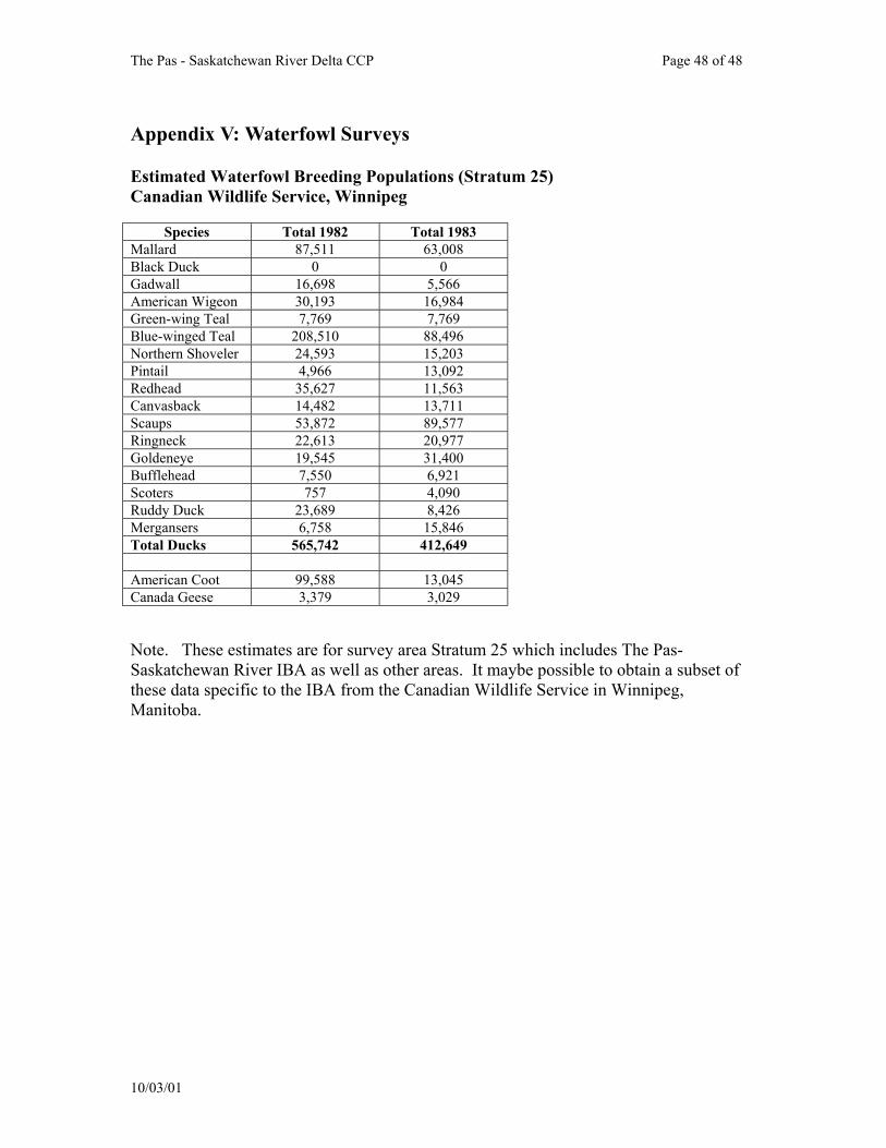
The Pas - Saskatchewan River Delta CCP Page 48 of 48
Appendix V: Waterfowl Surveys Estimated Waterfowl Breeding Populations (Stratum 25) Canadian Wildlife Service, Winnipeg
Species Total 1982 Total 1983 Mallard 87,511 63,008 Black Duck 0 0 Gadwall 16,698 5,566 American Wigeon 30,193 16,984 Green-wing Teal 7,769 7,769 Blue-winged Teal 208,510 88,496 Northern Shoveler 24,593 15,203 Pintail 4,966 13,092 Redhead 35,627 11,563 Canvasback 14,482 13,711 Scaups 53,872 89,577 Ringneck 22,613 20,977 Goldeneye 19,545 31,400 Bufflehead 7,550 6,921 Scoters 757 4,090 Ruddy Duck 23,689 8,426 Mergansers 6,758 15,846 Total Ducks 565,742 412,649 American Coot 99,588 13,045 Canada Geese 3,379 3,029 Note. These estimates are for survey area Stratum 25 which includes The Pas-Saskatchewan River IBA as well as other areas. It maybe possible to obtain a subset of these data specific to the IBA from the Canadian Wildlife Service in Winnipeg, Manitoba.
10/03/01
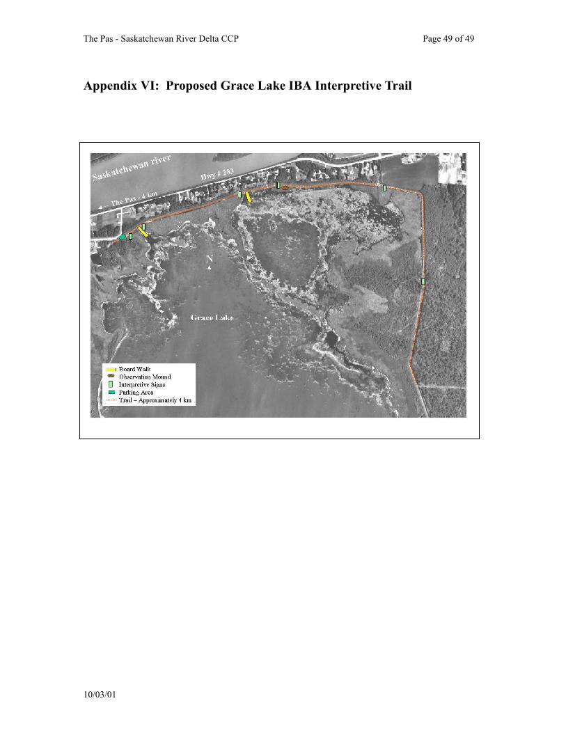
The Pas - Saskatchewan River Delta CCP Page 49 of 49
Appendix VI: Proposed Grace Lake IBA Interpretive Trail
10/03/01
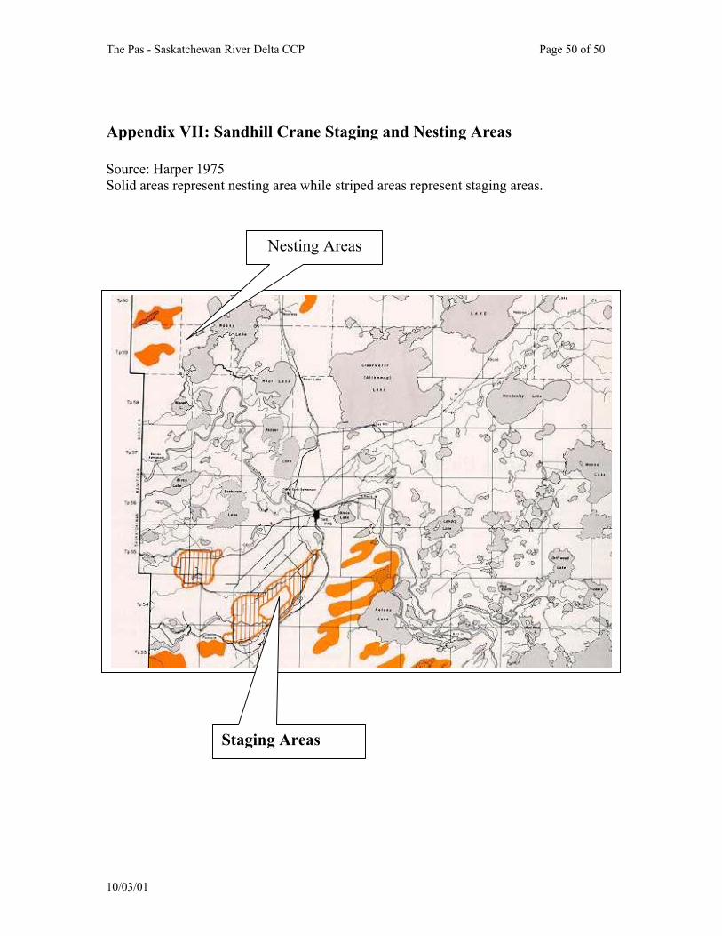
The Pas - Saskatchewan River Delta CCP Page 50 of 50
Appendix VII: Sandhill Crane Staging and Nesting Areas Source: Harper 1975 Solid areas represent nesting area while striped areas represent staging areas. Nesting Areas
Staging Areas
10/03/01

The Pas - Saskatchewan River Delta CCP Page 51 of 51
Appendix VIX: IBA Population Thresholds
1) Global threshold numbers are not necessarily 1% of the global population of a given bird. A site is also given global significance if 1% of a bird's North American population is found at a site. 2) When 10,000 is listed at the national level, 15,000 at the continental level, and 20,000 at the global level, these numbers are not 1% of the species population but are the number at which at a site containing that many birds will meet IBA criteria, under the general congregatory threshold (ie for very abundant species where 1 % of their national population is greater than 10,000 etc.). Species or Group IBA Threshold Nos. Observed Significance
Eared Grebes 1600 > 1,400 (June 2000) Almost National Sandhill Cranes (canadensis)
3,213 * 2,000 (fall 1972) National ??
Canvasback 6,830 12,000 Globally Significant Mallard 10,000 9,300 Almost National Waterfowl (Divers) 20,000 25,000 Globally Significant * No figures provided for national levels of significance, given criteria if for Continental Significance.
10/03/01