Embed Size (px)
Citation preview

THE HACKENSACK RIVER VERTICAL LIFT BRIDGES HISTORIC DISTRICT: ENGINEERING, NAVIGATION
AND COMMERCE IN THE PORT OF NEW YORK
By Glenn R. Modica

On the cover: The Hackensack River Vertical Lift Bridges Historic District. From the foreground they include the Delaware, Lackawanna & Western Railroad Bridge, NJ Route 7 (Wittpenn) Bridge, Pennsylvania Railroad Harsimus Branch freight bridge, and Pennsylvania Railroad Hudson & Manhattan Railroad passenger bridge. The Pulaski Skyway is in the distance (Boucher, HAER-Erie & Lackawanna Railroad Bridge).

PREFACEThe Hackensack River Vertical Lift Bridges Historic District is a historic resource unique to New Jersey. Four consecutive vertical lift bridges spanning the Hackensack River between Jersey City and Kearny comprise the district. From north to south the bridges include the Lower Hack Bridge, formerly the Delaware, Lackawanna & Western Railroad bridge and now operated by NJ Transit; the NJ Route 7-Wittpenn Bridge operated by the New Jersey Department of Transportation (NJDOT); the Pennsylvania Railroad Harsimus Branch freight bridge (now CSX/Norfolk Southern Railroad); and the Pennsylvania Railroad’s passenger bridge (now PATH). The latter three bridges, collectively known as the Triple Hack Bridges, were completed in 1930, while the Lower Hack Bridge was completed in 1928. The Wittpenn Bridge and the Pennsylvania Railroad’s Harsimus Branch bridge were built concurrently and share common piers at the western approach. John Alexander Low Waddell, the foremost bridge engineer of the early twentieth century, consulted on the design of the lift spans for the railroad bridges. The firm of Harrington, Howard and Ash, a successor firm to Waddell, designed the Wittpenn Bridge.
This publication has been prepared by RGA, Inc. on behalf of the NJDOT and the Jacobs Engineering Group Inc. The publication is an outgrowth of NJDOT’s plans to replace the Wittpenn Bridge with a new, vertical lift structure. In 2010, the NJDOT executed a Memorandum of Agreement to mitigate the effects of replacing the Wittpenn Bridge. Additional components of the project include Historic American Engineering Record documentation of the bridge and interpretive displays. All documentation will be placed on file with the NJDOT and the New Jersey Historic Preservation Office in Trenton.

0
Mile
1-
Area of Detail

1. Delaware, Lackawanna & Western Railroad Bridge (Lower Hack)2. NJ Route 7-Wittpenn Bridge3. Pennsylvania Railroad Harsimus Branch (Conrail/CSX) Bridge4. Pennsylvania Railroad (PATH) Bridge
1
23
4
0
Feet
1000-
KearnyJersey City
Hackensack River
Hackensack River
Hackensack RiverVertical Lift Bridges
Historic District

CONTENTSPREFACE iCONTENTS vINTRODUCTION 6ORIGIN OF THE BRIDGES 8THE HACKENSACK RIVER 11WAR OF CHEMICALS 14THE GLENDARUEL 17WAR DEPARTMENT ORDERS 20J.A.L. WADDELL 23DELAWARE, LACKAWANNA & WESTERN RAILROAD (LOWER HACK) BRIDGE 25PENNSYLVANIA RAILROAD BRIDGES 28NJ ROUTE 7-WITTPENN BRIDGE 30EPILOGUE 33BIBLIOGRAPHY 34
v

6
INTRODUCTIONMaritime commerce on the Hackensack River after World War I brimmed with activity. Schooners, scows and barges loaded with brick, stone and building materials steered downriver, while sailing vessels from Maine, Nova Scotia and the south brought lumber upriver as far as the head of navigation in New Milford, Bergen County.1 Gasoline and oil products carried on barges plied the river along with package and miscellaneous goods conveyed on steam lighters.2 Most of all, there was coal. Tons of it. Coal-laden barges guided by tugs moved slowly up the Hackensack River to make daily deliveries to the Seaboard By-Product Coke Company in Kearny or across the river to Public Service’s Marion gas plant in Jersey City.
Navigating the Hackensack River was rife with difficulty. Natural impediments included shifting shoals and shallow water, but manmade obstacles posed the greatest challenge. A series of swing-span bridges hung low over the channel, making navigation treacherous even for the experienced pilot. Most vessels had to be towed up and down the Hackensack River by tugboat. Smaller craft were towed singly while two to four tugboats moving with the tide guided larger barges and scows.3
A ship bound for the Hackensack River from New York Harbor bore about west at Constable Hook to enter the Kill Van Kull, a tidal estuary about 3.5 miles long separating Staten Island from Bayonne and the New Jersey mainland. A rocky reef at the western end of the Kill Van Kull projected from Bergen Point at the southern tip of Bayonne. The Bergen Point Lighthouse (also called Kills Light), first erected in the mid-nineteenth century, warned mariners of hazardous conditions.4 When abreast of the Bergen Point Light, vessels hauled around the lighthouse leaving it 250 yards on the starboard side. After passing the lighthouse, the pilot turned sharply north to enter the deepest part of the channel in Newark Bay and began the careful journey upstream.5
The first in the succession of bridges belonged to the Central Railroad of New Jersey. Nearly two miles long, the Central Railroad’s bridge linked Elizabeth and Bayonne across Newark Bay with a double-track, Scherzer rolling lift bascule span and timber trestle approaches.6 A pilot would have to steer easterly to maneuver through the draw of the bridge, which was built at a diagonal to the river.
Beyond the bridge, ships headed through a natural deepwater channel up the middle of Newark Bay, keeping the Passaic Lighthouse at the edge of the channel to port.7 The course continued up the middle of the channel and through the Upper Bay Bridge, a
1. USACE 1912, 7.2. USACE 1926, 11.3. USACE 1926, 8 and 11.4. Harrison and Jones, 56.5. USACE 1922, 6.6. Berhart, 45.7. Harrison and Jones, 56.
double-track swing bridge shared by the Lehigh Valley Railroad and the Pennsylvania Railroad.8 Ships approaching Kearny Point and the confluence of the Passaic and Hackensack rivers would keep to port as they passed the Elbow Beacon which shined a fixed white light marking the shallows of the broad river flats. Bearing north by northeast up the Hackensack River and past a craggy spit of land on the Jersey City side known as Droyer’s Point, vessels passed through the swing span of the Central Railroad’s Newark & New York Railroad bridge and then the Communipaw Avenue bridge, a vehicular swing-span bridge also known as the Newark Plank Road bridge and later the Lincoln Highway bridge.
Thus began the most challenging stretch of the Hackensack River. Ahead lay three closely spaced bridges – two railroad and one vehicular – that crossed the waterway at different angles and required careful navigation through each span. In succession from south to north, they included the Pennsylvania Railroad’s passenger and freight bridges followed by the Newark Turnpike Bridge operated by Hudson County. Another 1,500 feet north at the bend in the river lay another railroad bridge, this one operated by the Delaware, Lackawanna & Western Railroad. Just beyond the DL&W’s bridge lay the Seaboard By-Product Coke Company and Public Service’s Marion gas plant, the two largest contributors to Hackensack River traffic.
Traditionally, a ship has the foremost right of passage over all other modes of transportation. All drawbridges had to open upon three blasts of a ship’s whistle or horn. A reply of three blasts from the bridge tender meant the movable span was ready to be opened. Two long blasts indicated a delay in opening. The bridge had to open safely provided no train was approaching within five minutes of the bridge. During the morning and evening rush hour, the bridges did not have to remain open for more than ten minutes.9
The heavy and constant volume of traffic, across the bridges and over the river, stirred continual conflict between the railroads and shippers. Bridge operators often forced vessels to wait by refusing to open a bridge, usually during the morning or evening rush hour when trains passed over these bridges every five minutes. The right of passage through the swing bridges became a source of contention with the rise of industry along the Hackensack River toward the end of World War I. Industrial, maritime and civic interests argued that the Hackensack River swing-span bridges – in particular the four bridges south of the Seaboard By-Product Coke facility – posed a hazard to a ship’s right to unimpeded navigation and acted as barrier to economic development along the river.
8. Greenberg and Fischer, 151.9. United States Army Corps of Engineers 1915, 30-31.

7
The Bergen Point Light located at the western end of Kill van Kull at the entrance to Newark Bay warned mariners of the rocky reef that projected from the end of Bayonne (Foghorn Publishing).

8
ORIGIN OF THE BRIDGESBefore there were bridges, ferries carried passengers back and forth across the Hackensack River between Jersey City and Kearny. John Douw established the first ferry across the Hackensack River around 1759. The road to the ferry utilized a causeway built across the Kearny meadows several years earlier by John Schuyler to reach his copper mine. This road generally follows today’s Belleville Turnpike. The road in Jersey City leading to the ferry followed a route just north of today’s Newark Turnpike. Douw operated a tavern on the west side of the Hackensack River to shelter travelers and entertain guests.1
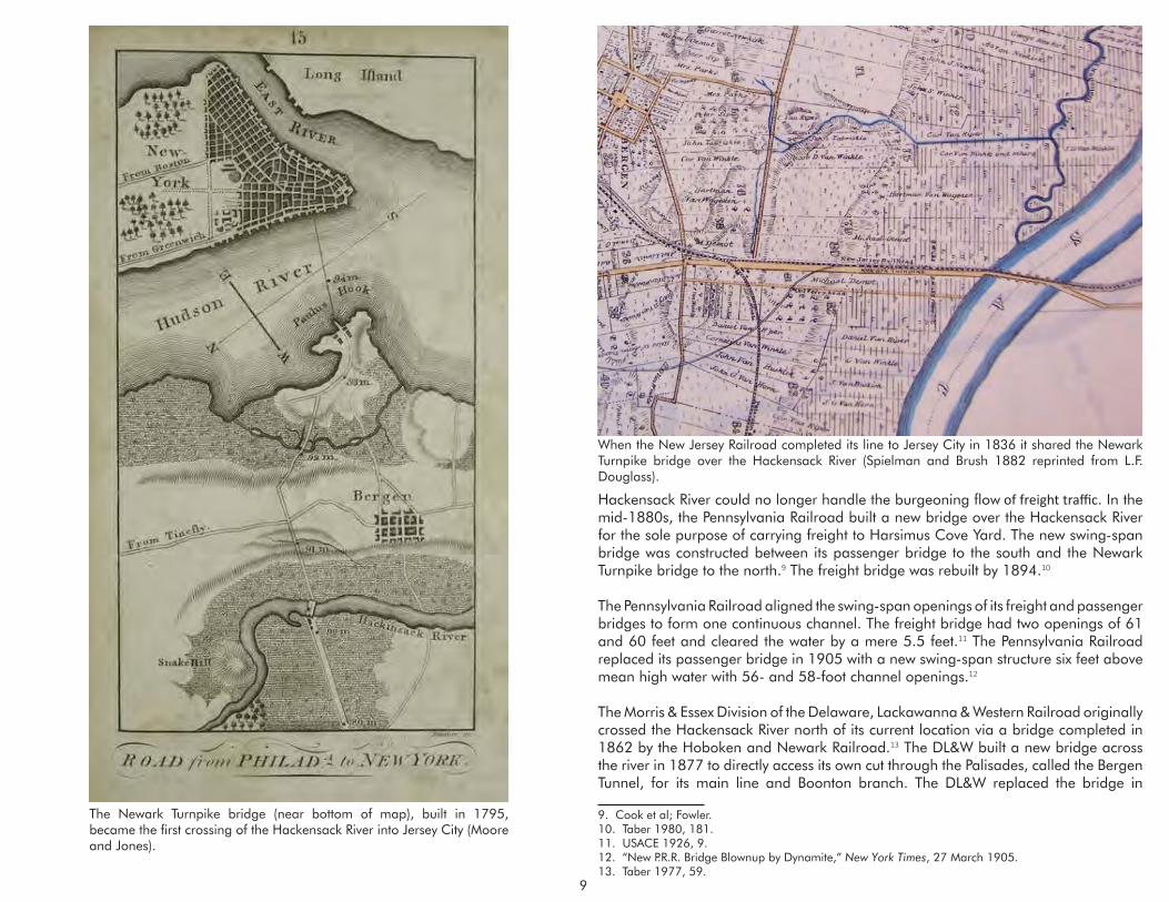
To improve connections between Philadelphia and New York, the New Jersey State Legislature in 1790 authorized construction of a four-rod road (66 feet) between Newark Court House and the ferry at Powles (Paulus) Hook in Jersey City. Draw bridges to be built over the Hackensack and Passaic rivers had to have at least a 24-foot opening to permit unimpeded navigation.2 The first bridge over the Hackensack River to Jersey City, completed by the summer of 1795, was a wooden drawbridge, 980 feet in length, with piers and abutments built of stone quarried from nearby Snake Hill.3 The new bridge quickly put Douw’s Ferry out of business.
Further transportation improvements occurred in 1804 when the New Jersey Legislature chartered the Newark Turnpike Company. Using the same route laid out in 1790, the Newark Turnpike Company operated a toll road from Paulus Hook at Warren Street, along Newark Avenue and then over the Hackensack River bridge to connect with the Belleville Turnpike in the meadows.4 The Hackensack and Passaic River Bridge Company acquired from the Newark Turnpike Company the franchise and use of the bridges.5
The Newark Turnpike was rebuilt several times over the course of the nineteenth century to address the ruts, washouts and otherwise near continuous deterioration of the roadway due to high traffic and storm damage. In 1911, Hudson County completed a new bridge with a 225-foot swing-span and three fixed spans. The bridge had channel clearance of 80 feet and sat nine feet above the water in the closed position. The bridge was designed by Alexander S. Hamill, Hudson County Engineer. A contemporary observer unimpressed with the new structure concluded “there are no remarkable features in the design.”6
The New Jersey Railroad and Transportation Company, the third railroad incorporated in the state, became the first to reach Jersey City when it laid its tracks across the 1. Winfield, 273; Robinson, 9.2. Lane, 123.3. Brydon, 186.4. Eaton, 78.5. Shaw, 1040.6. “Open Caisson Foundations of the Newark Turnpike Bridge;” USACE 1926, 9.
meadows in 1834. By 1838, the railroad had cut through the traprock in Bergen Hill to reach the Hudson River waterfront. The following year, the New Jersey Railroad connected with the Camden and Amboy Railroad at New Brunswick to provide the first direct rail service between New York and Philadelphia.7
To cross the Hackensack River, the New Jersey Railroad set its sights on jointly using the Newark Turnpike bridge. The New Jersey Railroad acquired a majority of the Hackensack and Passaic River Bridge Company’s stock and built a bridge adjacent to the south side of the turnpike bridge. In 1846, after the Grand Jury of Hudson County objected to the joint use of the bridge, the railroad erected an independent structure south of the turnpike bridge dedicated solely to railroad use.8
In 1867, the New Jersey Railroad was absorbed by the United Canal and Railroad Company of New Jersey, which was then leased in 1871 by the Pennsylvania Railroad for a term of 999 years. After the Pennsylvania Railroad completed its freight terminal at Harsimus Cove on the Hudson River in Jersey City, the single bridge across the
7. Lane, 3128. Ibid.
During the Colonial era, ferries crossed the Hackensack River from Jersey City near present-day Communipaw Avenue (bottom) and Newark Avenue (top) (Hills).
9
The Newark Turnpike bridge (near bottom of map), built in 1795, became the first crossing of the Hackensack River into Jersey City (Moore and Jones).
When the New Jersey Railroad completed its line to Jersey City in 1836 it shared the Newark Turnpike bridge over the Hackensack River (Spielman and Brush 1882 reprinted from L.F. Douglass).
Hackensack River could no longer handle the burgeoning flow of freight traffic. In the mid-1880s, the Pennsylvania Railroad built a new bridge over the Hackensack River for the sole purpose of carrying freight to Harsimus Cove Yard. The new swing-span bridge was constructed between its passenger bridge to the south and the Newark Turnpike bridge to the north.9 The freight bridge was rebuilt by 1894.10
The Pennsylvania Railroad aligned the swing-span openings of its freight and passenger bridges to form one continuous channel. The freight bridge had two openings of 61 and 60 feet and cleared the water by a mere 5.5 feet.11 The Pennsylvania Railroad replaced its passenger bridge in 1905 with a new swing-span structure six feet above mean high water with 56- and 58-foot channel openings.12
The Morris & Essex Division of the Delaware, Lackawanna & Western Railroad originally crossed the Hackensack River north of its current location via a bridge completed in 1862 by the Hoboken and Newark Railroad.13 The DL&W built a new bridge across the river in 1877 to directly access its own cut through the Palisades, called the Bergen Tunnel, for its main line and Boonton branch. The DL&W replaced the bridge in
9. Cook et al; Fowler.10. Taber 1980, 181.11. USACE 1926, 9.12. “New P.R.R. Bridge Blownup by Dynamite,” New York Times, 27 March 1905.13. Taber 1977, 59.

10
1902 with a double-track swing bridge that lay 12 feet above mean high water.14 The original 1862 bridge north of the DL&W was abandoned by 1910 and removed the following year.15
The four bridges at the north end of Kearny and Jersey City belonging to the Pennsylvania Railroad, Hudson County, and the Delaware, Lackawanna & Western Railroad were all swing-span bridges. In a swing-span, the movable span rotates around a central pivot. When fully opened the swing-span bridge provided two channels of navigation. Until the close of the nineteenth century, swing-span bridges dominated bridge construction where wide channels needed to be crossed. The swing-span had its drawbacks. They were slow to open and close. If the operating machinery failed they either didn’t open at all or refused to close. Wide barges especially had great difficulty navigating between the mid-channel pivot pier and the river piers. The bridges sat so low to the water that they had to be opened for all but the smallest of vessels.
14. Taber 1980, 22.15. USACE 1912, 7.

11
THE HACKENSACK RIVERThe Hackensack River begins a 50-mile journey from its headwaters near Haverstraw in Rockland County, New York. The river meanders south crossing the state line into Bergen County, New Jersey where it widens just below Little Ferry at the mouth of Overpeck Creek. It flows through salt meadows before finally merging with the Passaic River at the southern end of Kearny and emptying into Newark Bay. The Hackensack River formed some 15,000 years ago when the retreating Wisconsin Glacier scoured and compressed bedrock to form what paleontologists call Glacial Lake Hackensack. What rose up out of the lake bed became the Hackensack River watershed.1
The Hackensack River’s head of navigation lay some twenty miles upstream from Newark Bay in New Milford, Bergen County.2 Throughout the nineteenth century most maritime vessels on the Hackensack River carried goods to and from the upper reaches of the river—to New Milford, Little Falls and especially Hackensack. The lower portion of the Hackensack River, in the vicinity of Jersey City and Kearny, was bordered by vast low-lying meadows that remained largely undeveloped through the nineteenth century. Farmers built docks along the upper Hackensack River and its major tributary, Overpeck Creek, to float agricultural products downstream to markets in Jersey City and New York. The Town of Hackensack emerged in the nineteenth century as the most important industrial and shipping center along the river.3 Shipped downriver from its wharves lining the waterfront were bricks, agricultural produce, and flour. Goods sent upriver included mainly coal and lumber.4 The steady increase in maritime commerce led to the first request for federal government action to improve navigation on the river.
1. “The Hackensack River: A True Comeback Story.”2. USACE 1922, 8.3. Federal Writers’ Project, 259.4. USCAE 1889, 842-4; Olsen, 15.
The improvement of waterways rested with state governments or private corporations until 1824. In that watershed year, the Supreme Court’s decision in Gibbons v. Ogden conferred upon Congress the power to regulate interstate commerce, including commerce over the nation’s waterways.5 In 1824, Congress passed the first Rivers and Harbors Act that appropriated funds to remove obstructions from the Mississippi and Ohio rivers. The Rivers and Harbors Act conferred upon the Army Corps of Engineers, part of the Department of War, jurisdiction over the nation’s navigable waterways.6 Appropriations for the Rivers and Harbors Act remained slim until after the Civil
War. Late nineteenth century industrial growth fostered a vast increase in maritime traffic and led to the passage of more legislation and appropriation of more funds to facilitate navigation along the nation’s waterways.
The first federal legislation involving the Hackensack River came with the passage of the Rivers and Harbors Act of 1852. Although Congress appropriated $10,000 to remove a sandbar near the convergence of the Passaic and Hackensack rivers, there is no record of the project being carried out.7
The Army Corps of Engineers completed its first survey of the Hackensack River in 1889. The
survey covered the upper reaches of the river from Little Ferry to Hackensack, at the time an area with the greatest population, the most industry, and most maritime traffic. The Army Corps estimated that goods shipped along this section of the river amounted to 250,000 tons valued at $1 million per year. Despite the Army Corps’ recommendation to widen and improve the channel at an estimated cost of $60,000, Congress did not adopt the project.8
5. Holmes, 3.6. Hull and Hull, 13.7. Klawonn, 249.8. USCAE 1926, 6.
Topographical map showing the five closely spaced bridges near Kearny Point (center of map) at the bend in the Hackensack River. The northernmost bridge, shown here associated with the Paterson & Newark Railroad, was removed during World War I (Bien and Vermeule).

12
This 1914 coastal survey shows the recently dredged channel in Newark Bay and the depths of the Hackensack River (Coast and Geodetic Survey).

13
In its report, the Army Corps of Engineers gave passing reference to the lower section of the Hackensack River, stating it had “ample width and depth.” The Army Corps saw no immediate need to improve the lower section of the river but predicted that a future need may arise as the Hackensack River “runs through salt meadows as yet entirely unimproved, but destined within the next twenty years to become very valuable.”9
Observers routinely regarded the meadows as a “wasteland” and “worthless,” an unpleasant, unhealthy, and unproductive place that ought to be “improved” out of existence as rapidly as possible. Civic boosters, business leaders, and public officials had long cast an acquisitive eye toward the meadows. Countless plans and ideas had been brought forth to “reclaim” the meadows for industrial, commercial and residential use.10
In his comprehensive report on the meadows published in 1897, Cornelius Clarkson Vermeule, consulting engineer to New Jersey’s geological survey, remarked that the Hackensack River “throughout almost its entire navigable course, is cut off from neighboring populous upland by broad belts of tide-marsh, which make it entirely inaccessible, rendering almost useless its otherwise excellent facilities for manufacturing and internal commerce.”11 Vermeule recommended filling the meadows for commercial use and “bringing down of the cities to the water front, so that these waterways can be utilized.”12 Vermuele observed another impediment to future growth: the bridges with their low draws crossing the river. Vermeule recommended that “with the improvement of navigation on the Hackensack, some considerable relief to navigation and railroad traffic would be afforded if the numerous railroad and high-way bridges were raised high enough to admit tugs and barges passing under.”13
9. USCAE 1889, 842-4.10. “The New System of Reclaiming Lands, ”Frank Leslie’s Illustrated Newspaper, 16 November 1867, 36–37 after Marshall.11. Vermeule, 304.12. Ibid.13. Ibid, 310.
The increase in maritime activity and the use of larger ships with deeper drafts, mostly north of Jersey City, prompted the Army Corps of Engineers to initiate the first dredging project of the Hackensack River authorized by the Rivers and Harbors Act of 1912. The existing navigable depth of the Hackensack River from the head of Newark Bay to the Central Railroad’s Newark & New York Railroad bridge was about eight feet and then increased to approximately 12 feet north of the bridge.14
The Army Corps of Engineers project called for dredging and maintaining a consistent 12-foot deep, 200-foot wide channel from Newark Bay to Little Ferry, a distance of 13 miles. North of Little Ferry, the river would be dredged from its existing five- to six-foot depth to a depth of 12 feet with a 150-foot wide channel. Newark Bay was also dredged with a 20-foot deep, 300 feet wide channel.15 The project was estimated to cost $171,018.10 plus $6,000 for annual maintenance.16 The Army Corps of Engineers completed the dredging project on November 14, 1914 and reported favorably that larger boats are being used and are less dependent on tides.17
The dredging project could not have come at a better time. War broke out in Europe in July 1914. Even though the United States proclaimed its neutrality, American industry still provided the Allies with needed goods to aid the war effort. American entry into the hostilities in 1917 stimulated the need to produce more wartime goods. Industries seeking to capitalize on supplying American troops with the necessary war materiel sought new building sites and looked to the undeveloped meadows along the Hackensack River.
14. USACE 1918, 317.15. USACE 1922, 13.16. United States War Department, 317.17. Ibid, 318.

14
WAR OF CHEMICALS
Aerial view of the Seaboard By-Product Coke Company. The tracks of the Delaware, Lackawanna & Western Railroad are at bottom right (The Koppers Company).
On the eve of the First World War, the Hackensack River between Kearny and Jersey City still remained largely in its natural state. The Newark Meadows Improvement Company owned most of the land in the Kearny meadows. Along the eastern edge of the river was one industry – the New Jersey Zinc Company/National Metallurgical Company just below the Newark Plank Road bridge. The company had a river pier and a railroad siding leading to the Central Railroad’s Newark & New York Railroad. The former recreational use of the river was evidenced by the presence of the Eureka Yacht Club and Passaic River Yacht Club north of the Plank Road bridge. Jersey City’s four miles of Hackensack River frontage remained mostly “unreclaimed,” except for Lincoln Park (originally West Side Park), a recreation pier, and Public Service’s Marion gas works.1
After the United States entered the First World War in April 1917, existing industries shifted from producing domestic products to churning out military goods. The war precipitated a building boom as industry sought out available sites on which to erect new facilities. The undeveloped meadows bordering Newark Bay and the Hackensack River offered plenty of opportunities. New railroad sidings could connect with any of the railroads that crossed the meadows in order to deliver goods for transshipment from the Jersey City waterfront. More importantly, the Hackensack River provided a strategic location to send and receive river borne goods.
The First World War immediately stimulated development of Port Newark. The City of Newark began developing its waterfront along Newark Bay in 1915. Using its own money, the city built one mile of bulkhead, warehouses, slips and docks on thousands of acres of reclaimed meadows to attract industry and create a first-class port. During the war, the city leased 113 acres to the Submarine Boat Corporation to establish a shipyard.2 By the close of the war the Submarine Boat Corporation had become the second largest shipyard in the country. The Texas Oil company also established a refinery at the edge of Newark Bay.3
The largest operation to establish a facility in the meadows was the Federal Shipbuilding Company. A subsidiary of U.S. Steel, Federal Shipbuilding began developing in 1917 a 160-acre site on the west side of the Hackensack River in Kearny, between the Plank Road bridge and the Central Railroad’s Newark & New York Railroad bridge. Federal Shipbuilding developed the facility to construct ocean-going cargo vessels to carry war materiel and supplies to the European front. The first keel was laid at the yard on November 14, 1917, and the first vessel, the Liberty, was launched on June 19, 1918, five months before the end of the war.4
1. Hopkins 1908 and 1909.2. USACE 1922, 22.3. Ibid, 29.4. “Yard of the Federal Shipbuilding Company.”
Prior to the First World War, Germany led the world in chemical production. It not only manufactured more dyes for textiles but also produced the most benzene and toluene, chemicals used to make explosives such as TNT. When war broke out in 1914 that supply stopped and the First World War proved to be a war of chemicals. In 1916, three chemical-producing companies took up sites adjacent to each other in Kearny at the bend in the Hackensack River north of the Delaware, Lackawanna & Western bridge. Even though the United States still proclaimed its neutrality, the chemical industries provided direct aid to the Allies.5
The Martin Dennis Company of Newark built a new facility to manufacture sodium bichromate and potassium dichromate, chemicals used in the preparation of “Tanolin,” a leather tanning agent in high demand to cure military boots. The White Tar Company developed a long narrow parcel directly south of the Martin Dennis Company and constructed several buildings on the site to refine crude naphthalene to produce moth repellents, disinfectants, and deodorizers. These products helped prevent “trench fever,” a debilitating disease caused by lice.6
5. Cannadine, 253.6. AKRF, Appendix B:2-11.

15
Coal yard of the Seaboard By-Product Coke Company (“Plant of the Seaboard By-Product Coke Company”).
In April 1916, the H. Koppers Company began construction of a new coke producing facility on thirty-five acres between the White Tar Company and the Delaware, Lackawanna & Western bridge. The new facility, called the Seaboard By-Product Coke Company, began operations the following year. The gas released from burning coal produces a byproduct gas called coke. Coke gas, more efficient than coal, has great industrial uses and was distributed to fuel the furnaces of nearby industries turning out goods for the war effort.7
German-born Heinrich Koppers (1872-1941), an engineer by trade, developed an economical method of recovering the byproduct chemicals of the coking process. Building on his patented designs for coke ovens, Koppers established the firm of Heinrich Koppers AG in 1901 in Essen, Germany. Koppers immigrated to the United States and built coke ovens for U.S. Steel in Joliet, Illinois by 1907. In 1912, he established the H. Koppers Company in Chicago.8
The H. Koppers Company caught the acquisitive eye of American millionaire, Andrew Mellon. Andrew Mellon (1855-1937), a native of Pittsburgh, had made his money in banking but amassed his fortune by owning an interest in a broad spectrum of industries. Mellon’s holdings included Gulf Oil, the Aluminum Company of America
7. “Placing Foundations for Coke Plant Near New York,” 688.8. BJHP, Box 30, Folder 2, Stanley N. Brown to Burton Jesse Hendrick, 30 September 1941.
(Alcoa), the Standard Steel Car Company, makers of railroad cars, and Carborundum, manufacturers of industrial abrasives. Mellon also owned a stake in the New York Shipbuilding Company, located along the Delaware River in Camden, New Jersey, though he sold his shares in the company in 1916. Along with Henry Ford and John D. Rockefeller, Andrew Mellon was one of the richest men in the United States.9
In June 1914, Heinrich Koppers left for Germany intending to return after a few months. After war broke out in Europe on July 28, Koppers was classified as an enemy alien and unable to return to the United States.10 The federal government seized Koppers property, including his shares in his own company.11 In November 1914, Andrew Mellon, H.W. Croft and Hamilton Stewart purchased 80 percent of the Koppers Company stock to acquire a controlling interest in the firm. Mellon relocated the company’s headquarters the following year to the familiar steel territory of his hometown, Pittsburgh.12 In 1916 the Koppers Company established the Seaboard By-Product Coke Company in Kearny.
In October 1918, the federal Office of Alien Property Custodian sold Heinrich Kopper’s remaining shares in the company at public auction. One group of bidders participated, 9. Cannadine, 257.10. BJHP, Box 30, Folder 2, “BJH Notes,” 27 August 1941.11. Cannadine, 253.12. BJHP, Box 30, Folder 2, Stanley N. Brown to Burton Jesse Hendrick, 30 September 1941.

16
a group headed by Andrew Mellon, who modified the name to the Koppers Company. After the war, Heinrich Koppers was allowed to return to America. He visited Mellon in Pittsburgh in 1921 to discuss re-entering the company he created. Mellon refused, writing “I could see no reason for giving the proposition favorable consideration.”13
The First World War had created unprecedented demand for coke. Coke byproducts valuable to the war effort included ammonia, benzol, and tuluol, all used to manufacture explosives such as TNT. At the beginning of the war, the United States had not one facility to recover the aforementioned byproducts. From 1916 to 1918, Koppers put into operation a coke plant once every 60 days and a benzol and toluol plant every six weeks.14 The Koppers Company benefitted handsomely from the war, including a $7 million contract from U.S. Steel.15
The signing of the armistice in November 1918 ended hostilities and curtailed the demand for chemicals. Despite this the Seaboard By-Product Coke Company flourished during peacetime. Coke had a very practical and widespread domestic use. Coke was used for heating. The Seaboard By-Product Coke Company was ideally situated directly across the Hackensack River from Public Service’s Marion gas works in Jersey City. Seaboard had laid a gas pipeline beneath the Hackensack River to connect the two facilities. The gas that Seaboard produced went directly to the Public Service, which in turn distributed the gas to homes and businesses throughout northern New Jersey’s most urbanized areas.16 Reflecting on the decision to establish the Seaboard By-Product Coke Company, Andrew Mellon wrote in 1919: “The Seaboard plant has been built with the idea of disposing of the coke locally for domestic purposes on the
13. Cannadine, 254.14. BJHP, Box 30, Folder 2, “The Koppers Company,” typed manuscript, undated but appears to be circa 1930.15. Cannadine, 253.16. “Placing Foundations for Coke Plant Near New York,” 688.
theory that in the long run that market would be a very steady and profitable one in connection with the advantage of the Seaboard location for disposal of the various by-products.”17
With a buyer of their product near at hand, the Seaboard facility flourished after the war. Their demand for coal filled the Hackensack River with larger and heavier barges laden with incoming coal and outgoing coke. The success of Seaboard prompted expansion into new markets as “the ultimate success of the merchant coke plants at St. Paul and Jersey City [Kearny] in marketing coke for domestic uses encouraged the management to build more similar plants in other cities and selling the gas to public utilities.”18 By the 1920s, the Koppers Company had become one of the nation’s largest operators of coal mines, coke plants, tar distilling plants, wood preserving plants, and blast furnaces. In addition to distributing gas and electricity, the company produced fertilizers, road materials, creosote oil, and paint.19
Mellon and his partners transformed the company from a builder of ovens to a national conglomerate that had a great influence over the national economy. More than any other American company, the Koppers Company had both greatly benefitted from the war and played an instrumental role in winning it. Of all the industries along the banks of the Hackensack River, the Seaboard By-Product Coke Company created the most maritime commerce and stood to benefit the most from improved navigation along the river.
17. BJHP, Box 35, Folder 1, Andrew W. Mellon to J.L. Replogle, 29 December 1919.18. BJHP, Box 30, Folder 2, “The Koppers Company.”19. Ibid.

17
THE GLENDARUELThe exigencies of war placed great strains on the nation’s railroads. Nowhere was that more evident than in the Port of New York. Unprecedented demand for raw materials and manufactured products meant that carloads of coal, ore, steel and war materiel from the west stalled at the freight terminals along the Hudson River and could not be unloaded fast enough onto awaiting barges, car floats and lighters. Trains backed up for hundreds of miles. The breakdown of railroad freight handling prompted the federal government to nationalize the railroads and take them under control.1
In an effort to improve the regional transportation network and bolster commerce in and around the Port of New York, the states of New York and New Jersey created the New York, New Jersey Port and Harbor Development Commission in 1917. The Commission’s findings, issued in 1920 in a 500-page Comprehensive Report, took aim at the complicated and inefficient railroad freight handling system that terminated in Jersey City.2 To alleviate the problem, the Commission proposed to divert rail traffic before it reached the west side of the Hudson River. The Commission proposed belt line railroads to divert freight traffic around the busiest and most congested areas of northern New Jersey. Trains would be redirected to one of several shared freight and waterfront terminals that would centralize the transfer of inbound and outbound freight between railroads and ships.3
The proposed belt lines and rail terminals were intended to alleviate congestion across the region’s waterways, particularly the Hackensack River. The Commission noted that “an unnecessary number of bridges cross the [Hackensack] river.” The three consecutive bridges across the Hackensack River – the Pennsylvania Railroad’s freight and passenger bridges and the Newark Turnpike bridge – drew particular attention. The Commission stated bluntly “they are so close together as to render navigation hazardous.” The Commission proposed “they could and should be combined in a single structure.”4
While railroads struggled during the Great War, maritime commerce thrived. In 1914, the amount of goods shipped on the Hackensack River totaled 460,303 tons. That number rose to 795,563 tons in 1915, and to 696,391 tons in 1916. In 1917, when the United States entered the conflict, the amount of tonnage carried on the river more than doubled to 1,417,262 tons and rose again the following year to 1,841,548 tons. Even during the first year of peacetime in 1919, commerce continued to rise, eclipsing
1. Churella, 702.2. The Commission’s most far-reaching recommendation led to the creation of the Port of New York Authority in 1921. The Port Authority began as a planning agency charged with carrying out the 1920 Comprehensive Plan. But railroad executives proved to be intractable. After several years and little to show for its efforts, the Port Authority turned its attention to improving vehicular traffic through the region and made its imprint on the landscape by building interstate bridges. 3. New York, New Jersey Port and Harbor Development Commission.4. Ibid., 369.
two million tons. The value of all articles carried on the Hackensack River tripled, from $3.7 million in 1916 to $10.9 million in 1919.5
Nearly half of all the tonnage carried along the river in 1919 – one million tons – was coal. The $4.7 million worth of coal represented almost half the value of all goods shipped on the river.6 Nearly all of the coal went to the Seaboard By-Product Coke Company. Most of the remaining coal went to the Public Service’s Marion gas works, which consumed about 300,000 tons a year.7 The second most valuable product shipped on the Hackensack River was coke, the coke produced by Seaboard: 190,535 tons valued at $1.3 million.8 Seaboard’s impact on the commerce of the Hackensack River was so great that it single-handedly contributed to half the commerce brought up and down the Hackensack River.
A nationwide economic downturn in 1920 cut in half the total tonnage carried on the Hackensack River from the year before, to one million tons.9 The Army Corps of Engineers, then considering another dredging project of the river, attributed the decline “due mainly to the fact that a large manufacturing plant used considerably less coal in 1920 than in the preceding year.”10 Though not mentioned by name, the “manufacturing plant” was most certainly Seaboard. The economic recovery that began in 1921 signaled prosperity that would last the rest of the decade. Total yearly tonnage on the Hackensack River rebounded to 1.5 million tons, with Seaboard accounting for more than half of that amount from its imports of coal and exports of coke.11
As much as Seaboard contributed to the economic vitality of the Hackensack River, so too did it depend on the river and the safe operation of its coal barges heading upriver. Every day, Seaboard required 3,000 tons of bituminous coal. Not just any coal would do. Seaboard required high-grade coal of uniform quality to produce an even supply gas. A constant flow of coal was needed to keep the coke furnaces in continuous use, otherwise a reduction in temperature could cause the furnace lining to contract and become damaged.12
To ensure a steady supply of coal, the company could import coal either by rail or barge. The facility had direct rail connections to the Erie Railroad and the Delaware, Lackawanna & Western Railroad. Seaboard’s relationship with the railroads was at
5. USACE 1926.6. USACE 1922, 20.7. Ibid., 30.8. Ibid., 20.9. USACE 1921, 361,10. Ibid., 360.11. USACE 1922, 46.12. USACE 1926,18.

18
In 1922, the Glendaruel, a steamer loaded with coal making a delivery to the Seaboard By-Product Coke Company crashed into the Lincoln Highway bridge. A temporary bridge was erected within a few months (“Steamer Runs into Open Drawbridge and Wrecks it”).
times acrimonious. On several occasions, Seaboard disputed the coal rates charged by the railroads, claiming they were being overcharged based on the distance hauled. The contentious relationship took the form of several lawsuits against the railroads. In some instances, Seaboard joined Public Service as plaintiffs against the railroads.13
Rather than rely solely on the railroads, Seaboard preferred to import its coal by barge. The company built an 800-foot wharf just above the Delaware, Lackawanna & Western Railroad bridge. Seaboard imported nearly all its coal from Virginia, West Virginia and Kentucky. Seaboard claimed the coal from these southern fields was of better quality than the coal mined in western Pennsylvania. Not to mention that “greater difficulties and uncertainties attend the transportation and constant supply of Pennsylvania coal” via the railroad.14
Coal was loaded onto rail cars and sent to Hampton Roads Harbor in Norfolk, Virginia where it was loaded onto ocean-going barges. Coal barges leaving Norfolk could be loaded to only partial capacity due to the limited depth of the Hackensack River. Coal barges were limited to 1,450 tons and a 16-foot draft, just enough to move upstream at high tide. Overloaded barges that attempted to navigate upriver or barges moving upstream at ebb tide frequently grounded in the river between the Central Railroad’s Newark & New York bridge and the Lincoln Highway/Communipaw Avenue bridge to the north.15 In many instances, a barge arriving in New York Harbor during inclement weather could not navigate upstream at all. Instead, a barge had to drop anchor and incur demurrage charges due to the delay in unloading.16
Seaboard had at its disposal larger and faster ocean-going steamers. They could carry greater tonnage but they also had deeper drafts and could not be loaded to full capacity. Even a partially loaded steamer would save Seaboard twenty cents a ton over using barges.17 An especial advantage of steamers is that they could navigate through inclement weather, thus avoiding costly demurrage charges. After World War I, Seaboard came to increasingly rely on steamers to speed the flow of coal to its facility and lower costs.
13. Interstate Commerce Commission 1922, 317-334.14. USACE 1926, 18.15. USACE 1922, 30 and46.16. USCAE 1926,19.17. Ibid., 20.
On the morning of June 22, 1922, the Glendaruel, a collier from Norfolk, Virginia was heading up the Hackensack River to deliver coal to Seaboard. The Glendaruel, said to be the largest ship that ever went on the Hackensack River, had made the same trip only the week before.18 Carrying about 1,000 tons of coal with a gross weight of 2,063 tons, the collier was drawing nineteen feet of draft, the maximum limit under ideal circumstances. The tide that morning was low. The Glendaruel headed up the Hackensack River under her own power though a tug was at the stern to help guide the ship through the channel. By some accounts there may have been a “peculiar current” that day, one that sweeps from the southeast and “fools all the pilots.”19
After passing through the opening of the Central Railroad’s Newark & New York Railroad bridge, the Glendaruel continued north through the channel to pass through
the next bridge carrying the Lincoln Highway over the river. The swing-span of the Lincoln Highway bridge fully opened, giving the Glendaruel seventy-eight feet to maneuver. As the ship neared the bridge, the crew realized they were off course. They cast out a mud hook anchor to slow down but to no avail. The ship rammed into the wooden fender built to protect the swing-span, splitting the fender like kindling. The Glendaruel then squarely hit the draw span, knocking it off its pivot pier and pushing it upriver. The force of impact broke the supporting girders and buckled the 200-foot long swing-span, dropping the 900-ton structure on top of the wrecked fender.20 Nobody was seriously injured, and the boat sustained only minor damage on its bow. The Glendaruel ran aground and had to wait for the incoming tide before completing its journey.21
All vehicular traffic had to be diverted a mile north to the Newark Turnpike bridge. The State Highway Department had been in discussions with Hudson and Essex counties to assume control of the Lincoln Highway bridge for some time before the collision.22 The State Highway Department agreed to take control of the crossing and build a new Lincoln Highway bridge that would be “much larger, higher and stronger” than its mangled predecessor. In the meantime, the State Highway Department erected a temporary bridge with trolley tracks that opened in November 1922.23
18. “Suggest Sand Bar Caused Span Wreck, Newark Evening News, [illegible date] July 1922.19. “Coal Steamer Crashes Head-On Into Draw Span, Jersey Journal [Jersey City], 22 June 1922; “Marine Casualties.” 20. “Steamer Wrecks Drawbridge on Traffic Artery.”21. “Coal Steamer Crashes Head-On Into Draw Span;” “Marine Casualties.” 22. “Steamer Wrecks Drawbridge on Traffic Artery.”23. “Highway Board Plans An Entire New Structure,” Jersey Journal, 29 June 1922; “Bridge Reopening to End Congestion on Newark Pike,” Jersey Journal, 14 November 1922.

19
The matter of the Glendaruel went to trial in district court and then was appealed to the Circuit Court of Appeals. When the case was finally decided in 1928, Charlton B. Hibbard, the owner of the Glendaruel, had to pay $115,000 in damages to Hudson and Essex counties, then the owners of the bridge, which had to turn the money over to the State Highway Department.24
The collision reverberated back to Hackensack River industries. Due to the difficulties in navigating the Hackensack River, insurance underwriters would no longer insure large self-propelled vessels – like the Glendaruel – for damages caused to bridges and other fixed objects in the river. The risk of navigating in the section of the Hackensack River between Kearny and Jersey City was considered so hazardous that the underwriters threatened to refuse insurance to all vessels if navigation conditions in the river did not improve.25
The collision of the Glendaruel facilitated Congress to approve a new dredging project in the Hackensack River as part of the Rivers and Harbors Act of 1922, which was adopted on September 22. The legislation called for dredging the Hackensack River from the Central Railroad’s Newark & New York Railroad bridge to a point 4,800 feet above the Lincoln Highway bridge, a distance of 1.6 miles. The project called for creating a 300-foot wide channel and deepening the existing 20-foot channel to 30 feet.26
The Glendaruel incident brought to the fore the dangers of navigating the Hackensack River, especially the hazards posed by the succession of low-lying swing-span bridges. Most importantly, the collision directly affected the Seaboard By-Product Coke Company, the river’s most important and influential industry. The rise in maritime commerce on the Hackensack River punctuated by the Glendaruel event prompted the federal government to not only deepen the river channel but also to require the replacement of the swing-span bridges.
24. “In Re Hibbard et al.”25. USACE 1926, 10.26. Ibid., 8.

20
WAR DEPARTMENT ORDERSAll signs in 1923 pointed towards increased maritime activity on the Hackensack River. The Public Service Corporation began construction that year on a site in Kearny north of the Lincoln Highway bridge where they would build the largest electrical generating facility in the world. Public Service embarked on major upgrades to its infrastructure to bring reliable electricity to all parts of northern New Jersey.1 Public Service anticipated its new Kearny facility would initially need 360,000 tons of coal a year, about 1,000 tons every day. Public Service planned to bring coal from western Pennsylvania via the Pennsylvania Railroad to South Amboy where it would be loaded onto barges and shipped up the Hackensack River.2
Nearly two million tons of goods moved along the Hackensack River in 1923, the most since 1919. The total value of those commodities – $15.5 million – set a record.3
In 1924, total commerce on the Hackensack River eclipsed 2.3 million tons, and the value of shipped goods rose to $26.4 million, a 70 percent increase. As in previous years, most of that commerce began and ended at one facility: Seaboard By-Product Coke Company. Across the river from Seaboard, the Public Service Marion facility imported 115,000 tons of coal, which it received by barge from South Amboy. Combined, Seaboard and Public Service imported all the coal transported on the river. Other river borne products included sand, gravel, and crushed stone; chemicals and fertilizer; petroleum products; and lumber.4 An idea of the volume of river traffic on the Hackensack River can be gleaned from the number of bridge openings. In 1924, the Central Railroad’s Newark & New York Railroad bridge over the Hackensack River opened 12,266 times, about 34 times a day. The majority of openings were for tugs and barges, with schooners plying the river to a lesser extent.5 The Central Railroad bridge’s vertical clearance of 25 feet was higher than the five successive bridges leading to Seaboard. Though not all ships would have continued to Seaboard, the number of openings suggests that the bridges in the upper part of the Hackensack River had to open for all but the smallest of craft.
During the summer of 1924, Colonel H.C. Newcomer of the Army Corps of Engineers held hearings on the Hackensack River bridges at the Army Building on Whitehall Street in lower Manhattan. The Army Corps was considering citing the bridges as obstructions to navigation, due to their low clearance above the water and narrow draw openings.6 The hearings took place largely at the behest of Seaboard officials who wanted unimpeded service to their docks.7
1. Coniff and Conniff, 303.2. USACE 1926, 20.3. Ibid., 10.4. Ibid., 2, 11 and 18.5. Ibid.,11-12.6. “Railroads Plan New Hackensack River Bridges,” Newark Evening News, 20 August 1924.7. “Rail and River Men Tilt Over Bridges,” Newark Evening News, 21[?] August 1924.
Colonel Newcomer opened the meeting to comments. The first to speak was a representative from Seaboard who highlighted the growth of the company’s business and derided the bridges as obsolete due to their narrow width and as relics of a bygone era. Speakers representing Jersey City, Newark and the New Jersey Board of Commerce and Navigation all urged for larger bridges that would provide a minimum clearance of 35 to 40 feet to allow nearly all tugs to pass unimpeded. A representative from Federal Shipbuilding voiced his support of any plan that would improve navigation and allow the company to build larger ships.8
The Delaware, Lackawanna & Western Railroad announced its intention to replace its bridge over the Hackensack River. Nearly 3,000 of its trains were delayed annually by bridge openings due to deliveries and shipments to Seaboard. The rush hour openings were especially onerous and a great source of ire among its passengers.9 The railroads had other vested interests in upgrading their bridges. Heavier locomotives pulling trains carrying more cargo and passengers necessitated new bridges. The Delaware, Lackawanna & Western Railroad requested five years in which to complete its new bridge rather than the three usually dictated by the War Department. The Pennsylvania Railroad also signaled its intention to replace its passenger and freight bridges, though they still requested time to conduct appropriate surveys and develop plans.10
On October 30, 1924, Secretary of War John W. Weeks officially ordered the Delaware, Lackawanna & Western Railroad to replace its bridge over the Hackensack River. The railroad was required to reconstruct its bridge within four years in order to provide a 150-foot wide channel and a vertical clearance of no less than 35 feet.11 On April 28, 1925, Secretary Weeks signed the order notifying the Pennsylvania Railroad and Hudson County to replace their Hackensack River bridges within four years. The Army Corps would dredge a new shipping channel on the east side of the river, and the bridges had to provide a continuous 150-foot wide channel through all three draws.
How much influence, if any, did Andrew Mellon have over the decision to replace the bridges is not directly known. As part owner of the Koppers Company, Mellon had a vested interest in seeing its subsidiary – Seaboard By-Product Coke – remain successful. In 1921, Mellon had been appointed Secretary of the Treasury by newly elected President Warren G. Harding, a Republican. Mellon remained Secretary of the Treasury through the Republican administrations of Calvin Coolidge (1923-27) and Herbert Hoover (1928-1932). As Secretary of Treasury, Mellon was prohibited from using the office for personal financial gain.12 This was in accordance with the
8. “Railroads Plan…”9. “Rail and River Men…”10. “Railroads Plan…”11. USACE 1926, 9.12. Cannadine, 382.

21
Andrew Mellon sat for this photo right after he became Secretary of the Treasury in 1921. One of the richest men in America, Mellon owned a controlling interest in the Seaboard By-Product Coke Company, a subsidiary of the Koppers Company (Library of Congress).
1789 statute that established the Treasury Department and stipulated that no person employed in the department “shall directly or indirectly be concerned or interested in carrying on the business of trade or commerce.” Before taking office Mellon resigned from the Board of Directors of the many companies in which he had a financial interest, including Koppers and Seaboard.13 Opponents in Washington had long suspected that Mellon continued to maintain direct involvement with his companies. Mellon later claimed, while he was under federal investigation in the early 1930s for tax fraud, that he no longer kept in touch with his companies “as completely as if I had died at the time.”14 Evidence suggests otherwise.
Mellon’s diary entries record a litany of meetings and conversations with the affairs of his companies. According to one biographer, Mellon’s insistence that he had withdrawn from his businesses “as if I had died” was a “brazen lie.”15 Mellon not only stayed directly involved in his companies’ operations but also used his position to influence favorable legislation.
In 1921, Mellon corresponded with his brother Richard about a coal property that the Koppers Company should consider acquiring. The following year he alerted Henry Rust, president of Koppers, of the operations of a competing coke by-product company near Washington, D.C.16 Mellon convinced Secretary of State Charles Evans Hughes to award a contract to build a bridge over the Yellow River in China to McClintic-Marshall, a Mellon company. He influenced legislation for higher tariffs to benefit Alcoa, and for lower prices on imported raw materials that favored Carborundum. In 1922, the House Committee on Rivers and Harbors, a congressional body that approves expenditures for maritime improvements, rejected appropriating funds for a project that would benefit Gulf Oil. Mellon sought the assistance of Congressman John Morin, a Republican from Pennsylvania representing Pittsburgh. Mellon wrote to George S. Davison, president of Gulf Oil, that Morin promised to assist Mellon and “through the influence of Mr. Morin with Chairman [S. Wallace] Dempsey, they are going to reopen the matter and we are doing everything to have it reported favorably.”17
Andrew Mellon and Secretary of War John W. Weeks formed part of President Harding’s first cabinet. Mellon’s correspondence with Weeks suggests an amicable relationship built upon an exchange of favors. In 1922, Mellon agreed to donate funds to build a memorial at William and Mary College, a memorial to which Weeks evidently had solicited Mellon’s financial assistance. Mellon wrote Weeks that he would be “very glad to join in furnishing” the memorial and that “it will give me pleasure to participate.”18 Mellon’s largesse to Weeks’ requests also occurred a little more than one month after Weeks signed the orders to replace the Delaware, Lackawanna & Western Railroad
13. Ibid., 274.14. Ibid., 297.15. Ibid., 365.16. Ibid., 296.17. BJHP, Box 35, Folder 2, Andrew W. Mellon to George S. Davison, 1 March 1922; Cannadine 2006, 297.18. BJH Papers, Box 35, Folder 2, Andrew W. Mellon to John W. Weeks, 5 January 1922.

22
bridge over the Hackensack River. On December 11, 1924, Mellon wrote to Weeks: “In response to your letter of the 9th instant I take pleasure in enclosing herewith check for $1,000, contribution to the Women’s Division, National Amateur Athletic Federation of America. Sincerely yours, A.W. Mellon.”19
With his position of power and influence in Washington, it is tempting to conclude that Mellon played a role in influencing the replacement of the four Hackensack River bridges to benefit his own Koppers Company. Yet no evidence was found directly connecting Mellon with the bridge replacement projects. Mellon’s potential involvement notwithstanding, the Seaboard By-Product Coke Company generated most of the maritime traffic on the Hackensack River, and the company’s location clearly presented a pressing need to improve navigation to and from the facility.
Even as the railroads drew up plans for new bridges spanning the Hackensack River, they took up another battle against Seaboard. In March 1926, six railroads joined the North Jersey Transit Commission, the State Highway Commission, and the Hudson County Board of Chosen Freeholders, to file an application with War Department. They wanted to keep closed during the morning and evening rush hours some two dozen drawbridges over the Hackensack River, the Passaic River and Newark Bay to allow for the unobstructed passage of some 350,00 railroad and vehicular commuters. If the measure passed, ships would have to wait up to 12 hours for the next high tide. The City of Newark, joined by neighboring municipalities and shipping and manufacturing interests opposed the measure, stating that maritime traffic was of such import that denying free right of passage would harm industry.20
A week before the public meeting, the North Jersey Transit Commission distributed flyers on trains bound for Manhattan urging commuters to contact the Secretary of War and their state senators to support the bridge closure and help “overcome the
19. BJH Papers, Box 34, Folder 5, Andrew W. Mellon to John W. Weeks, 11 December 1924. 20. “Petitioning the War Department,” New York Times, 27 March 1926; “Newark Will Fight Closing of Bridges,” New York Times, 30 March 1926.
serious and vexatious delays.”21 The Army Corps of Engineers heard pubic testimony in May 1925 but denied the request to keep the bridges closed.
The delays continued. Train passengers had only to look out the window to see the cause: a barge or steamer laden with coal heading upstream to Seaboard. One such passenger was Mark M. Jones, an economist who commuted from East Orange to New York City by way of the Delaware, Lackawanna & Western Railroad. Jones, evidently an acquaintance of H.D. Rust, president of Seaboard, wrote to Rust in the fall of 1927 about the many passenger complaints he overheard: “I have wondered if you realize the extent to which your company is being credited with the responsibility of these delays.” Jones asked Rust if there was anything Seaboard could do to change the schedule of its barges on the river to reduce the delays.22
On behalf of H.D. Rust, Seaboard vice-president Donald MacArthur replied, “We realize very keenly the extent to which our Company has been credited with the responsibility of delays of various trains crossing the Hackensack River.”23 MacArthur recounted how five years earlier “we went into the matter at great length with the Government and the Railroads” leading to the War Department’s orders to replace the bridges. Regarding the previous year’s hearings to close the bridges during rush hour, MacArthur emphasized that the Army Corps of Engineers was “entirely unprejudiced” in rendering a “unbiased opinion” in favor of Seaboard to maintain the right of passage to maritime vessels. “In the meantime,” MacArthur continued, “we have been instrumental in getting the channel in the river deepened, and within a year or so all of the bridges crossing the Hackensack River will be replaced by modern bridges so that navigation will be accomplished much more easily than at present.”24
21. “Wants Bridges Closed, ” New York Times, 5 May 1926.22. KCR, Box 10116, “Koppers Files, Correspondence 1927-1967,” Mark M. Jones to H.D. Rust 23 September 1927.23. Ibid.24. KCR, Box 10116, “Koppers Files, Correspondence 1927-1967,” Donald MacArthur to Mark M. Jones, 26 October 1927.

23
J.A.L. WADDELL
John Alexander Low Waddell, the foremost vertical lift bridge engineer of the early twentieth century, designed the Pennsylvania Railroad’s freight and passenger bridges and the DL&W’s bridge (Waddell 1921).
The War Department required replacement of the four consecutive swing-span bridges just below Seaboard with vertical lift bridges. Small vertical lift bridges had been constructed over canals in the United States and Europe during the nineteenth century. The first vertical lift bridges in America were built in 1872 by Squire Whipple over New York State’s canal system, but the modern vertical lift bridge was largely an invention of J.A.L Waddell.1 John Alexander Low (J.A.L.) Waddell (1854-1938) was born in Ontario, Canada and received a Civil Engineering degree from Rensselaer Polytechnic Institute in 1875. He taught civil engineering at the University of Tokyo and upon returning to the United States Waddell joined the Phoenix Bridge Company. Waddell started his own practice in Kansas City in 1887 and soon made a name for himself for his design of vertical lift bridges.2
Waddell’s design for Chicago’s South Halstead Street Bridge over the Chicago River, completed in 1895, is recognized as the first vertical lift bridge “of any size and importance” built in the United States. The South Halstead Street Bridge had a 130-foot lift span with a 155-foot vertical clearance in the open position. The overhead trusses between the sheaves at the top of each tower leg became known as the “Waddell-type” vertical lift. Waddell received a patent for this design in 1895.3
The primary identifying feature of Waddell’s vertical lift design was the pair of steel towers at each end of the lift span. The tower spans are topped with steel wheels called sheaves around which steel cables pass. Counterweights, which balance the weight of the lift span, are attached to cables near the top of the tower spans and at the bottom to the lift span. To raise the lift span, electric motors turn reduction gears connected to drums that pull the operating cables connected to the lift span and towers. Guided by rollers at each corner, the lift span remains horizontal as it is raised upward to allow river traffic to pass below. Although a lift span can weigh over 1,000 tons, the nearly equal weight of the counterweights allows for small 150-300 horsepower electric motors.4
For more than a decade, the South Halstead Street Bridge remained the nation’s only lift bridge, as bascule and swing-spans still dominated movable bridge construction. Mechanical flaws in the South Halstead Street Bridge along with high construction costs gave the vertical lift a reputation as too expensive to build, maintain and operate.
1. Hoole and Kinne,158.2. Nyman.3. Hoole and Kinne, 158.4. Koglin, 90-99.

24
Waddell practiced independently until 1899 when he partnered with Ira G. Hendrick to form the firm of Waddell & Hendrick (1899-1907). Waddell then teamed with John Lyle Harrington as Waddell & Harrington (1907-1915). Harrington, a skilled civil and mechanical engineer, refined Waddell’s patented lift design into a practical type less expensive to construct and operate.5 Before their partnership dissolved in 1915, Waddell & Harrington designed about 30 vertical lift spans for highway and railroad crossings. Harrington went on to found his own firm – Harrington, Howard & Ash – which designed the Wittpenn Bridge.6
Between 1915-1920 Waddell partnered with his son, N. Everett Waddell, as Waddell & Son. In 1920, Waddell moved from Kansas City to New York City where he established an independent practice to capitalize on the region’s need for ever-expanding infrastructure. In 1924, the Port of New York Authority selected the experienced Waddell to instill public confidence by designing the fledgling agency’s first bridges: the Outerbridge Crossing and Goethals Bridge, both cantilever structures spanning the Arthur Kill between Staten Island and New Jersey. Vertical lift bridges were his forte, and he designed the Central Railroad’s Newark & New York Railroad double vertical lift bridge across Newark Bay, completed in 1926, followed by the Delaware, Lackawanna & Western Railroad’s Hackensack River (Lower Hack) bridge, completed 1928.7
Waddell practiced independently until 1927 when he formed a partnership with Shortridge Hardesty as Waddell & Hardesty (1927-1945). It was during this partnership
5. A.G. Lichtenstein & Associates, 63.6. Nyman.7. Ibid.
that the Pennsylvania Railroad hired Waddell & Hardesty to design its passenger and freight lift bridges. Around the same time, the firm also prepared plans for the joint Lehigh Valley Railroad/Pennsylvania Railroad bridge over Newark Bay, which would be completed in 1930.8
J.A.L. Waddell’s passed away on March 3, 1938 at the age of 84. During Waddell’s 50-year career, he designed approximately 90 vertical lift bridges not only in the United States but also in Canada, Mexico, Europe and New Zealand. His firm retained the Waddell & Hardesty name until it changed to Hardesty & Hanover in 1945.9 The firm remains in operation today as one of the most respected engineering firms involved in the design of movable bridges.
By the 1920s, Waddell’s refinement of the vertical lift bridge into an economical type to build and operate made it the preferred bridge to span long crossings. Vertical lifts had the advantage over swing-spans by opening and closing faster, thus reducing delays carrying passenger and freight. A vertical lift also had the ability to be partially opened for small vessels, furthering reducing operating time. Unlike a swing-span, a vertical lift did not need a central pier that blocked the navigation channel and diverted currents. Where circumstances dictated, vertical lift bridges could be built next to each other to allow for a continuous navigation channel.
8. Ibid.9. Ibid.; Petroski, 193-201.

25
DELAWARE, LACKAWANNA & WESTERN RAILROAD (LOWER HACK) BRIDGE
Construction of the new DL&W vertical lift bridge is underway in this circa 1927 photograph. At right are the DL&W’s swing span bridge and the Seaboard By-Product Coke Company (Taber).
Undated photograph of the Delaware, Lackawanna & Western Railroad’s swing span bridge over the Hackensack River, built in 1902 (Taber).
The Delaware, Lackawanna & Western Railroad selected J.A.L. Waddell, then practicing independently, to draw up plans for the company’s new vertical lift bridge across the Hackensack River. The proposed bridge would carry three tracks instead of the previous two. The channel opening of 150 feet would well exceed the 69 and 73 feet between the piers of the swing-span. The 35-foot vertical clearance when closed greatly exceeded the 12 feet of the existing bridge. The Delaware, Lackawanna & Western constructed the new bridge about 65 feet south of the existing bridge, which had to be kept in operation during construction.1
Construction began in March 1927. The greater height of the bridge above the waterway required the railroad to elevate more than a mile of track on the east and west sides of the river. The railroad laid its tracks atop high earthen embankments on both sides of the river to carry the tracks up to the level of the bridge. The earthen embankment approaches had a combined length of 6,100 feet (4,700 on the west and 1,400 on the east) that required 500,000 cubic yards of fill. The embankment reached a height of 48 feet at the west end and 42 feet at the east. The west approach has a natural slope, but a 300-foot long retaining wall was required on the south side of the Jersey City approach to prevent the fill from sliding into Meadow Street.2
1. “D.L. & W. Completes Three-Track Lift-Span Bridge.”2. Ibid.
With the new structure only 65 feet downstream of the existing bridge the Delaware, Lackawanna & Western had difficulty constructing the vertical lift span. When the old swing-span was fully opened it was long enough to potentially “foul” or hit the new lift span. To avoid this, the railroad erected about two-thirds of the lift span from the east tower on falsework. The remaining one-third of the bridge was erected on a barge and floated to the site and raised into position. The lift span was completed in the open position at a point high enough to allow the end of the swing-span to open below it. The bridge was put in operation on Sunday, October 21, 1928 and cost more than $3 million. After completion, the old bridge was removed though the ashlar abutments of the old structure are still visible along Duffield Avenue in Jersey City.3
The new bridge design includes a riveted Parker truss lift span that was 200 feet long and weighed 1,100 tons. The two Pratt truss tower spans with front vertical columns and rear inclined columns, each 153 feet tall, support concrete counterweights. Power for lifting the bridge is supplied by electric motors in the two-story operator’s house on the east tower span, which also contains an auxiliary gas motor. The span can be lifted to its maximum height of 135 feet in about 90 seconds.4
3. Ibid.4. DeLeuw, Cather & Company.

26
The DL&W’s Hackensack River Bridge, known as the Lower Hack, in 1979 (Boucher, HAER-Erie & Lackawanna Railroad Bridge).

27
There are three fixed steel deck girder river spans (one on the east and two on the west), each supported on three column bents. An 11-span reinforced concrete slab Kearny Viaduct forms the western portion of the west approach span. The bridge rests on concrete piers with timber piles and has an overall length of 1,309 feet and a width of 45 feet.
G.J. Ray, Chief Engineer of the DL&W, supervised construction. M. Hirschthal, the DL&W’s Concrete Engineer, designed the concrete approaches. The American Bridge Company fabricated all the steelwork, the Foundation Company built the river piers and H.F. Curtis constructed the approach viaducts.5
5. “D.L. & W. Completes Three-Track Lift-Span Bridge.”

28
PENNSYLVANIA RAILROAD BRIDGES
The Pennsylvania Railroad’s passenger bridge in 1919, looking east, with Hudson & Manhattan Railroad train crossing the bridge. The swing span of the Pennsylvania Railroad freight bridge is visible at left (Interstate Commerce Commission, Railroad Valuation Records).
The Pennsylvania Railroad’s freight bridge, completed in 1894, looking west in 1919 (Interstate Commerce Commission, Railroad Valuation Records).
The Pennsylvania Railroad selected Waddell & Hardesty to design its freight and passenger bridges. Construction began on both bridges simultaneously at the end of 1928. The first eastbound train passed over the new passenger bridge on November 2, 1930. The freight bridge opened two days later. Both the passenger and freight bridges took less than 22 months to complete and cost $9 million combined.1
The Pennsylvania Railroad shifted the alignment of its new passenger bridge about 80 feet south of the existing swing-span bridge. The eastern approach consists of a three-span concrete viaduct, a through girder span, five deck plate steel girder spans, and a deck truss span. Eight deck plate girders, a through girder and a three span concrete viaduct form the eastern approach. The vertical lift is a 331-foot Parker truss lift span that provides a clear channel of 166 feet. The lift span is flanked by two Pratt truss tower spans supporting the back legs of the lift towers. The bridge rests on a concrete substructure and measures 2,950 feet long.
The Pennsylvania Railroad’s existing freight bridge had less than a nine-foot clearance above mean high water. The Army Corps of Engineers generally required that all new bridges had to have a minimum 35-foot vertical clearance above the navigation channel. Raising the level of the freight bridge to the required height would have necessitated raising the railroad tracks approaching the bridge for some two miles. In
1. “Two Heavy Spans Floated Into Place to Complete Hackensack River Bridges;” “Special Features Used in New Lift-Span Bridges.”
the Kearny meadows just beyond the western end of the bridge lay Meadows Yard, one of the Pennsylvania Railroad’s most important freight yards on the east coast. Raising the elevation of the bridge and its approach tracks would require a commensurate change in grade of the yard, a prospect that would totally disrupt the goods handling system for much of the port region. In this instance, the Army Corps granted the railroad an exception and specified that the freight bridge only needed to be raised a little more than four feet to achieve a relatively low 13-foot clearance.2
The Pennsylvania Railroad built its new freight bridge north of its existing bridge in order to keep the railroad line open while constructing the new bridge. The freight bridge is comprised of one through girder and four deck plate steel girder western approach spans, two Pratt truss tower spans, a 206-foot long Parker truss lift span, and one deck plate steel girder and a six span concrete viaduct at the eastern approach. The bridge is 1,188 feet long, rests on reinforced concrete piers, and provides a 158-foot wide channel.3
Power to operate both lift spans came from four sources of power: two independent 650-volt D.C. motors, a connection with a 4,150-volt circuit to Public Service, and gasoline engines located in the machinery house on each of the lift spans. The freight bridge could be raised or lowered between two and three minutes, while the passenger
2. USACE 1926, 9.3. “Special Features Used in New Lift-Span Bridges.”
29
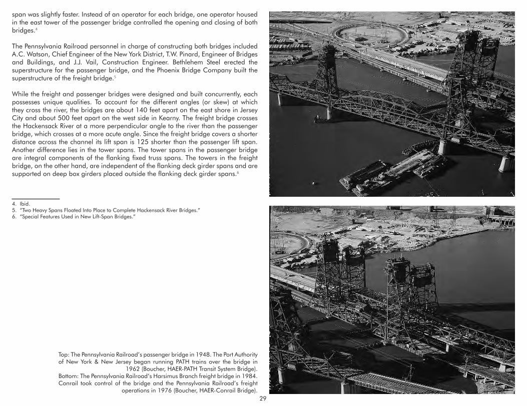
Top: The Pennsylvania Railroad’s passenger bridge in 1948. The Port Authority of New York & New Jersey began running PATH trains over the bridge in
1962 (Boucher, HAER-PATH Transit System Bridge).Bottom: The Pennsylvania Railroad’s Harsimus Branch freight bridge in 1984. Conrail took control of the bridge and the Pennsylvania Railroad’s freight
operations in 1976 (Boucher, HAER-Conrail Bridge).
span was slightly faster. Instead of an operator for each bridge, one operator housed in the east tower of the passenger bridge controlled the opening and closing of both bridges.4
The Pennsylvania Railroad personnel in charge of constructing both bridges included A.C. Watson, Chief Engineer of the New York District, T.W. Pinard, Engineer of Bridges and Buildings, and J.J. Vail, Construction Engineer. Bethlehem Steel erected the superstructure for the passenger bridge, and the Phoenix Bridge Company built the superstructure of the freight bridge.5
While the freight and passenger bridges were designed and built concurrently, each possesses unique qualities. To account for the different angles (or skew) at which they cross the river, the bridges are about 140 feet apart on the east shore in Jersey City and about 500 feet apart on the west side in Kearny. The freight bridge crosses the Hackensack River at a more perpendicular angle to the river than the passenger bridge, which crosses at a more acute angle. Since the freight bridge covers a shorter distance across the channel its lift span is 125 shorter than the passenger lift span. Another difference lies in the tower spans. The tower spans in the passenger bridge are integral components of the flanking fixed truss spans. The towers in the freight bridge, on the other hand, are independent of the flanking deck girder spans and are supported on deep box girders placed outside the flanking deck girder spans.6
4. Ibid.5. “Two Heavy Spans Floated Into Place to Complete Hackensack River Bridges.”6. “Special Features Used in New Lift-Span Bridges.”

30
NJ ROUTE 7-WITTPENN BRIDGE
Layout of the Hackensack River Bridges showing the sequence of construction (“Two Heavy Spans Floated into Place”).
The NJ Route 7-Wittpenn Bridge was dedicated on November 5, 1930 amid a heavy downpour. In attendance was Henry Otto Wittpenn, a former Jersey City mayor and now a member of the State Highway Department. Wittpenn died in 1931, and the State Highway Department named the bridge in his honor the following year.1 The opening was celebrated by a half hour of whistles from a fleet of tugboats and other vessels, some of which had helped carry the draw span into place. The Wittpenn Bridge was completed in less than two years at a cost of $3 million.
The NJ Route 7-Wittpenn Bridge over the Hackensack River was one of six new bridges planned in the 1920s by the State Highway Department to improve highway connections in and around Newark and Jersey City. The New Jersey State Highway Department included the Newark Turnpike as part of Route 10 (later renumbered Route 7) in the state highway system in 1927. Route 10 started in Jersey City, crossed the new bridge over the Hackensack River, headed through Kearny, Harrison, Newark, Bloomfield, the Oranges, and terminated in Dover, Morris County.2 Another bridge included in the long-range plan was a proposed high-level viaduct carrying Route 25 spanning the Passaic and Hackensack rivers. Later dubbed the Pulaski Skyway, the bridge soared 135 feet above the river and was an engineering marvel when it was completed in 1933.3
In 1927, the New Jersey State Highway Department received proposals to design the lift span of the Wittpenn Bridge from three engineering firms: Harrington, Howard & Ash; Waddell & Hardesty; and the Strauss Engineering Corporation.4 Harrington, Howard & Ash, a New York-based engineering firm, was chosen to design the bridge superstructure.5 All principals of the firm – John Lyle Harrington, Ernest E. Howard and Louis R. Ash – began their careers under the tutelage of J.A.L. Waddell. The trio established their own firm in 1915. Between 1915 and 1928, they designed 45 vertical lift bridges, 13 bascule bridges, and six rolling bascule bridges. During the Depression, the firm received many New Deal projects for both railroad and highway bridges. The firm became Ash, Howard, Needles and Tammen in 1928 and was renamed Howard, Needles, Tammen & Bergendoff in 1941.6 The firm, now known by its initials HNTB, survives today as one of the nation’s largest transportation engineering concerns.
Supervising the work at the State Highway Department were William H. Hudson, Assistant Construction Engineer; Sigvald Johnannesson Engineer of Design; and O.C. Whitman, Resident Engineer. Johnannesson, a graduate of the University of Copenhagen, is best known for his design of the Pulaski Skyway. The Foundation 1. “Moore Signs Milk and Other Bills,” Trenton Times, 3 May 1932.2. New Jersey State Highway Department.3. “Hackensack River Bridge Approved,” Trenton Times, 9 June 1928. 4. “New Bridge Ordered for Hackensack,” Newark News, 26 September 1927.5. “Plans Ordered for New Span on Hackensack,” Newark News, 18 October 1927.6. A.G. Lichtenstein & Associates, Inc., 63.
Company of New York and Charles Kavanaugh were hired to pour the foundations. The Stroebel Steel Construction Company of Chicago built the superstructure. The job of dismantling the old Newark Turnpike bridge rested with Merritt-Chapman & Scott Corporation.7
The War Department approved plans for the new Route 10 bridge in June 1928.8 The new structure would be sited south of the existing bridge and would eliminate the dangerous S-curve at the Jersey City approach. Construction began at the end of 1928 when caissons for the piers were sunk. Construction continued without incident until May 1929 when a worker on a floating concrete mixer was killed when the pontoon sank. The concrete was being used in construction of the bridge abutments.9 In order to provide level footing on which to lay the bridge piers, caissons were submerged below the water so that the workers, called sandhogs, could dig out the underlying rock and mud. While 75 feet underwater and 250 feet from the shore, an exploded
7. “Two Heavy Spans Floated Into Place to Complete Hackensack River Bridges.”8. “New Turnpike Bridge is O.K’D,” Jersey Journal, 11 June 1928.9. “Divers Seek Body of Man in River,” Newark News, 10 May 1929.

31
The Wittpenn Bridge in 2005 in the open position (Elliott 2005).
1931 aerial view of the completed Hackensack River lift bridges. The Seaboard By-Product Coke facility is at left and across the river is Public Service’s Marion facility (New York Public Library 2015).
air pressure line caused additional deaths when an onrush of mud and water into the caisson claimed six lives and injured ten others.10
At 2,169 feet long, the Wittpenn Bridge has deck plate girder approach spans on concrete piers, two fixed camelback through truss spans, and a modified fixed Pratt through truss. The vertical lift span is a 209-foot long skewed Parker truss. Each tower is 160 feet tall and consists of a Pratt truss with front vertical columns and rear inclined columns. The 63-foot wide bridge was first built with two lines of streetcar tracks and two sidewalks on the outer edges of the bridge. The trolley tracks were removed in the 1950s.
The State Highway Department selected an alignment south of the old Newark Turnpike bridge, while the Pennsylvania Railroad shifted its new freight bridge north. Due to the proximity of the two bridges, the Pennsylvania Railroad and the State Highway Department agreed that the most economical method of construction would be to build one set of piers to support both structures. Construction of the freight bridge and the Wittpenn Bridge involved a novel solution in which the westernmost eight piers, including all the river piers and the west abutment, are shared by both bridges.11 By having one set of piers instead of two, impediments to river navigation – caused by the 100-foot distance between the existing bridge’s piers – would be removed.
As part of the bridge building project, the Army Corps of Engineers shifted the navigation channel from the west side of the river to a newly dredged 160-foot wide channel on the east side. To maintain a continuous navigation channel, the adjacent Pennsylvania Railroad freight bridge and Wittpenn Bridge were both built at the same 39 degree angle to the river so that their lift spans would align.12 Navigation on the Hackensack River was halted for almost six days in 1930 – from Sunday, November
10. “Neglect is Charged in Caisson Blast,” New York Times, 31 May 1929.11. “Two Heavy Spans Floated Into Place to Complete Hackensack River Bridges.”12. “Two Heavy Spans Floated Into Place to Complete Hackensack River Bridges.”
2 at 3:30 am to Thursday, November 6 at 11 pm – to shift the channel. By this time, the two Pennsylvania Railroad bridges and the Wittpenn Bridge were fully constructed with important exceptions. All three bridges were left with openings over the old west channel to keep the river clear for navigation. To allow for dredging of the new east channel, none of the lift spans would be inserted until the Army Corps completed its work.
The first task in dredging the channel and shifting rail and vehicular traffic to the new bridges involved inserting new spans into the opening over the old channel. The Pennsylvania Railroad’s 245-foot through truss for the passenger bridge was erected on falsework in the river. At high tide at 5:30 in the morning of November 2, 1930, two barges maneuvered by four tugs floated the passenger lift span, weighing 813 tons, into its final position. The first New York bound passenger train passed over the new bridge later that morning.13
Around noon the same day, four deck plate girder spans, with a total length of 116 feet, were set in place into the freight bridge by a floating derrick. The spans had been erected off site and brought out on flat cars on the old freight bridge and unloaded by the derrick. The freight bridge went into service on November 4, 1930.14
13. Ibid.; “Special Features Used in New Lift-Span Bridges.”14. Ibid.

32
The fixed truss spans of the old Newark Turnpike bridge and the trestle from the Pennsylvania Railroad’s two swing-span bridges were removed so that the Corps could freely dredge the channel. A 116-foot long deck girder span for the Wittpenn Bridge, erected in the river on two barges, was inserted into its final position simultaneously with the Pennsylvania Railroad’s passenger bridge. The 184-foot through truss span of the old highway bridge was removed from the eastern channel on November 5 and floated out on a barge at high tide. The remainder of the bridges were dismantled, taken away, and sold for scrap.15
The new, modern bridges that crossed the Hackensack River were a functional success. Even so, they were generally considered unattractive. Many critics of the 1920s and 1930s argued that classical conceptions of beauty and historically-inspired designs were outdated and ill-suited to modern requirements and materials. Others criticized the vertical lift bridges carrying America’s expanding rail and road network as a blight on the landscape, an “eyesore” and “ungainly.”16 In “Esthetic Design of Steel Structure” Aymar Embury wrote that “it is indisputable that of all of the types of bridges in common use, the lift span is the ugliest.”17 J.A.L Waddell countered that “some of them undoubtedly are ugly, but others, at least to an engineer’s eye, are fine looking, being bold, massive, and evidently well-fitted for their purpose.”18
Functional efficiency was Waddell’s chief concern. He believed modern considerations of aesthetics would have to adapt to advances in engineering and materials. But Waddell also acknowledged the importance of harmony in setting, symmetry in design, the elimination of unnecessary ornament (any ornamentation should serve to emphasize function), and bridge elements that define their functions. According to Waddell, a bridge “must be fitted for the work it is to do, that it should express the truth, and that imitations and falsities are vicious and outside the realm of rational esthetics.”19
15. Ibid.16. Hoole and Kinne.17. Embury, 263.18. Waddell 1924, 215.19. Waddell 1928, 636.

33
EPILOGUE
Circa 1970s aerial view of the Triple Hack Bridges. From left to right: Pennsylvania Railroad (PATH) Bridge, Pennsylvania Railroad Harsimus Branch (Conrail/CSX) Bridge and the NJ Route 7-Wittpenn Bridge (New Jersey Department of Transportation).
The economic malaise wrought by the Great Depression brought a precipitous decline to maritime traffic on the Hackensack River. Even during ramped up industrial production during World War II, total tonnage carried along the river remained stagnant. Maritime commerce revived during the 1950s as consistently more than four million tons moved along the river. But by the 1970s goods shipped amounted to less than three million tons then dropped below two million tons in the 1990s.1
The industries that precipitated construction of the Hackensack River bridges declined, were abandoned, and then demolished. The Navy took control of Federal Shipbuilding at the end of World War II and operated the yard until 1964. By the 1970s the facility had been shut down.2 The property was recently converted by River Terminal Development into a warehouse and distribution center but the facility has no maritime use. The Diamond Shamrock Site (formerly Martin Dennis) continued as a chromate chemical manufacturing facility until it closed in the 1970s. The facility was demolished in 1979. At the Standard Chlorine site (formerly White Tar), naphthalene and naphthalene by-products were produced until the complex shut down in the 1990s. The Seaboard By-Product Coke Company continued to receive bimonthly shipments of liquid asphalt, sand and gravel into the 1970s until the Koppers Company shuttered the facility and leveled the buildings.3
The railroads fared little better. In 1954, the Hudson & Manhattan Railroad operating over the Pennsylvania Railroad’s passenger bridge went into receivership. The Pennsylvania Railroad ceased running passenger service over the bridge in 1961. In 1962, the Port Authority of New York and New Jersey acquired the trackage and the passenger bridge and began operating the Port Authority Trans Hudson (PATH) service between Jersey City and Manhattan. In 1968, the Pennsylvania Railroad and the New York Central, the two largest railroads in the country, merged to form the Penn Central Railroad. Just two years later, the Penn Central filed for bankruptcy, the nation’s largest bankruptcy up to that time.4 In 1976, Conrail assumed control of the former Pennsylvania Railroad’s freight operations and the Harsimus Branch freight bridge. The Norfolk Southern Corporation and the CSX Corporation acquired Conrail in 1998.
The declining Delaware, Lackawanna & Western Railroad merged with the Erie Railroad in 1960 to form the Erie-Lackawanna Railroad. The Erie-Lackawanna went bankrupt in 1972. New Jersey Transit took over commuter operations in 1983 and continues to operate the Hackensack River bridge as part of its Morristown Line.5
1. United States Board of Engineers for Rivers and Harbors 1951-2000.2. Olsen 1999, 69.3. AKRF 2008, B:2-11.4. Coxey and Kranefeld 2007.5. DeLeuw, Cather and Company 1991, 42.
The Wittpenn Bridge, operated by the New Jersey Department of Transportation, has remained a vital part of the region’s transportation infrastructure. Yet the narrow lane widths and other physical deficiencies render the bridge substandard and functionally obsolete. The Wittpenn Bridge will be replaced by a new vertical lift bridge located on a new alignment immediately north of the existing bridge. The new vertical lift bridge will increase the vertical clearance over mean high water from 35 to 70 feet in the closed position and retain the 135-foot clearance in the open position. The replacement for the Wittpenn Bridge will be a modern structure, representing the pinnacle of vertical lift engineering in the same way the Hackensack River Vertical Lift Bridges Historic District embodies the engineering prowess of its era.

34
BIBLIOGRAPHYAbbreviations used in footnotes:
BJHP: Burton Jesse Hendrick PapersKCR: Koppers Company RecordsUSACE: United States Army Corps of Engineers
A.G. Lichtenstein & Associates, Inc. The New Jersey Historic Bridge Survey. Prepared for the New Jersey Department of Transportation, Department of Environmental Analysis and the Federal Highway Administration, New Jersey Division, 1994. On file, New Jersey Historic Preservation Office, Trenton, NJ.
AKRF. Final Environmental Impact Statement, Portal Bridge Capacity Enhancement Project. Washington, D.C.: Federal Railroad Administration, 2008.
Berhart, Benjamin L. Historic Journeys By Rail: Central Railroad of New Jersey Stations, Structures & Marine Equipment. Dauberville, PA: Outer Station Project, 2004.
Bien, Julius and C.C. Vermeule. Newark to Paterson-East. New York: Julius Bien & Co., 1890. Boucher, Jack. Historic American Engineering Record-Conrail Bridge, Spanning the
Hackensack River, Kearny, Hudson County, New Jersey. HAER No. NJ-43. Washington, D.C: Historic American Engineering Record, National Park Service, 1978.
____________. Historic American Engineering Record-PATH Transit System Bridge (Port Authority Bridge), Spanning the Hackensack River, Kearny, Hudson County, New Jersey. HAER No. NJ-44. Washington, D.C: Historic American Engineering Record, National Park Service, 1978.
____________. Historic American Engineering Record-Erie & Lackawanna Railroad Bridge (Delaware, Lackawanna & Western Railroad Bridge), Spanning the Hackensack River, Kearny, Hudson County, New Jersey. HAER No. NJ-42. Washington, D.C: Historic American Engineering Record, National Park Service, 1979.
Brydon,Norman F. The Passaic River: past, present and future. New Brunswick, NJ: Rutgers University Press, 1974.
Burton Jesse Hendrick Papers (MS 1980). Manuscripts and Archives, Yale University Library, New Haven, CT.
Cannadine, David.Mellon: An American Life. New York: Alfred A. Knopf, 2006.
Churella, Albert J. The Pennsylvania Railroad, Volume I: Building an Empire, 1846- 1917. Philadelphia, University of Pennsylvania Press, 2013.
Coast and Geodetic Survey. New York Bay and Harbor. Washington, D.C.: Coast and Geodetic Survey, 1914.
Conniff, James C. G. and Richard Conniff. The Energy People: A History of PSE&G. Newark, NJ: The Public Service Electric and Gas Company, 1978.
Cook, George H., John C. Smock and C.C. Vermeule. A Topographical Map of the Counties of Bergen, Hudson and Essex. New York: Julius Bien & Co., 1884.
Coxey, William J. and James E. Kranefield. The Reading Seashore Lines. Palmyra, NJ: West Jersey Chapter, National Railway Historical Society, 2007.
“D.L. & W. Completes Three-Track Lift-Span Bridge.” Railway Age Vol. 85, No. 19 (10 November 1928): 917-923.
DeLeuw, Cather and Company. NJ Transit Historic Railroad Bridge Survey. Newark, NJ: DeLeuw, Cather and Company.
Eaton, Harriet Phillips. Jersey City and its Historic Sites. Jersey City, NJ: The Woman’s Club, 1899.
Elliott, Joseph. Historic American Engineering Record-NJ Route 7-Wittpenn Bridge over Hackensack River (NJDOT Structure No. 0909-150), City of Jersey City and Town of Kearny, Hudson County, New Jersey. On file, New Jersey Historic Preservation Office, Trenton, NJ.
Embury. Aymar II. “Esthetic Design of Steel Structures.” Civil Engineering 8, No.4 (April 1938): 261-265.
Federal Writers’ Project. New Jersey: A Guide to its Past and Present. New York: Viking Press, 1939.
Foghorn Publishing. “Bergen Point Light.” www.foghornpublishing.com. Accessed 20 February 2015.
Fowler, L.D. Atlas of Jersey City, New Jersey. Philadelphia, G.W. Bromley & Co., 1887.

35
Greenberg, William T. and Robert F. Fischer. The Lehigh Valley Railroad East of Mauch Chunk. Martinsville, NJ: The Gingerbread Shop, 1997.
“The Hackensack River: A True Comeback Story.” Hackensack Riverkeeper. Accessed September 14, 2014. http://www.hackensackriverkeeper.org/about-us/our- history/.
Harrison, Tim and Ray Jones. Lost Lighthouses: Stories and Images of America’s Vanished Lighthouses. Guilford, CT: Globe Pequot Press, 2000.
Hawley, Monica E. Historic American Engineering Record-PATH Transit System Bridge (Port Authority Bridge), Spanning the Hackensack River, Kearny, Hudson County, New Jersey. HAER No. NJ-44. Washington D.C .: Historic American Engineering Record, National Park Service, 1984.
Hills, John. Sketch of the Road from Paulus Hook and Hoboken to New Bridge. Brielle, NJ: Portolan Press reprinted 1976 from the 1778 original.
Holmes, Beatrice Hort. A History of Federal Water Resources Programs, 1800-1960. Washington, D.C.: U.S. Department of Agriculture, Economic Research Service, 1972.
Hoole, George A. and W.S. Kinne. Movable and Long-Span Steel Bridges. New York: McGraw-Hill Book Company, Inc., 1943.
Hopkins, G.M. Atlas of Hudson County, New Jersey, Volume I. Philadelphia: G.M. Hopkins & Co., 1908.
____________. Atlas of Hudson County, New Jersey, Volume II. Philadelphia: G.M. Hopkins & Co., 1909.
Hull, William J. and Robert W. Hull. The Origin and Development of the Waterways Policy of the United States. Washington D.C.: National Waterways Conference 1967.
“In Re Hibbard et al.” Circuit Court of Appeals, Second Circuit (27 F.2d 686 [2d Cir. 1928]. Decided 9 July 1928. https://casetext.com/case/in-re-hibbard. Accessed April 12, 2014.
Interstate Commerce Commission. Bureau of Valuation, Engineering Section, Record Group 134, Records of the Interstate Commerce Commission, Railroad Valuation Records. National Archives, College Park, MD.
____________. Decisions of the Interstate Commerce Commission of the United States, May to July 1921. Washington, D.C.: Government Printing Office, 1922.
Klawonn, Marion J. Cradle of the Corps : A History of the New York District, U. S. Army Corps of Engineers, 1775-1975. New York: Army Corps of Engineers, New York District, 1977.
Koglin, Terry L. Movable Bridge Engineering. Hoboken, NJ: John Wiley & Sons, Inc., 2003.
The Koppers Company. The Koppers Company’s Coal Gas Plants. Pittsburgh: The Koppers Company, 1924.
Koppers Company Records (548), Penn State University Archives, Special Collections Library, Pennsylvania State University, State College, PA.
Lane, Wheaton J. From Indian Trail to Iron Horse: Travel and Transportation in New Jersey 1620-1860. Princeton, NJ: Princeton University Press, 1939.
Library of Congress. “Andrew William Mellon, 1855-1937.” Prints and Photographs Division, Library of Congress, Washington, D.C.
“Marine Casualties.” The Nautical Gazette 103, no. 11 (July 1922): 28.
Marshall, Stephen. “Before the Commission: Three Centuries of Human Use and Alteration of the Newark and Hackensack Meadows.” Urban Habitats(December2004), electronic journal. http://www.urbanhabitats.org/v02n01/3centuries_full.html. Accessed November 26, 2012.
Messer, David W. and Charles S. Roberts. Triumph V: Philadelphia to New York 1830- 2002. Baltimore: Barnard, Roberts and Co., Inc., 2002.
New Jersey Department of Transportation. “Wittpenn Bridge” [photograph], circa 1970s. Department of Transportation Record Group, New Jersey State Archives, Trenton, NJ.
New Jersey State Highway Department. Annual Report for the Year Ending 1928. Trenton, NJ: New Jersey State Highway Department, 1929.
New York, New Jersey Port and Harbor Development Commission. Joint Report with Comprehensive Plan and Recommendations. Albany, NY: J.B. Lyon Company, 1920.
New York Public Library. “Aerial view of Kearney, N.J.” [photograph]. Irma and Paul Milstein Division of United States History, Local History and Genealogy, The New York Public Library. New York Public Library Digital Collections. Accessed May 4, 2015. http://digitalcollections.nypl.org/items/510d47e4-1d07-a3d9-e040-e00a18064a99.

36
Nyman, William E. “Dr. J.A.L. Waddell’s Contributions to Vertical Lift Bridge Design.” Paper presented at the Ninth Biennial Symposium, Heavy Movable Structures, Inc., October 22-25, 2002.
Olsen, Kevin K. A Great Conveniency: A Maritime History of the Passaic River, Hackensack River, and Newark Bay. Ringwood, NJ: North Jersey Highlands Society, 1999.
“Open Caisson Foundations of the Newark Turnpike Bridge.” Engineering Record 64, no. 25 (December 1911).
Petroski, Henry. Engineers of Dreams: Great Bridge Builders and the Spanning of America. New York: Knopf, 1995. “Placing Foundations for Coke Plant Near New York.” Engineering News 76, no. 26 (28 December 1916): 688-690.
“Plant of the Seaboard By-Product Coke Company.” The Gas Age 43, no. 1 (1 January 1919): 1-6.
Robinson, Walter F. Ph.D. Old Bergen Township (Now Hudson County) in the American Revolution. Bayonne, NJ: Bayonne Bicentennial Committee, 1976.
Shaw, William H. History of Essex and Hudson Counties, New Jersey. Philadelphia: Everts & Peck, 1884.
“Special Features Used in New Lift-Span Bridges.” Railway Age 91 (1 August 1931): 164-68.
Spielman and Brush. Certified copies of Original Maps of Hudson County, New Jersey. Hoboken, NJ: Spielman and Brush, 1882. Reprinted from L.F. Douglass 1841 Topographical Map of Jersey City, Hoboken, and the Adjacent Country.
“Steamer Runs into Open Drawbridge and Wrecks it.” Popular Mechanics Magazine
38, no. 3 (September 1922): 355. “Steamer Wrecks Drawbridge on Traffic Artery.” Engineering News-Record (29 June 1922): 1095-96.
Taber, Thomas Townsend. The Delaware, Lackawanna & Western Railroad, the Road of Anthracite, in the Nineteenth Century, 1828-1899. Muncy, PA: T.T. Taber III, 1977.
____________. The Delaware, Lackawanna & Western Railroad, the Route of Phoebe Snow, in the Twentieth Century, 1899-1960. Muncy, PA: T.T. Taber III, 1980.
“Two Heavy Spans Floated Into Place to Complete Hackensack River Bridges.” Engineering News-Record 105, no. 20 (13 November 1930), 778-80.
United States Army Corps of Engineers. Annual Report of the Chief of Engineers, United States Army to the Secretary of War, for the Year 1889, Part I. Washington, D.C., 1889. ____________. Newark Bay and Passaic and Hackensack Rivers, N.J. : letter from the Secretary of War, transmitting, with a letter from the Chief of Engineers, report on examination of Newark Bay and Passaic and Hackensack Rivers, N.J. Washington, D.C., 1912.
____________. Hackensack River and Overpeck Creek, N.J. : letter from the Secretary of War, transmitting with a letter from the Chief of Engineers, reports on preliminary examination and survey of Hackensack River, N.J. Washington, D.C.
____________. Report of the Chief of Engineers, U.S. Army, Part I. Washington, D.C.: Government Printing Office, 1921.
____________. Newark Bay, and Hackensack and Passaic Rivers, N.J. : letter from the Secretary of War, transmitting, with a letter from the Chief of Engineers, reports on preliminary examination and survey of Newark Bay and Hackensack and Passaic Rivers, N.J. Washington, D.C., 1922.
____________. Hackensack River, N.J. : letter from the Secretary of war transmitting a report from the Chief of Engineers on preliminary examination and survey of Hackensack River, N.J. Government Printing Office, Washington, D.C., 1926.
United States Board of Engineers for Rivers and Harbors. Water-borne Commerce of the United States. Washington, D.C.: Government Printing Office, 1951- 2000.
United States War Department. War Department Annual Reports, 1917, Volume II: Report of the Chief of Engineers. , Washington, D.C.: Government Printing Office, 1918.
“Yard of the Federal Shipbuilding Company.” Marine Engineering (April 1919): 267- 270.
Vermeule, C.C. Drainage of the Hackensack and Newark Tide-Marshes from the Annual Report of the State Geologist for 1896. Trenton, NJ: MacCrellish & Quigley, 1897.
Waddell, J.A.L. “The Vertical Lift Bridge.” Journal of the Western Society of Engineers 29, No.5 (May 1924): 209-216.

37
____________. Memoirs and Addresses of Two Decades. Ed. Frank W. Skinner. Easton, PA: Mack Printing Company, 1928.
Winfield, Charles H. History of the County of Hudson, New Jersey: From its Earliest Settlement to the Present Time. New York: Kennard & Hay Stationery Manufacturing & Print Co., 1874.