Embed Size (px)
DESCRIPTION
While spending the summer of 2014 in Boston, Massachusetts, I proposed an independent research project regarding the new Central Artery Greenway in downtown Boston. The project was conceptualized, researched and written over the course of four months time. Planning for the project began in the 1980s and construction was substantially complete by 2007. Over the nearly 30 years from project inception to completion, many components evolved and changed, including cost overruns that doubled the project cost to over $14 billion (2006). Large differences remain in the vision for the parks and open space created by the project and their status today. My research project will explore the design and implementation changes in the 27 acres of downtown parcels and the forces behind these changes. I believe this analysis will include issues such as design challenges, sustainability, political pressures, and public processes.
Citation preview
The Evolution of Boston’s Central Artery Greenway
Rebecca Laree McKevitz
Independent Study
Summer 2014
Boston, Massachusetts
1
This report is a compilation of findings regarding the conception, design process and final
implementation of Boston’s Central Artery Greenway. The research was focused on analyzing
and understanding the factors that influenced how these parks were designed and more
importantly, the unique circumstances that led to some complications in the final
implementation phases of this project. In order to fully understand the intricacies of the final
greenway project, it was important to acquire a good understanding of the history of this project
and the issues leading the city of Boston to engineer and build one of the most complex and
inventive urban mega-projects to date. Through the process of removing an above-ground
highway and replacing it with an underground tunnel, the city of Boston created new land in one
of our country’s oldest and most historic cities. This report was formulated in order to both
understand the landscape architecture elements involved in this large-scale urban planning and
design project, and also to convey an appreciation of the importance and value of landscape
architecture elements in urban settings.
In 2008, the Commonwealth of Massachusetts, in concert with numerous Federal and
state agencies, completed the Central Artery/Tunnel (CA/T) Project. This transportation project,
sometimes called the Big Dig, was conceived and designed in response to severe traffic
congestion, high incidents of accidents on I-93 (the Artery) in the downtown Boston area, and
the need to provide better access to Logan Airport and points north from the downtown area.
Prior to the project, the Artery consisted of an elevated two-level, six-lane highway with
associated entrance and exit ramps. The Artery cut through the downtown area, with its roughly
50 foot height and 140 foot width cutting portions of the city off from other areas and the
waterfront. The CA/T project replaced the Artery with a below-grade, 8 to 10 lane highway and
included several other elements):
The Ted Williams Tunnel to the Boston Logan airport
A new Charles River Crossing called the Zakim Bridge Creation of 22 development parcels on the Central Artery
2
Creation of new open space along the Charles River, in East Boston, and on Spectacle Island
Creation of the Rose Kennedy Greenway
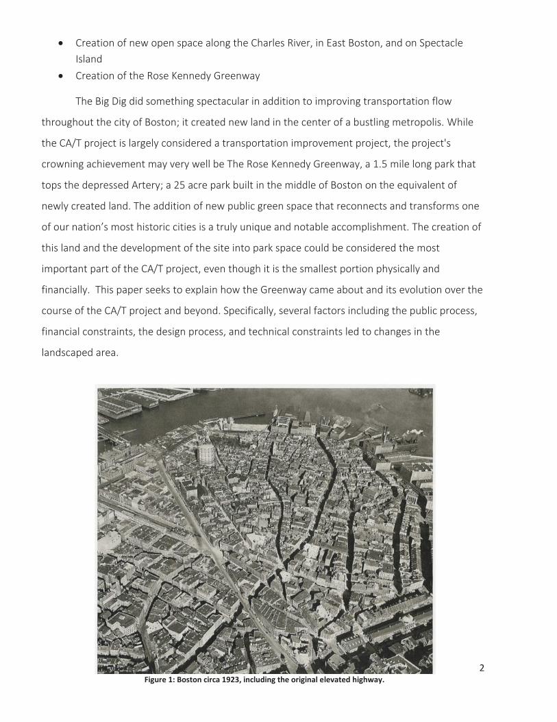
The Big Dig did something spectacular in addition to improving transportation flow
throughout the city of Boston; it created new land in the center of a bustling metropolis. While
the CA/T project is largely considered a transportation improvement project, the project's
crowning achievement may very well be The Rose Kennedy Greenway, a 1.5 mile long park that
tops the depressed Artery; a 25 acre park built in the middle of Boston on the equivalent of
newly created land. The addition of new public green space that reconnects and transforms one
of our nation’s most historic cities is a truly unique and notable accomplishment. The creation of
this land and the development of the site into park space could be considered the most
important part of the CA/T project, even though it is the smallest portion physically and
financially. This paper seeks to explain how the Greenway came about and its evolution over the
course of the CA/T project and beyond. Specifically, several factors including the public process,
financial constraints, the design process, and technical constraints led to changes in the
landscaped area.
Figure 1: Boston circa 1923, including the original elevated highway.
3
History of the Central Artery
The city of Boston, one of our country’s oldest cities, is a lively New England city that
includes impressive architecture, a gorgeous waterfront, and many notable landmarks. In 1959
the original Central Artery opened, which consisted of an elevated interstate that comfortably
carried about 75,000 vehicles a day. By the early 1990s, Boston had grown exponentially and the
Central Artery was forced to carry “upwards of 200,000 making it one of the most congested
highways in the United States” (MASSDOT). The elevated highway was soon known to
Bostonians by nicknames such as the “Highway in the Sky” and “The Other Green Monster”.
(Greiman, XVII) This massive six-lane elevated highway was designed to, “speed traffic through
the city, unclog city streets” and improve the overall circulation of Boston’s roadway system.
What planners didn’t realize during this process was that this colossal steel structure was
creating a barrier through the city that created what seemed like a permanent divide through
downtown and separated Bostonians from their historic waterfront and harbor (Aloisi, 6).
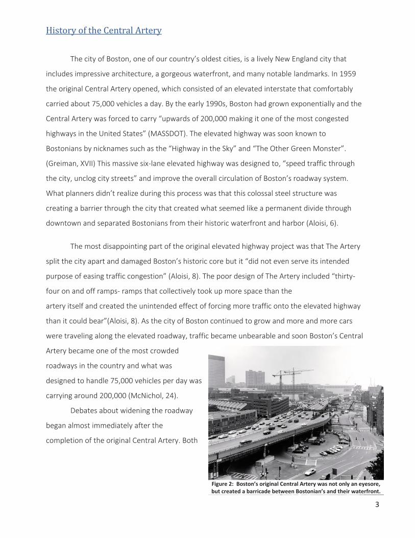
The most disappointing part of the original elevated highway project was that The Artery
split the city apart and damaged Boston’s historic core but it “did not even serve its intended
purpose of easing traffic congestion” (Aloisi, 8). The poor design of The Artery included “thirty-
four on and off ramps- ramps that collectively took up more space than the
artery itself and created the unintended effect of forcing more traffic onto the elevated highway
than it could bear”(Aloisi, 8). As the city of Boston continued to grow and more and more cars
were traveling along the elevated roadway, traffic became unbearable and soon Boston’s Central
Artery became one of the most crowded
roadways in the country and what was
designed to handle 75,000 vehicles per day was
carrying around 200,000 (McNichol, 24).
Debates about widening the roadway
began almost immediately after the
completion of the original Central Artery. Both
Figure 2: Boston’s original Central Artery was not only an eyesore, but created a barricade between Bostonian’s and their waterfront.
3

4
the idea to widen the existing highway horizontally and the option to add another level on top of
the already elevated roadway, creating what would be an extremely unsafe 80-foot eyesore,
seemed unrealistic and would only dismantle neighborhoods that had already been ruined
throughout the original Central Artery construction (McNichol, 28). In order to combat the
problems that were caused by the original above-ground roadway, a plan came about to remove
the portion of the roadway that went through downtown Boston, and replace it with an
underground tunnel. As envisioned, the sinking of the Central Artery into the ground would
remove the eyesore from downtown, and improve the traffic congestion that was still proving to
be an issue.
Public Process
When it comes to urban Mega-Projects like Boston’s CA/T project, there are many
stakeholders that are concerned about the success of the project, although typically with varying
goals and interests. The obvious players in these types of projects are federal, state and city
agencies who together have a pretty large stake in the project, but the other powerful force
behind public projects like the CA/T, is the public themselves. The public is comprised of public
agencies, certain federal, state and city agencies, political figures, and of course, concerned
individuals. Because so many people and organizations are involved in the public process, it can
have a dramatic impact on the course of the project as a whole.
Once funding was acquired, the next step was to begin feasibility studies and cost
estimation research. In 1985, two years before the funding was approved for the project, Fred
Salvucci, the civil engineer who came up with the idea to move the interstate underground, was
“already searching for the strongest team of engineers and managers in the world” and “after
assessing the demands of the Big Dig against the available skills, talents, and construction
experiences of the various bureaucracies in the Commonwealth, Salvucci decided to use both
public and private manpower” (McNichol 41). The Massachusetts Department of Public Works
took the lead and was in charge of overseeing a private management team who would
“coordinate, direct, schedule and review design and construction activities” throughout the
5
project. The Massachusetts Department of Public Works also prepared and published the Draft
Environmental Impact Report, which was meant to inform governmental agencies and the public
of a project's environmental impacts, both positive and negative.
The City of Boston and the Boston public had a huge impact on the decision to
implement urban green space on top of the newly sunken interstate. In order to offset the cost
overruns of the CA/T, Massachusetts Department of Transportation originally proposed to sell
the air rights to the space, which would lead to the creation of new development in downtown
Boston. The City of Boston then counter proposed
a new residential development and the addition of
pocket parks but ultimately the public did not want
to see new development which could further strain
the new transportation infrastructure. In addition,
mitigation to offset the environmental impacts of
the CA/T project was requested by several factions
and the creation of parkland was identified by the
public and agencies as the most desirable measure.
The first step in the public process is
identifying the need for the project. The original
central artery was plagued with congestion from
the day it was opened and only got worse as
Boston’s population exploded and soon there was
more traffic on I-93 than on New York City’s West
Side Highway and “the accident rate for the
elevated highway was four times the national average for urban interstates” (McNichol 28). In
1987, Senate voted through the transportation bill that allowed the Big Dig the federal funding it
needed to get started.
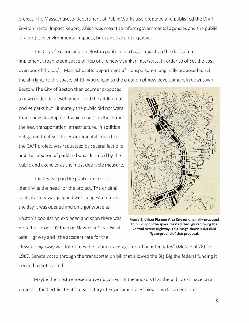
Maybe the most representative document of the impacts that the public can have on a
project is the Certificate of the Secretary of Environmental Affairs. This document is a
Figure 3: Urban Planner Alex Krieger originally proposed to build upon the space created through removing the Central Artery Highway. This image shows a detailed
figure-ground of that proposal.
6
culmination of comments made by agencies and the public in which the Secretary of
Environmental Affairs responds with suggestions for how to best deal with these concerns. This
document has a huge impact on the project and often changes many aspects of the construction
and design plans.
On August 29th, 1990, the Massachusetts Executive Office of Environmental Affairs
published this document for the Big Dig project and commented that the Draft Environmental
Incident Report “generated a significant amount of public comment” and that “this kind of public
scrutiny, questioning, and even second-guessing or downright disagreement, is precisely what
the environmental review process is intended to elicit”(Draft Environmental Impact Report). This
process allows the public the opportunity for input on how public projects should be designed
and carried out. The other way in which this document is valuable is so that project managers,
civil engineers and other designers can ensure that they are making decisions based on the
public’s goals and they can demonstrate that the final built project did, in fact, respond to the
values and concerns stated by the public.
Because the certification was written for the entirety of the Big Dig project, there is a lot
of content related to the construction methods, mitigation and infrastructure related to the
relocation of the interstate. Further into the document were several points related to the 27
newly created acres on top of the roadway. To summarize, the Secretary of Environmental
Affairs wrote
“In the main, I am supportive of the overall concepts of the project to help relieve
traffic congestion. The development of this project also affords Boston with the
unprecedented opportunities to improve the human environmental experience in
New England’s largest urban area and one of the nation’s key historical seaport
cities. The resolution of a number of vital concerns within this public
environmental review process is critical to the implementation of not only the
transportation improvements, but to the long range quality of life for our
citizens”(Draft Environmental Impact Report).

7
The certificate goes on to discuss the specific plans for the current greenway space, but
up until this document there had been much debate about how exactly this space would be
developed. Many individuals and organizations showed support for building upon this prime
downtown land, but according to the certificate, the strong suggestion of the Secretary of
Environmental Affairs called for urban green space. There were a few specific requests that were
published in the certificate including 75% of the land be maintained as publically accessible open
space, continuous pedestrian/bicyclist paths along the entire length of the corridor, limiting
surface streets to no more than three lanes wide, and the development of a Winter Garden for
the Massachusetts Horticultural Society.
Financial Constraints
Financial constraints in terms of budget overruns, unfulfilled fundraising which
eliminated elements, and ongoing maintenance and upkeep also affected the outcome of the
Rose Kennedy Greenway.
Budget Overruns
The original budget of $2.5 Billion for the CA/T project turned out to cost closer to $14.8
Billion, almost six times the planned cost. The huge cost overruns that occurred during the CA/T
project include an inaccurate original cost estimation, technical complexities, environmental
concerns, conflicting opinions from the community and other interested parties, and the sheer
size and scope of the overall CA/T project. Fryer writes that, “the federal government was
initially supposed to pay 90 percent of the Big Dig's tab, but as the project's costs grew, Congress
eventually capped its contribution, forcing Massachusetts to pick up the rest of the tab” (Fryer,
1). Due to the nature of the CA/T project, the planning, designing, and implementation of
Landscape Architecture elements came very late in the project. Although the original
Environmental Impact Report that was written by the Massachusetts Department of Public
Works in 1990 proposed the idea of adding public green space to the surface of the central
artery, when it came time to implement this design idea, the overall project was significantly
8
over budget and the park space remained to be built, making it a target for budget reductions.
Within the original master plan for the Central Artery Parks, it was planned that financing would
come exclusively from the Massachusetts Department of Transportation (MDOT) as a part of the
overall CA/T budget, but as the project’s expenses were growing exponentially, planners,
politicians and Bostonians alike began to
wonder who was going to make this
promised park a reality.
In the end, the construction of the
greenway was financed from a multitude of
sources, but the simply put, in order to
implement the greenway, 50% of funds
would come from public sources and the
other half would need to be raised through
private funding. When the Greenway
Conservancy was established it was
“charged with the responsibility to raise $20 million in endowment and other funds by the end of
2007” (Greenway Conservancy) and after meeting this goal, the remaining funding came from
the Massachusetts Department of Transportation.
Missing Attractions
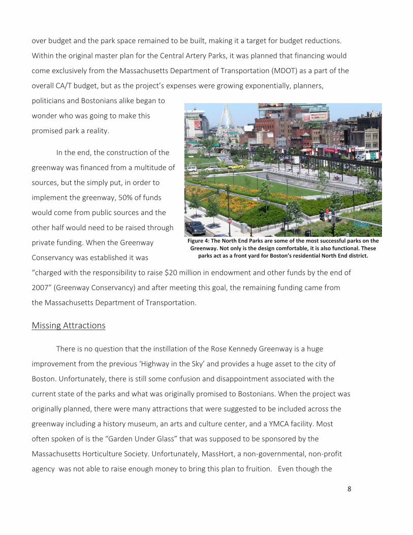
There is no question that the instillation of the Rose Kennedy Greenway is a huge
improvement from the previous ‘Highway in the Sky’ and provides a huge asset to the city of
Boston. Unfortunately, there is still some confusion and disappointment associated with the
current state of the parks and what was originally promised to Bostonians. When the project was
originally planned, there were many attractions that were suggested to be included across the
greenway including a history museum, an arts and culture center, and a YMCA facility. Most
often spoken of is the “Garden Under Glass” that was supposed to be sponsored by the
Massachusetts Horticulture Society. Unfortunately, MassHort, a non-governmental, non-profit
agency was not able to raise enough money to bring this plan to fruition. Even though the
Figure 4: The North End Parks are some of the most successful parks on the Greenway. Not only is the design comfortable, it is also functional. These
parks act as a front yard for Boston’s residential North End district.

9
greenway offers Boston residents countless amenities including a venue for sunrise yoga and
evening jazz concerts along with weekday food trucks and weekend farmers markets, the lack of
attractions has caused criticism.
Maintenance and Upkeep
Over the past two years, there has been much concern about the continued funding of
the Greenway and how exactly it is going to be sustained indefinitely into the future. The
Greenway is taken care of by the Greenway Conservancy which is a non-profit organization that
“maintains, programs, and improves the Greenway on behalf of the public and in partnership
with the Commonwealth of Massachusetts” (Greenway Conservancy). Currently, the greenway
leases its land from the Massachusetts Turnpike Authority and “continues to raise money to
support daily and seasonal park maintenance, special events and performances, and educational
programs for students, families, and life-long learners” (Greenway Conservancy).
As of now, the Greenway Conservancy is leasing the land from MDOT, who also happens
to be the Conservancy’s single biggest funder, but due to the fact that this agency is
“understandably strapped with its own transportation priorities and looking for every dime”, the
Rose Kennedy Greenway Conservancy has been asked to “produce a business plan that
demonstrates the group’s ability to operate the Greenway without state cash by 2018”.
Unfortunately, it is looking as if the Conservancy won’t be able to renew their lease unless they
can come up with a plan to operate without any state funding (Boston Globe).
According to CommonWealth Magazine, if the Conservancy agrees to these demands,
they “would financially gut the Conservancy…and force the nonprofit to rely entirely on private
fundraising efforts that have never hit the levels the group would need to survive on its own”
(CommonWealth). The bigger question though, is why the Greenway needs to be self-sufficient
in the first place? The Boston Globe points out that many of Boston’s other public parks rely on
public funding. For example, neither The Esplanade, which is operated by the State's Department
of Conservation and Recreation, nor the Boston Common and Commonwealth Mall, which are
10
operated by the Boston Parks Department, are privately funded. The Greenway is a public park
and therefore has a responsibility to organize itself in a way that serves Bostonian’s and visitors
alike.
Design Process
Boston’s CA/T project was imagined, planned, and built over a span of more than 30
years , with the design of the Rose Kennedy Greenway coming toward the later end of the
project. The design ideas behind the Rose Kennedy Greenway are “the product of nearly two
decades of debate and design about what to do with the swath of land opened up by the Big
Dig” (ABC). In 1990, The Massachusetts Environmental Policy Act declared that 75% of the space
created above the Central Artery tunnels was to be kept open, but the precise boundaries of the
corridor and what constitutes open space were never fully defined. Currently, the greenway
consists of 15 parcels that are divided up into five distinct districts.
Multiple Districts, Multiple Designers
Each of the five districts was designed by a different Landscape Architecture firm, or
team of firms. Halverson Design Partnership oversaw the entire design process and formulated
the overall Master Plan for the project. Just like the financing of the greenway evolved over time,
so did the design guidelines of the greenway parks. When taking a look at Halverson’s original
Master Plan and comparing to the current state of the parks, it is clear that the overall design
was scaled back due to financial constraints and that there are some missing elements
throughout the parks.
While walking from one end of the greenway to the other, the differences in design from
one district to the next are very apparent and raise some questions about the original design
goals and guidelines. It is also important to understand what kind of client these Landscape
Architecture firms were designing for in order to better comprehend design concepts and
decisions. (Figure 5)
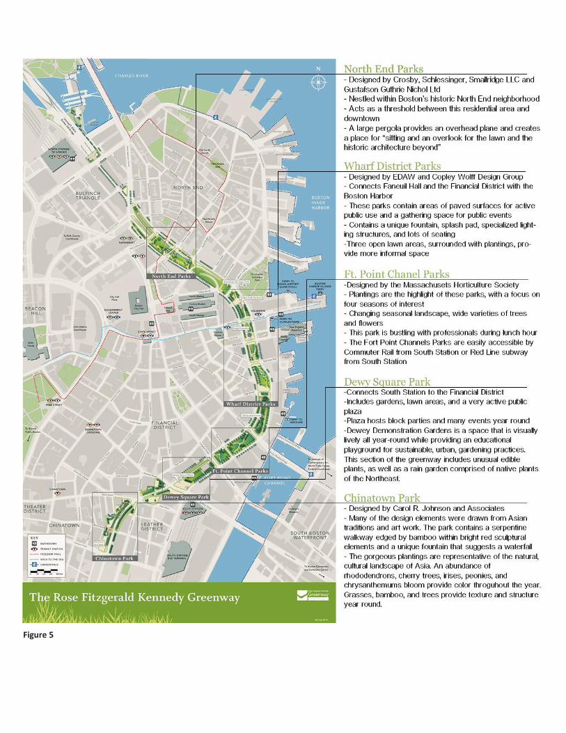
Figure 5
11
Due to the fact that there were many levels of clients associated with the greenway
design process, landscape architects were dealing with pressures from many different sources
and were assigned the task of appeasing them all. Both federal and state government officials
had say in the designing of the Greenway and had a completely different vision for the parks
than some of the other clients. Parsons Brinkerhoff, the planning and engineering firm that
oversaw the entire CA/T project, was in charge of setting strategic objectives for the project as
well as extracting a profit. Halverson Design Partnership was heavily invested in designing the
parks and was responsible for keeping the project on schedule and within budget as well as
managing risk and safety, while also ensuring quality of design. And most importantly, the public,
who were to be the main users of the space had their own ideas of what they wanted in their
new urban park. With these three differing views of what this site should be, Halverson put
together a master plan for all five districts which were then divided up and assigned to other
Landscape Architecture firms for their final designs.
Technical Constraints The project that was originally expected to be completed by 1998 was not finished until
2006, largely due to difficult construction conditions and never before utilized construction
techniques. The concept of building a “giant roof deck” on top of an interstate tunnel was a new
idea that came with new challenges. The most obvious and important technical constraint
associated with the greenway was building an urban green space on top of complex
infrastructure. The highway tunnel below meant that there were not only weight limits to
consider during the design process, but also utility lines to avoid during the construction process.
Another interesting aspect of building a park on top of transportation infrastructure is
the lack of soil designers and builders had to work with. According to Laura Janinski at the Rose
Kennedy Greenway Conservancy, the soil depth in some areas of the park is as shallow as six
inches. Chinatown is an especially good example of how designers overcame constraints like this.
In order to establish vegetation in the Chinatown Park, raised planters were built in order to
allow for soil depth and more ideal conditions for the species planted there.
12
One challenge that is continually being worked on is beautifying the parcels that include
highway ramps that provide access to the roadway beneath. These parcels are still being
developed as they must function safely and properly, and ideas for how to improve the
aesthetics of these unique parcels are still being adjusted and enhanced.
Evolution and Future of the Greenway
The addition of the Rose Kennedy Greenway to downtown Boston has greatly enhanced
the urban landscape, and the future of the greenway looks promising. Over the past six years,
Bostonians have gradually embraced their greenway and are beginning to appreciate the
contemporary urban park space and all of the flexibility and variety offered by this amenity. The
most recent addition to the greenway is the long awaited Greenway Carousel, which opened just
about a year ago and has been a hit ever since. This attraction is just one of many that are
planned for the greenway in the near future.
According to Laura Jasinski, a project manager at the Rose Kennedy Greenway
Conservancy, the original plans for the park called for the space to be much more broken up by
buildings that were planned for the greenway. The addition of a museum, YMCA facility and the
greenhouse, the greenway would not have been as unified. Currently, the very open plan for the
park leaves space for flexible programming. With the recent restructuring of the programming
on the greenway, the park is being better utilized with over three hundred public programs in
the park each year. Because of the relatively uninterrupted greenway parcels and the improved
organization of programming, the park has a large diversity of functions and caters to the needs
of all its users, and in turn, the people of Boston are starting to show their support for the
greenway (Jasinski)
13
Conclusion
As discussed above, the Central Artery Project resulted in the Rose Kennedy Greenway,
which went through a significant evolution as it was planned, designed and built. It is also
important to examine the factors that led to these changes in the park through the course of the
design and implementation. Fortunately, even though the Greenway was not part of the original
scheme, it was identified as necessary mitigation through the public process and is now being
embraced and utilized by many Bostonians.
The main downfall of the CA/T project was the massive cost overruns. Impressively, the
Greenway park survived budget constraints but not without some major cutbacks. The original
design for the park was scaled back substantially because outside entities could not deliver on
proposed elements due to fundraising constraints. Unfortunately, this meant that many of the
exciting amenities promised to Bostonians were not implemented which, in many cases, was
confusing and disappointing. Other outside entities, like private businesses nearby and the
Artery Business Committee, were then called upon to fund the parks implementation and
maintenance.
The design of the parks was begun after construction of the transportation project was
underway. A number of factors affected the final design of the Greenway, including financial and
technical constraints as well as government processes and public opinions. Four firms undertook
the
design of different sections of the Greenway and focused on designing the parcels to respond to
the characteristics and desires of each adjacent neighborhood or district of downtown.
Halverson Design Partnership oversaw the design and construction of the landscaped parks and
even though there were not strict design guidelines written, most of the parks seem to be very
successful in that they are being used. Though the design may not necessarily be trendsetting or
innovative, the most interesting aspect of the Greenway design is that it has been responsive to
the public and is still continuing to evolve. This relatively new green space continues to be a work
in progress and is focused on providing a space for Bostonians to spend time learning, exploring

14
and embracing their city. Even though the Greenway parks have been criticized as being
underwhelming, the Greenway could be seen as successful based upon its great utilization.
Boston’s “Big Dig” will be known as a legendary urban megaproject that pushed the limits
of modern engineering, construction and urban planning. The impressive infrastructure that was
built during the project improved much more than just Boston’s age old traffic problems; it
transformed the urban landscape of one of our country’s oldest and most historic seaport cities.
Even with all of the challenges associated with this project, the final result remains successful
and sets a precedent for future traffic projects across the country. The most innovative aspect of
the CA/T project is that through the process of shifting the interstate from the street surface to
an underground tunnel, 15 acres of new land was created in downtown Boston. The
development of this land into
public green space was a fitting
design decision for the urban fabric
of Boston, and the Rose Kennedy
Greenway continues to prove itself
to be the crown jewel of the Big Dig
project, and an invaluable asset to
the entire city of Boston.
Figure 5: Boston’s Central Artery before and after the Big Dig Project. The CA/T project proved to improve the traffic congestion in the city but more importantly beautified the city through the creation of new urban green space.

Works Cited Aloisi, James A. The Big Dig. Beverly, MA: Commonwealth Editions, 2004. Print. Associated Press. "Boston's 'Big Dig' Offers Lessons in Budgeting, Management." Boston's 'Big
Dig' Offers Lessons in Budgeting, Management. King 5, 23 Feb. 2012. Web. 08 Sept. 2014. <http://www.king5.com/story/local/2014/09/08/13065108/>.
Associated Press. "Rose Kennedy Greenway." A Better City- Project Background. N.p., n.d. Web.
08 Sept. 2014. <http://www.abettercity.org/landdev/rosekennedy.html>. "Draft Environmental Impact Report." Central Artery/Tunnel Project (1990). Print. Greiman, Virginia. Megaprojects: Lessons on Risk and Project Management from the Big Dig.
Hoboken, NJ: John Wiley & Sons, 2013. Print. Jasinski, Laura. "Rose Kennedy Greenway Conservancy." Telephone interview. 1 Aug. 2014. Levenson, Michael. "Rose Fitzgerald Kennedy Greenway Becomes People’s Park in Boston."
BostonGlobe.com. The Boston Globe, 18 Aug. 2013. Web. 08 Sept. 2014. <http://www.bostonglobe.com/metro/2013/08/17/rose-fitzgerald-kennedy-greenway-draws-increasing-crowds-becomes-people-park/5gTs1YwnXy22ANvAeNrYrL/story.html>.
Loth, Renee. "Rose Kennedy Greenway Deserves Public Support." BostonGlobe.com. The Boston
Globe, 4 Aug. 2012. Web. 08 Sept. 2014. <http://www.bostonglobe.com/opinion/2012/08/03/rose-kennedy-greenway-deserves-public-support-despite-what-massdot-says/lQ45nnj3sidxfwLkEq8TiM/story.html>.
McNichol, Dan, and Andy Ryan. The Big Dig. New York, NY: Silver Lining, 2000. Print. Primack, Phil. "Learning from the Big Dig." CommonWealth Magazine. CommonWealth
Magazine, Fall 2006. Web. 08 Sept. 2014. <http://www.commonwealthmagazine.org/News-and-Features/Features/2006/Fall/Learning-from-the-Big-Dig.aspx>.
"Project Background." Massachusetts Department of Transportation-Highway Division.
Commonwealth of Massachusetts, 2014. Web. 08 Sept. 2014. <http://www.massdot.state.ma.us/highway/TheBigDig/ProjectBackground.aspx>.
"Rose Fitzgerald Kennedy Greenway." Rose Fitzgerald Kennedy Greenway. Rose Kennedy
Greenway Conservancy, 2013. Web. 08 Sept. 2014. <http://www.rosekennedygreenway.org/about-us/greenway-history/>.