Embed Size (px)
Citation preview

SMEDG NOVEMBER 2016 SYDNEY
The countdown to drilling in the Southern Thomson Orogen John Greenfield Director Geoscience Acquisition & Synthesis Geological Survey of New South Wales


Aim: Unlock a new mineral province through improved geological knowledge
Collaborative inputs on two fronts:
1. NCF - GSNSW, Geoscience Australia, & Geological Survey of Queensland 2. ARC LINKAGE - GSNSW, GSQ, University of Newcastle, QUT and UQ.
New work discussed here will include:
• phase 2 AEM results
• gravity modelling
• surface geochemistry
• progression of tectonics ideas
• drilling program & plans

2014 2017 NCF 2015 2016

UNCOVER terrane - thickness & nature of cover Depth to bedrock (defined as pre-Permian rocks) – Eromanga Basin, Lake Eyre Basin and regolith – irregular DTB surface – GAB
BASAL UNCONFORMITY
CRETACEOUS OUTCROP
NSW GEOLOGY
ARTESIAN BASIN

Additional AEM surveying completed Regional VTEM Plus® 2052.5 line km in NSW acquired at 5km spacing in June 2016 (GA) - shown in red
Astounding “reveals” of resistive basement topography beneath cover
Laterally-constrained “all-in-one” inversion algorithm developed by GA
Induction tool results will constrain AEM conductivity sections
Data to be released first-half 2017
Coverage north of Fords Bridge and northwest of Louth within NSW where water bores had some indications of depth <200m
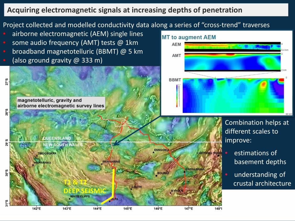
Combination helps at different scales to improve:
• estimations of basement depths
• understanding of crustal architecture
Acquiring electromagnetic signals at increasing depths of penetration
Project collected and modelled conductivity data along a series of “cross-trend” traverses • airborne electromagnetic (AEM) single lines • some audio frequency (AMT) tests @ 1km • broadband magnetotelluric (BBMT) @ 5 km • (also ground gravity @ 333 m)
T1 & T2 DEEP SEISMIC

Page 8
Integrating gravity, seismic, AEM and MT data to investigate crustal architecture and cover thickness: modelling new geophysical data from Southern Thomson region. ASEG Presentation 2016: Chris Folkes (GA)
…then comparing agreement between calculated and observed gravity data using different cover thickness models…
Gravity forward modelling across Olepoloko Fault based on deep seismic profile interpretation
cover thickness interpreted from BBMT conductivity
IMPROVED FIT
Geoscience Australia Record in prep

Kriged colour map of Principal Component 1 for the Mobile Metal Ion® analysis of coarse fraction Top Outlet Sediments (Tc)
Geochemical survey of the southern Thomson Orogen, SW Qld & NW NSW – the chemical composition of surface and near-surface catchment outlet sediments
Geoscience Australia Record 2016/11: Phil Main and Patrice de Caritat

MMI analysis suggests potential as vector to mineralisation, highlighting three areas, including the Warraweena area, east of Bourke • Elevated zinc recorded from cover sequences (exploration aircore) • Basalt to basaltic andesite (Warraweena volcanics)
Geoscience Australia Record 2016/11: Phil Main and Patrice de Caritat

Exploring the nature of the Thomson–Lachlan boundary through zircon Lu-Hf and O isotopes AESC Presentation 2016) Kathryn Waltenberg & Simon Bodorkos (GA), Richard Armstrong & Bin Fu (PRISE)
TIBOOBURRA SUITE
HUNGERFORD GRANITE
TINCHELOOKA DIORITE
TARCOON SUITE
BREWARRINA GRANITE
CUTTABURRA GRANITE
STUDY OVERVIEW • Using Hf + O
isotopes to map source regions
• 11 Thomson samples & 12 Lachlan samples
• 8 S-type and 15 I-type samples
• Compare the
Lachlan and Thomson orogens

STUDY CONCLUSIONS • Overall similarity between Lachlan and Thomson orogen samples
Tinchelooka Diorite ~ 400 Ma
Tarcoon Suite ~ 416 - 408 Ma
SOURCES • Most juvenile NE Lachlan => Macquarie Arc Source • Others mixed with more evolved crust (no new mantle input required)
AESC presentation, 2016 Kathryn Waltenberg & Simon Bodorkos (GA), Richard Armstrong & Bin Fu (PRISE)

Tectono-metamorphic evolution of the southern Thomson Orogen: new evidence from a multi-disciplinary study AESC Presentation 2016) Doublier, Zwingmann, Hegarty, Purdy, Fraser, Thorne, Cross & Champion
Integration of structural interpretation, geochronology data and metamorphic petrology data:
• K-Ar geochronology to date the main cleavage-forming event in lower grade rocks • Dominant fabric is centred on 415 Ma through most of project area within NSW • Incorporating new deformation/metamorphic data to develop time–space plots using age
constraints of provenance, emplacement, biostrat, volcanism & regional events

ARC LINKAGE Project
Testing tectonic models
Providing increased understanding of key geological sites
Supporting Students at Hons and PhD
• Systematic age determination of key lithostratigraphic units across the STO - sedimentary, igneous and metamorphic
• Detrital zircon age spectra of major sedimentary units for provenance analysis
“The southern Thomson Orogen – a missing link in the Tasmanides” Chief Investigator - University of Newcastle
(Prof Bill Collins) Also – University of Queensland, Queensland
University of Technology Partner Investigators – GSQ, GSNSW

ARC LINKAGE Completed Project Highlights
“Age and provenance of the Cobar Supergroup” (results in prep for publication) Honours thesis completed by Matthew Parrish, 2014, at University of Newcastle
Focus: define detrital provenance for Cobar Super Supergroup so that Southern Thomson investigations can compare with confidence.
“Uncovering the Southern Thomson Orogen, NSW: Geodynamic Significance of Warraweena Volcanics and Related Rocks” (results in prep for publication) Hons thesis completed by Sarah Whalan, 2014, at University of Newcastle
“Structure and kinematics of the Louth-Eumarra Shear Zone (north-central New South Wales, Australia) and implications for the geodynamics of the Thomson-Lachlan boundary” (Sam Dunstan 2015. University of Queensland)

ARC LINKAGE 2016 Project Highlights –
Sebastian Wong, an Honours student from University of Newcastle has submitted his thesis on lithology, structure and age in the YANCANNIA area (between White Cliffs and Cobham Lake), with three weeks of field mapping completed in the Yancannia Ranges.
Ryan Dwyer, an Honours student from University of Newcastle has submitted his thesis
on on U-Pb isotopic dating of provenance and magmatic crystallisation for the rocks in the LOUTH area.
Rashed Abdullah, a PhD student from University of Queensland is progressing with a study to interpret existing seismic survey data for STRUCTURAL & TECTONIC inferences in Qld and NSW.
Pascal Asmussen, a new student at the Queensland University of Technology is
developing a project to compare/contrast the stratigraphy and provenance of DEVONIAN BASINS across the southern Thomson Orogen in Qld and NSW .
Valuable and successful studies that add detail in key areas

Page 17

Page 19
Stratigraphic drilling program and plans:
QUEENSLAND
• Two stratigraphic holes were successfully completed in Qld near Eulo during September/October 2016 and basement cores obtained.
• DTB estimates from geophysics were very close to the actual unconformity depths drilled
• Core sampling by collaborative partners to take place in Brisbane during late November
A new drilling contract will be let in early 2017

SUMMARY • GSNSW is investing in southern Thomson projects to develop
UNCOVER potential for this remote and under-explored region
• NCF Collaborative Project with GA and GSQ is providing new data and ideas, with new stratigraphic cores planned
• ARC LINKAGE project research is developing detailed understanding of key geological aspects and sites
Benefits are many… Determining lithology and age constraints for basement rocks Improve tectonic understanding. Defining cover thickness and character Testing techniques for accurate depth to basement mapping Recognising structures and mineral system potential Reducing exploration risk