Embed Size (px)
Citation preview

VULNERABILITY AND ADAPTATION ASSESSMENT TRAINING WORKSHOP18-22 April, 2005
Maputo, Mozambique
THE COASTAL ZONE OF GHANA: VULNERABILITY AND
ADAPTATION ASSESSMENT TO CLIMATE CHANGE
AK ARMAHDEPARTMENT OF OCEANOGRAPPHY & FISHERIES
UNIVERSITY OF GHANALEGON
email: [email protected]

The Coastal Zone of Ghana and Sensitivity Mapping (Armah 2004)
Map of Coastal ZoneMap of Coastal ZoneMap of Coastal ZoneMap of Coastal Zone
#
#
#
#
#
#
#
#
#
#
#
#
#
TOGO
COT E D
' IVOI RE
GUINEA
OFGULF
WEST COAST
EAST
COAST
CEN
TRAL CO AS
T
200nm
200nm
Axim
Cape Three Points
Sekondi
Cape Coast
Winneba
ACCRALa
Prampram Ada
KetaLome
Tema
Apam
5° 5°
6° 6°
7° 7°
3°
3°
2°
2°
1°
1°
0°
0°
1°
1°
T owns#
Water Bodies
River Syste ms
30m Contour
75m Contour
LEGEND
50 0 50 KilometersN
FIGURE 1 : MAP SHOWING THE COASTAL ZONE OF GHANA
• MAP COASTAL ZONE
AKArmah 2004AKArmah 2004
IntroductionIntroduction
• The coastal zone may be divided into three geomorphologic zones:– West Coast, 95km, fine sand, gentle beaches, coastal
lagoons.– Central Coast, 321km, embayed coast of rocky
headlands, rocky shores, littoral sand barriers, coastal lagoons.
– East Coast, 149km, sandy beaches, deltaic estuary of Volta River situated halfway in-between.

IMPACT OF CLIMATE CHANGEON COASTAL ZONE OF GHANA
VULNERABILITY1. Sea Level Rise• Loss of land through erosion and inundation• Increases in salinity of estuaries and aquifers• Raised coastal water tables• Exacerbating coastal flooding and storm surges
– Identified vulnerable entities: Ecosystems, Infrastructure, Agriculture.
2. Translocation of upwelling ???– Vulnerable entity: Fisheries (80,000 artisanal fishermen)

Problems
• Risk Zone cannot be accurately delineated due to poor data. (Risk Zone defined as area within CZ below 3 m contour).
• Limited data on the topography of the coastal zone did not allow other scenarios to be evaluated. Required scale and adequacy were real problems.
• Maps are old (1:50,000) produced in 1974. Higher resolution maps (1:2500) restricted to only small sections of the risk zone
• Beach profiles are irregular and restricted to only few places

Sources of Data
• Data was collected on ecosystems, infrastructure, land, buildings, population that would potentially be vulnerable to sea level rise.

ADAPTATION
• Adaptation costs assumed protection for allcritical areas i.e. areas with population density of 10 per km2 .
• Where no adaptation measure was prescribed (do nothing option) area threatened was classified as “at risk”– Land and infrastructure were considered lost– People assumed displaced– Wetlands considered lost

MITIGATION MEASURES PROPOSED
• Do nothing• Set back• Controlled abandonment (with
protection of important areas)• Total protection of all areas with pop.
density > 10 per km2

RANKING COASTAL VULNERABILITY
• Ranking
AKArmah 2004AKArmah 2004 22
Ranking Coastal Vulnerability
Several approaches exist for Vulnerability ranking of the
CZ to sea level rise.
Approaches include classification of coastal features and
subsequent ranking (prioritization) of their vulnerability
The ranking can be defined in:
– Qualitative terms (e.g. high, medium, low vulnerability)
– Quantitative terms (e.g. numerical values)

RANKING CONT’D
• Still on Ranking
AKArmah 2004AKArmah 2004 33
STILL ON RANKING
Ranking is only a tool assessing magnitude of
consequences, and ranking is a balance between many
interests
The guiding principles of the ranking proposed are: – Transparency
– Easy to accept and explain to decision makers
– The rankings shall include ecological features and human use features, but these features preferably should be ranked
separately
RANKING CONT’D
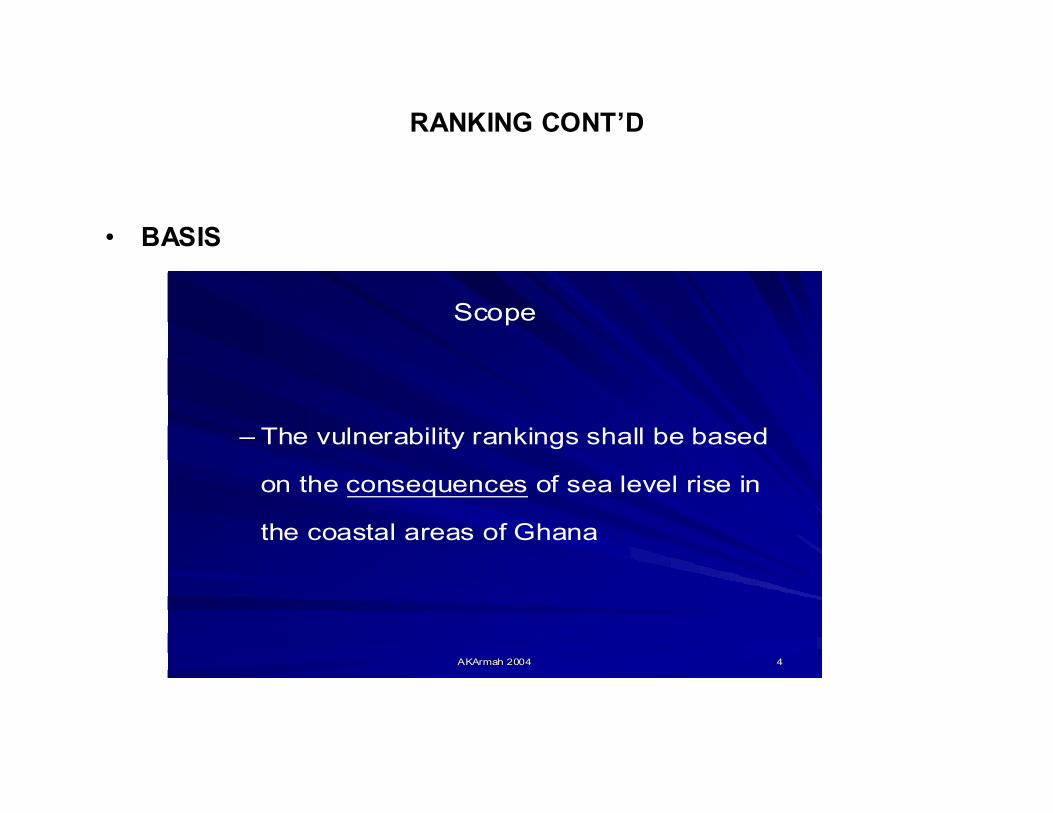
• BASIS
AKArmah 2004AKArmah 2004 44
Scope
– The vulnerability rankings shall be based
on the consequences of sea level rise in
the coastal areas of Ghana

RANKING CONT’D
• ECOLOGICAL FEATURES
AKArmah 2004AKArmah 2004 55
Ranking of Ecological Features
Ranking of vulnerability of ecological features in terms of sea level rise could be carried out in two steps: – Step I: Identification and classification of the coast in terms of
different types of ecosystems
– Step II: Ranking the vulnerabilities of the different ecosystems in terms of scenarios of sea level rise
Categories (Qualitative): – Very high vulnerability
– High vulnerability
– Medium vulnerability and
– Low vulnerability

RANKING CONT’D
• SANDY BEACHES CAN BE RANKED AS HIGHLY VULNERABLE DUE TO BIODIVERSITY REASONS
AKArmah 2004AKArmah 2004 1010
Sandy beaches with turtle nesting sites
Characteristics– Erosion takes away sand and exposes bedrocks and turtles
may not nest in preferred areas
Vulnerability– High vulnerability
Leatherback turtle covering eggs after laying. Photo: Pete Oxford

RANKINGSOCIO-ECONOMIC CONCERNS
STEPS
AKArmah 2004AKArmah 2004 2121
Socio-economic Ranking
The ranking of the vulnerability of socioThe ranking of the vulnerability of socio--
economic features may involve two steps:economic features may involve two steps:
–– Step I:Step I: Identification and classification of coast in Identification and classification of coast in
terms of socioterms of socio-- economic importanceeconomic importance
–– Step II:Step II: Ranking of human use features in terms of Ranking of human use features in terms of
vulnerability to sea level risevulnerability to sea level rise

RANKING SOCIO-ECONOMICS
• GHANA
AKArmah 2004AKArmah 2004 2323
Example of Rankings from Ghanaian perspective
highHistorical Monuments and AmenitiesCoasts with historical monuments (forts/castles) near waterfront
HighMediumMedium
Tourism and recreational issuesCoast with tourist hotels at the water front having > 20 roomsCoast with tourist hotels at the water front having ≤ 20 roomsCoasts used for recreational purposes
Low to highHighLow to highHigh
Industrial and Agriculture ActivitiesCoast with salt production utilizing marine waterCoast with major portCoast with industrial plant relying on marine water intakeCoastal Farming (e.g. shallot cropping)
HighHighMediumVery highHighLow to High
Fishery and Fishery ActivitiesFishery in open waterFishing villages having vessels and canoes in number > 50Fishing villages having vessels and canoes in number ≤ 50Coast used for intensive beach seine fishery (villages having >5nets)Coasts used for beach seine fishery (villages having ≤ 5 nets)Coasts with lagoon fishing and/or aquaculture
Vulnerability to sea level rise
Socio-economic features in the coastal area

SOCIO-ECONOMICS IMPACTS (CONT’D)
• FISHING
AKArmah 2004AKArmah 2004 2727
Coast with lagoon fishing and/or aquaculture plants
Characteristics– Coastal lagoons with artisanal fishery– Few small-scale aquaculture ponds exist
Impacts on lagoon fishing and/or aquaculture– Only artisanal fishery in open
lagoons has a potential of being impacted
Vulnerabilityhigh vulnerability Aquaculture facility at Ada

SOCIO-ECONOMICS IMPACTS (CONT’D
• SALT PRODUCTION
AKArmah 2004AKArmah 2004 2828
Coast with salt production utilising marine waters
Characteristics– Salt production takes place within or near coastal lagoons– Production may involve pumping water from adjacent sea– Extensive salt production occurs in about 14 lagoons
Impacts on salt production– Land for salt production may be lost
Vulnerability– Very high vulnerability
Salt production, Keta lagoon

INFRASTRUCTURE AT RISK(Coastal road and rail to main Port in Ghana)

SOCIO-ECONOMICS IMPACTS (CONT’D
• TOURISM
AKArmah 2004AKArmah 2004 2929
Coast with tourist hotels at the waterfrontCharacteristics– Hotels located next to shoreline that depends on natural
amenities of the coast– About 28 of such hotels along coastline with similar number
of minor resorts and campsites
Impact– Infrastructure could be washed away
Vulnerability– High vulnerability if the hotel has more than
20 rooms– Medium vulnerability if the hotel has 20 or
less rooms

SOCIO-ECONOMICS IMPACTS (CONT’D
• MONUMENTS/TOURISM
AKArmah 2004AKArmah 2004 3131
Coast with historical monument near the waterfront
Characteristics– Around 26 forts and castles along the coastline– They have a unique place in world history
Impacts on historical monuments– Direct impact on buildings
or sites
Vulnerabilityy– High vulnerability
Battlement of Fort, Axim

VULNERABILITY RANKING RESULTS
AKArmah 2004AKArmah 2004 3636
Results of Vulnerability Ranking
yyyyxxxxNumber and value of features of low vulnerability
yyyxxxNumber and value of features of medium vulnerability
yyxxNumber and value of features of high vulnerability
yxNumber and value of features of very high vulnerability
Human Use Features
Ecological Features
Ranking
• BIG QUESTION• NOW DO WE COMBINE
ECOLOGICAL AND SOCIO-ECONOMIC SCORES TO DETERMINE OVERALL RANK OF VULNERABLE SITES (COASTAL STRIPS) ETC ????
• BIOPHYSICAL AND SOCIO-ECONOMIC

KETA• Most erosion prone area, now protected in 2004 (for economic and socio-
political reasons! Not sea level).• Cost US Dollars 90 million
AKArmah 2004AKArmah 2004
Physical structures Physical structures egeg. . groynesgroynes, , breakwaters (breakwaters (KetaKeta, , TemaTema, , TakoradiTakoradi))
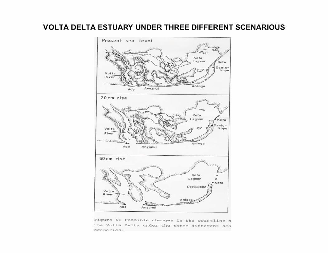
VOLTA DELTA ESTUARY UNDER THREE DIFFERENT SCENARIOUS

• YOUR ANSWER?
• JUST AS BAD AS MINE !!!
THANK YOU