Embed Size (px)
Citation preview
The Changing Face of Neolithic and Bronze Age Ireland: A Big DataApproach to the Settlement and Burial Records
McLaughlin, T., Whitehouse, N., Schulting, R. J., McClatchie, M., & Barratt, P. (2016). The Changing Face ofNeolithic and Bronze Age Ireland: A Big Data Approach to the Settlement and Burial Records. Journal of WorldPrehistory. DOI: 10.1007/s10963-016-9093-0
Published in:Journal of World Prehistory
Document Version:Publisher's PDF, also known as Version of record
Queen's University Belfast - Research Portal:Link to publication record in Queen's University Belfast Research Portal
Publisher rightsThis article is distributed under the terms of the Creative Commons Attribution 4.0 International License(http://creativecommons.org/licenses/by/4.0/), which permits unrestricted use, distribution, and reproduction in any medium, provided yougive appropriate credit to the original author(s) and the source, provide a link to the Creative Commons license, and indicate if changes weremade.
General rightsCopyright for the publications made accessible via the Queen's University Belfast Research Portal is retained by the author(s) and / or othercopyright owners and it is a condition of accessing these publications that users recognise and abide by the legal requirements associatedwith these rights.
Take down policyThe Research Portal is Queen's institutional repository that provides access to Queen's research output. Every effort has been made toensure that content in the Research Portal does not infringe any person's rights, or applicable UK laws. If you discover content in theResearch Portal that you believe breaches copyright or violates any law, please contact [email protected].
Download date:10. Jun. 2018
The Changing Face of Neolithic and Bronze Age Ireland:A Big Data Approach to the Settlement and BurialRecords
T. Rowan McLaughlin1 • Nicki J. Whitehouse2 •
Rick J. Schulting3 • Meriel McClatchie4 • Philip Barratt1,2 •
Amy Bogaard3
� The Author(s) 2016. This article is published with open access at Springerlink.com
Abstract This paper synthesizes and discusses the spatial and temporal patterns of
archaeological sites in Ireland, spanning the Neolithic period and the Bronze Age transition
(4300–1900 cal BC), in order to explore the timing and implications of the main changes
that occurred in the archaeological record of that period. Large amounts of new data are
sourced from unpublished developer-led excavations and combined with national archives,
published excavations and online databases. Bayesian radiocarbon models and context-
and sample-sensitive summed radiocarbon probabilities are used to examine the dataset.
The study captures the scale and timing of the initial expansion of Early Neolithic set-
tlement and the ensuing attenuation of all such activity—an apparent boom-and-bust cycle.
The Late Neolithic and Chalcolithic periods are characterised by a resurgence and
diversification of activity. Contextualisation and spatial analysis of radiocarbon data
reveals finer-scale patterning than is usually possible with summed-probability approaches:
the boom-and-bust models of prehistoric populations may, in fact, be a misinterpretation of
more subtle demographic changes occurring at the same time as cultural change and
attendant differences in the archaeological record.
Keywords Neolithic Ireland � Settlement � Burial � Megalithic tombs � Demographics �Radiocarbon dating
Electronic supplementary material The online version of this article (doi:10.1007/s10963-016-9093-0)contains supplementary material, which is available to authorized users.
& T. Rowan [email protected]
1 School of Geography, Archaeology and Palaeoecology, Queen’s University Belfast, Belfast BT71NN, Northern Ireland, UK
2 School of Geography, Earth and Environmental Sciences, Plymouth University, Plymouth, UK
3 School of Archaeology, University of Oxford, Oxford, UK
4 School of Archaeology, University College Dublin, Belfield, Dublin 4, Republic of Ireland
123
J World PrehistDOI 10.1007/s10963-016-9093-0
Introduction
In this paper we present new insights into Irish Neolithic and Early Bronze Age prehistoric
settlement patterns that have been discovered during the last two decades of intensive,
developer-funded fieldwork, and compare these results to the arguably more familiar
monumental megalithic landscape. The overall aim is to identify points in time and space
where settlement patterns were at their most dynamic, in order to examine both demo-
graphic and cultural changes and the ways in which the archaeological record challenges
notions of population influxes and booms and busts. We focus on a comparison between
(1) Mesolithic–Neolithic transitional sites (4300 cal BC–4000 cal BC), (2) Neolithic sites
(c. 4000 cal BC–2500 cal BC), and (3) sites of the Chalcolithic and opening centuries of
the Early Bronze Age (c. 2500 cal BC–1900 cal BC).
Population dynamics has recently re-emerged as a subject of active debate in prehistoric
studies, especially in parts of the world where large amounts of radiocarbon data are available
(e.g. Peros et al. 2010; Shennan et al. 2013; Kelly et al. 2013; Crombe and Robinson 2014).
The patterns of social and economic change that these studies appear to indicate—particularly
oscillating patterns of activity—conflict with traditional views of the steady, slow pace of
change in prehistory. Human history from the start of the Neolithic onwards—at least in
Europe—has been viewed conventionally as a gradual but continual increase in the scale and
complexity of social organisation (e.g. Childe 1925). By contrast, meta-analyses of large
radiocarbon datasets and of archaeological sites using Bayesian chronological approaches
(e.g. Whittle et al. 2011; Stevens and Fuller 2012; Feeser and Furholt 2013; Armit et al. 2013;
Wicks et al. 2014; Whitehouse et al. 2014) appear to indicate a past that was highly punctuated
and dynamic. This applies both to particular phenomena and to entire societies, with the latter
emerging, flourishing in certain regions, and then undergoing decline, collapse or a radical re-
structuring as in decline-and-fall accounts of classical civilisations. These meta-analytical
approaches provide a useful means of directly comparing human cultural dynamics with
climatic and landscape palaeoecological data (e.g. Whitehouse et al. 2014; Wicks and Mithen
2014; Woodbridge et al. 2014) and thus have great potential for exploring human environ-
mental impacts over the Holocene, and the creation of the cultural landscape.
Criticisms of these approaches as applied to the study of prehistory—particularly the
use of cumulative probability distributions of calibrated radiocarbon dates as proxies for
human populations—are centred on taphonomic considerations, and the fact that the shape
of the calibration curve strongly influences the results (cf. Contreras and Meadows 2014).
Archaeological materials are an imperfect record, with highly complex social factors
underlying the initial deposition of the material drawn on for radiocarbon dating, where-
upon millennia of taphonomic processes eventually result in the ‘what’ and ‘where’ of that
which survives (Schiffer 1987). Nor are data subsequently encountered in a neutral manner
by archaeologists: many biases exist as the result of research traditions and the practi-
calities of undertaking fieldwork. Many syntheses of radiocarbon datasets have failed to
fully confront these factors, limiting the applicability of these approaches and leading to
criticisms within the archaeological literature (e.g. Bamforth and Grund 2012; Contreras
and Meadows 2014; Crombe and Robinson 2014; Sheridan and Petrequin 2014). Here, we
present methods whereby the imperfections and limitations of the archaeological record
can be better contextualised, understood and taken into account when using meta-analytical
approaches centred on radiocarbon dates.
Ireland (Fig. 1), a large European island immediately west of Britain, is divided into
two territories; the northeastern quarter being Northern Ireland and part of the United
J World Prehist
123
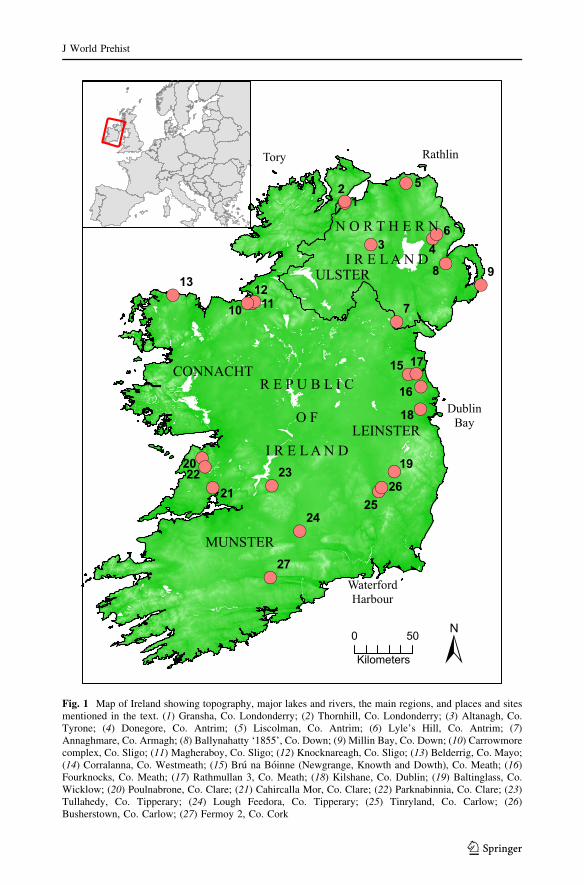
Fig. 1 Map of Ireland showing topography, major lakes and rivers, the main regions, and places and sitesmentioned in the text. (1) Gransha, Co. Londonderry; (2) Thornhill, Co. Londonderry; (3) Altanagh, Co.Tyrone; (4) Donegore, Co. Antrim; (5) Liscolman, Co. Antrim; (6) Lyle’s Hill, Co. Antrim; (7)Annaghmare, Co. Armagh; (8) Ballynahatty ‘1855’, Co. Down; (9) Millin Bay, Co. Down; (10) Carrowmorecomplex, Co. Sligo; (11) Magheraboy, Co. Sligo; (12) Knocknareagh, Co. Sligo; (13) Belderrig, Co. Mayo;(14) Corralanna, Co. Westmeath; (15) Bru na Boinne (Newgrange, Knowth and Dowth), Co. Meath; (16)Fourknocks, Co. Meath; (17) Rathmullan 3, Co. Meath; (18) Kilshane, Co. Dublin; (19) Baltinglass, Co.Wicklow; (20) Poulnabrone, Co. Clare; (21) Cahircalla Mor, Co. Clare; (22) Parknabinnia, Co. Clare; (23)Tullahedy, Co. Tipperary; (24) Lough Feedora, Co. Tipperary; (25) Tinryland, Co. Carlow; (26)Busherstown, Co. Carlow; (27) Fermoy 2, Co. Cork
J World Prehist
123
Kingdom, the remainder being the Republic of Ireland. A large number of developer-led
excavations took place in the island—especially in the Republic—between the late 1990s
and 2008, the timeframe of the most recent economic boom. A large number of prehistoric
settlements of all kinds were discovered by this work (Armit et al. 2013; Ginn 2011;
Whitehouse et al. 2014). In the wider context of Neolithic Europe, Ireland has a special
place, being situated at the endpoint of a series of cultural, economic and demographic
transformations which are among the most intensively studied in world prehistory (e.g.
Barker 1985; Gronenborn 2003; Rowley-Conwy 2004, 2011; Whittle 1996; Whittle et al.
2011). Despite the newly-discovered wealth of settlement evidence, Ireland’s archaeo-
logical record has not yet featured prominently in many of these accounts, except as
auxiliary to British research (e.g. Thomas 2004; Stevens and Fuller 2012). This means that
the connections between Ireland and its wider world have been relatively poorly explored,
except perhaps within narratives concerned with technology and trade (e.g. Cooney and
Mandal 1998; Cooney 2000b). Geographically, Ireland, whilst sharing many ecological
similarities with Britain, also has a number of distinct biogeographic characteristics such
that its records can and should be examined on their own merits (e.g. Mitchell 2005;
Montgomery et al. 2014). These distinctions are primarily expressed in an impoverished
flora and, particularly, fauna, presenting a rather more limited range of ecological niches
for the first human colonisers in the early Holocene (only limited evidence for a Palae-
olithic human presence has been found in Ireland, see Dowd and Carden 2016), and
impacting on the process of neolithisation. As well as presenting no large game animals
other than wild boar (red deer, roe deer and aurochs all being absent), a reduced fauna is
likely to have resulted in a very different Mesolithic landscape structure due to reduced
browsing pressure (Warren et al. 2014). The paucity of large game might have made
Neolithic domesticated cattle, sheep, goat and pig all the more attractive to Irish hunter-
gatherers, assuming some indigenous uptake of farming (Woodman 1985). Furthermore,
the introduction of domesticated grazers into Ireland would certainly have had a range of
ecological consequences, subjecting areas to grazing at levels not previously attained,
perhaps ultimately leading to reduced ecosystem function and ecosystem resilience.
Archaeological Context
Traditionally, much archaeological research on the Irish Neolithic was focused on
megalithic burial monuments, the distribution of surface finds, and investigations of major
earthworks (e.g. Cooney and Mandal 1998; Eogan 1991; Mallory et al. 2011; O’Kelly
1982). Megalithic sites and earthworks are included in some of the analyses presented here,
with the aim of comparing their chronology and geography to those of settlements. Prior to
the boom in development-led excavations in Ireland (Smyth 2007, 2012), attempts to
assess the extent of Neolithic settlement in the landscape were relatively limited,
depending upon field-walking and analysis of the distribution of extant Neolithic earth-
works and megalithic sites. Settlement, despite a lack of direct archaeological evidence,
was seen as widespread, except perhaps in upland areas (Cooney 1983, 2000a, p. 223). The
distribution of visible megaliths and earthworks indicates the presence of Neolithic people
in certain places, and indeed could be used as a proxy for settlement, although there has
been a temptation in the past to assume that the absence of evidence of megalithic tombs in
certain regions equates to an absence of Neolithic people. This assumption was quickly
rebutted by the first major archaeological investigations associated with infrastructure
projects in Ireland (Woodman 1992).
J World Prehist
123
As infrastructural development accelerated through the 1990s and 2000s, it became
apparent that Neolithic rectangular structures, usually interpreted as ‘houses’, were man-
ifest throughout the island (Cooney 1999; Grogan 1996). Smyth (2006, 2007, 2010, 2014)
has reviewed the evidence for these and other Neolithic buildings in considerable depth.
Indeed, the ubiquity of these structures has given rise to an ‘Irish model’ of settlement in
the Neolithic—one of permanent houses and cereal agriculture (Cooney 2000a; Bradley
2007; McClatchie et al. 2014). This model stands in contrast to Britain, most notably
southern Britain, where the available evidence points towards fewer rectangular houses—
or settlements of any kind—and where the importance of cereals is less clear (e.g. Thomas
2004). That being said, the picture may be slowly changing there as well, with earlier
Neolithic houses found at a number of locations, although it is worth noting that substantial
cereal assemblages have been recovered from only some of these sites (Jones and Legge
2008; Pelling and Campbell 2013). In northern Britain, ‘timber halls’, comparable to but
somewhat earlier and larger than Irish Neolithic houses, generally have quite substantial
cereal assemblages (e.g. Fairweather and Ralston 1993; Barclay et al. 2002; Kirby 2011;
Murray et al. 2009).
Rates of recovery for other types of Neolithic and Early Bronze Age settlements in
Ireland have been lower than those for rectangular houses, although a large number of pit
sites have been discovered (Carlin 2011b; Smyth 2012). Other sites that have been recently
discovered in exceptionally large numbers are burnt mounds and single burials. Prehistoric
burnt mounds in Ireland are numerous, but have only been widely excavated and dated in
recent decades, as a result of developer-led projects (O Neill 2009). Single burials occur
most often as depositions of cremated human remains in stone cists, pits or earthworks and
other sites; they have been discovered throughout the island, and date to a number of
distinct periods spanning virtually all of prehistory (Waddell 1970, 1990; Lanting and
Brindley 1998; Brindley 1999; Collins and Coyne 2003).
Methods
Syntheses of development-led excavations have proven challenging, due to the huge
volume of raw data, most of which remains unpublished. However, chronology can be a
powerful tool to provide an overview of the data (Shennan and Edinborough 2006). The
potential of radiocarbon chronology to revolutionize the understanding of prehistory has
been anticipated for some time in Ireland (e.g. Woodman 2000). However, as the majority
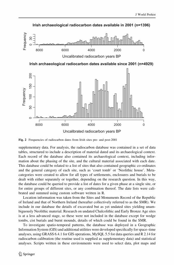
of radiocarbon dates from Irish sites have only become available in the last decade (Fig. 2),
the potential of development-led excavations in Ireland to enhance our understanding of
the past is only beginning to become apparent.
Here, we consider a database of radiocarbon dates that we have collated using published
dates and date lists (e.g. Brindley 2007; Chapple 2008); unpublished site reports, the
National Roads Authority’s archaeological database; and direct consultation with private
sector archaeologists. The Neolithic period (c. 4000–2500 cal BC) is represented by 1150
radiocarbon dates from 177 sites, with a further 739 dates recorded from 254 Chalcolithic
and Early Bronze Age sites (2500–1900 cal BC). These numbers comfortably exceed the
minimum 500 radiocarbon dates recommended for this type of analysis (Williams 2012).
We have recorded details about material sampled for each date, its context, and various
physical and archaeological parameters of each site, including geographical location and
typological status, storing this information in a relational database. A compendium of
published radiocarbon data and a list of sites is appended to this paper as electronic
J World Prehist
123
supplementary data. For analysis, the radiocarbon database was contained in a set of data
tables, structured to include a description of material dated and its archaeological context.
Each record of the database also contained its archaeological context, including infor-
mation about the phasing of the site, and the cultural material associated with each date.
This database could be related to a list of sites that also contained geographic co-ordinates
and the general category of each site, such as ‘court tomb’ or ‘Neolithic house’. Meta-
categories were created to allow for all types of settlements, enclosures and burials to be
dealt with either separately or together, depending on the research question. In this way,
the database could be queried to provide a list of dates for a given phase at a single site, or
for entire groups of different sites, or any combination thereof. The date lists were cali-
brated and summed using custom software written in R.
Location information was taken from the Sites and Monuments Record of the Republic
of Ireland and that of Northern Ireland (hereafter collectively referred to as the SMR). We
include in our database the details of excavated but as yet undated sites yielding unam-
biguously Neolithic material. Research on undated Chalcolithic and Early Bronze Age sites
is at a less advanced stage, so these were not included in the database except for wedge
tombs, cist burials and burnt mounds, details of which could be found in the SMR.
To investigate spatio-temporal patterns, the database was deployed in a Geographic
Information System (GIS) and additional utilities were developed specifically for space–time
analyses, using GRASS 6.4.1 for GIS operations, MySQL 5.5 for data queries and R 2.14 for
radiocarbon calibration (the routine used is supplied as supplementary data) and statistical
analyses. Scripts written in these environments were used to select data, plot maps and
Irish archaeological radiocarbon dates available in 2001 (n=1396)
Uncalibrated radiocarbon years BP
Freq
uenc
y
8000 6000 4000 2000 0
030
Irish archaeological radiocarbon dates available since 2001 (n=4929)
Uncalibrated radiocarbon years BP
Freq
uenc
y
8000 6000 4000 2000 0
050
100
150
200
Fig. 2 Frequencies of radiocarbon dates from Irish sites pre- and post-2001
J World Prehist
123
provide summary statistics. Radiocarbon dates were calibrated within these environments,
using the Intcal13 or Marine13 calibration curves as appropriate (Reimer et al. 2013).
Summed radiocarbon probability distributions were calculated separately for burial and non-
burial contexts, and from charcoal and non-charcoal samples, thereby allowing for old wood
samples to be excluded from the analysis if required. For the summed probability modelling,
multiple dates occurring within the same phase at a given site were included in the analysis to
avoid the risk of rejecting potentially interesting dates that had been erroneously attributed to
a given phase—indeed the strength of summed modelling is that no assumptions about the
phasing of the data are made. A comparison between the sum of all dates, and those instances
where only one date per phase is considered (see supplementary data) indicates that there is
little significant difference between the results. We do, however, follow an overall chrono-
logical framework for the Neolithic derived through Bayesian approaches already published
elsewhere (Carlin 2011b; Cooney et al. 2011; Schulting 2014, 2015; Schulting et al. 2012;
Whitehouse et al. 2014). We follow archaeological convention and present Bayesian mod-
elled phase boundaries in italics.
This approach allows for comparisons between multiple data contexts and varying
qualities. As a first step in exploring the significance of short-term fluctuations in Irish
radiocarbon data, the decay model proposed by Surovell et al. (2009) was used. Surovell
and his colleagues derived this model by regressing the Bryson et al. (2006) database of
radiocarbon dates from volcanic eruptions against a power function in the form:
Nt ¼ a(t þ b)�c
where Nt is the number of radiocarbon dates for the time period t, and a, b and c are
correlation coefficients (see Surovell et al. 2009, pp. 1716–1717). The function can
therefore be used to model a ‘taphonomic correction’ to summed probability distributions.
GIS was used to create maps of Ireland where the geographic location of each radio-
carbon-dated sample could be visualized according to its context, the type of material dated
and the probability that it lies within a given calibrated timeframe. Given the difficulties
associated with representing detailed contextual information on such a map, sites were
divided broadly into houses, enclosures, burnt mounds, burials and ‘other’ categories. The
‘house’ category includes rectangular, circular and irregular structures; the ‘other’ category
consists mainly of ‘pit-and-spread complexes’. Although individual pits are found on many
sites, pit-and-spread complexes are those sites where pits and spreads of cultural material
are the defining features (Smyth 2012). A set of summary statistics was produced for each
category, taking the site as the unit of analysis—for example, multiple rectangular houses
occurring together were counted as one site. Multiple phases occurring at one site were
treated separately. A succession of maps, plotted using narrow temporal bandwidths (of the
order of decades or even years) and viewed as animations, was used to visualize the
changing character of the archaeological record. Static maps were also generated for longer
timespans, allowing for the comparison of newly-discovered excavated sites and extant,
unexcavated and undated sites whose details are known from the SMR.
For analyses of site elevation, GIS was used to store a digital elevation model of Ireland,
built using Shuttle Radar Telemetry Mission (SRTM) data at 3 arcsecond resolution. A
surface interpolated from this model was sampled at the point coordinates of the various
sites, and the result was fed back into the database as a statistic that could be analyzed in
tandem with other site attributes. Sites near errant reflections in the SRTM data were
identified as outliers and excluded from elevation analysis. An average elevation statistic
was calculated for most site categories, except where small numbers and topographic
J World Prehist
123
heterogeneity resulted in no clear central tendency. A random sample of 1500 points in the
digital elevation model has a median elevation of 86 m and an interquartile range of 55 m–
142 m.
Results
What follows is an overview of the evidence for archaeological sites in Ireland,
4300–1900 cal BC. For convenience, the Neolithic period is divided into transitional,
Early, Early/Middle, Middle and Late periods, following conventions already established
(McClatchie et al. 2014; Whitehouse et al. 2014). We also explore the presentation of
spatial–temporal trends in the data without recourse to categorisation by time period, via
animated mapping and presentation of overall trends using summary statistics and summed
radiocarbon probabilities.
Final Mesolithic Ireland
Later Mesolithic in Ireland, which can be distinguished from earlier phases on the basis of
the stone tools that characterize it, began around 6700 cal BC and ended with the arrival of
farming (Woodman 2015, pp. 232–233). Settlement evidence from the period is rare, and
from 4200 cal BC rarer still (Woodman 2015, p. 330). Late Mesolithic artefacts have,
however, been found in contexts securely dated to approximately 4000 cal BC at
Belderrig, Co. Mayo (Warren 2008); Corralanna, Co. Westmeath (Warren et al. 2009); and
Tinryland, Co. Carlow (O’Connell 2009). Some time after this point, possibly as early as
3720 cal BC, the first hints of a Neolithic presence emerge, although the evidence is by no
means unequivocal and there are no known settlement sites.
Early Neolithic I, Pre-3720/3680 cal BC
Recent assessment of the radiocarbon record using Bayesian methods has dated the
appearance in Ireland of cereals and rectangular houses—both clear markers of the pres-
ence of Neolithic people—to no earlier than 3720–3680 cal BC (Cooney et al. 2011;
Whitehouse et al. 2014). The start of the Neolithic in Ireland has traditionally been placed
at c. 4000 cal BC, but this relied on a small number of potentially aberrant charcoal dates,
and on the earlier part of 95% confidence intervals on radiocarbon dates on human and
animal bone. For reasons discussed by Whitehouse et al. (2014) and outlined later in this
paper, early dates on wood charcoal from settlement sites unfortunately make no great
contribution to our knowledge of the earliest Neolithic in Ireland. At Ferriter’s Cove
(Woodman et al. 1999), and more tentatively at Kilgreany cave (Woodman et al. 1997),
cattle bones dating to 4300 cal BC and 4000 cal BC hint at a Mesolithic contact with
Neolithic Britain or continental Europe (there is no wild bovine native to Ireland), or
alternatively suggest that Neolithic cattle farming had already become established in a way
that is otherwise invisible archaeologically. On the other hand, evidence for cereal agri-
culture during this period (aside from inconclusive palynological data: Behre 2007;
Whitehouse et al. 2014) is lacking altogether, though this should be seen in the light of the
fact that the overwhelming majority of cereal samples are derived from rectangular
structures, which date to a later time (McClatchie et al. 2014).
J World Prehist
123
The best evidence for a Neolithic presence in Ireland before 3720 cal BC is found in the
burial record. Individuals buried at Altanagh, Co. Tyrone (Murphy et al. 2010) and
Poulnabrone, Co. Clare (Schulting 2014) lived around 3800 cal BC. It is possible that these
people were among Ireland’s first farmers, whose culture was just beginning to gather
momentum on the island, and whose settlements are yet to be discovered by fieldworkers.
Certainly, the scale of deposition of archaeological material of all kinds before 3720 cal
BC is limited, whilst the profusion of sites after this date indicates a radical transformation
of human society and its associated cultural landscape.
Early Neolithic II, 3720/3680–3640/3620 cal BC
Sites dating to the Early Neolithic II (ENII) period, encompassing the Neolithic ‘house
horizon’ of 3720/3680–3640/3620 cal BC, are shown in Fig. 3. Extant portal and court
tombs are included here, in addition to excavated and dated sites, although it should be
noted that neither type of monument has been as thoroughly excavated or dated as the
settlements now are. The chronology of portal tombs is poorly known, although the limited
available data support an early appearance, namely pre-3720 cal BC (Kytmannow 2008;
Schulting 2014). Construction of court tombs began during the interval 3700–3570 cal BC,
and their initial phase of use for burial probably continued slightly longer than did that of
rectangular houses (Schulting et al. 2012). Deposition at two passage tombs sites—the
Carrowmore complex, Co. Sligo, and Baltinglass, Co. Wicklow—also began at this time
(Bergh and Hensey 2013; Schulting et al. 2016), although many Irish passage tombs are of
the later (post-3400 cal BC), more ‘developed’ kind typified by Newgrange and Knowth,
and undated examples are not shown in Fig. 3.
The archaeological evidence for Early Neolithic settlement in Ireland is relatively well-
resolved by Atlantic European prehistoric standards. The rectangular structures shown in
Fig. 3 are all irrefutably Early Neolithic in date (McSparron 2008; Cooney et al. 2011;
Whitehouse et al. 2014), as are the causewayed enclosures at Donegore, Co. Antrim, Lyle’s
Hill, Co. Antrim and Magheraboy, Co. Sligo, the Kilshane enclosure, Co. Dublin, and the
enclosed settlement at Tullahedy, Co. Tipperary (Cooney et al. 2011; Schulting 2011;
Mallory et al. 2011). Also shown in Fig. 3 are individual burials (including finds of human
bone in caves) that date to the period of interest.
Considerable uncertainty surrounds the dating of many Early Neolithic pit-and-spread
complexes, as the majority of these sites are dated only by radiocarbon determinations on
charcoal samples—problematic due to potential old wood effects. At least one pit complex
of Early Neolithic date, Gransha, Co. Londonderry, may in fact be an example of a
rectangular Neolithic house site where depositional and taphonomic factors have rendered
the structural features less recognisable than usual (Schulting and Reimer 2008; White-
house et al. 2014).
Taphonomic and research biases are inherent in any distribution map, as discussed later
in this paper. Notwithstanding these, the Early Neolithic archaeological record in Ireland is
highly resolved chronologically from around 3700 cal BC and over the ensuing century. Of
special interest are those areas where many different site types have been found in close
proximity, particularly Lough Foyle and Dundalk Bay, which offer some of the most
detailed views of Early Neolithic life available anywhere in Atlantic Europe. Furthermore,
significant regional patterns can be identified. For example, in the southeast of the island,
both settlement sites and portal tombs are found along an inland corridor between
Waterford Harbour and Dublin Bay (see Fig. 1). Notably, very few of these sites are found
near the coast, except at the endpoints of this distribution. Over the northern half of the
J World Prehist
123
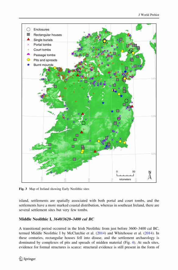
island, settlements are spatially associated with both portal and court tombs, and the
settlements have a more marked coastal distribution, whereas in southeast Ireland, there are
several settlement sites but very few tombs.
Middle Neolithic I, 3640/3620–3400 cal BC
A transitional period occurred in the Irish Neolithic from just before 3600–3400 cal BC,
termed Middle Neolithic I by McClatchie et al. (2014) and Whitehouse et al. (2014). In
these centuries, rectangular houses fell into disuse, and the settlement archaeology is
dominated by complexes of pits and spreads of midden material (Fig. 4). At such sites,
evidence for formal structures is scarce: structural evidence is still present in the form of
55N
54N
53N
52N
10W
9W 8W 7W 6W
Enclosures
Rectangular houses
Single burials
Portal tombs
Court tombs
Passage tombs
Pits and spreads
Burnt mounds
N0 50
kilometers
Fig. 3 Map of Ireland showing Early Neolithic sites
J World Prehist
123
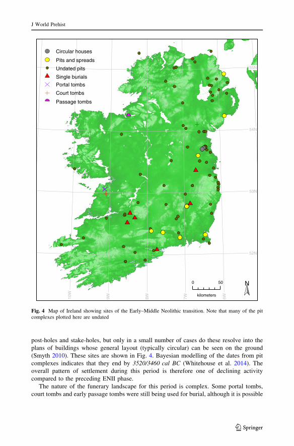
post-holes and stake-holes, but only in a small number of cases do these resolve into the
plans of buildings whose general layout (typically circular) can be seen on the ground
(Smyth 2010). These sites are shown in Fig. 4. Bayesian modelling of the dates from pit
complexes indicates that they end by 3520/3460 cal BC (Whitehouse et al. 2014). The
overall pattern of settlement during this period is therefore one of declining activity
compared to the preceding ENII phase.
The nature of the funerary landscape for this period is complex. Some portal tombs,
court tombs and early passage tombs were still being used for burial, although it is possible
55N
54N
53N
52N
10W
9W 8W 7W 6W
Circular houses
Pits and spreads
Undated pits
Single burials
Portal tombs
Court tombs
Passage tombs
N0 50
kilometers
Fig. 4 Map of Ireland showing sites of the Early–Middle Neolithic transition. Note that many of the pitcomplexes plotted here are undated
J World Prehist
123
that these megalithic sites were no longer being constructed. For example, there is evidence
for phases of intensive passage tomb use at Carrowmore, Co. Sligo (Bergh and Hensey
2013), and the deposition of human remains continued at the court tombs of Annaghmare,
Co. Armagh and Parknabinnia, Co. Clare (Schulting et al. 2012) and at the portal tomb at
Poulnabrone, Co. Clare (Lynch 2014; Schulting 2014). The continuing engagement with
Early Neolithic funerary monuments in a changing landscape is implied, even if con-
struction declined or ceased. Due to the uncertainties involved, only megalithic structures
known to be in use during this period are shown in Fig. 4. Also shown are the single burials
known from this period, including one that was found enclosed within an undated but
presumably earlier Neolithic house at Busherstown, Co. Carlow (O Neill 2009).
Figure 4 also shows the distribution of excavated pit complexes where diagnostic Early
to Middle Neolithic material has been identified but, at the time of writing, has not been
radiocarbon dated. These are more widespread than Early Neolithic settlements—their
distribution includes the midlands, coastal Leinster and the northern offshore islands of
Rathlin and Tory (see also Fig. 1). Following a recent review by Cooney et al. (2011), and
an extensive radiocarbon dating programme by Whitehouse et al. (2014), it seems that
most well-dated pit complexes fall within this Early–Middle Neolithic transition period,
albeit during the earlier part of the phase, that is, between 3600 and 3500 cal BC, providing
an indication of the absolute chronology of similar, undated sites.
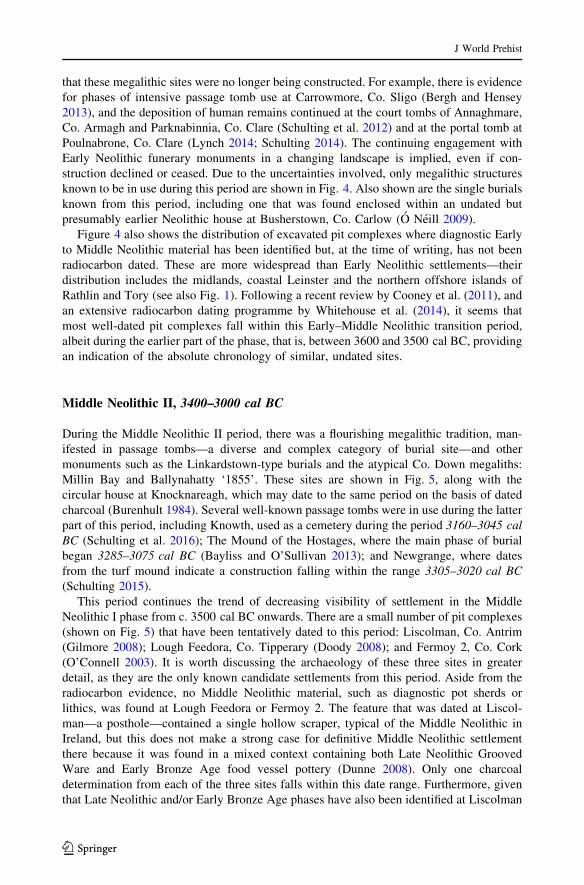
Middle Neolithic II, 3400–3000 cal BC
During the Middle Neolithic II period, there was a flourishing megalithic tradition, man-
ifested in passage tombs—a diverse and complex category of burial site—and other
monuments such as the Linkardstown-type burials and the atypical Co. Down megaliths:
Millin Bay and Ballynahatty ‘1855’. These sites are shown in Fig. 5, along with the
circular house at Knocknareagh, which may date to the same period on the basis of dated
charcoal (Burenhult 1984). Several well-known passage tombs were in use during the latter
part of this period, including Knowth, used as a cemetery during the period 3160–3045 cal
BC (Schulting et al. 2016); The Mound of the Hostages, where the main phase of burial
began 3285–3075 cal BC (Bayliss and O’Sullivan 2013); and Newgrange, where dates
from the turf mound indicate a construction falling within the range 3305–3020 cal BC
(Schulting 2015).
This period continues the trend of decreasing visibility of settlement in the Middle
Neolithic I phase from c. 3500 cal BC onwards. There are a small number of pit complexes
(shown on Fig. 5) that have been tentatively dated to this period: Liscolman, Co. Antrim
(Gilmore 2008); Lough Feedora, Co. Tipperary (Doody 2008); and Fermoy 2, Co. Cork
(O’Connell 2003). It is worth discussing the archaeology of these three sites in greater
detail, as they are the only known candidate settlements from this period. Aside from the
radiocarbon evidence, no Middle Neolithic material, such as diagnostic pot sherds or
lithics, was found at Lough Feedora or Fermoy 2. The feature that was dated at Liscol-
man—a posthole—contained a single hollow scraper, typical of the Middle Neolithic in
Ireland, but this does not make a strong case for definitive Middle Neolithic settlement
there because it was found in a mixed context containing both Late Neolithic Grooved
Ware and Early Bronze Age food vessel pottery (Dunne 2008). Only one charcoal
determination from each of the three sites falls within this date range. Furthermore, given
that Late Neolithic and/or Early Bronze Age phases have also been identified at Liscolman
J World Prehist
123
and Fermoy 2, there is a high probability that the old wood effect has caused erroneous
attribution of later phases of occupation to the Middle Neolithic period.
The overall pattern, therefore, is of very low archaeological visibility of settlement sites
of all kinds in the Middle Neolithic in Ireland, despite an exhaustive search of all relevant
archives. This situation strongly contrasts with the visibility, diversity and importance of
megalithic structures, which are widespread over much of the island, though concentrated
in a number of localities, the best-known being Bru na Boinne (Boyne Valley), Co. Meath.
It seems clear that whatever settlement structures were being used during this period, their
potential for generating archaeological signals was very low. Perhaps this was due to a
preference for earth rather than timber as the main building material, and the lack of any
55N
54N
53N
52N
10W
9W 8W 7W 6W
Circular houses
Pits and spreads
Passage tombs
Linkardstown cists
Other megaliths
Single burials
N0 50
kilometers
Fig. 5 Map of Ireland showing Middle Neolithic sites
J World Prehist
123
requirement to dig features deeply enough into the subsoil to create persistent archaeo-
logical features in the first place.
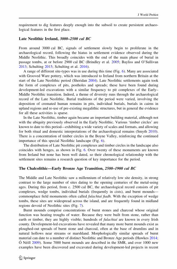
Late Neolithic Ireland, 3000–2500 cal BC
From around 3000 cal BC, signals of settlement slowly begin to proliferate in the
archaeological record, following the hiatus in settlement evidence observed during the
Middle Neolithic. This broadly coincides with the end of the main phase of burial in
passage tombs, at or before 2900 cal BC (Brindley et al. 2005; Bayliss and O’Sullivan
2013; Schulting 2015; Schulting et al. 2016).
A range of different site-types was in use during this time (Fig. 6). Many are associated
with Grooved Ware pottery, which was introduced to Ireland from northern Britain at the
start of the Late Neolithic period (Sheridan 2004). Late Neolithic settlements again took
the form of complexes of pits, postholes and spreads; these have been found during
development-led excavations with a similar frequency to pit complexes of the Early–
Middle Neolithic transition. Indeed, a theme of diversity runs through the archaeological
record of the Late Neolithic. Burial traditions of the period were varied, involving the
deposition of cremated human remains in pits, individual burials, burials in cairns in
upland regions and re-use of pre-existing megalithic structures, but in general the evidence
for all these activities is sparse.
In the Late Neolithic, timber again became an important building material, although not
with the ubiquity previously observed in the Early Neolithic. Various ‘timber circles’ are
known to date to this period—exhibiting a wide variety of scales and formats, and allowing
for both ritual and domestic interpretations of the archaeological remains (Smyth 2010).
There is a concentration of timber circles in the Boyne Valley, reinforcing the continued
importance of this special Neolithic landscape (Fig. 6).
The distribution of Late Neolithic pit complexes and timber circles in the landscape also
coincides with henges, as shown in Fig. 6. Over twenty of these monuments are known
from Ireland but none has been well dated, so their chronological relationship with the
settlement sites remains a research question of key importance for the period.
The Chalcolithic—Early Bronze Age Transition, 2500–1900 cal BC
The Middle and Late Neolithic saw a millennium of relatively low site density, in strong
contrast to the large number of sites dating to the opening centuries of the metal-using
ages. During this period, from c. 2500 cal BC, the archaeological record consists of pit
complexes, wedge tombs, individual burials (frequently in cists), and burnt mounds—
commonplace field monuments often called fulachtaı fiadh. With the exception of wedge
tombs, these sites are widespread across the island, and are frequently found in midland
regions devoid of Neolithic sites (Fig. 7).
Burnt mounds comprise concentrations of burnt stones and charcoal whose original
function was heating troughs of water. Because they were built from stone, rather than
earth or timber, they are highly visible; hundreds of fulachtaı are known in every Irish
county. Development-led excavations have revealed that many more burnt mounds exist as
ploughed-out spreads of burnt stone and charcoal, often at the base of drumlins and in
natural hollows near streams or marshland. Morphologically similar spreads of burnt
material can date to a number of distinct Neolithic and Bronze Age periods (Hawkes 2014;
O Neill 2009). Some 7000 burnt mounds are described in the SMR, and over 1000 new
examples have been discovered and excavated during development-led projects in recent
J World Prehist
123
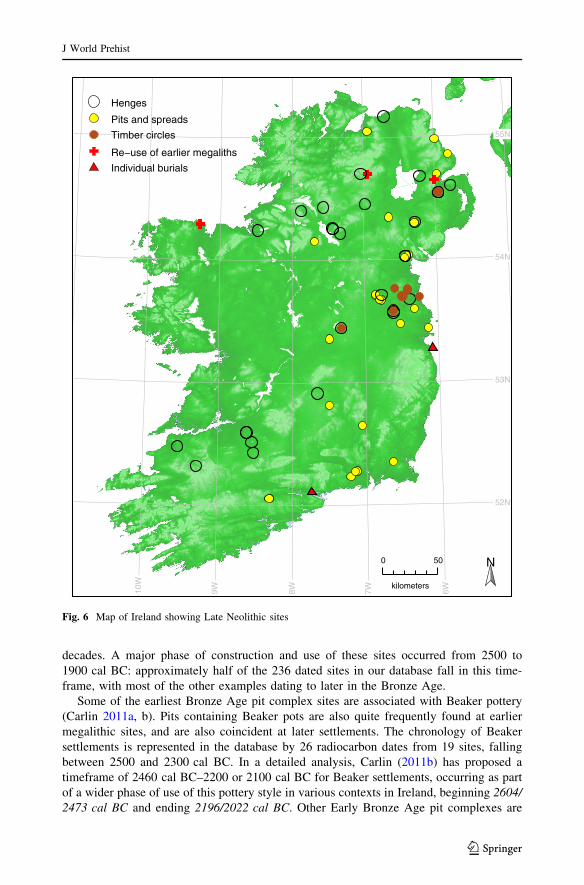
decades. A major phase of construction and use of these sites occurred from 2500 to
1900 cal BC: approximately half of the 236 dated sites in our database fall in this time-
frame, with most of the other examples dating to later in the Bronze Age.
Some of the earliest Bronze Age pit complex sites are associated with Beaker pottery
(Carlin 2011a, b). Pits containing Beaker pots are also quite frequently found at earlier
megalithic sites, and are also coincident at later settlements. The chronology of Beaker
settlements is represented in the database by 26 radiocarbon dates from 19 sites, falling
between 2500 and 2300 cal BC. In a detailed analysis, Carlin (2011b) has proposed a
timeframe of 2460 cal BC–2200 or 2100 cal BC for Beaker settlements, occurring as part
of a wider phase of use of this pottery style in various contexts in Ireland, beginning 2604/
2473 cal BC and ending 2196/2022 cal BC. Other Early Bronze Age pit complexes are
55N
54N
53N
52N
10W
9W 8W 7W 6W
Henges
Pits and spreads
Timber circles
Re−use of earlier megaliths
Individual burials
N0 50
kilometers
Fig. 6 Map of Ireland showing Late Neolithic sites
J World Prehist
123
either aceramic or associated with insular pottery styles such as Food Vessels. More work
is needed to ascertain if there are any strong chronological patterns in the patterns of
deposition at these sites.
Wedge tombs are traditionally associated with the first metal-using people in Ireland: a
brief Chalcolithic phase (O’Brien 2012). Research using Bayesian methods suggests they
were in use from 2300 to 2000 cal BC (Schulting et al. 2008). Although megalithic
structures are usually equated with the Neolithic, wedge tombs are the most common
category of prehistoric mortuary monument on the island (de Valera and O Nuallain 1982;
see also Table 1). The period from 2500 to 2000 cal BC also sees the re-use of a significant
number of megalithic structures (Brindley et al. 2005; Carlin 2011a; Schulting et al. 2012;
Bayliss and O’Sullivan 2013). Most of the well-dated excavated megalithic sites display
55N
54N
53N
52N
10W
9W 8W 7W 6W
Pits and spreads
Burnt mounds
Cist burials
Wedge tombs
N0 50
kilometers
Fig. 7 Map of Ireland showing Early Bronze Age sites
J World Prehist
123
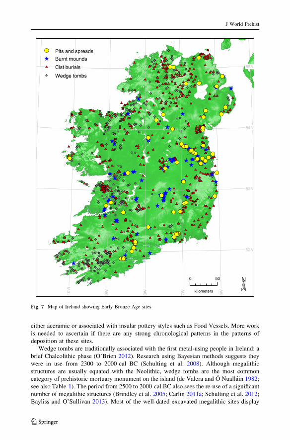
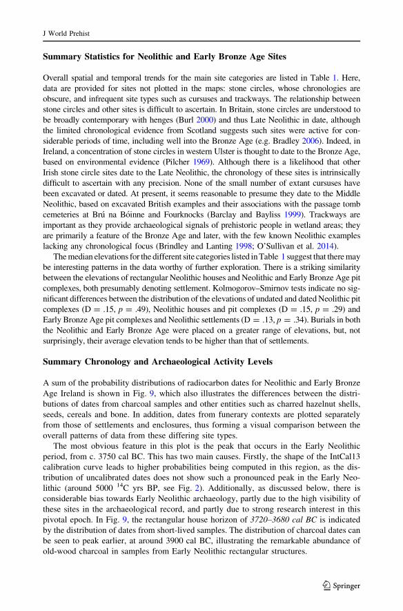
Tab
le1
Sum
mar
yst
atis
tics
for
Iris
hN
eoli
thic
site
s
Sit
ety
pe
Nu
mb
erk
no
wn
aN
um
ber
dat
edN
um
ber
wel
l-d
ated
bM
edia
nel
evat
ion
c(m
)G
eog
rap
hy
Chro
no
log
y
Ear
lyen
closu
resd
63
11
08
Wid
esp
read
,lo
wd
ensi
ty3
75
0ca
lB
C–
34
00
cal
BC
Rec
tangula
rhouse
s54
40
26
53
Wid
espre
ad,
hig
hden
sity
3750
cal
BC
–3600
cal
BC
Oth
erst
ruct
ure
san
dti
mb
erci
rcle
s5
51
77
62
Wid
esp
read
37
00
cal
BC
–32
00
cal
BC
28
00
cal
BC
–25
00
cal
BC
Neo
lith
icp
its
and
spre
ads
15
95
41
65
3W
ides
pre
ad,
hig
hd
ensi
ty3
75
0ca
lB
C–
34
00
cal
BC
30
00
cal
BC
–25
00
cal
BC
Neo
lith
icb
urn
tm
ou
nd
s7
73
91
Mid
lan
dre
gio
ns,
low
den
sity
37
00
cal
BC
–33
00
cal
BC
Cu
rsu
ses
70
08
5W
ides
pre
ad,
low
den
sity
Mid
dle
Neo
lith
ic?
Co
urt
tom
bse
39
82
34
89
No
rth
ern
hal
fo
fIr
elan
d3
70
0ca
lB
C–
35
70
cal
BC
Po
rtal
tom
bse
18
53
08
1N
ort
her
n,
east
ern
and
Sh
ann
on
reg
ions
c.3
70
0ca
lB
C–
35
00
cal
BC
Pas
sage
tom
bse
147
10
4145
Wid
espre
ad,
elev
ated
site
sc.
3700
cal
BC
and
3400–3000
cal
BC
Lin
kar
dst
ow
nci
sts
11
54
39
So
uth
east
ern
reg
ions,
low
den
sity
c.3
40
0ca
lB
C–
32
00
cal
BC
Hen
ges
22
20
12
1N
ort
her
nan
dea
ster
nre
gio
ns
c.3
00
0ca
lB
C–
25
00
cal
BC
Neo
lith
ictr
ack
way
s5
20
82
Wet
lan
ds
36
00
cal
BC
–25
00
cal
BC
Sin
gle
bu
rial
s1
41
41
18
1M
idla
nd
regio
ns,
low
den
sity
39
00
cal
BC
–25
00
cal
BC
Oth
erN
eoli
thic
site
sf61
61
––
Var
ious
Sto
ne
circ
les
23
81
01
35
Wid
esp
read
wit
hh
igh
den
sity
inS
WL
ate
Neo
lith
ic?
W.
Uls
ter
sto
ne
circ
les
11
11
02
11
Wes
tern
Uls
ter,
up
lan
dsi
tes
Ear
lyB
ron
zeA
ge?
EB
Ab
urn
tm
ou
nd
sc.
50
00
g1
11
19
7W
ides
pre
ad2
50
0ca
lB
C–
19
00
cal
BC
EB
Ap
its
and
spre
ads
un
cert
ain
86
55
7W
ides
pre
ad2
50
0ca
lB
Co
nw
ard
s
J World Prehist
123
Table
1co
nti
nu
ed
Sit
ety
pe
Nu
mb
erk
no
wn
aN
um
ber
dat
edN
um
ber
wel
l-d
ated
bM
edia
nel
evat
ion
c(m
)G
eog
rap
hy
Ch
ron
olo
gy
Wed
ge
tom
bs
57
25
51
40
Wes
tern
reg
ions
23
00
cal
BC
–2
00
0ca
lB
C
Re–
use
of
earl
ier
meg
alit
hs
un
kno
wn
12
7h
17
7W
ides
pre
ad2
20
0ca
lB
C–
17
00
cal
BC
Cis
tb
uri
als
92
04
03
59
4W
ides
pre
ad2
20
0ca
lB
C–
18
50
cal
BC
aM
inim
um
nu
mb
ero
fse
par
ate
site
sb
Rel
iable
sequen
ceof
dat
esfr
om
short
-liv
edsa
mple
sc
WG
S8
4d
atu
md
Cau
sew
ayed
encl
osu
res,
Tu
llah
edy
and
Th
orn
hil
le
Loca
ted
SM
Rsi
tes
of
clea
rty
polo
gy
fF
inds,
mid
den
s,fl
int
scat
ters
,quar
ries
,et
c.g
Est
imat
edu
sin
gth
en
um
ber
of
exta
nt
site
san
dth
ep
rop
ort
ion
of
exca
vat
edsi
tes
dat
ing
to2
50
0ca
lB
C–
19
00
cal
BC
(47
%)
hS
ites
wit
hd
irec
td
ates
on
hu
man
bo
ne
J World Prehist
123
signals of Chalcolithic or Early Bronze Age re-use; it is therefore tempting to speculate
that the practice was very widespread.
Cist burials are a well-studied type of site associated with Food Vessel pottery, and
extensive dating programmes have established that they were constructed over the period
2200–1850 cal BC (Brindley 2007; Waddell 1990). It is, however, noteworthy that during
development-led excavations, cists are found far less frequently than burnt mounds, thus
highlighting a traditional bias in archaeological research, which has concentrated upon
burials and related artefacts.
Animated Radiocarbon Map
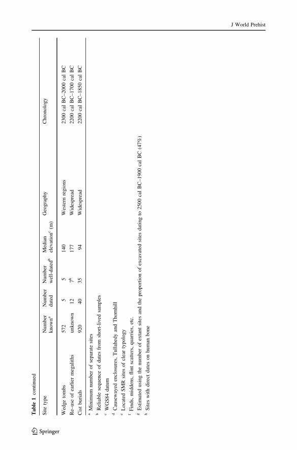
Figure 8 provides a visualisation of the distribution of archaeological radiocarbon dates
from Ireland. An animated version of the map can be accessed via the electronic sup-
plementary materials. For every frame of the animation, each radiocarbon date is plotted
using a point whose shape is dictated by the type of site from which the sample originated.
The size of the point is directly proportional to the probability that the sample dates to a
particular year, and the material dated determines the colour of the point. The threshold
Fig. 8 Example frames from an animated map of Irish sites 4500 cal BC–1900 cal BC. Static framesdisplay determinations whose probabilities intersect the date shown—the shape of each point indicates thesample’s context and its colour indicates the material dated. An animated series of maps, 4500 cal BC–1900 cal BC, is supplied as supplementary data (Color figure online)
J World Prehist
123
timeframe for each point is approximately equivalent to the span of the calibrated date’s
99% confidence interval, and each point increases in size over the span of the 68%
confidence interval with a maximum occurring at the modal year (or years) of the
calibration.
The animated map begins at 4500 cal BC, illustrating the sparse distribution of Late
Mesolithic sites (though this represents an increase from the preceding centuries). From the
outset, charcoal samples from Neolithic contexts are also visible, highlighting the mag-
nitude of the old wood problem. Because a sample’s point size reflects the probability that
the sample dates to that particular year, the shape of the calibration curve affects the point
size and the dots on the map can be seen to oscillate accordingly. The old wood effect
becomes increasingly problematic around 4000 cal BC—which until recently was the
orthodox date for the start of the Neolithic period. From approximately 3800 cal BC, dates
from cereals start to become visible; these are the left-hand tails of the probability dis-
tributions of the calibrated dates.
In the decades following 3750 cal BC, activity increases markedly, coinciding with the
Neolithic ‘house horizon’ (Cooney et al. 2011; McSparron 2008; Whitehouse et al. 2014).
Increasing activity can also be noted among many charcoal samples at this time, illus-
trating that the old wood effect does not necessarily apply to every sample. After a brief but
widespread lull at around 3600 cal BC, which is the end of period of use for rectangular
houses, activity at pit complexes remains widespread until approximately 3400 cal BC. At
this point, cereal dates decrease in frequency, disappearing entirely by 3350 cal BC. As
discussed by McClatchie et al. (2014) and Whitehouse et al. (2014), interpretation of this is
not straightforward, as there is a strong sampling (and therefore dating) bias towards
cereals from rectangular structures.
From 3400 to 2900 cal BC, passage tombs and Linkardstown-type burials dominate the
archaeological record. These too fluctuate in frequency, with very few sites dating to
around 3300 cal BC for example, even if charcoal samples are included. This is despite the
presence of a centuries-long plateau in the calibration curve beginning around 3350 cal BC
(Brindley 1999; Schulting et al. 2016).
The Late Neolithic period, to 2500 cal BC, is characterized by a resurgence and
diversification of activity, with dates from a number of burials and Grooved Ware set-
tlements becoming visible in the animations. As 2500 cal BC approaches, a number of
charcoal samples from burnt mounds appear, although many of these are from Bronze Age
contexts, and plotted early due to the combination of the old wood effect and another
plateau in the calibration curve.
The density of charcoal dates from burnt mounds increases, reaching a maximum at
around 2300 cal BC and persisting until the end of the study period at 1900 cal BC.
Dates from pit complexes are also shown in the animation, and although less frequent
than burnt mounds, these too are quite widespread. At around 2200 cal BC, dates from
cist burials become manifest. Initially, such burials are found more densely in
southern regions of the island, then their distribution appears to move northwards
before finally becoming more even by 2100 cal BC. This suggests that this burial
tradition was introduced to the south of the island, and became more widespread
following a period of northward expansion or diffusion. This is a new, unexpected
result emerging from visualizing the data in this manner. The ability of the animated
map to resolve these fine-grained prehistoric cultural and/or demographic changes is
tantalising; assessing the significance of these observations will make for interesting
further research.
J World Prehist
123
Summary Statistics for Neolithic and Early Bronze Age Sites
Overall spatial and temporal trends for the main site categories are listed in Table 1. Here,
data are provided for sites not plotted in the maps: stone circles, whose chronologies are
obscure, and infrequent site types such as cursuses and trackways. The relationship between
stone circles and other sites is difficult to ascertain. In Britain, stone circles are understood to
be broadly contemporary with henges (Burl 2000) and thus Late Neolithic in date, although
the limited chronological evidence from Scotland suggests such sites were active for con-
siderable periods of time, including well into the Bronze Age (e.g. Bradley 2006). Indeed, in
Ireland, a concentration of stone circles in western Ulster is thought to date to the Bronze Age,
based on environmental evidence (Pilcher 1969). Although there is a likelihood that other
Irish stone circle sites date to the Late Neolithic, the chronology of these sites is intrinsically
difficult to ascertain with any precision. None of the small number of extant cursuses have
been excavated or dated. At present, it seems reasonable to presume they date to the Middle
Neolithic, based on excavated British examples and their associations with the passage tomb
cemeteries at Bru na Boinne and Fourknocks (Barclay and Bayliss 1999). Trackways are
important as they provide archaeological signals of prehistoric people in wetland areas; they
are primarily a feature of the Bronze Age and later, with the few known Neolithic examples
lacking any chronological focus (Brindley and Lanting 1998; O’Sullivan et al. 2014).
The median elevations for the different site categories listed in Table 1 suggest that there may
be interesting patterns in the data worthy of further exploration. There is a striking similarity
between the elevations of rectangular Neolithic houses and Neolithic and Early Bronze Age pit
complexes, both presumably denoting settlement. Kolmogorov–Smirnov tests indicate no sig-
nificant differences between the distribution of the elevations of undated and dated Neolithic pit
complexes (D = .15, p = .49), Neolithic houses and pit complexes (D = .15, p = .29) and
Early Bronze Age pit complexes and Neolithic settlements (D = .13, p = .34). Burials in both
the Neolithic and Early Bronze Age were placed on a greater range of elevations, but, not
surprisingly, their average elevation tends to be higher than that of settlements.
Summary Chronology and Archaeological Activity Levels
A sum of the probability distributions of radiocarbon dates for Neolithic and Early Bronze
Age Ireland is shown in Fig. 9, which also illustrates the differences between the distri-
butions of dates from charcoal samples and other entities such as charred hazelnut shells,
seeds, cereals and bone. In addition, dates from funerary contexts are plotted separately
from those of settlements and enclosures, thus forming a visual comparison between the
overall patterns of data from these differing site types.
The most obvious feature in this plot is the peak that occurs in the Early Neolithic
period, from c. 3750 cal BC. This has two main causes. Firstly, the shape of the IntCal13
calibration curve leads to higher probabilities being computed in this region, as the dis-
tribution of uncalibrated dates does not show such a pronounced peak in the Early Neo-
lithic (around 5000 14C yrs BP, see Fig. 2). Additionally, as discussed below, there is
considerable bias towards Early Neolithic archaeology, partly due to the high visibility of
these sites in the archaeological record, and partly due to strong research interest in this
pivotal epoch. In Fig. 9, the rectangular house horizon of 3720–3680 cal BC is indicated
by the distribution of dates from short-lived samples. The distribution of charcoal dates can
be seen to peak earlier, at around 3900 cal BC, illustrating the remarkable abundance of
old-wood charcoal in samples from Early Neolithic rectangular structures.
J World Prehist
123
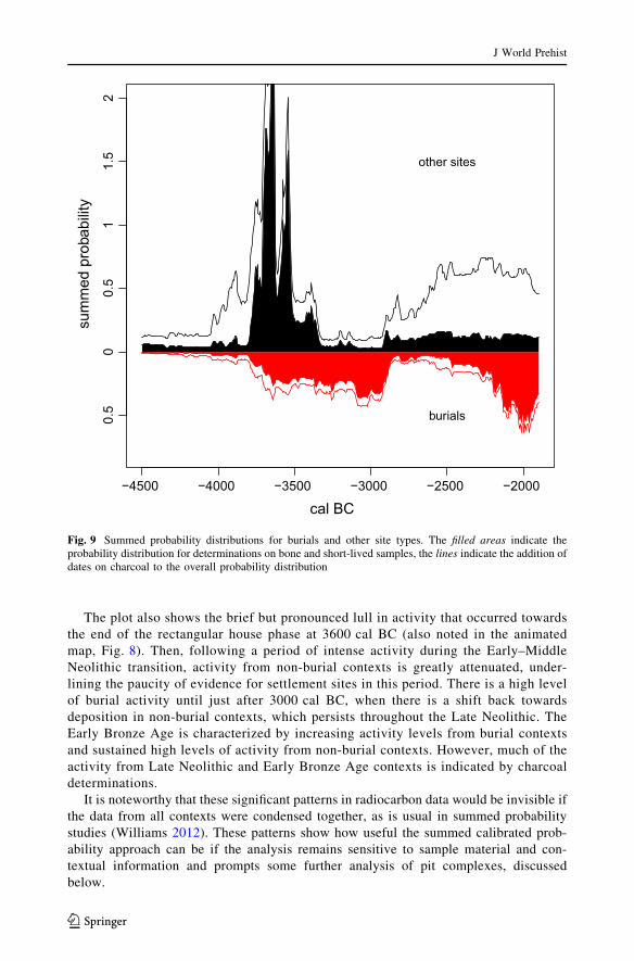
The plot also shows the brief but pronounced lull in activity that occurred towards
the end of the rectangular house phase at 3600 cal BC (also noted in the animated
map, Fig. 8). Then, following a period of intense activity during the Early–Middle
Neolithic transition, activity from non-burial contexts is greatly attenuated, under-
lining the paucity of evidence for settlement sites in this period. There is a high level
of burial activity until just after 3000 cal BC, when there is a shift back towards
deposition in non-burial contexts, which persists throughout the Late Neolithic. The
Early Bronze Age is characterized by increasing activity levels from burial contexts
and sustained high levels of activity from non-burial contexts. However, much of the
activity from Late Neolithic and Early Bronze Age contexts is indicated by charcoal
determinations.
It is noteworthy that these significant patterns in radiocarbon data would be invisible if
the data from all contexts were condensed together, as is usual in summed probability
studies (Williams 2012). These patterns show how useful the summed calibrated prob-
ability approach can be if the analysis remains sensitive to sample material and con-
textual information and prompts some further analysis of pit complexes, discussed
below.
−4500 −4000 −3500 −3000 −2500 −2000
cal BC
sum
med
pro
babi
lity
0.5
00.
51
1.5
2
other sites
burials
Fig. 9 Summed probability distributions for burials and other site types. The filled areas indicate theprobability distribution for determinations on bone and short-lived samples, the lines indicate the addition ofdates on charcoal to the overall probability distribution
J World Prehist
123
Discussion
Bias in Archaeological Datasets
Any map of the distribution of archaeological sites is inevitably strongly influenced by
both research biases and taphonomic factors. In Ireland, considerable bias results from the
fact that most excavated Neolithic sites are close to contemporary urban centres, or along
major roads and pipeline routes. Conversely, extant sites are more likely to exist in regions
remote from modern-day development and intensive agriculture. Taphonomic considera-
tions arise from the nature of the sites themselves. There is an obvious distinction between
sites constructed of stone and those of earth or timber: the latter rapidly degrade and
disappear whereas the former remain visible unless buried by peat, hillwash or subsequent
human activity. Hence there are numerous sites consisting of stone, such as megalithic
tombs and burnt mounds, still visible in the landscape. The great value of development-led
excavations in Ireland is the discovery of many previously unknown timber and earth-built
sites (Cooney 1999; Smyth 2007; Woodman 2000), albeit with a bias towards certain
locations (natural route-ways); however, they are less valuable as regards research agendas,
as the sites are chosen by the pressures of development rather than existing understanding
of the archaeological landscape. Extrapolating from the relatively small proportion of the
island’s surface that has been subject to archaeological investigation, it is likely that a very
large number of rectangular houses and pit complex settlements once existed.
Taking these considerations into account, there are correlations between the geographic
distributions of megalithic tombs and Early Neolithic settlements, particularly in northern
and northeastern coastal areas and along inland river valleys in southeastern Ireland
(Fig. 4). Northwestern Ireland, where megalithic concentrations are at their highest, has
seen less excavation but Early Neolithic sites feature prominently in the work conducted
there, including the important and potentially very early causewayed enclosure at
Magheraboy (Danaher 2007; Cooney et al. 2011). The exception to this pattern occurs in
southwestern Ireland, which was extensively settled in the Early Neolithic but is largely
devoid of megalithic sites. Therefore, despite the various biases, there are regional dif-
ferences in the distribution of settlement sites and megalithic tombs in Ireland, and this
observation parallels those made elsewhere concerning aspects of the design and siting of
the megalithic sites themselves, and the material culture of the period (Cooney 2000b).
Choices made during post-excavation work also influence the patterning of data. Pits
and spreads are simple features, and as such they offer less scope for interpretation than
houses and burials. Consequently, given finite resources, Irish archaeologists have been
somewhat reluctant to subject them to specialist analyses and radiocarbon dating, in
contrast to some other types of prehistoric site. The relative numbers of dated and undated
sites in Table 1 illustrate this pattern. At the time of writing, 71% of rectangular house sites
have been dated, compared to 34% of Neolithic pit-and-spread complexes. Rarer still are
pit-and-spread complexes where multiple dates are available from short-lived samples. An
unknown in this analysis is the degree to which pits are undated on multi-period sites,
which is almost certainly an additional source of bias. Neolithic houses are further
emphasized in the radiocarbon record (e.g. Figure 9) by research interests surrounding
dating the neolithisation of the island (Cooney et al. 2011), and efforts to understand the
agricultural practices of the period (McClatchie et al. 2014). A somewhat hidden fact is
that pit complexes are found during development-led fieldwork far more frequently than
J World Prehist
123
any other type of Neolithic site, yet they are under-studied, and important segments of the
archaeological settlement narrative may be missing as a result (cf. Smyth 2012).
There are, however, some geographical patterns in the data that seem significant despite
these problems. Central regions in Ireland have neither Early Neolithic megalithic monu-
ments nor settlements, although there are some undated sites (shown on Fig. 4), which should
be a priority for future work. Excavation bias can be ruled out, as many Early Bronze Age sites
are known from the Midlands (Fig. 7), as are numerous Middle and Late Bronze Age set-
tlements (Ginn 2011). These regions may simply have been unsettled or poorly settled in the
Early Neolithic. Whilst the palaeoecological record from these areas suggests they were not
devoid of human impact at this time, the scale and precise timing of these palaeoecological
events is difficult to ascertain (Whitehouse et al. 2014; Barratt et al. in prep.).
Turning to the Early Bronze Age pit-and-spread complexes, similar biases probably
affect their known numbers, although research is at an early stage with respect to undated
sites of this period. If the dated sites are representative of the overall number, then Early
Bronze Age pit complexes are found with an even greater frequency than Neolithic ones.
Most dated pits contained Beaker or Food Vessel pottery. In contrast, burnt mounds rarely
contain any artefactual material (O Neill 2009). Pits containing pottery may be over-
represented in the radiocarbon narrative, compared to less frequently dated aceramic
depositions, which may in turn create a bias toward certain types of site and points in time
where pottery was more commonly used.
That said, the frequency of pit complexes probably remains a more useful tool than
burials or burnt mounds to make a comparison between Early Bronze Age and Neolithic
settlement intensity. Burnt mounds are highly visible extant sites, and also tend to be
recognized quickly during development-led excavations, due to the enormous quantity of
burnt material they contain. Although Early Neolithic burnt mounds in Ireland are rela-
tively well-dated, the only well-dated burnt mound dating to the Early Bronze Age is
Cahircalla Mor, Co. Clare (Taylor 2006). In addition, one date on unburnt hazelnut shell is
available from Rathmullan 3, Co. Meath (Irish Archaeological Consultancy, personal
communication, June 2013). At face value, the lack of quality dating evidence from these
sites seems exasperating, but there are perceived costs and difficulties associated with
isolating suitable short-lived dating material (such as seeds or nutshells) from samples rich
in wood charcoal.
Conversely, cist burials have been very well dated, thanks to the nature of these deposits
and the availability of AMS radiocarbon dating (especially new AMS developments with
respect to cremated bone) (Brindley 2007; Lanting and Brindley 1998—though see Snoeck
et al. (2014) for a cautionary note). The absolute number of known cist burials is not
comparable to other sites as the numbers reflect the circumstances of discovery—many
cists were found by agricultural workers during field drainage operations (Waddell 1970).
Future work will have the opportunity to address some of these issues. A priority should
be the dating and analysis of pit-and-spread complexes, especially in midland areas where
chronological data are lacking (Fig. 4), not least to test the hypothesis that many of these
sites date to the Early–Middle Neolithic transitional period, Middle Neolithic I,
3600–3400 cal BC. Thorough dating of burnt mounds is also required if their relationship
with Early Bronze Age settlements and burials is to be understood.
Chronology and Discontinuity, or Boom and Bust?
The biases discussed above must be somehow addressed if the archaeological record can
be read as a demographic proxy or a measure of changing economic practices (e.g.
J World Prehist
123

Shennan et al. 2013; Stevens and Fuller 2012). The first problem is the radiocarbon old
wood effect. In Ireland, the precisely dated Neolithic ‘house horizon’ offers a useful
chronological datum for assessing radiocarbon dates from the whole period. The old wood
effect has confused the estimation of the start of the Neolithic in Ireland, which until
recently was thought to date to around 4000 cal BC (cf. Cooney 2000a; Cooney et al. 2011;
Whitehouse et al. 2014). Potentially misleadingly, the animated map (Fig. 8) and the
summed radiocarbon dates (Fig. 9) indicate large numbers of charcoal samples dating to
the period 4000–3700 cal BC, themselves deriving from various contexts often within or
associated with rectangular houses. Also contributing to this pattern are, for example,
charcoal dates from Carrowmore (Burenhult 1984) and Magheraboy (Danaher 2007). In
our database, 41 of the 103 dated charcoal samples from these structures have been
identified to species, but no particular tree or shrub species predominates. At rectangular
houses, approximately 50% of radiocarbon dates on charcoal are too early when compared
to Bayesian models of short-lived samples from these sites, emphasizing the problems of
radiocarbon dating charcoal. That said, workers are usually very careful to select charcoal
sapwood and short-lived elements for dating, and indeed the effect is barely noticeable for
other contexts, such as Early Bronze Age burials. It is possible that various archaeological
and ecological factors combine to accentuate the old wood problem in the context of
landnam. For example, the errant dates may reflect the old growth of the substantial
timbers which were, presumably, used in the buildings’ construction (Smyth 2006, 2007).
This phenomenon is potentially amplified by the relatively easy access to dead, seasoned
timber in primeval forest ecosystems during the early landnam phases (cf. Whitehouse
2006). Clearly much more work is needed to better understand the old wood charcoal
vectors and their effects on radiocarbon dates, which may produce a more nuanced
understanding of human–environment interactions in a time period pivotal to the fate of
both the European primeval forest and the humans who first modified it so radically.
Problems in charcoal dating aside, there are several chronological patterns of great
interest. Pits and spreads, which are manifest for many archaeological periods, are widely
recognized to be the result of settlement activity, as the pits contain material such as lithic
debris, pottery sherds, plant remains and animal bone. Consider a ‘null hypothesis’ sug-
gesting that, all things being equal, the rate of pit deposition was even throughout pre-
history. The null hypothesis predicts that the number of known pits attenuates with age,
due to the decay channel provided by erosion and diagenesis (cf. Surovell et al. 2009).
Real-world archaeological signals are, of course, infinitely more complex than this, due to
the research biases discussed above, fluctuating prehistoric population levels, and changes
in behavioural patterns that affect the deposition of such material in the ground. Never-
theless, a comparison of the data with this null hypothesis is useful, as it provides a firmer
basis for assessing how fluctuating levels of archaeological activity can be related back to
the changes in behaviour and activity.
This model can be formalized using Surovell and colleagues’ (2009) power function
with the summed radiocarbon probability distribution function for pit-and-spread sites
(Fig. 10). The results again show a highly significant rate of deposition between 3700 and
3300 cal BC and an ensuing Middle Neolithic hiatus. It must be stressed that the model
cannot, of course, control for changes in practice, such as the shift away from timber as a
building material during the Neolithic, and therefore using it as a simple analogue of
population is misleading. It remains useful, however, because it provides a formal way to
calibrate observed differences in site formation rates between periods. In this example, the
rate of pit formation is twice as high in the Early Bronze Age as in the Late Neolithic, if we
take the radiocarbon dates at face value. After applying the power function, the rate of pit
J World Prehist
123
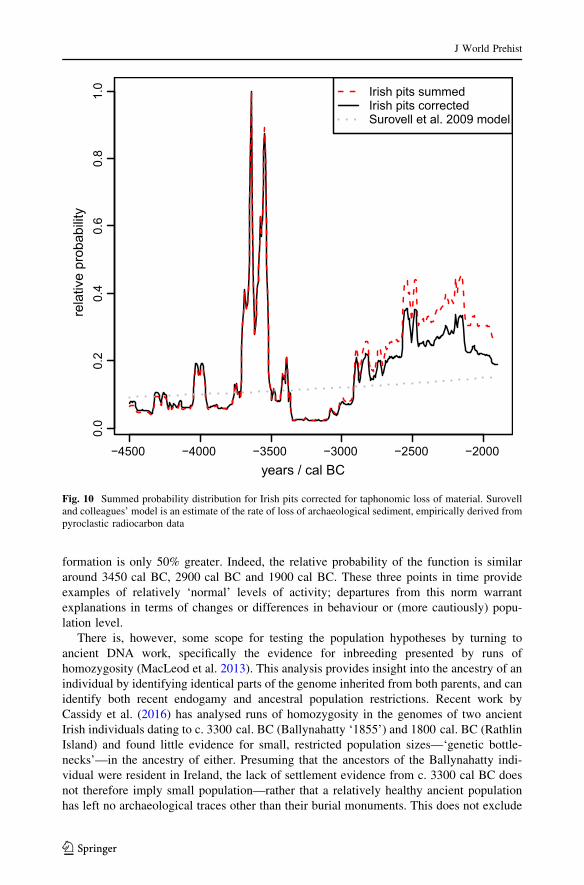
formation is only 50% greater. Indeed, the relative probability of the function is similar
around 3450 cal BC, 2900 cal BC and 1900 cal BC. These three points in time provide
examples of relatively ‘normal’ levels of activity; departures from this norm warrant
explanations in terms of changes or differences in behaviour or (more cautiously) popu-
lation level.
There is, however, some scope for testing the population hypotheses by turning to
ancient DNA work, specifically the evidence for inbreeding presented by runs of
homozygosity (MacLeod et al. 2013). This analysis provides insight into the ancestry of an
individual by identifying identical parts of the genome inherited from both parents, and can
identify both recent endogamy and ancestral population restrictions. Recent work by
Cassidy et al. (2016) has analysed runs of homozygosity in the genomes of two ancient
Irish individuals dating to c. 3300 cal. BC (Ballynahatty ‘1855’) and 1800 cal. BC (Rathlin
Island) and found little evidence for small, restricted population sizes—‘genetic bottle-
necks’—in the ancestry of either. Presuming that the ancestors of the Ballynahatty indi-
vidual were resident in Ireland, the lack of settlement evidence from c. 3300 cal BC does
not therefore imply small population—rather that a relatively healthy ancient population
has left no archaeological traces other than their burial monuments. This does not exclude
−4500 −4000 −3500 −3000 −2500 −2000
0.0
0.2
0.4
0.6
0.8
1.0
years / cal BC
rela
tive
prob
abili
tyIrish pits summedIrish pits correctedSurovell et al. 2009 model
Fig. 10 Summed probability distribution for Irish pits corrected for taphonomic loss of material. Surovelland colleagues’ model is an estimate of the rate of loss of archaeological sediment, empirically derived frompyroclastic radiocarbon data
J World Prehist
123
the possibility that population levels fluctuated during the course of the Neolithic, but it
does illustrate the problems of taking the archaeological record too literally in terms of
demographic modelling—in particular, that low activity in large samples of radiocarbon
dates really is evidence for an absence of people (pace Timpson et al. 2014). The hiatus in
pit deposition between 3300 and 3000 cal BC is nonetheless a significant finding, implying
that the archaeological coverage of the Middle Neolithic in Ireland is incomplete, despite
the rich and well-researched evidence for Middle Neolithic burial, ritual and art. Of course,
the division between settlement and burial context need not imply a similar dichotomy in
domestic and ritual behaviour (cf. Bradley 2005). Unfortunately, of those tombs that have
been excavated, few signals of domestic activity emerge. Cereal remains from Baltinglass
and Knowth date to earlier, pre-tomb occupation phases before 3400 cal BC, although the
Baltinglass tomb had an earlier construction date altogether (Schulting et al. submitted).
The points in time where archaeological signals proliferate are as problematic in terms
of population modelling as those where settlement is absent. Between 3750 and 3500 cal
BC, for example, the settlement record in Ireland points to much activity. Bayesian models
of the dates from the earlier Neolithic pit complexes have identified that their use as active
settlement sites commenced between 3710 and 3655 cal BC and ended between 3515 and
3460 cal BC (Schulting 2011; Whitehouse et al. 2014). The significance of this discovery
is reinforced by a number of recent publications that have pointed out high levels of
activity—a boom—among all domestic and burial contexts at this time, in both Ireland and
Britain, echoing a pattern in radiocarbon data from other European regions (Shennan and
Edinborough 2006; Bayliss and Whittle 2007; Whittle et al. 2011; Schulting et al. 2012;
Shennan et al. 2013).
Extrapolating from the relatively small proportion of Ireland’s surface that has been
subject to archaeological investigation, many thousands—perhaps tens of thousands—of
similar sites must lie undiscovered in the countryside. The high frequency of Early Neo-
lithic sites, contrasted with the low frequency of Late Mesolithic sites, is explained most
simply by large-scale movement of people to Ireland at the start of the Neolithic, even
without considering the fundamental changes in economy and monumentality that
occurred in tandem with this process. Analysis of ancient DNA homozygosity at Bally-
nahatty supports this view (Cassidy et al. 2016). It is possible that several such episodes of
neolithisation took place simultaneously, or somehow overlapped in such a way that the
archaeological record now contains entangled traces of different or competing, but ulti-
mately all ‘Neolithic’ groups of people. Many recurring themes in Early Neolithic Britain
and Europe are present in Ireland around 3700 cal BC—rectangular houses echoing
aspects of LBK architecture (Smyth 2010, 2014); early passage tombs expressing an
Atlantic tradition already centuries old, of likely Breton origin (Sheridan 2010); and in
northern Ireland and southern Scotland, a shared megalithic paradigm (e.g. Collins 1973;
Sheridan 2004).
At face value, the Irish radiocarbon data indicate that this initial flourishing was short
lived, and that there was a sudden ‘bust’ at 3500 cal BC (Fig. 9). However, by focussing
upon pits in the analysis (Fig. 10), we can control some of the bias caused by the high
visibility of rectangular houses in the archaeological record. Although there is still a
pronounced peak in activity ending around 3500 cal BC, which coincides with a steep
region of the calibration curve (Reimer et al. 2013), activity does not reach a minimum
until 3300 cal BC. A decline in activity, over some 200 years or 10 human generations,
would be a more realistic characterisation of the overall pattern.
The balance of information suggests the population in Early Neolithic Ireland, at least
by 3700 cal BC was large—thousands of sites were in use at the same time, spread over
J World Prehist
123
much of the island. The declining levels of activity seen between 3500 and 3300 cal BC
are difficult to explain without invoking a change in human behaviour across the island that
led to the persistence of burial in the archaeological record, but the absence of settlement.
Whether or not this was also the consequence of a reduced population size is a matter of
debate, but another perspective on this puzzle can be acquired from palaeoecological data.
Efforts to synthesize palynological investigations of the Irish landscape are at an advanced
stage, and initial results suggest that vegetation changes commensurate with reforestation
occur in tandem with the degradation of the settlement signal, beginning around 3500 cal
BC (Whitehouse et al. 2014; Barratt et al. in prep.). We can therefore begin to suggest that
the hiatus in settlement archaeology really does reflect a more general lack of human
activity, although from the genetic evidence from Ballynahatty (Cassidy et al. 2016) it is
unlikely that the population ‘collapsed’ completely.
Prominent burials and elusive settlement signals have analogues with other points of
European prehistory, such as the Corded Ware culture of Central Europe (Muller et al.
2009). Thus, far from seeing a boom and bust of prehistoric populations at this time, we
see—through contextualising the archaeological data—a record of cultural change, when
settlement and economic activities were moderated, and where burial and megalithic
monuments achieved greater prominence.
The Late Neolithic in Ireland underwent a reversal of Middle Neolithic trends, which is
similarly difficult to interpret. The sudden re-emergence of the settlement signal after
3000 cal BC implies some indication that a demographic event had occurred, or that there
was a widespread and rapid change in behaviour, especially as during this period Grooved
Ware pottery was introduced from Britain, perhaps from Orkney (Brindley 1999; Sheridan
2004). The term ‘rapid’ is of course relative—it is unknown whether the changes happened
over a century or a generation or less, as the radiocarbon record for the sites in question as
yet lacks this level of resolution. Nevertheless, in archaeological terms, the term does seem
applicable.
The pit deposition rate during the Late Neolithic and Early Bronze Age shows only
gradual increase beyond the rate that would be observed on the basis of taphonomy alone.
As with Britain, a potential mass immigration of people into Ireland in the Chalcolithic/
Early Bronze Age—bringing with them the distinctive material culture and burial practices
of that time (de Valera and O Nuallain 1982; Eogan 1991)—has been postulated. An
alternative view is that the Bronze Age transition happened as a result of increasing
contacts with Britain and Europe, and was predicated on an emerging indigenous elite
(Cooney and Grogan 1994). In the analysis presented here, because the rate of pit depo-
sition gradually increased from the Late Neolithic period onwards at a rate that only
slightly exceeds the expected increase due to taphonomy, a relatively stable and slow-
growing human population during this time is inferred. This view contrasts with the
marked increase of the archaeological visibility of burials in the centuries following
2200 cal BC. A stable population supports the opinion that large or sudden population
influxes did not occur, although it remains possible that immigration occurred at a rate that
matched emigration and/or decline in those groups whose ancestry had been established on
the island for a longer period—conquest rather than colonization perhaps. Ancient DNA
analysis of three Early Bronze Age individuals found in cist burials on Rathlin Island has
demonstrated that they had few or no Middle Neolithic ancestors; in addition, runs of
homozygosity in one of these individuals imply that there were no bottlenecks in that
ancestry either, all of which points to descent from a relatively large incoming population,
rather than an elite group of outsiders or an acculturated Neolithic progeniture (Cassidy
et al. 2016). Returning briefly to the animated map (Fig. 8), it is noteworthy that spatial and
J World Prehist
123
temporal trends in the cist burials of the period suggest that the tradition probably origi-
nated at c. 2200 cal BC in the south of the island, becoming more widespread soon
thereafter. The combined insight from archaeological and chronological data and ancient
DNA provides a fresh perspective on how cultural change in prehistory occurred. It is also
interesting that despite a boom in burial, a proliferation of other site-types such as burnt
mounds, and the diversification observed in the material culture of the period, the expected
commensurate increase in pit deposition is not observed. This finding also serves to
reinforce the need to contextualise archaeological data in summed probability analyses.
Conclusions
In 1989, the absolute chronology of Ireland’s prehistory was based on 109 radiocarbon
dates from 61 sites (O’Kelly 1989, pp. 347–352). In this study, the figure stands at 4679
dates from 1536 sites. These numbers are biased towards the Neolithic period, and the true
figures are probably much higher (e.g. Armit et al. 2013). The amount of raw archaeo-
logical data available for Ireland has substantially increased, thanks to development-led
excavation. The challenge of how to plumb these data for knowledge of the human past can
be met by the development of appropriate information systems and analytical tools, such as
the methods described in this paper and elsewhere (e.g. Surovell et al. 2009; Shennan et al.
2013; Stevens and Fuller 2012; Armit et al. 2013, Kerr and McCormick 2013). Many of
these methods are applicable to other regions and countries working through a similar
backlog of excavated sites (Bradley 2012). We have concentrated upon chronological and
geographical dimensions in this paper, although a more in-depth study of prehistoric life
could also integrate scientific approaches, such as palaeoecology, lipid analysis and other
analyses of artefactual material, stable isotope analysis and other biomolecular studies on
ancient animal and human bones. Ancient DNA analysis will be particularly useful in
testing hypotheses concerning incoming populations, as the pioneering work by Cassidy
et al. (2016) has shown. In the developer-led sector in Ireland, none of these techniques has
been extensively applied, although this situation is slowly changing with respect to
palaeoecology, stable isotopes and lipid analyses (e.g. Murphy et al. 2010; Stuijts et al.
2010; Whitehouse et al. 2014; Schulting et al. 2012; Schulting et al. 2016; Smyth and
Evershed 2015).
Despite the wealth of data, gaps and discontinuities in the archaeological record remain,
although some of these gaps are as informative as they are problematic. The Irish Neolithic
gets rather more enigmatic with time, with the Early Neolithic period being relatively
visible archaeologically, and attracting a high level of research interest. The recent dis-
covery that there is only scant evidence for recognisably ‘Neolithic’ activity in Ireland
before c. 3750 cal BC has important ramifications, and many of the ideas postulated in this
paper depend on this revised chronology. As discussed above, the old wood effect is
particularly problematic for Early Neolithic Ireland, and has confused the dating of the
earliest Neolithic in Ireland. McSparron’s (2008) demonstration of the short period of use
for rectangular houses is therefore of key importance; so too is the increasing awareness of
the episodic nature of other types of site (McSparron 2003, 2008; Cooney et al. 2011;
Schulting et al. 2012; Whitehouse et al. 2014).
Modern-day development pressures have revealed clusters of Neolithic houses around
the northern and eastern coasts—foci of settlement in the Early Neolithic. These newly-
discovered clusters coincide with funerary landscapes, and these places seem
J World Prehist
123
geographically poised to be likely points of contact with Britain—perhaps reflecting the
original points of entry for people bringing with them the new plants, animals and ways of
thinking which together constituted the Neolithic. Due to an absence of data, and perhaps a
reluctance to broach politically-loaded debates (Stout 1996), Irish archaeology has been
generally unable to meaningfully investigate the prehistoric dimensions of Ireland’s cul-
tural and demographic relationships with Britain and elsewhere. We have taken this first
step of exploring prehistoric demographics in Ireland with a view to future exploration of
both its position on the periphery of Europe, and its links to its neighbours.
The Early to Middle Neolithic transition (Middle Neolithic I) is a key time period in
both Ireland and Britain (cf. Bishop 2015; Stevens and Fuller 2012). Evidence for
settlement is frequently found, but has received less attention both from researchers and
from those working in development-led archaeology. Hence fewer sites have been dated,
and understanding of the burial traditions of the period is correspondingly hazy. The pit-
and-spread complex has emerged as an important site-type warranting much greater
research emphasis both in the field and in the laboratory. Notwithstanding these issues,
by considering the large number of sites that date to the period, Ireland supported 10–20
generations of significant numbers of people, from the manifestation of Neolithic sites
after 3750 cal BC, until 3500–3400 cal BC, when the archaeological record undergoes
significant changes.
Despite archaeological monitoring at thousands of sites in Ireland, and the numerous
prehistoric settlements that have been found as a result, secure, well-dated evidence of
Middle Neolithic II settlement during the period 3400–3000 cal BC is still to be discov-
ered. This challenges our view of overall lifestyles during the era of the developed passage
tomb. We can only speculate about the nature of settlement during this period, as there is
so little evidence, and neither pastoralism nor arable agriculture offers a model for the
economy of the period that fits the available archaeological and environmental data. There
are no directly dated cereals from Middle Neolithic II, so evidence of a cereal economy, if
there was one, is absent (McClatchie et al. 2014). Investigation of the faunal remains from
the period is also hampered by a lack of suitable material. The limited stable isotope
evidence on human remains for this period does not suggest a significant return to marine
resources (Ditchfield 2014; Schulting et al. 2012, 2016), but nor does it exclude a decline
in the use of cereals or other plants in favour of animals. Analyses of lipids absorbed in
Irish pottery indicate dairying was of considerable importance throughout the Neolithic
(Cramp et al. 2014; Smyth and Evershed 2015; but note that fewer vessels have been
analysed from the later period). This is not incompatible with a mobile or semi-nomadic
mixed pastoral economy for Middle Neolithic Ireland, although it should be noted that
there is no contrast between Early, Middle and Late periods in this regard. Pastoralism,
which seems to offer one potential explanation for the lack of cereals, has been applied to
the Middle Neolithic in Britain (Stevens and Fuller 2012; although see also Bishop
2015). However, in Ireland, the commensurate impact on the landscape is not seen in
palaeoecological records—many pollen diagrams from this period indicate a phase of
less extensive use of the landscape than would be expected under pastoralism, with
evidence for forest regeneration in many parts of Ireland, especially westerly areas
(O’Connell and Molloy 2001; Whitehouse et al. 2014). The palaeoclimatic context of this
period is also interesting, given that the end of the Holocene Thermal Maximum led to a
sustained period of lower temperatures and wetter conditions in Ireland and elsewhere in
northern Europe (Steig 1999; Roland et al. 2015).
The sudden increase in activity in the Early Neolithic was echoed, to a degree, at the
start of the Late Neolithic. New pottery forms and site types—Grooved Ware and henges—
J World Prehist
123
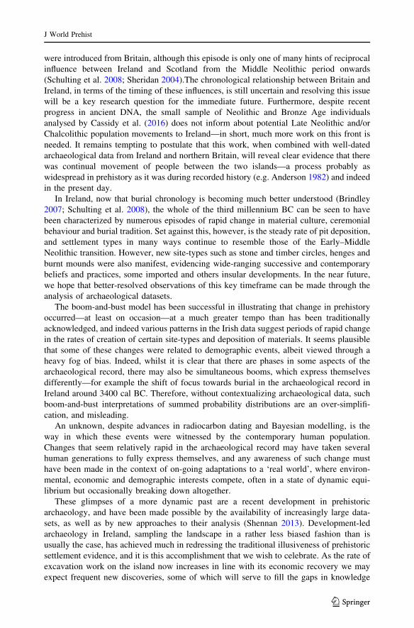
were introduced from Britain, although this episode is only one of many hints of reciprocal
influence between Ireland and Scotland from the Middle Neolithic period onwards
(Schulting et al. 2008; Sheridan 2004).The chronological relationship between Britain and
Ireland, in terms of the timing of these influences, is still uncertain and resolving this issue
will be a key research question for the immediate future. Furthermore, despite recent
progress in ancient DNA, the small sample of Neolithic and Bronze Age individuals
analysed by Cassidy et al. (2016) does not inform about potential Late Neolithic and/or
Chalcolithic population movements to Ireland—in short, much more work on this front is
needed. It remains tempting to postulate that this work, when combined with well-dated
archaeological data from Ireland and northern Britain, will reveal clear evidence that there
was continual movement of people between the two islands—a process probably as
widespread in prehistory as it was during recorded history (e.g. Anderson 1982) and indeed
in the present day.
In Ireland, now that burial chronology is becoming much better understood (Brindley
2007; Schulting et al. 2008), the whole of the third millennium BC can be seen to have
been characterized by numerous episodes of rapid change in material culture, ceremonial
behaviour and burial tradition. Set against this, however, is the steady rate of pit deposition,
and settlement types in many ways continue to resemble those of the Early–Middle
Neolithic transition. However, new site-types such as stone and timber circles, henges and
burnt mounds were also manifest, evidencing wide-ranging successive and contemporary
beliefs and practices, some imported and others insular developments. In the near future,
we hope that better-resolved observations of this key timeframe can be made through the
analysis of archaeological datasets.
The boom-and-bust model has been successful in illustrating that change in prehistory
occurred—at least on occasion—at a much greater tempo than has been traditionally
acknowledged, and indeed various patterns in the Irish data suggest periods of rapid change
in the rates of creation of certain site-types and deposition of materials. It seems plausible
that some of these changes were related to demographic events, albeit viewed through a
heavy fog of bias. Indeed, whilst it is clear that there are phases in some aspects of the
archaeological record, there may also be simultaneous booms, which express themselves
differently—for example the shift of focus towards burial in the archaeological record in
Ireland around 3400 cal BC. Therefore, without contextualizing archaeological data, such
boom-and-bust interpretations of summed probability distributions are an over-simplifi-
cation, and misleading.
An unknown, despite advances in radiocarbon dating and Bayesian modelling, is the
way in which these events were witnessed by the contemporary human population.
Changes that seem relatively rapid in the archaeological record may have taken several
human generations to fully express themselves, and any awareness of such change must
have been made in the context of on-going adaptations to a ‘real world’, where environ-
mental, economic and demographic interests compete, often in a state of dynamic equi-
librium but occasionally breaking down altogether.
These glimpses of a more dynamic past are a recent development in prehistoric
archaeology, and have been made possible by the availability of increasingly large data-
sets, as well as by new approaches to their analysis (Shennan 2013). Development-led
archaeology in Ireland, sampling the landscape in a rather less biased fashion than is
usually the case, has achieved much in redressing the traditional illusiveness of prehistoric
settlement evidence, and it is this accomplishment that we wish to celebrate. As the rate of
excavation work on the island now increases in line with its economic recovery we may
expect frequent new discoveries, some of which will serve to fill the gaps in knowledge
J World Prehist
123
that still exist at the time of writing, especially if systematic programmes of radiocarbon
dating are instigated, together with a renewed appreciation of the importance of careful
sample selection. The combination of contextual and chronological archaeological data
(e.g. Figure 9) illustrates just how dynamic past societies were, and for the first time we
can more clearly identify the points in time and space where the changes were at their
greatest. In Ireland, the points at the start and end of the Middle Neolithic period (c. 3400
and 3000–2900 cal BC) are perhaps the most intriguing of all, and these deserve some of
the research attention usually lavished upon the Early Neolithic.
Acknowledgments The work reported here was funded by the Heritage Council, Republic of Ireland,INSTAR Programme 2008–2010, for ‘Cultivating Societies: Assessing the Evidence for Agriculture inNeolithic Ireland’ (Ref: 16682, to Whitehouse, Schulting, Bogaard and McClatchie). The followingorganisations and individuals are thanked for providing access to unpublished site reports and radiocarbondata: ACS Ltd; ADS Ltd; Aegis Archaeology Ltd; AML Archaeology Ltd; Arthur ApSimon; CAF, Queen’sUniversity Belfast; Robert Chapple; CRDS Ltd; Dept of Archaeology, University College Cork; EachtraArchaeological Projects Ltd; Headland Archaeology Ltd; IAC Ltd; Margaret Gowen and Co. Ltd; NAC Ltd;National Roads Authority; School of Archaeology, University College Dublin; Stafford McLoughlinArchaeology Ltd; TVAS Ireland Ltd; Valerie J. Keeley Ltd. Discussions with various colleagues greatlyimproved the paper: in particular we thank Neil Carlin, Russell McLaughlin, Jim Mallory and Jessica Smythfor their helpful comments and ideas, as well as Alison Sheridan and a second, anonymous reviewer.
Open Access This article is distributed under the terms of the Creative Commons Attribution 4.0 Inter-national License (http://creativecommons.org/licenses/by/4.0/), which permits unrestricted use, distribution,and reproduction in any medium, provided you give appropriate credit to the original author(s) and thesource, provide a link to the Creative Commons license, and indicate if changes were made.
References
Anderson, M. O. (1982). Dalriada and the creation of the Kingdom of the Scots. In D. Whitelock, R.McKetterick, & D. Dumville (Eds.), Ireland in Early Medieval Europe: Studies in memory of KathleenHughes (pp. 106–132). Cambridge: Cambridge University Press.
Armit, I., Swindles, G., & Becker, K. (2013). From dates to demography in later prehistoric Ireland?Experimental approaches to the meta-analysis of large 14C data-sets. Journal of Archaeological Sci-ence, 40, 433–438.
Bamforth, D. B., & Grund, B. (2012). Radiocarbon calibration curves, summed probability distributions, andearly Paleoindian population trends in North America. Journal of Archaeological Science, 39,1768–1774. doi:10.1016/j.jas.2012.01.017.
Barclay, A., & Bayliss, A. (1999). Cursus monuments and the radiocarbon problem. In A. Barclay & J.Harding (Eds.), Pathways and ceremonies: The cursus monuments of Britain and Ireland (pp. 11–29).Oxford: Oxbow.
Barclay, G. J., Brophy, K., & MacGregor, G. (2002). Claish, Stirling: An early Neolithic structure in itscontext. Proceedings of the Society of Antiquaries of Scotland, 132, 65–137.
Barker, G. (1985). Prehistoric farming in Europe. Cambridge: Cambridge University Press.Bayliss, A., & O’Sullivan, M. (2013). Interpreting chronologies for the Mound of the Hostages, Tara and its
contemporary contexts in Neolithic and Bronge Age Ireland. In M. O’Sullivan, C. Scarre, & M. Doyle(Eds.), Tara—from the past to the future: Towards a new research agenda (pp. 26–104). Dublin:Wordwell.
Bayliss, A., & Whittle, A. (Eds.) (2007). Histories of the dead: Building chronologies for five southernBritish long barrows. Cambridge Archaeological Journal, 17(S1), 1–147.
Behre, K.-E. (2007). Evidence for Mesolithic agriculture in and around central Europe? Vegetation Historyand Archaeobotany, 16, 203–219.
Bergh, S., & Hensey, R. (2013). Unpicking the chronology of Carrowmore. Oxford Journal of Archaeology,32, 343–366. doi:10.1111/ojoa.12019.
Bishop, R. R. (2015). Did Late Neolithic farming fail or flourish? A Scottish perspective on the evidence forLate Neolithic arable cultivation in the British Isles. World Archaeology, 47(5), 834–855.
J World Prehist
123
Bradley, R. (2005). Ritual and domestic life in prehistoric Europe. London: Routledge.Bradley, R. (2006). Northern Scottish henge project, Aberdeenshire (Kintore parish), research excavation.
Discovery and Excavation in Scotland, 7, 19–20.Bradley, R. (2007). Houses, bodies and tombs. Proceedings of the British Academy, 144, 347–355.Bradley, R. (2012). Postscript: Recorded time. In C. Haselgrove, L. Webley, R. Bradley, & M. V. Linden
(Eds.), Development-led archaeology in Northwest Europe (pp. 173–175). Oxford: Oxbow.Brindley, A. (1999). Irish Grooved Ware. In R. Cleal & A. MacSween (Eds.), Grooved Ware in Britian and
Ireland (pp. 23–25). Oxford: Oxbow.Brindley, A. (2007). The dating of food vessels and urns in Ireland. Galway: Department of Archaeology,
National University of Ireland.Brindley, A., & Lanting, J. (1998). Radiocarbon dates for Irish trackways. Journal of Irish Archaeology, 9,
45–67.Brindley, A., Lanting, J., & Van Der Plicht, J. (2005). Radiocarbon-dated samples from the Mound of the
Hostages. In M. O’Sullivan (Ed.), Duma na nGial: The Mound of the Hostages, Tara (pp. 281–296).Dublin: Wordwell & University College Dublin.
Bryson, R. U., Bryson, R. A., & Ruter, A. (2006). A calibrated radiocarbon database of late Quaternaryvolcanic eruptions. Earth Discussions, 1, 123–124.
Burenhult, G. (1984). The archaeology of Carrowmore. Theses and Papers in North European Archaeology,14. Stockholm: Institute of Archaeology, University of Stockholm.
Burl, A. (2000). The stone circles of Britain, Ireland, and Brittany. New Haven: Yale University Press.Carlin, N. (2011a). Into the West: Placing Beakers within their Irish contexts. In A. M. Jones & G. Kirkham
(Eds.), Beyond the core: Reflections on regionality in prehistory (pp. 87–100). Oxford: Oxbow.Carlin, N. (2011b). A proper place for everything: The character and context of beaker depositional practice
in Ireland. Ph.D. dissertation, University College Dublin, Dublin.Cassidy, L. M., Martiniano, R., Murphy, E., Teasdale, M. D., Mallory, J., Hartwell, B., et al. (2016).
Neolithic and Bronze Age migration to Ireland and establishment of the insular Atlantic genome.Proceedings of the National Academy of Sciences, 113(2), 368–373. doi:10.1073/pnas.1518445113.
Chapple, R. M. (2008). The absolute dating of archaeological excavations in Ulster carried out by NorthernArchaeological Consultancy Ltd, 1998–2007. Ulster Journal of Archaeology, 67, 153–181.
Chaffey G., Barclay, A., & Pelling, R. (2016). Horton, Kingsmead Quarry (Vol. 1). Wessex Archaeology.Childe, V. G. (1925). The dawn of European civilization. London: Routledge & Kegan Paul.Collins, A. E. P. (1973). A re-examination of the Clyde-Carlingford tombs. In G. Daniel & P. Kjærum
(Eds.), Megalithic graves and ritual (pp. 93–103). Copenhagen: Jutland Archaeological Society.Collins, T., & Coyne, F. (2003). Fire and water: Early Mesolithic cremations at Castleconnell, Co., Lim-
erick. Archaeology Ireland, 17(2), 24–27.Contreras, D. A., & Meadows, J. (2014). Summed radiocarbon calibrations as a population proxy: A critical
evaluation using a realistic simulation approach. Journal of Archaeological Science. doi:10.1016/j.jas.2014.05.030.
Cooney, G. (1983). Megalithic tombs in their environmental setting: A settlement perspective. In T. Reeves-Smith & F. Hamond (Eds.), Landscape archaeology in Ireland, British Archaeological Reports 116(pp. 179–194). Oxford: BAR.
Cooney, G. (1999). A boom in Neolithic houses. Archaeology Ireland, 13, 13–16.Cooney, G. (2000a). Landscapes of Neolithic Ireland. London: Routledge.Cooney, G. (2000b). Recognising regionality in the Irish Neolithic. In A. Desmond, G. Johnson, M.
McCarthy, J. Sheehan, & E. Shee Twohig (Eds.), New agendas in Irish Prehistory: Papers in com-memoration of Liz Anderson (pp. 49–65). Bray: Wordwell.
Cooney, G., Bayliss, A., Healy, F., Whittle, A., Danaher, E., Cagney, L., et al. (2011). Ireland. In A. Whittle,F. Healy, & A. Bayliss (Eds.), Gathering time: Dating the early Neolithic enclosures of southernBritain and Ireland (pp. 562–681). Oxford: Oxbow.
Cooney, G., & Grogan, E. (1994). Irish Prehistory: A social perspective. Dublin: Wordwell.Cooney, G., & Mandal, S. (1998). The Irish Stone Axe Project Monograph I. Bray: Wordwell.Cramp, L. J. E., Jones, J., Sheridan, A., Smyth, J., Whelton, H., Mulville, J., et al. (2014). Immediate
replacement of fishing with dairying by the earliest farmers of the northeast Atlantic archipelagos.Proceedings of the Royal Society B: Biological Sciences. doi:10.1098/rspb.2013.2372.
Crombe, P., & Robinson, E. (2014). 14C dates as demographic proxies in Neolithisation models of north-western Europe: A critical assessment using Belgium and northeast France as a case-study. Journal ofArchaeological Science. doi:10.1016/j.jas.2014.02.001.
Danaher, E. (2007). Monumental beginnings: The archaeology of the N4 Sligo inner relief road. NRAScheme Monographs 1. Dublin: National Roads Authority.
J World Prehist
123
de Valera, R., & O Nuallain, S. (1982). Survey of the megalithic tombs of Ireland, Volume IV: CountiesCork, Kerry, Limerick and Tipperary. Dublin: Stationery Office.
Ditchfield, P. (2014). Stable isotope analysis. In A. Lynch (Ed.), Poulnabrone, Co. Clare: Excavation of anEarly Neolithic portal tomb. Archaeological Monograph Series (pp. 86–92). Dublin: Department ofArts, Heritage and the Gaeltacht.
Doody, M. (2008). Final report: Lough Feedora, Co. Tipperary. N8 Cashel to Mitchelstown RoadImprovement Scheme. Unpublished excavation report, Margaret Gowen & Co.
Dowd, M., & Carden, R. F. (2016). First evidence of a Late Upper Palaeolithic human presence in Ireland.Quaternary Science Reviews, 139, 158–163. doi:10.1016/j.quascirev.2016.02.029.
Dunne, C. M. (2008). Appendix 3: Report on the ceramic assemblage from Liscolman, County Antrim. InGilmore, S. (Ed.), Straidbilly, Liscolman, County Antrim. Unpublished excavation report, NorthernArchaeological Consultancy.
Eogan, G. (1991). Prehistoric and early historic cultural changes at Brugh na Boinne. Proceedings of theRoyal Irish Academy, 91C, 105–132.
Fairweather, A. D., & Ralston, I. B. M. (1993). The Neolithic timber hall at Balbridie, Grampian Region,Scotland: The building, the date, the plant macrofossils. Antiquity, 67, 313–323.
Feeser, I., & Furholt, M. (2013). Ritual and economic activity during the Neolithic in Schleswig-Holstein,northern Germany: An approach to combine archaeological and palynological evidence. Journal ofArchaeological Science, 51, 126–134. doi:10.1016/j.jas.2013.01.021.
Gilmore, S. (2008). Straidbilly, Liscolman, County Antrim. Unpublished excavation report, NorthernArchaeological Consultancy.
Ginn, V. (2011). The fusion of settlement and identity in dispersed and nucleated settlements in Bronze AgeIreland. Journal of Irish Archaeology, 20, 27–44.
Grogan, E. (1996). Neolithic houses in Ireland. In T. Darvill & J. Thomas (Eds.), Neolithic houses innorthwest Europe and beyond. Monograph Series 57 (pp. 41–60). Oxford: Oxbow.
Gronenborn, D. (2003). Migration, acculturation and culture change in western temperate Eurasia,6500–5000 cal BC. Documenta Praehistorica, 30, 79–91.
Hawkes, A. (2014). Fulachtaı fia and Bronze Age cooking in Ireland: Reappraising the evidence. Pro-ceedings of the Royal Irish Academy, 115C, 47–77.
Jones, G., & Legge, A. J. (2008). Evaluating the role of cereal cultivation in the Neolithic: Charred plantremains from Hambledon Hill. In R. Mercer & F. Healy (Eds.), Hambledon Hill, Dorset, England:Excavation and survey of a Neolithic monument complex and its surrounding landscape (Vol. 2,pp. 469–476). Swindon: English Heritage Archaeological Reports.
Kelly, R. L., Surovell, T. A., Shuman, B. N., & Smith, G. M. (2013). A continuous climatic impact onHolocene human population in the Rocky Mountains. Proceedings of the National Academy of Sci-ences, 110(2), 443–447. doi:10.1073/pnas.1201341110.
Kirby, M. (2011) Lockerbie Academy: Neolithic and Early Historic timber halls, a Bronze Age cemetery, anundated enclosure and a post-medieval corn-drying kiln in south-west Scotland, Scottish Archaeo-logical Internet Reports 46. Edinburgh: Society of Antiquaries of Scotland.
Kerr, T., & McCormick, F. (2013). Statistics sunspots and settlement: Influences on sum of probabilitycurves. Journal of Archaeological Science, 41, 493–501. doi:10.1016/j.jas.2013.09.002.
Kytmannow, T. (2008). Portal tombs in the landscape: The chronology, morphology and landscape settingof the portal tombs of Ireland, Wales and Cornwall, British Archaeological Reports (British Series)455. Oxford: Archaeopress.
Lanting, J. N., & Brindley, A. L. (1998). Dating cremated bone: The dawn of a new era. Journal of IrishArchaeology, 9, 1–7.
Lynch, A. (Ed.). (2014). Poulnabrone: An Early Neolithic portal tomb in Ireland, Archaeological Mono-graph Series no. 9. Dublin: Department of Arts, Heritage and the Gaeltacht.
MacLeod, I. M., Larkin, D. M., Lewin, H. A., Hayes, B. J., & Goddard, M. E. (2013). Inferring demographyfrom runs of homozygosity in whole-genome sequence, with correction for sequence errors. MolecularBiology and Evolution, 30(9), 2209–2223.
Mallory, J. P., Nelis, E., & Hartwell, B. (2011). Excavations at Donegore Hill, Co. Antrim. Bray: Wordwell.McClatchie, M., Bogaard, A., Colledge, S., Whitehouse, N. J., Schulting, R. J., Barratt, P., & McLaughlin,
T. R. (2014). Neolithic farming in northwestern Europe: Archaeobotanical evidence from Ireland.Journal of Archaeological Science, 51, 206–215.
McSparron, C. (2003). The excavation of a Neolithic house in Enagh townland, Co. Derry. In I. Armit, E.Murphy, E. Nelis, & D. Simpson (Eds.), Neolithic settlement in Ireland and western Britain (pp.172–175). Oxford: Oxbow.
McSparron, C. (2008). Have you no homes to go to? Archaeology Ireland, 22, 18–21.
J World Prehist
123
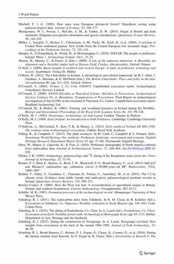
Mitchell, F. J. G. (2005). How open were European primaeval forests? Hypothesis testing usingpalaeoecological data. Journal of Ecology, 93, 168–177.
Montgomery, W. I., Provan, J., McCabe, A. M., & Yalden, D. W. (2014). Origin of British and Irishmammals: Disparate post-glacial colonisation and species introductions. Quaternary Science Reviews,98, 144–165.
Muller, J., Seregely, T., Becker, C., Christensen, A.-M., Fuchs, M., Kroll, H., et al. (2009). A revision ofCorded Ware settlement pattern: New results from the Central European low mountain range. Pro-ceedings of the Prehistoric Society, 75, 125–142.
Murphy, E., O Donnabhain, B., Welsh, H., & McGranaghan, C. (2010). INSTAR: The people of prehistoricIreland. Phase 1. Archaeology Ireland, 24(1), 23–25.
Murray, H., Murray, C., & Fraser, S. (Eds.). (2009). A tale of the unknown unknowns: A Mesolithic pitalignment and a Neolithic timber hall at Warren Field, Crathes, Aberdeenshire. Oxford: Oxbow.
O Neill, J. (2009). Burnt mounds in northern and western Europe: A study of prehistoric technology andsociety. Saarbruken: Verlag Dr. Muller.
O’Brien, W. (2012). The Chalcolithic in Ireland: A chronological and cultural framework. In M. J. Allen, J.Gardiner, A. Sheridan, & D. McOmish (Eds.), The British Chalcolithic: Place and polity in the later3rd millennium BC (pp. 211–225). Oxford: Oxbow.
O’Connell, A. (2003). Fermoy 2, Co Cork, 03E0979. Unpublished excavation report. ArchaeologicalConsultancy Services Limited.
O’Connell, T. (2009). N9/N10 Kilcullen to Waterford Scheme: Kilcullen to Powerstown. ArchaeologicalServices Contract No. 4—Resolution, Prumplestown to Powerstown. Final Report on archaeologicalinvestigations at Site E2589, in the townland of Tinryland, Co. Carlow. Unpublished excavation report:Headland Archaeology Ltd.
O’Connell, M., & Molloy, K. (2001). Farming and woodland dynamics in Ireland during the Neolithic.Biology and Environment (Proceedings of the Royal Irish Academy Series B), 101, 99–128.
O’Kelly, M. J. (1982). Newgrange: Archaeology, art and legend. London: Thames & Hudson.O’Kelly, M. J. (1989). Early Ireland: An introduction to Irish Prehistory. Cambridge: Cambridge University
Press.O’Sullivan, A., McCormick, F., Kerr, T. R., & Harney, L. (2014). Early medieval Ireland AD 400–1100:
The evidence from archaeological excavations. Dublin: Royal Irish Academy.Pelling, R., & Campbell, C. (2013). The plant resources. In M. Canti, C. Campbell & S. Greaney (Eds),
Stonehenge World Heritage Site synthesis: Prehistoric landscape, environment and economy. EnglishHeritage Research Department Report Series 45 (pp. 37–60). Portsmouth: English Heritage.
Peros, M., Munoz, S., Gajewski, K., & Viau, A. (2010). Prehistoric demography of North America inferredfrom radiocarbon data. Journal of Archaeological Science, 37, 656–664. doi:10.1016/j.jas.2009.10.029.
Pilcher, J. R. (1969). Archaeology, palaeoecology and 14C dating of the Beaghmore stone circle site. UlsterJournal of Archaeology, 32, 73–91.
Reimer, P. J., Bard, E., Bayliss, A., Beck, J. W., Blackwell, P. G., Bronk Ramsey, C., et al. (2013). IntCal13and Marine13 radiocarbon age calibration curves 0–50,000 years cal BP. Radiocarbon, 55(4),1869–1887.
Roland, T., Daley, T., Caseldine, C., Charman, D., Turney, C., Amesbury, M., et al. (2015). The 5.2 kaclimate event: Evidence from stable isotope and multi-proxy palaeoecological peatland records inIreland. Quaternary Science Reviews, 124, 209–223.
Rowley-Conwy, P. (2004). How the West was lost: A reconsideration of agricultural origins in Britain,Ireland, and southern Scandinavia. Current Anthropology, 45(supplement), S83–S113.
Schiffer, M. B. (1987). Formation processes of the archaeological record. Albuquerque: University of NewMexico Press.
Schulting, R. J. (2011). The radiocarbon dates from Tullahedy. In R. M. Cleary & H. Kelleher (Eds.),Excavations at Tullahedy, Co. Tipperary: Neolithic settlement in North Munster (pp. 145–161). Cork:Collins Press.
Schulting, R. J. (2014). The dating of Poulnabrone, Co. Clare. In A. Lynch (Ed.), Poulnabrone, Co. Clare:Excavation of an Early Neolithic portal tomb, Archaeological Monograph Series (pp. 93–113). Dublin:Department of Arts, Heritage and the Gaeltacht.
Schulting, R. J. (2015). Dating the construction of Newgrange. In A. Lynch, Newgrange revisited: Newinsights from excavations at the back of the mound 1984–1985. Journal of Irish Archaeology, 23,46–50.
Schulting, R. J., Bronk Ramsey, C., Reimer, P. J., Eogan, G., Cleary, K., Cooney, G., et al. (2016). Datingthe human remains from Knowth. In G. Eogan & K. Cleary (Eds.), Excavations at Knowth 6: The
J World Prehist
123
archaeology of the large passage tomb at Knowth, Co. Meath. Dublin: Royal Irish Academy.(forthcoming).
Schulting, R. J., Murphy, E., Jones, C., & Warren, G. (2012). New dates from the north and a proposedchronology for Irish court tombs. Proceedings of the Royal Irish Academy, 112C, 1–60.
Schulting, R. J., & Reimer, P. J. (2008). Appendix 7: AMS 14C dating of cereal remains (in R. M. Chapple,The excavation of Early Neolithic and Early Bronze Age sites at Oakgrove, Gransha, County Lon-donderry). Ulster Journal of Archaeology, 67, 53–55.
Schulting, R. J., Sheridan, A., Clarke, S., & Bronk Ramsey, C. (2008). Largantea and the dating of Irishwedge tombs. Journal of Irish Archaeology, 17, 1–17.
Shennan, S. (2013). Demographic continuities and discontinuities in Neolithic Europe: Evidence, methodsand implications. Journal of Archaeological Method and Theory, 20, 300–311.
Shennan, S., Downey, S. S., Timpson, A., Edinborough, K., Colledge, S., Kerig, T., et al. (2013). Regionalpopulation collapse followed initial agriculture booms in mid-Holocene Europe. Nature Communi-cations, 4, 2486. doi:10.1038/ncomms3486.
Shennan, S., & Edinborough, K. (2006). Prehistoric population history: From the Late Glacial to the LateNeolithic in central and northern Europe. Journal of Archaeological Science, 34, 1139–1145.
Sheridan, J. A. (2004). Neolithic connections along and across the Irish Sea. In V. Cummings & C. Fowler(Eds.), The Neolithic of the Irish Sea: Materiality and traditions of practice (pp. 9–21). Oxford:Oxbow.
Sheridan, J. A. (2010). The Neolithization of Britain and Ireland: The ‘big picture’. In B. Finlayson & G.Warren (Eds.), Landscapes in transition (pp. 89–105). Oxford: Oxbow.
Sheridan, J. A., & Petrequin, P. (2014). Constructing a narrative for the Neolithic of Britain and Ireland: Theuse of ‘hard science’ and archaeological reasoning. In A. Whittle & P. Bickle (Eds.), Early farmers:The view from archaeology and science, Proceedings of the British Academy 198 (pp. 369–390).Oxford: Oxford University Press/The British Academy.
Smyth, J. (2006). The role of the house in Early Neolithic Ireland. European Journal of Archaeology, 9,229–257.
Smyth, J. (2007). Neolithic settlement in Ireland: New theories and approaches. Unpublished Ph.D. dis-sertation, University College Dublin, Dublin.
Smyth, J. (2010). The house and group identity in the Irish Neolithic. Proceedings of the Royal IrishAcademy, C111, 1–31.
Smyth, J. (2012). Breaking ground: An overview of pits and pit-digging in Neolithic Ireland. In H.Anderson-Whymark & J. Thomas (Eds.), Regional perspectives on Neolithic pit deposition: Beyondthe mundane (pp. 13–29). Oxford: Oxbow.
Smyth, J. (2014). Settlement in the Irish Neolithic: New discoveries at the edge of Europe. PrehistoricSociety Research Paper 6. Oxford: Oxbow.
Smyth, J., & Evershed, R. P. (2015). The molecules of meals: New insight into Neolithic foodways.Proceedings of the Royal Irish Academy, 115C, 27–46. doi:10.3318/priac.2015.115.07.
Snoeck, C., Brock, F., & Schulting, R. J. (2014). Carbon exchanges between bone apatite and fuels duringcremation: Impact on radiocarbon dates. Radiocarbon, 56(2), 591–602.
Steig, E. J. (1999). Mid-Holocene climate change. Science, 286, 1485–1487.Stevens, C. J., & Fuller, D. Q. (2012). Did Neolithic farming fail? The case for a Bronze Age agricultural
revolution in British Isles. Antiquity, 86, 707–722.Stout, M. (1996). Emyr Estyn Evans and Northern Ireland: The archaeology and geography of a new state.
In J. A. Atkinson, I. Banks, & J. O’Sullivan (Eds.), Nationalism and archaeology (pp. 111–127).Glasgow: Cruithne Press.
Stuijts, I., O’Donnell, L., Corns, L. A., McAuley, J., Shaw, R., Bunce, A., & O’Sullivan, K. (2010).WODAN: A database for wood and charcoal identifications. Archaeology Ireland, 24(4), 40–42.
Surovell, T. A., Finley, J. B., Smith, G. M., Brantingham, P. J., & Kelly, R. (2009). Correcting temporalfrequency distributions for taphonomic bias. Journal of Archaeological Science, 36, 1715–1724.
Taylor, K. (2006). N18 Ennis Bypass and N85 Western Relief Road, Site AR127, Cahircalla More, Co.Clare: A final archaeological excavation report for Clare County Council Licence No: 04E0028.Unpublished excavation report. Technical report, TVAS Ireland.
Thomas, J. (2004). Current debates on the Mesolithic—Neolithic transition in Britain and Ireland. Docu-menta Praehistorica, 31, 113–130.
Timpson, A., Colledge, S., Crema, E., Edinborough, K., Kerig, T., Manning, K., et al. (2014). Recon-structing regional population fluctuations in the European Neolithic using radiocarbon dates: A newcase-study using an improved method. Journal of Archaeological Science, 52, 549–557.
Waddell, J. (1970). Irish Bronze Age cists: A survey. Journal of the Royal Society of Antiquaries of Ireland,100, 91–139.
J World Prehist
123
Waddell, J. (1990). The Bronze Age burials of Ireland. Galway: Galway University Press.Warren, G. (2008). Fieldwork in Belderrig, 2004–2008. Unpublished excavation report, University College
Dublin.Warren, G., Davis, S., McClatchie, M., & Sands, R. (2014). The potential role of humans in structuring the
wooded landscapes of Mesolithic Ireland: A review of data and discussion of approaches. VegetationHistory and Archaeobotany, 23(5), 629–646. doi:10.1007/s00334-013-0417-z.
Warren, G., Little, A., & Stanley, M. (2009). A late Mesolithic lithic scatter and radiocarbon dates fromCorralanna, Co., Westmeath. Proceedings of the Royal Irish Academy, 109C, 1–35.
Whitehouse, N. J. (2006). The Holocene British and Irish ancient woodland fossil beetle fauna: Implicationsfor forest history, biodiversity and faunal colonisation. Quaternary Science Reviews, 25, 1755–1789.
Whitehouse, N. J., Schulting, R. J., McClatchie, M., Barratt, P., McLaughlin, T. R., Bogaard, A., et al.(2014). Neolithic agriculture on the European western frontier: The boom and bust of early farming inIreland. Journal of Archaeological Science, 51, 181–205.
Whittle, A. (1996). Neolithic Europe: A survey (2nd ed.). Cambridge: Cambridge University Press.Whittle, A., Healy, F., & Bayliss, A. (Eds.). (2011). Gathering time: Dating the Early Neolithic enclosures
of southern Britain and Ireland. Oxford: Oxbow.Wicks, K., & Mithen, S. (2014). The impact of the abrupt 8.2 ka cold event on the Mesolithic population of
western Scotland: A Bayesian chronological analysis using ‘activity events’ as a population proxy.Journal of Archaeological Science, 45, 240–269.
Wicks, K., Pirie, A., & Mithen, S. J. (2014). Settlement patterns in the late Mesolithic of western Scotland:The implications of Bayesian analysis of radiocarbon dates and inter-site technological comparisons.Journal of Archaeological Science, 41, 406–422.
Williams, A. N. (2012). The use of summed radiocarbon probability distributions in archaeology: A reviewof methods. Journal of Archaeological Science, 39, 578–589.
Woodbridge, J., Fyfe, R. M., Roberts, N., Downey, S., Edinborough, K., & Shennan, S. (2014). The impactof the Neolithic agricultural transition in Britain: A comparison of pollen-based land-cover andarchaeological 14C date-inferred population change. Journal of Archaeological Science, 51, 216–224.
Woodman, P. C. (1985). Prehistoric settlement and environment. In K. J. Edwards & W. Warren (Eds.), TheQuaternary history of Ireland (pp. 251–278). London: Academic Press.
Woodman, P. C. (1992). Filling in the spaces in Irish prehistory. Antiquity, 66, 295–314.Woodman, P. C. (2000). Hammers and shoeboxes: New agendas for Irish Prehistory. In A. Desmond, G.
Johnson, M. McCarthy, J. Sheehan, & E. Shee Twohig (Eds.), New agendas in Irish Prehistory: Papersin commemoration of Liz Anderson (pp. 1–14). Bray: Wordwell.
Woodman, P. C. (2015). Ireland’s first settlers: Time and the Mesolithic. Oxford: Oxbow.Woodman, P. C., Anderson, E., & Finlay, N. (1999). Excavations at Ferriter’s Cove, 1983–1995: Last
foragers, first farmers in the Dingle Peninsula. Bray: Wordwell.Woodman, P. C., McCarthy, M., & Monaghan, N. (1997). The Irish Quaternary Faunas Project. Quaternary
Science Reviews, 16, 129–159.
J World Prehist
123