Embed Size (px)
Citation preview
Calcasieu
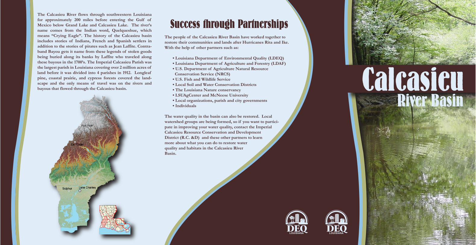
The Calcasieu River flows through southwestern Louisiana for approximately 200 miles before entering the Gulf of Mexico below Grand Lake and Calcasieu Lake. The river’s name comes from the Indian word, Quelqueshue, which means “Crying Eagle”. The history of the Calcasieu basin includes stories of Indians, French and Spanish settlers in addition to the stories of pirates such as Jean Laffite. Contra-band Bayou gets it name from these legends of stolen goods being buried along its banks by Laffite who traveled along these bayous in the 1700’s. The Imperial Calcasieu Parish was the largest parish in Louisiana covering over 2 million acres of land before it was divided into 4 parishes in 1912. Longleaf pine, coastal prairie, and cypress forests covered the land-scape and the only means of travel was on the rivers and bayous that flowed through the Calcasieu basin.
Success through PartnershipsThe people of the Calcasieu River Basin have worked together to restore their communities and lands after Hurricanes Rita and Ike. With the help of other partners such as:
• Louisiana Department of Environmental Quality (LDEQ) • Louisiana Department of Agriculture and Forestry (LDAF)• U.S. Department of Agriculture Natural Resource Conservation Service (NRCS) • U.S. Fish and Wildlife Service• Local Soil and Water Conservation Districts• The Louisiana Nature conservancy• LSUAgCenter and McNeese University• Local organizations, parish and city governments• Individuals
The water quality in the basin can also be restored. Local watershed groups are being formed, so if you want to partici-pate in improving your water quality, contact the Imperial Calcasieu Resource Conservation and Development District (R.C. &D) and these other partners to learn more about what you can do to restore water quality and habitats in the Calcasieu River Basin.
River Basin
The Mermentau River Basin lies in southwestern Louisiana and encompasses the prairie region of the state. Rice, craw�sh, soybean and sugarcane �elds comprise the current landscape of the Mermentau Basin. The word “Mermentau” originated from the name Nementou of an Attaka-pas Indian Chief, who lived in a village on the river in the 1700’s. When the French settled in the area, they altered the name to Mermentau since the word “mer” meant open sea (in French). The major bayous that �ow through the Mermentau basin include: Bayou des Cannes, Bayou Nezpique, Bayou Plaquemine Brule, Bayou Queue de Tortue and Bayou Lacassine. The Mermentau basin has a rich cultural history of the French and Cajun people, many of whom have lived along these bayous for more than 250 years. The native prairie ecosystem was also as diverse as its people with a wide range of prairie wild�owers, wildlife and forests. Most of the bayous have been highly altered for navigation and �ood control during 1915-30’s. These alterations combined with land-use changes from native prairie to agricultural production have led to water quality problems and loss of habitat for many native species of plants and animals.
Water Quality ConcernsToday, the Calcasieu River Basin consists of agricultural fields, pine forests and the city of Lake Charles, which is the largest city in southwest-ern Louisiana. The Calcasieu River flows through Lake Charles, providing a means of commerce and transportation to the Gulf of Mexico. Many of
the bayous in the northern portion of the basin have good water quality, but the headwaters of the Calcasieu River are not meeting either
the swimming or the fish and wildlife propagation uses. As the river flows from Marsh Bayou to the saltwater barrier, the
water quality improves, but does receive sediments from agriculture fields. This segment of the Calcasieu River
is scenic and is classified as an outstanding natural resource. As the Calcasieu River flows south from the saltwater barrier to the Calcasieu Ship Channel, it picks up industrial discharges. South of Moss Lake to the Gulf of Mexico, the Calcasieu River fully meets all of its recreational uses. Bayous in the eastern portion of the Calcasieu basin receive nonpoint source pollutants from agricultural fields such as rice, sugarcane and crawfish ponds, whereas the bayous in the western portion of the basin receive pollutants from pastures and forested areas.
Restoring the Water QualityThe water quality in the Calcasieu basin can be restored through implemen-tation of best management practices (BMPs) on agricultural, forestry and urban lands. Some examples of the types of BMPs that need to be utilized include:
• AGRICULTURE – sediment and erosion control through conservation tillage, residue management on croplands and water management prac-tices on rice and crawfish ponds, pesticide and fertilizer management, protection of streamside management zones and riparian vegetation;
• SEPTIC SYSTEMS – maintenance of existing home sewage systems and repair or replacement of old and failing systems;
• URBAN STORM WATER – smart growth and green infrastructure such as rain gardens, vegetative swales, natural and constructed wetlands, urban forests, porous pavement, protection and restoration of urban streams;
• ROAD AND HIGHWAY CONSTRUCTION – sediment and erosion control, protection of water bodies at stream crossings and bridges, protection of stream banks, riparian vegetation and wetlands;
• HYDROMODIFICATION – protection of stream banks, wetlands and riparian vegetation and natural channel design.
Protecting and Restoring Native Habitats
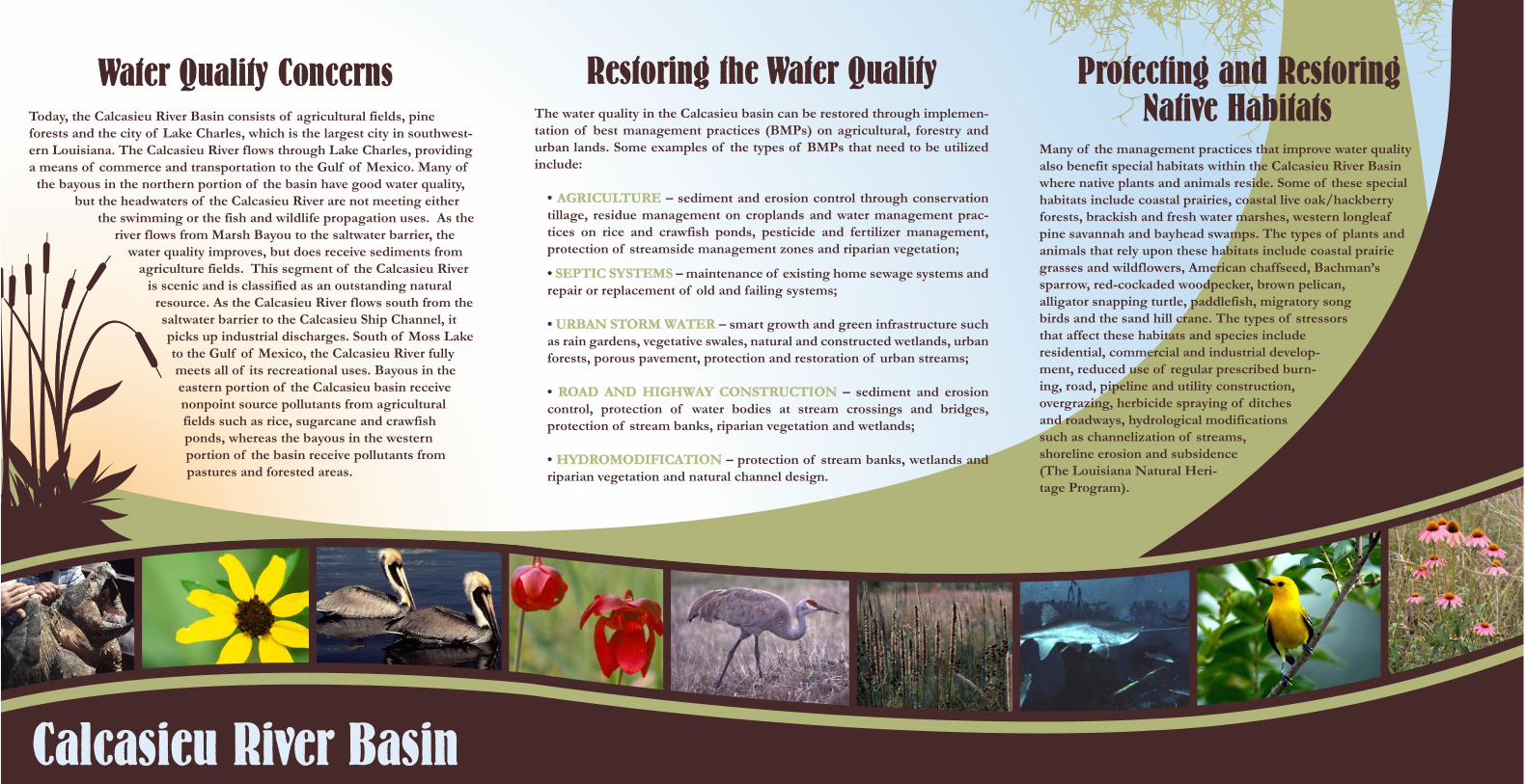
Many of the management practices that improve water quality also benefit special habitats within the Calcasieu River Basin where native plants and animals reside. Some of these special habitats include coastal prairies, coastal live oak/hackberry forests, brackish and fresh water marshes, western longleaf pine savannah and bayhead swamps. The types of plants and animals that rely upon these habitats include coastal prairie grasses and wildflowers, American chaffseed, Bachman’s sparrow, red-cockaded woodpecker, brown pelican, alligator snapping turtle, paddlefish, migratory song birds and the sand hill crane. The types of stressors that affect these habitats and species include residential, commercial and industrial develop-ment, reduced use of regular prescribed burn-ing, road, pipeline and utility construction, overgrazing, herbicide spraying of ditches and roadways, hydrological modifications such as channelization of streams, shoreline erosion and subsidence (The Louisiana Natural Heri-tage Program).
Calcasieu River Basin


![[Type text] Geographic Response Plan Calcasieu Parish](https://img.dokumen.tips/doc/110x75/6247d3b4c87ff269e163e5e8/type-text-geographic-response-plan-calcasieu-parish.jpg)

