Embed Size (px)
Citation preview
Total Petroleum Systems of the Pelagian Province, Tunisia, Libya, Italy, and Malta—The Bou Dabbous– Tertiary and Jurassic-Cretaceous Composite
By T.R. Klett
U.S. Geological Survey Bulletin 2202-D
U.S. Department of the Interior U.S. Geological Survey
U.S. Department of the Interior Gale A. Norton, Secretary
U.S. Geological Survey Charles G. Groat, Director
Version 1.0, 2001
This publication is only available online at: http://geology.cr.usgs.gov/pub/bulletins/b2202-d/
Any use of trade, product, or firm names in this publicationis for descriptive purposes only anddoes not imply endorsement by the U.S. Government
Manuscript approved for publication August 3, 2001 Published in the Central Region, Denver, Colorado Graphics by the author and Gayle M. DumonceauxPhotocomposition by Gayle M. DumonceauxEdited by L.M. Carter
Contents Foreword ....................................................................................................................................... 1Abstract ......................................................................................................................................... 2Introduction .................................................................................................................................. 3Acknowledgments........................................................................................................................ 3Province Geology.......................................................................................................................... 3
Tectonic History ................................................................................................................. 5Stratigraphy ........................................................................................................................ 11
Regional Exploration Activity ...................................................................................................... 13The Bou Dabbous–Tertiary Total Petroleum System (204801).............................................. 14
Source Rocks...................................................................................................................... 15Overburden Rocks ............................................................................................................. 15Reservoir Rocks ................................................................................................................. 15Seal Rocks........................................................................................................................... 15Trap Types in Oil and Gas Fields ..................................................................................... 15Assessment of Undiscovered Petroleum....................................................................... 18
The Jurassic-Cretaceous Composite Total Petroleum System (204802)............................. 20Source Rocks...................................................................................................................... 20Overburden Rocks ............................................................................................................. 24Reservoir Rocks ................................................................................................................. 24Seal Rocks........................................................................................................................... 24Trap Types in Oil and Gas Fields ..................................................................................... 24Assessment of Undiscovered Petroleum....................................................................... 24
Summary ........................................................................................................................................ 26References Cited ......................................................................................................................... 26Appendices.................................................................................................................................... 28
1. Exploration-activity and discovery-history plots for the Bou Dabbous–Tertiary Structural/Stratigraphic Assessment Unit (20480101)................................... 30
2. Exploration-activity and discovery-history plots for the Jurassic-CretaceousStructural/Stratigraphic Assessment Unit (20480201).................................................. 88
Figures
1–4. Maps showing: 1. Central Mediterranean Sea, showing USGS-defined Pelagian Province
(2048), major geologic structures, and location of cross sections...................... 42. Areal extent of Bou Dabbous–Tertiary Total Petroleum System (204801)
and coinciding Bou Dabbous–Tertiary Structural/Stratigraphic Assessment Unit (20480101) in the Pelagian Province.......................................... 5
3. Areal extent of Jurassic-Cretaceous Composite Total Petroleum System (204802) and coinciding Jurassic-Cretaceous Structural/Stratigraphic Assessment Unit (20480201) in the Pelagian Province.......................................... 6
4. Sketch maps showing distribution of proven Mesozoic and Cenozoic sourcerocks in Tunisia............................................................................................................. 7
III
5. Cross sections through Pelagian Province (2048) ........................................................... 8 6. Columnar section, stratigraphic nomenclature, tectonic events, and
petroleum occurrence for Tunisia and offshore Libya ................................................... 12 7. Events chart for Bou Dabbous–Tertiary Total Petroleum System (204801)................. 14 8. Lithofacies map of the Metlaoui Group (excluding the Chouabine and
Tselja Formations) and locations of fields with reported oil and gas volumes in Bou Dabbous–Tertiary Total Petroleum System (204801) .......................... 16
9. Diagrams illustrating selected trap styles in Pelagian Province (2048) ....................... 18 10. Map showing major faults and anticlines in Tunisia, as well as locations of
oil and gas fields.................................................................................................................... 19 11. Events chart for Jurassic-Cretaceous Composite Total Petroleum
System (204802) ..................................................................................................................... 23 12. Lithofacies map of the Zebbag Formation and locations of fields with
reported oil and gas volumes in Jurassic-Cretaceous Composite Total Petroleum System (204802)........................................................................................ 25
Tables
1. Number and sizes of discovered fields for each assessment unit in the Pelagian Province (2048) through 1995 ............................................................................. 3
2. Reservoir properties of discovered accumulations for each assessment unit in the Pelagian Province (2048) through 1995 .......................................................... 17
3. Estimated sizes, number, and coproduct ratios of undiscovered oil and gas fields for each assessment unit in the Pelagian Province (2048) ......................... 21
4. Estimated undiscovered conventional oil, gas, and natural gas liquids volumes for oil and gas fields for each assessment unit in the Pelagian Province (2048) ..................................................................................................... 22
IV
Total Petroleum Systems of the Pelagian Province, Tunisia, Libya, Italy, and Malta—The Bou Dabbous– Tertiary and Jurassic-Cretaceous Composite
By T.R. Klett
Foreword
This report was prepared as part of the U.S. Geological Survey World Petroleum Assessment 2000 (U.S. Geological Survey World Energy Assessment Team, 2000). The primary objective of World Petroleum Assessment 2000 is to assess the quantities of conventional oil, natural gas, and natural gas liquids outside the United States that have the potential to be added to reserves in the next 30 years. Parts of these assessed volumes reside in undiscovered fields whose sizes exceed the stated minimum-field-size cutoff value for the assessment unit; the cutoff varies, but it must be at least 1 million barrels of oil equivalent. Another part of these assessed volumes occurs as reserve growth of fields already discovered. However, the contribution from reserve growth of discovered fields to resources is not covered for the areas treated in this report.
In order to organize, evaluate, and delineate areas to assess, the Assessment Methodology Team of World Petroleum Assessment 2000 developed a hierarchical scheme of geographic and geologic units. This scheme consists of regions, geologic provinces, total petroleum systems, and assessment units. For World Petroleum Assessment 2000, regions serve as organizational units and geologic provinces are used as prioritization tools. Assessment of undiscovered resources was done at the level of the total petroleum system or the assessment unit.
The world was divided into 8 regions and 937 geologic provinces. These provinces have been ranked according to the discovered known (cumulative production plus remaining reserves) oil and gas volumes (Klett and others, 1997). Then, 76 “priority” provinces (exclusive of the United States and chosen for their high ranking) and 26 “boutique” provinces (exclusive of the United States) were selected for appraisal of oil and gas resources. Boutique provinces were chosen for their anticipated petroleum richness or special regional economic or strategic importance.
A geologic province is an area having characteristic dimensions of hundreds of kilometers that encompasses a natural geologic entity (for example, a sedimentary basin, thrust belt, or accreted terrane) or some combination of contiguous geologic entities. Each geologic province is a spatial entity with common
geologic attributes. Province boundaries were drawn as logically as possible along natural geologic boundaries, although in some places they were located arbitrarily (for example, along specific water-depth contours in the open oceans).
Total petroleum systems and assessment units were delineated for each geologic province considered for assessment. It is not necessary for the boundaries of total petroleum systems and assessment units to be entirely contained within a geologic province. Particular emphasis is placed on the similarities of petroleum fluids within total petroleum systems, unlike geologic provinces and plays in which similarities of rocks are emphasized.
The total petroleum system includes all genetically related petroleum that occurs in shows and accumulations (discovered and undiscovered) generated by a pod or by closely related pods of mature source rock. Total petroleum systems exist within a limited mappable geologic space, together with the essential mappable geologic elements (source, reservoir, seal, and over-burden rocks). These essential geologic elements control the fundamental processes of generation, expulsion, migration, entrapment, and preservation of petroleum within the total petroleum system.
An assessment unit is a mappable part of a total petroleum system in which discovered and undiscovered oil and gas fields constitute a single relatively homogeneous population such that the methodology of resource assessment based on estimation of the number and sizes of undiscovered fields is applicable. A total petroleum system might equate to a single assessment unit. If necessary, a total petroleum system may be subdivided into two or more assessment units such that each assessment unit is sufficiently homogeneous in terms of geology, exploration considerations, and risk to assess individually. Differences in the distributions of accumulation density, trap styles, reservoirs, and exploration concepts within an assessment unit were recognized and not assumed to extend homogeneously across an entire assessment unit.
A numeric code identifies each region, province, total petroleum system, and assessment unit. The criteria for assigning codes are uniform throughout the project and throughout all publications of the project. The numeric codes used in this study are:
1
Unit Name Code
Region Middle East and North Africa 2 Province Pelagian 2048 Total Petroleum Systems Bou Dabbous–Tertiary 204801
Jurassic-Cretaceous Composite 204802 Assessment Units Bou Dabbous–Tertiary Structural/Stratigraphic 20480101
Jurassic-Cretaceous Structural/Stratigraphic 20480201
A graphical depiction that places the elements of the total petroleum system into the context of geologic time is provided in the form of an events chart. Items on the events chart include (1) the major rock-unit names; (2) the temporal extent of source-rock deposition, reservoir-rock deposition, seal-rock deposition, overburden-rock deposition, trap formation, generation-migration-accumulation of petroleum, and preservation of petroleum; and (3) the critical moment, which is defined as the time that best depicts the generation-migration-accumulation of hydrocarbons in a petroleum system (Magoon and Dow, 1994). The events chart serves only as a timeline and does not necessarily represent spatial relations.
Probabilities of occurrence of adequate charge, rocks, and timing are assigned to each assessment unit. Additionally, an access probability is assigned for necessary petroleum-related activity within the assessment unit. All four probabilities, or risking elements, are similar in application and address the question of whether at least one undiscovered field of minimum size has the potential to be added to reserves in the next 30 years somewhere in the assessment unit. Each risking element thus applies to the entire assessment unit and does not equate to the percentage of the assessment unit that might be unfavorable in terms of charge, rocks, timing, or access.
Estimated total recoverable oil and gas volumes (cumulative production plus remaining reserves, called “known” volumes hereafter) quoted in this report are derived from Petroconsultants, Inc., 1996 Petroleum Exploration and Production database (Petroconsultants, 1996a). To address the fact that increases in reported known volumes through time are commonly observed, the U.S. Geological Survey (Schmoker and Crovelli, 1998) and the Minerals Management Service (Lore and others, 1996) created a set of analytical “growth” functions that are used to estimate future reserve growth (that, when added to known volumes, is called “grown” volumes hereafter). The set of functions was originally created for geologic regions of the United States, but the assumption is that these regions can serve as analogs for the world. This study applied the Federal offshore Gulf of Mexico growth function (developed by the U.S. Minerals Management Service) to known oil and gas volumes, which in turn were plotted to aid in estimating undiscovered petroleum volumes. These estimates of undiscovered petroleum volumes therefore take into account reserve growth of fields yet to be discovered.
Estimates of the minimum, median, and maximum number, sizes, and coproduct ratios of undiscovered fields are made based on geologic knowledge of the assessment unit, exploration and discovery history, analogs, and, if available, prospect maps. Probabilistic distributions are applied to these estimates and combined by Monte Carlo simulation to calculate undiscovered resources.
Illustrations in this report that show boundaries of the total petroleum systems, assessment units, and extent of source rocks were compiled using geographic information system (GIS) soft-ware. The political boundaries and cartographic representations were taken, with permission, from the Environmental Research Institute’s ArcWorld 1:3 million digital coverage (1996), have no political significance, and are displayed for general reference only. Oil and gas field center points were provided by, and reproduced with permission from, Petroconsultants (1996a, 1996b).
Abstract
Undiscovered conventional oil and gas resources were assessed within total petroleum systems of the Pelagian Province (2048) as part of the U.S. Geological Survey World Petroleum Assessment 2000. The Pelagian Province is located mainly in eastern Tunisia and northwestern Libya. Small portions of the province extend into Malta and offshore Italy. Although several petroleum systems may exist, only two “composite” total petroleum systems were identified. Each total petroleum system comprises a single assessment unit. These total petroleum systems are called the Bou Dabbous–Tertiary and Jurassic-Cretaceous Composite, named after the source-rock intervals and reservoir-rock ages.
The main source rocks include mudstone of the Eocene Bou Dabbous Formation; Cretaceous Bahloul, Lower Fahdene, and M’Cherga Formations; and Jurassic Nara Formation. Known reservoirs are in carbonate rocks and sandstone intervals throughout the Upper Jurassic, Cretaceous, and Tertiary sections. Traps for known accumulations include fault blocks, low-amplitude anticlines, high-amplitude anticlines associated with reverse faults, wrench fault structures, and stratigraphic traps.
The estimated means of the undiscovered conventional petroleum volumes in total petroleum systems of the Pelagian Province are as follows:
[MMBO, million barrels of oil; BCFG, billion cubic feet of gas; MMBNGL, million barrels of natural gas liquids]
Total Petroleum System MMBO BCFG MMBNGL
Bou Dabbous–Tertiary 667 2,746 64 Jurassic-Cretaceous Composite 403 2,280 27
2 Total Petroleum Systems, Pelagian Province, Tunisia, Libya, Italy, Malta
Introduction
Undiscovered conventional oil and gas resources were assessed within total petroleum systems of the Pelagian Province (2048) as part of the World Energy Project being conducted by the U.S. Geological Survey (USGS). The Pelagian Province is a geologic province delineated by the USGS. This study documents the geology, undiscovered oil- and gas-resource potential, exploration activity, and discovery history of this geologic province.
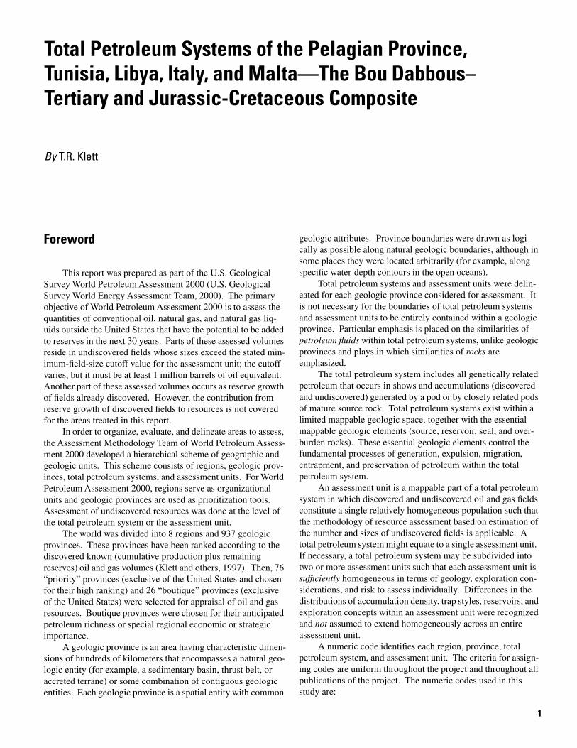
The Pelagian Province is located mainly in eastern Tunisia and northwestern Libya (fig. 1). A portion of the province extends into Malta and offshore areas of Italy. The province area encompasses approximately 294,000 km2. Neighboring geologic provinces as delineated by the USGS include the Tyrrhenian Basin (4069), Sicily (4066), Mediterranean Basin (2070), Sirte Basin (2043), Nefusa Uplift (2049), Hamra Basin (2047), Trias/Ghadames Basin (2054), Atlas Uplift (2053), and Tellian Foredeep (2052) (Persits and others, 1997).
Several total petroleum systems may exist in the Pelagian Province, but only two “composite” total petroleum systems are described in this report. Data available for this study are insufficient to adequately determine the relative contribution of every total petroleum system to individual accumulations and there-fore preclude further subdivision. The described systems are called the Bou Dabbous–Tertiary (204801) and Jurassic-Cretaceous Composite (204802) Total Petroleum Systems, named after the source-rock intervals and reservoir-rock ages. Both total petroleum systems coincide with the extent of proven source rocks within the province and the hypothesized extent of petroleum migration from their respective source rocks (figs. 2, 3, and 4). Due to insufficient data, province and total petroleum system boundaries can only be approximately delineated and therefore are subject to future modification.
One assessment unit was defined for each total petroleum system; the assessment units coincide with the total petroleum systems (figs. 2, 3). The assessment units are named after the total petroleum system with a suffix of “Structural/ Stratigraphic.” This suffix refers to the progression from a structural and combination trap exploration strategy to a stratigraphic trap exploration strategy.
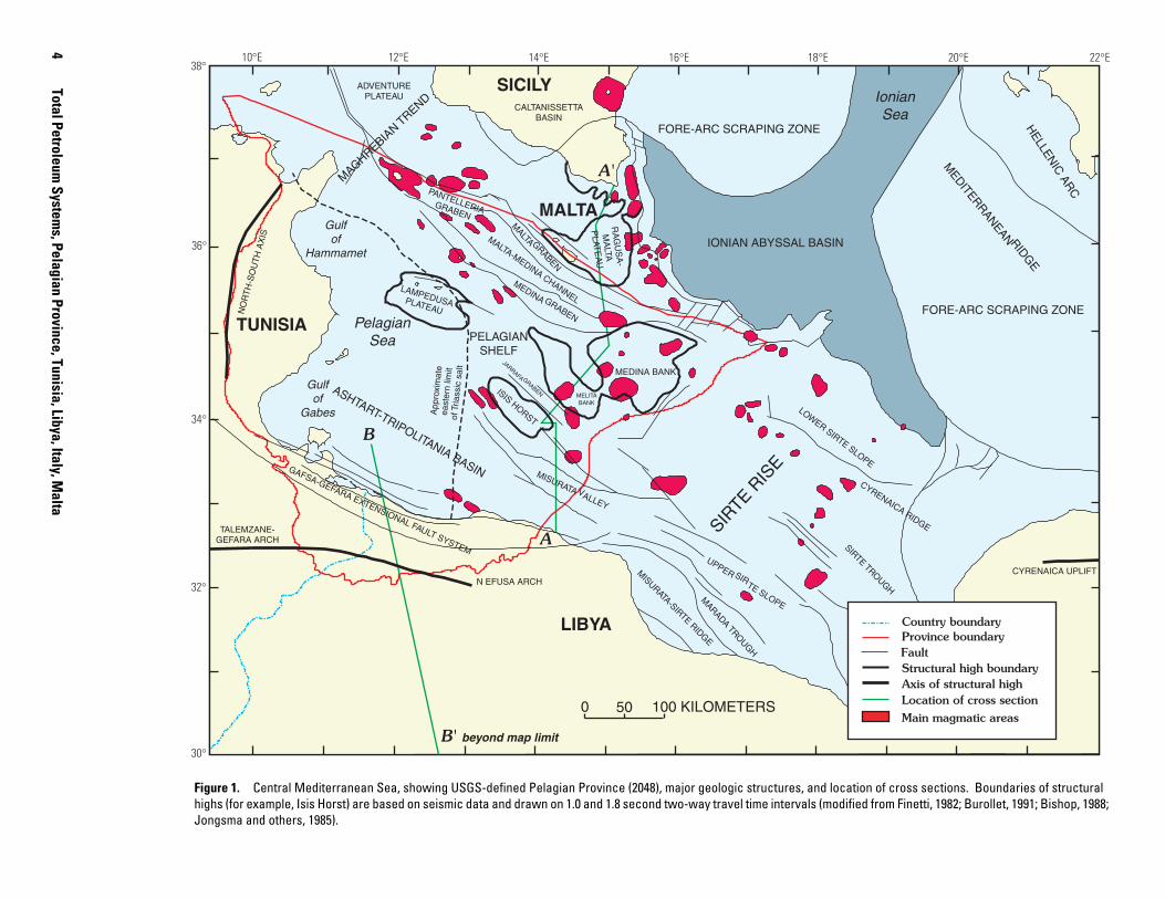
Volumes of petroleum discovered in each of the total petroleum systems of the Pelagian Province are shown in table 1. The Pelagian Province as a whole contains more than 2,300 mil-lion barrels (MMB) of known petroleum liquids (estimated total recoverable volume, which is cumulative production plus remaining reserves and includes approximately 2,240 million barrels of oil, MMBO, and 70 million barrels of natural gas liquids, MMBNGL) and approximately 17,200 billion cubic feet of known natural gas (17.2×10¹² CFG or 17.2 TCFG) (Petroconsultants, 1996a). These volumes are greater than those shown in table 1 in that the volumes include those from neigh-boring total petroleum systems that slightly extend into the province. The Bou Dabbous–Tertiary Total Petroleum System contains a greater volume of known petroleum (approximately 2,100 MMBO, 15,500 BCFG, and 44 MMBNGL) than the Jurassic-Cretaceous Composite Total Petroleum System (approximately 103 MMBO, 1,300 BCFG, and 23 MMBNGL).
Table 1. Number and sizes of discovered fields for each assessment unit in the Pelagian Province (2048) through 1995.
[MMBO, million barrels of oil; BCFG, billion cubic feet of gas; NGL, natural gas liquids; MMBNGL, million barrels of NGL. Volumes reported are summed for oil and gas fields (USGS defined). Oil and gas fields containing known volumes below 1 million barrels of oil or 6 billion cubic feet of gas (BCFG) are grouped. Data from Petroconsultants (1996a)]
Acknowledgments
I thank Ali M’Rabet of Entreprise Tunisienne d’Activités Pétrolières (ETAP) and David Boote and Marc Traut of Occidental Oil and Gas Corporation for their suggestions, and Lorna Carter, William Keefer, Katharine Varnes, Gregory Ulmishek, and Janet Pitman for their editorial review. I also thank Margarita Zyrianova for help in drafting some of the figures.
Province Geology
The Pelagian Province generally coincides with the off-shore shelf area of east-central Tunisia and northern Libya (figs. 1, 2). However, the western and southern boundaries are onshore. The western boundary is along the North-South Axis (fig. 1), a basement-related structural feature bounded by normal faults separating the Pelagian Province in eastern Tunisia from the Mesozoic fault basin farther west (Bobier and others, 1991).
Province Geology 3
4 10°E 12°E 14°E 16°E 18°E 20°E 22°E38°
SICILYADVENTURE PLATEAU
MALTA GRABEN
MALTA-MEDINA CHANNEL
MEDINA GRABEN
RA
GU
SA
MA
LTA
PLAT
EA
U
IONIAN ABYSSAL BASIN
ISISHORST
JARRAFA GRABEN MELITA BANK
MEDINA BANK
FORE-ARC SCRAPING ZONE
FORE-ARC SCRAPING ZONE
MEDITERRANEAN RIDG
E H
ELLENIC
ARC
SIRTE
RIS
E
UPPER SIRTE SLOPE
MARADA
TROUGH
MISURATA-SIRTE RIDGE
SIRTE TROUGH
CYRENAICA RIDGE
LOWER SIRTE SLOPE
CALTANISSETTA BASIN
MALTA
CYRENAICA UPLIFT
TUNISIA
ASHTART-TRIPOLITANIA BASIN
LAMPEDUSAPLATEAU
TALEMZANEGEFARA ARCH
PANTELLERIAGRABEN
MISURATA VALLEY
MAGHREBIAN T
REND
LIBYA
0 50 100 KILOMETERS
A'
A
GAFSA-GEFARA EXTENSIONAL FAULT SYSTEM
B
B' beyond map limit
NO
RT
H-S
OU
TH
AX
IS
Country boundary Province boundary
Structural high boundary Fault
Location of cross section Axis of structural high
Main magmatic areas
N EFUSA ARCH
Gulf of
Gabes
Gulf of
Hammamet
Pelagian Sea
App
roxi
mat
eea
ster
n lim
it of
Tria
ssic
sal
t
PELAGIAN SHELF
Ionian Sea
Total Petroleum System
s, Pelagian Province, Tunisia, Libya, Italy, Malta
36°
34°
32°
30°
Figure 1. Central Mediterranean Sea, showing USGS-defined Pelagian Province (2048), major geologic structures, and location of cross sections. Boundaries of structural highs (for example, Isis Horst) are based on seismic data and drawn on 1.0 and 1.8 second two-way travel time intervals (modified from Finetti, 1982; Burollet, 1991; Bishop, 1988; Jongsma and others, 1985).
10°E 12°E 14°E 16°E
38°
36°
34°
32°
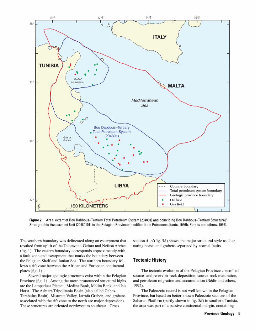
Figure 2. Areal extent of Bou Dabbous–Tertiary Total Petroleum System (204801) and coinciding Bou Dabbous–Tertiary Structural/ Stratigraphic Assessment Unit (20480101) in the Pelagian Province (modified from Petroconsultants, 1996b; Persits and others, 1997).
ITALY
TUNISIA
MALTA
LIBYA Country boundary Total petroleum system boundary
Oil field Gas field
Geologic province boundary
Bou Dabbous–Tertiary Total Petroleum System
(204801)
Mediterranean Sea
Gulf of Hammamet
Gulf of Gabes
150 KILOMETERS0
The southern boundary was delineated along an escarpment that resulted from uplift of the Talemzane-Gefara and Nefusa Arches (fig. 1). The eastern boundary corresponds approximately with a fault zone and escarpment that marks the boundary between the Pelagian Shelf and Ionian Sea. The northern boundary follows a rift zone between the African and European continental plates (fig. 1).
Several major geologic structures exist within the Pelagian Province (fig. 1). Among the more pronounced structural highs are the Lampedusa Plateau, Medina Bank, Melita Bank, and Isis Horst. The Ashtart-Tripolitania Basin (also called Gabes
-Tarabulus Basin), Misurata Valley, Jarrafa Graben, and grabens associated with the rift zone to the north are major depressions. These structures are oriented northwest to southeast. Cross
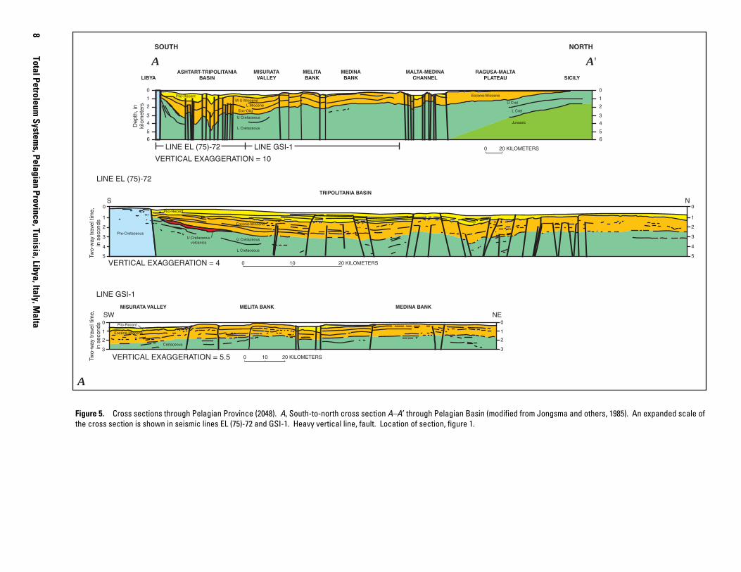
section A–A′(fig. 5A) shows the major structural style as alternating horsts and grabens separated by normal faults.
Tectonic History
The tectonic evolution of the Pelagian Province controlled source- and reservoir-rock deposition, source-rock maturation, and petroleum migration and accumulation (Bédir and others, 1992).
The Paleozoic record is not well known in the Pelagian Province, but based on better known Paleozoic sections of the Saharan Platform (partly shown in fig. 5B) in southern Tunisia, the area was part of a passive continental margin, containing
Province Geology 5
10°E 12°E 14°E 16°E
38°
36°
34°
32°
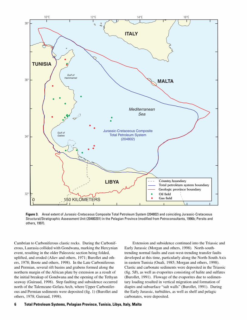
Figure 3. Areal extent of Jurassic-Cretaceous Composite Total Petroleum System (204802) and coinciding Jurassic-Cretaceous Structural/Stratigraphic Assessment Unit (20480201) in the Pelagian Province (modified from Petroconsultants, 1996b; Persits and
ITALY
TUNISIA
MALTA
Jurassic-Cretaceous Composite Total Petroleum System
(204802)
LIBYA Country boundary Total petroleum system boundary
Oil field Gas field
Geologic province boundary
Mediterranean Sea
Gulf of Hammamet
Gulf of Gabes
150 KILOMETERS0
others, 1997).
Cambrian to Carboniferous clastic rocks. During the Carboniferous, Laurasia collided with Gondwana, marking the Hercynian event, resulting in the older Paleozoic section being folded, uplifted, and eroded (Aliev and others, 1971; Burollet and others, 1978; Boote and others, 1998). In the Late Carboniferous and Permian, several rift basins and grabens formed along the northern margin of the African plate by extension as a result of the initial breakup of Gondwana and the opening of the Tethyan seaway (Guiraud, 1998). Step faulting and subsidence occurred north of the Talemzane-Gefara Arch, where Upper Carboniferous and Permian sediments were deposited (fig. 1) (Burollet and others, 1978; Guiraud, 1998).
Extension and subsidence continued into the Triassic and Early Jurassic (Morgan and others, 1998). North-south-trending normal faults and east-west-trending transfer faults developed at this time, particularly along the North-South Axis in eastern Tunisia (Ouali, 1985; Morgan and others, 1998). Clastic and carbonate sediments were deposited in the Triassic (fig. 5B), as well as evaporites consisting of halite and sulfates (Burollet, 1991). Flowage of the evaporites due to sedimentary loading resulted in vertical migration and formation of diapirs and subsurface “salt walls” (Burollet, 1991). During the Early Jurassic, turbidites, as well as shelf and pelagic carbonates, were deposited.
6 Total Petroleum Systems, Pelagian Province, Tunisia, Libya, Italy, Malta
Ypresian (Bou Dabbous) Albian (Fahdene)
Upper Cenomanian to lower Turonian (Bahloul)
Jurassic (Nara)
GH
GG
GH
GG
GH
GG
GH
GG
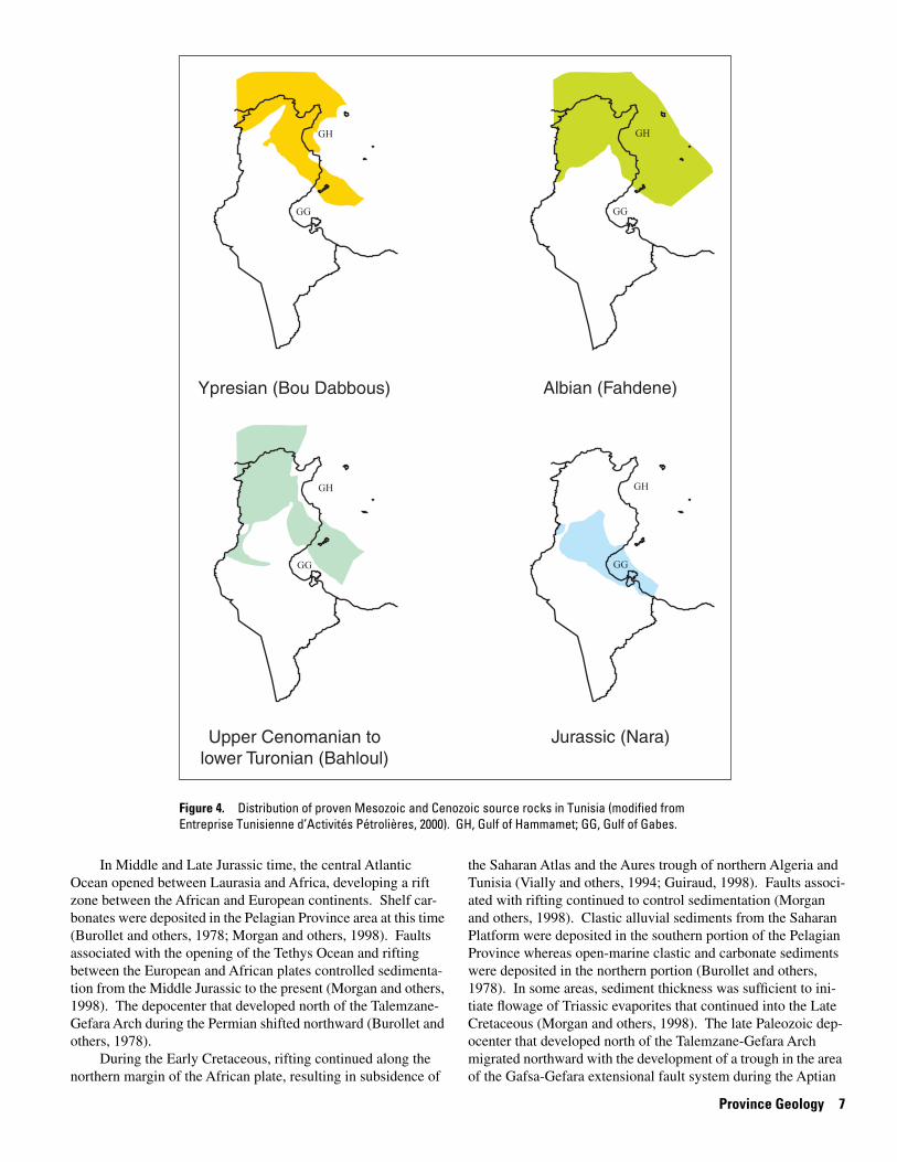
Figure 4. Distribution of proven Mesozoic and Cenozoic source rocks in Tunisia (modified from Entreprise Tunisienne d’Activités Pétrolières, 2000). GH, Gulf of Hammamet; GG, Gulf of Gabes.
In Middle and Late Jurassic time, the central Atlantic Ocean opened between Laurasia and Africa, developing a rift zone between the African and European continents. Shelf carbonates were deposited in the Pelagian Province area at this time (Burollet and others, 1978; Morgan and others, 1998). Faults associated with the opening of the Tethys Ocean and rifting between the European and African plates controlled sedimentation from the Middle Jurassic to the present (Morgan and others, 1998). The depocenter that developed north of the Talemzane-Gefara Arch during the Permian shifted northward (Burollet and others, 1978).
During the Early Cretaceous, rifting continued along the northern margin of the African plate, resulting in subsidence of
the Saharan Atlas and the Aures trough of northern Algeria and Tunisia (Vially and others, 1994; Guiraud, 1998). Faults associated with rifting continued to control sedimentation (Morgan and others, 1998). Clastic alluvial sediments from the Saharan Platform were deposited in the southern portion of the Pelagian Province whereas open-marine clastic and carbonate sediments were deposited in the northern portion (Burollet and others, 1978). In some areas, sediment thickness was sufficient to initiate flowage of Triassic evaporites that continued into the Late Cretaceous (Morgan and others, 1998). The late Paleozoic depocenter that developed north of the Talemzane-Gefara Arch migrated northward with the development of a trough in the area of the Gafsa-Gefara extensional fault system during the Aptian
Province Geology 7
8Total Petroleum
Systems, Pelagian Province, Tunisia, Libya, Italy, M
alta
LINE GSI-1
LINE GSI-1LINE EL (75)-72 0 0 KILOMETERS
VERTICAL EXAGGERATION = 10
6
5
4
3
2
1
0
SICILY RAGUSA-MALTA
PLATEAU MALTA-MEDINA
CHANNEL MEDINA BANK
MELITA BANK
MISURATA VALLEY
ASHTART-TRIPOLITANIA BASINLIBYA
6
5
4
3
2
1
0
Dep
th, i
n ki
lom
eter
s
A
NS
LINE EL (75)-72
5
4 4
3
2
1
2
0
1
0
3
5 Two-
way
trav
el ti
me,
in
sec
onds
0 20 KILOMETERS
SW MEDINA BANKMELITA BANKMISURATA VALLEY
VERTICAL EXAGGERATION = 5.5
2
0
1
3
Two-
way
trav
el ti
me,
in
sec
onds
3
1
2
0 NE
TRIPOLITANIA BASIN
0 20 KILOMETERS
10
10
Plio-Recent M-U Miocene
L Miocene Eoc-Olig
U Cretaceous
L Cretaceous
U Cret
L Cret
Jurassic
Eocene-Miocene
VERTICAL EXAGGERATION = 4
A'
Plio-Recent
Plio-Recent
Pre-Cretaceous
Eocene-Miocene
Eocene-Miocene
U Cretaceous
L Cretaceous
Cretaceous
U Cretaceous volcanics
SOUTH NORTH
A
2
Figure 5. Cross sections through Pelagian Province (2048). A, South-to-north cross section A–A′ through Pelagian Basin (modified from Jongsma and others, 1985). An expanded scale of the cross section is shown in seismic lines EL (75)-72 and GSI-1. Heavy vertical line, fault. Location of section, figure 1.
NORTHWEST SOUTHEAST
0
1
2
3 Ordovician
B B'
TALEMZANE-GEFARA ARCH
Miocene Oligocene
PELAGIAN BASIN HAMRA BASIN
Upper CretaceousLower Cretaceous
Jurassic Triassic
Silurian
Devonian
Lower Carboniferous
U�
Sil
Permian Upper Carboniferous
Triassic
Upper Cretaceous
U Cret
Lower Cretaceous
Jurassic
Triassic Cambrian and
Ordovician
Pliocene-Pleistocene
0 100 KILOMETERS
Evaporites
Fault
Unconformity
Pelagian Province (2048) Hamra Province (2047)
GAFSA-GEFARA EXTENSIONAL FAULT SYSTEM
Dep
th, i
n ki
lom
eter
s
SAHARAN PLATFORM
0
1
2
3
B
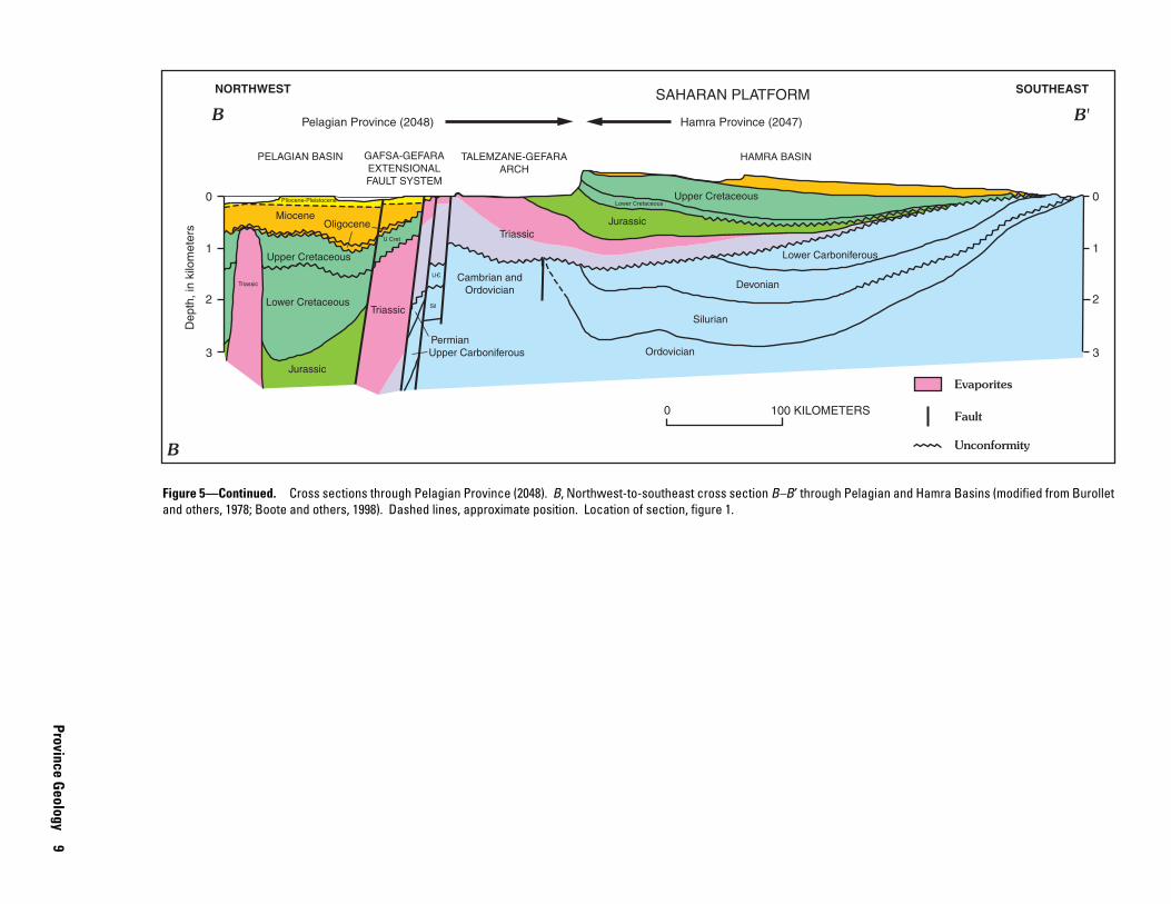
Figure 5—Continued. Cross sections through Pelagian Province (2048). B, Northwest-to-southeast cross section B–B′ through Pelagian and Hamra Basins (modified from Burollet and others, 1978; Boote and others, 1998). Dashed lines, approximate position. Location of section, figure 1.
Province Geology
9
Miocene (nonmarine) sand and mudstone
Miocene (marine) sand and mudstone
Paleocene basinal mudstone and marl
Cretaceous limestone and marl
Eocene shelf limestone
Oligocene limestone/marl
E
E
E
E E
O
O
P
P
WEST EAST
2,000
M.S.L.
4,000
6,000
8,000
10,000
M.S.L.
Depth, in feet
2,000
4,000
6,000
8,000
10,000
Post Miocene
Fault
UnconformityC
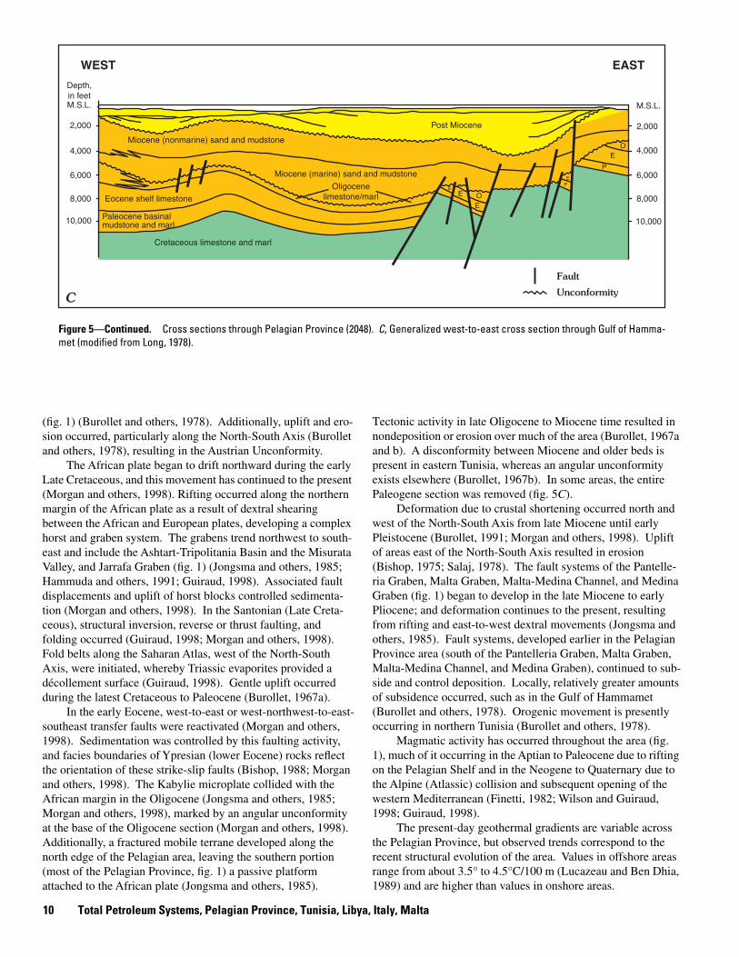
Figure 5—Continued. Cross sections through Pelagian Province (2048). C, Generalized west-to-east cross section through Gulf of Hammamet (modified from Long, 1978).
(fig. 1) (Burollet and others, 1978). Additionally, uplift and erosion occurred, particularly along the North-South Axis (Burollet and others, 1978), resulting in the Austrian Unconformity.
The African plate began to drift northward during the early Late Cretaceous, and this movement has continued to the present (Morgan and others, 1998). Rifting occurred along the northern margin of the African plate as a result of dextral shearing between the African and European plates, developing a complex horst and graben system. The grabens trend northwest to south-east and include the Ashtart-Tripolitania Basin and the Misurata Valley, and Jarrafa Graben (fig. 1) (Jongsma and others, 1985; Hammuda and others, 1991; Guiraud, 1998). Associated fault displacements and uplift of horst blocks controlled sedimentation (Morgan and others, 1998). In the Santonian (Late Cretaceous), structural inversion, reverse or thrust faulting, and folding occurred (Guiraud, 1998; Morgan and others, 1998). Fold belts along the Saharan Atlas, west of the North-South Axis, were initiated, whereby Triassic evaporites provided a décollement surface (Guiraud, 1998). Gentle uplift occurred during the latest Cretaceous to Paleocene (Burollet, 1967a).
In the early Eocene, west-to-east or west-northwest-to-east-southeast transfer faults were reactivated (Morgan and others, 1998). Sedimentation was controlled by this faulting activity, and facies boundaries of Ypresian (lower Eocene) rocks reflect the orientation of these strike-slip faults (Bishop, 1988; Morgan and others, 1998). The Kabylie microplate collided with the African margin in the Oligocene (Jongsma and others, 1985; Morgan and others, 1998), marked by an angular unconformity at the base of the Oligocene section (Morgan and others, 1998). Additionally, a fractured mobile terrane developed along the north edge of the Pelagian area, leaving the southern portion (most of the Pelagian Province, fig. 1) a passive platform attached to the African plate (Jongsma and others, 1985).
Tectonic activity in late Oligocene to Miocene time resulted in nondeposition or erosion over much of the area (Burollet, 1967a and b). A disconformity between Miocene and older beds is present in eastern Tunisia, whereas an angular unconformity exists elsewhere (Burollet, 1967b). In some areas, the entire Paleogene section was removed (fig. 5C).
Deformation due to crustal shortening occurred north and west of the North-South Axis from late Miocene until early Pleistocene (Burollet, 1991; Morgan and others, 1998). Uplift of areas east of the North-South Axis resulted in erosion (Bishop, 1975; Salaj, 1978). The fault systems of the Pantelleria Graben, Malta Graben, Malta-Medina Channel, and Medina Graben (fig. 1) began to develop in the late Miocene to early Pliocene; and deformation continues to the present, resulting from rifting and east-to-west dextral movements (Jongsma and others, 1985). Fault systems, developed earlier in the Pelagian Province area (south of the Pantelleria Graben, Malta Graben, Malta-Medina Channel, and Medina Graben), continued to sub-side and control deposition. Locally, relatively greater amounts of subsidence occurred, such as in the Gulf of Hammamet (Burollet and others, 1978). Orogenic movement is presently occurring in northern Tunisia (Burollet and others, 1978).
Magmatic activity has occurred throughout the area (fig. 1), much of it occurring in the Aptian to Paleocene due to rifting on the Pelagian Shelf and in the Neogene to Quaternary due to the Alpine (Atlassic) collision and subsequent opening of the western Mediterranean (Finetti, 1982; Wilson and Guiraud, 1998; Guiraud, 1998).
The present-day geothermal gradients are variable across the Pelagian Province, but observed trends correspond to the recent structural evolution of the area. Values in offshore areas range from about 3.5° to 4.5°C/100 m (Lucazeau and Ben Dhia, 1989) and are higher than values in onshore areas.
10 Total Petroleum Systems, Pelagian Province, Tunisia, Libya, Italy, Malta
Stratigraphy
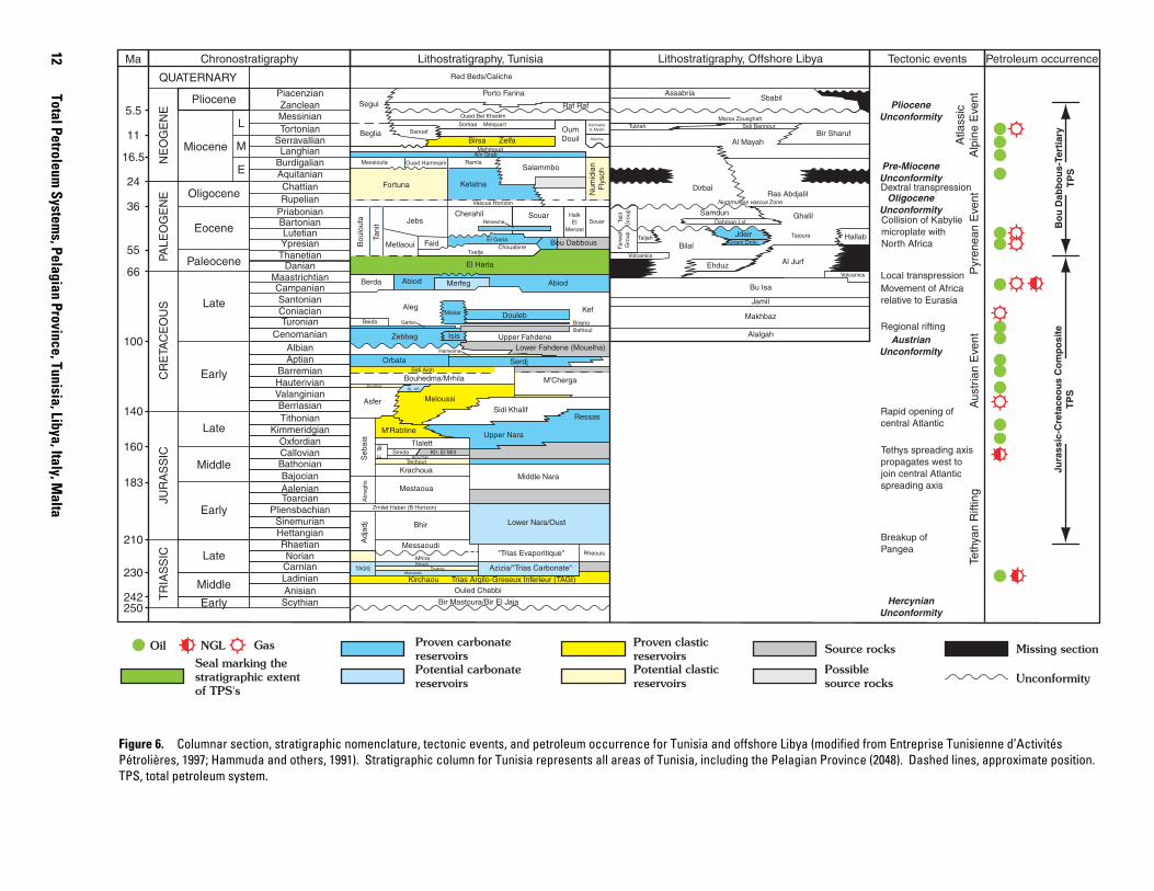
The regional stratigraphy is variable across the Pelagian Province, and stratigraphic nomenclature varies among authors and countries. Throughout the Mesozoic and Cenozoic, open-marine conditions existed generally in the northern part of the province, whereas neritic shelf conditions existed in the south-ern part (Burollet and others, 1978). Little information exists for rocks older than Triassic or Jurassic (Burollet, 1990). This study uses primarily the nomenclature given by Entreprise Tunisienne d’Activités Pétrolières (1997) for the Tunisian portion of the province and Hammuda and others (1991) for the Libyan portion. Columnar sections, stratigraphic nomenclature, and correlations are shown in figure 6.
Triassic rocks can be separated into two main intervals, a lower clastic interval and an upper evaporite interval (Bishop, 1975). The lower clastic interval includes sandstone and mud-stone of the Bir El Jaja, Ouled Chebbi, and Kirchaou or Trias Argilo-Greseux Inferieur Formations (fig. 6). Depositional facies were continental in the southern portion of the Pelagian Province, grading into shallow marine facies northward. The northern limit of the clastic interval is not known (Bishop, 1975). The Kirchaou or Trias Argilo-Greseux Inferieur Formation provides major oil and gas reservoirs in the Saharan Plat-form basins of Libya, Tunisia, and Algeria. Between the clastic and evaporite intervals is a dolomitic section equivalent to the Azizia, Trias Carbonate, and Trias Argilo-Greseux Superieur (TAGS) Formations (fig. 6). The upper evaporite interval contains interbedded anhydrite, salt, and dolostone (Busson, 1967; Bishop, 1975).
The Jurassic and Lower Cretaceous sections contain mostly carbonate rocks, representing increasingly deeper marine to pelagic deposition northwestward (Burollet and others, 1978). Lagoonal, deltaic, and terrigenous facies were present in the south and southwest, which migrated northward through time until the Aptian (Bishop, 1975; Burollet and others, 1978; M’Rabet, 1984). These landward deposits include sandstone of the Upper Jurassic M’Rabtine Formation, Upper Jurassic to Lower Cretaceous Meloussi Formation, and Lower Cretaceous Boudinar Formation (fig. 6). Marine deposits include limestone, dolostone, and marl (Salaj, 1978) of the Jurassic Nara Formation and Upper Jurassic to Lower Cretaceous Sidi Khalif and M’Cherga Formations (fig. 6). Micrite and mudstone were deposited in the deep marine environments (Bishop, 1975).
Deposition of condensed sections, as well as the development of shoal facies and some reefs, occurred along the North-South Axis during the Jurassic and Early Cretaceous (Bishop, 1975; Salaj, 1978; Burollet and others, 1978). Farther east and to the south, pelagic sediments were deposited in a subsiding depositional trough that existed in the present-day Gulf of Gabes area (fig. 1) (Salaj, 1978; Burollet and others, 1978).
A maximum flooding event occurred during the Barremian to Aptian (Early Cretaceous; Bishop, 1975; Salaj, 1978). Barremian rocks consist of limestone, marl, and interbedded sandstone and shale of the Bouhedma and M’Cherga Formations, and the Sidi Aïch sandstone (Bishop, 1975; Salaj, 1978; Entreprise Tunisienne d’Activités Pétrolières, 1997).
Aptian and Albian rocks include limestone, dolostone, sandstone, mudstone, marl, and some evaporites of the Orbata, Serdj, Hameima, and Lower Fahdene Formations (Burollet and others, 1978; Salaj, 1978). The Orbata Formation (or Orbata member of the Gafsa Formation in earlier publications) is lime-stone and dolostone (Bishop, 1975). The Serdj Formation is a reef limestone that is laterally equivalent to the Orbata Formation and overlain by clastic sediments of either the deeper marine Hameima Formation or Lower Fahdene (also called the Mouelha) Formation (fig. 6) (Burollet and others, 1978).
Unconformably overlying the Orbata Formation is the Albian to Turonian Zebbag Formation (fig. 6). Zebbag sediments were deposited on a shallow marine carbonate platform in the Gulf of Gabes area and central Tunisia (Bishop, 1988). Sub-tidal conditions existed in central Tunisia and in the area of the present-day Gulf of Gabes coast, where lagoonal mudstone, dolostone, and anhydrite were deposited (Bishop, 1975; Bishop, 1988). Reefs, reefoid facies, and rudist banks are also present (Bishop, 1975; Burollet and others, 1978). In the Pelagian Province, the Zebbag Formation is limestone, dolostone, and bioclastic rocks, and is laterally equivalent to basinal mudstone and argillaceous limestone of the Fahdene and Bahloul Formations (Bishop, 1988). The Fahdene Formation is a dark-gray mud-stone and the Bahloul Formation is a dark-colored, laminated, euxinic, argillaceous limestone (Burollet and others, 1978; Bishop, 1988).
The Turonian to Campanian Aleg Formation overlies the Fahdene, Bahloul, and Zebbag Formations. Rocks of the Aleg Formation include mudstone, limestone, and marl (Bishop, 1975; Salaj, 1978). The Bireno, Miskar, and Douleb Formations are equivalent to some intervals of the Aleg Formation (fig. 6). Both the Bireno and Douleb Formations are, in part, laterally equivalent to, or are members of the Miskar Formation. These formations consist of limestone, dolostone, and marl (Salaj, 1978; Entreprise Tunisienne d’Activités Pétrolières, c. 1999). The Miskar Formation represents a rudist bank or banks on the shelf edge or slope (Bishop, 1988; Knott and others, 1995).
During the Campanian to Maastrichtian (latest Cretaceous), chalky limestone, micrite, and marl of the Abiod Formation were deposited over the Aleg Formation (Burollet and others, 1978; Salaj, 1978; Bishop, 1975). The Santonian Jamil Formation and Campanian to Maastrichtian Bu Isa Formation are laterally equivalent, in part, to the Aleg and Abiod Formations (fig. 6).
Overlying the Abiod and Bu Isa Formations is the Maastrichtian to Thanetian (Paleocene) El Haria Formation, a gray, black, or brown mudstone, containing some thin limestone beds in the lower part (Burollet, 1967b; Bishop, 1975). The El Haria Formation covers much of the Pelagian Province but is absent in the southern and southwestern portions, as a result of either non-deposition or removal by erosion (Bishop, 1975). The Al Jurf, Ehduz, and part of the Bilal Formations are laterally equivalent to the El Haria Formation (fig. 6).
The Thanetian to Lutetian Metlaoui Group overlies the El Haria Formation and consists of rocks representing lagoonal, carbonate ramp, and marine deposition. The lowermost beds are the Tselja (oldest) and Chouabine Formations (fig. 6). The Tselja Formation is represented by evaporites (including gypsum) and dolomitic rocks; the Chouabine Formation is
Province Geology 11
12
QUATERNARY
Pliocene
Paleocene
Miocene
Oligocene
Eocene
Late
Early
Late
Middle
Early
Late
Middle
Early
Piacenzian Zanclean Messinian Tortonian
Serravallian Langhian
Burdigalian Aquitanian Chattian Rupelian
Priabonian Bartonian Lutetian Ypresian Thanetian
Danian Maastrichtian Campanian Santonian Coniacian Turonian
Cenomanian Albian Aptian
Barremian Hauterivian Valanginian Berriasian Tithonian
Kimmeridgian Oxfordian Callovian Bathonian Bajocian Aalenian Toarcian
Pliensbachian Sinemurian Hettangian Rhaetian Norian
Carnian Ladinian Anisian
Scythian TR
IAS
SIC
JU
RA
SS
IC
CR
ETA
CE
OU
S
PALE
OG
EN
E
NE
OG
EN
E
Red Beds/Caliche
Porto Farina
Raf RafSegui
Beglia
Oued Bel Khedim Somaa t
Saouaf
Birsa a
Kechabta O. Melah
Hakima
Aïn Grab Messiouta Oued Hammam Ramla
Salammbo
Num
idia
n F
lysc
h
Vascus Horizon
Fortuna Ketatna
Bou
louf
a
Tani
t Jebs
Metlaoui Faid
Cherahil Reineche
El Garia
Tselja
Bou Dabbous
Halk El
Menzel Souar
Souar
El Haria
Berda Abiod AbiodMerfeg
Aleg KefMiskar Douleb Bireno Bahloul
Beida
Zebbag Lower Fahdene (Mouelha)
Upper FahdeneIsis
Hameima
SerdjOrbata Sidi Aïch
Boudinar DL 101
Bouhedma/Mrhila M'Cherga
MeloussiAsfer Sidi Khalif
Ressas
Upper Nara M'Rabtine
Seb
aia
Tlalett Smida Kh. El Miit
F. Ta
t.
Brourmet Techout
Krachoua Middle Nara
Mestaoua
Abr
eghs
Zmilet Haber (B Horizon)
Lower Nara/OustBhir
Adj
adj
Messaoudi "Trias Evaporitique" Rheouis
Mhira
TAGS Rehach
Touareg Mekraneb
Azizia/"Trias Carbonate"
Kirchaou Trias Argilo-Greseux Inferieur (TAGI) Ouled Chebbi
Bir Mastoura/Bir El Jaja Hercynian Unconformity
Teth
yan
Rift
ing
Austrian Unconformity
Pyr
enea
n E
vent
Oligocene Unconformity
Atla
ssic
A
lpin
e E
vent
Pliocene Unconformity
Breakup of Pangea
Tethys spreading axis propagates west to join central Atlantic spreading axis
Rapid opening of central Atlantic
Aus
tria
n E
vent
Regional rifting
Local transpression Movement of Africa relative to Eurasia
Dextral transpression
Collision of Kabylie microplate with North Africa
5.5
11
16.5
24
36
55
66
100
140
160
183
210
230
242 250
Ma Chronostratigraphy Lithostratigraphy, Tunisia Tectonic events Petroleum occurrence
Mahmoud
Oum Douil
Bo
u D
abb
ou
s-Te
rtia
ry
TP
S
Jura
ssic
-Cre
tace
ou
s C
om
po
site
T
PS
Alalgah
Makhbaz
Jamil
Bu Isa
Volcanics
Volcanics
Al JurfEhduz
Bilal Farw
ah
Gro
up
Telil
G
roup
Taljah Jirani Dolo.
Dahman Lst.
Samdun Ghalil
HallabTajoura
Nummulites vascus Zone
Dirbal Ras Abdjalil
Al Mayah Bir Sharuf
Sidi BannourTubtah Marsa Zouaghah
SbabilAssabria
Jdeir
Chouabine
Lithostratigraphy, Offshore Libya
Pre-Miocene Unconformity
Gattar
M
L
E
Melquar
Zelf
Total Petroleum System
s, Pelagian Province, Tunisia, Libya, Italy, Malta
Oil NGL Gas Proven carbonate reservoirs
Seal marking the Potential carbonatestratigraphic extent reservoirsof TPS's
Proven clastic Source rocksreservoirs
Possible
Missing section
Unconformity Potential clastic reservoirs source rocks
Figure 6. Columnar section, stratigraphic nomenclature, tectonic events, and petroleum occurrence for Tunisia and offshore Libya (modified from Entreprise Tunisienne d’Activités Pétrolières, 1997; Hammuda and others, 1991). Stratigraphic column for Tunisia represents all areas of Tunisia, including the Pelagian Province (2048). Dashed lines, approximate position. TPS, total petroleum system.
represented by glauconitic and phosphatic beds (Burollet and others, 1978; Bishop, 1988). Above and partially equivalent to the Chouabine Formation are rock units that represent a continuous set of lagoonal to open-marine depositional facies. These units include the Faid Formation, representing an evaporitic anhydrite and dolostone facies; the Ain Merhotta Formation, restricted shelf gastropod facies (not shown in fig. 6); the El Garia Formation, shallow-shelf nummulitid facies; and the Bou Dabbous Formation, deep-water globigerinid facies (Bishop, 1988; Loucks and others, 1998). The Libyan Jirani Dolomite and Jdeir Formation are laterally equivalent to the Metlaoui Group (fig. 6).
Rocks of the middle to upper Eocene are mudstone and limestone of the Souar Formation, and are laterally equivalent to evaporites of the Jebs Formation (Bishop, 1988). Some coquinoid nummulitic carbonate rocks are present in the Souar Formation, such as the Lutetian Reineche Formation (fig. 6) (Bishop, 1975). The Oligocene Unconformity marks the top of the Souar and laterally equivalent formations.
Immediately overlying the Oligocene Unconformity is mudstone with interbedded fine-grained sandstone containing some nummulitic limestones, called the Nummulites vascus horizon (Bishop, 1975; Burollet and others, 1978; Salaj, 1978; Hammuda and others, 1991).
Rocks representing a succession of terrigenous to marine depositional facies overlie the Nummulites vascus horizon (Bishop, 1975; Burollet and others, 1978; Salaj, 1978). Each depositional facies type carries a different formation name. The most landward formation is the Fortuna Formation, capped by continental rocks of the Messiouta Formation. Nearshore marine rocks are represented by limestone of the Ketatna Formation, which interfingers with offshore mudstone of the Salammbo Formation (Schwab, 1995). The Libyan equivalents to the Ketatna and Salammbo Formations are the Dirbal and Ras Abdjalil Formations (Hammuda and others, 1991) (fig. 6). The ages of all these formations range from Rupelian to Burdigalian (Oligocene to Miocene; fig. 6). Tectonic activity during the late Oligocene and early Miocene resulted in erosion and nondeposition. Basal Miocene sediments are commonly conglomeritic and unconformably overlie older sediments (Burollet, 1967b).
Upper Miocene rocks include (1) the transgressive lime-stone of the Aïn Grab Formation; (2) marls of the Mahmoud Formation; (3) a sandy sequence represented by the Beglia, Saouaf, Birsa, Oum Douil, and part of the Segui Formations; and (4) lagoonal and brackish-water sediments (including anhydrite; Jongsma and others, 1985) of the Messinian Oued Bel Khedim and Marsa Zouaghah Formations (Burollet and others, 1978; Salaj, 1978) (fig. 6). The top of the Miocene is marked by an angular unconformity, above which lower Pliocene sediments were deposited during marine transgression (Bishop, 1975; Burollet and others, 1978).
During the Pliocene, strong local subsidence occurred in troughs and basins, into which thick accumulations of terrigenous and marine clastic sediments were deposited (Bishop, 1975; Burollet and others, 1978). Formations include the Raf Raf and Porto Farina Formations, both laterally equivalent to parts of the Segui and Sbabil Formations (fig. 6).
Quaternary deposits include clastic terrigenous and marine sediments (Burollet and others, 1978).
Regional Exploration Activity
As of 1996, more discoveries were made in reservoirs of the Bou Dabbous–Tertiary Total Petroleum System than in reservoirs of the Jurassic-Cretaceous Composite (figs. 2 and 3). Most of the larger oil and gas fields in both total petroleum systems were discovered since 1970 (Appendices 1 and 2), although a few earlier discoveries had been made in the Jurassic-Cretaceous Composite Total Petroleum System.
Most of the exploration in Tunisia was in the Pelagian Province, beginning in the early 1950’s. Fewer than 10 new-field wildcat wells were drilled in most years until the early 1970’s. Since the early 1970’s, however, the number of new-field wildcat wells drilled per year increased, and the number peaked in the early 1980’s to more than 20 new-field wildcat wells per year; drilling then generally decreased until the middle 1990’s. Exploration by foreign companies in Tunisia between the early 1960’s and the 1970’s was limited. Throughout the 1970’s and 1980’s, however, Tunisia revised its legislation and introduced measures to encourage foreign companies to explore and develop oil and gas resources (Davies and Bel Haiza, 1990; Montgomery, 1994).
In the Libyan portion of the Pelagian Province, exploration activity appeared greatest in the early 1960’s with about six to seven new-field wildcat wells per year and again from the late 1970’s to early 1980’s with as many as six new-field wildcat wells per year. Few new-field wildcat wells were drilled from the mid 1980’s to 1996.
In 1955, the Libyan government implemented the Libyan Petroleum Law, designed to attract foreign interest (Nelson, 1979). In the early 1970’s, however, the Petroleum Law was amended as a result of nationalization of oil companies, thereby reducing the control of oil- and gas-related activities by foreign companies. Furthermore, U.S. and U.N. sanctions imposed on Libya in the late 1980’s and early 1990’s discouraged foreign participation and restricted the available resources required for exploration and development (Arab Petroleum Research Center, 1998; Petzet, 1999). In the late 1980’s, however, new terms to encourage foreign interest were introduced, which were still in effect as of 1996.
From the late 1970’s until the late 1980’s, the exploration and production of fields in a portion of offshore Tunisia and Libya were suspended pending adjudication of the Tunisian-Libyan demarcation line in the Gulf of Gabes (Nelson, 1979). The conflict was resolved in 1988 when Libya and Tunisia agreed to create a joint oil exploration company to operate in this area (called the 7th November concession) (Arab Petroleum Research Center, 1998).
A large portion of the Pelagian Province is offshore (fig. 1), and water depths in that portion are generally less than 400 m. The greatest water depth is in the Malta Trough, which has a maximum depth of 1,715 m (Jongsma and others, 1985). As of 1996, wells were drilled in water as deep as 351 m (Petroconsultants, 1996a).
A basic infrastructure has been established in the Pelagian Province whereby tanker terminals and a pipeline network are capable of transporting petroleum from most of the major producing fields to port cities in Tunisia and Libya (Arab Petroleum Research Center, 1998).
Regional Exploration Activity 13
Pro
vinc
e N
ame:
Pel
agia
n B
asin
(20
48)
TP
S N
ame:
Bou
Dab
bous
-Ter
tiary
(20
4801
)
Aut
hor(
s):
T.R
. Kle
tt D
ate:
9-3
-99
Cretaceous
PR
ES
ER
VA
TIO
N
CR
ITIC
AL
MO
ME
NT
GEN
ERAT
ION
-
TRA
P F
OR
MA
TIO
N
OV
ER
BU
RD
EN
RO
CK
RE
SE
RV
OIR
RO
CK
SE
AL
RO
CK
SO
UR
CE
RO
CK
RO
CK
UN
IT
PETR
OLE
UM
SYST
EM E
VEN
TS
GEO
LOG
IC
TIM
E SC
ALE
0
100
200
50
150
250
Paleogene
Jurassic
Triassic
Permian
65
E
E
E
E
M
M
L
L
L
L
Neogene
24
Pal
Eoc
Olig
Mio
Plio
ACC
UM
ULA
TIO
N
MIG
RAT
ION
•
BRS
AG
KET
REI JDE BOU
144
Figure 7. Events chart for Bou Dabbous–Tertiary Total Petroleum System (204801). BRS, Birsa; AG, Aïn Grab; KET, Ketatna; REI, Reineche; JDE, Jdeir, BOU, Bou Dabbous.
The Bou Dabbous–Tertiary Total Petroleum System (204801)
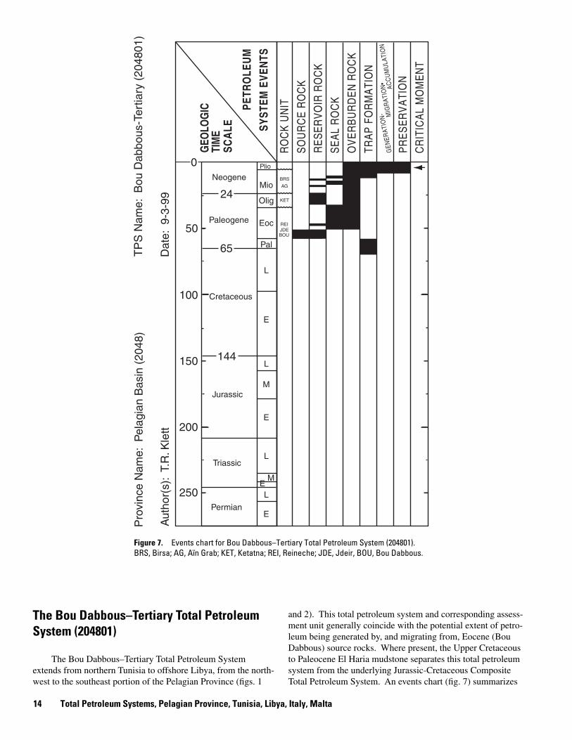
The Bou Dabbous–Tertiary Total Petroleum System extends from northern Tunisia to offshore Libya, from the north-west to the southeast portion of the Pelagian Province (figs. 1
and 2). This total petroleum system and corresponding assessment unit generally coincide with the potential extent of petroleum being generated by, and migrating from, Eocene (Bou Dabbous) source rocks. Where present, the Upper Cretaceous to Paleocene El Haria mudstone separates this total petroleum system from the underlying Jurassic-Cretaceous Composite Total Petroleum System. An events chart (fig. 7) summarizes
14 Total Petroleum Systems, Pelagian Province, Tunisia, Libya, Italy, Malta
the ages of source, reservoir, and seal rocks; the timing of trap development; and generation and migration of petroleum.
Eocene extension and fault reactivation controlled the distribution of depositional facies of the Metlaoui Group (Morgan and others, 1998). Neogene subsidence resulted in deposition of turbidite-fan deposits and invoked maturation of Cretaceous and Eocene source rocks and petroleum migration (Bédir and others, 1992). Petroleum migration most likely occurred from late Miocene to Quaternary (Bédir and others, 1992). Potential traps for petroleum accumulations were developed in the late Miocene and Quaternary as a result of compression by reactivating older structures (Bédir and others, 1992).
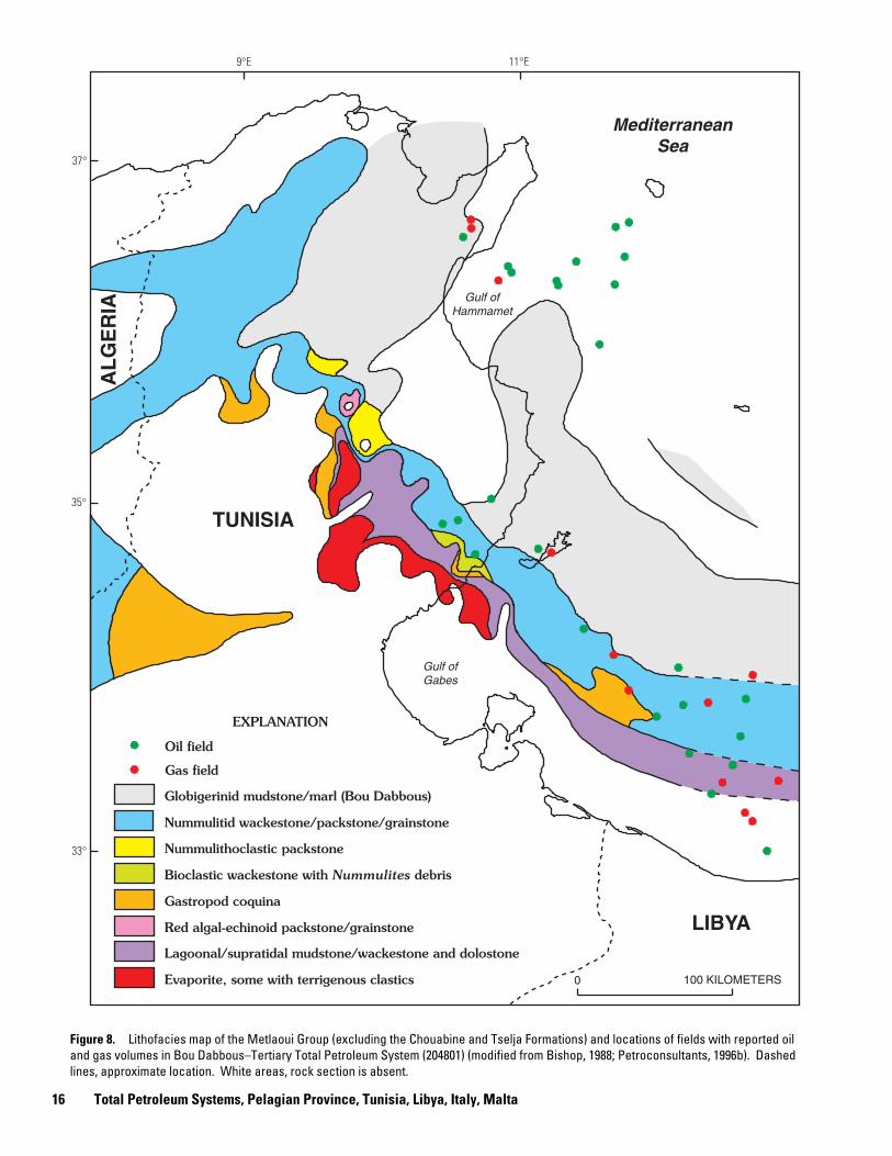
Several fields with reported production from Oligocene and Miocene reservoirs exist in the Gulf of Hammamet where the Bou Dabbous source rocks have not been mapped (figs. 2, 4, and 8). Although the Bou Dabbous Formation is assumed to be the most likely source rock, Cretaceous source rocks may have been a major supply of petroleum to these fields. If this is the case, then a portion of the discovered and undiscovered petroleum included with the Bou Dabbous–Tertiary Total Petroleum System (approximately 8 to 10 percent of the known oil and 3 to 5 percent of the known gas; approximately 10 to 25 percent of the undiscovered oil and 5 to 25 percent of the undiscovered gas) should be included with the Jurassic-Cretaceous Total Petroleum System.
Source Rocks
The primary source rock is dark-brown marl and mudstone of the lower Eocene (Ypresian) Bou Dabbous Formation (or lateral equivalents) (Macgregor and Moody, 1998; Entreprise Tunisienne d’Activités Pétrolières, c. 1999). Various authors have mapped the extent of the Bou Dabbous Formation differently (compare figs. 4 and 8). However, this formation generally follows an arcuate and elongate trend extending from the north-west to the southeast portions of the province (fig. 2).
The Bou Dabbous Formation contains type I and II kerogen and ranges in thickness from 50 to 300 m (Entreprise Tunisienne d’Activités Pétrolières, c. 1999). Total organic carbon content (TOC) of the Bou Dabbous ranges from 0.4 to 4 percent, and maturation is described as early mature to mature (Entreprise Tunisienne d’Activités Pétrolières, c. 1999). This source rock most likely became mature in the Miocene to Pleistocene (Bédir and others, 1992), and the generated petroleum migrated later-ally into adjacent, juxtaposed reservoirs and vertically along faults or fractures.
The API gravity of oil generated from the Bou Dabbous source rock ranges from 18º to 53º; the mean is 36º (Petroconsultants, 1996a; GeoMark, 1998). Sulfur content ranges from 0.2 to 0.6 percent; the mean is 0.4 percent (GeoMark, 1998).
Overburden Rocks
Overburden rocks are variable across the Pelagian Province area mainly due to erosion and nondeposition during the Oligocene and Pliocene deformation (fig. 5C). Eocene, Miocene,
and Pliocene rocks make up most of the overburden. In some areas, large portions of the Paleogene section (Paleocene, Eocene, and Oligocene) were removed by erosion during pre-Miocene deformation (fig. 5C). Smaller portions of Miocene rocks were removed, in turn, by erosion before and during the Pliocene. Both Mesozoic and Cenozoic rocks are thickest in the Ashtart-Tripolitania Basin and in the central part of the Gulf of Hammamet. A Quaternary section of variable thickness covers much of the area.
Reservoir Rocks
Known reservoir rocks include members of the lower Eocene Metlaoui Group (the laterally equivalent members of Bou Dabbous Formation), such as the El Garia fractured lime-stone; Jirani dolostone, Jdeir limestone, and Reineche lime-stone, as well as the Oligocene to Miocene Ketatna limestone and the middle Miocene Aïn Grab limestone and Birsa sand-stone. The Oligocene to Miocene Fortuna sandstone may be a potential reservoir. Figure 8 shows the distribution of the Metlaoui Group reservoirs and source rock, as well as locations of fields having reported oil and gas in reservoirs of the Bou Dabbous–Tertiary Total Petroleum System. Names of laterally equivalent rock units are given in figure 6, and known reservoir properties are given in table 2.
Volumetrically, most of the discovered petroleum, as of 1996, is in Metlaoui Group reservoirs (approximately 1,900 MMBO and 15,000 BCFG), although a significant volume of petroleum was discovered in Miocene-age reservoirs (approximately 175 MMBO and 400 BCFG).
Seal Rocks
Seals include Eocene and Miocene mudstone and carbon-ate rocks (compact micrite, for example) (Entreprise Tunisienne d’Activités Pétrolières, c. 1999). Mudstone of the Cherahil and Souar Formations and their lateral equivalents provide seals for many of the Eocene reservoirs (Macgregor and Moody, 1998).
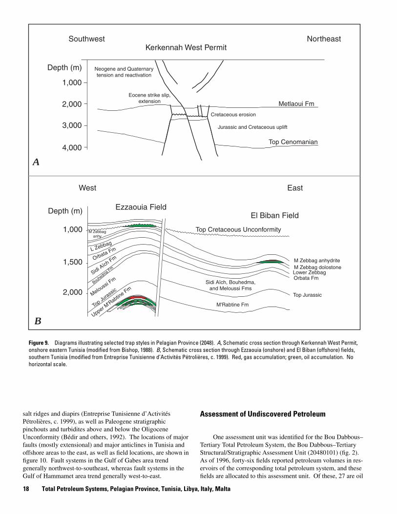
Trap Types in Oil and Gas Fields
Generally, traps were developed by the formation of horst blocks and associated pinchouts during the Cretaceous to Paleocene, by reactivation of these horsts during the Miocene to Quaternary (fig. 9A), and by folding and subsequent faulting (fig. 9B) (Bédir and others, 1992; Entreprise Tunisienne d’Activités Pétrolières, c. 1999). Most of the discovered oil and gas fields (having reported petroleum in reservoirs within the Bou Dabbous–Tertiary Total Petroleum System as of 1996) are associated with low-amplitude anticlines, high-amplitude anti-clines associated with reverse faults (inversion anticlines), wrench fault structures, and stratigraphic features (Petroconsultants, 1996a; Entreprise Tunisienne d’Activités Pétrolières, c. 1999). Accumulations in combination structural-stratigraphic traps are also common. Potential traps may be associated with
The Bou Dabbous–Tertiary Total Petroleum System (204801) 15
9°E 11°E
37°
LIBYA
TUNISIA
AL
GE
RIA
0 100 KILOMETERS
Mediterranean Sea
Gulf of Hammamet
Gulf of Gabes
Oil field
Gas field
Nummulitid wackestone/packstone/grainstone
Nummulithoclastic packstone
Bioclastic wackestone with Nummulites debris
Gastropod coquina
Globigerinid mudstone/marl (Bou Dabbous)
Red algal-echinoid packstone/grainstone
Lagoonal/supratidal mudstone/wackestone and dolostone
Evaporite, some with terrigenous clastics
EXPLANATION
35°
33°
Figure 8. Lithofacies map of the Metlaoui Group (excluding the Chouabine and Tselja Formations) and locations of fields with reported oil and gas volumes in Bou Dabbous–Tertiary Total Petroleum System (204801) (modified from Bishop, 1988; Petroconsultants, 1996b). Dashed lines, approximate location. White areas, rock section is absent.
16 Total Petroleum Systems, Pelagian Province, Tunisia, Libya, Italy, Malta
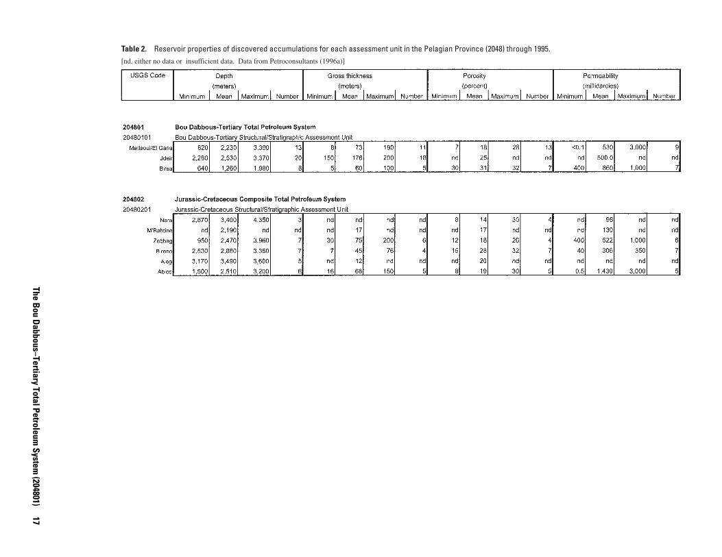
Table 2. Reservoir properties of discovered accumulations for each assessment unit in the Pelagian Province (2048) through 1995. [nd, either no data or insufficient data. Data from Petroconsultants (1996a)]
The Bou D
abbous–Tertiary Total Petroleum System
(204801) 17
1,000
2,000
3,000
4,000
Depth (m)
1,000
Depth (m)
1,500
2,000
Southwest
West East
Northeast Kerkennah West Permit
Ezzaouia Field El Biban Field
Metlaoui Fm
Top Cenomanian
M Zebbag anhydrite M Zebbag dolostone
Top Cretaceous Unconformity
Lower Zebbag Orbata Fm
Sidi Aïch
Fm
Bouhedma Fm
Meloussi Fm
Top Jurassic
M'Rabtine Fm
Sidi Aïch, Bouhedma, and Meloussi Fms
Upper M'Rabtin
e Fm
Top Ju
rassic
M Zebbag anhy
L Zebbag
Orbata Fm
A
B
Neogene and Quaternary tension and reactivation
Eocene strike slip, extension
Cretaceous erosion
Jurassic and Cretaceous uplift
Figure 9. Diagrams illustrating selected trap styles in Pelagian Province (2048). A, Schematic cross section through Kerkennah West Permit, onshore eastern Tunisia (modified from Bishop, 1988). B, Schematic cross section through Ezzaouia (onshore) and El Biban (offshore) fields, southern Tunisia (modified from Entreprise Tunisienne d’Activités Pétrolières, c. 1999). Red, gas accumulation; green, oil accumulation. No horizontal scale.
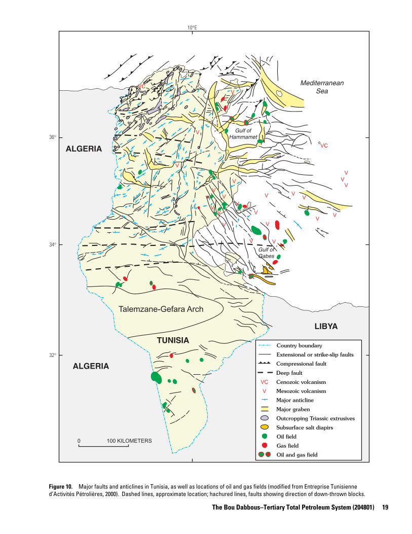
salt ridges and diapirs (Entreprise Tunisienne d’Activités Pétrolières, c. 1999), as well as Paleogene stratigraphic pinchouts and turbidites above and below the Oligocene Unconformity (Bédir and others, 1992). The locations of major faults (mostly extensional) and major anticlines in Tunisia and offshore areas to the east, as well as field locations, are shown in figure 10. Fault systems in the Gulf of Gabes area trend generally northwest-to-southeast, whereas fault systems in the Gulf of Hammamet area trend generally west-to-east.
Assessment of Undiscovered Petroleum
One assessment unit was identified for the Bou Dabbous– Tertiary Total Petroleum System, the Bou Dabbous–Tertiary Structural/Stratigraphic Assessment Unit (20480101) (fig. 2). As of 1996, forty-six fields reported petroleum volumes in reservoirs of the corresponding total petroleum system, and these fields are allocated to this assessment unit. Of these, 27 are oil
18 Total Petroleum Systems, Pelagian Province, Tunisia, Libya, Italy, Malta
10°E
36°
34°
32°
0 100 KILOMETERS
V
V
V
V
V V
V V
V
V V
V
V V
V
V V
V
V
V
V
V
VC
VC
Talemzane-Gefara Arch
Country boundary
Extensional or strike-slip faults
Oil field
Gas field
Compressional fault
Oil and gas field
V
VC Cenozoic volcanism
Mesozoic volcanism
Major anticline
Major graben
Outcropping Triassic extrusives
Subsurface salt diapirs
Deep fault
TUNISIA
Mediterranean Sea
LIBYA
ALGERIA
ALGERIA
Gulf of Gabes
Gulf of Hammamet
Figure 10. Major faults and anticlines in Tunisia, as well as locations of oil and gas fields (modified from Entreprise Tunisienne d’Activités Pétrolières, 2000). Dashed lines, approximate location; hachured lines, faults showing direction of down-thrown blocks.
The Bou Dabbous–Tertiary Total Petroleum System (204801) 19
fields, 14 are gas fields, and 5 fields are not classified because they contained less than 1 MMBOE. Combined, these fields contained 2,114 MMBO, 15,509 BCFG, and 44 MMBNGL, as known volumes (table 1) (Petroconsultants, 1996a). Minimum field sizes of 4 MMBO and 24 BCFG were chosen for this assessment unit based on the field-size distribution of discov�ered fields.
At the end of 1995, the exploration density was approxi�mately 15 new-field wildcat wells per 10,000 km2. Exploration activity was not consistent through time, peaking from the 1970’s to the early 1980’s, and experiencing a resurgence start�ing in the early 1990’s. Exploration appears to be in a moder�ately mature stage across much of the area. The overall success rate has been approximately 26 discoveries per 100 new-field wildcat wells (or about one discovery per four new-field wildcat wells). As of 1996, offshore fields existed in water depths that range from about 4 to 350 m, averaging about 135 m. The sizes of oil and gas fields discovered have generally decreased through time and with respect to exploration activity. Trends in field sizes or number of discoveries with respect to exploration activ�ity (number of new-field wildcat wells drilled) are not apparent. Plots showing exploration activity and discovery history are pre�sented in Appendix 1.
Exploration of structural and combination traps is expected to continue, and many more fields, both oil and gas, could be discovered. Discoveries in structural and stratigraphic traps involving the Metlaoui Group reservoirs are likely to be smaller than existing accumulations, whereas discoveries in the Birsa sandstone may contribute larger volumes to reserves than in the past. Stratigraphic traps involving the Fortuna sandstone and lateral equivalents may also contain important accumulations.
This study estimates that about one-half of the total number of fields (discovered and undiscovered) of at least the minimum size has been discovered. The estimated median size and num�ber of undiscovered oil fields are 12 MMBO and 30 fields; the same values for undiscovered gas fields are 60 BCFG and 15 fields. The ranges of number, size, and coproduct-ratio esti�mates for undiscovered fields are given in table 3.
The estimated means of the undiscovered conventional petroleum volumes are 667 MMBO, 2,746 BCFG, and 64 MMBNGL (table 4). The mean size of the largest anticipated undiscovered oil and gas fields is 110 MMBO and 283 BCFG, respectively.
The Jurassic-Cretaceous Composite Total Petroleum System (204802)
The Jurassic-Cretaceous Composite Total Petroleum Sys�tem extends across most of the Pelagian Province. This sys�tem and corresponding assessment unit (Jurassic-Cretaceous Structural/Stratigraphic Assessment Unit, 20480201) generally coincide with the potential extent of petroleum migration from Jurassic and Cretaceous source rocks. As mentioned previ�ously, the Upper Cretaceous to Paleocene El Haria mudstone separates this total petroleum system from the overlying
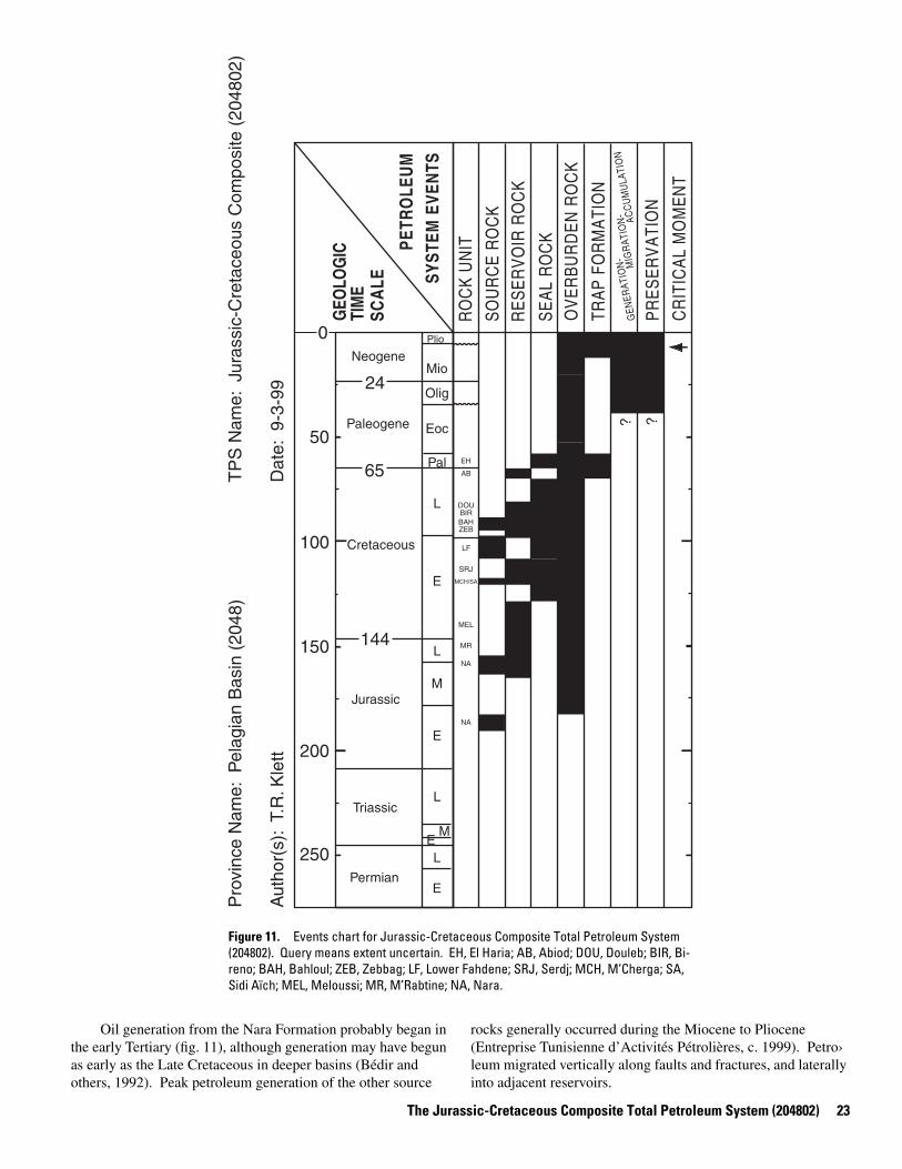
Tertiary total petroleum system. Where the El Haria mudstone is absent in the southern part of the Pelagian Prov�ince, the total petroleum system boundary is approximated by the Cretaceous-Paleocene boundary. Triassic evaporites and Lower Jurassic carbonate rocks separate this total petroleum system from any underlying systems. An events chart (fig. 11) summarizes the ages of source, reservoir, and seal rocks; the timing of trap development; and generation and migration of petroleum.
During the Jurassic and Early Cretaceous, faulting and strong local subsidence defined deep-water basins separated by uplifted fault blocks, which consisted of slope and carbonate platform deposits (Morgan and others, 1998). The deep-water basins allowed deposition of organic-rich sediments and turbidite fan deposits (Bédir and others, 1992; Morgan and others, 1998).
Transpression and inversion during the Late Cretaceous and Paleogene caused uplift and erosion of carbonate plat-forms that formed previously along fault zones. These struc�tural events, as well as more recent deformation, provided traps for petroleum accumulations (Bédir and others, 1992; Morgan and others, 1998). Petroleum generation occurred throughout the Tertiary.
Source Rocks
The primary source rocks are mudstone of the Jurassic Nara Formation, Lower Cretaceous M’Cherga Formation, Albian Lower Fahdene Formation, and Cenomanian to Turonian Bahloul Formation. According to Entreprise Tunisienne d’Activités Pétrolières (c. 1999), the Jurassic Nara Formation source rock exists in an elongated northwest to southeast trend from central Tunisia through the Gulf of Gabes and extending along the coast into Libya. Cretaceous source rocks are present throughout much of the Pelagian Province, although the distri�bution of the Bahloul Formation is limited to an arcuate and elongate, northwest to southeast trend (fig. 4). Combined, one or more of the Jurassic and Cretaceous source rocks are present across most of the province.
Source rock properties are described by Entreprise Tunisi�enne d’Activités Pétrolières (c. 1999) as follows:
1. The Nara Formation source rocks are thin black mud-stone with alternating limestone; approximately 80 m thick; contain as much as 2 percent TOC; maturation described as mature to late mature.
2. The M’Cherga Formation source rocks are light- to dark-gray calcareous and dolomitic mudstone containing type II kerogen; as much as 100 m thick; contain 0.2–3 percent TOC; maturation described as mature to late mature.
3. The Lower Fahdene Formation source rocks are dark pelagic marl with interbedded limestone containing type II and III kerogen; as much as 150 m thick; contain 0.5–3 percent TOC; maturation described as early mature to mature.
4. The Bahloul Formation source rocks are laminated black argillaceous limestone containing type II kerogen; approximately 20 m thick; contain as much as 14 percent TOC; maturation described as early mature to mature.
20 Total Petroleum Systems, Pelagian Province, Tunisia, Libya, Italy, Malta
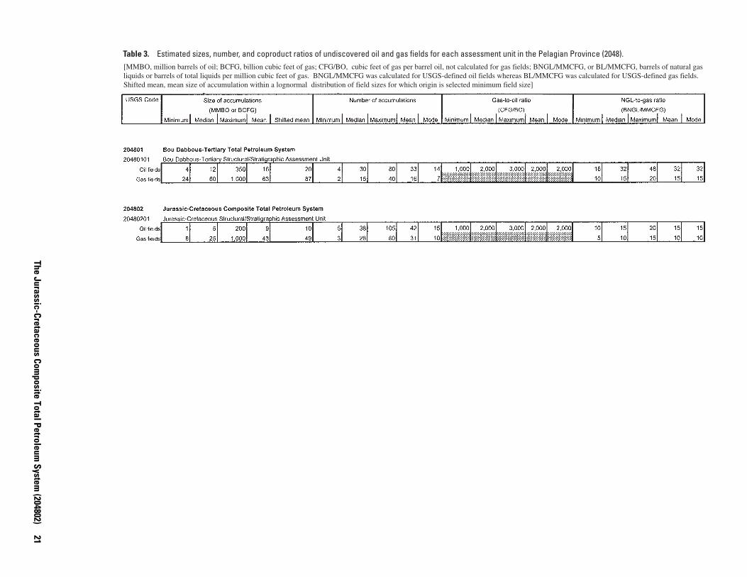
Table 3. Estimated sizes, number, and coproduct ratios of undiscovered oil and gas fields for each assessment unit in the Pelagian Province (2048). [MMBO, million barrels of oil; BCFG, billion cubic feet of gas; CFG/BO, cubic feet of gas per barrel oil, not calculated for gas fields; BNGL/MMCFG, or BL/MMCFG, barrels of natural gas liquids or barrels of total liquids per million cubic feet of gas. BNGL/MMCFG was calculated for USGS-defined oil fields whereas BL/MMCFG was calculated for USGS-defined gas fields. Shifted mean, mean size of accumulation within a lognormal distribution of field sizes for which origin is selected minimum field size]
The Jurassic-Cretaceous Composite Total Petroleum
System (204802)
21
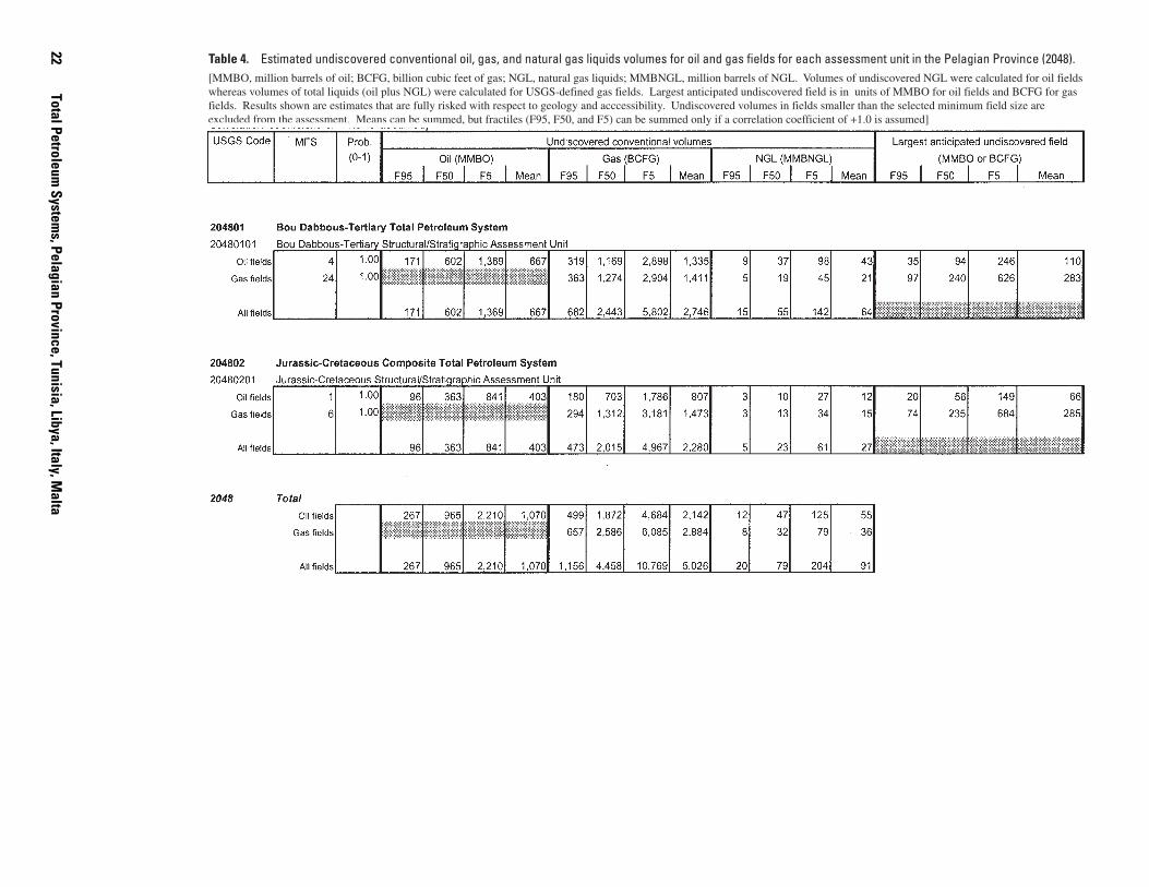
22 Table 4. Estimated undiscovered conventional oil, gas, and natural gas liquids volumes for oil and gas fields for each assessment unit in the Pelagian Province (2048). [MMBO, million barrels of oil; BCFG, billion cubic feet of gas; NGL, natural gas liquids; MMBNGL, million barrels of NGL. Volumes of undiscovered NGL were calculated for oil fields whereas volumes of total liquids (oil plus NGL) were calculated for USGS-defined gas fields. Largest anticipated undiscovered field is in units of MMBO for oil fields and BCFG for gas fields. Results shown are estimates that are fully risked with respect to geology and acccessibility. Undiscovered volumes in fields smaller than the selected minimum field size are excluded from the assessment. Means can be summed, but fractiles (F95, F50, and F5) can be summed only if a correlation coefficient of +1.0 is assumed]
Total Petroleum System
s, Pelagian Province, Tunisia, Libya, Italy, Malta
Pro
vinc
e N
ame:
Pel
agia
n B
asin
(20
48)
TP
S N
ame:
Jur
assi
c-C
reta
ceou
s C
ompo
site
(20
4802
)
Aut
hor(
s):
T.R
. Kle
tt D
ate:
9-3
-99
Cretaceous
PR
ES
ER
VA
TIO
N
CR
ITIC
AL
MO
ME
NT
GEN
ERAT
ION
-
TRA
P F
OR
MA
TIO
N
OV
ER
BU
RD
EN
RO
CK
RE
SE
RV
OIR
RO
CK
SE
AL
RO
CK
SO
UR
CE
RO
CK
RO
CK
UN
IT
PETR
OLE
UM
SY
STEM
EVE
NTS
GEO
LOG
IC
TIM
E SC
ALE
0
100
200
50
150
250
Paleogene
Jurassic
Triassic
Permian
65
144
E
E
E
E
M
M
L
L
L
L
Neogene
24
Pal
Eoc
Olig
Mio
Plio
ACC
UM
ULA
TIO
NM
IGR
ATIO
N
MCH/SA
SRJ
LF
BAH ZEB
EH
BIR DOU
AB
MEL
MR
NA
NA
? ?
Figure 11. Events chart for Jurassic-Cretaceous Composite Total Petroleum System (204802). Query means extent uncertain. EH, El Haria; AB, Abiod; DOU, Douleb; BIR, Bireno; BAH, Bahloul; ZEB, Zebbag; LF, Lower Fahdene; SRJ, Serdj; MCH, M’Cherga; SA, Sidi Aïch; MEL, Meloussi; MR, M’Rabtine; NA, Nara.
Oil generation from the Nara Formation probably began in the early Tertiary (fig. 11), although generation may have begun as early as the Late Cretaceous in deeper basins (Bédir and others, 1992). Peak petroleum generation of the other source
rocks generally occurred during the Miocene to Pliocene (Entreprise Tunisienne d’Activités Pétrolières, c. 1999). Petro�leum migrated vertically along faults and fractures, and laterally into adjacent reservoirs.
The Jurassic-Cretaceous Composite Total Petroleum System (204802) 23
The API gravity of oil generated from the Jurassic and Cretaceous source rock ranges from 28º to 37º; the mean is 33º (Petroconsultants, 1996a; GeoMark, 1998). The sulfur content ranges from 0.2 to 0.4 percent, with a mean of 0.3 percent (GeoMark, 1998).
Overburden Rocks
Cretaceous and Cenozoic rocks make up most of the over-burden. As with the overlying Bou Dabbous–Tertiary Total Petroleum System, overburden rocks are variable across the area (fig. 5). In addition to strata removed by erosion during the Cen�ozoic (previously described in the Bou Dabbous–Tertiary Total Petroleum System section), minor amounts of Lower Cretaceous and Upper Cretaceous to Paleocene rocks are also absent (figs. 5B and 6).
Reservoir Rocks
Known reservoir rocks include: (1) Middle to Upper Juras�sic Nara Formation dolomite or dolomitic limestone and M'Rab�tine sandstone; (2) Lower Cretaceous Meloussi and Sidi Aïch sandstone and Orbata and Serdj carbonates; and (3) Upper Cre�taceous Zebbag, Isis, and Bireno, Douleb, and Miskar carbon�ates and Abiod fractured chalk (table 2, fig. 6). Figure 12 shows the distribution of Zebbag Formation reservoirs, as well as loca�tions of fields having reported oil and gas volumes from reser�voirs within the Jurassic-Cretaceous Composite Total Petroleum System.
Most of the discovered oil volumes in this total petroleum system, as of 1996, appears to be in Lower Cretaceous Bireno (approximately 38 MMBO) and Jurassic (approximately 34 MMBO) reservoirs, whereas most of the discovered gas appears to be in Upper Cretaceous Abiod fractured reservoirs (approxi�mately 1,000 BCFG).
Seal Rocks
Seals include Upper Jurassic to Lower Cretaceous mud-stone of the M’Cherga Formation; various Lower to Upper Cre�taceous mudstone and carbonate rocks, including Aleg mudstone; and Upper Cretaceous to Paleocene El Haria mud-stone (Macgregor and Moody, 1998; Entreprise Tunisienne d’Activités Pétrolières, c. 1999).
Trap Types in Oil and Gas Fields
As with the Bou Dabbous–Tertiary Total Petroleum System, trap types of known accumulations include fault blocks, low-amplitude anticlines, high-amplitude anticlines associated with reverse faults (inversion anticlines), wrench fault structures,
and stratigraphic traps (fig. 9A and B). Volumetrically, most of the discovered oil in the Jurassic-Cretaceous Total Petroleum System appears to be in anticlinal traps, whereas most of the discovered gas appears to be in fault-related traps.
Assessment of Undiscovered Petroleum
One assessment unit was identified for the Jurassic-Creta�ceous Composite Total Petroleum System, Jurassic-Cretaceous Structural/Stratigraphic Assessment Unit (20480201) (fig. 3). As of 1996, twenty-six fields reported petroleum volumes in reservoirs of the corresponding total petroleum system, and these fields are allocated to this assessment unit. Of these dis�covered fields, 11 are oil fields, 6 are gas fields, and 9 fields are not classified because they contain less than 1 MMBOE. Com�bined, these fields contain 103 MMBO, 1,301 BCFG, and 23 MMBNGL, as known volumes (table 1) (Petroconsultants, 1996a). Minimum field sizes of 1 MMBO and 6 BCFG were chosen for this assessment unit based on the field-size distribu�tion of discovered fields.
At the end of 1995, the exploration density was approxi�mately eight new-field wildcat wells per 10,000 km2. Explora�tion activity has been variable through time and appears to be in an immature stage. The overall success rate is approximately 14 discoveries per 100 new-field wildcat wells (or about one dis�covery per seven new-field wildcat wells). As of 1996, offshore fields existed in water depths that range from about 5 to 82 m, averaging about 46 m. The size and number of oil fields appear to have increased with respect to exploration activity, whereas trends for gas fields were not apparent. Additionally, more recent oil field discoveries have been made at shallower depths. Plots showing exploration activity and discovery history are pre�sented in Appendix 2.
Exploration for structural and combination traps is expected to continue, resulting in the probable discovery of more fields, both oil and gas. Discoveries in structural and stratigraphic traps involving Zebbag (and lateral equivalents), Douleb, and Abiod reservoirs will most likely continue as exploration progresses seaward into deeper water. Some of these discoveries may be substantial. More discoveries may also be made in Jurassic rocks, but these may be few and small due to the limited extent of mature source rocks and reservoirs.
This study estimates that about one-fourth of the total num�ber of fields (discovered and undiscovered) of at least the mini-mum size has been discovered to date. The estimated median size and number of undiscovered oil fields are 5 MMBO and 38 fields; the same values for undiscovered gas fields are 25 BCFG and 28 fields. The ranges of number, size, and coproduct-ratio estimates for undiscovered fields are given in table 3.
The estimated means of the undiscovered conventional petroleum volumes are 403 MMBO, 2,280 BCFG, and 27 MMBNGL (table 4). In addition, the mean size of the largest anticipated undiscovered oil and gas fields is 66 MMBO and 285 BCFG, respectively.
24 Total Petroleum Systems, Pelagian Province, Tunisia, Libya, Italy, Malta
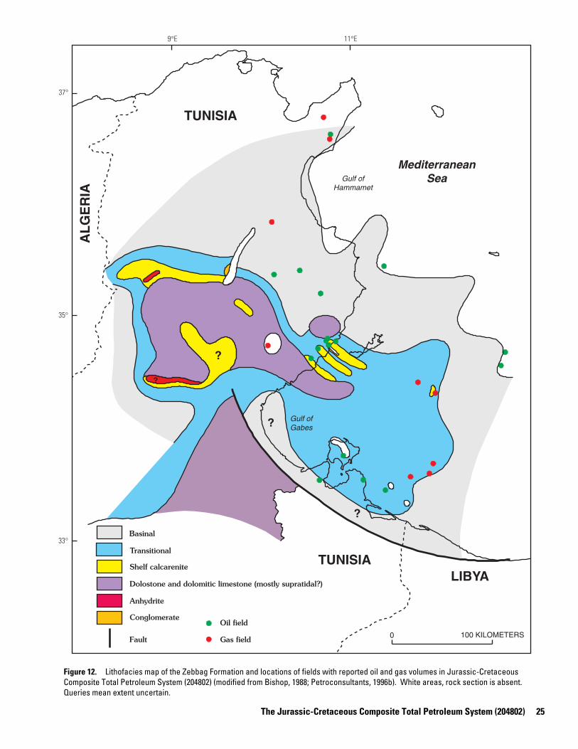
9°E 11°E
37°
?
?
?
?
LIBYA TUNISIA
TUNISIA
AL
GE
RIA
Transitional
Fault
Shelf calcarenite
Dolostone and dolomitic limestone (mostly supratidal?)
Anhydrite
Basinal
Conglomerate
0 100 KILOMETERS
Mediterranean Sea
Oil field
Gas field
Gulf of Hammamet
Gulf of Gabes
35°
33°
Figure 12. Lithofacies map of the Zebbag Formation and locations of fields with reported oil and gas volumes in Jurassic-Cretaceous Composite Total Petroleum System (204802) (modified from Bishop, 1988; Petroconsultants, 1996b). White areas, rock section is absent. Queries mean extent uncertain.
The Jurassic-Cretaceous Composite Total Petroleum System (204802) 25
Summary
Two “composite” total petroleum systems, the Bou Dabbous–Tertiary and Jurassic-Cretaceous Composite, are identified in the Pelagian Province (2048). The Bou Dabbous–Tertiary Total Petroleum System (204801) and corresponding assessment unit coincide with the potential extent of petroleum migration from Eocene source rocks. The Jurassic-Cretaceous Composite Total Petroleum System (204802) and corresponding assessment unit coincide with the potential extent of petroleum migration from Jurassic and Cretaceous source rocks. The Upper Cretaceous to Paleocene El Haria mudstone separates the two total petroleum systems over much of the area.
It is likely that much of the petroleum in the Gulf of Hammamet area was derived from Cretaceous source rocks. If this is the case, then the discovered and undiscovered oil and gas volumes of the Bou Dabbous–Tertiary Total Petroleum System should be included in the Jurassic-Cretaceous Composite Total Petroleum System.
The primary source rock of the Bou Dabbous–Tertiary Total Petroleum System is dark-brown marl and mudstone of the lower Eocene Bou Dabbous Formation, which became mature in the Miocene to Pleistocene. Known reservoir rocks include lateral equivalents of the lower Eocene Bou Dabbous Formation, such as the El Garia fractured limestone; Eocene Jirani dolostone, Jdeir limestone, and Reineche limestone; Oligocene to Miocene Ketatna limestone; and the middle Miocene Aïn Grab limestone and Birsa sandstone. Seals include Eocene and Miocene mudstone and carbonate rocks. Known accumulations are in fault blocks, low-amplitude anticlines, high-amplitude anticlines associated with reverse faults, wrench fault structures, and stratigraphic traps.
The primary source rocks of the Jurassic-Cretaceous Composite Total Petroleum System include mudstone of the Jurassic Nara Formation, Lower Cretaceous M’Cherga and Lower Fahdene Formations, and Upper Cretaceous Bahloul Formation. Oil generation probably began in the early Tertiary, and peak petroleum generation likely took place in the Miocene and Pliocene. Known reservoir rocks include the Nara Formation dolomite or dolomitic limestone; Upper Jurassic M’Rabtine sandstone; Lower Cretaceous Meloussi and Sidi Aïch sandstone and Orbata and Serdj carbonates; and Upper Cretaceous Zebbag, Isis, Bireno, Douleb, and Miskar carbonates and Abiod chalk. Seals include Upper Jurassic to Lower Cretaceous mudstone of the M’Cherga Formation, various Lower to Upper Cretaceous mud-stone and carbonate rocks, and the Upper Cretaceous to Paleocene El Haria mudstone. Trap types of known accumulations include fault blocks, low-amplitude anticlines, high-amplitude anticlines associated with reverse faults, wrench fault structures, and stratigraphic traps.
The estimated mean undiscovered conventional petroleum resources in the Bou Dabbous–Tertiary Total Petroleum System are 667 MMBO, 2,746 BCFG, and 64 MMBNGL. The estimated mean undiscovered conventional petroleum resources in the Jurassic-Cretaceous Composite Total Petroleum System are 403 MMBO, 2,280 BCFG, and 27 MMBNGL. The combined estimated mean undiscovered conventional petroleum resources
of both total petroleum systems of the Pelagian Province are 1,070 MMBO, 5,026 BCFG, and 91 MMBNGL.
References Cited
Aliev, M., Aït Laoussine, N., Avrov, V., Aleksine, G., Barouline, G., Lakovlev, B., Korj, M., Kouvykine, J., Makarov, V., Mazanov, V., Medvedev, E., Mkrtchiane, O., Moustafinov, R., Oriev, L., Oroudjeva, D., Oulmi, M., and Saïd, A., 1971, Geological structures and estimation of oil and gas in the Sahara in Algeria: Spain, Altamira-Rotopress, S.A., 265 p.
Arab Petroleum Research Center, 1998, Arab Oil and Gas Directory: Par-is, Arab Petroleum Research Center, 640 p.
Bédir, M., Zargouni, F., Tlig, S., and Bobier, C., 1992, Subsurface geodynamics and petroleum geology of transform margin basins in the Sahel of Mahdia and El Jem (eastern Tunisia): American Association of Petroleum Geologists Bulletin, v. 76, no. 9, p. 1417–1442.
Bishop, W.F., 1975, Geology of Tunisia and adjacent parts of Algeria and Libya: American Association of Petroleum Geologists Bulletin, v. 59, no. 3, p. 413–450.
Bishop, W.F., 1988, Petroleum geology of east-central Tunisia: American Association of Petroleum Geologists Bulletin, v. 72, no. 9, p. 1033– 1058.
Bobier, C., Viguier, C., Chaari, A., and Chine, A., 1991, The post-Triassic sedimentary cover of Tunisia: Seismic sequences and structure: Tectonophysics, v. 195, p. 371–410.
Boote, D.R.D., Clark-Lowes, D.D., and Traut, M.W., 1998, Palaeozoic petroleum systems of North Africa, in Macgregor, D.S., Moody, R.T.J., and Clark-Lowes, D.D., eds., Petroleum geology of North Africa: Geological Society, London, Special Publication 132, p. 7–68.
Burollet, P.F., 1967a, General geology of Tunisia, in Guidebook to the geology and history of Tunisia: Petroleum Exploration Society of Libya, Ninth Annual Field Conference, p. 51–58.
Burollet, P.F., 1967b, Tertiary geology of Tunisia, in Guidebook to the geology and history of Tunisia: Petroleum Exploration Society of Libya, Ninth Annual Field Conference, p. 215–225.
Burollet, P.F., 1990, Evolution of Atlassic basins in Tunisia [abs.]: American Association of Petroleum Geologists Bulletin, v. 74, no. 5, p. 622.
Burollet, P.F., 1991, Structures and tectonics of Tunisia: Tectonophysics, v. 195, p. 359–369.
Burollet, P.F., Mugniot, J.M., and Sweeney, P., 1978, The geology of the Pelagian block—The margins and basins off southern Tunisia and Tripolitania, in Nairn, A.E.M., Kanes, W.H., and Stehli, F.G., eds., The ocean basins and margins: New York, Plenum Press, v. 4B, p. 331– 359.
Busson, G., 1967, Mesozoic of southern Tunisia, in Guidebook to the geology and history of Tunisia: Petroleum Exploration Society of Libya, Ninth Annual Field Conference, p. 131–151.
Davies, W.C., and Bel Haiza, A., 1990, Sweeter E and P terms, Cretaceous Abiod chalk oil play lead to busier exploration in Tunisia: Oil and Gas Journal, December 10, p. 50–53.
Entreprise Tunisienne d’Activités Pétrolières, 1997, Tunisian Strati-graphic Chart: Tunis, Tunisia, Entreprise Tunisienne d’Activités Pétrolières.
Entreprise Tunisienne d’Activités Pétrolières, c. 1999, Information packet: Tunis, Tunisia, Entreprise Tunisienne d’Activités Pétrolières.
26 Total Petroleum Systems, Pelagian Province, Tunisia, Libya, Italy, Malta
Entreprise Tunisienne d’Activités Pétrolières, 2000, Tunisia open acre-age: Tunis, Tunisia, Imprimeries Réunies Groupe Cérès Conseil DDB, 77 p.
Environmental Systems Research Institute, 1996, ArcWorld 1:3M World cartographic layers: Redlands, Calif., Environmental Systems Research Institute, Inc.; available from Environmental Systems Research Institute, Inc., 380 New York Street, Redlands, CA 92373-8100 U.S.A.
Finetti, I., 1982, Structure, stratigraphy and evolution of central Mediterranean: Bollettino di Geofisica Teorica ed Applicata, v. 24, no. 96, p. 247–312.
GeoMark Research, 1998, OILS; Oil information library system, version 1.0: Houston, Texas, GeoMark Research, Inc.; database available from GeoMark Research, Inc., 9748 Whithorn Drive, Houston, TX 77095 U.S.A.
Guiraud, R., 1998, Mesozoic rifting and basin inversion along the north-ern African Tethyan margin: an overview, in Macgregor, D.S., Moody, R.T.J., and Clark-Lowes, D.D., eds., Petroleum geology of North Africa: Geological Society, London, Special Publication 132, p. 217–229.
Hammuda, O.S., van Hinte, J.E., and Nederbragt, S., 1991, Geohistory analysis mapping in central and southern Tarabulus Basin, northwestern offshore Libya, in Salem, M.J., Hammuda, O.S., and Eliagoubi, B.A., eds., The geology of Libya, Volume IV: Amsterdam, The Netherlands, Elsevier Science Publishers B.V., p. 1657–1680.
Jongsma, D., van Hinte, J.E., and Woodside, J.M., 1985, Geologic structure and neotectonics of the North African Continental Margin south of Sicily: Marine and Petroleum Geology, v. 2, p. 156–179.
Klett, T.R., Ahlbrandt, T.S., Schmoker, J.W., and Dolton, G. L., 1997, Ranking of the world's oil and gas provinces by known petroleum volumes: U.S. Geological Survey Open-File Report 97-463, 1 CD-ROM.
Knott, I., Moody, R., and Sandman, R., 1995, Coniacian-Turonian carbonates of the Miskar Field, offshore Tunisia [abs]: American Association of Petroleum Geologists Bulletin, v. 79, no. 8, p. 1227.
Long, M., 1978, Tertiary oil discoveries whet explorer interest off Tunisia: Oil and Gas Journal, v. 76, no. 2 (January 9), p. 64–69.
Lore, G.L., Brooke, J.P., Cooke, D.W., Klazynski, R.J., Olson, D.L., and Ross, K.M., 1996, Summary of the 1995 assessment of conventionally recoverable hydrocarbon resources of the Gulf of Mexico and Atlantic Outer Continental Shelf: Minerals Management Service OCS Report MMS 96-0047, 67 p.
Loucks, R.G., Moody, R.T.J., Bellis, J.K., and Brown, A.A., 1998, Regional depositional setting and pore network systems of the El Garia Formation (Metlaoui Group, Lower Eocene), offshore Tunisia, in Macgregor, D.S., Moody, R.T.J., and Clark-Lowes, D.D., eds., Petroleum geology of North Africa: Geological Society, London, Special Publication 132, p. 355–374.
Lucazeau, F., and Ben Dhia, H., 1989, Preliminary heat-flow density data from Tunisia and the Pelagian Sea: Canadian Journal of Earth Sciences, v. 26, p. 993–1000.
Macgregor, D.S., and Moody, R.T.J., 1998, Mesozoic and Cenozoic petroleum systems of North Africa, in Macgregor, D.S., Moody, R.T.J., and Clark-Lowes, D.D., eds., Petroleum geology of North Africa: Geological Society, London, Special Publication 132, p. 201–216.
Magoon, L.B., and Dow, W.G., 1994, The petroleum system, in Magoon, L.B., and Dow, W.G., eds., The petroleum systemFrom source to trap: American Association of Petroleum Geologists Memoir 60, p. 3–24.
Montgomery, S., 1994, Ghadames Basin and surrounding areas—Structure, tectonics, geochemistry and field summaries: Petroleum Frontiers, v. 10, no. 4, 79 p.
Morgan, M.A., Grocott, J., and Moody, R.T.J., 1998, The structural evolution of the Zaghouan-Ressas Structural Belt, northern Tunisia, in Macgregor, D.S., Moody, R.T.J., and Clark-Lowes, D.D., eds., Petroleum geology of North Africa: Geological Society, London, Special Publication 132, p. 405–422.
M’Rabet, A., 1984, Neocomian deltaic complex in central Tunisia: A particular example of ancient sedimentation and basin evolution: Sedimentary Geology, v. 40, p. 191–209.
Nelson, H.D., ed., 1979, Libya, a country study: Washington, D.C., American University, Foreign Area Studies, 350 p.
Ouali, J., 1985, Structure et évolution géodynamique du chaînon Nara-Sidi Khalif (Tunisie Centrale): Bulletin des Centres de Recherches Exploration-Production Elf-Aquitaine, v. 9, no. 1, p. 155–182.
Persits, F., Ahlbrandt, T., Tuttle, M., Charpentier, R., Brownfield, M., and Takahashi, K., 1997, Maps showing geology, oil and gas fields and geologic provinces of Africa: U.S. Geological Survey Open-File Report 97-470A.
Petroconsultants, 1996a, Petroleum exploration and production data-base: Houston, Texas, Petroconsultants, Inc., [database available from Petroconsultants, Inc., P.O. Box 740619, Houston, TX 77274-0619].
Petroconsultants, 1996b, PetroWorld 21: Houston, Texas, Petroconsultants, Inc., [database available from Petroconsultants, Inc., P.O. Box 740619, Houston, TX 77274-0619].
Petzet, G.A., 1999, Patience, persistence preceded Elephant discovery in Libya: Oil and Gas Journal, v. 97, no. 20 (May 17), p. 65–66.
Salaj, J., 1978, The geology of the Pelagian block; The eastern Tunisian platform, in Nairn, A.E.M., Kanes, W.H., and Stehli, F.G., eds., The ocean basins and margins; The western Mediterranean, v. 4B: New York, Plenum Press, p. 361–416.
Schmoker, J.W., and Crovelli, R.A., 1998, A simplified spreadsheet pro-gram for estimating future growth of oil and gas reserves: Nonrenewable Resources, v. 7, no. 2, p. 149–155.
Schwab, A.M., 1995, Oligocene-Miocene shallow marine carbonates in offshore Tunisia: A sequence stratigraphic case study of an integrated data set [abs.]: American Association of Petroleum Geologists Bulletin, v. 79, no. 8, p. 1247.
Vially, R., Letouzey, J., Bénard, F., Haddadi, N., Desforges, G., Askri, H., and Boudjema, A., 1994, Basin inversion along the North African margin—The Saharan Atlas (Algeria), in Roure, F., ed., Peri-Tethyan platforms: Paris, Éditions Technip, p. 79–117.
Wilson, M., and Guiraud, R., 1998, Late Permian to Recent magmatic activity on the African-Arabian margin of the Tethys, in Macgregor, D.S., Moody, R.T.J., and Clark-Lowes, D.D., eds., Petroleum geology of North Africa: Geological Society, London, Special Publication 132, p. 231–263.
U.S. Geological Survey World Energy Assessment Team, 2000, U.S. Geological Survey World Petroleum Assessment 2000Description and results: U.S. Geological Survey Digital Data Series DDS-60, 4 CD-ROMs.
References Cited 27

Appendices
Two sets of exploration-activity and discovery-history plots are provided for each of the
assessment units in the Pelagian Province, one set showing known field sizes (cumulative
production plus remaining reserves) and another showing field sizes that were adjusted to
compensate for potential reserve growth that may occur in the next 30 years (labeled “grown”).
Within each set of plots, oil fields and gas fields are treated separately. The plots include:
• Cumulative Number of New-Field Wildcat Wells vs. Drilling-Completion Year
• Number of New-Field Wildcat Wells vs. Drilling-Completion Year
• Oil- or Gas-Field Size (MMBO or BCFG) vs. Oil- or Gas-Field Rank by Size (With
Respect to Discovery Halves or Thirds)
• Number of Oil or Gas Fields vs. Oil- or Gas-Field Size Classes (MMBO or BCFG) (With
Respect to Discovery Halves or Thirds)
• Volume of Oil or Gas (MMBO or BCFG) vs. Oil- or Gas-Field Size Classes
(MMBO or BCFG)
• Oil- or Gas-Field Size (MMBO or BCFG) vs. Field-Discovery Year
• Oil- or Gas-Field Size (MMBO or BCFG) vs. Cumulative Number of New-Field
Wildcat Wells
• Cumulative Oil or Gas Volume (MMBO or BCFG) vs. Field-Discovery Year
• Cumulative Oil or Gas Volume (MMBO or BCFG) vs. Cumulative Number of New-
Field Wildcat Wells
• Cumulative Number of Oil or Gas Fields vs. Field-Discovery Year

• Cumulative Number of Oil or Gas Fields vs. Cumulative Number of New-Field
Wildcat Wells
• Reservoir Depth, Oil or Gas Fields (m) vs. Field-Discovery Year
• Reservoir Depth, Oil or Gas Fields (m) vs. Cumulative Number of New-Field
Wildcat Wells
• Gas/Oil, Oil Fields (CFG/BO) vs. Mean Reservoir Depth (m)
• NGL/Gas, Oil Fields (BNGL/MMCFG) vs. Mean Reservoir Depth (m)
• Liquids/Gas, Gas Fields (BL/MMCFG) vs. Mean Reservoir Depth (m)
• Number of Reservoirs in Oil Fields vs. API Gravity (Degrees)

Appendix 1. Exploration-activity and discovery-history plots for the Bou Dabbous-Tertiary
Structural/Stratigraphic Assessment Unit (20480101). A. Plots of known oil and gas volumes.

Bou Dabbous-Tertiary Structural/Stratigraphic, Assessment Unit 20480101
180
CU
M. N
EW
-FIE
LD
WIL
DC
AT
WE
LL
S (
No
.)
160
140
120
100
80
60
40
20
0
1950 1955 1960 1965 1970 1975 1980 1985 1990 1995 2000
DRILLING-COMPLETION YEAR
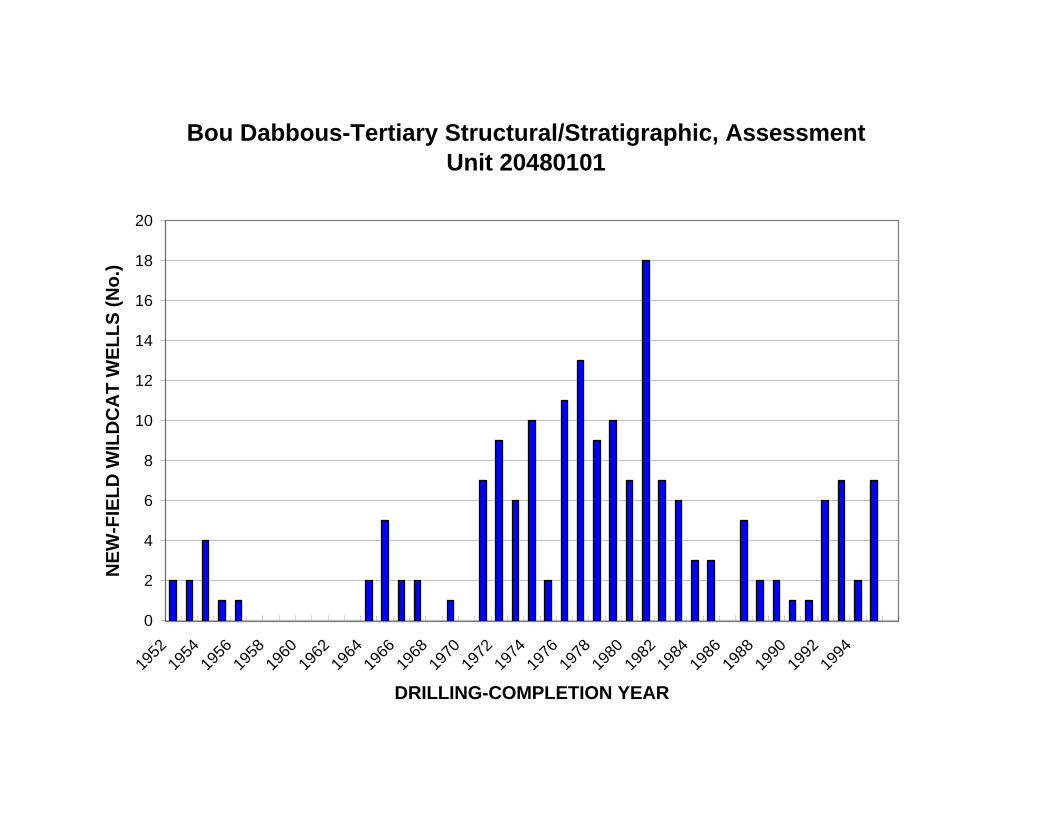
Bou Dabbous-Tertiary Structural/Stratigraphic, Assessment Unit 20480101
20
NE
W-F
IEL
D W
ILD
CA
T W
EL
LS
(N
o.)
18
16
14
12
10
8
6
4
2
0
1952
1954
1956
1958
1960
1962
1964
1966
1968
1970
1972
1974
1976
1978
1980
1982
1984
1986
1988
1990
1992
1994
DRILLING-COMPLETION YEAR

Bou Dabbous-Tertiary Structural/Stratigraphic, Assessment Unit 20480101
10,000
KN
OW
N O
IL-F
IEL
D S
IZE
(M
MB
O)
1,000
100
10
First third of fields discovered
Second third of fields discovered
Third third of fields discovered
1
0 2 4 6 8 10
OIL-FIELD RANK BY SIZE
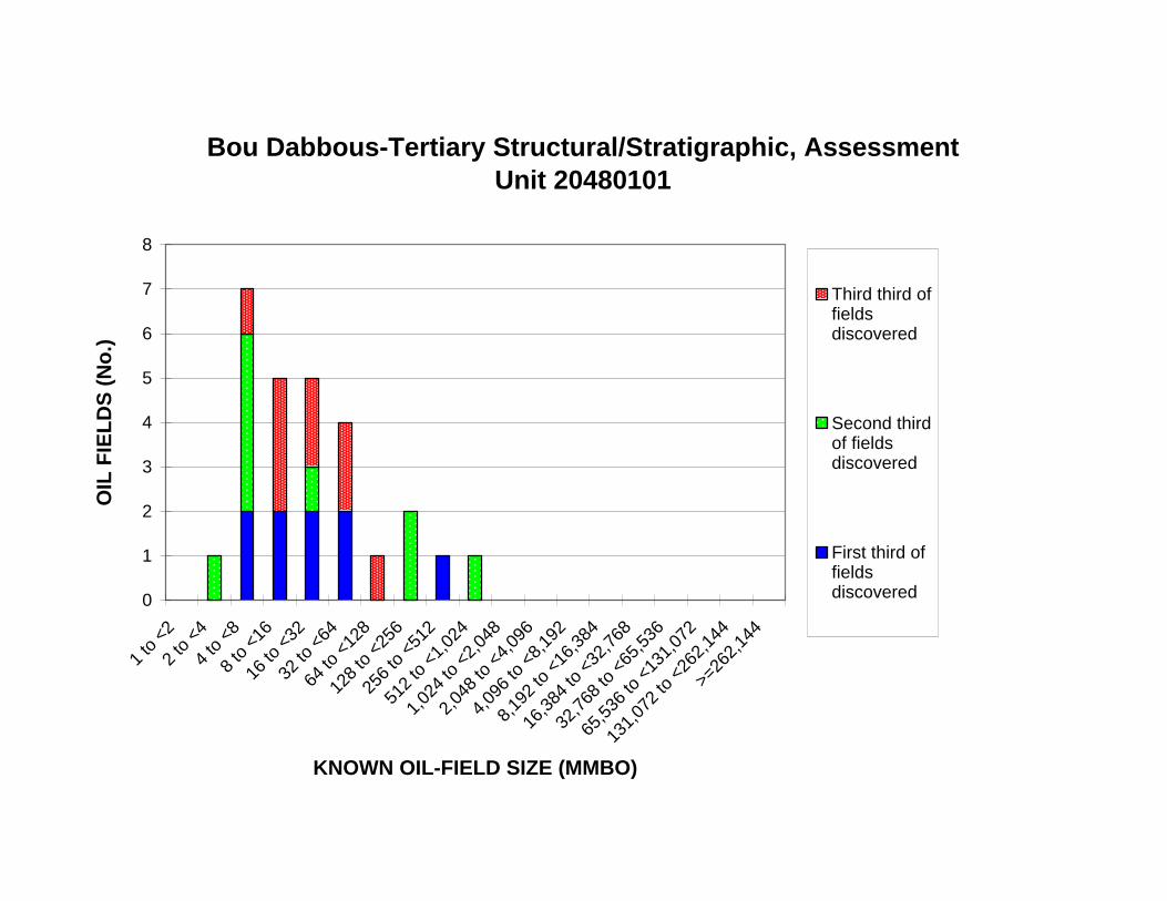
16 to
<32
32 to
<64
64 to
<12
8
128
to <
256
256
to <
512
512
to <
1,02
4
1,02
4 to
<2,
048
2,04
8 to
<4,
096
4,09
6 to
<8,
192
8,19
2 to
<16
,384
16,3
84 to
<32
,768
32,7
68 to
<65
,536
65,5
36 to
<13
1,07
2
Bou Dabbous-Tertiary Structural/Stratigraphic, Assessment Unit 20480101
8
7 Third third of fields discovered
Second third of fields discovered
First third of fields discovered
OIL
FIE
LD
S (
No
.) 6
5
4
3
2
1
0
1 to
<2
2 to
<4
4 to
<8
8 to
<16
>=26
2,14
4
131,
072
to <
262,
144
KNOWN OIL-FIELD SIZE (MMBO)
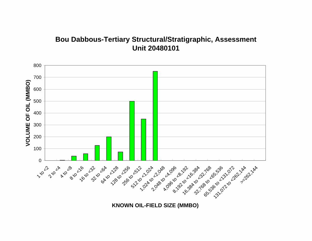
512
to <
1,02
4
1,02
4 to
<2,
048
2,04
8 to
<4,
096
4,09
6 to
<8,
192
8,19
2 to
<16
,384
16,3
84 to
<32
,768
32,7
68 to
<65
,536
65,5
36 to
<13
1,07
2
Bou Dabbous-Tertiary Structural/Stratigraphic, Assessment Unit 20480101
800
700
VO
LU
ME
OF
OIL
(M
MB
O)
600
500
400
300
200
100
0
1 to
<2
2 to
<4
4 to
<8
8 to
<16
16 to
<32
32 to
<64
64 to
<12
8
128
to <
256
256
to <
512
131,
072
to <
262,
144
>=26
2,14
4
KNOWN OIL-FIELD SIZE (MMBO)
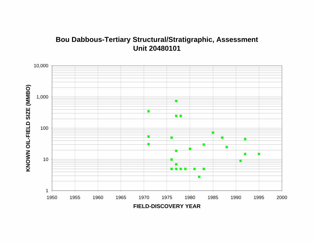
Bou Dabbous-Tertiary Structural/Stratigraphic, Assessment Unit 20480101
10,000
KN
OW
N O
IL-F
IEL
D S
IZE
(M
MB
O)
1,000
100
10
1
1950 1955 1960 1965 1970 1975 1980 1985 1990 1995 2000
FIELD-DISCOVERY YEAR

Bou Dabbous-Tertiary Structural/Stratigraphic, Assessment Unit 20480101
10,000
KN
OW
N O
IL-F
IEL
D S
IZE
(M
MB
O)
1,000
100
10
1
0 20 40 60 80 100 120 140 160 180
CUM. NEW-FIELD WILDCAT WELLS (No.)
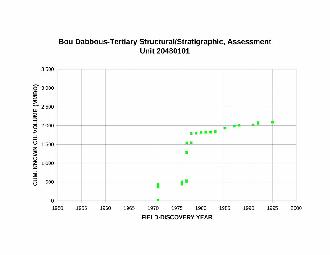
Bou Dabbous-Tertiary Structural/Stratigraphic, Assessment Unit 20480101
3,500
CU
M. K
NO
WN
OIL
VO
LU
ME
(M
MB
O)
3,000
2,500
2,000
1,500
1,000
500
0
1950 1955 1960 1965 1970 1975 1980 1985 1990 1995 2000
FIELD-DISCOVERY YEAR
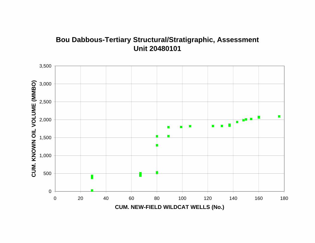
Bou Dabbous-Tertiary Structural/Stratigraphic, Assessment Unit 20480101
3,500
CU
M. K
NO
WN
OIL
VO
LU
ME
(M
MB
O)
3,000
2,500
2,000
1,500
1,000
500
0
0 20 40 60 80 100 120 140 160 180
CUM. NEW-FIELD WILDCAT WELLS (No.)

Bou Dabbous-Tertiary Structural/Stratigraphic, Assessment Unit 20480101
30
25
CU
M. O
IL F
IEL
DS
(N
o.)
20
15
10
5
0
1950 1955 1960 1965 1970 1975 1980 1985 1990 1995 2000
FIELD-DISCOVERY YEAR

Bou Dabbous-Tertiary Structural/Stratigraphic, Assessment Unit 20480101
30
25
CU
M. O
IL F
IEL
DS
(N
o.)
20
15
10
5
0
0 20 40 60 80 100 120 140 160 180
CUM. NEW-FIELD WILDCAT WELLS (No.)
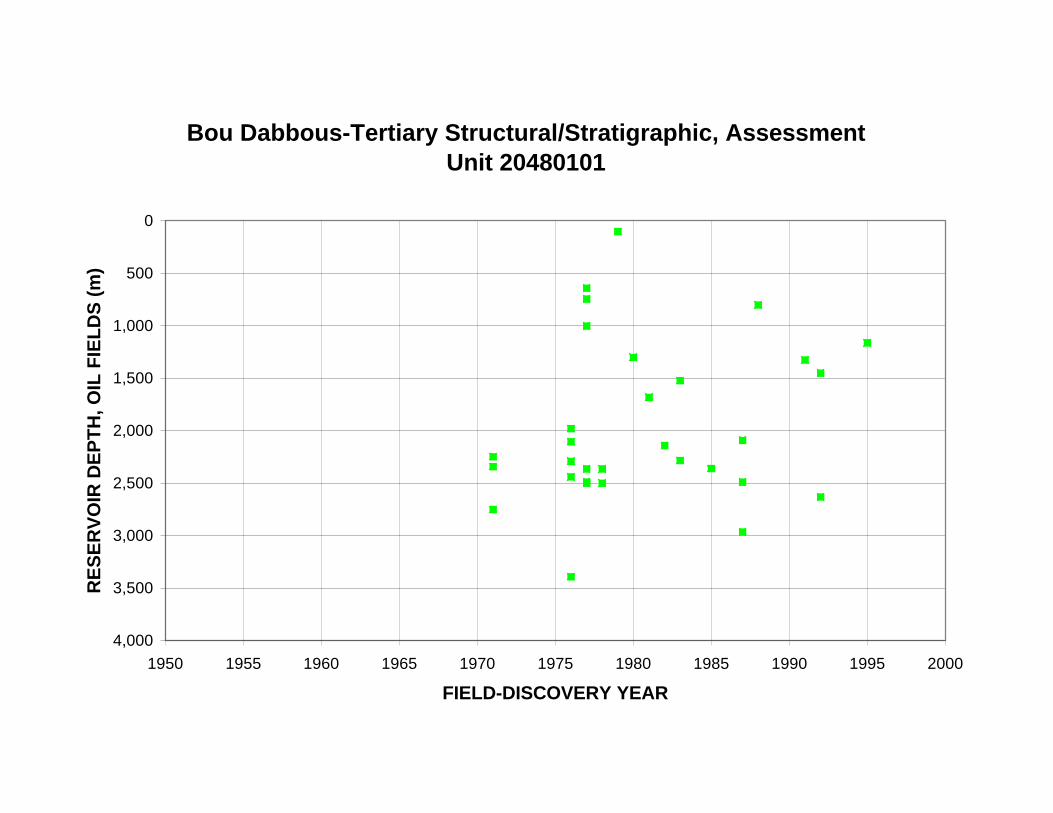
RE
SE
RV
OIR
DE
PT
H, O
IL F
IEL
DS
(m
)
Bou Dabbous-Tertiary Structural/Stratigraphic, Assessment Unit 20480101
0
500
1,000
1,500
2,000
2,500
3,000
3,500
4,000
1950 1955 1960 1965 1970 1975 1980 1985 1990 1995 2000
FIELD-DISCOVERY YEAR

RE
SE
RV
OIR
DE
PT
H, O
IL F
IEL
DS
(m
)
Bou Dabbous-Tertiary Structural/Stratigraphic, Assessment Unit 20480101
0
500
1,000
1,500
2,000
2,500
3,000
3,500
4,000
0 20 40 60 80 100 120 140 160 180
CUM. NEW-FIELD WILDCAT WELLS (No.)

Bou Dabbous-Tertiary Structural/Stratigraphic, Assessment Unit 20480101
14,000
12,000
GA
S/O
IL, O
IL F
IEL
DS
(C
FG
/BO
)
10,000
8,000
6,000
4,000
2,000
0
0 500 1,000 1,500 2,000 2,500 3,000 3,500 4,000
MEAN RESERVOIR DEPTH (m)

Bou Dabbous-Tertiary Structural/Stratigraphic, Assessment Unit 20480101
70
NG
L/G
AS
, OIL
FIE
LD
S (
BN
GL
/MM
CF
G)
60
50
40
30
20
10
0
0 500 1,000 1,500 2,000 2,500 3,000 3,500 4,000
MEAN RESERVOIR DEPTH (m)

Bou Dabbous-Tertiary Structural/Stratigraphic, Assessment Unit 20480101
16
RE
SE
RV
OIR
S IN
OIL
FIE
LD
S (
No
.) 14
12
10
8
6
4
2
0
0 to <10 10 to <20
20 to <30
30 to <40
40 to <50
50 to <60
60 to <70
70 to <80
80 to <90
90 to <100
>=100
API GRAVITY (DEGREES)
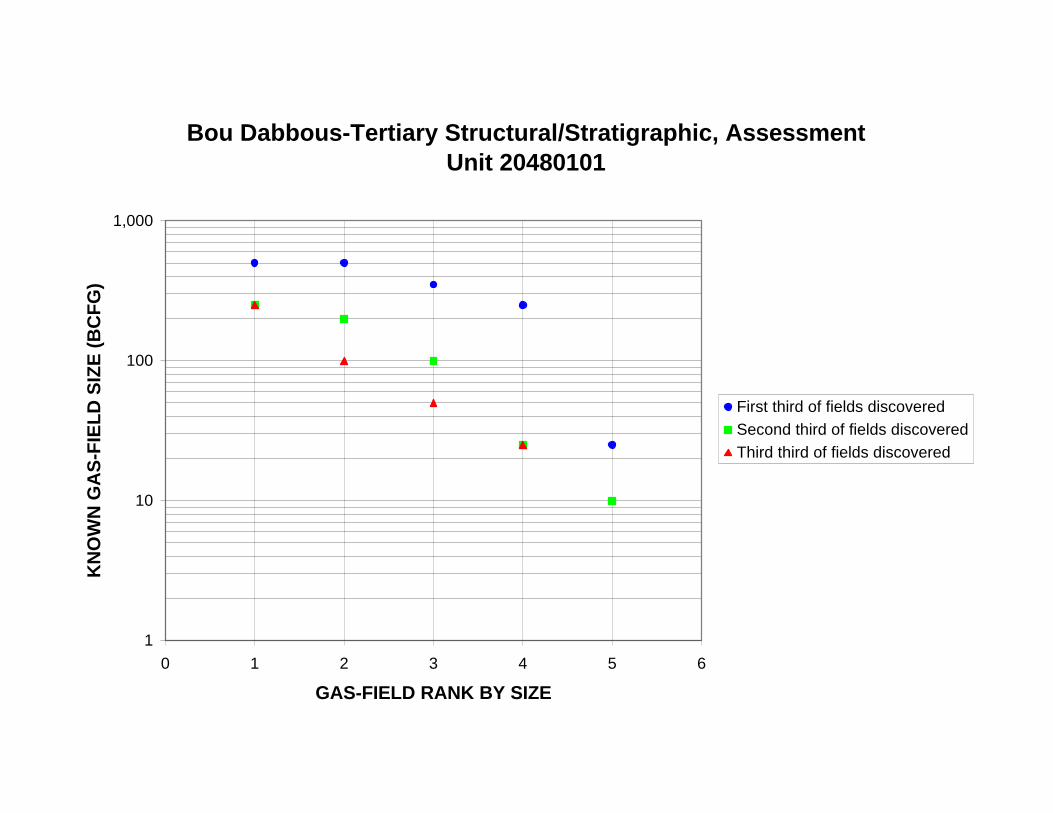
Bou Dabbous-Tertiary Structural/Stratigraphic, Assessment Unit 20480101
1,000
KN
OW
N G
AS
-FIE
LD
SIZ
E (
BC
FG
)
100
10
First third of fields discovered
Second third of fields discovered
Third third of fields discovered
1
0 1 2 3 4 5 6
GAS-FIELD RANK BY SIZE
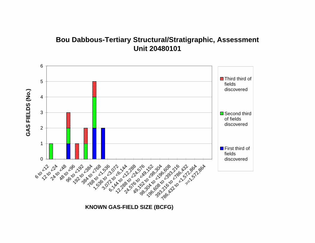
12 to
<24
24 to
<48
48 to
<96
96 to
<19
2
192
to <
384
384
to <
768
768
to <
1,53
6
1,53
6 to
<3,
072
3,07
2 to
<6,
144
6,14
4 to
<12
,288
12,2
88 to
<24
,576
24,5
76 to
<49
,152
49,1
52 to
<98
,304
98,3
04 to
<19
6,60
8
196,
608
to <
393,
216
393,
216
to <
786,
432
Bou Dabbous-Tertiary Structural/Stratigraphic, Assessment Unit 20480101
6
5Third third of fields discovered
Second third of fields discovered
First third of fields discovered
GA
S F
IEL
DS
(N
o.)
4
3
2
1
0
6 to
<12
>=1,
572,
864
786,
432
to <
1,57
2,86
4
KNOWN GAS-FIELD SIZE (BCFG)
768
to <
1,53
6
1,53
6 to
<3,
072
3,07
2 to
<6,
144
6,14
4 to
<12
,288
12,2
88 to
<24
,576
24,5
76 to
<49
,152
49,1
52 to
<98
,304
98,3
04 to
<19
6,60
8
196,
608
to <
393,
216
393,
216
to <
786,
432
Bou Dabbous-Tertiary Structural/Stratigraphic, Assessment Unit 20480101
1,400
VO
LU
ME
OF
GA
S (
BC
FG
) 1,200
1,000
800
600
400
200
0
6 to
<12
12 to
<24
24 to
<48
48 to
<96
96 to
<19
2
192
to <
384
384
to <
768
786,
432
to <
1,57
2,86
4
>=1,
572,
864
KNOWN GAS-FIELD SIZE (BCFG)
Bou Dabbous-Tertiary Structural/Stratigraphic, Assessment Unit 20480101
1,000
KN
OW
N G
AS
-FIE
LD
SIZ
E (
BC
FG
)
100
10
1
1950 1955 1960 1965 1970 1975 1980 1985 1990 1995 2000
FIELD-DISCOVERY YEAR
Bou Dabbous-Tertiary Structural/Stratigraphic, Assessment Unit 20480101
1,000
KN
OW
N G
AS
-FIE
LD
SIZ
E (
BC
FG
)
100
10
1
0 20 40 60 80 100 120 140 160 180
CUM. NEW-FIELD WILDCAT WELLS (No.)
Bou Dabbous-Tertiary Structural/Stratigraphic, Assessment Unit 20480101
4,000
CU
M. K
NO
WN
GA
S V
OL
UM
E (
BC
FG
) 3,500
3,000
2,500
2,000
1,500
1,000
500
0
1950 1955 1960 1965 1970 1975 1980 1985 1990 1995 2000
FIELD-DISCOVERY YEAR
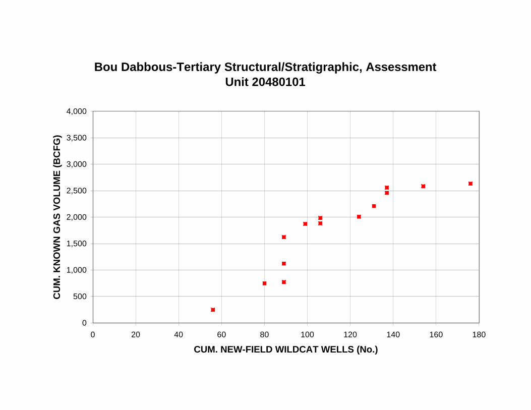
Bou Dabbous-Tertiary Structural/Stratigraphic, Assessment Unit 20480101
4,000
CU
M. K
NO
WN
GA
S V
OL
UM
E (
BC
FG
) 3,500
3,000
2,500
2,000
1,500
1,000
500
0
0 20 40 60 80 100 120 140 160 180
CUM. NEW-FIELD WILDCAT WELLS (No.)
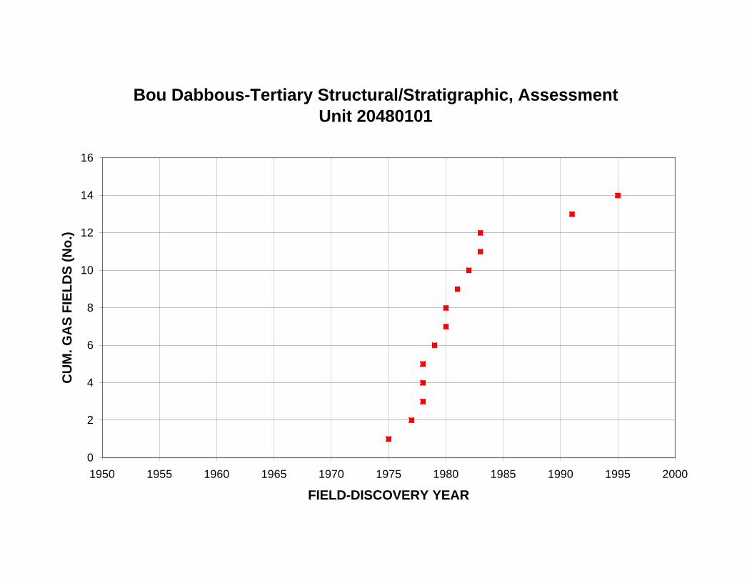
Bou Dabbous-Tertiary Structural/Stratigraphic, Assessment Unit 20480101
16
14
CU
M. G
AS
FIE
LD
S (
No
.) 12
10
8
6
4
2
0
1950 1955 1960 1965 1970 1975 1980 1985 1990 1995 2000
FIELD-DISCOVERY YEAR
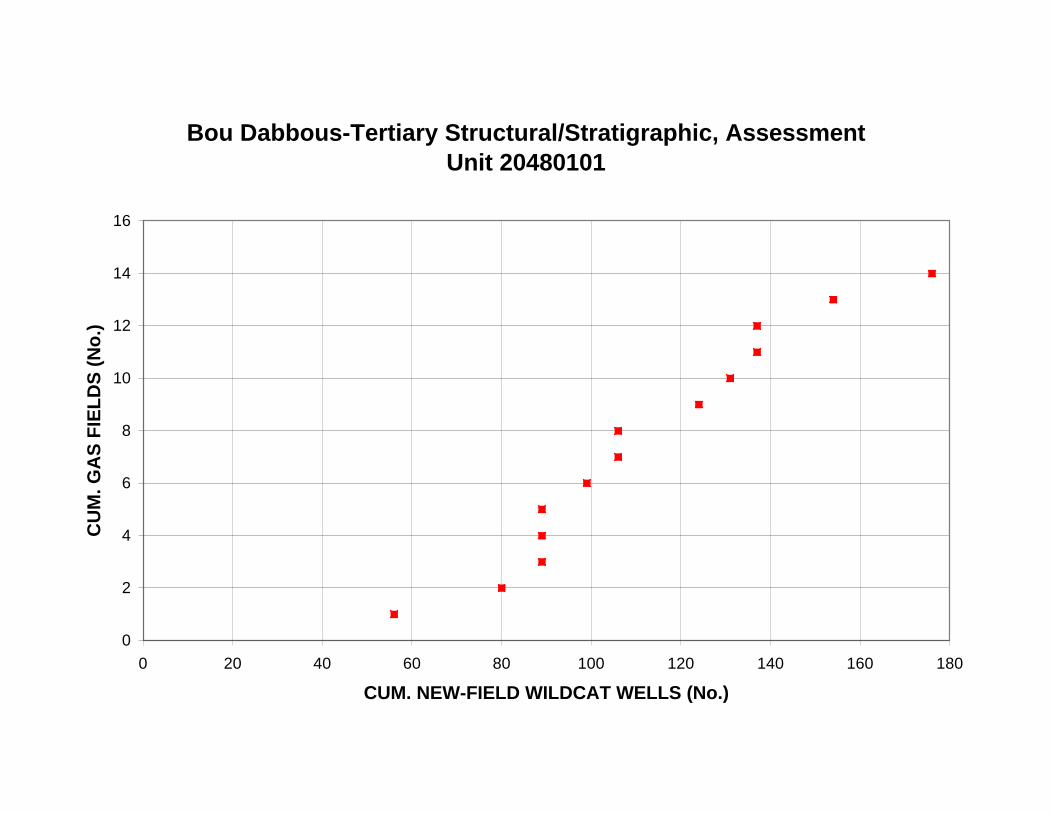
Bou Dabbous-Tertiary Structural/Stratigraphic, Assessment Unit 20480101
16
14
CU
M. G
AS
FIE
LD
S (
No
.) 12
10
8
6
4
2
0
0 20 40 60 80 100 120 140 160 180
CUM. NEW-FIELD WILDCAT WELLS (No.)

RE
SE
RV
OIR
DE
PT
H, G
AS
FIE
LD
S (
m)
Bou Dabbous-Tertiary Structural/Stratigraphic, Assessment Unit 20480101
0
500
1,000
1,500
2,000
2,500
3,000
3,500
4,000
1950 1955 1960 1965 1970 1975 1980 1985 1990 1995 2000
FIELD-DISCOVERY YEAR
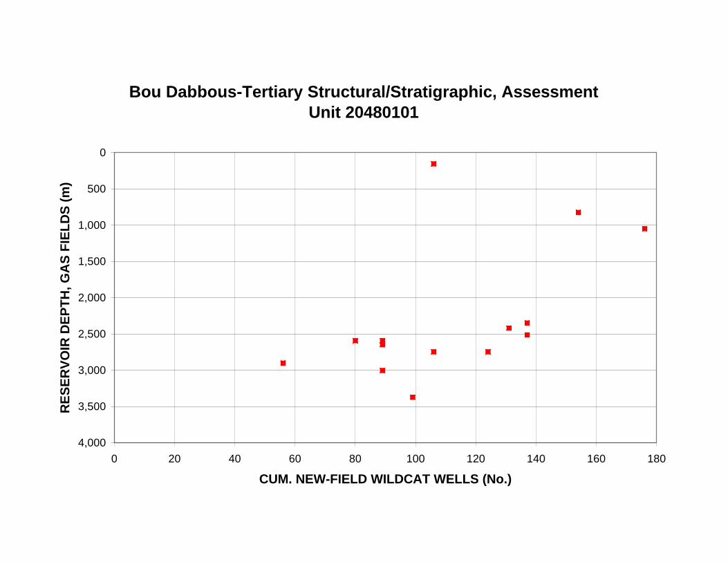
RE
SE
RV
OIR
DE
PT
H, G
AS
FIE
LD
S (
m)
Bou Dabbous-Tertiary Structural/Stratigraphic, Assessment Unit 20480101
0
500
1,000
1,500
2,000
2,500
3,000
3,500
4,000
0 20 40 60 80 100 120 140 160 180
CUM. NEW-FIELD WILDCAT WELLS (No.)

Bou Dabbous-Tertiary Structural/Stratigraphic, Assessment Unit 20480101
60
LIQ
UID
S/G
AS
, GA
S F
IEL
DS
(B
L/M
MC
FG
)
50
40
30
20
10
0
0 500 1,000 1,500 2,000 2,500 3,000 3,500 4,000
MEAN RESERVOIR DEPTH (m)

Appendix 1. Exploration-activity and discovery-history plots for the Bou Dabbous-Tertiary
Structural/Stratigraphic Assessment Unit (20480101). B. Plots of grown oil and gas volumes.
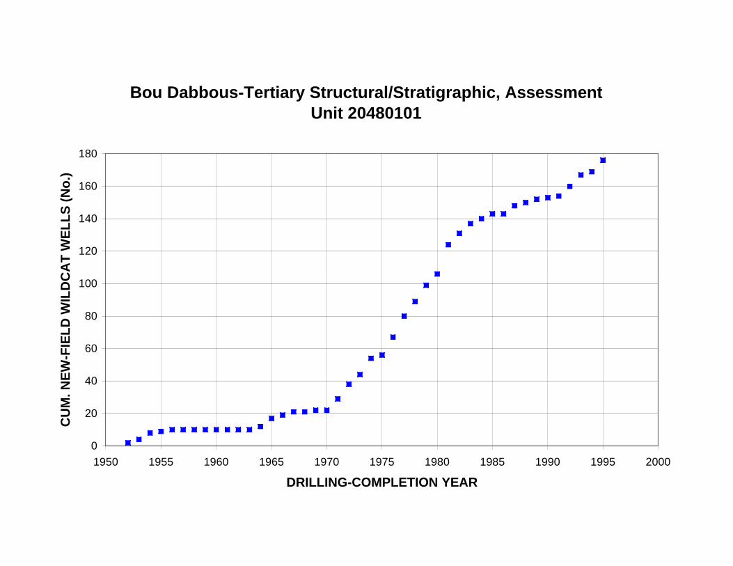
Bou Dabbous-Tertiary Structural/Stratigraphic, Assessment Unit 20480101
180
CU
M. N
EW
-FIE
LD
WIL
DC
AT
WE
LL
S (
No
.)
160
140
120
100
80
60
40
20
0
1950 1955 1960 1965 1970 1975 1980 1985 1990 1995 2000
DRILLING-COMPLETION YEAR

Bou Dabbous-Tertiary Structural/Stratigraphic, Assessment Unit 20480101
20
NE
W-F
IEL
D W
ILD
CA
T W
EL
LS
(N
o.)
18
16
14
12
10
8
6
4
2
0
1952
1954
1956
1958
1960
1962
1964
1966
1968
1970
1972
1974
1976
1978
1980
1982
1984
1986
1988
1990
1992
1994
DRILLING-COMPLETION YEAR
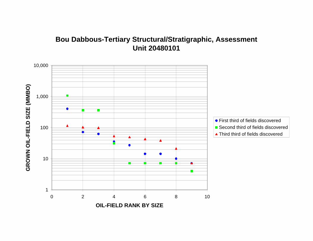
Bou Dabbous-Tertiary Structural/Stratigraphic, Assessment Unit 20480101
10,000
GR
OW
N O
IL-F
IEL
D S
IZE
(M
MB
O)
1,000
100
10
First third of fields discovered
Second third of fields discovered
Third third of fields discovered
1
0 2 4 6 8 10
OIL-FIELD RANK BY SIZE
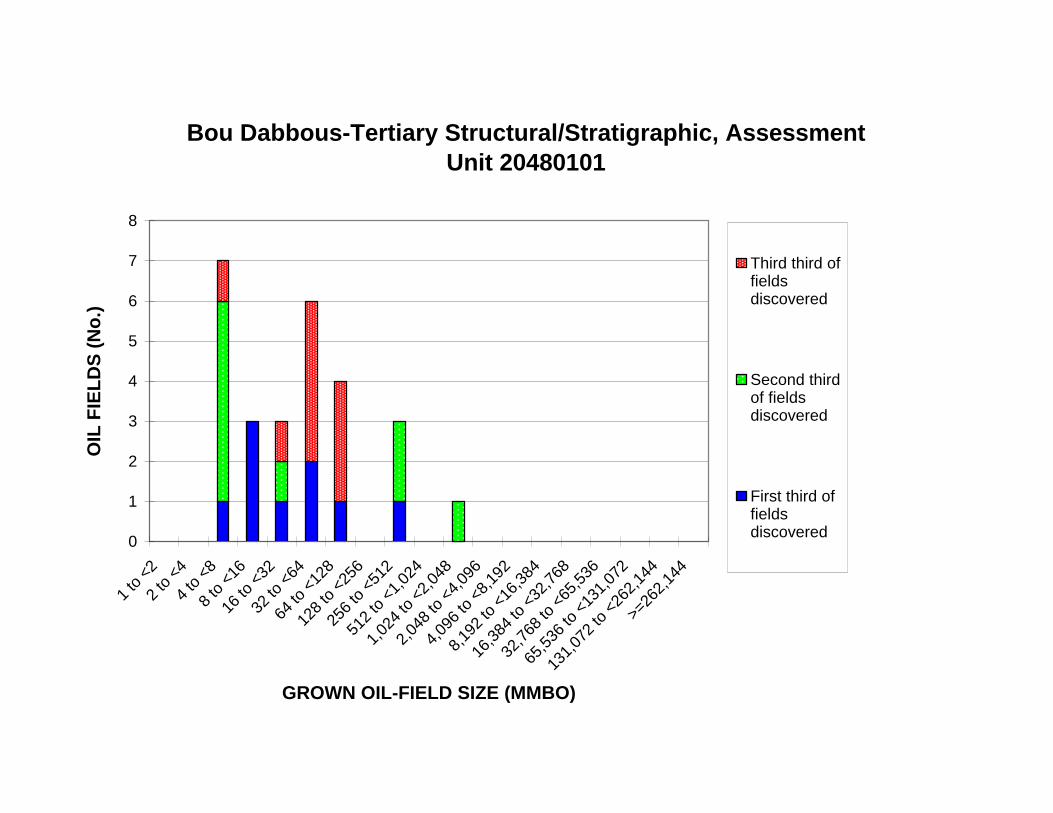
16 to
<32
32 to
<64
64 to
<12
8
128
to <
256
256
to <
512
512
to <
1,02
4
1,02
4 to
<2,
048
2,04
8 to
<4,
096
4,09
6 to
<8,
192
8,19
2 to
<16
,384
16,3
84 to
<32
,768
32,7
68 to
<65
,536
65,5
36 to
<13
1,07
2
Bou Dabbous-Tertiary Structural/Stratigraphic, Assessment Unit 20480101
8
7 Third third of fields discovered
Second third of fields discovered
First third of fields discovered
OIL
FIE
LD
S (
No
.) 6
5
4
3
2
1
0
1 to
<2
2 to
<4
4 to
<8
8 to
<16
>=26
2,14
4
131,
072
to <
262,
144
GROWN OIL-FIELD SIZE (MMBO)

512
to <
1,02
4
1,02
4 to
<2,
048
2,04
8 to
<4,
096
4,09
6 to
<8,
192
8,19
2 to
<16
,384
16,3
84 to
<32
,768
32,7
68 to
<65
,536
65,5
36 to
<13
1,07
2
Bou Dabbous-Tertiary Structural/Stratigraphic, Assessment Unit 20480101
1,200
VO
LU
ME
OF
OIL
(M
MB
O) 1,000
800
600
400
200
0
1 to
<2
2 to
<4
4 to
<8
8 to
<16
16 to
<32
32 to
<64
64 to
<12
8
128
to <
256
256
to <
512
131,
072
to <
262,
144
>=26
2,14
4
GROWN OIL-FIELD SIZE (MMBO)

Bou Dabbous-Tertiary Structural/Stratigraphic, Assessment Unit 20480101
10,000
GR
OW
N O
IL-F
IEL
D S
IZE
(M
MB
O)
1,000
100
10
1
1950 1955 1960 1965 1970 1975 1980 1985 1990 1995 2000
FIELD-DISCOVERY YEAR
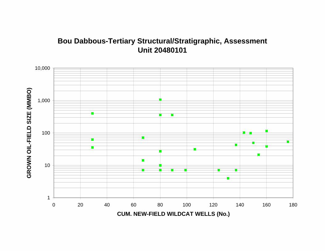
Bou Dabbous-Tertiary Structural/Stratigraphic, Assessment Unit 20480101
10,000
GR
OW
N O
IL-F
IEL
D S
IZE
(M
MB
O)
1,000
100
10
1
0 20 40 60 80 100 120 140 160 180
CUM. NEW-FIELD WILDCAT WELLS (No.)
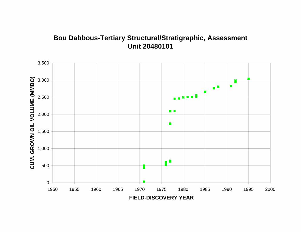
Bou Dabbous-Tertiary Structural/Stratigraphic, Assessment Unit 20480101
3,500
CU
M. G
RO
WN
OIL
VO
LU
ME
(M
MB
O)
3,000
2,500
2,000
1,500
1,000
500
0
1950 1955 1960 1965 1970 1975 1980 1985 1990 1995 2000
FIELD-DISCOVERY YEAR
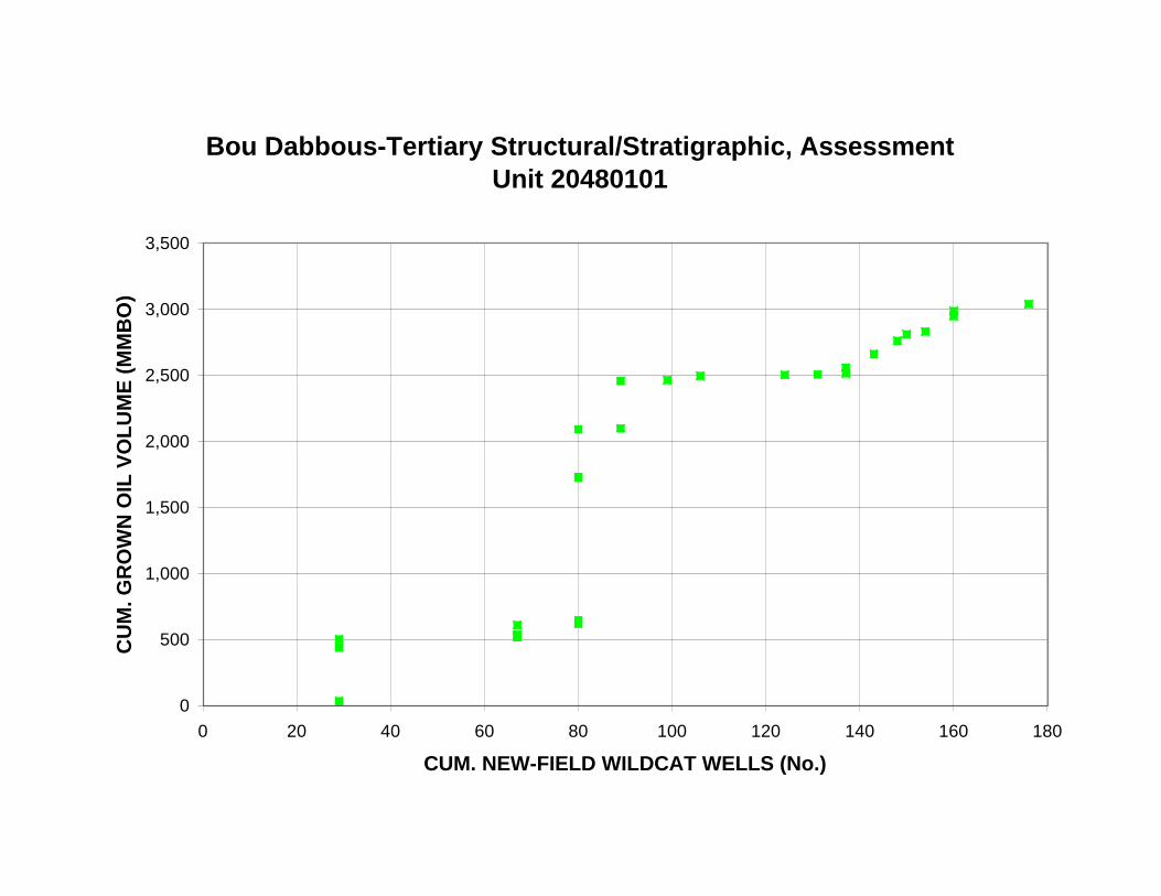
Bou Dabbous-Tertiary Structural/Stratigraphic, Assessment Unit 20480101
3,500
CU
M. G
RO
WN
OIL
VO
LU
ME
(M
MB
O)
3,000
2,500
2,000
1,500
1,000
500
0
0 20 40 60 80 100 120 140 160 180
CUM. NEW-FIELD WILDCAT WELLS (No.)
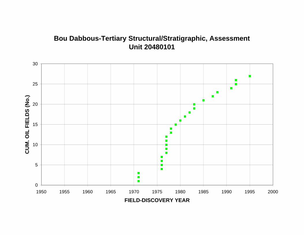
Bou Dabbous-Tertiary Structural/Stratigraphic, Assessment Unit 20480101
30
25
CU
M. O
IL F
IEL
DS
(N
o.)
20
15
10
5
0
1950 1955 1960 1965 1970 1975 1980 1985 1990 1995 2000
FIELD-DISCOVERY YEAR
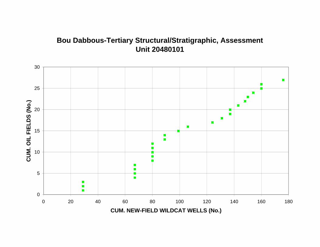
Bou Dabbous-Tertiary Structural/Stratigraphic, Assessment Unit 20480101
30
25
CU
M. O
IL F
IEL
DS
(N
o.)
20
15
10
5
0
0 20 40 60 80 100 120 140 160 180
CUM. NEW-FIELD WILDCAT WELLS (No.)

RE
SE
RV
OIR
DE
PT
H, O
IL F
IEL
DS
(m
)
Bou Dabbous-Tertiary Structural/Stratigraphic, Assessment Unit 20480101
0
500
1,000
1,500
2,000
2,500
3,000
3,500
4,000
1950 1955 1960 1965 1970 1975 1980 1985 1990 1995 2000
FIELD-DISCOVERY YEAR
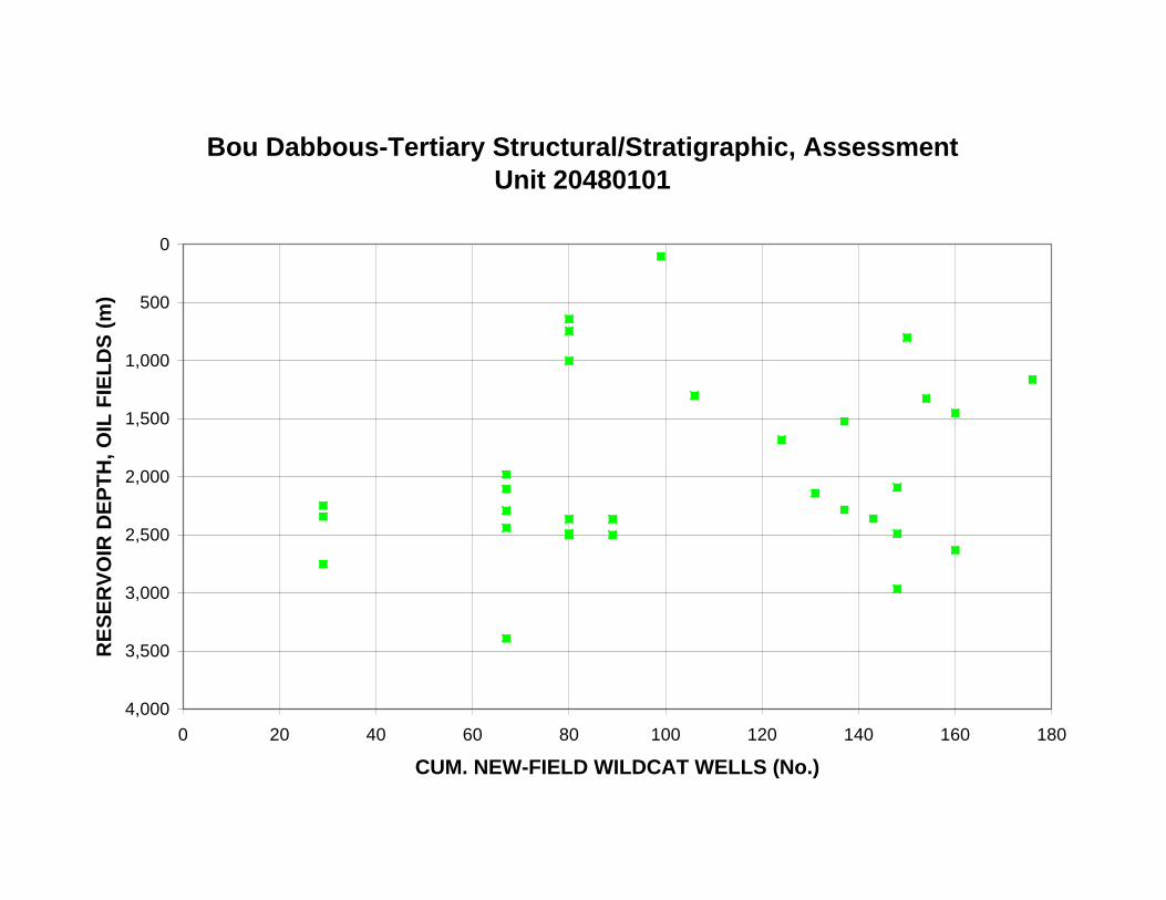
RE
SE
RV
OIR
DE
PT
H, O
IL F
IEL
DS
(m
)
Bou Dabbous-Tertiary Structural/Stratigraphic, Assessment Unit 20480101
0
500
1,000
1,500
2,000
2,500
3,000
3,500
4,000
0 20 40 60 80 100 120 140 160 180
CUM. NEW-FIELD WILDCAT WELLS (No.)
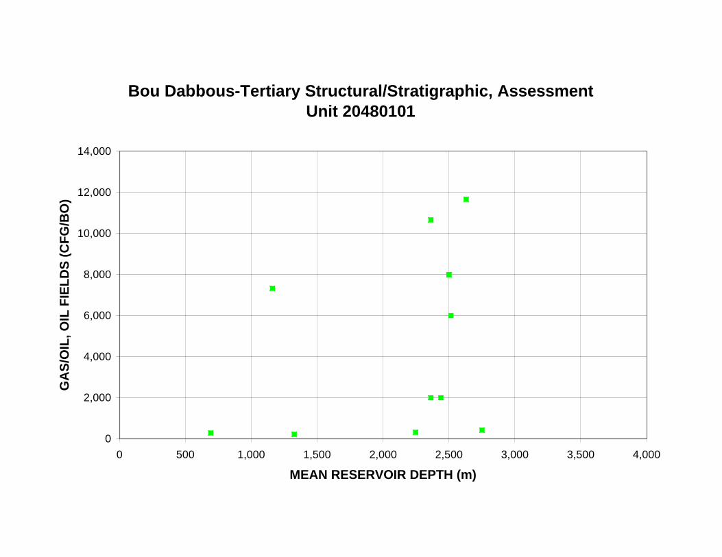
Bou Dabbous-Tertiary Structural/Stratigraphic, Assessment Unit 20480101
14,000
12,000
GA
S/O
IL, O
IL F
IEL
DS
(C
FG
/BO
)
10,000
8,000
6,000
4,000
2,000
0
0 500 1,000 1,500 2,000 2,500 3,000 3,500 4,000
MEAN RESERVOIR DEPTH (m)
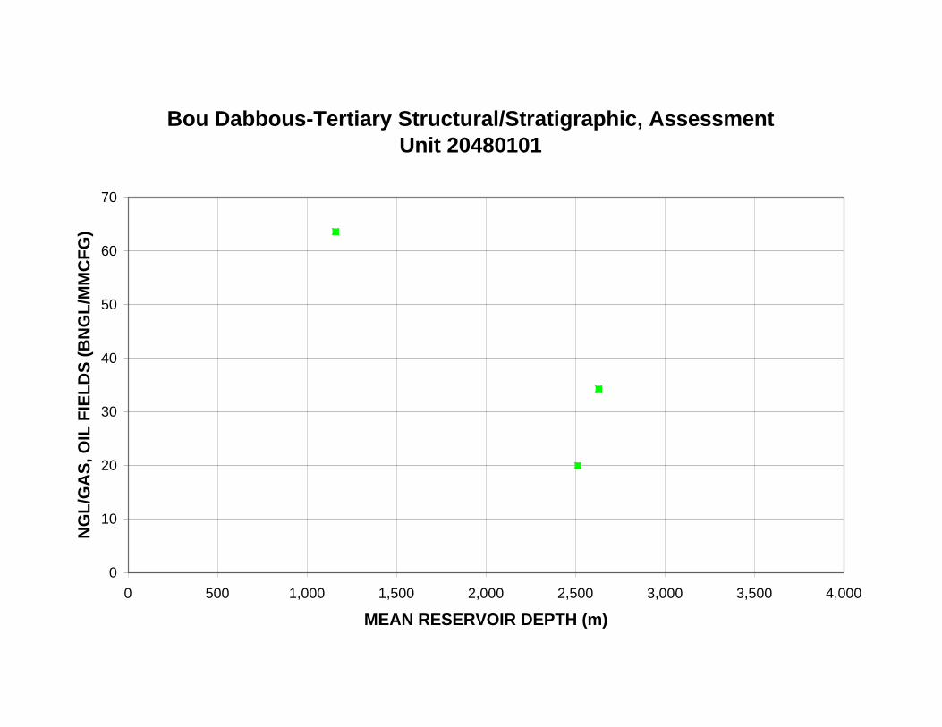
Bou Dabbous-Tertiary Structural/Stratigraphic, Assessment Unit 20480101
70
NG
L/G
AS
, OIL
FIE
LD
S (
BN
GL
/MM
CF
G)
60
50
40
30
20
10
0
0 500 1,000 1,500 2,000 2,500 3,000 3,500 4,000
MEAN RESERVOIR DEPTH (m)
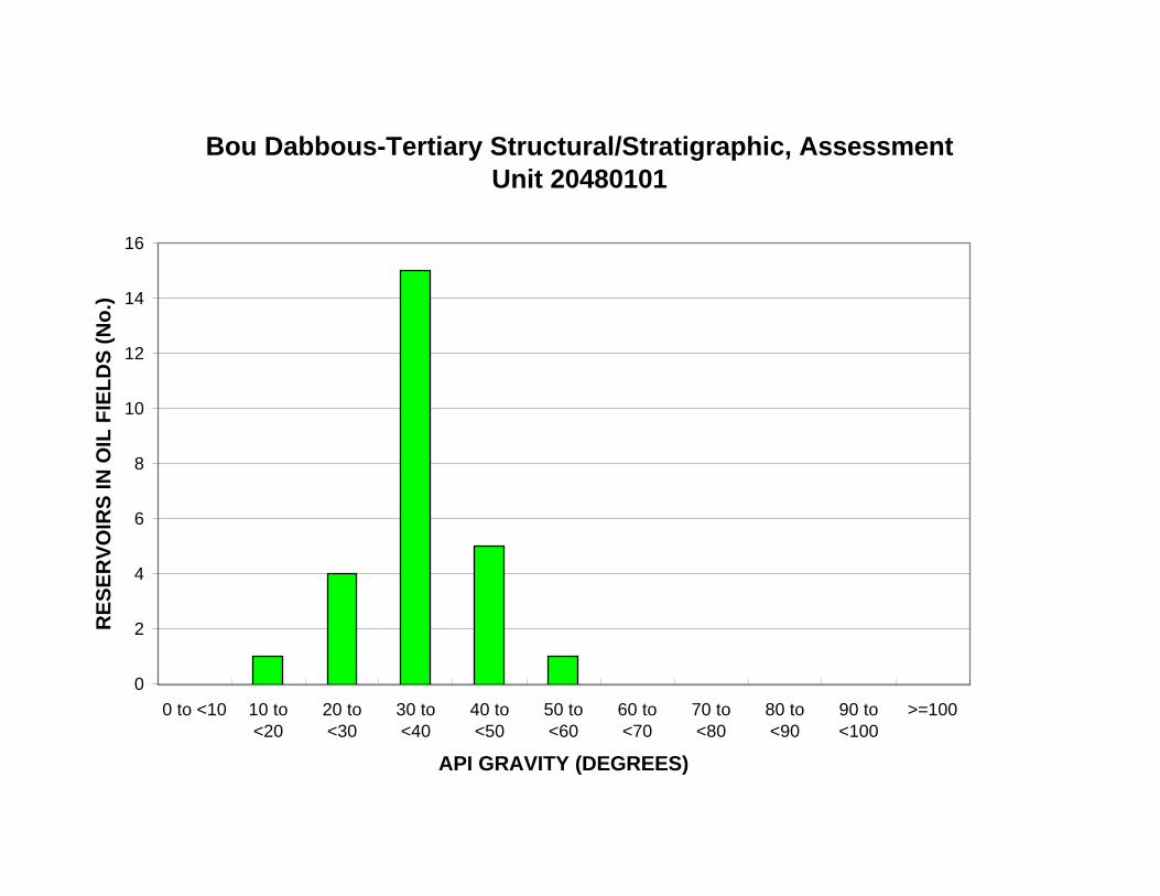
Bou Dabbous-Tertiary Structural/Stratigraphic, Assessment Unit 20480101
16
RE
SE
RV
OIR
S IN
OIL
FIE
LD
S (
No
.) 14
12
10
8
6
4
2
0
0 to <10 10 to <20
20 to <30
30 to <40
40 to <50
50 to <60
60 to <70
70 to <80
80 to <90
90 to <100
>=100
API GRAVITY (DEGREES)
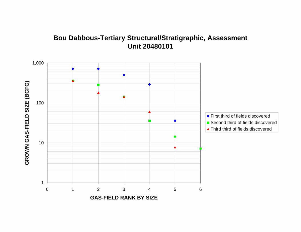
Bou Dabbous-Tertiary Structural/Stratigraphic, Assessment Unit 20480101
1,000
GR
OW
N G
AS
-FIE
LD
SIZ
E (
BC
FG
)
100
10
First third of fields discovered
Second third of fields discovered
Third third of fields discovered
1
0 1 2 3 4 5 6
GAS-FIELD RANK BY SIZE
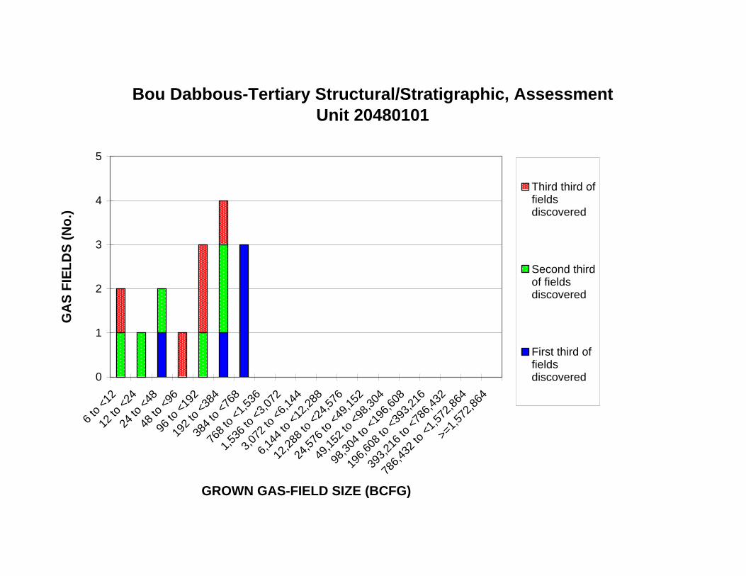
12 to
<24
24 to
<48
48 to
<96
96 to
<19
2
192
to <
384
384
to <
768
768
to <
1,53
6
1,53
6 to
<3,
072
3,07
2 to
<6,
144
6,14
4 to
<12
,288
12,2
88 to
<24
,576
24,5
76 to
<49
,152
49,1
52 to
<98
,304
98,3
04 to
<19
6,60
8
196,
608
to <
393,
216
393,
216
to <
786,
432
Bou Dabbous-Tertiary Structural/Stratigraphic, Assessment Unit 20480101
5
4Third third of fields discovered
Second third of fields discovered
First third of fields discovered
GA
S F
IEL
DS
(N
o.)
3
2
1
0
6 to
<12
>=1,
572,
864
786,
432
to <
1,57
2,86
4
GROWN GAS-FIELD SIZE (BCFG)
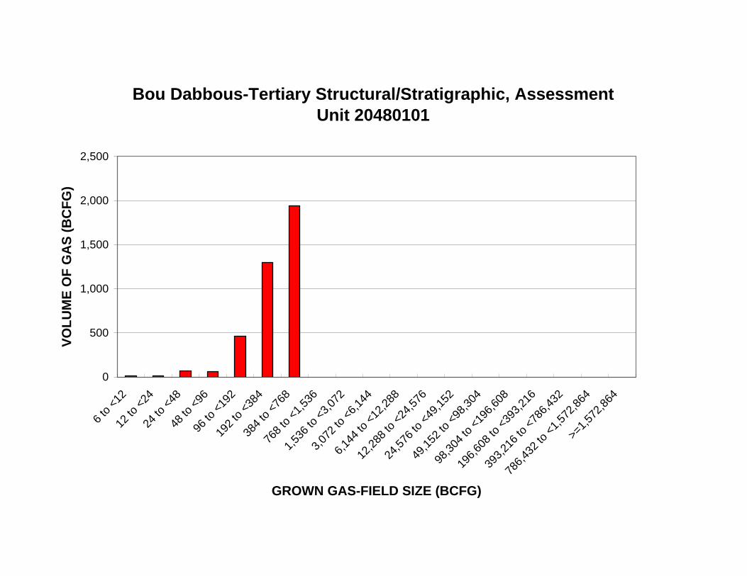
768
to <
1,53
6
1,53
6 to
<3,
072
3,07
2 to
<6,
144
6,14
4 to
<12
,288
12,2
88 to
<24
,576
24,5
76 to
<49
,152
49,1
52 to
<98
,304
98,3
04 to
<19
6,60
8
196,
608
to <
393,
216
393,
216
to <
786,
432
Bou Dabbous-Tertiary Structural/Stratigraphic, Assessment Unit 20480101
2,500
VO
LU
ME
OF
GA
S (
BC
FG
)
2,000
1,500
1,000
500
0
6 to
<12
12 to
<24
24 to
<48
48 to
<96
96 to
<19
2
192
to <
384
384
to <
768
786,
432
to <
1,57
2,86
4
>=1,
572,
864
GROWN GAS-FIELD SIZE (BCFG)

Bou Dabbous-Tertiary Structural/Stratigraphic, Assessment Unit 20480101
1,000
GR
OW
N G
AS
-FIE
LD
SIZ
E (
BC
FG
)
100
10
1
1950 1955 1960 1965 1970 1975 1980 1985 1990 1995 2000
FIELD-DISCOVERY YEAR
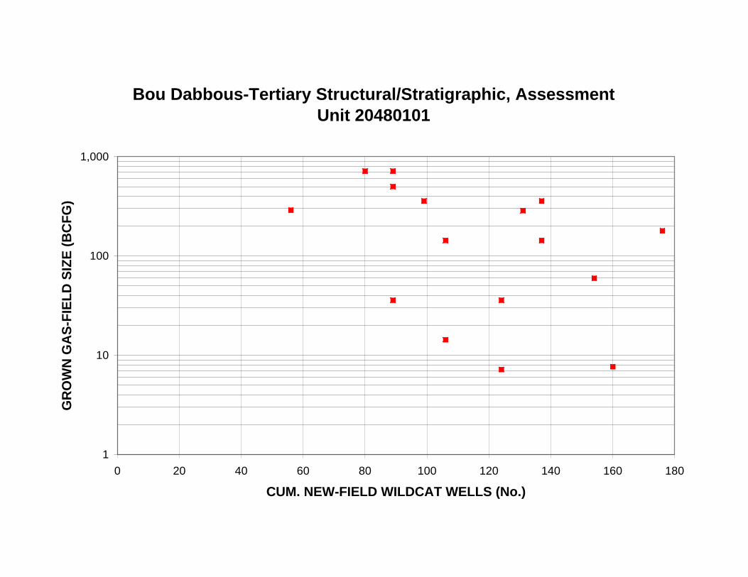
Bou Dabbous-Tertiary Structural/Stratigraphic, Assessment Unit 20480101
1,000
GR
OW
N G
AS
-FIE
LD
SIZ
E (
BC
FG
)
100
10
1
0 20 40 60 80 100 120 140 160 180
CUM. NEW-FIELD WILDCAT WELLS (No.)
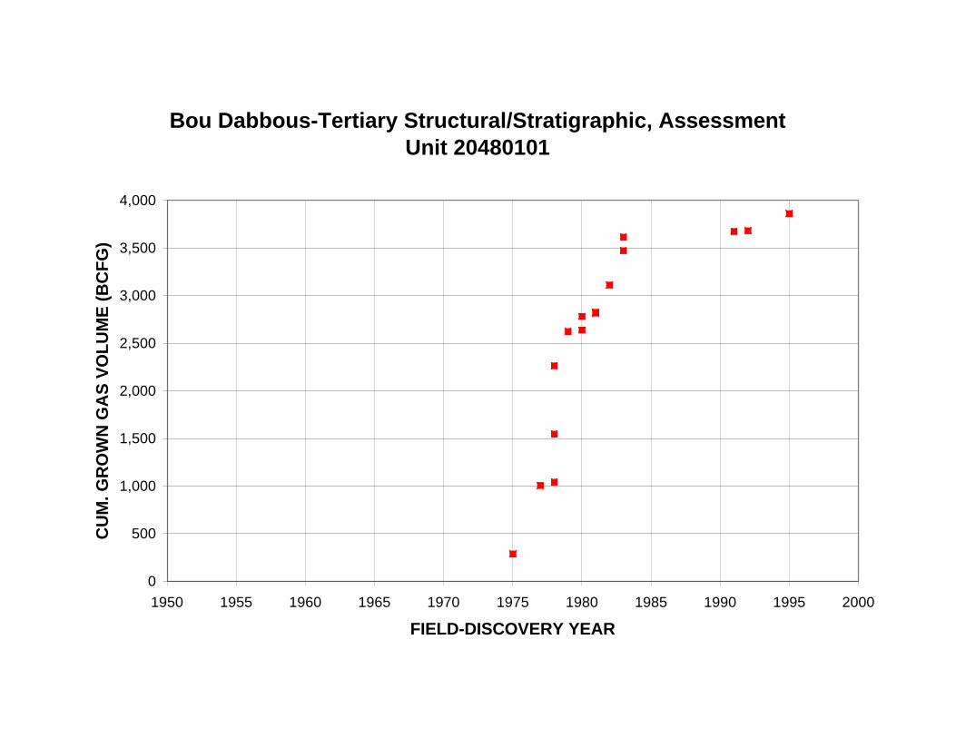
Bou Dabbous-Tertiary Structural/Stratigraphic, Assessment Unit 20480101
4,000
CU
M. G
RO
WN
GA
S V
OL
UM
E (
BC
FG
) 3,500
3,000
2,500
2,000
1,500
1,000
500
0
1950 1955 1960 1965 1970 1975 1980 1985 1990 1995 2000
FIELD-DISCOVERY YEAR
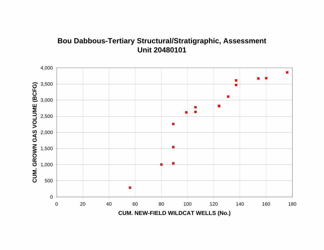
Bou Dabbous-Tertiary Structural/Stratigraphic, Assessment Unit 20480101
4,000
CU
M. G
RO
WN
GA
S V
OL
UM
E (
BC
FG
) 3,500
3,000
2,500
2,000
1,500
1,000
500
0
0 20 40 60 80 100 120 140 160 180
CUM. NEW-FIELD WILDCAT WELLS (No.)
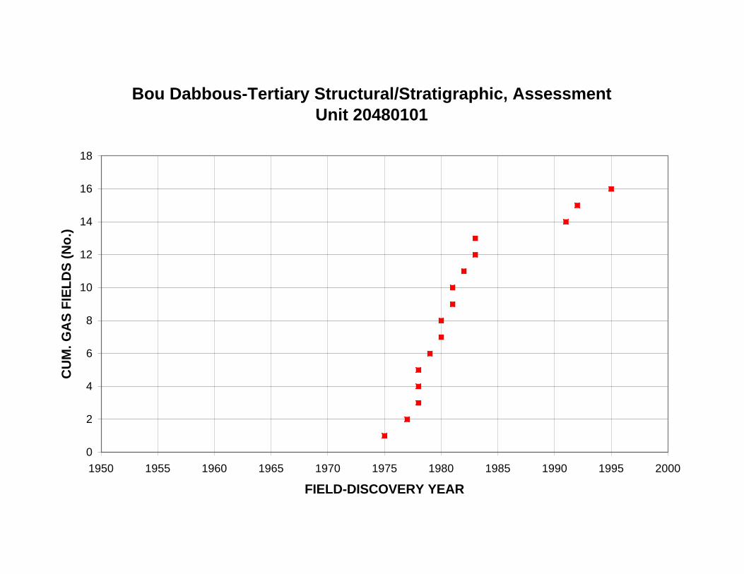
Bou Dabbous-Tertiary Structural/Stratigraphic, Assessment Unit 20480101
18
16
14
CU
M. G
AS
FIE
LD
S (
No
.)
12
10
8
6
4
2
0
1950 1955 1960 1965 1970 1975 1980 1985 1990 1995 2000
FIELD-DISCOVERY YEAR
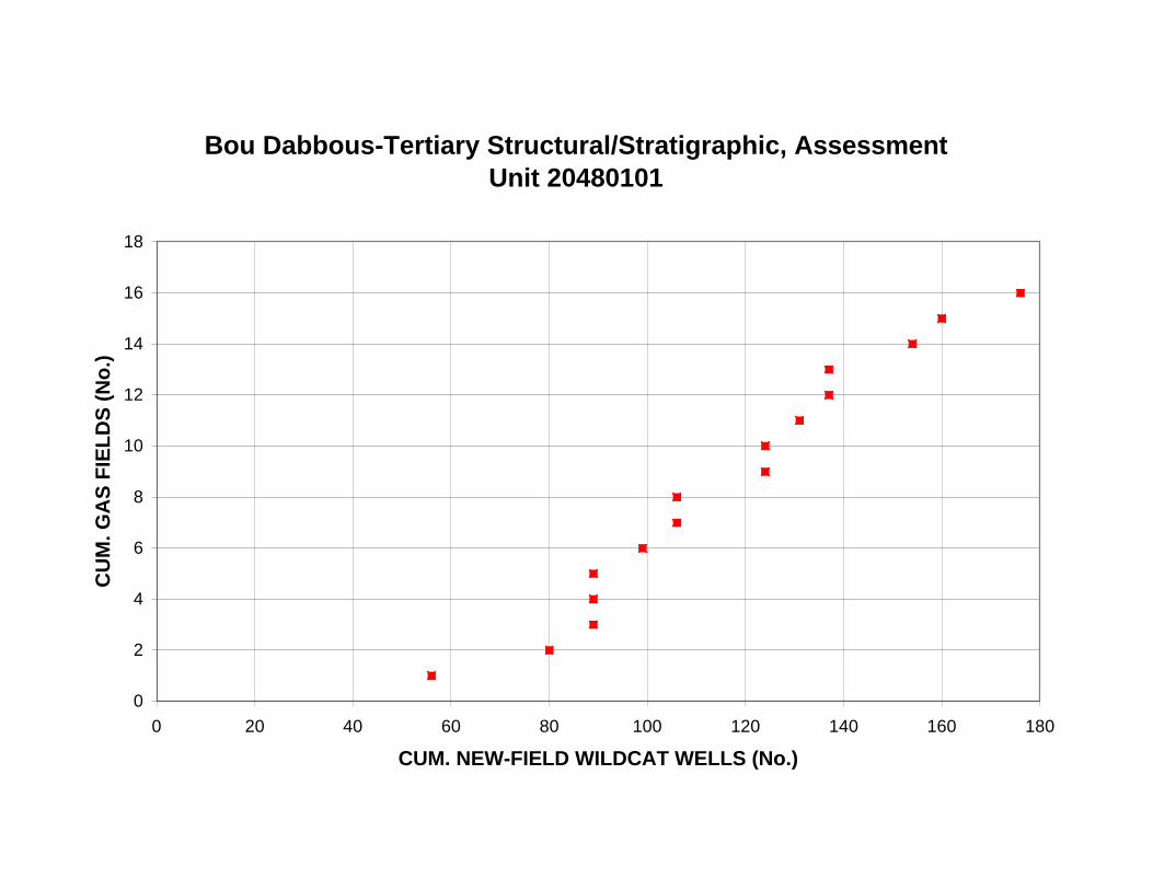
Bou Dabbous-Tertiary Structural/Stratigraphic, Assessment Unit 20480101
18
16
14
CU
M. G
AS
FIE
LD
S (
No
.)
12
10
8
6
4
2
0
0 20 40 60 80 100 120 140 160 180
CUM. NEW-FIELD WILDCAT WELLS (No.)
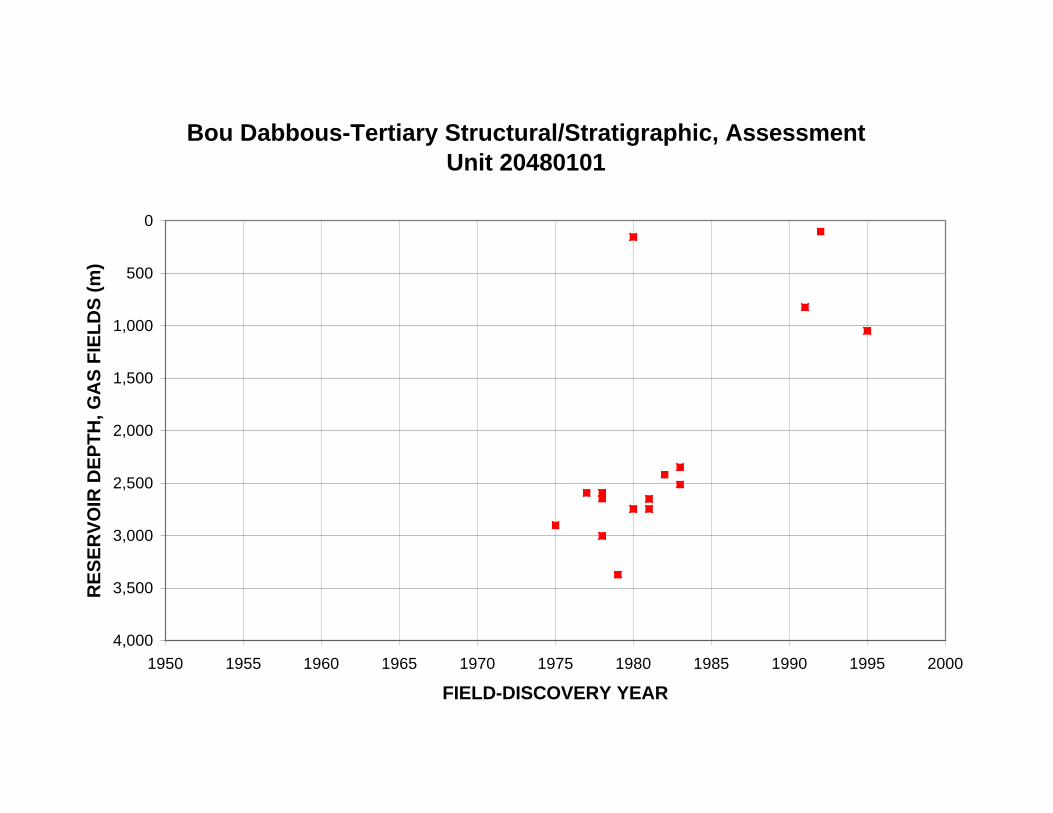
RE
SE
RV
OIR
DE
PT
H, G
AS
FIE
LD
S (
m)
Bou Dabbous-Tertiary Structural/Stratigraphic, Assessment Unit 20480101
0
500
1,000
1,500
2,000
2,500
3,000
3,500
4,000
1950 1955 1960 1965 1970 1975 1980 1985 1990 1995 2000
FIELD-DISCOVERY YEAR
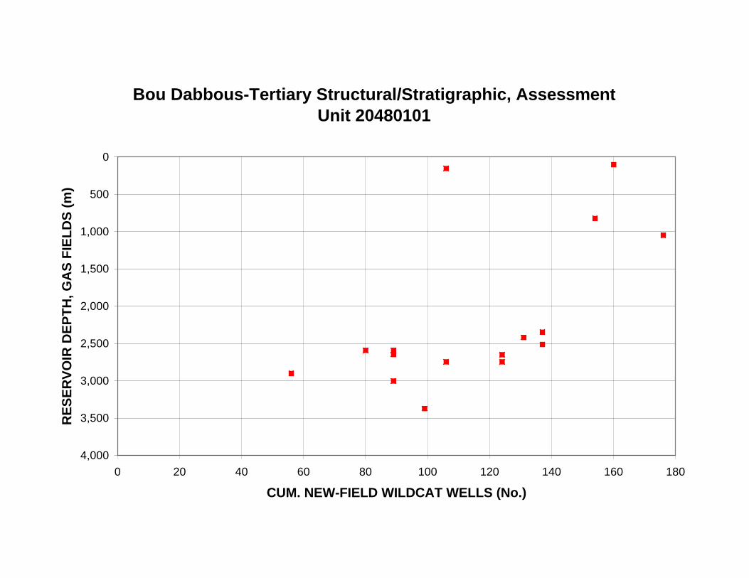
RE
SE
RV
OIR
DE
PT
H, G
AS
FIE
LD
S (
m)
Bou Dabbous-Tertiary Structural/Stratigraphic, Assessment Unit 20480101
0
500
1,000
1,500
2,000
2,500
3,000
3,500
4,000
0 20 40 60 80 100 120 140 160 180
CUM. NEW-FIELD WILDCAT WELLS (No.)
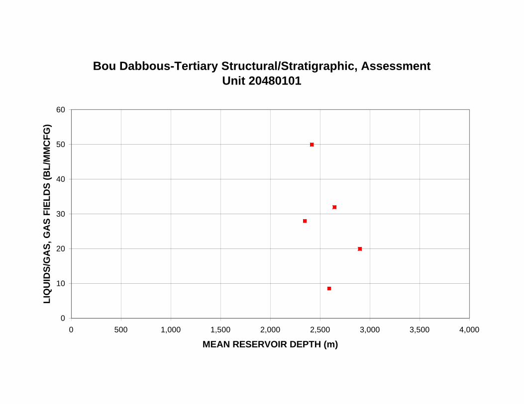
Bou Dabbous-Tertiary Structural/Stratigraphic, Assessment Unit 20480101
60
LIQ
UID
S/G
AS
, GA
S F
IEL
DS
(B
L/M
MC
FG
)
50
40
30
20
10
0
0 500 1,000 1,500 2,000 2,500 3,000 3,500 4,000
MEAN RESERVOIR DEPTH (m)

Appendix 2. Exploration-activity and discovery-history plots for the Jurassic-Cretaceous
Structural/Stratigraphic Assessment Unit (20480201). A. Plots of known oil and gas volumes.
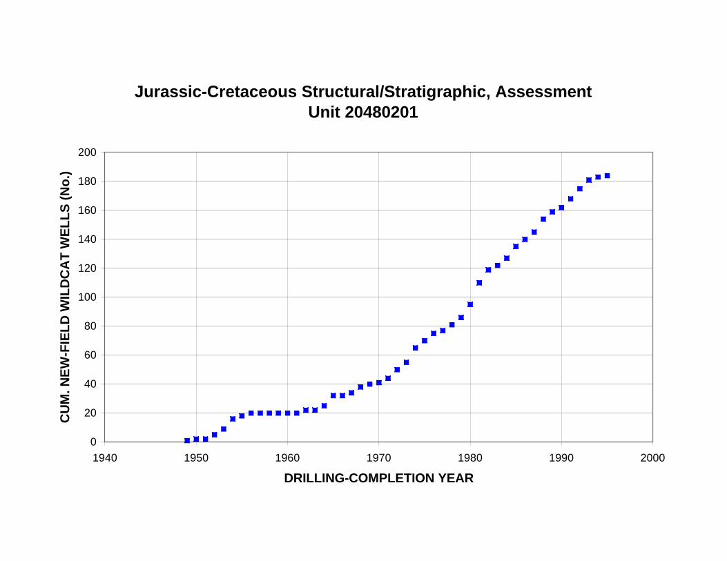
Jurassic-Cretaceous Structural/Stratigraphic, Assessment Unit 20480201
200
CU
M. N
EW
-FIE
LD
WIL
DC
AT
WE
LL
S (
No
.)
180
160
140
120
100
80
60
40
20
0
1940 1950 1960 1970 1980 1990 2000
DRILLING-COMPLETION YEAR
Jurassic-Cretaceous Structural/Stratigraphic, Assessment Unit 20480201
16
NE
W-F
IEL
D W
ILD
CA
T W
EL
LS
(N
o.)
14
12
10
8
6
4
2
0
1949
1951
1953
1955
1957
1959
1961
1963
1965
1967
1969
1971
1973
1975
1977
1979
1981
1983
1985
1987
1989
1991
1993
1995
DRILLING-COMPLETION YEAR
Jurassic-Cretaceous Structural/Stratigraphic, Assessment Unit 20480201
100
KN
OW
N O
IL-F
IEL
D S
IZE
(M
MB
O)
First half of fields discovered
Second half of fields discovered 10
1
0 1 2 3 4 5 6
OIL-FIELD RANK BY SIZE
16 to
<32
64 to
<12
8
128
to <
256
256
to <
512
512
to <
1,02
4
1,02
4 to
<2,
048
2,04
8 to
<4,
096
4,09
6 to
<8,
192
8,19
2 to
<16
,384
16,3
84 to
<32
,768
32,7
68 to
<65
,536
65,5
36 to
<13
1,07
2
Jurassic-Cretaceous Structural/Stratigraphic, Assessment Unit 20480201
6
5 Second half of fields discovered
First half of fields discovered
OIL
FIE
LD
S (
No
.)
4
3
2
1
0
1 to
<2
2 to
<4
4 to
<8
8 to
<16
32 to
<64
>=26
2,14
4
131,
072
to <
262,
144
KNOWN OIL-FIELD SIZE (MMBO)
512
to <
1,02
4
1,02
4 to
<2,
048
2,04
8 to
<4,
096
4,09
6 to
<8,
192
8,19
2 to
<16
,384
16,3
84 to
<32
,768
32,7
68 to
<65
,536
65,5
36 to
<13
1,07
2
Jurassic-Cretaceous Structural/Stratigraphic, Assessment Unit 20480201
60
VO
LU
ME
OF
OIL
(M
MB
O) 50
40
30
20
10
0
1 to
<2
2 to
<4
4 to
<8
8 to
<16
16 to
<32
32 to
<64
64 to
<12
8
128
to <
256
256
to <
512
131,
072
to <
262,
144
>=26
2,14
4
KNOWN OIL-FIELD SIZE (MMBO)
Jurassic-Cretaceous Structural/Stratigraphic, Assessment Unit 20480201
100
KN
OW
N O
IL-F
IEL
D S
IZE
(M
MB
O)
10
1
1940 1950 1960 1970 1980 1990 2000
FIELD-DISCOVERY YEAR
Jurassic-Cretaceous Structural/Stratigraphic, Assessment Unit 20480201
100
KN
OW
N O
IL-F
IEL
D S
IZE
(M
MB
O)
10
1
0 20 40 60 80 100 120 140 160 180 200
CUM. NEW-FIELD WILDCAT WELLS (No.)
Jurassic-Cretaceous Structural/Stratigraphic, Assessment Unit 20480201
250
CU
M. K
NO
WN
OIL
VO
LU
ME
(M
MB
O)
200
150
100
50
0
1940 1950 1960 1970 1980 1990 2000
FIELD-DISCOVERY YEAR
Jurassic-Cretaceous Structural/Stratigraphic, Assessment Unit 20480201
250
CU
M. K
NO
WN
OIL
VO
LU
ME
(M
MB
O)
200
150
100
50
0
0 20 40 60 80 100 120 140 160 180 200
CUM. NEW-FIELD WILDCAT WELLS (No.)
Jurassic-Cretaceous Structural/Stratigraphic, Assessment Unit 20480201
12
10
CU
M. O
IL F
IEL
DS
(N
o.)
8
6
4
2
0
1940 1950 1960 1970 1980 1990 2000
FIELD-DISCOVERY YEAR
Jurassic-Cretaceous Structural/Stratigraphic, Assessment Unit 20480201
12
10
CU
M. O
IL F
IEL
DS
(N
o.)
8
6
4
2
0
0 20 40 60 80 100 120 140 160 180 200
CUM. NEW-FIELD WILDCAT WELLS (No.)
RE
SE
RV
OIR
DE
PT
H, O
IL F
IEL
DS
(m
)
Jurassic-Cretaceous Structural/Stratigraphic, Assessment Unit 20480201
0
500
1,000
1,500
2,000
2,500
3,000
3,500
4,000
1940 1950 1960 1970 1980 1990 2000
FIELD-DISCOVERY YEAR
RE
SE
RV
OIR
DE
PT
H, O
IL F
IEL
DS
(m
)
Jurassic-Cretaceous Structural/Stratigraphic, Assessment Unit 20480201
0
500
1,000
1,500
2,000
2,500
3,000
3,500
4,000
0 20 40 60 80 100 120 140 160 180 200
CUM. NEW-FIELD WILDCAT WELLS (No.)
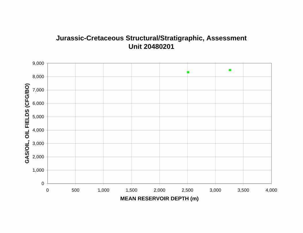
Jurassic-Cretaceous Structural/Stratigraphic, Assessment Unit 20480201
9,000
8,000
GA
S/O
IL, O
IL F
IEL
DS
(C
FG
/BO
)
7,000
6,000
5,000
4,000
3,000
2,000
1,000
0
0 500 1,000 1,500 2,000 2,500 3,000 3,500 4,000
MEAN RESERVOIR DEPTH (m)

Jurassic-Cretaceous Structural/Stratigraphic, Assessment Unit 20480201
16
NG
L/G
AS
, OIL
FIE
LD
S (
BN
GL
/MM
CF
G)
14
12
10
8
6
4
2
0
0 500 1,000 1,500 2,000 2,500 3,000 3,500 4,000
MEAN RESERVOIR DEPTH (m)
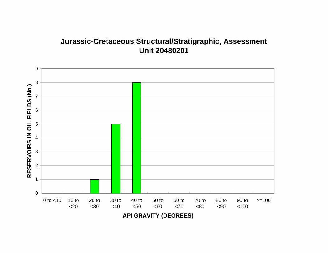
Jurassic-Cretaceous Structural/Stratigraphic, Assessment Unit 20480201
9
RE
SE
RV
OIR
S IN
OIL
FIE
LD
S (
No
.) 8
7
6
5
4
3
2
1
0
0 to <10 10 to <20
20 to <30
30 to <40
40 to <50
50 to <60
60 to <70
70 to <80
80 to <90
90 to <100
>=100
API GRAVITY (DEGREES)
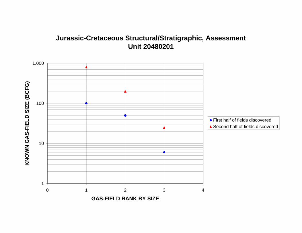
Jurassic-Cretaceous Structural/Stratigraphic, Assessment Unit 20480201
1,000
KN
OW
N G
AS
-FIE
LD
SIZ
E (
BC
FG
)
100
10
First half of fields discovered
Second half of fields discovered
1
0 1 2 3 4
GAS-FIELD RANK BY SIZE
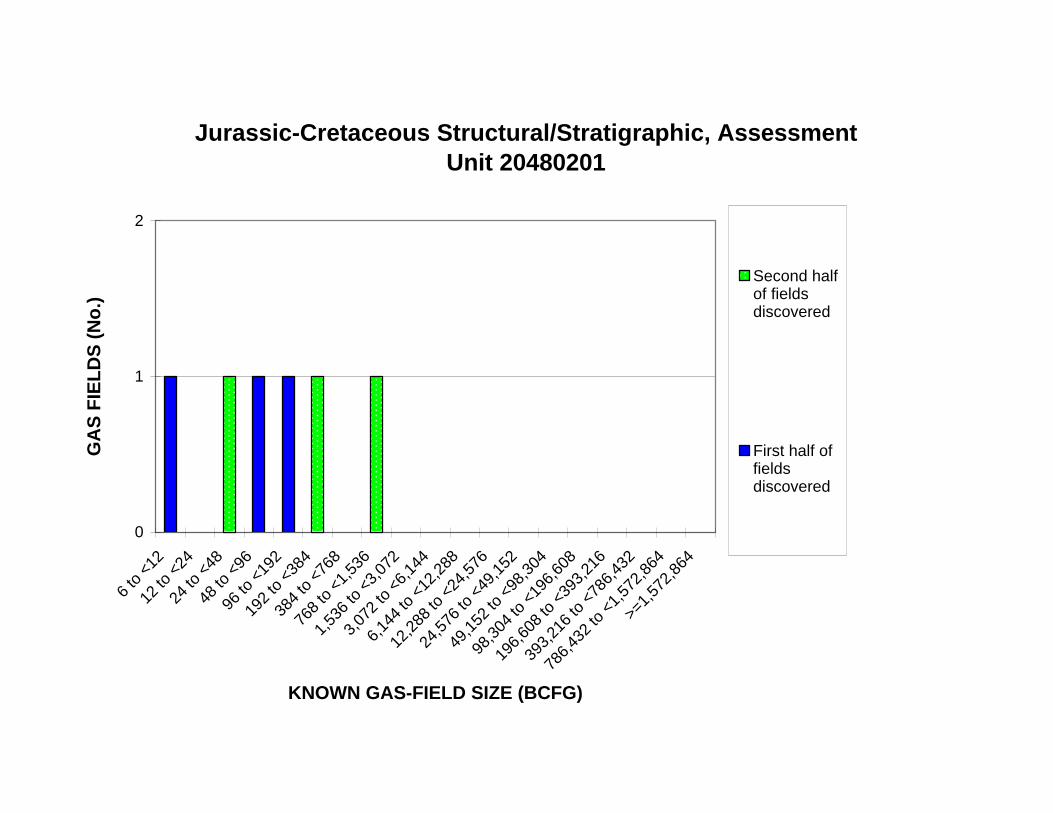
12 to
<24
24 to
<48
48 to
<96
96 to
<19
2
192
to <
384
384
to <
768
768
to <
1,53
6
1,53
6 to
<3,
072
3,07
2 to
<6,
144
6,14
4 to
<12
,288
12,2
88 to
<24
,576
24,5
76 to
<49
,152
49,1
52 to
<98
,304
98,3
04 to
<19
6,60
8
196,
608
to <
393,
216
393,
216
to <
786,
432
Jurassic-Cretaceous Structural/Stratigraphic, Assessment Unit 20480201
2
Second half of fields discovered
First half of fields discovered
GA
S F
IEL
DS
(N
o.)
1
0
6 to
<12
>=1,
572,
864
786,
432
to <
1,57
2,86
4
KNOWN GAS-FIELD SIZE (BCFG)
768
to <
1,53
6
1,53
6 to
<3,
072
3,07
2 to
<6,
144
6,14
4 to
<12
,288
12,2
88 to
<24
,576
24,5
76 to
<49
,152
49,1
52 to
<98
,304
98,3
04 to
<19
6,60
8
196,
608
to <
393,
216
393,
216
to <
786,
432
Jurassic-Cretaceous Structural/Stratigraphic, Assessment Unit 20480201
900
800
VO
LU
ME
OF
GA
S (
BC
FG
)
700
600
500
400
300
200
100
0
6 to
<12
12 to
<24
24 to
<48
48 to
<96
96 to
<19
2
192
to <
384
384
to <
768
786,
432
to <
1,57
2,86
4
>=1,
572,
864
KNOWN GAS-FIELD SIZE (BCFG)
Jurassic-Cretaceous Structural/Stratigraphic, Assessment Unit 20480201
1,000
KN
OW
N G
AS
-FIE
LD
SIZ
E (
BC
FG
)
100
10
1
1940 1950 1960 1970 1980 1990 2000
FIELD-DISCOVERY YEAR
Jurassic-Cretaceous Structural/Stratigraphic, Assessment Unit 20480201
1,000
KN
OW
N G
AS
-FIE
LD
SIZ
E (
BC
FG
)
100
10
1
0 20 40 60 80 100 120 140 160 180 200
CUM. NEW-FIELD WILDCAT WELLS (No.)
Jurassic-Cretaceous Structural/Stratigraphic, Assessment Unit 20480201
2,000
CU
M. K
NO
WN
GA
S V
OL
UM
E (
BC
FG
) 1,800
1,600
1,400
1,200
1,000
800
600
400
200
0
1940 1950 1960 1970 1980 1990 2000
FIELD-DISCOVERY YEAR
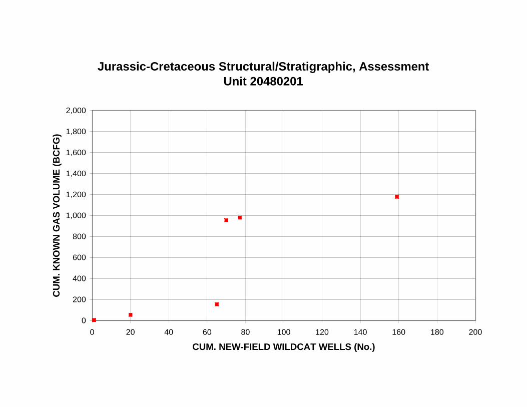
Jurassic-Cretaceous Structural/Stratigraphic, Assessment Unit 20480201
2,000
CU
M. K
NO
WN
GA
S V
OL
UM
E (
BC
FG
) 1,800
1,600
1,400
1,200
1,000
800
600
400
200
0
0 20 40 60 80 100 120 140 160 180 200
CUM. NEW-FIELD WILDCAT WELLS (No.)
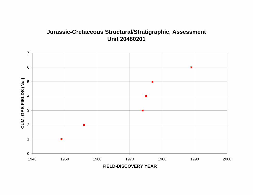
Jurassic-Cretaceous Structural/Stratigraphic, Assessment Unit 20480201
7
6
CU
M. G
AS
FIE
LD
S (
No
.)
5
4
3
2
1
0
1940 1950 1960 1970 1980 1990 2000
FIELD-DISCOVERY YEAR
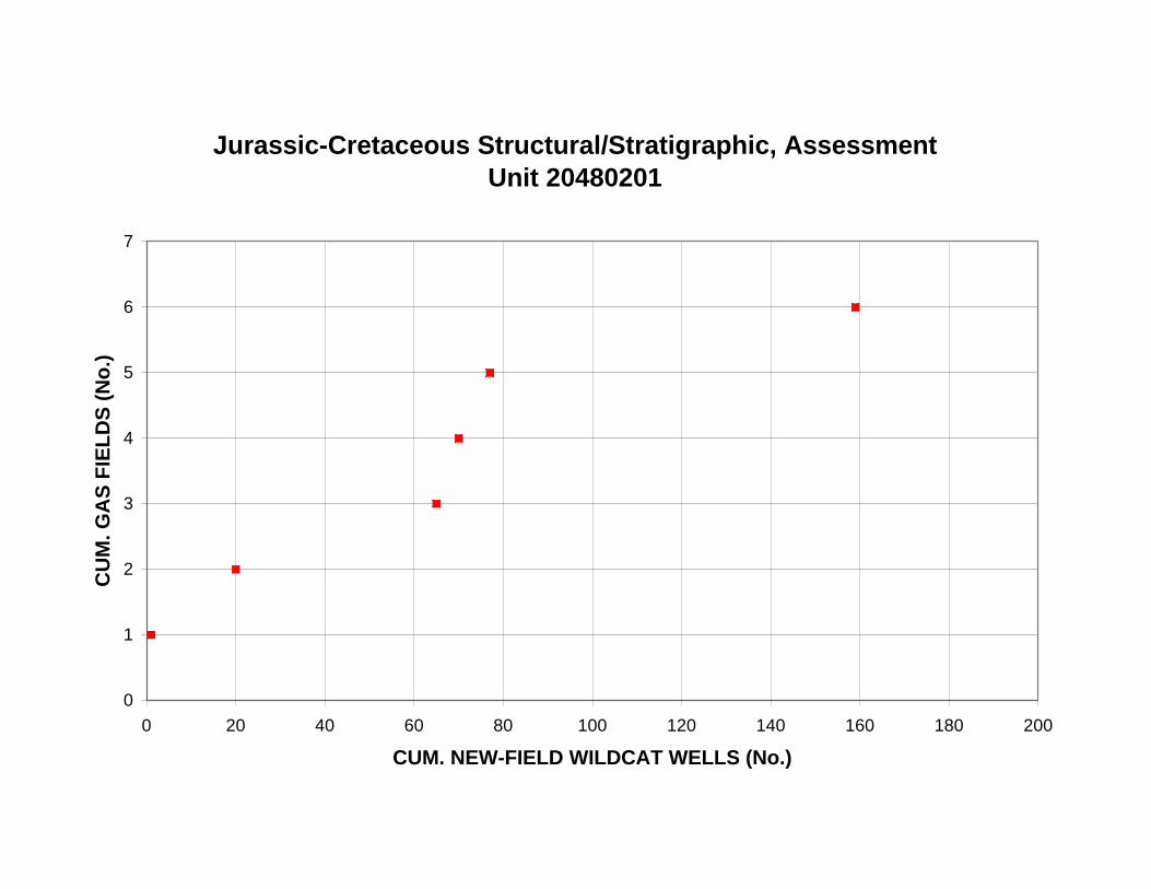
Jurassic-Cretaceous Structural/Stratigraphic, Assessment Unit 20480201
7
6
CU
M. G
AS
FIE
LD
S (
No
.)
5
4
3
2
1
0
0 20 40 60 80 100 120 140 160 180 200
CUM. NEW-FIELD WILDCAT WELLS (No.)
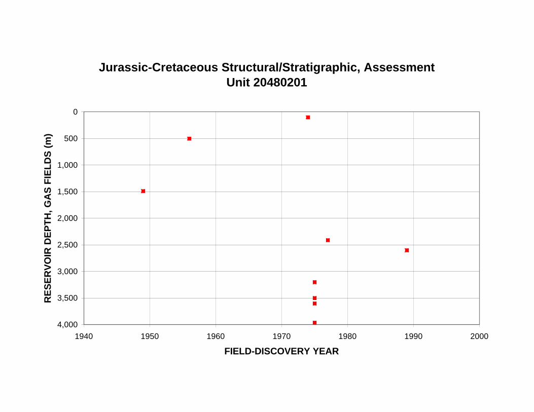
RE
SE
RV
OIR
DE
PT
H, G
AS
FIE
LD
S (
m)
Jurassic-Cretaceous Structural/Stratigraphic, Assessment Unit 20480201
0
500
1,000
1,500
2,000
2,500
3,000
3,500
4,000
1940 1950 1960 1970 1980 1990 2000
FIELD-DISCOVERY YEAR
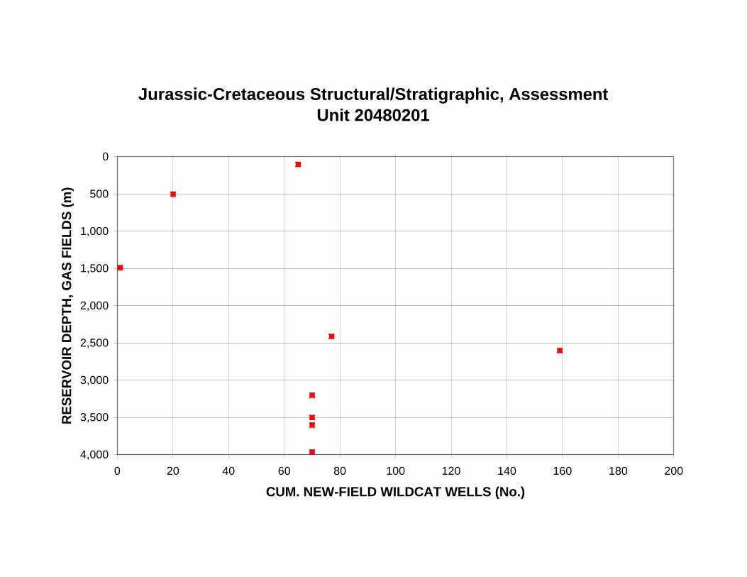
RE
SE
RV
OIR
DE
PT
H, G
AS
FIE
LD
S (
m)
Jurassic-Cretaceous Structural/Stratigraphic, Assessment Unit 20480201
0
500
1,000
1,500
2,000
2,500
3,000
3,500
4,000
0 20 40 60 80 100 120 140 160 180 200
CUM. NEW-FIELD WILDCAT WELLS (No.)

Jurassic-Cretaceous Structural/Stratigraphic, Assessment Unit 20480201
60
LIQ
UID
S/G
AS
, GA
S F
IEL
DS
(B
L/M
MC
FG
)
50
40
30
20
10
0
0 500 1,000 1,500 2,000 2,500 3,000 3,500 4,000
MEAN RESERVOIR DEPTH (m)

Appendix 2. Exploration-activity and discovery-history plots for the Jurassic-Cretaceous
Structural/Stratigraphic Assessment Unit (20480201). B. Plots of grown oil and gas volumes.

Jurassic-Cretaceous Structural/Stratigraphic, Assessment Unit 20480201
200
CU
M. N
EW
-FIE
LD
WIL
DC
AT
WE
LL
S (
No
.)
180
160
140
120
100
80
60
40
20
0
1940 1950 1960 1970 1980 1990 2000
DRILLING-COMPLETION YEAR

Jurassic-Cretaceous Structural/Stratigraphic, Assessment Unit 20480201
16
NE
W-F
IEL
D W
ILD
CA
T W
EL
LS
(N
o.)
14
12
10
8
6
4
2
0
1949
1951
1953
1955
1957
1959
1961
1963
1965
1967
1969
1971
1973
1975
1977
1979
1981
1983
1985
1987
1989
1991
1993
1995
DRILLING-COMPLETION YEAR
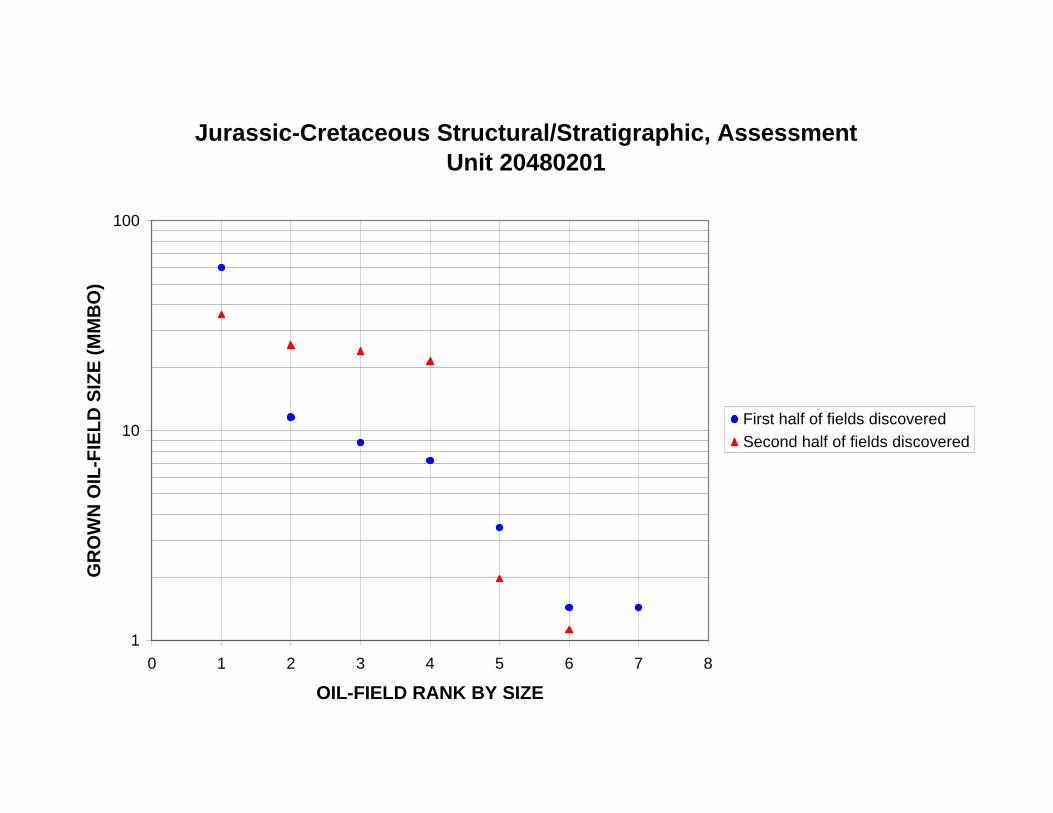
Jurassic-Cretaceous Structural/Stratigraphic, Assessment Unit 20480201
100
GR
OW
N O
IL-F
IEL
D S
IZE
(M
MB
O)
First half of fields discovered
Second half of fields discovered 10
1
0 1 2 3 4 5 6 7 8
OIL-FIELD RANK BY SIZE
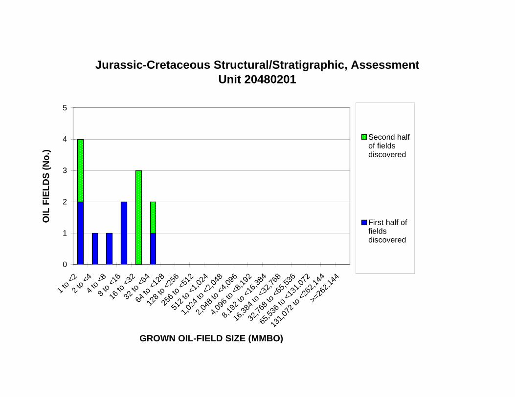
16 to
<32
64 to
<12
8
128
to <
256
256
to <
512
512
to <
1,02
4
1,02
4 to
<2,
048
2,04
8 to
<4,
096
4,09
6 to
<8,
192
8,19
2 to
<16
,384
16,3
84 to
<32
,768
32,7
68 to
<65
,536
65,5
36 to
<13
1,07
2
Jurassic-Cretaceous Structural/Stratigraphic, Assessment Unit 20480201
5
4 Second half of fields discovered
First half of fields discovered
OIL
FIE
LD
S (
No
.)
3
2
1
0
1 to
<2
2 to
<4
4 to
<8
8 to
<16
32 to
<64
>=26
2,14
4
131,
072
to <
262,
144
GROWN OIL-FIELD SIZE (MMBO)
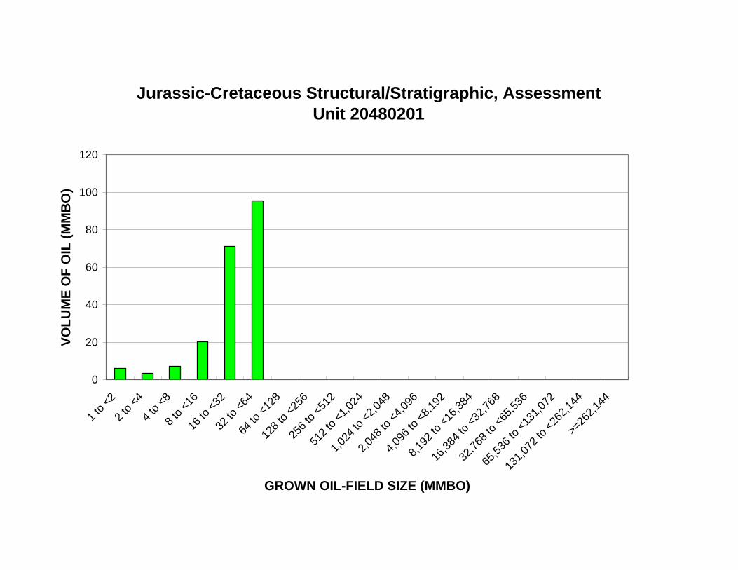
512
to <
1,02
4
1,02
4 to
<2,
048
2,04
8 to
<4,
096
4,09
6 to
<8,
192
8,19
2 to
<16
,384
16,3
84 to
<32
,768
32,7
68 to
<65
,536
65,5
36 to
<13
1,07
2
Jurassic-Cretaceous Structural/Stratigraphic, Assessment Unit 20480201
120
VO
LU
ME
OF
OIL
(M
MB
O) 100
80
60
40
20
0
1 to
<2
2 to
<4
4 to
<8
8 to
<16
16 to
<32
32 to
<64
64 to
<12
8
128
to <
256
256
to <
512
131,
072
to <
262,
144
>=26
2,14
4
GROWN OIL-FIELD SIZE (MMBO)
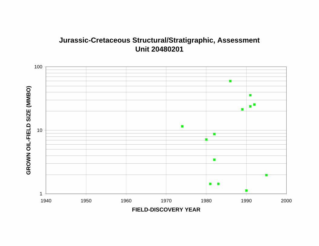
Jurassic-Cretaceous Structural/Stratigraphic, Assessment Unit 20480201
100
GR
OW
N O
IL-F
IEL
D S
IZE
(M
MB
O)
10
1
1940 1950 1960 1970 1980 1990 2000
FIELD-DISCOVERY YEAR
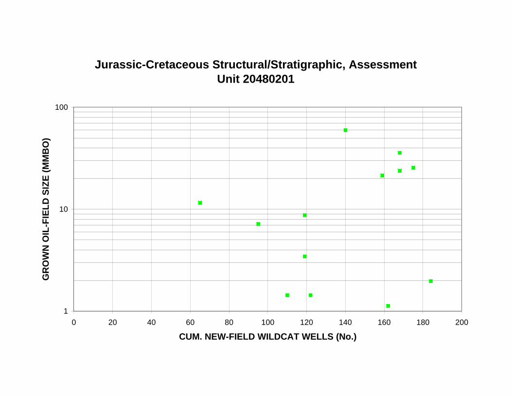
Jurassic-Cretaceous Structural/Stratigraphic, Assessment Unit 20480201
100
GR
OW
N O
IL-F
IEL
D S
IZE
(M
MB
O)
10
1
0 20 40 60 80 100 120 140 160 180 200
CUM. NEW-FIELD WILDCAT WELLS (No.)
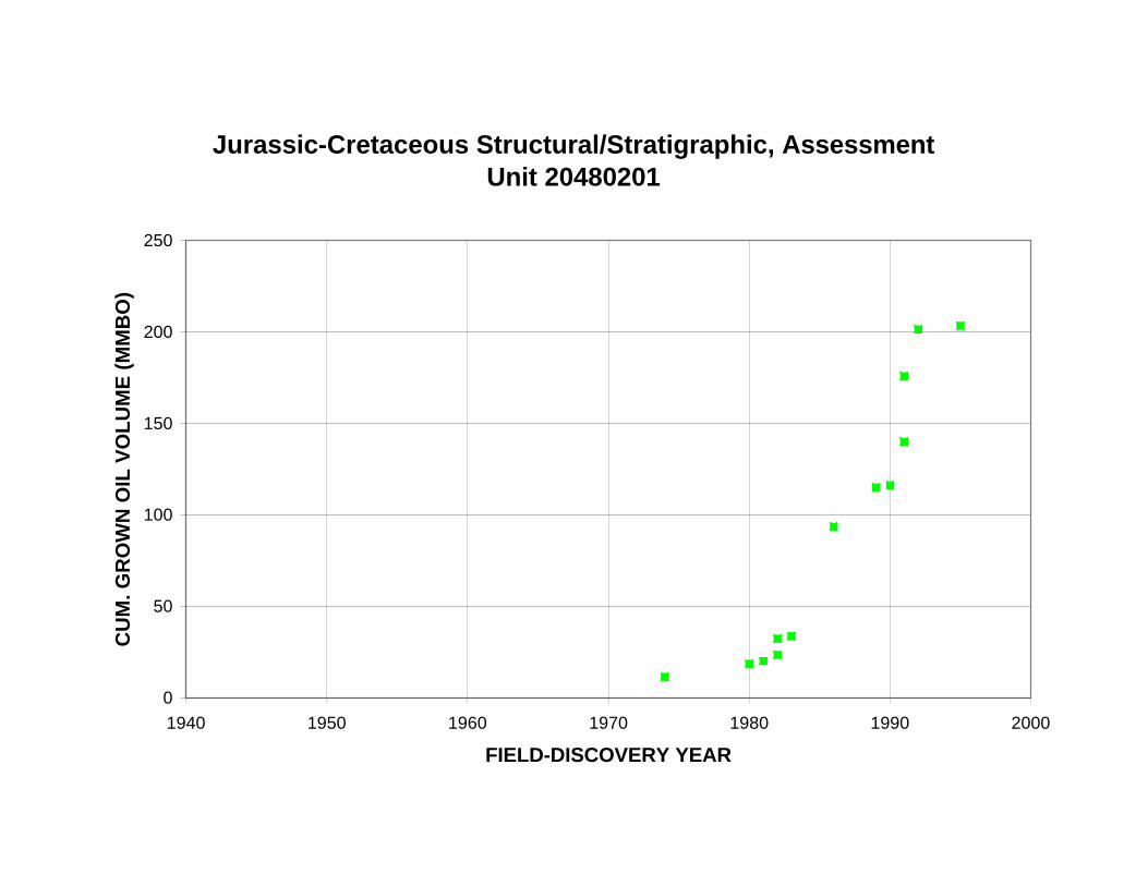
Jurassic-Cretaceous Structural/Stratigraphic, Assessment Unit 20480201
250
CU
M. G
RO
WN
OIL
VO
LU
ME
(M
MB
O)
200
150
100
50
0
1940 1950 1960 1970 1980 1990 2000
FIELD-DISCOVERY YEAR
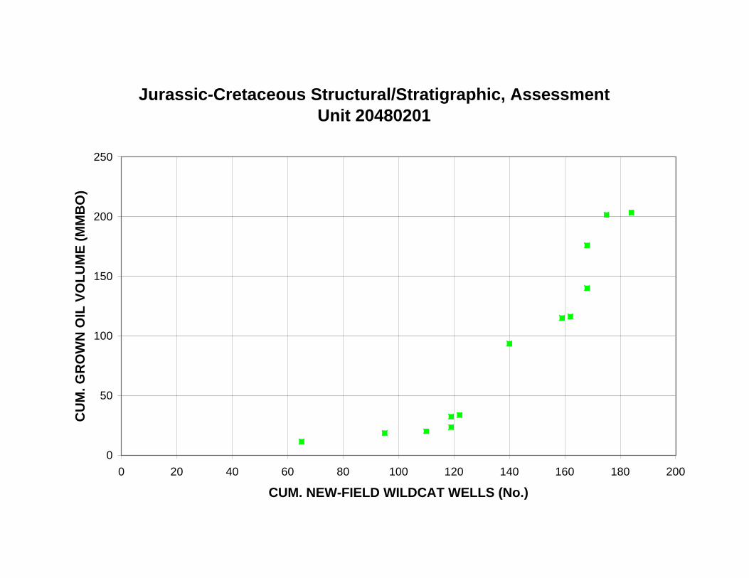
Jurassic-Cretaceous Structural/Stratigraphic, Assessment Unit 20480201
250
CU
M. G
RO
WN
OIL
VO
LU
ME
(M
MB
O)
200
150
100
50
0
0 20 40 60 80 100 120 140 160 180 200
CUM. NEW-FIELD WILDCAT WELLS (No.)

Jurassic-Cretaceous Structural/Stratigraphic, Assessment Unit 20480201
14
12
CU
M. O
IL F
IEL
DS
(N
o.)
10
8
6
4
2
0
1940 1950 1960 1970 1980 1990 2000
FIELD-DISCOVERY YEAR
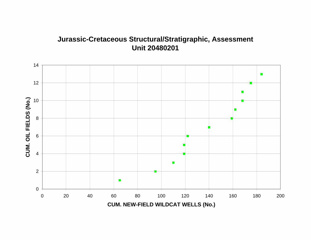
Jurassic-Cretaceous Structural/Stratigraphic, Assessment Unit 20480201
14
12
CU
M. O
IL F
IEL
DS
(N
o.)
10
8
6
4
2
0
0 20 40 60 80 100 120 140 160 180 200
CUM. NEW-FIELD WILDCAT WELLS (No.)
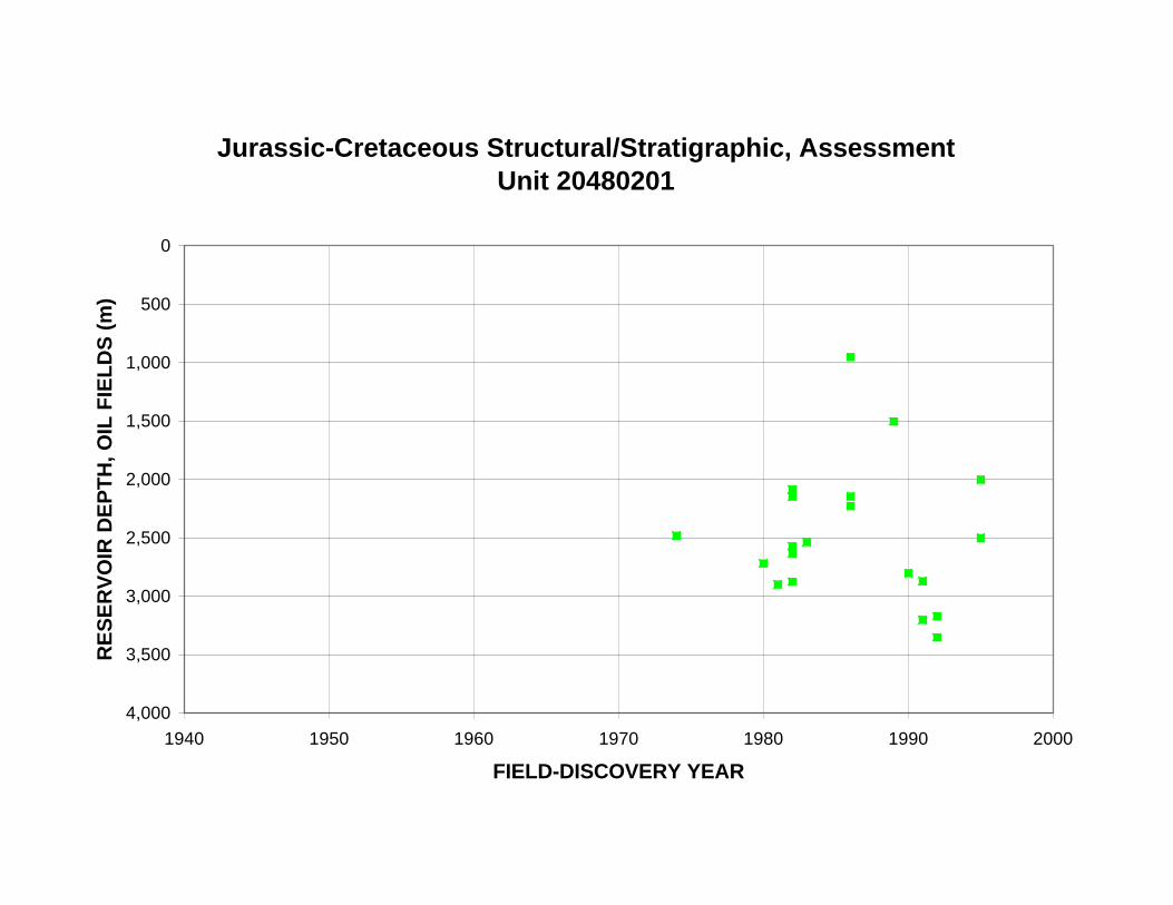
RE
SE
RV
OIR
DE
PT
H, O
IL F
IEL
DS
(m
)
Jurassic-Cretaceous Structural/Stratigraphic, Assessment Unit 20480201
0
500
1,000
1,500
2,000
2,500
3,000
3,500
4,000
1940 1950 1960 1970 1980 1990 2000
FIELD-DISCOVERY YEAR
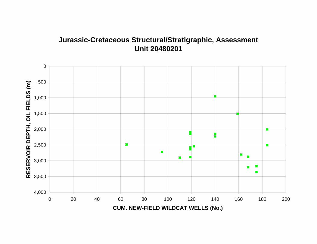
RE
SE
RV
OIR
DE
PT
H, O
IL F
IEL
DS
(m
)
Jurassic-Cretaceous Structural/Stratigraphic, Assessment Unit 20480201
0
500
1,000
1,500
2,000
2,500
3,000
3,500
4,000
0 20 40 60 80 100 120 140 160 180 200
CUM. NEW-FIELD WILDCAT WELLS (No.)

Jurassic-Cretaceous Structural/Stratigraphic, Assessment Unit 20480201
9,000
8,000
GA
S/O
IL, O
IL F
IEL
DS
(C
FG
/BO
)
7,000
6,000
5,000
4,000
3,000
2,000
1,000
0
0 500 1,000 1,500 2,000 2,500 3,000 3,500 4,000
MEAN RESERVOIR DEPTH (m)
Jurassic-Cretaceous Structural/Stratigraphic, Assessment Unit 20480201
16
NG
L/G
AS
, OIL
FIE
LD
S (
BN
GL
/MM
CF
G)
14
12
10
8
6
4
2
0
0 500 1,000 1,500 2,000 2,500 3,000 3,500 4,000
MEAN RESERVOIR DEPTH (m)
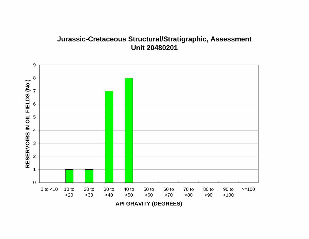
Jurassic-Cretaceous Structural/Stratigraphic, Assessment Unit 20480201
9
RE
SE
RV
OIR
S IN
OIL
FIE
LD
S (
No
.) 8
7
6
5
4
3
2
1
0
0 to <10 10 to <20
20 to <30
30 to <40
40 to <50
50 to <60
60 to <70
70 to <80
80 to <90
90 to <100
>=100
API GRAVITY (DEGREES)
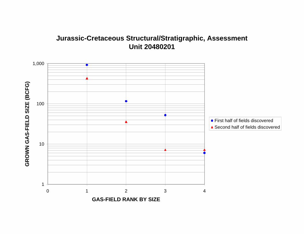
Jurassic-Cretaceous Structural/Stratigraphic, Assessment Unit 20480201
1,000
GR
OW
N G
AS
-FIE
LD
SIZ
E (
BC
FG
)
100
10
First half of fields discovered
Second half of fields discovered
1
0 1 2 3 4
GAS-FIELD RANK BY SIZE
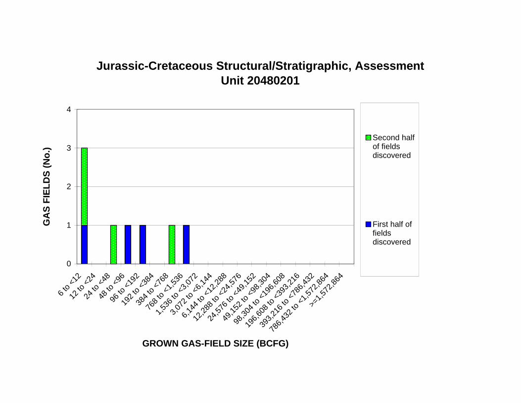
12 to
<24
24 to
<48
48 to
<96
96 to
<19
2
192
to <
384
384
to <
768
768
to <
1,53
6
1,53
6 to
<3,
072
3,07
2 to
<6,
144
6,14
4 to
<12
,288
12,2
88 to
<24
,576
24,5
76 to
<49
,152
49,1
52 to
<98
,304
98,3
04 to
<19
6,60
8
196,
608
to <
393,
216
393,
216
to <
786,
432
Jurassic-Cretaceous Structural/Stratigraphic, Assessment Unit 20480201
4
Second half of fields discovered
First half of fields discovered
GA
S F
IEL
DS
(N
o.)
3
2
1
0
6 to
<12
>=1,
572,
864
786,
432
to <
1,57
2,86
4
GROWN GAS-FIELD SIZE (BCFG)
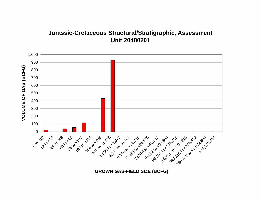
768
to <
1,53
6
1,53
6 to
<3,
072
3,07
2 to
<6,
144
6,14
4 to
<12
,288
12,2
88 to
<24
,576
24,5
76 to
<49
,152
49,1
52 to
<98
,304
98,3
04 to
<19
6,60
8
196,
608
to <
393,
216
393,
216
to <
786,
432
Jurassic-Cretaceous Structural/Stratigraphic, Assessment Unit 20480201
1,000
900
VO
LU
ME
OF
GA
S (
BC
FG
)
800
700
600
500
400
300
200
100
0
6 to
<12
12 to
<24
24 to
<48
48 to
<96
96 to
<19
2
192
to <
384
384
to <
768
786,
432
to <
1,57
2,86
4
>=1,
572,
864
GROWN GAS-FIELD SIZE (BCFG)
Jurassic-Cretaceous Structural/Stratigraphic, Assessment Unit 20480201
1,000
GR
OW
N G
AS
-FIE
LD
SIZ
E (
BC
FG
)
100
10
1
1940 1950 1960 1970 1980 1990 2000
FIELD-DISCOVERY YEAR
Jurassic-Cretaceous Structural/Stratigraphic, Assessment Unit 20480201
1,000
GR
OW
N G
AS
-FIE
LD
SIZ
E (
BC
FG
)
100
10
1
0 20 40 60 80 100 120 140 160 180 200
CUM. NEW-FIELD WILDCAT WELLS (No.)
Jurassic-Cretaceous Structural/Stratigraphic, Assessment Unit 20480201
2,000
CU
M. G
RO
WN
GA
S V
OL
UM
E (
BC
FG
) 1,800
1,600
1,400
1,200
1,000
800
600
400
200
0
1940 1950 1960 1970 1980 1990 2000
FIELD-DISCOVERY YEAR
Jurassic-Cretaceous Structural/Stratigraphic, Assessment Unit 20480201
2,000
CU
M. G
RO
WN
GA
S V
OL
UM
E (
BC
FG
) 1,800
1,600
1,400
1,200
1,000
800
600
400
200
0
0 20 40 60 80 100 120 140 160 180 200
CUM. NEW-FIELD WILDCAT WELLS (No.)
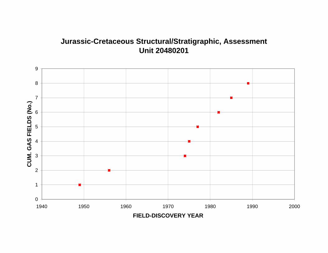
Jurassic-Cretaceous Structural/Stratigraphic, Assessment Unit 20480201
9
8
7
CU
M. G
AS
FIE
LD
S (
No
.)
6
5
4
3
2
1
0
1940 1950 1960 1970 1980 1990 2000
FIELD-DISCOVERY YEAR
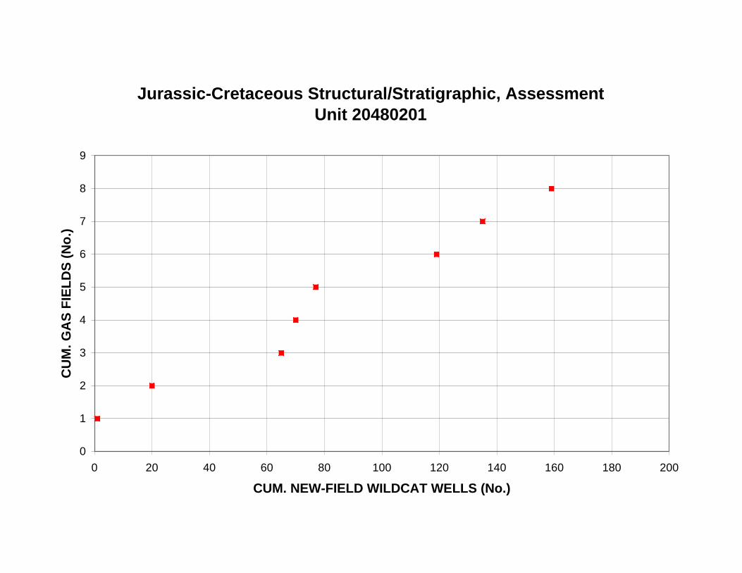
Jurassic-Cretaceous Structural/Stratigraphic, Assessment Unit 20480201
9
8
7
CU
M. G
AS
FIE
LD
S (
No
.)
6
5
4
3
2
1
0
0 20 40 60 80 100 120 140 160 180 200
CUM. NEW-FIELD WILDCAT WELLS (No.)
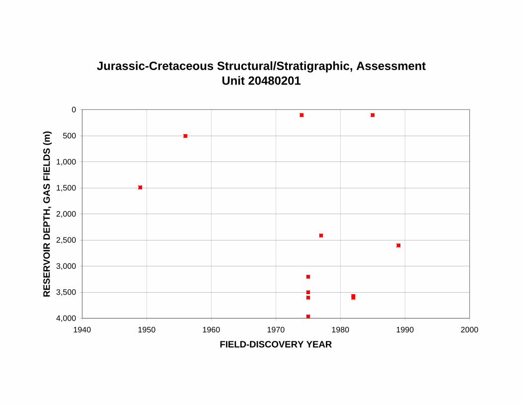
RE
SE
RV
OIR
DE
PT
H, G
AS
FIE
LD
S (
m)
Jurassic-Cretaceous Structural/Stratigraphic, Assessment Unit 20480201
0
500
1,000
1,500
2,000
2,500
3,000
3,500
4,000
1940 1950 1960 1970 1980 1990 2000
FIELD-DISCOVERY YEAR
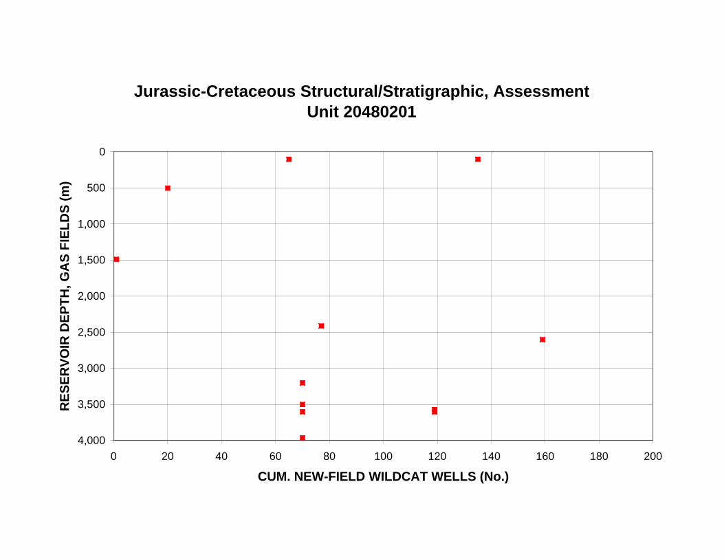
RE
SE
RV
OIR
DE
PT
H, G
AS
FIE
LD
S (
m)
Jurassic-Cretaceous Structural/Stratigraphic, Assessment Unit 20480201
0
500
1,000
1,500
2,000
2,500
3,000
3,500
4,000
0 20 40 60 80 100 120 140 160 180 200
CUM. NEW-FIELD WILDCAT WELLS (No.)
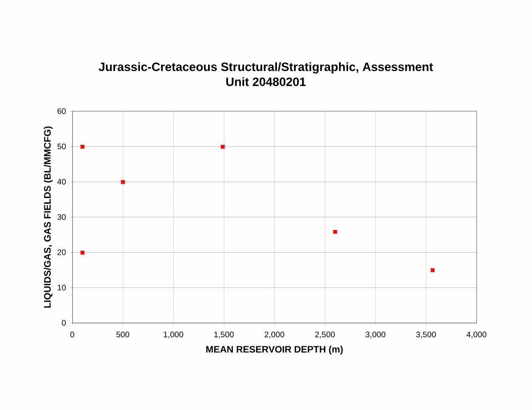
Jurassic-Cretaceous Structural/Stratigraphic, Assessment Unit 20480201
60
LIQ
UID
S/G
AS
, GA
S F
IEL
DS
(B
L/M
MC
FG
)
50
40
30
20
10
0
0 500 1,000 1,500 2,000 2,500 3,000 3,500 4,000
MEAN RESERVOIR DEPTH (m)


